cg&gis lab computer graphics and geographic information systems laboratory university of ni š...
TRANSCRIPT
CG&GIS LabComputer Graphics and Geographic Information
Systems Laboratory
University of NišFaculty of Electronic Engineering

2
About CG&GIS Lab Vehicle fleet tracking Key technologies References Architecture Hardware configuration Basic features AVL events Conclusion
About CG&GIS Lab Vehicle fleet tracking Key technologies References Architecture Hardware configuration Basic features AVL events Conclusion

Computer Graphics and GIS Lab is established 1991 at the University of Niš – Faculty of Electronic Engineering.
We specialize in providing state-of-the-art solutions in GIS oriented services based on the latest technology, but we heavily relay on R&D in the software engineering in general. We digitize the world, bring the knowledge and maps together to our customer satisfaction.
CG&GIS Lab offers services for extensive Volume GIS/CAD Data Conversion, Customized Application Development for various industries, GIS Development, various mapping, Remote Sensing Applications worldwide.

Many of our researchers have strong scientific background. Working through PhD dissertations and MSc theses they shaped the authentic GIS solution system. The number of publications authored by the members of the CG & GIS Lab, in the period 1996-2011, is greater than a hundred. On the basis of nerly twenty large software projects already finished in: business, health care, government, logistics, agriculture, education, telecommunications, gas & electric, environmental management, homeland and public safety, forestry, real estate, etc., we prepare refined solutions to offer to the public through CG & GIS Lab. The flexibility of the CG & GIS Lab allows rapid expansion according to the market needs in all other field our GIS solution system might be beneficial.
Many of our researchers have strong scientific background. Working through PhD dissertations and MSc theses they shaped the authentic GIS solution system. The number of publications authored by the members of the CG & GIS Lab, in the period 1996-2011, is greater than a hundred. On the basis of nerly twenty large software projects already finished in: business, health care, government, logistics, agriculture, education, telecommunications, gas & electric, environmental management, homeland and public safety, forestry, real estate, etc., we prepare refined solutions to offer to the public through CG & GIS Lab. The flexibility of the CG & GIS Lab allows rapid expansion according to the market needs in all other field our GIS solution system might be beneficial.

CG & GIS Lab provides services and is involved in R&D in the following domains: Computer Graphics and Visualization Geographical Information Systems (GIS) Mapping
Utility Thematic Topographic Contour
Cartography Photogrametry Remote Sensing Virtual Reality Advanced Databases and Information Systems Command, Control, Communication, Computers and Intelligence (C4I) Systems Knowledge-Based Systems Human-Computer interaction Advanced Autonomous Robotics Internet applications

Serbian Defense Forces Ministry of Internal Affair of Serbia Telekom Serbia State Institute of Hydro-Meteorology, Republic of Serbia Power Supply companies City of Niš Authorities Other Local communities
Serbian Defense Forces Ministry of Internal Affair of Serbia Telekom Serbia State Institute of Hydro-Meteorology, Republic of Serbia Power Supply companies City of Niš Authorities Other Local communities

• Basis of all mobile object tracking systems is internally developed Sky* framework
• Different systems implemented for specific domains SkyBUS – public bus transportation analysis system SkyTrack – general purpose vehicle fleet tracking SkyMed – medical emergency response vehicle
dispatching and tracking system SkyPal – personal fieldworker tracking and alerting
system
• Various functionalities of specific applications can be implemented in any requested solution.

• System for monitoring public bus transportation in the city of Niš – 150 vehicles
• Public water supply company “Naissus” – system for tracking 40 vehicles and working machines
• Emergency medical service – Niš – System for tracking 30 vehicles + call center (in development)
• System for monitoring public bus transportation in the city of Niš – 150 vehicles
• Public water supply company “Naissus” – system for tracking 40 vehicles and working machines
• Emergency medical service – Niš – System for tracking 30 vehicles + call center (in development)

GPS Global Positioning
System
GPS Global Positioning
System
GPRS General Packet Radio Service
GPRS General Packet Radio Service
GSM Global System for
Mobile Communications
GSM Global System for
Mobile Communications
GIS Geographic Information Systems
GIS Geographic Information Systems

Positioning busses using satellite based locating and tracking their movement over moving map in realtime,
Control of number of active vehicles, line, number of stops and timetable conformance,
Automated generation of monthly and daily reports realized line runs per company, vehicle and summary.
Storage and review of individual vehicle movement history for previous two months,
Entry and edit of engaged transport companies, vehicles, GPS tracking devices, bus stops and lines.
Various means to inform citizens about bus lines, timetables, as well as current locations of buses on specific lines and their estimated arrival time on station.

• Locationg vehicles using satellite positioning and monitoring vehicles movement over moving map in realtime,
• Controling conformance to designated operating area and daily tasks,
• Centralized overview and control of the entire vehicle fleet,• Alarming about irregular situations like overspeed, leaving
designated operation area, panic button etc.,• Generating monthly and daily reports per driver, vehicle and
summary, using forms and visualizing report data, over moving map
• Printing report data in various formats,• Memorizing and replaying historical movement data for the last
two months,• Enteing and editing vehicles, users and GPS tracking devices.

Vehicle
UPS
GPS/GPRS Center
Modem
Modem
Monitoring station
Main server
Modem Client
Monitoring station
Backup server
21" Monitor 21" Monitor
Modem
Internet
Web Client
Modem Client
Monitoring station
SD
Smart-UPS
6 2 0
www.apcc.com
SD
Smart-UPS
6 2 0
www.apcc.com
GPS Satellites
GPS/GPRS Tracker
Mobile packet transfer network
(GPRS)

• Main Server• Backup Server,• Two high resolution monitors,• Two uninterrupted power supply devices,• Broadband symetrical Internet access,• Additional equipment requested by the user (projector, printer,...).
• Main Server• Backup Server,• Two high resolution monitors,• Two uninterrupted power supply devices,• Broadband symetrical Internet access,• Additional equipment requested by the user (projector, printer,...).
GPS/GPRS Centar
ModemMain serverBackup server
21" Monitor 21" Monitor
Modem
SD
Smart-UPS
6 2 0
www.apcc.com
SD
Smart-UPS
6 2 0
www.apcc.com
LAN
Printer (option)Projector (option)
UPS

GPS/GPRS tracker - RB General Ekonomik GPS/GPRS tracker - Ei INFORMATIKA
HUNTER - HCP Kruševac GTarget- eForte Niš
• Sky systems can simultaneously support various tracking equipment• Sky systems can simultaneously support various tracking equipment

• Sky GIS client offers an array of functionalities for tracking one or multiple vehicles, analize and track vehicle movement, record and replay vehicles movement history.
• Sky GIS client offers an array of functionalities for tracking one or multiple vehicles, analize and track vehicle movement, record and replay vehicles movement history.
• Information about each tracked vehicle: vehicle status (color coded), speed, identification and category
• Information about each tracked vehicle: vehicle status (color coded), speed, identification and category

• Sky allows movement history and trajectory recording and storage for all tracked vehicles. History review is enabled for flexibly chosen replay period.
• Sky allows movement history and trajectory recording and storage for all tracked vehicles. History review is enabled for flexibly chosen replay period.
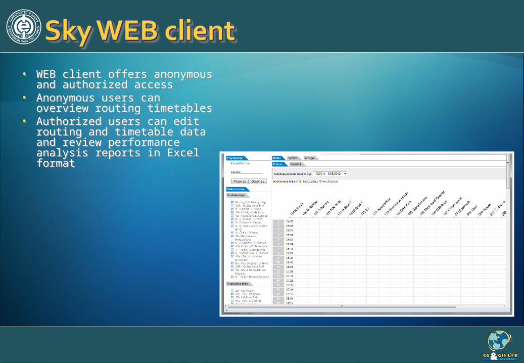
• WEB client offers anonymous and authorized access
• Anonymous users can overview routing timetables
• Authorized users can edit routing and timetable data and review performance analysis reports in Excel format
• WEB client offers anonymous and authorized access
• Anonymous users can overview routing timetables
• Authorized users can edit routing and timetable data and review performance analysis reports in Excel format

• WEB GIS client offers anonymous and authorized access to vehicle positions visualized over moving map
• WEB GIS client offers anonymous and authorized access to vehicle positions visualized over moving map

19

20

21

22

• Wap client gives anonymous users (travelers) graphical overview of selected routes, vehicles operating on selected routes and estimated arrival time in reference to selected locations
• Wap client gives anonymous users (travelers) graphical overview of selected routes, vehicles operating on selected routes and estimated arrival time in reference to selected locations

• Report Manager can output performance analysis data in tabular format and save results in PDF or Excel format
• Report Manager can output performance analysis data in tabular format and save results in PDF or Excel format

• Public info panels are mounted in clearly visible spots near destination locations and display estimated arrival time for the next vehicle
• Public info panels are mounted in clearly visible spots near destination locations and display estimated arrival time for the next vehicle

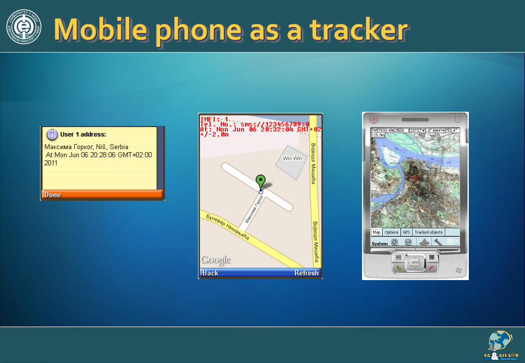
• Extension of Sky system for mobile/handheld devices• Used on PocketPC (PDA) and Smartphone devices• Supports Windows Mobile 5.0 and newer operating systems• Mobile application can act as:
• tracking client showing moving objects over moving map
• personal tracker, sending individual’s location to the control centre
• personal tracking service can be transparently activated on demand using incoming call from predefined number or by incoming SMS with encoded and predefined key phrase content
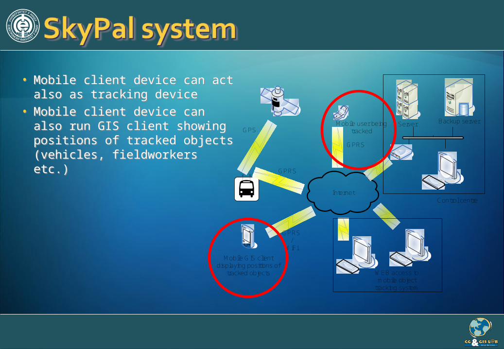
• Mobile client device can act also as tracking device
• Mobile client device can also run GIS client showing positions of tracked objects (vehicles, fieldworkers etc.)
• Mobile client device can act also as tracking device
• Mobile client device can also run GIS client showing positions of tracked objects (vehicles, fieldworkers etc.)
GPS
Internet
GPRS
Server Backup server
WEB access to mobile object
tracking system
Control centre
Mobile GIS client displaying positions of
tracked objects
GPRS/
WiFi
GPRS
Mobile user being tracked
28

• Mobile GIS client connecting to control centre
• Using WiFi or GPRS/3G packet data network transparently
• Integrates internal or external GPS device (dynamically positions user on the moving map).
• Mobile GIS client connecting to control centre
• Using WiFi or GPRS/3G packet data network transparently
• Integrates internal or external GPS device (dynamically positions user on the moving map).

• Can display various raster background maps (topographic maps, city plans...)
• Displays coordinates of selected map point (geographic and local) and altitude (from GPS or 3D terrain model)
• Can display various raster background maps (topographic maps, city plans...)
• Displays coordinates of selected map point (geographic and local) and altitude (from GPS or 3D terrain model)

• Displays course, speed and identification for each of the tracked objects
• Offers measurements tool (length, circumference, area etc.)
• Displays course, speed and identification for each of the tracked objects
• Offers measurements tool (length, circumference, area etc.)

Indication of spatial route constraint violation – every transport route has a strictly defined geofence zone which constraints the movement of the transport vehicles. This event is triggered if a vehicle breeches this zone. This can be caused by a potential unplanned heavy traffic or weather conditions which can influence the driver to leave the planned route and choose an alternative road.
Indication of vehicle schedule constraint violation – the usage of every vehicle is time constrained meaning that it can be used in a strictly defined time schedule. This event is triggered if a vehicle is being used outside defined time schedule indicating a emergency situation or possible unauthorised vehicle usage.
Geofence

Indication of route time schedule violation – every vehicle is constrained with an optimal delivery route time schedule. This event is triggered if a vehicle fails to execute delivery according to the specified time schedule. This can be caused by various reasons including sudden heavy traffic and weather conditions, vehicle malfunction etc.
Indication of touring plan start – all products deliveries and tours are described in the monthly customers touring plan document. This event is triggered when a vehicle starts a route according to this document leaving from a start point which is usually the merchandiser’s warehouse.
Indication of a completed touring plan – this event is triggered when a vehicle completes a touring plan visiting all customers and delivering all goods according to the touring plan obeying time schedules and given routes. The touring plan route end point is usually the merchandiser’s warehouse.
T1
T2

Indication of maximum speed violation – this event is triggered when a vehicle breaches the maximum speed limit defined by traffic regulations. This event can be also an indication of the driver’s risky behaviour.
Indication of unplanned stopping – the optimal delivery route is constrained by precise stopping locations which include stops at customer delivery locations, stops at gas stations and possible stops at accommodation locations. This event is triggered if a vehicle performs stops outside of this defined constrain locations. This can be caused by a possible emergency situation involving vehicle malfunction or driver health problems etc.
Indication of maximum time of stay violation – during the optimal delivery route all vehicles are constrained by a maximum time of stay at defined customer locations. This event is triggered when this time limit is exceeded. This can be caused by possible goods unloading problems, vehicle malfunctions etc.

Indication of fuel consumption violation – all machines and vehicles are considered to generate an average fuel consumption estimated by considering daily working time schedules. This event is triggered if a machine or a vehicle wastes more fuel than previously estimated. This can be caused by possible machine or vehicle malfunctions.
Indication of machine time schedule violation – all machines and vehicles are constrained by strict time schedules. This event is triggered when a machine or a vehicle is engaged outside the defined time schedule. This can be caused by a emergency situation or a possible unauthorised machine/vehicle usage.

36
Full control of complete GiNiS platform (developed from the scratch using C/C++).
Custom made GIS applicationsEasy to useEasy to integrateSupport for standard GIS formatsDesktop/Web/Mobile GIS

3737
University of NišFaculty of Electronic Engineering
Aleksandra Medvedeva 14, 18000 NišSerbia
CG&GIS LabComputer Graphics and Geographic Information
Systems Laboratory
Tel.: (+381 18) 529-500 Fax:(+381 18) 588-399
e-mail: [email protected]://gislab.elfak.ni.ac.rs