ces aquatic ecosystems final draft aug08 - sanral1.pdf · aquatic ecosystems specialist dr patsy...
TRANSCRIPT

APPENDIX 3
AQUATIC ECOSYSTEMS
Specialist
Dr Patsy Scherman/Dr Brian Colloty Coastal and Environmental Services
Peer Reviewer
Dr Bill Harding DH Environmental Consulting

SPECIALIST STUDY ON THE POTENTIAL IMPACT OF THE PROPOSED N2 WILD COAST TOLL HIGHWAY ON
AQUATIC SYSTEMS
Prepared by
P-A Scherman, M Jennings, B Colloty, L Bosman, P Ngwenya, A Gordon♦, J Blake
Coastal & Environmental Services 67 African Street
P O Box 934 Grahamstown
6140
Submitted to
CCA Environmental (Pty) Ltd on behalf of
The South African National Roads Agency Limited
October 2007

Proposed N2 Wild Coast Toll Highway: Aquatic Study for the EIA
Coastal & Environmental Services October 2007 ii
TEAM STRUCTURE
The team conducting the assessment was composed of the following specialists: Dr Patsy Scherman Team leader and river specialist (macroinvertebrates) Mike Jennings Estuarine specialist Dr Brian Colloty Riparian vegetation specialist Lungisa Bosman Wetland specialist Prudence Ngwenya Desktop data collection Andrew Gordon♦ River specialist: fish and macroinvertebrates Justin Blake Estuarine specialist ♦ Institute for Water Research, Rhodes University, Grahamstown
ACKNOWLEDGEMENTS
The study team would like to acknowledge the assistance and data received from the following persons and organizations:
• Albany Museum, Grahamstown – Dr de Moor and Mr Baninzi • South African Institute for Aquatic Biodiversity – Mrs Terry, Dr Bills, Dr A Whitfield • Resource Quality Services, Department of Water Affairs and Forestry – Neels Kleynhans and
Christa Thirion • South African National Biodiversity Institute – Mr Mukhoro • East London Museum – Mr Greg Brett • Conservation Support Services – Mr Ben Cobbing (mapping) • Ms Retha Stassen, Dr Mandy Uys, Dr Anton Bok, Mr S Deyzel, Dr Jim Cambray
Our thanks also to Julian Drew and Michael Mgcotyelwa who organized the very able assistance of a guide, Springs, to accompany the estuary team in the field. Thanks Springs!

Proposed N2 Wild Coast Toll Highway: Aquatic Study for the EIA
Coastal & Environmental Services October 2007 iii
EXECUTIVE SUMMARY
This aquatic assessment reports on the potential impact of the proposed N2 Wild Coast Toll Road on the aquatic environment. The aquatic environments studied for this report included, rivers (instream habitat), riparian vegetation, wetlands and estuaries, with the major focus being the alternative greenfields routes. Roads, being linear, do impact on the various aquatic environments, either directly (physical change) or indirectly (water quantity & quality). Road and bridge-building associated impacts such as changes in channel structure and habitat availability, increased sedimentation into the river channel, and changes in population structures in the short term are highly probable, particularly in the sensitive rivers and estuaries of the study area. Changing mouth conditions, with subsequent impacts on the availability of nursery areas (for example) in estuaries, are likely to take place with increasing sediment loads moving down rivers. Operational aspects also impact on these systems, to a lesser degree than the construction phase but are longer in duration. With this in mind the major systems were studied using all the available information, which although not detailed, still provided a useful insight into the significance of the potential impacts and how these should be mitigated. Again, effective management procedures, drainage management and the implementation of monitoring programmes and detailed construction and operational Environmental Management Plans, will reduce potential impacts. Whilst the majority of the 188 estuaries between Gonubie, north of East London, and Isipingo, south of Durban, will not be directly crossed by the various alignments of the N2 Wild Coast Toll Highway, cumulative downstream impacts, and the upstream presence of the road, is expected to impact on these sensitive systems. The impacts on systems where the road does cross the river catchments will depend on the impacts on the rivers and wetlands which supply the estuaries with freshwater, vital for the functioning of the systems, and will most likely be confined to construction-related impacts of sedimentation and water quality related problems, although water quality problems may persist through increased use of the road. The greenfields sections of the alignment are exceptions, as disruption of the wetlands and rivers in the river catchments will alter the flow (quantity) of water to the estuaries, should the coastal Mzamba alignment be used. A further problem is that of increased access to remote areas, where the estuaries are in near pristine condition, although baseline studies are urgently required to confirm this statement. Increased access can only lead to pressures on these systems and a potential depletion of natural resources. It has been difficult to quantify the intensity and significance of road and bridge-building activities on the riverine environments, due to the lack of data and research on these systems. The latest information from SANRAL on bridge designs was used during the assessment, with Ecological Importance and Sensitivity status of the rivers influencing assessment categories. Impact scores for systems having piers in the instream environment were generally higher than other bridge designs. The avoidance of headwaters, which act as refugia areas, reduce potential impacts. The highest impacts for the rivers were allocated to bridges having multiple piers in the rivers, i.e. Mzimvubu, Ntafufu, Mzamba, Kulumbe and Mnyameni rivers. Although the Mzimvubu River currently carries high sediment loads, it is a river of high regional (if not national) importance, and additional impacts resulting in habitat destruction should be avoided. Most wetlands within the study area occur naturally, but have been altered for use due to the reliance of communities on wetlands as domestic water sources, building materials etc.. SANRAL should ensure that prior to constructing any structures close to wetlands, an in-depth assessment of the value of each wetland to communities nearby should be conducted and mitigation measures undertaken accordingly. This should be undertaken with the involvement of communities and local municipalities, and will probably include the provision of alternative water supplies. High impact scores were seen in Section 6 of the route, as wetlands of high domestic value were found along this section of road, particularly along the coastal Mzamba route. The SANRAL-preferred alignment would result in fewer impacts in this section.

Proposed N2 Wild Coast Toll Highway: Aquatic Study for the EIA
Coastal & Environmental Services October 2007 iv
The following key impacts were assessed per aquatic component during the N2 Wild Coast Toll Highway EIA. More information can be found in Section 5 of the document.
Aquatic component Riparian and instream
vegetation Rivers Wetlands Estuaries
Destruction of vegetation and loss of sensitive habitats
Change in channel structure Destruction of vegetation and loss of sensitive habitats Sedimentation
Increased surface run-off Loss of instream habitats Increased surface run-off Water quantity
Risk of surface and groundwater pollution
Risk of surface and groundwater pollution - sediments
Risk of surface and groundwater pollution Water quality
Reduction in permeable surfaces
Risk of surface and groundwater pollution - other
Reduction in permeable surfaces Improved access
Diversion of flow by hard surfaces
Changes in ecosystem structure + function, + loss of biodiversity
Diversion of flow by hard surfaces
Change in vegetation community type Change in vegetation
community type
Physical change to wetlands The above summary of potential impacts for all road sections showed that physical change in the aquatic environment is the dominant issue, followed by change in water quantity and the water quality. Without mitigation, these impacts were rated as being high in this study, although these impacts would be localised or short in duration. This was largely due to the potential for cumulative impacts and the loss of vegetation. The loss of vegetation, which is the cornerstone in stabilising the river banks, providing habitat for other organisms, as well as goods and services for the local communities could lead to the loss of these habitats, while decreasing the water quality of the system. However with mitigation the majority of impacts could be reduced to a low significance. The exception being the 2 greenfield sections, where wetlands and estuaries could be impacted on directly and the impacts would thus be rated high without any mitigation. These would remain high if the final routes did not try and avoid the wetlands (a source of water for local residents) and that the increase in use of the estuaries is not managed. Again with further studies into the actual size and number of the wetlands, which should also proposed suitable buffer zones, the significance of the impacts could also be reduced. Further interaction of tourism initiatives and the conservation authorities, which will be required by law when the Integrated Coastal Zone Management Bill is promulgated (late 2008), would then promote future management plans and protection for the estuaries in view of the increased accessibility to these systems. The initiation of monitoring programmes is essential in managing potential impacts on all systems. The existing rivers database should be developed further, with monitoring programmes developed for each aquatic component, using indicator organisms or groups of organisms. Note that monitoring should be initiated before road and bridge-building activities are initiated. Mitigation measures to be implemented in order to reduce the effects of the construction and operational phases of the road have been highlighted in the impacts section of this report. Mitigation would be achieved through the incorporation of best practice measures into a Construction Environmental Management Plan (CEMP). This should then be monitored by a suitable Environmental Control Officer, capable of measuring the upstream and downstream water quality (turbidity), to detect any negative impacts arising from the road and bridge building sites. With these control mechanisms in place, the construction impacts could be well mitigated and the operational issues pro-actively managed to reduce the overall impact of the road to level that would be tolerable. This is assuming that suitable rehabilitation with follow up work is conducted and that the potential for increasing the number of visitors to the region is monitored. Therefore the overall project EIA could further motivate the institution of well developed tourism plans, based on the spatial development plans within the region, which are also approved by the environmental authorities. This should

Proposed N2 Wild Coast Toll Highway: Aquatic Study for the EIA
Coastal & Environmental Services October 2007 v
also be aided by other initiatives to protect the remaining environment further from degradation, with or without the toll road. The overall recommendation of this report is that the further development of the road would have be rated has having a low impact on the aquatic environment, and due to the sensitivity of the wetlands within the greenfield sections, the SANRAL preferred alternative be followed. This alternative would limit the interruption of base flow conditions that result from the wetlands that in turn sustain the rivers and estuaries.
Proposed N2 Wild Coast Toll Highway: Aquatic Study for the EIA
Coastal & Environmental Services October 2007 vi
TABLE OF CONTENTS
1. INTRODUCTION ............................................................................................................................................... 9
1.1 BACKGROUND AND BRIEF......................................................................................................................................... 9
1.2 STUDY AREA AND PROJECT DESCRIPTION................................................................................................................. 10
1.3 ASSUMPTIONS AND LIMITATIONS .......................................................................................................................... 10
2 STUDY APPROACH, METHODS AND RESULTS....................................................................................................... 11
2.1 HISTORICAL DATA: RIVERS..................................................................................................................................... 12
2.2 AVAILABLE DATA: WETLANDS ................................................................................................................................ 12
2.3 HISTORICAL DATA: ESTUARIES................................................................................................................................ 12
2.4 FIELD SURVEY: RIVERS .......................................................................................................................................... 13
2.4.1 Fish.............................................................................................................................................................. 13
2.4.2 Macroinvertebrates..................................................................................................................................... 17
2.4.3 Riparian vegetation ..................................................................................................................................... 18
2.5 FIELD SURVEY: WETLANDS .................................................................................................................................... 20
2.6 FIELD SURVEY: ESTUARIES ..................................................................................................................................... 23
2.6.1 Water quality measurements ..................................................................................................................... 25
2.6.2 Fish sampling .............................................................................................................................................. 27
2.6.3 Results: Water quality and fish sampling.................................................................................................... 27
2.7 RESULTS OF BIOLOGICAL SURVEYS FOR RIVERS AND ESTUARIES PER ROAD DIVISION............................................................. 29
2.7.1 Section 1: Gonubie Interchange to Ngobozi.................................................................................................... 29
2.7.2 Section 2: Ngobozi to Mthatha ....................................................................................................................... 29
2.7.3 Section 3: Mthatha to Ndwalane .................................................................................................................... 30
2.7.4 Section 4: Ndwalane to the Ntafufu River....................................................................................................... 31
2.7.5 Section 5: Ntafufu River to Lusikisiki (Magwa Intersection)............................................................................ 35
2.7.6 Section 6: Lusikisiki to the Mthamvuna River.................................................................................................. 37
2.7.7 Section 7: Mthamvuna River to Isipingo Interchange ..................................................................................... 49
3. DESCRIPTION OF THE AFFECTED ENVIRONMENT ............................................................................................ 50
3.1 RIVERS ............................................................................................................................................................... 50
3.2 WETLANDS....................................................................................................................................................... 51
3.2.1 Wetland amphibia ...................................................................................................................................... 53
3.3 ESTUARIES .......................................................................................................................................................... 54
4. SOURCES OF RISK .......................................................................................................................................... 55
4.1 RISK SOURCES...................................................................................................................................................... 55
4.1.1 Rivers and wetlands .................................................................................................................................... 55
4.1.2 Estuaries...................................................................................................................................................... 57
4.2 RELEVANT LEGISLATIVE AND PERMIT REQUIREMENTS ................................................................................................ 59

Proposed N2 Wild Coast Toll Highway: Aquatic Study for the EIA
Coastal & Environmental Services October 2007 vii
4.2.1 Wetlands..................................................................................................................................................... 59
4.2.2 Rivers........................................................................................................................................................... 59
4.2.3 Estuaries ...................................................................................................................................................... 60
5 IMPACT DESCRIPTION AND ASSESSMENT....................................................................................................... 61
5.1 IMPACTS ALONG THE ROUTE CORRIDOR: RIVERS AND WETLANDS ................................................................................... 62
5.2 IMPACTS ALONG THE ROUTE CORRIDOR: ESTUARIES .................................................................................................... 96
6 DISCUSSION & CONCLUSION........................................................................................................................ 110
7 REFERENCES ................................................................................................................................................ 113
8. APPENDICES ................................................................................................................................................ 116

Proposed N2 Wild Coast Toll Highway: Aquatic Study for the EIA
Coastal & Environmental Services October 2007 viii
LIST OF ABBREVIATIONS AND ACRONYMS
ASPT Average Score Per Taxon CD: RDM Chief Directorate: Resource Directed Measures CES Coastal & Environmental Services CEMP Construction Environmental Management Plan DO Dissolved Oxygen DWAF Department of Water Affairs and Forestry EC Electrical Conductivity ECRHP Eastern Cape River Health Programme EIA Environmental Impact Assessment EIR Environmental Impact Report EIS Ecological Importance and Sensitivity IUCN International Union for Conservation of Nature and Natural Resources MAR Mean Annual Runoff DEAT Department of Environmental Affairs and Tourism NEMA National Environmental Management Act ORP Oxidation Reduction Potential PES Present Ecological State PPT Parts per thousand RQS Resource Quality Services SAIAB South African Institute for Aquatic Biodiversity SANBI South African National Biodiversity Institute SANRAL South African National Road Agency Limited SASS South African Scoring System SEA Strategic Environmental Assessment TDS Total Dissolved Solids TOCEs Temporarily Open Closed Estuaries TPS Total Species List WMA Water Management Area

Proposed N2 Wild Coast Toll Highway: Aquatic Study for the EIA
Coastal & Environmental Services October 2007 9
1. INTRODUCTION 1.1 Background and brief The focus of this study is to assess the environmental impacts that would arise from the construction and operation of the proposed N2 Wild Coast Toll Highway on the aquatic systems along the route. A number of alternative routes have been proposed and will be considered during the study, including greenfield sections between the Mzimvubu and Mthamvuna rivers. The route of the proposed toll highway crosses a number of rivers, streams, drainage areas, wetlands and estuaries. This report will therefore assess the health of aquatic environment and their ecological status where information is available, identify areas where additional information is needed, and list the impacts the road development may have on these aquatic systems. The information provided in this document will be used in the further planning and design of the proposed project and would be included in the Environmental Impact Report (EIR) to be compiled as part of the Environmental Impact Assessment (EIA) process. The previous aquatic study was used as the starting point for this document, which at the time was largely based information for certain systems. The previous study did not account for estuaries or wetlands, and also focused on a different set of alternative routes. The Terms of Reference for the study included both general and specific requirements. Selected general requirements, and specific requirements for the aquatic study, are shown below. Comments are shown in italics.
• Describe the baseline conditions that exist in the study area and identify any sensitive areas that would need special consideration. This task was undertaken by accessing historical information and conducting one field survey.
• Undertake a review of new information on the presence of rare, endangered and/or sensitive fish species in the study area and assess the potential impacts of the proposed project and identified feasible alternatives on these species. This request was expanded to include instream macroinvertebrates and riparian vegetation, as they form important components of aquatic systems.
• Evaluate the ecological sustainability of the proposed project and identified feasible alternatives (in association with other relevant studies).
• Provide a brief outline of the approach used in the study. Assumptions, sources of information and the difficulties with predictive models must also be clearly stated.
• Indicate the reliability of information used in the assessment, as well as any constraints/limitations applicable to the report. This point is of direct relevance to the aquatic study as a single field survey was conducted for the study, which focused on the greenfields route. Due to the number of rivers and wetlands in the area, more extensive fieldwork would be required for a higher confidence assessment.
• Identify and assess any cumulative effects arising from the proposed project. Cumulative impacts are particularly relevant to aquatic assessments due to the longitudinal nature of rivers, with widespread upstream activities potentially impacting on downstream estuaries.
• Identify areas where impacts could combine or interact with impacts likely to be covered by other specialists, resulting in aggravated or enhanced impacts and assess potential effects.
• Recommend practicable mitigation measures to minimise or eliminate negative impacts, enhance potential project benefits or to protect public and individual rights to compensation and indicate how these can be implemented in the final design, construction and operation of the proposed project.
• Identify ways to ensure that recommended mitigation measures would be implemented, as appropriate.
• Recommend an appropriate monitoring and review programme in order to track the effectiveness of proposed mitigation measures.

Proposed N2 Wild Coast Toll Highway: Aquatic Study for the EIA
Coastal & Environmental Services October 2007 10
1.2 Study area and project description The information below is taken from the Final Scoping Report of March 2007 (CCA Environmental, 2007). The proposed N2 Wild Coast Toll Highway extends over a total distance of approximately 560 km between the N2 Gonubie Interchange (near East London in the Eastern Cape) and the N2 Isipingo Interchange (south of Durban in Kwa-Zulu Natal). The key components of the proposed project include:
• Upgrading and widening of existing road sections (of the N2 and R61) included within the proposed project (approximately 470 km)
• New road construction within two greenfields sections (approximately 90 km) • Construction of eight new major bridges • Upgrading and/or construction of new road interchanges and intersections • Construction of associated structures (such as toll plazas, pedestrian overpasses and animal
underpasses) The proposed route alignment would connect major economic centres, including East London, Butterworth, Mthatha, Lusikisiki, Port Edward, Port Shepstone and Durban, and would be approximately 75 km shorter than the existing N2 route between East London and Durban via Mount Frere, Kokstad and Harding. Approximately 80% of the proposed route utilises existing road sections, as follows:
• Existing N2 between the Gonubie Interchange and Mthatha • Existing R61 between Mthatha and Ndwalane • Existing R61 between Ntafufu River and Lusikisiki • Existing R61 and N2 between the Mthamvuna River and the Isipingo Interchange
Greenfields sections are those between Ndwalane and Ntafufu, and between Lusikisiki and the Mthamvuna River. Within the new road sections, major bridge crossings are required at a number of deeply incised gorges, namely the Msikaba, Kwadlambu, Mthentu, Mnyameni, Kulumbe, Mpahlane and Mzamba rivers. The route has been divided into the following seven sections, with the greenfields sections denoted in bold. Descriptions of the study area, aquatic ecosystems and potential impacts, will be according to these divisions:
• Section 1: Gonubie Interchange to Ngobozi – 80 km • Section 2: Ngobozi to Mthatha – 145 km • Section 3: Mthatha to Ndwalane – 72 km • Section 4: Ndwalane to the Ntafufu River – 16.5 km • Section 5: Ntafufu River to Lusikisiki – 24.5 km • Section 6: Lusikisiki to the Mthamvuna River – 73.5 km, with the second 61 km being the
greenfields section. The following deep gorges fall into this stretch of the alignment – Msikaba, Mthentu, Kwadlambu, Mnyameni, Kulumbe, Mpahlane and Mzamba rivers.
• Section 7: Mthamvuna River to Isipingo Interchange – 148 km 1.3 Assumptions and limitations The following points must be taken into consideration, particularly when assessing the results of the field survey.
• Limited aquatic ecosystem data are available for large areas of the Wild Coast, particularly for river and wetland systems. Wetland mapping data for this area is particularly poor.

Proposed N2 Wild Coast Toll Highway: Aquatic Study for the EIA
Coastal & Environmental Services October 2007 11
• Limited field sampling was undertaken during this assessment. A one-week survey in a study area this large and inaccessible is obviously inadequate, but some ground-truthing was undertaken in the greenfields section of the route between the Lusikisiki and Mthamvuna rivers, including the Mzimvubu and Ntafufu Rivers.
• Artifacts of sampling: Due to limited sampling, artifacts of sampling may be seen in the results (e.g. due to accessibility of one river over another). More intensive sampling would need to be undertaken to confirm sightings (or absences of particular species) of the July field survey.
• Seasonal effects: Field sampling should not be undertaken in winter. • Focus area of field survey: The field survey focused on the two primary routes through the
greenfields sections, i.e. the coastal Mzamba route (route H) and the SANRAL-preferred route (route L). The selection of these routes was based on information and maps received from CCA Environmental and the team’s assessment of the alternative route impacts. Additional routes will be assessed in the impact section of the report where necessary.
• The vegetation survey assumed that the terrestrial vegetation had been sampled as part of the study and that this study would only focus on the instream and riparian vegetation. Identification of plant species due to the timing of the survey was hampered by the following:
o Field work was constrained by the time allowed in the field and the high number of river
crossing points. Thus there was not always sufficient time to sample all the rivers, especially those with limited access, i.e. steep gorges. It was thus assumed from past experience and visual observations that the instream habitat and riparian vegetation would be limited to a narrow band along the rivers within steep valleys.
o Due to the survey being conducted within the winter period, most plants species would be observed outside of their growth season. For example, the sensitive / threatened bulb (geophyte) species were not easily identified during this period. Overgrazing and veld burning practices further limited plant species identification. In certain regions, grazing areas had shifted to the riparian zones.
The impact assessment was thus based on the information at hand, however the authors strived to produce an assessment of the issues based on this knowledge that would only require a small amount of further study (e.g. wetland map) or could be captured in a suitable monitoring programme or in environmental management plans. 2 STUDY APPROACH, METHODS AND RESULTS The study approach was two-fold; firstly to gather and assess historical and available information regarding the aquatic systems of the study area, and thereby identify any areas where sensitive organisms may be found. Secondly, a week-long field survey was conducted, which focused on the two primary routes through the greenfields sections, i.e. the coastal Mzamba route (route H) and the SANRAL-preferred alignment (route L). Due to the size of the study area, and large numbers of rivers, estuaries and wetlands found in the area, it was not possible to conduct extensive field surveys. For most river sites that have been surveyed along the Wild Coast the sample size is very small; with often only one survey having been conducted. The confidence in the assessment is therefore low. In addition, the field survey was conducted in July 2007, which is not the ideal season in which to conduct either instream or riparian, river and estuarine surveys. This also applied to the identification of the seepage wetlands, which are not always evident during the winter period. The section below therefore reports on both the historical data available for rivers (fish, macroinvertebrates and riparian vegetation), wetlands and estuaries; as well as methods and results for the July field survey. A situation assessment per road section will be given in Section 5, and will include specific river and estuary results from the July survey. These maps are a graphical representation of areas that have been sampled for this study – as can be seen from the maps, large spatial / temporal gaps exist in terms of river data for the Wild Coast.

Proposed N2 Wild Coast Toll Highway: Aquatic Study for the EIA
Coastal & Environmental Services October 2007 12
2.1 Historical data: Rivers As the aquatic study was previously conducted in 2002/2003, this task included a re-assessment of the available reports and data, as well as incorporating any additional information that has become available since 2003. Data were requested from a number of aquatic scientists and institutions, with the information for this study mostly coming from the following organizations and studies:
• All the relevant literature and mapping info for the study area was reviewed. This includes not only instream river surveys, but also vegetation surveys within the region.
• The fish database of the South African Institute for Aquatic Biodiversity (SAIAB); contacts Dr Roger Bills, Dr Alan Whitfield and Mrs Sally Terry
• The invertebrate database of the Albany Museum of Grahamstown; contacts Dr Ferdy de Moor and Mr Mbongeni Baninzi
• Surveys conducted by Ms Christa Thirion of the Directorate: Resource Quality Services (RQS), of the Department of Water Affairs and Forestry (DWAF), of the Great Kei and Mtakatye rivers in 2001
• A Rapid Ecological Reserve study of the Mzimvubu (T31G), Mzintlava (T32A), Tina (T34J), Tsitsa (T35K) and Inxu rivers (T35G), conducted for DWAF by Kotzé and Niehaus in 2004
• Surveys of the Mthatha River conducted as part of the Eastern Cape River Health Programme (ECRHP) in 2004/2005
• Data collected for the Strategic Environmental Assessment (SEA) for Water Management Area (WMA) 12, conducted by CES and associates in 2005/2006 (CES, 2006). Information on the sensitivity of rivers and estuaries in WMA12 was based on the desktop assessments of Ecological Importance and Sensitivity (EIS) and Present Ecological State (PES), updated with data from ground-truthing surveys.
The division within the DWAF responsible for resource protection, Chief Directorate: Resource Directed Measures (CD: RDM), was involved in the study under the direction of CES, and undertook surveys of the following Pondoland rivers as part of the SEA:
o Mzintlava River (coastal and upper sites) o Mthentu River o Ntafufu River o Droewig River, part of the Mzimvubu system o Mzamba River o Msikaba River o Mthamvuna River
2.2 Available data: Wetlands Little information was available on the wetlands of the Wild Coast, with the South African National Biodiversity Institute (SANBI) and Working for Wetlands contacted as primary data sources. Most of these wetlands have not been properly mapped, except for those that can be identified on 1:50 000 topocadastral maps and orthophotos. This resulted in a lack of information to prioritise wetlands in the study. 2.3 Historical data: Estuaries A number of estuaries of the Wild Coast have previously been surveyed, with a desktop assessment of EIS and PES being available for all the estuaries. While estuaries in the Wild Coast region have been identified as being of national importance due to their location, condition and vulnerability, relatively little work has been undertaken in the region (Turpie, 2004).

Proposed N2 Wild Coast Toll Highway: Aquatic Study for the EIA
Coastal & Environmental Services October 2007 13
This is largely due to the remoteness of the area and difficulties encountered in accessing the coast. Harrison et al. (1998, 1999, 2000) published a series of reports rating estuaries in terms of biological health (based on ichthyofaunal community status), water quality (based on suitability for aquatic life, determined by dissolved oxygen, oxygen absorbed and unionized ammonia concentrations; suitability for human contact, determined by faecal coliforms; and trophic status, determined by nitrate and ortho-phosphate).aesthetic state (based on a fourteen weighted parameters) and overall estuarine health, including a selection of the most important, as well as accessible estuaries along the Wild Coast. Numerous attempts have been made to rank estuaries in order to prioritise those that are the most important in terms of conservation importance and management, as well as provision of resources due to the high demand for consumptive and non-consumptive use of estuaries and water within their catchments (Turpie et al., 2002). 2.4 Field survey: Rivers River information is clearly divided into fish, aquatic macroinvertebrates and riparian vegetation. 2.4.1 Fish Ratings presented on the overall insensitivity of species to habitat change were obtained from Kleynhans et al. (2005). Skelton (2003) was consulted in order to determine if any important or sensitive species potentially occurred in the regions adjacent to the proposed toll route, which may not be represented in sampling survey results or the SAIAB database. The sampling of fish was undertaken using a Samus – 725G electrofisher, a 1m seine net and a D-net, depending on the river substrate and habitats present at each site. Although captured fish were identified on site using Skelton (2003), DNA samples were taken from three individuals of each species and delivered to SAIAB for further analysis. DNA samples were placed in 1.5 ml tubes filled with ethanol, fish were then placed in 10% formalin and both DNA samples and fish were transported to SAIAB to confirm species identification. These results were not available at the time of preparing this report. Water quality parameters were measured using a handheld Hanna meter, which measures Electrical Conductivity (EC), Total Dissolved Solids (TDS), pH and temperature. The fish habitats present at each site were assessed according to four velocity/depth classes: slow/deep; slow/shallow; fast/deep; and fast/shallow. Fast was flow exceeding 0.3 m/s and deep was water exceeding 0.5 m (Kleynhans, 1999). Table 2.1 is a synthesis of fish species distribution data, both from the July field survey and the SAIAB national fish database, while Table 2.2 lists freshwater red list of threatened fish species in the regions adjacent to the proposed toll highway (IUCN, 2006), and species identified as intolerant to habitat change. Note that most of the study area is commonly referred to as the “Transkei gap” due to the poor fish populations, based on historical regional geological processes.

Proposed N2 Wild Coast Toll Highway: Aquatic Study for the EIA
Coastal & Environmental Services October 2007 14
Table 2.1 Fish species distribution data for regions adjacent to the proposed N2 toll highway. Information was obtained from recent surveys and the National Fish Collection database at the South African Institute for Aquatic Biodiversity. Ratings presented on the overall insensitivity of species to habitat change were obtained from Kleynhans et al. (2005). Those shaded in grey are moderately intolerant of habitat change.
FISH SPECIES RIVER Ambassis
producta Anguilla
bengalensis labiata
Anguilla bicolor
Anguilla marmorata
Anguilla mossambica
Awaous aeneofuscus
Barbus anatolicus
Barbus anoplus
Barbus gurneyi
Barbus natalensis
Barbus paludinosus
Barbus viviparus
Caffrogobius natalensis
Clarias gariepinus
Cyprinus carpio
Eleotris sp.
Eleotris fusca
Glossogobius callidus
Manzimtoti X X X
Little Manzimtoti X X X
Mkomazi X
Mandawe X
Mpambonyoni X
Mzimkulu X X X X (alien) X
Izotsha X X X
Ibilanhlolo X
Mthamvuna X X X
Mzamba X
Bazane
Sideni X
Kulumbe X
Mpahlane
Mnyameni X X X
Mthentu X X X
Kwadlambu X
Msikaba X
Mteku ?
Mzintlava X X X X (alien)
Ntafufu X X X
Mzimvubu X ? X (alien) X
iTsitsa + tributaries
X X
Mthatha (upstream dam)
Mthatha (downstream dam)
X X X X (translocated)
X
Mbashe X X X (alien)
Qora X X
Great Kei X X X (translocated)
X (alien)
Kwelera X (translocated)
X (alien)
Gqunube X (translocated)
X (alien)
Intolerance rating
- Moderately tolerant
- Moderately tolerant
Moderately tolerant
Moderately tolerant
- Moderately tolerant
Moderately intolerant
Moderately tolerant
Tolerant Moderately tolerant
- Tolerant Tolerant - - Moderately tolerant

Proposed N2 Wild Coast Toll Highway: Aquatic Study for the EIA
Coastal & Environmental Services October 2007 15
Table 2.1 cont. Fish species distribution data for regions adjacent to the proposed N2 toll highway. Information was obtained from recent surveys and the National Fish Collection database at the South African Institute for Aquatic Biodiversity.
FISH SPECIES
RIVER Hypseleotris cyprinoides
Hypseleotris dayi
Labeo umbratus
Labeobarbus aeneus
Labeobarbus natalensis
Micropterus dolomieu
Micropterus punctulatus
Micropterus salmoides
Monodactylus falciformes
Mugil cephalus
Myxus capensis
Oreochromis mossambicus
Oncorhynchus myiss
Poecilia reticulata
Pseudocrenilabrus philander
Redigobius dewaali
Sandelia bainsii
Manzimtoti X X (alien) X
Little Manzimtoti
X X (alien) X
Mkomazi
Mandawe X X X
Mpambonyoni X (lower risk, near
threatened)
X X
Mzimkulu X X X X (Lower risk, near
threatened)
Izotsha X
Ibilanhlolo X
Mthamvuna X
Mzamba X (alien)
Bazane
Sideni
Kulumbe
Mpahlane
Mnyameni
Mthentu X (alien) X
Kwadlambu
Msikaba
Mteku
Mzintlava X
Ntafufu X
Mzimvubu X (Lower risk, least concern)
X
iTsitsa + tributaries
X (alien) X (alien)
Mthatha (upstream dam)
X (alien) X (alien)
Mthatha (downstream dam)
X X X (Lower risk, least concern)
X
Mbashe
Qora
Great Kei X X (translocated)
X (Lower risk, least concern)
Kwelera X (alien) X (Endangered)
Gqunube X (alien)
Intolerance rating
- - Moderately tolerant
- - Moderately tolerant
Moderately tolerant
Moderately tolerant
Moderately tolerant
Moderately tolerant
Moderately intolerant
Tolerant Moderately intolerant
- Tolerant Moderately tolerant
Moderately intolerant

Proposed N2 Wild Coast Toll Highway: Aquatic Study for the EIA
Coastal & Environmental Services October 2007 16
Table 2.1 cont. Fish species distribution data for regions adjacent to the proposed N2 toll highway. Information was obtained from recent surveys and the National Fish Collection database at the South African Institute for Aquatic
Biodiversity.
RIVER FISH SPECIES
Stenogobius kenyae
Stenogobius polyzonus
Syngnathus temminckii
Tilapia rendalli Tilapia sparrmanii
Valamugil cunnesius
Xiphophorus maculatus
Xiphophorus helleri
Manzimtoti X (translocated) X (alien)
Little Manzimtoti X (alien)
Mkomazi X
Mandawe X (alien)
Mpambonyoni
Mzimkulu X X
Izotsha X (translocated) X
Ibilanhlolo
Mthamvuna
Mzamba
Bazane
Sideni
Kulumbe
Mpahlane
Mnyameni
Mthentu
Kwadlambu
Msikaba
Mteku
Mzintlava
Ntafufu
Mzimvubu
iTsitsa + tributaries
Mthatha (upstream dam)
Mthatha (downstream dam)
X X (translocated)
Mbashe
Qora
Great Kei X (translocated)
Kwelera
Gqunube
Intolerance rating - - - Tolerant Tolerant - - Tolerant

Proposed N2 Wild Coast Toll Highway: Aquatic Study for the EIA
Coastal & Environmental Services October 2007 17
Table 2.2 Freshwater Red Data List of fish species in the regions adjacent to the proposed toll highway (IUCN, 2006), and species identified as intolerant of habitat change.
SECTION FISH STATUS (IUCN)
1. Gonubie interchange – Ngobozi Upgrade of existing N2
Sandelia bainsii Myxus capensis
Endangered Lower Risk / Least Concern
2. Ngobozi – Mthatha Upgrade existing N2 M. capensis Lower Risk / Least Concern
3. Mthatha – Ndwalane Upgrade existing R61 M. capensis Lower Risk / Least Concern
4. Ndwalane – Ntafufu Construction of new road M. capensis Lower Risk / Least Concern
5. Ntafufu – Lusikisiki Upgrade existing R61 M. capensis Lower Risk / Least Concern
6. Lusikisiki- Mthamvuna Construction of new road
M. capensis B. gurneyi
Lower Risk / Least Concern Moderately intolerant of habitat change
7. Mthamvuna – Isipingo Upgrade of R61 and N2
M. capensis B. gurneyi Redigobius dewaali Hypseleotris dayi
Lower Risk / Least Concern Moderately intolerant of habitat change Lower risk, near threatened Lower risk, near threatened
Rivers within Sections 2-6 have been poorly surveyed and thus the distributions listed in this report cannot be considered definitive. Further surveying of these rivers may reveal more widespread distributions across this area instead of the isolated distributions recorded at present. Furthermore, DNA identification of the Barbus species surveyed will provide definitive answers regarding distribution and the possible existence of a new species (it has been suggested previously by Bok (2000) that a possible new species of Barbus occurs within some rivers of (Section 6). Sandelia bainsii has been recorded within the Kwelera River and is considered endangered and moderately intolerant to habitat change. It has a very high requirement for unmodified water quality and rocky streams with good instream cover. It is possible that with more intensive surveying of rivers within the Eastern Cape its known distribution could be defined. The freshwater mullet, Myxus capensis, has been recorded in a number of rivers along the length of the proposed N2 Wild Coast Toll Highway, but should be expected to occur in almost all rivers that are open to the sea and do not possess waterfalls. It requires flowing rivers with clear upstream passage in order to complete its lifecycle. Barbus gurneyi has been recorded within rivers in Sections 6 and 7. It is considered moderately intolerant to habitat change requiring overhanging vegetation and good water quality, i.e. high oxygen levels and low turbidities. Redigobius dewaali prefers the lower reaches of rivers and requires low turbidity waters and extensive vegetation cover. It is threatened by the deterioration of these types of habitat. More extensive surveying may reveal its distribution extends along the entire length of the N2 Wild Coast Toll Highway as there have been isolated records from the Limpopo to Knysna (Skelton, 2003). Hypseleotris dayi and H. cyprinoides were both recorded in Section 7. They require a similar habitat to R. dewaali, and consequently are also threatened by the deterioration of this type of habitat. They have only been recorded in KwaZulu Natal coastal rivers. 2.4.2 Macroinvertebrates Macroinvertebrates were sampled using South African Scoring System Version 5 (SASS5) protocol (described in Dickens and Graham (2002)). The SASS is a well recognized measure of water quality and general river health. The method produces a SASS Score, Number of Taxa and Average Score Per Taxon

Proposed N2 Wild Coast Toll Highway: Aquatic Study for the EIA
Coastal & Environmental Services October 2007 18
(ASPT). The ASPT can be related to a river health class using methodology for determining the Ecological Reserve (Hughes, 2005) (Table 2.3). The SASS method was also utilized to get a rapid indication of biodiversity within the rivers sampled. It is acknowledged that SASS was not designed for this purpose, but it does provide a rapid and consistent method of sampling the identified rivers. Where possible, three biotopes were sampled: stones (in and out-of-current), vegetation (in and out-of-current) and gravel/sand/mud. Macroinvertebrate distribution data were also obtained from recent studies, e.g. the SEA for WMA 12, and from the national macroinvertebrate database of the Albany Museum (Appendix 1) (see Section 2.1). The SEA indicated the following river health assessments, based on macroinvertebrate distributions (according to the SASS method):
• Mthamvuna (S 30° 51’ 18.7’’ : E 30° 04’ 23.8’’): SASS ASPT – 6.2. River class = Good. • Mzamba (S 31° 02’ 57.5’’ : E 30° 01’ 19.2’’): SASS ASPT – 6.2. River class = Good. • Mthentu (S 31° 07’ 48.9’’ : E 29° 45’ 22.7’’): SASS ASPT – 5.9. River class = Fair. • Msikaba (S 31° 11’ 54.4’’ : E 29° 36’ 29.2’’): SASS ASPT – 6.5. River class = Good. • Mtakatye (S 31° 36’ 30.0’’ : E 29° 03’ 30.0’’): SASS ASPT – 5.5 and 5.3. River class = Fair. • Great Kei (S 32° 30’ 28.6’’ : E 27° 58’ 00.7’’): SASS ASPT – 6.8. River class = Good.
Table 2.3 The default ecological Reserve benchmark category boundaries for ASPT
RIVER HEALTH CLASS BOUNDARY ASPT SCORE Natural 7 Good 6 Fair 5 Poor <5
A summary of sensitive macroinvertebrates surveyed in rivers within each section of the proposed toll highway is presented in Section 2.7, with a brief discussion on the water quality of the rivers. Although there is lower invertebrate diversity in some of the larger turbid systems, especially near large settlements, the tributaries of these systems and nearby smaller rivers often have a very high diversity of sensitive invertebrates and act as refugia. Generally, there is a high diversity of sensitive families within in most rivers in Sections 2-6. The SASS scores determined from the survey conducted for this report may be misleading if viewed in isolation as the sampling was conducted in winter, when there is naturally lower diversity of macroinvertebrates. 2.4.3 Riparian vegetation Extensive riparian zones associated with wide floodplains within the study area are not commonly found, and at most narrow fringes of hygrophilous (water loving) grasses and sedges were expected. However, although not directly associated within the rivers but requiring moist valleys, this study region is also an important habitat for Valley Thicket (Valley Bushveld) and Coastal Forests. As seasonal floristic and vegetation surveys were initiated along the proposed route as part of the vegetation study, focus in this study was on the possible impact of the bridge crossings on the instream vegetation, in terms of maintaining river health. Eight (8) sites were identified based on proximity of the proposed road bridge crossings and gaining access to these points during the 5-day site visit. The timing and duration of the survey in terms of the vegetation assessment did impose some limitations to the study, which were mentioned in Section 1.3. For the purpose of this study, a two-fold survey approach was used to determine the riparian plant species, which included the following:
Proposed N2 Wild Coast Toll Highway: Aquatic Study for the EIA
Coastal & Environmental Services October 2007 19
• Two line intersect transects per river bank were used, the first perpendicular to the riverbank and the second parallel to the river bank at a distance of 10 to 15 m from the bank. These were used to establish any zonation changes in both directions from the bank, i.e. to determine the length and width of the riparian zones. This was then replicated on the opposite bank, resulting in 4 transects per site. The length of these transects was dependent on whether a clear differentiation was observed between riparian and terrestrial vegetation. This method also reflects the information needs for instream habitat (riparian vegetation) of a typical rapid Level III Ecological Reserve determination, should it be required at a latter stage.
• A general site walk looking for additional species, especially those considered sensitive or requiring conservation.
During this survey the aquatic vegetation groups could be summarised as follows:
• Seepage wetlands (dealt with in the wetland study of this report), but also referred to as Freshwater Swamps in previous EIA specialist studies for the area
• Palustrine or riparian wetlands • Instream vegetation
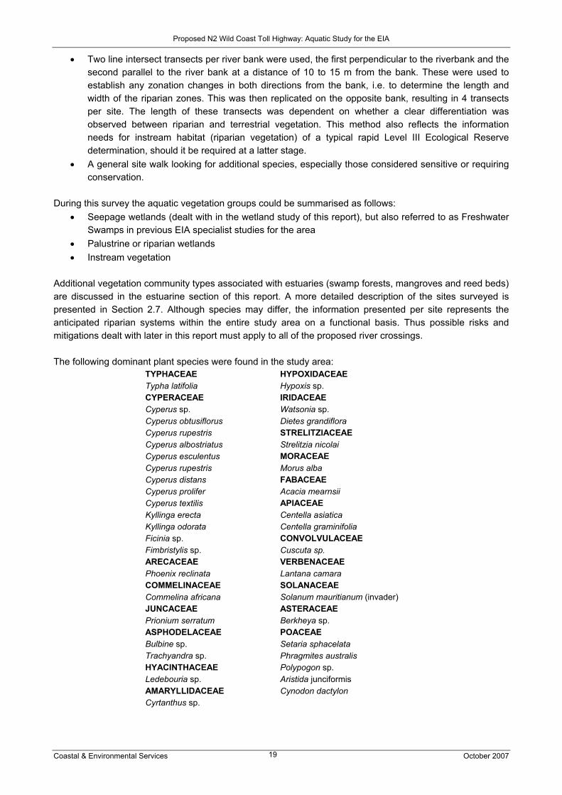
Additional vegetation community types associated with estuaries (swamp forests, mangroves and reed beds) are discussed in the estuarine section of this report. A more detailed description of the sites surveyed is presented in Section 2.7. Although species may differ, the information presented per site represents the anticipated riparian systems within the entire study area on a functional basis. Thus possible risks and mitigations dealt with later in this report must apply to all of the proposed river crossings. The following dominant plant species were found in the study area:
TYPHACEAE Typha latifolia CYPERACEAE Cyperus sp. Cyperus obtusiflorus Cyperus rupestris Cyperus albostriatus Cyperus esculentus Cyperus rupestris Cyperus distans Cyperus prolifer Cyperus textilis Kyllinga erecta Kyllinga odorata Ficinia sp. Fimbristylis sp. ARECACEAE Phoenix reclinata COMMELINACEAE Commelina africana JUNCACEAE Prionium serratum ASPHODELACEAE Bulbine sp. Trachyandra sp. HYACINTHACEAE Ledebouria sp. AMARYLLIDACEAE Cyrtanthus sp.
HYPOXIDACEAE Hypoxis sp. IRIDACEAE Watsonia sp. Dietes grandiflora STRELITZIACEAE Strelitzia nicolai MORACEAE Morus alba FABACEAE Acacia mearnsii APIACEAE Centella asiatica Centella graminifolia CONVOLVULACEAE Cuscuta sp. VERBENACEAE Lantana camara SOLANACEAE Solanum mauritianum (invader) ASTERACEAE Berkheya sp. POACEAE Setaria sphacelata Phragmites australis Polypogon sp. Aristida junciformis Cynodon dactylon

Proposed N2 Wild Coast Toll Highway: Aquatic Study for the EIA
Coastal & Environmental Services October 2007 20
2.5 Field survey: Wetlands A primary aim of this study was to describe the extent of any possible wetland areas within the proposed route, and to assess the impact of the N2 Wild Coast Toll Highway on these wetlands. This assessment involved the use of aerial photographs, 1:50 000 topocadastral maps, and available layout or survey diagrams, together with a site visit. The interpretation was based on the DWAF’s guidelines for delineating and describing wetlands (DWAF, 2003). The results of the terrestrial vegetation assessment, which mapped wetland areas, was also used in this study. The site visit was initially meant to verify the findings of the desktop study and to assess prioritised wetlands in detail, focussing on those close to the two primary routes of the greenfields sections, i.e. coastal Mzamba route (route H) and the SANRAL-preferred alignment (route L). Due to the inaccessibility of some of these areas, and associated time constraints, it was not always possible to access wetlands close to the route options. As a result the process of identification and assessment of wetlands could not be conducted in detail. For example, wetlands could not be delineated and therefore wetland boundaries could not be properly identified. A number of wetlands were identified during the site visit and GPS points were taken in order to map them for inclusion in the report (see Table 2.4 for the position of wetlands assessed during the field survey). The wetland assessment consisted of two parts with regards to determining the type and extent of the wetlands, as well as their conservation value. Although only a sub-sample of wetlands were assessed, they do not appear to be well conserved and of high conservation value, and do not appear to contain many species of special concern. However, wetlands are sensitive to habitat fragmentation, and demonstrate a “moderate” diversity. The overall sensitivity of these wetlands when judging them from an ecological point of view is “moderate”. The reduction of impacts on wetlands as a result of communities having access to piped water can not be fully assessed using the statistics data referred to in the Social Impact Assessment. One reason is that the data is for local and district municipalities as well as the province as whole. For example, the SIA mentions that changes in access to water resources in the O.R. Tambo district municipality decreased by less than 3% from 2001 to 2006 with the number of people reliant on natural water estimated at 62.4%. The SIA also mentions that in the section from Ntafufu to Lusikisiki the majority of the population relies on natural water resources such as river and springs. It states that over 62% of the population (i.e. 7000 households) does not have access to piped water. These estimates are in line with observations made during the aquatic assessment field trip where it was noted that mostly larger communities have access to water services, in the form of a community stand pipe or a borehole. The majority of these communities are on the western side of the proposed N2. The more rural communities east of the N2 Highway are more reliant on natural sources of water. The overall sensitivity of these wetlands, based on a social perspective, is “high”, especially during winter, when they are mostly utilised for grazing and a source of water supply for domestic use and livestock watering.

Proposed N2 Wild Coast Toll Highway: Aquatic Study for the EIA
Coastal & Environmental Services October 2007 21
Table 2.4 Wetlands areas assessed during the field survey of July 2007
NAME LONGITUDE LATITUDE Size Surrounding land use Impacts DESCRIPTION AND
COMMENTS
2 km2 Water collection Fires
A number of possible protected plant species were
identified (geophytes).
Brick-making around the
spring
Area dominated by
grazing Black peat
Uncultivated fields
Bizana 31 04 54.5 30 01 58.8
Gum and wattle plantations
Sideni 1.5 km2 Grazing and
cultivation Fires Dominated by Palmiet and water lilies.
31 05 05.1 30 04 07.1
On the northern boundaries there is a woodlot for wood supply for communities of
Sideni
A water source for communities close-by
Kulumbe 31 07 37.1 30 04 12.6
60 m wide and 1
km long
A number of exotic plants,
such as flowering
Cuscuta, were identified.
Sedges and Palmiet dominate the wetland
which seems to be permanent and in good condition,
especially close to the river
2 kms long
Cultivation on both sides of the
wetland Fires
Just above Mnyameni River crossing on the western side of the river close to the Mnyameni Falls.
Mnyameni 31 09 08.2 30 04 03.2
Dominated by
Palmiet, Hibiscus and Cyperus textilis
2 kms long
Cultivation through the
wetland from neighbouring
houses
Wetland is dominated by
Wattle and Blue gums.
Phragmites is the dominant species close to the river.
Sand winning
Kwadlambu 31 17 23.8 29 49 41.5
A number of
erosion gullies
have been
formed as a
result
Tributaries meet close to the confluence of
the Ngucu River
Kwadlambu 31 14 26.8 29 50 01.6 At the confluence with the Ngucu River
Kwadlambu 31 14 26.8 29 50 03.7 At the garden fence Mzimvubu 31 33 28.7 29 28 15.9
Most wetlands found on the
floodplains of the Mzimvubu River are cultivated.
Few areas are not impacted
Dominated by Phragmites

Proposed N2 Wild Coast Toll Highway: Aquatic Study for the EIA
Coastal & Environmental Services October 2007 22
NAME LONGITUDE LATITUDE Size Surrounding land use Impacts DESCRIPTION AND
COMMENTS
Many food gardening
projects in the area
Lantana invasion
along the banks of the river
The wetland is highly
impacted by cultivation, especially cabbages
Dominated by Phragmites and
Lantana on the sides of the wetland
Mzimvubu
Furrows drain the wetlands
Ntafufu 31 30 07.7 29 30 39.7 500 m long and 150 m wide
There is a borrow pit which was dammed at the time of the
site visit
At Gugwana village banks are eroded.
Dominated by Phragmites and
sedges, especially Thypha capensis
Invaded by butternut
plants
Mzintlava 31 25 30.5 29 32 14
Fire and some
erosion is visible
Dominated by Phragmites and
sedges while difficult to identify most plants
as they were burnt
Cultivation occurs along the
banks of the wetland
Impacted upon by fires at the time
Dominated by Carex and sedges
Mzizangwe 31 22 22.3 29 37 59.9
Grazing is
dominant in the area
Wetlands were just below the Magwa Dam on the south
eastern side
Mainly impacted upon
by grazing, with a portion of the wetland
burnt
A number of wetlands birds were seen in the
area
Eroded river banks, mainly due to sand
winning
The wetland looked permanent with some areas that may have
temporal zones
Mteku 31 18 25.2 29 45 31.8
There were erosion gullies
close to the river
especially where
livestock drink and cross the
wetland
Only dominant species that could be
noticed were Phragmites due to the
area being burnt
The larger wetlands are particularly important in their ability to impede and filter surfaces flows, as well as store water and therefore ensure maintenance of the base flow of rivers. Due to the regional geology, this attenuation of water would aid in the recharge of groundwater systems. Wetlands also improve water quality by acting as water purifiers and therefore reduce the number of water-borne diseases prevalent in the study area. Wetlands plants such as reeds and sedges also have the ability to reduce the impact of floods as they tend to reduce the flow of water during floods and assist in trapping sediments and therefore reduce soil erosion, as observed in one of the Palmiet wetlands in the study area. Wetland fauna observed during the site visit included a variety of groups ranging from amphibians and birds to small mammals. Crustacean remains were evident at most of the larger wetlands indicating the possibility of mongoose activity. Waterfowl such as ducks (yellow-billed), geese (Egyptian), cormorants and herons have been observed in and around

Proposed N2 Wild Coast Toll Highway: Aquatic Study for the EIA
Coastal & Environmental Services October 2007 23
the wetlands. The wetlands in areas close to rivers such as the Mzintlava and Mteku maintained numerous runs (tunnels within the grass tussocks), indicating the presence of Vlei rats (Otomys irroratus). None of the species observed were of conservation concern. Only a few wetlands are in a near natural condition, these being found in the north eastern portion of the study area around Bizana, Msikaba and up to the Mthamvuna River. 2.6 Field survey: Estuaries The purpose of this study was to ascertain the state of estuaries between Gonubie and Isipingo, and identify whether or not they stand to be affected by the proposed routes of the highway. As part of the study, a once-off week long sampling survey was undertaken to sample a selection of previously sampled and un-sampled Wild Coast estuaries in the greenfields section between Lusikisiki, north-east of Port St Johns, and Port Edward. This was done in order to verify previous findings, as well as attempt to gather information on systems for which no data exists. Findings were compared to Harrison et al. (1998, 2000), which was also used to assess the state of all estuaries potentially affected by the proposed N2 Toll Highway. Fifteen estuaries were sampled between Port St Johns and Port Edward over a period of five days (see Figure 2.1). Harrison et al. (2000) identified 46 estuaries in this region, whilst only ten were sampled and described in the publication. The selected estuaries were chosen based on the following:
• Area covered by the catchment i.e. whether or not the proposed route of the N2 Wild Coast Toll Highway traversed the river catchment of the estuary
• Availability of data i.e. an attempt was made to sample previously un-surveyed systems • Ranking in terms of South African and Wild Coast importance (Turpie and van Niekerk, 2005) • Accessibility
Of the estuaries sampled, six were permanently open systems and nine were TOCEs, based on the classification system used by Whitfield (1992). Table 2.5 lists the sampled estuaries, from south to north, the state of the mouth (after Whitfield, 1992), classification according to Whitfield (2000) and Harrison et al. (2000), as well as the South African and Wild Coast importance ranking (Turpie and van Niekerk, 2005). According to Whitfield (1992), estuaries can be classified into 5 different groups. Estuarine bays exhibit a large tidal prism and tidal mixing processes with average salinities varying between 20 and 35 ppt (parts per thousand). No estuarine bays were identified in the present study. Permanently open estuaries are characterized by a moderate tidal prism, tidal/riverine mixing process with an average salinity of 10- >35 ppt. The Mthentu and Msikaba estuaries are examples of permanently open estuaries. River mouths exhibit a small tidal prism with riverine dominated mixing processes. The average salinity of river mouths is less than 10ppt. The Mzimvubu River was the only river mouth identified in this survey. Estuarine lakes exhibit a negligible tidal prism, wind dominated mixing processes with average salinities ranging from 1 to 25 ppt. No estuarine lakes were identified in the present study. Temporarily open/closed estuaries are typically smaller estuaries, closed off from the sea, which exhibit no tidal prism, mixing processes associated with the presence of wind and salinities ranging between 1 and 25ppt. The Mgwegwe, Butsha and the Mpahlane are examples of TOCE’s in the present study (Whitfield, 1992).

Proposed N2 Wild Coast Toll Highway: Aquatic Study for the EIA
Coastal & Environmental Services October 2007 24
Figure 2.1 Estuaries sampled during the survey, as well as proposed alignment of the N2 Toll
Highway (green route L = “SANRAL-preferred alignment” of greenfields section; red route H = “coastal Mzamba route” i.e. alternative route)
Mzimvubu
Nkodusweni
Ntafufu
Mzintlava
Mboyti
Kilroe
Msikaba Butsha
Mgwegwe
Mthentu
Sikombe
Mnyameni
Mpahlanyane
Mpahlane
Mzamba

Proposed N2 Wild Coast Toll Highway: Aquatic Study for the EIA
Coastal & Environmental Services October 2007 25
Table 2.5 Sampled estuaries from south to north indicating mouth state, overall condition (Whitfield, 2000; Harrison et al., 2000) and South African and Wild Coast rank (Turpie and van Niekerk, 2005)
Condition (Harrison et al., 2000) Estuary Mouth
state
Overall condition (Whitfield,
2000) Fish WQ Aesthetics Overall
South African rank
Wild Coast rank∆
Mzimvubu River mouth Fair Fair Fair Moderate Moderate 31 4
Nkodusweni TOCE Excellent# 118 25
Ntafufu Open Excellent Moderate – Good Good Good Moderate
– Good 71 13
Mzintlava Open Excellent# 114 24
Mboyti TOCE Good# 72 14
Kilroe* TOCE
Msikaba Open Excellent Moderate – Poor Good Very Good Moderate
– Good 99 20
Butsha* TOCE Moderate – Poor Fair Very Good Moderate
Mgwegwe TOCE Excellent Moderate Fair – Good Very Good Moderate
– Good 103 21
Mthentu Open Excellent Fair Fair - Good Very Good Moderate
– Good 50 9
Sikombe TOCE Excellent# 157 43
Mnyameni TOCE Excellent# 119 26
Mpahlanyane TOCE Excellent# 217 66
Mpahlane TOCE Excellent# 206 62
Mzamba Open Good Moderate Mod – Poor Good Moderate 42 8
* = Not classified according to Whitfield (2000) or ranked. Mouth state based on observations during present study field trip # = “Baseline studies urgently required” according to Whitfield (2000) = 248 estuaries ranked from Orange River Estuary (western most) to Kosi Estuary (eastern most)
∆ = Study area from Great Kei (western most) to Mthamvuna (eastern most) Estuaries (68 systems)
The ranking methodology, as described by Turpie and Van Niekerk 2005, involves prioritizing South African estuaries on the basis of conservation importance based on the collation of existing data for all South African estuaries. Estuaries are scored in terms of their size, type, biogeographic zone, habitats as well as their biota. At each estuary one station was occupied in the lower reaches, except for the Mzimvubu and Mpahlanyane estuaries where a second station was occupied in the middle reaches of the estuary. At each station water quality measurements were taken and seine netting for fish was undertaken. 2.6.1 Water quality measurements Physico-chemical water quality measurements were taken in situ using a YSI 556 Multi-Probe System (Plate 2.1), comprised of the YSI 556-02 portable multi-parameter logger and YSI 5563-10 cable and sonde, capable of measuring:
• Temperature • pH is a measure of the acidity or alkalinity of a solution. Aqueous solutions at 25oC with a pH less
than seven are considered acidic, while those with a pH greater than seven are considered basic

Proposed N2 Wild Coast Toll Highway: Aquatic Study for the EIA
Coastal & Environmental Services October 2007 26
(alkaline). The pH of 7.00 is considered neutral at 25oC because at this pH the concentration of hydronium ions (H3O+) approximately equals the concentration of hydroxide ions (OH−) in pure water. Changes in pH can have severe effects on aquatic biota due to alterations in the ionic and osmotic balances of organisms, as well as result in changes in the availability of toxic substances such as aluminium and ammonia.
• Salinity, Electrical Conductivity (EC) and Total Dissolved Solids (TDS) – salinity is a measure of the saltiness of water, while EC is a measure of a solutions ability to conduct an electric current, and is determined by substances dissolved in the water column i.e. TDS. These variables can affect microbial and ecological processes such as rates of metabolism and nutrient cycling.
• Dissolved Oxygen (DO) content is a measure of the amount of gaseous oxygen (O2) dissolved in water, which is vital for survival of aquatic organisms. Oxygen gets into water by diffusion from the surrounding air, by aeration (rapid movement), and as a waste product of photosynthesis.
• Oxidative Reductive Potential (ORP) is related to the concentration of oxidizers or reducers in a solution, and their activity or strength. It provides an indication of the solution's ability to oxidize (during which electrons are lost to the reducing agent) or reduce (gain of electrons by the oxidizing agent) another material.
Measurements were taken from the bank by wading to approximately 1.5 m and taking the readings from 0.5 m below surface at an arms length. Stratification (most obviously in salinity) was checked for by lowering the sonde to as low as possible (but above the bottom of the channel), and noting differences in parameters to surface levels.
Plate 2.1 Physico-chemical water quality measurements being taken – measurements were generally recorded from deeper than shown in the photograph i.e. by wading out to a depth of 1.5 m

Proposed N2 Wild Coast Toll Highway: Aquatic Study for the EIA
Coastal & Environmental Services October 2007 27
2.6.2 Fish sampling Seine netting (Plate 2.2) was undertaken at each station using a 5 m x 1 m net with a mesh size of 5 mm. Seining is a common method used when assessing species composition of littoral zone fish communities and has been widely used in freshwater, marine and estuarine studies (Harrison et al, 1999). An average area of 50 m2 was sampled during each net tow, and different habitats in the vicinity of the occupied stations were samples until no new species were recorded. The bottom of the net was kept in contact with the bottom of the estuary at all times, and fish were identified on site and released back into the estuarine environment. Fish were identified using Whitfield (1998) and Heemstra and Heemstra (2004).
Plate 2.2 Fish sampling using the 5 m x 1 m seine net in the littoral zone 2.6.3 Limitations
Typically the number of fish species recorded was less than that described by Harrison et al. (1998), as the survey was limited by the following factors:
• Equipment: A 30 m x 1.7 m x 15 mm bar mesh seine net fitted with a 5 mm bar mesh purse and a fleet of gill nets was used by Harrison et al, whereas in the present study only a 5 m seine net was used due to time limitations.
• Time: Limited time for field work was available meaning typically only the lower reaches of the surveyed estuaries were sampled.
• Access: Access to the middle reaches of the estuaries was often not possible – a boat would have made this possible but due to time constraints and the difficulties in transporting a boat one was not used.
• Landing sites: Many estuaries fish could be seen from the bank but could not be caught and positively identified due to the lack of suitable landing sites for the seine net.
• Ideally in situ physico-chemical measurements should be recorded from the middle of the channel, where measurements are most representative of the system and stratification would be most evident, but this was not possible as a boat was not used.
2.6.3 Results: Water quality and fish sampling Physico-chemical results of all estuaries are shown in Table 2.6. Temperature levels were indicative of the time of day of sampling (i.e. cooler temperatures were recorded at those systems sampled earlier in the mornings), while all temperatures ranged from 17.46oC to 21.74oC. pH levels ranged from 8.09 to 8.44 pH units. Sea water is typically well buffered with a pH of between 8.1 and 8.3, highlighting the effect of the marine influence on the estuaries – this is to be expected as measurements were taken in the lower reaches of all estuaries. DO levels ranged from “fair” (for Mthentu) to “good” (all remaining estuaries), as could be expected as the surface waters are well mixed, either by the tide or influence of the wind. Salinities in the TOCEs (that were closed at the time of sampling) ranged from 9.78 ppt (Sikombe) to 18.77 ppt (Nkodusweni), while salinities at the permanently open systems ranged from the lower levels of 3.20 ppt, 4.65 ppt and 12.72 ppt (recorded on the outgoing tide at the Msikaba at the surface, Mzamba and middle

Proposed N2 Wild Coast Toll Highway: Aquatic Study for the EIA
Coastal & Environmental Services October 2007 28
reaches of the Mzimvubu, respectively) to those typical of sea water (35.2 ppt), with an intermediate value recorded at the bottom of the Msikaba Estuary (on the outgoing tide). TDS levels (3.80 mg/L – 34.51 mg/L) were closely correlated with salinity readings, while EC (832.80 mS/m – 5 308.80 mS/m) and ORP levels (148 mV – 232 mV) were indicative of estuarine to marine water. Table 2.6 Physico-chemical results of the sampled estuaries (DO = Dissolved Oxygen, ppt = parts
per thousand, TDS = Total Dissolved Solids, mg/L = milligrams per litre, EC = Electrical Conductivity, mS/m = millisiemens per metre, ORP = Oxidative-Reductive Potential, mV = millivolts)
ESTUARY TEMPERATURE (OC) pH DO
(MG/L) DO (%)
SALINITY (PPT)
TDS (MG/L)
EC (mS/m)
ORP (mV)
Mzimvubu Lower 19.88 8.31 6.16 83.20 34.50 34.04 5235.10 160 Mzimvubu Middle 17.70 8.31 7.06 82.20 12.72 13.74 2116.00 169 Nkodusweni 18.16 8.40 7.85 94.20 18.77 19.62 3018.60 184 Ntafufu 20.04 8.39 6.64 90.50 35.08 34.51 5308.80 163 Mzintlava 17.54 8.26 6.11 76.70 28.64 28.77 4424.50 164 Mbotyi 18.79 8.09 6.42 79.00 14.14 15.16 2332.50 155 Kilroe 19.92 8.41 6.76 83.10 15.83 16.81 2586.10 155 Msikaba Surface 17.48 8.39 9.34 85.00 3.20 3.80 585.00 139 Msikaba Bottom 20.01 8.38 7.74 128.50 25.20 25.65 3933.60 139 Butshe 18.35 8.31 7.43 85.20 11.81 12.83 1977.80 148 Mgwegwe 18.96 8.19 7.08 84.90 18.24 19.12 2941.00 167 Mthentu 20.41 8.37 5.95 81.40 34.16 33.65 5173.30 158 Sikombe 18.74 8.42 8.22 96.00 9.78 10.78 1658.60 150 Mnyameni 21.74 8.44 6.03 84.80 35.00 34.44 5298.50 145 Mpahlanyane Lower 17.86 8.21 6.98 81.60 14.18 15.18 2335.10 121 Mpahlanyane Middle 18.30 8.09 6.90 81.80 14.08 15.09 2321.40 177
Mpahlane 19.38 8.14 7.03 75.80 11.62 12.66 2000.70 232 Mzamba 17.46 8.31 7.78 84.30 4.65 5.41 832.80 148
A total of eighteen fish species were caught, comprising those using estuaries as breeding grounds, as well as inshore marine species, which depend on estuaries to varying degrees during the juvenile phase of their life cycle (Harrison et al., 1998). Species included:
• Ambassidae spp. • Amblyrhynchotes honkenii • Arothron hispidus • Atherina breviceps • Gilchristella aestuaria • Glossogobius callidus • Juvenile Muglidae, including: Liza dumerilii, Liza richardsoni, Liza tricuspidens, Mugil cephalus and
Myxus capensis - note that although Myxus capensis, the freshwater mullet’s distribution is widespread and it was found in most estuaries along the proposed route, its habitat is threatened due to its dependence on freshwater. • Monodactylus facliformes • Heteromyceris capensis • Psammogobius knysnaensis • Pseudorhombus arius • Pomodasys olivaceum • Rhabdosargus holubi • Terapon jarbua

Proposed N2 Wild Coast Toll Highway: Aquatic Study for the EIA
Coastal & Environmental Services October 2007 29
2.7 Results of biological surveys for rivers and estuaries per road division The state of rivers and estuaries in each road section (Tables 2.7 – 2.13), as well as the detailed results of the sites surveyed in July 2007, are presented below. 2.7.1 Section 1: Gonubie Interchange to Ngobozi This section of the route follows the existing N2, which will be rehabilitated and upgraded where required. It therefore includes the Gqunube, Kwelera and Kei river systems. Most of the quaternary catchments from East London to the Kei River are largely modified and of low ecological importance. The Kei River catchment is considered to be of low importance and sensitivity, and is moderately modified. This section of the route does not cross any estuaries, and no endorheic pans, lacustrine wetlands or mountain catchment areas are present. Due to the topography of the region there is a high likelihood of finding wetlands that are categorised as palustrine seepage slope systems. Table 2.7 lists the status of biota in this road section. The fish column refers specifically to fish on the red data list of threatened fish species in the regions adjacent to the proposed toll highway (IUCN, 2006), and species identified as intolerant to habitat change. Note that although the endangered species, Barbus trevelyani, is found in the headwaters of the Buffalo River, this river is not part of the study area. However, it is possible that the distribution of B. trevelyani may extend to adjoining catchments. Sixteen estuaries exist between the Gonubie and Great Kei River mouths; nine TOCEs, one small permanently open system, and five medium – large permanently open system over which the existing N2 crosses, i.e. Gonubie, Kwelera, Bulura, Quko and Great Kei rivers (Harrison et al., 2000). These systems, however, are crossed in the river sections of the catchment. Table 2.7 Biotic distributions and health status of rivers and estuaries in Section 1 of the N2
Wild Coast Toll Highway
FISH MACROINVERTEBRATES ESTUARINE HEALTH STATUS
RIVER HEALTH STATUS
Sandelia bainsii: Endangered Myxus capensis: Lower risk / Least concern
Macroinvertebrate families or orders sensitive to water quality (Perlidae, various Ephemeroptera and Pyralidae) were sampled in the Great Kei.
16 estuaries. Ichthyofaunal status generally “good”; water quality status “good” to “excellent”; aesthetics “good”
Rivers moderately to largely modified. EIS generally low.
2.7.2 Section 2: Ngobozi to Mthatha This section utilises the existing N2 highway, which will be rehabilitated and upgraded, where necessary. Additional bridges will have to be constructed across the Corana and Mthatha rivers, and a mainline toll plaza will be constructed near the Candu River. The main rivers include the Mbashe, Mthatha and the Buwa rivers. Other smaller rivers include the Cegcuwana, Mchubakazi, Munyu, Nywara, Mpozolo and Candu rivers. The drainage area of the Khobonqaba and iNxaxo rivers is considered to be a very important and sensitive drainage area and is largely natural. The Mbashe River catchment is regarded as moderately important and largely modified. Lastly, the Mthatha River catchment has been largely modified and is considered to be of moderate importance. Wetlands of the palustrine seepage slope systems are expected due to the topography of the area. This section of the road does not cross any estuaries due to its inland alignment. Table 2.8 lists the status of biota in this road section.

Proposed N2 Wild Coast Toll Highway: Aquatic Study for the EIA
Coastal & Environmental Services October 2007 30
Fifty seven estuaries exist between the Great Kei and Mthatha River mouths; the majority (42) being TOCEs and generally unaffected by the road, while seven are small permanently open systems, and eight and medium – large permanently open systems i.e. the Khobonqaba, Inxaxo / Ngusi, Qora, Shinixi, Mbashe, Nkanya, Bulungula and Mthatha estuaries. Of these the Qora, Mbashe and Mthatha are the largest and crossed by the existing N2. Note that the majority of estuaries between Mazeppa Bay and the Mbashe Estuary, and between the Bulungula Estuary and Coffee Bay have not been sampled. The road will be widened and pavements constructed along most of the route, and bridges will have to be constructed across the Corana and Mthatha rivers, potentially affecting the estuaries through river-related impacts. Generally the route is inland meaning the estuaries, most of which have small coastal catchments, will not be affected. Table 2.8 Biotic distributions and health status of rivers and estuaries in Section 2 of the N2
Wild Coast Toll Highway
FISH MACROINVERTEBRATES ESTUARINE HEALTH STATUS
RIVER HEALTH STATUS
Myxus capensis: Lower risk / Least concern
Although the main stem of the Mthatha River, especially near city of Mthatha, suffers from poor water quality, some of the tributaries are a refuge to many sensitive macroinvertebrates and possess good water quality. Surveys from the Mbashe River suggest the water quality is good (De Moor and Baninzi, 2007 – in Appendix 1)
57 estuaries. Ichthyofaunal status generally “moderate - good”; water quality status “poor”; aesthetics “good”
Rivers moderately – largely modified. EIS generally moderate. Sensitive systems include the Khobonqaba and iNxaxo rivers.
2.7.3 Section 3: Mthatha to Ndwalane This section of the route stretches to Ndwalane, just over the Mngazi River, and departs from the N2 and moves towards the coast on the existing R61, where rehabilitation and upgrading will be required, including bridge widening at the Mngazi River. The main rivers along this stretch of the proposed toll road include the Mthatha and Mtakatye rivers. Other rivers include the Mgwenyana, Mkomfi and Dwesa rivers. The catchments of the Mnenu, Mngazana, Mngazi, Mvilo and Mdumbi rivers are largely natural and considered to be of very high importance. Wetlands in this area are palustrine seepage slopes. Permanent wetlands do not exist due to the topography of the area. There are thirteen estuaries between the Mthatha and the Mngazi estuaries; seven of which are TOCEs, one which is permanently open but classified as small, and five medium – large permanently open systems, i.e. the Mdumbi, Mtakatye, Sinangwana, Mngazana and Mngazi estuaries. The road crosses the Mngazana and Mngazi rivers relatively close to the estuaries and the coast, which may be of concern as the Mngazana Estuary is ranked as the most important along the Wild Coast, and the 15th most important in South Africa, principally due to the extensive mangrove forests found in the system. The maintenance work on the road close to the estuary could potentially result in sedimentation of the estuarine channels should construction activities erode the banks of the river channel. Water quality may also be affected by construction activities, as well as by increased use of the road when operational, i.e. oils and grease from cars washed into the rivers through stormwater discharge, as well as potential accidents in the river catchment. Access to roads leading off the highway will be improved, potentially resulting in more people visiting the sensitive estuaries along this stretch of the route.

Proposed N2 Wild Coast Toll Highway: Aquatic Study for the EIA
Coastal & Environmental Services October 2007 31
Table 2.9 Biotic distributions and health status of rivers and estuaries in Section 3 of the N2 Wild Coast Toll Highway
FISH MACROINVERTEBRATES ESTUARINE HEALTH
STATUS RIVER HEALTH
STATUS Myxus capensis: Lower risk / Least concern
The Mtakatye possesses some sensitive families, with an ASPT score relating to a river health class of “fair”. The low scores may be related to limited habitat at the site assessed. However, the Mngazi River possesses many sensitive families and the water quality is assessed by De Moor and Baninzi (2007) to be “very good”
13 estuaries. Ichthyofaunal status generally “moderate - good”; water quality status “fair-good”; aesthetics “moderate - good”. Note only 6 estuaries classified. Whitfield (2000) describes the condition of the majority of the estuaries as “excellent”, although states that “urgent baseline studies are required”.
Rivers largely natural with a high EIS.
2.7.4 Section 4: Ndwalane to the Ntafufu River This section of the route includes a section of new road being constructed, with a major high-level bridge crossing over the Mzimvubu River. Although this section of the route is short, it crosses the Mzimvubu and Ntafufu rivers. Although largely natural, the Mzimvubu River is considered to be of low ecological importance and sensitivity. The highly erodible soils of the Mzimvubu catchment and land use activities such as subsistence farming and clearing for firewood, have led to extensive erosion and high sediment loads in the river (Madikizela et al., 2001). The majority of wetlands in this area are palustrine seepage slopes, with the only exception being the floodplain surrounding the lower reaches of the Mzimvubu River. There is very little information available on this system, but it is considered to be under serious threat (Cowan and van Riet, 1998). However, the proposed route of the toll highway is along the middle reaches of the Mzimvubu and Ntafufu rivers, and will not directly impact the floodplain. Twelve estuaries exist between the Mngazi and Ntafufu estuaries, including seven TOCEs, three small permanently open systems, and two medium – large systems i.e. the Mzimvubu (classified as a river mouth due to the high volume of freshwater exiting the mouth) and the Ntafufu estuaries. New bridges will be constructed over the Mzimvubu and Ntafufu Rivers, with potential sedimentation and water quality effects and associated impacts on the river systems and therefore on the estuaries. The Mzimvubu Estuary is already classified as suffering from excess siltation (Whitfield, 2000), and the Ntafufu Estuary is classified as important due to the range of habitats (mangroves and salt marsh) available (Whitfield, 2000), making it an important ecosystem and nursery ground for breeding and juvenile fish, as demonstrated by Harrison et al. (1998). As the new road will be further inland than the existing road, it is unlikely to improve access to the coast, but will mean more thoroughfare and potential visitors to the region, particularly Port St Johns and the small and TOCEs to the south where caravan and camping parks exist i.e. on the Mtambane Estuary floodplain. A number of river and estuary sites were assessed in this section of the proposed road. Specific survey details are shown below Table 2.10.

Proposed N2 Wild Coast Toll Highway: Aquatic Study for the EIA
Coastal & Environmental Services October 2007 32
Table 2.10 Biotic distributions and health status of rivers and estuaries in Section 4 of the N2 Wild Coast Toll Highway
FISH MACROINVERTEBRATES ESTUARINE HEALTH
STATUS RIVER HEALTH
STATUS Myxus capensis: Lower risk / Least concern
The Mzimvubu possesses some sensitive Ephemeroptera (mayflies) and Plecoptera (stoneflies), with an ASPT score relating to a river health class of “fair”. Limited stones and vegetation habitat in the lower reaches and high sedimentation may reduce the number of sensitive families. However, the smaller Ntafufu has many sensitive families and is assessed as having good water quality (De Moor and Baninzi, 2007 – in Appendix 1). The river health class was “good”.
12 estuaries. Ichthyofaunal status generally “moderate - good”; water quality status “fair-good”; aesthetics “moderate - good”. Note only 6 estuaries classified.
Rivers moderately modified. Mzimvubu has a low EIS.
Mzimvubu River and Estuary The Mzimvubu River site sampled was at S 31° 33’ 21.2’’, E 29° 29’ 34.0’’ (site is approximately located along the proposed SANRAL route) – see Plate 2.3.
Plate 2.3 Upstream Mzimvubu River, showing a backwater section with the main channel off to
the left
Water quality parameters: Electrical conductivity 22 mS/m; pH 8.1; temperature 16°C. Fish habitat present at site: This is a large turbid river, braided at the site (approximately 50 m wide). There were two fish habitats present: slow/shallow and fast/deep. Within both habitats there was very little overhanging vegetation, undercut banks and root wads. The substrate was sand and mud, with a very small cobble riffle. The surrounding land use encompassed cultivated lands and some grazing. There was evidence of some water abstraction, but this is unlikely to be having any effect at this site. There was also exotic vegetation encroachment at the site. The high turbidity is evidence of poor land management higher up in the catchment. Fish species sampled: Catfish larvae sp. (yet to be confirmed by DNA analysis); Myxus capensis. Myxus capensis has previously been recorded in the Mzimvubu River. Myxus capensis is classified Lower Risk / Least Concern by the IUCN red list of threatened species (IUCN, 2006). Dams and weirs obstruct their free passage up rivers and causing a decline in South African populations (Skelton, 2001). Fish sensitivity: If the catfish are Clarias gariepinus, they are considered tolerant of habitat change, while M. capensis is considered moderately intolerant. Macroinvertebrate scores: SASS ASPT = 5.4. River class = Fair.
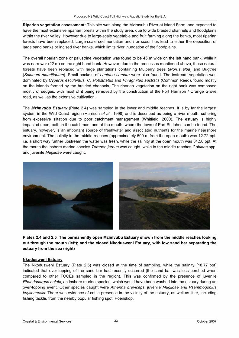
Proposed N2 Wild Coast Toll Highway: Aquatic Study for the EIA
Coastal & Environmental Services October 2007 33
Riparian vegetation assessment: This site was along the Mzimvubu River at Island Farm, and expected to have the most extensive riparian forests within the study area, due to wide braided channels and floodplains within the river valley. However due to large-scale vegetable and fruit farming along the banks, most riparian forests have been replaced. Large-scale sedimentation and / or scour has lead to either the deposition of large sand banks or incised river banks, which limits river inundation of the floodplains. The overall riparian zone or palustrine vegetation was found to be 45 m wide on the left hand bank, while it was narrower (22 m) on the right hand bank. However, due to the processes mentioned above, these natural forests have been replaced with large plantations containing Mulberry trees (Morus alba) and Bugtree (Solanum mauritianum). Small pockets of Lantana camara were also found. The instream vegetation was dominated by Cyperus esculentus, C. alobstriatus and Phragmites australis (Common Reed), found mostly on the islands formed by the braided channels. The riparian vegetation on the right bank was composed mostly of sedges, with most of it being removed by the construction of the Fort Harrison / Orange Grove road, as well as the extensive cultivation. The Mzimvubu Estuary (Plate 2.4) was sampled in the lower and middle reaches. It is by far the largest system in the Wild Coast region (Harrison et al., 1998) and is described as being a river mouth, suffering from excessive siltation due to poor catchment management (Whitfield, 2000). The estuary is highly impacted upon, both in the catchment and at the mouth, where the town of Port St Johns can be found. The estuary, however, is an important source of freshwater and associated nutrients for the marine nearshore environment. The salinity in the middle reaches (approximately 500 m from the open mouth) was 12.72 ppt, i.e. a short way further upstream the water was fresh, while the salinity at the open mouth was 34.50 ppt. At the mouth the inshore marine species Terapon jarbua was caught, while in the middle reaches Gobidae spp. and juvenile Muglidae were caught.
Plates 2.4 and 2.5 The permanently open Mzimvubu Estuary shown from the middle reaches looking out through the mouth (left); and the closed Nkodusweni Estuary, with low sand bar separating the estuary from the sea (right) Nkodusweni Estuary The Nkodusweni Estuary (Plate 2.5) was closed at the time of sampling, while the salinity (18.77 ppt) indicated that over-topping of the sand bar had recently occurred (the sand bar was less perched when compared to other TOCEs sampled in the region). This was confirmed by the presence of juvenile Rhabdosargus holubi, an inshore marine species, which would have been washed into the estuary during an over-topping event. Other species caught were Atherina breviceps, juvenile Muglidae and Psammogobius knysnaensis. There was evidence of cattle presence in the vicinity of the estuary, as well as litter, including fishing tackle, from the nearby popular fishing spot, Poenskop.

Proposed N2 Wild Coast Toll Highway: Aquatic Study for the EIA
Coastal & Environmental Services October 2007 34
Ntafufu River and Estuary The Ntafufu River site was sampled at S 31° 30’ 05.4’’, E 29° 30’ 32.6’’ (site is approximately located along the preferred-SANRAL alignment) - see Plate 2.6.
Plate 2.6 Upstream Ntafufu River, viewed from the road bridge
Water quality parameters: Electrical conductivity 17 mS/m; pH 7.9; temperature 17°C. Fish habitat present at site: This is a small clear river (approximately 10 m wide) with no turbidity. There were two predominant fish habitats present: slow/shallow and fast/shallow. Within the slow/shallow habitat little overhanging vegetation and undercut banks and root wads were found. The substrate consisted of extensive cobble beds with some bedrock. Within the fast/shallow habitat there was again little overhanging vegetation and no undercut banks or root wads. The substrate also consisted of cobble with some bedrock. The surrounding land-use is sparse residential homesteads and livestock gazing, and some limited subsistence land cultivation. There is a bridge crossing, but this appears to have little impact on the fish habitat. There is evidence of some instream laundry washing at the site. Fish species sampled: Barbus anoplus (yet to be confirmed by DNA analysis); Oreochromis mossambicus; Glossogobius callidus. Fish sensitivity: Barbus anoplus is considered moderately tolerant of habitat change, while O. mossambicus is considered tolerant of habitat change and G. callidus is moderately tolerant. Macroinvertebrate scores: SASS ASPT = 6.0. River class = Good. CES (2006) results: ASPT = 6.3. River class = Good. Riparian vegetation assessment: Instream vegetation was limited to small vegetated areas, containing either stands of Cyperus esculentus or Phragmites australis (Common Reed), interspersed with large sections of pools dominated by flat cobbles and flat boulders. Evidence of long-term disturbance either through grazing and riverbank erosion was found throughout the site, which has allowed for the introduction of invasive weeds such as Senna didymobtyra (Peanut Butter Bush) found in dense stands throughout the reach. The overall riparian zone or palustrine vegetation was found to be 3.5 m wide on the left hand bank, while it was narrower (1.5 m) on the right hand bank. The lack of wide riparian zones was due to the occurrence of steep valley sides. Plant species occurring on these steep cliffs and the upper plateaus were dominated by moist grasslands species, including geophytes. A conspicuous genus was several species of Berkeya, found beyond the riparian zones. The Ntafufu Estuary (Plates 2.7 and 2.8) is described as having a variety of natural habitats making it a very valuable estuary (Whitfield, 2000). Seine netting was conducted off a mangrove-vegetated island in a sandy area close to the mouth of the estuary, where juvenile Muglidae were caught – it would be expected that larger fish would be caught in the channel and other habitats available to fish – 34 fish species were

Proposed N2 Wild Coast Toll Highway: Aquatic Study for the EIA
Coastal & Environmental Services October 2007 35
recorded by Harrison et al. (1998). The salinity at the time of sampling was 35.08 ppt, as would be expected near the mouth. The estuary in the vicinity of the mouth was in a very good aesthetic state, although lodge accommodation was being constructed and the system is a popular holiday destination and recreational venue.
Plates 2.7 and 2.8 The Ntafufu mouth (left) showing mangrove-vegetated island and sandy channels; and the area that was seined (right) 2.7.5 Section 5: Ntafufu River to Lusikisiki (Magwa Intersection) This section of the route includes a widening of the Mzintlava River bridge. The Mzintlava is considered to be a largely natural system. Other rivers of significance include the Mzizangwa River, the Mkozi River at Fraser Falls, and the Xura River (a tributary of the Msikaba River) near Lusikisiki; however, the proposed route skirts around many of these rivers. This section of the road does not cross any estuaries due to the inland alignment of the route. Wetlands are predominant and are of the small palustrine seepage type due to the undulating topography of the area. Fourteen estuaries exist between the Ntafufu and Mlambomkulu mouth (the latter where the river falls directly into the sea at Waterfall Bluff), of which the only permanently open system is the Mzintlava. The Mzintlava Estuary was sampled in the present survey, during which three fish species were caught. Given the greater number of fish species caught by Harrison et al. (1998) in estuaries sampled during the 1998 survey when compared to the present survey, it is most likely that a diverse range of fish species would be caught should more rigorous sampling be undertaken. The road bridge across the Mzintlava River will be widened, as will most of the route. Drainage from this section of the road discharges mostly into the Mzintlava and Mkozi rivers, implying some sedimentation and water quality impacts as a result of the construction phase of the project. The coastal areas and estuaries in this section will almost certainly be more visited as a result of the road and improved access to the region, due to the natural features such as Waterfall Bluff and the holiday resorts and accommodation to let along the banks of the estuaries i.e. Mboyti River Lodge in the floodplain of the Mboyti Estuary.

Proposed N2 Wild Coast Toll Highway: Aquatic Study for the EIA
Coastal & Environmental Services October 2007 36
Table 2.11 Biotic distributions and health status of rivers and estuaries in Section 5 of the N2 Wild Coast Toll Highway
FISH MACROINVERTEBRATES ESTUARINE HEALTH
STATUS RIVER HEALTH
STATUS Myxus capensis: Lower risk / Least concern
The Mzintlava River possesses a number of sensitive macroinvertebrate families within the Plecoptera, Ephemeroptera, Trichoptera and Coleoptera. The river health class determined from ASPT scores of a number of surveys was “good”.
14 estuaries. Estuaries not sampled by Harrison. Whitfield (2000) describes the condition of the majority of the estuaries as “excellent”, although states that “urgent baseline studies are required”.
Mzintlava is largely natural.
Mzintlava River and Estuary The Mzintlava River was sampled at S 31° 25’ 30.9’’, E 29° 32’ 13.5’’ (site is located along the preferred-SANRAL alignment) – see Plates 2.9 and 2.10.
Plate 2.9 Section of Mzintlava River looking upstream from the sampling site
Plate 2.10 The Mzintlava River downstream of the sampling site
Water quality parameters: Electrical conductivity 22 mS/m; pH 8.5; temperature 16°C. Fish habitat present at the site: This is a small river (approximately 7 m wide) with greenish water colour and low turbidity. There were three fish habitats present: slow/deep, slow/shallow and fast/shallow. Within all habitats there was very little overhanging vegetation, undercut banks and root wads. The substrate within slow/deep consisted of bedrock, while substrate for the slow/shallow and fast/shallow habitats consisted of

Proposed N2 Wild Coast Toll Highway: Aquatic Study for the EIA
Coastal & Environmental Services October 2007 37
large cobble with some bedrock. There is limited surrounding area land use, although instream washing does take place at the site. There is a bridge crossing, but it appears to have little impact on the river. Fish species sampled: Barbus anatolicus (yet to be confirmed by DNA analysis). Fish sensitivity: The general intolerance of B. anatolicus has not been assessed. Macroinvertebrate scores: SASS ASPT = 6.4. River class = Good. SASS undertaken for CES (2006): two sites: ASPT = 6.0. River class = Good; ASPT = 6.7. River class = Good Riparian vegetation assessment: Instream vegetation was limited to small vegetated areas, containing either stands of Cyperus esculentus, C. alobstriatus and Phragmites australis (Common Reed) further downstream. Other conspicuous species included several specimens of Cyrtanthus breviflorus and the Ilala Palm (Phoenix reclinata), found within the riparian zones. Evidence of long-term disturbance, either through flooding, grazing and regular veld burning practices, was also evident throughout the site. The overall riparian zone or palustrine vegetation was found to be 2.5 m wide on either bank. The lack of wide riparian zones was due to the occurrence of steep valley sides. Plant species occurring on these steep cliffs and the upper plateaus were dominated by moist grasslands species. The Mzintlava Estuary (Plate 2.11) was sampled adjacent to a newly constructed lodge, which was the only accommodation that could be seen on the banks of the estuary i.e. the estuary is apparently not heavily utilized and in an “excellent” state according to Whitfield (2000). The salinity, measured in a wide stretch of the channel before it narrowed to a thin 200 m long channel connected to the sea, was 28.64 ppt. Ambassidae spp., juvenile Muglidae and Psammogobius knysnaensis were caught.
Plates 2.11 and 2.12 The Mzintlava (left) and Mboyti (right) estuaries, both looking out through the open mouth at the time of sampling
Mboyti Estuary The Mboyti Estuary (Plate 2.12), although described as a TOCE, was open at the time of sampling, but connected to the sea by a very narrow and shallow channel. The salinity of 14.14 ppt, although measured approximately 500 m from the mouth, highlighted the lack of marine influence / strong connection with the sea. Glossogobius callidus, juvenile Muglidae and Rhabdosargus holubi were caught. The estuary and nearby beaches are a popular holiday destination, with lodges fronting the system. 2.7.6 Section 6: Lusikisiki to the Mthamvuna River A number of deeply incised gorges and small streams would be crossed by the various road alignments considered in this section, e.g. Msikaba, Mthentu, Kwadlambu, Mnyameni, Kulumbe, Mpahlane and Mzamba River gorges. The Mthentu and Msikaba bridges will involve high-level bridges while other gorges will be crossed by more conventional river crossings. The route consists of two main alternatives, the so-called “SANRAL-preferred alignment” and the “coastal Mzamba route”. The preferred alignment will cross the

Proposed N2 Wild Coast Toll Highway: Aquatic Study for the EIA
Coastal & Environmental Services October 2007 38
Msikaba (plus the Kwadlambu and other tributaries of the Msikaba River), Mthentu, Mnyameni (plus the Kulumbe and other tributaries of the Mnyameni River), the Mpahlane, Mzamba, Mtentwana and Mthamvuna rivers, plus the headwaters of the Sikombe and Mpahlanyane rivers. The coastal Mzamba alignment, which deviates from the “preferred alignment” between the Mthentu and Mzamba rivers (but uses the same crossing points for each), crosses the same rivers but avoids the headwaters of the Sikombe and Mpahlanyane rivers. This section of the road does not cross any estuaries due to the inland alignment of the route. Wetlands are predominant and are again of the small palustrine seepage type due to the undulating topography of the area. While the coastal Mzamba alignment is further from the coast, the route will traverse wetlands which are important sources of a continuous supply of freshwater to the rivers and estuaries, therefore interrupting the dynamics of the wetland system which may have water quality and quantity impacts on the estuaries. Twenty five estuaries are present between the Mlambomkulu and Mthamvuna estuaries; twenty one of which are TOCEs and four of which are medium – large systems i.e. Msikaba, Mthentu, Mzamba and Mthamvuna estuaries. Whitfield (2000) describes the condition of the majority of the estuaries as “excellent”, although states that “urgent baseline studies are required”, highlighting the remoteness of the region. Ten of the fifteen estuaries sampled as part of the present survey were in this section. Fish seining results in the estuaries not sampled by Harrison et al. (1998) indicated that the estuaries could potentially contain a diverse range of fish species (should more rigorous sampling methods be used), and were aesthetically very pleasing due to the isolated and remote nature of the majority of systems suggesting near pristine conditions. As access to the coastline in this section of the Wild Coast region is very difficult, the estuaries have remained in a near pristine state, and are very important habitats for fish, as demonstrated by Harrison et al. (1998). The construction of a road through the region will improve access to the coast, with secondary effects on the estuaries through increased pressure as a result of more visitors to the region, in the form of recreational activities and the possibility of development in the region. Table 2.12 Biotic distributions and health status of rivers and estuaries in Section 6 of the N2
Wild Coast Toll Highway
FISH MACROINVERTEBRATES ESTUARINE HEALTH STATUS
RIVER HEALTH STATUS
Myxus capensis: Lower risk / Least concern B. gurneyi: Moderately intolerant of habitat change
Data from the Albany museum and from the survey undertaken for this report, suggest that the rivers between Lusikisiki and the Mthamvuna possess a high diversity of sensitive invertebrate families and can be considered as having “good” to “very good” water quality. Some of the smaller rivers around Lusikisiki have “poor” water quality due to pollution from this town.
25 estuaries - only 8 classified. Ichthyofaunal status generally “moderate - good”; water quality status “fair-good”; aesthetics “moderate - good”. Mzamba and Mtentwana systems: water quality status is “poor”. Whitfield (2000) describes the condition of the majority of the estuaries as “excellent”, although states that “urgent baseline studies are required”, highlighting the remoteness of the region.
EIS of many rivers high to very high, e.g. high for the Msikaba and Mthentu rivers, and very high for the Mnyameni, Mzamba and Mthamvuna rivers.
Kilroe Estuary The Kilroe Estuary (Plates 2.13 and 2.14) was closed at the time of sampling. The system is very small, approximately 150 m in length, and separated from the sea by a perched sandbar. The salinity (15.83 ppt), however, suggested that over-topping had resulted in an influx of marine water. A green algae growing on the bedrock throughout the estuary suggested that the estuary had not been opened (i.e. flushed) for a long period, which is likely given the small size of the catchment and perched nature of the sand bar. Litter was also apparent in the vicinity of the estuary. Only Glossogobius callidus were caught, however the presence of piscavorious pursuit predators (i.e. darters) suggested the presence of other pelagic fish.
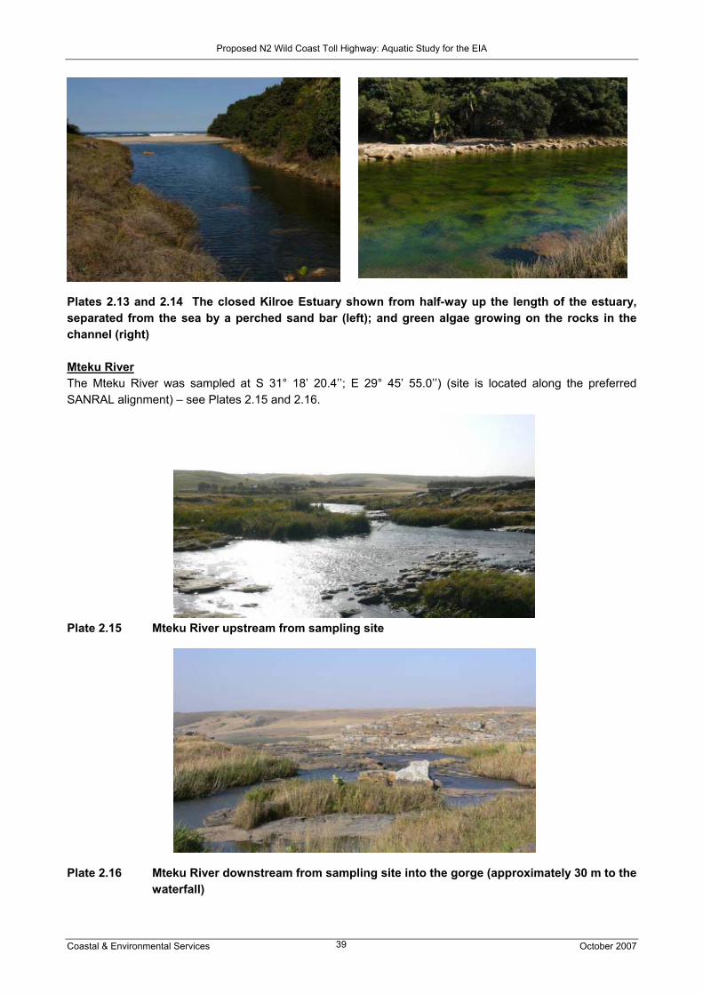
Proposed N2 Wild Coast Toll Highway: Aquatic Study for the EIA
Coastal & Environmental Services October 2007 39
Plates 2.13 and 2.14 The closed Kilroe Estuary shown from half-way up the length of the estuary, separated from the sea by a perched sand bar (left); and green algae growing on the rocks in the channel (right) Mteku River The Mteku River was sampled at S 31° 18’ 20.4’’; E 29° 45’ 55.0’’) (site is located along the preferred SANRAL alignment) – see Plates 2.15 and 2.16.
Plate 2.15 Mteku River upstream from sampling site
Plate 2.16 Mteku River downstream from sampling site into the gorge (approximately 30 m to the
waterfall)

Proposed N2 Wild Coast Toll Highway: Aquatic Study for the EIA
Coastal & Environmental Services October 2007 40
Water quality parameters: Electrical conductivity 20 mS/m; pH 8.1; temperature 15°C. Fish habitat present at the site: This is a small river (approximately 10 m wide) with slightly greenish water colour and very low turbidity. There were three fish habitats present at the time of sampling: slow/deep, slow/shallow and fast/shallow. Within slow/deep there were moderate quantities of overhanging vegetation, undercut banks and root wads. The substrate consisted of bedrock and mud. Within the slow/shallow and fast/shallow habitats there was some overhanging vegetation and limited undercut banks or root wads. The substrate consisted largely of bedrock with fissures within the bedrock and a few large stones to provide cover for fish. There is limited surrounding area land use. Although there is a crossing through the river it is over a bedrock section and appears to have little impact on the river. Fish species sampled: Barbus species yet to be confirmed by DNA analysis, possibly B. anoplus or B. gurneyi. Fish sensitivity: The general intolerances of B. anoplus or B. gurneyi to habitat change are moderately tolerant to moderately intolerant respectively. Both species require slow flow, and B. gurneyi is sensitive to water quality modification and has a strong preference for overhanging vegetation. Macroinvertebrate scores: SASS ASPT = 5.3. River class = Fair. Riparian vegetation assessment: The Mteku River site was surveyed within the Atentule region just above the waterfall. This river is fed by a number of seeps and large wetlands and joins the Msikaba River after flowing through a deep gorge. Although this river has similar attributes to the other rivers sampled, the wetlands provide a continued and elevated baseflow. Species found were dominated by areas of Palmiet (Prionium serratum) and various sedges (Cyperus spp.). These areas were extensively grazed, again hampering species identification. Medium-scale sand winning also occurred within the site at several places, which had altered the river bank structure. The overall riparian zone or palustrine vegetation was found to be 5.5 m wide on the left hand bank, while it was narrower (1.25 m) on the right hand bank. The lack of wide riparian zones was due to the occurrence of exposed bedrock. Plant species occurring on the upper plateaus were dominated by moist grasslands species, including geophytes.
Msikaba Estuary The Msikaba Estuary (Plates 2.17 and 2.18) forms the southern boundary of the Mkambati Nature Reserve, and its condition is described as “excellent” by Whitfield (2000). Stratification in terms of salinity and temperature was noted with fresher, cooler water on the surface (3.20 ppt, 17.48oC, respectively) and saltier, warmer water at a depth of 1.5 m (25.20 ppt, 20.01oC, respectively). Such stratification, particularly in temperature, is commonly noted by those who frequent the estuary for holiday purposes. The estuary is the deepest in the Wild Coast region (Harrison et al., 1998), resulting in the cool nature of the freshwater exiting the mouth.
Plates 2.17 and 2.18 Aerial view of the Msikaba Estuary (left) showing shallow nature of the connection with the sea; and area where the station was occupied in the lower reaches of the Msikaba (right)

Proposed N2 Wild Coast Toll Highway: Aquatic Study for the EIA
Coastal & Environmental Services October 2007 41
The mouth at the time of sampling was very shallow, most likely due to the deposition of marine sand in the mouth by longshore currents and the March 2007 spring high tide event. Whilst no fish were caught at the station occupied near the mouth, this was most likely due to the lack of diverse range of accessible habitats to sample, meaning seine netting was undertaken over sandy substrate on the edge of the channel. Harrison et al. (1998) recorded 22 fish species, and fishing has been banned in the estuary, highlighting the importance of the system as a nursery ground for breeding and juvenile fish, as well as larger predatory fish. Kwadlambu River The Kwadlambu River (called Ngucu by locals) was sampled at S 31° 14’ 35.9’’; E 29° 50’ 01.8’’ (site is approximately located along the preferred SANRAL alignment) – see Plates 2.19 and 2.20. Plates 2.19 and 2.20 Upstream and downstream from the sampling site on the Kwadlambu River Water quality parameters: Electrical conductivity 17 mS/m; pH 7.9; temperature 15°C. Fish habitat present at site: This is a small river (approximately 8-10 m wide) with greenish water colour and low turbidity. There were two predominant fish habitats present: slow/deep and fast/shallow. Within the slow/deep habitat there was moderate overhanging vegetation and some undercut banks and root wads. The substrate was sand. Within the fast/shallow habitat there was very little overhanging vegetation and no undercut banks or root wads. The substrate was bedrock with fissures within the bedrock and some large stones to provide cover for fish. There is very little surrounding landuse impact, although the site does contain a cattle crossing which will have a moderate impact immediately downstream of the site. Fish species sampled: Barbus anoplus (yet to be confirmed by DNA analysis). Fish sensitivity: Barbus anoplus is considered moderately tolerant of habitat change. Macroinvertebrate scores: SASS ASPT = 5.4. River class = Fair Riparian vegetation assessment: Small areas of instream vegetation exist, dominated by Palmiet (Prionium serratum) and various sedges (Cyperus spp.). This area was heavily grazed. With most of the grass burnt in the surrounding areas, grazing had intensified within the limited riparian zone of this river. The grazing activity precluded exact identification of the sedge species as these were also found palatable by the cattle. The remainder of the area was dominated by exposed rock (left hand bank) and deep rock pools, which limited the development of wide riparian zones. This river reach was largely intact with the exception of the small riffle within the survey site, which was used as a cattle and pedestrian route, utilising the exposed bedrock. The only alien vegetation found included a large stand of Eucalypt trees. The overall riparian zone or palustrine vegetation was found to be 1.5 m wide

Proposed N2 Wild Coast Toll Highway: Aquatic Study for the EIA
Coastal & Environmental Services October 2007 42
on the left hand bank, while it was wider (2.5 m) on the right hand bank. The lack of wide riparian zones was due to the occurrence of steep valley sides, composed largely of exposed rock. Butsha Estuary The mouth of the Butsha Estuary (Plate 2.21) is situated less than 500 m from the mouth of the Msikaba, and was closed at the time of sampling. The salinity was 11.81 ppt, suggesting the influence of saline water, but the water is typically fresh to brackish due to the perched nature of the sand bar and small catchment size of the estuary, thus preventing a connection being established with the sea. Only Glossogobius callidus were caught, but Harrison et al. (1998) recorded 16 species. The estuary is in the Mkambati Nature Reserve.
Plates 2.21 and 2.22 The closed, small Butsha Estuary (left), showing where the water had receded from after an over topping event i.e. wet sand in the foreground; and an aerial view of the closed Mgwegwe Estuary (right), showing the confined nature of the beach resulting in the low sand bar (non perched) Mgwegwe Estuary The Mgwegwe Estuary (Plate 2.22) was closed at the time of sampling, although the sand bar was not as perched as at other estuaries sampled in the region due to the small nature of the bay and beach. The salinity was 18.24 ppt, the highest recorded of all the TOCEs, suggesting over-topping events had recently occurred. This was confirmed by the abundance (over 200) of juvenile Rhabdosargus holubi caught, an inshore marine species which would have been washed into the estuary during an over-topping event. Other species caught were Glossogobius callidus, juvenile Muglidae and Psammogobius knysnaensis. The Mgwegwe Estuary falls within the Mkabmati Nature Reserve and its condition is described as “excellent” by Whitfield (2000). Mthentu Estuary The Mthentu Estuary (Plate 2.23) forms the northern border of the Mkambati Nature Reserve, and its condition is described as “excellent” by Whitfield (2000). The salinity of 34.16 ppt was expected due to the permanently open nature of the mouth. Whilst juvenile Muglidae were caught, this was due to the deep nature of the approximately 100m wide channel, and lack of available habitats for seine-netting. Harrison et al. (1998) recorded 32 species, and fishing has been banned in the estuary, highlighting the importance of the system as a nursery ground for breeding and juvenile fish, as well as larger predatory fish.

Proposed N2 Wild Coast Toll Highway: Aquatic Study for the EIA
Coastal & Environmental Services October 2007 43
Plates 2.23 and 2.24 Seine netting in the deep channel of the Mthentu Estuary (left); and the closed Sikombe Estuary shown from the highly perched sand bar (right) Sikombe Estuary The Sikombe Estuary (Plate 2.24) was closed at the time of sampling, and separated from the sea by a highly perched sand bar. The salinity of the lower reaches was 9.78 ppt. Amblyrhynchotes honkenii, Atherina breviceps and juvenile Muglidae were caught, although larger fish were seen from the bank but could not be caught to be positively identified due to net avoidance and lack of suitable landing sites for the net. The estuary was aesthetically very pleasing, with little evidence of anthropogenic impacts. Mnyameni River and Estuary The Mnyameni River was sampled at S 31° 08’ 13.3’’; E 29° 57’ 49.5’’ (site is approximately located along the coastal Mzamba route) in the upper reaches of the river – see Plates 2.25 and 2.26 - within a geological region composed mostly of consolidated sands. The site has been severely disturbed by activities related to the building of a low level bridge across the river downstream of the sampling site. The impoundment and diverting of the stream has resulted in channel, bed and flow modification at the site, while some discolouration of the water was also evident – possibly due to fuels from trucks collecting water at the point of the low level bridge. Water abstraction activities therefore also take place. Construction methods included the use of coffer dams within an area susceptible to erosion, refuelling of water bowsers and mixing of concrete within the riverbed.
Plate 2.25 Mnyameni River upstream from sampling site

Proposed N2 Wild Coast Toll Highway: Aquatic Study for the EIA
Coastal & Environmental Services October 2007 44
Plate 2.26 Mnyameni River downstream of sampling site Water quality parameters: Electrical conductivity 11 mS/m; pH 8.1; temperature 20°C. Fish habitat present at site: This is a small river (approximately 4-5 m wide), and the water colour has a brownish tinge due to some turbidity. There were two fish habitats present: slow/deep and slow/shallow. There was very little overhanging vegetation or undercut banks and root wads. The substrate was sand/mud. The impoundment and diverting of the stream has resulted in channel, bed and flow modification at the site with some impact on fish habitat immediately downstream of the site. Fish species sampled: Barbus gurneyi (yet to be confirmed by DNA analysis) Fish sensitivity: Barbus gurneyi is considered moderately intolerant to habitat change as it is sensitive to water quality modification and has a strong preference for overhanging vegetation. Macroinvertebrate scores: SASS was not undertaken as habitat at the site was not suitable for sampling Riparian vegetation assessment: Alien vegetation found included Guava trees (Psidium guava), Lantana camara and Black Wattles (Acacia mearnsii) found on the river banks. Limited palustrine vegetation was found within this reach, with only the adjacent seep containing any form of riparian / wetland vegetation. Species of concern or requiring relocation were not evident, possibly due dynamic nature of the site (destabilised sands), occurring within a region dominated mostly by grasslands, allowing for limited riparian zones. The Mnyameni Estuary (Plate 2.27) was open at the time of sampling, although described as a TOCE by Whitfield (2000). The salinity, as expected, was 35.00 ppt. The highest number of fish species recorded at any of the estuaries sampled was caught (at least eight) at this site, including Amblyrhynchotes honkenii, Arothron hispidus, Atherina breviceps, Glossogobius callidus, Heteromycteris capensis, juvenile Muglidae, Pseudorhombus arius, Rhabdosargus holubi and Terapon jarbua. This was largely due to the range of habitats accessible for sampling i.e. shallow and deep sandy channels, vegetation-fringed channels, shallow rocky substrate, etc.. The estuary was in an aesthetically very pleasing state, with only one lodge (which is not regularly used, according to locals in the area) in the mouth region.

Proposed N2 Wild Coast Toll Highway: Aquatic Study for the EIA
Coastal & Environmental Services October 2007 45
Plate 2.27 The open Mnyameni Estuary and range of habitats i.e. sandy sediments, rocks,
vegetated channels Kulumbe River The Kulumbe River was sampled below its confluence with the Sideni River at S 31° 07’ 40.8’’; E30° 04’ 10.2’’ (site is approximately located between the preferred SANRAL alignment and coastal Mzamba route) – see Plates 2.28 and 2.29. The Kulumbe River is a tributary of the Mnyameni River.
Plate 2.28 Kulumbe River upstream from the sampling site
Plate 2.29 Kulumbe River downstream from the sampling site

Proposed N2 Wild Coast Toll Highway: Aquatic Study for the EIA
Coastal & Environmental Services October 2007 46
Water quality parameters: Electrical conductivity 7 mS/m; pH 7.1; temperature 19°C. Fish habitat present at site: This is a small river (approximately 3m wide) with little turbidity. The only fish habitat present during sampling was slow/shallow. Within this habitat there was moderate overhanging vegetation and sparse undercut banks or root wads. The substrate was a combination of bedrock and sand/mud with some large stones. There was little surrounding landuse impact besides a small road crossing through the river, which appeared infrequently used. Fish species sampled: Barbus gurneyi (yet to be confirmed by DNA analysis) Fish sensitivity: Barbus gurneyi is considered moderately intolerant to habitat change as it is sensitive to water quality modification and has a strong preference for overhanging vegetation. Macroinvertebrate scores: SASS ASPT = 6.5. River class = Good. Riparian vegetation assessment: The instream vegetation of the Kulumbe River was dominated by Palmiet (Prionium serratum) and various sedges dominated by Cyperus textilis. In certain middle channels areas, where the dense Palmiet stands had accumulated sediment, small specimens of Trachyandra spp. were found. Marginal or overhanging vegetation was dominated by sedges (Cyperus esculentus) and Aristida junciformis. This river reach was also intact with the exception of the small riffle within the survey site, which was used as a road crossing. The exotic (invasive) vegetation was limited to seven Guava trees (Psidium guava). The overall riparian zone or palustrine vegetation was found to be 5 m wide on the left hand bank, while it was narrower (2 m) on the right hand bank. The lack of wide riparian zones was due to the occurrence of steep valley sides, composed largely of exposed rock. Plant species occurring on these steep cliffs and the upper plateaus were dominated by moist grasslands species, including geophytes. Mpahlanyane Estuary The Mpahlanyane Estuary (Plate 2.30) was closed at the time of sampling. Two stations were occupied, one in the lower reaches near the moth and one in the middle reaches, although the salinity (14.18 ppt and 14.08 ppt, respectively) and other physico-chemical parameters showed very little differences between the two stations indicating a well mixed system. More than six fish species were caught in the lower reaches, including Atherina breviceps, Gilchristella aestuaria, Glossogobius callidus, juvenile Muglidae, Psammogobius knysnaensis and Terapon jarbua. Seine netting was not conducted in the middle reaches due to a lack of available landing sites. The estuary was aesthetically very pleasing, with little evidence of anthropogenic impacts and regarded as being in an “excellent” state by Whitfield (2000).
Plate 2.30 The closed Mpahlanyane Estuary
Mpahlane Estuary The Mpahlane Estuary (Plate 2.31) was closed at the time of sampling, with a salinity of 11.62 ppt indicating limited over-topping over the perched sand bar. Glossogobius callidus, juvenile Muglidae, Monodactylus facliformes, Pomodasys olivaceum and Rhabdosargus holubi were caught. The estuary was aesthetically

Proposed N2 Wild Coast Toll Highway: Aquatic Study for the EIA
Coastal & Environmental Services October 2007 47
very pleasing, with little evidence of anthropogenic impacts and regarded as being in an “excellent” state by Whitfield (2000).
Plates 2.31 and 2.32 Shallow mud flats of the closed Mpahlane Estuary (left); and the open mouth of the Mzamba Estuary (right) Mzamba Estuary The Mzamba Estuary (Plate 2.32), although permanently open, had a salinity of 4.65 ppt at the time of sampling due to the effect of the outgoing tide. Amblyrhynchotes honkenii, Glossogobius callidus and juvenile Muglidae were caught, although Harrison et al. (1998) recorded 34 species. The estuary forms the southern border of the Wild Coast Sun Resort, although is relatively unimpacted and aesthetically very pleasing, and is an important system in terms of fish utilization as indicated by the high number of species recorded by Harrison and colleagues. Sideni River The Sideni River was sampled at S 31° 05’ 05.1’’; E30° 04’ 07.1’’ (site is approximately located between the preferred SANRAL alignment and coastal Mzamba route) – see Plates 2.33 and 2.34. The Sideni River is a tributary of the Kulumbe River, which in turn flows into the Mnyameni River.
Plate 2.33 Sideni River upstream from sampling site

Proposed N2 Wild Coast Toll Highway: Aquatic Study for the EIA
Coastal & Environmental Services October 2007 48
Plate 2.34 Sideni River downstream from sampling site Water quality parameters: Electrical conductivity 7 mS/m; pH 7.5; temperature 17°C. Fish habitat present at site: This is a small river (approximately 2 m wide) with low turbidity levels. The only fish habitat present during sampling was slow/shallow. Within this habitat there was sparse overhanging vegetation, undercut banks or root wads. The substrate was a combination of bedrock and sand/mud with some large stones. There appeared to be little impact from surrounding area land use beyond some livestock grazing. The site is used as a cattle drinking point. Fish species sampled: Barbus gurneyi (yet to be confirmed by DNA analysis) Fish sensitivity: Barbus gurneyi is considered moderately intolerant to habitat change as it is sensitive to water quality modification and has a strong preference for overhanging vegetation. Macroinvertebrate scores: SASS ASPT = 5.5. River class = Fair. Riparian vegetation assessment: The instream vegetation of the Sideni River was dominated by Palmiet (Prionium serratum) and various sedges (Cyperus rupestris, C. textilis and C. albostriatus). Marginal or overhanging vegetation was dominated by sedges (Cyperus esculentus) and stony soil specialist grasses such as Aristida junciformis. This river reach was largely intact with the exception of the small riffle within the survey site, which was used as a cattle and pedestrian crossing over the exposed bedrock of the river. This access point had created a small amount of disturbance in the form of runnels, as the footpaths erode during the wet season. The only exotic (invasive) vegetation found included single Guava trees (Psidium guava) and a small Eucalyptus woodlot further downstream. The overall riparian zone or palustrine vegetation was found to be 15 m wide on either side of the river, and extended for approximately 3 km up and downstream. Several seeps, discussed in the wetland section of the report (Chapter 3), also joined the river within this area, adding to the appearance of a broad floodplain or riparian zone. Note A number of river gorges and other river sites were assessed during the wetland / river survey of July 2007, but not necessarily surveyed due to inaccessibility or absence of instream habitat. These sites include the following:
• Mzamba River gorge • Mphalane River gorge • Downstream site on the Mnyameni River (directly above the waterfall) • Mkamela River • Msikaba River gorge • Mzizangwe River

Proposed N2 Wild Coast Toll Highway: Aquatic Study for the EIA
Coastal & Environmental Services October 2007 49
2.7.7 Section 7: Mthamvuna River to Isipingo Interchange This section of the road is approximately 148 km long and involves the rehabilitation and upgrade of the R61 between the Mthamvuna River and Port Shepstone, and the N2 between Port Shepstone and the Isipingo Interchange. This section crosses many rivers, all with existing bridge structures. The main rivers that will be crossed include the Mpenjati, Mbizane, Mzimkhulu, Mzumba, Mtwalume, Fafa, Mpambanyoni, Mkomazi and Lovu rivers. The following smaller rivers are present in the area.
• Tongazi • Domba • Mzinto • Kandandlovu • Koshwana • Mkumbane • Kaba • Ntshambili • Sezela • Mvutshini • Mzimayi • Mdesingane • Bilanhlolo • Mhlungwa • Mahlongwana • Vungu • Mfazazana • Ngane • Mhlanga • KwaMakosi • Mgababa • Zotsha • Mnamfu • Msimbazi • Mtentweni • Mvuzi • Manzimtoti • Mhlangamkulu • Mzimayi • Mbokodweni
The literature only identifies several palustrine seepage slope systems with no major wetlands occurring in this region. Fifty one estuaries exist between the Mthamvuna and the Isipingo estuaries, the majority of which (45) are TOCEs, while 4 are classified as small permanently open systems and two permanently open medium – large systems, i.e. the Mzimkhulu and Mkomazi estuaries. This section of the road is very close to the coastline (typically less than a kilometre) meaning the majority of the estuaries are crossed directly. The road would be rehabilitated i.e. resurfaced and widened between Winklespruit and the Isipingo Interchange, including widening of the Manzimtoti bridge. Construction related impacts i.e. sedimentation and water quality related problems are predicted, which is of concern as the majority of the estuaries are TOCEs i.e. not regularly flushed therefore pollutants may accumulate within the systems. After completion of the construction phase, however, impacts are anticipated to be no worse than at present, as it is an existing road and the coastline and estuaries are readily accessible and heavily utilized by residents, holiday makers and recreational fisherman. Table 2.13 Biotic distributions and health status of rivers and estuaries in Section 7 of the N2
Wild Coast Toll Highway
FISH MACROINVERTEBRATES ESTUARINE HEALTH STATUS
RIVER HEALTH STATUS
Myxus capensis: Lower risk / Least concern. B. gurneyi: Moderately intolerant of habitat change. Redigobius dewaali + Hypseleotris dayi: Lower risk; near threatened.
Some sensitive families occur in the upper reaches of many of the rivers within this section (De Moor and Baninzi, 2007 – in Appendix 1). However, in the lower reaches, these rivers are often highly impacted by surrounding area landuse.
51 estuaries. Ichthyofaunal status generally “moderate - good”, although “very poor” at the Vungu Estuary + no fish caught at the Uvuzana Estuary; water quality status “very poor -good”; aesthetics “moderate – good”, although “poor” close to Durban.
Most rivers are modified, with EIS being moderate.

Proposed N2 Wild Coast Toll Highway: Aquatic Study for the EIA
Coastal & Environmental Services October 2007 50
3. DESCRIPTION OF THE AFFECTED ENVIRONMENT 3.1 Rivers The streams and rivers found within the region are characteristic of the eastern coastal regions of South Africa, and due to geological changes have small regional catchments, with incised middle and lower reaches (Rowntree et al., 2000). The headwaters are thus found in undulating hills and as they flow towards the coast, the major river systems are found either within valleys or steep gorges due to recent upliftment of the coastal plain. Most of the mainstem rivers therefore resemble mountain headwaters with shallow boulder and pebble strewn riverbeds with numerous waterfalls, riffles (small rapids) and pools. The former-Transkei area, in particular, has numerous rivers and streams of which mainly the upper reaches are considered to be unimpacted and sensitive to development. The Transkei area receives 20% of the total surface run-off in South Africa. For this reason it has been identified by the DWAF as an important source of water supply (Nicolson et al., 1996). Extensive riparian zones / floodplains are not expected due to the low Mean Annual Runoffs (MARs), while the steep rocky banks preclude high numbers of water-loving (hydrophilic) plants colonizing these regions, i.e. these rivers generally lack large floodplain areas with broad riparian zones. Hydrophilic plants have shallow rooting depths and require their roots to be within reach of permanent water on a permanent basis. However due to the isolation of these rivers, which has resulted in the formation of the Pondoland Regional Centre of Endemism, the distribution of a large number of plant species is restricted to the region and thus require conservation and protection. Vegetation found along rivers and streams, referred to as riparian vegetation, and therefore depend on the combination of geomorphologic structure and hydrological regimes within river channels. Any changes to the instream structure and water supply (inundation) will consequently impact on the structure and function of the riparian vegetation (Rowntree et al., 2000). Natural ecosystems are usually divided functional units or habitats, such as forests or grasslands, while ecotones are those ecosystems which act as transitional environments between two different ecosystems. Riparian systems are thus defined as ecotones found between terrestrial habitats and the aquatic environment. Riparian systems thus contain elements of both systems, which consequently enhances biodiversity attributes of these riverine fringes, but equally increases their sensitivity to change (Stiling, 1996). Changes to riparian systems are usually as a result of physical perturbations of the river channels and river banks. Changes begin with the removal of plants, which in turn leads to soil instability and consequently erosion (Davies et al., 1993). Erosion is possibly the most noticeable form of riverine degradation due to high silt or sediment loads within the water column being visible. This then results in changes to instream habitats of other biota (plants and animals), due to sedimentation of habitats or changes in water quality. Construction within these environments thus exacerbates the potential for habitat degradation, not only at the site, but also further downstream. Operational phases of road networks also lead to changes in riparian systems due to changes in run-off velocities or micro-scale catchment patterns due to stormwater management requirements. Many of the Transkei rivers have not been surveyed for instream fish and macroinvertebrate populations, and assessments of present ecological state and river health on the basis of biological indicators are therefore limited. This is a relatively well-watered region, containing large, perennial and usually spectacularly beautiful and unspoiled rivers. However, the region between the Great Kei and Mthamvuna rivers falls within a region termed the “Transkei Gap” by freshwater ichthyologists. This is because fish surveys have (until recently) revealed surprisingly low numbers of freshwater fish species in these strong-flowing rivers, in spite of the excellent conditions and physical habitat for freshwater fish (Skelton, 1993; Bok, 2000). The primary indigenous freshwater fish species present in Transkei rivers was the small chubbyhead barb (Barbus anoplus), which is widespread throughout southern Africa. A number of angling species (e.g. cyprinids and smallmouth yellowfish, Barbus aeneus) were translocated from the Orange River to the Kei River system in 1964 and now dominate fish populations in most large water bodies in the Transkei

Proposed N2 Wild Coast Toll Highway: Aquatic Study for the EIA
Coastal & Environmental Services October 2007 51
(Shramm, 1993). Fish species such as mullet (e.g. Mugil cephalus, Myxus capensis) and the ubiquitous freshwater eels (Anguilla spp.), which breed in the sea and migrate in large numbers high up former-Transkei rivers, are also found. Although anthropogenic activities have had a negative impact on fish in rivers near major towns in recent years, the absence of freshwater fish species in the former-Transkei is thought to be due to biogeographical factors related to evolutionary events in the history of southern Africa (Bok, 2000). Most of the fish and macroinvertebrate surveys in the study area have been “snap-shot” surveys, with very little long-term monitoring studies undertaken. The region has been particularly under-surveyed in terms of macroinvertebrates (de Moor, Albany Museum, pers. comm.). 3.2 Wetlands The study area is dominated by a communal land tenure system with traditional leaders such as chiefs and headmen acting as custodians of the land. The current land tenure system makes it difficult for wetland management and rehabilitation programmes to be implemented in some of these areas as the land ownership issues sometimes becomes difficult and contentious. There is also a lack of important infrastructure services such as roads, electricity and supply of reticulated water. Communities rely heavily on natural resources and traditional methods of living such as keeping livestock and cultivation. This places pressure on the biophysical environment. Wetlands in these areas are therefore favoured by communities for drinking water (seeps and springs), cultivation and livestock grazing as water supply is continuous, and are found scattered throughout the study area. The study area can also be regarded as high rainfall area, which was confirmed by the Strategic Environmental Assessment for WMA 12 conducted by Coastal & Environmental Services (2006). The fact that the area is a high rainfall area and that communities rely on natural resources, pose some serious challenges for development in these areas, as wetlands can lose their value and functioning as a result of these developments. Although most South African wetlands are temporal due to the seasonality of rainfall in the country, most wetlands in the study area seem to be permanent and act as a consistent water supply for rivers and communities in the area. Plate 3.1 is a seep wetland area used for water supply by local villagers. Wetlands also provide communities with resources such as reed and sedges for building houses and crafts. As can be seen in Plate 3.1, the spring is not closed and it utilised by both people and livestock. This is a common occurrence in these areas where people share the same water resource as animals, potentially resulting in water-related diseases.
Plate 3.1 Seep area used as water supply for surrounding villagers
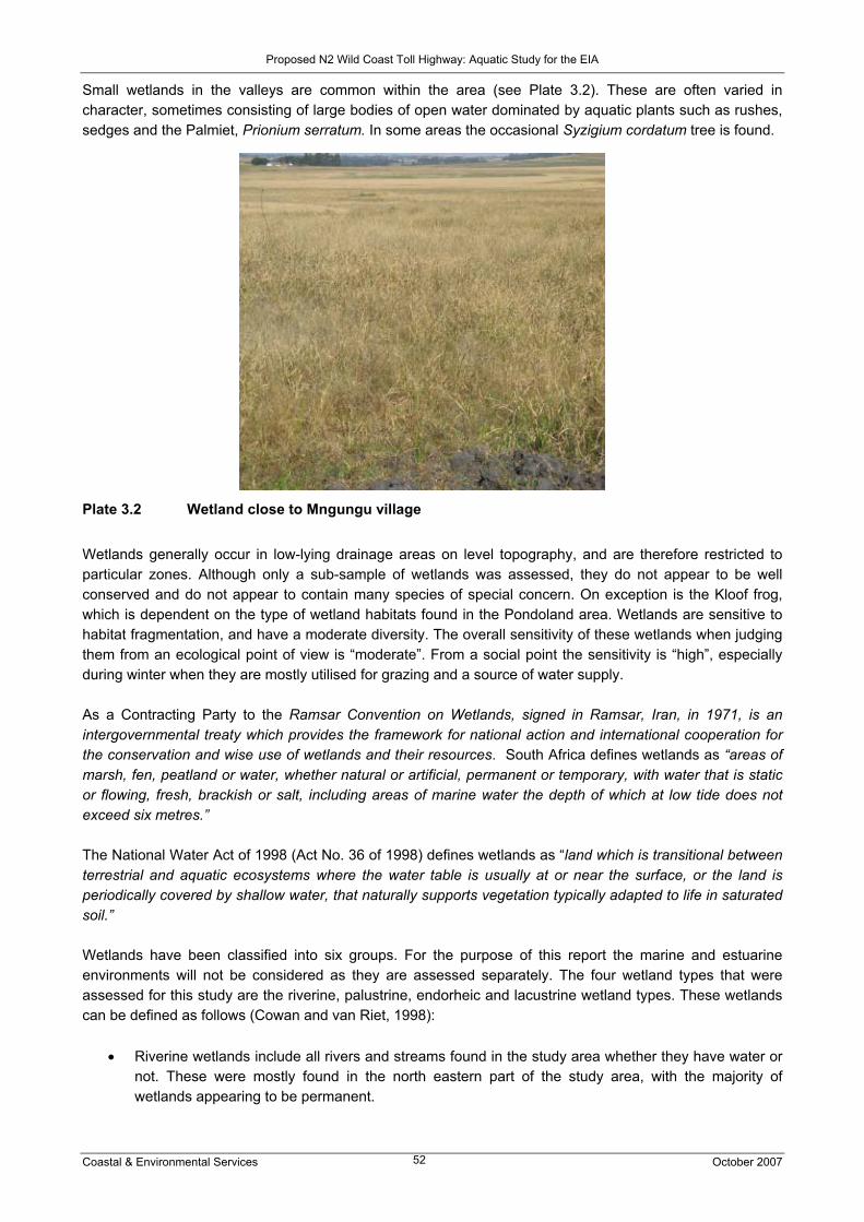
Proposed N2 Wild Coast Toll Highway: Aquatic Study for the EIA
Coastal & Environmental Services October 2007 52
Small wetlands in the valleys are common within the area (see Plate 3.2). These are often varied in character, sometimes consisting of large bodies of open water dominated by aquatic plants such as rushes, sedges and the Palmiet, Prionium serratum. In some areas the occasional Syzigium cordatum tree is found.
Plate 3.2 Wetland close to Mngungu village Wetlands generally occur in low-lying drainage areas on level topography, and are therefore restricted to particular zones. Although only a sub-sample of wetlands was assessed, they do not appear to be well conserved and do not appear to contain many species of special concern. On exception is the Kloof frog, which is dependent on the type of wetland habitats found in the Pondoland area. Wetlands are sensitive to habitat fragmentation, and have a moderate diversity. The overall sensitivity of these wetlands when judging them from an ecological point of view is “moderate”. From a social point the sensitivity is “high”, especially during winter when they are mostly utilised for grazing and a source of water supply. As a Contracting Party to the Ramsar Convention on Wetlands, signed in Ramsar, Iran, in 1971, is an intergovernmental treaty which provides the framework for national action and international cooperation for the conservation and wise use of wetlands and their resources. South Africa defines wetlands as “areas of marsh, fen, peatland or water, whether natural or artificial, permanent or temporary, with water that is static or flowing, fresh, brackish or salt, including areas of marine water the depth of which at low tide does not exceed six metres.” The National Water Act of 1998 (Act No. 36 of 1998) defines wetlands as “land which is transitional between terrestrial and aquatic ecosystems where the water table is usually at or near the surface, or the land is periodically covered by shallow water, that naturally supports vegetation typically adapted to life in saturated soil.” Wetlands have been classified into six groups. For the purpose of this report the marine and estuarine environments will not be considered as they are assessed separately. The four wetland types that were assessed for this study are the riverine, palustrine, endorheic and lacustrine wetland types. These wetlands can be defined as follows (Cowan and van Riet, 1998):
• Riverine wetlands include all rivers and streams found in the study area whether they have water or not. These were mostly found in the north eastern part of the study area, with the majority of wetlands appearing to be permanent.

Proposed N2 Wild Coast Toll Highway: Aquatic Study for the EIA
Coastal & Environmental Services October 2007 53
• Palustrine wetlands are found in areas adjacent to rivers. These could be floodplains or moist soils areas maintained by the river system. Most of these wetlands were found in the areas around Port St Johns and Lusikisiki.
• Lacustrine – lakes • Endorheic – pans or depressions with no visible inlets or outlets, i.e. water is trapped within a small
catchment and water is only lost via evaporation. Of particular interest are the wetlands not associated with permanent riverine systems, as temporary or ephemeral wetlands are more complex in their structure and function. These types of wetlands are predominantly found along Route H (Figure 3.1) and typical examples are shown in Plates 3.1 and 3.2.
Figure 3.1 Wetlands (aquamarine colour) along alternative alignments between the Msikaba and
Mthamvuna Rivers (from Hoare 2007) 3.2.1 Wetland amphibia This information is taken from the faunal specialist study for the toll road. Also refer to the relevant chapter of this study. Amphibian fauna, found in marginal riparian zones of rivers and in wetlands, are poorly known for the former-Transkei part of the route. This route follows an important transition zone between southern temperate amphibian fauna, and a tropical fauna that descends along the coastal littoral in association with the warm waters of the Agulhas Current. Tropical species reaching their southern limit in the region include:
• Bush squeaker (Arthroleptis wahlbergi) – reaches its southern limit at Port St Johns. • Long reed frog (Hyperolius nasutus) – reaches its southern limit at Mkambati. • Water lily frog (Hyperolius pusillus) – reaches its southern limit at Dwesa. • Forest tree frog (Leptopelis natalensis) – reaches its southern limit at Port St Johns. • Dwarf puddle frog (Phrynobatrachus mababiensis) – reaches its southern limit at East London. • Sharp-nosed grass frog (Ptychadena oxyrhynchus) – reaches its southern limit at East London. • Striped grass frog (Ptychadena porosissima) – reaches its southern limit at East London.
Route H

Proposed N2 Wild Coast Toll Highway: Aquatic Study for the EIA
Coastal & Environmental Services October 2007 54
Regional endemics include:
• Natal ghost frog (Heleophryne natalensis) – reaches its southern limit at Mthamvuna Gorge. • Natal chirping frog (Arthroleptella hewitti) – reaches its southern limit at Mkambati. • Knysna leaf-folding frog (Afrixalus knysnae) – mainly restricted to the Wild Coast. • Kloof frog (Natalobatrachus bonebergi) – from Port St Johns to Ngoye Forest.
Although none of these species are included in the SA red data book for amphibians (Branch, 1988), new taxa may well still exist, particularly in the poorly studied river gorges. 3.3 Estuaries Estuaries are well-known for their biodiversity due to the range of habitats available to biota making use of the estuarine environment. Breeding and juvenile marine fish enter estuaries and make use of the calm waters as nursery areas, and migratory and resident birds take advantage of the invertebrate and fish populations that estuaries support. Estuaries also support a significant number of endemic species which depend on estuaries for survival, due to the unique habitats available. Estuaries, however, also form the most threatened aquatic areas in the country due to the large numbers of coastal developments that have taken place (Turpie et al., 2002). Estuaries are threatened by activities that occur not only within and immediately around them, but also by activities that reduce and impact on the quality of the supply of freshwater inputs from catchments that feed into estuaries, including upstream rivers and their catchments (Branch et al., 1985 in: Hodgson and Allanson, 2000). It is therefore necessary to directly manage estuaries and ensure freshwater in flow, as well as the entire catchments to prevent functionally degraded systems (CSIR, 2005). Estuaries can be divided into two major types, i.e. those with a permanent link to the sea, and those that close for varying lengths of time and open after rainfall events within the catchment of the rivers that feed them. Permanently open estuaries can be further divided into barred and non-barred, depending on the amount of fluvial discharge. Temporarily Open Closed Estuaries (TOCEs) can be divided into perched and non-perched systems, depending on the height of the sand bar (berm) which is determined by beach profile, grain size and wave energy (Harrison et al., 2000). TOCEs receive marine water when the sand bar is eroded and the estuary breaches, usually after significant or sustained rainfall events, after which the estuary usually becomes tidal, or through over-topping events when marine water spills over the sand bar and into the estuary during spring high tides, and favourable wind and wave conditions. The extent and frequency of over-topping events are determined principally by the height of the sand bar. Of the approximately 250 estuaries found along the South African coastline, roughly 70% are TOCEs (Whitfield, 2000). The majority of these systems are found in the Eastern Cape, particularly along the Wild Coast. Estuaries of the Wild Coast are extremely important as they form the transition zone from the sub-tropical estuaries of KwaZulu Natal to the warm-temperate estuaries of the Eastern Cape. Turpie (2004) stated that more than 20% of the catchments in the Transkei region are affected by subsistence agriculture and many of the catchments have very high proportions of degraded land cover, with impacts felt downstream in the estuaries. However the current health status of most estuaries in the region is said to be “excellent” to “good”, but systems are also classified as “vulnerable” to “endangered” (Turpie, 2004).

Proposed N2 Wild Coast Toll Highway: Aquatic Study for the EIA
Coastal & Environmental Services October 2007 55
4. SOURCES OF RISK 4.1 Risk sources Several potential risks to the aquatic environment were identified in this study. These risks have the potential to impact on these systems either directly or indirectly. The latter type of impacts are consequently the most difficult to quantify and / or mitigate. Although discussed in more detail in the Impact Assessment section, it is anticipated that most issues / impacts could be mitigated through careful design of the river crossings, tollgates and resultant stormwater control measures. For the purposes of this section, the risks have been separated into two sections, namely those which could impact river / wetland systems and then those risks which would impact on the estuaries. The rationale being that although the physical disturbances may be similar, the resultant changes could affect the functioning of the systems in different ways. 4.1.1 Rivers and wetlands Although the proposed route alignments cross several significant river systems or are in close proximity to wetland areas, it must be borne in mind that a linear development, such as a road, does impact aquatic systems on a catchment scale as well. Simply stated, if the road was poorly designed, it could for example, on a cumulative basis impact on a large number of rivers / wetlands through the disruption of surface water flows. Furthermore, potential risks affect inland water systems through direct physical changes of the riverbank / bed or indirectly to their surrounding catchments. Removal of vegetation, coupled to an increase in hard surfaces which concentrate flows (quantity and velocities), could lead to the increased occurrence of erosion and sedimentation within systems. Erosion and sedimentation are thus secondary impacts, which also alter the physical characteristics of aquatic systems, resulting in changed habitats and water quality (e.g. increased suspended sediment loads). These are not only site-specific impacts, but also impact the systems further downstream. The potential risks, which would thus require design and construction mitigation within rivers (including ephemeral streams) and wetlands, are the following:
• Destruction of vegetation and changes in vegetation community type • Reduction in permeable surfaces leading to changes to hydrological processes (increased surface
run-off, velocities and volumes) • Increased sediment loads down rivers, resulting in changes to instream habitats and therefore
instream community structures • Risk of surface and groundwater pollution, especially with regards to tollgates
These risks are applicable to all river and wetland systems, in particular the greenfields areas of the proposed alignments. The risks within the region stretching from Port St Johns to Port Edward are further exacerbated by the steep topography and sensitive vegetation types found. With the exception of the Mzimvubu River, the remaining rivers and wetland areas are generally not prone to high levels of erosion and / or sedimentation. The risks listed above can be ascribed to the following issues: Certain natural and anthropogenic activities, e.g. floods, and placing bridge structures in a river bed or wetland area, cause immense damage to the structure of banks or river beds, and therefore the channel in

Proposed N2 Wild Coast Toll Highway: Aquatic Study for the EIA
Coastal & Environmental Services October 2007 56
which the water flows. The physical channel structure forms the template for instream habitat, and is essential for maintaining habitat quality. Any changes in channel condition and structure would have a cumulative effect, and if sufficiently extreme, may result in a shift in population structure and possibly biotic diversity at a site. Macroinvertebrates are particularly dependent on instream habitat availability, and due to their short life-spans and localised habitats, are very vulnerable to changes in channel structure and resultant changes in instream habitat. Instream habitat is also the link between activities in the riparian zone (i.e. habitat at a macro-scale) and instream biota. Degradation of the riparian zone would, therefore, result in changes to channel structure and condition, with resultant impacts on instream habitat and biotic population structure. This issue will be particularly relevant during the construction of low-level bridges. As most of the bridges planned for the N2 Wild Coast Toll Highway are high-level bridges, the impacts on riverine instream channel condition and structure should be largely avoided, although impacts on wetland habitats will be severe. Increased sedimentation loads in the aquatic environment will be one of the main impacts of the road-building and road-upgrading activities. Increased sedimentation will result from a number of activities. Irresponsible construction and upgrading activities would result in major impacts on the riparian zone of water bodies, thereby reducing the integrity of the riparian zone and a reduction in the services provided by intact and functional riparian strips (e.g. the stabilisation of river channels, banks and floodplains; flood attenuation; maintenance of water temperature and quality; provision of habitat, refuge and migration corridors for terrestrial, avian and aquatic fauna; the interception and breakdown of pollutants; the interception and deposition of nutrients and sediments; and the provision of fuels, building materials and medicines for local communities). Deterioration of the riparian strip, which is likely to take place during bridge-building and widening activities, will therefore have direct effects on channel structure, water quality, and subsequently the biotic integrity of the ecosystem. Bank destabilisation will therefore lead to increased erosion, resulting in increased sedimentation. Erosion and sedimentation will obviously be greater on steep slopes, along drainage lines and particularly where the soil types are erodible, e.g. the Mzimvubu catchment. During construction certain materials will be stockpiled at sites along the route that are conveniently located for easy access. These materials are exposed to the elements, and may also be eroded into sensitive wetlands and rivers. In areas where the road passes wetlands or slow-flowing streams, eroded materials may settle, resulting in increased silt loading. This may, in turn, reduce the water quality available to local communities and cattle, as well as disrupt the ecological functioning of these systems, particularly by coating instream habitats. Changes in drainage patterns (or hydrological processes) are primarily related to activities such as diverting rivers and streams, impoundment, or placing large permanent structures across wetlands and estuaries. The construction of the proposed road may result in the flow of small rivers, streams and wetlands being impeded, which may result in potential impacts such as:
• Formation of wetlands – water may previously have entered downstream wetlands, rivers or streams, but now form temporary wetlands upstream of new road sections.
• Ecological changes downstream due to a reduced water flow, e.g. increased siltation due to a decrease in velocity, drying up of sections of wetlands, etc.
• Destruction or physical loss of wetlands: Wetlands are sensitive and specialised areas which are particularly vulnerable to impacts from developments such as the toll highway. Loss of wetlands may result in secondary impacts on local communities and animals utilising these water resources. This is particularly relevant for this study as large parts of the greenfields route are reliant on wetland seeps and springs as domestic water sources.
In areas of high erosion along the proposed route, silting up of culverts may take place if proper maintenance is not carried out, due to the transport and deposition of eroded materials in stormwater run-off. This may

Proposed N2 Wild Coast Toll Highway: Aquatic Study for the EIA
Coastal & Environmental Services October 2007 57
result in increased upstream flooding, which will increase the scour of downstream areas of the road. Significant changes in drainage patterns may also have localised impacts on groundwater recharge rates. Potential water quality issues discussed in Section 4.1.2 also pertain to rivers and wetlands. All impacts on aquatic bodies that result in changes to habitat, flow pattern or hydrodynamics and water quality, have the potential to cause changes in ecosystem structure and function, and subsequent loss of biodiversity and species richness (including increased abundances of alien fish species and subsequent loss of indigenous fish species). Some aquatic systems and organisms are more resilient than others (e.g. estuaries, due to their dynamic nature; meaning that their ability to assimilate change is greater than more sensitive streams and wetland areas). Knowledge of aquatic environments is therefore important as it provides an assessment of ecological sensitivity and importance, and allows for a prediction of assimilative capacity. Unfortunately large parts of the study area have been poorly sampled and surveyed, therefore providing little knowledge of the species richness or “species of special concern” that may exist, particularly in the Pondoland areas. 4.1.2 Estuaries The proposed alignment of the N2 between the N2 Gonubie Interchange north of East London and the N2 Isipingo Interchange south of Durban is such that estuaries along the route will generally not be directly impacted upon. The two proposed greenfields sections i.e. where new roads will have to be constructed, are both inland and all bridges over waterways will be in the river section of the systems. Whilst portions of the remaining sections will be widened, in some cases over estuaries i.e. on the KwaZulu Natal south coast, impacts will be less severe than those associated with the construction of new roads. However, there is the very real possibility that estuaries will suffer as a result of new road construction through indirect impacts. As river catchments feed estuaries with freshwater vital for the function of estuaries as ecosystems, should the rivers en route be impacted upon, these effects will be felt in the estuaries. Estuaries are well noted for their biodiversity, and this is threatened in the following ways (Turpie, 2002):
• Habitat alteration / loss • Changes in mouth dynamics • Overexploitation • Change in sedimentation • Loss of system variability • Recreational disturbance • Change in salinity • Increased turbidity • Change in nutrient status • Chemical and organic pollutants • Solid pollution • Change in oxygen and sulphide status • Alien invasive plants • Change in temperature
There are four main issues that could potentially result in the effects mentioned above as a result of upgrade and construction of the proposed highway:
• Sedimentation • Water quantity changes • Water quality changes • Improved access to estuaries / development

Proposed N2 Wild Coast Toll Highway: Aquatic Study for the EIA
Coastal & Environmental Services October 2007 58
Sedimentation can result from poor land use within catchments leading to erosion of drainage valleys resulting in more sediment being discharged into estuaries than under natural conditions. Sediment therefore builds up within the estuary, leading to an alteration of channel structure and condition which leads to channels becoming shallower and changes of habitat for biota utilizing the estuaries. This can ultimately result in a closure of the mouth if channels become too shallow or the volume of freshwater discharging through the mouth is insufficient to remove the accumulated sediment. Stabilization of the sand bar separating TOCEs from the sea can result in fewer breaching events and associated flushing of estuarine sediments. Sedimentation can also result from construction activities including construction debris entering into river catchments (i.e. rubble either deposited into river / estuarine channels or left to be washed into channels after construction is complete) or the removal of vegetation to make way for new structures in catchments. Water quantity changes can result from either the impoundment of freshwater in river catchments, leading to less freshwater available to the estuaries than under natural conditions, or the alteration of drainage patterns disturbing the flow of rivers and estuaries. An adequate supply of freshwater is vital to maintain the state of the mouth, and a decrease in flow into estuaries can result in mouth closure or less frequent breaching events in TOCEs, as marine sediments are allowed to build up in the mouth due to tidal deposition and longshore drift. This can in turn affect the biodiversity of estuaries. Increased impermeable surfaces in river and estuarine catchments, at the expense of natural vegetation, can also increase flow into estuaries i.e. stormwater discharge and sheetwash. This changes the temporal discharge of freshwater as, for example, wetlands have the ability to retain water and release is slowly and consistently over time. If these are replaced by impermeable surfaces run-off will peak after rainfall events, while not occur during drier times changing the flow dynamics of estuaries. Deterioration in the water quality of the freshwater entering into estuaries, of estuarine water, or of marine water entering into the mouth of estuaries can impact on the functioning of estuaries as ecosystems, resulting in a loss of biodiversity. Changes in water quality can result from point source discharge of pollutants into the aquatic environment i.e. from industrial source, or from non-point source discharges such as poor catchment management practices resulting in the pollution of drainage system i.e. development within catchments. Erosion within catchments can also result in a deterioration of estuaries, as turbidity and associated metals i.e. aluminium, manganese and iron (depending on the geology of the catchment) can potentially become available in the estuarine environment. This is of particular concern in TOCEs, or in combination with a decrease in the quantity of freshwater available to estuaries which can result in the closure of mouths, as the moderating effect of marine water is not available to dilute the effects of the poor quality water. Stormwater discharge and sheetwash of impermeable surface are often sources of poor quality water, and international studies have shown that emissions from motor cars, through entry into stormwater as well as directly into water courses, is one of the key impacts negatively affecting aquatic ecosystems as a result of road use (Kennedy, 2003). Improved access to estuaries can result in secondary effects such as development within estuarine catchments. Development within catchments changes the drainage patterns into estuaries and often results in stormwater discharge point sources of pollution, and affects the aesthetics of the estuarine environment. Recreational activities such as boating and fishing can result in the release of pollutants into the environment i.e. oils and grease, and put pressure on natural resources resulting in potential depletion, for example, of fish. Development often attracts further establishment of house and recreational facilities, as well as informal settlements, adding to the pressures placed on the estuarine environment.

Proposed N2 Wild Coast Toll Highway: Aquatic Study for the EIA
Coastal & Environmental Services October 2007 59
4.2 Relevant legislative and permit requirements The overarching environmental legislation covering all components of this study is the Environmental conservation Act and the National Environmental Management Act (NEMA), upon which a decision on this road construction will be based. 4.2.1 Wetlands Wetland protection has been campaigned on national and international levels. Locally the Constitution, five (5) Acts and two (2) international treaties allow for the protection of wetlands. Wetlands are protected from the destruction or pollution by the following:
• Section 24 of The Constitution of the Republic of South Africa • Agenda 21 – Action plan for sustainable development of the Department of Environmental Affairs
and Tourism (DEAT) 1998 • The Ramsar Convention, 1995 including the Wetland Conservation Programme and the National
Wetland Rehabilitation Initiative (DEAT, 2000) • National Environmental Management Act, 1998 (Act No. 107 of 1998) • National Water Act, 1998 (Act No. 36 of 1998) • Environmental Conservation Act, 1989 (Act No. 37 of 1989) • Conservation of Agricultural Resources Act, 1983 (Act No. 43 of 1983) • Minerals and Petroleum Resources Act, 2002 (Act No. 28 of 2002) The national Department of Environmental Affairs and Tourism (DEAT) is the department which is mainly responsible for the protection and conservation of wetlands. In addition to South Africa being a signatory to the Ramsar Convention, the department has also established the Working for Wetlands programme to ensure better management of wetlands in the country. The Draft National Wetland Policy strongly advocates that any practices that result in wetland degradation should be avoided at all cost, unless effective mitigating measures can be implemented. Other policies and legislation that promote the protection of wetlands include the Conservation of Agricultural Resources Act of the Department of Agriculture and the National Water Act of the Department of Water Affairs and Forestry. 4.2.2 Rivers Any activities regarding rivers (including the riparian zone) is governed by the National Water Act (NWA) (Act No. 36 of 1998. Licensing will need to be undertaken for the relevant activities, e.g. alteration of beds and banks of the rivers and stream, stream diversions. The NWA (Chapter 3, Part 3) provides for the protection of significant water resources through the Reserve, i.e. the quantity and quality of water needed to sustain basic human needs and ecosystems (e.g. estuaries, rivers, lakes, groundwater and wetlands) to ensure ecologically sustainable development and utilisation of a water resource. The Ecological Reserve pertains specifically to aquatic ecosystems, and is primarily focussed on activities such as abstractions, discharges and alterations to flow patterns and velocity. The implication of road-building activities on aquatic systems is the requirement for licensing, and therefore the requirement for the Reserve to be assessed. This is a function normally conducted by DWAF. However, if Reserve studies are only initiated at the licensing stage there is a risk that timelines might be impacted on, particularly if they are conducted internally by DWAF. It should also be noted that Reserves might have to be conducted at different levels of confidence, depending on the river in question. For example, due to the importance of the Mzimvubu system regionally and nationally, DWAF’s requirement will probably be that the Reserve study be conducted at an Intermediate or Comprehensive level, rather than the Desktop level which might be acceptable for less important systems. Higher confidence studies require more time to conduct, as

Proposed N2 Wild Coast Toll Highway: Aquatic Study for the EIA
Coastal & Environmental Services October 2007 60
field surveys are also conducted. It is suggested that some liaison takes place with the Xolobeni Heavy Mineral Mining Team (contact person: Carina Kurpershoek of GCS), who have already initiated Reserve specialist studies for selected rivers. GCS also undertook baseline monitoring of selected rivers and estuaries in September-October 2007. Legislating governing activities in the riparian zone, specifically riparian vegetation, includes the NWA and Forestry Act, although the latter primarily focuses on terrestrial vegetation systems. It is therefore assumed that these legislation requirements will be detailed in the Vegetation Specialist Report for this study. 4.2.3 Estuaries Management of estuaries will be according to Chapter 4 of the Integrated Coastal Management (ICM) Bill, which is currently being approved by Parliament and promulgated into law by late 2008 (i.e. Draft 11.4 of 16 May 2007) (Kroese, CES, pers. comm.) According to this Bill, management will be effected using the following:
• National estuarine management protocol, which state that estuaries and the estuarine ecosystems of which they form part must be managed in a coordinated and efficient manner and in accordance with a national estuarine management protocol, which must be prescribed by the Minister within two years of the Act coming into force:
The national estuarine management protocol must - (a) determine a strategic vision and objectives for achieving effective integrated management of
estuaries and estuarine ecosystems; (b) set standards and principles for the management of estuaries and estuarine ecosystems; (c) establish procedures or give guidance regarding how the boundaries of estuarine
management areas should be determined, how these areas should be managed and how the management responsibilities are to be exercised by different organs of state and other parties;
(d) establish minimum requirements for estuarine management plans; (e) identify who must prepare estuarine management plans, the process to be followed in doing
so and the periods within which they must be completed; and (f) specify the process for reviewing estuarine management plans to ensure that they comply
with the requirements of this Act.
• Estuarine management plans that must -
(a) apply to an estuarine management area which is defined in that plan; and be consistent with – (i) the national estuarine management protocol; and
(ii) the national coastal management programme and with the applicable provincial coastal management programme and municipal coastal management programme referred to in Parts 1, 2 and 3 of Chapter 6.
(b) be developed by means of a process that – (i) involves a public participation process in accordance with Part 5 of Chapter 6; and (ii) is consistent with the protocol and coastal management programmes.
• An estuarine management plan may form an integral part of a provincial coastal management
programme or a municipal coastal management programme. The Eastern Cape Parks Board has initiated this process for the Mthentu and Mbashe estuaries
• Provincial park authorities are currently the implementing agencies for estuaries, although Stakeholders would include the likes of SANRAL; however they would not be the overall responsible agent.
• Municipal legislation is also available in some areas to assist with the management of estuaries.

Proposed N2 Wild Coast Toll Highway: Aquatic Study for the EIA
Coastal & Environmental Services October 2007 61
Additional legislation governing the management of estuaries includes the Marine Living Resources Act, which focuses on the sustainable management of marine environments, including estuaries, as many marine line fish populations utilize estuaries as nursery areas, e.g. the White Steenbras and Spotted Grunter. It must also be noted that currently estuaries do receive the following protection within the study region:
Section 39 of the Transkei (Environmental Conservation) Decree 9 of 1992 creates a Coastal Conservation area 1 km wide (excluding Municipal land) extending along the entire length of the former Transkei coast. This is measured from the high water mark of the seashore and relevant tidal estuaries to 1 km inland. The administration of this Decree is the responsibility of the Eastern Cape Department of Economic Affairs Environmental and Tourism. In terms of this Decree, the following activities are prohibited within the declared Coastal Conservation area, except under permit:
• the clearance of land or the removal of sand, soil, stone or vegetation; • the development of picnic areas, caravan parks or similar amenities; • the erection of buildings; • the construction of railways, landing strips, slipways, landing stages or jetties; • the building of dams, canals, reservoirs, water purification plants, septic tanks or sewage works; • the laying of pipelines or the erection of power lines or fencing; • the establishment of waste disposal sites or the dumping of refuse; • the construction of public or private roads or any bridle paths or foot paths; or • the undertaking of any other activity which disturbs the natural state of the vegetation, the land or
any waters which may occur in the demarcated area. 5 IMPACT DESCRIPTION AND ASSESSMENT The Terms of Reference for the study required that the following alternatives be assessed:
• The “do nothing” alternative. This alternative implies no construction activities except for routine maintenance. The natural environment in the study area is currently on a negative trajectory due to ineffective management, which means its present state is expected to deteriorate over time. If not managed properly, the state of aquatic ecosystems will be further impacted on by increasing urban pressures and related activities.
• SANRAL’s-preferred alignment between Lusikisiki and the Mthamvuna River (the focus of the July field survey)
• Site-specific alternative route alignments in the greenfields sections of the proposed route, i.e. in the sections between Ndwalane and Ntafufu and Lusikisiki and the Mthamvuna River (as outlined in Section 5.4 of the Final Scoping Report)
• The coastal Mzamba route between Lusikisiki and the Mthamvuna River (the focus of the July field survey)
• Alternative mainline toll plaza positions to SANRAL’s preferred Ndwalane and Mthentu mainline toll plazas
In addition, impacts along the route corridor should distinguish between construction and operational impacts, as well as the rating of impacts pre- and post-mitigation. For the aquatic systems, the two alignment options that present the major differences in ratings and impacts are SANRAL’s-preferred alignment and the coastal Mzamba route. An attempt has been made to conduct impact ratings for wetlands, with the focus on the two alternative alignments in the greenfields section between Lusikisiki and the Mthamvuna River, i.e. the coastal Mzamba route and the SANRAL-preferred alignment. The limited data available for wetlands, including wetland maps, and the brevity of the July field survey, does not allow for high resolution. As the alternative toll plazas in Sections 3 (Alternative toll plaza) and 4 (Ndwalane toll plaza) of the route, and Section 6 (Mthentu and Alternative toll plazas) will not impact on any aquatic systems, they have not been compared in this study.

Proposed N2 Wild Coast Toll Highway: Aquatic Study for the EIA
Coastal & Environmental Services October 2007 62
With regard to pre and post mitigation, CES has assumed that the without mitigation scenario is when construction or operation occurs without any environmental management / best management practices in place, i.e. no Environmental Management Plan is used. Mitigation thus includes the implementation of best practice measures (SANRAL Drainage Manual) and suitable environmental management plans (SANRAL Generic Environmental Management Plan). However any recommendations made in this report should be included into the EMP and be implemented and monitored by the Environmental Control Officer. 5.1 Impacts along the route corridor: Rivers and wetlands It was established in this study that the proposed development would have several direct impacts on the hydrological and instream environments. These affects could further be divided into environmental changes both in the construction and operational phases of the development. Responsible construction would be required most for lower level bridges, while high-level span bridges over the gorges would not impact on the instream environment, but could lead to instability within the upper slopes or riparian areas of the river channels and wetland areas. Note that all the road sections are expected to experience similar impacts for instream and riparian vegetation – although the confidence in this assessment is low due to little historical data and only one field survey undertaken for this study. The significance of each of the impacts on the instream and riparian vegetation are summarised in Table 5.1. The impacts shown in Table 5.1 are not a summation of the impacts for the entire road as the impacts have been assessed for each of the river crossings. Each of these impacts were thus similar and thus to avoid repetition for each road section, Table 5.1 is shown. Instream (fish and macroinvertebrates) and wetland assessments are presented in Tables 5.2 – 5.8 per road section. Maps are also shown per road section, indicating sites of historical surveys as well as the July 2007 survey. Destruction of riparian vegetation and loss of sensitive habitats Description of effect The dominant vegetation type within the proposed bridge crossing footprints is grassland, hydrophilic grasslands and small patches of coastal forest. Instream and riparian vegetation is limited to small bands or fringes containing mostly sedges, reeds and Palmiet. These vegetation types, together with the highly erodible soil types must be considered at all times during construction. Without mitigation and consideration of the Palmiet areas, this impact would have a high significance as excessive removal of vegetation without rehabilitation would result in erosion. Mitigation Clearing of vegetation should be scheduled for the drier winter months and limited to areas immediately needed for construction. Vegetation stripping should occur in parallel with the progress of road construction to minimise erosion and/or run-off. Large tracts of bare soil will either cause dust pollution or quickly erode and then cause sedimentation in the lower portions of the catchment. Large stands of Palmiet should be avoided during the construction phase and viable populations should remain in situ to allow for the possible recovery of these stands. Only selected plant species must be used in the re-vegetation process. Assessment (with mitigation) – Section 1 – 7 Riparian and Instream vegetation By keeping the clearing of any vegetation to a minimum both in areas where the road and bridges are being upgraded or newly built, will reduce the overall impact from high to low (Table 5.1). The re-vegetation of these areas after construction should also be monitored during the operational phase. The overall impact is rated as permanent due to the definite change or resetting of the plant community structure. However, if suitable indigenous species are used in the re-vegetation / rehabilitation process, the impact would be regarded as low, i.e. with mitigation. This would also aid in reducing the other impacts such as the increasing the surface area of permeable surfaces and reduce the diversion of flow to low, providing “soft” run-off areas, which slow flows and trap any pollution. This is especially significant for the greenfields sections 4 and 6, where the road crossings are in close proximity to estuaries.

Proposed N2 Wild Coast Toll Highway: Aquatic Study for the EIA
Coastal & Environmental Services October 2007 63
Physical change to wetland areas Description of effect The proposed road alignments within the proposed routes would avoid passing through any major wetlands. However due to the high number of the smaller seepage type wetlands, this may not always be possible, with particular reference to Route H (refer to Figure 3.1), where the road alignment will impact on large wetland areas. Wetland processes are altered not only through physical change, but through the alteration of linked processes such as surface water flows and topography. Most wetlands are linked to groundwater systems and any change to water tables, could thus indirectly result in wetlands drying out, if surface water flow or groundwater movement directions are altered. This could occur during the construction of large borrow pits, which have the potential to alter water tables. Conversely, if excessive stormwater is diverted into a wetland, the wetland could change from temporary to always being inundated. Plant communities then change from grasses or sedges to reeds and bulrushes, and if the wetland is not sufficiently protected from sustained high flows, it could also erode. These wetlands would also contain levels of pollution, found in the run-off generated from the road surfaces and thus the water would not always suitable for human use or contact. The importance of each wetland should thus be considered due to the ecological and social aspects raised in this report, i.e. a reduction in wetland plant cover would reduce the available ecological habitats, while a reduction or excessive increase in water levels would reduce the available resources (plants) for domestic, livestock use and for the continued functioning of the wetland. Temporary wetlands are an important source of winter grazing (bulrushes are not palatable) and also contain a high proportion of geophytes. Most geophytes are considered a source of food or medicine. Mitigation Construction of the road should as far as possible not occur within any wetlands, thus resulting in their alteration or removal. This includes assessing the possible changes to wetland conditions; hydrological regimes etc. on wetland function when selecting sites for borrow pits, a requirement in the Department of Minerals and Energy mining permit process. Further mitigation would be to ensure that no flows are altered and it is assumed that the SANRAL Drainage manual stipulations will be implemented, i.e. flows are not diverted or impounded by the physical structure of the road. Assessment With road sections 1, 2, 3 4, 5 and 7 (Table 5.2b, 5.3b, 5.4b, 5.5.c, 5.5d and 5.6b) the impact of physical change to wetlands areas was assessed as being low with mitigation in the construction and operational phases, as the most of the road works would consist of upgrading the existing routes. Any changes to the plant communities or diversion of flows, as well as the physical disturbance of the wetlands, would be rated as a medium impact both in the construction and operational phases without mitigation. This would lead to the reduced functioning of the wetlands and impact on the resources users. Impacts within road section 6 (Tables 5.7c & 5.7d) were rated slightly higher than the remaining road sections, due to the increase in the number and size of the wetlands, with most also being in a better condition. Within the greenfields section, due to the dependence of the local communities on wetlands for water, the SANRAL preferred route would have less of an impact (low) in the operational phase, while Coastal Mzamba (Route H) would be rated as having a medium impact both in the construction and operational phases due to the number of wetlands that would be crossed (Figure 3.1). The construction and operational phase impacts for the SANRAL route was also rated as medium and low respectively with mitigation, due to the permanent changes that could be brought about by changes to hydrological regimes, which could in turn impact on the wetland water supply, i.e. re-direction of flows during construction period and these impacts would then continue into the operational phase, although lower, even with mitigation.

Proposed N2 Wild Coast Toll Highway: Aquatic Study for the EIA
Coastal & Environmental Services October 2007 64
Loss of instream habitat due to changes in channel structure and condition Description of effect Certain natural and anthropogenic activities, e.g. floods, and placing bridge structures in a river bed or wetland area, cause immense damage to the structure of banks or river beds, and therefore the channel in which the water flows. The physical channel structure forms the template for instream habitat, and is essential for maintaining habitat quality. Any changes in channel condition and structure would have a cumulative effect, and if sufficiently extreme, may result in a shift in population structure and possibly biotic diversity at a site. Mitigation
• Bridges must span the entire width of the channel and floodplain so as to avoid disturbance to the riparian zones of rivers.
• Pillars, columns or bridge buttresses should not be placed in instream or in riparian zones, if at all possible.
• The disturbance of instream channels and riparian zones during bridge construction must be minimized.
• The number and width of pillars, vertical columns and buttresses placed within the river channel and floodplain should be minimised.
• Physical structures, which could later alter hydrological regimes, should not be placed in the vicinity of any wetlands.
Assessment By keeping the physical footprint of the road and verges that would require clearing to a minimum, i.e. not extend clearing to areas beyond the required road reserve, together with the short duration period required for construction, instream disturbance would be limited. The overall impacts for road sections 1-3, 5 and 7 would be to low or very low (with mitigation) during the construction phase only as these sections of road are currently operational. This is based on the proposed designs, in which SANRAL have taken cognisance of localised hydrological processes and the probability for any additional changes within these habitats would not be significant. The level of construction required for the Mzimvubu and Ntafufu Bridges was assessed has having a slightly higher impact (Section 4) due to the number of bridge piers within the river beds. The localised impact is rated medium and high without mitigation, due to potential downstream impact of sedimentation for the respective bridges. The Ntafufu was rated higher due to the type of instream habitat (cobble / riffle) that would be impacted upon. These environments are important for instream biota, especially in the upper catchments of systems. With mitigation the impact of both bridges could be reduced to low (Table 5.5a & 5.5b). The assessment of Section 6, with regards riverine (instream) issues presented a number of impact iterations, namely, the two alternative routes (Route H / Coastal Mzamba) and the “preffered SANRAL” route, as well as the possible impact of particular bridges within these routes namely on the Mzamba, Mnyameni Kulumbe (Table 5.7a) and the remaining bridges on the smaller streams (Table 5.7b). Without any mitigation, the loss of instream habitat would be high for the Mzamba, Mnyameni and Kulumbe Rivers; however this would be probable for Route H and highly probable for the SANRAL preferred route. With mitigation the significance could be reduced to low – very low for both options (Table 5.7a), but this would be improbable for Route H and probable for the SANRAL route. On the remaining bridges (Table 5.7b) the impact of Route H would probably be medium, while the SANRAL route would be high without mitigation (highly probable). With mitigation the impacts would be reduced to low – very low for both options, but again these impacts would be more probable along the SANRAL Route.

Proposed N2 Wild Coast Toll Highway: Aquatic Study for the EIA
Coastal & Environmental Services October 2007 65
Increased surface run-off Description of effect Vegetation not only stabilises soils, but also reduces surface run-off velocities when rainfall occurs. Attenuation of surface water flow encourages permeation of the soils and contributes to maintaining water table levels (Davies et al., 1993). During the construction phase, with no instream vegetation cover, water velocities will increase. Further in the case of this project, together with the increased risk of erosion, all of the surface run-off will be diverted via the road away from localised or micro scale catchments. If the surface run-off is reduced this would affect the availability of water for the use by plants within the riparian and wetland areas. Over an extended period of time, these systems will dry out and possible recovery will be impeded. Conversely, if excessive stormwater is diverted into a wetland, the wetland could change from temporary to always being inundated. Plant communities then change from grasses or sedges to reeds and bulrushes, and if the wetland is not sufficiently protected from sustained high flows, it could also erode. These wetlands would also contain levels of pollution, found in the run-off generated from the road surfaces and thus the water would not always suitable for human use or contact. The importance of each wetland should thus be considered due to the ecological and social aspects raised in this report, i.e. a reduction in wetland plant cover would reduce the available ecological habitats, while a reduction or excessive increase in water levels would reduce the available resources (plants) for domestic, livestock use and for the continued functioning of the wetland. Temporary wetlands are an important source of winter grazing (bulrushes are not palatable) and also contain a high proportion of geophytes. Most geophytes are considered a source of food or medicine. Mitigation The construction of a surface stormwater drainage system during the construction phases must be done in a manner that would protect the quality and quantity of the downstream system. The use of swales, which could then be grassed for the operational phase, is recommended as the swales would attenuate run-off water. The purpose of the retention swales is to ensure that stormwater containing silt and other sediments will settle out (commonly accepted sound environmental practice). It is expected that seepage, evaporation and overflow will occur in the swale retention areas ensuring that the water released off-site is of a better quality. It is further recommended that these swales and retention ponds be incorporated into the operational phase. The velocity of water that may reach wetlands should be slowed before it is intercepted by virgin soils using a siltation and erosion control structure, which abuts with natural bedrock. The plans and specification for this structure should be forwarded to the relevant stakeholders such as Working for Wetlands and local municipalities.

Proposed N2 Wild Coast Toll Highway: Aquatic Study for the EIA
Coastal & Environmental Services October 2007 66
Assessment By keeping the physical footprint of the road and verges that would require clearing to a minimum, i.e. not extend clearing to areas beyond the required road reserve, together with the short duration period required for construction and the limited surface areas impacted on, the overall impacts for road sections 1-5 would be reduced to low with mitigation. After construction and in the operation phase, the impacts were also rated as low for these road sections based on the proposed designs, in which SANRAL have taken cognisance of localised hydrological processes, together with re-vegetation (Tables 5.2b, 5.3b, 5.4b, 5.5c, 5.5d, 5.6b). This impact was rated differently for the greenfields section 6 (Table 5.7c & 5.7d). Without mitigation, the construction and operation impacts along Route H, would be rated high and medium respectively due to the number, size and social importance of the wetlands traversed. With mitigation, the impacts could be reduced to medium in both project phases. This was similar for the SANRAL route, with the exception being that the operational impacts, with mitigation were rated as low. This was due to the consideration of the mitigations and that there were fewer wetlands that would be impacted on along the “preferred” route. Risk of surface and groundwater pollution, including turbidity loads due to sedimentation and other pollutants Description of effect During the construction phase, due to the reduction of vegetated plant cover and any works that would have to take place within the river channels, sediment will enter the systems. This would lead to increased turbidities and pose sedimentation risks within the downstream areas if not managed using the methods listed below. During operations, diesel and oils and any other chemical substances conveyed along the road, will pose a threat to the continued functioning of the instream and adjacent areas, if by chance these are dispersed via surface run-off, or permeate into the groundwater. Changes to water quality (surface and groundwater) impact on the functioning of plants and other instream biota. This impact would have a high significance on the instream biota as only a minimal amount of pollution could impact on instream conditions without mitigation. Mitigation All construction materials including fuels and oil should be stored in a demarcated area that is contained within a berm to avoid spread of any contamination. Cement and plaster should only be mixed within mixing trays. Washing and cleaning of equipment should also be done within a bermed area, in order to trap any cement or plaster and avoid excessive soil erosion. These sites must be rehabilitated prior to commencing the operational phase. Mechanical plant and bowsers must not be refuelled or serviced within or directly adjacent to any river channel. The following mitigation must be undertaken to avoid excessive sediment loads and other contaminants in rivers and wetlands:
• Emergency plans must be in place in case of spillages onto road surfaces and/or into river and wetland systems.
• Chemicals used for road surfacing and bridge building must be stored safely on site and surrounded by bunds. No stockpiling should take place within a wetland.
• Storage containers must be regularly inspected so as to prevent leaks into aquatic systems, e.g. groundwater.
• Toll plazas should be designed with a designated area for trucks, emergency vehicles etc., so as to prevent leakage of oil/grease and petrol into groundwater. Appropriate oil traps should be incorporated into the design of toll plazas.
• Littering and contamination of water sources during construction must be mitigated by effective construction camp management.

Proposed N2 Wild Coast Toll Highway: Aquatic Study for the EIA
Coastal & Environmental Services October 2007 67
• All stockpiles must be protected from erosion, stored on flat areas where run-off will be minimised, and be surrounded by bunds.
• Stockpiles must be located away from river channels if at all possible and for as short a time as possible.
• Erosion control of all banks must take place so as to reduce erosion and sedimentation into river channels or wetland areas.
• Pillars, vertical columns and buttresses should not be placed within river channels if at all possible. If this is necessary, all precautions should be taken to avoid excessive disturbance of the bank and increased sedimentation into the river channel. If work must take place within the channel it is suggested that coffer dams are built around the works area to trap any possible pollutants or sediments.
• Silt traps must be placed down slopes where vegetation stripping is taking place, so as to catch any silt which may move into the rivers or wetlands.
• Silt traps and culverts should be regularly maintained and cleared so as to ensure effective drainage. • Water diversion and erosion control structures must be capable of withstanding storm events with a
probability of greater than 50% for the time of year during which construction takes place or as specified by the hydrological engineer.
• Weather forecasts from the South African Weather Bureau of up to three days in advance must be monitored on a daily basis to avoid exposing soil or building works or materials during a storm event and appropriate action must be taken in advance to protect construction works should a storm event be forecasted.
• The construction camp and necessary ablution facilities meant for construction workers must be well removed from aquatic systems, especially undisturbed wetlands.
• The water quality in the streams supplied by wetlands that will be affected should be tested prior to the commencement of construction activities with the objective of establishing baseline data for further monitoring of water quality. These data can be used as a level on which upon monitoring will be based.
• Local people should be employed to act as litter patrols on a weekly or daily basis if necessary during the construction phase, to ensure that pollution is reduced at all times.
The following mitigations are recommended for the operational phase:
• Emergency plans must be in place in case of spillages onto road surfaces and/or into river and wetland systems.
• The oil traps incorporated into the design of toll plazas should be serviced on a monthly basis, especially before the summer rainfall period
• Erosion control measures should be monitored to ensure their effectiveness. • Silt traps and culverts should be regularly maintained and cleared so as to ensure effective drainage. • Local people should be employed to act as litter patrols on a weekly or daily basis if necessary
during the operational phase, to ensure that pollution (solid waste) is reduced at all times. Assessment By keeping the physical footprint of the road and verges that would require clearing to a minimum, i.e. not extend clearing to areas beyond the required road reserve combined with the short duration period required for construction within the riverine habitat, the overall impacts for all road sections would be reduced to low with mitigation. After construction and in the operation phase, the impacts were also rated as low for all the road sections based on the proposed designs in which SANRAL have taken cognisance of hydrological processes. During the operations the potential impacts or rather risk of pollution events occurring are reduced, as most areas will be re-vegetated and SANRAL should put in place an emergency response programme. If managed well, the possibility of any impacts related pollution events and or sedimentation, both in the construction and operations phase could be reduced to low for any road sections with the exception of the construction of the Mzimvubu (Table 5.5a), Ntafufu (Table 5.5b), Mzamba, Mnyameni and Kulumbe bridges (Table 5.7a). During the construction phase the impacts most related to sedimentation

Proposed N2 Wild Coast Toll Highway: Aquatic Study for the EIA
Coastal & Environmental Services October 2007 68
were rated as high (Route H), and medium (preferred route) for the Mzamba, Mnyameni and Kulumbe bridges without out any mitigation. However regardless of the route chose, this would be reduces to low – very low for all these bridges. The Mzimvubu and Ntafufu bridges were rated as medium (without mitigation) and low with mitigation for both impacts related to sedimentation and other pollutants. All remaining bridges for road section 6 (Table 5.7b) were rated as medium (Route H) and high (SANRAL), for both construction and operational phases without mitigation due to consequences of sedimentation and other pollutants, which could impact on the estuaries in close proximity. Changes in drainage patterns due to the construction of the road Description of effect Changes in drainage patterns are primarily related to activities such as diverting rivers and streams, impoundment, or placing large permanent structures across wetlands and rivers. The continued functioning of rivers and the instream biota is dependent on sustained base flows. Any interruption of these flows then impacts on the survival of the plants and organisms. Estuaries are also dependent of freshwater, and should sufficient water be diverted from a catchment, aspects such as mouth closure could result. Small scale changes in the hydrological regime, as a result of roads, are probably the worst impact that could result from road construction and operation. Mitigation
• Adequate drainage must be included in road design so as to ensure effective drainage of wetland areas.
• Rehabilitation of slopes must be carried out (e.g. particularly where bridge-building will take place in river gorges) so as to ensure the recovery of established drainage patterns.
• Stormwater drainage from the road surface should be deviated from wetlands and drainage areas. The use of Reno mattresses and Armourflex is recommended for the diversion of stormwater from entering wetlands or streams directly.
Assessment By reducing the potential for any significant changes in drainage patterns and the short duration period required for construction within the riverine habitat, the overall impacts for all road sections would be reduced to low with mitigation. After construction and in the operation phase, the impacts were also rated as low for all the road sections based on the proposed designs in which SANRAL have taken cognisance of hydrological processes. Reduction in permeable surfaces Description of effect Hard engineered surfaces reduce the amount of permeable surfaces for water to penetrate the soils and maintain the local groundwater systems. Due to the linear nature of the proposed project and cumulative impacts, the environmental significance on the vegetation could be significant without mitigation as water is then diverted and the soils then dry out and later erode due to the lack of plant cover. Mitigation The area covered by the footprint of this development should be balanced with suitable stormwater run-off areas, making extensive use of grassed swales, gabions and reno mattresses. This will reduce surface flow velocities and allow time for the water to permeate the local soils and groundwater systems. This will maintain localised flows to sustain the surrounding wetlands and / or vegetation.

Proposed N2 Wild Coast Toll Highway: Aquatic Study for the EIA
Coastal & Environmental Services October 2007 69
Assessment With the exception of the hard surfaces of the roads, all the remaining areas should be re-vegetated. Wetland areas should be left intact as far as possible. If this is borne in mind, during construction and in the operation phase, the impacts would be low for the road sections 1-5, with or without mitigation, as this linear development occurs within areas that are mostly still vegetated, i.e. the development is not adding hard substrates within an urban or industrial area (Tables 5.2b, 5.3b, 5.4b, 5.5c, 5.5d and 5.6b). Again the exception being the greenfields section 6 due to the wetland areas. For this reason the construction and operation phases of Route H were rated as high, without mitigation and medium and low with mitigation. The medium rating for the construction phase with mitigation (Table 5.7c) was as a result of most mitigations not yet been in place or being re-vegetated, e.g. swales. This is assumed that a suitable alignment within the proposed route corridor will be found to protect the wetland areas in particular. Diversion of flow by hard surfaces Description of effect Roads involve the creation of linear hard surfaces, which usually include the provision of stormwater drainage. This will divert further flow away from any water bodies, as well as increase flow velocities of run-off and increase the risk of pollution if any of this stormwater contains spilled oils, fuels or coolants from passing traffic. This is especially the case for toll plazas, where large quantities of spilled oils may leak from vehicles while idling. Toll plaza areas should make provision for this with stormwater control areas being constructed with suitable sumps, which would not only trap sediments, but oils and other hydrocarbons. Due to the nature and sensitivity of the rivers within Section 6 of the proposed alignments, it must be advocated that these sumps be cleaned by a reputable waste handling company at regular intervals prior to summer rainfall events. This would prevent these systems from reaching full capacity. Unmitigated development would result in significant impacts on surrounding river systems due to the diversion of flows. Mitigation Stormwater should be discharged into retention swales. These could be used to enhance the sense of place, if they are grassed with indigenous vegetation. Any stormwater should not enter any wetland areas directly, but only via structures such as swales. The toll plazas must be designed with oil traps to prevent any contamination of the downstream areas. Assessment By reducing the potential for any significant changes in drainage patterns and the short duration period required for construction within the riverine habitat, the overall impacts for all road sections would be reduced to low with mitigation. After construction and in the operation phase, the impacts were also rated as low for all the road sections based on the proposed designs in which SANRAL have taken cognisance of hydrological processes. With mitigation this impact has been rated as medium for all road sections (Table 5.1), but should be focused on by the road engineers in the greenfields sections of the proposed road. Change in vegetation community type Description of effect The natural vegetation found within any given landscape is dependent on a number of natural parameters. These parameters, such as hydrology, temperature and soils determine the type of vegetation that will occur (Stirling, 1996). With disturbance of any natural environment the potential of introducing exotic plant species during the construction phase poses a risk to indigenous plant species. This could lead to impacts with a High significance without mitigation due to the importance of the flora within the region. With careful management during rehabilitation phase of the project, which extends into the operational phase, this impact could be reduced to low. In other words, although the impact is initiated by construction, it is poor rehabilitation that will allow for the colonisation of weeds or exotic plants in the operational phase, thus is impact is an operational issue as recovery of vegetation community types is a long term process.

Proposed N2 Wild Coast Toll Highway: Aquatic Study for the EIA
Coastal & Environmental Services October 2007 70
Mitigation The use of indigenous plants must be encouraged in the rehabilitated areas, and stockpiles containing mostly exotic or weedy species should not receive specialised handling and should be covered for extended periods to inhibit seedling germination of these species. Active management and eradication of exotic / alien plant species should also occur when seedlings are found. The plant species listed within this report together with the terrestrial vegetation study should be used by the Environmental Control Officer, to select the appropriate species. In other words the use of hygrophilous grasses must be used in the rehabilitation / re-vegetation of the riparian zones. Where slopes are suitable, riparian trees should also be planted, where natural forests currently occur. All areas disturbed by construction activities must be rehabilitated to their former state once construction activities have ceased and should be monitored afterwards. The re-vegetation must strive to equal the status quo, especially for the greenfields sections, of the riparian zones. This also pertains to floodplain areas and the placement of the bridge piers. The hydrodynamic environment of these areas should be considered, thus directing the bridge pier placement, to minimise the impacts, i.e. not increase flows thereby increasing erosion or sedimentation. Road construction and operations should always consider areas of the virgin land and these areas should be closely monitored for erosion and the possible encroachment of alien species. Necessary measures should be implemented to reduce soil erosion or encroachment of exotic flora. Assessment By reducing the potential for any significant changes in drainage patterns and the short duration period required for construction within the riverine habitat, the overall impacts for all road sections during construction, no impacts would occur. After construction and in the operation phase, the impacts were rated as low with mitigation (medium, without) for all the road sections based on the proposed designs in which SANRAL have taken cognisance of hydrological processes (Table 5.1). For the road sections 1-6 the wetland areas were also only rated during the operational phase (Tables 5.2b, 5.3b, 5.4b, 5.5c, 5.5d, 5.6b, 5.7c, 5.7d), and impacts were rated as medium without mitigation and low with mitigation, regardless of the road sections or alignments if suitable species are use for re-vegetation. Change in ecosystem structure and function, and subsequently biodiversity Description of effect All impacts on aquatic bodies that result in changes to habitat, flow pattern or hydrodynamics and water quality, have the potential to cause changes in ecosystem structure and function. Most of the issues above may result in loss of biodiversity in aquatic environments if development does not proceed with appropriate caution and effective mitigation. In many instances, certain organisms may be replaced with other organisms, e.g. indigenous fish replaced with alien species, or sensitive macroinvertebrates replaced with tolerant taxa, which may even result in the diversity improving at a site, but have reduced the species variability that may be unique to a specific region. Due to the specific requirements (e.g. in terms of habitat, flow requirements and water quality) of many indigenous fish species, changes in preferred habitat condition may result in a greater susceptibility to being out-competed, and possibly replaced, by alien fish species already present in the river systems. Disturbances to the system therefore create habitat niches where alien fish may thrive, increase in abundance and out-compete more sensitive indigenous fish species, thereby resulting in a loss of biodiversity. This is of particular relevance in areas where red data book species are found, where fish populations have not yet been surveyed, and where disturbances may occur in the river channel. Mitigation
• Engineering design must reduce impacts on aquatic systems, and in so doing, reduce the possibility of changes in ecosystem structure and function, by maintaining base flows and reduced the potential sedimentation or erosion. Additional precautionary measures should be taken to avoid excessive disturbance in sensitive areas.

Proposed N2 Wild Coast Toll Highway: Aquatic Study for the EIA
Coastal & Environmental Services October 2007 71
• Sensitive areas, where the possibility of impact is high, should be monitored before and after construction so as to detect changes in the present state of aquatic biota (e.g. numbers of alien fish species).
• Hydrogeological regimes of the important wetland areas should be maintained with little or no alteration, e.g. the wetland areas near Mteku Falls (Atentule River).
• Large construction footprints (bridge piers) should be limited to within reason, to reduce the overall impact on the floodplain areas. These areas not only contribute to the general ecology, but also dissipate major floods. Bridge piers and associated works, should not increase the extent of the floodlines, but take cognisance of these.
• It is also advised that an Environmental Control Officer, with a good understanding of the local flora be appoint during the construction phase. The ECO should be able to make clear recommendations with regards the re-vegetation of the newly completed / disturbed areas, using selected species detailed in this and the terrestrial vegetation report. All alien plant regrowth must be monitored and should it occur these plants should be eradicated. Specific species that would be required in the rehabilitation include the Cyperus, Juncus, Thypha capensis, Setaria and Prinonium serratum
Note that potential impacts on water quality will continue into the operational phase of the toll highway. It is recommended that SANRAL establish working relations with other government departments such as the DWAF to ensure that water quality monitoring is undertaken and results are assessed. The Client should take the necessary management actions should water quality status decline, particularly in areas where there is no reticulated water supply – this may involve the provision of alternate water supply. Assessment By reducing the clearing of any vegetation to a minimum both in areas where the road and bridges are being upgraded or newly built, will reduce the overall impact from medium to low. The re-vegetation of these areas after construction should also be monitored during the operational phase. The overall impact is rated as permanent due to the definite change or resetting of the plant community structure. However, if suitable indigenous plant species must be used in the re-vegetation / rehabilitation process, this impact would be regarded as low with mitigation. This would also aid in reducing the other impacts such as the reduction of permeable surfaces and diversion of flow to low, providing “soft” run-off areas, which slow flows and trap any pollution.

Proposed N2 Wild Coast Toll Highway: Aquatic Study for the EIA
Coastal & Environmental Services October 2007 72
Table 5.1 Impact summary table for both the construction and operational phases, with and
without mitigation affecting the riparian and instream vegetation for all road sections Issue/Impact Phase Extent Duration Intensity Probability Significance Status Confidence Without mitigation
Construction Local Permanent Medium Definite High Negative High Destruction of vegetation and loss of sensitive habitats
Operation N/A
Construction Local Permanent Medium Definite Medium Negative High Increased surface run-
off Operation Local Permanent Medium Definite Medium Negative High
Construction Local Permanent Medium Definite Medium Negative High Risk of surface and groundwater
pollution
Operation Local Permanent Medium Definite Medium Negative High
Construction N/A Reduction in permeable surfaces
Operation Local Permanent Medium Definite Medium Negative High
N/A Diversion of flow by hard
surfaces Operation Local Permanent Medium Definite Medium Negative High
Construction N/A Change in vegetation community
type
Operation Local Permanent Medium Definite High Negative High
With mitigation Construction Local Permanent Low Definite Low Negative High Destruction of
vegetation and loss of sensitive habitats
Operation N/A
Construction Local Permanent Low Definite Low Negative High Increased surface run-
off Operation Local Permanent Low Definite Low Negative High
Construction Local Permanent Low Definite Low Negative High Risk of surface and groundwater
pollution
Operation Local Permanent Low Definite Low Negative High
Construction N/A Reduction in permeable surfaces
Operation Local Permanent Low Definite Low Negative High
N/A Diversion of flow by hard
surfaces Operation Local Permanent Low Definite Low Negative High
Construction N/A Change in vegetation community
type
Operation Local Permanent Low Definite Low Negative High
Note: In Table 5.1 that the impact ratings have deviated from the rating methodology with regard the following aspects. The destruction of vegetation and loss of any sensitive habitats based on the criteria should have been rated as Medium without any mitigation. However due to the nature of the riparian vegetation and the important role it plays within riverine systems, this impact was rated as high. This is particularly true for the road sections within the greenfields areas. With mitigation the impact could be rated as Low.

Proposed N2 Wild Coast Toll Highway: Aquatic Study for the EIA
Coastal & Environmental Services October 2007 73
Due to the types of construction activities and nature of the rivers in Section 1 of the road, the impacts below
were derived for the rivers. Although Sandelia bainsii has been found in the headwaters of the Buffalo River,
the road alignments are far removed from the headwaters of rivers. Figure 5.1 is a map of the route,
indicating areas where data were collected historically and during the July survey.
Figure 5.1 Section 1 of the N2 Wild Coast toll highway

Proposed N2 Wild Coast Toll Highway: Aquatic Study for the EIA
Coastal & Environmental Services October 2007 74
Table 5.2a Impact summary table for both the construction and operational phases, with and
without mitigation affecting the riverine environments for Section 1
Note: Impacts in Table 5.2a, which were rated to be short in duration, localised and of low intensity should according to the rating methodology have been rated as very low. However, due to the medium confidence in the assessment based on the limited knowledge of the systems, the overall significance of the impacts was only rated as Low. If further information regards the current state of the systems and the impact of the current N2 has had on these systems was known, then the authors would have been more confident in the assessment. It should also be noted that the above statement relates to the impact assessment without mitigation.
Issue/Impact Phase Extent Duration Intensity Probability Significance Status Confidence Without mitigation
Construction Local Short Medium Probable Low Negative Medium Loss of instream habitats
Operation N/A
Construction Local Short Medium Probable Low Negative Medium Risk of surface and
groundwater pollution - sediments
Operation Local Short Medium Improbable Low Negative Medium
Construction Local Short Medium Probable Low Negative Medium Risk of surface and
groundwater pollution -
other
Operation Local Short Medium Probable Low Negative Medium
With mitigation Construction Local Short Low Improbable Very Low Negative Medium Loss of
instream habitats Operation N/A
Construction Local Short Low Improbable Low Negative Medium Risk of surface and
groundwater pollution – sediments
Operation Local Short Low Improbable Low Negative Medium
Construction Local Short Medium Probable Low Negative Medium Risk of surface and
groundwater pollution –
other
Operation Local Short Low Improbable Low Negative Medium

Proposed N2 Wild Coast Toll Highway: Aquatic Study for the EIA
Coastal & Environmental Services October 2007 75
Table 5.2b Impact summary table for both the construction and operational phases, with and
without mitigation affecting the wetland environment for Section 1
Issue/Impact Phase Extent Duration Intensity Probability Significance Status Confidence Without mitigation
Construction Local Permanent Low Definite Low Negative High Destruction of vegetation and
loss of sensitive habitats
Operation N/A
Construction Local Permanent Low Definite Low Negative High Increased surface run-off Operation Local Permanent Low Definite Low Negative High
Construction Local Permanent Low Definite Low Negative High Risk of surface and
groundwater pollution
Operation Local Permanent Low Definite Low Negative High
Construction Local Permanent Low Probable Low Negative Low Reduction in permeable surfaces Operation Local Permanent Low Definite Low Negative High
Construction N/A Permanent Medium Definite Medium Negative High Diversion of flow by hard
surfaces Operation Local Permanent Medium Probable Medium Negative Low
Construction N/A Change in vegetation community
type
Operation Local Permanent Medium Probable Medium Negative Low
Construction Local Permanent Medium Probable Medium Negative Low Physical change to wetlands
Operation Local Permanent Medium Probable Medium Negative Low
With mitigation Construction Local Permanent Low Definite Low Negative High Destruction of
vegetation and loss of
sensitive habitats
Operation N/A
Construction Local Permanent Low Definite Low Negative High Increased surface run-off Operation Local Permanent Low Definite Low Negative High
Construction Local Permanent Low Definite Low Negative High Risk of surface and
groundwater pollution
Operation Local Permanent Low Definite Low Negative High
Construction Local Permanent Low Probable Low Negative Low Reduction in permeable surfaces
Operation Local Permanent Low Definite Low Negative High
Construction N/A Permanent Low Definite Low Negative High Diversion of flow by hard
surfaces Operation Local Permanent Low Definite Low Negative High
Construction N/A Change in vegetation community
type
Operation Local Permanent Low Definite Low Negative High
Construction Local Permanent Low Probable Low Negative Low Physical change to wetlands
Operation Local Permanent Low Probable Low Negative Low

Proposed N2 Wild Coast Toll Highway: Aquatic Study for the EIA
Coastal & Environmental Services October 2007 76
Section 2 of the road will include the construction of new carriageway bridges across the Corona and Mthatha rivers alongside the existing bridges, and a mainline toll plaza near the Candu River. New bridges will have four piers, with two on opposite sides of the mid-channel and the other two with footings below ground level, thereby requiring excavations in the instream or floodplain areas. Embankments reinforced with grout and gabions with fill will be used to maintain the levels of roads and bridges. Figure 5.2 is a map of the route, indicating areas where data were collected historically and during the July survey. Figure 5.2 Section 2 of the N2 Wild Coast toll highway

Proposed N2 Wild Coast Toll Highway: Aquatic Study for the EIA
Coastal & Environmental Services October 2007 77
Table 5.3a Impact summary table for both the construction and operational phases, with and
without mitigation affecting the riverine environments for Section 2
Note: Impacts in Table 5.3a, which were rated to be short in duration, localised and of medium intensity should according to the rating methodology have been rated as very low (road already in place). This was not the case for the impact significance related to impacts associated with risk of surface water / groundwater pollution (sediments). These were all rated as having a low significance. The rationale being that if the construction activities during the upgrade of this section were not mitigated, then the impacts would be slightly higher than very low, based on the information with regards instream habitat at hand (medium confidence).
Issue/Impact Phase Extent Duration Intensity Probability Significance Status Confidence Without mitigation
Construction Local Short Medium Probable Low Negative Medium Loss of instream habitats
Operation N/A
Construction Local Short Low Probable Low Negative Medium Risk of surface and
groundwater pollution - sediments
Operation Local Short Medium Probable Low Negative Medium
Construction N/A Risk of surface and
groundwater pollution -
other
Operation Local Short Medium Probable Low Negative Medium
Construction Local Short Low Probable Low Negative Medium Changes in ecosystem structure +
function, + loss of biodiversity
Operation N/A
With mitigation Construction Local Short Low Improbable Low Negative Medium Loss of
instream habitats Operation N/A
Construction Local Short Low Improbable Low Negative Medium Risk of surface and
groundwater pollution – sediments
Operation Local Short Low Improbable Low Negative Medium
Construction N/A Risk of surface and
groundwater pollution –
other
Operation Local Short Low Improbable Low Negative Medium
Construction Local Short Low Improbable Low Negative Medium Changes in ecosystem structure +
function, + loss of biodiversity
Operation N/A

Proposed N2 Wild Coast Toll Highway: Aquatic Study for the EIA
Coastal & Environmental Services October 2007 78
Table 5.3b Impact summary table for both the construction and operational phases, with and
without mitigation affecting the wetland environmental for Section 2
Issue/Impact Phase Extent Duration Intensity Probability Significance Status Confidence Without mitigation
Construction Local Permanent Low Definite Low Negative High Destruction of vegetation and
loss of sensitive habitats
Operation N/A
Construction Local Permanent Low Definite Low Negative High Increased surface run-off Operation Local Permanent Low Definite Low Negative High
Construction Local Permanent Low Definite Low Negative High Risk of surface and
groundwater pollution
Operation Local Permanent Low Definite Low Negative High
Construction Local Permanent Low Probable Low Negative Low Reduction in permeable surfaces Operation Local Permanent Low Probable Low Negative High
Construction N/A Permanent Medium Definite Medium Negative High Diversion of flow by hard
surfaces Operation Local Permanent Medium Probable Medium Negative Low
Construction Local Permanent Medium Definite Medium Negative Low Change in vegetation community
type
Operation Local Permanent Medium Probable Medium Negative Low
Construction Local Permanent Medium Probable Medium Negative Low Physical change to wetlands
Operation Local Permanent Medium Probable Medium Negative Low
With mitigation Construction Local Permanent Low Definite Low Negative High Destruction of
vegetation and loss of
sensitive habitats
Operation N/A
Construction Local Permanent Low Definite Low Negative High Increased surface run-off Operation Local Permanent Low Definite Low Negative High
Construction Local Permanent Low Definite Low Negative High Risk of surface and
groundwater pollution
Operation Local Permanent Low Definite Low Negative High
Construction Local Permanent Low Probable Low Negative Low Reduction in permeable surfaces
Operation Local Permanent Low Definite Low Negative High
Construction Local Permanent Low Definite Low Negative High Diversion of flow by hard
surfaces Operation Local Permanent Low Definite Low Negative High
Construction Local Permanent Low Definite Low Negative Low Change in vegetation community
type
Operation Local Permanent Low Definite Low Negative High
Construction Local Permanent Medium Probable Low Negative Low Physical change to wetlands
Operation Local Permanent Low Probable Low Negative Low

Proposed N2 Wild Coast Toll Highway: Aquatic Study for the EIA
Coastal & Environmental Services October 2007 79
Section 3 of the road will include construction and upgrading activities, including bridge widening at the Mngazi River. Although a number of rivers in this section are largely natural with a high EIS, limited construction will take place. Figure 5.3 is a map of the route, indicating areas where data were collected historically and during the July survey. Figure 5.3 Section 3 of the N2 Wild Coast toll highway

Proposed N2 Wild Coast Toll Highway: Aquatic Study for the EIA
Coastal & Environmental Services October 2007 80
Table 5.4a Impact summary table for both the construction and operational phases, with and
without mitigation affecting the riverine environments for Section 3
Issue/Impact Phase Extent Duration Intensity Probability Significance Status Confidence Without mitigation
Construction Local Short Low Probable Low Negative Medium Loss of instream habitats
Operation N/A
Construction Local Short Low Probable Low Negative Medium Risk of surface and
groundwater pollution - sediments
Operation Local Short Low Probable Low Negative Medium
Construction N/A Risk of surface and
groundwater pollution -
other
Operation Local Short Low Probable Low Negative Medium
Construction Local Short Low Improbable Low Negative Medium Changes in ecosystem structure +
function, + loss of biodiversity
Operation N/A
With mitigation Construction Local Short Low Improbable Low Negative Medium Loss of
instream habitats Operation N/A
Construction Local Short Low Improbable Low Negative Medium Risk of surface and
groundwater pollution – sediments
Operation Local Short Low Improbable Low Negative Medium
Construction N/A Risk of surface and
groundwater pollution –
other
Operation Local Short Low Improbable Low Negative Medium
Construction Local Short Low Improbable Low Negative Medium Changes in ecosystem structure +
function, + loss of biodiversity
Operation N/A

Proposed N2 Wild Coast Toll Highway: Aquatic Study for the EIA
Coastal & Environmental Services October 2007 81
Table 5.4b Impact summary table for both the construction and operational phases, with and without mitigation affecting the wetland environment for Section 3
Issue/Impact Phase Extent Duration Intensity Probability Significance Status Confidence Without mitigation
Construction Local Permanent Low Definite Low Negative High Destruction of vegetation and
loss of sensitive habitats
Operation N/A
Construction Local Permanent Low Definite Low Negative High Increased surface run-off Operation Local Permanent Low Definite Low Negative High
Construction Local Permanent Low Definite Low Negative High Risk of surface and
groundwater pollution
Operation Local Permanent Low Definite Low Negative High
Construction Local Permanent Low Probable Low Negative Low Reduction in permeable surfaces Operation Local Permanent Low Definite Low Negative High
Construction N/A Permanent Low Definite Low Negative High Diversion of flow by hard
surfaces Operation Local Permanent Low Probable Low Negative Low
Construction N/A Change in vegetation community
type
Operation Local Permanent Low Probable Low Negative Low
Construction Local Permanent Medium Definite Medium Negative High Physical change to wetlands
Operation Local Permanent Medium Probable Medium Negative Low
With mitigation Construction Local Permanent Low Probable Low Negative High Destruction of
vegetation and loss of
sensitive habitats
Operation N/A
Construction Local Permanent Low Definite Low Negative High Increased surface run-off Operation Local Permanent Low Definite Low Negative High
Construction Local Permanent Low Definite Low Negative High Risk of surface and
groundwater pollution
Operation Local Permanent Low Probable Low Negative High
Construction Local Permanent Low Probable Low Negative Low Reduction in permeable surfaces
Operation Local Permanent Low Probable Low Negative High
Construction Local Permanent Low Definite Low Negative High Diversion of flow by hard
surfaces Operation Local Permanent Low Probable Low Negative High
Construction N/A Change in vegetation community
type
Operation Local Permanent Low Probable Low Negative High
Construction Local Permanent Low Definite Low Negative High Physical change to wetlands
Operation Local Permanent Low Probable Low Negative Low
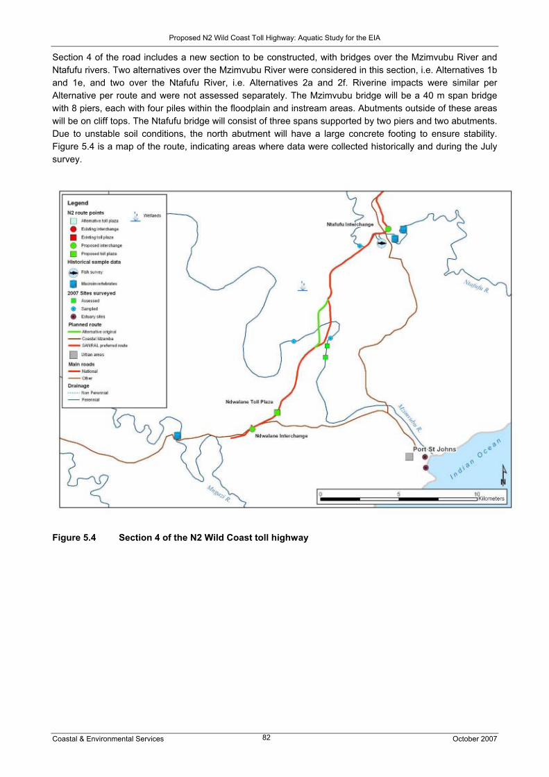
Proposed N2 Wild Coast Toll Highway: Aquatic Study for the EIA
Coastal & Environmental Services October 2007 82
Section 4 of the road includes a new section to be constructed, with bridges over the Mzimvubu River and Ntafufu rivers. Two alternatives over the Mzimvubu River were considered in this section, i.e. Alternatives 1b and 1e, and two over the Ntafufu River, i.e. Alternatives 2a and 2f. Riverine impacts were similar per Alternative per route and were not assessed separately. The Mzimvubu bridge will be a 40 m span bridge with 8 piers, each with four piles within the floodplain and instream areas. Abutments outside of these areas will be on cliff tops. The Ntafufu bridge will consist of three spans supported by two piers and two abutments. Due to unstable soil conditions, the north abutment will have a large concrete footing to ensure stability. Figure 5.4 is a map of the route, indicating areas where data were collected historically and during the July survey.
Figure 5.4 Section 4 of the N2 Wild Coast toll highway

Proposed N2 Wild Coast Toll Highway: Aquatic Study for the EIA
Coastal & Environmental Services October 2007 83
Table 5.5a Impact summary table for both the construction and operational phases, with and
without mitigation affecting the riverine environments for Section 4: Mzimvubu bridge
Note: Without mitigation, the majority of the impacts (operation & construction phase) were elevated beyond the significance criteria stated in the impact rating methodology, i.e. were rated as medium when they should have rated as low or very low. This was due to the cumulative impact a poorly designed bridge, together with poorly managed construction works would have on an already impacted system. The close proximity to the estuary (regional) also was considered in this assessment. However, considering the proposed bridge design and the mitigations, the impacts were rated as having a low significance.
Issue/Impact Phase Extent Duration Intensity Probability Significance Status Confidence Without mitigation
Construction Regional Short Medium Probable Medium Negative Medium Change in channel structure Operation N/A
Construction Regional Short Medium Probable Medium Negative Medium Loss of instream habitats Operation N/A
Construction Regional Short Medium Probable Medium Negative Medium Risk of surface and groundwater pollution - sediments
Operation Local Short Medium Probable Medium Negative Medium
Construction N/A Risk of surface and groundwater pollution - other
Operation Regional Short Medium Probable Medium Negative Medium
Construction Local Short Medium Probable Medium Negative Medium Changes in ecosystem structure + function, + loss of biodiversity
Operation N/A
With mitigation Construction Local Short Low Probable Low Negative Medium Change in
channel structure Operation Local Short Low Improbable Low Negative Medium
Construction Local Short Low Improbable Low Negative Medium Loss of instream habitats Operation N/A
Construction Local Short Low Probable Low Negative Medium Risk of surface and groundwater pollution – sediments
Operation Local Short Low Improbable Low Negative Medium
Construction N/A Risk of surface and groundwater pollution – other
Operation Local Short Low Improbable Low Negative Medium
Construction Local Short Low Improbable Low Negative Medium Changes in ecosystem structure + function, + loss of biodiversity
Operation N/A

Proposed N2 Wild Coast Toll Highway: Aquatic Study for the EIA
Coastal & Environmental Services October 2007 84
Table 5.5b Impact summary table for both the construction and operational phases, with and
without mitigation affecting the riverine environments for Section 4: Ntafufu bridge
Note: Without mitigation, the impacts (operation & construction phase) were elevated beyond the significance criteria stated in the impact rating methodology, i.e. were rated as high or medium when they should have rated as low or very low. This was due to the cumulative impact a poorly designed bridge, together with poorly managed construction works would have on an important system very near the estuary. However, considering the proposed bridge design and the mitigations, the impacts were rated as having a low significance.
Issue/Impact Phase Extent Duration Intensity Probability Significance Status Confidence Without Mitigation
Construction Regional Short Medium Probable High Negative Medium Change in channel structure Operation N/A
Construction Regional Short Medium Probable High Negative Medium Loss of instream habitats Operation N/A
Construction Regional Short Medium Probable Medium Negative Medium Risk of surface and groundwater pollution - sediments
Operation Local Short Medium Probable Medium Negative Medium
Construction N/A Risk of surface and groundwater pollution - other
Operation Local Short Medium Probable Medium Negative Medium
Construction Regional Short Medium Probable Medium Negative Medium Changes in ecosystem structure + function, + loss of biodiversity
Operation N/A
With mitigation Construction Local Short Low Probable Low Negative Medium Change in
channel structure Operation Local Short Low Improbable Low Negative Medium
Construction Local Short Low Improbable Low Negative Medium Loss of instream habitats Operation N/A
Construction Local Short Low Probable Low Negative Medium Risk of surface and groundwater pollution – sediments
Operation Local Short Low Improbable Low Negative Medium
Construction N/A Risk of surface and groundwater pollution – other
Operation Local Short Low Improbable Low Negative Medium
Construction Local Short Low Improbable Low - Medium Negative Medium Changes in ecosystem structure + function, + loss of biodiversity
Operation N/A

Proposed N2 Wild Coast Toll Highway: Aquatic Study for the EIA
Coastal & Environmental Services October 2007 85
Table 5.5c Impact summary table for both the construction and operational phases, with and
without mitigation affecting the wetland environments for Section 4: Mzimvubu bridge
Issue/Impact Phase Extent Duration Intensity Probability Significance Status Confidence Without mitigation
Construction Local Permanent Low Definite Low Negative High Destruction of vegetation and loss of sensitive habitats Operation N/A
Construction Local Permanent Low Definite Low Negative High Increased surface run-off Operation Local Permanent Low Definite Low Negative High
Construction Local Permanent Low Definite Low Negative High Risk of surface and groundwater pollution
Operation Local Permanent Low Definite Low Negative High
Construction Local Permanent Low Probable Low Negative Low Reduction in permeable surfaces Operation Local Permanent Low Probable Low Negative High
Construction N/A Permanent Medium Definite Medium Negative High Diversion of flow by hard surfaces Operation Local Permanent Medium Probable Medium Negative Low
Construction Local Permanent Medium Definite Medium Negative Low Change in vegetation community type
Operation Local Permanent Medium Probable Medium Negative Low
Construction Local Permanent Medium Probable Medium Negative Low Physical change to wetlands Operation Local Permanent Medium Probable Medium Negative Low
With mitigation Destruction of vegetation and loss of sensitive habitats
Construction Local Short term Low Definite Low Negative High
Construction Local Short term Low Definite Low Negative High Increased surface run-off Operation Local Permanent Low Definite Low Negative High
Construction Local Short term Low Definite Low Negative High Risk of surface and groundwater pollution
Operation Local Permanent Low Definite Low Negative High
Construction Local Permanent Low Probable Low Negative Low Reduction in permeable surfaces Operation Local Short term Low Probable Low Negative High
Construction N/A Permanent Low Definite Low Negative High Diversion of flow by hard surfaces Operation Local Permanent Low Definite Low Negative High
Construction Local Permanent Low Definite Low Negative Low Change in vegetation community type
Operation Local Short term Low Definite Low Negative High
Construction Local Short term Medium Probable Low Negative Low Physical change to wetlands Operation Local Permanent Low Probable Low Negative Low

Proposed N2 Wild Coast Toll Highway: Aquatic Study for the EIA
Coastal & Environmental Services October 2007 86
Table 5.5d Impact summary table for both the construction and operational phases, with and without mitigation affecting the wetland environment for Section 4: Ntafufu bridge
Issue/Impact Phase Extent Duration Intensity Probability Significance Status Confidence Without mitigation Destruction of vegetation and loss of sensitive habitats
Construction Local Permanent High Definite Medium Negative High
Construction Local Permanent Low Definite Low Negative High Increased surface run-off Operation Local Permanent Low Definite Low Negative High
Construction Local Permanent High Definite High Negative High Risk of surface and groundwater pollution
Operation Local Permanent Medium Definite Medium Negative High
Construction Local Permanent Low Definite Medium Negative High Reduction in permeable surfaces Operation Local Permanent Low Probable Low Negative High
Construction Local Permanent Medium Definite Medium Negative High Diversion of flow by hard surfaces Operation Local Permanent Medium Probable Medium Negative Low
Construction Local Permanent High Definite High Negative Low Change in vegetation community type
Operation Local Permanent Medium Probable Medium Negative Low
Construction Local Medium High Definite Medium Negative High Physical change to wetlands Operation Local Permanent Medium Probable Medium Negative Low
With mitigation Construction Local Permanent Medium Definite Low Negative High Destruction of
vegetation and loss of sensitive habitats
Operation N/A
Construction Local Permanent Low Definite Low Negative High Increased surface run-off Operation Local Permanent Low Definite Low Negative High
Construction Local Permanent Low Definite Low Negative High Risk of surface and groundwater pollution
Operation Local Permanent Low Definite Low Negative High
Construction Local Permanent Low Probable Low Negative Low Reduction in permeable surfaces Operation Local Permanent Low Definite Low Negative High
Construction N/A Permanent Low Definite Low Negative High Diversion of flow by hard surfaces Operation Local Permanent Low Definite Low Negative High
Construction Local Permanent Low Definite Low Negative Low Change in vegetation community type
Operation Local Permanent Low Definite Low Negative High
Construction Local Permanent Low Probable Low Negative Low Physical change to wetlands Operation Local Permanent Low Probable Low Negative Low

Proposed N2 Wild Coast Toll Highway: Aquatic Study for the EIA
Coastal & Environmental Services October 2007 87
Section 5 of the road includes a widening of the Mzintlava River bridge. A number of rivers of significance are found in this area, although the road skirts around many of these rivers. Figure 5.5 is a map of the route, indicating areas where data were collected historically and during the July survey. Figure 5.5 Section 5 of the N2 Wild Coast toll highway

Proposed N2 Wild Coast Toll Highway: Aquatic Study for the EIA
Coastal & Environmental Services October 2007 88
Table 5.6a Impact summary table for both the construction and operational phases, with and
without mitigation affecting the riverine environments for Section 5
Note: Impacts in Table 5.6a, which were rated to be short in duration, localised and of medium or low intensity should according to the rating methodology have been rated as low and very low respectively. This was not the case for the impact significance related to impacts associated with loss of instream habitats, risk of surface water / groundwater pollution (sediments). These were all rated as having a low significance. The rationale being that if the construction activities during the upgrade of this section were not mitigated, then the impacts would be slightly higher than very low, based on the information with regards instream habitat at hand (medium confidence).
Issue/Impact Phase Extent Duration Intensity Probability Significance Status Confidence Without mitigation
Construction Local Short Low Probable Low Negative Medium Loss of instream habitats Operation N/A
Construction Local Short Medium Probable Low Negative Medium Risk of surface and groundwater pollution - sediments
Operation Local Short Low Probable Low Negative Medium
Construction N/A Risk of surface and groundwater pollution - other
Operation Local Short Medium Probable Low Negative Medium
Construction Local Short Low Improbable Low Negative Medium Changes in ecosystem structure + function, + loss of biodiversity
Operation N/A
With mitigation Construction Local Short Low Improbable Low Negative Medium Loss of
instream habitats Operation N/A
Construction Local Short Low Improbable Low Negative Medium Risk of surface and groundwater pollution – sediments
Operation Local Short Low Improbable Low Negative Medium
Construction N/A Risk of surface and groundwater pollution – other
Operation Local Short Low Improbable Low Negative Medium
Construction Local Short Low Improbable Low Negative Medium Changes in ecosystem structure + function, + loss of biodiversity
Operation N/A

Proposed N2 Wild Coast Toll Highway: Aquatic Study for the EIA
Coastal & Environmental Services October 2007 89
Table 5.6b Impact summary table for both the construction and operational phases, with and without mitigation affecting the wetland environment for Section 5
Issue/Impact Phase Extent Duration Intensity Probability Significance Status Confidence Without Mitigation
Construction Local Permanent Medium Definite Medium Negative High Destruction of vegetation and loss of sensitive habitats Operation N/A
Construction Local Permanent Low Definite Low Negative High Increased surface run-off Operation Local Permanent Low Definite Low Negative High
Construction Local Permanent Low Definite Low Negative High Risk of surface and groundwater pollution
Operation Local Permanent Low Definite Low Negative High
Construction Local Permanent Low Probable Low Negative Low Reduction in permeable surfaces Operation Local Permanent Low Definite Low Negative Low
Construction Local Permanent Medium Definite Medium Negative High Diversion of flow by hard surfaces Operation Local Permanent Medium Probable Medium Negative Low
Construction N/A Change in vegetation community type
Operation Local Permanent Medium Probable Medium Negative Low
Construction Local Permanent Medium Definite Medium Negative High Physical change to wetlands Operation Local Permanent Medium Probable Medium Negative High
With mitigation Construction Local Permanent Low Definite Low Negative High Destruction of
vegetation and loss of sensitive habitats
Operation N/A
Construction Local Permanent Low Definite Low Negative High Increased surface run-off Operation Local Permanent Low Definite Low Negative High
Construction Local Permanent Low Definite Low Negative High Risk of surface and groundwater pollution
Operation Local Permanent Low Definite Low Negative High
Construction N/A Reduction in permeable surfaces Operation Local Permanent Low Definite Low Negative High
Construction Local Permanent Low Definite Low Negative High Diversion of flow by hard surfaces Operation Local Permanent Low Definite Low Negative High
Construction N/A Change in vegetation community type
Operation Local Permanent Low Definite Low Negative High
Construction Local Permanent Low Definite Low Negative High Physical change to wetlands Operation Local Permanent Low Probable Low Negative High

Proposed N2 Wild Coast Toll Highway: Aquatic Study for the EIA
Coastal & Environmental Services October 2007 90
Section 6 of the road includes the greenfields route between Lusikisiki and the Mthamvuna River, with a number of high-span bridges over gorges, as well as more conventional bridge crossings. Figure 5.6 is a map of the route, indicating areas where data were collected historically and during the July survey. The alternative coastal Mzamba route through the wetland belt is shown on the map below. Bridge structures include high span bridges over the Msikaba, Mthentu and Mpahlane rivers, with the Mzamba bridge following the design of the Mzimvubu bridge (i.e. 8 piers of which four piles will be in the floodplain), and the Mnyameni and Kulumbe bridges being similar to the Ntafufu bridge (i.e. 3 spans supported by two piers and abutments). The latter three rivers are scored separately due to the bridge designs being more impacting on the river environments. The major difference of the coastal Mzamba route vs. the SANRAL-preferred alignment regarding impacts on the rivers is that the coastal Mzamba route crosses the same rivers but avoids the headwaters of the Sikombe and Mpahlanyane rivers. The impact of the coastal Mzamba route is therefore slightly lower (Table 5.7a). This is however negated by the potential impact of the road on the inland wetland belt. Although wetlands are found throughout this area, wetlands are prolific along the coastal Mzamba route (see the vegetation report of this study for detailed groundtruthing information and wetlands maps of this area), and would essentially be permanently removed by road and bridge-building activities. Due to the large dependence on the wetlands for domestic use, alternative water supply would have to be provided. Figure 5.6 Section 6 of the N2 Wild Coast toll highway
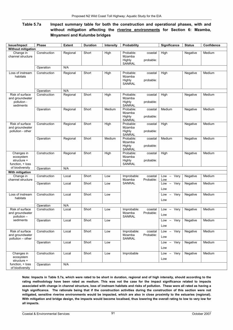
Proposed N2 Wild Coast Toll Highway: Aquatic Study for the EIA
Coastal & Environmental Services October 2007 91
Table 5.7a Impact summary table for both the construction and operational phases, with and without mitigation affecting the riverine environments for Section 6: Mzamba, Mnyameni and Kulumbe bridges
Note: Impacts in Table 5.7a, which were rated to be short in duration, regional and of high intensity, should according to the rating methodology have been rated as medium. This was not the case for the impact significance related to impacts associated with change in channel structure, loss of instream habitats and risks of pollution. These were all rated as having a high significance. The rationale being that if the construction activities during the construction of this section were not mitigated, sensitive riverine environments would be impacted, which are also in close proximity to the estuaries (regional). With mitigation and bridge design, the impacts would become localised, thus lowering the overall rating to low to very low for all impacts.
Issue/Impact Phase Extent Duration Intensity Probability Significance Status Confidence Without mitigation
Construction Regional Short High Probable: coastal Mzamba Highly probable: SANRAL
High Negative Medium Change in channel structure
Operation N/A
Construction Regional Short High Probable: coastal Mzamba Highly probable: SANRAL
High Negative Medium Loss of instream habitats
Operation N/A Construction Regional Short High Probable: coastal
Mzamba Highly probable: SANRAL
High Negative Medium Risk of surface and groundwater
pollution - sediments
Operation Regional Short Medium Probable: coastal Mzamba Highly probable: SANRAL
Medium Negative Medium
Construction Regional Short High Probable: coastal Mzamba Highly probable: SANRAL
High Negative Medium Risk of surface and groundwater pollution - other
Operation Regional Short Medium Probable: coastal Mzamba Highly probable: SANRAL
Medium Negative Medium
Construction Regional Short High Probable: coastal Mzamba Highly probable: SANRAL
High Negative Medium Changes in ecosystem structure +
function, + loss of biodiversity Operation N/A
With mitigation Construction Local Short Low Low – Very
Low Negative Medium Change in
channel structure Operation Local Short Low Low – Very
Low
Negative Medium
Construction Local Short Low
Improbable: coastal Mzamba Probable: SANRAL
Low – Very
Low
Negative Medium Loss of instream habitats
Operation N/A Construction Local Short Low Low – Very
Low
Negative Medium Risk of surface and groundwater
pollution – sediments Operation Local Short Low
Improbable: coastal Mzamba Probable: SANRAL
Low – Very
Low
Negative Medium
Construction Local Short Low Low – Very
Low
Negative Medium Risk of surface and groundwater pollution – other
Operation Local Short Low
Improbable: coastal Mzamba Probable: SANRAL
Low – Very
Low
Negative Medium
Construction Local Short Low Improbable Low – Very
Low
Negative Medium Changes in ecosystem structure +
function, + loss of biodiversity
Operation N/A

Proposed N2 Wild Coast Toll Highway: Aquatic Study for the EIA
Coastal & Environmental Services October 2007 92
Table 5.7b Impact summary table for both the construction and operational phases, with and without mitigation affecting the riverine environments for Section 6: other bridges
Issue/Impact Phase Extent Duration Intensity Probability Significance Status Confidence Without mitigation
Construction Regional Short Medium Probable: coastal Mzamba Highly probable: SANRAL
Medium: coastal Mzamba High: SANRAL
Negative Medium Change in channel structure
Operation N/A
Construction Regional Short Medium Probable: coastal Mzamba Highly probable: SANRAL
Medium: coastal Mzamba High: SANRAL
Negative Medium Loss of instream habitats
Operation N/A Construction Regional Short Medium Probable:
coastal Mzamba Highly probable: SANRAL
Medium: coastal Mzamba High: SANRAL
Negative Medium Risk of surface and groundwater
pollution - sediments
Operation Local Short Medium Probable: coastal Mzamba Highly probable: SANRAL
Medium Negative Medium
Construction Regional Short Medium Probable: coastal Mzamba Highly probable: SANRAL
Medium: coastal Mzamba High: SANRAL
Negative Medium Risk of surface and groundwater pollution - other
Operation Local Short Medium Probable: coastal Mzamba Highly probable: SANRAL
Medium Negative Medium
Construction Regional Short Medium Probable: coastal Mzamba Highly probable: SANRAL
Medium Negative Medium Changes in ecosystem structure +
function, + loss of biodiversity
Operation N/A With mitigation
Construction Local Short Low Low – Very Low Negative Medium Change in channel structure Operation Local Short Low Low – Very Low Negative Medium
Construction Local Short Low
Improbable: coastal Mzamba Probable: SANRAL
Low – Very Low Negative Medium Loss of instream habitats
Operation N/A Construction Local Short Low Low – Very Low Negative Medium Risk of surface
and groundwater pollution – sediments
Operation Local Short Low
Improbable: coastal Mzamba Probable: SANRAL
Low – Very Low Negative Medium
Construction Local Short Low Low – Very Low Negative Medium Risk of surface and groundwater pollution – other Operation Local Short Low
Improbable: coastal Mzamba Probable: SANRAL
Low – Very Low Negative Medium
Construction Local Short Low Improbable Low – Very Low Negative Medium Changes in ecosystem structure +
function, + loss of biodiversity
Operation N/A

Proposed N2 Wild Coast Toll Highway: Aquatic Study for the EIA
Coastal & Environmental Services October 2007 93
Note: Impacts in Table 5.7b, which were rated to be short in duration, regional and of medium intensity, should according to the rating methodology have been rated as low. This was not the case for the impact significance related to impacts associated with change in channel structure, loss of instream habitats and risks of pollution. These were all rated as having a high (SANRAL route) and medium (Mzamba route) significance. The rationale being that if the construction activities during the construction of this section were not mitigated, sensitive riverine environments would be impacted, which are also in close proximity to the estuaries (regional). With mitigation and bridge design, the impacts would become localised, thus lowering the overall rating to low to very low for all impacts. The rating methodology indicates that the overall rating should be very low, but again due to the sensitive nature of these systems, low – very low has been selected, i.e. steep gorges, natural vegetation close to the heads of the estuaries. This also applies to the note under table 5.7a Table 5.7c Impact summary table for both the construction and operational phases, with and
without mitigation affecting the wetland environment for Section 6: coastal Mzamba route
Issue/Impact Phase Extent Duration Intensity Probability Significance Status Confidence Without mitigation
Construction Regional Permanent High Definite High Negative High Destruction of vegetation and loss of sensitive habitats Operation N/A
Construction Local Permanent High Definite High Negative High Increased surface run-off Operation Local Permanent Medium Definite Medium Negative High
Construction Regional Permanent High Definite High Negative High Risk of surface and groundwater pollution
Operation Local Permanent High Definite High Negative High
Construction Local Permanent High Definite High Negative High Reduction in permeable surfaces Operation Local Permanent High Definite High Negative High
Construction Regional Permanent High Definite High Negative High Diversion of flow by hard surfaces Operation Local Permanent Medium Definite Low Negative Low
Construction N/A Change in vegetation community type
Operation Local Permanent Medium Probable Medium Negative High
Construction Regional Permanent Medium Definite Medium Negative High Physical change to wetlands Operation Local Permanent Medium Probable Medium Negative High
With mitigation Construction Local Permanent Medium Definite Medium Negative High Destruction of
vegetation and loss of sensitive habitats
Operation N/A
Construction Local Permanent Medium Definite Medium Negative High Increased surface run-off Operation Local Permanent Medium Definite Medium Negative High
Construction Local Permanent Medium Definite Medium Negative High Risk of surface and groundwater pollution
Operation Local Permanent Low Definite Low Negative High
Construction Local Permanent Medium Probable Medium Negative Low Reduction in permeable surfaces Operation Local Permanent Low Definite Low Negative High
Construction Local Permanent Medium Definite Medium Negative High Diversion of flow by hard surfaces Operation Local Permanent Low Definite Low Negative High
Construction N/A Change in vegetation community type
Operation Local Permanent Medium Definite Medium Negative High
Construction Local Permanent Low Definite Low Negative High Physical change to wetlands Operation Local Permanent Low Probable Low Negative Low

Proposed N2 Wild Coast Toll Highway: Aquatic Study for the EIA
Coastal & Environmental Services October 2007 94
Table 5.7d Impact summary table for both the construction and operational phases, with and without mitigation affecting the wetland environment for Section 6: SANRAL preferred alignment
Issue/Impact Phase Extent Duration Intensity Probability Significance Status Confidence Without mitigation
Construction Local Permanent High Definite High Negative High Destruction of vegetation and loss of sensitive habitats Operation N/A
Construction Local Permanent High Definite High Negative High Increased surface run-off Operation Local Permanent Medium Definite Medium Negative High
Construction Local Permanent High Definite High Negative High Risk of surface and groundwater pollution
Operation Local Permanent Medium Definite Medium Negative High
Construction Local Permanent Medium Probable Medium Negative Low Reduction in permeable surfaces Operation Local Permanent High Definite High Negative High
Construction Local Permanent Medium Definite Medium Negative High Diversion of flow by hard surfaces Operation Local Permanent Medium Definite Medium Negative Low
Construction Local Permanent Medium Definite Medium Negative High Change in vegetation community type
Operation Local Permanent Medium Probable Medium Negative Low
Construction Local Permanent Medium Definite Medium Negative High Physical change to wetlands Operation Local Permanent Medium Probable Medium Negative Low
With mitigation Construction Local Permanent Low Definite Low Negative High Destruction of
vegetation and loss of sensitive habitats
Operation N/A
Construction Local Permanent Medium Definite Medium Negative High Increased surface run-off Operation Local Permanent Low Definite Low Negative High
Construction Local Permanent Medium Definite Medium Negative High Risk of surface and groundwater pollution
Operation Local Permanent Low Definite Low Negative High
Construction Local Permanent Medium Probable Medium Negative Low Reduction in permeable surfaces Operation Local Permanent Low Definite Low Negative High
Construction N/A Permanent Medium Definite Low Negative High Diversion of flow by hard surfaces Operation Local Permanent Low Definite Low Negative High
Construction Local Permanent Medium Definite Medium Negative Medium Change in vegetation community type
Operation Local Permanent Low Definite Low Negative High
Construction Local Permanent Low Definite Low Negative High Physical change to wetlands Operation Local Permanent Low Probable Low Negative Low
Note: Physical change to wetlands should be kept to a minimum due to the dependency of the local communities within this road section on these systems. Such changes could result in the loss of wetlands. With this in mind, some of the ratings in Table 5.7d are elevated above the ratings shown in the impact assessment methodology as this remains a critical issue and the significance in this case was to low.

Proposed N2 Wild Coast Toll Highway: Aquatic Study for the EIA
Coastal & Environmental Services October 2007 95
Section 7 of the route crosses a number of modified rivers, all with existing bridge structures. Figure 5.7 is a map of the route, indicating areas where data were collected historically and during the July survey. Figure 5.7 Section 7 of the N2 Wild Coast toll highway Table 5.8 Impact summary table for both the construction and operational phases, with and
without mitigation affecting the riverine environments for Section 7
Issue/Impact Phase Extent Duration Intensity Probability Significance Status Confidence Without mitigation
Construction Local Short Medium Probable Very low Negative Medium Risk of surface and
groundwater pollution - sediments
Operation Local Short Medium Improbable Very Low Negative Medium
Construction N/A Risk of surface and
groundwater pollution -
other
Operation Local Short Medium Probable Very low Negative Medium
With mitigation Construction Local Short Low Improbable Very low Negative Medium Risk of surface
and groundwater pollution – sediments
Operation Local Short Low Improbable Very low Negative Medium
Construction N/A Risk of surface and
groundwater pollution –
other
Operation Local Short Low Improbable Very low Negative Medium
Proposed N2 Wild Coast Toll Highway: Aquatic Study for the EIA
Coastal & Environmental Services October 2007 96
5.2 Impacts along the route corridor: Estuaries The impacts expected for estuaries (outlined in Section 4.1.2) have been rated for each of the seven sections according to the identified issues (see Tables 5.9 – 5.15). The alternative route, i.e. the coastal Mzamba route, has been included in Section 6 (Lusikisiki (Magwa Intersection) to Mthamvuna River), as this is the only section effected by this alternative. Section 1: Gonubie Interchange to Ngobozi Impact 1: Sedimentation Description of effect Sedimentation is most likely to be as a result of construction related activities i.e. upgrade and rehabilitation of the road and widening in the relevant section. This may result in deposition of construction debris into the five river catchments crossed by the road which will ultimately arrive at the estuaries, at which the ichthyofaunal, water quality and aesthetic status are described as “good”, “good – excellent” and “good”, respectively (Harrison et al., 2000). Should vegetation be removed to allow for lay-bye areas, rainfall will wash sediment into the river channels, resulting in sedimentation of the estuaries. Mitigation As all the river – estuary systems in Section 1 are crossed by the proposed road in the river sections, and the rivers supply the estuaries with fresh water and associated sediment load, sedimentation effects in the estuaries are an indirect impact of the proposed road construction. Impacts are thus best mitigated by reducing the impacts at the river sections through the mitigatory measures proposed in Chapter 5.1.1 of this report, as well as through SANRAL’s mitigatory measures employed when constructing bridges. Assessment (after mitigation) Sedimentation of the estuaries will probably result in a medium intensity impact in the short term (i.e. during construction of the relevant section of the road). Due to the extent of area covered, and the importance of the estuaries in terms of diversity and fish breeding and nursery grounds, this effect will be at a regional level. This negative effect is of Low significance. Impact 2: Water quantity changes Water quantity changes in the estuaries (i.e. volume of water available to estuaries) are unlikely to result due to the road being upgraded in this section (assuming no water is abstracted from or impounded in the river channel). Impact 3: Water quality changes Description of effect Water quality changes are expected as a result of both the construction and operational phases of the project. Oils and grease as a result of construction-related activities, as well as from use of the road by the expected additional cars as a result of the proposed upgrade, will have water quality impact on the (five) rivers crossed by the road, which will in turn affect the related estuaries. Accidents in the catchments of rivers, and fuel spillages from broken down vehicles are potential problems in the operational phase of the road. At present the water quality status of the estuaries in the region in general is described as “good” (Harrison et al., 2000). Mitigation As all the river – estuary systems in Section 1 are crossed by the proposed road in the river sections, and any pollutants entering the river will be transported downstream to the estuaries, a potential decrease in water quality in the estuaries is an indirect impact of the proposed road construction. Impacts are thus best mitigated by reducing the impacts at the river sections through the mitigatory measures proposed in Chapter 5.1.1 of this report, as well as through SANRAL’s mitigatory measures employed when constructing bridges.

Proposed N2 Wild Coast Toll Highway: Aquatic Study for the EIA
Coastal & Environmental Services October 2007 97
Operational impacts, however, are more difficult to mitigate as while storm water can be diverted and settled or treated before discharge into the aquatic environment, emissions from motor cars and sheet-wash off roads in the catchments of the rivers (which will ultimately discharge into the estuaries) is difficult to control. Assessment (after mitigation) Water quality related effects will probably result in medium intensity impacts in the construction phase of the project, and medium intensity impacts in the operational phase. Construction impacts are expected for the short term and operational impacts for the medium term. Due to the extent of area covered, and the importance of the estuaries in terms of diversity and fish breeding and nursery grounds, this effect will be at a regional level. Construction and operational impacts will have a negative effect of Low and Medium significance, respectively. Impact 4: Improved access Impacts related to improved access to estuarine areas as a result of the construction of the road are unlikely to be relevant as this section of coast is readily accessible at present. Table 5.9 Summary of impacts on estuaries expected for Section 1
Issue/Impact Phase Extent Duration Intensity Probability Significance Status Confidence Without mitigation
Construction Regional Short High High Medium Negative Medium Sedimentation Operational N/A Water quantity N/A
Construction Regional Short High Probable Medium Negative Medium Water quality
Operational Regional Medium Medium Probable Medium Negative Medium Improved access N/A With mitigation
Construction Regional Short Medium Probable Low Negative Medium Sedimentation Operational N/A Water quantity N/A
Construction Regional Short Medium Probable Low Negative Medium Water quality Operational Regional Medium Medium Probable Medium Negative Medium Improved access N/A
Section 2: Ngobozi to Mthatha (Ngqeleni) Impact 1: Sedimentation Description of effect Sedimentation is most likely to be as a result of construction related activities i.e. upgrade and rehabilitation of the road and widening along most of the route. This may result in deposition of construction debris into the three river catchments crossed by the road which will ultimately arrive at the estuaries, at which the ichthyofaunal, water quality and aesthetic status are described as “moderate – good”, “poor” and “good”, respectively (Harrison et al., 2000). Should vegetation be removed to allow for lay-bye areas, rainfall will wash sediment into the river channels, resulting in sedimentation of the estuaries. Mitigation As all the river – estuary systems in Section 2 are crossed by the proposed road in the river sections, and the rivers supply the estuaries with fresh water and associated sediment load, sedimentation effects in the estuaries are an indirect impact of the proposed road construction. Impacts are thus best mitigated by reducing the impacts at the river sections through the mitigatory measures proposed in Chapter 5.1.1 of this report, as well as through SANRAL’s mitigatory measures employed when constructing bridges. Assessment (after mitigation)

Proposed N2 Wild Coast Toll Highway: Aquatic Study for the EIA
Coastal & Environmental Services October 2007 98
Sedimentation of the estuaries will probably result in a medium intensity impact in the short term (i.e. during construction of the relevant section of the road). Due to the extent of area covered, and the importance of the estuaries in terms of diversity and fish breeding and nursery grounds, this effect will be at a regional level. This negative effect is of Low significance. Impact 2: Water quantity changes Water quantity changes in the estuaries (i.e. volume of water available to estuaries) are unlikely to result as a result of the road being upgraded in this section (assuming no water is abstracted from or impounded in the river channel). Impact 3: Water quality changes Description of effect Water quality changes are expected as a result of both the construction and operational phases of the project. Oils and grease as a result of construction related activities, as well as from use of the road by the expected additional cars as a result of the proposed upgrade, will have water quality impact on the (three) rivers crossed by the road, which will in turn affect the related estuaries. Accidents in the catchments of rivers, and fuel spillages from broken down vehicles are potential problems in the operational phase of the road. At present, however, the water quality status of the estuaries in the region in general is described as “poor” (Harrison et al., 2000). Mitigation As all the river – estuary systems in Section 2 are crossed by the proposed road in the river sections, and any pollutants entering the river will be transported downstream to the estuaries, a potential decrease in water quality in the estuaries is an indirect impact of the proposed road construction. Impacts are thus best mitigated by reducing the impacts at the river sections through the mitigatory measures proposed in Chapter 5.1.1 of this report, as well as through SANRAL’s mitigatory measures employed when constructing bridges. Operational impacts, however, are more difficult to mitigate as while storm water can be diverted and settled or treated before discharge into the aquatic environment, emissions from motor cars and sheet-wash off roads in the catchments of the rivers (which will ultimately discharge into the estuaries) is difficult to control. Assessment (after mitigation) Water quality related effects will probably result in medium intensity impacts in the construction phase of the project, and medium intensity impacts in the operational phase. Construction impacts are expected for the short term, and operational impacts for the medium term. Due to the extent of area covered, and the importance of the estuaries in terms of diversity and fish breeding and nursery grounds, this effect will be at a regional level. Construction and operational impacts will have a negative effect of Low and Medium significance, respectively. Impact 4: Improved access Impacts related to improved access to estuarine areas as a result of the construction of the road are unlikely to be relevant as this section of the road is inland.

Proposed N2 Wild Coast Toll Highway: Aquatic Study for the EIA
Coastal & Environmental Services October 2007 99
Table 5.10 Summary of impacts on estuaries expected for Section 2
Issue/Impact Phase Extent Duration Intensity Probability Significance Status Confidence Without mitigation
Construction Regional Short High High Medium Negative Medium Sedimentation Operational N/A Water quantity N/A
Construction Regional Short High Probable Medium Negative Medium Water quality Operational Regional Medium Medium Probable Medium Negative Medium
Improved access N/A With mitigation
Construction Regional Short Medium Probable Low Negative Medium Sedimentation Operational N/A Water quantity N/A
Construction Regional Short Medium Probable Low Negative Medium Water quality Operational Regional Medium Medium Probable Medium Negative Medium Improved access N/A
Section 3: Mthatha (Ngqeleni) to Ndwalane Impact 1: Sedimentation Description of effect Sedimentation is most likely to be as a result of construction related activities i.e. upgrade and rehabilitation of the road and widening along most of the route (Mngazi River bridge to be widened). This may result in deposition of construction debris into the important and sensitive river catchments crossed by the road (i.e. Mngazi and Mngazana Rivers) which will ultimately arrive at the estuaries, at which the ichthyofaunal, water quality and aesthetic status are described as “moderate – good”, “fair – good” and “moderate – good”, respectively (Harrison et al., 2000). Should vegetation be removed to allow for lay-bye areas, rainfall will wash sediment into the river channels, resulting in sedimentation of the estuaries. Mitigation The proposed road crosses the river – estuary systems relatively close to the estuarine environment in Section 3, but still most likely in the fresh water portion (river) of the systems. As the rivers supply the estuaries with fresh water and associated sediment load, sedimentation effects in the estuaries are an indirect impact of the proposed road construction. Impacts are thus best mitigated by reducing the impacts at the river sections through the mitigatory measures proposed in Chapter 5.1.1 of this report, as well as through SANRAL’s mitigatory measures employed when constructing bridges. Assessment (after mitigation) Sedimentation of the estuaries will probably result in a medium intensity impact in the short term (i.e. during construction of the relevant section of the road). Due to the extent of area covered, and the importance of the estuaries in terms of diversity and fish breeding and nursery grounds, this effect will be at a regional level. This negative effect is of Low significance. Impact 2: Water quantity changes Water quantity changes in the estuaries (i.e. volume of water available to estuaries) are unlikely to result as a result of the road being upgraded in this section (assuming no water is abstracted from or impounded in the river channel). Impact 3: Water quality changes Description of effect Water quality changes are expected as a result of both the construction and operational phases of the project. Oils and grease as a result of construction related activities, as well as from use of the road by the expected additional cars as a result of the proposed upgrade, will have water quality impact on the sensitive rivers crossed by the road (particularly on the eastern part of the road, where the road crosses the Mngazi

Proposed N2 Wild Coast Toll Highway: Aquatic Study for the EIA
Coastal & Environmental Services October 2007 100
and Mngazana Rivers close to the coast i.e. <10 km), which will in turn affect the related estuaries. Accidents in the catchments of rivers, and fuel spillages from broken down vehicles are potential problems in the operational phase of the road. At present the water quality status of the estuaries in the region in general is described as “fair – good” (Harrison et al., 2000). Mitigation The proposed road crosses the river – estuary systems relatively close to the estuarine environment in Section 3, but still most likely in the fresh water portion (river) of the systems. Any pollutants entering the river will be transported downstream to the estuaries; therefore a potential decrease in water quality in the estuaries is an indirect impact of the proposed road construction. Impacts are thus best mitigated by reducing the impacts at the river sections through the mitigatory measures proposed in Chapter 5.1.1 of this report, as well as through SANRAL’s mitigatory measures employed when constructing bridges. Operational impacts, however, are more difficult to mitigate as while storm water can be diverted and settled or treated before discharge into the aquatic environment, emissions from motor cars and sheet-wash off roads in the catchments of the rivers (which will ultimately discharge into the estuaries) is difficult to control, particularly due to the proximity of the road crossings to the estuaries. Assessment (after mitigation) Water quality related effects will probably result in medium intensity impacts in the construction phase of the project, and medium intensity impacts in the operational phase. Construction impacts are expected for the short term and operational impacts for the medium term. Due to the extent of area covered, and the importance of the estuaries in terms of diversity and fish breeding and nursery grounds, this effect will be at a regional level. Construction and operational impacts will have a negative effect of Low and Medium significance, respectively. Impact 4: Improved access Description of effect As a result of the improvements to the road, more road users are expected in this region of the Wild Coast relative to at present. As a result of the increased thoroughfare, more visitors are expected to the coastal areas, particularly on the eastern section, where the road approaches the coast. More visitors imply increased recreational and developmental related pressures. This is of particular concern due to the importance and sensitivity of the estuaries in this region (e.g. the Mngazana Estuary is considered to be the most important estuary along the Wild Coast). This impact is not only restricted to the estuaries of rivers directly affected by the road, but to all estuaries along this section (i.e. thirteen estuaries). Mitigation Improved access related impacts will be best mitigated by the legislation protecting estuaries nation-wide, as well as along the Wild Coast specifically (Chapter 4.2.3). Estuarine resources can be protected through the enforcement of bag limits i.e. when catching fish or collecting shell-fish. Historically, however, these have proved difficult to control, particularly in remote areas, resulting in overexploitation. This problem is often exacerbated when collecting is for subsistence purposes. Impacts related to depletion of natural resources are therefore difficult to mitigate. It is also vital that development be controlled, particularly in the floodplains of the estuaries along the coast. This is relevant to all estuaries along this section of the coast (i.e. thirteen estuaries). Assessment (after mitigation) It is highly probable that improved access to the sensitive estuarine areas in the region of this section of the road will result in medium intensity impacts. This will persist in the long term, or until depletion of the resources provided by the estuaries at a regional level. This will have a negative effect of High significance.

Proposed N2 Wild Coast Toll Highway: Aquatic Study for the EIA
Coastal & Environmental Services October 2007 101
Table 5.11 Summary of impacts on estuaries expected for Section 3
Issue/Impact Phase Extent Duration Intensity Probability Significance Status Confidence Without mitigation
Construction Regional Short High High Medium Negative Medium Sedimentation Operational N/A Water quantity N/A
Construction Regional Short High Probable Medium Negative Medium Water quality Operational Regional Medium Medium Probable Medium Negative Medium
Construction N/A Improved access
Operational Regional Long High High Very High Negative Medium With mitigation
Construction Regional Short Medium Probable Low Negative Medium Sedimentation Operational N/A Water quantity N/A
Construction Regional Short Medium Probable Low Negative Medium Water quality Operational Regional Medium Medium Probable Medium Negative Medium Construction N/A Improved access Operational Regional Long Medium Probable High Negative Medium
Section 4: Ndwalane to Ntafufu River Impact 1: Sedimentation Description of effect This section of the road is a greenfields section i.e. will have to be constructed. Sedimentation is most likely to be as a result of construction related activities i.e. clearance to make way for the road, deposition of gravel, grading etc. This may result in deposition of construction material and debris into the two rivers crossed by the road, i.e. the Mzimvubu and Ntafufu Rivers. The Mzimvubu River suffers from excess sedimentation at present, and the Ntafufu River is considered to be an important estuary due to the diverse range of habitats available to estuarine biota i.e. both systems are sensitive to sedimentation impacts. The ichthyofaunal, water quality and aesthetic status of the estuaries in the region are described as “moderate – good”, “fair – good” and “moderate – good”, respectively (Harrison et al., 2000). Vegetation removed to make way for the road will result in erosion during rainfall events, adding to the effects of sedimentation in the rivers and ultimately in the estuaries. Mitigation As all the river – estuary systems in Section 4 are crossed by the proposed road in the river sections, and the rivers supply the estuaries with fresh water and associated sediment load, sedimentation effects in the estuaries are an indirect impact of the proposed road construction. Impacts are thus best mitigated by reducing the impacts at the river sections through the mitigatory measures proposed in Chapter 5.1.1 of this report, as well as through SANRAL’s mitigatory measures employed when constructing bridges. Assessment (after mitigation) It is highly probable that the Mzimvubu and Ntafufu estuaries will be affected by sedimentation as a result of construction of the road between Ndwalane and the Ntafufu rivers. This will result in a medium intensity impact for both routes, which will be restricted to the construction phase of the project, i.e. short term. Due to the extent of area covered, and the importance of the estuaries in terms of diversity and fish breeding and nursery grounds, this effect will be at a regional level. This negative effect will be of Low significance. Impact 2: Water quantity changes Water quantity changes in the estuaries (i.e. volume of water available to estuaries) are unlikely to result as a result of the road being constructed in this section (assuming no water is abstracted from or impounded in the river channel).

Proposed N2 Wild Coast Toll Highway: Aquatic Study for the EIA
Coastal & Environmental Services October 2007 102
Impact 3: Water quality changes Description of effect Water quality changes are expected as a result of both the construction and operational phases of the project. Oils and grease as a result of construction related activities, as well as from use of the road, will have water quality impact on the rivers crossed by the road, which will in turn affect the related estuaries. Accidents in the catchments of rivers, and fuel spillages from broken down vehicles are potential problems in the operational phase of the road. At present the water quality status of the estuaries in the region in general is described as “fair – good” (Harrison et al., 2000). Mitigation As all the river – estuary systems in Section 4 are crossed by the proposed road in the river sections, and any pollutants entering the river will be transported downstream to the estuaries, a potential decrease in water quality in the estuaries is an indirect impact of the proposed road construction. Impacts are thus best mitigated by reducing the impacts at the river sections through the mitigatory measures proposed in Chapter 5.1.1 of this report, as well as through SANRAL’s mitigatory measures employed when constructing bridges. Operational impacts, however, are more difficult to mitigate as while storm water can be diverted and settled or treated before discharge into the aquatic environment, emissions from motor cars and sheet-wash off roads in the catchments of the rivers (which will ultimately discharge into the estuaries) is difficult to control. Assessment (after mitigation) Water quality related effects will probably result in medium intensity impacts in the construction phase of the project, and medium intensity impacts in the operational phase. Construction impacts are expected for the short term and operational impacts for the medium term. Due to the extent of area covered, and the importance of the estuaries in terms of diversity and fish breeding and nursery grounds, this effect will be at a regional level. Construction and operational impacts will have a negative effect of Low and Medium significance, respectively. Impact 4: Improved access Description of effect While the new section of road to be constructed is further inland than the existing R61 (which runs via Port St Johns), as a result of the improvements to the road, more road users are expected in this region of the Wild Coast relative to at present. As a result of the increased thoroughfare, more visitors are expected to the coastal areas, particularly in the vicinity of Port St Johns and the sensitive predominantly closed estuaries to the south, as well as to the coastal features and estuaries in the northern portion of this section of relevant coastline (i.e. Waterfall Bluff). This impact is not only restricted to the estuaries of rivers directly affected by the road, but to all estuaries along this section (i.e. twelve estuaries). Mitigation Improved access related impacts will be best mitigated by the legislation protecting estuaries nation-wide, as well as along the Wild Coast specifically (Chapter 4.2.3). Estuarine resources can be protected through the enforcement of bag limits i.e. when catching fish or collecting shell-fish. Historically, however, these have proved difficult to control, particularly in remote areas, resulting in overexploitation. This problem is often exacerbated when collecting is for subsistence purposes. Impacts related to depletion of natural resources are therefore difficult to mitigate. It is also vital that development be controlled, particularly in the floodplains of the estuaries along the coast. This is relevant to all estuaries along this section of the coast (i.e. twelve estuaries). Assessment (after mitigation) It is highly probable that improved access to the sensitive estuarine areas in the region of this section of the road will result in the medium intensity impacts discussed in Section 1.1. This will persist in the long term, or until depletion of the resources provided by the estuaries at a regional level. This will have a negative effect of High significance.

Proposed N2 Wild Coast Toll Highway: Aquatic Study for the EIA
Coastal & Environmental Services October 2007 103
Table 5.12 Summary of impacts on estuaries expected for Section 4
Issue/Impact Phase Extent Duration Intensity Probability Significance Status Confidence Without mitigation
Construction Regional Short High High Medium Negative Medium Sedimentation Operational N/A Water quantity N/A
Construction Regional Short High Probable Medium Negative Medium Water quality Operational Regional Medium Medium Probable Medium Negative Medium
Construction N/A Improved access
Operational Regional Long High High Very High Negative Medium With mitigation
Construction Regional Short Medium Probable Low Negative Medium Sedimentation Operational N/A Water quantity N/A
Construction Regional Short Medium Probable Low Negative Medium Water quality Operational Regional Medium Medium Probable Medium Negative Medium Construction N/A Improved access Operational Regional Long Medium Probable High Negative Medium
Section 5: Ntafufu River to Lusikisiki (Magwa Intersection) Impact 1: Sedimentation Description of effect Sedimentation is most likely to be as a result of construction related activities i.e. upgrade and rehabilitation of the road and widening along most of the route (Mzintlava River bridge to be widened). This may result in deposition of construction debris into the important and sensitive river catchments crossed by the road which will ultimately arrive at the estuaries, which were not rated by Harrison et al. (2000), but which are considered to be in an “excellent” state by Whitfield (2000). Should vegetation be removed to allow for lay-bye areas, rainfall will wash sediment into the river channels, resulting in sedimentation of the estuaries. Mitigation As all the river – estuary systems in Section 5 are crossed by the proposed road in the river sections, and the rivers supply the estuaries with fresh water and associated sediment load, sedimentation effects in the estuaries are an indirect impact of the proposed road construction. Impacts are thus best mitigated by reducing the impacts at the river sections through the mitigatory measures proposed in Chapter 5.1.1 of this report, as well as through SANRAL’s mitigatory measures employed when constructing bridges. Assessment (after mitigation) Sedimentation of the estuaries will probably result in a medium intensity impact in the short term (i.e. during construction of the relevant section of the road). Due to the extent of area covered, and the importance of the estuaries in terms of diversity and fish breeding and nursery grounds, this effect will be at a regional level. This negative effect is of Low significance. Impact 2: Water quantity changes Water quantity changes in the estuaries (i.e. volume of water available to estuaries) are unlikely to result as a result of the road being upgraded in this section (assuming no water is abstracted from or impounded in the river channel). Impact 3: Water quality changes Description of effect Water quality changes are expected as a result of both the construction and operational phases of the project. Oils and grease as a result of construction related activities, as well as from use of the road by the expected additional cars as a result of the proposed upgrade, will have water quality impact on the sensitive

Proposed N2 Wild Coast Toll Highway: Aquatic Study for the EIA
Coastal & Environmental Services October 2007 104
rivers crossed by the road, which will in turn affect the related estuaries. Accidents in the catchments of rivers, and fuel spillages from broken down vehicles are potential problems in the operational phase of the road. Mitigation As all the river – estuary systems in Section 5 are crossed by the proposed road in the river sections, and any pollutants entering the river will be transported downstream to the estuaries, a potential decrease in water quality in the estuaries is an indirect impact of the proposed road construction. Impacts are thus best mitigated by reducing the impacts at the river sections through the mitigatory measures proposed in Chapter 5.1.1 of this report, as well as through SANRAL’s mitigatory measures employed when constructing bridges. Operational impacts, however, are more difficult to mitigate as while storm water can be diverted and settled or treated before discharge into the aquatic environment, emissions from motor cars and sheet-wash off roads in the catchments of the rivers (which will ultimately discharge into the estuaries) is difficult to control. Assessment (after mitigation) Water quality related effects will probably result in medium intensity impacts in the construction phase of the project, and medium intensity impacts in the operational phase. Construction impacts are expected for the short term, and operational impacts for the medium term. Due to the extent of area covered, and the importance of the estuaries in terms of diversity and fish breeding and nursery grounds, this effect will be at a regional level. Construction and operational impacts will have a negative effect of Low and Medium significance, respectively. Impact 4: Improved access Description of effect As a result of the improvements to the road, more road users are expected in this region of the Wild Coast relative to at present. As a result of the increased thoroughfare, more visitors are expected to the coastal areas, particularly as these areas are at present difficult to access due to the poor state of the existing roads. More visitors imply increased recreational and developmental related pressures. This is of particular concern due to the importance and sensitivity of the estuaries in this region, which in a relatively pristine state due to lack of human interference and development. This impact is not only restricted to the estuaries of rivers directly affected by the road, but to all estuaries along this section (i.e. fourteen estuaries). Mitigation Improved access related impacts will be best mitigated by the legislation protecting estuaries nation-wide, as well as along the Wild Coast specifically (Chapter 4.2.3). Estuarine resources can be protected through the enforcement of bag limits i.e. when catching fish or collecting shell-fish. Historically, however, these have proved difficult to control, particularly in remote areas, resulting in overexploitation. This problem is often exacerbated when collecting is for subsistence purposes. Impacts related to depletion of natural resources are therefore difficult to mitigate. It is also vital that development be controlled, particularly in the floodplains of the estuaries along the coast. This is relevant to all estuaries along this section of the coast (i.e. fourteen estuaries). Assessment (after mitigation) It is highly probable that improved access to the sensitive estuarine areas in the region of this section of the road will result in medium intensity impacts. This will persist in the long term, or until depletion of the resources provided by the estuaries at a regional level. This will have a negative effect of High significance.

Proposed N2 Wild Coast Toll Highway: Aquatic Study for the EIA
Coastal & Environmental Services October 2007 105
Table 5.13 Summary of impacts on estuaries expected for Section 5
Issue/Impact Phase Extent Duration Intensity Probability Significance Status Confidence Without mitigation
Construction Regional Short High High Medium Negative Medium Sedimentation Operational N/A Water quantity N/A
Construction Regional Short High Probable Medium Negative Medium
Water quality
Operational Regional Medium Medium Probable Medium Negative Medium Construction N/A
Improved access Operational Regional Long High High Very High Negative Medium
With mitigation Construction Regional Short Medium Probable Low Negative Medium Sedimentation Operational N/A
Water quantity N/A Construction Regional Short Medium Probable Low Negative Medium Water quality Operational Regional Medium Medium Probable Medium Negative Medium Construction N/A Improved access Operational Regional Long Medium Probable High Negative Medium
Section 6: Lusikisiki (Magwa Intersection) to Mthamvuna River This section of the road involves two alternatives, i.e. the SANRAL-preferred alignment and the Coastal Mzamba alignment. Impact 1: Sedimentation Description of effect This section of the road is a greenfields section i.e. will have to be constructed. Sedimentation is most likely to be as a result of construction related activities i.e. clearance to make way for the road, deposition of gravel, grading etc. This may result in deposition of construction material and debris into the numerous rivers crossed by the road and as a result of bridges that will have to be constructed in the SANRAL-preferred alignment, i.e. the Msikaba (plus the Kwadlambu and other tributaries of the Msikaba River), Mthentu, Mnyameni (plus the Kulumbe and other tributaries of the Mnyameni River), the Mpahlane, Mzamba, Mtentwana and Mthamvuna rivers, plus the headwaters of Sikombe and Mpahlanyane rivers. The Coastal Mzamba route, which deviates from the SANRAL-preferred alignment between the Mthentu and Mzamba rivers (but uses the same crossing points for each), crosses the same rivers but avoids the headwaters of the Sikombe and Mpahlanyane rivers. Both routes will result in sedimentation impacts in the estuaries of these rivers, some of which are Temporarily Open Closed Estuaries (TOCEs), and many of which are considered to be in an “excellent” state (Whitfield, 2000), while the ichthyofaunal, water quality and aesthetic status of the estuaries in the region are described as “moderate – good”, “fair – good” and “moderate – good”, respectively (Harrison et al., 2000). Vegetation removed to make way for the road on both routes will result in erosion during rainfall events, adding to the effects of sedimentation in the rivers and ultimately in the estuaries. Mitigation The proposed road crosses the river – estuary systems relatively close to the estuarine environment in the northern part of Section 6 i.e. Mzamba and Mpahlane (SANRAL-preferred route) rivers, but still most likely in the fresh water portion (river) of the systems. The Mthamvuna River will be crossed in the estuarine section, but this will be an upgrade of the existing bridge. As the rivers supply the estuaries with fresh water and associated sediment load, sedimentation effects in the estuaries are an indirect impact of the proposed road construction. Impacts are thus best mitigated by reducing the impacts at the river sections through the

Proposed N2 Wild Coast Toll Highway: Aquatic Study for the EIA
Coastal & Environmental Services October 2007 106
mitigatory measures proposed in Chapter 5.1.1 of this report, as well as through SANRAL’s mitigatory measures employed when constructing bridges. Assessment (after mitigation) It is highly probable that the Msikaba, Mthentu, Mnyameni, the Mpahlane, Mzamba, Mtentwana and Mthamvuna estuaries, plus the Sikombe and Mpahlanyane estuaries in the case of the SANRAL-preferred alignment, will be affected by sedimentation as a result of construction of the new road. This will result in a medium intensity impact for both routes, which will be restricted to the construction phase of the project, i.e. short term. Due to the extent of area covered, and the importance of the estuaries in terms of diversity and fish breeding and nursery grounds, this effect will be at a regional level. This negative effect will be of Low significance. Impact 2: Water quantity changes Description of effect While the Coastal Mzamba route is further from the coast, the route will traverse wetlands which are important sources of a continuous supply of freshwater to the rivers and estuaries. Interrupting the dynamics of these wetland systems by putting a permanent structure through them (i.e. a road) will have water quantity impacts i.e. wetlands have the ability to retain water and release is slowly and consistently over time and if replaced by impermeable surfaces, run-off will peak after rainfall events, while not occurring during drier times changing the flow dynamics of estuaries. Water quantity impacts are not expected for the SANRAL-preferred alignment (assuming no water is abstracted from or impounded in the river channel), as the rivers will be crossed over gorges (i.e. by high-span bridges). Mitigation Water quantity impacts resulting from the disturbance of the wetlands will be difficult to mitigate against due to the abundance of wetlands along the route corridor, and the importance of all with regard to discharge of fresh, purified water to the rivers and ultimately estuaries. Mitigatory measures such as raising the road above the ground are impractical due to the costs involved, and even this would result in a disruption of the wetlands functioning, and the loss of wetlands due to the placement of permanent structures will be unavoidable. Assessment (after mitigation) Interference with the functioning of the wetlands along the Coastal Mzamba route is highly likely to have medium intensity water quantity impacts in the Mnyameni and Mpahlane estuaries (i.e. regional scale) in the operational phase in the long term. This negative effect will be of High significance. Impact 3: Water quality changes Description of effect Water quality changes are expected as a result of both the construction and operational phases of the project. Oils and grease as a result of construction related activities, as well as from use of the road by the expected additional cars as a result of the proposed upgrade, will have water quality impact on the rivers crossed by the road, which will in turn affect the related estuaries. Accidents in the catchments of rivers, and fuel spillages from broken down vehicles are potential problems in the operational phase of the road. At present the water quality status of the estuaries in the region in general is described as “fair – good” (Harrison et al., 2000). Mitigation The proposed road crosses the river – estuary systems relatively close to the estuarine environment in the northern part of Section 6 i.e. Mzamba and Mpahlane (SANRAL-preferred route) rivers, but still most likely in

Proposed N2 Wild Coast Toll Highway: Aquatic Study for the EIA
Coastal & Environmental Services October 2007 107
the fresh water portion (river) of the systems. The Mthamvuna River will be crossed in the estuarine section, but this will be an upgrade of the existing bridge. As any pollutants entering the river will be transported downstream to the estuaries, a potential decrease in water quality in the estuaries is an indirect impact of the proposed road construction. Impacts are thus best mitigated by reducing the impacts at the river sections through the mitigatory measures proposed in Chapter 5.1.1 of this report, as well as through SANRAL’s mitigatory measures employed when constructing bridges. Operational impacts, however, are more difficult to mitigate as while storm water can be diverted and settled or treated before discharge into the aquatic environment, emissions from motor cars and sheet-wash off roads in the catchments of the rivers (which will ultimately discharge into the estuaries) is difficult to control. Assessment (after mitigation) Water quality related effects will probably result in medium intensity impacts in the construction phase of the project, and medium intensity impacts in the operational phase. Construction impacts are expected for the short term and operational impacts for the medium term. Due to the extent of area covered, and the importance of the estuaries in terms of diversity and fish breeding and nursery grounds, this effect will be at a regional level. Construction and operational impacts will have a negative effect of Low and Medium significance, respectively. Impact 4: Improved access Description of effect The new section of road to be constructed, using either the SANRAL-preferred alignment or the coastal Mzamba route, will open up areas of the coastline that were previously very difficult to access. Whilst access roads to the coast may not be upgraded initially, the greater numbers of people travelling through the area closer to the coast then the existing road would take them, is likely to result in more people visiting the coastline on this stretch of the route, as well as the twenty five estuaries, twenty one of which are TOCEs and therefore sensitive to changes within their catchments. These systems have generally been described as being in excellent condition (Whitfield, 2000) or near pristine, and are therefore highly susceptible to adverse effects from human interference. Mitigation Improved access related impacts will be best mitigated by the legislation protecting estuaries nation-wide, as well as along the Wild Coast specifically (Chapter 4.2.3). Estuarine resources can be protected through the enforcement of bag limits i.e. when catching fish or collecting shell-fish. Historically, however, these have proved difficult to control, particularly in remote areas, resulting in overexploitation. This problem is often exacerbated when collecting is for subsistence purposes. Impacts related to depletion of natural resources are therefore difficult to mitigate. It is also vital that development be controlled, particularly in the floodplains of the estuaries along the coast. This is relevant to all estuaries along this section of the coast (i.e. twenty five estuaries). Assessment (after mitigation) It is highly probable that improved access to the sensitive estuarine areas in the region of this section of the road will result in medium intensity impacts. This will persist in the long term, or until depletion of the resources provided by the estuaries at a regional level. This will have a negative effect of High significance.

Proposed N2 Wild Coast Toll Highway: Aquatic Study for the EIA
Coastal & Environmental Services October 2007 108
Table 5.14 Summary of impacts on estuaries expected for Section 6
Issue/Impact Phase Extent Duration Intensity Probability Significance Status Confidence Without mitigation
Construction Regional Short High High Medium Negative Medium Sedimentation Operational N/A Construction Regional Short Medium High Low Negative Medium Water quantity
(coastal Mzamba route) Operational Regional Long Medium High High Negative Medium
Construction Regional Short High Probable Medium Negative Medium Water quality Operational Regional Medium Medium Probable Medium Negative Medium
Construction N/A Improved access
Operational Regional Long High High Very High Negative Medium With mitigation
Construction Regional Short Medium Probable Low Negative Medium Sedimentation Operational N/A Construction Regional Short Medium High Low Negative Medium Water quantity Operational Regional Long Medium High High Negative Medium Construction Regional Short Medium Probable Low Negative Medium Water quality Operational Regional Medium Medium Probable Medium Negative Medium Construction N/A Improved access Operational Regional Long Medium Probable High Negative Medium
Section 7: Mthamvuna River to Isipingo Interchange Impact 1: Sedimentation Description of effect Sedimentation is most likely to be as a result of construction related activities i.e. upgrade and rehabilitation of the road and widening along most of the route. As the road is very close to the coast (typically <2 km), this may result in deposition of construction debris into the numerous river and estuary catchments crossed by the road – there are fifty one estuaries along this stretch, the majority of which (forty five), are TOCEs and therefore more vulnerable to sedimentation impacts. The ichthyofaunal, water quality and aesthetic status of the estuaries in the region, however, are described as “moderate – good” but “very poor” in places, from “very poor” to “good” and “moderate – good” to “poor”, respectively (Harrison et al., 2000). Should vegetation be removed to allow for lay-bye areas, rainfall will wash sediment into the river channels, resulting in sedimentation of the estuaries. Mitigation The majority of the river – estuary systems in Section 7 are crossed by the proposed road within 1km of the coast and therefore by in the estuarine portion of the systems. Impacts are therefore direct, but the suggested mitigatory measures are the same as for the river crossings of Sections 1 – 6 of the route, i.e. those stipulated in Chapter 5.1.1 of this report, as well as through SANRAL’s mitigatory measures employed when constructing bridges. Assessment (after mitigation) Sedimentation of the estuaries will probably result in a medium intensity impact in the short term (i.e. during construction of the relevant section of the road). Due to the extent of area covered, and the importance of the estuaries in terms of diversity and fish breeding and nursery grounds, this effect will be at a regional level. This negative effect is of Low significance. Impact 2: Water quantity changes Water quantity changes in the estuaries (i.e. volume of water available to estuaries) are unlikely to result as a result of the road being upgraded in this section (assuming no water is abstracted from or impounded in the river channel).
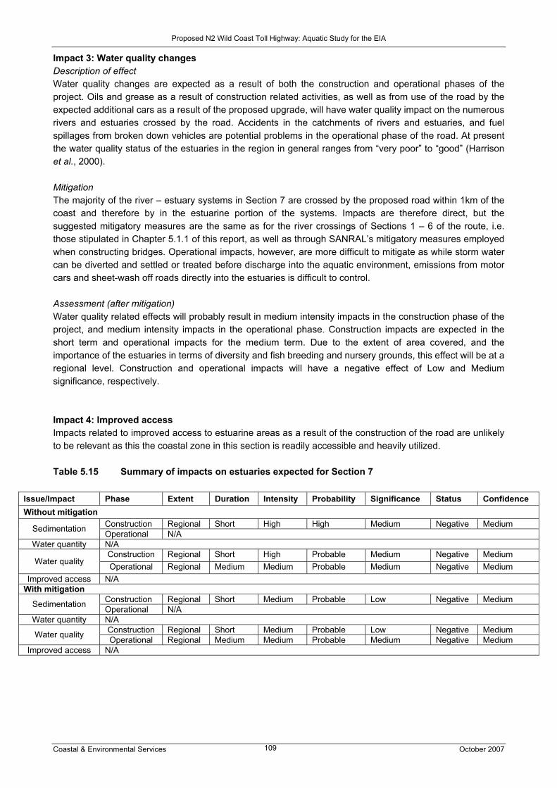
Proposed N2 Wild Coast Toll Highway: Aquatic Study for the EIA
Coastal & Environmental Services October 2007 109
Impact 3: Water quality changes Description of effect Water quality changes are expected as a result of both the construction and operational phases of the project. Oils and grease as a result of construction related activities, as well as from use of the road by the expected additional cars as a result of the proposed upgrade, will have water quality impact on the numerous rivers and estuaries crossed by the road. Accidents in the catchments of rivers and estuaries, and fuel spillages from broken down vehicles are potential problems in the operational phase of the road. At present the water quality status of the estuaries in the region in general ranges from “very poor” to “good” (Harrison et al., 2000). Mitigation The majority of the river – estuary systems in Section 7 are crossed by the proposed road within 1km of the coast and therefore by in the estuarine portion of the systems. Impacts are therefore direct, but the suggested mitigatory measures are the same as for the river crossings of Sections 1 – 6 of the route, i.e. those stipulated in Chapter 5.1.1 of this report, as well as through SANRAL’s mitigatory measures employed when constructing bridges. Operational impacts, however, are more difficult to mitigate as while storm water can be diverted and settled or treated before discharge into the aquatic environment, emissions from motor cars and sheet-wash off roads directly into the estuaries is difficult to control. Assessment (after mitigation) Water quality related effects will probably result in medium intensity impacts in the construction phase of the project, and medium intensity impacts in the operational phase. Construction impacts are expected in the short term and operational impacts for the medium term. Due to the extent of area covered, and the importance of the estuaries in terms of diversity and fish breeding and nursery grounds, this effect will be at a regional level. Construction and operational impacts will have a negative effect of Low and Medium significance, respectively. Impact 4: Improved access Impacts related to improved access to estuarine areas as a result of the construction of the road are unlikely to be relevant as this the coastal zone in this section is readily accessible and heavily utilized. Table 5.15 Summary of impacts on estuaries expected for Section 7
Issue/Impact Phase Extent Duration Intensity Probability Significance Status Confidence Without mitigation
Construction Regional Short High High Medium Negative Medium Sedimentation Operational N/A Water quantity N/A
Construction Regional Short High Probable Medium Negative Medium Water quality Operational Regional Medium Medium Probable Medium Negative Medium
Improved access N/A With mitigation
Construction Regional Short Medium Probable Low Negative Medium Sedimentation Operational N/A Water quantity N/A
Construction Regional Short Medium Probable Low Negative Medium Water quality Operational Regional Medium Medium Probable Medium Negative Medium Improved access N/A

Proposed N2 Wild Coast Toll Highway: Aquatic Study for the EIA
Coastal & Environmental Services October 2007 110
6 DISCUSSION & CONCLUSION Although the systems within the study area were found to be largely in a natural condition, current land use practices, sand winning, poor secondary roads and bridges and alien plant infestations, have impacted on the status of the aquatic environment. In the interests of proactive environmental management, future developments should thus not result in further degradation. Areas of particular concern are the greenfields routes, where the majority of the headwaters already require some form of rehabilitation due to the impacts listed above. Rivers that presently require rehabilitation would include the Mzimvubu, Kwadlambu and Mnyameni for example, but concerted effort to eradicate all alien plants throughout the entire study area would be required. With this in mind, six possible impacts which could alter the functioning of the instream and riparian vegetation within the study region were identified during this study. These were all rated as having a low intensity within the locality of the bridge crossings, if the mitigations were upheld in terms of stormwater control and minimising the construction and operation footprints within the river channels. Although all these impacts would be negative, based on high confidence levels, the significance of the impacts would be Medium without mitigation and Low with mitigation. The only exception is the evaluation of impacts related to removal of vegetation or changes in habitat, which was rated as having a high significance during the construction phase. The greatest risk of the proposed project would be allowing the operations of the road to increase the potential for erosion and sedimentation to occur. This would impact on the formation of stable plant community types within the river channels. It has been difficult to quantify the intensity and significance of road and bridge-building activities on the riverine environments, due to the lack of data and research on these systems. The latest information from SANRAL on bridge designs was used during the assessment, with impact scores for systems having piers in the instream environment being higher. As the knowledge base for rivers such as the Mzamba and Kulumbe are so poor, impacts cannot be confidently rated. It is however assumed that potential impacts may be relevant on a regional basis, as sensitive biota may be present in these systems. The EIS status of the rivers therefore influenced assessment categories. Avoidance of the headwaters, which act as refugia areas, should reduce impacts. The highest impacts for the rivers were allocated to bridges having multiple piers in the rivers, i.e. Mzimvubu, Ntafufu, Mzamba, Kulumbe and Mnyameni rivers. Although the Mzimvubu River currently carries high sediment loads, it is a river of high regional (if not national) importance, and additional impacts resulting in habitat destruction should be avoided. The permanent destruction of wetlands is a real possibility during road construction. High impact scores were seen in Section 6 of the route, particularly along the coastal Mzamba route. Extensive wetlands of high domestic value were found along this section of road and associated with wetland degradation or permanent removal would have to be improved service delivery in terms of water supply to these areas. No stand-pipes or boreholes were seen along this section of the route during the July survey, with communities completely dependent on seeps and springs. The SANRAL-preferred alignment would result in fewer impacts in this section. A particular area of concern is the wetlands on the Atentule River, which feed the Mteku falls. These wetlands which are peat forming, are in close proximity to the proposed Msikaba Bridge and associated road alignment. The highest impact ratings for estuaries were seen in sections 4 and 6 of the route, with some high impacts in Sections 3 and 5. Pondoland estuaries are considered sensitive and in a near pristine condition, and due to the longitudinal nature of rivers, any impact upstream will be felt downstream in the estuary. The estuaries between Gonubie and Isipingo, and particularly those of the Wild Coast, will be impacted on during the upgrading of existing sections and construction of the new sections of road. Potential affects on these systems will be reduced with effective management such as assigning them protection status (i.e. Estuarine

Proposed N2 Wild Coast Toll Highway: Aquatic Study for the EIA
Coastal & Environmental Services October 2007 111
Protected Areas), such as the nine systems that enjoy protected status at present i.e. the Nkosweni, Ntafufu, Mzintlava, Mbotyi, Mkweni, Msikaba, Mthentu, Sikombe and Mnyameni estuaries, which all fall within the newly proclaimed Pondoland Marine Protected Area. The level of protection of these estuaries, however, is relatively low, with protection only extending to the tidal reaches of the estuary. Further, the nature of this protection has not been fully defined (Turpie and van Niekerk, 2005). These and all estuaries along the Wild Coast need to be adequately managed and protected should the road be constructed, to preserve the sensitive and valuable nature of these diverse and productive ecosystems. The overall impact rating for estuaries versus the riverine environments is not in proportion within this report, based on the above fact. Until it is clearly understood that the Pondoland systems can be protected, the potential impacts, especially those posed by increased access, carry a high significance. However, with careful management by role-players such as the Eastern Cape Parks Board, who promote responsible tourism and limited the number of developments, such conservation agencies could benefit by the increase in visitors. Revenue could then be used to manage the natural resources being used, beyond the boundaries of the exiting parks. In past assessments, Palmiet was listed as endangered and thus requiring conservation. However in the latest revision (January 2007) of the Threatened Plant Species list (TPS list) by SANBI, based on IUCN criteria, Prinonium serratum has been listed as a species of Least Concern. A taxon is rated Least Concern when it has been evaluated against the criteria and does not qualify for Critically Endangered, Endangered, Vulnerable or Near Threatened and is found to be widespread and abundant. This species however remains on the TPS list due to a decline in populations as a result of habitat destruction. If the proposed road should go ahead, and large areas of Palmiet are removed, then the overall environmental significance would be HIGH. Palmiet plays an important role in improving water quality, attenuating high flows and trapping sediment, thus providing stability within the river systems. It is difficult to comment on cumulative impacts or the long-term sustainability of the toll road. Impacts on aquatic systems are definitely cumulative, particularly in terms of the longitudinal nature of rivers, with impacts ending up in estuaries. The cumulative nature of a project is also dependent on other impacting activities in the area, e.g. the proposed Xolobeni Heavy Mineral Mine. There is no doubt that cumulative impacts due to the disturbance of beds and banks and instream impacts due to bridge building (toll road), together with water abstraction and damming impacts of the mining activity, will potentially be severe on a regional and national level. Toll road impacts will however be shorter term impacts, with effective management and implementation of mitigatory measures resulting in lowering impacts considerably. Changes in channel structure and habitat availability, increased sedimentation into the river channel, and changes in population structures in the short term are highly probable, particularly in the sensitive rivers and estuaries. Changing mouth conditions, with subsequent impacts on the availability of nursery areas (for example) in estuaries, are likely to take place with increasing sediment loads moving down rivers. Again, effective management procedures and the implementation of monitoring programmes and detailed construction and operational EMPs, will reduce potential impacts. Mitigation measures to be implemented in order to reduce the effects of the construction and operational phases of the road have been highlighted in the impacts section of this report. The most important areas, revealed in this specialist report, are the “green fields” sections of the road. These sections have been highlighted as “highly sensitive” in terms of their aquatic systems due to the large numbers of wetlands and rivers in the area. Mitigation would be achieved through the incorporation of best practice measures into a Construction Environmental Management Plan (CEMP). This should then be monitored by a suitable Environmental Control Officer, capable of measuring the upstream and downstream water quality (turbidity), to detect any negative impacts arising from the road and bridge building sites. However, the long-term sustainability of wetland systems is in jeopardy. Wetlands are probably the environment that will be most heavily affected by road-building, with permanent destruction of wetlands in road-building areas. Important habitats will be lost, and domestic patterns of water use disturbed. Alternative

Proposed N2 Wild Coast Toll Highway: Aquatic Study for the EIA
Coastal & Environmental Services October 2007 112
water supply options for domestic use will be needed. Due to the absolute dependence on wetlands in the wetland belt along the coastal Mzamba route in Section 6, it is recommended that the SANRAL-preferred route be followed as this will result in fewer wetland impacts. It is further suggested that a detailed mapping of the wetlands within Section 6 should occur. The wetland map should also indicate the intensity of water use and suitable buffer zones that would protect the functioning the wetland system. The final route selection then should be based on this map. The disruption of wetland process would have a cumulative impact on the functioning of the rivers and then estuaries, thus for this reason, it is suggested that the SANRAL preferred alternative be followed. In summary, with suitable mitigation and proactive management most of the impacts related directly to the proposed road could be managed using the recommendations listed above. It cannot be overstated that the proponent should take as many precautions to manage and monitor all phases of the development and should form part of any forum to manage the region, i.e. possible increase in tourism. Therefore the overall project EIA could further motivate the institution of well developed tourism plans, based on the spatial development plans within the region, which are also approved by the environmental authorities. This should also be aided by other initiatives to protect the remaining environment further from degradation, with or without the toll road, such as future nature reserves, the Eastern Cape Parks' Wild Coast Project and the coastal management bill.
Proposed N2 Wild Coast Toll Highway: Aquatic Study for the EIA
Coastal & Environmental Services October 2007 113
7 REFERENCES
BOK, A. 2000. New freshwater fish species found in Transkei rivers. Internal DWAF report.
BRANCH, W.R. 1988. South African Red Data Book – Reptiles and Amphibians. South African Natural
Science Programme. Report 151: i – iv, 242 pp.
BRANCH, G.M., BALLY, R., BENNET, B.A.DE DECKER, H.P., FROMME, G.A.W., HEYL, C.W., WILLIS,
J.P. 1985. Synopsis of the impact of artificially opening the mouth of the Bot River Estuary: implications for
management. Transactions of the Royal Society of South Africa 45: 465-483. In: Hodgson, A.N. and
Allanson, B.R. 2000. The Knysna Basin Project 1995 – 1998: A Scientific Report on the Knysna Estuary.
Transactions of the Royal Society of South Africa 55: 97-240.
CCA ENVIRONMENTAL. 2007. Proposed N2 Wild Coast Toll Highway: Final Scoping Report.
COASTAL & ENVIRONMENTAL SERVICES. 2006. Strategic Environmental Assessment for Water
Management Area 12 (WMA 12 SEA). Prepared for the Department of Water Affairs and Forestry.
COWAN, G I. and VAN RIET, W. 1998. A Directory of South African Wetlands. Department of Water Affairs
and Tourism, Pretoria.
CSIR. 2005. Systematic Conservation Assessment of the Pondoland SEA Focus Area. CSIR Report ENV-S-
C 2005-041.
DAVIES, B.R., O’KEEFFE, J.H. and SNADDON, C.D. 1993. A synthesis of the ecological functioning,
conservation and management of South A frican river ecosystems. WRC Report no TT 62/93.
DEAT. 2000. THE RAMSAR CONVENTION, (1971) including the Wetland Conservation Programme (DEAT)
and the National Wetland Rehabilitation Initiative.
DEPARTMENT OF WATER AFFAIRS AND FORESTRY. 2003. Practical field procedure for identification
and delienation of wetlands and Riparian areas version: Final draft, February 2003.
DICKENS, C.W.S and GRAHAM, P.M. 2002. The South African Scoring System (SASS) Version 5 rapid
bioassessment method for rivers. African Journal of Aquatic Science (27) 1-10.
HARRISON, T.D., COOPER, J.A.G., RAMM, A.E.L. and SINGH, R.A. 1999. Application of the Estuarine
Health Index to South African Estuaries, Transkei: Technical Report. CSIR, Project No. JE01D.
HARRISON, T.D., COOPER, J.A.G., RAMM, A.E.L. and SINGH, R.A. 1998. Health of South African
Estuaries, Transkei: Executive Report. CSIR, Project No. JE01D.

Proposed N2 Wild Coast Toll Highway: Aquatic Study for the EIA
Coastal & Environmental Services October 2007 114
HARRISON, T.D., COOPER, J.A.G. and RAMM, A.E.L. 2000. State of South African Estuaries:
Geomorphology, Ichthyofauna, Water Quality and Aesthetics. State of the environment Series: Report No: 2.
department of Environmental Affairs and Tourism.
HEEMSTRA, P. and HEEMSTRA, E. 2004. Coastal Fishes of Southern Africa. South African Institute for
Aquatic Biodiversity.
HUGHES, D.A. 2005. SPATSIM: an integrated framework for ecological Reserve determination and
implementation. WRC Report No. TT 245/04.
IUCN (International Union for Conservation of Nature and Natural Resources). 2006. Red list of threatened
species. http://www.iucnredlist.org. Accessed 4 August 2007.
KENNEDY, P. 2003. The effects of road transport on freshwater and marine ecosystems. Prepared for: New
Zealand Ministry of Transport. Document 84914.
KLEYNHANS, C.J. 1999. The development of a fish index to assess the biological integrity of South African
rivers. Water SA (25) 265-278.
KLEYNHANS, C.J, LOUW, M.D, THIRION, C, ROSSOUW, NJ and ROWNTREE, K. 2005. River
Ecoclassification: Manual for Ecostatus determination (Version 1). Joint Water Research Commission and
Department of Water Affairs and Forestry report. WRC Report No. KV 168/05.
KOTZE P.J. and NIEHAUS B.H. 2004. Rapid Ecological Reserve (Quantity) for the Mzimvubu River (T31G),
Mzintlava River (T32A), Tina River (T34J), Tsitsa River (T35K), Inxu River (T35G), for Department of Water
Affairs and Forestry; RDM: Draft report
NATIONAL ENVIRONMENTAL MANAGEMENT ACT, 1998 (Act No. 107 of 1998).
NATIONAL WATER ACT, 1998 (Act No. 36 of 1998).
NICOLSON, G., AVIS, A.M., NORTON, P. and TYRELL, H. 1996. Wild Coast Spatial Development Initiative:
Environmental Report. Report commissioned by Land and Agriculture Policy Centre for the Development
Bank of Southern Africa and the Department of Trade and Industry. 73 pp.
ROWNTREE, K., WADESON, R. and O’KEEFE, J. 2000. The development of a geomorphologic
classification system for the longitudinal zonation of South African rivers. South African Geographical
Journal 82(3): 163-172.

Proposed N2 Wild Coast Toll Highway: Aquatic Study for the EIA
Coastal & Environmental Services October 2007 115
SHRAMM, M. 1993. A comparison of cyprinid fish populations in three large Transkei reservoirs with respect
to abundance and reproduction. South African Journal of Aquatic Sciences 19 (1): 74 – 88.
SKELTON, P. 2003. A complete guide to the freshwater fishes of southern Africa. Struik Publishers, Cape
Town, South Africa.
STIRLING, P.D. 1996. Ecology: Theories and applications. 2nd Edition, Prentice Hall. Inc.
TURPIE J.K. 2002. The Current State of Protection and Health of Estuarine Biodiversity in South Africa, with
Emphasis on Eastern Cape Estuaries. Submitted to the Institute of Natural Resources.
TURPIE, J.K. 2004. Improving the Biodiversity Importance Rating of South African Estuaries. The
Consortium for Estuarine Research and Management’s “Amazon Project”: Information Requirements for the
Implementation of Resource Directed Measures for Estuaries. WRC Programme K5/1247.
TURPIE, J.K., ADAMS, J.B., JOUBERT, A., HARRISON, T.D., COLLOTY, B.M., MAREE, R.C., WHITFIELD,
A.K., WOOLDRIDGE, T.H., LAMBERTH, S.J., TALJAARD, S. and VAN NIEKERK, L. 2002. An Assessment
of the Conservation Priority Status of South African Estuaries for Use in Management and Water Allocation.
Water SA, Vol. 28 (2).
TURPIE, J.K. and VAN NIEKERK, L. 2005. Prioirty Estuaries for Conservation on the Wild Coast, South
Africa. Appendix 2: Pondoland Focus Area Conservation Assessment.
WHITFIELD, A.K. 1992. A Characterization of Southern African Estuarine Systems. S. Afr. J. Aquat. Sci. 12
89-103.
WHITFIELD, A.K. 1998. Biology and Ecology of Fishes in Southern African Estuaries. J.L.B. Smith Institute
of Ichthyology, Grahamstown.
WHITFIELD, A.K. 2000. Available Scientific Information on Individual South African Estuarine Systems.
WRC Report No. 577/3/00.

Proposed N2 Wild Coast Toll Highway: Aquatic Study for the EIA
Coastal & Environmental Services October 2007 116
8. APPENDICES

Proposed N2 Wild Coast Toll Highway: Aquatic Study for the EIA
Coastal & Environmental Services October 2007 117
APPENDIX 1
MACROINVERTEBRATE RECORDS FROM THE ALBANY MUSEUM, GRAHAMSTOWN
Proposed N2 Wild Coast Toll Highway: Aquatic Study for the EIA
Coastal & Environmental Services October 2007 118
DATA ON FRESHWATER INVERTEBRATES, EXTRACTED FROM DATABASES AND CATALOGUES IN THE ALBANY MUSEUM ON COLLECTIONS MADE IN RIVERS FLOWING
THROUGH THE EASTERN HALF OF THE EASTERN CAPE INCLUDING THE FORMER TRANSKEI
Compiled by: F C de Moor and M Baninzi July 2007
Department of Freshwater Invertebrates Makana Biodiversity Centre
Albany Museum Somerset Street
Grahamstown 6139

Proposed N2 Wild Coast Toll Highway: Aquatic Study for the EIA
Coastal & Environmental Services October 2007 119
INTRODUCTION This report is based on information extracted from the computerized databases and hand written catalogues, not yet computerized, as well as from previous reports on work carried out in the rivers of the Eastern Cape Province. A spreadsheet (Sites and taxa) listing all the rivers and their tributaries from which there is information on selected taxa identified to species level is provided. In addition an excel spreadsheet (Eastern Cape catalogues) with two sheets of data (final list - recording 260 records, and - sheet 2- recording 2837 records) with detailed information from various computerized catalogues is also provided. This spreadsheet provides coverage of all taxa. Not all taxa are however identified to specific level and in many instances only family identification is provided. To bring the information into perspective three tables listing sites, lat/long coordinates and other information recorded during the more detailed surveys of the Eastern Cape Rivers are provided. Table 1 lists the sites of North Eastern Cape Rivers surveyed between 1990-1993. The details of taxa are provided in the Eastern Cape catalogues: sheet 2 and Sites and taxa spreadsheets. Table 2 lists the sites of Transkei Rivers surveyed in Oct-Dec 1996. Tables 3a and 3b list the family taxa and record estimated number of species recorded in each family. In addition the Sites and taxa spreadsheet provides more specific information of species recorded for each river. A brief discussion on the water quality of these rivers is also provided. Table 4 lists the sites of rivers in the Nahoon and Buffalo River catchment surveyed between 1999-2004. A list of taxa recorded is provided in table 5 and also in the spreadsheet Sites and taxa. Additional data from various rivers in computerized catalogues is provided in spreadsheets Sites and taxa and Eastern Cape catalogues: final list COMMENTS ON THE DATA PRESENTED Even though specific SASS surveys were not conducted, the high species diversity in the tributaries of the Mzivubu and Mbashe Rivers obtained during surveys conducted between 1990-1993 indicate that the water is of good quality (Table 1, see also spreadsheets Sites and taxa and Eastern Cape catalogues: sheet 2). The major threats to these rivers are excessive water abstraction and increased soil erosion through altered land use practices. Surveys of the Mzimkulu, Mzivubu and their tributaries and the many smaller rivers in the former Transkei were conducted in 1996 and details of the rivers surveyed are recorded in Table 2 (see also spreadsheets Sites and taxa and Eastern Cape catalogues: sheet 2). Only a limited number of the samples collected have been analyzed and therefore many more taxa would be expected to be found in these rivers. Although not yet identified to species level there were a large number of mayfly species including some sensitive Leptophlebiidae and at least three species of Leptoceridae and three species of freshwater prawns recorded from the Mqwatyana River near the coast. Mzimkulu River system (sites 1, X., 2, 3, 4, 5) The upper reaches of the Lubbukweni River produced the highest diversity of aquatic invertebrates. The area falls within the Nsekeni Nature Reserve which should theoretically afford it some conservation protection.

Proposed N2 Wild Coast Toll Highway: Aquatic Study for the EIA
Coastal & Environmental Services October 2007 120
The other streams sampled within this system appeared to be lower in species diversity. Notonemouridae stoneflies were found in the Tom river. These animals are only found in high altitude montane streams with excellent water quality (high dissolved oxygen, low levels of eutrophication, low turbidity and free of heavy metals and pesticides). Tricorythid mayflies and elmid beetles found in the Siqubbini River suggest that the water quality there is also good Mzimvubu River system (sites 8, 9, Y, 12, 13, 14, 15) Aquatic macroinvertebrate species diversity was found to be fairly high with estimated numbers of species found ranging from 10 to 20 in all the tributaries surveyed. All sites sampled in the upper reaches of this large river system revealed a comparatively high number of baetid mayflies. Some pollution sensitive leptophlebiid mayflies were found at most sites. Hydraenid and helodid beetles and Athericidae fly larvae, all indicators of good water quality, were found on the Jordan River, while the Paballong River was the only river that recorded blepharocerid fly larvae and pupae. This last mentioned family is only found in high altitude swift flowing streams with exceptionally high water quality. Transkei North Coast Rivers These rivers are especially unique in that they all flow over Table Mountain Sandstone (TMS). Very low pH values associated with this type of geology were recorded for all rivers with values ranging from 6.0 (Mqwatyana River) to 3.8 (Mdumbi River). Such low pH values would undoubtedly have an effect on the faunal composition of these rivers. Mqwatyana River (sites 16 and 17) A high diversity of 39 species was recorded from this river. Sensitive species collected include leptophlebiid mayflies, helodid beetles and three species of leptocerid caddisflies. Three species of freshwater prawns were also collected. Water quality assessed on this basis is excellent. Mkambati River (sites 18 and 21) Species diversity appears to be fair at the lower site but very low at the upper site (24 and 7 species respectively) and was significantly lower than for both the Mqwatyana and Daza Rivers. The sensitive leptophlebiid mayfly family and other indicator species such as helodid or psephenid beetles were not found in this river. In comparison to the other rivers sampled in the Mkambati Nature Reserve, species diversity in this river is noticeably lower. This may be attributed to the fact that municipal cattle dip drains into one of the tributaries of this river and pesticides used in the dipping process would impact negatively on the quality of the water, resulting in the absence of the sensitive species. A pump also abstracts water upstream of the site sampled and was reported to occasionally leak diesel into the river and this would also have a negative effect on the quality of the water. The complete absence of freshwater prawns in this river is due to the fact that the river has no estuary, with fresh water falling directly into the sea from a fairly high waterfall. Daza River (site 19) The number of species collected, estimated at 42, is the highest recorded for rivers within the Mkambati Nature Reserve. Indicator species of good water quality include a freshwater amphipod, a diversity of baetid mayflies, heptageniid and leptophlebiid mayflies, chlorocyphid damselfly nymphs, perlid stonefly nymphs, a species of hydraenid beetle and the highest recorded diversity of caddisflies. This relatively small river appeared to be in a pristine state. Mtentu River (site 22) This large river system produced the second highest number of species recorded (45 species) during this survey from the four biotopes sampled. For such a large system with many tributaries, diversity was found to be remarkably high at the middle reach sampling site. Indicator species of good water quality collected include heptageniid, leptophlebiid, tricorythid and four baetid mayfly species, perlid stonefly nymphs, three

Proposed N2 Wild Coast Toll Highway: Aquatic Study for the EIA
Coastal & Environmental Services October 2007 121
leptocerid caddisfly species, psephenid beetles and athericid fly larvae. Water quality in the middle reaches of the river is deemed to be exceptionally high. Mzamba River (site 23) This river was sampled in the upper reaches and produced a diversity of 30 species. Both stones in current and marginal vegetation biotopes were sampled. An estimated seven species of mayfly were recorded (the same families found in the Mtentu River). Psephenid beetle larvae and perlid stonefly nymphs were also found here. Based on the species collected, water quality is assessed as good. Msikaba River system (sites 24, 25, 26) Several tributaries of this river system were sampled with the Mhlumba and Mtsila Rivers producing a diversity of 32 and 30 species of aquatic macroinvertebrates respectively. The Xura River revealed poor diversity of only seven species. Sensitive species collected in the former two rivers but absent in the latter river include leptophlebiid mayfly nymphs, hydroptilid caddisfly larvae. In addition, psephenid beetle larvae and perlid stonefly nymphs were collected at the Mhlumba River site. Based on these findings, water quality is deemed best at site 24, followed by site 25 and poor at site 26. The latter site, near the large town of Lusikisiki, was noted to be full of litter with large blooms of algae indicative of eutrophication. Mtata River system (site 27) This large river system was sampled along its lower reaches and appeared degraded. Eutrophication was evident, with blooms of brown algae prevalent. Diversity of aquatic macroinvertebrates was extremely poor with only seven species. Crustacea were represented by three species of freshwater prawn in this lower reache. As these species were numerically abundant, it was assumed that the algal blooms provided a direct or indirect abundant food source. All available biotopes were sampled and only produced the hardiest of aquatic species, Baetis harrisoni and one air breathing veliid species. Water quality is assessed as poor at this lower reach site. Mdumbi River system (site 28) This river was sampled at the lower reaches in both stones in current and marginal vegetation biotopes. Diversity of aquatic macroinvertebrate species was found to be high with 33 species collected. Sensitive species collected included a species of leptophlebiid mayfly, chlorocyphid damselfly nymphs, two species of leptocerid caddisfly larvae, one species of hydroptilid caddisfly larvae and helodid beetle larvae. Water quality is assessed as good. Hluleka River system (site 30) With an estimated number of 35 species from stones in current and marginal vegetation biotopes, diversity of the aquatic macroinvertebrate fauna is relatively high for a lower reach sampling site. Indicator species of good water quality include a species of freshwater amphipod, leptophlebiid mayfly nymphs, three species of baetid mayfly nymphs and helodid beetle larvae. Water quality is assessed as good. The catchment of this river falls within the nature reserve with the same name, affording it conservation protection. Mngazi River system (site 31) The 48 species from stones in current and marginal vegetation biotopes is the highest recorded diversity during this survey. A high diversity of almost all groups including representatives from all five mayfly families, perlid stonefly nymphs, chlorocyphid damselfly nymphs, pyralid moth larvae (only site where this family was recorded) and psephenid beetle larvae were found at this site. Based on these findings, water quality is assessed as very good. Mntafufu River system (site 32) A comparatively high diversity of 33 aquatic macroinvertebrate species was recorded for this middle reach sampling site from stones-in-current and marginal vegetation biotopes. Representatives of all five mayfly
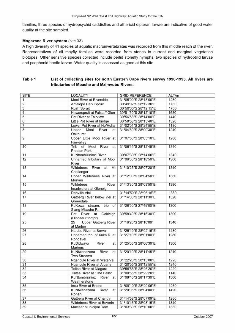
Proposed N2 Wild Coast Toll Highway: Aquatic Study for the EIA
Coastal & Environmental Services October 2007 122
families, three species of hydropsychid caddisflies and athericid dipteran larvae are indicative of good water quality at the site sampled. Mngazana River system (site 33) A high diversity of 41 species of aquatic macroinvertebrates was recorded from this middle reach of the river. Representatives of all mayfly families were recorded from stones in current and marginal vegetation biotopes. Other sensitive species collected include perlid stonefly nymphs, two species of hydroptilid larvae and psephenid beetle larvae. Water quality is assessed as good at this site. Table 1 List of collecting sites for north Eastern Cape rivers survey 1990-1993. All rivers are
tributaries of Mbashe and Mzimvubu Rivers. SITE LOCALITY GRID REFERENCE ALT/m 1 Mooi River at Riverside 31º05'00"S 28º18'00"E 1280 2 Antelope Park Spruit 30º49'02"S 28º12'30"E 1780 3 Rush Spruit 30º50'30"S 28º12'15"E 1760 4 Hawerspruit at Falstaff Glen 30º51'50"S 28º12'16"E 1680 5 Pot River at Fairview 30º56'58"S 28º14'00"E 1440 6 Little Pot River at bridge 30º58'58"S 28º15'40"E 1320 7 Lower Pot River at Ho/Hoha 31º02'01"S 28º24'55"E 1180 8 Upper Mooi River at
Oakhurst 31º04'50"S 28º09'30"E 1240
9 Upper Little Mooi River at Fairvalley
31º07'50"S 28º05'10"E 1280
10 Trib of Mooi River at Preston Park
31º06'15"S 28º12'45"E 1340
11 KuNtombizininzi River 30º07'30"S 28º14'00"E 1340 12 Unnamed tributary of Mooi
River 31º06'00"S 28º18'50"E 1300
13 Wildebees River at Mt Challenger
31º10'25"S 28º07'20"E 1340
14 Upper Wildebees River at Morven
31º12'00"S 28º04'50"E 1360
15 Wildebees River headwaters at Glenelg
31º13'30"S 28º03'50"E 1380
16 Danville Vlei 31º14'50"S 28º05'15"E 1380 17 Gatberg River below vlei at
Greendale 31º14'00"S 28º11'30"E 1320
18 KuKowa stream, trib of Slang-Mbashe R.
31º28'50"S 27º49'00"E 1300
19 Pot River at Oakleigh (Dinosaur footpr)
30º58'40"S 28º16'30"E 1300
25 25 Upper Gatberg River at Madun
31º16'20"S 28º10'00" 1340
26 Ntsubu River at Borva 31º25'10"S 28º02'15"E 1480 27 Unnamed trib. of Xuka R. at
Rondavel 31º27'10"S 28º01'00"E 1280
28 KuDidwayo River at Marinus
31º25'05"S 28º06'30"E 1300
29 KuNtwanazana River at Two Streams
31º20'10"S 28º11'45"E 1240
30 Nqancule River at Waterval 31º22'20"S 28º13'00"E 1220 31 Nqancule River at Albany 31º20'55"S 28º12'55"E 1240 32 Tsitsa River at Niagara 30º56'55"S 28º26'20"E 1220 33 Tsitsa River at "The Falls" 31º00'55"S 28º29'20"E 1140 34 KuNtombizininzi River at
Weatherstone 31º08'40"S 28º17'30"E 1300
35 Inxu River at Brione 31º09'10"S 28º20'05"E 1260 36 KuNtwanazana River at
Ronan 31º20'05"S 28º04'00"E 1420
37 Gatberg River at Chantry 31º14'58"S 28º07'09"E 1260 38 Wildebees River at Beverin 31º10'45"S 28º08'15"E 1340 39 Maclear Municipal Dam 31º03'30"S 28º10'00"E 1380

Proposed N2 Wild Coast Toll Highway: Aquatic Study for the EIA
Coastal & Environmental Services October 2007 123
40 Dammed trib. Little Pot R. at Killarney
30º59'25"S 28º14'59"E 1280
41 Rush Valley Pan 30º51'02"S 28º12'56"E 1740 42 Glen Avice Pan 30º47'22"S 28º12'02"E 1960 43 Unnamed trib. of Wildebees
R. 30º09'39"S 28º10'55"E 1360
44 Mountain stream, Prentjiesberg SW Peak
31º08'48"S 28º08'18"E 1900
45 Wildebees River on Lanark Farm
31º09'55"S 28º12'50"E 1300
46 Dam on Gatberg River 31º14'39"S 28º06'24"E 1360 47 Dam on KuNtwanazana
River 31º20'00"S 28º03'55"E 1420
48 Small seep flowing into pools, below pine plantation.
31º04'00"S 28º19'02"E 1400

Proposed N2 Wild Coast Toll Highway: Aquatic Study for the EIA
Coastal & Environmental Services October 2007 124
Table 2 List of sites, coordinates and biotopes* surveyed for invertebrates, during the Transkei rivers survey, October-November 1996. *indicates samples not yet analysed.
SITE RIVER
SYSTEM RIVER TRIBUTARY CO-ORDINATES
BIOTOPES SAMPLED
1 Mzimkulu Lubbukweni, Mangeni 30� 09' 11"S : 29� 27' 28"E MVOC
x Mzimkulu Lubbukweni, Mangeni 30� 09' 30"S : 29� 27' 34"E MVOC
2 Mzimkulu Tom, Gungununu 30� 11' 19"S : 29� 29' 52"E SIC, LPIC MOSSIC
3 Mzimkulu Gungununu 30� 07' 01"S : 29� 27' 39"E MVOC
4 Mzimkulu Siqubbini 30� 08' 53"S : 29� 25' 56"E SOR, SIC, MOSSIC
5 Mzimkulu Ngwangwane, Gungununu
30� 07' 15"S : 29� 37' 19"E SIC, LIGHT*
6 Mzimkulu Trib. of Malenge, Gungununu
30� 11' 15"S : 29� 33' 59"E No sample
7 Mzintlava Main channel 30� 22' 54"S : 29� 26' 58"E No sample
8 Mzimvubu Kinira 30� 18' 41"S : 28� 38' 12"E SIC, LPIC
9 Mzimvubu Kinira, Mabele, Jordan
30� 17' 31"S : 28� 23' 41"E SIC, LIGHT*
10 Mzimvubu Kinira, Mabele, Jordan
30� 19' 49"S : 28� 21' 09"E No sample
11 Orange Quthing (in Lesotho) 30� 20' 00"S : 28� 13' 09"E SIC, SOC
Y Mzimvubu Kinira, Komalihare, Paballong
30� 20' 15"S : 28� 16' 09"E SIC
12 Mzimvubu Kinira, Komalihare, Paballong
30� 20' 39"S : 28� 18' 11"E FNW, POOL
13 Mzimvubu Mabele, Jordan 30� 17' 06"S : 28� 22' 20"E SIC
14 Mzimvubu Mabele, Jordan 30� 17' 45"S : 28� 19' 39"E SIC
15 Mzimvubu Trib. of Mabele 30� 19' 49"S : 28� 21' 19"E MVOC
16 Mqwatyana 30� 15' 55"S : 30� 01' 47"E SIC, MVIC
17 Mqwatyana 30� 15' 46"S : 30� 02' 12"E SIC, POOL
18 Mkambati 30� 16' 26"S : 30� 01' 23"E SEEP, SOR MVIC/OC
19 Daza 30� 17' 41"S : 29� 58' 55"E LIGHT*, SIC, MVIC/OC, FNW

Proposed N2 Wild Coast Toll Highway: Aquatic Study for the EIA
Coastal & Environmental Services October 2007 125
20 Daza 30� 18' 19"S : 29� 59' 45"E No sample
21 Mkambati 30� 15' 14"S : 29� 57' 34"E MVIC/OC
22 Mtentu 30� 07' 52"S : 29� 45' 22"E SIC, MVIC, SOC, SOR
23 Mzamba 30� 55' 45"S : 29� 49' 00"E SIC, MVIC/OC
24 Msikaba Mhlumba 30� 11' 52"S : 29� 36' 32"E SIC, FNW, MVIC/OC
25 Msikaba Mtsila 30� 14' 12"S : 29� 35' 43"E SIC, MVIC
26 Msikaba Xura 30� 19' 07"S : 29� 34' 04"E SIC
27 Mtata 30� 55' 27"S : 29� 08' 11"E SIC, MVIC/OC
28 Mdumbi 30� 53' 17"S : 29� 11' 27"E SIC, MVIC
29 Mshakatye 31� 50' 35"S : 29� 14' 36"E No sample
30 Hluleka 30� 49' 27"S : 29� 18' 05"E SIC, MVIC, LIGHT*
31 Mngazi 30� 36' 39"S : 29� 24' 16"E SIC, MVOC
32 Mntafufu 30� 29' 39"S : 29� 31' 40"E SIC, MVIC/OC
33 Mngazana 30� 37' 42"S : 29� 20' 38"E SIC, MVIC

Proposed N2 Wild Coast Toll Highway: Aquatic Study for the EIA
Coastal & Environmental Services October 2007 126
* Key to Biotope abbreviations Biotope Description
FNW
LIGHT
LPIC
MOSSIC
MVIC
MVOC
POOL
SIC
SOC
SOR
Flying near water
Light trap sample
Leaf pack in current
Moss in current
Marginal vegetation in current
Marginal vegetation out of current
Collected from pool
Stones in current
Stones out of current
Surface of river
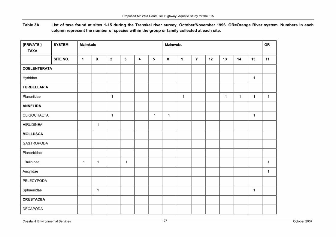
Proposed N2 Wild Coast Toll Highway: Aquatic Study for the EIA
Coastal & Environmental Services October 2007 127
Table 3A List of taxa found at sites 1-15 during the Transkei river survey, October/November 1996. OR=Orange River system. Numbers in each column represent the number of species within the group or family collected at each site.
{PRIVATE } TAXA
SYSTEM Mzimkulu Mzimvubu OR
SITE NO. 1 X 2 3 4 5 8 9 Y 12 13 14 15 11
COELENTERATA
Hydridae 1
TURBELLARIA
Planariidae 1 1 1 1 1 1
ANNELIDA
OLIGOCHAETA 1 1 1 1
HIRUDINEA 1
MOLLUSCA
GASTROPODA
Planorbidae
Bulininae 1 1 1 1
Ancylidae 1
PELECYPODA
Sphaeriidae 1 1
CRUSTACEA
DECAPODA

Proposed N2 Wild Coast Toll Highway: Aquatic Study for the EIA
Coastal & Environmental Services October 2007 128
Potamonidae 1 1
OSTRACODA 4 1
CLADOCERA 1 1 1
ARACHNIDA
ARANAEIDA 1
HYDRACARINA 1 1 1
INSECTA
EPHEMEROPTERA
Baetidae 3 1 2 3 3 3 2 3 1 4 2 2 4
Heptageniidae 1 1
Leptophlebiidae 1 2 1 2 1 1
Tricorythidae 1 1 1 1 1 1
Caenidae 2 1 2 1 1 1
PLECOPTERA
Notonemouridae 2 1
Perlidae 1 1 1
ODONATA
ZYGOPTERA
Coenagrionidae 1 2 2 1
ANISOPTERA

Proposed N2 Wild Coast Toll Highway: Aquatic Study for the EIA
Coastal & Environmental Services October 2007 129
Aeshnidae 1 1 1 1 1
HEMIPTERA
Gerridae 1
Veliidae 1 1
Corixidae 1 2 2
Pleidae 1
Notonectidae 1 1
TRICHOPTERA
Hydropsychidae 1 2 3 1 1 1 1 1 1
Ecnomidae 2 1 1
Hydroptilidae 1
Leptoceridae 1
Lepidostomatidae 1
COLEOPTERA
Helodidae 1
Dytiscidae 2 2 1 3
Gyrinidae 1 1 1
Hydraenidae 1 2 1 2 1 1
Elmidae 2
Hydrophilidae 1

Proposed N2 Wild Coast Toll Highway: Aquatic Study for the EIA
Coastal & Environmental Services October 2007 130
DIPTERA
Blephariceridae 1
Simuliidae 1 2 1 2 2 2 1 1 2
Chironomidae 4
Tanypodinae 2 1 1 2 2 2
Orthocladiinae 2 2 2 2 2 3 1 3
Chironominae
Chironomini 1 1 1 1 1 2 1 1
Tanytarsini 1 1 1 2
Ceratopogonidae 1 1 1 1 1
Tipulidae 2 1 1
Athericidae 1
Muscidae 1 1
Pelechorynchidae? 1
Total No. Families 16 17 10 10 8 8 11 15 9 4 11 8 15 11
Est. Total No. Species 23 26 15 17 15 15 20 19 15 4 17 10 20 20

Proposed N2 Wild Coast Toll Highway: Aquatic Study for the EIA
Coastal & Environmental Services October 2007 131
Table 3B List of taxa found at sites 16-33 during the survey of the Transkei rivers, October/November 1996. MQWAT=Mqwatyana, MKAM=Mkambati, DA=Daza, MT=Mtentu, MZ=Mzamba, TA=Mtata, MD= Mdumbi, HL=Hluleka, MG=Mngazi, MN=Mntafufu, MA= Mngazana River systems. Numbers in each column represent the number of species within the group or family ncollected at each site.
SYSTEM MQWAT MKAM DA MT MZ MSIKABA TA MD HL MG MN MA
TAXA SITE NO. 16 17 18 21 19 22 23 24 25 26 27 28 30 31 32 33
COELENTERATA
Hydridae 1
TURBELLARIA
Planariidae 1 1 1 1 1 1
ANNELIDA
OLIGOCHAETA 1 1 1 1 1 1 1
MOLLUSCA
GASTROPODA
Lymnaeidae 1 1 1
Planorbidae
Planorbinae 1 1 1 1 1 1 2 1
Bulininae 1 1 1
Neritidae 1
Assimneidae 1
Succineidae? 1
Ancylidae 1 1 1 1 2 1 1 1

Proposed N2 Wild Coast Toll Highway: Aquatic Study for the EIA
Coastal & Environmental Services October 2007 132
PELECYPODA
Corbiculidae 1 1
CRUSTACEA
DECAPODA
Potamonidae 1 1 1 1 1 1 1 1 1
Atyidae 2 1 1 2 1 2 2
Palaemonidae 1 1 1 1
AMPHIPODA 1 1
ISOPODA 1
CLADOCERA 1
OSTRACODA 2 1 1 2
ARACHNIDA
ARANAEIDA 1 1 1 3
HYDRACARINA 1
COLLEMBOLA
Isotomidae 1
Poduridae 1
Sminthuridae 1

Proposed N2 Wild Coast Toll Highway: Aquatic Study for the EIA
Coastal & Environmental Services October 2007 133
INSECTA
EPHEMEROPTERA
Baetidae 3 2 3 2 3 4 3 3 2 1 1 2 3 4 2 3
Heptageniidae 1 1 1 1 1 1 1
Leptophlebiidae 1 1 2 2 2 1 1 1 1 2 1 2
Tricorythidae 1 2 1 1 1
Caenidae 1 2 1 1 1 1 2 2 2 2
PLECOPTERA
Perlidae 1 1 1 1 1 1
ODONATA
ZYGOPTERA
Coenagrionidae 1 1 1 2 1 1 1 1 1 1 1
Chlorocyphidae 1 1 1
Lestidae 1 1 1 1
ANISOPTERA
Gomphidae 1 1 1
Libellulidae 1 1 1 1 1 1 1 1 1 1
Corduliidae 1
Aeshnidae 1 1 1 1 1 1 1 1 1

Proposed N2 Wild Coast Toll Highway: Aquatic Study for the EIA
Coastal & Environmental Services October 2007 134
HEMIPTERA
Gerridae 1 1 1 1 1 1
Veliidae 1 1 1 2 2 2 2 1 1 1 1 1 2
Corixidae 1 1
Nepidae 1 1 1
Pleidae 1
Belostomatidae 1 1
Notonectidae 1 1 1 1
Naucoridae 1 1 1 1 1 1 1 1 1 1
TRICHOPTERA
Hydropsychidae 1 1 1 2 2 2 2 2 1 1 3 3 2
Philopotamidae 1 1 1
Hydroptilidae 1 1 1 1 1 1 1 1 2
Leptoceridae 3 1 2 3 2 1
Xiphocentronidae 1
LEPIDOPTERA
Pyralidae 1
COLEOPTERA
Helodidae 1 1 1
Dytiscidae 1 2 1 1 2 1

Proposed N2 Wild Coast Toll Highway: Aquatic Study for the EIA
Coastal & Environmental Services October 2007 135
Gyrinidae 2 1 1 1 1 1 1 1 1 1 1
Hydraenidae 1
Elmidae 1 2 2 1 1 1 1 1 1
Hydrophilidae 2 1 1 1 1 1
Psephenidae 1 1 1 1 1
DIPTERA
Psychodidae 1
Simuliidae 2 2 1 1 3 1 4 1 2 2 2 4 5 2 3
Chironomidae 2 3 3 1
Tanypodinae 2 1 1 1 1 1
Orthocladiinae 3 2 1 1 2 1 1 2 1 2 2
Chironominae
Chironomini 3 1 1 1 1 1 2 1 2
Tanytarsini 1 1 1 2 2 2 2 1 1 1
Ceratopogonidae 1 1 1 1 1
Tabanidae 1 1
Tipulidae 1 1 1 1
Athericidae 1 1 1
Muscidae 1 1 1 1
Stratiomyidae 1

Proposed N2 Wild Coast Toll Highway: Aquatic Study for the EIA
Coastal & Environmental Services October 2007 136
Total No. Families 23 11 19 6 30 32 19 25 20 5 6 27 32 33 25 26
Est. Total No. Species 39 17 24 7 42 45 30 32 30 7 7 32 35 48 33 41
Table 4 Coordinates of collecting sites used for the aquatic macro-invertebrate survey on tributaries of Nahoon and Buffalo Rivers between 1999 and 2004.
SITE CO-ORDINATES
BM1 Mncotso River tributary of Buffalo River 320 54’ 48”S; 270 36’53”E
NR1 Rwantsa River tributary of Nahoon River 320 53’20”S; 270 37’55”E
NR4 Rwantsa River tributary of Nahoon River
320 52’25”S; 270 38’34”E
NR5 Rwantsa River tributary of Nahoon River 320 53’00”S; 270 40’45”E
NR6 Rwantsa River tributary of Nahoon River 320 53’56”S; 270 41’53”E
NX2 Xolo River tributary of Nahoon River 320 52’43”S; 270 37’05”E
NX4 Xolo River tributary of Nahoon River 320 52’ 40”S; 270 37’20”E
NX4a Xolo River tributary of Nahoon River 320 51’ 16”S; 270 36’50”E
NX6 Xolo River tributary of Nahoon River 320 50’ 14”S; 270 37’49”E
NX7 Xolo River tributary of Nahoon River 320 49’ 22”S: 270 38’00”E
N0 Nahoon River 320 50’28”S; 270 39’21”E
N2 Nahoon River 320 51’10”S; 270 39’06”E

Proposed N2 Wild Coast Toll Highway: Aquatic Study for the EIA
Coastal & Environmental Services October 2007 137
Table 5 Macroinvertebrates recorded at river sites sampled during the May-June 2000 survey of the aquatic ecosystems downstream of the proposed landfill site for East London TLC (* = taxa recorded; S = taxa sighted but not collected; grey shading indicates dam sites).
TAXA RIVER SITES
BM1 N0 N2 N3 NX
1
NX
2
NX
4
NX
4
a
NX
6
NX
7
NR
1
NR
4
NR
5
NR6
Porifera * *
Platyhelminthes
Planariidae
? Planaria sp. * * * *
Annelida
Tubificidae
Tubifex sp. * * * *
Branchiura sowerbyi * * *
Naididae * * * * *
Hirudinea *
Mollusca
Ancylidae
Burnupia sp. * * * * * * * * *
Ferrissia sp . * *
Lymnaeidae
Lymnaea truncatula * * * *
Lymnaea natalensis * * * * *
Planorbidae
Gyraulus connollyi * *
Bulinus tropicus *
Physidae
Physa acuta * *
Corbiculidae
Corbicula fluminalis * *
Sphaeriidae
Pisidium costulatum * *
Crustacea
Cladocera
Ilyocryptus sp. * *
Ostracoda *
Copepoda *
Isopoda
?Aselas sp. *
Decapoda
Potamonautes sidneyi * * * * * * * *

Proposed N2 Wild Coast Toll Highway: Aquatic Study for the EIA
Coastal & Environmental Services October 2007 138
Acari
Hydracarina * *
Arachnida
Tetragnathidae * * * *
Collembola
Poduridae *
Entomobryidae *
INSECTA
Ephemeroptera
Baetidae
Acanthiops tsitsa *
Afroptilum sudafricanum * * * * * * * * *
Baetis harrisoni * * * * * * *
Centroptiloides bifasciata * * *
Cheleocloeon excisum * * * * * * * *
Cloeodes inzingae * * *
Cloeon virgiliae * * * * * * * * * *
Dabulamanizia indusii *
Dabulamanzia media *
Demoulinia crassi * * * * * *
Pseudocloeon glaucum * * * *
Pseudocloeon latum * * *
Pseudocloeon nr. Piscis * * * *
Pseudopannota
maculosa
* * * *
Caenidae
Caenis sp. 2 * * * * * *
Heptageniidae
Afronurus peringueyi * * *
Leptophlebiidae
Adenophlebia auriculata *
Adenophlebia sylvatica * * * * * * * * *
Choroterpes nigrescens * * * *
Polymitarcyidae * * * *
Povilla adusta * *
Odonata
Coenagrionidae
Pseudagrion spp. * * * * * * * * * * * *
Enallagma sp. * * * * * * *
Ischnura senegalensis * *
Platycnemididae
Allocnemis leucosticta *
Lestidae
Lestes sp. * * * * * * *

Proposed N2 Wild Coast Toll Highway: Aquatic Study for the EIA
Coastal & Environmental Services October 2007 139
Synlestidae
Chlorolestes tessellatus *
Chlorolestes sp. * *
Calopterygidae
Phaon iridipennis *
Chlorocyphidae
Platycypha caligata S S

Proposed N2 Wild Coast Toll Highway: Aquatic Study for the EIA
Coastal & Environmental Services October 2007 140
Derovatellus sp. *
Hydaticus galla * *
Hydaticus sp.
? Potamonectes sp. 1 * * *
? Potamonectes sp. 2 * *
Rhantaticus sp. * * * * *
Gen. sp. indet. * *
Gyrinidae
Aulonogyrus sp. * * *
Orectogyrus sp. *
Hydrophilidae
Acidocerus sp. *
Berosus sp. * *
Chasmogenus sp. * * *
?Helobata sp *
?Helochares sp. *
Hydrochara sp. * *
Hydraenidae
Hydraena sp. * *
Helodidae
Type 1 * * * *
Type 2 * *
Type 3 *
Psephenidae
Eubrianax sp. * * * ?*
Elmidae
?Potamodytes sp. *
Stenelmis sp. *
Chrysomelidae
Trichoptera
Hydropsychidae
Cheumatopsyche afra * * *
Cheumatopsyche Type 5 * * * * * *
Macrostemum capense *
Hydroptilidae
Hydroptila cruciata *
Ecnomidae
Ecnomus sp. nr
.oppidanus
*
Ecnomus ?thomasseti *
Ecnomus sp. * * * * *
Leptoceridae
Athripsodes sp. 1 * *
Athripsodes sp. 2 * *
Homilia knysnaensis *
Leptocerus sp. * * *

Proposed N2 Wild Coast Toll Highway: Aquatic Study for the EIA
Coastal & Environmental Services October 2007 141
Lepidoptera
Pyralidae
Nymphula sp. * *
Diptera
Tipulidae
Antocha sp. *
Tipula sp. * *
Psychodidae * *
Ptychopteridae
Ptychoptera ?capensis *
Chaoboridae
Chaoborus sp. * *
Culicidae
Aedes sp. * *
Anopheles ?marshallii
s.l.
*
Anopheles ?concolor
implexus
* *
Anopheles sp. * * * * *
Culex sp. * * * *
Ficalbia sp. *
Ceratopogonidae * * *
?Atrichopogon sp. * * *
Bezzia sp. * * *
Dasyhelia sp. * *
?Forcipomyia sp. *
Chironomidae * * * * * * * * * * *
Chironominae * * * *
Tanytarsini *
Orthocladiinae * *
Corynoneura sp. *
Tanypodinae * * * * *
Simuliidae
Simulium adersi * * * *
Simulium damnosum sl. * * *
Simulium impukane * *
Simulium hargreavesi * * *
Simulium medusaeforme * * * * *
Simulium nigritarse * ?* * * * * *
Simulium
(Pomeroyellum) sp.
*
Simulium ruficorne *
Simulium vorax * * *
Tabanidae *
Athericidae

Proposed N2 Wild Coast Toll Highway: Aquatic Study for the EIA
Coastal & Environmental Services October 2007 142
Atherix sp. * *
Empididae * * *
Dolichopodidae *
Syrphidae
Eristalis sp. *
Ephydridae *
Muscidae
Limnophora sp. *
Lispe sp. *
TOTAL TAXA
PER SITE
25 29 49 25 15 21 19 50 38 45 21 35 45 36

Proposed N2 Wild Coast Toll Highway: Aquatic Study for the EIA
Coastal & Environmental Services October 2007 143
APPENDIX 2
Peer Review Comments and Response Trail
N2 Aquatic assessment specialist survey responses to
comments received
Project N2 Aquatic Assessment
Document number
Subject Response to comments made on
N2 aquatic assessment specialist
report Bill Harding
To Fuad Fredericks
From Brian Colloty
Coastal & Environmental Services
Grahamstown
P. O. Box 934, Grahamstown, 6140
Tel: +27 (46) 622 2364; Fax: +27 (46) 622 6564
Email: [email protected]
Also in East London and Durban
www.cesnet.co.za
Date issued March 2008
Instructions
The following comments were received from Dr. Bill Harding on the N2 aquatic assessment specialist
report. Changes based on these comments are listed below and have subsequently been made to the
report. Any significant changes have been listed as a response for each comment:
1. Assess whether the specialist study has complied with its Terms of Reference. The specialist study under review was tasked with assessing the likely impact of the proposed highway,
either from upgrading of existing roads or the construction of new, on the aquatic ecosystems traversed
by same. Here, per Section 1.2, it is important to note that of the total route of 560 km, some 470 km
(eighty percent) follows an existing road system that has been in existence for many years. The existing
system will be upgraded to confirm with the toll road specifications, while a new road will be built over the
remaining 90 km – the so called ‘greenfields’ route.
This particular specialist study follows on an earlier assessment (2002/2003), details of which were not
provided to this reviewer. Additionally, no details of comments raised for either study, during the public
process or otherwise, were provided with the review package. The study under review was tasked with
identifying new and additional information in order to augment the database of baseline information for
the aquatic ecosystems (rivers, wetlands and estuaries) extant along the route.
The assessment of the impacts associated with the upgrading of the N2 Wild Coast road system is an
important issue. The identified impacts clearly need to define an attainable and sustainable balance
between economic development factors and the need to ensure that natural resources are minimally
affected.
Regrettably, the report is poorly written and clumsy. The presentation of data, facts and arguments is
haphazard, complicated by tortuous sentence structure and generalized arguments. Poor design of tables
and the lack of a modular, well spaced, section by section report structure, rendered extraction of data
Proposed N2 Wild Coast Toll Highway: Aquatic Study for the EIA
Coastal & Environmental Services October 2007 144
and relating cause and effect both frustrating and difficult.
The Executive Summary and Discussion sections are extremely poor and the Conclusion is woefully
inadequate. There are no maps that highlight (‘red-flag’) keys points of concern or which provide for a
comparison and contrasting of ecosystem condition and importance vs. the level of engineering alteration
proposed for specific localities.
The report arrives at the conclusion (stated on page 51 Section 4.1 – “it is anticipated that most issues /
impacts could be mitigated through careful design of the river crossings, tollgates and resultant (sic)
stormwater control measures” that the identified impacts are likely to be of short-term duration and
largely mitigable. I believe, however, that this conclusion, albeit accurate, could simply have been arrived
at from a desktop analysis. Road building is not a ‘dark art’, rather it is a well defined process, governed
by carefully specified and controllable civil engineering actions. Augmenting this is the fact that some
eighty percent of the road involves the upgrading of an existing road. It may, therefore, be argued that the
impacts will be confined, in the main, to highly controllable, site-specific impacts.
• The various comments were noted and issues raised around report structure, the executive
summary and conclusion have been attended to in the report revision. The question around
the need for field work is debatable, but this was also as a result of a specific request from
the client, especially considering the sensitive nature of the greenfields routes and the
paucity of the data. With regards the previous study, the current report was built upon the
information and content of the past report, guided by any additional specialist surveys and
field work. With regard key red-flag issues, these were difficult to map, for example the total
extent of wetlands is still unknown, as highlighted in the report. Primary concern areas have
been listed in the relevant sections of the report. These will be highlighted in the conclusion
section.
2. Assess whether adequate consideration in given, where appropriate, to the legal, policy and/or planning context of direct relevance to the specialist study. The report lists the legislation governing the manner in which impacts on aquatic ecosystems need to be
addressed. Considerably more detail needs to be provided in terms of the need for site specific Method
Statements allied to each specific river crossing, minimizing of impacts of wetlands and related matters.
This is an EIA level report in which detailed mitigation approaches need to be spelt out. The study would
have been better directed through less attention to one-off data gathering and more attention to the
specifics of the road upgrading actions – the latter in relation to minimizing construction related impacts.
• The point is noted and discussed in the response above. Additional clarification of the
mitigation has been included in the report where appropriate.
3. Assess the study approach, technical content and assessment methodology of the specialist study to determine whether it is credible. The central aim of the project was to assess and describe the potential environmental impacts that would
arise from the road upgrading or new construction. In order to do this, four core tasks were required:
• Assess ecological condition and importance based on extant data;
• Gather such new data as was possible from the arguably completely inadequate time allowance

Proposed N2 Wild Coast Toll Highway: Aquatic Study for the EIA
Coastal & Environmental Services October 2007 145
for field work;
• Identify and ‘red flag’ those areas for which information should be gathered – presumably with
specific motivation as to why same should be collected.
• Relate identified impacts to condition and allocate appropriate, practicable mitigation
management practices.
As indicated above, this reviewer has not had sight of the previous study (2002/2003) and, thus, has no
knowledge of the information sources drawn on or the literature review prepared at that time. The July
2007 specialist study was limited to a one-week field survey over a considerable distance, crossing many
aquatic systems and in a terrain that is, in many cases, poses significant constraints to ready access.
This notwithstanding, the project team appear to have collected valuable packets of information.
However, it must be argued that there exists sufficient baseline data from which to synthesize, using
expert-judgement, an overall assessment of ecological importance. Accordingly, such a short time
allocation for the field survey might have better been served by undertaking an aerial videography of the
route. Additionally, the now common expedient of gleaning information from Google Earth images would
have been insightful.
In my opinion, the importance of an assessment of this nature, in terms of providing value to all
stakeholders, is less about the small stuff (collections of one-off samples of physico-chemical data,
aquatic invertebrates and the like) and more about applying sound, informed expert-judgement. South
African aquatic ecologists know more than enough about what is required to guide the protection of
aquatic ecosystems against impacts caused by road construction. While useful, the one-off collection of
primary data does little to support the arguments required here. The report already acknowledges key
estuarine studies – the information from which can be augmented from earlier works, mostly integrated
into the “Estuaries of South Africa” work edited by Allanson and Baird (Cambridge, 1999). Other works,
such as the”Inland Waters of Southern Africa: An Ecological Perspective edited by Allanson et al (Kluwer,
1990) and the “Field Guide to Eastern and Southern Cape Coasts” by Lubke and de Moor (UCT Press,
1988), as well as “A Field Guide to the Eastern Cape Coast” – Lubke et al (Wildlife Society of Southern
Africa, 1987) provide valuable insights regarding biophysical processes and ecology relevant to this area.
These, combined with the thorough estuarine assessments as referenced in the document, provide a
substantial base of existing, well researched information which underpins the general understanding of
the value and ecological importance of the environments through which the proposed road will be built or
already exists. This information should then be used to inform an analysis of the likely civil engineering
impacts and a synthesis of pragmatic mitigation measures.
The report (Section 1.3) lists a number of Assumptions and Limitations to the study. Based on the
arguments presented above, I consider most of these to be non-issues.
Lastly, I do not understand why precedents were not sought – for example, an examination of the impacts
related to the construction of the North Coast Toll Road (Durban to Richards Bay) would have been
insightful as to the nature of impacts and their intensity and duration.
• These comments are noted, it must be added though that using additional techniques such as
videography would have been useful, but due to the timing of the report deadlines, identifying the
smaller wetland seeps in winter, for example would not have been possible. The Google images
in certain areas also had poor resolution.
Proposed N2 Wild Coast Toll Highway: Aquatic Study for the EIA
Coastal & Environmental Services October 2007 146
4. Assess the adequacy of information used and identify whether there are any obvious information gaps, omissions or inaccuracies that need to be addressed. This has been addressed above. A critical gap is the lack of a exhaustive examination of mitigation
procedures linked to specific engineering actions. This process should be ‘work-shopped’ with input from
an experienced roads engineer.
• Additional comment from a qualified engineer was sought, to expand on the mitigations after
these comments were received.
5. Assess whether the significance ratings given to potential impacts are reasonable and reliable. I believe that in the main, the ratings are accurate. However, with respect to certain identified impacts,
these being habitat loss, sedimentation, loss of riparian vegetation, changes in water quality and the
‘cumulative’ effect of impacts, the ratings may have been set a category too high (Over-rated).
These issues are dealt with under pt 7 (below).
• The report authors have again evaluated the impact ratings and with the exception of some
wetlands areas and estuaries in the greenfields area, certain impact ratings have been changed.
6. Assess whether the recommendations of the study with regard to the most appropriate alternatives are sound and defensible. Comments on this item are dealt with under pt 7 (below). No alternatives, other than the preferred
SANRAL route, are considered by the report.
7. State any alternative viewpoints concerning the issues presented in the report, if any, given reasons for your particular stance. The identified impacts are all closely associated with site-specific (highly localized) impacts, most
commonly the crossing of rivers and, in almost all cases, the widening of existing bridge crossings. In
other cases intrusion into wetland zones may occur, but it would appear that this will be mostly avoided.
Distal to the river crossing impacts is an apparent association with what the report refers to as
‘cumulative’ impacts, i.e. impacts increasing in intensity with distance from the impact.
Impacts on instream and riparian environments, as a result of alterations to existing bridges, are
localized, short-term, site-specific occurrences which can be carefully controlled by means of detailed
Method Statements, supervision and the exercising of due care and diligence. I fail to see how the
widening of a bridge culvert, under such managed care, can result in significant changes in ecosystem
structure or loss of biodiversity. Equally, I fail to see how such actions will result in the generation of
changes in sedimentation profiles that are discernible from the ‘background’ sediment loads currently
borne by these rivers, or of such a magnitude that will not be rapidly reset by the riverine hydraulics.
Concerns relating to sedimentation have, in my opinion, been consistently overstated throughout the
report – at least without clear substantiation or quantification.
Changes in water quality are presumably associated with road use. Again, a background impact from the
existing road has been in place for a long time. The report needs to address whether or not this is
discernible, or if improved stormwater management and runoff controls could be added to the drainage

Proposed N2 Wild Coast Toll Highway: Aquatic Study for the EIA
Coastal & Environmental Services October 2007 147
designs to mitigate existing impacts. It is doubtful whether the increased road use will bring about
measureable changes in water quality, at least not within the scope of the routine DWAF monitoring to
discern.
The report makes repeated mention of ‘cumulative impacts’. With the preceding paragraph in mind, I fail
to see any substantiation for such impacts arising – unless there are multiple crossings of the same river.
• The report authors have again evaluated the impact ratings and with the exception of some
wetlands areas and estuaries in the greenfields area, certain impact ratings of the have been
changed.
8. State whether you believe that any key uncertainties or risks, and/or assumptions underpinning the assessment, have been sufficiently highlighted in the study. The data pertaining to fish could be used to screen the rivers for importance values based on
complementarity, i.e. the need to consider rivers that contain species occurring only therein, or occurring
in only a small subset of the entire suite of rivers. The report has drawn attention to the dangers posed by
roads traversing wetlands in such a manner that the wetland hydrology is irreversibly and negatively
altered. Such actions are to be avoided. Permanent destruction or loss of wetlands is non-negotiable.
Rather, the road construction through the greenfields section should be regarded as an option to
sensitively upgrade already-damaged ecosystems and ensure no degradation from present condition.
I believe that the uncertainties raised lack specifics.
• Comment was noted. The uncertaintiy was possibly due to the lack of detailed wetland mapping
information and the important role these wetlands play in sustain the communities, which have no
alternative water sources.
9. Submit a Letter Report (3-6) pages containing the findings of this review.
Overall recommendations
a. The report should be re-drafted and carefully edited into a readable and concise presentation. With
better restructuring and argument formulation it should provide a clearer assessment of the Terms of
Reference;
o Structured according to CCA guidelines and report templates
b. Most of the tables (e.g. 2.4) need to be restructured to contain less narrative and to render them easy
to assess at a glance. It should be possible to assess each identified ‘impact’ across all potentially-
affected sites;
o Included additional headings in tables to clarify and condense information.
c. Data collected during the study, together with Methods employed, should be moved to Appendices and
not allowed to encumber the main body of the report. This applies to most of Sections 2 and 3;

Proposed N2 Wild Coast Toll Highway: Aquatic Study for the EIA
Coastal & Environmental Services October 2007 148
o Structured according to CCA guidelines and report templates
d. The Terms of Reference call for an assessment of ecological importance based on existing data. This
needs to be attended to, with reference to pt. b, above. There do not appear to be any mapped
summaries of ecological importance;
o Should be done by CCA in terms on integrated ecological importance based on all specialist
surveys.
e. Avoid loose and unscientific statements, e.g. “crustacean remnants indicated the presence of
mongoose”. Mongoose are not the only consumers of crabs in rivers and wetlands.
o Have reworded to “possible presence of mongoose or otters”.
Avoid vague and meaningless statements such as “most South African wetlands are ‘temporal’ “– which
means “of or relating to time” – is this implying seasonal perhaps?
o Although most South African wetlands are temporal due to the seasonality of rainfall in the
country, the majority of wetlands in the study still contained water, below ground level and were
thus accessed using hand dug wells. This provides a consistent water supply to communities in
the area.
“if the road was poorly designed, it could, for example, on a cumulative basis impact on a large number
of rivers /wetlands….”!
Use terms such as ‘impoundment’ rather than “damming”;
o Noted.
Recommendations such as “take the necessary management actions should water quality status decline”
– are vague and imply that routine water quality monitoring protocols have the capacity to resolve road
use-induced water quality changes, over and above those originating from the entire catchment
background. This sort of recommendation lacks an understanding of reality. What criteria and methods
would you use to specifically target criteria that would conclusively provide these answers?
o This statement has further been qualified with the following insertion:
o It is thus proposed that the Environmental Management Plan must include provisions for
an Environmental Site Officer (ESO), who report to an Environmental Control Officer.
The daily tasks of the ESO, should include monitoring of upstream and downstream
suspended sediments loads. This would provide information on the management of the
construction site, so that sediment loads (Total Suspended Sediments) are no elevated
beyond the natural ambient levels. Works areas must be cut off from the main channel,
when working in the riverbed, using coffer dams. These dams would allow any sediment
and or pollutant from the construction site to be captured. It is further suggested due to
nature of these systems that sandbag coffer dams are used and not earth wall dams.
f. Sentences such as “animals observed around the wetlands included ducks, geese, cormorants and
herons” would be better worded starting with “waterfowl”.

Proposed N2 Wild Coast Toll Highway: Aquatic Study for the EIA
Coastal & Environmental Services October 2007 149
o Waterfowl such as ducks (yellow-billed), geese (Egyptian goose), cormorants and herons
have been observed in and around the wetlands.
Furthermore, if vlei rats, based on their burrows alone, could be identified to species, why not the
observed waterfowl?;
o See note above.
g. Section 4 is a very important section in which findings are synthesized. Its title should be ‘Sources of
Risk’.
This section is poorly set out and full of confusing statements e.g. “potential risks affect inland water
systems through direct physical changes to the actual systems or indirectly to their surrounding
catchments.”
o Noted and statements have been revised.
Revise the list on page 52 and deal with the confusing statements “inundation by vegetation” and remove
repetition. (diversion of flow and changes to hydrological processes fall within the same category);
Amendments were as follows:
• Destruction of vegetation and changes in vegetation community type
• Reduction in permeable surfaces leading to changes to hydrological processes (increased
surface run-off, velocities and volumes)
• Increased sediment loads down rivers, resulting in changes to instream habitats and
therefore instream community structures
• Risk of surface and groundwater pollution, especially with regards to tollgates
h. Don’t generalize. Use an easy-access tool such as Google Earth to track the route (most of which is
clearly visible) and, on a start-to-end basis tabulate the likely risks. Alternatively SANRAL must be in
possession of recent, ortho-rectified aerial photography. Use this approach to identify where the
upgrading may be employed to improve existing impacts, for example, removal of collapsed bridge
structures or other in-stream or riparian impediments;
1. Tasked to construct report as per CCA template, which was developed in road sections.
2. Google image is unclear for a large number of the sections, especially the “greenfields” route.
i. Endeavour to make the assessments on a quantitative basis. The issue of whether sediment generated
from a bridge widening, will actually have any measurable impact, or an impact of any significance, is a
central case in point. Equally so are the inferences that Toll Gates will lead to pollution of groundwater, or
the risk of borrow pits altering wetland groundwater tables – this may be so but it has to be substantiated
with reasonable confidence – source geohydrological opinion on statements such as these! Mention is
made of an increase in impermeable surfaces reducing infiltration to groundwater. I seriously doubt
whether the (relatively) miniscule increase in road area over extant will result in this occurring! Finally, the
barrier to overland (sheet) flows posed by road embankments is argued as a problem. This needs to be
evaluated against the fact that eighty percent of the route is already embanked and has been for some
Proposed N2 Wild Coast Toll Highway: Aquatic Study for the EIA
Coastal & Environmental Services October 2007 150
time. The upgraded road could possible be used as an opportunity to remediate existing poor design;
Comments within the report have been included to clarify this issue with regard the scale of the impacts:
j. Qualify or expand on statements. The report mentions ‘alteration in drainage patterns resulting from
diversion of rivers’ – where have such diversions been identified, if at all?
Certain of the larger rivers or areas where new bridges will be constructed, coffer dams may be required.
The statement above will reflect that this is considered in the construction phase only.
k. Review all of the ratings in the impact tables. Here it would be very useful to workshop in the opinions
of an experienced road engineer;
• These were reviewed by Patsy Scherman and Brian Colloty and changes in the impact tables
were made.
l. Pay attention to the need for relevant detail. Barely has the Discussion begun and it breaks off into an
irrelevant discussion about the importance of palmiet!
• Palmiet paragraph has been moved. Now follows paragraph dealing with estuaries.
m. Do not tag on monitoring recommendations without thinking them through properly. It is unlikely that
current monitoring protocols will be able to discern road building impacts, equally so more sophisticated
protocols. It is recommended that monitoring start before the upgrade starts – this is unreasonable - for
how long would such monitoring need to be in place to provide a sound baseline of reference
information? If anything, monitoring needs to be closely allied to the analysis of likely cause and effect
that will arise during road building, and which will be tracked by the appointed Environmental Control
Officers appointed to oversee the civil works.
Assumed an EMP would be generated based on the recommendations given in this report.
• The initiation of monitoring programmes is essential to managing potential impacts on all
systems. Baseline monitoring of selected rivers and estuaries were undertaken recently as part of
the Xolobeni Heavy Mineral Mining study. This database should, ideally, be developed further,
with monitoring programmes developed for each aquatic component, using indicator organisms
or groups of organisms. As a minimum measure, monitoring needs to be closely allied to the
analysis of likely cause and effect that will arise during road building, and which will be tracked by
the Environmental Control Officers appointed to oversee the civil works.
It is thus proposed that the Environmental Management Plan must include provisions for an
Environmental Site Officer (ESO), who report to an Environmental Control Officer. The daily tasks of the
ESO, should include monitoring of upstream and downstream suspended sediments loads. This would
provide information on the management of the construction site, so that sediment loads (Total Suspended
Sediments) are no elevated beyond the natural ambient levels. Works areas must be cut off from the
main channel, when working in the riverbed, using coffer dams. These dams would allow any sediment
and or pollutant from the construction site to be captured. It is further suggested due to nature of these
systems that sandbag coffer dams are used and not earth wall dams.

Proposed N2 Wild Coast Toll Highway: Aquatic Study for the EIA
Coastal & Environmental Services October 2007 151
APPENDIX 3
TEAM MEMBERS CV’S
PATRICIA ANNE SCHERMAN Date of birth: 21 May 1965 EDUCATION BSc Hons Rhodes University PhD (Biotechnology) Rhodes University FIELD OF EXPERTISE My research interests are primarily environmental water quality and biological monitoring. The development of integrated management programmes of aquatic systems is a professional interest. EMPLOYMENT HISTORY March 2006 – present Operational Director, Coastal & Environmental Services, Grahamstown. March 2005 – March 2006 Principal Environmental Consultant, Coastal & Environmental Services,
Grahamstown. Feb. 2002 - February 2005 Senior Environmental Consultant, Coastal & Environmental Services,
Grahamstown. 1994 - February 2002 Research Officer and Project Leader of the IWR, and Manager of the Centre
for Aquatic Toxicology (CAT-IWR) since its inception in 1999. 1993 During the period January to February participated in the World Ocean
Current Experiment (WOCE) programme to Antarctica as an oceanic nutrient analyst.
1992-1993 Employed as Senior Technical Officer in the Institute for Water Research, Rhodes University.
PROFESSIONAL EXPERIENCE
• Aquatic toxicity testing using macroinvertebrates in artificial stream systems, and the analysis and interpretation of these results.
• SA River Health Programme (SA National Aquatic Ecosystem Biomonitoring Programme) - national
and provincial programmes, including the technical team leader of the Eastern Cape River Health team (Buffalo State-of-Rivers Report produced in 2004/2005; Mtata River Technical Report production underway).
• The drafting and revision of Water Quality Guidelines for Aquatic Ecosystems.
• Worked on the WRC-funded project, entitled Risk-based approach to setting integrated
environmental objectives for protection of water resources: Phases 1+2.
• Classification of the Kruger National Park rivers.
• Contract for Unilever UK on the effects of in-stream detergent use, focussing on the Kat River in the Eastern Cape.
• Water Resource Protection and Implementation: Determination of water quality methods the
Ecological Reserve.
Proposed N2 Wild Coast Toll Highway: Aquatic Study for the EIA
Coastal & Environmental Services October 2007 152
• Participated in the Olifants River Reserve project - Water quality team (1999-2001).
• Ecological Reserve Assessment for water quality in the Breede River (2001).
• Water quality task leader on the following DWAF Reserve contracts: Thukela, Letaba and Kromme / Seekoei (2001-2006).
• An Environmental Impact Assessment for the development of a tannery (Swazitan) at Matsapha,
Swaziland.
• Fatal flaw assessment for the development of a liquid natural gas processing facility.
• The development and management of environmental monitoring programmes, including conducting surface water assessment and managing the environmental monitoring programme of the East London Industrial Development Zone (2002-2004: Phase I, 2004-2005: Phase II), and CSL mining development in Chibuto, Mozambique (2003-2004: Phase I).
• Management of Phase II of environmental monitoring for Corridor Sands Limitada at Chibuto and
Chongoene, Mozambique.
• Developing a water monitoring programme for Tiomin heavy mineral mine in Kenya.
• Technical team leader of the Kromme / Seekoei Reserve Study (2003-2006).
• Conducted the water component of the Strategic Environmental Assessment for WMA12.
• Involvement in teaching and training: Lecturing third year students for the Institute for Water Research at Rhodes University; developing and running a national biomonitoring course with Dr Nikite Muller of the IWR since 2003 – this course is currently being extensively revised; and involvement in the development of a water quality Reserve module for FETWater (Framework for Education and Training in the water sector).
• Overseeing and participating in the water studies associated with a number of heavy mineral mining
EIAs: CSL in Mozambique, Tiomin in Kenya, Moma in Mozambique, Toliara in Madagascar.

Proposed N2 Wild Coast Toll Highway: Aquatic Study for the EIA
Coastal & Environmental Services October 2007 153
MICHAEL EVAN JENNINGS Date of birth: 29 August 1980 QUALIFICATIONS University of Cape Town: Bachelor of Science with University Honours (Oceanography) Rhodes University: Masters of Science (Zoology – Marine Biology) THESIS TITLE Nutrient dynamics in and offshore of two permanently open South African estuaries with contrasting fresh water inflow. CONSULTING EXPERIENCE 2007 – present: Senior Environmental Consultant, Coastal & Environmental Services 2006 – 2007: Environmental Consultant, Coastal & Environmental Services 2005 – 2006: Part-time assistance to Coastal & Environmental Services International Projects:
• Corridor Sands Project Heavy Minerals Mine, Chibuto, Mozambique (Water Monitoring Programme – sample collection and reporting, task team of Risk Assessment)
• Kenmare Heavy Minerals Mine, Moma, Mozambique (design and management of Water Monitoring Programme, Environmental Audits and report writing)
• Rio Tinto Heavy Minerals Mine, Xai-Xai and Inhambane, Mozambique (Water Monitoring Programme – sample collection and reporting)
• Tiomin Heavy Minerals Mine, Kwale, Kenya (Water Management Strategy, Water Monitoring Programme)
• Rabai Power Generation Plant, Mombassa, Kenya (Water Quality Impact Report) • Luanda Waterfront Development, Luanda, Angola (Water Impact Assessment, Terrestrial Impact
Assessment, Marine Water Quality Monitoring Programme – sample collection and reporting) • El Burulus Heavy Minerals Mine, Burulus, Egypt (Ecological Impact Assessment review)
Local Projects:
• East London Industrial Development Zone, East London (manage Water Monitoring Programme – sample collection and reporting, trainee mentorship)
• Wild Coast Toll Upgrade, Transkei (Estuary Impact Assessment) • Harvest Vale Development, Kenton-on-Sea (manage Basic Assessment, Ecological and
Hydrological Specialist Survey) • Hollingrove Development, Bathurst (Water Quality Specialist Study for a Basic Assessment) • Moyeni Development, Jeffrey’s Bay (Water Impact Assessment) • La Repose Development, Alexandria (Desalination Water Quality Impact Assessment) • Kenton Eco-Estate, Kenton-on-Sea (Environmental Audit) • Ukuhlamba-Drakensberg Transfrontier Park, Drakensberg (Biodiversity chapter of Strategic
Environmental Assessment) • Madiba Bay Development, Port Elizabeth (Water Quality Report) • Knysna Estuary Management Plan, Knysna (manage stakeholder and authority engagement and
Estuary Management Plan development, including Situation Assessment) • Knysna N2 Bypass, Knysna (manage Aquatic Specialist Investigation) • Mabopane Bulk Water Upgrade, Tswane (review Basic Assessment) • Outeniqua Reserve Study, Knysna (field work and estuarine Ecological Reserve data interpretation).
RESEARCH EXPERIENCE November 2005 – January 2006: Participated in the ANTXXII cruise on board the MV Polarstern to
Antarctica and the Lazaruv Sea to conduct the LAKRIS zooplankton survey.

Proposed N2 Wild Coast Toll Highway: Aquatic Study for the EIA
Coastal & Environmental Services October 2007 154
February 2004 – November 2006: Research project undertaken in Great Fish and Kariega Estuaries as well as in the adjacent nearshore environment of each including the collection and analysis of water quality samples to contribute towards the submission of an MSc. As an addition to the study zooplankton samples were collected and analysed.
April 2005 – March 2006: Partook in the Water Research Commission (WRC) Project K5/1581: The fresh
water requirements of intermittently open Cape estuaries. Participated in a water quality survey investigating the links between two intermittently open Eastern Cape estuaries and their adjacent marine environments, involving collection and analysis of estuarine, sand-bar and nearshore water samples.
March – May 2002: Participated in the Dynamic Eddy Impacts on Marion’s Ecosystem (DEIMEC)
research cruise to the Prince Edward Islands in the Southern Ocean on board the MV SA Agulhas.
RESEARCH PUBLICATIONS AND PRESENTATIONS Froneman PW, Ansorge IJ, Vumazonke L, Gulekana K, Webb AM, Leukes W, Risien CM, Thomalla S, Bernard KS, Hermes J, Knott M, Anderson D, Hargey N, Jennings ME, Veitch J, Lutjeharms JRE, McQuaid CD (2002). Physical and biological variability in the Antarctic Polar Frontal Zone: Report on the research cruise 104 of the M.V. S.A. Agulhas. South African Journal of Science 98:534-536. Jennings ME, Froneman PW, Waldron H. Delivery of macro-nutrients to the sea from two altered South African estuaries. Land Ocean Interaction in the Coastal Zone (LOICZ) II Inaugural Open Science Meeting. Egmond aan Zee, Netherlands, June 2005. Oral presentation at an international conference. Ansorge IJ, Thomalla S, Gulekana K, Hermes J, Risien CM, Webb AM, Anderson D, Hargey N, Jennings ME, Veitch J, Waldron H. Macro-nutrient variability around a cold-cored feature upstream of the Prince Edward Islands (Southern Ocean). 11th South African Marine Science Symposium (SAMSS). Swakopmond, Namibia, 2002. Poster presentation. Jennings ME, Froneman PW, Waldron H. Delivery of macro-nutrients to the sea from two altered South African estuaries. 12th South African Marine Science Symposium (SAMSS). Durban, South Africa, 2005. Poster presentation. NOTED ACHIEVEMENTS Received the ‘Upstream Training Trust’ scholarship for studies in the field of geology in 2000, 2001 and 2002.

Proposed N2 Wild Coast Toll Highway: Aquatic Study for the EIA
Coastal & Environmental Services October 2007 155
BRIAN COLLOTY Date of Birth: 21 December 1972 Languages: English, Afrikaans, Xhosa QUALIFICATIONS
• B. Sc. [Natural Sciences] - University of Port Elizabeth 1994 • B. Sc. Honours [Zoology] - University of Port Elizabeth 1995 • M.Sc. [Botany] - University of Port Elizabeth 1996 - The Structure and Status of the Keiskamma
River. • Ph.D. - The botanical importance rating of estuaries in the Ciskei and Transkei region. Funded by
the Water Research Commission. University of Port Elizabeth. PROFESSIONAL MEMBERSHIPS
• Member of the South African Association of Aquatic Scientists (2005 – present) • Professional Natural Scientist – SACNASP (Ecologist - 400268/07)
EMPLOYMENT EXPERIENCE
• Principal Environmental Consultant, Coastal & Environmental Service (July 2005 – present) - Project management and Ecologist.
o Daily management and project administration of the Environmental Impact Assessments (EIA) and Basic Assessments (BA).
o Compilation of Environnemental Management Programme Reports (EMPR’s). o Strategic Planning, Conceptual designs, and sensitivity assessments o Drafting of Development Guidelines and Conservation Management Guidelines, River
Rehabilitation Plans and EMPS. o Specialist faunal and floral studies, with specific reference to estuaries, riparian zones,
wetlands, coastal forests, grasslands and savannas. • Project Manager and Ecologist, Strategic Environmental Focus (February 2003 – June 2005):
o Daily management and project administration of the Environmental Impact Assessment (EIA) process.
o Compilation of Scoping and Environmental Impact Reports and Environmental Management Plans.
o Strategic Planning, Conceptual designs and sensitivity assessments. o Drafting of Development Guidelines and Conservation Management Guidelines, River
Rehabilitation Plans and EMPS. o Specialist faunal and floral studies, with specific reference to estuaries, riparian zones,
wetlands, coastal dunes, grasslands and savannas. • Project and financial management, AVK SA: (2001 – January 2003) Tasks include:
o Source information for project leads o Create systems to monitor sales productivity, sales success, sales strategy o Create databases such as customer care programmes o Training – leading seminars on technical aspect of designing water and sanitation systems
• Researcher, Dept of Botany (funded by the Water Research Commission): (1996 - 2000) Specialisation:
o Expertise in the development of importance rating and monitoring methods. o Disciplines include Botany, riverine health, project management. o Botanical scoping report for EIA of the Coega development – Estuarine component, 1996. o Swartkops River, Estuarine Flow Requirements study - Changes in botanical importance
over the past fifty years. Submitted to the Department of Water Affairs 1997. This methodology is currently used by KwaZulu-Natal Nature Conservation Services to monitor the aquatic ecology of St Lucia and by Richard’s Bay Minerals to monitor the effects of dredgers passing across the Nhlabane Lake system.
o EIA report (Biology) for proposed Kasuka coastal development – Report editor. Submitted to A & E Property Developments, October 1998.
o Planning estimate of the water reserve for the estuaries in the Pondoland region – Vegetation. Submitted to the Department of Water Affairs and Forestry, May 1999.
o Preliminary site investigation into the impact of proposed dam sites for the Lusikisiki water supply scheme – Vegetation report. Submitted to A. Bok & Associates July 1999.

Proposed N2 Wild Coast Toll Highway: Aquatic Study for the EIA
Coastal & Environmental Services October 2007 156
o Environmental impact assessment of proposed weir and chalets on the Sanddrif property for the Dolphin trail, Tsitsikamma. Submitted to A. Bok & Associates October 1999.
CURRENT PROJECTS
• Project Manage the long-term (3 yr) marine monitoring phase with regards the dredge works
required in Luanda bay, Angola • Project manager of the comprehensive Environmental, Social Impact Assessment (ESIA) for the
Toliara Sands Project (Exxaro) in South West Madagascar. • Project Manager of the alternative dredge material disposal site for Durban Port, South Africa.
Completed vegetation / wetland studies, surveys/opinions include amongst others: • Riparian assessment for the Sedibeng District Municipality as part of the Sedibeng Open Space
System planning. • Completed portions of the SOE Reports for the entire local and district Municipalities on the West
Rand, Gauteng. • Faunal and floral assessment of the Sibaya Precinct, KZN as part of the EMF (2005). • Ecological review of East London IDZ SEA as part of the Automotive Supplier Park EMF. • Surface Water and Faunal assessment including sampling and sensitivity mapping utilising GIS for
proposed platinum mine north of Pilanesberg National Park, Rooderand (2003) and Boynton (2004) projects (Client: Anglo Platinum).
• Surface water and aquatic assessment and sensitivity mapping utilising GIS for various proposed developments for Mogale City Local Municipality.
• Biomonitoring for an EMPR for the proposed expansion of Hlobane Colliery, Vryheid, • Several hydrological assessments for various types of development proposals within Gauteng
province. • Environmental feasibility studies for developments by Gauteng Provincial Government (Joe Slovo
Village) and Anglo Gold (Vaal River and West Wits). • Survey of endorheic pans and wetlands within the Optimum Colliery Lease area. • Floral assessment for Ticor SA Fairbreeze Ext C lease area as part of the EMPR (2004). • Wetland Assessment for Ticor SA Fairbreeze Ext C lease area as part of the EMPR, including the
Siyayi Estuary (2005). • Various ecological/environmental scans within Gauteng, Mpumalanga, North West Province and
Kwazulu-Natal. • Riparian vegetation assessment for the proposed N2 Wild Coast Toll Road.
PUBLICATIONS
Scientific publications:
• Colloty, BM, JB Adams and AK Whitfield. (1999). Background information on the Mtata and ten adjacent estuaries. Report submitted to JLB Smith Institute on behalf of the Department of Water Affairs and Forestry. 25 pp.
• Colloty, B., Adams, J.B. and Bate, G.C. (1999). Eastern Pondoland planning reserve estimate for sixteen estuaries - vegetation report. Report prepared for DWAF. 20 pp + appendix.
• Colloty, BM, Adams, JB and Bate, GC 2000. The botanical importance of the estuaries in former Ciskei/Transkei. WRC report 812/1/00 150 pp.
• Colloty, BM, JB Adams and GC Bate. (2000). The botanical importance rating of the Swartkops estuary over time. Water SA Vol. 26: 171-180.
• Colloty, BM, JB Adams and GC Bate. (2002). Classification of estuaries in the Ciskei and Transkei regions based on physical and botanical characteristics. South African Journal of Botany 68: 312-321.
• Turpie JK, Adams JB, Joubert AR, Harrison TD, Colloty BM, Maree RC, Whitfield AK, Wooldridge TH, Lamberth SJ, Taljaard S & Van Niekerk L. 2002. Assessment of the conservation priority status of South African estuaries for use in management and water allocation. WaterSA, 28(2):191-206.
• Colloty, BM, JB Adams and GC Bate. (2004). The distribution and status of mangroves along the Transkei Coast, Eastern Cape, South Africa. Wetlands Ecology and Management 12: 531-541.
• Colloty, BM, JB Adams and GC Bate. (2003). Habitat Integrity rating methodology for South African Estuaries. South African Journal of Aquatic Scientists – In press.
Popular articles: • Rating the importance of estuarine flora. Veld and Flora 38: 35-36.

Proposed N2 Wild Coast Toll Highway: Aquatic Study for the EIA
Coastal & Environmental Services October 2007 157
• Botanical importance of Pondoland estuaries. East Cape Estuary Management Forum – Institute for Natural Resources Newsletter October 1999, University of Natal, Pietermaritzburg.
• Impact of dune mining on Transkei coastal fauna and flora. – Country and Life (May issue 2000). • Botanical importance of South African estuaries. East Cape Estuary Management Forum – Institute for
Natural Resources Newsletter October 1999, University of Natal, Pietermaritzburg.
Presentations and Posters: • The status of riparian plant communities along the Keiskamma River. South African Association of
Botanists, University of Fort Hare. January 1997. • The development of a botanical importance rating for estuaries. South African Association of Aquatic
Scientists, Mtunzini July 1997. • The importance of estuaries along the Transkei coast. The East Cape Wild Bird Society October 1998. • The relationship between geomorphology and plant distribution along the Transkei coast. 25 th Annual
Congress of the South African Association of Botanists, University of Transkei, Umtata. 11–15 January 1999.
• The use of a botanical importance rating system to assess the change in flora of the Swartkops estuary over time. ECSA 29 International Estuarine and Coastal Scientists Association, University of Port Elizabeth. 13–17 July 1998.
• The spatial and temporal changes in microalgal composition in the Kabeljous estuary. ECSA 29 International Estuarine and Coastal Scientists Association, University of Port Elizabeth. 13–17 July 1998.
• Long-term monitoring of an urbanised stream during an upgrade of three bridges and erosion control measures. Joint Conference of SASAQS & ZSSA, University of Cape Town. 30 – 4 July 2003.
• Conservation importance rating of Endorheic Pans found on the Mpumalanga Highveld. International Mire Conservation Group – South African Mires and Peatlands. 10 – 23 September 2004.

Proposed N2 Wild Coast Toll Highway: Aquatic Study for the EIA
Coastal & Environmental Services October 2007 158
LUNGISA ROSEMAN BOSMAN
Date of birth: 9 July 1968 Tel: 046 -637 0178 Cell: 083 515 5938 QUALIFICATIONS Bachelor of Social Science (1993) U.C.T. Majors (Public Administration & Sociology) Post Graduate Diploma in Organisation and Management (1997) U.C.T. Certificate in Management (2002) Rhodes University
WORK EXPERIENCE
• Worked on a contract as a supervisor for Kat-River Citrus Co-op (1995) • Worked part-time as a site supervisor for Ikamva Builders (1998) • Started working at the Institute for Water Research as a social facilitator for the Learn to value
Water project in February 2001 till January 2002. • Worked at the Science Festival as part of the Institute for Water Research policy of bringing
science to the people. • Done an Environmental Impact Assessment with Anton Bok for a bridge that was to be built at
Hertzog. • Co-ordinated the development of a course on "How Ecosystems Work - Goods and Services"
for the Water Research Commission which was developed at The Institute for Water Research. • Working for the Wetlands inventory group as a Junior Research Officer from May 2002 till
present.
CONSULTING EXPERIENCE
Since joining CES have been in a number of projects doing public participation and social impact
assessment
o Environmental Implementation Plan for the Amatole District Municipality Coleske Socio-economic survey - Doing survey of households for the proposed resettlement of the Coleske community in Baviaanskloof. Engaging with different stakeholders around the development of resettlement framework policy.
o Ukahlamba District Municipality Environmental Management System o Chris Hani District Municipality State of Environment Report (SOER) and Environmental
Management Plan (EMP o Alfred Nzo District Municipality Integrated Waste Management Plan o Strategic Environmental Assessment (SEA) for Water Management Area 12 (WMA12) o Ngqushwa Municipality Strategic Environmental Assessment (SEA) o Amahlathi Municipality State of Environment Report and Strategic Environmental
Assessment (SEA) o Buffalo City Integrated Environmental Management Plan (IEMP) and Coastal Zone
Management Plan (CZMP) O.R. Tambo District Municipality Environmental Atlas
o Coffee Bay Tourism Developments o Eco-Lodge Developments at Ntlangano and Mtamvuna o Knysna N2 Bypass EIA o Knysna N2 Upgrade EIA project o Madiba Bay Leisure Park Development EIA o Uitenhage Bulk Sewer Upgrade

Proposed N2 Wild Coast Toll Highway: Aquatic Study for the EIA
Coastal & Environmental Services October 2007 159
PRUDENCE THOBEKILE NGWENYA Date of Birth 05 SEPTEMBER 1979 QUALIFICATIONS
• B.Sc (Majors Chemistry and Microbiology)(University of Limpopo) • B.Sc Honours in Chemistry • M.Sc in IWRM (University of Zimbabwe) • Certificate in Water Resources Planning Model & Water Resources Yield Model • Certificate in Tracer Hydrology
OTHER ACQUIRED SKILLS Knowledge and implementation of the following legislation:
• Knowledgeable in the field of IFR sampling as I have participated in field surveys and analysis.
• Knowledgeable in the field of River Health sampling (SASS, FAI, RVI & IHAS) as I have participated in field surveys and analysis.
• Knowledgeable in the field of Alien Aquatic Plants as it was part of my Job description at KOBWA to compile status-monitoring reports for the catchment.
DISSERTATION Cracking of high melting point alkanes to low melting point alkanes using zeolites as a catalyst Effect of grazing management on hydrological processes of range lands case study of Southern Zimbabwe PROFESSIONAL EXPERIENCE 2001-2002: I was employed at University of Limpopo as a Research and Laboratory assistant. I was assisting students with their experiments. Performing routine and non-routine analyses. Preparing chemicals and reagents for students and lectures. Quality control checks related to analytical tests. Checking, identifying, and reporting non-conforming results and documenting the results on the data bases. 2004-2005: I was employed at KOBWA as a Water Quality Analyst. My main function was to apply my expertise in water quality, information systems and the environment in order to monitor the efficiency of the system operation rules so as to control and manage the water resources in the Catchment effectively. The focus of my attention was placed on the analyzing and loading of the chemical and microbiological water quality data and report writing. Ground-water analysis, overseeing the IFR determination and the progress of the Rivers Health Programme as well as managing the Catchment. 2006: I was employed at KOBWA as an Assistant Systems Engineer. My main function was to apply my expertise in Water Resources Management, The focus of my attention was placed on the water demand assessment and management, drought assessment, water conservation, G.I.S data analysis and mapping. 2007: I’m employed at CES as an Environmental Consultant to conduct environmental studies. The focus of my attention is placed on fresh water systems, working on the projects related to this field. FUTURE CAREER ASPIRATIONS I would like to be actively involved in the growth of the institution, its products and/or services using my skills and experience in water chemistry, Water quality and quantity Management and related fields. I would particularly like to focus my efforts in the strategic water resource, environmental water quality and planning sectors. ACHIEVEMENTS

Proposed N2 Wild Coast Toll Highway: Aquatic Study for the EIA
Coastal & Environmental Services October 2007 160
2005: Awarded a scholarship by Waternet to study Masters in Integrated Water Resources
Management in Zimbabwe 2006: Chosen to present a paper in Waternet/WARFSA/GWP Symposium in Malawi RESEARCH PUBLICATIONS 2006: D. Love, Mizha. A, Ngwenya. P, and Twomlow. S (2006), Corseving soil water through grazing management in Insiza (Zimbabwe).

Proposed N2 Wild Coast Toll Highway: Aquatic Study for the EIA
Coastal & Environmental Services October 2007 161
ANDREW KENNETH GORDON
Address: Unilever Centre for Environmental Water Quality, Institute for Water Research,
Rhodes University, Grahamstown, 6140.
QUALIFICATIONS
• B.Sc. Zoology and Geography • B.Sc. (Hons) Ichthyology and Fisheries Science • M.Sc. Fisheries Science: Clownfish nutrition study
Rhodes University, Grahamstown, South Africa
1993 – 1998
WORK EXPERIENCE
• 17/02/2003 – present: Researcher for the Unilever Centre for Environmental Water Quality,
Institute for Water Research, Rhodes University. • 16/12/2000 – 02/09/2002: Part-time social work in England. • 01/01/1999 - 29/09/2000: Assistant scientist at the Oceanographic Research Institute,
Durban. COURSES ATTENDED AND QUALIFICATIONS
• September 15-19, 2003. Attended the Unilever Introduction to Applied Aquatic Ecotoxicology course. Pretoria, South Africa.
• November 4 – 7, 2002. Attended an Environmental Impact Assessment course.. Potchefstroomse Universiteit vir Christelike Hoër Onderwys, South Africa.
• June 13 - 19, 1999. Attended a training course on Environmental Assessment of Coastal Aquaculture. Dar es Salaam, Tanzania.
• Class IV Scientific Diver.
AWARDS RECEIVED
• 1997 Best student paper at SASAQS Conference (South African Society of Aquatic
Scientists) PUBLICATIONS and CONFERENCES
• Peer reviewed publications 7 • Unpublished reports 1 • Thesis Masters • Conference papers 6

Proposed N2 Wild Coast Toll Highway: Aquatic Study for the EIA
Coastal & Environmental Services October 2007 162
JUSTIN DAVID BLAKE Date of birth: 27 November 1982 QUALIFICATIONS 2000 – 2004 Bachelor of Science with Honours (Marine Biology): Rhodes University 2005 – 2008 Masters of Science (Marine Biology): Rhodes University THESIS TITLE The ichthyofauna and piscivorous avifauna of a temporarily open / closed estuary on the Eastern Cape Coast, South Africa. RESEARCH EXPERIENCE
• January 2008 – Present: Environmental consultant with CES working in the marine field, reporting for projects in South Africa as well as other African countries.
• July – August 2007: Part-time consultant with CES on specialist field surveys, data analysis
and report formatting and collating (N2 wildcoast aquatic assessment, Corridor Sand Project, Moyeni multipurpose residential and golfing estate)
• March – April 2007: Team leader of biological sampling team on the research cruise to the
Prince Edward Islands in the Southern Ocean on board the MV SA Agulhas.
• March – April 2004: Participated in the Dynamic Eddy Impacts on Marion’s Ecosystem (DEIMEC) research cruise to the Prince Edward Islands in the Southern Ocean on board the MV SA Agulhas.
RESEARCH PUBLICATIONS AND PRESENTATIONS Ansorge, I.J. and Froneman, P.W. and Lutjeharms, J.R.E. and Bernard, K.S. and Lange, L. and Lukáč, D. and Backburg, B. and Blake, J. and Bland, S. and Burls, N. and Davies-Coleman, M.T. and Gerber, R. and Gildenhuys, S. and Hayes-Foley, P. and Ludford, A. and Manzoni, T. and Robertson, E. and Southey, D. and Swart, S. and Van Rensburg, D. and Wynne, S. (2004) An interdisciplinary cruise dedicated to understanding ocean eddies upstream of the Prince Edward Islands. South African Journal of Science, 100 (7 & 8). pp. 319-322