central avenue master plan - saskatoon
TRANSCRIPT
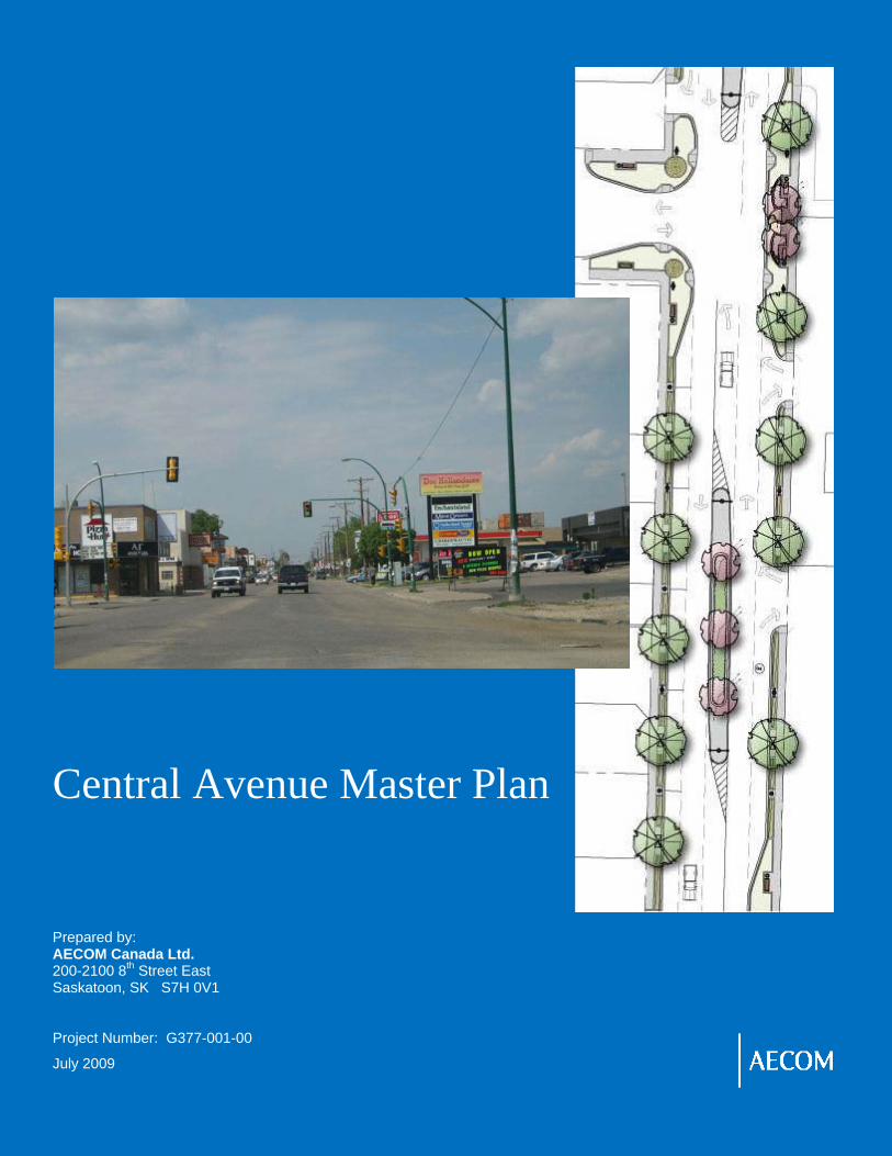
Central Avenue Master Plan Prepared by: AECOM Canada Ltd. 200-2100 8th Street East Saskatoon, SK S7H 0V1 Project Number: G377-001-00
July 2009

Sutherland Business Improvement District
Ce nt ra l Ave n ue Master P lan
RPT-G377-001-00 Final Report - 090722.doc
Statement of Qualifications and Limitations © 2009 AECOM CANADA LTD. OR CLIENT. ALL RIGHTS RESERVED. THIS DOCUMENT IS PROTECTED BY COPYRIGHT AND TRADE SECRET LAW AND MAY NOT BE REPRODUCED IN ANY MANNER, EXCEPT BY CLIENT FOR ITS OWN USE, OR WITH THE WRITTEN PERMISSION OF AECOM CANADA LTD. OR CLIENT.
Distribution List
# of Copies Association / Company Name PDF Hard
Copy
1 Sheldon Wasylenko – Sutherland BID 1 1
1 Paula Kotasek – City of Saskatoon 1 1
Revision Log Revision # Revised By Date Issue / Revision Description
1 Draft Report
Jo-Anne Richter, Nathan Gray, Trevor Tumach
June 2009 As per comments submitted by Steering Committee on April 2009 Central Avenue Master Plan - DRAFT
2 Final Report
Jo-Anne Richter July 2009 Final report - incorporates comments from Public Open House

Sutherland Business Improvement District
Ce nt ra l Ave n ue Master P lan
RPT-G377-001-00 Final Report - 090722.doc
Executive Summary The Sutherland neighbourhood in the city of Saskatoon is a community with a unique and interesting history, dating back to its beginning in the early 1900’s as a railway town.
The purpose of this study is to develop a Master Plan that will lead to the revitalization of the Sutherland business area. In addition this study seeks to address outstanding recommendations identified by the Local Area Plan, and of neighbourhood safety audits, for the Sutherland neighbourhood. Structured as a joint initiative between the Sutherland Business Improvement District and the City of Saskatoon, AECOM has worked with a Steering Committee comprised of representatives of these two agencies, to develop a Master Plan to address these needs.
This Master Plan process has resulted in the development of recommendations related to land use and future development, improved traffic flow, streetscaping and maximization of pedestrian safety. It is anticipated that implementation of recommendations of the Master Plan will result in a revitalized commercial area that is provides a welcoming and friendly shopping and service oriented environment for both the local community and the broader area.
Land Use and Development
The Sutherland business area is an area undergoing the process of revitalization. The following recommendations related to planning and future development will assist in realizing a more vibrant commercial area.
• Rezone lands on east side of Central Ave., between 109th Street and the railway track crossing, from B3 to B5A, to provide more opportunity for commercial development of this area. (City of Saskatoon).
• Amend B5A zoning provisions to restrict any future billboards from being situated in that zoning district (City of Saskatoon).
• Encourage commercial property owners to consider opportunity to develop residential units in conjunction with commercial uses on a site. (BID)
• Promote awareness and uptake of funding opportunities offered to property owners through the Enterprise zone (BID) to encourage façade improvements, as well as the redevelopment and development of commercial properties in Sutherland . (BID)
• Consider any potential opportunities to develop a green corridor to link Sutherland Park and the northerly portion of Sutherland neighbourhood to the commercial corridor. (City of Saskatoon in conjunction with Sutherland community).
• Explore potential opportunity to develop a plaza area that would serve a focal point for Central Avenue, in conjunction with any development that may occur on the CPR lands fronting Central Avenue.
• Encourage individual property owners to consider how they might reduce the dust generated from their properties (BID).
• Promote neighbourhood functionality through civic maintenance, encouraging private property maintenance, seeking active involvement of bar and restaurant owners in minimizing the negative behaviours of patrons, and undertaking active enforcement measures to address issues such as parking turnover rates, speeding, and public safety. (BID, City of Saskatoon, Sutherland Community)
• Develop Branding / Marketing study to identify a theme, brand, and appropriate marketing initiatives for the Sutherland Business community. (BID)

Sutherland Business Improvement District
Ce nt ra l Ave n ue Master P lan
RPT-G377-001-00 Final Report - 090722.doc
Transportation
The recommended Traffic and Parking Management Plan for the Central Avenue Master Plan was developed based on a review of the existing and forecast operations for vehicular traffic, trucks, transit, pedestrians and cyclists, safety, as well as parking.
The Traffic and Parking Management Plan includes a five-lane cross section with on-street parallel parking, one travel lane in each direction and the implementation of a left turn lane/centre median. In order to provide this cross section, a reduction in travel lane width and turning lane width is necessary and is consistent with other retrofit streetscape projects within the city.
The functionality of Central Avenue as an arterial roadway has been maintained, with additional emphasis on improving the vitality of businesses along both sides of Central Avenue.
Other recommendations within the Traffic and Parking Management Plan include:
• Implement of northbound and southbound left turn lanes at the Central Avenue and 108th Street intersection to provide additional storage for these movements. Re-align the east leg to match the west leg and eliminate the lane offset.
• Monitor the unsignalized intersections periodically as Central Avenue becomes further developed with new businesses as part of the City’s development approval process (i.e. Site Impact Traffic Studies)
• Develop bulbed curb extensions at intersections to improve pedestrian flow across Central Avenue, where feasible and not in conflict with transit stops
• Construct an active pedestrian corridor at the Central Avenue and 112th Street intersection
• Implement pedestrian crosswalk signage and pavement markings along Central Avenue that is consistent with the treatments identified within the City of Saskatoon Traffic Control at Pedestrian Crossing
• Retain the restriction on the westbound left turn movement at the Central Avenue and Gray Avenue intersection due to the skewed intersecting angle. Consider a more detailed safety review to examine the vertical alignment and geometrics
• Continue to examine alternative north-south links within the Sutherland Industrial Park to access Central Avenue south of 105th Street or McKercher Drive as an alternative truck route
• Maximize the number of on-street parking spaces along Central Avenue and the side streets where possible. Increased enforcement of existing parking restrictions is the most appropriate measure to address on-street parking concerns within the study area

Sutherland Business Improvement District
Ce nt ra l Ave n ue Master P lan
RPT-G377-001-00 Final Report - 090722.doc
Streetscape Enhancement
Central Avenue is a busy arterial roadway. Improvements to the streetscape directed at slowing traffic, supporting pedestrians, and providing landscaping and other amenities will establish a more local neighbourhood feel. The following provides a summary of the recommendations for the streetscape plan to achieve these objectives:
• Establish a defined concrete walking surface and unit paver amenity strips adjacent to the existing buildings, along both sides of Central Avenue. The amenity strips will offer opportunities to place street trees in tree grates and separate the parking lane from the concrete sidewalk.
• Create corner bulbs at each intersection along Central Avenue to allow better pedestrian movement at the corners, and facilitate safer street crossing, by increasing the visibility of pedestrians, reducing the width of street to be crossed, and slowing traffic. Some of the elements incorporated in the corner bulbs are raised planters, benches, planting including both a mix of trees and shrub material, and various unit paver and hard surface patterns.
• Bury electrical utilities within the amenity strips
• Install pedestrian crossing lights at 112th Street
• Install medians along Central Avenue, thereby reducing the vehicular traffic to one lane in each direction, and to deter pedestrians from attempting to cross at mid block. Concrete aprons bordering the medians lead to a raised planter complete with irrigation, ornamental trees and shrub planting. At each end of the median, a banner pole will offer opportunities to advertise upcoming events.
• Provide enhanced lighting along Central Avenue in the form of street lights and lower level pedestrian lights
• Create spaces for gathering and sitting at corner bulbs, and potentially through development of a small plaza at 110th Street
• Provide a separate curb and sidewalk along the length of Gray Avenue on the south side of the street to better accommodate pedestrians.
A theme for Sutherland that may be identified through the branding study can be reflected in the specific colour materials and furniture selections. It is recommended that overhead entrance features on Central Avenue, at 108th Street and at 115th Street be installed, and that these structures also introduce and reflect the theme / brand developed for the area.
The Master Plan for Central Avenue will focus on revitalizing the commercial corridor along Central Avenue, as well as along Gray Avenue. Focus on enhancing pedestrian safety is paramount. Many of the outstanding recommendations of the Local Area Plan are addressed, and it is anticipated that a number of the issues and concerns identified through neighbourhood safety audits can be alleviated or minimized through development of a more vibrant and pedestrian friendly commercial corridor. Recommendations for phasing of the streetscaping work are included in the Master Plan, and are based on completion of two block sections of Central Avenue. It is anticipated that the work along Gray Avenue would be completed in one phase. This Master Plan sets the stage for further detailed design work required prior to implementation of the upgrades to Central Avenue and Gray Avenue.
With continued active involvement of the Sutherland Business Improvement District, the City of Saskatoon, and the business owners and residents of Sutherland, the commercial corridor in Sutherland has tremendous potential to serve as a neighbourhood focal point, offering a welcoming and friendly place to shop, to walk, to gather, and to socialize.

Sutherland Business Improvement District
Ce nt ra l Ave n ue Master P lan
RPT-G377-001-00 Final Report - 090722.doc
Table of Contents Statement of Qualifications and Limitations Distribution List Revision Log Executive Summary
1.0 Introduction ......................................................................................................... 1
1.1 Study Purpose ..................................................................................................................... 1 1.2 Study Area .......................................................................................................................... 1 1.3 Community Consultation ..................................................................................................... 2
1.3.1 Community Focus Group Meeting ................................................................. 2 1.3.2 Public Open House to Review Draft Report ................................................... 3
2.0 Land Use ............................................................................................................. 4
2.1 Background ......................................................................................................................... 4 2.2 Existing Land Uses ............................................................................................................. 4 2.3 Summary of Zoning Designations ....................................................................................... 7 2.4 Commercial Zoning Districts in Study Area ........................................................................ 9 2.5 Industrial Zoning Districts in Study Area ........................................................................... 10 2.6 Vacant Land / Infill Opportunities ...................................................................................... 10 2.7 Vacant Buildings ............................................................................................................... 11 2.8 Land Use Conflict and Issues of Concern ........................................................................ 11 2.9 Land Use and Future Development Considerations ......................................................... 14
2.9.1 Rezone lands on east side of Central Avenue from B3 to B5A ................... 14 2.9.2 Residential Development ............................................................................. 15 2.9.3 Infill Development. ........................................................................................ 16 2.9.4 Property Maintenance and Building Improvements ..................................... 16
2.9.4.1 Architectural Control Overlay Zone ......................................... 16 2.9.4.2 Enterprise Zone ....................................................................... 17
2.9.5 Access to Green Space / Open Space ........................................................ 17 2.9.6 Noise and Dust control ................................................................................. 18 2.9.7 Neighbourhood functionality ......................................................................... 18 2.9.8 Branding / Marketing .................................................................................... 18
2.10 Summary of Recommendations ........................................................................................ 19
3.0 Transportation .................................................................................................. 22
3.1 Traffic Volumes ................................................................................................................. 22 3.2 Capacity Analysis .............................................................................................................. 23 3.3 Accommodation of Trucks ................................................................................................ 25 3.4 Transit ............................................................................................................................... 26 3.5 Active Modes of Transportation (Pedestrian and Cyclist) ................................................. 27 3.6 Collision Assessment ........................................................................................................ 28 3.7 Parking Assessment ......................................................................................................... 29 3.8 Summary of findings ......................................................................................................... 31 3.9 Recommended Traffic and Parking Management Plan .................................................... 32

Sutherland Business Improvement District
Ce nt ra l Ave n ue Master P lan
RPT-G377-001-00 Final Report - 090722.doc
4.0 Streetscape Enhancement Plan ...................................................................... 38
4.1 Background/Existing Streetscape ..................................................................................... 38 4.2 Proposed Central Avenue Streetscape............................................................................. 41
4.2.1 Roadway and Curb Reconstruction ............................................................. 41 4.2.2 Buried Electrical ........................................................................................... 42 4.2.3 Sidewalk/Amenity Strip –West Side of Central Avenue ............................... 42 4.2.4 Sidewalk/Amenity Strip –East Side of Central Avenue ................................ 43 4.2.5 Center Median .............................................................................................. 43 4.2.6 Corner Bulbing ............................................................................................. 44 4.2.7 Structures ..................................................................................................... 44 4.2.8 Entrance features at 108th and 115th Intersections ....................................... 44
4.3 Proposed Gray Avenue Streetscape ................................................................................ 45 4.3.1 Sidewalk/Boulevard Strip ............................................................................. 45 4.3.2 Buried Electrical ........................................................................................... 46
4.4 Sustainable Development Opportunities........................................................................... 46 4.5 Summary of Recommendations ........................................................................................ 46
5.0 Capital Cost Analysis ....................................................................................... 52
6.0 Phasing ............................................................................................................. 55
7.0 Recommendations of the Local Area Plan and Safety Audit ........................ 60
List of Appendices
Appendix A Community Consultation Program Appendix B Level of Service Definitions Appendix C City of Saskatoon Truck Routes Map Appendix D Collision History on Central Avenue Appendix E Typical Active Pedestrian Corridor

Sutherland Business Improvement District
Ce nt ra l Ave n ue Master P lan
RPT-G377-001-00 Final Report - 090722.doc
List of Tables
Table 1.1: Community Forum – Summary of Comments ............................................................................. 2 Table 2.1: Existing Land Uses ...................................................................................................................... 6 Table 2.2: Zoning Districts within study area ................................................................................................ 7 Table 2.3: Comparison of site requirement for selected land uses with B3 and B5A Zoning Districts ....... 14 Table 2.4: Sutherland Dwellings by type ..................................................................................................... 15 Table 3.1: Existing and Forecast Afternoon Peak Hour LOS Results for Signalized Intersections ............ 24 Table 3.2: Existing and Forecast Afternoon Peak Hour LOS Results for Unsignalized Intersections ........ 25 Table 3.3: Existing Pedestrian Crosswalk Warrant Analyses for Unsignalized Intersections along Central
Avenue ...................................................................................................................................... 27 Table 3.4: Collision Rates for Intersections and Midblock Sections Along Central Avenue ....................... 28 Table 3.5: Forecast Afternoon Peak Hour LOS Results for Signalized Intersections (Existing versus
Recommended Cross Section) ................................................................................................. 33 Table 3.6: Forecast Afternoon Peak Hour LOS Results for Unsignalized Intersections (Existing versus
Recommended Cross Section) ................................................................................................. 33 Table 5.1: Overall Cost Analysis - Central Avenue ..................................................................................... 53 Table 5.2: Overall Cost Analysis – Gray Avenue ........................................................................................ 54 Table 6.1: Phasing 107th Street to 109th Street ........................................................................................... 56 Table 6.2: Phasing 109th Street to 111th Street ........................................................................................... 57 Table 6.3: Phasing 111th Street to CPR Tracks .......................................................................................... 58 Table 6.4: CPR Tracks to 115th Street ........................................................................................................ 59 Table 7.1: Recommendations of the Local Area Plan ................................................................................ 60 Table 7.2: Suggestions of the Sutherland Safety Audit .............................................................................. 62
List of Figures
Figure 1 Existing Land Uses and Zoning Map ........................................................................................... 5 Figure 2 Proposed Land Use Map ........................................................................................................... 21 Figure 3 Existing Afternoon Peak Hour Traffic Volumes ......................................................................... 22 Figure 4 Existing Transit Routes and Bus Stops Within the Study Area ................................................. 26 Figure 5 Parking Utilization Along Central Avenue for Weekday and Weekend Peak 3-Hour Period .... 30 Figure 6 Recommended Traffic and Parking Management Plan ............................................................. 37 Figure 7 Streetscape Master Plan ........................................................................................................... 48 Figure 8 Central Avenue Block Streetscape Plan .................................................................................... 49 Figure 9 Central Avenue Cross Section ................................................................................................... 50 Figure 10 Gray Avenue Cross Section ..................................................................................................... 51

Sutherland Business Improvement District
Ce nt ra l Ave n ue Master P lan
RPT-G377-001-00 Final Report - 090722.doc - 1 -
1.0 Introduction
1.1 Study Purpose
The Sutherland neighbourhood in the city of Saskatoon is a community with a unique and interesting history, dating back to its beginning in the early 1900’s as a railway town. Although the Town of Sutherland has since been amalgamated into the City of Saskatoon, this community is still proud of its “small town” character.
Not surprisingly given its roots, the Sutherland neighbourhood incorporates a wide range of land uses, including residential neighbourhoods, a commercial corridor and an active industrial component, much of which involves the operations of the Canadian Pacific Railroad.
The Sutherland Business Improvement District (SBID) was established in 1999 with a role to work towards improving the business climate on behalf of its members. The Sutherland Business Improvement District, as well as many other stakeholder groups, was actively involved with the City of Saskatoon in developing a Local Area Plan (LAP) for the Sutherland neighbourhood, which was completed in February 1999. Since that time, the Sutherland community has been working with the City of Saskatoon to implement the recommendations of the LAP, however some of key recommendations, particularly those related to the commercial areas, to parking and transportation concerns, and to safety, have yet to be implemented.
At the same time, with the development of new neighbourhoods and associated commercial development nodes in the north east sector of Saskatoon, Sutherland has experienced the closure of some key services, including banking institutions, grocery store, and other retail stores as these companies have relocated to those new areas. The SBID determined that a revitalization plan for the Central Avenue commercial area was needed. Structured as a joint initiative between the SBID and the City of Saskatoon, AECOM has worked with a Steering Committee comprised of representatives of these two agencies, to develop a Master Plan to address this need.
The purpose of this study is to develop a Master Plan that will lead to the revitalization of the Sutherland business area. In addition this study seeks to address outstanding recommendations identified by the Local Area Plan for the Sutherland neighbourhood, and of the safety audit. This Master Plan process has resulted in the development of recommendations related to streetscaping, improved traffic flow, maximization of pedestrian safety and future development. It is anticipated that implementation of recommendations of the Master Plan will result in a revitalized commercial area that is provides a welcoming and friendly shopping and service oriented environment for both the local community and the broader area.
1.2 Study Area
The study area for the Master Plan includes the commercial properties fronting onto Central Avenue from 107th Street to 115th Street, as well as commercial/industrial properties along Gray Avenue from Grant Street to Central Avenue and blocks adjacent to the Central Avenue commercial corridor.

Sutherland Business Improvement District
Ce nt ra l Ave n ue Master P lan
RPT-G377-001-00 Final Report - 090722.doc - 2 -
1.3 Community Consultation
Opportunity for community input to the Master Plan was scheduled at two distinct points in the process. Early in the development process a focus group meeting was held to gather community knowledge and input to key issues and concerns that should be considered. Once the draft report was completed an Open House provided opportunity for community members to review the mapping and recommendations of the document and to provide comments and concerns. A short summary of each of these community consultation initiatives is provided below.
1.3.1 Community Focus Group Meeting
Community input is critical to a successful master planning process. As part of the background data gathering stage, AECOM scheduled a community forum and invited representatives from community groups including the Sutherland Business Improvement District, the Sutherland Business Association, Community Association, Sutherland Local Area Planning Committee, Sutherland Safety Sub-Committee, and local residents. The forum was structured to allow participants to identify issues, concerns and opportunities for future growth and development in Sutherland, and to gain their perspective on key issues required for the revitalization of this business district. Approximately 60 people were in attendance.
Key issues and items of discussion included the following:
Table 1.1: Community Forum – Summary of Comments
Issue Concerns Potential Solutions Traffic and Parking • Railway crossing backs up traffic
• Parking issues • Traffic volumes high, traffic calming required, number of large trucks on Central Avenue a concern
• Switching seems to be less of a problem than previously, overpass at rail crossing • Mixed feelings about parking metres, explore angle parking • Suggestions to modify intersections at 108 and Central Avenue, use of turning lanes, implement traffic calming measures
Pedestrian Traffic • Sidewalks are in poor condition, or intermittent • Crosswalks poorly defined, general feeling that it is dangerous to cross Central Avenue
• Repair, ensure sidewalks are provided along the extent of both sides of Central Avenue • Bulb intersections, improve lighting at crosswalks, pedestrian activated signals, slow speeds on Central Avenue
Visual Clutter • Number and size of billboards • Number of temporary signs • Utility lines • Redesign facades
• Set appropriate standards for size and number of billboards • Limit use of portable signs\ enforce • Bury utilities • Set standards, provide access to grants to allow business owners to upgrade their building facades

Sutherland Business Improvement District
Ce nt ra l Ave n ue Master P lan
RPT-G377-001-00 Final Report - 090722.doc - 3 -
Issue Concerns Potential Solutions Street Amenities • Lack of key services – grocery store,
bank • Need amenities: bike racks, trash barrels, flower pots, street lighting, ashtrays, benches, landscaping
• Encourage reuse of vacant stores • Phase in improvements, ensure ongoing cleaning and maintenance, fence parking lots, incorporate landscaping (hard and soft) • Have amenities based around a theme – ie. Historical
CPR Lands / Industrial Land Uses
• CPR land along Central Avenue should be redeveloped as it is unsightly / unkempt • Dust control needed • Noise from train yard a concern • Some sense that CPR yards/containers unsightly
• Number of suggestions provided including parking lot, park, develop for business or residential use • Pave 107th Street past Cement Plant, reroute trucks from Central Avenue • Construct sound barrier Landscaping with trees / shrubs to soften view, camouflage containers / fence
Other Issues • Safety / crime • Bus service • Empty stores • Implement Local Area Plan recommendations
• Community policing / foot patrols • Bus service needs to be revamped • Encourage reuse of vacant store to provide key services to community • ensure LAP recommendations are integrated into Master Plan
These comments have been considered and incorporated with other background data and information in the process of developing the Master Plan for Central Avenue.
A complete summary of the comments received at the Community Forum is included in Appendix A.
1.3.2 Public Open House to Review Draft Report
With completion of the Final Draft of the Master Plan, a public open house was held to provide opportunity for review and comment on the information contained in the report. The Open House was held on June 24, 2009 at the Sutherland Community Hall. Large maps highlighting key components of the Master Plan were set up as display panels and provided opportunity for the public to review and discuss the recommendations of the draft document with the consultants, city staff and the Steering Committee members.
Participants were provided with a summary information handout and a comment sheet. Copies of the full draft report were also available for review in hard copy format at the Open House. A digital PDF file of the report was also available and emailed to those who requested it following the Open House.
In addition, an information display which included the information summary sheets, comments sheets, and copies of the draft report, was placed at the Alice Turner Branch Library for a one week period of time following the Open House.
In general the response to the draft report was favourable and supportive. Six written comments were submitted and are provided in Appendix A. Two comments identifying concern about the potential impact of additional traffic into the residential neighbourhood were noted. Other comments included interest in the process leading to the implementation of the recommendations.

Sutherland Business Improvement District
Ce nt ra l Ave n ue Master P lan
RPT-G377-001-00 Final Report - 090722.doc - 4 -
2.0 Land Use
2.1 Background
This section provides an assessment of the existing uses, as well as a discussion of potential opportunities to achieve some of the goals that have been identified through the course of this study with respect to enhancing the commercial corridor in the Sutherland neighbourhood.
In order to gain a better understanding of the characteristics of the commercial area of Sutherland, existing land uses within the study area, as well as within blocks immediately adjacent to the study area, have been documented and mapped. In addition, the existing zoning designations are indicated. This information is provided on Figure 1 Existing Land Uses and Zoning.
The information contained in the Sutherland Local Area Plan (LAP), including recommendations and key goals and objectives have provided a starting point for the land use study; in many cases our analysis and recommendations support and further the goals identified through that planning process. Where suggestions are made which differ from recommendations of the LAP, rationale for the change in direction is provided.
The LAP establishes the following vision for the Sutherland neighbourhood:
“Our Community is safe, vibrant, and friendly; encourages and supports cultural, social, artistic and economic diversity; and maintains a small town atmosphere, with an abundance of diverse and affordable housing.”
Section 7.0 of this report provides a summary of the outstanding recommendations from the Local Area Plan and documents the extent to which these recommendations have been addressed in the Master Plan.
2.2 Existing Land Uses
A wide range of uses have been established along Central Avenue and Gray Avenue, which is not uncommon for an area with such a long history of development. While many of these businesses have been established at their locations for many years, new businesses and buildings have been developed more recently, particularly at the northerly end of the Central Avenue commercial corridor, and at various locations along Gray Avenue.
As shown in Figure 1 (Existing Land Uses and Zoning), and in Table 2.1 below, businesses in Sutherland cover a broad spectrum of restaurants and retail, as well as offices, professional services and community centres. These land uses provide a buffer between the heavy industrial CPR operation, located between Central and Gray Avenues, and the residential neighbourhood, with a mix of medium and low density residential development. Park space, while situated in relative proximity to the commercial centres, is not easily accessible from Central Avenue. Residential uses, both low density (R2) and medium density (RM4 and RM3) are established immediately adjacent to the commercial corridor.

B5AB5A B3 M1M1
RM4
B2
RMTN
R2
B2
B3
IL1
IH
IL1
SCALE 1:1250m
RM3
UM
A FI
LE N
AME:
Figure - 1
ISS
/REV
:
Sutherland Business Improvement DistrictCentral Avenue Master Plan and Report
Existing Land Uses and Zoning
CG
377-
001-
00_0
1-C
P00
03_R
X.d
wg
Sav
ed B
y: p
ryst
upak

Sutherland Business Improvement District
Ce nt ra l Ave n ue Master P lan
RPT-G377-001-00 Final Report - 090722.doc - 6 -
Table 2.1: Existing Land Uses
Central Avenue
Restaurants Retail Personal Service
Office / Community Service
Automobile /Industrial
• Mr. Sub • Verns Pizza • Subway • Wing Nuts • Pizza Hut • Extreme Pita • Taco Time • Ice Cream Igloo • Quiznos • Robins Donuts • 2-4-1 Pizza • Enchantaland Coffee Shop • Intermission Coffee Shop • My Kitchen Restaurant • Asian Cuisine • Hard Wok Buffet • Athena • Sutherland • Venice House • Foxy’s Lounge & Eatery Modern Billiards
• Madina Foods & Halal Meats • Sutherland Drugs • Nature’s Health Centre • Stasia • Reid’s Hardware • Bruce’s Bicycle Works • Golden Touch Carpet and Design • Lorraine’s Floral Gallery • Pharmasave • Sutherland Garden Mart • Downey’s Bakery • The Clean Shoppe Drycleaners • Summit Meats • Mac’s • 7 – 11 • Co-Op Convenience Store
• Hairstyle Inn • Beaners • JR’s Barbers • Jinx Full Service Salon • Coiffures by Anna • Untangled Hair Group • Glo Spa • Health Club
• Rayner Agencies • Ken Chevaldayoff • Graham Addley • RBC • Globe Travel • Sutherland Medical Clinic • Sutherland Dental Group • Sutherland Chiropractic Clinic• Saskatoon Smiles Dental • Central Avenue Chiropractic • Sutherland Hall
• Great Canadian Oil Change • Co-Op Gas • Atlas Tire / Carwash • TireCraft • Collision Plus Autobody
Gray Avenue
Restaurants Retail Personal Service
Office / Commity Service
Automobile /Industrial
• Mackenize Cole Coffee
• Movie Gallery • First Step Fitness • Sunsera Salons • Lady B Fit
• Koskie Law Office • C.A. International Ministeries • Jastek Construction • SRT Specialty Transport • Tam International
• CPR • Gas Plus • Mr. Bubbles Car Wash • Kenny J Auto Sales • Lajcon Distributors • AGG Rental Centre • Azore Concrete

Sutherland Business Improvement District
Ce nt ra l Ave n ue Master P lan
RPT-G377-001-00 Final Report - 090722.doc - 7 -
2.3 Summary of Zoning Designations
The study area includes a number of zoning districts as shown in Figure 1. The table below provides an overview of the zoning districts located within the study area, the intent of the various districts and highlights key development guidelines and standards.
The LAP identifies two goals with respect to commercial land use; to maintain the character and encourage the success of the Central Avenue business district, and to minimize land use conflicts within the Central Avenue commercial area, and between the Sutherland commercial area and adjacent residential properties.
Table 2.2: Zoning Districts within study area
Zoning Location Purpose Development Guidelines
• B5A – Sutherland Commercial Overlay District
• West side Central Avenue from 108th St to 112th St. (Mr. Sub to Great Canadian Oil Change)
• Recognizes historical commercial areas, including wide range of commercial uses in medium to high density form.
• Based on B5 zoning with stricter requirements for off street parking and building height. • Off street parking requirements for all uses over 200 square metres in size. Restaurants require 1 space per 10 square metres of public assembly space, with an exemption for the first 10 spaces. • Height restrictions of 5 storeys or 15 metres.• Gross floor area based on width of site; for sites less than 15 metres not to exceed 5:1
• B3 – Medium Density Arterial Commercial
• East side of Central Avenuefrom 105th St. to the tracks, including a portion of the CPR lands fronting Central Avenue
• Facilitates arterial commercial development providing moderate to wide range of commercial uses on small to medium sized lots.
• Building setback requirements in place for front, side and rear yard setbacks • Most uses required 1 parking space for each 50 m2 gross leasable floor area (ie. offices, retail stores, personal service trades). • Gross floor area not to exceed 0.75:1
• B2 – District Commercial District
• Two parcels of land developed for commercial / service uses at Central Avenue and 115th St.
• To provide an intermediate range of commercial uses servicing the needs of 2 -5 neighbourhooods

Sutherland Business Improvement District
Ce nt ra l Ave n ue Master P lan
RPT-G377-001-00 Final Report - 090722.doc - 8 -
Zoning Location Purpose Development Guidelines
• M1 – Local Institutional Service District
• 3 residential parcels at 107th and Central Avenue, Central Avenue. Chiropractic and vacant lot north of tracks.
• Facilitates a limited range of institutional and community activities that are generally compatible with low density residential uses, includes offices, medical clinics, schools, dwellings.
• Building setback requirements in place for front, side and rear yard setbacks, parking may be provided in front, side or rear yards. • Office uses require 1 parking space per 50 m2 gross floor area.
• IL1 – General Light Industrial District
• Properties along northwest side of Gray Avenue
• Facilitate economic development through a wide variety of light industrial activities and related businesses that do not create land use conflicts or nuisance conditions during the normal course of operations.
• Wide range of uses restaurants / retail stores, shopping centres – 1 parking space per 30 m2 gross leasable floor area. Other uses – 1 space per 93 m2 gross floor area.
• IH – Heavy Industrial District (note this area is outside of the study area boundary)
• CPR yards (does not extend to frontage along Central or Gray Avenues)
• Facilitates economic development through industrial activities that may have the potential for creating nuisance conditions during the normal course of operations.
• As noted above (IL1 zone)
• R2 – One and Two Unit Residential District
• Majority of residential lands within Study area
• Provides for one and two unit residential dwelling, in recognition of historical development
• RM3 – Medium Density Multiple Unit Development District
• Three parcels of land fronting 108th Street
• Provides for a variety of residential developments in a medium density form
Shall not exceed 3 storeys
• RM4 – Medium/High Density Multiple-Unit Dwelling District
• Selected residential units identified by the Local Area Plan as being suitable for higher density residential use
• Higher density residential use serves to support commercial areas in proximity
Shall not exceed 4 storeys
(Information excerpted from City of Saskatoon Zoning Bylaw No. 7800)

Sutherland Business Improvement District
Ce nt ra l Ave n ue Master P lan
RPT-G377-001-00 Final Report - 090722.doc - 9 -
2.4 Commercial Zoning Districts in Study Area
The B5A zone (Sutherland Commercial Overlay District) zone, encompasses the commercial lands on the west side of Central Avenue, described as 706 to 1204 inclusive, Central Avenue. The B5A zone is specific to this particular location. It is based on the B5 District with regard to permitted and discretionary uses, development standards and other requirements. However, in order to implement the recommendations of the Sutherland Local Area Plan, the B5A zone designates a maximum building height of five storeys (15 m) and establishes more stringent requirements for off-street parking for various uses. Developers are permitted to establish remote parking lots to meet their off-street parking requirements, provided a caveat is registered on the title of the lot designated for parking to ensure it remains as such. The zoning district allows development with minimal or no front yard setbacks for all land uses with the exception of multiple unit dwellings, boarding apartments and boarding houses.
Other B5 zoning districts within the city include the Riversdale and Broadway Business Districts. The B5 district recognizes historic commercial areas which include a wide range of commercial uses in medium to high density form. These uses include hotels/motels, restaurants, service stations, retail stores, personal service trades, offices, medical clinics financial institutions schools, one unit and multiple unit dwelling units banquet halls, parking lots, and shopping centres. Within the B5 zoning district a number of land uses have no onsite parking requirements, including art galleries, bakeries, beauty salons, health clubs, convenience stores, drug stores, dry cleaners, financial institutions, hotels, medical clinics, and offices.
Unlike the B5 Zoning District, off street parking requirements are established for all land uses in B5A zoning district that exceed a specified floor area. For example, retail stores or clinics which fall into the category of “all other uses” are required to provide 1 parking space for each 50 square metres of building floor area over 200 square metres (2152 sq. ft). For comparison purposes, the Mac’s Convenience store is just over 2200 square feet; any building exceeding that size would be required to provide some onsite parking. Uses that have been established prior to the implementation of the zoning bylaw are exempt from this requirement; however if the intensity of the use of the building is increased, or if an existing use of a building is changed to a new use, parking and loading facilities are required in the amount by which the requirements of the new use exceed the requirements for the existing use.
The B3 Zoning District provides for arterial and district commercial uses on small to medium sized lots. Other B3 zoning in the City of Saskatoon occurs along 22nd Street west of the Central Business District. A relatively wide range of uses are permitted. Onsite requirements for parking are based on floor area of the building. Landscaping requirements include a 3 metre strip along front site line. Requirements for site width, site area, and front, side and rear yards are established. The parcel on which the strip mall / Robins Donuts is situated was rezoned to B3 by agreement, with restrictions on the range of uses permitted on this site.
It should be noted that current B3 zoning and the associated development standards may limit development options on the portion of land currently owned by the CPR and which fronts onto Central Avenue. These development standards are compared to the development standards in the B5A zoning district in Section 2.7.1.of this report.
A B2 zoning on two parcels of land at the northerly end of the study area accommodates commercial and or service uses serving the broader community. Relatively recent developments on those parcels have occurred in the form of a small strip mall, in addition to a building housing a donut shop and hair salon.

Sutherland Business Improvement District
Ce nt ra l Ave n ue Master P lan
RPT-G377-001-00 Final Report - 090722.doc - 10 -
The M1 Local Institutional Service District is intended to facilitate a limited range of institutional and community activities that are generally compatible with low density residential uses. Three existing single unit residential parcels at the south end of the Central Avenue commercial areas have an M1 zoning, in anticipation that these residential uses will eventually be redeveloped for office/service uses. The location of these parcels, which are adjacent to existing commercial developments and fronting onto Central Avenue, is likely the key consideration for this zoning. The M1 zoning, which provides for professional business and office type uses, provides good transitional land use between low density residential development and commercial uses which may generate substantially more traffic and activity through the evenings and weekends. Similarly, a relatively large residential parcel that backs onto the CPR rail line and fronts onto 115th street, has been zoned M1. This parcel is likely influenced by noise and vibration from the train and adjacent commercial uses, and therefore is an appropriate parcel for future redevelopment.
2.5 Industrial Zoning Districts in Study Area
Two industrial zoning designations are identified in the study area; a heavy industrial zoning district (IH) and a light industrial district (IL1), along Gray Avenue.
The IL1 zoning district provides for almost any industrial / commercial use except for residential uses, institutional uses such as hospitals or schools, and uses that might be considered unsightly, noxious or hazardous. Development along Gray Avenue incorporates a broad mix of typical light industrial uses such as car washes, contracting businesses, businesses with equipment/storage needs, as well as office and commercial uses such professional offices, health club and a coffee shop. This zone is intended to act as a buffer between the heavy industrial areas and the residential areas.
The IL1 zone identifies landscaping requirements of 4.5 metres along front site line, and requires that outside storage areas be located in side or rear yards and screened from any public street. Landscaping is evident where new uses have been established. Many of the uses that were established prior to the implementation of the zoning bylaw do not appear to meet the requirements for landscaping and/or screening of storage materials, but are not required to do so, unless the use on the property changes significantly.
The Heavy Industrial zone recognizes the use of the CPR lands as a significant hub facility for this company. The IH zone accommodates industries that have the potential for creating nuisance conditions during the normal course of operations, which in this case, might be considered to be noise and dust, in addition to what some might consider a visual nuisance. It should be noted that as federally governed lands, the transportation uses on the CPR lands are permitted regardless of the municipal zoning designations for the property.
A portion of the CPR lands which front onto Central Avenue are zoned B3, in part to provide a buffer between the commercial and heavy industrial use.
2.6 Vacant Land / Infill Opportunities
Scattered parcels of vacant lots are situated in the study area including a vacant lot adjacent to Taco Time and a vacant lot north of the strip mall on 115th Street (located outside of the study area) as shown on map Figure 2 – Proposed Land Use
In addition, there are some lots which might be suitable for further infill development, most notably a portion of the CPR lands fronting Central Avenue. Preliminary discussions with officials from CPR indicates that the company may consider subdividing and selling a portion of this land area, in response to recommendations that might be included in the Master Plan.

Sutherland Business Improvement District
Ce nt ra l Ave n ue Master P lan
RPT-G377-001-00 Final Report - 090722.doc - 11 -
Infill opportunities may also be available on lots that have additional site area available, such as the parking lot of the former Extra Foods building, existing residential lots with M1 zoning, and industrial parcels along Gray Avenue. Parking requirements may pose some restrictions to the development of these areas.
CPR lands fronting Central Avenue
Parcels located adjacent to the tracks, on the north side of Central Avenue appear to have a relatively large land base in relation to the footprint of the buildings located on the parcels. However, setback requirements from the tracks, and concerns with respect to noise and vibration may limit any further infill of these sites.
Along Gray Avenue a mix of old and new developments coexist. The parcels situated between Dunlop Street and Fitzgerald Street includes traditional light industrial uses and has likely been established for some time. Redevelopment of these parcels over time is anticipated.
2.7 Vacant Buildings
At the time this study was initiated, a number of vacant buildings were located on Central Avenue and this was identified as a concern by the Steering Committee and during the public forum. It was felt that the number of vacancies was due in part to new developments that have occurred in neighbouring areas (Attridge Drive). However, it is promising that as the study is nearing completion, almost all of the buildings are now occupied.
A number of new businesses have opened recently, many of which are smaller independent businesses; including coffee shops, a hair salon, specialty food store, and restaurants. Generally these uses are well suited to the Main Street appeal desired for Central Avenue.
2.8 Land Use Conflict and Issues of Concern
One of the challenges of planning for a historic neighbourhood with a great variety of land uses established in close proximity to each other is ensuring that conflicts between land uses are minimized, and that future development does not further exacerbate land use conflicts. Further, existing buildings are permitted under the bylaws by which they were established and therefore may not meet current development standards that contribute to the overall function and look of a neighbourhood.

Sutherland Business Improvement District
Ce nt ra l Ave n ue Master P lan
RPT-G377-001-00 Final Report - 090722.doc - 12 -
Any uses, buildings or sites which were established prior to the current Zoning Bylaw, but which do not meet certain requirements of the bylaw, are considered to be “non-conforming”. As outlined in the Planning and Development Act 2007, (Section 88 – 93), the long term use, building, or site may continue provided it was established in conformity with the bylaw at the time of development, and that the use is not discontinued for a period of more than 12 consecutive months. Any alterations, repairs or additions may be made to the buildings, providing the element of non-conformity is not further increased. If a building is damaged such that repair is more than 75% of the replacement cost of the building, it can be repaired or rebuilt only in accordance with the current Zoning bylaw.
In Sutherland, there are few, if any, commercial or light industrial land uses that do not conform to the current Zoning Bylaw, because the zoning district for these properties provides for a wide range of commercial or light industrial uses in a medium to high density form. However, businesses may be non-conforming with respect to some of the development standards associated with the zoning district in which they are located, including landscaping requirements, building setback requirements and / or provision for off-street parking. As alterations or changes in use of buildings are sought, these non-conforming components can be addressed, however in the interim, other means to encourage property owners to voluntarily address some of these deficiencies should be explored.
Heavy industrial land uses adjacent to commercial and residential areas are a historic use and will likely continue. While the most visible use is the CPR yards, there are also other industrial uses situated south of the CPR yards and west of Central Avenue that impact the community. As outlined in Section 3.9 of this report. Recommended Parking and Management Plan, the City of Saskatoon Transportation Branch, Infrastructure Services Department, is exploring opportunities to utilize other north-south links within the Sutherland Industrial Park to access Central Avenue south of 105th Street or McKercher Drive as an alternative truck route. As per the City of Saskatoon Truck route delivery trucks are not permitted Central Avenue unless they are following the most direct route to a destination for a delivery or pick-up of goods. The proposed modifications to Central Avenue will further discourage truck traffic on Central Avenue. If needed bylaw enforcement to ensure that trucks on Central Avenue are taking a direct route to a delivery or pickup point should be undertaken.
Industrial land use view from Central Avenue

Sutherland Business Improvement District
Ce nt ra l Ave n ue Master P lan
RPT-G377-001-00 Final Report - 090722.doc - 13 -
Public input received in the development of the Sutherland Local Area Plan, and in the Safety Audits undertaken for Sutherland identified issues of noise, drunken and aggressive behaviour, broken bottles, and concerns about personal safety and property vandalism. Residents attribute much of this behaviour with licensed establishments.
An additional concern that has been identified through the course of this study is the proliferation of billboards and temporary signs located along Central Avenue. Unfortunately these signs reinforce the image of Central Avenue as an arterial street, rather than a neighbourhood main street. The City of Saskatoon Zoning Bylaw includes Sign Regulations which specify the signs permitted within various zoning districts, as well as regulate size and placement. Billboard signs are currently located in a number of locations along Central Avenue, and in most instances, they situated in zones which permit these types of signs (B5A and IL1 zones). In other locations (B3 zoning districts) they are not permitted, however, they would be considered an existing non-conforming use as they were established prior to the passing of the current Zoning Bylaw.
Often, a number of portable freestanding signs can be seen along Central Avenue. These signs were also identified as a concern at the Stakeholders meetings, but are permitted in the bylaws. Generally, companies that rent these signs are careful to ensure that they are sited in conformity with the regulations outlined in the City of Saskatoon Sign Regulations, however monitoring to ensure they meet the bylaw requirements with regard to their location, separation distances and the duration of time for which they are displayed, may be helpful. For example, portable signs are required to be situated a minimum of 20.0 metres from any other portable or freestanding sign, must maintain setback distances from intersections and streets, and are limited to a 14 day duration.
Central Avenue looking North

Sutherland Business Improvement District
Ce nt ra l Ave n ue Master P lan
RPT-G377-001-00 Final Report - 090722.doc - 14 -
2.9 Land Use and Future Development Considerations
In considering future development options for parcels along Central Avenue and Gray Avenue we have reviewed and assessed alternative zoning options, as well as other planning related initiatives, with a goal of encouraging and facilitating a business area that is vibrant, people friendly, and is considered to be an desirable location for businesses. At the same time, the long established uses adjacent to the commercial corridor must be acknowledged and accommodated as it is unlikely that they will choose to relocate their operations. This includes the CPR lands, the light industrial land uses along Gray Avenue and the heavy industrial uses, including the cement plant which is situated west of Central Avenue on 105th Street.
It is our recommendation that the Sutherland BID and the City of Saskatoon work together to explore a number of opportunities, as outlined below, which we feel would contribute to achieving their objectives of an enhanced commercial corridor. Details pertinent to future development options are shown on Map Figure 2. A summary of recommendations outlined in this section is provided at the end of this section.
2.9.1 Rezone lands on east side of Central Avenue from B3 to B5A
The Sutherland Local Area Plan recommended rezoning of the CPR lands fronting on Central Avenue to from an industrial to a commercial zone, to ensure consistency with the Sutherland Land Use Policy Map (designating both sides of Central Avenue as Special Area Commercial) As a result this area was zoned B3. Discussions with the Steering Committee further endorsed the concept of encouraging development of this land commercial purposes. The resulting increase in density of development along the street is seen as a positive change that will contribute to the viability and appeal of this commercial area.
However, it is felt that development options under the current B3 zoning may be restricted, as a result of minimum development standards established for front, rear and side yards, as well as minimum site area, as indicated in the chart below which contrasts the requirements for a standard retail use permitted in either the B3 or the B5A zoning district.
Table 2.3: Comparison of site requirement for selected land uses with B3 and B5A Zoning Districts
Permitted Use
Site Width (m)
Site Area (m2)
Front Yard
Side Yard
Rear Yard Building Height
Retail Store, Bakeries, Personal Service trades and health clubs
B3 - 15 m
B5A - 7.5 m
B3 - 450 m2
B5A – 225 m2
B3 - 6 n
B5A - none
B3 - 1.5 m
B5A – 0 m
B3 – 6 m
B5A – 0 m
B3 - 10 m
B5A – 5 storeys and no more than 15 m
Public Garages
B3 - 22.5 m
B5A - 7.5 m
B3 – 675
B5A – 225 m
B3 - 6 m
B5A - 3 m
B3 - 1.5 m
B5A - 0 m
B3 - 6 m
B5A – 0 m
B3 - 10 m
B5A – 5 storeys and no more than 15 m

Sutherland Business Improvement District
Ce nt ra l Ave n ue Master P lan
RPT-G377-001-00 Final Report - 090722.doc - 15 -
It is recommended that this area be rezoned from B3 to the B5A district. This change will maintain the intent of recommendations within the LAP, but will ensure both sides of the street develop with consistent standards. The B5A zoning district provides for a range of uses, including retail, commercial and public parking. It also allows higher building heights in comparison to the B3 zone, but this could be considered appropriate in this location as it may help to screen the industrial activity of the CPR yards. The primary restriction for development is likely the requirement for provision of off street parking based on the size and/or type of development proposed.
Further, it is recommended that, because the B5A Zoning District is specific to the Sutherland area, consideration be given to prohibiting billboards from this zone, to preclude any further siting of billboards within this zone. Billboards are not permitted in the B3 zoning district; the change to a B5A zone may provide opportunity for additional billboards to be located in this area if all appropriate regulations can be met.
2.9.2 Residential Development
The commercial corridor along Central Avenue serves as buffer between industrial and residential uses. Much of the residential land within the Sutherland area is zoned R2, providing for one unit or two unit dwellings, however a number of blocks immediately adjacent to the commercial area are zoned for medium density residential development.
The public consultation program initiated as part of the Local Area plan process clearly indicated that residents feel that their neighbourhood has more than its share of higher density housing; there is a distinct sense that existing R2 areas should not be considered for higher density uses. Information from the Neighbourhood profiles published by the City of Saskatoon, and based on 2006 census information, indicates the following breakdown in residential developments:
Table 2.4: Sutherland Dwellings by type
Dwelling Type Number of Dwellings Percentage of total dwellings
Single unit dwelling 875 38% Semi-detached house 95
62%
Row house 130 Apartment: Detached
duplex 175
Apartment: less than 5 stories 920
Other single attached 10 Movable dwelling 110
Total 2,315 100%
Neighbourhood Area (acres) 532.0
Dwelling Units per Acre 4.4
(Based on 9th Edition Neighbourhood Profiles, City of Saskatoon)

Sutherland Business Improvement District
Ce nt ra l Ave n ue Master P lan
RPT-G377-001-00 Final Report - 090722.doc - 16 -
It should be noted that the density calculation (4.4 dwelling units per acre) is based on the total land area within the Sutherland neighbourhood, including a 44.2 acre vacant parcel of land owned by the University of Saskatchewan. A density of 4.8 dwelling units per acre is realized when this parcel of land is excluded from the neighbourhood area calculation. This density begins to approximate a relatively common municipal standard of 5 residential units per acre in older suburban neighbourhoods. In order to support a vibrant main street a density which approaches 8.0 dwelling units per acre is desirable. At this time the R3 and R4 zones are not developed to full capacity (i.e. a number of single unit houses still located in these zoning districts); as residential development on these R4 parcels are developed to higher densities this will increase the overall density calculation for the neighbourhood.
This ratio between single unit and multi unit developments is similar to the mix of densities in some of the newer subdivisions which provides a split of approximately 60 % single unit to 40% multi-unit development.
The current B5A zoning designation provides for mixed use commercial / residential development such as residential units over ground floor commercial uses. This type of residential development is often unobtrusive, and provides “eyes on the street”. The proximity of Sutherland to the University, the Royal University Hospital and to Innovation Place makes Sutherland a desirable residential location. We recognize that requirements for off street parking in conjunction with development of additional building area for residential use may be a constraining factor; however there is provision for use of remote parking lots that could be explored as a means of addressing this concern. Property owners should be encouraged to consider opportunity to develop residential units in conjunction with commercial uses on a site.
2.9.3 Infill Development.
As shown on the Proposed Land Use Map Figure 2 a number of parcels are identified as having opportunity for infill, or for redevelopment. This includes parcels that are currently vacant, parcels that may have additional space to accommodate development, or industrial type land uses that may be able to generate higher revenues through redevelopment to other uses. The objective is to establish a streetscape that provides a sense of activity and vitality. An increase in density of uses along the street will contribute to the viability of the area.
2.9.4 Property Maintenance and Building Improvements
The character and feel of Sutherland is dependent to some extent on the degree to which individual property owners, business owners and tenants buy in to the concept. While a number of businesses consistently maintain their property, others are more ambivalent about the value in doing so. Some options to encourage a more proactive approach to property maintenance briefly summarized below.
2.9.4.1 Architectural Control Overlay Zone
The City of Saskatoon makes provision for the establishment of an architectural overlay zone, which establishes specific development controls to ensure a common complementary “look” for buildings within a defined area. Currently the only architectural overlay zone in place in the City of Saskatoon is in the River Landing area, and this was implemented when the area was an undeveloped site. While such an overlay zone may offer a means of defining and implementing a common look or accepted image in the Sutherland area, it could be very difficult to implement because it is an already developed area. Implementation of an Architectural Control Overlay Zone is not recommended for the Sutherland Business area.

Sutherland Business Improvement District
Ce nt ra l Ave n ue Master P lan
RPT-G377-001-00 Final Report - 090722.doc - 17 -
In an established area such as Sutherland, encouraging the voluntary cooperation of business owners to undertake initiatives to beautify their properties, or coordinate aspects of their property to particular colours or theme, would likely be more accepted and could result in greater participation.
2.9.4.2 Enterprise Zone
A number of neighbourhoods throughout the city are located within the Enterprise zone, as they are considered to be neighbourhoods requiring some support to ensure they are able to provide a certain level of income, job creation, economic opportunity, property value and some essential commercial services. The Sutherland Business Improvement District was recently recognized as an Enterprise Zone. A number of programs are offered to business and property owners within these areas, to encourage targeted businesses to locate or expand their operations in order to create more economic activity. In addition, programs providing funding assistance to encourage property owners and developers to invest in renovations, expansion or creation of new housing and to increase consumer and investor confidence in the Zone are available. Specific programs include:
• Facade Appearance Grant - Provides a grant of up to $2,500 for the purpose of enhancing or restoring the appearance of any street-facing facades.
• Building and Plumbing Permit Fee Rebate - Rebate of these fees for renovation or new construction within the Enterprise Zone
• Property Tax Abatement – Up to five years of property tax abatement applies to any increase in taxes as a result of development or significant improvements.
• Development Charges – Rebate of any or all off-site and direct development charges as calculated by the Infrastructure Services Department. Determined on a case by case basis.
Local business and property owners should be encouraged to take advantage of the municipal programs to make improvements to their properties. To date, three applications for façade improvements of commercial businesses have been approved for a total of $8,000. As public infrastructure upgrades to sidewalks and street amenities are implemented, it would be timely to encourage private property owners to consider enhancements to their properties and businesses that would connect them to the new street image. The Enterprise Zone program offers some direct incentives to undertake both minor improvements, as well as more extensive redevelopment initiatives. All property and business owners should be made aware of the opportunities and support offered through the Enterprise Zone. Further details, including application forms, are available on the City of Saskatoon website at http://www.city.saskatoon.sk.ca/org/city_planning/enterprise/index.asp.
2.9.5 Access to Green Space / Open Space
The Sutherland commercial corridor currently offers little, if any green space, although two parks are located in relatively close proximity to this area. Sutherland Park, located a half block east of Central Avenue between 113th and 115 Streets is physically and visually isolated from the commercial corridor. A smaller park, Father Basil Markle Park, is located west of Central Avenue with access from 108th Street, but is adjacent to a busy heavy industrial area. Over the long term the feasibility of establishing a green corridor linking Sutherland Park to Central Avenue should be explored, as a means of providing additional pedestrian linkages between the commercial corridor and Sutherland Park, as well as to the north portion of the neighbourhood. Ease of access, as well as supporting pedestrian and cycling movement, will encourage more neighbourhood resident patronage of the commercial area with little impact on parking or traffic.

Sutherland Business Improvement District
Ce nt ra l Ave n ue Master P lan
RPT-G377-001-00 Final Report - 090722.doc - 18 -
In addition, there may be an opportunity to establish a small plaza area, in conjunction with potential development of the CPR lands which front Central Avenue, as illustrated in the Overall Streetscape Plan (Figure 7). This type of open space could provide a focal point for the area. Further details regarding ownership, development and maintenance of this site would need to be addressed.
2.9.6 Noise and Dust control
Noise and dust were apparent issues noticed in visits to the Sutherland business area. Noise and dust generation is likely caused by a combination of factors, including:
• Traffic along Central Avenue
• Industrial uses located off of 105th Street (ie. cement operation)
• Lack of landscaping
• Dirt pathways in place of sidewalks on some parts of Central Avenue
• Gravel / dirt parking lots at some places of business
• CPR operations
These are difficult issues to resolve, however we anticipate that streetscape improvements such as sidewalks along the extent of Central Avenue, additional landscaping in public areas, including trees along medians, and additional development along the east side of Central Avenue will help to reduce or minimize these concerns. Individual business owners might be encouraged to consider how they might reduce the dust generated from their sites (dust control). It may be difficult to completely eliminate the noise and dust that one often associates with the Central Avenue area, but with improvements in a number of areas, noise and dust may be reduced to a point where they are much less noticeable.
2.9.7 Neighbourhood functionality
Issues related to the functionality of the neighbourhood, from the perspective of public safety, parking concerns, traffic concerns have been identified through area safety audits. It is recommended that the Sutherland BID and the City work together to ensure the image and function of the community is being maintained. This would include:
• Ongoing civic maintenance by the City and the BID to ensure signs of vandalism /graffiti are minimized, trash receptacles emptied, broken bottles etc. cleaned up (both on streets and in back alleys).
• Encourage all property owners (private and public) to consider aesthetics of their properties including landscaping, maintenance, screening of storage, garbage bins. Provide information about programs that may assist in property improvements and redevelopment opportunities.
• Encourage owners of licensed establishments to take an active role in being more neighbourhood friendly and discouraging negative actions of their patrons.
• Undertake active enforcement to assist in alleviating potential conflicts such as on-street parking, traffic speeds, truck traffic, temporary signs, property restrictions, vandalism, and public safety.
2.9.8 Branding / Marketing
Sutherland is a unique entity within the City of Saskatoon as it originated as a railway town, in approximately 1900. Although it was amalgamated to become part of Saskatoon in 1956, the neighbourhood still has some of the characteristics of a small town.

Sutherland Business Improvement District
Ce nt ra l Ave n ue Master P lan
RPT-G377-001-00 Final Report - 090722.doc - 19 -
The need to develop a brand or image for the Sutherland area has been identified often by the Steering Committee. While a number of themes or ideas have been suggested in this regard, many have indicated that it is time to move away from using the railway theme as the sole brand for this neighbourhood. While this transportation mode is still very much a part of the Sutherland identity, the proximity of the community to the University, to Innovation Place, as well as the range of businesses and services provided in the area suggest that a broader theme of a global village or hub might be more appropriate.
A marketing scheme for Sutherland will require more detailed analysis and thought, but the streetscape plan for Central Avenue and Gray Avenue makes reference to the historic aspects of this neighbourhood. From this framework there will be many opportunities to expand on and reinforce the image of Sutherland as a unique village hub in planning local community events, in facade improvements of local businesses, and in the development and landscaping of new buildings.
The City of Saskatoon published an informative document entitled: Discovering Sutherland; A Resource Guide for Community Heritage Projects (Leisure Services Department, 1991). This document provides an overview of the history of Sutherland, suggests themes for further research, and identifies some heritage programming ideas.
It is recommended that a Branding/Marketing study be completed for the Sutherland Business District that will address and recommend a number of components related to the branding and marketing of the area:
• Entry signage to the commercial area
• Clear signage, including pedestrian crossings, speed limits, and bus stops.
• Artwork in public areas
• Colour and style scheme
• Development of marketing / information materials
• Implementation and promotion of programs available for street beautification such as the Enterprise Zone programs, street basket programs,
• Potential community activities (street fairs, festivals, events)
It is recommended that the Sutherland BID work with the Urban Design Section at the City of Saskatoon to identify responsibilities and funding opportunities for completion of the plan. Consideration might be given by the BID to staff a position to facilitate the ability to implement community based initiatives.
2.10 Summary of Recommendations
The Sutherland business area is an area undergoing the process of revitalization. Over time it is anticipated that investment confidence in the area will grow. The following recommendations related to planning and future development will assist in realizing a more vibrant commercial area.
• Rezone lands on east side of Central Avenue, between 109th Street and the railway track crossing, from B3 to B5A to provide more opportunity for commercial development of this area. (City of Saskatoon).
• Amend B5A zoning provisions to restrict billboards from that zoning district (City of Saskatoon).
• Encourage property owners to consider opportunity to develop residential units in conjunction with commercial uses on a site. (Sutherland BID)

Sutherland Business Improvement District
Ce nt ra l Ave n ue Master P lan
RPT-G377-001-00 Final Report - 090722.doc - 20 -
• Promote awareness and uptake of funding opportunities offered to property owners through the Enterprise zone to encourage façade improvements, as well as the redevelopment and development of commercial properties in Sutherland. (Sutherland BID)
• Consider any potential opportunities to develop green corridor to link Sutherland Park and northerly portion of Sutherland neighbourhood to the commercial corridor. (City of Saskatoon in conjunction with Sutherland community)
• Explore potential opportunity to develop a plaza area that would serve a focal point for Central Avenue, in conjunction with any development that may occur on the CPR lands fronting Central Avenue. (Sutherland BID in conjunction with City of Saskatoon)
• Encourage individual property owners to consider how they might reduce the dust generated from their properties. (BID).
• Promote neighbourhood functionality through civic maintenance, encouraging private property maintenance, involving bar and restaurant owners in minimizing the negative behaviours of patrons, and undertaking active enforcement measures to address issues such as parking turnover rates, speeding, and public safety. (Sutherland BID, City of Saskatoon, Sutherland Community)
• Develop Branding / Marketing study to identify a theme, brand, and appropriate marketing initiatives for the Sutherland Business community. (Sutherland BID)

SCALE 1:1250m
B5A B3M1
RM4
B2
RMTN
R2 R1A
B2
B3
IL1
R2 R2
IH
B5A
M1
M1
B3
M1
RM3
UM
A FI
LE N
AME:
Figure - 2
ISS
/REV
:
Sutherland Business Improvement DistrictCentral Avenue Master Plan and Report
Proposed Land Use
AG
377-
001-
00_0
1-C
PT0
04_R
X.d
wg
Sav
ed B
y: p
ryst
upak
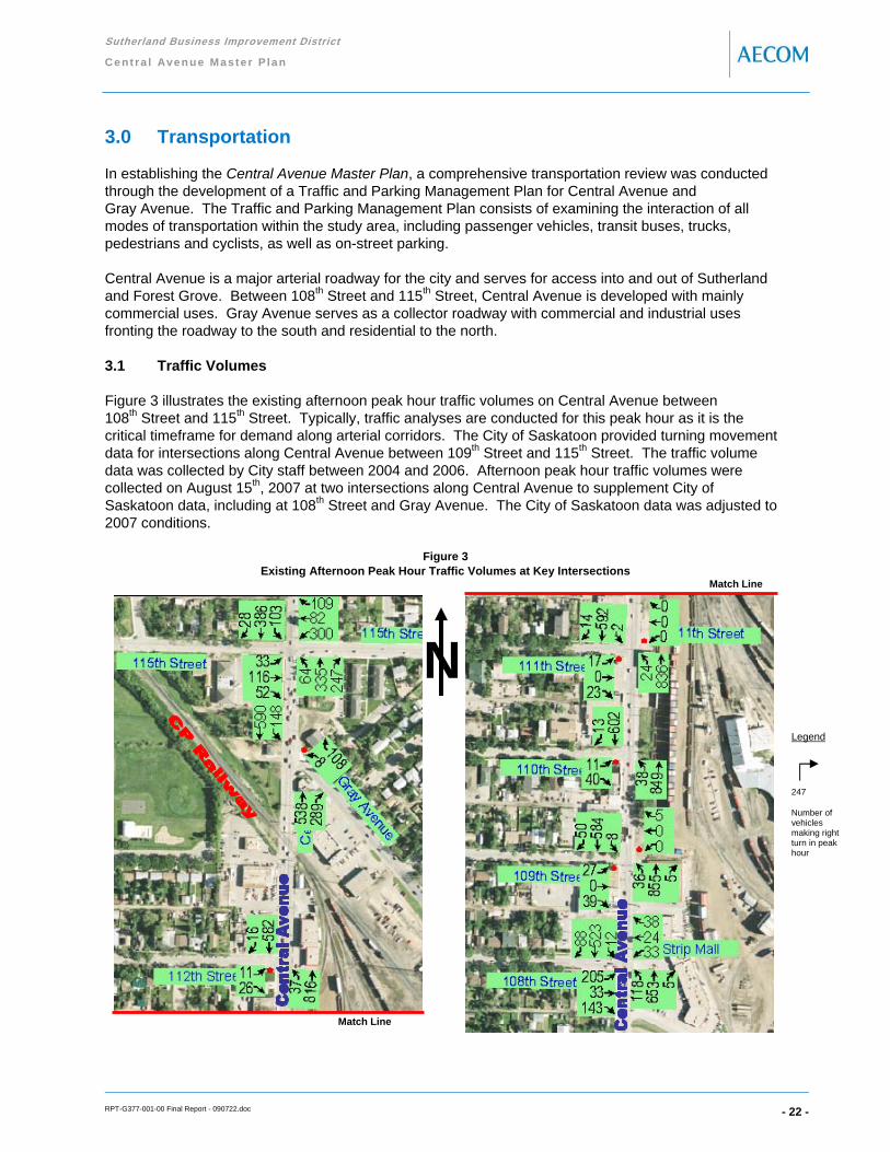
Sutherland Business Improvement District
Ce nt ra l Ave n ue Master P lan
RPT-G377-001-00 Final Report - 090722.doc - 22 -
3.0 Transportation
In establishing the Central Avenue Master Plan, a comprehensive transportation review was conducted through the development of a Traffic and Parking Management Plan for Central Avenue and Gray Avenue. The Traffic and Parking Management Plan consists of examining the interaction of all modes of transportation within the study area, including passenger vehicles, transit buses, trucks, pedestrians and cyclists, as well as on-street parking.
Central Avenue is a major arterial roadway for the city and serves for access into and out of Sutherland and Forest Grove. Between 108th Street and 115th Street, Central Avenue is developed with mainly commercial uses. Gray Avenue serves as a collector roadway with commercial and industrial uses fronting the roadway to the south and residential to the north.
3.1 Traffic Volumes
Figure 3 illustrates the existing afternoon peak hour traffic volumes on Central Avenue between 108th Street and 115th Street. Typically, traffic analyses are conducted for this peak hour as it is the critical timeframe for demand along arterial corridors. The City of Saskatoon provided turning movement data for intersections along Central Avenue between 109th Street and 115th Street. The traffic volume data was collected by City staff between 2004 and 2006. Afternoon peak hour traffic volumes were collected on August 15th, 2007 at two intersections along Central Avenue to supplement City of Saskatoon data, including at 108th Street and Gray Avenue. The City of Saskatoon data was adjusted to 2007 conditions.
Figure 3 Existing Afternoon Peak Hour Traffic Volumes at Key Intersections
Legend
247
Number of vehicles making right turn in peak hour
Match Line
Match Line
N

Sutherland Business Improvement District
Ce nt ra l Ave n ue Master P lan
RPT-G377-001-00 Final Report - 090722.doc - 23 -
The critical intersections along Central Avenue within the study area for traffic demand include the Central Avenue and 108th Street intersection and the Central Avenue and 115th Street intersection, which are controlled by traffic signals.
The T-intersection of Central Avenue and Gray Avenue is also a key intersection due to the skewed angle. There were 8 vehicles identified during the afternoon peak hour that unlawfully made a westbound left turn (Gray Avenue to Central Avenue), as this movement is restricted based on the skewed intersection angle. This intersection is free-flow for Central Avenue traffic and stop controlled for Gray Avenue traffic (i.e. westbound).
All other intersections are stop controlled similar to the Central Avenue and Gray Avenue intersection.
Approximate daily traffic volumes on Central Avenue are 19,000 vehicles per day as identified in the City of Saskatoon Sutherland Traffic Safety Report, 2007. Gray Avenue daily traffic volumes are identified within the City of Saskatoon Traffic Characteristics Report, 2006 as approximately 4,900 vehicles per day based on a 2004 count.
Historical traffic volume data was analyzed to determine a growth rate for traffic volumes on Central Avenue and Gray Avenue. Due to the construction of Circle Drive and Attridge Drive interchange and the Circle Drive and College Drive interchange and the development within Arbor Creek and Willow Grove, traffic volumes have fluctuated on Central Avenue in recent years. A growth rate of one percent per year for 10 years was utilized to establish forecast volumes within the study area.
It was noted that the speed limit through the study area is 50 km/h. There has been an identified concern about travel speeds along Central Avenue by the public through the local area planning process.
3.2 Capacity Analysis
Central Avenue is primarily a four-lane roadway with on-street parking in the outside lanes along the corridor between 112th Street and 108th Street. Since there are no left turn bays on Central Avenue, vehicles often sling-shot around left turning vehicles on Central Avenue by using the outside lane to manoeuvre around queues. These more aggressive drivers create conflicts with pedestrians, cyclists, parked vehicles and other on-coming turning vehicles.
North of 112th Street, drivers utilize all four-lanes along Central Avenue due to the restriction of on-street parking.
There is no median or channelization along Central Avenue or Gray Avenue within the study limits. The only exception is at the intersection of Central Avenue and Gray Avenue, where a concrete island is present to deter westbound left turn movements.
There are numerous mid-block accesses for parking lots that provide for all movements (i.e. both left turns and right turns into and out of the accesses).
A Level of Service (LOS) analysis was conducted to examine capacity constraints at intersections along the Central Avenue corridor for existing and forecast traffic volumes using Synchro Ver. 7.0. The base Synchro model files were developed based on existing signal timing plans provided by the City of Saskatoon.

Sutherland Business Improvement District
Ce nt ra l Ave n ue Master P lan
RPT-G377-001-00 Final Report - 090722.doc - 24 -
Intersection level of service results ranges in definition from LOS A, which provides the highest level of operational service to intersection users, to LOS F, which constitutes failure of the intersection or the turning movement being studied. LOS D is commonly considered the limit of acceptable operation. Significant delays in traffic can occur below this level. Under certain circumstances, a LOS E is acceptable for left turn movements only in an attempt to provide improved level of service for opposing through traffic. Appendix B provides a more detailed description of level of service definitions.
Intersection capacity utilization (ICU) is another performance measure used in analyzing intersection operation, similar to a volume to capacity (v/c) ratio and level of service. ICU is the amount of time required to serve all movements at saturation for a given cycle length, divided by that reference cycle length. The ICU will indicate how much reserve capacity is available or how much the intersection is overcapacity. The ICU does not predict delay, but it can be used to predict how often an intersection will experience congestion. Its intended applications are for traffic impact studies, future roadway design, and congestion management programs.
Overall intersection LOS results for the existing and forecast afternoon peak hour for each signalized and unsignalized intersection are presented in Table 3.1 and Table 3.2, respectively.
Table 3.1: Existing and Forecast Afternoon Peak Hour LOS Results for Signalized Intersections
The Central Avenue and 115th Street intersection is currently operating at an overall LOS C with the critical southbound shared left turn/through movement operating at a LOS D. This movement is anticipated to maintain a LOS D in the forecast conditions; however the v/c ration is identified to reach 0.83. Although improvements are typically required when a movement operates at v/c greater than 0.8, the confined right-of-way and level of development immediately adjacent to the intersection will complicate strategies to increase capacity at this intersection.
The Central Avenue and 108th Street intersection is currently operating at an overall LOS B. The critical northbound shared left turn/through movement is currently operating at a LOS B and is expected to operate at a LOS C within the forecast timeframe. Similar to 115th Street, this movement will approach a 0.8 v/c ratio under the forecast conditions. The east leg of this intersection (i.e. strip mall access) is currently offset, which further complicates the movements to and from the access.
v/c Movement LOSCentral Avenue and 115th Street
Existing C 81.8% 0.72 SB LT/TH/RT D EB LT/TH: LOS C WB LT/TH: LOS B
Forecast C 90.2% 0.83 SB LT/TH/RT D EB LT/TH: LOS C WB LT/TH: LOS C
Central Avenue and 108th StreetExisting B 71.5% 0.68 NB LT/TH/RT B EB LT/TH: LOS C WB LT/TH/RT: LOS B
Forecast B 76.7% 0.79 NB LT/TH/RT C EB LT/TH: LOS C WB LT/TH/RT: LOS B
Intersection Maximum v/c Ratio Side Street LOS
Signalized Intersection Evaluation Parameters
IntersectionLOS
ICU%

Sutherland Business Improvement District
Ce nt ra l Ave n ue Master P lan
RPT-G377-001-00 Final Report - 090722.doc - 25 -
Table 3.2: Existing and Forecast Afternoon Peak Hour LOS Results for Unsignalized Intersections
The unsignalized intersections between 108th Street and 115th Street operate between LOS A and LOS B, overall. The key critical movements from the side street (i.e. either a westbound or eastbound left turn are mainly operating at a LOS C with between 15 to 20 seconds of average delay. Overall, the forecast unsignalized operation will be most constrained along Central Avenue at Gray Avenue and at 109th Street (i.e. overall LOS C).
The Transportation Association of Canada (TAC) Traffic Signal Warrants Analysis was conducted to determine if traffic signals would be warranted on the unsignalized intersections along Central Avenue within the study area. Pedestrian traffic data was estimated where required in the analysis. The analysis identified that traffic volumes do not justify traffic signals at these intersections under the existing or forecast conditions.
The fore-going capacity analysis for signalized and unsignalized intersections assumes that the current lane configuration remains consistent and that no additional auxiliary left turn lanes are implemented and that the current sling-shot around queued left turn vehicles would still occur. The examination of alternate cross-sections featuring geometric improvements is presented in Section 3.9.
3.3 Accommodation of Trucks
Appendix C presents the City of Saskatoon truck route map. The city truck route map restricts truck traffic and heavy loads to only roads that can accommodate the additional loading based on a vehicle classification scheme.
Since Central Avenue between 108th Street and 115th Street is classified as an arterial road, truck drivers can utilize this roadway if it is the direct route to and from their destination. However, trucks cannot travel through Sutherland if it is not the direct route.
Trucks primarily travel on Central Avenue to and from the Sutherland Industrial Park. The most difficult intersection for truck traffic is the Central Avenue and 107th Street intersection.
Central Avenue and Gray AvenueExisting B 61.9% WB LT/RT C 16.2Forecast C 67.0% WB LT/RT C 18.9
Central Avenue and 112th StreetExisting A 53.6% EB LT C 15.3Forecast B 57.6% EB LT C 17.0
Central Avenue and 111th StreetExisting A 50.4% EB LT/TH C 20.2Forecast A 54.5% EB LT/TH C 23.8
Central Avenue and 110th StreetExisting A 55.0% EB LT B 13.7Forecast B 59.1% EB LT B 14.8
Central Avenue and 109th StreetExisting B 61.0% EB LT/TH C 18.5Forecast C 65.4% EB LT/TH C 21.6
Approach Delay (s)
LOSIntersection
Unsignalized Intersection Evaluation Parameters
Critical Side Street Approach
IntersectionLOS
ICU%

Sutherland Business Improvement District
Ce nt ra l Ave n ue Master P lan
RPT-G377-001-00 Final Report - 090722.doc - 26 -
Vehicle classification data was collected during the afternoon peak hour at a location north of 108th Street on August 15th, 2007. The data collection results identified 13 trucks and 5 buses northbound on Central Avenue (i.e. four percent of the total traffic flow), as well as 5 trucks and 7 buses southbound on Central Avenue (i.e. 3% of total traffic flow).
3.4 Transit
There are currently two Saskatoon Transit routes that utilize Central Avenue through the study area, including Route 4 Dundonald/Willowgrove and Route 21 Forest Grove, as well as Transit Dart Routes 70 and 80, which are bus rapid transit (BRT) routes. These routes and the current transit stops along Central Avenue are illustrated in Figure 4.
Figure 4 Existing Transit Routes and Bus Stops Within the Study Area
There are currently 23 southbound buses on Central Avenue per day associated with Route 21 – City Centre/Forest Grove. The buses run on a half hour schedule between 7:00 a.m. and 7:00 p.m.
There are currently 31 southbound buses on Central Avenue per day associated with Route 4 – Dundonald/Willowgrove, which exit Central Avenue at Gray Avenue. There are also 34 northbound buses on Central Avenue. These buses run primarily on a half hour schedule between 6:00 a.m. and 1:00 a.m.
The Transit Dart – Routes 70/80 include 72 southbound and 67 northbound buses on Central Avenue on typically a 10 to 15 minute schedule between 6:00 a.m. and 1:00 a.m.
In total, there is approximately 18 buses on Central Avenue between 115th Street and 108th Street during the afternoon peak hour.
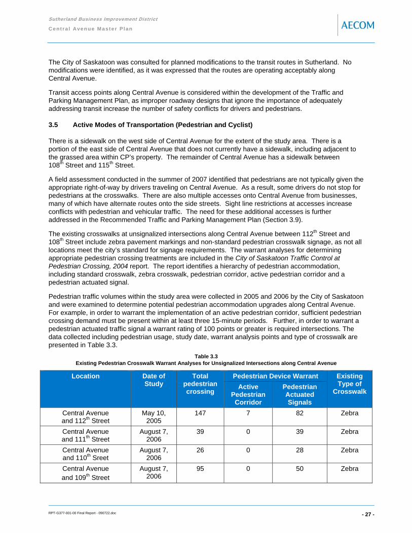
Sutherland Business Improvement District
Ce nt ra l Ave n ue Master P lan
RPT-G377-001-00 Final Report - 090722.doc - 27 -
The City of Saskatoon was consulted for planned modifications to the transit routes in Sutherland. No modifications were identified, as it was expressed that the routes are operating acceptably along Central Avenue.
Transit access points along Central Avenue is considered within the development of the Traffic and Parking Management Plan, as improper roadway designs that ignore the importance of adequately addressing transit increase the number of safety conflicts for drivers and pedestrians.
3.5 Active Modes of Transportation (Pedestrian and Cyclist)
There is a sidewalk on the west side of Central Avenue for the extent of the study area. There is a portion of the east side of Central Avenue that does not currently have a sidewalk, including adjacent to the grassed area within CP’s property. The remainder of Central Avenue has a sidewalk between 108th Street and 115th Street.
A field assessment conducted in the summer of 2007 identified that pedestrians are not typically given the appropriate right-of-way by drivers traveling on Central Avenue. As a result, some drivers do not stop for pedestrians at the crosswalks. There are also multiple accesses onto Central Avenue from businesses, many of which have alternate routes onto the side streets. Sight line restrictions at accesses increase conflicts with pedestrian and vehicular traffic. The need for these additional accesses is further addressed in the Recommended Traffic and Parking Management Plan (Section 3.9).
The existing crosswalks at unsignalized intersections along Central Avenue between 112th Street and 108th Street include zebra pavement markings and non-standard pedestrian crosswalk signage, as not all locations meet the city’s standard for signage requirements. The warrant analyses for determining appropriate pedestrian crossing treatments are included in the City of Saskatoon Traffic Control at Pedestrian Crossing, 2004 report. The report identifies a hierarchy of pedestrian accommodation, including standard crosswalk, zebra crosswalk, pedestrian corridor, active pedestrian corridor and a pedestrian actuated signal.
Pedestrian traffic volumes within the study area were collected in 2005 and 2006 by the City of Saskatoon and were examined to determine potential pedestrian accommodation upgrades along Central Avenue. For example, in order to warrant the implementation of an active pedestrian corridor, sufficient pedestrian crossing demand must be present within at least three 15-minute periods. Further, in order to warrant a pedestrian actuated traffic signal a warrant rating of 100 points or greater is required intersections. The data collected including pedestrian usage, study date, warrant analysis points and type of crosswalk are presented in Table 3.3.
Table 3.3 Existing Pedestrian Crosswalk Warrant Analyses for Unsignalized Intersections along Central Avenue
Location Date of Study
Total pedestrian crossing
Pedestrian Device Warrant Existing Type of
Crosswalk Active
Pedestrian Corridor
Pedestrian Actuated Signals
Central Avenue and 112th Street
May 10, 2005
147 7 82 Zebra
Central Avenue and 111th Street
August 7, 2006
39 0 39 Zebra
Central Avenue and 110th Sreet
August 7, 2006
26 0 28 Zebra
Central Avenue and 109th Street
August 7, 2006
95 0 50 Zebra

Sutherland Business Improvement District
Ce nt ra l Ave n ue Master P lan
RPT-G377-001-00 Final Report - 090722.doc - 28 -
Therefore, an active pedestrian corridor is warranted for the intersection of Central Avenue and 112th Street, as more than three periods warrant (i.e. 7 periods) an elevated level of control. A pedestrian actuated signal would be warranted if the warrant points were greater than 100 points.
The intersection of Central Avenue and Gray Avenue was not analyzed as pedestrian data was unavailable. This intersection currently has pedestrian crosswalk signage, but it is non-standard. Further data is required to justify additional pedestrian accommodation at this intersection, as there is concern about the CP railway crossing and sightlines affecting the safety of pedestrians at this location.
The City of Saskatoon identifies a cycling network with shared-use lanes on 108th Street and 115th Street within Sutherland that continue to Preston Avenue for access to the University of Saskatoon and downtown. There is also an elevated crossing from Sutherland to the College Park neighbourhood located at Central Avenue. Cyclist traffic on Central Avenue is currently not efficiently accommodated due to the four-lane cross-section that includes on-street parking in the outside lane. There are also conflicts with the drivers who sling-shot around left turning vehicles.
The existing cross section for Central Avenue would not typically be considered cyclist-friendly. However, there are adequate east-west accesses to shared-use lanes. Alternatively, Egbert Avenue is also an optional adjacent north-south route with less traffic that is considered more cyclist-friendly than Central Avenue.
3.6 Collision Assessment
A five-year collision history (2001 to 2005) analysis was conducted for accidents that occurred on Central Avenue between 115th Street and 108th Street to investigate the current level of safety at intersections and on links between these intersections. The data was obtained from Saskatchewan Government Insurance’s Traffic Accident Inventory System.
Table 3.4 presents the collision data in terms of the total number of collisions and the accident rate per ten million entering vehicles by intersection and the accident rate per million kilometres travelled by link.
Table 3.4: Collision Rates for Intersections and Midblock Sections Along Central Avenue
Intersections 5-YearCollision Total
Peak Hour Entering Volume
Collision Rate / 10 Million Entering Vehicles
Central Avenue and 115th Street 125 1,855 36.92Central Avenue and Gray Avenue 47 1,681 15.32Central Avenue and 112th Street 16 1,488 5.89Central Avenue and 111th Street 18 1,508 6.54Central Avenue and 110th Street 23 1,553 8.12Central Avenue and 109th Street 31 1,609 10.56Central Avenue and 108th Street 85 1,875 24.84
Links onCentral Avenue
5-YearCollision Total
Peak HourLink Volume
Collision Rate / Million Kilometres Travelled
115th Street to Gray Avenue 9 1,384 3.96Gray Avenue to 112th Street 28 1,425 5.18112th Street to 111th Street 12 1,461 4.50111th Street to 110th Street 10 1,475 3.71110th Street to 109th Street 35 1,529 12.54109th Street to 108th Street 32 1,519 11.54

Sutherland Business Improvement District
Ce nt ra l Ave n ue Master P lan
RPT-G377-001-00 Final Report - 090722.doc - 29 -
At 36.92 collisions per 10 million entering vehicles, the Central Avenue and 115th Street intersection has the highest intersection collision rate along the analyzed section of Central Avenue. The Central Avenue and 108th Street intersection also has a high collision rate. In comparison, the Central Avenue and Attridge Drive intersection has a collision rate in of 39.23 collisions per 10 million entering vehicles (e.g. 62 total collisions at this intersection in 2005).
The collision rates at the unsignalized intersections along Central Avenue are highest at Gray Avenue (i.e. skewed intersection and closest to the CP railway crossing) and at 109th Street (i.e. intersection closest to traffic signal at 108th Street).
The level of severity at intersections and along midblock sections on Central Avenue averages approximately 85 percent property damage only (PDO) collisions and 15 percent personal injury collisions. The only exceptions are at the intersection of Central Avenue and 112th Street, where the percentage split for severity was 75% / 25% for PDO / injury collisions and at the intersection of Central Avenue and 111th Street, where the percentage split for severity was 64% / 36% for PDO / injury collisions. There were no collisions identified that resulted in a fatality.
The collision data for intersections and at midblock locations along Central Avenue are also presented in further detail within Appendix D. The appendix summarizes the collision configuration by location as well. Note that the appendix data includes available 2006 and 2007 collisions within the totals.
The most predominate collision configurations along Central Avenue within the study area include 240 rear end, 68 sideswipe-same direction, 63 left turn/straight-opposite direction and 34 right angle collisions.
A summary of other key findings for intersections occurring at the study intersections and midblock links include:
• Rear end, sideswipe-same direction, right angle and left turn/straight-opposite direction collisions readily occur throughout the study area, but are highest at the signalized intersections
• The majority of collisions occur between 115th Street and 112th Street, as well as between 110th Street and 108th Street
• The majority of all collisions occurred for the northbound and southbound directions • 18 collisions were identified at the CP railway crossing (i.e. mostly identified as rear end collision
configuration) • Approximately 91% of the vehicles involved in the collisions included passenger vehicles (i.e. cars,
pickups and vans), 1% trucks larger than a pickup and 8% involved other vehicles (i.e. buses, motorcycles or bicycles)
3.7 Parking Assessment
The availability of parking and the type of parking enforcement for on-street parking on Central Avenue was identified as an issue by the Steering Committee at the project start up meeting. An examination of City of Saskatoon parking data was conducted to assess the appropriateness of the current on-street parking supply based on existing and anticipated future parking demand.
The City of Saskatoon provided parking data collected in January 2007 for every block face on Central Avenue and side streets between 108th Street and the CP railway based half hour intervals. A summary of the weekday and weekend peak 3-hour timeframe for on-street parking utilization (i.e. average parked vehicles versus supply) is presented in Figure 5.

Sutherland Business Improvement District
Ce nt ra l Ave n ue Master P lan
RPT-G377-001-00 Final Report - 090722.doc - 30 -
Figure 5 Parking Utilization Along Central Avenue for Weekday and Weekend Peak 3-Hour Period

Sutherland Business Improvement District
Ce nt ra l Ave n ue Master P lan
RPT-G377-001-00 Final Report - 090722.doc - 31 -
The peak 3-hour period for on-street parking during the weekday was between 11:30 a.m. and 2:30 p.m. and for the weekend was from 3:30 p.m. to 6:30 p.m. There were numerous half hour periods during the data collection timeframe where the utilization was 100% on most block faces, but overall occupancy was approximately 50% for both the weekday and weekend peak 3-hour periods.
A similar study was conducted in 2000 and the same peak 3-hour periods had an occupancy of 68% during the weekday and 70% during the weekend. The change in occupancy between 2000 and 2007 is mainly attributed to changes in land use and relocation of business such as the grocery market from Central Avenue.
The two-hour parking restriction on most Central Avenue block faces has had a positive effect on average duration (i.e. length of stay for parked vehicles), as the average is approximately 45 to 50 minutes. The average duration through the entire study area is 55 minutes, which includes some vehicles that stayed for long durations on the side streets adjacent to Central Avenue. The duration of stay on the side streets may require additional enforcement to ensure adequate turnover occurs where parking is currently restricted.
Another parking statistic that is analyzed within an on-street parking study is turnover rate, which relates to the number of vehicles parked in a space over a particular timeframe. The average turnover rate for the study area is 3 to 5 turnovers per space during the 9.5 hour data collection period (i.e. 9:00 a.m. to 6:30 p.m.) This turnover rate is consistent with the 2000 parking data; however, there were more turnovers on the west side of Central Avenue during weekday than the 2000 data indicates.
Additional parking data was collected by the City of Saskatoon on November 13th, 2007 to determine if there would be consistent parking utilization conditions at another point during the year. The November data proved to be very consistent with the January data. As a result, the January data is considered a representative summary of parking conditions on Central Avenue.
3.8 Summary of findings
The fore-going transportation analyses have identified the following salient findings that will be critical in developing the recommended Traffic and Parking Management Plan:
• Existing transportation network within the study area places priority on north-south traffic flow along Central Avenue (free-flow conditions at most intersections) and a reduced priority is provided for pedestrian traffic (i.e. no sidewalk on east side adjacent to CP lands)
• Traffic signals are not warranted at any of the existing unsignalized intersections • Transit buses and truck traffic volumes are considerable on Central Avenue and will remain on the
roadway based on planned transit and truck routes through the city • Improved pedestrian accommodation along and across Central Avenue would be beneficial and is
warranted at the Central Avenue and 112th Street intersection. There is non-standard signage at other crosswalks on Central Avenue based on City guidelines
• Capacity analysis, collision totals, and accident configurations indicate congestion, lack of auxiliary lanes and excessive travel speeds may be operational issues along Central Avenue
• Through the local area plan process, it was identified by the public that there are traffic speed concerns along Central Avenue
• Parking utilization has slightly decreased since 2000 due to changing land uses along Central Avenue based on a comparison of the existing parking data and 2000 parking data
• Overall, slightly shorter duration and increased turnover for parking is likely the result of implemented two-hour parking restrictions

Sutherland Business Improvement District
Ce nt ra l Ave n ue Master P lan
RPT-G377-001-00 Final Report - 090722.doc - 32 -
3.9 Recommended Traffic and Parking Management Plan
Figure 6 illustrates the recommended Traffic and Parking Management Plan for Central Avenue within the study area. The plan includes a five-lane cross section with on-street parallel parking, one travel lane in each direction and the implementation of a left turn lane/centre median. In order to provide this cross section, a reduction in travel lane width and turning lane width is necessary and is consistent with other retrofit streetscape projects within the city (i.e. 20th Street Streetscape Improvement Master Plan).
The recommended Traffic and Parking Management Plan was developed with the following goals:
• Prioritize pedestrian flow across Central Avenue to implement a balance of emphasis on developments on both sides of the street
• Improve the safety for vehicles traveling on Central Avenue and the side streets • Maintain viability of Central Avenue to accommodate trucks and transit • Implement a cross section for Central Avenue that will work in conjunction with land use and zoning
provisions to re-invigorate the Central Avenue Business District as a destination for goods and services
• Preserve the inventory of available on-street parking along Central Avenue
The functionality of Central Avenue as an arterial roadway has been maintained, with additional emphasis on improving the vitality of businesses along both sides of Central Avenue.
Northbound and southbound left turn lanes are recommended at the Central Avenue and 108th Street intersection to provide additional storage for these movements. It is also recommended that the east leg of this intersection be re-aligned to match the west leg and eliminate the lane offset. The provision of auxiliary lanes will remove the left turning traffic from through traffic along Central Avenue and improve overall operation along the corridor. The capacity analysis findings for the recommended option based on the forecast afternoon peak hour traffic volumes are presented in Tables 3.5 and 3.6 for signalized and unsignalized intersections along Central Avenue, respectively.
There is substantial delay for eastbound and westbound left turn or shared left turn/through movements from the side streets onto Central Avenue due to the large volume of traffic for the northbound and southbound through movements operating free-flow through the intersections. Although the delay and level of service results for the side street movements indicate a large change from the existing cross section, the actual difference is much less. The capacity analysis over estimates the efficiency of the existing cross section due to the sling-shot effect that currently occurs within the parking lane around left turning vehicles. The recommended cross section does provide a reduced capacity for the intersections from 109th Street to 112th Street, but is expected to increase the level of safety by eliminating the sling-shot manoeuvres, removing left turning vehicles from through movements and improving the visibility of pedestrians. For example, a collision reduction of between 20 to 50% is anticipated for channelization of turning vehicles and improvements to sight distance based on literature reviews from other jurisdictions.
It is anticipated that drivers will choose either 108th Street or 115th Street to make the left turn movements at signalized intersections if left turn delays are deemed inappropriate. The delays to left turning vehicles will also naturally produce a clockwise vehicle circulation pattern around these blocks of Central Avenue, where right turns will facilitate local traffic.

Sutherland Business Improvement District
Ce nt ra l Ave n ue Master P lan
RPT-G377-001-00 Final Report - 090722.doc - 33 -
Traffic signals are not warranted at the unsignalized intersections and there are numerous studies that have demonstrated the negative impact on road safety resulting from signalization of unwarranted locations. It is recommended that the unsignalized intersections be periodically monitored as Central Avenue becomes further developed with new businesses as part of the City’s development approval process (i.e. Site Impact Traffic Studies).
Table 3.5 Forecast Afternoon Peak Hour LOS Results for Signalized Intersections (Existing versus Recommended Cross Section)
Table 3.6
Forecast Afternoon Peak Hour LOS Results for Unsignalized Intersections (Existing versus Recommended Cross Section)
Pedestrian flow across Central Avenue is addressed through recommended bulbed curb extensions at intersections, where feasible and not in conflict with transit stops. Also, an active pedestrian corridor at the Central Avenue and 112th Street intersection is recommended, which is warranted based on pedestrian volumes and the City of Saskatoon Traffic Control at Pedestrian Crossing, 2004 report. Appendix E illustrates an active pedestrian corridor based on City of Saskatoon guidelines.
v/c Movement LOSCentral Avenue and 115th Street
C 90.2% 0.83 SB LT/TH/RT D EB LT/TH: LOS C WB LT/TH: LOS C
C 90.2% 0.83 SB LT/TH/RT D EB LT/TH: LOS C WB LT/TH: LOS C
Central Avenue and 108th StreetB 76.7% 0.79 NB LT/TH/RT C EB LT/TH: LOS C WB LT/TH/RT: LOS B
B 88.4% 0.79 NB TH B EB LT/TH: LOS C WB LT/TH/RT: LOS B
Maximum v/c Ratio Side Street LOS
Signalized Intersection Evaluation Parameters
IntersectionLOS
ICU%
Existing Cross Section
Recommended Cross Section
Existing Cross Section
Recommended Cross Section
Intersection
Central Avenue and Gray AvenueC 67.0% WB LT/RT C 18.9C 67.0% WB LT/RT C 18.9
Central Avenue and 112th StreetB 57.6% EB LT C 17.0B 59.6% WB LT/TH/RT F 72.2
Central Avenue and 111th StreetA 54.5% EB LT/TH C 23.8B 58.4% EB LT/TH F 97.3
Central Avenue and 110th StreetB 59.1% EB LT B 14.8B 59.2% EB LT E 42.1
Central Avenue and 109th StreetC 65.4% EB LT/TH C 21.6C 64.8% EB LT/TH F 420.9
Existing Cross SectionRecommended Cross Section
Approach Delay (s)
LOSIntersection
Unsignalized Intersection Evaluation Parameters
Critical Side Street Approach
IntersectionLOS
ICU%
Recommended Cross Section
Recommended Cross Section
Existing Cross SectionRecommended Cross Section
Existing Cross Section
Existing Cross SectionRecommended Cross Section
Existing Cross Section

Sutherland Business Improvement District
Ce nt ra l Ave n ue Master P lan
RPT-G377-001-00 Final Report - 090722.doc - 34 -
Consistent pedestrian crosswalk signage and pavement marking needs to be updated along Central Avenue so that it is consistent with the treatments identified within the City of Saskatoon Traffic Control at Pedestrian Crossing. Updated pedestrian data at the Central Avenue and 110th Street intersection will be collected and analyzed by the City of Saskatoon to determine if this intersection warrants a higher form of pedestrian corridor control.
Transit stops are maintained along the corridor and are enhanced with the placement adjacent to the bulbed intersection extensions. Placing the transit stops beyond the intersection ensures that pedestrians will be visible at all times and that occupants will not block the transit buses from proceeding along the bus route. The placement will also assist buses in re-entering the travel lane.
North of the CP railway to the end of the study area, the Central Avenue corridor will be maintained as a four-lane cross section (i.e. no modifications have been identified). As a result, the restriction on the westbound left turn movement at the Central Avenue and Gray Avenue intersection will be retained due to the skewed intersecting angle. A more detailed safety review examining the vertical alignment and geometrics is recommended for this corridor as there are existing property constraints that increase the difficulty of improving traffic flow and the level of safety for motorists and pedestrians. This detailed level of review is beyond the scope of the Central Avenue Master Plan.
A future consideration for the City of Saskatoon street network historically includes the extension of McKercher Drive to Berini Drive. Although this link would alter traffic patterns within the neighbourhood and reduce volumes on Central Avenue, this link is not considered within the Traffic and Parking Management Plan as the alignment would likely necessitate the relocation of the CP rail yard within Sutherland.
Traffic calming measures for Egbert Avenue that were originally identified in the local area planning process, and subsequently completed, are still valid. The reduced emphasis on traffic flow along Central Avenue may lead to additional traffic on Egbert Avenue. It is not the intention of the Traffic and Parking Management Plan to simply ignore the impact to adjacent north-south roadways within Sutherland. Further analysis and consideration of improvements to Egbert Avenue may be required to address any negative impacts to Egbert resulting from the implementation of traffic management measures undertaken on Central Avenue.
The Sutherland BID should continue to support the City of Saskatoon’s examination of utilizing other north-south links within the Sutherland Industrial Park to access Central Avenue south of 105th Street or McKercher Drive as an alternative truck route. Alternative links that have been identified by the City of Saskatoon include an extension of Jessop Avenue and or the abandoned railway right-of-way immediately adjacent to Central Avenue.
The number of on-street parking spaces has been maximized along Central Avenue and the side streets where possible. Due to existing restrictions at the intersections, the bulbed corner extensions do not reduce the overall parking inventory. Strict enforcement of existing parking restrictions is the most appropriate measure to ensure provision of on-street parking within the study area. Although the current level of utilization, duration and turnover do not warrant parking meters, the Traffic and Parking Management Plan accounts for the possibility of metered parking along Central Avenue at some point when parking demand requires this level of enforcement.

Sutherland Business Improvement District
Ce nt ra l Ave n ue Master P lan
RPT-G377-001-00 Final Report - 090722.doc - 35 -
The purpose of the recommended cross section for Central Avenue is to improve overall safety along the corridor for pedestrians and vehicular traffic. This is achieved by providing the bulbed corners for pedestrians at key intersections and the centre median to store left turning vehicles. It is very common to observe vehicles change lanes from the inside to the outside lane when the vehicle ahead turns on the left turn signal light. During congested periods of the day (i.e. peak hours), there is added potential for these manoeuvres to cause collisions such as a sideswipe or right turn/passing.
The benefit of providing a dedicated left turn lane is that opposing drivers will anticipate left turn movements from the auxiliary lane. The existing shared left turn / through lane configuration does not allow the driver to easily distinguish which vehicles are potential conflicts and which are vehicles traveling through the intersection within the inside lane.
The centre median will also simplify the operation of all mid-block accesses and private driveways to a right in / right out configuration and is expected to decrease mid-block collisions. The presence of left turn lanes also allows the City of Saskatoon to more efficiently implement and operate the intersections in protected or protected/permissive phasing, if required at some point due to congestion.
Pedestrian accommodation across Central Avenue will be greatly improved compared to the existing cross section by decreasing the required crossing distance and making pedestrians more visible for opposing drivers. Further, by improving the pedestrian accommodation at existing intersections, it is expected that there will be less desire for people to attempt to cross mid-block on Central Avenue.
In summary, the recommended cross section provides the following advantages and disadvantages in meeting the overall goal of the Traffic and Parking Management Plan:
Advantages
• Reduces the amount of asphalt that requires continual maintenance by decreasing the traffic width and implementing bulbed corners and a centre median
• Restricts left turn movements from occurring at mid-block locations, as well as U-turns with the implementation of a median
• Improves the streetscape by providing a median and bulbed corners at intersections for landscaping treatments
• Simplifies the operation for vehicles entering and traveling through the intersection by removing shared left turn / through movements along Central Avenue, while still providing adequate capacity within the corridor for north-south traffic
• Provides the City of Saskatoon with an efficient intersection geometry to implement protected or protected-permissive left turn phasing, if deemed necessary as traffic volumes increase
• Decreases the crossing time for pedestrians and increases pedestrian visibility. An active pedestrian corridor is recommended for the intersection of Central Avenue and 112th Street to further increase pedestrian visibility and efficiency
• May be used in conjunction with marketing and recruitment for the business improvement district’s revitalization plan
• Maintains accessibility for trucks and transit along the corridor. The bulbed corners will protect buses from rear end collisions by eliminating the sling-shot manoeuvres
• Maintains the existing inventory of existing parking spaces along Central Avenue

Sutherland Business Improvement District
Ce nt ra l Ave n ue Master P lan
RPT-G377-001-00 Final Report - 090722.doc - 36 -
Disadvantages
• Reduces capacity for left turns from the side streets to Central Avenue at the unsignalized intersections
• Requires the City of Saskatoon or business improvement district to maintain landscaped features within the median and at the bulbed corners of each intersection
• Decreases the efficiency of northbound and southbound right turns along Central Avenue where corner bulbs will require the movement to be shared with the through movement
• Requires additional review of potential traffic calming measures along Egbert Avenue
Based on the analysis, the centre median option with bulbed intersections is recommended along the Central Avenue corridor between 108th Street and 112th Street. This option will provide adequate capacity for critical northbound and southbound movements, improve traffic operations, accommodate transit and pedestrian demand and increase the level of safety along the corridor. By creating a more favourable environment for pedestrian and vehicular traffic is it anticipated that the vitality of this commercial corridor will be enhanced.
It is anticipated that the storage length for left turn lanes, the transitions between bulbed intersections and the terminal points for the centre medians will be confirmed during the detailed design phase.
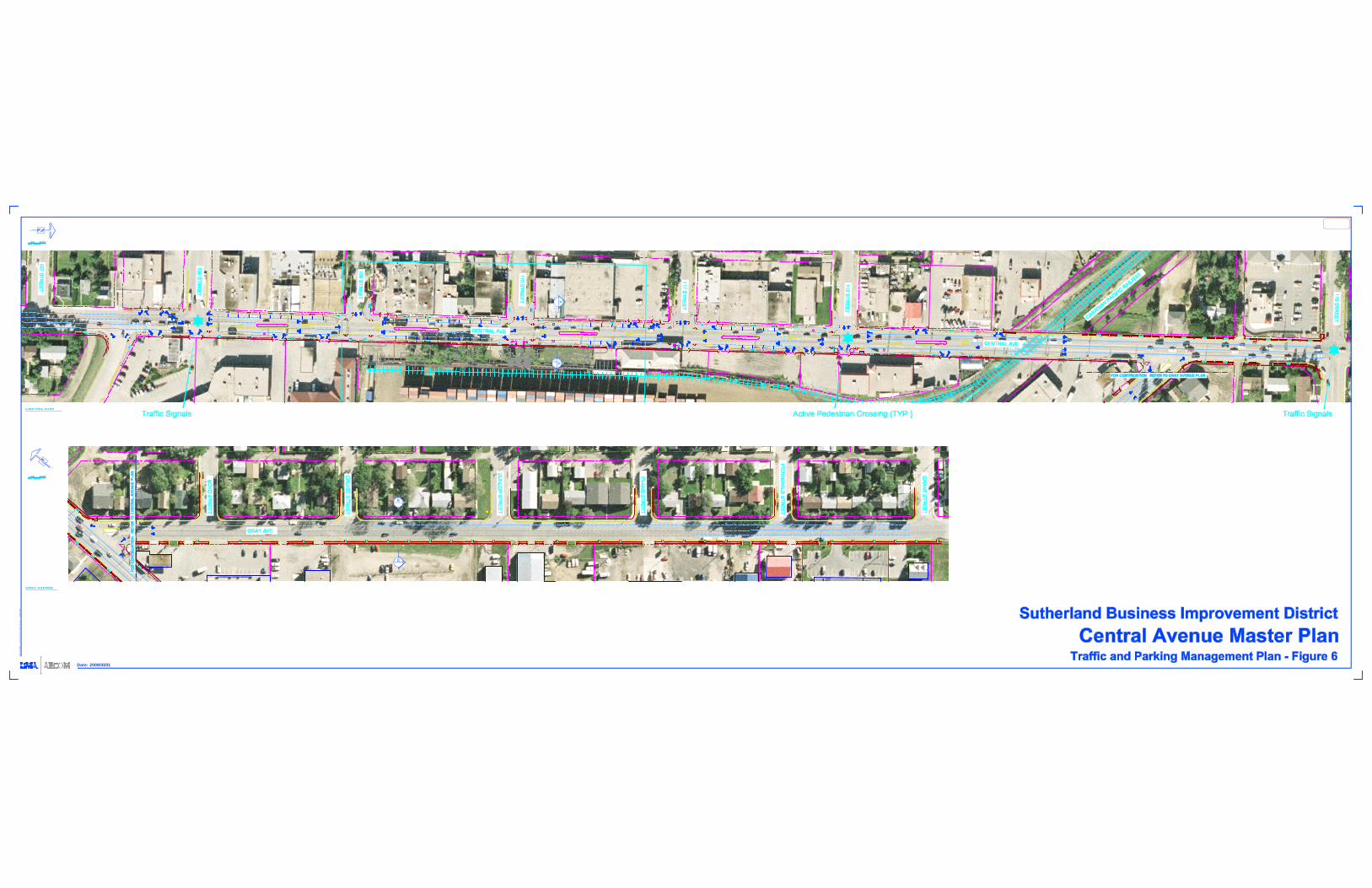
B
B
CENTRAL AVENUE
GRAY AVENUE
AA
UM
A F
ILE
NAM
E:
Date: 2009/03/31
G37
7-00
1-00
_01-
L-P
007_
RX
.dw
g
S
aved
By: s
tuderb

Sutherland Business Improvement District
Ce nt ra l Ave n ue Master P lan
RPT-G377-001-00 Final Report - 090722.doc - 38 -
4.0 Streetscape Enhancement Plan
4.1 Background/Existing Streetscape
When Sutherland was originally established as a town, Central Avenue served as the main street, with a broad mix of commercial uses, extending primarily from 108th Street to 112th Street. After the Town of Sutherland was incorporated into the City of Saskatoon, Central Avenue became an arterial roadway providing connections to College Drive and more recently, to Attridge Drive. Although the development in proximity to Sutherland and to Central Avenue has resulted in increased population and traffic usage on Central Avenue, the capacity provided by this 20 metre (65.6 foot) right-of-way has not. Limitations to the expansion of the Central Avenue right-of-way are imposed by existing buildings with zero frontage requirements on the west side of the street and the Canadian Pacific Railways land and adjacent buildings on the east side of Central Avenue.
Central Avenue looking North
Central Avenue – East Side
The combination of volume and speed of traffic, visual clutter including overhead lines, billboards, temporary signs, and a highly variable provision of sidewalks along Central Avenue, currently contribute to poor accommodation for pedestrians. Increased pedestrian safety and aesthetics on the roadway were identified as one of the problems (Policy 3.2) in the Local Area Plan (LAP) prepared by the City of Saskatoon in 1999. Traffic and parking concerns (Policy 5.1) including existing and potential safety issues adjacent to the railway right-of-way were also identified as concerns.

Sutherland Business Improvement District
Ce nt ra l Ave n ue Master P lan
RPT-G377-001-00 Final Report - 090722.doc - 39 -
There is strong support, in both the Local Area Plan (Policy 7.1), from the Steering Committee, and from the participants of the Stakeholder Workshop held in conjunction with this Master Plan study, for a local improvement program to enhance the streetscape on Central Avenue. Along with the roadway and sidewalk reconstruction, improvements to the underground infrastructure were recommended as well.
From a visual perspective there is room for improvement; a walk through of the area led to the identification of a number of streetscape related concerns including:
• Overhead power lines are visually unattractive.
• Grade crossing at railway is not user friendly for pedestrians.
• Style of bus shelters inconsistent along street.
• Excessive billboards along Central Avenue.
• Sidewalk treatment inconsistent along street.
• Too many portable signs along Central Avenue.
• Lack of street trees.
• Inconsistent street light types
• No sidewalk adjacent to Central Avenue and Gray Avenue for portions of the streets.
• Lack of site furniture along street
Portable signs along Central Avenue
Overhead powerlines

Sutherland Business Improvement District
Ce nt ra l Ave n ue Master P lan
RPT-G377-001-00 Final Report - 090722.doc - 40 -
Billboards on West side of Central Inconsistant sidewalk treatment
Our goals in developing a Streetscape Master Plan for Central and Gray Avenues are four fold;
• Develop a more visually and aesthetically pleasing streetscape
• Develop a more functional streetscape that encourages and facilitates pedestrian traffic
• Support the recommendations of the traffic management plan for vehicular traffic, including through traffic as well as local traffic
• Enhance the sense of safety and security along Central and Gray Avenues.
Central Avenue from 108th Street Gray Avenue looking East

Sutherland Business Improvement District
Ce nt ra l Ave n ue Master P lan
RPT-G377-001-00 Final Report - 090722.doc - 41 -
4.2 Proposed Central Avenue Streetscape
The Streetscape Master Plan for Central Avenue is illustrated on Figure 7 – Central Avenue Overall Streetscape Plan, Figure 8 – Central Avenue Block Streetscape Plan, and Figure 9 – Central Avenue Cross Section. In consultation with the Steering Committee, the street cross section has been revised to incorporate the parking lanes width of 2.4 metres, and driving lanes width of 3.5 metres. The proposed Master Plan for Central Avenue is based on the above noted lane widths and recommends the following: 4.2.1 Roadway and Curb Reconstruction
In order to incorporate the proposed parking lanes of 2.4 metres and driving lanes of 3.5 metres, along with the center median, existing roadway and curb must be demolished. As the current underground utilities date back to the early 1900’s, new services including storm, sanitary, and water should be upgraded while the roadway is demolished. The new construction would allow the surface drainage to be redirected towards the new storm system resulting in less potential for water ponding along Central Avenue. Combined curb and gutters would replace the dilapidated curbs existing along portions of Central Avenue. Line painting would delineate driving, turning, and parking lanes and parking stalls along the full length of the street.
Central Avenue from 107th Street

Sutherland Business Improvement District
Ce nt ra l Ave n ue Master P lan
RPT-G377-001-00 Final Report - 090722.doc - 42 -
4.2.2 Buried Electrical
The existing power lines should be buried to ensure complete visual enhancement of the streetscape. The buried electrical could be incorporated within the proposed unit paver amenity strip paralleling Central Avenue on both sides of the street.
Overhead power lines
4.2.3 Sidewalk/Amenity Strip –West Side of Central Avenue
Pedestrian movement along Central Avenue is a critical part of this master plan. Presently, the existing sidewalk varies in width, colour, and surface treatments. It is recommended that a 1.2 metre sidewalk adjacent to the building fronts, comprised of a poured in place concrete, be installed and could be regular grey concrete or a coloured patterned concrete. The sidewalk runs the length of the street from 107th to 115th along the property line. The proposed streetscape also includes a 1.15 meter unit paver amenity strip adjacent to the combined curb and gutter. This amenity strip would incorporate overhead street lighting (7.2 metres in height, average 2 per block) and lower level pedestrian lighting (3.6 metres in height, average 3 per block). We recommend that the light standards and fixtures be a contemporary style and charcoal in colour. Unit pavers within the amenity strip would consist of a charcoal soldier course around the exterior of the strip with a tan/charcoal running bond random pattern mix inside the soldier course. The electrical for the street lighting would be buried under the amenity strip. The amenity walking surface, including 1.8 metre long tree grates, would line the street from 107th to 115th. The grates could incorporate a logo or street character/theme within the design. Street trees in the grates would be integrated between the lights. Some street trees species that could be used for this application would be elm, ash, or linden. Silva Cell structure, installed below the ground surface along the full length of the amenity strip will direct future root growth down below the substructure of the sidewalk and roadway. Additional placement of site furniture including bike racks, benches, garbage cans, and bus shelters is anticipated and will be addressed at the detailed design phase.

Sutherland Business Improvement District
Ce nt ra l Ave n ue Master P lan
RPT-G377-001-00 Final Report - 090722.doc - 43 -
Proposed Unit Paver Treatment
Sidewalk Treatment – West Side
4.2.4 Sidewalk/Amenity Strip –East Side of Central Avenue
Much like the west side of Central Avenue, the existing sidewalk varies in width, colour, and surface treatments. In places, no sidewalk exists and pedestrians have carved out a narrow path through the dirt. The proposed sidewalk would be consistent with the sidewalk proposed for the west side of the street and would run from 107th to 115th along the property line. The amenity strip width would be reduced from 1.15 metre to 1.05 metres on the east side. The design and construction material for the strip would remain consistent with the west side of Central Avenue. This amenity strip would include overhead street lighting (7.2 metres in height, average 2 per block), lower level pedestrian lighting (3.6 metres in height, average 3 per block) and street trees, matching the locations of the street lighting fixtures and trees across the street.
4.2.5 Center Median
A 3.3 metre wide center median is incorporated in each of the blocks down Central Avenue between 108th and the Canadian Pacific Railway crossing, north of 112th Street. A total of five medians are proposed. These medians will have a 0.5 metre wide apron adjacent to the curb which extend to an expanded apron at the ends of the median. A 0.3 metre wide by 0.3 metre high planter extending for approximately 50 metres will be a feature within each median. The raised planter could be cast-in-place concrete or unit masonry. The planters will feature ornamental trees (approximately 3 trees per block) as well as a mix of plant material including shrubs, perennials, and annuals will provide additional colour and texture. The planters should be irrigated to encourage healthy development and ensure future plant sustainability. Cora-plast plastic barrier should run along the full length of the median on both sides to force future tree root growth down below the substructure of the apron and roadway. As a final element in the median, 7.2 metre banner poles could be located at both ends of each median. These poles should match the contemporary light standards. A variety of banners can be hung at various times to allow events to be advertised along the street. A standard set of banners highlighting historical features of the neighbourhood might serve as “default” banners when local events are not being promoted.

Sutherland Business Improvement District
Ce nt ra l Ave n ue Master P lan
RPT-G377-001-00 Final Report - 090722.doc - 44 -
4.2.6 Corner Bulbing
At each of the intersections of Central Avenue from 108th to 112th inclusive, corner bulbing is recommended. Corner bulbing narrows the traffic lane at these key pedestrian crossings, and encourages traffic calming. In addition, the extra curbside space afforded by the corned bulbs provides additional space for focal features that will be visible for length of Central Avenue and also to traffic entering onto Central Avenue from any of the side streets. The hard surface areas of the corner bulbs would extend to the edge of the parking lanes on each side of the street. The bulbs would include the extension of the unit pavers used on the sidewalk. Sidewalk ramps at each corner will encourage and facilitate pedestrian traffic crossing at these locations. Each corner bulb would include an overhead street light (7.2 metres in height), for a total of four street lights at each intersection. The light standards and fixtures would match those along Central. Unit pavers within the bulbs would consist of a charcoal soldier course around the exterior of the bulb with a tan/charcoal running bond random pattern mix inside the soldier course. Unit paver circle kits could be introduced in these areas to enhance the hard surface aesthetics. Within the each bulb on the east side of the street, two tree grates, 1.8 metre long would contain the street trees. These trees should be either elm, ash or linden, and of specimen quality. The grates could incorporate a logo or street character/theme within the design. Planters situated on the corner bulbs should be the same material as used within the median and with a recommended height of 0.45 metres. Within the planters, a mix of shrubs and perennials could be used along with an overhead canopy from ornamental trees. These planters should be irrigated to encourage healthy development and ensure future plant sustainability. Site furniture including benches and trash receptacles are included at various locations within the corner bulbs. Selection of furniture should include recycled plastic faux-wood finish material with metal trim colour painted to match the light standards or charcoal grey. 4.2.7 Structures
Bus shelters located along Central Avenue should be of a consistent style that matches the light standards and site furniture. Charcoal colour should be incorporated on metal finishes to maintain consistency along the street. 4.2.8 Entrance features at 108th and 115th Intersections
Central Avenue – Looking North Central Avenue – Looking South
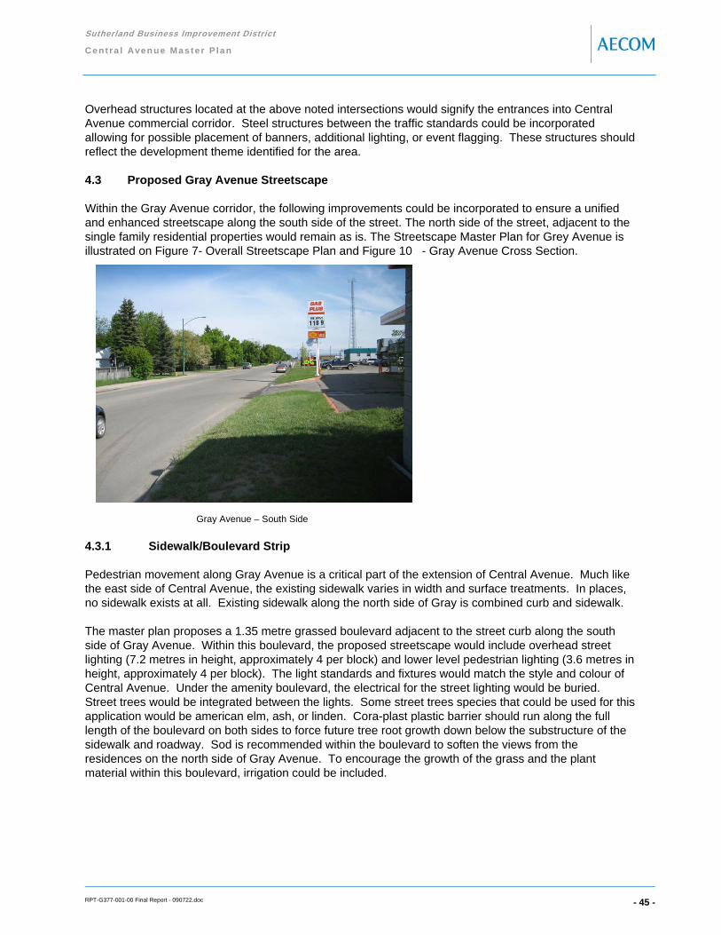
Sutherland Business Improvement District
Ce nt ra l Ave n ue Master P lan
RPT-G377-001-00 Final Report - 090722.doc - 45 -
Overhead structures located at the above noted intersections would signify the entrances into Central Avenue commercial corridor. Steel structures between the traffic standards could be incorporated allowing for possible placement of banners, additional lighting, or event flagging. These structures should reflect the development theme identified for the area.
4.3 Proposed Gray Avenue Streetscape
Within the Gray Avenue corridor, the following improvements could be incorporated to ensure a unified and enhanced streetscape along the south side of the street. The north side of the street, adjacent to the single family residential properties would remain as is. The Streetscape Master Plan for Grey Avenue is illustrated on Figure 7- Overall Streetscape Plan and Figure 10 - Gray Avenue Cross Section.
Gray Avenue – South Side
4.3.1 Sidewalk/Boulevard Strip
Pedestrian movement along Gray Avenue is a critical part of the extension of Central Avenue. Much like the east side of Central Avenue, the existing sidewalk varies in width and surface treatments. In places, no sidewalk exists at all. Existing sidewalk along the north side of Gray is combined curb and sidewalk. The master plan proposes a 1.35 metre grassed boulevard adjacent to the street curb along the south side of Gray Avenue. Within this boulevard, the proposed streetscape would include overhead street lighting (7.2 metres in height, approximately 4 per block) and lower level pedestrian lighting (3.6 metres in height, approximately 4 per block). The light standards and fixtures would match the style and colour of Central Avenue. Under the amenity boulevard, the electrical for the street lighting would be buried. Street trees would be integrated between the lights. Some street trees species that could be used for this application would be american elm, ash, or linden. Cora-plast plastic barrier should run along the full length of the boulevard on both sides to force future tree root growth down below the substructure of the sidewalk and roadway. Sod is recommended within the boulevard to soften the views from the residences on the north side of Gray Avenue. To encourage the growth of the grass and the plant material within this boulevard, irrigation could be included.

Sutherland Business Improvement District
Ce nt ra l Ave n ue Master P lan
RPT-G377-001-00 Final Report - 090722.doc - 46 -
Adjacent to the boulevard, a 1.5 metre sidewalk would allow pedestrians to walk along the street but be separated from the vehicles on the adjacent roadway. The surface treatment of the walk should poured in place concrete and could be regular grey concrete or a coloured patterned concrete. The sidewalk runs the length of the Gray Avenue from Central Avenue to Grant Street, adjacent to the private property. On the south side of the sidewalk, a consistent fence of 1.2 metres in height from Central Avenue to Grant Street should be considered. This fence would shield parking lots and vehicles from against residences views. Construction material of the fence could be wood or something more ornamental.
4.3.2 Buried Electrical
The existing power poles along the south side of Gray Avenue should be buried to visually enhance the streetscape. The buried electrical should be buried within the 1.35 metre grassed boulevard between the street curb and the separate sidewalk. 4.4 Sustainable Development Opportunities
Any future development should be undertaken with consideration for opportunities to implement appropriate sustainable practices. Redevelopment of Central Avenue and Gray Avenue, and the surrounding areas, offers potential for a variety of considerations including:
• Encouraging and facilitating brownfield development of existing buildings and sites within the area
• Use of storm water retention along the street to reduce size of underground services.
• Use of landscaping materials with low water requirements (Xeriscaping)
• Implementation of community focussed initiatives such as community gardens
• Accommodation for public transit, pedestrian and other active forms of transit.
The Master Plan sets the basic framework in place to accommodate and encourage sustainable initiatives; specifics must be addressed at the detailed design stage, and through the development of other studies and reports.
4.5 Summary of Recommendations
Central Avenue is a busy arterial roadway. Improvements to the streetscape directed at slowing traffic, supporting pedestrians, and providing landscaping and other amenities will establish a more local neighbourhood feel. The following provides a summary of the recommendations for the streetscape plan to achieve these objectives:
• Establish a defined walking surface and amenity strips adjacent to the existing buildings, along both sides of Central Avenue
• Create corner bulbs at each intersection along Central Avenue to allow better pedestrian movement at the corners, and facilitate safer street crossing, by increasing the visibility of pedestrians, reducing the width of street to be crossed, and slowing traffic
• Bury electrical utilities
• Install pedestrian crossing lights at 112th Street
• Install medians along Central Avenue, thereby reducing the vehicular traffic to one lane in each direction, and to deter pedestrians from attempting to cross at mid block

Sutherland Business Improvement District
Ce nt ra l Ave n ue Master P lan
RPT-G377-001-00 Final Report - 090722.doc - 47 -
• Provide enhanced lighting along Central
• Provide a separate curb and sidewalk along the length of Gray Avenue on the south side of the street to better accommodate pedestrians
• Create spaces for gathering and sitting at corner bulbs, and potentially through development of a small plaza at 110th Street
A theme for Sutherland that may be identified through the branding study can be reflected in the specific colour materials and furniture selections. It is recommended that the overhead entrance features on Central Avenue, at 108th Street and at 115th Street be installed, and that these structures also introduce and reflect the theme / brand developed for the area.

SCALE 1:400m
B
B
SCALE 1:400m
CENTRAL AVENUE
GRAY AVENUE
AA
UM
A FI
LE N
AME:
Date: 2009/06/18
G37
7-00
1-00
_01-
L-P0
01_R
X.dw
g
S
aved
By:
pry
stup
ak

SCALE 1:200m
SCALE 1:400m
UM
A FI
LE N
AME:
G37
7-00
1-00
_01-
L-P
003_
RX
.dw
g
S
aved
By:
pry
stup
ak
Date: 2009/06/18

PLPL
SECTION
CENTRAL AVENUE22X34
ASCALE 1:40m
SCALE 1:80m
UM
A FI
LE N
AME:
Date: 2009/06/18
G37
7-00
1-00
_01-
L-P
002_
RX
.dw
g
S
aved
By:
pry
stup
ak

PL PL
SECTION
GRAY AVENUE22X34
BSCALE 1:40m
SCALE 1:80m
UM
A FI
LE N
AME:
Date: 2009/06/18
G37
7-00
1-00
_01-
L-P
006_
RX
.dw
g
S
aved
By:
pry
stup
ak

Sutherland Business Improvement District
Ce nt ra l Ave n ue Master P lan
RPT-G377-001-00 Final Report - 090722.doc - 52 -
5.0 Capital Cost Analysis
The following cost estimate is separated into the Central Avenue and Gray Avenue Streetscape. 2009 contractor pricing was used and items were broken down as much as possible based on the amount of detail required for master planning purposes.

Sutherland Business Improvement DistrictCentral Avenue Master PlanJune 18, 2009
Units Qty. Unit Price Extension
Description
General Requirements
1 Mobilization-demobilization lump 1 $50,000 $50,000
2 Insurance, bonding, permits lump 1 $100,000 $100,000
Sub Total $150,000
Site Demolition
Site Demolition
3 Asphalt m2 14034 $4 $56,136
4 Concrete m2 4871 $20 $97,420
5 Curb l.m 1624 $8 $12,992
6 Power Poles lump 1 $400,000 $400,000
Sub Total $566,548
Topsoil and Finish Grading
7 Fine grading allowance m2 425 $1 $425
8 Topsoil - all (imported - 300mm depth) including 50mm depth manure and 50mm depth sand m2 425 $15 $6,375
Sub Total $6,800
Unit Paving
9 Unit Pavers m2 1771 $140 $247,940
Sub Total $247,940
Asphalt
10 Standard Asphalt c/w Sub-base Preparation and Granular - 80mm depth m2 13934 $55 $766,370
11 Line Painting lump 1 $10,000 $10,000
Sub Total $776,370
Concrete
12 Concrete / Stamped Concrete m2 2130 $150 $319,500
13 Concrete Apron m2 355 $150 $53,250
14 Concrete Curb l.m 2092 $100 $209,200
15 Pedestrian Ramp each 78 $250 $19,500
Sub Total $601,450
Retaining Walls
16 Retaining Walls - Median - 300mm Ht. l.m 278 $150 $41,700
17 Retaining Walls - Sidewalk- 450mm Ht. l.m 98 $300 $29,400
Sub Total $71,100
Irrigation
18 Irrigation System m2 425 $10 $4,250
Sub Total $4,250
Underground Electrical
19 Underground Electrical (Buried Overhead Lines) lump 1 $1,200,000 $1,200,000
Sub Total $1,200,000
Lighting
20 Street Lighting each 54 $15,000 $810,000
21 Pedestrian Lighting each 37 $7,000 $259,000
22 Electrical Outlets each 63 $100 $6,300
23 Pedestrian Crossing each 1 $50,000 $50,000
24 Overhead Structure & Traffic Lights each 2 $500,000 $1,000,000
Sub Total $2,125,300
Site Furnishings
25 Park Benches each 20 $2,000 $40,000
26 Trash Receptacles each 14 $1,000 $14,000
27 Tree grates each 63 $600 $37,800
28 Street signage each 8 $1,500 $12,000
29 Banner Poles each 10 $10,000 $100,000
Sub Total $203,800
Plant Material
Plant Material - Trees
30 Deciduous Trees (100 cal.) each 63 $600 $37,800
31 Ornamental Deciduous Trees (50 cal.) each 19 $400 $7,600
Plant Material - Shrubs/Perennials
32 Coniferous/Deciduous Shrubs m2 276 $50 $13,800
33 Cora-Plast - median only l.m 350 $25 $8,750
34 Sliva Cell m2 1013 $150 $151,950
35 Mulch m2 425 $6 $2,550
Sub Total $222,450
Sub Total $6,176,008
10% Contingency $617,601
Grand total $6,793,609
New Underground Utility Construction
Underground Utilities
1 Water l.m 863 $300 $258,900
1 Hydrants each 8 $6,500 $52,000
2 Sewer l.m 863 $350 $302,050
3 Storm l.m 1024 $450 $460,800
4 Man Holes each 16 $6,000 $96,000
5 Catch Basins each 22 $5,000 $110,000
Sub Total $1,279,750
Sub Total $1,279,750
10% Contingency $127,975
Grand total $1,407,725
All costs are based on 2009 Contractor prices.
Table 5.1 - Overall Cost Analysis -Central Avenue

Sutherland Business Improvement District Gray Avenue June 18, 2009
Units Qty. Unit Price Extension
Description
General Requirements
1 Mobilization-demobilization lump 1 $15,000 $15,000
2 Insurance, bonding, permits lump 1 $30,000 $30,000
Sub Total $45,000
Site Demolition
Site demolition
3 Asphalt m2 584 $4 $2,336
4 Concrete m2 1622 $20 $32,440
5 Curb l.m 568 $8 $4,544
6 Power Poles lump 1 $150,000 $150,000
Sub Total $189,320
Topsoil and Finish Grading
7 Fine grading allowance m2 813 $1 $813
8 Topsoil - all (imported - 100mm depth) including 50mm depth manure and 50mm depth sand m2 886 $10 $8,860
9 Planting Topsoil - all (imported - 300mm depth) including 50mm depth manure and 50mm depth sand m2 32 $15 $480
Sub Total $10,153
Asphalt
10 Standard Asphalt c/w Sub-base Preparation and Granular - 80mm depth m2 584 $55 $32,120
Sub Total $32,120
Concrete
11 Concrete / Stamped Concrete m2 581 $150 $87,150
12 Concrete Curb l.m 486 $100 $48,600
13 Pedestrian Ramp each 28 $250 $7,000
Sub Total $142,750
Table 5.2 - Overall Cost Analysis - Gray Avenue
Sub Total $142,750
Irrigation
14 Irrigation System m2 815 $10 $8,150
Sub Total $8,150
Lighting
15 Underground Electrical (Buried Overhead Lines) lump 1 $450,000 $450,000
Sub Total $450,000
Lighting
16 Street Lighting each 13 $15,000 $195,000
17 Pedestrian Lighting each 15 $7,000 $105,000
Sub Total $300,000
Sod
18 Sod m2 815 $5 $4,075
Sub Total $4,075
Plant Material
Plant Material - Trees
19 Deciduous Trees (100 cal.) each 32 $600 $19,200
20 Cora-Plast l.m 850 $25 $21,250
21 Mulch m2 32 $6 $192
Sub Total $40,642
Fencing
22 1.2m Ht Wood Fence l.m 490 $200 $98,000
Sub Total $98,000
Sub Total $1,320,210
10% Contingency $132,021
Grand total $1,452,231
All costs are based on 2009 Contractor prices.

Sutherland Business Improvement District
Ce nt ra l Ave n ue Master P lan
RPT-G377-001-00 Final Report - 090722.doc - 55 -
6.0 Phasing
As shown in the cost estimate listed above, it is recognized that a project of this magnitude can not be completed in one phase. Recommended phases of Central Avenue would each include roadway and curb construction, underground utilities, and streetscape construction. Gray Avenue is recommended to be completed as one phase including the burying of the electrical line. The phasing listed below is one option to separate costing over the course of the next number of years to take the project from start to fruition.
Phasing
1. 107th to 109th Street (including overhead entrance structure)
2. 109th Street to 111th Street
3. 111th Street to CPR tracks including potential walkway link
4. CPR tracks to 115th Street (including overhead entrance structure)
5. Gray Avenue from Central Avenue to Grant Street
Note: Phases 1 through 5 would incorporate the burying of electrical lines in each of their applicable phases.

Sutherland Business Improvement District Central Avenue Master Plan (107 Street - 109 Street) June 18, 2009
Units Qty. Unit Price Extension
Description
General Requirements
1 Mobilization-demobilization lump 1 $12,500 $12,500
2 Insurance, bonding, permits lump 1 $25,000 $25,000
Sub Total $37,500
Site Demolition
Site Demolition
3 Asphalt m2 3152 $4 $12,608
4 Concrete m2 887 $20 $17,740
5 Curb l.m 341 $8 $2,728
6 Power Poles lump 1 $100,000 $100,000
Sub Total $133,076
Topsoil and Finish Grading
7 Fine grading allowance m2 65 $1 $65
8 Topsoil - all (imported - 300mm depth) including 50mm depth manure and 50mm depth sand m2 65 $15 $975
Sub Total $1,040
Unit Paving
9 Unit Pavers m2 377 $140 $52,780
Sub Total $52,780
Asphalt
10 Standard Asphalt c/w Sub-base Preparation and Granular - 80mm depth m2 3035 $55 $166,925
11 Line Painting lump 1 $2,500 $2,500
Sub Total $169,425
Concrete
12 Concrete / Stamped Concrete m2 440 $150 $66,000
13 Concrete Apron m2 55 $150 $8,250
14 Concrete Curb l.m 407 $100 $40,700
15 Pedestrian Ramp each 20 $250 $5,000
Sub Total $119,950
Retaining Walls
16 Retaining Walls - Median - 300mm Ht. l.m 48 $150 $7,200
17 Retaining Walls - Sidewalk- 450mm Ht. l.m 13 $300 $3,900
Sub Total $11,100
Irrigation
18 Irrigation System m2 65 $10 $650
Sub Total $650
U d d El t i l
Table 6.1 - Phasing 107th Street to 109th Street
Underground Electrical
19 Underground Electrical (Buried Overhead Lines) lump 1 $300,000 $300,000
Sub Total $300,000
Lighting
20 Street Lighting each 13 $15,000 $195,000
21 Pedestrian Lighting each 5 $7,000 $35,000
22 Electrical Outlets each 10 $100 $1,000
23 Overhead Structure & Traffic Lights each 1 $500,000 $500,000
Sub Total $731,000
Site Furnishings
24 Park Benches each 5 $2,000 $10,000
25 Trash Receptacles each 4 $1,000 $4,000
26 Tree grates each 10 $600 $6,000
27 Street signage each 2 $1,500 $3,000
28 Banner Poles each 2 $10,000 $20,000
Sub Total $43,000
Plant Material
Plant Material - Trees
29 Deciduous Trees (100 cal.) each 10 $600 $6,000
30 Ornamental Deciduous Trees (50 cal.) each 4 $400 $1,600
Plant Material - Shrubs/Perennials
31 Coniferous/Deciduous Shrubs m2 43 $50 $2,150
32 Cora-Plast - median only l.m 61 $25 $1,525
33 Sliva Cell m2 148 $150 $22,200
34 Mulch m2 65 $6 $390
Sub Total $33,865
Sub Total $1,633,386
10% Contingency $163,339
Grand total $1,796,725
New Underground Utility Construction
Underground Utilities
1 Water l.m 215 $300 $64,500
1 Hydrants each 2 $6,500 $13,000
2 Sewer l.m 215 $350 $75,250
3 Storm l.m 256 $450 $115,200
4 Man Holes each 4 $6,000 $24,000
5 Catch Basins each 5 $5,000 $25,000
Sub Total $316,950
Sub Total $316,950
10% Contingency $31,695
Grand total $348,645
All costs are based on 2009 Contractor prices.
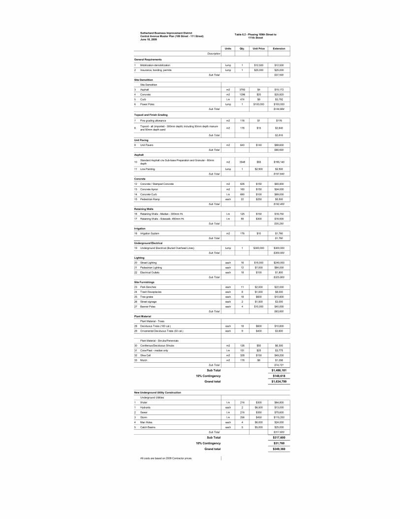
Sutherland Business Improvement District Central Avenue Master Plan (109 Street - 111 Street) June 18, 2009
Units Qty. Unit Price Extension
Description
General Requirements
1 Mobilization-demobilization lump 1 $12,500 $12,500
2 Insurance, bonding, permits lump 1 $25,000 $25,000
Sub Total $37,500
Site Demolition
Site Demolition
3 Asphalt m2 3793 $4 $15,172
4 Concrete m2 1296 $20 $25,920
5 Curb l.m 474 $8 $3,792
6 Power Poles lump 1 $100,000 $100,000
Sub Total $144,884
Topsoil and Finish Grading
7 Fine grading allowance m2 176 $1 $176
8 Topsoil - all (imported - 300mm depth) including 50mm depth manure and 50mm depth sand m2 176 $15 $2,640
Sub Total $2,816
Unit Paving
9 Unit Pavers m2 640 $140 $89,600
Sub Total $89,600
Asphalt
10 Standard Asphalt c/w Sub-base Preparation and Granular - 80mm depth m2 3548 $55 $195,140
11 Line Painting lump 1 $2,500 $2,500
Sub Total $197,640
Concrete
12 Concrete / Stamped Concrete m2 626 $150 $93,900
13 Concrete Apron m2 160 $150 $24,000
14 Concrete Curb l.m 690 $100 $69,000
15 Pedestrian Ramp each 22 $250 $5,500
Sub Total $192,400
Retaining Walls
16 Retaining Walls - Median - 300mm Ht. l.m 125 $150 $18,750
17 Retaining Walls - Sidewalk- 450mm Ht. l.m 55 $300 $16,500
Sub Total $35,250
Irrigation
18 Irrigation System m2 176 $10 $1,760
Sub Total $1,760
U d d El t i l
Table 6.2 - Phasing 109th Street to 111th Street
Underground Electrical
19 Underground Electrical (Buried Overhead Lines) lump 1 $300,000 $300,000
Sub Total $300,000
Lighting
20 Street Lighting each 16 $15,000 $240,000
21 Pedestrian Lighting each 12 $7,000 $84,000
22 Electrical Outlets each 18 $100 $1,800
Sub Total $325,800
Site Furnishings
23 Park Benches each 11 $2,000 $22,000
24 Trash Receptacles each 8 $1,000 $8,000
25 Tree grates each 18 $600 $10,800
26 Street signage each 2 $1,500 $3,000
27 Banner Poles each 4 $10,000 $40,000
Sub Total $83,800
Plant Material
Plant Material - Trees
28 Deciduous Trees (100 cal.) each 18 $600 $10,800
29 Ornamental Deciduous Trees (50 cal.) each 9 $400 $3,600
Plant Material - Shrubs/Perennials
30 Coniferous/Deciduous Shrubs m2 126 $50 $6,300
31 Cora-Plast - median only l.m 151 $25 $3,775
32 Sliva Cell m2 328 $150 $49,200
33 Mulch m2 176 $6 $1,056
Sub Total $74,731
Sub Total $1,486,181
10% Contingency $148,618
Grand total $1,634,799
New Underground Utility Construction
Underground Utilities
1 Water l.m 216 $300 $64,800
1 Hydrants each 2 $6,500 $13,000
2 Sewer l.m 216 $350 $75,600
3 Storm l.m 256 $450 $115,200
4 Man Holes each 4 $6,000 $24,000
5 Catch Basins each 5 $5,000 $25,000
Sub Total $317,600
Sub Total $317,600
10% Contingency $31,760
Grand total $349,360
All costs are based on 2009 Contractor prices.

Sutherland Business Improvement District Central Avenue Master Plan (111 Street - CPR Tracks) June 18, 2009
Units Qty. Unit Price Extension
Description
General Requirements
1 Mobilization-demobilization lump 1 $12,500 $12,500
2 Insurance, bonding, permits lump 1 $25,000 $25,000
Sub Total $37,500
Site Demolition
Site Demolition
3 Asphalt m2 3773 $4 $15,092
4 Concrete m2 1495 $20 $29,900
5 Curb l.m 512 $8 $4,096
6 Power Poles lump 1 $100,000 $100,000
Sub Total $149,088
Topsoil and Finish Grading
7 Fine grading allowance m2 153 $1 $153
8 Topsoil - all (imported - 300mm depth) including 50mm depth manure and 50mm depth sand m2 153 $15 $2,295
Sub Total $2,448
Unit Paving
9 Unit Pavers m2 482 $140 $67,480
Sub Total $67,480
Asphalt
10 Standard Asphalt c/w Sub-base Preparation and Granular - 80mm depth m2 4019 $55 $221,045
11 Line Painting lump 1 $2,500 $2,500
Sub Total $223,545
Concrete
12 Concrete / Stamped Concrete m2 570 $150 $85,500
13 Concrete Apron m2 140 $150 $21,000
14 Concrete Curb l.m 636 $100 $63,600
15 Pedestrian Ramp each 26 $250 $6,500
Sub Total $176,600
Retaining Walls
16 Retaining Walls - Median - 300mm Ht. l.m 105 $150 $15,750
17 Retaining Walls - Sidewalk- 450mm Ht. l.m 30 $300 $9,000
Sub Total $24,750
Irrigation
18 Irrigation System m2 153 $10 $1,530
Sub Total $1,530
U d d El t i l
Table 6.3 - Phasing 111th Street to CPR Tracks
Underground Electrical
19 Underground Electrical (Buried Overhead Lines) lump 1 $300,000 $300,000
Sub Total $300,000
Lighting
20 Street Lighting each 14 $15,000 $210,000
21 Pedestrian Lighting each 9 $7,000 $63,000
22 Electrical Outlets each 17 $100 $1,700
23 Pedestrian Crossing each 1 $50,000 $50,000
Sub Total $324,700
Site Furnishings
24 Park Benches each 4 $2,000 $8,000
25 Trash Receptacles each 2 $1,000 $2,000
26 Tree grates each 17 $600 $10,200
27 Street signage each 2 $1,500 $3,000
28 Banner Poles each 4 $10,000 $40,000
Sub Total $63,200
Plant Material
Plant Material - Trees
29 Deciduous Trees (100 cal.) each 17 $600 $10,200
30 Ornamental Deciduous Trees (50 cal.) each 6 $400 $2,400
Plant Material - Shrubs/Perennials
31 Coniferous/Deciduous Shrubs m2 107 $50 $5,350
32 Cora-Plast - median only l.m 138 $25 $3,450
33 Sliva Cell m2 266 $150 $39,900
34 Mulch m2 153 $6 $918
Sub Total $62,218
Sub Total $1,433,059
10% Contingency $143,306
Grand total $1,576,365
New Underground Utility Construction
Underground Utilities
1 Water l.m 216 $300 $64,800
1 Hydrants each 2 $6,500 $13,000
2 Sewer l.m 216 $350 $75,600
3 Storm l.m 256 $450 $115,200
4 Man Holes each 4 $6,000 $24,000
5 Catch Basins each 6 $5,000 $30,000
Sub Total $322,600
Sub Total $322,600
10% Contingency $32,260
Grand total $354,860
All costs are based on 2009 Contractor prices.
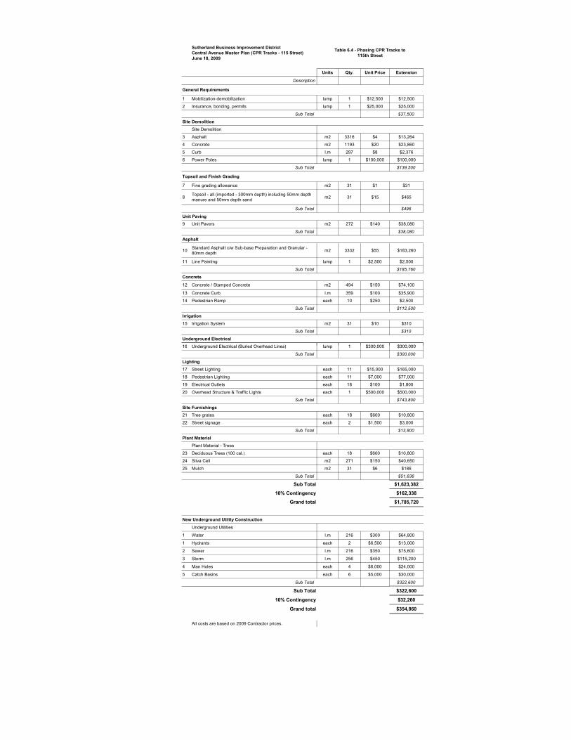
Sutherland Business Improvement District Central Avenue Master Plan (CPR Tracks - 115 Street) June 18, 2009
Units Qty. Unit Price Extension
Description
General Requirements
1 Mobilization-demobilization lump 1 $12,500 $12,500
2 Insurance, bonding, permits lump 1 $25,000 $25,000
Sub Total $37,500
Site DemolitionSite Demolition
3 Asphalt m2 3316 $4 $13,264
4 Concrete m2 1193 $20 $23,860
5 Curb l.m 297 $8 $2,376
6 Power Poles lump 1 $100,000 $100,000
Sub Total $139,500
Topsoil and Finish Grading
7 Fine grading allowance m2 31 $1 $31
8 Topsoil - all (imported - 300mm depth) including 50mm depth manure and 50mm depth sand m2 31 $15 $465
Sub Total $496
Unit Paving 9 Unit Pavers m2 272 $140 $38,080
Sub Total $38,080
Asphalt
10 Standard Asphalt c/w Sub-base Preparation and Granular - 80mm depth m2 3332 $55 $183,260
11 Line Painting lump 1 $2,500 $2,500
Sub Total $185,760
Concrete
12 Concrete / Stamped Concrete m2 494 $150 $74,100
13 Concrete Curb l.m 359 $100 $35,900
14 Pedestrian Ramp each 10 $250 $2,500
Sub Total $112,500
Irrigation15 Irrigation System m2 31 $10 $310
Sub Total $310
Underground Electrical16 Underground Electrical (Buried Overhead Lines) lump 1 $300 000 $300 000
Table 6.4 - Phasing CPR Tracks to 115th Street
16 Underground Electrical (Buried Overhead Lines) lump 1 $300,000 $300,000
Sub Total $300,000
Lighting17 Street Lighting each 11 $15,000 $165,000
18 Pedestrian Lighting each 11 $7,000 $77,000
19 Electrical Outlets each 18 $100 $1,800
20 Overhead Structure & Traffic Lights each 1 $500,000 $500,000
Sub Total $743,800
Site Furnishings21 Tree grates each 18 $600 $10,800
22 Street signage each 2 $1,500 $3,000
Sub Total $13,800
Plant Material Plant Material - Trees
23 Deciduous Trees (100 cal.) each 18 $600 $10,800
24 Sliva Cell m2 271 $150 $40,650
25 Mulch m2 31 $6 $186
Sub Total $51,636
Sub Total $1,623,382
10% Contingency $162,338
Grand total $1,785,720
New Underground Utility Construction
Underground Utilities
1 Water l.m 216 $300 $64,800
1 Hydrants each 2 $6,500 $13,000
2 Sewer l.m 216 $350 $75,600
3 Storm l.m 256 $450 $115,200
4 Man Holes each 4 $6,000 $24,000
5 Catch Basins each 6 $5,000 $30,000
Sub Total $322,600
Sub Total $322,600
10% Contingency $32,260
Grand total $354,860
All costs are based on 2009 Contractor prices.

Sutherland Business Improvement District
Ce nt ra l Ave n ue Master P lan
RPT-G377-001-00 Final Report - 090722.doc - 60 -
7.0 Recommendations of the Local Area Plan and Safety Audit
A number of recommendations of the Local Area Plan remain outstanding, with one of the goals of the Master Plan being to address or further the completion of these recommendations. In addition, a number of safety audits conducted in May 2006 identified areas for improvements and recommendations for the neighbourhood. Table 7.1 provides a summary of the LAP recommendations outstanding, with corresponding information provided to indicate how these recommendations have been addressed by the Master Plan. Table 7.2 provides a list of the improvements and comments identified through the neighbourhood safety audit, and indicates how these have been addressed in the Master Plan.
Table 7.1 Recommendations of the Local Area Plan
LAP Recommendation Central Avenue Master Plan
Transportation, Circulation & Parking Recommendation 3.2 - Increase pedestrian safety and aesthetics of Central Avenue.
That Traffic Management, Community association and the Central Avenue BID meet to identify the appropriate traffic role of Central Avenue in order to increase pedestrian safety and aesthetics of the roadway.
Streetscape Plan and Traffic Management Plan place focus on pedestrian safety, including reducing driving lanes to one lane in each direction, and creating corner bulbs to allow for greater pedestrian visibility. Streetscape Plan will improve aesthetics of street.
Transportation, Circulation & Parking Recommendation 3.4 – Review operation of 108th Street – That Traffic Management in consultation with the community Association review the operation of 108th Street and that a study be undertaken with a long term goal of management traffic volumes on Sutherland area roadways.
Turning lanes for the northbound and southbound left turn movements along Central Avenue at 108th Street have been identified to improve operations. Opposing vehicles will be more able to distinguish turning vehicles and potential conflicts. The re-alignment of the east leg to match the west leg is also identified.
Land Use (Commercial/Industrial)
Recommendation 4.1 – Resolve issues related to commercial development – That the Community Association and the Central Avenue BID work more closely to identify areas for partnership and resolve issues within the neighbourhood.
The Master Plan includes recommendations directed toward the functioning of the neighbourhood, and identifies both formal and information opportunities for the BID and the City to work together to mitigate or alleviate issues of concerns. This includes bylaw enforcement to minimize parking, speeding, inappropriate truck traffic; information and awareness initiatives to encourage property maintenance and improvements; involvement of the property owners to assist in minimizing negative behaviours of patrons.

Sutherland Business Improvement District
Ce nt ra l Ave n ue Master P lan
RPT-G377-001-00 Final Report - 090722.doc - 61 -
LAP Recommendations Central Avenue Master Plan
Neighbourhood Safety
Recommendation 5.1 – Identify existing and potential safety issues in neighbourhood – That the Saskatoon Police Service and Leisure Services work with the Sutherland Community Association to identify existing and potential safety issues that may be addressed by the Safer City Advisory Committee
A Safety audit conducted in May 2006 included suggestions to improve neighbourhood safety in Sutherland. Many of these are addressed in Central Avenue Master Plan and are summarized in Table 7.2 below.
Infrastructure and Municipal Services
Recommendation 7.1 – Examine important infrastructure issue and Local Improvement Program – That the Leisure Service Branch through the Community Association work with the Sutherland residents to identify which infrastructure issues are most important to the neighbourhood. Those issues or projects deemed most important can be brought to the appropriate City department’s attention through the Community association. Where these issues do not fit the City’s budget or priority list, the neighbourhood may choose to pursue an alternative approach such as the Local Improvement Program.
Streetscape Plan presented in Section 4.0 includes recommendations for improvements to sidewalks and roadways on Central Avenue, including recommendations for phasing and cost estimates.

Sutherland Business Improvement District
Ce nt ra l Ave n ue Master P lan
RPT-G377-001-00 Final Report - 090722.doc - 62 -
Table 7.2 Suggestions of the Sutherland Safety Audit
Safety Audit – Improvements Identified Central Avenue Master Plan
Better residential lighting, better lighting in alley ways Streetscape Plan includes pedestrian level and street level lighting along Central and Gray Avenues
Repaint street at pedestrian crosswalks, especially around schools
Master Plan focus is on facilitating pedestrian movement. Along Central Avenue this is achieved by corner bulbing to increase pedestrian visibility, improvements to sidewalks, reducing driving lanes to one lane in each direction.
Noisy late night traffic that rips around Recommendations in the Master Plan include use of enforcement to minimize negative behaviours. It is also recommended that business owners be encouraged to take an active role in maintaining positive relations with the community.
Maintenance of commercial areas, improvements to enhance Sutherland Hotel.
Clean up Central Avenue., new facades, parking restrictions
Enterprise zone provides opportunities for property owners to apply for funding assistance for façade improvements and property development initiatives. Master Plan recommends that BID ensure owners are aware of these opportunities.
Streetscape Plan will include major redevelopment of Central Avenue.
Make area for parking such as East Central Avenue Master Plan includes recommendation that bylaw enforcement be employed as needed to ensure parking turnover rates are being maintained. Streetscape improvements will encourage pedestrian traffic.
Spaces between Central Avenue business should be fenced
Responsibility of individual property owners.
Safety Audit - Comments Central Avenue Master Plan
Greater police presence during peak bar attendance houses Sept – May 10 pm to 2 am
Recommendations in the Master Plan include use of enforcement to minimize negative behaviours. It is also recommended that business owners be encouraged to take an active role in maintaining positive relations with the community.
Approach MP and ask for assistance to facilitate purchase of lands between Central Avenue and curb - fence off CP rail area.
Master Plan for Central Avenue parking along CN designated parking
Master Plan recommends rezoning of these lands to B5A to provide greater opportunity for development of this area.
Appendix A
Community Consultation Program
• Community Focus Group Meeting – Summary of Comments
• Public Open House – Written comments received

SUTHERLAND – CENTRAL AVENUE MASTER PLAN PUBLIC CONSULTATION MEETING
JUNE 27, 2007
PARTICIPANTS Community Members – 49 people in attendance Steering Committee – 9 people in attendance Break Out Groups – Summary of Comments by topic area TRAFFIC AND PARKING
TABLE #
COMMENTS ISSUES/CONCERNS SOLUTIONS/OPPORTUNITIES
1 • Grey intersection has improved
• Railway crossing
• Traffic calming
• Has this increased residential traffic?
• Difficult for pedestrians/cyclists
• Ensure what is done does not displace the residential areas
• Angle parking probably won’t work (not enough space)
• Less switching than before • Speed bumps • Specialized treatments (ie:
cobblestones) • Pedestrian bump outs • Add traffic lights like Broadway • Consider parking meters if it
adds value to the area • Take heavy truck traffic off
Central • 107th St. east of Central MUST
be finished to reduce/eliminate dust
• Pedestrian activated light at Pharmasave
• Modify lanes so there is a dedicated left turning lane & 1 through lane
2 • Many uncontrolled intersections in residential areas; people are unsure how to proceed through
• Traffic calming on Central = Egbert will get busier
• Lanyon Ave is used as a racecourse – control?
• Straighten intersection of 108th going into parking lot
• Turning lane to turn from Central to 108th.
• NO SEMI’S • Angle parking 108th-112th • Regulate parking times (meters
or signs)

TRAFFIC AND PARKING - con’t
TABLE #
COMMENTS ISSUES/CONCERNS SOLUTIONS/OPPORTUNITIES
3 • Parking meters are premature; need more business
• Turnover of space is good
•
• Parking off laneways is safer
• Need attractive business to get more interest
• Need destination attractions
• Train runs regardless of traffic volumes
• Security cameras
4 • Insufficient parking • Traffic volume too high
• Expropriate CPR land • Eliminate parking on grassed
area (east side of Central) • Lease land for parking • Traffic lights
5 • Too many people’s lives are in danger when crossing Central Ave
• Students have to catch bus to high schools in Erindale by Pharmasave & cross Central daily
• Intersection of Central & 108th
• Train crossing on Central is very uneven on east side it is almost impossible
• Pedestrian crossing on College and Central is crumbling – the steps are now dangerous
• Straighten intersection • Traffic calming by Pharmasave
(112th & Central) or pedestrian traffic light
• Over/under pass @ railroad crossing
• Fly-over @ Central and College
6 • Mixed view on parking meters
• YES to angle parking
• Better lighting at crosswalks
• Traffic lights need to be synchronized
• Delay for traffic on sidestreets; slow-moving traffic
• Parking within road right-of-way
• Slow traffic down • Median @ College &
Central; is it necessary? There is no lighting. Recent accident claimed 1 female. Should it be removed?
• More parking; metered OK • Reduce speed limit • Walk lights for the visually
impaired • Better bus service • Bus shelters where possible • MORE STREET CLEANING

STREET AMENITIES
TABLE #
COMMENTS ISSUES/CONCERNS SOLUTIONS/OPPORTUNITIES
1 • Pedestrian & street lighting • Interlocking benches @
crosswalks • Flower pots • Amenities for smokers around
bars • Trees along street • Tree grates with historical
theme (engine) • Parking lot fencing, landscaping
& art circles with historical theme
2 • Agree with existing comments
• Bike racks • Tie in with Gray Ave
• Phase in improvements – interlocked bricks
3 • MORE SIDEWALKS!!!
• Recycle old stores to new
• Ex: Mountain Equipment store; grocery store in liquor store and Royal Bank
4 • Cobblestones • Trash barrels • Fix up
frontage • Sweep
sidewalks
5 • Need a grocery store
• Need a bank • Benches with
train engraved/etched into backs (like Outlook, SK)
6 • MAINTENANCE CREW • Make street appealing to attract
street vendors • Paving stones mixed with
concrete • Benches • Flower pots • Trees, shrubs appropriate scale
and planting • Bus shelters where room allows • Lighting • Paved alley ways
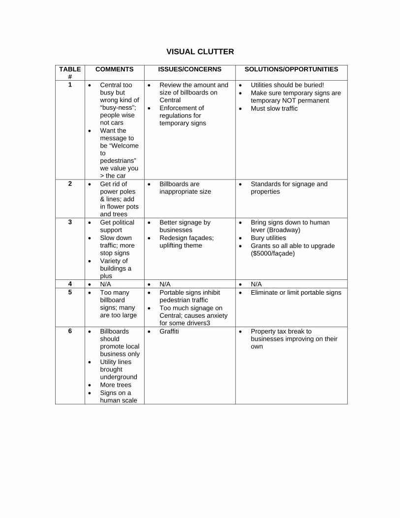
VISUAL CLUTTER
TABLE #
COMMENTS ISSUES/CONCERNS SOLUTIONS/OPPORTUNITIES
1 • Central too busy but wrong kind of “busy-ness”; people wise not cars
• Want the message to be “Welcome to pedestrians” we value you > the car
• Review the amount and size of billboards on Central
• Enforcement of regulations for temporary signs
• Utilities should be buried! • Make sure temporary signs are
temporary NOT permanent • Must slow traffic
2 • Get rid of power poles & lines; add in flower pots and trees
• Billboards are inappropriate size
• Standards for signage and properties
3 • Get political support
• Slow down traffic; more stop signs
• Variety of buildings a plus
• Better signage by businesses
• Redesign façades; uplifting theme
• Bring signs down to human lever (Broadway)
• Bury utilities • Grants so all able to upgrade
($5000/façade)
4 • N/A • N/A • N/A 5 • Too many
billboard signs; many are too large
• Portable signs inhibit pedestrian traffic
• Too much signage on Central; causes anxiety for some drivers3
• Eliminate or limit portable signs
6 • Billboards should promote local business only
• Utility lines brought underground
• More trees • Signs on a
human scale
• Graffiti • Property tax break to businesses improving on their own

STREET CHARACTER
TABLE COMMENTS ISSUES/CONCERNS SOLUTIONS/OPPORTUNITIES 1 • Plaques to identify history
• Walking tours to follow the plaques
• Extend municipal funding for commercial areas
• Theme • Banners • Special color
2 • Feeling of Sutherland as a village
• Harvest fest moved to Forestry Farm; lost its appeal
• Give a sense of an earlier time period
• Need a festival on Central • Banners to reflect history of
Sutherland • Statues of early settlers • Interpretive panels • Possibility of a median down
Central with trees or lanterns 3 • Street
character: HISTORY
• Street furniture in theme (historic) • Cast iron and black as railway
station • CP train as focus
4 • Common theme on shops
• Interest free loans for businesses to improve buildings
• Hitching rails • Tub plants (troughs)
5 • Facilitate street festival (ie – Harvestfest)
• It is a “train town” keep the character when revamping; as a town using train themes
• Store front improvements – common theme; need a train “station”
• • Opportunity for funding – sell parcel of land adjacent to fire hall (old library site) to fund further development
• Put power underground • New street lights
6 • Train signs on posts are outdated
• Not “old town” feel
• Posts & map holder (like 21st St.) old style theme is good
• Art gallery; musem; bookstores
• Embrace history
• CP railway theme • Old style street lamps, fountain,
public art; statues of “founders”

PEDESTRIAN FRIENDLY?
TABLE #
COMMENTS ISSUES/CONCERNS SOLUTIONS/OPPORTUNITIES
1 • Make the pedestrian environment more friendly – cars need to be there but there needs to be more emphasis on pedestrian traffic
• •
2 • Close Central entirely and make it strictly for pedestrians
• Corner nodes • Sidewalks • Ensure safe
crossing
• Beautification • Repair
3 • MORE SIDEWALKS!!!
• Trees
• Lack of sidewalks • Lack of pedestrian
crossing on Gray • Poorly defined
intersection at 108th
• More consistent street • Hand activated lights
4 • • Crosswalk at Pharmacy
• Traffic signal • Bulbing • Cobblestone • Sidewalk on both sides of
Central 5 • • Proper sidewalks
• Trees • New street lights
•
6 • • Older homes southwest site to be dealt in
• Crosswalks – flashing yellow lights
• More parking
• Newer buildings on Central • New sidewalks • Flower pots needed • Bike racks • Slower speed limit on
Central; narrower streets • Lights in alley behind bar • Lack of garbage containers

CPR LAND
TABLE
# COMMENTS ISSUES/CONCERNS SOLUTIONS/OPPORTUNITIES
1 • Open to commercial development
• Incorporate the history of CPR/Sutherland and anything that is done in this area (ie: picture/mural/sculpture on walls)
• Parking lot with or without parking meters
• Fix sidewalks and extend through this area
• Sound barrier to block noise from train yard
• Angle parking with one way in and one way out
• Soften the view with trees/shrubs
2 • Who is going to notice the crosswalk sign with all of the background distraction? (ie: billboard, power lines, etc)
• Business development
• Containers are an eyesore
• Make rail crossing smoother
• Small shops • Convert some to green
space; camouflage containers/fence
• Negotiate with CPR to buy or lease some land for parking
3 • Explore potential park and parking potential lease
• RE: photo on bottom left side – move over, make parking lot and beside make a pocket park
• Height of wall (max 6’ allowed by City?)
• Better/more communication
• Off street parking
• Change fence to brick wall (sound barrier)
• Mural art possible on blank walls
4 • Lease grassed area • • 5 • No weed control on
City land • Clean up mud hole • Trees act as
coverage for train yard
• Central Ave has been ignored by City; no upgrades, etc. in MANY years (except for plant pots)
• Parking • No sidewalks on
east side of Central
• Dust control 107th (east of Central)
• Angle parking? • Stonewall barrier in front of
CPR (sound continuation wall)
• Pave 107th past cement plant • Switching station moved to
alleviate congestion and extra traffic
6 • Condos or business built on CPR land good option
• Dust control • Sound OK; visual
needs to be attended to
• Re-route trucks from Central • Talk to CPR: sidewalk;
parking; green space
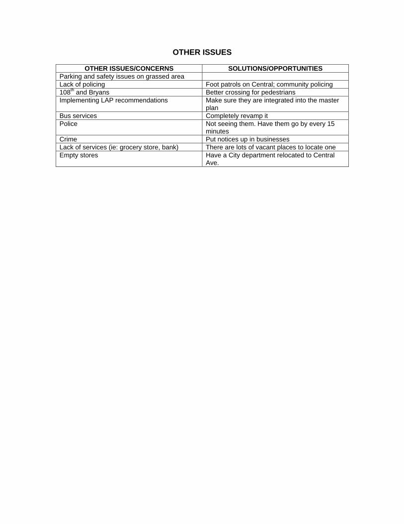
OTHER ISSUES
OTHER ISSUES/CONCERNS SOLUTIONS/OPPORTUNITIES Parking and safety issues on grassed area Lack of policing Foot patrols on Central; community policing 108th and Bryans Better crossing for pedestrians Implementing LAP recommendations Make sure they are integrated into the master
plan Bus services Completely revamp it Police Not seeing them. Have them go by every 15
minutes Crime Put notices up in businesses Lack of services (ie: grocery store, bank) There are lots of vacant places to locate one Empty stores Have a City department relocated to Central
Ave.

Central Avenue Master Plan - Draft Report Public Open House – June 24, 2009
Comments submitted
Comment Response
Excellent! Let’s take the design forward into action as soon as possible. (copy of report requested)
Pdf copy of report sent as requested
I think that the master plan looks promising but I feel more needs to be done to brand the community. As a resident I would like to have an opportunity to comment before such a plan would be finalized. (copy of report requested)
Pdf copy of report sent as requested
Comment regarding request for further information as development progresses is noted.
Please send report in email. Pdf copy of report sent as requested Encouraging report, the current vacant space along Central is an “eye sore” year round. Although traffic will be restricted if plan goes through we will feel less an effect being near the end of construction. I would be surprised if any residential units were spurred along Central with the heavy traffic and rail yards, but stranger things have happened. Good luck and please keep us informed of further development.
Comment regarding request for further information as development progresses is noted.
I have had an opportunity to view the master plan and I have to say that I am quite pleased with what I see. How final are these plans? I believe that everything mentioned in the report must be done, as any reduction in the changes/work planned would seriously hamper the positive changes required to get Central Avenue back on track. I am particularly happy with a) Designated Turning Lanes, b) Infill opportunities on neglected CPR lands, c) Sutherland arches at 108th and 115th, and d) the planned boulevard and streetscaping. I am especially happy to see some mention of alternate routing for large trucks and hope that some sort of solution can be found. As for vehicular traffic, one thing that I did not see in the report but thought should be worth mentioning, with a slower traffic on Central, vehicles will begin to utilize Egbert Avenue between 115th and 108th more frequently. If this does happen, it may be in the city's interest to a) look at resurfacing the street before it becomes a heavily used thoroughfare, and b) erect traffic controls on Egbert at 108th street. Thank you for your time, and please keep me informed on the status of this plan. Any information on when we may actually begin to see work started would be fantastic.
Central Ave. Master Plan indicates that “Traffic calming measures for Egbert Avenue that were originally identified in the local area planning process, and subsequently completed, are still valid. The reduced emphasis on traffic flow along Central Avenue may lead to additional traffic on Egbert Avenue. It is not the intention of the Traffic and Parking Management Plan to simply ignore the impact to adjacent north-south roadways within Sutherland. Further analysis and consideration of improvements to Egbert Avenue may be required to address any negative impacts to Egbert resulting from the implementation of traffic management measures undertaken on Central Avenue.”
- no further changes to Master Plan anticipated
Comment regarding request for further information as development progresses is noted.

Comment Response
Pleased with draft of Central Avenue Master Plan - “major” concern with consequences of slowing traffic on
Central - traffic will be redirected into residential neighbourhoods, especially Rutherford, Lanyon Ave. and Egbert -Remedial Measures to deter increased traffic volumes and
increased speed must be implemented prior to this development.
- not appropriate to take measures to address concerns on Central and move to residential.
- like plaza concepts, attractive lighting, flower boxes – clean up dust from Industrial business (Central Business Plan)
See comment above regarding need to monitor traffic on Egbert Ave.
- no further changes to Master Plan anticipated

Appendix B
Level of Service Definitions

COMMONLY USED LEVEL OF SERVICE DEFINITIONS
Level of ServiceFor Urban Arterial Road
Level of ServiceFor Traffic Signal Controlled Intersection
Free flowing traffic with averageoverall travel speed in the upperrange. A
Minimal delay experienced by motorists and no traffic signal phase is fully utilized. Veryseldom does a motorist wait longer than the duration of one red signal interval. Theapproaches appear open, turning movements are easily made and drivers have freedomof operation. The (Poisson) probability is that 95% of the time all vehicles arriving on onecomplete cycle will clear during the next green interval.
Delay is not unreasonable.Average overall speeds dropdue to intersection delay andintervehicular conflicts.
BTraffic signal phases are occasionally fully utilized and delays experienced bymotorists are not unreasonable. Many drivers begin to feel somewhat restrictedwithin groups of vehicles approaching the intersection. The (Poisson) probabilityis that 90% of the time all vehicles arriving on one cycle will clear during the nextgreen interval.
Traffic flow still stable withacceptable delays. Averageoverall travel speeds in themiddle range.
CTraffic signal phases are more frequently fully utilized, but delays are stillacceptable. Drivers feel more restricted, may have to wait more than the durationof one red signal interval and queues may develop behind turning vehicles. The(Poisson) probability is that 75% of the time all vehicles arriving on one completecycle will clear during the next green interval.
Approaching unstable flow.Delays at intersections maybecome extensive. Averageoverall speeds in the lowerrange.
DDrivers experience increasing restriction and instability of flow. There aresubstantial delays to approaching vehicles during short peaks within the peakperiod but there are enough traffic signal cycles with lower demand to permit theoccasional clearance of developing queues and prevent excessive back-ups. The(Poisson) probability is that 60% of the time all vehicles arriving on one completecycle will clear during the next green interval.
Unstable flow. Continuousbackup on approaches tointersections. Average over-all traffic speed variable butin the lower range.
ETraffic flow demand equals the capacity. Continuous delays are experienced.There are long queues of vehicles waiting upstream of the intersection and delaysto vehicles may extend to several traffic signal cycles. The (Poisson) probability isthat 50% of the time all vehicles arriving on one complete cycle will clear duringthe next green interval.

Appendix C
City of Saskatoon Truck Routes Map

Appendix D
Collision History on Central Avenue
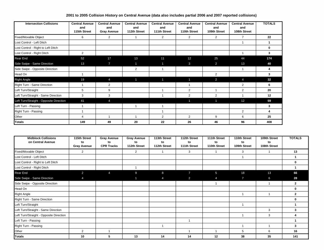
Intersection Collisions Central Avenueand
115th Street
Central Avenueand
Gray Avenue
Central Avenueand
112th Street
Central Avenueand
111th Street
Central Avenueand
110th Street
Central Avenueand
109th Street
Central Avenueand
108th Street
TOTALS
Fixed/Movable Object 6 2 1 2 2 2 7 22
Lost Control - Left Ditch 1 1
Lost Control - Right to Left Ditch 0
Lost Control - Right Ditch 2 1 3
Rear End 52 17 13 11 12 25 44 174
Side Swipe - Same Direction 13 7 1 1 3 2 13 40
Side Swipe - Opposite Direction 2 1 1 4
Head On 1 2 3
Right Angle 19 4 1 1 1 2 4 32
Right Turn - Same Direction 1 2 1 2 6
Left Turn/Straight 5 9 1 2 1 2 20
Left Turn/Straight - Same Direction 3 3 1 2 2 1 12
Left Turn/Straight - Opposite Direction 41 4 1 1 12 59
Left Turn - Passing 1 1 1 3
Right Turn - Passing 1 1 2 4
Other 4 1 1 2 2 9 6 25
Totals 149 49 20 22 26 46 96 408
Midblock Collisionson Central Avenue
115th Streetto
Gray Avenue
Gray Avenueto
CPR Tracks
Gray Avenueto
112th Street
113th Streetto
112th Street
112th Streetto
111th Street
111th Streetto
110th Street
110th Streetto
109th Street
109th Streetto
108th Street
TOTALS
Fixed/Movable Object 2 2 1 3 1 3 1 13
Lost Control - Left Ditch 1 1
Lost Control - Right to Left Ditch 0
Lost Control - Right Ditch 1 1
Rear End 2 4 9 8 7 5 18 13 66
Side Swipe - Same Direction 4 1 4 2 4 7 6 28
Side Swipe - Opposite Direction 1 1 2
Head On 0
Right Angle 1 1 2
Right Turn - Same Direction 0
Left Turn/Straight 1 1
Left Turn/Straight - Same Direction 3 3
Left Turn/Straight - Opposite Direction 1 3 4
Left Turn - Passing 1 1
Right Turn - Passing 1 1 1 3
Other 2 1 1 1 5 6 16
Totals 10 5 13 14 14 12 38 35 141
2001 to 2005 Collision History on Central Avenue (data also includes partial 2006 and 2007 reported collisions)

Appendix E
Typical Active Pedestrian Corridor
