cedar hills regional landfill 2019 annual report · 2020. 10. 19. · cedar hills regional landfill...
TRANSCRIPT

CEDAR HILLS REGIONAL LANDFILL
2019 ANNUAL REPORT
MAY 2020


2019 ANNUAL REPORT CEDAR HILLS REGIONAL LANDFILL
MAY 2020
Thanks to following KC Solid Waste Division staff members for their contributions: Cheryl Florendo Jamey Barker Joan Kenton Joyce Matsukawa Kerwin Pyle Kris McArthur Laura Belt
Mary Anne Hale Natalya Usova Scott Barden Shirley Jurgensen Sterling Bath Terri Barker
Prepared by: Facility Engineering & Science Section King County Solid Waste Division
Date Prepared: May 1, 2020


CONTENTS
1. Overview 1
2. Facility Information 2
3. Landfill Capacity and Development Status 3
4. Financial Assurance Analysis 5
5. Waste Disposal Quantities 6
6. Summary of Groundwater, Stormwater, Leachate, and Landfill Gas Monitoring 7 Results and 2019 Proposed Environmental Monitoring Program
6.1 Summary of the Groundwater Monitoring Program 7 6.2 Summary of the Stormwater Monitoring Program 7 6.3 Summary of the Leachate Monitoring Program 8 6.4 Summary of the Landfill Gas Monitoring Program 9 6.5 Environmental Monitoring Program for 2019 10
7. Summary of Landfill Personnel Training Program 11
8 Evaluation Reports 12
8.1 Summary of Emergency or Corrective Actions Taken in 2019 12 8.2 Evaluation of Stormwater Monitoring Data 13 8.3 Evaluation of Groundwater Monitoring Data 15 8.4 Evaluation of Landfill Gas Monitoring Data 17 8.5 Evaluation of Wastewater Monitoring Data and Volume Generated 18 8.6 Landfill Settlement 19
9. Attachments 20
Attachment A – Operating Permits Attachment B – Tonnage Report Attachment C – Disposal Fees Attachment D – Landfill Capacity Documentation Attachment E – Financial Assurance Documentation Attachment F – Annual Summary of Groundwater Monitoring Results Attachment G – Landfill Gas Monitoring Results Attachment H – Stormwater Reports Attachment I – Wastewater Discharge Self-Monitoring Reports


Cedar Hills Regional Landfill Annual Report ‐ 2019 1
SECTION 1 - OVERVIEW
The King County Solid Waste Division (KCSWD) owns and operates the Cedar Hills Regional Landfill (CHRLF) in eastern King County for the disposal of municipal solid waste generated in the County, exclusive of the cities of Seattle and Milton. It is a 920-acre site located at 16645 228th Avenue Southeast, off Cedar Grove Road, approximately three miles north of Maple Valley, six miles east of the City of Renton and four miles south of the City of Issaquah. In addition to the landfill, the site contains Passage Point, a transitional housing facility; a landfill gas-to energy facility owned and operated by Bio Energy Washington, LLC (BEW); and right-of-ways for a natural gas pipeline and numerous power transmission lines.
In 2019, Area 7 of CHRLF reached capacity. With concurrence from regulatory agencies, KCSWD prepared the area to winter over to allow for a full construction season to install final cover. Construction of Area 8 was completed in the spring of 2019 and the new cell began receiving waste during the summer of 2019. Authorization to begin accepting waste in Area 8 was granted on July 5, 2019 by Public Health of Seattle and King County (PHSKC); a copy of their authorization letter is included in Attachment A. Additionally, an Order of Approval was issued by the Puget Sound Clean Air Agency (PSCAA), dated July 02, 2019 under Notice of Construction Number 11307 authorizing KCSWD to begin operating Area 8.
This report includes a compilation of activity summaries and system evaluations associated with the following:
Landfill capacity;
Financial assurance cost estimates for closure and post-closure;
Changes to landfill operations; and,
Environmental monitoring program, including a summary of groundwater, stormwater, leachate, and landfill gas monitoring results and exceedances.
This annual report is submitted pursuant to the provisions of the Washington State Criteria for Municipal Solid Waste Landfills, Operating Criteria - Annual Reports - Washington Administrative Code (WAC) 173-351-200(11), and the Cedar Hills Regional Landfill Operating Permit, Section XII - Reporting Requirements, Part B - Annual Report and Permit Renewal Application. The Annual Municipal Solid Waste Permit (PR0015736) was issued to KCSWD for operation of CHRLF by PHSKC on January 23rd, 2019 for 2019. An addendum to the 2019 permit was issued on June 13th, 2019. Copies of the permit and addendum are included in Attachment A.
Additionally, on May 7th, 2019, PHSKC issued to KCSWD the Municipal Solid Waste 10-Year Permit of Operation for CHRLF. A copy of this permit is also included in Attachment A.

Cedar Hills Regional Landfill Annual Report ‐ 2019 2
SECTION 2 - FACILITY INFORMATION
The Washington Department of Ecology (WDOE) form, titled “Annual Report Municipal Solid Waste Landfill” that is required for submittal of this report is included in Attachment B.
Significant facility activities which occurred in 2019 include:
Construction of Area 8 was completed in the spring of 2019 and began receiving waste in the summer of 2019.
Area 7 Top Deck was stabilized for over-wintering after placement of waste was completed.
Aerators for the leachate lagoons received maintenance repairs during the fall of 2019.
Cedar Hills Regional Landfill Annual Report ‐ 2019 3
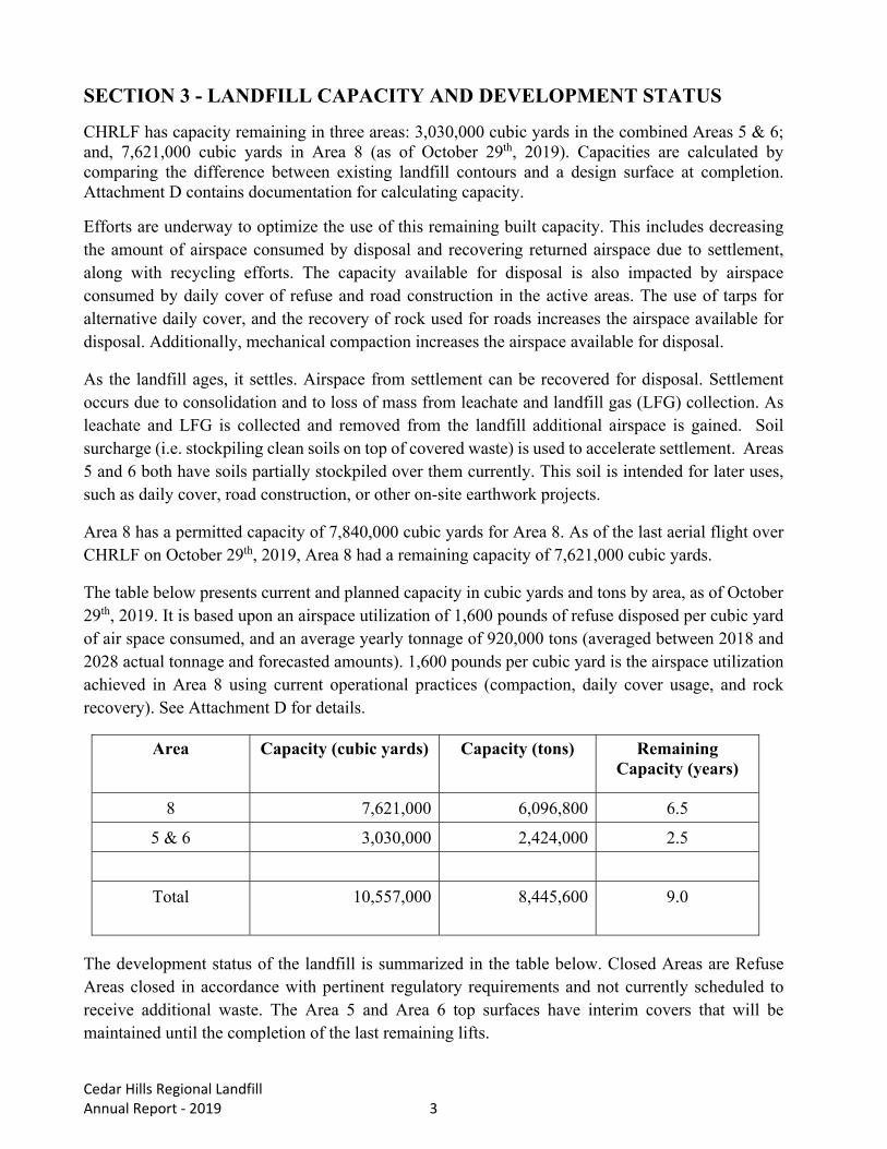
SECTION 3 - LANDFILL CAPACITY AND DEVELOPMENT STATUS
CHRLF has capacity remaining in three areas: 3,030,000 cubic yards in the combined Areas 5 & 6; and, 7,621,000 cubic yards in Area 8 (as of October 29th, 2019). Capacities are calculated by comparing the difference between existing landfill contours and a design surface at completion. Attachment D contains documentation for calculating capacity.
Efforts are underway to optimize the use of this remaining built capacity. This includes decreasing the amount of airspace consumed by disposal and recovering returned airspace due to settlement, along with recycling efforts. The capacity available for disposal is also impacted by airspace consumed by daily cover of refuse and road construction in the active areas. The use of tarps for alternative daily cover, and the recovery of rock used for roads increases the airspace available for disposal. Additionally, mechanical compaction increases the airspace available for disposal.
As the landfill ages, it settles. Airspace from settlement can be recovered for disposal. Settlement occurs due to consolidation and to loss of mass from leachate and landfill gas (LFG) collection. As leachate and LFG is collected and removed from the landfill additional airspace is gained. Soil surcharge (i.e. stockpiling clean soils on top of covered waste) is used to accelerate settlement. Areas 5 and 6 both have soils partially stockpiled over them currently. This soil is intended for later uses, such as daily cover, road construction, or other on-site earthwork projects.
Area 8 has a permitted capacity of 7,840,000 cubic yards for Area 8. As of the last aerial flight over CHRLF on October 29th, 2019, Area 8 had a remaining capacity of 7,621,000 cubic yards.
The table below presents current and planned capacity in cubic yards and tons by area, as of October 29th, 2019. It is based upon an airspace utilization of 1,600 pounds of refuse disposed per cubic yard of air space consumed, and an average yearly tonnage of 920,000 tons (averaged between 2018 and 2028 actual tonnage and forecasted amounts). 1,600 pounds per cubic yard is the airspace utilization achieved in Area 8 using current operational practices (compaction, daily cover usage, and rock recovery). See Attachment D for details.
Area Capacity (cubic yards) Capacity (tons) Remaining Capacity (years)
8 7,621,000 6,096,800 6.5
5 & 6 3,030,000 2,424,000 2.5
Total 10,557,000 8,445,600 9.0
The development status of the landfill is summarized in the table below. Closed Areas are Refuse Areas closed in accordance with pertinent regulatory requirements and not currently scheduled to receive additional waste. The Area 5 and Area 6 top surfaces have interim covers that will be maintained until the completion of the last remaining lifts.

Cedar Hills Regional Landfill Annual Report ‐ 2019 4
STATUS OF LANDFILL AREAS
Landfill Area Area Specific Information
Main Hill Status Closed
Exposed Surface Area 84.4 acres
South Solid Waste Area Waste was removed from this area and relocated to Area 7.
Southeast Pit Status Closed
Exposed Surface Area 9.6 acres
Central Pit Status Closed
Exposed Surface Area 9.6 acres
Area 2/3 Status Closed
Exposed Surface Area 22.2 acres
Area 4 Status Closed
Exposed Surface Area 22.2 acres
Area 5 Status Interim closure
Final Cover Surface Area 9.2 acres
Top Deck Interim Cover Area 31.4 acres
Area 6 Status Interim closure
Final Cover Surface Area 25.2 acres
Top Deck Interim Cover Area 30.1 acres
Volume in Place 6,800,000 cubic yards
Area 7 Status Closure activities in progress
Final Cover Surface Area 9.1 acres
Top Deck Area 17.4 acres
Volume in Place 8,070,000 cubic yards
Area 8 Status Active
Liner Footprint Area 31.4 acres
Volume in Place (as of Oct. 29th, 2019) 219,000 cubic yards
Note: Areas are net final cover plan view surfaces or as otherwise noted.

Cedar Hills Regional Landfill Annual Report ‐ 2019 5
SECTION 4 - FINANCIAL ASSURANCE ANALYSIS
The KCSWD maintains a Landfill Reserve Fund (LRF) account for new area development, closure, post-closure, facility relocation, and facility improvements. The transfer amount is set during the disposal rate approval process. New Rates were adopted in 2018. The 2019 contribution was $17.2M.
The post-closure maintenance estimate is updated annually. The updated estimate is based on current costs for maintenance of the systems and considers whether there have been changes to the environmental control systems that would lead to changes in maintenance costs and any changes to current costs of maintenance.
Based on a recommendation from the King County Auditor’s Office, the KCSWD uses the King County Office of Economic and Financial Analysis (OEFA) forecast for the both inflationary assumptions, and likely future investment return interest rates. The current1 direction is to use a real (after inflation) long term rate of return of 0.68%.
This year’s estimate is that $3,984,000 (2019 dollars) per year will be required to maintain the landfill for 42 years for a total of $167 million in expenses over the closure period. The background for this year’s estimate is included in Attachment E. The $167 million in total spending can be sustained over a 42-year period with a trust fund of about $146 million invested in government-backed securities paying a real (after inflation) rate of return of 0.68%.
This updated estimate will be used in calculating the LFR fund contribution for 2020.
1 March, 2020 forecast
0.0
20.0
40.0
60.0
80.0
100.0
120.0
140.0
160.0
1/1/2041
1/1/2043
1/1/2045
1/1/2047
1/1/2049
1/1/2051
1/1/2053
1/1/2055
1/1/2057
1/1/2059
1/1/2061
1/1/2063
1/1/2065
1/1/2067
1/1/2069
1/1/2071
1/1/2073
1/1/2075
1/1/2077
1/1/2079
1/1/2081
1/1/2083
Millions
Trust Balance42 year trust; annual $3,984,000 withdrawal; 0.68% Real Return

Cedar Hills Regional Landfill Annual Report ‐ 2019 6
SECTION 5 - WASTE DISPOSAL QUANTITIES
The CHRLF received 868,532 tons of municipal solid waste in 2019. Detailed information can be found in Attachment B.

Cedar Hills Regional Landfill Annual Report ‐ 2019 7
SECTION 6 - SUMMARY OF 2019 GROUNDWATER, STORMWATER, LEACHATE AND LANDFILL GAS MONITORING PROGRAM AND 2020 PROPOSED ENVIRONMENTAL MONITORING PROGRAM 6.1 Summary of Groundwater Monitoring Program Groundwater monitoring is conducted in accordance with WAC 173-351-410 and reported here in compliance with WAC 173-351-415(1). A summary of groundwater data collected during the reporting year is presented in Part 7 of Attachment F.
The Groundwater Monitoring Program is described in detail in the Environmental Monitoring Sampling and Analysis Plan for Cedar Hills Regional Landfill (2013) (SAP), and in Attachment F of this annual report. Twenty-nine (29) groundwater monitoring wells are monitored for groundwater elevations and geochemical sampling in the regional aquifer, and fourteen (14) for monitoring the perched saturated zones. Nine (9) additional wells in the regional aquifer and nineteen (19) additional wells in the perched zones are monitored only for groundwater elevations. Detection monitoring wells are located downgradient of, or lateral to, waste placement areas. Background characterization wells are located up-gradient of waste placement areas.
6.2 Summary of Stormwater Monitoring Program The stormwater monitoring program is described in the SAP. The goals of this program include these elements:
• Monitor the effectiveness of Best Management Practices (BMPs) per the Stormwater Pollution Prevention Plan (SWPPP) for CHRLF;
• Evaluate compliance with the Industrial Stormwater General Permit (ISGP); and,
. • Evaluate compliance with the Construction Stormwater General Permit (CSGP).
Stormwater discharges associated with industrial activities at CHRLF are covered by the ISGP, which establishes monitoring requirements and benchmark values for several parameters. Three (3) discharge locations are monitored quarterly for compliance with the ISGP. Routine inspections also are conducted on a monthly basis and more frequently during storm events. Permit compliance monitoring locations are at N4 (north end of the landfill); GS1 (south end of the landfill); and, SL3 (discharges to a bioswale along 228th Avenue Southeast near the entrance to the landfill).
Besides routine monitoring conducted in accordance with the ISGP, KCSWD maintains several contingency surface water monitoring stations. The purpose of the contingency monitoring stations is to allow additional surface water monitoring if ISGP monitoring results exceed applicable benchmarks and broader surface water monitoring is warranted.
In 2019, KCSWD also had a Construction Stormwater General Permit (CSGP) - permit number WAR305034 with WDOE - for the Area 8 construction activities. A separate SWPPP was created for this CSGP permit. Permit coverage took effect in 2017 and remains active for 2020 construction. Locations monitored include four (4) discharge locations on a weekly basis for compliance with the

Cedar Hills Regional Landfill Annual Report ‐ 2019 8
CSGP in accordance with the SWPPP. In accordance with the permit, monitoring and inspections were performed on a monthly basis due to construction inactivity beginning in April; weekly monitoring and inspections will be performed when construction recommences. Construction site BMPs and the CSGP monitoring locations are monitored daily during construction activities. The four monitoring locations were designated as follows: C-1 (northwest end of the site downstream of the northwest siltation pond); C-2 (northeast end of the site, downstream of the north stormwater pond); C-3 (southeast part of the site, downstream of the south stormwater lagoon and upstream of the bioswale); and, C-4 (southwest part of the site, downstream from the southwest siltation pond).
Copies of required stormwater reports submitted to WDOE are included in Attachment H.
6.3 Summary of Leachate Monitoring Program KCSWD primarily collects two types of leachate samples at CHRLF: characterization and compliance. Leachate characterization is a critical component of the on-going groundwater contamination detection monitoring that is performed at the landfill. Leachate characterization also serves to assess pretreatment needs prior to discharge, and to evaluate the effectiveness of pretreatment. Characterization includes all analytes that groundwater is analyzed for, plus several analytes specifically related to wastewater characterization and treatment. Monthly characterization samples are collected at four monitoring locations: LEPS, V1A (replacing LAPI which has been decommissioned and removed), PS-2A, and MH-46N. In October 2018, modifications were made to the leachate conveyance system due to the construction of Area 8 of the landfill. These modifications resulted in the decommissioning of leachate monitoring location for influent into the leachate lagoon, LAPI. Vault 1A (V1A) was established as the replacement monitoring location for the influent of the leachate lagoons. MH-LIF is monitored as a leachate confluence point. Compliance samples refer to those collected to support compliance with Wastewater Discharge Permits No. 7842-03, issued by King County Industrial Waste (KCIW). Monthly compliance samples collected from LEPS are analyzed for all permit-specified parameters. Sample analyte concentrations and leachate discharge flow data are used to calculate permit analyte loadings. Compliance is determined by comparing results to allowable limits specified in the permit.
KCSWD calculates and report metals mass loading values alongside their respective concentration and flow values on the KCIW Self-Monitoring Report (SMR) form. SMR’s are generated monthly and submitted to KCIW. SMR’s for 2019 can be found in Attachment I. KCSWD also submits an Annual Facility and Sampling and Monitoring Report to KCIW detailing sampling and analytical results for all non-permit required sampling and analysis. In addition to compliance sampling and reporting, KCSWD has been conducting an investigation of characterization locations within the landfill leachate conveyance system since 2018, including leachate flows from PS1A, PS4, and A567, and the seasonal flow from the contaminated stormwater

Cedar Hills Regional Landfill Annual Report ‐ 2019 9
(CSW) lagoon. In 2019, additional sampling locations were added including flows from Area 8 and BEW. Field and analytical leachate data are included in Part 7 of Attachment F. 6.4 Summary of Landfill Gas Monitoring Program Landfill gas (LFG) monitoring is performed in accordance with provisions of WAC 173-351-200(4). A network of LFG monitoring probes has been installed at strategic locations and elevation intervals below the ground surface to monitor the potential presence of LFG in the subsurface vadose zone outside of the footprint of the landfill refuse (see Attachment G).
According to WAC 173-351-200 (4)(a), the concentration of methane gas generated by the facility shall meet the following limits:
The concentration of methane gas generated by the facility does not exceed twenty-five percent of the lower explosive limit for methane in facility structures (excluding gas control or recovery system components);
The concentration of methane gas does not exceed the lower explosive limit (LEL) for methane at the facility property boundary or beyond;
The concentration of methane gases does not exceed one hundred parts per million (ppm) by volume of methane in offsite structures.
There are two categories (defined by function) of LFG probes at the CHRLF:
Migration Monitoring (Compliance) Probes
Interior Monitoring Probes
Migration Monitoring Probes are primarily intended to verify that methane concentrations at the property boundary do not exceed 50,000 ppm in the subsurface vadose zone. There are thirty-six (36) Migration Monitoring (Compliance) Probes at CHRLF. The installation history of the LFG monitoring probes at the CHRLF was described in the 2005 CHRLF Annual Report. These probes are either single or multiple completion probes installed at different depths depending on subsurface geological formation. Information on the location, elevation, installation date, and a description of each probe is provided in the Monitoring Plan figure in Attachment G.
Interior Monitoring Probes are used to evaluate and manage the performance of the LFG collection system with respect to LFG composition (methane, oxygen and carbon dioxide) and vacuum radius of influence. This information is used to adjust the LFG collection and conveyance system to minimize the potential for LFG migration outside of the refuse footprint. There are twenty-five (25) Interior Monitoring Probes at CHRLF. The installation history of the LFG interior monitoring probes at the CHRLF was described in the 2005 CHRLF Annual Report. The probes are either single or multiple completion probes installed at different depths depending on subsurface geological

Cedar Hills Regional Landfill Annual Report ‐ 2019 10
formation. Information on the location, elevation, installation date, and a description of each probe is provided in the Monitoring Plan figure in Attachment G.
Migration and interior probe monitoring are performed quarterly for compliance with WAC 173-351, and monthly for operational indicators. Monitoring results are included in Attachment G. Results from LFG migration monitoring for 2019 are discussed in Section 8.4 of this report. 6.5 Environmental Monitoring Program for 2019 Effective January 1, 2016, KCSWD implemented the SAP, as approved by PHSKC and WDOE in 2015. The SAP outlines current monitoring programs designed to comply with the requirements of Chapter 173-351 WAC and other applicable environmental regulations and permits, including wastewater discharge permits and stormwater permits. Modifications to the SAP will occur only with prior approval of PHSKC and WDOE.

Cedar Hills Regional Landfill Annual Report ‐ 2019 11
SECTION 7 - SUMMARY OF LANDFILL PERSONNEL TRAINING PROGRAM The KCSWD implements a Landfill Training Program that ensures that landfill personnel comply with the Certification requirements of WAC 173-300-060. Employees with valid SWANA Landfill Certification as Manager of Landfill Operations (MOLO) are listed below in the table below.
MOLO Certifications
NAME TITLE DATE OF CERTIFICATION
John Hills Lead Equipment Operator Certified through April 2021
Rusty Bogart Landfill Gas Operator Certified through October 2021
Nigel White Special Projects Manager Certified through October, 2022
Scott Barden Landfill Operations Manager Certified through October 2020
Bill Berni Operations Manager Certified through July 2020
Kris Burgin Operations Supervisor Certified through May 2022
Jason Gonzales Lead Equipment Operator Certified through May 2019
Mark Hammer Assistant Operations Manager Certified through May 2019
Anthony Slaughter Operations Supervisor Certified through May 2022

Cedar Hills Regional Landfill Annual Report ‐ 2019 12
SECTION 8 - EVALUATION REPORTS
8.1 Summary of Emergency or Corrective Actions Taken in 2019
8.1.1 Stormwater Corrective Action In 2019, CHRLF did not exceed any ISGP established stormwater monitoring benchmark limits.
During 2019, the Area 8 CSGP had exceedances of the turbidity benchmark limit in January, February, March, and November. In response to turbid stormwater discharges associated with the Area 8 construction project, KCSWD implemented additional temporary erosion and sediment control (TESC) improvements and repairs to maintain the water quality of construction discharges and meet discharge limits. Additional details regarding exceedances and corrective actions are contained in the Discharge Monitoring Reports and Annual Report included in Attachment H.
8.1.2 Wastewater Discharge Permit Corrective Action In 2019, KCSWD continued to investigate and develop a remedy for the Notice of Violation received from KCIW in July of 2018 for arsenic and chromium loading exceedances in wastewater discharged from CHRLF. Actions taken followed the outline provided in the Assessment of Penalty and Compliance Order that was issued by KCIW on December 21st, 2018. KCIW issued a Revised Compliance Order dated October 29, 2019 which superseded and replaced the December 2018 Compliance Order. The Revised Compliance Order primarily modified the due dates and reporting requirements. KCSWD’s continued response includes research and development of realistic engineered alternatives to reduce metals loading below permit limits using source control and/or treatment technologies.
Exceedances of the permit parameters (metals loading, daily flow volume) occurred periodically in 2019. In accordance with permit requirements, these exceedances were reported to KCIW utilizing their 14-day report protocol, which explained the cause of the exceedance, corrective actions taken to respond to the exceedance and ensure ongoing compliance, and resampling, as applicable.
No other corrective actions occurred in 2019 with regards to the wastewater discharge permit.
8.1.3 PHSKC Inspection Reports and Corrective Actions In 2019, PHSKC inspected CHRLF four (4) times. Corrective actions taken in response to inspection reports included routine maintenance activities such as litter collection, safety issues, recordkeeping, and soils coverage management. The November 19th, 2019 inspection resulted in a nuisance odor violation, per WAC 173-350-330. This was the result of the leachate lagoon aerators being non-functioning due to electrical issues. Aerators were repaired and normal operation of the lagoons was restored, resulting in resolution of the odor issue.
8.1.4 Title V Air Operating Permit Deviation Reports
Cedar Hills Regional Landfill Annual Report ‐ 2019 13
Title V deviation reports in 2019 included the following:
In January 2019, two separate instances occurred with flares at the North Flare Station (NFS) operating below the permitted temperatures for each flare (based on historical stack testing). Power outages and inclement weather caused these events, with each instance resolving once power was restored.
In June 2019, an exceedance of the Title V Operating Permit (AOP #10138) occurred during methane surface emission monitoring of the landfill in Area 2/3. This occurred near a LFG well that was operating under positive pressure. Negative pressure was restored to the well, and the well cap was replaced which resolved the surface emission exceedance.
In August 2019, a solenoid valve failed that allowed the release of LFG at the NFS. The defective valve was replaced, along with other valves of the same type, and a 5-year replacement protocol was put into place, along with routine inspection and maintenance, to ensure a similar failure would not occur in the future.
In December 2019, exceedances of the Title V Operating Permit (AOP #10138) occurred during methane surface emission monitoring of the landfill in Areas 6 & 7. Nearby wells were identified, and the vacuum was increased in the localized region of the exceedances. Follow-up monitoring indicated that the corrective actions taken resulted in reduction of surface emissions below the relevant criteria.
8.1.5 Independent Remedial Action KCSWD is proceeding with an Independent Remedial Action in the East Perched Zone (EPZ) under the Model Toxics Control Act (MTCA) in accordance with WAC 173-340-510 and 173-340-515. KCSWD issued a Remedial Investigation/Feasibility Study (RI/FS) in December of 2016 and is implementing the EPZ Phase 1 Interim Actions. Work completed in 2019 included on-going monitoring of new groundwater and landfill gas wells installed in 2018 in the EPZ.
8.2 Evaluation of Stormwater Monitoring Data Under the ISGP, quarterly sampling is required for the following twelve (12) parameters: biological oxygen demand, total suspended solids, ammonia (total as N), alpha terpineol, benzoic acid, p-Cresol (4-methylphenol), phenol, zinc (total), pH, turbidity, copper (total), and oil sheen. Field and analytical stormwater data are included in Part 7 of Attachment F.
Monitoring station N4 monitors discharges to an unnamed tributary to McDonald Creek, which ultimately flows into Issaquah Creek. Monitoring station SL3 monitors discharges to a series of roadside ditches along 228th Avenue SE and Cedar Grove Road. While the ditches ultimately connect to the Cedar River, the underlying geology is highly infiltrative, resulting in the infiltration of stormwater discharging from CHRLF long before it reaches the Cedar River. Monitoring station GS1 monitors discharges to a designated King County wetland with palustrine forested, palustrine open water, and palustrine emergent wetland classes. The wetland does not contain key aquatic life uses.
There were no exceedances of ISGP benchmarks or applicable effluent limits in 2019.

Cedar Hills Regional Landfill Annual Report ‐ 2019 14
The CHRLF also has a CSGP for the Area 8 construction activities. Four (4) discharge points are monitored in compliance with the CSGP. The four monitoring locations are: C-1 at the northwest end of the site downstream of the northwest siltation pond; C-2 at the northeast end of the site, downstream of the north stormwater pond; C-3 at the southeast part of the site, downstream of the south stormwater lagoon and upstream of the bioswale; and C-4 at the southwest part of the site, downstream from the southwest siltation pond. All CSGP monitoring points discharge into the ISGP monitoring locations. Under the CSGP, inspections of all areas disturbed by construction activities, all BMPs, and all stormwater discharge points are performed at least once every calendar week and within twenty-four (24) hours of any discharge from the site. In accordance with the permit, monitoring and sampling was reduced to a monthly schedule due to construction inactivity from April thru December in 2019. Monitoring is required for turbidity. Monitoring for pH is required if more than 1000 cubic yards of concrete is poured (no monitoring for pH occurred in 2019).
Exceedances of the CSGP for 2019 are summarized in the table below.
SUMMARY OF 2019 STORMWATER MONITORING DATA THAT EXCEEDED CSGP CRITERIA (Turbidity)
Date Turbidity Measurement by Monitoring Location (NTUs)
C1 C2 C3 C4 1/2 <25 or NS <25 or NS 45 28 1/4 52.9 <25 or NS 46.3 <25 or NS
1/23 97.1 <25 or NS <25 or NS <25 or NS 2/15 40 <25 or NS <25 or NS <25 or NS 2/19 55.2 <25 or NS <25 or NS <25 or NS 3/1 38.9 <25 or NS <25 or NS <25 or NS
11/20 <25 or NS <25 or NS 103 <25 or NS 12/20 83.1 <25 or NS 273 <25 or NS
NTU = Nephelometric
turbidity unit
= criteria exceeded NS = Not Sampled
Field and analytical stormwater data are included in Part 7 of Attachment F. When turbidity exceedances occurred, the effectiveness of the existing stormwater BMPs were evaluated and modifications were made to improve erosion and sediment controls.

Cedar Hills Regional Landfill Annual Report ‐ 2019 15
8.3 Evaluation of Groundwater Monitoring Data
Groundwater at the CHRLF occurs both in a regional aquifer and in perched zones. The regional aquifer flows through advance outwash and deeper deposits and is separated from the base of waste placement areas by over 200 feet of unsaturated sands and gravels. Perched groundwater occurs in onsite till, ice-contact deposits and recessional outwash. No laterally or vertically extensive perched zones have been identified, leaving the regional aquifer beneath the landfill as the earliest target hydraulic pathway for groundwater contaminant detection. Attachment F contains a detailed analysis of groundwater monitoring results. Sections 8.3.1 and 8.3.2 give a summary of the conclusions of the Annual Groundwater Monitoring Report certified in Attachment F. 8.3.1 Regional Aquifer The regional aquifer beneath CHRLF is recharged entirely by precipitation. A local recharge area is located immediately south of the landfill within the Queen City Farms (QCF) property and is centered north of the Main Gravel Pit Lake. In general, groundwater flow in the regional aquifer is radial from the recharge area. Beneath the landfill, regional flow is to the north in the south and central portions of the landfill site. Flow direction in the northern part of the site turns northeasterly as recharge from the McDonald Creek drainage affects flow patterns. Regional aquifer flow is physically separated from the Cedar River and likely discharges to Issaquah Creek. There is no significant seasonal variation in horizontal groundwater flow paths. Horizontal gradients are influenced by infiltrating precipitation in the recharge area. Vertical hydraulic gradients are demonstrated by head differences in adjacent wells screened at different depths and related to hydraulic conductivity of the aquifer materials. A flow path analysis has been completed for the site and indicates a complex flow regime in the landfill vicinity. Site hydrogeological reports and supporting documentation identify the regional aquifer is the first continuously saturated zone beneath the landfill and serves as the earliest path for detection monitoring. A monitoring network is in place consisting of thirty-eight (38) regional monitoring wells located to characterize groundwater flow and to obtain representative samples for water quality characterization. Downgradient flow converges into a high transmissivity zone which provides excellent monitoring coverage for all flow paths within the potential source area. An extensive list of chemical analytes and field parameters are analyzed, and the results are evaluated by a variety of graphical and statistical methods. The groundwater data analyses presented in this report describe onsite groundwater elevations, flow direction and velocity, and summarizes the evaluation of groundwater quality to determine if chemical concentrations have changed over time or differ between well locations. This report determines if these findings are indicative of impacts to groundwater quality by surface activities.

Cedar Hills Regional Landfill Annual Report ‐ 2019 16
Upgradient groundwater quality, especially in wells nearest the southern recharge zone, is profoundly affected by conditions and activities that have occurred on the adjoining QCF property. Upgradient groundwater quality is variable and subject to surface activities occurring near the recharge zone. Increasing trends for several key water quality indicator parameters began in 2011, coincidental with major clearing and grading activities on the QCF property and have continued through 2019. As flow continues into areas beneath the landfill footprint, changes are discernible as groundwater encounters and equilibrates to different oxidation-reduction conditions, soil gas/groundwater interface conditions, and solvent/solute interactions. Flow paths under the landfill footprint and immediately downgradient of waste cells are influenced by the presence of LFG in the unsaturated strata. Flow paths in the north landfill area are also notably higher in chloride concentrations. The data are consistent with an input from onsite, overlying infrastructure in the north end. Concentrations have declined and stabilized since maximum levels were reached in 2008-2010. Dispersion along the flow-path is apparent in other wells. Downgradient groundwater quality is also highly variable and displays temporal trends. Much as recharge effects are dampened with distance from the source, the concentrations of many analytes are attenuated by processes such as dispersion, dilution, sorption, and degradation as groundwater flows beneath the landfill. The highest concentrations of certain analytes occur in upgradient wells. Groundwater in the regional aquifer leaving the site has no exceedances of primary drinking water standards. The data also indicate that CHRLF acts as an attenuation zone for upgradient impacts, allowing a reduction in the concentration of chlorinated volatile organic compounds (CVOCs) to occur as groundwater flows from the south property line to the north-northeast. Recent water quality evaluations of QCF groundwater are available in Fifth Five-Year Review Report for Queen City Farms (2018). 8.3.2 Perched Zones
Perched groundwater occurs in onsite till, ice-contact deposits and recessional outwash. No laterally or vertically extensive perched zones have been identified. Recharge is by precipitation with possible hydraulic continuity to surface streams. Impacts from past landfilling practices have previously been recognized in several perched zones. Site improvements and engineered facilities have been effective in reducing contaminant concentrations attributable to past practices. Declining or stable long-term trends for many contaminants are apparent in these wells. The East Main Hill perched zone is undergoing an independent clean up action led by KCSWD. Recent investigation findings for this zone are presented in the East Perched Zones Remedial Investigation and Feasibility Study (December 2016). A discussion of conditions in the perched zone near the former South Solid Waste Area are available in the Technical Memoranda Results of

Cedar Hills Regional Landfill Annual Report ‐ 2019 17
Groundwater Sampling and Fate and Transport Analysis South Solid Waste Area Perched Zone Assessment (April 2010).
8.3.3 Prediction Limit Exceedances
MW-84 Prediction Limit Exceedance: During 2019, CHRLF monitoring well MW-84 experienced a ‘3-of-3’ upper prediction limit exceedance of total barium. MW-84 is a quarterly monitored upgradient well located in the northwest corner of the CHRLF that receives groundwater flow from off-site areas to the west of the landfill boundary. An increasing trend for total barium at MW-84 has been observed based on analysis of historical data; however, concentration results of total barium in MW-84 remain over two orders of magnitude below the Washington State Groundwater Quality Standard (WAC 173-200), and do not pose a risk to human health or the environment per all relevant standards. Further discussion of the prediction limit exceedances for MW-84 can be found in Attachment F. MW-67 Prediction Limit Exceedance: During 2019, CHRLF monitoring well MW-67 experienced ‘3-of-3’ upper prediction limit exceedances for total arsenic and barium (confirmation pending). MW-67 is a semi-annually monitored down-gradient well located in the northeast corner of the CHRLF that receives groundwater flow from areas to the east of the landfill. Arsenic concentrations at MW-67 are similar in magnitude to the statewide background. An increasing trend for total barium at MW-67 has been observed based on analysis of historical data; however, concentration results of total barium in MW-67 remain over two orders of magnitude below the WAC 173-200 Groundwater Quality Standard, and do not pose a risk to human health or the environment per all relevant standards. Pending confirmation of the results, KCSWD will provide PHSKC with a proposal for next steps to be taken. In the interim, KCSWD will continue to monitor all regularly sampled analytes at MW-67. Further discussion of the prediction limit exceedances for MW-67 can be found in Attachment F. 8.4 Evaluation of Landfill Gas Monitoring Data
During 2019, no exceedances of methane occurred in any of the migration monitoring probes at CHRLF in 2019. Methane detections occurred in multiple probes below the exceedance criteria; including in GP-39 at the SW corner of the landfill; GP-31A along the west property line of the landfill; and GP-44A at the SE corner of the landfill, near the entrance. All detections were significantly below the LEL, with the exception of the detection at GP-44A in September 2019 at 4.2% methane. All subsequent monthly monitoring measurements for methane at GP-44A were non-detect. Other low-level detections, particularly those during the August 19th, 2019 monitoring event are likely the result of calibration error in the monitoring equipment used.
Cedar Hills Regional Landfill Annual Report ‐ 2019 18
Using interior probe readings, adjustments were made on an on-going basis in more than 300 LFG wells inside the footprint of the landfill refuse to optimize collection of LFG. These extraction wells are upgradient from the above-referenced interior monitoring probes. Adjustments were made twice a month to ensure the containment of LFG within the footprint of landfill refuse. These adjustments were successful in preventing potential migration of LFG outside of the landfill refuse footprint, as demonstrated by the methane readings in the migration monitoring probes. Additionally, no methane was detected inside any of the CHRLF facilities, or in offsite facilities (Passage Point) at concentrations above 100 ppm. All LFG monitoring data for 2019 for the perimeter compliance probes, interior probes, and building monitoring are included in Attachment G. 8.5 Evaluation of Wastewater Monitoring Data and Volumes Generated Leachate collected throughout the landfill is routed to the onsite leachate lagoons where it mixes with other sources of wastewater at CHRLF (e.g., contaminated stormwater, gray water, sewage, and BEW process water). Following aeration, the combined wastewater discharges to the King County sewerage system pursuant to a Waste Discharge Permit issued to KCSWD by KCIW (permit 7842-03).
8.5.1 Wastewater Volumes The recorded volumes of wastewater discharged from the leachate aeration basins by way of the Leachate Effluent Pumping Station (LEPS) are stated in the table below. The actual leachate volume generated within the landfill is not measured directly. The maximum daily discharge volume for wastewater from CHRLF per permit 7842-03 in 2019 was 2.7 million gallons per day (MGD). In 2019, there was one exceedance of this discharge limit: December 21st, 2019 where the discharge volume was 2.83 MGD. There were no other exceedances of the discharge volume in 2019.
8.5.2 Wastewater Monitoring Analytical Data
Per the KCIW permit, the total loading limit is 0.27 pounds per day (lbs/day) for total arsenic. There were multiple exceedances of the arsenic loading limit throughout the year. There were no exceedances of any of the other analytical permit parameters in 2019. All wastewater monitoring analytical data is included in Attachment F. Self-monitoring reports submitted to KCIW in 2019 are included in Attachment I.

Cedar Hills Regional Landfill Annual Report ‐ 2019 19
8.6 Landfill Settlement Settlement Monitoring at CHRLF began in 1992, and by 2005 seven (7) monitoring locations had been established. More stations were added in 2007, while others have been abandoned as a result of operational impacts, including one station that was covered with Area 8 excavation soils in the summer of 2017. The total number of stations is currently eight (8). Annual Settlement, which is in part dependent on refuse thickness as well as time, has historically varied in a range of 0% to nearly 4% of total refuse thickness for different settlement monitoring locations over time. Settlement at all stations monitored in 2019 was minimal with the highest rate being 0.06% of the underlying refuse thickness. It is anticipated that landfill settlement will continue, with older landfill areas settling at a comparatively lower rate to newer areas of disposed refuse.

Cedar Hills Regional Landfill Annual Report ‐ 2019 20
SECTION 9 - ATTACHMENTS
Attachment A – Municipal Solid Waste Permit
Attachment B – Tonnage Report
Attachment C – Disposal Fees
Attachment D – Landfill Capacity Documentation
Attachment E – Financial Assurance Documentation
Attachment F – Annual Summary of Groundwater Monitoring Results
Attachment G – Landfill Gas Probe Monitoring Results
Attachment H – Stormwater Reports
Attachment I – Wastewater Discharge Self-Monitoring Reports