ce200a ‐ surveying lab ‐ spring 2018 a) 200a surveying lab_3.pdf · ce200a ‐ surveying lab...
TRANSCRIPT

1
CE200A ‐ Surveying Lab ‐ Spring 2018
Instructor: Allison Lapatka, PE, PLS NJIT Email: [email protected] Cell: (973) 906‐5037 Office Hours: Call or email for appointment NJIT Surveying Website: http://web.njit.edu/surveying Text (Required):
a) Wolf, Ghilani, Elementary Surveying An Introduction to Geomatics, 14th Edition, Prentice Hall, Inc. 2015. ISBN‐13: 978‐0‐13‐375888‐7 or most current edition.
b) Handouts provided by the instructor – Access via Moodle c) FE Reference Manual – most current edition
Prerequisites: Math 111 – Calculus I Co‐requisite: CE200 ‐ Surveying Description: Students perform field exercises in conjunction with the classroom exercises in CE200 utilizing classical and electronic instruments and AutoCAD software. Course Objectives: 1. Develop an understanding of modern field measurement tools and techniques. 2. Integrate field data acquisition with appropriate CAD tools. 3. Develop an appreciation for the performance aspects of field data acquisition and the associated costs and reliability Topics: Pacing (Distance Measurement), Leveling, Angle Measurements, Traversing, Topographic Survey, CAD Based Mapping, Staking Out Schedule: Lecture/Recitation – (see co requisite, CE 200) Laboratory –6 hour lab, every week (Saturday) Professional Component: Engineering Topics Program Objectives: 1,2 Prepared By: Allison Lapatka A hard copy (printout) of the current version of the syllabus is to be brought to each class. If there are amendments made to the syllabus, it will be posted on the course web site. A hard copy (printout) of the current lab is to be brought to each session.
2
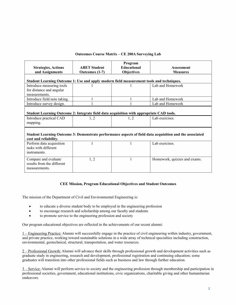
Outcomes Course Matrix – CE 200A Surveying Lab
Strategies, Actions and Assignments
ABET Student Outcomes (1-7)
Program Educational Objectives
Assessment Measures
Student Learning Outcome 1: Use and apply modern field measurement tools and techniques. Introduce measuring tools for distance and angular measurements.
1 1 Lab and Homework
Introduce field note taking. 1 1 Lab and Homework Introduce survey design. 1 1 Lab and Homework
Student Learning Outcome 2: Integrate field data acquisition with appropriate CAD tools. Introduce practical CAD mapping.
1, 2 1, 2 Lab exercises.
Student Learning Outcome 3: Demonstrate performance aspects of field data acquisition and the associated cost and reliability. Perform data acquisition tasks with different instruments.
1 1 Lab exercises.
Compare and evaluate results from the different measurements.
1, 2 1 Homework, quizzes and exams.
CEE Mission, Program Educational Objectives and Student Outcomes
The mission of the Department of Civil and Environmental Engineering is:
to educate a diverse student body to be employed in the engineering profession to encourage research and scholarship among our faculty and students to promote service to the engineering profession and society
Our program educational objectives are reflected in the achievements of our recent alumni: 1 – Engineering Practice: Alumni will successfully engage in the practice of civil engineering within industry, government, and private practice, working toward sustainable solutions in a wide array of technical specialties including construction, environmental, geotechnical, structural, transportation, and water resources. 2 – Professional Growth: Alumni will advance their skills through professional growth and development activities such as graduate study in engineering, research and development, professional registration and continuing education; some graduates will transition into other professional fields such as business and law through further education. 3 – Service: Alumni will perform service to society and the engineering profession through membership and participation in professional societies, government, educational institutions, civic organizations, charitable giving and other humanitarian endeavors.
3
Our Student Outcomes are what students are expected to know and be able to do by the time of their graduation: 1. an ability to identify, formulate and solve complex engineering problems by applying principles of engineering, science
and mathematics 2. an ability to apply engineering design to produce solutions that meet specified needs with consideration of public health,
safety and welfare, as well as global, cultural, social, environmental and economic factors 3. an ability to communicate effectively with a range of audiences 4. an ability to recognize ethical and professional responsibilities in engineering situations and make informed judgments,
which must consider the impact of engineering solutions in global, economic, environmental and societal contexts 5. an ability to function effectively on a team whose members together provide leadership, create a collaborative and in-
clusive environment, establish goals, plan tasks and meet objectives 6. an ability to develop and conduct appropriate experimentation, analyze and interpret data and use engineering judgment
to draw conclusions 7. an ability to acquire and apply new knowledge as needed, using appropriate learning strategies
Revised: 2/13/18
Grading:
1) Lab Reports: You will have a lab report for each lab, which will include the objectives, procedures, results, and analysis and/or comments about your results and the lab itself. The reports must be typed. The objectives and procedures section is to show your understanding of the subject, so do NOT just copy what the handout says. Use your own words. If you were absent for a lab, a report is still due, but make a note on the lab report and in your fieldbook that you were absent and that the data was copied from someone in your group. Each instructor will provide further details for their particular requirements.
Lab Report Components: 1. Typed write‐up 2. Photocopy of personal field book 3. Printout of CAD file, 8.5x11, 11x17, 24x36, 30x42 is acceptable, as applicable (All components are required unless otherwise noted or the lab is considered incomplete)
2) Field books: Field books will be graded at the end of the semester. Keep them clear and legible. All work at each
lab is to be done in the field book. Transcription from another notebook is not acceptable. Field book is to be used at the first session.
3) Topographic Map: A map of each group's assigned section of campus showing physical and topographical
features of the area. The project may include a design aspect which will be determined later in the semester.
4) Measurement Report: A short report comparing the results of the various methods used to obtain measurements in this course: more details will be given later in the semester.
See each instructor for particular grading policies. Keep in mind that the grade for CE200A is completely separate from the grade for CE200. This means that you can pass or fail any combination of the two. A passing grade in CE200 does not mean a passing grade in CE200A and vice versa.

4
Grading Breakdown
Attendance/Participation 10%
Pacing Lab 10% Leveling Lab 15%
TS Familiarization Lab 10%
Student Design Lab 15%
Traverse Lab 15%
Field Book 5%
Final Project 20%
Total 100%
*The NJIT Honor Code will be upheld and any violations will be brought to the immediate attention of the Dean of Students The NJIT Honor Code will be upheld and any violation WILL be brought to the immediate attention of the Dean of Students. There is a zero (0) tolerance in this course for plagiarism. All assignments are to be typed and a copy of all field notes are to be included in the lab report. Hand written lab reports will not be graded. All exercise instructions are to be read before the lab session in which they are performed. All assignments are to be handed in at the time of the lab. If you will not attend a session, your lab report must be left in your instructor's mailbox at the Civil Engineering department so your instructor can pick it up before class. Absence from a lab does not remove your requirement to hand in the lab write‐up on time. All assignments are to be handed in at the laboratory class following the field work. The exception to this are any semester long assignments. Group lab reports are not allowed. Each member of each group is to perform the write‐up and explain what was accomplished and what was learned from each laboratory exercise. There is to be no sharing of any work, especially including CAD work, between students. Part of this course is the understanding of how CAD work fits in with the surveying profession. Assistance and tutoring is encouraged, however, identical or similar CAD files will be graded as if they were not handed in. This includes but is not limited to title blocks, typical blocks, etc... The first assignment that is handed in late will have its grade reduced by 1 letter grade. Assignment will be reduced by 1 letter grade for each additional week late. All CAD files are to have a title block. The title block is to include the same information shown on the sample that is to be distributed to the class. If a title block is not present, points will be deducted from the assignment. Class participation, including attendance and punctuality are considered in the final grade. ALL CAD FILES EMAILED TO PROFESSOR MUST BE SAVED AS A PDF, WITH A FILE PATH OF: “LAST NAMES, DATE, LAB TITLE.PDF”.
90-100% = A 84-89% = B+ 80-84% = B 70-79% = C 60-69% = D
0-59% = F
5
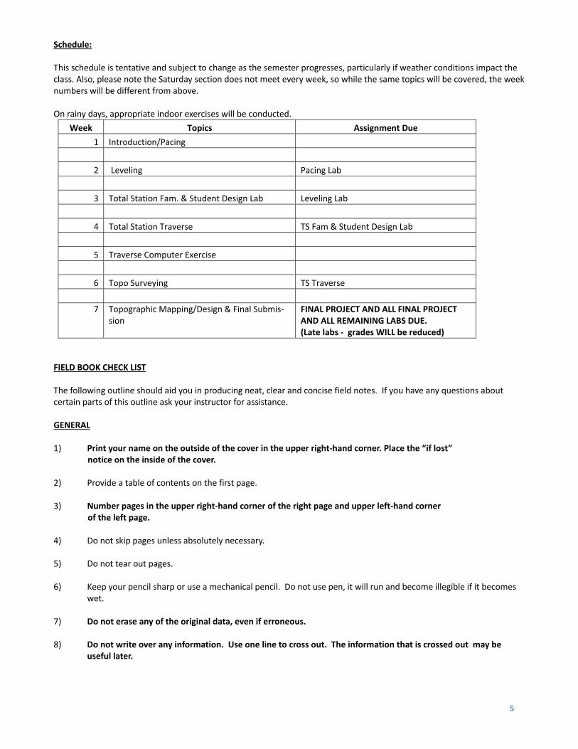
Schedule: This schedule is tentative and subject to change as the semester progresses, particularly if weather conditions impact the class. Also, please note the Saturday section does not meet every week, so while the same topics will be covered, the week numbers will be different from above. On rainy days, appropriate indoor exercises will be conducted.
Week Topics Assignment Due
1 Introduction/Pacing
2 Leveling Pacing Lab
3 Total Station Fam. & Student Design Lab Leveling Lab
4 Total Station Traverse TS Fam & Student Design Lab
5 Traverse Computer Exercise
6 Topo Surveying TS Traverse
7 Topographic Mapping/Design & Final Submis‐sion
FINAL PROJECT AND ALL FINAL PROJECT AND ALL REMAINING LABS DUE. (Late labs ‐ grades WILL be reduced)
FIELD BOOK CHECK LIST The following outline should aid you in producing neat, clear and concise field notes. If you have any questions about certain parts of this outline ask your instructor for assistance. GENERAL 1) Print your name on the outside of the cover in the upper right‐hand corner. Place the “if lost”
notice on the inside of the cover.
2) Provide a table of contents on the first page. 3) Number pages in the upper right‐hand corner of the right page and upper left‐hand corner
of the left page.
4) Do not skip pages unless absolutely necessary. 5) Do not tear out pages. 6) Keep your pencil sharp or use a mechanical pencil. Do not use pen, it will run and become illegible if it becomes
wet. 7) Do not erase any of the original data, even if erroneous. 8) Do not write over any information. Use one line to cross out. The information that is crossed out may be
useful later.
6
9) When voiding an entire page, print VOID in large letters across the page. 10) If a page has been recopied, indicate by printing COPY prominently. 11) Letter all notes very neatly. 12) Additions or changes made in the office should be done in red pencil. 13) Do not be sloppy. Above all, field work requires that others be able to read, interpret and act on the information
that you provide from the field. If that information is illegible, the information that you provide the office is useless or will require too much explanation to be effective.
14) Those processing your information in the office have not necessarily seen the site or know the order of what
was done. LEFT‐HAND PAGE
Put title of exercise at head of each page.
Put column headings as required on each page. Final calculated values should not show more precision than field observations. Make page checks for level notes. Show corrected values in red ink or red pencil. Be sure pencil is sharp. Put initials of student who is performing the work as well as team members RIGHT‐HAND PAGE Remarks should include weather, time, group members present, and instrument information as well as party members and each of their duties. Note that instrument serial number from either the level or total station is important for legal and practical reasons. This information is to be noted at each lab session; as you may or may not receive the same instrument from session to session. Make a clear sketch. Describe benchmarks and occupied stations; i.e. benchmark # or TP # with description of what it is‐(concrete monument, nail, etc.), elevation of benchmark. If questions arise, consult the sample field notes in the Appendix of the surveying textbook, or ask your instructor.