ce 2254 surveying ii - kings college of engineering bank even 13-14/civil/second year... · the...
TRANSCRIPT
1
KINGS COLLEGE OF ENGINEERING
DEPARTMENT OF CIVIL ENGINEERING
Question Bank
Sub. Code/Name: CE2254 Surveying II Year/Sem: II/IV
UNIT-I
Part-A (2 Marks)
1. Define Tacheometer.
It is an ordinary transit theodolite fitted with an extra lens called analytic
lens. The purpose of fitting the analytic lens is to reduce the additive constant to zero.
2. Define Substance bar:
A Substance bar is manufactured by Mr. Kern. The length of the substance bar is
2m (6ft) for measurement of comparatively short distance in a traverse. A Substance bar
may be used as a substance base. The length of the bar is made equal to the distance
between the two targets.
3. What do you mean by Fixed hair method:
In this method, the stadia wires are fixed (or) fitted at constant distance apart.
4. State Stadia intercept:
The difference of the distance between the top and bottom cross hairs is called as staff
intercept
5. What do you mean by tangential method:
In this method, the stadia hairs are not for taking readings. The readings being
taken against the horizontal cross hair.
.
6. The tangential method:
In this method, the stadia hairs are not for taking readings. The readings being
taken against the horizontal cross hair.
2
7. What is the principle of stadia method?
The method is based on the principle that the ratio of the perpendicular to the base
is constant to similar isosceles triangle.
8. What are the systems of tacheometry measurements?
The stadia system
The tangential system
Measurement by means of special instrument.
9. Define Sub tense method:
In this method stadia interval is variable. The staff intercept is kept fixed while
the stadia interval is variable lines.
10 State Staff intercept:
The difference of the reading corresponding to the top and bottom stadia wires.
11. What are the merits and demerits of movable hair method?
Merits:
Long sights can be taken with greater accuracy than stadia method
The error obtained is minimum
Demerits:
The computations are not quicker
Careful observation is essential
12. Define Analytic lens:
Analytic lens is an additional lens placed between the diaphragm and the
objective at a fixed distance from the objective. This lens will be fitted in ordinary transit
theodolite. After fitting this additional lens the telescope is called as external focusing
analytic telescope. The purpose of fitting the analytic lens is to reduce the additive
constant to zero.
13. Define Tacheometry:
Tacheometry is a branch of angular surveying in which the horizontal and
vertical distances (or) points are obtained by optional means as opposed to the ordinary
slower process of measurements by chain (or) tape.
� , plumb bob, wooden· pegs.
3
Part-B
1. Calculate the horizontal and vertical distances using tangential tacheometry when
both the observed angles are angle of elevation and angle of depression. (16)
2. Explain the procedure of estimating the horizontal and vertical distances where
the line of collimation is inclined to the horizontal and the staff is held normal to
the line of collimation (16)
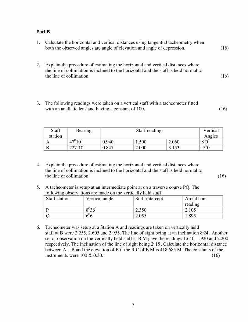
3. The following readings were taken on a vertical staff with a tacheometer fitted
with an anallatic lens and having a constant of 100. (16)
Staff
station
Bearing Staff readings Vertical
Angles
A 47010
’ 0.940 1.500 2.060 8
00
’
B 227010
’ 0.847 2.000 3.153 -5
00
’
4. Explain the procedure of estimating the horizontal and vertical distances where
the line of collimation is inclined to the horizontal and the staff is held normal to
the line of collimation (16)
5. A tacheometer is setup at an intermediate point at on a traverse course PQ. The
following observations are made on the vertically held staff.
Staff station Vertical angle Staff intercept Arcial hair
reading
P 8036
’ 2.350 2.105
Q 606
’ 2.055 1.895
6. Tacheometer was setup at a Station A and readings are taken on vertically held
staff at B were 2.255, 2.605 and 2.955. The line of sight being at an inclination 8024’. Another
set of observation on the vertically held staff at B.M gave the readings 1.640, 1.920 and 2.200
respectively. The inclination of the line of sight being 20 15’. Calculate the horizontal distance
between A + B and the elevation of B if the R.C of B.M is 418.685 M. The constants of the
instruments were 100 & 0.30. (16)
4
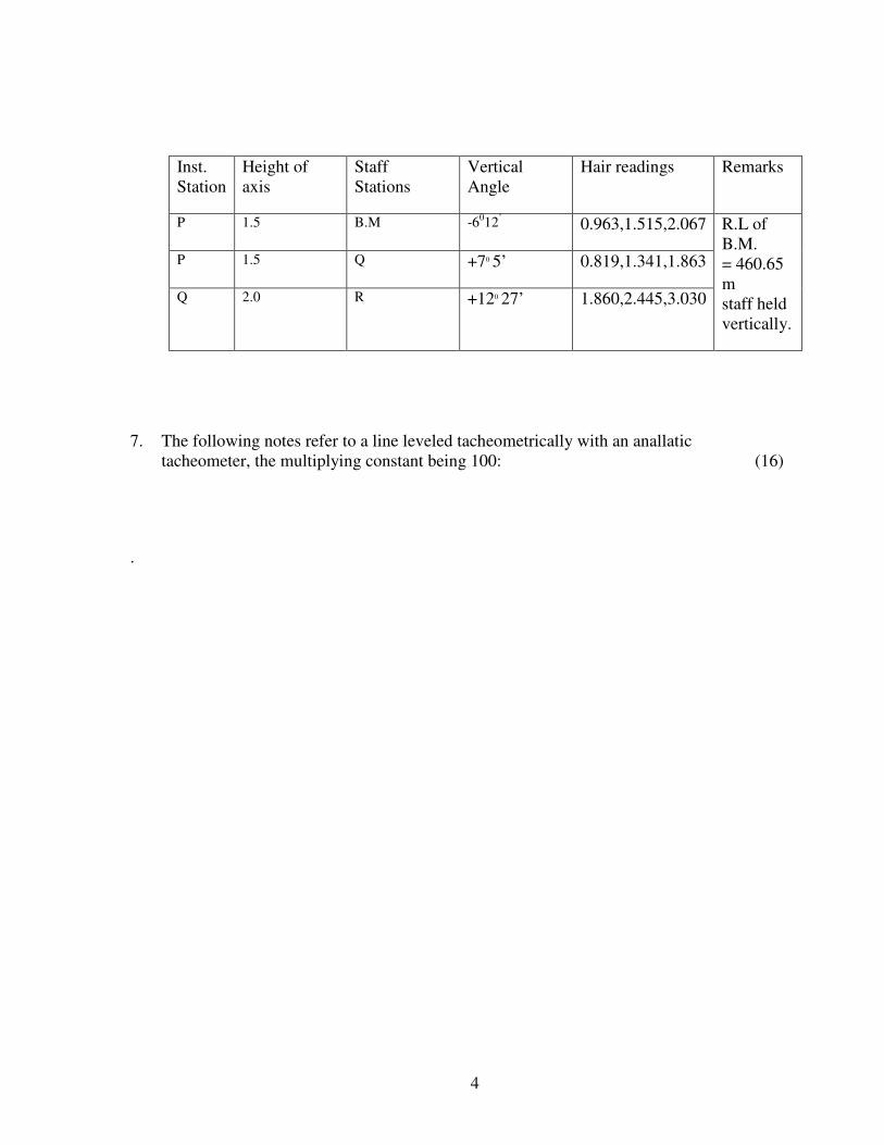
7. The following notes refer to a line leveled tacheometrically with an anallatic
tacheometer, the multiplying constant being 100: (16)
.
Inst.
Station
Height of
axis
Staff
Stations
Vertical
Angle
Hair readings
Remarks
P 1.5 B.M -6012
’ 0.963,1.515,2.067
R.L of
B.M.
= 460.65
m
staff held
vertically.
P 1.5 Q +70 5’
0.819,1.341,1.863
Q 2.0 R +120 27’
1.860,2.445,3.030
5
UNIT-II
Part-A (2 Marks)
1. Define Permanent Bench mark:
These are established by different government departments like PWD, Railways,
Irrigation etc., The RL of these points are determined with reference to G.T.S
Benchmarks. Points on rocks, culvert, gate, pillars etc.
.
2. Define: Arbitrary Bench Mark:
When the RL of some fixed Points are assumed, they are termed a arbitrary Bench
mark
3. State Trigonometrical levelling:
Trigonometrical levelling is the process of determining the differences of
elevation of the given station from observed vertical angles and known distance.
4. DefineGeodetic Surveying :
In this surveying, the shape of the earth is taken into account and all the lines
lying in the surface are curved lines. It is used for area greater than 250km2. It is
accurate. It is conducted by great geometrical survey of India.
5. Define Laplace Station :
At certain station, astronomical observations for azimuth & longitude are also
made on the station is called Laplace station
6. What do you mean by Satellite Station :
A subsidiary station is established as near the true or principal station as possible,
the station so established is called a satellite station or eccentric station or false
station.
7. Define Base net:
A series of triangles connecting the baseline to the main triangulation is called
base net.
8. Write the various types of Bench Mark:
� Great Trigonometric survey Bench mark
� Permanent Bench mark
� Arbitrary Bench mark
� Temporary Bench mark
6
9. Write the various methods used to measure baseline
� Rigid bar method
� Wheeler’ s method
� Jaderin’ s method
� Hunter’ s short base method
� Tacheometric method
10. list theApparatus used in Baseline:
� Rigid Bars
� Flexible apparatus
.
11. What are the Corrections made while calculation of true length?
� Correction for absolute length
� Correction for temperature
� Correction for pull or tension
� Correction for Sag
� Correction for Slope
12. Define Temporary Bench mark:
These are established temporarily whenever required. These are generally chosen
to close the day’ s work and to start the next days. Points on roofs, walls,
basements etc
13 State the Extension of baseline:
The length of baseline is usually not greater than 10 to 20 km. As it is not a often
possible to sewed a favorable sight for a longer base. They usually practice is
therefore to use short base & Extend it by means. Of forming well conditioned
triangles.
14 DefineAxis Signal correction :
If the height of the signed is not the same as that of height of the instrument axis
above the station, a correction known as the axis signal correction or eye &
objective correction is to be applied.
15. State Baseline :
The Base line is laid down with great accuracy of measurement & alignment as it
forms the basis for the computations of triangulation system the length of the base
line depends upon the grades of the triangulation.
16. Define Triangulation :
Triangulation is nothing but the system consists of not of interconnected triangles.
In this method, knowing the length of one side and three angles, the length of
other two sides of each triangle can be computed.
7
17. What do you mean by Reduction to centre:
If the true station were occupied by computing the corrections and apply them
algebraically to the observed values is generally known as reduction of centre
.
18. What are the Equipments used for base line measurement:
� Marking stakes or tripod
� Straining device
� Supporting stakes or tripod
� Steel tape
� Six number of thermometer.
19 What are the Two types of Trigonometrically leveling:
Plane Trigonometrical levelling
Geodetic Trigonometrical leveling
Part-B (16Marks)
1. What are the methods of measurement of the base line and explain any two with
neat sketch. (16)
2. From an eccentric Station S, 12.25 metres to the west of the main station B, the
following angles were measured BSC = 760251; CSA = 540321 2011.
The stations S and C are to the opposite sides of the line AB. Calculate the
correct angle ABC if the lengths AB and BC are 5286.5 and 4932.2m
respectively. (16)
.
3. What is meant by a “satellite station”? Explain briefly (16)
4. What are the different corrections to be applied while measuring baseline in
geodetic surveying? (16)
5. A steel tape 30m long, standardized at 10 oc with a pull of 100N was used for
measuring a baseline. Find the correction per tape length, if the temperature at the
time of measurement was 20oc and pull applied was 150 N. Density of steel =
3000 kg/m3. Weight of tape=5.88N. (16)
6. In a trignometrical measurement of the difference in level of two stations P and Q,
8
10480 m apart, the following data were obtained.
Instrument at P, angle of elevation of Q = 0’ 15”
Instrument at Q, angle of depression of P = 3’ 33”
Height of instrument at P = 1.42 m.
Height of instrument at Q = 1.45 m.
Height of signal at P = 3.95 m.
Height of signal at Q = 3.92 m.
Find the difference in level between P and Q and the curvature and refraction
correction.
Take R sin 1” = 30.38m. (16)
7 A steel tape is 30 m long at a temp of 15ºc when lying horizontal on the ground.
Its c/s area is 0.08 cm2 and weight of 18.kg (18N) and. Co-eff of expansion is 117
x10-7/ºc. The tape is stretched over 3 supports which are at the same level and at
equal intervals. Calculate the actual length between the end graduations under
the following conditions. Temp = 25ºc, Pull -180 kgt, E = 2.1 x 10⁵ N/cm 2. (16)
8. Draw a neat sketch and explain the prismatic compass (16)
9. What is a two point problem? How it is solved. (16)
10. Define three point problem and how it is solved by tracing paper method. (16)
9
UNIT –III
PART –A
1 Define Systematic Errors:
The systematic error is an error that under the same conditions will always be of
the same size and sign. It is simply due to the error in instrument. These errors
may be regarded as positive or negative according with whether they make the
result too small (or) too great. This effect is cumulative.
2. State Accidental Errors:
The Accidental Errors are those which remain after mistakes and systematical
errors have been eliminated and are caused by the combination of reasons beyond
the ability of the observer to control.
3. Write the classification of Observer Quantity:
� An observer quantity may be classified as
� Independent Quantity
� Conditioned Quantity
4. What do you mean by Conditioned Quantity:
It is the one whose value is dependent upon the values of one (or) more quantities.
Its values bear a rigid relation to some other quantities. It is also called
“dependent quantities”
5. What do you mean by Direct Observation:
A direct observation is the one made directly on the quantity being determined.
Eg: Measurement of base line.
6. State Weight of an Observation:
The weight of an observation is a number giving an indication of its precision and
trust worthiness, when making a comparison between several quantities of
different worth.
If a certain observation of weight 4 it means that it is 4 times as much reliable as
an observation of weight 1.
When two quantities (or) observations are assumed to be equally reliable, the
observed values are said to be of equal weight (or) of unit weight.
7 What do you mean by Observed value of a Quantity:
An observed value of a quantity is a value obtained when it is corrected for all the
known errors. Observed value = Measured value ± errors (or) corrections.
10
8. Define Normal Equation:
It is the education which is formed by the multiplying each equation by the coefficient
of the unknown, whose normal equation is to be formed out by adding
the equation thus formed.
.
Axis of telescope is an imaginary line passing through the optical centre of the object glass
and the optical centre of the eye-piece.
9. Define Most probable Errors:
It is defined as the quantity which added to and subtracted from the most probable
value, fixes the limit within which it is an even chance the true value of the
measured quantity must lie.
10. Explain Declination:
The declination f a celestial body is angular distance from the plane of the
equator, measured along the star’ s meridian generally called the declination circle.
Declination varies from 00 to 900, and is marked + or – according as the body is
north or south of the equator.
10. State hour angle:
The hour angle of a heavenly body is the angle between the observer’ s meridian
and the declination circle passing through the body. The hour angle is always
measured westwards.
11. What is Celestial Horizon:
It is also called true or Rational horizon or geocentric horizon. It is the great circle
traced upon the celestial sphere by that plane which is perpendicular to the zenith
–Nadir line and which passes through the centre of the earth.
12. What are the celestial poles and equator :
If the earth’ s axis of rotation is produced indefinitely, it will meet the celestial
sphere in two points called the North & South celestial poles (P and P’ ).
The celestial equator is the great circle of the celestial sphere in which it is
intersected by he plane or terrestrial equator.
13. Define Sensible horizon:
It is a circle in which a plane passing through the point of observation and
tangential to the earth’ s surface intersects with celestial sphere. The line of sight
of an accurately leveled telescope lies in this plane.
14. The Observers Meridian:
The meridian of any particular point is that circle which passes through the zenith
and nadir of the point as well as through the poles.
.
11
15. How will you distinguish between a summit and a depression by studying the nature of the
contour?
A closed contour line indicates either a summit or a depression according as the Higher or
lower values are inside them. In summit the higher values are inside the closed contour and
the lower values on the outer. In the depression the lower value is at the inside of the closed
contour and the higher values on the outside.
16. How earthwork required is calculated using contours.
For computation of earthwork areas of cross-sections of successive cross-sections are
considered. The average area, multiplied by the spacing between cross-sections gives the
volume of earthwork. For this trapezoidal or prismoidal rules can be used.
17. Why the horizontal equivalent is not constant?
Horizontal equivalent is the horizontal distance between any two consecutive contours.
Depending on the steepness or plain nature of the ground· the horizontal equivalent depends.
For steeper slope the horizontal equivalent is less than a plain ground for the same difference
in elevation. As the slope of the ground· between two contour is not constant in all directions,
the horizontal equivalent is not constant.
18. In some contours the lines are closer in some they are wider for the same contour interval what
does it mean.
Contours running close together indicate a slope for a given contour interval. For the same
contour interval, they run wider in plain flat terrain.
19. What is contour gradient? Where it is used?
The gradient between any two contours .Is called the contour gradient. This is got by dividing
the difference in elevation between two contours, at a point and the horizontal stance between
them. This is used in route surveying.
20. Explain the object of preparing a contour map.
Generally topography of an area is depicted by a 'contour which are very useful for various
engineering projects. As a matter of fact every civil engineering work has to be started (with a
contour map. Contour maps are prepared for alignment of highway, railway, waterway, sewer
line, etc and to decide the catchments, area of the reservoir and the location of a dam or
reservoir.
12
PART – B
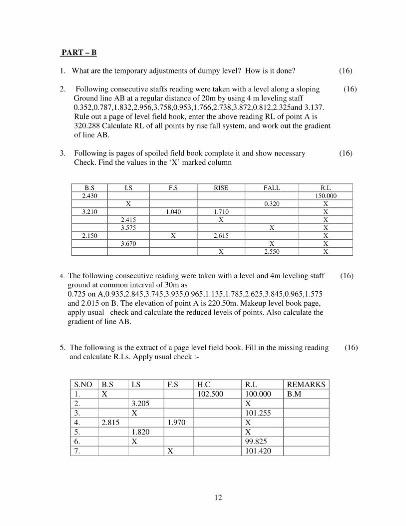
1. What are the temporary adjustments of dumpy level? How is it done? (16)
2. Following consecutive staffs reading were taken with a level along a sloping (16)
Ground line AB at a regular distance of 20m by using 4 m leveling staff
0.352,0.787,1.832,2.956,3.758,0.953,1.766,2.738,3.872,0.812,2.325and 3.137.
Rule out a page of level field book, enter the above reading RL of point A is
320.288 Calculate RL of all points by rise fall system, and work out the gradient
of line AB.
3. Following is pages of spoiled field book complete it and show necessary (16)
Check. Find the values in the ‘X’ marked column
B.S I.S F.S RISE FALL R.L
2.430 150.000
X 0.320 X
3.210 1.040 1.710 X
2.415 X X
3.575 X X
2.150 X 2.615 X
3.670 X X
X 2.550 X
4. The following consecutive reading were taken with a level and 4m leveling staff (16)
ground at common interval of 30m as
0.725 on A,0.935,2.845,3.745,3.935,0.965,1.135,1.785,2.625,3.845,0.965,1.575
and 2.015 on B. The elevation of point A is 220.50m. Makeup level book page,
apply usual check and calculate the reduced levels of points. Also calculate the
gradient of line AB.
5. The following is the extract of a page level field book. Fill in the missing reading (16)
and calculate R.Ls. Apply usual check :-
S.NO B.S I.S F.S H.C R.L REMARKS
1. X 102.500 100.000 B.M
2. 3.205 X
3. X 101.255
4. 2.815 1.970 X
5. 1.820 X
6. X 99.825
7. X 101.420
13
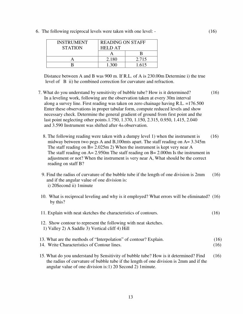
6. The following reciprocal levels were taken with one level: - (16)
INSTRUMENT
STATION
READING ON STAFF
HELD AT
A B
A 2.180 2.715
B 1.300 1.615
Distance between A and B was 900 m. If R.L. of A is 230.00m Determine i) the true
level of B ii) he combined correction for curvature and refraction.
7. What do you understand by sensitivity of bubble tube? How is it determined? (16)
In a leveling work, following are the observation taken at every 30m interval
along a survey line. First reading was taken on zero chainage having R.L. =176.500
Enter these observations in proper tabular form, compute reduced levels and show
necessary check. Determine the general gradient of ground from first point and the
last point neglecting other points.1.750, 1.370, 1.150, 2.315, 0.950, 1.415, 2.040
and 3.590 Instrument was shifted after 4th observation.
8. The following reading were taken with a dumpy level 1) when the instrument is (16)
midway between two pegs A and B,100mts apart. The staff reading on A= 3.345m
The staff reading on B= 2.025m 2) When the instrument is kept very near A
The staff reading on A= 2.950m The staff reading on B= 2.000m Is the instrument in
adjustment or not? When the instrument is very near A, What should be the correct
reading on staff B?
9. Find the radius of curvature of the bubble tube if the length of one division is 2mm (16)
and if the angular value of one division is:
i) 20Second ii) 1minute
10. What is reciprocal leveling and why is it employed? What errors will be eliminated? (16)
by this?
11. Explain with neat sketches the characteristics of contours. (16) 12. Show contour to represent the following with neat sketches.
1) Valley 2) A Saddle 3) Vertical cliff 4) Hill
13. What are the methods of “Interpolation” of contour? Explain. (16)
14. Write Characteristics of Contour lines. (16)
15. What do you understand by Sensitivity of bubble tube? How is it determined? Find (16)
the radius of curvature of bubble tube if the length of one division is 2mm and if the
angular value of one division is:1) 20 Second 2) 1minute.
14
UNIT- IV
Part-A (2 Marks)
1. What are consecutive coordinates and independent coordinates?
Consecutive coordinates are those in which the latitude and departures of a point life calculated
with reference to the point. These coordinates may be positive or negative on the quadrant on
which, it falls Independent coordinates are those in which the latitude departures of a point are
calculated with respect to origin. The origin may be a survey station or a point outside the traverse.
2. Define latitude and departure.
The latitude of a line is the distance measured parallel the North-South line. Similarly the distance
measured parallel to the East-West line is the departure. If the reduced bearing of a line and its
length are known then the latitude and departure can be computed
3. What is Transit Rule?
In theodolite traversing the angular measurements are more accurately done compared to linear
measurements. The transit rule is applicable only in such situations. As per this rule the correction
to latitude or departure is considered as a factor of latitude or departure of the side instead of the
length the side. Accordingly the transit rule is Total error in latitude Correction to departure.
4. What is Bowdich rule?
Bowdich rule is applied for corrections in latitude: and departure. As per this rule, the error is
proportional to the length of the side. Therefore the corrections to the latitude and departure are
given as closing error in latitude
5. Which method you prefer for open-traverse using theodolite?
The deflection angle method is mostly suitable for open-traverse in the survey of rivers, coast
lines, roads, railways, etc. A deflection angle may be defined as the angle between the 'preceding
survey line and the following line. The angle may be a right-hand deflection angle or the left-hand
deflection angle based on the observation.
6. How traversing is done by adopting included angle method?
This method may be used for both open-traverse and closed-traverse. It is more suitable for closed-
traverse. Although traverse may be done in clockwise or anticlockwise direction. For closed-
traverse the traverse is generally taken in the anti-clockwise direction. It is necessary to note down
whether the angle is interior angle or exterior angle.
7. Explain reiteration Method.
In this method all the horizontal angles are measured successively and finally the horizon is closed
the angle the last and first station is measured. The final reading vernier should be the same as its
initial reading. does not coincide, the 'difference is equally 'distributed i, e measured angles.
8 Explain the repetition method.
In this method the angle is added continuously and the total angle is divided into the number of
repetitions to get the angle. Generally six repetitions are made, out of which half of the repetitions
are made, out of which half of e repetitions are made with the telescope normal and half with the
telescope inverted. By this process very accurate measurement of angles can be made.
15
9. What is called spire test?
The test conducted to bring the horizontal axis perpendicular to vertical axis is called the spire test.
This condition ensures that the motion of telescope is in a vetiical plane.
10. What do you understand by the name transit theodolite?
Theodoltes are primarily classified as (i) Transit and (ii) Non-transit theodolite
Transit theodolite is one in which the telescope can be revolved through a complete revolution
about its horizontal axis in a vertical plane. Transit theodolite is mostly used now-a. days.
11. Define standards in theodolite.
This is shaped like letter 'A' and also called as A frame which is the supporting telescope, top of
the standards are provided with the bearings for the pivots of the telescope About these pivots the
telescope can 'rotate freely in the vertical plane.
12. List the essential qualities of a theodolite telescope.
Internally focusing telescope is used in theodolites. In this telescope, the objective arid eye-piece
do not move when the focusing screw is tuned. There is a double concave lens is fitted with rack
and pinion arrangement between eye-piece and objective. This lens moves in and out when the
focusing is done and a real image is formed on the plane of cross-hairs.
13. List the essential parts of a theodolite.
A transit theodolite consists of the following parts:
� Leveling head
� Plate levels
� Lower plate
� Telescope
� upper plate
� Altitude bubbles
� Plumb bob
� Compass
� T-frame
14. What is a prismoidal formula for computation of volume?
V=d/3 [A1+An + 4 (A2 +A4 + ... ) + 2 (A3 +A5+ ... )]
15. What is prismoidal correction for Trapezoidal Rule?
In general volumes between successive areas are found on the average of end areas and a
prismoidal correction Prismoidal correction is deducted from the volume computed using
average end areas. It varies with the type of, n involved.
16. What is a planimeter?
Planimeter is an instrument used for finding out the area plotted, plan. It is a mechanical device
which is fast. The polar planimeter is the one which is widely used
16
17. State Trapezoidal rule? What are the limitations?
The trapezoidal rule may be stated as, the sum of the first and last ordinates; twice the sum of the
intermediate ordinates and the total sum is multiplied by half of the common distance. Here the
boundaries between the end of ordinates are assumed to be straight lines.
This can be applied to any number of ordinates. There is no limitation.
18. State Simpson's rule? What are the limitations?
The Simpson's rule may be stated as: The sum of the and last ordinates, four times the sum of
the even ordinates twice the sum of the odd ordinates, multiplied by the non distance and divided
by three. The boundaries between the ordinates are assumed to an arc of a parabola. The
limitation of this rule is that it can be applied when lumber of ordinates is odd.
19. How area is calculated from a plan by dividing into squares?
A square chart of convenient size is plotted on a tracing per, with each square representing a
definite area namely are cm. or square meter.
The tracing paper is placed on the drawing sheet or map I the number of full squares are first
counted. The portion the squares on the boundary are broken which are estimated terms of
fractional squares. The required area is calculated
20. What is called area of skeleton? Give examples.
In the process of surveying the whole area is divided to some geometrical figures, such as
triangles, rectangles, squares, and trapeziums and then the areas are calculated by e known
geometric formulae.
PART – B
1. Describe the process of repetition and reiteration method of Theodolite traversing (16)
2. What are the different fundamental axes of theodolite and list out the relation
between them? (16)
3. Explain, how to determine R.L. of the Elevated object as base of the object inaccessible
and instrument station are in the same vertical plane as that of the elevated object and
also instrument axes at the same level in case of trigonometric leveling.
(16)
4. An observer standing on the deck of a ship just sees a light house. The top of the light
house is 40mts above the sea level and height of the observer’s eye is 5mt above the sea
level. Find the distance of the observer from the light house. (16)
5. Explain the terms:
1) Latitude 3) Consecutive Coordinate (16)
2) Departure 4) Independent Coordinate
17
6. A theodolite was setup a distance of 180m from a light house and the angle of
elevation to its top and depression to its base were observed as 22º45’ and 1º12’
respectively. The reading on a staff held on B.M. of R.L. 175.590m.was 1.85m
with line of collimation horizontal. Calculate 1) The height of light house
2) The R.L of top. (16)
4. Write short note on temporary adjustment of theodolite. (16)
7. Draw a neat diagram of transit theodolite and label its parts. (16)
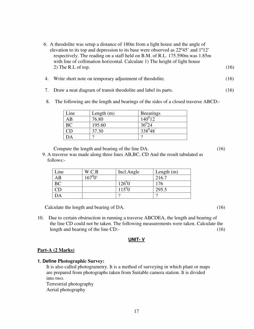
8. The following are the length and bearings of the sides of a closed traverse ABCD:-
Line Length (m) Beearings
AB 76.80 140012
’
BC 195.60 36024
’
CD 37.30 338048
’
DA ? ?
Compute the length and bearing of the line DA. (16)
9. A traverse was made along three lines AB,BC, CD And the result tabulated as
follows:-
Line W.C.B Incl.Angle Length (m)
AB 16700’ 216.7
BC 12600
’ 176
CD 11500
’ 295.5
DA ? ?
Calculate the length and bearing of DA. (16)
10. Due to certain obstruction in running a traverse ABCDEA, the length and bearing of
the line CD could not be taken. The following measurements were taken. Calculate the
length and bearing of the line CD:- (16)
UNIT- V
Part-A (2 Marks)
1. Define Photographic Survey:
It is also called photogrametry. It is a method of surveying in which plant or maps
are prepared from photographs taken from Suitable camera station. It is divided
into two.
Terrestrial photography
Aerial photography
18
2. What do you mean by Equilibrium Theory :
The earth is covered all around by the ocean of uniform depth. The ocean is
capable of assuming the equilibrium.
3. What is the use of Fathometer :
A fathometer is used for ocean sounding where the depth of water is too much
and to make a continuous and accurate record of depth of water below the boat or
ship at which it is installed.
4. Define Hydrographic Survey:
Hydrographic Survey is that branch of surveying which deals with the
measurement of bodies of water. It is the art of delineating the submarine levels,
contours and features of seas, gulfs, rivers and lakes.
5. What are Tides:
All celestial bodies exert a gravitational force on each other. These forces of
attraction between earth & other celestial bodies cause periodical variations in the
level of water surface, known as tides.
.
6. What is Stereoscopic fusion:
If a pair of photographs is taken of an object from two slightly different positions
of the camera and then viewed by an apparatus which ensures that the left eye
sees only the left-hand picture & right eye is directed to the right hand picture, the
two separate images of the object will fuse together is the brain to provide the
observer with spatial impression. This is known as a Stereoscopic fusion.
7. Define Parallax bar:
A parallax bar used to measure difference of two points, consists of a bar which
holds a fixed plate of transparent material near the left end and a movable plate to
the right end.
8. List the types of EDM instrument :
� Tellurimeter
� Geodimeter
� Distomats
9. What do you mean byCadastral survey :
Cadastral means, “Registration concern Land Survey” . It is of one of based on
national land survey based on land survey law.
10. Explain Modulation :
Amplitude modulation
Frequency modulation
In amplitude modulation, the carrier wave has constant frequency & the
19
modulating wave (the measurement wave) in formation is conveyed by the
amplitude of the carrier wave. In the frequency modulation the carrier wave has
constant amplitude, while the frequency varies in proportion to the amplitude of
the modulation wave.
11 Define Cadastral survey :
Cadastral means, “Registration concern Land Survey” . It is of one of based on
national land survey based on land survey law.
12. Define Stereo pair:
The pair of two such photographs is known as stereo pair. The effect of
distortions exist in a single photograph may be eliminated through a large extend
of stereo pairs.
13. What is an Parallax bar:
A parallax bar used to measure difference of two points, consists of a bar which
holds a fixed plate of transparent material near the left end and a movable plate to
the right end. increase of centrifugal force at a constant rate.
14. Define Mean sea level :
Mean sea level may be defined as the mean level of the sea, obtained by taking
the mean of all the height of the tide as measured at hourly intervals over some
states period covering a whole number of complete tides.
15. What is Angle of Parallax?
It is the angle of convergence of the two rays of vision.
16. What is floating mark?
In parallax bar, when the two dots are viewed properly under a stereoscope they
fuse into a single dot called floating mark.
.
17. What is a transition curve and where such provided?
A curve having a gradual varying radius is called a transition curve. For example a curve with
infinite radius in the beginning and varying gradually to a finite radius. Transition curves are
provided in railway tracks to ensure safe running of the trains without overturning or derailment.
This curves provide comfort to passengers both on roads and on railways.
18. What is a reverse curve? Where it is used?
When two curves of different or equal radii are bending in opposite directions then it is called a
reverse curve, Reverse curves have one common tangent.
Such curves are preferred in situations where the straights have their angle of intersection is too
acute. This is used in roads and railways where a low speed is anticipated.
19. What is a compound curve? Where it is used?
20
When a curve consists of more than one radius connecting two intersecting straights it is called a
compound curve. The direction of change of curvature is on the same side.
It is used in situation where it is not possible to connect the two tangents by one circular curve, it
becomes necessary, to take a common tangent, and set out two curves of different radii to connect
the rear and forward tangents.
Part –B
1.a. Define lift and lead. (4)
b. Explain the operations involved in tunnel alignment and setting of tunnel. (12)
1. A simple curve is to have a radius of 300m. The tangents intersect at chainage (16)
of 1192.00m, and the deflection angle at intersection is 50.50 . Find the angent
distance, change at beginning and a length of long chord , degree of curve and
the number of full and sub chords.
3. a. What is a need for super elevation (4)
b. A transition curve is required fir a circular curve of radius 400m, the gauge (12)
being 1.5m between rail centers and maximum curve super elevation is restricted
to 12.cm . The transition curve is to be designed for a velocity such that no lateral
pressure is impressed on the rails and the rate of gain of radial and the rate of gain
of radial acceleration is 30 cm/sec2. Calculate the required length of transition
curve and the design period.
4. a. Distinguish between a compound curve and a reverse curve. (4)
b. A parabolic vertical curve is to be set out connecting twouniform grades +0.8% (12)
The transition curve is to be designed for a velocity such that no lateral
pressure is impressed on th rails and the rate of of gain of radial acceleration is
30cm/sec2. Calculate the length of transition curve and the design period.
5. a. A transition curve of 100m length is introduced on either side of a circular curve of
radius 500m .Calculate the shift and spiral angle. (10)
b. What are the factors to be considered in mine surveying? (6)
6a. Explain the procedure of setting out foundation trenches for buildings with masonary
walls. (8)
b. Briefly explain the method of setting out a simple curve by offset from the chords
produced. (8)
7. Draw a simple circular curve and mark the salient points. Explain the setting out of
curve by two theodolite method. (16)
8. Compare the difficulties involved in mine surveying with a normal surveying
Work or ground (16)
9. Distinguish between a compound curve and a reverse curve. (16)

21
10. Explain any linear two linear methods of setting out circular curves (16)