cb-15 ru-40 - groton-ct.gov map.pdf · cb-15 ru-20 ru-40 bailey ru-40 point ho bs is la nd east rn...
TRANSCRIPT
RS-12
R-12
CB-15
RU-80
IP-80A
RU-20
RS-12
RU-20
WF-20
WDD
RS-8
RU-20R-12
IA-40
IA-40
IA-40
FP
CB-15
RS-20
R-12
RS-12
RS-20
IP-80B
RU-20
RU-40
R-12
IP-80C
RS-20
RS-12
RS-12
CA-12DDD
RS-12
IA-40IA-40
RMF-8
RS-12
OMF
RS-20
RU-20
RU-40
CB-15
RU-20
RS-12
CB-15
NMDD
RMF-8
RMF-12
RMF-8OMF
CA-12
CA-12
RMF-16OMF
R-12
RMF-12
CA-40
OMF
RMF-12
OMFOMF
RMF-12
RMF-16R-12
CB-15
RMF-16RU-20
OMFIA-40
RMF-12RU-20
OMFCA-12CB-15
IA-40
CA-12
RMF-8
RU-20
CB-15
RU-20
RU-40
RU-40BAILEYPOINT
HOBBSISLAND
EASTERNPOINT
EASTERN POINTBEACH
AVERYPOINT
PINEISLAND
JUPITERPOINT
POINTBUSHY
BUSHY POINT BEACH
POINTMUMFORD
MOUSEISLAND
MORGANPOINT
SIXPENNYISLAND
WILLOWPOINT
POINTSPENCE
BLUFF POINTCOASTAL RESERVE
STATE PARK
RAM
ISLAND
SUBMARINE
THAMES RIVER
COVE
MYST
IC
RIVE
R
GREENS
SHAWS
MAMACOKE
MAMACOKE
NEW LONDON MASON
ISLAND
MURPHY
ANDREWS
HARBOR
MYST
IC
BAKE
R C
OVE
GROTON - NEW LONDONAIRPORT
POQU
ONOC
K
RIVER
MUMFORD COVE
VENETIAN HARBOR
PALMER
WEST
COV
E
BEEBE COVE
BASE
STATE PIERADM. SHEAR
COVE
HARBOR
HARBOR
POINT
ISLAND
COVE
HILL
FILE: G:\depts\Planning\projects\ArcGIS\Stock Maps\Zoning Map color.mxd
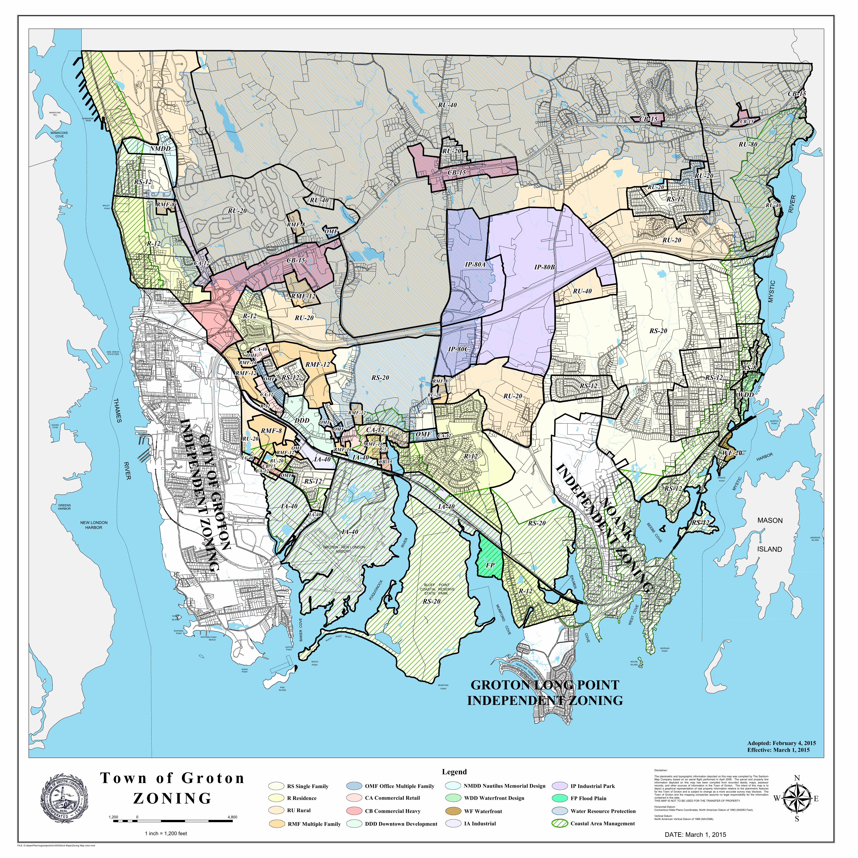
T o w n o f G r o t o nZ O N I N G
1,200 4,8000
1 inch = 1,200 feet
µLegend
RS Single FamilyR ResidenceRU Rural
RMF Multiple Family
OMF Office Multiple FamilyCA Commercial Retail
CB Commercial Heavy
DDD Downtown Development
NMDD Nautilus Memorial DesignWDD Waterfront Design
WF WaterfrontIA Industrial
IP Industrial ParkFP Flood Plain
Water Resource ProtectionCoastal Area Management
CITY OF GROTON
INDEPENDENT ZONING
NOANK
INDEPENDENT ZONING
GROTON LONG POINTINDEPENDENT ZONING
Adopted: February 4, 2015Effective: March 1, 2015
DATE: March 1, 2015
Disclaimer:The planimetric and topographic information depicted on this map was compiled by The SanbornMap Company based on an aerial flight performed in April 2009. The parcel and property lineinformation depicted on this map has been compiled from recorded deeds, maps, assessorrecords, and other sources of information in the Town of Groton. The intent of this map is todepict a graphical representation of real property information relative to the planimetric featuresfor the Town of Groton and is subject to change as a more accurate survey may disclose. TheTown of Groton and the mapping companies assume no legal responsibility for the informationcontained in this data.THIS MAP IS NOT TO BE USED FOR THE TRANSFER OF PROPERTY.Horizontal Datum:Connecticut State Plane Coordinates, North American Datum of 1983 (NAD83 Feet).Vertical Datum:North American Vertical Datum of 1988 (NAVD88).