catchment property rights and the case of kenya’s nyando
TRANSCRIPT
1
Catchment Property Rights and the Case of Kenya’s Nyando Basin1
Brent Swallow, World Agroforestry Centre, P.O. Box 30677, Nairobi, Kenya, email: [email protected]; www.worldagroforestrycentre.org Leah Onyango, Maseno University, Maseno, Kenya, [email protected] Ruth Meinzen-Dick, International Food Policy Research Institute, Washington DC, USA, email: [email protected]; www.capri.cgiar.org; www.ifpri.cgiar.org Abstract: It is generally acknowledged that insecure and incomplete property rights have large effects on the use and management of watershed resources. The standard policy response to this problem is to privatize farm land, declare riverine areas to be public property, and establish a set of restrictions on the use of both private and public land. This paper presents a more nuanced concept of catchment property rights, drawing upon key concepts from watershed hydrology and the multidisciplinary social science of property rights. We present preliminary results from a study of the Nyando river basin in western Kenya. The implications are that policy reforms aimed at catchment property rights need to recognize the complexity and inter-connections that make up hydrologic catchments, give greater priority to key catchment resources such as domestic water and sediment filters, recognize the key links between water and land rights, and devise ways to harmonize the multiple sources of authority that govern the use of management of watershed resources. Keywords: watershed, governance, Africa, Lake Victoria, management, legal pluralism Introduction Attention to watershed management is increasing across the developing world. In India, for example, over $500 million is invested in watershed projects every year. There are compelling reasons to believe that this interest will continue to grow. Water resources are becoming increasingly scarce. Tunisia, Kenya, Rwanda, Burundi, Algeria, Somalia and Malawi were already considered water scarce in 1990, by 2025 they will be joined by Libya, Morocco, Egypt, Comoros, South Africa and Ethiopia (as measured by the availability of 1,000 cubic meters of renewable water per person per year (http://www.cnie.org/pop/pai/water-14.html). Concerns
1 Paper accepted for publication in the proceedings of the Africa Regional Workshop on Preparing the Next Generation of Watershed Management Programmes, Co-hosted by the Food and Agriculture Organizations and the World Agroforestry Centre, ICRAF, Nairobi, Kenya, 8-10 October 2003. The authors wish to acknowledge support from our home institutions and funding from the Comprehensive Assessment of Water Management in Agriculture, the European Union and Danida. Data on property rights for the Nyando basin were provided by the Kenya Ministry of Lands and the Forestry Department of the Ministry of Environment and Natural Resources. Florence Muchori provided valuable GIS assistance for preparation of the map. We also appreciate the many useful comments we received from participants who attended the Africa Regional Workshop on Preparing the Next Generation of Watershed Management Programmes. We also note, with sadness and fond appreciation, the valuable insights into the social institutions for water management that have been generated by the late Jessica Roy.
2
about water scarcity in South Africa have led to the Working for Water program to remove fast growing invasive trees from critical catchment areas and areas of valuable biodiversity (www-dwaf.pwv.gov.za/wfw). Across the developing world, ever greater numbers of people are exposed to flood risks. Soil erosion continues to degrade agricultural potential, while dams, reservoirs and irrigation infrastructure continue to be clogged with sediment. Integrated water management and ecosystem approaches are now generally recognized as vital to durable solutions to these challenges. In India, for example, the most successful watershed and catchment management programs involve multiple stakeholders – community groups, non-governmental organizations, government agencies – a mix of new techniques and social organization, and give balanced attention to improving resource management and farmers’ livelihoods (Kerr, Pangare and Pangare, 2002). A particular area where more integrated approaches are required is in property rights reform. Insecure property rights to cropland are often cited as the major cause of soil erosion, sedimentation and low crop production (see review in Gebremedhin and Swinton, 2003). An obvious policy prescription for dealing with catchment degradation therefore is to enhance tenure security on cropland. While more secure tenure may well reduce plot-level erosion, it is possible that less erosion at the plot level will not translate into significant changes in sediment loss at the catchment scale. Catchments are comprised of different types of land, put to different uses, and held under different types of property rights. Crop agriculture may or may not be a large contributor to erosion within a catchment. In most catchments, there are other land uses, especially roads and footpaths, which occupy small areas of land but account for large percentages of total erosion (Ziegler, Sutherland and Giambelluca, 2001). In addition, catchments invariably comprise micro and macro sinks where eroded soils accumulate, as well as filters that reduce lateral flows of water, pollutants and sediment (van Noordwijk et al., 1998; Swallow, Garrity and Van Noordwijk, 2002). It is important, therefore, to take a wider perspective on property rights. The objective of this paper is therefore to present a catchment perspective of property rights. Following Tiffen and Gichuki (2000) and DENR (1998), we define a catchment as “the area of land from which rainwater can drain, as surface runoff, via a specific stream or river system to a common outlet point which may be a dam, irrigation system or municipal / urban water supply off take point, or where the stream / river discharges into a larger river, lake or the sea” (DENR, 1998, p.29). On the other hand, a watershed is a “whaleback land unit” that forms the upper area of one or more catchments, with hydrologic linkages to lower parts of the catchments (Tiffen and Gichuki, 2000). We use the term property rights to refer to claims to use or control resources that are recognized as legitimate by an entity or entities larger than the individual, and the social and / or legal mechanisms that define and protect those claims. The key elements of catchment property rights therefore are the claims to use or control the resource stocks, flows and filters that comprise catchments, the individuals and groups that exert those claims, the statutory and non-statutory entities that support those claims, and the institutions that define and protect those claims and enforce duties on others. The remainder of the paper consists of three components. The second section presents an analytical framework for watershed property rights that builds upon a simple model of watershed function and the concepts and approach of legal pluralism. The third section applies that framework to the case of the Nyando river basin in western Kenya. The final section presents conclusions.
3
An analytical framework for analysis of catchment property rights
A watershed model of sources, sinks, flows and filters Van Noordwijk et al. (1998) and Swallow, Garrity and Van Noordwijk (2002) propose that watersheds be conceptualized as containing four main components: sources, sinks, flows and filters. Sources are units of land that yield more soil or water to downstream land units than they accumulate from upstream sources, while sinks are units of land that accumulate more soil or water from upstream sources than they yield to downstream sources. Both sources and sinks exist at multiple scales. At a landscape scale, natural forests tend to be net sinks of sediment and water. At a smaller scale, natural forests usually have undulating land surfaces that contain small areas of source and sink. Flows refer to lateral flows of organisms, soil, water, air and specific substances carried in such flows. Lateral flows of water are a defining characteristic of hydrologic catchments. Closely related to the concept of lateral flow is that concept of filter. A filter is an element of a landscape that intercepts or modifies a lateral flow. Filters can decouple flows of dissolved particles from a flow of water, or act on flows of air or organisms. Filters have profound effects on the way that people cope with externalities and the ‘scaling up’ and ‘scaling down’ of catchment management. There are filters in the landscape at all scales, from field edges, to rice paddies, to river vegetative strips to wetlands. Figure 1 presents a graphical model of a catchment that is comprised of sources, sinks, lateral flows and filters. Overall catchment management depends crucially upon the particular portions of the catchment that can be identified according to source, sink, filter and flow. Landscape portions that are particularly important include the following:
(a) Water sources: Catchments usually have discrete water sources, such as springs, that may be subject to multiple use by multiple users. Such sources may be the cause of severe gulley erosion if poorly managed.
(b) Soil erosion sources: Land areas that are particularly prone to high rates of erosion generally include footpaths and roadsides, which are often public property. Crop lands and grazing lands, which may be private or common property, are more variable as sources of sediment.
(c) Pollution hotspots: Particular commercial farms, such as horticulture farms or agro-industries may be associated with particularly high discharge of pesticides, fertilizers or industrial residues.
(d) Wetlands: Wetlands tend to be very important sinks and filters of sediment and nutrients. They also tend to be subject to multiple use, multiple users and conflicting property rights. Wetlands often have important values for preserving biological diversity.
(e) Waterways and constructed canals: Waterways and canals serve as channels for carrying flows of water and suspended pollutants. Natural waterways are often viewed as public or common property, while canals may be private or group property.
(f) Riparian areas: Riparian areas along watersheds or water reservoirs are important as potential or actual filters of soil and water (Tabacchi et al., 1998). Riparian areas tend to be declared public areas and are often used by large numbers of people with divergent interests (Swallow, Garrity and van Noordwijk, 2002).
(g) Field and farm boundaries: Field and farm boundaries can be important filters of water and sediments. Depending upon the land tenure system, such boundaries may be subject

4
to intense private investment in trees, vegetative fences or stone structures or intense competition and multiple use.
Figure 1: Simplified graphical model of sources, sinks, flows and filters in a hydrologic catchment (Source: modified from Swallow, Garrity and Van Noordwijk, 2001).
Importance of property rights and collective action over catchment components The Collective Action and Property Rights program (CAPRI) offers a simple conceptual framework to depict the importance of property rights and collective action for the adoption and management of different types of agricultural technologies and natural resource investments (Knox, Meinzen-Dick and Hazell, 1998). The key components of the framework are: (1) time duration of investment, which implies the value of long-term security of land tenure; and (2) spatial distribution of effects of investment, which implies the benefits to be obtained from collective action for resource management. Knox, Meinzen-Dick and Hazell (1998) indicate watershed / catchment management as a resource investment that requires both secure property rights and strong collective action. In Figure 2 we use the CAPRI framework to offer some hypotheses about the importance of secure property rights and effective collective action for the watershed components discussed in sub-section 2.1.
External Stake-holders
Water and sediment sources
Lateral flow of soil & suspended matter
Sinks
Filter
Water use & management
Land use
Lateral flowof water
Externalities

5
Figure 2: The spatial distribution and time duration of investment in key catchment components Source: Modified from Knox, Meinzen-Dick and Hazell (1998).
A legal pluralism approach to watershed property rights Conventional treatments of property rights start from the presumption that there is a single legal source of authority that defines and enforces a single set of rules and laws about how people may access, use and manage resources and the benefits that derive from those resources. In contrast, the legal pluralism approach recognizes that there tend to be multiple sources of authority and institutions affecting people’s access and use of resources and does not judge the legitimacy or superiority of any particular authority or institution (Meinzen-Dick and Pradhan, 2002). Analysis of property rights through the perspective of legal pluralism begins with understanding of how individuals access and control resources. The “law” that governs access and control of resources is not confined to rules and regulations enacted by state organs, but includes norms and rules of behavior that are generated by various forms of social organization, including villages, ethnic groups, associations or the state. Various types of law may be important in influencing property rights, including statutory law, religious law, customary law, project law, organization law and a range of local norms. Different types of laws are likely to be supported or sanctioned by different social authorities, which will tend to have different types of strengths and weaknesses. People with claims or complaints regarding watershed resources are likely to appeal to different types of law and social authorities to support those claims (Meinzen-Dick and Pradhan, 2002).
Time path of benefit stream Short- term
Long- term
Spatial distribution of benefits
Plot
Landscape
Benefits of tenure
Need forcollectiveaction
roof-top catchmen
spring protection
conservation tillage
flood control
dam
conservationstructures
Re-vegetation of riverine areas

6
Catchment property rights in the Nyando river basin of Western Kenya The Nyando River basin covers an area of 3500 square kilometers of Western Kenya and has within it some of the most severe problems of agricultural stagnation, environmental degradation and deepening poverty found anywhere in Kenya. The Nyando River drains into the Winam Gulf of Lake Victoria and is a major contributor of sediment, nitrogen and phorphorus to Lake Victoria.2 About 750,000 persons reside within the Nyando basin, most of whom live in Nyando District in Nyanza Province and Nandi and Kericho districts in Rift Valley Province. The incidence of consumption poverty is high, ranging from an average of 58% in Kericho District, 63% in Nandi District and 66% in Nyando District. At the administrative location level, the locations of Nyando District include both those with the lowest poverty rate in the sugar belt of Muhoroni Division (36%) (52%) and the highest poverty rate in Upper Nyakach Division (80%) – in the entire basin (Central Bureau of Statistics, 2003). HIV / AIDS prevalence varies between 28% in Nyando District, 7% in Nandi District, and 12% in Kericho District. Land use and property rights vary across the basin. The upper part of the basin is comprised of gazetted forests, commercial tea production, and small-scale agriculture on steep hillsides that were de-gazetted as forests during the last 40 years. Mid-altitude areas are a mixture of small-holder farms (with maize, beans and some coffee, bananas, sweet potatoes and dairy) and large-scale commercial farms (mostly sugar cane). The flood-prone lakeshore area is mostly used for subsistence production of maize, beans and sorghum production, combined with commercial production of sugar cane and irrigated rice. There are clear differences in land use between long-settled areas and resettlement areas. The irrigated areas are owned by smallholder farmers and the moribund National Irrigation Board.
Sources, sinks, filters and flows in the Nyando basin Scientists from the Lake Victoria Environment Management Programme, Water Quality Component and the World Agroforestry Centre have conducted several studies of water quality, land use and soil degradation across the Nyando basin during the last few years. Many of those results are summarized in a proceedings volume edited by Mungai et al. (2004). An analysis of sediment cores from the outlet of the river Nyando into Lake Victoria shows a historical trend toward higher levels of sedimentation, with strong peaks in sediment deposition during high rainfall events associated with El Nino. Increased nutrient and sediment loads in the Nyando are linked to both point and non-point sources of pollution. Key point sources are sugar processing and agro-chemical factories, while non-point sources are the thousands of small farm families who operate throughout the basin. ICRAF scientists estimate that about 61% of the land in the basin is sediment “source” area with average net erosion rates of 43 tonnes per hectare per year, while 39% of the land in the basin is sediment sink area that accumulates about 45 tonnes per hectare per year. Sediment source areas are further distinguished into areas with relatively high erosion rates (fast erosion) and relatively slow erosion rates (“slow erosion.”). Fast erosion is concentrated in hillslopes in the flood-prone Kano plains and some of the steep hillsides in the upper and mid-altitude parts of the basin. The remaining upland forests and wetlands and some of the sugar cane and smallholder farming areas in the mid-altitude zone appear to be net
2 The myriad problems of Lake Victoria – heavy loading of nutrients, loss of indigenous fish species, invasion by aquatic weeds, bans on fish exports to the European Union – have prompted a number of research, development and networking activities during the last decade.
7
sediment sinks (Walsh, Shepherd and Verchot, 2004). Most of the riparian areas that could be important filters have been systematically deforested over the last 40 years.
Statutory land tenure in the Nyando basin Land and water in the Nyando basin are held under a surprisingly wide variety of statutory property rights arrangements. Figure 3 presents the various types of land tenure as a classification tree, showing that there are at least six types of private tenure, including three types of private tenure on former crown land (large agricultural leaseholds (former white-owned farms), sub-divided agricultural leaseholds, non-agricultural leaseholds) and four types of private tenure on trust land (freehold land in adjudication areas, freehold land in settlement schemes, non-agricultural leaseholds, group ranches). At the present time, these different tenure types are administered under a number of statutes, including the Government Lands Act, the Trust Lands Act, the Registration of Titles Act, the Land Adjudication Act, and the Registered Land Act. Land degradation problems appear to be most severe in sub-divided agricultural leaseholds and in freehold land in adjudication areas. In the former there are problems associated with poor land use planning during the transition from large scale to small scale farms in the 1960s and early 1970s. The land buying companies that purchased land on behalf of groups of shareholders did not consider the productive capacity of the land, the terrain, or the need for public utilities. Their main interest was to allocate some land to all of their members. Land buying companies have been formed along ethnic lines, thus creating clusters of different cultures living next to each other on the same landscape. This had the effect of weakening traditional systems. As a result people in these areas find statutory laws more functional. A contrasting situation is found in the areas that were designated as native reservations in the colonial era. Natural growth in the populations in the native reserves has led to high population pressure in those areas and to over-use of all land resources. Figure 3 also illustrates that there are at least five types of public land in the Nyando basin. In both government land and trust land areas, there is land that is not alienated to any specific user. This type of public land is very vulnerable and is often subject to abuse because of de facto open access. This is the land that is supposed to form the land bank from which the custodians of land draw when a development need arises. In the Nyando basin this bank is almost empty. There is also land that is alienated for specific public purposes such as forests, parks, government institutions, and public utilities such as schools and hospitals. The use for which it is alienated determines the custodian of such land. These are less vulnerable. Preliminary studies indicate that many very important areas for catchment management have been formally designated as private property and not left as public lands. This includes spring heads, the catchment areas immediately around spring heads, riparian areas, some wetlands, and water harvesting structures. While private property generally offers the tenure security that is desirable to provide incentives to prevent degradation, inappropriate privatization can also cause problems, such as when the layout of plots results in many holdings cut across steep hillsides, or when key watershed points (e.g. spring heads) that have spatial benefits that go beyond the individual household are privatized and put under the control of one household.
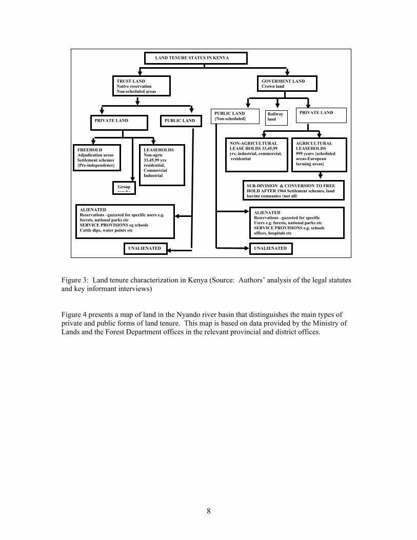
8
Figure 3: Land tenure characterization in Kenya (Source: Authors’ analysis of the legal statutes and key informant interviews) Figure 4 presents a map of land in the Nyando river basin that distinguishes the main types of private and public forms of land tenure. This map is based on data provided by the Ministry of Lands and the Forest Department offices in the relevant provincial and district offices.
LAND TENURE STATUS IN KENYA
TRUST LAND Native reservation Non-scheduled areas
GOVERMENT LAND Crown land
PUBLIC LAND PRIVATE LAND
PRIVATE LAND
PUBLIC LAND {Non-scheduled}
FREEHOLD Adjudication areas Settlement schemes {Pre-independence}
LEASEHOLDS Non-agric 33,45,99 yrs residential, Commercial Industrial
AGRICULTURAL LEASEHOLDS 999 years {scheduled areas-European farming areas}
NON-AGRICULTURAL LEASE HOLDS 33,45,99 yrs, industrial, commercial, residential
SUB-DIVISION & CONVERSION TO FREE HOLD AFTER 1964 Settlement schemes, land buying companies {not all}
ALIENATED Reservations –gazzeted for specific users e.g. forests, national parks etc SERVICE PROVISIONS eg schools Cattle dips, water points etc
UNALIENATED
ALIENATED Reservations –gazzeted for specific Users e.g. forests, national parks etc SERVICE PROVISIONS e.g. schools offices, hospitals etc
UNALIENATED
Group ranche
Railwayland

9
Figure 4: Land tenure adjudication in the Nyando basin of Western Kenya (Sources: Map produced by the World Agroforestry Centre GIS lab on the basis of data compiled by the authors from data supplied by the Kenya Ministry of Lands and Ministry of Forestry)
10
Multiple statutory sources of authority for land, water and tree management in the Nyando basin
The Ministry of Lands is responsible for land adjudication, survey, registration, settlement, land administration, and land use planning under the statutory land tenure system of Kenya. Currently there are more than twenty statutes that are used for land administration, which make the process confusing and expensive. Formal land administration in Kenya is very centralized, with lands, survey, physical planning, settlement and adjudication handled by relatively independent departments of the Ministry. At the local level, the functions of the Ministry of Lands are handled by a number of boards and committees. Land Control Boards are responsible for approving or denying land transactions on freehold land. Liaison committees receive and resolve contentious issues on development applications that have not been approved by the local authorities. Plot allocation committees deal with issues of allocation of public land to public or private individuals and entities for development purposes. Local adjudication committees and arbitration boards facilitate the process of adjudication of land. The Environment Management and Coordination Act Cap 8 of 1999 attempts to provide an appropriate legal and institutional framework for the management of the environment. It creates the National Environment Council (NEC), the National Environment Management Authority (NEMA), the Provincial and District Environment Committees and the Public Complaints Committee, the National Environment Action Plan Committee, the Technical Advisory Committee on Environment, the Establishment of Standards and Enforcement Review Committee. It also establishes the National Environment Trust Fund, the National Environment Restoration Fund and provides for Deposit Funds. The National Environment Management Authority was established in July 2002 and made responsible for coordinating and supervising all matters related to the environment. NEMA is responsible for the preparing environment action plans, protecting and conserving the environment, including key water resources rivers, lakes, wetlands, hillsides, hilltops and the coastal zone. It establishes guidelines and procedures for environmental impact assessment of policies, programmes and projects likely to have significant environmental impact. It enforces quality control standards and can issue environment restoration orders, environmental easements, and environmental conservation orders (Buigutt, 2004). Department of Forestry: The Forest Act Cap 385 of 1962 (revised 1982 and 1992) is implemented by the Forest Department of the Ministry of Environment and Natural Resources. According to this act, “a forest area means an area of land declared under section 4 to be a forest area”. The act addresses preservation, protection management, enforcement and utilization of forest resources on forest reserves which must be reserved through a gazette notice as forestland. This limits forest development by the government to specific regions. Degazettement of forest lands is periodically undertaken to make way for new settlements. Concerns about the continual loss of forest lands and forest functions led to the drafting of a new Forestry bill. That new bill attempts to expand the definition of forest to include all types of woody vegetation. It also attempts to address issues of gazettement and de-gazettement, and provide for greater community involvement in forest management. The Forestry Bill was rejected by parliament in early 2004.
11
The Ministry of Agriculture is the leading agency in agriculture matters and the Agricultural Act Cap 318 of 1963 is the principle legislation. The act provides for the development of agricultural land use in accordance with accepted practice of good land management and husbandry. It provides for the conservation of soil and its fertility. It also empowers the Minster of Agriculture to make preservation rules to regulate, control and prohibit the clearing of land for cultivation, grazing or watering of livestock with a view to protecting land against floods, land slides, formation of gulleys, and destruction from roads and other infrastructures. Soil and water conservation has been given some level of priority by the Ministry of Agriculture and the Office of the President. The National Soil and Water Conservation Programme (NSWCP) was supported by the Swedish International Development Agency (Sida) for the 25 years that ended in the year 2000. For the last 12 years, the NSWCP implemented a catchment approach to conservation that was generally considered to be successful (Pretty and xxx). Until a re-alignment of the government structure in early 2003, the Ministry of Agriculture was responsible for supporting irrigation development. The Lake Basin Development Authority was set up by an act of parliament (Lake Basin Development Authority Cap.442) to plan for the development of the Lake Victoria basin area of Kenya and to initiate project activities that would boost economic growth and human welfare in the region. A controversial component of the Lake Basin Development Authority was its largely unsuccessful support to the conversion of wetlands into irrigated agriculture. The Ministry of Water Resources Management and Development: Until 2002, the focus of water management in Kenya was on the provision of water for domestic use, agriculture, livestock development and industrial utilization. A number of organizations were involved in the provision of water and sanitation services, including the Ministry or Department of Water, The National Water Conservation and Pipeline Corporation, Local Authorities, local communities, self help groups, non-governmental organizations, projects in the private sector, regional development authorities, and the Office of the President (for water development in the ASAL region). There was very little focus on water resource management and systems of water monitoring fell into relative disrepair. In the late 1990s, concerns about increasing water scarcity, low coverage of water services, and declining water quality led to a new water policy, new legislation and a set of reforms of the water sector. The Water Act 2002 vests all water resource in the state and provides for the formulation of a National Water Resource Management Strategy and the establishment of The Water Resource Management Authority (WRMA), the Water Services Regulatory Board (WSRB) and the Rural Water Services Trust Fund (RWSTF). The Water Act provides an elaborate structure for water resource management based on catchment areas that are defined by the WRMA in accordance with the NWRMS. The WRMA formulates a Catchment Management Strategy and appoints a Catchment Advisory Committee for each catchment. Water Users’ Associations are recognized as the primary authority for water management in rural areas. The Water Act 2002 also creates the Water Services Regulatory Board (WSRB) that concentrates more upon the utilization (services providers) of water, rather than the conservation of water. The WRSB is represented in the catchment by Water Service Boards who oversee water service providers. Once all of these new authorities are functional, the Ministry of Water will focus on the provision of information and implementation of policy.
Multiple social authorities for land, water and tree management in the Nyando basin

12
The Nyando river basin is comprised of two major language groups – Luo and Kalenjin – with small minorities of other ethnic groups. Luo-speaking people reside primarily in the low and mid-altitude parts of the basin, while Kipsigis Kalenjin and Nandi Kalenjin reside primarily in the upper parts of the basin. The Ogiek are a small ethnic group whose customary habitat is the forests in the upper parts of the basin. Resettlement of the large farms in the “white highlands” has led to the co-existence of distinct clusters of Kipsigis Kalenjin with people of other ethnic groups, including Kikuyu, Kisii and Luhya. One spatial settlement pattern was one of the factors that contributed to politically-motivated “tribal clashes” in 1992, 1994 and 1997. The Luo ethnic group is well known in Kenya for the strength of its customary authorities and the large number of prohibitions and restrictions on individual land use. Polygamy is common and polygamous households have a complex system of duties and obligations. Clans and sub-clans are very important sources of social authority; village committees are unlikely to succeed if they do not deliberately include representatives of all clans or sub-clans. Women have very little independent access to land under Luo customary law, with the exception of a small home garden (Orundu) that even junior wives are entitled to (Onyango, 2002). Lack of control over land also severely constrains women’s access to water sources, since almost all water sources are established in private lands. Women thus have full responsibility for the provision of water for the domestic needs of their households, with almost no authority to manage their water sources. Land management at the village and farm scales are also affected by the activities of a number of important projects and programmes. Perhaps most important of these are the focal area development committees and common interest groups that have been established with support from the Ministry of Agriculture under the National Soil and Water Conservation Programme, the National Agriculture and Livestock Extension Programme, the Lake Victoria Environment Management Programme, and the World Agroforestry Centre (ICRAF). Focal area development committees are elected by local communities to coordinate local contributions to extension and development plans developed by the communities and extension agents. Common interest groups form within those communities to address issues of common interest – often including spring protection, water pan construction, soil fertility enhancement, fuel energy conservation and income diversification. Hundreds of such community groups have been established over the last 15 years. In one part of the Nyando basin, ICRAF and the Ministry of Agriculture has been supporting coordination among neighbouring focal area development committees (Swallow et al., 2003). At the village level, rights and access to water are also affected by both customary authorities and area-based projects. In this area of rural Kenya, water service projects have been supported by the Ministry of Health, the Ministry of Water, the Ministry of Agriculture as well as a number of non-governmental organizations. Conclusions The above review illustrates the surprisingly large arrays of formal land tenure types and sources of statutory and customary authority over land and water management in the Nyando basin. While it appears that this complex land tenure system creates many problems for watershed management, insecure private rights to cropland is not one of the most compelling problems. High rates of erosion in the lower part of the basin are associated with private uncultivated areas that are overused for grazing and wood collection. High rates of erosion in the upper part of the basin appear to be more associated with the private allocation and farming of steep hillsides.

13
Gulley formation and low quality water in the mid-altitude areas are associated with springs that are commonly used, but located on private land. Deforestation and cultivation of riparian areas is associated with privatization of riverine areas, together with ineffective enforcement of rules on the use of those areas. Lack of public infrastructure for water management is partially associated with the lack of public or collective land on which to locate water storage structures. The Government of Kenya is currently undertaking a review of its land tenure and land policy. Whatever emerges from that review, however, it is unlikely that there will be a large reallocation of land from private individuals to the government. What is more feasible is that the public and collective interests in those key components of the watershed are exerted through new instruments such as environmental easements. However, that approach will require engagement with key statutory and social authorities. Catchment authorities or environment committees will be most effective if they are able to operate with the support of social authorities such as clan elders, water and land management projects, and local authorities. The Nyando case is complex, perhaps more so than most other watersheds in Africa. Nonetheless, it illustrates the importance of linking science with policy and institutional design: better scientific understanding of the catchment hydrology can lead to a policy and programme focus on small discrete parts of the catchment. The Nyando case also shows the need to understand the complex linkages between property rights and watershed management problems. And, finally, it illustrates the need to involve multiple social and statutory authorities in watershed management, including the various government institutions whose responsibilities and mandates often overlap and conflict. References Buigutt, K.S.A. (2004). The Mandate of the National Environmental Management Authority and Implementation of the Environmental Management and Co-Ordination Act (1999). .” In David Mungai, Brent Swallow, Joseph Mburu, Leah Onyango and Anna Njui, eds, (2004). Proceedings of a Workshop on Reversing Environmental and Agricultural Decline in the Nyando River Basin. World Agroforestry Centre (ICRAF), the National Environment Management Authority of Kenya (NEMA), the Water Quality Component of the Lake Victoria Environment Management Programme (LVEMP), and the Ministry of Agriculture and Rural Development, Nairobi, Kenya. Central Bureau of Statistics (2003). Poverty in Kenya. Central Bureau of Statistics and the International Livestock Research Institute. Nairobi. DENR (1998). The Philippines Strategy for Improved Watershed Resources Management. Forest Management Bureau, Department of Environment and Natural Resources. Manila, The Philippines. Gebremedhin, Berhanu and Scott M. Swinton (2003), Investment in soil conservation in northern Ethiopia: the role of land tenure security and public programs, Agricultural Economics 29(1): 69-84. Kerr, John, Ganesh Pangare and Lokur Pangare (2002). Watershed Development Projects In India: An Evaluation. IFPRI Research Report 127, International Food Policy Research Institute, Washington DC. Kiara,J., Munyikombo, L.S., Mwarasomba, L.S, Pretty, Jules, Thompson, John. 1999. Impact of the catchment approach to soil and water conservation: Experiences of the Ministry of
14
Agriculture, Kenya. In: Fiona Hinchcliffe, John Thompson, Jules Pretty and Parmesh Shah (Editors). London: Intermediate Technology Publications. Knox, Anna, Ruth Meinzen-Dick and Peter Hazell (1998), Property Rights, Collective Action and Technologies for Natural Resource Management. CAPRI Working Paper No. 1. Washington DC: IFPRI. Meinzen-Dick, Ruth S. and Rajendra Pradhan (2002). Legal Pluralism and Dynamic Property Rights. CAPRI Working Paper 22. CGIAR System-Wide Program on Collective Action and Property Rights, IFPRI, Washington, DC. Mungai, David, Brent Swallow, Joseph Mburu, Leah Onyango and Anna Njui (eds.) (2004). Proceedings of a Workshop on Reversing Environmental and Agricultural Decline in the Nyando River Basin. World Agroforestry Centre (ICRAF), the National Environment Management Authority of Kenya (NEMA), the Water Quality Component of the Lake Victoria Environment Management Programme (LVEMP), and the Ministry of Agriculture and Rural Development, Nairobi, Kenya. Onyango, Leah (2002). “Agroforestry: Rural Women’s Participation in Agroforestry and its Implications on a Sustainable Rural Environment in Nyando District.” MA thesis, Department of Urban and Rural Planning, University of Nairobi. Pretty, J. and P. Shah. 1999. Soil and water conservation: A brief history of coercion and control. In: F. Hinchcliffe, J. Thompson, J. Pretty and P. Shah (Editors). London: Intermediate Technology Publications. Swallow, B., A. Okono, C. Ong and F. Place, 2003. “TransVic: Improved Land Management across the Lake Victoria Basin,” In R.R. Harwood and A.H. Kassam (eds.), Research Towards Integrated Natural Resource Management: Examples of Research Problems, Approaches and Partnerships in Action in the CGIAR.. CGIAR Interim Science Council: Centre Directors’ Committee on Integrated Natural Resources Management, Rome, Italy, pp 65-78. Swallow, Brent M., Dennis P. Garrity and Meine van Noordwijk (2002), “The effects of scales, flows and filters on property rights and collective action in watershed management” Water Policy 3(6): 457-474.
Tabacchi, Eric, David L. Correll, Richard Hauer, Gilles Pinay, Anne-Marie Planty-Tabacchi, Robert C. Wissmar (1998), Development, maintenance and role of riparian vegetation in the river landscape, Freshwater Biology 40(3): 497-516.
Tiffen, M. and F. Gichuki. 2000. People, property and profit in catchment management: examples from Kenya and elsewhere. In Integrated watershed management in the global ecosystem, ed., Rattan Lal. Boca Raton, FL: CRC Press, pp. 305-325. Van Noordwijk, M., M. van Roode, E.L. McCallie and B. Lusiana, 1998. “Erosion and sedimentation as multiscale, fractal processes: implications for models, experiments and the real world,” In F.W.T. Penning de Vries, F. Agus and J. Kerr (eds.), Soil Erosion at Multiple Scales, CAB International, pp. 223-253.
Walsh, Markus, Keith Shepherd and Lou Verchot (2004), “Identification of Sediment Sources and Sinks in the Nyando River Basin,” In David Mungai, Brent Swallow, Joseph Mburu, Leah
15
Onyango and Anna Njui, eds, (2004). Proceedings of a Workshop on Reversing Environmental and Agricultural Decline in the Nyando River Basin. World Agroforestry Centre (ICRAF), the National Environment Management Authority of Kenya (NEMA), the Water Quality Component of the Lake Victoria Environment Management Programme (LVEMP), and the Ministry of Agriculture and Rural Development, Nairobi, Kenya. Ziegler, A.D., R.A. Sutherland and T.W. Giambelluca (2001). “Acceleration of Horton overland flow and erosion by footpaths in an upland agricultural watershed in northern Thailand,” Geomorphology, Volume 41, Issue 4, December 2001, Pages 249-262.