case study bible 2015
TRANSCRIPT

Name…………………................

The Case study has 3 levels in the mark scheme. It is worth 9 marks + 3 for SPaG. 12 altogether!
-If you don't name an actual example you can not get beyond level 1. (1-3 marks)
-To access level 2 you must make a point and develop it (3 of them for top level 2). Remember to answer both parts of the question (4-6 marks)
-For level 3, answers are described, explained and have numerous place specific details. (7-9 marks)
Where possible mention SEE- Social, Economic, Environmental.
Use paragraphs and key terms. There are 3 marks available for good SPaG.
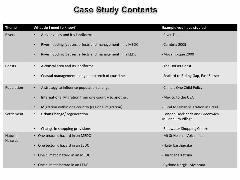
Theme What do I need to know? Example you have studied
Rivers • A river valley and it’s landforms
• River flooding (causes, effects and management) in a MEDC
• River flooding (causes, effects and management) in a LEDC
-River Tees
-Cumbria 2009
-Mozambique 2000
Coasts • A coastal area and its landforms
• Coastal management along one stretch of coastline
-The Dorset Coast
-Seaford to Birling Gap, East Sussex
Population • A strategy to influence population change.
• International Migration from one country to another.
• Migration within one country (regional migration).
-China’s One Child Policy
-Mexico to the USA
-Rural to Urban Migration in Brazil
Settlement • Urban Change/ regeneration
• Change in shopping provisions.
-London Docklands and Greenwich Millennium Village
-Bluewater Shopping Centre
Natural Hazards
• One tectonic hazard in an MEDC
• One tectonic hazard in an LEDC
• One climatic hazard in an MEDC
• One climatic hazard in an LEDC
-Mt St Helens- Volcanoes
-Haiti- Earthquake
-Hurricane Katrina
-Cyclone Nargis- Myanmar

Upper Course-Source high in the Pennines (893m
above sea level)-High run off as steep V shaped
valleys of impermeable rock -High rainfall – good water supply
-Many tributaries -High Force waterfall – tallest in
England 21 metres high
-Gorges, rapids and potholes at Low force
Middle Course-Clear widening and
meandering -Meanders cut off in the 19th
century-Sides become less steep
-Lateral erosion
Lower Course-Very urbanised and large populations. Eg Yarn
-Important wildlife seals & migratory birds also SSSI
-Ox bow lakes -Large oil, gas and petrochemical industries (as flat
land)-Natural Levees formed due to silt build up
-Mouth is in the North sea -Wide Mudflat and Tees estuary (tidal)
-Huge water sports complex Tees Barrage
River Management-Long history of flash flooding
-Cow green reservoir, controls water supply for industries along the
river-Straighten the river for easier navigation during the industrial
revolution Flood protection schemes in Yarn
85 miles in length
It drains an area of
710 square miles Upper Course: High Force Waterfall-
a famous waterfall at the upper course of the River Tees

Responses

Characteristics of Mozambique-South East Africa, bordered by the Indian
Ocean. -The floods happened in February 2000
-Life expectancy before the flood was only about 47 years.
90% of the people of Mozambique have to live on less that $1 a day (about 60p). -83% of people work in agriculture. Social impacts
-1 million people lost their homes. -Thousands of people drowned. -The flood survivors had to go to refugee camps without much food or water and with poor sanitation, so diseases spread quickly.
Economic impacts
-$30 million was needed to repair the roads, $6 million for railways and $4
million for the electricity supply.
Environmental impacts -The flood destroyed fertile
farmland.
Responses and management-Mozambique are an LEDC. GDP is 195 th in the world. Money is spent on schools and hospitals as these tend to be more urgent that flooding. -Rivers begin in other countries so they can’t always control what they do in the upper courses. -The European Union has given money to start a flood warning system. They have sensors to measure rainfall in the river catchments so they can warn people by radio and help them evacuate before a flood comes.
Why?Short term causes:-3 days of heavy rain at the start of Jan 2000. -5 weeks of almost continuous rainfall from the middle of Jan.--Cyclone Eline struck Mozambique on 22 Feb.
Long term causes:-Grasslands in the upper course of the rivers are being destroyed. These grasslands are like sponges, so without them more water gets into the rivers. -Massive urbanisation in S.Africa means more water gets into the upper courses of the rivers that end up in Mozambique.
One of the main rivers affected was
the Zambezi.


Location: Seaford to Birling Gap, East Sussex, UK.
Problems: -Shingle is lost from Seaford’s beach due to the process of longshore drift carrying material from west to east. This causes the beach to disappear and parts of the town are susceptible to flooding during storm events.
Coastal Management in place and it’s sustainability:
Hard engineering: Between 1986 and 1987 a 9 million coastal management programme was put in to place by Southern Water. One of the main developments was a terminal groyne; built towards the eastern end of Seaford’s beach to slow down the process of longshore drift. The groyne traps sediment and helps to build up the width of the beach. Advantages: Socially sustainable as it maintains the beach and helps to protect the town of Seaford from flooding. Disadvantage: Environmental impacts are worsened elsewhere. For example, erosion is increased at Birling Gap because the groyne traps much needed sediment and is starving the area of replenished material. In terms of economic sustainability it could be considered to be quite cheap because of how long this groyne will last for and it does a good job of maintaining the beach and protecting the town of Seaford from flooding. Conflict: Birling Gap is starved of material and the residents there feel that this is unfair and want protection for their settlement.
Hard engineering: Rip rap is place in front of the cliffs at Seaford Head. These are big concrete boulders designed to absorb wave energy and reduce erosion of the cliff. Economically sustainable because they are relatively cheap. Conflict: Environmentalists think that the rip rap is an eyesore and intrudes on the natural landscape.
Soft engineering: Beach replenishment in Seaford- Twice a year a firm of contractors arrive to redistribute the shingle at Seaford Bay. The process takes about 3 weeks and employs 6 earthmovers, two bulldozers and a digger. The contractors move the material back from the east to the centre to replace the material that was carried by LSD. This creates a wide beach to protect the town from flooding. Economically expensive as it is costing £100,000 each year to carry out, however when you compare this with what the economic costs of the flooding would be this seems a cheap price to pay. Conflict: Local people are unable to use parts of the beach whilst this is taking place and it could impact upon tourism. However this is managed by carrying out the activity during the winter.


A case study of managing population change- China and
the one child policy. • Background - Started – 1979 but the policy has
recently been relaxed in Nov 2013 and you can now have a second child.
• Reason for policy – concerns over the rapidly growing population. (China has 1.3bn people)
• Exceptions – twins. If you live in rural areas (the 2nd child helps on the farm)
• Has it been successful – Yes. The population is growing more slowly, but it is still growing.
• However many religious and human rights groups think it is wrong.
• Should education of family planning play a bigger part now?
• Consequences of not keeping to it • Fines. • Have to pay for education/ health care.• Gender Benefits of keeping to it– • Access to health care, education and housing. • Other effects of the law: • The elderly now have fewer young people to look
after them. Or the young have more people to look after. Higher dependency ratio
• Incidents of female infanticide have been recorded (killing baby girls), and lots more selective terminations.
• Gender imbalance – reportedly 120 boys to 100 girls.

What is the situation? There is a 2000km border between USA and Mexico. 1 million+ Mexicans migrate to the USA each year.
CausesPush Factors (reasons why people leave Mexico): Poor medical facilities (1800 per doctor), low paid jobs (GNP= $3,750), Adult literacy rates 55%- poor education prospects, life expectancy 72 years, 40% unemployed. Pull Factors (reasons why people are attracted to the USA): Excellent medical facilities (400 per doctor), well paid jobs (GNP $24, 750), Adult literacy rates 99%- good education prospects, many jobs available for low paid workers such as Mexicans. Consequences
Management of this migration:The USA has tried to limit the numbers coming across by constructing a physical barrier.However, it is almost an impossible task of trying to cover the 2000km border. Most believeit is unlikely it will ever be completed. The government provides patrols to limit the numberof people crossing the border.
What are the impacts on the USA?
•Illegal migration costs the USA millions of dollars for border patrols and prisons•Mexicans are seen as a drain on the USA economy•Migrant workers keep wages low which affects Americans•Cultural and racial issues•Mexican migrants benefit the US economy by working for low wages•Mexican culture has enriched the US border states with food, language and music•The incidents of TB has been increasing greatly due to the increased migration
What are the impacts on Mexico?
•The Mexican countryside has a shortage of economically active people•Many men emigrate leaving a majority of women who have trouble finding marriage partners•Young people tend to migrate leaving the old and the very young•Legal and illegal immigrants together send some $6 billion a year back to Mexico•Certain villages such as Santa Ines have lost 2/3 of its inhabitants

Impacts on the NE of Brazil (Caatinga)•Young men and women leave the area in search of a better quality of life which they think can be found in the cities of the south east. (Think push/pull factors!)•They send money back to families in the countryside. •The Caatinga area now has less young, energetic fit and healthy people to help farm the land and run the house. •The young and elderley find life an even bigger struggle and cannot look after themselves as well.
Impacts on the SE of Brazil (Belo Horizonte, Rio De Janeiro and Sao Paulo)•Growth of slums (also known as favelas and shanty towns)•Over 150,000 live in Rocinha•The government cant supply basic services/ infrastructure to these slums – sewerage, water, electricity. •40% of people live (in Rocinha) in slums that often built poorly and illegally, but are difficult to move on. •Planning how land should be used is very difficult. •Overcrowding of schools and other services.
Where?Rural to Urban migration is occurring in North East Brazil. People are pushed away from the drought ridden area know as the ‘Caatinga’ such as Sao Francisco and Nova Casa Nova and are being pulled to the big cities in the south east such as Belo Horizonte, Sao Paulo and Rio De Janeiro.
How are they managing the situation? •The self help scheme. Government subsidise (reduce the cost of) materials so residents can build more secure buildings with bricks, and tiles. •Community schemes are set up so they help each other. •Many of the settlements are 40-50km from the city centre – so transport needs to be improved. •Attempting to solve the issue of who owns the land – if the people now own it, they will be more likely to invest and look after their home (as they know they cant be evicted!) •Electricity companies are supplying more energy efficient products – low energy light bulbs, efficient fridges etc to cut down energy bills.

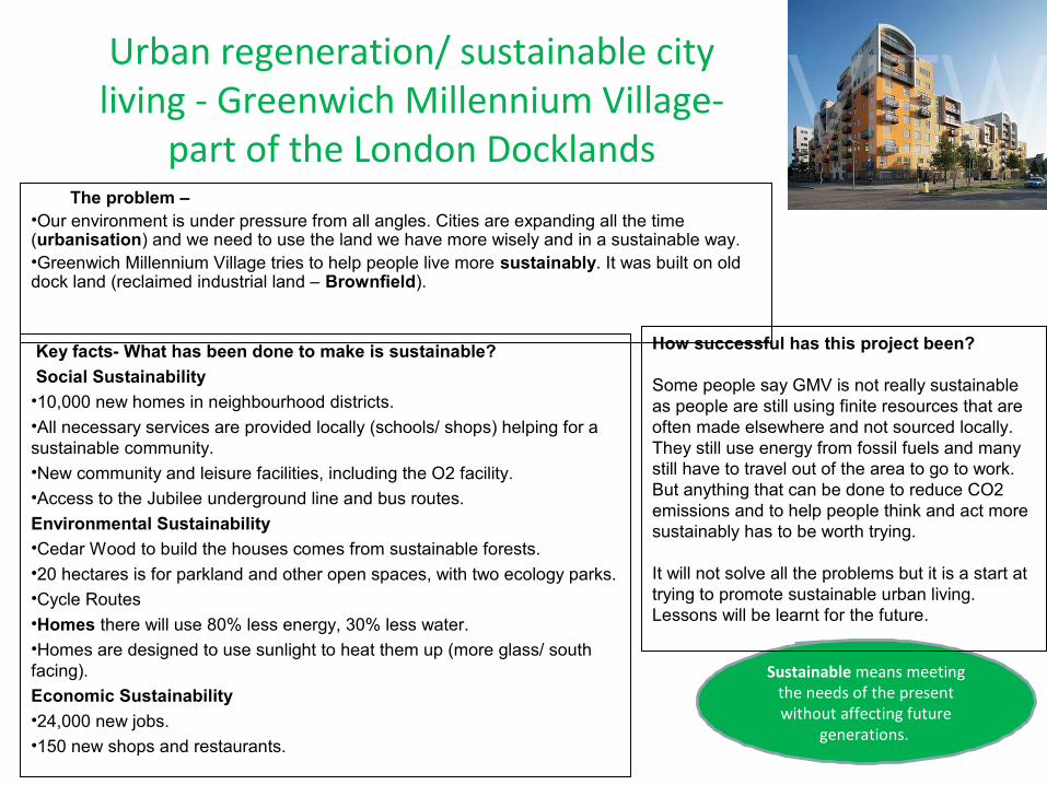
Urban regeneration/ sustainable city living - Greenwich Millennium Village-
part of the London Docklands The problem – •Our environment is under pressure from all angles. Cities are expanding all the time (urbanisation) and we need to use the land we have more wisely and in a sustainable way. •Greenwich Millennium Village tries to help people live more sustainably. It was built on old dock land (reclaimed industrial land – Brownfield).
Key facts- What has been done to make is sustainable?
Social Sustainability•10,000 new homes in neighbourhood districts.•All necessary services are provided locally (schools/ shops) helping for a sustainable community. •New community and leisure facilities, including the O2 facility. •Access to the Jubilee underground line and bus routes.
Environmental Sustainability•Cedar Wood to build the houses comes from sustainable forests. •20 hectares is for parkland and other open spaces, with two ecology parks. •Cycle Routes•Homes there will use 80% less energy, 30% less water.•Homes are designed to use sunlight to heat them up (more glass/ south facing).
Economic Sustainability •24,000 new jobs. •150 new shops and restaurants.
Sustainable means meeting the needs of the present without affecting future
generations.
How successful has this project been?
Some people say GMV is not really sustainable as people are still using finite resources that are often made elsewhere and not sourced locally. They still use energy from fossil fuels and many still have to travel out of the area to go to work. But anything that can be done to reduce CO2 emissions and to help people think and act more sustainably has to be worth trying.
It will not solve all the problems but it is a start at trying to promote sustainable urban living. Lessons will be learnt for the future.

Change in shopping provisions: Out of town shopping centre- Bluewater, KentThere has been major changes in the way we shop in the last 100 years. 1.Changes in transport- car ownership has increased so people can travel further for their shopping. This means there are fewer smaller convenience stores in rural areas, but there are more out-of-town shopping centres. They are built out of town because land is cheaper, there is more available and it is accessible with on-site parking. 2.Changing market forces- changes in supply and demand for goods and retail services. People now want a larger range of goods at cheaper prices. Small, specialist shops can not meet this demand, but larger chain stores and out of town shopping centres can- they have lots of different products under one roof at much cheaper prices. 3.Social habits have also changed- people have less time to shop for the things they really need (e.g. food) but want more leisure time to shop (e.g. clothes). This means supermarkets have become more convenient as all types of food are stocked together.
Bluewater is a brownfield site. It was built in a former chalk quarry which was in use in the 1960s-80s. Bluewater has over 14 hectares of retail space and nearly 1.5 hectares for indoor leisure use. The rest of the site is occupied by parkland, lakes and car parking.Location: Kent, SE England. 35km from central London. The nearest towns are Dartford and Gravesend. Transport Links: 40 min from central London, Served by 60 buses per hour, good motorway links such a mile away from the M25 and A2/M2, good rail links, free parking.
Bluewater has 25 million visitors per year – it has a large threshold population.
Bluewater has 11 million people living within one hours drive – so it has a good catchment area and 59% are better off “White Collar” workers.
Characteristics of Bluewater
Described as an economic success! Over 330 stores, parking for 13,000 cars, open until 9pm each day, 3 anchor stores – John Lewis, M&S, House of Fraser, Café and Restaurants, 50 acres of lakes and parkland, playgrounds and cycle ways, 12 screen cinema, crèche, safe, pleasant environment, complete leisure experience – family day. Plans to expand with railway links to places in Europe.
Impacts on shops in nearby towns such as Dartford and GravesendDartford and Gravesend now described as ‘dead heart’ places. The number of shops have declined here and the CBDs have suffered from competition. They moved to Bluewater where rent is cheaper and they can have more space. Customers also going to Bluewater instead. They are fighting back by redeveloping their town centres and they released campaigns such as ‘Shop local’.
Environmental impacts of Bluewater: increased congestion/accidents on the roads, light pollution, now acting as a growth pole by attracting more hotels and local business, have attempted to blend in by planting trees around the former quarry.


Mt St Helens was dormant for a long time but small quakes from 1980 suggested that the magma was moving. On March the 18th a quake in the volcano of 4.2 on the Richter scale signalled the volcanoes return to activity. A large “bulge” on the side of the volcano signified a build up of magma. On May 18 at 8:32 a.m., a magnitude 5.1 earthquake centred directly below the north slope triggered that part of the mountain to slide this was on of the largest landslides in history, it moved at around 110 mph and it covered about 24 square miles
Mount St Helens is on the plate boundary between the
Juan de Fuca plate and North American plate. When
it erupted it permanently changed the surrounding
landscape.
200 homes, 47 bridges, 15 miles of railways and
185 miles of highway were destroyed. U.S. President Jimmy Carter surveyed the
damage and stated it looked more desolate than
a moonscape.
*Large number of wildlife were killed by the blast and the volcanic ash with nothing
surviving in the blast zone* flooding resulting from blocked rivers
washed away road and rail bridges* crops were ruined and livelihoods of
loggers were devastated with large areas of trees being flattened like matchsticks

The country is located on a conservative plate boundary between the Caribbean Plate and the North American Plate.
3 Million people live in Port au Prince with the majority living in slum
conditions after rapid urbanisation.
The poorest country in the western hemisphere. GDP is
143/227. 66% of the population of Haiti earn less than £1 a
day with 56% of the population classed as “extremely poor”
In early January 2010 the EU released
€3 m in emergency funding.
The European Council and its member
nations later announced more than
€429 million in aid.
The governments of the United States, Israel ,the Dominican Republic, Canada, Brazil, Italy and
Cuba3 sent over 1,000 military and disaster relief personnel each, with the United States being by
far the largest single contributor to the relief efforts.
- 12th January 2010 an earthquake measuring 7.0 on the Richter scale
struck Haiti.-The focus was 13km underground-The epicentre was 25km from the
capital Port-au-Prince-Haiti suffered a huge number of
serious aftershocks.
-The number of people in relief camps of tents since the quake was
1.6 million -In July 2010, CNN returned to Port-
au-Prince and reported, "It looks like the quake just happened
yesterday“.-A January 2012 Oxfam report said
that a half a million Haitians remained homeless
-Only about 20% of aid has been spent by the Haiti government as they
have no resources.

Tropical storms have strong winds and torrential rain. They are
circular in shape and can be hundreds of km wide. They form
over tropical seas (27oC or higher). Warm moist air rises and condenses. This releases energy
which makes it grow really powerful. They lose strength as they move over land because their energy source (warm water) is cut off.
Hurricane Katrina hit the South East USA on 29th August 2005 and cost a staggering $300 billion.
The primary impacts included 1800 were killed and 300,000 homes were
destroyed. 3 million people were left without electricity and bridges including the I-
10 collapsed. Coastal habitats were also damaged.
The secondary impacts were tens of thousands
were made homeless and 230,000 jobs were lost from business that were damaged and destroyed.
Water supplies were polluted with sewage,
chemicals and dead bodies.
The USA has a sophisticated monitoring system to predict if hurricanes will hit (satellites can
track them). This means people can be evacuated. 80% were evacuated
before the storm hit, reducing the death toll. Mississippi and Louisiana declared states of emergency and
stockpiled supplies (food and water). The coastguard, police, fire
services and army rescued over 50,000 people and they had access to equipment such as helicopters.
Although the response was better than in Burma the USA government received much criticism. Some homeless families ended up
in sports stadia where conditions were intolerable and fighting etc broke out as
tensions rose. There were accusations that as it was ‘black poor people mostly affected’
the government didn’t care. Looting was commonplace. Finally, flood defences that
were supposed to protect New Orleans failed and this actually increased the damage as
flood water became trapped
Katrina was a category 4 storm. Storm surges reached over 6 metres in
height. New Orleans was one of the worst affected areas because it lies below sea level and is
protected by levees. People sought refuge in the Superdome
stadium. Conditions were unhygienic, and there was a shortage of food and water. Looting was commonplace throughout the
city. Tension was high and many felt vulnerable and unsafe.

The cyclone happened on 2nd May 2008 at the
Irrawaddy delta in Burma
The cost of the damage was $10 billion.
The primary impacts included -140,000 were killed
-450,000 homes -1700 schools were destroyed.
-200,000 farm animals were killed -40% of food stores were
destroyed. -Rice fields were flooded on the
Irrawaddy Delta
The secondary impacts were that -up to 3 million were made
homeless -millions lost their livelihoods. -Over 70% of households didn’t have access to clean water and
this caused diseases. -There was a shortage of food.
-1000’s of temples were destroyed
The Government failed to warn its people. People were not
evacuated in time
As Burma is a poor country it could not afford to plan,
predict and prepare like the USA.
The emergency services were ill prepared, had little training or equipment and
lacked numbers. The government refused to
accept foreign aid at first as they said they could cope. Its
government is a military dictator and they do not like outsiders! Aid workers were
eventually allowed in, though this was three weeks after the
cyclone.
The impacts were also greater in Burma than the
USA because many in Burma depend on farming (crops and
livestock) and much of this was totally destroyed
Additionally, they do not have flood defences and
their houses are poor quality and easily destroyed.
•Strong winds up to 135mph • • Storm surge of 7.6m
• Heavy rainfall
http://www.coolgeography.co.uk/A-level/AQA/Year%2013/Weather%20and%20climate/Hurricanes/Cyclone_Nargis.htm