case study 4: the aral sea basin...lacks a robust and comprehensive treaty. this case study will...
TRANSCRIPT

July 12, 2007 15:39 spi-b465 Bridges Over Water 9.75in x 6.5in case-study4 FA1
CASE STUDY 4: THE ARAL SEA BASIN∗
The year 1992 marks two distinct but likewise related events in the history oftransboundary water. For one, the collapse of the Soviet Union introduced a newera in international relations accompanied by several opportunities for cooperationover transboundary water. At the same time, one of the biggest environmental andnatural resources catastrophes — the degradation of the Aral Sea and the associatedenvironmental problems — became an international concern after years of beingmanaged domestically. The five newly independent states (republics) of Kazakhstan,Kyrgyz Republic (Kyrgyzstan), Tajikistan, Turkmenistan, and Uzbekistan were leftto address the shrinking sea. Given that the grave deterioration of the Aral Sea isrelatively a recent issue, it has yet to be dealt with in a serious manner. Whilenumerous statements have been issued by the riparian countries, the river basinlacks a robust and comprehensive treaty. This case study will focus, therefore, onthe factors and processes militating against full cooperation in the basin.
FEATURES OF THE BASIN
The Aral Sea extends over 690,000km2 (Kirmani and LeMoigne, 1997). The basinis formed by two of the largest rivers of Central Asia — The Amu Darya and theSyr Darya. The source of the Amu Darya is largely in Tajikistan, with a few water-courses originating in northeastern Afghanistan. The Syr Darya originates mainly inKyrgyzstan. The Aral Sea Basin has three distinct ecological zones: the mountains,the deserts, and the Aral Sea with its deltas. The Tian Shan and Pamir mountains inthe south and southwest are characterized by high altitudes with peaks over 7,000mand by an average annual high precipitation ranging from 800 to 1,600mm/year.The mountains host large forest reserves and some national parks. In the foothillsand valleys, soil and temperature conditions are favorable for agriculture. The low-land deserts of Karakum and Kyzylkum cover most of the basin area, and arecharacterized by low precipitation (under 100 mm/year) and high evaporation rates(Kirmani and LeMoigne, 1997, p. 10).
The basin coincides with almost the entire area of Kyrgyz Republic, Tajikistan,Turkmenistan, and Uzbekistan. It covers also the southern part of Kazakhstan, andthe northern part of Afghanistan and Iran (Dukhovny et al., 2006). The total mean
∗This case study benefited from research by Tim Eestermans, Lola Gulomova, Benjamin Hengst,
Pothik Chatterjee, Haik Gugarats, Elcin Caner, Max Du Jardin, Abigail Goss, Hamir K. Sahnai,
Edward Anderson, Brigid Harris, Andrea Semaan Bissar, Marco Sampablo Lauro, Nicholas M. A.
Smith, and Jeff Brez. It benefited greatly from comments by Masood Ahmad. The case study is
not aimed at covering all aspects and details.
285

Map CS4.1: The Aral Sea Basin
Source: World Bank (Permission granted to reproduce map.)

July 12, 2007 15:39 spi-b465 Bridges Over Water 9.75in x 6.5in case-study4 FA1
286 Bridges Over Water
Map CS4.1: The Aral Sea Basin
Source: World Bank (Permission granted to reproduce the map)
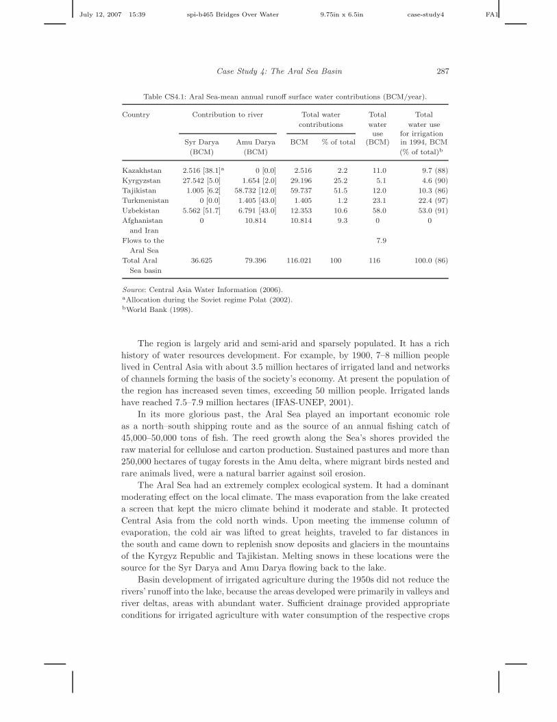
annual flow of the two rivers is estimated at about 116 BCM (Central Asia WaterInformation, 2006). Groundwater resources utilized in the basin amount to 35 BCM(Water Resources Institute, 2003). While Afghanistan and Iran contribute 9% of thebasin’s resources (Table CS4.1), they are not part of the Aral Sea Basin dispute.
The Aral Sea, which has no outlet, was the fourth largest inland (brackish) lakein the world prior to 1960. It is shared by Uzbekistan and Kazakhstan. As indicated,the Amu Darya and Syr Darya originate respectively in the Kyrgyz Republic andTajikistan, yet cross Turkmenistan, Kazakhstan, and Uzbekistan, before discharginginto the Aral Sea. In the 1950s the Aral Sea had a water volume exceeding 1,090km3
(1 km3 = 1 billion m3 = BCM), and a surface area of more than 67,900km2. Thewater level in the Aral Sea ranged seasonally between 50 and 53m above sea level(Glantz, 1999; Central Asia Water Information, 2006).
July 12, 2007 15:39 spi-b465 Bridges Over Water 9.75in x 6.5in case-study4 FA1
Case Study 4: The Aral Sea Basin 287
Table CS4.1: Aral Sea-mean annual runoff surface water contributions (BCM/year).
Country Contribution to river Total water Total Total
contributions water water useuse for irrigation
Syr Darya Amu Darya BCM % of total (BCM) in 1994, BCM
(BCM) (BCM) (% of total)b
Kazakhstan 2.516 [38.1]a 0 [0.0] 2.516 2.2 11.0 9.7 (88)
Kyrgyzstan 27.542 [5.0] 1.654 [2.0] 29.196 25.2 5.1 4.6 (90)
Tajikistan 1.005 [6.2] 58.732 [12.0] 59.737 51.5 12.0 10.3 (86)
Turkmenistan 0 [0.0] 1.405 [43.0] 1.405 1.2 23.1 22.4 (97)
Uzbekistan 5.562 [51.7] 6.791 [43.0] 12.353 10.6 58.0 53.0 (91)
Afghanistan 0 10.814 10.814 9.3 0 0
and Iran
Flows to the 7.9
Aral Sea
Total Aral 36.625 79.396 116.021 100 116 100.0 (86)
Sea basin
Source: Central Asia Water Information (2006).aAllocation during the Soviet regime Polat (2002).bWorld Bank (1998).
The region is largely arid and semi-arid and sparsely populated. It has a richhistory of water resources development. For example, by 1900, 7–8 million peoplelived in Central Asia with about 3.5 million hectares of irrigated land and networksof channels forming the basis of the society’s economy. At present the population ofthe region has increased seven times, exceeding 50 million people. Irrigated landshave reached 7.5–7.9 million hectares (IFAS-UNEP, 2001).
In its more glorious past, the Aral Sea played an important economic roleas a north–south shipping route and as the source of an annual fishing catch of45,000–50,000 tons of fish. The reed growth along the Sea’s shores provided theraw material for cellulose and carton production. Sustained pastures and more than250,000 hectares of tugay forests in the Amu delta, where migrant birds nested andrare animals lived, were a natural barrier against soil erosion.
The Aral Sea had an extremely complex ecological system. It had a dominantmoderating effect on the local climate. The mass evaporation from the lake createda screen that kept the micro climate behind it moderate and stable. It protectedCentral Asia from the cold north winds. Upon meeting the immense column ofevaporation, the cold air was lifted to great heights, traveled to far distances inthe south and came down to replenish snow deposits and glaciers in the mountainsof the Kyrgyz Republic and Tajikistan. Melting snows in these locations were thesource for the Syr Darya and Amu Darya flowing back to the lake.
Basin development of irrigated agriculture during the 1950s did not reduce therivers’ runoff into the lake, because the areas developed were primarily in valleys andriver deltas, areas with abundant water. Sufficient drainage provided appropriateconditions for irrigated agriculture with water consumption of the respective crops

July 12, 2007 15:39 spi-b465 Bridges Over Water 9.75in x 6.5in case-study4 FA1
288 Bridges Over Water
constituting less than the evapotranspiration of the preceding plants which grew inthe area. Consequently, the water balance in the Aral Sea Basin was not affected(Dinar et al., 1995).
The Problems
In the 1960s, the Soviet government initiated regional irrigation developmentprojects aimed at improving economic conditions in the region and addressing foodand fiber (cotton) security, which were a major priority for Moscow. A system ofcanals and pumps was constructed to withdraw water from the Amu Darya and SyrDarya before their discharge into the Aral Sea, and to convey the water to remotedesert areas of Kazakhstan, Turkmenistan (the Karakum Canal, described in gov-ernment publications as the “Eighth Wonder of the World” — Turkmenistan Min-istry of Irrigation and Water Economy, 1995) and Uzbekistan. The Karakum Canalis the largest canal in Central Asia. It diverts 500 m3/s from the middle of the AmuDarya to Turkmenistan. About 33% of the water used for irrigation in Turkmenistanpercolates through the sandy soils of the canal. Furthermore, seepage losses are sosignificant that they have created an 800 km2 lake alongside the Karakum Canal.
The long-term impact of these water diversions has been devastating to theAral Sea, as can be seen from Table CS4.2. While the shrinking of the lake andthe deterioration of its water quality were apparent prior to 1991, the associatedenvironmental consequences became international, and gained serious attention,only after the collapse of the Soviet Union. The environmental damages caused bythe diminishing lake have had direct and indirect health and economic consequences,such as loss of employment opportunities and elevated cancer occurrences.
Water management under the Soviets was centralized and coordinated by theMinistry of Water Management, which oversaw construction projects necessaryfor regional hydropower and agricultural needs (Langford and Vinogradov, 2001,p. 350), operation of the infrastructure and allocation of water quotas for differentuses in the five Soviet republics. Of the total 116 BCM/year diverted from the AmuDarya and Syr Darya at the end of the Soviet legacy, nearly 90% was used for irriga-tion (Dukhovny et al., 2006; Table CS4.1). The water was used mainly for growingcotton, wheat, and rice, using very inefficient irrigation technologies. Irrigation’sshare in riparian water use is estimated at 81, 94, 92, 98, and 94%, respectivelyfor Kazakhstan, Kyrgyzstan, Tajikistan, Turkmenistan, and Uzbekistan, in 1990(World Resource Institute, 2003; see also Table CS4.1).
Once the Soviet Union was dissolved, the downstream riparians, still utiliz-ing generous water allocations, immediately became dependent on their upstreamneighbors for water, dramatically increasing both the possibility for conflict in theregion as well as the need for cooperation. Today the downstream nations, whoseeconomies depend heavily on irrigated agriculture for hard currency income, viewwater management not only as an economic issue, but also as integral to theirnational security (ICG, 2006, p. 2).
With the subsequent independence of the five Central Asian republics, financialhelp from Moscow was likewise dashed. In the absence of major aid for solving the

July 12, 2007 15:39 spi-b465 Bridges Over Water 9.75in x 6.5in case-study4 FA1
Case Study 4: The Aral Sea Basin 289
Table CS4.2: Aral Sea — forty years of mining the Aral Sea and their conse-
quences.
Year Annual inflow into Water level (m) Salinity (g/l)
the Aral Sea (BCM)b
1960 56.0 53.3 10
1970 38.5 51.6 11
1976a 10.3 48.3 14
1980 8.3 46.2 16
1985 0 44.0 20
1989 5.4 39.0 28
1994a 30.6 36.8 > 35
2000a 3.5 33.4 > 60
Source: IFAS-UNEP (2001); for 1989–2000: Sanigmii (2000).aSource for 1976, 1994, and 2000: Glantz (1999). Values in 1994 and 2000 are
for the Large Sea. The small, Northern Sea, has higher water levels and lower
salinization levels.bSource: Weinthal (2002); for 1989–2000: Sanigmii (2000).
Note: Flow measurements are made in the last weir station, about 150 km from
the Aral Sea. Thus, the flow amounts do not necessarily mean that the quantity
entered the Aral Sea, although it is a very good approximation. The year 1994
was an exceptionally wet year, where precipitation was sufficient to eliminate
pumping of water from the rivers.
environmental consequences of the Sea’s deterioration, the five republics needed tomanage the problem in unison. Interestingly, their point of departure was the samewater allocations which was in place during the Soviet era, and the uneven level ofimpact each republic faces due to the lake degradation. The following sections willfocus on the regional dispute that ensued and the various agreements negotiatedamong the basin states.
HISTORY OF WATER AND OTHER DISPUTESIN THE BASIN
Increasing demand for water in each of the post-independence republics, inadequatemonitoring and measurement provisions, and lack of enforcement made the originalallocations unsustainable. Tension over water allocations increased with the lack of acentral coordinating authority. While outright resource wars have been avoided, thefive nations have been at odds with each other (Table CS4.3) adopting a “zero-sum”attitude — each country acts to maximize its water allocation without referenceto regional needs or planning. In addition, most of the states in the region haveannounced plans to build their own dams and reservoirs to increase internal watercapacity. Verbal threats have been enunciated (Table CS4.3; see also Time TableAnnex).
Two main reservoirs provide water for irrigated crops in the three down-stream states, Kazakhstan, Turkmenistan, and Uzbekistan — the Karakum in

July 12, 2007 15:39 spi-b465 Bridges Over Water 9.75in x 6.5in case-study4 FA1
290 Bridges Over Water
Table CS4.3: Water-related and other disputes among the Aral Sea Basin riparian states.
Kazakhstan Tajikistan Uzbekistan
Kazakhstan In 1997 Kazakhstan repeatedly
blames Uzbekistan for cutting
the water flow by 70%.
Border disputes. Uzbekistan
attempts to shift the border
twice during this year.
Disagreements over the terms of
an energy swap agreement.
Uzbekistan introduces visa
regime for citizens of other
member countries in the
Commonwealth of
Independent States (CIS),
which makes trade between
the countries difficult due to
border shifts.
Kyrgyzstan Kazakhstan fails to
deliver energy
under an energy
swap agreement.
Kyrgyzstan closes
Toktogul
reservoir.
Kyrgyzstan cuts water flow
from its reservoir when
Uzbekistan does not
agree to pay for water.
In 1999 Uzbekistan deploys
130,000 troops on the Kyrgyz
border to guard the reservoirs
rid the area of 4000–10,000
Islamic Movement of
Uzbekistan (IMU) and
Taliban fighters who had
infiltrated the area.
Ownership dispute over the
reservoir on the border of
Kyrgyzstan and Uzbekistan.
Border disputes.
Dispute over energy swap
agreement.
Uzbekistan places mines along
the border with Kyrgyzstan to
prevent the illegal movement
of IMU fighters from the
territory of Kyrgyzstan.
Uzbekistan introduces visa
regime for citizens of other
member countries in the CIS,
which makes trade between
the countries difficult due to
border shifts.
(Continued)

July 12, 2007 15:39 spi-b465 Bridges Over Water 9.75in x 6.5in case-study4 FA1
Case Study 4: The Aral Sea Basin 291
Table CS4.3 (Continued)
Kazakhstan Tajikistan Uzbekistan
Tajikistan At the request of
Kazakhstan,
Tajikistan releases
water every time
Kazakhstan faced
difficulties with
irrigation of fields
even though it
suffered great
losses.
Ethnic tensions rise in the north
of Tajikistan where Uzbeks
reside.
Political tensions escalate due to
civil war in Tajikistan.
Uzbekistan imposes trade
restrictions and repeatedly
closes the border, blaming
Tajikistan for aiding the IMU.
Uzbekistan places mines along
the border with Tajikistan to
prevent the illegal movement
of IMU fighters from the
territory of Tajikistan.
Uzbekistan introduces visa
regime for citizens of other
member countries in the CIS,
which makes trade between the
countries difficult due to border
shifts.
Uzbekistan Uzbekistan asks
Tajikistan to
release water
downstream
in exchange
for electricity and
gas in winter.
Disputes erupt
between
Tajikistan and
Uzbekistan due to
Uzbekistan’s
failure to comply
with agreed terms.
northern Tajikistan and Toktogul on the Kyrgyz border with Uzbekistan. Unliketheir downstream neighbors Kyrgyzstan and Tajikistan have no natural gas andoil reserves and consider the water originating on their territory to be theirresource.1
1The Kyrgyz President signed an edict in October 1997 codifying the right of Kyrgyzstan to
profit from water resources within its territories. Kyrgyzstan demonstrated a clear intent to follow
through on its plans. It has also demanded compensation for lost revenues — rather than generating
hydropower Kyrgyzstan releases water downstream to Uzbek farmers (Heltzer, 2003).
July 12, 2007 15:39 spi-b465 Bridges Over Water 9.75in x 6.5in case-study4 FA1
292 Bridges Over Water
In 1998, Kazakhstan and Uzbekistan signed barter agreements (United Nations,2006) with Kyrgyzstan, exchanging coal and electricity for water. The swap agree-ments do not specify the volume of water to be released in exchange for a giventonnage of coal nor do they indicate how water stored during wet years shouldbe released in dry years. When the states fail to meet the targets, each country’sexperts disagree as to the volume of water to be received downstream. These dis-putes occur about the volume of energy swaps and not about the time of waterrelease or other issues. As a result of these disputes, the agricultural fields of Kaza-khstan and Uzbekistan suffered dramatically due to the shortage of irrigation water.This in turn results in decrease of the water flow of the Syr Darya into the Aral Sea.
Regional Politics and Power
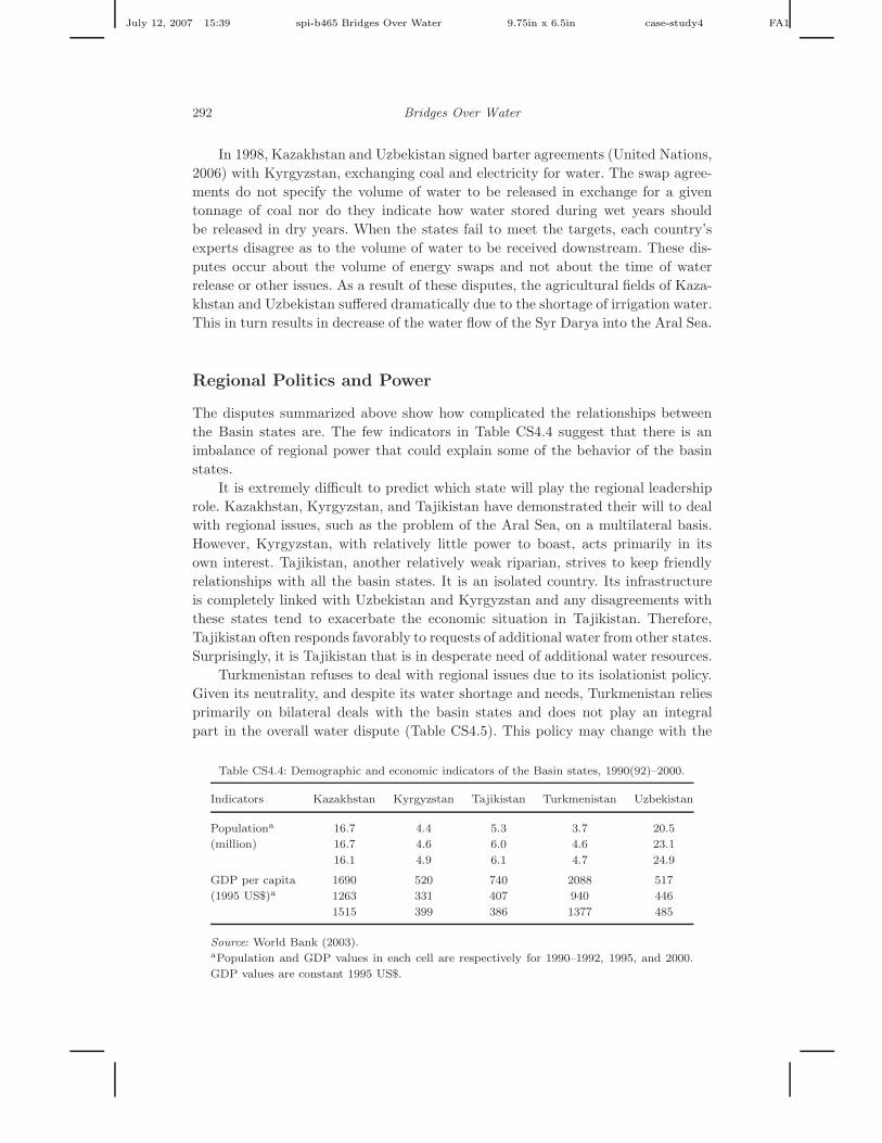
The disputes summarized above show how complicated the relationships betweenthe Basin states are. The few indicators in Table CS4.4 suggest that there is animbalance of regional power that could explain some of the behavior of the basinstates.
It is extremely difficult to predict which state will play the regional leadershiprole. Kazakhstan, Kyrgyzstan, and Tajikistan have demonstrated their will to dealwith regional issues, such as the problem of the Aral Sea, on a multilateral basis.However, Kyrgyzstan, with relatively little power to boast, acts primarily in itsown interest. Tajikistan, another relatively weak riparian, strives to keep friendlyrelationships with all the basin states. It is an isolated country. Its infrastructureis completely linked with Uzbekistan and Kyrgyzstan and any disagreements withthese states tend to exacerbate the economic situation in Tajikistan. Therefore,Tajikistan often responds favorably to requests of additional water from other states.Surprisingly, it is Tajikistan that is in desperate need of additional water resources.
Turkmenistan refuses to deal with regional issues due to its isolationist policy.Given its neutrality, and despite its water shortage and needs, Turkmenistan reliesprimarily on bilateral deals with the basin states and does not play an integralpart in the overall water dispute (Table CS4.5). This policy may change with the
Table CS4.4: Demographic and economic indicators of the Basin states, 1990(92)–2000.
Indicators Kazakhstan Kyrgyzstan Tajikistan Turkmenistan Uzbekistan
Populationa 16.7 4.4 5.3 3.7 20.5
(million) 16.7 4.6 6.0 4.6 23.1
16.1 4.9 6.1 4.7 24.9
GDP per capita 1690 520 740 2088 517
(1995 US$)a 1263 331 407 940 446
1515 399 386 1377 485
Source: World Bank (2003).aPopulation and GDP values in each cell are respectively for 1990–1992, 1995, and 2000.
GDP values are constant 1995 US$.

July 12, 2007 15:39 spi-b465 Bridges Over Water 9.75in x 6.5in case-study4 FA1
Case Study 4: The Aral Sea Basin 293
Table CS4.5: Regional power relations and behavioral pattern.
State Political power within the region and behavioral pattern
Kazakhstan Strong, often acts as mediator in basin disputes
Kyrgyzstan Medium, but acts in its own benefit. Plagued by ethnic and
political unrest since 1990
Tajikistan Weak, adopts a friendship framework. Fell into civil war immediately
upon gaining independence (among liberals, pro-Communists and
Islamists)
Turkmenistan Adopts an isolationist policy on regional issues
Uzbekistan Strong, considers itself a regional leader yet often acts unilaterally
on different regional matters
passing away of Turkmenistan’s life-long ruler, Saparmurat Niyazov or as he usedto be called — Turkmenbashi (father of the Turkmens).
ATTEMPTS AT CONFLICT MANAGEMENT —
THE NEGOTIATION PROCESS ANDREGIONAL AGREEMENTS
Since some of the states’ land and population shares in the basin range between 50%and 99% (Heltzer, 2003), it is clear why the riparians are eager to covet as muchof the Basin’s resources as possible. The desire of the upstream states to utilizeriver flows for hydropower during winter has been incompatible with the desire ofthe downstream states to store upstream water for irrigation during the dry season.During the Soviet era, the timing for releasing the water downstream was dictatedand enforced by Moscow. After independence, however, the need for negotiationsbecame much more critical. In fact, between 1991 and 1994, more than 300 informalagreements concerning the Aral Sea Basin were concluded as compared with onlythree formal agreements signed prior to the collapse of the Soviet Regime (Peachey,2004).
Basin-Level Agreements and Plans
In 1986, the Soviet Union created the Syr Darya and Amu Darya Basin Manage-ment Organizations (BVO) mainly for internal coordination purposes. They werenot forums for negotiation but rather management authorities to oversee plansapproved by the Soviet Ministry of Water Management (Dukhovny et al., 2006).Three international agreements were likewise concluded between the Soviet Unionand Afghanistan.
The first Agreement — The Frontier Agreement between Afghanistan and theUSSR — was signed in 1946. It established a joint commission aimed to discusswater issues related to the Amu Darya, which forms a border between the two

July 12, 2007 15:39 spi-b465 Bridges Over Water 9.75in x 6.5in case-study4 FA1
294 Bridges Over Water
countries. It also codified a water allocation regime, allotting 9 BCM of the PyandjRiver to Afghanistan and the remainder to the USSR (Ahmad and Wasiq, 2004;Votrin, 2006).
The second Agreement between the two states — Treaty Concerning the Regimeto the Soviet-Afghan Frontier — was signed in January 1958. It established water-related environmental and ecological standards. The two states agreed to refrainfrom actions that alter the course of frontier waters, and to restore the waterwaysif they do begin to diverge from their previous route. They also agreed to preventwater pollution and to exchange data and information regarding water levels andvolume. In addition, they also agreed to establish a flood warning system.
In June 1958, the two countries concluded their third, and final water Agree-ment — The Protocol between the USSR and Afghanistan Concerning the JointExecution of Works for the Integrated Utilization of the Water Resources in theFrontier Section of the Amu Darya. The treaty promoted the shared utilization ofthe waters of the Amu Darya between the two countries (Ahmad and Wasiq, 2004;Votrin, 2006).
The need for a dispute resolution framework became apparent when the SovietUnion was dissolved in December 1991. The path to such a framework has beenanything but direct, however, and has required numerous agreements and institu-tional changes to arrive at the present structure (de Chazournes, 2006). The fol-lowing section will trace the process leading to this structure and the agreementsreached.2
The Almaty Agreement (1992) and the InterstateCommission for Water Cooperation
The creation of five new states necessitated the formation of a regional institutionfor dispute resolution. In February 1992, a mere three months after the official dis-solution of the USSR, the Ministers of Water Resources for the five states signed theAgreement on Cooperation in the Management, Utilization and Protection of WaterResources in Interstate Sources in Almaty. This agreement established a frameworkto resolve water disputes, but also set water allocation levels at Soviet era quanti-ties until the states could reach a solution amenable to all parties. This essentiallyfavored downstream (agriculture intensive) states, and provided no allocation forAfghanistan (O’HARA, 2004).
Another result of the Almaty Agreement was the creation of the InterstateCommission for Water Cooperation (ICWC), comprised of the basin’s Ministersof Water Resources. ICWC’s objective has been to develop a single water policythat meets the interests of each state while sustaining the basin resources. ICWCis also responsible for managing and monitoring water allocations and serves as the
2Provisions to include Afghanistan in this framework once that country formulates a stable gov-
ernment and is better able to predict and insist its water needs, will have to be made.

July 12, 2007 15:39 spi-b465 Bridges Over Water 9.75in x 6.5in case-study4 FA1
Case Study 4: The Aral Sea Basin 295
reporting authority for the re-established Amu Darya and Syr Darya Basin Man-agement Organizations (BVOs). The BVOs make recommendations to the ICWCfor short-term and long-term water development for their respective basin, takinginto account allocation, water quality, conservation, and environmental protectionissues (Vinogradov, 2001).
The Agreement on Joint Activities in the Aral Sea (1993)
This new agreement, which was signed between all five heads of state on 26 March1993, addresses the environmental, social, and economic issues of the Aral Sea Basin.While the treaty was non-binding and provided no dispute resolution mechanisms,it established regional institutions for water management in the basin. These orga-nizations are discussed in detail in the next section. As stated by Article III of theagreement, Russia participated as an observer in addressing the Aral Sea crisis, andprovided financial and technical assistance (IWL, 2006; Roll et al., 2006).
The ICAS, the IFAS, and the SDC (1993–1995)
Additional organizations were created between 1993 and 1995 to support the man-agement of the Aral Sea Basin. These included the Interstate Council on the AralSea Basin (ICAS) that was formed to develop policies and proposals for the man-agement of the Aral Sea Basin (Peachey, 2004); the International Fund for the AralSea (IFAS), designed to manage contributions and to finance program activities(Mukhammadiev, 2001); the Sustainable Development Commission (SDC) formedto ensure that socio-economic issues were considered by ICAS when determiningnew policy, and the Executive Committee of the ICAS (EC-ICAS), which was giventhe responsibility of implementing programs set forth by the Aral Sea Basin Pro-gram (ASBP).
The (ASBP)-International Involvement (1994)
The ASBP, initiated in 1994, is a consortium of international organizations such asUNDP, UNEP, the World Bank, and the EU. It is aimed at identifying long-termsolutions for the basin’s wide-ranging problems (environment, water management,rehabilitation of the disaster zone around the lake). It is also charged with improvingthe capacity of the riparian states to implement these programs (World Bank, 1998).
A review of the Aral Sea management framework structure, following theinitiation of the ASBP, found that there was a lack of clarity in the roles andfunctions between the newly formed ICAS and the ICWC, as well as between theICAS and the EC-ICAS (Vinogradov, 2001). In response, the five riparian statesagreed in 1997 to restructure the institutional framework, leading to a new IFASthat combines the ICAS and the previous IFAS. The EC-ICAS was transformed intothe EC-IFAS which, along with the SDC and the ICWC, were to answer directly tothe new IFAS board members. The revised institutional framework of the Aral Sea

July 12, 2007 15:39 spi-b465 Bridges Over Water 9.75in x 6.5in case-study4 FA1
296 Bridges Over Water
Basin along with the ASBP are considered a major factor in improved cooperationin the basin (see also section on the North Sea restoration).
Main Declarations, Bilateral and Multilateral Agreements,
and Unilateral Legal Initiatives (1995–2003)
Below we provide a very short review of major negotiated outcomes and unilateralinitiatives. The details can be found in (IFAS, 2006) and (Roll et al., 2006). Theyare also summarized in the Annex.
Between 1995 and 2003, four declarations were made by the riparian statespertaining to the improvement of the basin (IFAS, 2006). Following the formationof the ASBP, the Nukus Declaration (September 1995) discusses the sustainabledevelopment of the Aral Sea Basin and affirms the financial obligations of the statesto the ICAS, IFAS, and the SDC. The Almaty Declaration (1997) proclaims 1998 asthe Year of Protection of the Environment in the region. The declaration recognizesthat an eco-system approach should be used in the region’s water resource manage-ment. The Ashgabat Declaration (1999) emphasized the support for joint actionsto address common environmental problems in the basin (Roll et al., 2006) andannounced the implementation of the Water Resources and Environment ControlProject (improved use of water and other natural resources). The 2002 DushanbeDeclaration establishes major directions for solving the problems related to the AralSea, and for improving monitoring and information exchange on water and othernatural resources.
Bilateral and Multilateral Water Agreements
As alluded to earlier, a complex water storage system had been built during theSoviet era on the Amu Darya and Syr Darya to store water in winter for use in thesubsequent summer for irrigation and electricity generation. Since independence oneof the lingering problems continues to be the operation and maintenance of infras-tructure and hydraulic facilities. The issue was partly addressed by the FrameworkAgreement. The Agreement stated that the infrastructure would be owned by thestate where it was located, though the liability for the management activities wouldbe shared among them (de Chazournes, 2006).
To cope with the remaining problems, states reverted to short-term bilateraland trilateral agreements. Most of these agreements pertained to the Syr Darya as itsuffers from greater water scarcity and requires additional attention. Furthermore,the upstream riparian on the Amu Darya, Tajikistan, had been engaged in a civilwar in the mid-1990s, which hindered its ability to negotiate.
In truth, these informal arrangements have not been successful over time. Themain issue of dispute has been the lack of long-term compensation mechanisms fromthe downstream states to the upper riparians. This has resulted in a more formalizedand predictable framework, to avoid such disputes from arising, instead of the seriesof ad hoc agreements to establish energy and water trade-offs. An illustration of theresult of such arrangements can be seen at the Toktogul hydropower station and

July 12, 2007 15:39 spi-b465 Bridges Over Water 9.75in x 6.5in case-study4 FA1
Case Study 4: The Aral Sea Basin 297
reservoir, on the Syr Darya in Kyrgyzstan, which controls the release of water tothe downstream riparian states.
The Syr Darya Framework Agreement. This agreement, also referred to asthe Bishkek Agreement, was signed by the Prime Ministers of Kyrgyzstan, Uzbek-istan, and Kazakhastan in 1998 (de Chazournes, 2006). Tajikistan became a signa-tory to the agreement only later, in 1999, as its civil war was coming to an end.The agreement demonstrated support for cooperative management of the basin’sresources and was an attempt to resolve the issue of exchanging fuel for water, apoint of contention among the upper and lower riparians.
The agreement specified that Kyrgyzstan should be compensated by the down-stream riparians (Uzbekistan and Kazakhastan) for the costs of maintaining theinfrastructure related to water storage, and subsequently the potential hydropowerproduction it foregoes in the winter (McKinney, 2004). The agreement is basedon the proposed management and maintenance of the five reservoirs: Toktogul,Kairakum, Charvak, Chardarya, and Andijan, in the Syr Darya Basin. The treatyalso pertained to the timing of water storage releases from the Toktogul reservoirand the related compensation schemes among the riparians. In addition, the agree-ment takes into account the issue of the value of the water released.
Article IV of the agreement declares that energy losses, as a result of reducedwater releases during the nonvegetative period (winter months), shall be compen-sated with coal, gas, and electricity, or their monetary equivalent. A tariff will beincluded in these exchanges based on costs of operation, maintenance, and recon-struction of hydrotechnical facilities.
The treaty also declares that the four nations will seek agreement on construc-tion of new hydropower facilities, and promote the use of monetary exchange as areplacement for current energy exchanges. The riparians likewise agreed to reducethe amount of pollutants released into the river, and to develop water saving tech-nologies.
Box CS4.1: The Syr Darya Water-Energy Swap Agreement in Numbers.
Kyrgyzstan receives 1.1 million of kWh of power in electricity or coal, valuedat $22 million, and 400 million kWh of power plus 500 million m3 of gas, val-ued at $48.5 million, from Kazakhstan and Uzbekistan respectively. In returnKyrgyzstan delivers 3.25 BCM of water from the Toktogul Reservoir in monthlyflows and 1.1 billion kWh of summer hydroelectric power to both Kazakhstanand Uzbekistan.
Source: United Nations Treaty Collection (2006).
Overall, the 1998 Barter Agreement seems reasonable. Since Kazakhstan andUzbekistan benefit from timely water releases from Kyrgyz dams, it is only fair thatthey pay for part of the maintenance and operation of the dams. However, the factthat Uzbekistan pays more than Kazakhstan for the same amount of water andpower could be challenged. Furthermore, is it fair that Uzbekistan and Kazakhstanpay for the maintenance and operation of the dam plus pay for the water releases?

July 12, 2007 15:39 spi-b465 Bridges Over Water 9.75in x 6.5in case-study4 FA1
298 Bridges Over Water
The Amu Darya River Basin Agreements. Barter agreements, codifyingenergy for water swaps, are also instituted among the Amu Darya riparian states.Tajikistan exports 3.4 billion kWh ($170 million) of hydroelectric power to Uzbek-istan from the Amu Darya dams. In exchange, Tajikistan imports 3 billion kWh($130 million) of electricity per year from Uzbekistan in the form of natural gas.Furthermore, while the Amu Darya does not flow within the borders of Kyrgyzs-tan, the ICWC allocates 0.15 BCM/year of Amu Darya water to Kyrgyzstan foradditional energy production. By allocating Amu Darya water to Kyrgyzstan, theICWC is able to alleviate some of the demands on the Syr Darya (Heltzer, 2003).
Kyrgyzstan’s New Law and Its Impact
In 2001, the Kyrgyz Parliament passed a new law that allows Kyrgyzstan to demandmonetary compensation from the downstream riparians for water storage and infras-tructure maintenance undertaken by Kyrgyzstan. This law is considered by Kyrgyzs-tan a clarification of the 1998 Framework Agreement (Heltzer, 2003). Furthermore,the law reflects Kyrgyzstan’s belief that while the downstream states are entitled toa percentage of the water, the amount they have historically used has been excessive.Specifically, the law introduces payments for storage infrastructure related services(to account for operation and maintenance of the storage and conveyance facilities)and for quantities of water released beyond what the downstream states actuallyneed for irrigation (according to Kyrgyzstan’s opinion). The law also accounts forthe hydropower benefits Kyrgyzstan foregoes due to the storage of water in favorof downstream states.
Kyrgyzstan’s law has expectedly impacted other riparians in the region. Forexample, Tajikistan, the second upstream riparian, has been contemplating a sim-ilar law. In November 2002, Tajikistan and Uzbekistan negotiated and adopted aPower-Trade Relations Agreement (de Chazournes, 2006). It established a frame-work for bilateral power-trade relations, and also instituted policy conditions for anintegrated water and energy system. Other riparian states in the basin are expectedto join this framework.
It is quite clear that Kyrgyzstan’s law intends to bring the lower riparians backto the bargaining table, renegotiating the terms of the region’s water allocationregime. Uzbekistan, which is a significant user of water, may realize that it is cheaperto reach an agreement on water allocation levels so that it only has to pay for theexcess water it uses. This may aid the region in determining equitable and efficientwater allocations.
International Agreements Involving the Basin States
The basin states are involved in various other international agreements that cancontribute directly, or indirectly, to cooperation on the Aral Sea.

July 12, 2007 15:39 spi-b465 Bridges Over Water 9.75in x 6.5in case-study4 FA1
Case Study 4: The Aral Sea Basin 299
Central Asian Economic Community (CAEC)
Central Asia Cooperation Organization was established in 1994 by Kazakhstan,Uzbekistan, and Kyrgystan. Tajikistan joined in 1998 and Russia in 2004.
Commonwealth of Independent States (CIS)Collective Security Treaty
Established on 15 May 1992 with Armenia, Kazakhstan, Kyrgyzstan, Russia, Tajik-istan, and Uzbekistan as signatories. Azerbaijan, Georgia, and Belarus joined in1993. The regime entered into force on 20 April 1994. The treaty reaffirmed thedesire of all participating states to abstain from the use or threat of force. Signa-tories are not allowed to join other military alliances with other groups of states.Similarly, aggression against one signatory would be perceived as an aggressionagainst all.
Shanghai Cooperation Organization (SCO)
Began in 1996 with a treaty on Deepening Military Trust in Border Regions andsigned, in Shanghai, by Kazakhstan, China, Kyrgyzstan, Russia, and Tajikistan. In1997 the same countries signed the Treaty on Reduction of Military Forces in BorderRegions in a meeting in Moscow. On 14 June 2001, the above treaties evolved intoan intergovernmental organization which included Kazakhstan, Kyrgyzstan, Russia,China, Tajikistan, and Uzbekistan.
Observation on Conflict and Cooperation in theAral Sea Basin
The agreements and declarations enumerated above have established an approachfor limiting water consumption in the Amu Darya and Syr Darya basins, and ona common strategy for transboundary water resources management. The treatieshave likewise set the basis for potential cooperation. Unfortunately, this collectivecorpus of agreements has only marginally ameliorated tension in the area.
The emergence of cooperation in the Aral Sea basin so soon after independencewas especially striking, since most other attempts at rapid regional institutionaliza-tion and cross-border exchange have been useless. As explained by Weinthal (2002),the rapid cooperation in the region, in the form of new institutions, may be just asmuch about ‘state making’ as it is promoting regional cooperation.
On the other hand, the large number of regional agreements pertaining to theAral Sea may be scrutinized, since they are devoid of meaningful content. Similarly,the riparian states have likewise shown little willingness to establish and partici-pate in multilateral, multi-issue frameworks, which is required to prevent conflictand safeguard natural resources. Thus far, basin states have preferred bilateral,case-by-case solutions. Specifically, the lower riparians (economically and militar-ily more powerful than the upper riparians) have chosen to adopt these bilateral
July 12, 2007 15:39 spi-b465 Bridges Over Water 9.75in x 6.5in case-study4 FA1
300 Bridges Over Water
case-by-case solutions to mitigate the recurrent disputes over water. Such a strategymay have reduced the impact of regional cooperation initiatives that take advan-tage of economies of scale and respond appropriately the extrenalities present inthe basin. On the other hand, case-by-case panaceas have also prevented interstatecrises from escalating into open violent conflict (Just and Netanyahu, 1998).
Finally, the active and generous role of the international community in theform of international organizations and NGOs impel institution building at boththe regional and domestic levels that induce cooperation and reinforce capacity.
EPILOGUE: RECENT DEVELOPMENTS
Two recent developments may affect the status and direction of regional affairs.First, the successful revival of the Northern Sea, and the second, the death ofTurkmenistan’s life-long ruler, Saparmurat Niyazov — Turkmenbashi.
The Northern Aral Sea Resurrection
The Southern Aral Sea continues to shrink as outflows from the sea surpassinflows. The level of the Northern Aral Sea, however, has been rising due to recentrehabilitation efforts (World Bank, 2001). During the period from 1991 to 1997the Southern Aral Sea received an average of 13.2 BCM of water inflows from theNorthern Aral Sea and the Amu Darya River, and 3.6 BCM from precipitation. Itlost an average of 29.6 BCM due to evaporation. The Northern Sea is in a muchbetter state. The average inflow from the Syr Darya River to the Northern Aral Seawas 5.8 BCM and the average inflow from precipitation was 0.4 BCM. Outflow fromthe Northern Sea averaged 3.4BCM while losses due to evaporation were constantat 2.8 BCM (World Bank, 2001).
It is currently widely recognized that the goal of restoring the entire Aral Seato previous levels is not achievable in the foreseeable future. It is estimated that torestore the sea in 25 years would require 75BCM of water annually, which wouldbe an unrealistic expectation as it would require, either billions of US dollars ininvestments to improve the efficiency of the existing irrigation systems upstream,or closing most of the irrigation systems. Funds for such large investments are notavailable and closing the irrigation systems would create even bigger economic andsocial hardships than the Aral Sea crisis ever did (World Bank, 2001).
However, the Northern Aral Sea, which is fed by the Syr Darya can be rehabili-tated by building a dike in the Berg Strait. Simultaneously, the delta area, wetlandsand lakes near the Sea could then be rehabilitated. Current projects aimed to reha-bilitate the Aral Sea include the World Bank’s Syr Darya Control and Northern AralSea Phase-I Project (World Bank, 2001) and the Aral Sea Basin Program (WorldBank, 1998). The World Bank’s project in Kazakhstan aims to rehabilitate theNorthern Sea and rejuvenate fish yields; increase water levels and decrease salinity;improve air, soil, and water quality; improve irrigation and crop production; improve

July 12, 2007 15:39 spi-b465 Bridges Over Water 9.75in x 6.5in case-study4 FA1
Case Study 4: The Aral Sea Basin 301
the water supply; and improve the health of the local population. Implementationof the project includes the construction of a dam between the Northern Sea and theSouthern Sea with the goal of increasing the water level in the Northern Sea, andrepairing old infrastructure such as the Chardara Dam on the border of Uzbekistanand Kazakhstan (World Bank, 2001).
When these rehabilitation schemes began, project managers assumed that itwould take up to 10 years for the water to rise 3m and cover 800 km2 of dryseabed. However, just 7 months after the dike’s completion, the Northern Aral Seahas reached the target level, 42 m above the level of the Baltic Sea. Spare water isalready flowing through the spillway — evidence of what may become one of thebiggest reversals of an environmental catastrophe in history (Pala, 2006, p. 163).
The Death of Turkmeni leader, Saparmurat Niyazov
Turkmenbasi on December 21, 2006
The passing away of the Turkmeni leader, Saparmurat Niyazov Turkmenbasi onDecember 21, 2006 shocked his nation, the region and many others that have interestin regional water and gas issues. How would that even affect the waves in the AralSea?
In this context, many, if not all, possible outcomes are unknown. The domesticpower balance would probably dictate many of the answers to the following ques-tions. What kind of a future is waiting for Turkmenistan? How will the oppositionact? What kind of attitudes will Turkmenistan maintain towards regional issues?What would be the faith of the “isolationist” policy? While it is still too early topredict, it is clear that new power balances, domestic, regional and international,have now renewed stake and will affect Turkmenistan’s role in the regional economyand politics (Erol, 2006). The Aral Sea and the gas reserves and plans are certainlypart of this possible stake.

July 12, 2007 15:39 spi-b465 Bridges Over Water 9.75in x 6.5in case-study4 FA1
302 Bridges Over Water
ANNEX
Time Table of Major Events Associated with the Aral Sea.
Year Agreement/Declaration/Event Accomplishment
1953 Treaty signed between Soviet
Union and Afghanistan
Establishes precedent for transboundary
cooperation
1986 Basin Water-Management
Associations (BWAs)
established: BWA Amu Darya
and BWA Syr Darya
Regional boards to coordinate water
management in respective river drainage
basins; formed initial infrastructure
1991 All five nations agree to abide
by Soviet era water allocations
First step in water management following
Soviet breakup
1992 Almaty Agreement signed by all
Central Asian nations
Interstate Coordinating Water Commission
(ICWC) created to ensure quota
implementation and protect resources, govern
the two BWAs. Scientific Information center
(SIC) created to monitor and measure water
in region
1993 ICKKU/ICKKTU Interstate Council of Kazakhstan,
Kyrgyzstan, and Uzbekistan, and later,
Tajikistan
1993 International Fund to Save the
Aral Sea (IFAS) created by all
five nations
Created to coordinate financial resources
provided by member states and donors
1993 Interstate Council on the Aral
Sea Basin (ICAS) set up by all
five nations
Created to coordinate projects and set policy
on Aral Basin efforts
1995 ICSDTEC (SCSD) Sustainable Development Commission
1995 Nukus Declaration signed by all
five nations
Nukus Declaration acknowledged the
formulation of the Aral Sea Basin Sustainable
Development Convention. All nations pledge
commitment to Basin protection and
fund-raising
1997 New IFAS created, merged with
ICAS
Streamlined institutional structure New draft
institutional agreement resulted, with
improvements in legal content
09/1997 The four states of Kazakhstan, Kyrgyzstan,
Tajikistan, and Uzbekistan signed an
agreement on the use of the Syr Darya waters
1996–present Various multi- and bilateral
agreements (less than five
nations)
Topics of these agreements include energy
swaps, water flow and allocation, and water
measurement
1998–present Various multi-lateral
conferences, including those
sponsored by UN or other
NGOs
Repeated commitments to environmental and
regional planning; establishment of scientific
monitoring regimes
03/1998 Agreement for Cooperation in the field of
Environment and Rational Use of Nature.
04/1998 Central Asian Environment
Ministerial Conference
The Ministers reaffirmed their commitment
to environmental cooperation in accordance
with previous agreements

July 12, 2007 15:39 spi-b465 Bridges Over Water 9.75in x 6.5in case-study4 FA1
Case Study 4: The Aral Sea Basin 303
REFERENCES
Ahmad, M. and M. Wasiq (2004). Water Resource Development in Northern Afghanistan
and its Implications for Amu Darya Basin. Washington, DC: World Bank.
Cenral Asia Water Information (2006). http://www.cawater-info.net/aral/water e.htm
(Visited on October 26, 2006).
de Chazournes, L. B. (2006). The Aral Sea Basin: Legal and institutional aspects of gov-
ernance. In: Finger, M., T. Ludivine and J. Allouche (eds.), The Multigovernance of
Water. New York: State University of New York Press.
Dinar, A., P. Seidel, H. Olem, V. Jorden, A. Duda and R. Johnson (1995). Restoring and
protecting the world’s lakes and reservoirs. World Bank Technical Paper Number 289.
Washington, DC: World Bank.
Dukhovny, V., V. Sokolov and B. Mukhamadiev (2006). Integrated water resources man-
agement in the Aral Area Basin: Science policy and practice. In: John, W. and
P. Wouters (eds.), Hydrology and Water Law—Bridging the Gap. London: IWA Pub-
lishing, pp. 198–217.
Erol, M. S. (2006). Turkmenistan after Turkmenbashi. The Journal of Turkish Weekly
Opinion. http://www.turkinshweekly.net/comments.php?id=2393 (Visited on April
22, 2006).
Glantz, M. H. (1999). Sustainable development and creeping environmental problems in
the Aral Sea Region. In: Glantz, M. H. (ed.), Creeping Environmental Problems and
Sustainable Development in the Aral Sea Basin. Cambridge: Cambridge University
Press, pp. 1–25.
Heltzer, G. (2003). Stalemate in the Aral Sea Basin: Will Kyrgyzstan’s new water law
bring the downstream nations back to the multilateral bargaining table?, Georgetown
Environmental Law Review, Winter, 15(2), 291–321.
IFAS (2006). Declarations. http://www.ec-ifas.org/English version/About IFAS eng/ dec-
laration eng.htm (Visited on November 4, 2006).
IFAS–UNEP (2001). International Fund for the Aral Sea and the UN Environment Pro-
gramme. Environment State of the Aral Sea Basin — Regional Report of the Central
Asian States 2000. http://enrin.grida.no/aral/aralsea/english/obr/obr.htm (Visited
on October 27, 2006).
International Crisis Group (ICG) (2006). Central Asia: Water and Conflict.
http://www.intl-crisis-group.org/projects/showreport.cfm?reportid=668 (Visited on
November 2, 2006).
International Water Law (IWL) (2006). Agreement of the Republic of Kazakhstan, Repub-
lic of Kyrgyzstan, Republic of Tajikistan, Turkmenistan, and Republic of Uzbekistan
on joint activities in addressing the Aral Sea. http:// www.internationalwaterlaw.org/
RegionalDocs/Aral-Sea.htm (Visited on November 3, 2006).
Just, R. E. and S. Netanyahu (1998). International water resource conflicts: Experience
and potential. In: Just, R. E. and S. Netanyahu (eds.), Conflict and Cooperation on
Trans-Boundary Water Resources. Boston: Kluwer Academic Publishers, pp. 1–26.
Kirmani, S. and G. L. Moigne (1997). Fostering riparian cooperation in international river
basins: The World Bank at its best in development diplomacy. World Bank Technical
Paper 349, Washington, DC: World Bank.
Langford, V. P. E. and S. Vinogradov (2001). Managing transboundary water resources in
the Aral Sea Basin: In search of a solution. International Journal of Global Environ-
mental Issues, 1(3/4), 345–362.

July 12, 2007 15:39 spi-b465 Bridges Over Water 9.75in x 6.5in case-study4 FA1
304 Bridges Over Water
McKinney, D. C. (2004). Cooperative management of transboundary water resources
in Central Asia. In: Burghart, D. and T. Sabonis-Helf (eds.), In the Tracks of
Tamerlane—Central Asia’s Path into the 21st Century. National Defense University
Press (Available online 2003: http://www.ce.utexas.edu/prof/mckinney/papers/aral/
CentralAsiaWater-McKinney.pdf).
Mukhammadiev, B. (2001). Legal aspects of interstate cooperation for transboundary
water resources management in the Aral Sea Basin. AWRA/IWLRI-University of
Dundee International Specialty Conference, August 6–8, 2001.
O’Hara, S. L. (2004). Central Asians Divided Over Use of Dwindling Water Supply. Local
Governance Brief, Summer, 2004.
Peachey, E. (2004). The Aral Sea Basin crisis and sustainable water resource management
in central Asia. Journal of Public and International Affairs (Vol. 15), Spring, 2004.
Pala, C. (2006). Once a terminal case, the North Aral Sea shows new signs of life. Science,
312, 183, April 14.
Polat, N. (2002). Boundary Issues in Central Asia. Ardsley, NY: Translational Publishers,
p. 137.
Roll, Gulnara, et al. (2006). Aral Sea: Experience and Lessons Learned Brief. http://
www.ilec.or.jp/lbmi2/reports/01 Aral Sea 27February2006.pdf (Visited on Novem-
ber 4, 2006).
Sanigmii (2000). Uzbekistan Scientific Institute of Hydrometeorology, Tashkent. Data
made available to the authors.
Turkmenistan Ministry of Irrigation and Water Economy (Called also Ministry of Land
Reclamation and Water Management), Irrigation in Turkmenistan, Ashgabat, March
1995 (in Turkmen, Russian, and English).
United Nations, United Nations Treaty Collection (2006). Protocol of the Bishkek Agree-
ment. http://untreaty.un.org/ (Visited on November 6, 2006).
Vinogradov, S. (2001). Managing Transboundary Water Resources in the Aral Sea Basin:
in search of a solution. International Journal of Global Environmental Issues, 1(3/4),
345–362.
Votrin, V. (2006). Transboundary water disputes in Central Asia: Using indicators of water
conflict in identifying water conflict potential, Vrije Universiteit Brussel. http://www.
transboundarywaters.orst.edu/publications/related research/votrin/votrin thesis.
html (Visited on November 3, 2006).
Weinthal E. (2002). State Making and Environmental Cooperation: Linking Domestic and
International Politics in Central Asia. Cambridge, MA: The MIT Press.
World Bank (1998). Aral Sea Basin Program (Kazakhstan, Kyrgyz Republic, Tajikistan,
Turkimenistan and Uzbekistan) Water and Environmental Management Project.
Project Document Volume I — Main Report, May 1998. Rural Development and
Environment Sector Unit Europe and Central Asia Region. Washington, DC: GEF.
World Bank (2001). Project Appraisal Document on a Proposed Loan in The Amount of
US$64.5 Million to The Republic of Kazakhstan for the Syr Darya Control and North-
ern Aral Sea Phase-I Project May 11, 2001. Rural Development and Environment
Sector Unit Europe and Central Asia Region. Washington, DC: World Bank Report
No. 22190-KZ.
World Bank (2003). Water Resources in the Europe and Central Asia Region, Volume II:
Country Water Notes and Selected Transboundary Basins. Washington, DC: World
Bank.

July 12, 2007 15:39 spi-b465 Bridges Over Water 9.75in x 6.5in case-study4 FA1
Case Study 4: The Aral Sea Basin 305
World Resources Institute (2003). World Resources, Decisions for the Earth. Washington,
DC: World Resources Institute.
ADDITIONAL READING
Beach, H. L., J. Hamner, J. Hewitt, E. Kaufman, A. Kurki, J. Oppenheimer and A. Wolf
(2000). Transboundary Freshwater Dispute Resolution: Theory, Practice and Anno-
tated References. Tokyo and New York: United Nations University Press.
Bedford, D.P. (1996). International water management in the Aral Sea Basin, Water Inter-
national, 21, 63–69.
De Chazournes, L. B. (2006). The Aral Sea Basin: Legal and institutional aspects of
governance. In: Finger, M., T. Ludivine and J. Allouche (eds.), The Multigovernance
of Water. New York: State University of New York Press, pp. 147–171.
Dinar, S. (2003). Treaty principles and patterns: Selected international water agreements
as lessons for the resolution of the Syr Darya and Amu Darya water disputes. In:
Hartmunt, V. and N. Dobretsov (eds.), Transboundary Water Resources: Strategy for
Regional Security and Ecological Stability. NATO Science Series. Dordrecht: Springer,
pp. 147–168.
Glantz, M. H. (ed.) (1999). Creeping Environmental Problems and Sustainable Develop-
ment in the Aral Sea Basin. Cambridge: Cambridge University Press.
Gleason, G. (2001). Interstate cooperation in Central Asia from the CIS to the Shanghai
forum. Europe-Asia Studies, 53(7), 1077–1095.
Heltzer, G. (2003). Stalemate in the Aral Sea Basin: Will Kyrgyzstan’s new water law
bring the downstream nations back to the multilateral bargaining table?, Georgetown
Environmental Law Review, Winter, 15(2), 291–321.
Levintanus, A. (1992). Saving the Aral Sea, Water Resources Development, 8(1), 60–64.
Micklin, P. (1992). The Aral Sea crisis: Introduction to the special issue, Post Soviet
Geography, 3(5), 269–270.
Micklin, P. (1998). Regional and international responses to the Aral crisis: An overview of
efforts and accomplishments, Post-Soviet Geography and Economics, 39(7), 399–417.
O’Hara, S. L. (2000). Lessons from the Past: Water management in Central Asia, Water
Policy, 2, 365–384.
O’Hara, S. L. (2000). Central Asia’s water resources: Contemporary and future manage-
ment issues, Water Resources Development, 16(3), 423–441.
Precoda, N. (1991). Requiem to the Aral Sea, Ambio, 20(3–4), 109–114.
Sergai, V. (1996). Transboundary water resources in the former Soviet Union: Between
conflict and cooperation, Natural Resources Journal, 36, 393–414.
World Bank (2004). Water energy nexus, improving regional cooperation in the Syr-Darya
Basin. Washington.