carson city, nvwater.nv.gov/documents/presentations/2016-1-19 usbr presentation...u.s. bureau of...
TRANSCRIPT

U.S. Bureau of Reclamation
Lahontan Basin Area Office Carson City, NV
Water Supply Outlook January 19, 2016
Presented by: Nadira Kabir, Ph.D., P.E.

Outline
• Current Conditions
• NRCS/RFC Forecasted Data
• Model for Forecasting Basin Outlook
• 2016 Preliminary Outlook
1/19/2016 2

MARTIS
Nixon
Fernley Derby
Dam
WINNEMUCCA
LAKE (dry)
STAMPEDE
TRUCKEE
RIVER
CARSON
LAKE CARSON
RIVER
LAKE TAHOE
DONNER
Pyramid Lake
Indian Reservation
Stillwater
NWR
LAHONTAN BOCA
INDEPENDENCE
PROSSER
Reno/Sparks Newlands
Project
Carson
City
Fallon
Fallon Indian
Reservation
PYRAMID
LAKE
Tahoe City
WALKER
RIVER
WALKER
LAKE
Walker River
Indian
Reservation Yerington
TOPAZ
LAKE
Schurz
MARBLE BLUFF
TRUCKEE
CANAL
HUMBOLDT
LAKE
TOULON
LAKE
RYE PATCH
RESERVOIR
HUMBOLDT
RIVER
PYRAMID
LAKE
Humboldt Wildlife
Management Area
LOWER HUMBOLDT
REGION
1/19/2016 3

Water Year 2015 Precipitation % of Normal 10/1/2014 – 3/17/2015
1/19/2016 4

Current WY Precipitation To Date
1/19/2016 5

1/19/2016 6
Current Snowpack

1/19/2016 7
Lake Tahoe Snowpack Per Year

1/19/2016 8
Great Basin Snowpack January 2015 January 2016

Historical & Forecasted Apr-Jul Runoff by Basin
1/19/2016 9

Historical & Forecasted A-J Runoff - Truckee
1/19/2016 10

Historical & Forecasted A-J Runoff - Carson
1/19/2016 11
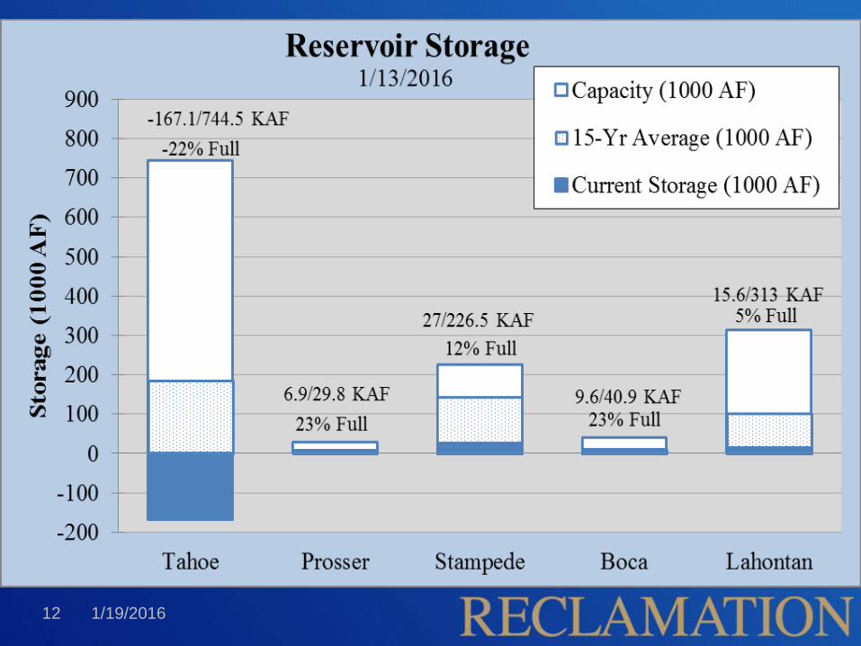
1/19/2016 12

RiverWare Modeling for Water
Management Truckee Carson River Model Development:
1.Ops Model: Day-to-day Operation
2.Planning Model – Long-term Reliability/Evaluation
– Joint effort between Reclamation and TROA Implementation
Office (Water Master’s Office) – for the Operations Model
– Stakeholders Input
Model Includes: • Supply (Inflows)
• Demand (water rights, etc.)
• Operating Criteria
– Pre-TROA: Based on 1935 Truckee River Agreement (TRA)
– Current: Truckee River Operating Agreement (TROA) 13 1/19/2016

Operation Criteria
• General Electric Decree (1915)
• Truckee River Agreement (1935)
• Orr Ditch Decree (1944)
• Donner Lake Agreement (1943)
• Tahoe-Prosser Exchange (1959)
• Interim Storage Agreement (1994)
• Adjusted OCAP – Operating Criteria and Procedure
(1997)
14 1/19/2016

Truckee River Operating Agreement:
TROA
• New Operating Policy: TROA
– Negotiated pursuant to PL 101-618 (1990)
– Partially implemented on December 1, 2015
– Full implementation – coming soon
• TROA Builds on current Truckee River
Agreement policy
– Adds operational flexibility
• Users may hold back their water as “credit water”
• Allows for system of exchanges between reservoirs
15 1/19/2016

Prosser Reservoir
Reservoir Characteristics
• Storage capacity
• Max Min Pools
• Outlet works
• Spillway capacity
• Storage Priority
• Flood Control Operations
• Evaporation
• Precipitation
• Power
1/19/2016 16
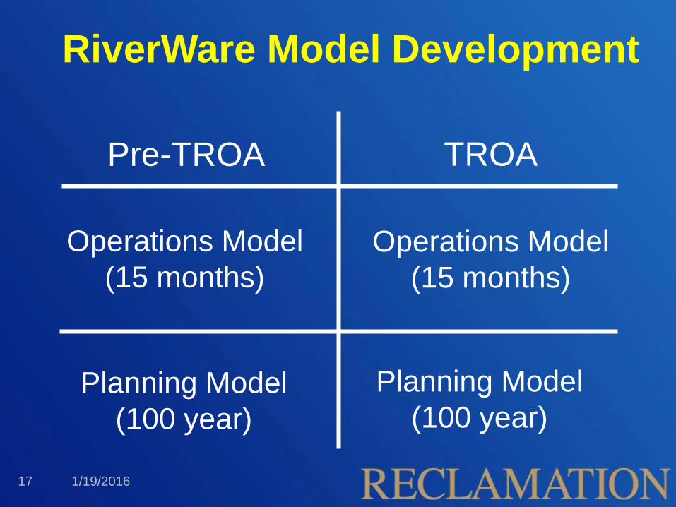
Operations Model
(15 months)
Operations Model
(15 months)
Planning Model
(100 year)
RiverWare Model Development
Pre-TROA TROA
Planning Model
(100 year)
1/19/2016 17

Ops Model for Water Management
Operation – Day-to-day Operations and Look Ahead
– Short-term Model – 15 months hydrology
– Operational forecasts for stakeholders since 2004
– Inflow – Current Gage and Forecasted
Model Use:
– Water Master – Daily operations and TROA Scheduling Committee
– Reclamation - Truckee Canal Diversion operations & Lahontan Flood operations
1/19/2016 18

RiverWare Framework
• Node-based river system operations model
• Physical characteristics
• Uses rule-based simulation - policy is coded in the
rule set
1/19/2016 19

RiverWare Operations Model - Forecasted
Inflow Methodology • NRCS/RFC April-July runoff volume
forecasts for 3 basins:
- Tahoe, Truckee, and Carson.
• Forecasts are given as probability of
exceedance:
- 10%, 30%, 50%, 70%, and 90%
• Obtain inflow hydrograph patterns -
volumes are matched to historically
similar years
• Disaggregate hydrographs to several
basin locations
• Model is run for each exceedance value
Lake Tahoe
Gage
1/19/2016 20

LBAO Forecasting What forecasts we produce and why
• OCAP Forecasts
Truckee Canal Operations
– Lahontan Monthly Target Storages • Ft. Churchill Apr-Jul Volume
• Carson Division Annual Demand
– Truckee Canal Monthly Diversions • Truckee and Carson Division Monthly Demand
• Truckee Canal Monthly Losses
• Lahontan Reservoir Monthly Losses
21 1/19/2016

• Forecasts Truckee Basin Operations
– Reservoir Filling/Flood Control Operations
– Reservoir Operations to meet Floriston Rates
– Tahoe-Prosser Exchange
– Truckee Meadows Diversions and Demands
– Fish and Wildlife Service Fish Releases
– Truckee Canal Operations
– Pyramid Lake Elevations
• TROA Operational Forecasting Using RiverWare – TROA Administrator – Parties to submit a schedule - coordination process
1/19/2016 22
LBAO Forecasting What forecasts we produce and why

WY 2016 January 14 Forecast - Hydrograph
1/19/2016 23
Farad AJ Vol
(KAF)
Carson AJ Vol
(KAF)
Tahoe Gate
Closed Rise (ft)
20% (W) 346 263 2.2
50% (M) 245 175 1.1
80% (D) 128 94 0.4

Average & Forecasted Farad Flow
1/19/2016 24
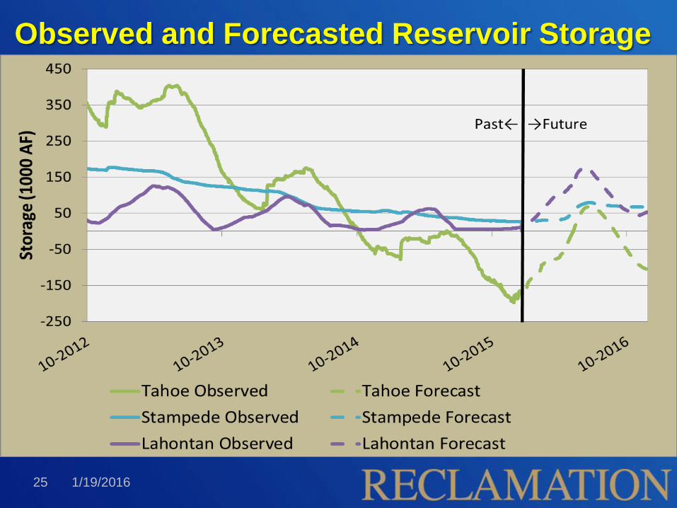
Observed and Forecasted Reservoir Storage
1/19/2016 25

WY 2016 Storage Preliminary Projection -
Tahoe
1/19/2016 26

WY 2016 Storage Preliminary Projection -
Stampede
1/19/2016 27

WY 2016 Storage Preliminary Projection -
Lahontan
1/19/2016 28

End!
Comments? Questions?

Truckee River Agreement-1935 The TRA is the basis for pre-TROA operation of Lake Tahoe, Boca Reservoir,
and the Truckee River.
A slightly modified version of the original Floriston Rates Agreement was
subsequently incorporated into the Truckee River Agreement. This included
Reduced Floriston Rates.
Lake Tahoe Elevations Oct. Nov.-Feb. March Apr.-Sept.
Less than 6225.25 feet 400 300 300 500
6225.25 to 6226.00 feet 400 350 350 500
Over 6226.00 feet 400 400 500 500
Parties to the TRA include:
TCID, SPPC (TMWA), and WCWCD
1/19/2016 30

WY 2015 Projection – Lake Tahoe Release
1/19/2016 31
0
3
7
10
13
16
20
0.0
0.2
0.4
0.6
0.8
1.0
1.2
Ja
n-1
5
Fe
b-1
5
Ma
r-15
Ap
r-1
5
Ma
y-1
5
Ju
n-1
5
Ju
l-15
Aug-1
5
Sep-1
5
Oct-
15
No
v-1
5
De
c-1
5
Me
an
Mo
nth
ly R
ela
ese
(C
FS
)
Re
lea
se
(kA
F)
Lake Tahoe--Release
30% Outflow 50% Outflow 70% Outflow
Combined Forecast
3/17/2015

WY 2015 Projection – Farad Gage Flow
1/19/2016 32
0
100
200
300
400
500
600
700
800 Ja
n-1
5
Fe
b-1
5
Mar-
15
Apr-
15
Ma
y-1
5
Ju
n-1
5
Ju
l-15
Au
g-1
5
Se
p-1
5
Oct-
15
No
v-1
5
De
c-1
5
Me
an
Mo
nth
ly F
low
(cfs
)
Truckee River at Farad--Gage Flow
30% Flow
50% Flow
70% Flow
Floriston Rate_50%
"Floriston Rates_70%
"Floriston Rates_30%
Combined Forecast
3/17/2015

WY 2015 Projection – Nixon Gage Flow
1/19/2016 33
0
50
100
150
200
250
300
350
Ja
n-1
5
Fe
b-1
5
Ma
r-15
Apr-
15
Ma
y-1
5
Ju
n-1
5
Ju
l-15
Aug-1
5
Sep-1
5
Oct-
15
No
v-1
5
De
c-1
5
Me
an
Mo
nth
ly F
low
(cfs
)
Truckee River at Nixon--Gage Flow
30% Flow
50% Flow
70% Flow
Combined Forecast
3/17/2015

WY 2012-present Nixon Gage Flow
1/19/2016 34

WY 2015 Project – Prosser Storage
1/19/2016 35
4
5
6
7
8
9
10
11
12
13
14 Ja
n-1
5
Fe
b-1
5
Ma
r-15
Apr-
15
Ma
y-1
5
Ju
n-1
5
Ju
l-15
Aug-1
5
Sep-1
5
Oct-
15
No
v-1
5
Dec-1
5
Sto
rag
e (
kA
F)
Prosser Reservoir--Storage
30% Storage
50% Storage
70% Storage
Combined Forecast
3/17/2015

Truckee River Basin
Reservoirs
Reservoir Construction Date Use Storage Volume (AF)
Lake Tahoe 1874 / 1913 Floriston Rates 744,600
Independence Pre 1900 / 1939 POSW 3,000 / 17,500
Donner 1928 POSW 9,500
Boca 1938 Rates / FC / CS 40,870
Prosser 1963 TPX / Fish / FC 29,840
Stampede 1969 Fish / FC / CS 226,500
Martis 1971 Flood Control 20,400
1/19/2016 36
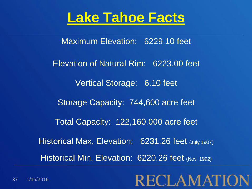
Lake Tahoe Facts
Maximum Elevation: 6229.10 feet
Elevation of Natural Rim: 6223.00 feet
Vertical Storage: 6.10 feet
Storage Capacity: 744,600 acre feet
Total Capacity: 122,160,000 acre feet
Historical Max. Elevation: 6231.26 feet (July 1907)
Historical Min. Elevation: 6220.26 feet (Nov. 1992)
1/19/2016 37

Average Annual Precipitation (Tahoe City): 32.33 inches
Average Annual Evaporation: +/- 3.8 feet (460,000 AF)
“Normal Year” Release: +/- 9.5 inches (95,000 AF)
Tahoe’s annual surface evaporation is enough water to meet the Reno-
Sparks area surface water demands for over five years!
Surface Area: 85,000 acres in CA + 37,000 acres in NV = 122,000 acres
Lake Tahoe Facts
1/19/2016 38

RiverWare Development Process
• Began in 2000
– Joint effort between Reclamation and TROA
Implementation Office (Water Master’s Office)
• 2009: Shift in Responsibility
– TROA Implementation Office in lead role for Ops model
– Reclamation support Ops model; lead planning
modeling
• 2010: Planning Model Development, Water
Quality Modeling
1/19/2016 39