carnarvon hibiscus pty ltd vic/l31 west seahorse-3 …
TRANSCRIPT

CARNARVON HIBISCUS PTY LTD
VIC/L31 WEST SEAHORSE-3 WELL
NON-PRODUCTION OPERATIONS ENVIRONMENT PLAN (EP)
Submitted by Carnarvon Hibiscus Pty Ltd as the titleholder and operator of the VIC/L31 Production Licence.
DOC NO: CHPL-WSH3-HSEQ-PLN-001
Rev Issue Date
Reason for Issue Originator Reviewer Approver
1 25/11/2019 ADDRESS NOPSEMA COMMENTS AND RE-ISSUE
FOR ASSESSMENT G. PINZONE M. PATON M. PATON
0 01/11/2019 ISSUED FOR NOPSEMA ASSESSMENT G. PINZONE M. PATON M. PATON
B 29/10/2019 HIBISCUS PETROLEUM REVIEW G. PINZONE M. PATON -
A 21/10/2019 AVENTUS CONSULTING REVIEW L. MCLENNAN G. PINZONE -

West Seahorse-3 Non-production Operations
Page i of 127
CHPL-WSH3-HSEQ-PLN-001 ENVIRONMENT PLAN Rev 1
Table of Contents
ABBREVIATIONS ............................................................................................................................ III
UNITS OF MEASURMENT .............................................................................................................. VI
1 INTRODUCTION ....................................................................................................................... 1 1.1 BACKGROUND ................................................................................................................................. 1 1.2 THE TITLEHOLDER ........................................................................................................................... 1 1.3 PURPOSE ......................................................................................................................................... 3 1.4 SCOPE OF THIS PLAN ....................................................................................................................... 3 1.5 INTERFACES WITH OTHER DOCUMENTS ......................................................................................... 3 1.6 ENVIRONMENT PLAN SUMMARY .................................................................................................... 3
2 ACTIVITY DESCRIPTION ........................................................................................................... 5 2.1 THE ACTIVITY .................................................................................................................................. 5 2.2 ACTIVITY LOCATION ........................................................................................................................ 5 2.3 THE ACTIVITY AREA ......................................................................................................................... 6 2.4 OPERATIONAL DETAILS ................................................................................................................... 6 2.5 WELL DESIGN .................................................................................................................................. 7 2.6 WELL DESIGN AND SUPPORT ACTIVITIES ........................................................................................ 9 2.7 FUTURE ACTIVITIES ....................................................................................................................... 10
3 LEGISLATION AND GUIDELINES ............................................................................................... 12 3.1 COMMONWEALTH LEGISLATION APPLICABLE TO THE ACTIVITY .................................................. 12 3.2 GOVERNMENT GUIDELINES .......................................................................................................... 15 3.3 INTERNATIONAL INDUSTRY ENVIRONMENTAL CODES OF PRACTICE AND GUIDELINES ................ 15 3.4 AUSTRALIAN INDUSTRY ENVIRONMENTAL CODES OF PRACTICE AND GUIDELINES ...................... 16
4 STAKEHOLDER CONSULTATION .............................................................................................. 18 4.1 STAKEHOLDER CONSULTATION OBJECTIVES ................................................................................. 18 4.2 REGULATORY REQUIREMENTS ...................................................................................................... 18 4.3 STAKEHOLDER IDENTIFICATION .................................................................................................... 19 4.4 ENGAGEMENT METHOD AND APPROACH .................................................................................... 20 4.5 SUMMARY OF STAKEHOLDER CONSULTATION ............................................................................. 22 4.6 ONGOING CONSULTATION ........................................................................................................... 22
5 DESCRIPTION OF THE EXISTING ENVIRONMENT ..................................................................... 28 5.1 REGIONAL CONTEXT ..................................................................................................................... 28 5.2 CONSERVATION VALUES AND SENSITIVITIES ................................................................................ 32 5.3 COASTAL ENVIRONMENT .............................................................................................................. 35 5.4 BIOLOGICAL ENVIRONMENT ......................................................................................................... 37 5.5 CULTURAL HERITAGE VALUES ....................................................................................................... 53 5.6 SOCIO-ECONOMIC ENVIRONMENT ............................................................................................... 54
6 IMPACT AND RISK ASSESSMENT METHODOLOGY ................................................................... 80 6.1 COMMUNICATE AND CONSULT .................................................................................................... 80 6.2 ESTABLISH THE CONTEXT .............................................................................................................. 80 6.3 IDENTIFY THE RISKS ....................................................................................................................... 81 6.4 ANALYSE THE RISKS ....................................................................................................................... 82 6.5 EVALUATE THE RISKS ..................................................................................................................... 82 6.6 TREAT THE RISKS ........................................................................................................................... 96

West Seahorse-3 Non-production Operations
Page ii of 127
CHPL-WSH3-HSEQ-PLN-001 ENVIRONMENT PLAN Rev 1
6.7 MONITOR AND REVIEW ................................................................................................................ 96
7 ENVIRONMENTAL IMPACT AND RISK ASSESSMENT ................................................................ 97 7.1 IMPACT: SEABED DISPLACEMENT ................................................................................................. 97 7.2 RISK: DISPLACEMENT OF OR INTERFERENCE WITH THIRD-PARTY VESSELS AND ACTIVITIES ....... 101
8 IMPLEMENTATION STRATEGY .............................................................................................. 106 8.1 ACTIVITY ORGANISATIONAL STRUCTURE .................................................................................... 106 8.2 ROLES AND RESPONSIBILITIES ..................................................................................................... 106 8.3 ENVIRONMENTAL MANAGEMENT SYSTEM ................................................................................ 107 8.4 TRAINING AND AWARENESS ....................................................................................................... 111 8.5 ENVIRONMENTAL EMERGENCIES AND PREPAREDNESS ............................................................. 111 8.6 ROUTINE RECORDING AND REPORTING ..................................................................................... 111 8.7 CHANGE MANAGEMENT ............................................................................................................. 113 8.8 MONITORING, AUDITING, ASSURANCE AND INSPECTIONS ........................................................ 114
9 REFERENCES ......................................................................................................................... 115
Appendices 1 Information flyer

West Seahorse-3 Non-production
Operations Page iii of 127
CHPL-WSH3-HSEQ-PLN-001 ENVIRONMENT PLAN Rev 1
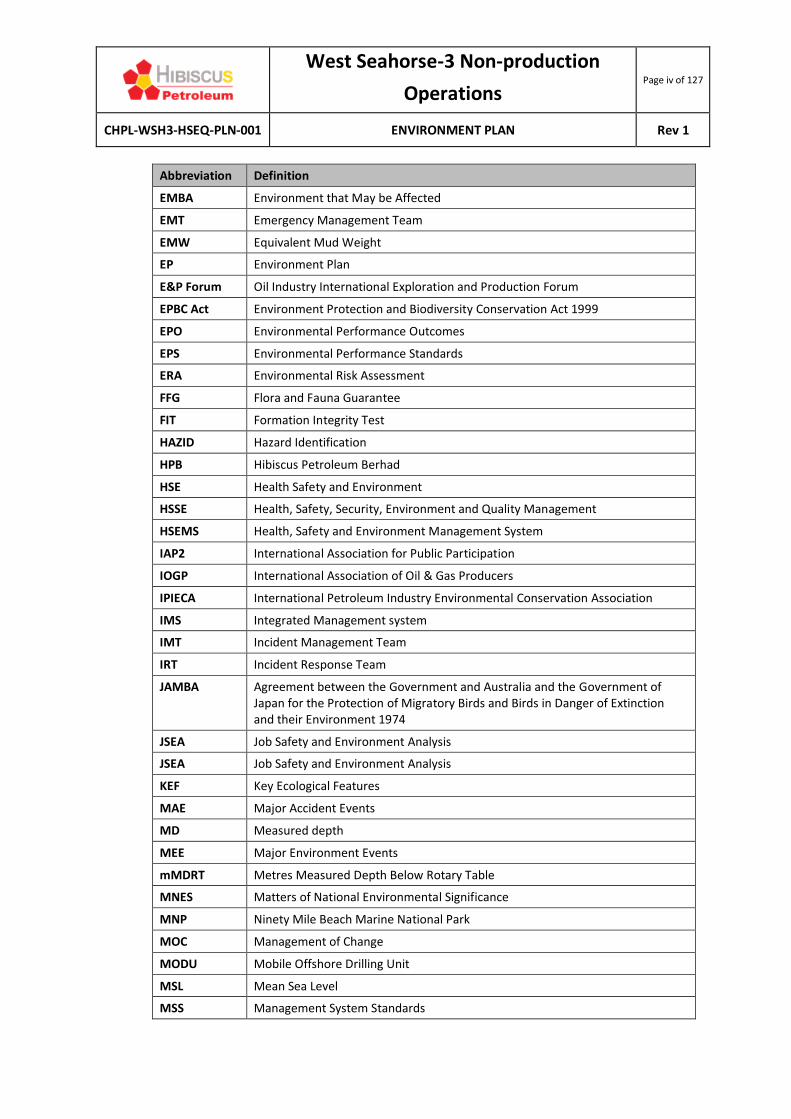
ABBREVIATIONS
Abbreviation Definition
3D Oil 3D Oil Limited
ABS Australian Bureau of Statistics
AFMA Australian Fisheries Management Authority
AFZ Australian Fishing Zone
AHD Australian Height Datum
AHO Australian Hydrographic Office
ALARP As Low As Reasonably Practicable
AMSA Australian Maritime Safety Authority
AMP Australian Marine Parks
API American Petroleum Institute
APPEA Australian Petroleum Production & Exploration Association
ASBTIA Australian Southern Bluefin Tuna Industry Association
ATBA Area to be Avoided
BIAs Biologically Important Areas
BoM Bureau of Meteorology
BPEM Best Practice Environmental Management
CAMBA Agreement between the Government and Australia and the Government of the People’s Republic of China for the Protection of Migratory Birds and their Environment 1986
CER Irish Commission for Energy Regulation
CFA Commonwealth Fisheries Association
CHPL Carnarvon Hibiscus Pty Limited
CITES Convention on International Trade in Endangered Species of Wild Fauna and Flora 1973
CMP Crisis Management Plan
CMT Crisis Management Team
CoEP Code of Environmental Practice
CTS Commonwealth Trawl Sector
DJPR Department of Jobs, Precincts & Regions
DoD Department of Defence
DoEE Department of Environment & Energy
DIRD Department of Infrastructure and Regional Development
EAC East Australian Current
EARPL Esso Australia Resources Pty Ltd
ESD Ecologically Sustainable Development
EIA Environmental Impact Assessment
West Seahorse-3 Non-production
Operations Page iv of 127
CHPL-WSH3-HSEQ-PLN-001 ENVIRONMENT PLAN Rev 1
Abbreviation Definition
EMBA Environment that May be Affected
EMT Emergency Management Team
EMW Equivalent Mud Weight
EP Environment Plan
E&P Forum Oil Industry International Exploration and Production Forum
EPBC Act Environment Protection and Biodiversity Conservation Act 1999
EPO Environmental Performance Outcomes
EPS Environmental Performance Standards
ERA Environmental Risk Assessment
FFG Flora and Fauna Guarantee
FIT Formation Integrity Test
HAZID Hazard Identification
HPB Hibiscus Petroleum Berhad
HSE Health Safety and Environment
HSSE Health, Safety, Security, Environment and Quality Management
HSEMS Health, Safety and Environment Management System
IAP2 International Association for Public Participation
IOGP International Association of Oil & Gas Producers
IPIECA International Petroleum Industry Environmental Conservation Association
IMS Integrated Management system
IMT Incident Management Team
IRT Incident Response Team
JAMBA Agreement between the Government and Australia and the Government of Japan for the Protection of Migratory Birds and Birds in Danger of Extinction and their Environment 1974
JSEA Job Safety and Environment Analysis
JSEA Job Safety and Environment Analysis
KEF Key Ecological Features
MAE Major Accident Events
MD Measured depth
MEE Major Environment Events
mMDRT Metres Measured Depth Below Rotary Table
MNES Matters of National Environmental Significance
MNP Ninety Mile Beach Marine National Park
MOC Management of Change
MODU Mobile Offshore Drilling Unit
MSL Mean Sea Level
MSS Management System Standards

West Seahorse-3 Non-production
Operations Page v of 127
CHPL-WSH3-HSEQ-PLN-001 ENVIRONMENT PLAN Rev 1
Abbreviation Definition
MSV Maritime Safety Victoria
MyOSH Incident Management System
NNTT National Native Title Tribunal
NOPSEMA National Offshore Petroleum Safety Environmental Management Authority
NOPTA National Offshore Petroleum Titles Authority
OPEP Oil Pollution Emergency Plan
OPGGS(E) Commonwealth Offshore Petroleum and Greenhouse Gas Storage (Environment) Regulations 2009
OPGGS Act Offshore Petroleum and Greenhouse Gas Storage Act 2006 (Cth)
OSMP Oil Spill Monitoring Plan
OSRA Oil Spill Response Atlas
P&A Plug and Abandon
PMST Protected Matters Search Tool
PPE Personal Protective Equipment
PSZ Petroleum Safety Zone
PVT Pressure, volume and temperature
RAMSAR Convention on Wetlands of International Importance especially as Waterfowl Habitat 1971
ROKAMBA Republic of Korea Migratory Birds Agreement 2006
ROS Regional Outfall Sewer
ROV Remotely Operated Vehicle
SESS Southern and Eastern Scalefish and Shark
SETFIA South-East Trawl Fishing Industry Association
SIV Seafood Industry Victoria
SG Specific Gravity
SHS Scalefish Hook Sector
SSIA Southern Shark Industry Alliance
SSFA Sustainable Shark Fishing Association
SPFIA Small Pelagic Fishery Industry Association
TA Temporary Abandonment/Temporarily Abandon
TACC Total Allowable Commercial Catch
TECs Threatened Ecological Communities
TOC Top of Cement
TVD True Vertical Depth
UNEP IE United Nations Environment Programme Industry and Environment
VADA Victorian Abalone Divers Association
VFA Victorian Fisheries Authority
VRLA Victorian Rock Lobster Association

West Seahorse-3 Non-production
Operations Page vi of 127
CHPL-WSH3-HSEQ-PLN-001 ENVIRONMENT PLAN Rev 1
Abbreviation Definition
VSFA Victorian Scallop Fisherman’s Association
WEMS Well Engineering Minimum Standards
WOMP Well Operations Management Plan
WSH-3 West Seahorse-3
UNITS OF MEASURMENT
Abbreviation Measurement
‘ Foot/Feet
“ Inch(es)
°C Degrees Celsius
bbl Barrel
dB Decibel(s)
g Gram/s
ha Hectare/s
hr Hour/s
kJ Kilojoule(s)
km Kilometre
km/hr Kilometres per hour
kPa Kilopascal(s)
L Litre(s)
m Metre(s)
m2 Square metres
m3 Cubic metres
mL Millilitre(s)
MM Million
MMbbl Million barrels
MMscf Million Standard Cubic Feet
nm Nautical Mile(s)
scf Standard Cubic Foot/Feet
t Tonne(s)
µg Microgram(s)

West Seahorse-3 Non-production
Operations Page 1 of 127
CHPL-WSH3-HSEQ-PLN-001 ENVIRONMENT PLAN Rev 1
1 INTRODUCTION
1.1 BACKGROUND
The West Seahorse-3 (WSH-3) well was originally drilled by 3D Oil Limited (3D Oil) in early 2008 in the then Exploration Permit Vic/P57. The well is located in Commonwealth waters in eastern Bass Strait approximately 13 km off the Gippsland coast (Figure 1.1). The objectives of the well were to appraise and develop the hydrocarbon bearing target sandstones of the Latrobe Group in the West Seahorse field, originally discovered by drilling the West Seahorse-1 well in 1981. The well intersected the primary sandstone at 1,561 metres below the rotary table (mRT) close to the prognosed depth and confirmed the presence of an oil column down to 1,570 mRT in a high-quality reservoir. Oil is also interpreted within an overlying interbedded interval of sandstones, coals and siltstones from 1,552 mRT to 1,561 mRT. Deeper targets were intersected deep to prognosis and below the oil-water contacts. Following completion of the well, WSH-3 was successfully temporarily abandoned (TA) in early May 2008 in accordance with international standards for well integrity (NORSOK, 2013). Since Carnarvon Hibiscus Pty Limited’s (CHPL) acquisition of Vic/L31, there have been no further works on WSH-3. The WSH-3 wellhead remains TA in place until such time as it is completed as an oil producer or it is permanently abandoned.
1.2 THE TITLEHOLDER
Hibiscus Petroleum Berhad (HPB) is Malaysia’s first listed independent oil and gas exploration and production company. Its key activities are focused on monetising producing oilfields and growing their portfolio of development and production assets. HPB is headquartered in Kuala Lumpur, and shares are listed on the Main Market of Bursa Malaysia Securities Berhad (Bursa Securities). Australia holds significant potential for HPB’s future development plans, with a focus on the proven and probable reserves in the West Seahorse Field under the Vic/L31 production licence, along with additional exploration opportunities in the Vic/P57 exploration licence. CHPL, a wholly owned subsidiary of HPB, acquired the Vic/P57 permit in December 2012 and successfully applied for a Production Licence (Vic/L31) over a portion of the block holding the West Seahorse Field, which was granted by the National Offshore Petroleum Titles Authority (NOPTA) in December 2013. At this time, 3D Oil was the joint titleholder with CHPL until September 2014 when CHPL purchased 3D Oil’s share in the permit. CHPL has since been the 100% titleholder and Operator of Vic/L31.
The titleholder for this activity is:
Carnarvon Hibiscus Pty Ltd ACN: 157 689 426 2nd Floor, Syed Kechik Foundation Building, Jalan Kapas, Bangsar, 59100 Kuala Lumpur, Malaysia Phone: +603 2028 1025 Email: [email protected]

West Seahorse-3 Non-production
Operations Page 2 of 127
CHPL-WSH3-HSEQ-PLN-001 ENVIRONMENT PLAN Rev 1
Figure 1.1. Location of VIC/L31 and the WSH-3 well
West Seahorse-3 Non-production
Operations Page 3 of 127
CHPL-WSH3-HSEQ-PLN-001 ENVIRONMENT PLAN Rev 1
The nominated liaison person for this EP is:
Mark Paton Chief Operating Officer, HBP 2nd Floor, Syed Kechik Foundation Building, Jalan Kapas, Bangsar, 59100 Kuala Lumpur, Malaysia Phone: +603 2028 1025 Mobile: +6017 303 1234 or +61 418 895 913 Email: [email protected]
1.3 PURPOSE
The purpose of this Environment Plan (EP) is to provide an environmental impact assessment (EIA) and environmental risk assessment (ERA) of the WSH-3 wellhead during its TA non-production phase and secure environmental approval under the Commonwealth Offshore Petroleum and Greenhouse Gas Storage (Environment) Regulations 2009 (herein referred to as the OPGGS(E)).
1.4 SCOPE OF THIS PLAN
The activity (as defined in Section 2.1) is conducted in accordance with all applicable legislation and regulations, and specifically to meet the requirements of the Offshore Petroleum and Greenhouse Gas Storage Act 2006 (Cth) (OPGGS Act) and its associated Regulations. This EP is prepared in accordance with Division 2.3 of the OPGGS(E). It is submitted to the National Offshore Petroleum Safety and Environmental Management Authority (NOPSEMA) for assessment and acceptance under Division 2.2 of the OPGGS(E). In brief, this EP includes a description of:
• The nature of the activity;
• Stakeholder consultation activities;
• The environment affected by the activity;
• Environmental impacts and risks (including emergency incidents);
• Mitigation and management measures;
• Environmental performance outcomes, standards and measurement criteria;
• How impacts and risks will be reduced to be As Low As Reasonably Practicable (ALARP) and ‘acceptable’ levels;
• The implementation strategy to ensure that the environmental impacts and risks are managed in a systematic manner; and
• Reporting arrangements.
1.5 INTERFACES WITH OTHER DOCUMENTS
As a non-operational asset, the key interface with this EP is the NOPSEMA-accepted WSH-3 Well Operations Management Plan (WOMP) (WSH-CHP-10-RG-RP-0002, Rev 1, Jan 2017).
1.6 ENVIRONMENT PLAN SUMMARY
Table 1.1 provides a summary of this EP as required by Regulation 11(4) of the OPGGS(E).
West Seahorse-3 Non-production
Operations Page 4 of 127
CHPL-WSH3-HSEQ-PLN-001 ENVIRONMENT PLAN Rev 1
Table 1.1. EP Summary of material requirements
EP Summary Requirement EP Section
The location of the activity Section 1.1
A description of the receiving environment Chapter 5
A description of the activity Chapter 2
Details of the environmental impacts and risks Chapter 7
The control measures for the activity Chapter 7
The arrangements for ongoing monitoring of the titleholder’s environmental performance
Chapter 8
Response arrangements in the oil pollution emergency plan (OPEP) Not relevant
Consultation already undertaken and plans for ongoing consultation Chapter 4
Details of the titleholder’s nominated liaison person for the activity Section 1.2

West Seahorse-3 Non-production
Operations Page 5 of 127
CHPL-WSH3-HSEQ-PLN-001 ENVIRONMENT PLAN Rev 1
2 ACTIVITY DESCRIPTION
This chapter provides a description of the activity in accordance with the requirements of Regulation 13(1) of the OPGGS(E).
2.1 THE ACTIVITY
In accordance with Regulation 4(1) of the OPGGS(E), this EP applies to a defined ‘petroleum activity.’ Based on the WOMP and for the purposes of this EP, the petroleum activity is defined as:
‘Non-production operations phase of a TA (suspended) wellhead on the seabed’. In accordance with OPGGS(E) Regulation 19(1), this EP remains valid for 5 years from the date of acceptance. This activity does not cover plugging and abandonment (P&A) or decommissioning of the well.
2.2 ACTIVITY LOCATION
The WSH-3 wellhead is located in eastern Bass Strait approximately 13 km off the Gippsland coast in a water depth of 39.5 m (see Figure 1.1). The well coordinates are:
Latitude: 38 12’ 24.9422” S (5,771,044.135 N)
Longitude: 147 37’ 09.8649” E (554,229.358 E). Table 2.1 lists the well’s position in the context of other notable locations in the region.
Table 2.1. Distance from WSH-3 to key features
Feature Distance and direction from WSH-3 to the nearest point of the feature
Nearest landfall 13 km northwest
Towns
Loch Sport 16 km northwest
Paradise Beach 17.5 km west
Golden Beach 19 km west
Honeysuckles 39 km southwest
Seaspray 42 km southwest
Longford 47 km west-northwest
Lakes Entrance 49 km northeast
Sale 50 km northwest
Petroleum infrastructure
Seahorse subsea wells (nearest) (oil) 3 km east
Seahorse to Barracouta A pipeline (oil) 4 km east

West Seahorse-3 Non-production
Operations Page 6 of 127
CHPL-WSH3-HSEQ-PLN-001 ENVIRONMENT PLAN Rev 1
Feature Distance and direction from WSH-3 to the nearest point of the feature
Barracouta to shore pipeline: Vic/PL1 & Vic/PL4(V) (oil & condensate)
6 km southwest
Bream to shore pipeline: Vic/PL32 & Vic/PL32(V)
10 km southwest
Tarwhine to Barracouta A pipeline (oil) 10 km south-southeast
Barracouta platform (oil & gas) 11 km south-southeast
Tarwhine subsea well (oil) 20 km south-southwest
Bream A platform (oil and gas) 35 km south-southeast
Dolphin to shore pipeline (oil) 37 km southwest
Dolphin monopod (oil) 37 km south-southwest
Tasmanian gas pipeline 40 km west-southwest
Non-petroleum infrastructure
Regional Outfall Sewer (ROS) (Delray Beach) 23 km west-southwest
Saline Wastewater Outfall Pipeline (SWOP) (McGaurans Beach)
55 km southwest
Basslink electricity interconnector cable 60 km southeast
Australian Marine Parks
Beagle 109 km south-southwest
Victorian marine parks
Ninety Mile Beach Marine National Park 42 km southwest
2.3 THE ACTIVITY AREA
The WSH-3 activity area is defined as:
All areas within the WSH-3 Petroleum Safety Zone (PSZ), which covers a 300 m-radius area around the WSH-3 wellhead.
This 300-m radius around the well equates to an area of 28.3 ha (0.283 km2). Because there are no credible hydrocarbon spill scenarios with which to establish a traditional Environment that May be Affected (EMBA), the extent of the PSZ can be reasonably used to define the activity area and as such is used throughout this EP. Further explanation of the WSH-3 TA design and justification for the definition of the activity area is provided in Sections 2.4 to 2.6.
2.4 OPERATIONAL DETAILS
Following completion of its appraisal activities, WSH-3 was successfully plugged and TA in early May 2008. The TA cement plug design features four plugs as illustrated in Figure 2.1.

West Seahorse-3 Non-production
Operations Page 7 of 127
CHPL-WSH3-HSEQ-PLN-001 ENVIRONMENT PLAN Rev 1
Figure 2.1. WSH-3 TA plugs
The WSH-3 wellhead will remain TA and in place until such time as it is completed as an oil producer or it is permanently abandoned.
2.5 WELL DESIGN
The WSH-3 well was TA in accordance with D-010 Well Integrity in Drilling and Well Operations (NORSOK, 2013) and HPB Standards for Well Integrity (AUS-HPB-60-MN-1004). This section describes in detail the construction of the TA WSH-3 well.
2.5.1 CASING DESIGN
The casing design for WSH-3 is described below:

West Seahorse-3 Non-production
Operations Page 8 of 127
CHPL-WSH3-HSEQ-PLN-001 ENVIRONMENT PLAN Rev 1
• 762 mm (30”) x 508 mm (20”) structural casing/conductor was set from about 2 m above the seabed to 44.5 m below the seabed. The joint crossing the seabed is 37.5 mm (1½”) wall thickness.
• 340 mm (13⅜”) surface casing was set in the Lakes Entrance formation at 1,034 metres True Vertical Depth (mTVD). This casing string was designed to withstand installation loads and a limited kick from the next section total depth.
The casing designs incorporated design safety factors in excess of the current HPB Well Engineering Minimum Standards (WEMS).
2.5.2 PORE PRESSURE & FORMATION STRENGTH
All formations drilled in the WSH field are normally pressured. The maximum recorded pore pressure during the drilling of WSH-3 was 1.01 SG (8.4 ppg). A formation integrity test was performed after setting 340 mm surface casing (13⅜”) at 1,117 metres Measured Depth below Rotary Table (mMDRT). After cleaning the rat hole to 1,123 m, 3 meters of new formation was drilled in 311 mm (12¼”) hole and the Formation Integrity Test (FIT) performed to equivalent mud weight of 13.65 ppg (1.64 SG) with no leak off recorded. The well’s kick tolerance in 311 mm (12¼”) was then calculated as 136.9 bbl, exceeding the WEMS values of:
• Hole size > 311 mm requires a minimum kick tolerance of 7.95 m3 (50 bbls); and
• Hole size ≤ 311 mm requires a kick tolerance of 3.97 m3 (25 bbls).
Table 2.2 summarises the casing designs selected for the WSH-3 well.
Table 2.2. WSH-3 casing data
Type Size Weight (ppf) Grade Thread Depth
(mMDRT)
Conductor
30” 309.7 (top joint 1.5”wall remainder 1" wall)
X-52 D60/MT 110.6
Surface casing
13.375” 68 N-80 BTC 1117
2.5.3 CASING CEMENT DESIGN
The casing cement design is as follows:
• 762 mm (30”) structural conductor casing on the WSH-3 well was cemented to surface with 1.91 SG (15.90 ppg) class G cement using a 200% excess on gauge hole. Fluorescence dye was used to improve visibility for ROV monitoring of returns to the seabed. The 762 mm conductor shoe was set at 122.0 mMDRT (casing tally) and cemented as per the cementing program.
• 340 mm (13⅜”) surface casing was cemented with a 1.5 SG (12.5 ppg) lead slurry and a 1.89 sg (15.8 ppg) tail slurry of class G cement. The tail slurry volume was specified to extend 117 m above the casing shoe. A 10% excess over gauge hole was specified. Cement placement was verified using final circulating pressure calculations. The casing shoe was set at 1,117 mMDRT.
2.5.4 TEMPORARY ABANDONMENT PLUG CEMENT DESIGN
The TA plugs used Class G cement (standard for offshore wells), with the design summarised in Table 2.3. The cementing design complies with the WEMS (WSH-ADD-60-EN-CL-9001) with the

West Seahorse-3 Non-production
Operations Page 9 of 127
CHPL-WSH3-HSEQ-PLN-001 ENVIRONMENT PLAN Rev 1
exception of the cement excess quantities. Figure 2.1 presents a schematic of the TA plug design of the well.
Table 2.3. WSH-3 cementing data
Plug Well interval (mMDRT) Plug thickness Notes
1A 1,633 m - 1,770 m 137 m
1B 1,490 m - 1,633 m 143 m This was tagged with the cementing string at 1,490 mMDRT and weight tested to 8 klbs after the cement had hardened.
2 1,030 m - 1,149 m 119 m Set across the 340 mm casing shoe. Successfully pressure tested to 1,500 psi.
3 130 m - 207 m 77 m
2.5.5 TEMPORARY ABANDONMENT CAP
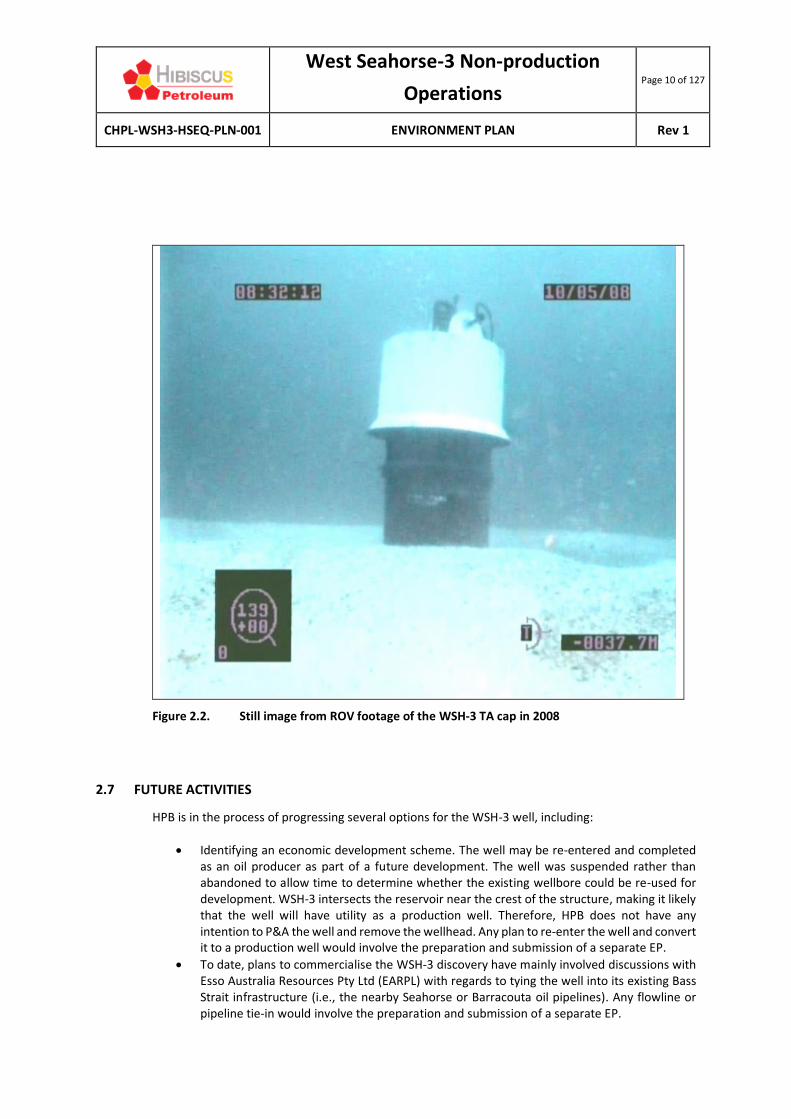
A TA cap was installed on top of the 762 mm (30”) Quick-Jay box connector in the wellhead system. The TA cap protrudes 2 m above the seabed and measures approximately 1.1 m in diameter (Figure 2.2). The TA cap is constructed of steel and sits on top of the subsea wellhead and is designed to protect the wellhead from corrosion, marine growth and damage from third-party activities, such as trawl fishing. Since the TA cap was installed in 2008, there have been no reports of intentional or unintentional interference with the structure. Corrosion inhibitor was injected under the TA cap to protect the wellhead seal surfaces to allow for future well intervention.
2.6 WELL DESIGN AND SUPPORT ACTIVITIES
A risk review conducted as part of the NOPSEMA-accepted WOMP concluded that the risk of hydrocarbon fluids release from the TA WSH-3 is no different to a permanently abandoned well. Therefore, it was concluded that risks to well integrity and to the receiving environment from leaking hydrocarbons is ALARP. As such, no vessel-based inspection and maintenance activities are required. For this reason, no Oil Pollution Emergency Plan (OPEP) has been prepared for this activity and this EP does not assess the impacts and risks of activities associated with vessel-based activities, such as periodic remotely operated vehicle (ROV) inspections. The EIA and ERA is therefore limited to the physical presence of the WSH-3 wellhead on the seabed.
West Seahorse-3 Non-production
Operations Page 10 of 127
CHPL-WSH3-HSEQ-PLN-001 ENVIRONMENT PLAN Rev 1
Figure 2.2. Still image from ROV footage of the WSH-3 TA cap in 2008
2.7 FUTURE ACTIVITIES
HPB is in the process of progressing several options for the WSH-3 well, including:
• Identifying an economic development scheme. The well may be re-entered and completed as an oil producer as part of a future development. The well was suspended rather than abandoned to allow time to determine whether the existing wellbore could be re-used for development. WSH-3 intersects the reservoir near the crest of the structure, making it likely that the well will have utility as a production well. Therefore, HPB does not have any intention to P&A the well and remove the wellhead. Any plan to re-enter the well and convert it to a production well would involve the preparation and submission of a separate EP.
• To date, plans to commercialise the WSH-3 discovery have mainly involved discussions with Esso Australia Resources Pty Ltd (EARPL) with regards to tying the well into its existing Bass Strait infrastructure (i.e., the nearby Seahorse or Barracouta oil pipelines). Any flowline or pipeline tie-in would involve the preparation and submission of a separate EP.

West Seahorse-3 Non-production
Operations Page 11 of 127
CHPL-WSH3-HSEQ-PLN-001 ENVIRONMENT PLAN Rev 1
While HPB progresses the plans to develop WSH-3 as a producing well, it is acknowledged that due to events outside its control, these plans may not eventuate. HPB is cognisant of the need to comply with Section 572 of the OPGGS Act, which states that a titleholder must remove all structures that are not used in the connection of operations. In light of this requirement, the following scenario would be progressed if development of WSH-3 is not possible:
• In the event that the field is not developed during the term of the licence, HPB will remove the trash cap and wellhead prior to relinquishing the licence.
o The cement plugs in the well are the same as would be installed to P&A the well. Therefore, only the trash cap and wellhead need to be removed from the seabed to complete the abandonment process.
o It is envisaged that the wellhead would be removed via an abrasive blasting cutting system. This technique has been previously used in Australia. The wellhead cutting equipment is deployed from a dynamically positioned vessel with ROV observation. The wellhead is severed several metres below the mudline and recovered to the deck of the vessel and scrapped.
Should such an activity proceed, it would involve the preparation and submission of a decommissioning EP to NOPSEMA for acceptance prior to any decommissioning activities taking place.

West Seahorse-3 Non-production
Operations Page 12 of 127
CHPL-WSH3-HSEQ-PLN-001 ENVIRONMENT PLAN Rev 1
3 LEGISLATION AND GUIDELINES
In accordance with OPSSG(E) Regulation 13(4), this chapter describes the legislative requirements that apply to the activities described in this EP. Table 3.1 presents a summary of the key Commonwealth legislation and regulations relevant to the environmental management of the activity.
3.1 COMMONWEALTH LEGISLATION APPLICABLE TO THE ACTIVITY
Key Commonwealth legislation that is applicable to the activity is summarised in Table 3.1. Commonwealth legislation that is applicable to vessel-based activities is not discussed for the reasons outlined in Section 2.6.

West Seahorse-3 Non-production Operations Page 13 of 127
CHPL-WSH3-HSEQ-PLN-001 ENVIRONMENT PLAN Rev 1
Table 3.1. Summary of key Commonwealth environmental legislation relevant to the activity
Legislation/Regulation Scope Related International Conventions Administering Authority
Environment Protection and Biodiversity Conservation Act 1999 (EPBC Act)
(& Regulations 2000)
Protects matters of national environmental significance (MNES), provides for Commonwealth environmental assessment and approval processes and provides an integrated system for biodiversity conservation and management of protected areas.
The nine MNES are:
1. World heritage properties; 2. National heritage places; 3. Wetlands of international importance (Ramsar
wetlands); 4. Nationally threatened species and ecological
communities; 5. Migratory species; 6. Commonwealth marine environment; 7. The Great Barrier Reef Marine Park; 8. Nuclear actions (including uranium mining); and 9. A water resource, in relation to coal seam gas
development and large coal mining development.
Relevance to this activity: This EP includes a description and assessment of MNES that may be impacted by the activity.
Convention on Biological Diversity and Agenda 21 1992.
Convention on International Trade in Endangered Species of Wild Fauna and Flora 1973 (CITES).
Agreement between the Government and Australia and the Government of Japan for the Protection of Migratory Birds and Birds in Danger of Extinction and their Environment 1974 (JAMBA).
Agreement between the Government and Australia and the Government of the People’s Republic of China for the Protection of Migratory Birds and their Environment 1986 (CAMBA).
Republic of Korea Migratory Birds Agreement 2006 (ROKAMBA).
Convention on Wetlands of International Importance especially as Waterfowl Habitat 1971 (RAMSAR).
International Convention for the Regulation of Whaling 1946.
Convention on the Conservation of Migratory Species of Wild Animals (Bonn Convention) 1979.
Department of Environment & Energy (DoEE)
(NOPSEMA in the case of this activity)

West Seahorse-3 Non-production Operations Page 14 of 127
CHPL-WSH3-HSEQ-PLN-001 ENVIRONMENT PLAN Rev 1
OPGGS Act 2006 and OPGGS (Environment) Regulations 2009
The Act addresses all licensing and HSE issues for offshore petroleum activities extending beyond the 3 nm limit.
The Regulations (Part 2) specify that an EP must be prepared for any petroleum activity and that activities are undertaken in an ecologically sustainable manner.
Section 616 of the Act allows for the gazettal of a PSZ.
Relevance to this activity: The preparation and acceptance of this EP satisfies the key requirements of this legislation. A PSZ is gazetted for WSH-3 under the Act (noting that the gazettal was done under the then Petroleum (Submerged Lands) Act 1967, which was repealed by the OPPGS Act).
Not applicable. NOPSEMA

West Seahorse-3 Non-production
Operations Page 15 of 127
CHPL-WSH3-HSEQ-PLN-001 ENVIRONMENT PLAN Rev 1
3.2 GOVERNMENT GUIDELINES
This EP has been developed in accordance with the NOPSEMA Guidance Note for Environment Plan Content Requirements (N04750-GN1344, Revision 3, April 2016). This document provides guidance to the petroleum industry on NOPSEMA’s interpretation of the OPGGS(E) to assist Titleholders in preparing EPs. Other relevant government guidelines that have been taken into consideration during the preparation of this EP include: EP
• Environment Plan decision making (NOPSEMA Guideline GL1721, Rev 5, June 2018).
• Decision-making guideline – Criterion – 10A(g) – Consultation requirements (NOPSEMA Guideline N-04750-GL1629, Rev 1, November 2016).
EPBC Act Matters
• EPBC Act Policy Statement 1.1 – Significant Impact Guidelines – Matters of National Environmental Significance (DoE, 2013).
3.3 INTERNATIONAL INDUSTRY ENVIRONMENTAL CODES OF PRACTICE AND GUIDELINES
A number of international codes of practice and guidelines are relevant to environmental management of the activity. Those of most relevance are described in this section. The Commonwealth legislation described in Table 3.1 lists the conventions and agreements that are enacted by, or whose principles are embodied in, that legislation. While none of the codes of practice or guidelines described in this section have legislative force in Australia, they are considered to represent best practice environmental management (BPEM).
3.3.1 UNEP IE: ENVIRONMENTAL MANAGEMENT IN OIL AND GAS EXPLORATION AND PRODUCTION
In 1997, the United Nations Environment Programme Industry and Environment (UNEP IE) and the Oil Industry International Exploration and Production Forum (E&P Forum) developed an overview of issues and management approaches for environmental management in oil and gas exploration and production. With regard to offshore petroleum, it contains a brief and broad list of environmental protection measures, mostly relating to the assessment of impacts (which is met through the preparation of this EP).
3.3.2 WORLD BANK GROUP EHS GUIDELINES
The Environmental, Health and Safety Guidelines for Offshore Oil and Gas Development (World Bank Group, 2015) is a technical reference document with general and industry-specific examples of good international industry practice. These guidelines are applied when one or more members of the World Bank Group are involved in a project, and are used only for guidance here. The document contains measures considered to be achievable in new facilities, using existing technology, at reasonable costs. The guidelines are designed to be tailored to the applicable hazards and risks established for a given project.

West Seahorse-3 Non-production
Operations Page 16 of 127
CHPL-WSH3-HSEQ-PLN-001 ENVIRONMENT PLAN Rev 1
3.3.3 IOGP: BEST PRACTICE GUIDELINES
The International Association of Oil & Gas Producers (IOGP) has a membership including companies that produce more than one-third of the world’s oil and gas. The IOGP provides a forum where members identify and share knowledge and good practices to achieve improvements in health, safety, environment, security and social responsibility. The IOGP’s aim is to work on behalf of oil and gas exploration and production companies to promote safe, responsible and sustainable operations. The IOGP’s work is embodied in publications that are made freely available on its website (www.iogp.org). At October 2019, IOGP’s members comprise 83 members, comprising oil and gas exploration and production companies, associations and contractors. Although CHPL is not an IOGP member, relevant guidelines have been referenced in this EP as relevant.
3.3.4 IPIECA: BEST PRACTICE GUIDELINES
IPIECA is the International Petroleum Industry Environmental Conservation Association, established in 1974 (since 2002, IPIECA stopped using the full title). At October 2019, IPIECA’s members comprise 69 members, comprising oil and gas exploration and production companies, associations and contractors. IPIECA’s vision is for an oil and gas industry whose operations and products meet society’s environmental and social performance expectations, with a focus on the key areas of climate and energy, environment, social and reporting. It develops, shares and promotes good practices and knowledge to help the industry improve its environmental and social performance. IPIECA’s work is embodied in publications that are made freely available on its website (www.ipieca.org). Although CHPL is not an IPIECA member, relevant guidelines have been referenced in this EP as relevant. CHPL has applied IPIECA’s recent Mapping the Oil and Gas Industry to the Sustainable Development Goals: An Atlas (July 2017) to its WSH-3 activity. Goal 14 (Conserve and sustainably use the oceans, seas and marine resources for sustainable development) is the most relevant to the offshore activity, and has been met by incorporating EIA and ERA into this EP.
3.4 AUSTRALIAN INDUSTRY ENVIRONMENTAL CODES OF PRACTICE AND GUIDELINES
There are few Australian industry codes of practice or guidelines regarding environmental management for offshore petroleum operations. Those that do apply to this activity are briefly discussed in this section. None of these codes of practice or guidelines have legislative force in Australia, but are considered to represent BPEM. Aspects of each code or guideline relevant to the impacts and risks presented by the activity are described in the ‘demonstration of acceptability’ throughout Chapter 7.
3.4.1 NATIONAL STRATEGY FOR ECOLOGICALLY SUSTAINABLE DEVELOPMENT
The National Strategy for Ecologically Sustainable Development (ESDSC, 1992) defines the goal of Ecologically Sustainable Development (ESD) as “development that improves the total quality of life, both now and in the future, in a way that maintains the ecological processes on which life depends.”
Section 3A of the EPBC Act defines the principles of ESD as:
• Decision-making processes should effectively integrate both long-term and short-term economic, environmental, social and equitable considerations;

West Seahorse-3 Non-production
Operations Page 17 of 127
CHPL-WSH3-HSEQ-PLN-001 ENVIRONMENT PLAN Rev 1
• If there are threats of serious or irreversible environmental damage, lack of full scientific certainty should not be used as a reason for postponing measures to prevent environmental degradation;
• The principle of inter-generational equity – that the present generation should ensure that the health, diversity and productivity of the environment is maintained or enhanced for the benefit of future generations;
• The conservation of biological diversity and ecological integrity should be a fundamental consideration in decision-making; and
• Improved valuation, pricing and incentive mechanisms should be promoted.
The ESD concept has been taken into consideration in the development of the environmental performance standards outlined in Chapter 7 of this EP.
3.4.2 APPEA: CODE OF ENVIRONMENTAL PRACTICE
In Australia, the petroleum exploration and production industry operates within an industry code of practice developed by the Australian Petroleum Production and Exploration Association (APPEA); the APPEA Code of Environmental Practice (CoEP) (2008). This code provides guidelines for activities that are not formally regulated and have evolved from the collective knowledge and experience of the oil and gas industry, both nationally and internationally. The APPEA CoEP covers general environmental objectives for the industry, including planning and design, assessment of environmental risks, emergency response planning, training and inductions, auditing and consultation, and communication. For the offshore sector specifically, it covers issues relating to geophysical surveys, drilling and development and production. The APPEA CoEP has been used as a reference for the EIA and ERA (Chapter 7 of this EP) to ensure that all necessary environmental issues and controls for petroleum production have been incorporated into the management of this activity.

West Seahorse-3 Non-production
Operations Page 18 of 127
CHPL-WSH3-HSEQ-PLN-001 ENVIRONMENT PLAN Rev 1
4 STAKEHOLDER CONSULTATION
CHPL has opened the channels of communication with stakeholders (as defined in Section 4.2) to provide an opportunity for open and honest communication that promotes integration of stakeholder values into its decision-making process. This provides the means for CHPL to identify individuals and
groups as well as their needs, ideas, values and issues of concern regarding the environmental and/or social impacts of the activity. CHPL is committed to open, ongoing and effective engagement with the communities in which it operates and providing information that is clear, relevant and easily understandable. This section of the EP defines the:
• Objectives of stakeholder consultation;
• Regulatory requirements for stakeholder consultation;
• Who needs to be considered in decision-making; and
• When decisions must be completed.
4.1 STAKEHOLDER CONSULTATION OBJECTIVES
CHPL’s stakeholder engagement strategy for this activity provides a structured approach to engagement activities in line with current best practice. The key objectives of this engagement are to:
• Provide stakeholders with access to clear and concise information and a point of contact for the project;
• Provide an opportunity for a two-way information exchange and meaningful stakeholder consultation; and
• Meet the stakeholder consultation requirements for EPs (see Section 4.2).
4.2 REGULATORY REQUIREMENTS
Stakeholder consultation is required under the OPGGS(E), as summarised in this section. Section 280 (Interference with other rights) of the OPGGS Act states that a person carrying out activities in an offshore area should not interfere with other users of the offshore area to a greater extent than is necessary for the reasonable exercise of the rights and performance of the duties of the first person. In order to determine what activities are being carried out, and whether exploration or production activities may interfere with existing users, consultation is required. In relation to the content of an EP, more specific requirements are defined in the OPGGS(E) Regulation 11A. This regulation requires that a Titleholder consult with ‘relevant persons’ in the preparation of an EP. A ‘relevant person’ is defined in Regulation 11A as:
1. Each Department or agency of the Commonwealth to which the activities to be carried out under the EP, or the revision of the EP, may be relevant;
2. Each Department or agency of a State or the Northern Territory to which the activities to be carried out under the EP, or the revision of the EP, may be relevant;
3. The Department of the responsible State Minister, or the responsible Northern Territory Minister;
4. A person or organisation whose functions, interests or activities may be affected by the activities to be carried out under the EP, or the revision of the EP; and
West Seahorse-3 Non-production
Operations Page 19 of 127
CHPL-WSH3-HSEQ-PLN-001 ENVIRONMENT PLAN Rev 1
5. Any other person or organisation that the Titleholder considers relevant.
Further guidance regarding the definition of functions, interests or activities is provided in NOPSEMA’s Environment Plan decision making guideline (GL1721, Rev 5, June 2018), as follows:
• Functions – a person or organisation’s power, duty, authority or responsibilities;
• Activities – a thing or things that a person or group does or has done; and
• Interests – a person or organisation’s rights, advantages, duties and liabilities; or a group or organisation having a common concern.
Regulation 14(9) of the OPGGS(E) also defines a requirement for consultation in relation to the Implementation Strategy defined in the EP. In addition, Regulation 16(b) of the OPGGS(E) requires that the EP contain a summary and full text of this consultation.
4.3 STAKEHOLDER IDENTIFICATION
CHPL has used a number of methods to determine the key stakeholders for this activity. This includes project team knowledge from activities previously undertaken in the region, existing networks and Summary EPs published by NOPSEMA for activities undertaken in the Gippsland region. Listed in Table 4.1 are the relevant persons with whom CHPL has consulted for this activity. The stakeholders are grouped into the five categories of relevant persons as outlined by the OPGGS(E) (as listed in Section 4.2). To determine the type of information to provide to a stakeholder, an information category was developed and is detailed in Table 4.2.
Table 4.1. Stakeholders identified for this activity
Category 1 – Department or agency of the Commonwealth to which the activities to be carried out under the EP may be relevant
Australian Maritime Safety Authority (AMSA) - Nautical and Regulation Section
Australian Fisheries Management Authority (AFMA)
Australian Hydrographic Office (AHO) National Offshore Petroleum Titles Administrator (NOPTA)
Department of Defence (DoD) – Defence Support Group
Department of Infrastructure and Regional Development (DIRD)
Category 2 – Each Department or agency of a State to which the activities to be carried out under the EP may be relevant
Department of Jobs, Precincts & Regions (DJPR) - Earth Resources Regulation (ERR)
Maritime Safety Victoria (MSV)
Victorian Fisheries Authority (VFA)
Category 3 – The Department of the responsible State Minister
Not applicable.
Category 4 – A person or organisation whose functions, interests or activities may be affected by the activities to be carried out under the EP
Fisheries - Commonwealth
Commonwealth Fisheries Association (CFA) Australian Southern Bluefin Tuna Industry Association (ASBTIA)

West Seahorse-3 Non-production
Operations Page 20 of 127
CHPL-WSH3-HSEQ-PLN-001 ENVIRONMENT PLAN Rev 1
South-East Trawl Fishing Industry Association (SETFIA)
Small Pelagic Fishery Industry Association (SPFIA)
Southern Shark Industry Alliance (SSIA) AFMA – Southern and Eastern Scalefish and Shark fishery
Sustainable Shark Fishing Association (SSFA)
Fisheries – Victorian
Seafood Industry Victoria (SIV) Eastern Zone Abalone Industry Association
Victorian Abalone Divers Association (VADA) Victorian Rock Lobster Association (VRLA)
Victorian Scallop Fisherman’s Association (VSFA) VRFish
Adjacent petroleum Titleholders
3D Oil Limited (VIC/P57) CarbonNet Project
ExxonMobil (Esso Australia Resources Pty Ltd)
Category 5 – Any other person or organisation that the Titleholder considers relevant
Not applicable.
Table 4.2. Information category to determine information provided to stakeholder
Category Description Information type Follow up
1 Organisations or individuals whose functions, interests or activities may be impacted by the activity.
Representative body for fishers who provide information to their members.
Information sheet and/or provision of information as per organisation’s consultation guidance.
Provision of further information where required.
Meeting or phone call where required.
In the event there is no response to initial email, follow up may be required because the activity may impact on the this stakeholder’s functions, interests or activities.
2 Organisations or individuals whose functions, interests or activities will not be impacted by the activity but are kept up to date with CHPL’s activity as a courtesy.
In the event there is no response to initial email, follow up is not required because the activity will not impact on the functions, interests or activities of this stakeholder.
4.4 ENGAGEMENT METHOD AND APPROACH
The stakeholder engagement method and approach employed for the WSH-3 activity is described in this section.

West Seahorse-3 Non-production
Operations Page 21 of 127
CHPL-WSH3-HSEQ-PLN-001 ENVIRONMENT PLAN Rev 1
4.4.1 ENGAGEMENT APPROACH
The approach to stakeholder consultation has considered the International Association for Public Participation (IAP2) spectrum, deemed to be best practice for stakeholder engagement. In order of increasing level of public impact, the elements of the spectrum and their goals are as follows:
• Inform – to provide the public with balanced and objective information to assist them in understanding the problems, alternatives and/or solutions.
• Consult – to obtain public feedback on analysis, alternatives and/or decisions.
• Involve – to work directly with stakeholders throughout the process to ensure that public concerns and aspirations are consistently understood and considered.
• Collaborate – to partner with the public in each aspect of the decisions, including the development of alternatives and the identification of the preferred solution.
• Empower – to place final decision-making in the hands of the stakeholders.
Given the innocuous nature of this activity, the fact that the WSH-3 well and the TA cap have been in place for 11 years without any incident and that no vessel-based activities are associated with the activity, stakeholder consultation has been largely limited to ‘inform’ only, with ‘consult’ undertaken with selected stakeholders based on the information category they were assigned (as per Table 4.2). Similarly, the ‘involve’ and ‘collaborate’ steps have not been required. Under the regulatory regime for the approval of EPs, the decision maker is the regulator. This being the case, the final step in the IAP2 spectrum, ‘Empower’, has not been adopted.
4.4.2 ENGAGEMENT METHODOLOGY
The primary tool and method that was used for stakeholder engagement was the preparation and distribution of a project information sheet to the stakeholders identified in Table 4.1. The information flyer was generated and issued via the MailChimp program. Given the innocuous nature of the activity, it was decided that using the program would allow CHPL to track who opens the flyer and thus gauge interest in the activity even in the absence of responses. The information flyer (Appendix 1) provides an introduction to CHPL, details about the activity, its potential impacts, mitigation measures and contact details if further information is required. CHPL considers the consultation period (5 weeks ahead of EP submission to NOPSEMA) provides an adequate timeframe in which stakeholders can assess potential impacts of the activity on their functions, activities or interests and provide feedback to CHPL.
4.4.3 RESULTS OF STAKEHOLDER ENGAGEMENT
The analytics provided by the MailChimp program indicated that up until the point of finalising the original EP submission (31 October 2019), only 13 of the 30 stakeholders (or 43%) have opened the email (excluding the two bounce-backs) and there have been no responses to the email (excluding auto-replies) (Figure 4.1). At the time of EP re-submission to address NOPSEMA’s assessment comments (25 November 2019), these statistics had not changed.

West Seahorse-3 Non-production
Operations Page 22 of 127
CHPL-WSH3-HSEQ-PLN-001 ENVIRONMENT PLAN Rev 1
Figure 4.1. Summary statistics for the stakeholder information flyer from MailChimp (at 25 Nov 2019)
4.4.4 CONSULTATION WITH FISHERIES ASSOCIATIONS
CHPL has consulted with all relevant fishing industry groups who have interests over or adjacent to the activity area with particular focus (including phone calls) on fisheries with recent catch effort in the area. Where fisheries have no recent catch effort in the area, distribution of the project information flyer has been considered appropriate.
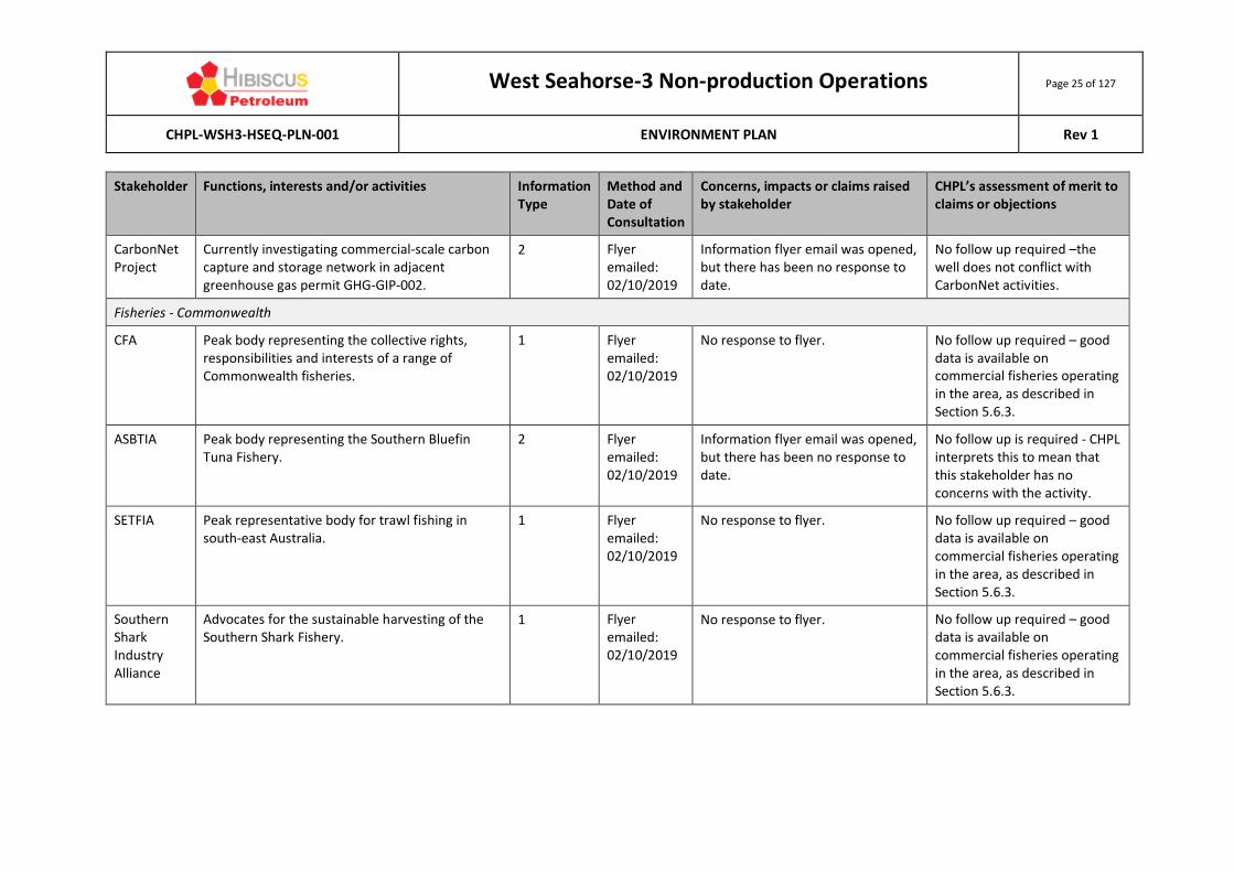
4.5 SUMMARY OF STAKEHOLDER CONSULTATION
A summary of stakeholder consultation undertaken, together with CHPL’s responses and assessment of merit is included in Table 4.3. In summary, there has been no interest in the activity, with no emails or phone calls to CHPL as a result of distributing the information flyer, and no interest expressed by those telephoned by CHPL. As such, there is no compendium of original communications associated with this EP.
4.6 ONGOING CONSULTATION
While the pre-EP submission has ended, CHPL will consult with relevant persons regarding the activity should any stakeholders express interest in doing so.

West Seahorse-3 Non-production Operations Page 23 of 127
CHPL-WSH3-HSEQ-PLN-001 ENVIRONMENT PLAN Rev 1
Table 4.4 Summary of WSH-3 stakeholder consultation
Stakeholder Functions, interests and/or activities Information Type
Method and Date of Consultation
Concerns, impacts or claims raised by stakeholder
CHPL’s assessment of merit to claims or objections
Category 1 – Department or agency of the Commonwealth to which the activities to be carried out under the EP may be relevant
AMSA AMSA is a statutory authority established under the Australian Maritime Safety Authority Act 1990, with one of its key functions being to promote maritime safety and protect the ocean.
2 Flyer emailed: 02/10/2019
Information flyer email was opened, but there has been no response to date.
No follow up required - shipping traffic is described in Section 5.6.7.
AFMA Manages fisheries in Commonwealth waters. 1 Flyer emailed: 02/10/2019
No response to flyer.
No follow up required – good data is available on commercial fisheries operating in the area, as described in Section 5.6.3.
AHO Responsible for the publication and distribution of nautical charts and other information required for safe shipping navigation in Australian waters.
2 Flyer emailed: 02/10/2019
No response to flyer.
No follow up required – the well and the PSZ are already marked on navigation charts.
DoD Manages all Australian defence activities. The DoD has operations in Sale, Gippsland.
2 Flyer emailed: 02/10/2019
No response to flyer.
No follow up required – the well has no impact on DoD activities.
DIRD Manages infrastructure, major projects, transport, local government, rural and regional development and population policy.
2 Flyer emailed: 02/10/2019
No response to flyer.
No follow up required – the well is existing infrastructure.

West Seahorse-3 Non-production Operations Page 24 of 127
CHPL-WSH3-HSEQ-PLN-001 ENVIRONMENT PLAN Rev 1
Stakeholder Functions, interests and/or activities Information Type
Method and Date of Consultation
Concerns, impacts or claims raised by stakeholder
CHPL’s assessment of merit to claims or objections
Category 2 – Each Department or agency of a State to which the activities to be carried out under the EP may be relevant
DJPR - ERR Regulator of oil and gas activities in Victorian waters.
2 Flyer emailed: 02/10/2019
No response to flyer.
No follow up required – the well is outside ERR’s jurisdiction.
Transport Safety Victoria
Implements transport safety in Victoria. 2 Flyer emailed: 02/10/2019
Information flyer email was opened, but there has been no response to date.
No follow up required – no vessel activities are associated with the well.
VFA Manager of fisheries in Victorian waters. 1 Flyer emailed: 02/10/2019
No response to flyer.
No follow up required – good data is available on commercial fisheries operating in the area, as described in Section 5.6.3.
Category 3 – The Department of the responsible State Minister
As per DJPR (ERR) in category 2.
Category 4 – A person or organisation whose functions, interests or activities may be affected by the activities to be carried out under the EP
Titleholders
Esso Australia Resources Pty Ltd (EARPL)
Operates oil and gas facilities in Bass Strait and is the titleholder of the adjacent Vic/L18 permit.
2 Flyer emailed: 02/10/2019
Email bounced back. Contact established with EARPL and re-issued.
No response to flyer.
No follow up required – EARPL is aware of the infrastructure surrounding their operations.
3D Oil Titleholder of adjacent Vic/P57 permit in Bass Strait.
2 Flyer emailed: 02/10/2019
Information flyer email was opened, but there has been no response to date.
No follow up required – 3D Oil has no activities in the activity area.
West Seahorse-3 Non-production Operations Page 25 of 127
CHPL-WSH3-HSEQ-PLN-001 ENVIRONMENT PLAN Rev 1
Stakeholder Functions, interests and/or activities Information Type
Method and Date of Consultation
Concerns, impacts or claims raised by stakeholder
CHPL’s assessment of merit to claims or objections
CarbonNet Project
Currently investigating commercial-scale carbon capture and storage network in adjacent greenhouse gas permit GHG-GIP-002.
2 Flyer emailed: 02/10/2019
Information flyer email was opened, but there has been no response to date.
No follow up required –the well does not conflict with CarbonNet activities.
Fisheries - Commonwealth
CFA Peak body representing the collective rights, responsibilities and interests of a range of Commonwealth fisheries.
1 Flyer emailed: 02/10/2019
No response to flyer.
No follow up required – good data is available on commercial fisheries operating in the area, as described in Section 5.6.3.
ASBTIA Peak body representing the Southern Bluefin Tuna Fishery.
2 Flyer emailed: 02/10/2019
Information flyer email was opened, but there has been no response to date.
No follow up is required - CHPL interprets this to mean that this stakeholder has no concerns with the activity.
SETFIA Peak representative body for trawl fishing in south-east Australia.
1 Flyer emailed: 02/10/2019
No response to flyer.
No follow up required – good data is available on commercial fisheries operating in the area, as described in Section 5.6.3.
Southern Shark Industry Alliance
Advocates for the sustainable harvesting of the Southern Shark Fishery.
1 Flyer emailed: 02/10/2019
No response to flyer.
No follow up required – good data is available on commercial fisheries operating in the area, as described in Section 5.6.3.

West Seahorse-3 Non-production Operations Page 26 of 127
CHPL-WSH3-HSEQ-PLN-001 ENVIRONMENT PLAN Rev 1
Stakeholder Functions, interests and/or activities Information Type
Method and Date of Consultation
Concerns, impacts or claims raised by stakeholder
CHPL’s assessment of merit to claims or objections
Tuna Australia
Peak body representing statutory fishing right owners, holders and fish processors and sellers of the eastern and western tuna and billfish fisheries of Australia.
2 Flyer emailed: 02/10/2019
Information flyer email was opened, but there has been no response to date.
No follow up is required - CHPL interprets this to mean that this stakeholder has no concerns with the activity.
Sustainable Shark Fishing Association
Represents interests of its Commonwealth-licenced shark gillnet and shark hook members in the Gillnet Hook and Trap Fishery.
1 Flyer emailed: 02/10/2019
Information flyer email was opened, but there has been no response to date.
No follow up is required - CHPL interprets this to mean that this stakeholder has no concerns with the activity.
Fisheries – Victorian
SIV Peak industry body for Victorian Fisheries 1 Flyer emailed: 02/10/2019
Information flyer email was opened, but there has been no response to date.
No follow up is required - CHPL interprets this to mean that this stakeholder has no concerns with the activity.
VR Fish Peak body representing recreational fishers in Victoria.
2 Flyer emailed: 02/10/2019
No response to flyer.
No follow up is required - CHPL is aware of the recreational fishing efforts in the region.
VSFA Representative body for Victorian scallop fishers. 2 Flyer emailed: 02/10/2019
No response to flyer.
No follow up required – good data is available on commercial fisheries operating in the area, as described in Section 5.6.3.

West Seahorse-3 Non-production Operations Page 27 of 127
CHPL-WSH3-HSEQ-PLN-001 ENVIRONMENT PLAN Rev 1
Stakeholder Functions, interests and/or activities Information Type
Method and Date of Consultation
Concerns, impacts or claims raised by stakeholder
CHPL’s assessment of merit to claims or objections
Eastern Zone Abalone Industry Association
Part of the broader Victorian Abalone Fishery relevant to this activity.
2 Flyer emailed: 02/10/2019
No response to flyer.
No follow up required – good data is available on commercial fisheries operating in the area, as described in Section 5.6.3.
Category 5 – Any other person or organisation that the Titleholder considers relevant
None identified for this activity.

West Seahorse-3 Non-production
Operations Page 28 of 127
CHPL-WSH3-HSEQ-PLN-001 ENVIRONMENT PLAN Rev 1
5 DESCRIPTION OF THE EXISTING ENVIRONMENT
In accordance with OPGGS(E) Regulation 13(2), the EMBA for this activity is described in this chapter, together with its values and sensitivities. As described in Section 2.3, a traditional EMBA (that is normally based on oil spill trajectory modelling) is not relevant to this activity because there is no risk of an oil release from the well (due to the four cement plugs in the well). This renders carrying out vessel-based inspection and maintenance activities as unnecessary and results in a lack of credible oil spill scenario with which to establish a traditional EMBA. As such, the EMBA for this activity has been defined as the area encompassing the PSZ.
5.1 REGIONAL CONTEXT
The activity area is located within the Southeast Shelf Transition provincial bioregion within the South-east marine region (DoE, 2015a). This region extends from east of Wilson’s Promontory to north of Tathra (NSW) (Figure 5.1). This bioregion is defined based on its distinct and unique habitats and biological communities, structured by a combination of physical, chemical and biological processes (Barton et al., 2012). The coastline adjacent to the bioregion is exposed, with long sandy beaches broken by rocky headlands and numerous coastal lagoons.
5.1.1 CLIMATE
The region’s climate is defined as temperate (Barton et al., 2012), with moist winters and warm summers. It is influenced by rain bearing cold fronts that move from south-west to north-east across the region, producing strong winds from the west, north-west and south-west. In winter, when the subtropical ridge moves northwards over the Australian continent, cold fronts generally create sustained west to south-westerly winds and frequent rainfall in the region (McInnes and Hubbert, 2003). In summer, frontal systems are often shallower and occur between two ridges of high pressure, bringing more variable winds and rainfall. Temperature and Rainfall Average monthly air temperatures at Lakes Entrance (49 km northeast of the activity area, but the
closest coastal town with a Bureau of Meteorology [BoM] weather station) range from 14.6C in July
to 23.8C in February (1965 to 2006) (BoM, 2019). Mean annual rainfall is 713 mm with the rainfall fairly evenly distributed throughout the year, with a mean minimum of 41.5 mm in February and a maximum of 71 mm in November (BoM, 2019). Winds Bass Strait is located on the northern edge of the westerly wind belt known as the Roaring Forties. Occasionally, intense meso-scale low-pressure systems occur in the region, bringing very strong winds, heavy rain and high seas. These events are unpredictable in occurrence, intensity and behaviour, but are most common between September and February (McInnes and Hubbert, 2003).

West Seahorse-3 Non-production
Operations Page 29 of 127
CHPL-WSH3-HSEQ-PLN-001 ENVIRONMENT PLAN Rev 1
Source: DoE (2015).
Source: Barton et al (2012).
Figure 5.1. The Southeast Shelf Transition provincial bioregion (top) and the Twofold Shelf Victorian bioregion (bottom)

West Seahorse-3 Non-production
Operations Page 30 of 127
CHPL-WSH3-HSEQ-PLN-001 ENVIRONMENT PLAN Rev 1
5.1.2 PHYSICAL ENVIRONMENT
Geomorphology The activity area overlaps the seafloor ‘slope’ geomorphic unit as classified in the South-east Marine Region Profile (DoE, 2015a). Seabed Regional The substrate across Bass Strait comprises a variety of sediment types related to tidal currents, with sediment grain size linked to wave energy. Sediments become progressively finer with increasing distance from the shore, consisting of fine, muddy sands in the mid-shelf regions (Harris and Heap, 2009; Wilson and Poore, 1987). Subtidal soft sediment is recent Holocene sand (<10, 000 years ago) consisting of a mixture of fine and medium sand with some silt, gravelly sand and shell, and with a low carbonate content of 14-19% (Barton et al., 2012). Harris and Heap (2009) also state that that the calcium carbonate content of the sands in the activity area is about 10-20%. The carbonate component consists of recognisable skeletal fragments of molluscs, bryozoans and foraminifera (Harris and Heap, 2009). Local A geotechnical and geophysical survey was conducted in 2007 prior to the drilling of WSH-3; this data is used to characterise and describe the seabed around the well site. The seabed at WSH-3 is relatively flat and featureless on a sandy seabed with localised depressions in water depths of approximately 38 – 40 m (Fugro, 2007). At the time of the survey in 2007, there was no debris evident at the WSH-3 location. The upper most sediments, present from the seabed to approximately 2.5 m below the seabed, consist of Holocene sands and unconsolidated, fine to course, occasionally shelly sand with a variable carbonate content (~10-80%) (Holdgate et al., 2003). This, along with the earlier description of regional seabed conditions, indicates that the prevalence of a sandy seabed extends well beyond the activity area.
5.1.3 OCEANOGRAPHY
Water Depth The WSH-3 wellhead is located in water depth of 39.5 m (see Figure 2.1). Water Currents
The region is oceanographically complex, with sub-tropical influences from the north and sub-polar influences from the south combined with tides, winds and density driven flows (DoE, 2015a). There is a slow easterly flow of waters in Bass Strait and a large anti-clockwise circulation (DoE, 2015a). Three key water currents influence Bass Strait:
1. The Leeuwin Current; 2. The East Australian Current (EAC); and 3. The Bass Strait Cascade (DoE, 2015a).
Figure 5.2 represents the major ocean currents in south-eastern Australian waters during summer and winter.

West Seahorse-3 Non-production
Operations Page 31 of 127
CHPL-WSH3-HSEQ-PLN-001 ENVIRONMENT PLAN Rev 1
Source: DoE (2015a)
Figure 5.2. Major ocean currents in south-eastern Australian waters during summer (top) and winter (bottom)

West Seahorse-3 Non-production
Operations Page 32 of 127
CHPL-WSH3-HSEQ-PLN-001 ENVIRONMENT PLAN Rev 1
Sea Temperature
The shallowness of Bass Strait means that its waters more rapidly warm in summer and cool in winter than waters of nearby regions (DoE, 2015a). The sea surface temperatures in the area reflect the influence of warmer waters brought into Bass Strait by the EAC (IMCRA, 1998; Barton et al., 2012). Waters of eastern Bass Strait are generally well mixed, but surface warming sometimes causes weak stratification in calm summer conditions. The average annual sea surface temperature is 16°C.
Salinity Salinity consistently ranges from 35-36 practical salinity units (psu) throughout the year (based on the World Ocean Atlas database).
Tides
Bass Strait is a relatively shallow area of the continental shelf, connecting the southeast Indian Ocean with the Tasman Sea. Bass Strait has a reputation for high winds and strong tidal currents (DoE, 2015a). Tidal currents run parallel to the coast and follow a semi-diurnal pattern (Barton et al., 2012), with some diurnal inequalities (Jones and Padman, 1983) and speeds generally ranging from 0.1 to 2.5 m/s (Fandry, 1983). However, Barton et al (2012) report that strong tidal currents (2 to 2.5 knots, or 1-1.3 m/s) are characteristic of the area. Tidal variation is 0.9 m for spring tides and 0.6 m for neap tides (Barton et al., 2012).
Waves
Bass Strait is a high-energy environment exposed to frequent storms and significant wave heights (Jones, 1980), though Barton et al (2012) report wave energy in the Twofold Shelf Bioregion as relatively low. Storms may occur several times a month resulting in wave heights of 3 to 4 m or more.
Water Quality
The Regional Outfall Sewer (ROS) has a discharge point at Delray Beach that extends into nearshore waters 23 km shoreward of the operational area. While no data is publicly available regarding the water quality of this release, it is expected to result in increased turbidity and nutrient levels (particularly nitrogen and phosphorous) within a mixing zone around the discharge point.
5.1.4 AMBIENT OCEAN SOUND
Wind is a major contributor to noise between 100 Hz and 30 kHz and can reach 85-95 dB re 1µPa2/Hz under extreme conditions (WDCS, 2004). Rain may produce short periods of high underwater sound with a flat frequency spectra to levels of 80 dB re 1µPa2/Hz and magnitude 4 earthquakes have been reported to have spectral levels reaching 119 dB re 1µPa2/Hz at frequency ranges of 5-15 Hz. It is noted that earthquakes of this magnitude are relatively frequent along Australia’s continental shelf in the southern margin (i.e., tens of small earthquakes per year) (McCauley & Duncan, 2001).
5.2 CONSERVATION VALUES AND SENSITIVITIES
The conservation values and sensitivities in and around the activity area are described in this section, with Table 5.1 providing an outline of the conservation categories included.

West Seahorse-3 Non-production
Operations Page 33 of 127
CHPL-WSH3-HSEQ-PLN-001 ENVIRONMENT PLAN Rev 1
Table 5.1. Conservation values in the activity area
Category Conservation classification Section
MNES under the EPBC Act
Commonwealth marine areas (principally Australian Marine Parks, AMP)
Section 5.2.1
World Heritage-listed properties Section 5.2.2
National Heritage-listed places Section 5.2.3
Wetlands of international importance Section 5.2.4
Nationally threatened species and threatened ecological communities
Section 5.2.5, Section 5.4
Migratory species Section 5.4
Commonwealth marine areas Section 5.4
Great Barrier Reef Marine Park Not applicable
Nuclear actions Not applicable
A water resource, in relation to coal seam gas development and large coal mining development
Not applicable
Other areas of national importance
Commonwealth heritage-listed places Section 5.2.6
Key Ecological Features (KEF) Section 5.2.7
Nationally important wetlands Section 5.2.8
Victorian protected areas
Marine National Parks and Sanctuaries Section 5.2.9
5.2.1 AUSTRALIAN MARINE PARKS
The activity area does not overlap any AMPs. The nearest AMPs are the Beagle AMP and East Gippsland AMP, located 109 km southwest and 214 km east of the activity area, respectively (Figure 5.3).
5.2.2 WORLD HERITAGE-LISTED PROPERTIES
World Heritage-Listed properties are examples of sites that represent the best examples of the world’s cultural and heritage values, of which Australia has 19 properties (DoEE, 2019a). In Australia, these properties are protected under Chapter 5, Part 15 of the EPBC Act. No properties on the World Heritage List occur within the activity area. The nearest site is the Royal Exhibition Building and Carlton Gardens in Melbourne, an onshore property located 236 km to the northwest of the activity area.
5.2.3 NATIONAL HERITAGE-LISTED PLACES
The National Heritage List is Australia’s list of natural, historic and Indigenous places of outstanding significance to the nation (DoEE, 2019b). These places are protected under Chapter 5, Part 15 of the EPBC Act.

West Seahorse-3 Non-production
Operations Page 34 of 127
CHPL-WSH3-HSEQ-PLN-001 ENVIRONMENT PLAN Rev 1
There are no National Heritage-listed places in Bass Strait, with the nearest places all located onshore (Australian Alps National Parks and Reserves and the Point Nepean Defence Sites and Quarantine Station Area).
5.2.4 WETLANDS OF INTERNATIONAL IMPORTANCE
Australia has 66 wetlands of international importance (‘Ramsar wetlands’) that cover more than 8.3 million hectares (as of September 2019) (DoEE, 2019c). Ramsar wetlands are those that are representative, rare or unique wetlands, or are important for conserving biological diversity, and are included on the List of Wetlands of International Importance developed under the Ramsar Convention. These wetlands are protected under Chapter 5, Part 15 of the EPBC Act. There are no Ramsar wetlands in the activity area. The nearest is the ‘Gippsland Lakes’ which is located onshore and 14.5 km from the activity area at its closest point.
5.2.5 THREATENED ECOLOGICAL COMMUNITIES
Threatened Ecological Communities (TECs) provide wildlife corridors and/or habitat refuges for many plant and animal species, and listing a TEC provides a form of landscape or systems-level conservation (including threatened species). The Protected Matters Search Tool (PMST) results indicate that there are no TECs within the activity area (DoEE, 2019d). The nearest TEC to the activity area is the Giant Kelp Marine Forests of South East Australia, which is mapped as occurring at the mouth of the Snowy River 102 km to the north-east.
5.2.6 COMMONWEALTH HERITAGE-LISTED PLACES
Commonwealth Heritage-listed places are natural, indigenous and historic heritage places owned or controlled by the Commonwealth (DoEE, 2019e). In Australia, these properties are protected under Chapter 5, Part 15 of the EPBC Act. No properties on the Commonwealth Heritage List occur within the EMBA. The nearest places are the Wilsons Promontory Lighthouse (146 km southwest of the activity area) and the Gabo Island Lighthouse (219 km northeast of the activity area).
5.2.7 KEY ECOLOGICAL FEATURES
Key Ecological Features (KEFs) are elements of the Commonwealth marine environment that, based on current scientific understanding, are considered to be of regional importance for either the region's biodiversity or ecosystem function and integrity. KEFs have no legal status in decision-making under the EPBC Act, but may be considered as part of the Commonwealth marine area (DoEE, 2019f). The National Conservation Values Atlas indicates that the activity area does not intersect any KEFs. The closest KEF is the ‘Upwelling East of Eden’ with its western most edge located 35 km east of the activity area (Figure 5.3).
5.2.8 NATIONALLY IMPORTANT WETLANDS
Nationally important wetlands are considered significant for a variety of reasons, including their importance for maintaining ecological and hydrological roles in wetland systems, providing important habitat for animals at a vulnerable stage in their life cycle, supporting 1% or more of the national population of any native plant or animal taxa or for its outstanding historical or cultural significance (DoEE, 2019g).

West Seahorse-3 Non-production
Operations Page 35 of 127
CHPL-WSH3-HSEQ-PLN-001 ENVIRONMENT PLAN Rev 1
There are no nationally important wetlands located within the activity area. The nearest is the ‘Lake Wellington Wetlands’, which occurs 5.4 km inland of the shoreline.
5.2.9 VICTORIAN MARINE PROTECTED AREAS
Victoria has 24 marine national parks and sanctuaries that are protected and managed under the National Parks Act 1982 (Vic) by Parks Victoria. There are no marine protected areas located in the activity area, with the nearest being the Ninety Mile Beach Marine National Park (MNP), 42 km southwest of the activity area (see Figure 5.3).
5.3 COASTAL ENVIRONMENT
Given that the activity area does not extend to any shoreline, the coastal environment is described here only in general.
The coastline adjacent to the activity area comprises the Ninety Mile Beach, a 90-mile (145 km) long stretch of sandy beach on the seaward side of a narrow, tall, vegetated sand dune system. These sand dunes provide important habitat for hooded plovers and roosting sites for other shorebird species.
Sand is the dominant intertidal substrate of the coastline adjacent to the activity area, with intertidal shore platforms intermittently occurring.

West Seahorse-3 Non-production
Operations Page 36 of 127
CHPL-WSH3-HSEQ-PLN-001 ENVIRONMENT PLAN Rev 1
Figure 5.3. Protected areas and KEFs adjacent to the VIC/L31 permit

West Seahorse-3 Non-production
Operations Page 37 of 127
CHPL-WSH3-HSEQ-PLN-001 ENVIRONMENT PLAN Rev 1
5.4 BIOLOGICAL ENVIRONMENT
Results of the PMST database search provides the key means by which species and their Biologically Important Areas (BIAs) are identified for the activity area and are discussed in this section (DoEE, 2019d).
5.4.1 BENTHIC ASSEMBLAGES
Bass Strait The seascape of the region is composed of a series of massive sediment flats, interspersed with small patches of reef, bedrock and consolidated sediment (Wilson and Poore, 1987). OSRA mapping for the Ninety Mile Beach indicates that there is an absence of hard substrate or emergent reefs in the region. The sediment flats are generally devoid of emergent fauna but benthic invertebrates such as polychaetes, bivalves, molluscs, crustaceans and echinoderms are present and many species are widely distributed across Bass Strait (Poore et al., 1985; Wilson and Poore, 1987). There are also a number of burrowing species that inhabit the soft seabed, including tubeworms, nematodes, nemerteans and seapens (OMV, 2001).
Parry et al (1989) also found high diversity and patchiness of benthos sampled off Lakes Entrance, where a total of 353 species of infauna was recorded. Crustaceans (53%), polychaetes (32%) and molluscs (9%) dominated sample results. Barton et al (2012) report that in the Ninety Mile Beach Marine National Park (42 km west-southwest of the activity area at its nearest point), reefs are dominated by invertebrates (70% coverage), including sponges, ascidians (sea squirts) and smaller bryozoans (resembling coral) and hydroids (colonies of tiny jellies attached to a feather-like base).
Activity Area The sandy nature of the seabed around the wellhead in Figure 2.2. It is therefore assumed that the activity area is consistent with the sandy sediment profile of the broader Gippsland continental shelf described above.
5.4.2 FLORA
Literature searches, combined with Oil Spill Response Atlas (OSRA) mapping, indicate that marine flora, such as seagrasses and kelp, are generally not abundant in the extensive areas of subtidal sand flats in the water depths of the activity area. This is likely to be due to the high-energy nature of the Gippsland coastline and the mobile nature of sands, which prevents many species being able to anchor themselves to the seabed. Barton et al (2012) report that in the Ninety Mile Beach MNP (28 km west-southwest of the activity area), reefs have sparse floral communities of small red algae. Given the park’s proximity, this may be expected to be representative of flora present on rocky reefs near the activity area.
5.4.3 PLANKTON
Plankton is a key component in oceanic food chains and comprises two elements; phytoplankton and zooplankton, as described herein.

West Seahorse-3 Non-production
Operations Page 38 of 127
CHPL-WSH3-HSEQ-PLN-001 ENVIRONMENT PLAN Rev 1
Phytoplankton (photosynthetic microalgae) comprise 13 divisions of mainly microscopic algae, including diatoms, dinoflagellates, gold-brown flagellates, green flagellates and cyanobacteria and prochlorophytes (McLeay et al., 2003). Phytoplankton drift with the currents, although some species have the ability to migrate short distances through the water column using ciliary hairs. Zooplankton is the faunal component of plankton, comprising small crustaceans (such as krill) and fish larvae that feed on zooplankton. Zooplankton includes species that drift with the currents and also those that are motile. More than 170 species of zooplankton have been recorded in eastern and central Bass Strait, with copepods making up approximately half of the species encountered (Watson & Chaloupka, 1982). The CarbonNet Pelican 3D marine seismic survey (which took place in early 2018 and is located 10 km south-west of WSH-3) undertook pre- and post-seismic survey plankton sampling. This found that the composition of zooplankton was a typical healthy example of those expected for temperate coastal waters. Copepods were found to be the dominant group, with varying proportions of appendicularians, cladocerans and doliolids. Numerous other groups occurred in small numbers, including siphonophores, fish larvae, fish eggs, polychaetes, ghost shrimps and cnidarians (jellies) (CarbonNet, 2019).
5.4.4 FISH
It is estimated that there are over 500 species of fish found in the waters of Bass Strait, including a number of species of importance to commercial and recreational fisheries (LCC, 1993). There are 32 fish species (28 of which are seahorses and pipefish) recorded in the EPBC Act PMST (DoEE, 2019d) as potentially occurring in the activity area.
Table 5.2. EPBC Act-listed fish that may occur in the activity area
Scientific name Common name
EPBC Act status BIA within the EMBA?
Recovery Plan in place?
Listed threatened
species
Listed migratory
species
Listed marine species
Freshwater
Prototroctes maraena
Australian grayling
V - - - RP, AS
Oceanic
Carcharodon carcharias
Great white shark
V Yes - B RP, AS
Lamna nasus Porbeagle - Yes - - -
Rhincodon typus Whale shark V Yes - - Expired
Pipefish, seahorses and seadragons
Heraldia nocturna
Upside-down pipefish
- - Yes - -
Hippocampus abdominalis
Big-belly seahorse
- - Yes - -
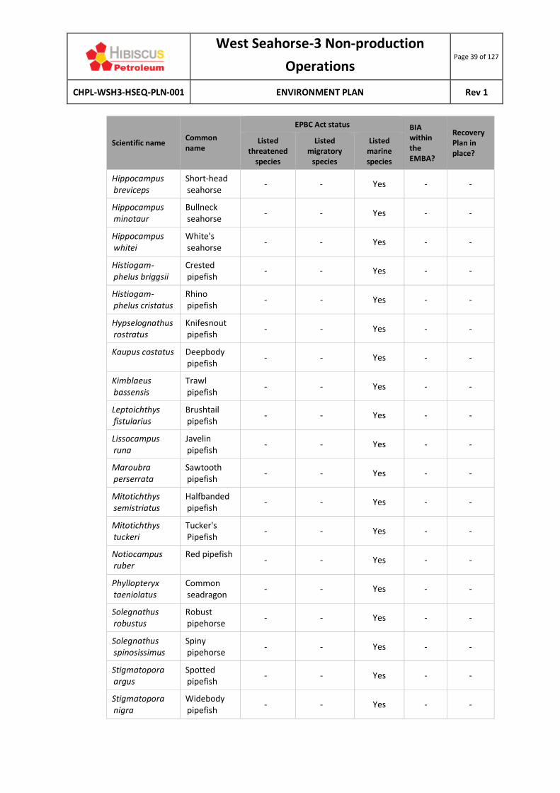
West Seahorse-3 Non-production
Operations Page 39 of 127
CHPL-WSH3-HSEQ-PLN-001 ENVIRONMENT PLAN Rev 1
Scientific name Common name
EPBC Act status BIA within the EMBA?
Recovery Plan in place?
Listed threatened
species
Listed migratory
species
Listed marine species
Hippocampus breviceps
Short-head seahorse
- - Yes - -
Hippocampus minotaur
Bullneck seahorse
- - Yes - -
Hippocampus whitei
White's seahorse
- - Yes - -
Histiogam-phelus briggsii
Crested pipefish
- - Yes - -
Histiogam-phelus cristatus
Rhino pipefish
- - Yes - -
Hypselognathus rostratus
Knifesnout pipefish
- - Yes - -
Kaupus costatus Deepbody pipefish
- - Yes - -
Kimblaeus bassensis
Trawl pipefish
- - Yes - -
Leptoichthys fistularius
Brushtail pipefish
- - Yes - -
Lissocampus runa
Javelin pipefish
- - Yes - -
Maroubra perserrata
Sawtooth pipefish
- - Yes - -
Mitotichthys semistriatus
Halfbanded pipefish
- - Yes - -
Mitotichthys tuckeri
Tucker's Pipefish
- - Yes - -
Notiocampus ruber
Red pipefish - - Yes - -
Phyllopteryx taeniolatus
Common seadragon
- - Yes - -
Solegnathus robustus
Robust pipehorse
- - Yes - -
Solegnathus spinosissimus
Spiny pipehorse
- - Yes - -
Stigmatopora argus
Spotted pipefish
- - Yes - -
Stigmatopora nigra
Widebody pipefish
- - Yes - -

West Seahorse-3 Non-production
Operations Page 40 of 127
CHPL-WSH3-HSEQ-PLN-001 ENVIRONMENT PLAN Rev 1
Scientific name Common name
EPBC Act status BIA within the EMBA?
Recovery Plan in place?
Listed threatened
species
Listed migratory
species
Listed marine species
Stipecampus cristatus
Ringback pipefish
- - Yes - -
Syngnathoides biaculeatus
Double-end pipehorse
- - Yes - -
Urocampus carinirostris
Hairy pipefish
- - Yes - -
Vanacampus margaritifer
Mother-of-pearl pipefish
- - Yes - -
Vanacampus phillipi
Port Phillip pipefish
- - Yes - -
Vanacampus poecilolaemus
Longsnout pipefish
- - Yes - -
Definitions
Listed threatened species:
A native species listed in Section 178 of the EPBC Act as either extinct, extinct in the wild, critically endangered, endangered, and vulnerable or conservation dependent.
Listed migratory species: A native species that from time to time is included in the appendices to the Bonn Convention and the annexes of JAMBA, CAMBA and ROKAMBA, as listed in Section 209 of the EPBC Act.
Listed marine species: As listed in Section 248 of the EPBC Act.
Key
EPBC status (@ September 2019) V Vulnerable
E Endangered
CE Critically endangered
BIA A Aggregation
D Distribution (i.e., presence only)
F Foraging
M Migration
B Breeding
Recovery plans CA Conservation Advice
(under the EPBC Act 1999) CMP Conservation Management Plan
RP Recovery Plan
(under the FFG Act 1988) AS Action Statement

West Seahorse-3 Non-production
Operations Page 41 of 127
CHPL-WSH3-HSEQ-PLN-001 ENVIRONMENT PLAN Rev 1
Australian grayling (Prototroctes maraena) (EPBC Act: Vulnerable, FFG Act: Threatened) The Australian grayling is a dark brown to olive-green fish attaining 19 cm in length. The species typically inhabits the coastal streams of New South Wales, Victoria and Tasmania, migrating between streams and the ocean (Backhouse et al., 2008; DELWP, 2015). The species spends most of its life in freshwater (DELWP, 2015), and migrates to lower reaches of rivers to spawn typically in autumn (Museums Victoria, 2019). The Australian Grayling Action Statement (DELWP, 2015) lists several rivers as important locations for the species. None of these rivers are intersected by the activity area.
Great white shark (Carcharodon carcharias) (EPBC Act: Vulnerable, FFG Act: Threatened) The great white shark is widely distributed and located throughout temperate and sub-tropical waters, with their known range in Australian waters including all coastal areas except the Northern Territory (DSEWPaC, 2013).
Observations of adult sharks are more frequent around fur seal and sea lion colonies, including Wilsons Promontory (approximately 150 km southwest of the activity area) and the Skerries (approximately 175 km northeast of the activity area) (DSE, 2003). Juveniles are known to congregate in certain key areas including the Ninety Mile Beach area (including Corner Inlet and Lakes Entrance), where a BIA for breeding is overlapped by the activity area (Figure 5.4). A BIA (distribution only) for the great white shark covers the entire southeast marine region. Given their transitory nature and the proximity of known congregation areas, great white sharks may occur within the activity area. Whale shark (Rhincodon typus) (EPBC Act: Vulnerable, listed migratory, Flora and Fauna Guarantee (FFG) Act: Not listed) The whale shark is the world’s largest fish and one of only three filter-feeding shark species (TSSC, 2015a). They have a broad distribution in warm and tropical waters of the world, and in Australia are known only to occur on the west coast of Western Australia, with a feeding aggregation occurring off the Ningaloo Reef between March and July each year (TSSC, 2015a). The species is not known to migrate through Bass Strait, and it is highly unlikely to occur within the activity area. Sygnathids (EPBC Act: Listed marine species, FFG Act: Not listed) Twenty-seven (27) of the 31 marine ray-finned fish species identified in the EPBC Act PMST (87%) are sygnathiformes, which includes seahorses, seadragon, pipehorse and pipefish. The majority of these fish species are associated with seagrass meadows, macroalgal seabed habitats, rocky reefs and sponge gardens located in shallow, inshore waters (e.g., protected coastal bays, harbours and jetties) less than 50 m deep (Museums Victoria, 2019). Figure 2.2 indicates hard substrate is not present around the WSH-3 wellhead. The wellhead itself may provide a hard substrate for colonising species, in turn providing habitat for sygnathids.
5.4.5 CETACEANS
The PMST (DoEE, 2019d) indicates that five whale species and five dolphin species may reside within or migrate through the activity area (Table 5.3).
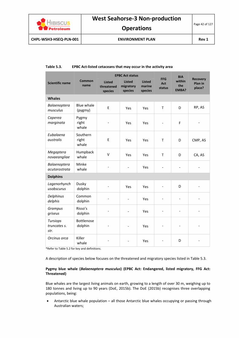
West Seahorse-3 Non-production
Operations Page 42 of 127
CHPL-WSH3-HSEQ-PLN-001 ENVIRONMENT PLAN Rev 1
Table 5.3. EPBC Act-listed cetaceans that may occur in the activity area
Scientific name Common
name
EPBC Act status FFG Act
status
BIA within
the EMBA?
Recovery Plan in place?
Listed threatened
species
Listed migratory
species
Listed marine species
Whales
Balaenoptera musculus
Blue whale (pygmy)
E Yes Yes T D RP, AS
Caperea marginata
Pygmy right whale
- Yes Yes - F -
Eubalaena australis
Southern right whale
E Yes Yes T D CMP, AS
Megaptera novaeangliae
Humpback whale
V Yes Yes T D CA, AS
Balaenoptera acutorostrata
Minke whale
- - Yes - - -
Dolphins
Lagenorhynchusobscurus
Dusky dolphin
- Yes Yes - D -
Delphinus delphis
Common dolphin
- - Yes - - -
Grampus griseus
Risso’s dolphin
- - Yes - - -
Tursiops truncates s. str.
Bottlenose dolphin - - Yes - - -
Orcinus orca Killer whale
- - Yes - D -
*Refer to Table 5.2 for key and definitions.
A description of species below focuses on the threatened and migratory species listed in Table 5.3.
Pygmy blue whale (Balaenoptera musculus) (EPBC Act: Endangered, listed migratory, FFG Act: Threatened) Blue whales are the largest living animals on earth, growing to a length of over 30 m, weighing up to 180 tonnes and living up to 90 years (DoE, 2015b). The DoE (2015b) recognises three overlapping populations, being:
• Antarctic blue whale population – all those Antarctic blue whales occupying or passing through Australian waters;

West Seahorse-3 Non-production
Operations Page 43 of 127
CHPL-WSH3-HSEQ-PLN-001 ENVIRONMENT PLAN Rev 1
• Indo-Australian pygmy blue whale – all those pygmy blue whales occupying or passing through waters from Indonesia to western and southern Australia; and
• Tasman-Pacific pygmy blue whale – all those putative pygmy blue whales occupying or passing through waters in southeast Australia and the Pacific Ocean.
The Tasman-Pacific pygmy blue whale (B. musculus. brevicauda) is the sub-species that migrates through Bass Strait, found in waters north of 55°S (DoE, 2015b). Blue whales are a highly mobile species that feed on krill (euphausids, Nyctiphane australis). A BIA for ‘likely foraging’ for the pygmy blue whale covers most of Bass Strait, including the activity area, with known foraging areas (abundant food source/annual high use area) occurring off the southwest Victorian coast (Figure 5.7). Pygmy blue whales may pass through the activity area.
Pygmy right whale (Caperea marginata) (EPBC Act: Listed migratory, FFG Act: Not listed) Pygmy right whales are a little-studied baleen whale species found in temperate and sub-Antarctic waters in oceanic and inshore locations. There are few confirmed sightings of pygmy right whales at sea (Reilly et al., 2008), with few or no records from eastern Victoria and no population estimates available for Australian waters (DoEE, 2019i). The largest reported group sighted (100+) occurred near Portland in June 2007 (Gill et al., 2008). Based upon the lack of sightings off eastern Victoria, the absence of a BIA in Australian waters and the nearshore location of the activity area, it is considered unlikely that this species occurs within the activity area. Southern right whale (Eubalaena australis) (EPBC Act: Endangered, listed migratory, FFG Act: Threatened) Southern right whales are medium to large black (or less commonly grey-brown) baleen whales (DSEWPC, 2012). They are recognisable by the lack of a dorsal fin, rotund body shape, and whitish callosities (patches of keratinised skin colonised by cyamids - small crustaceans) on the head. They reach a maximum length of approximately 17.5 m and a weight of around 80 tonnes, with mature females slightly larger than males (DSEWPC, 2012).
The southern right whale is typically distributed between 16°S and 65°S in the southern hemisphere and is present off the Australian coast between May and October (sometimes as early as April and as late as November) (DSEWPC, 2012). Southern right whales tend to be distinctly clumped in aggregation areas (DSEWPC, 2012). Aggregation areas are well known, with the largest located in Western Australia and South Australia. The closest known aggregation area to the activity area is located in the Warrnambool region, approximately 455 km to the west. The southern right whale has a defined migration BIA that occurs close to the shore along the entire Victorian coastline (Figure 5.7).
Humpback whale (Megaptera novaeangliae) (EPBC Act: Vulnerable, listed migratory, FFG Act: Threatened) The humpback whale is a moderately large (15-18 m long) baleen whale that has a worldwide distribution but geographic segregation. Humpback whales are found in Australian offshore and Antarctic waters. They primarily feed on krill in Antarctic waters south of 55°S. The eastern Australian population of humpback whales is referred to as Group E1 by the International Whaling Commission, one of seven distinct breeding stocks in the southern hemisphere (TSSC, 2015b). Bass Strait represents part of the core range of the E1 Group, but feeding, resting or calving is not known to occur in Bass Strait (TSSC, 2015b), though migration through Bass Strait may occur (Figure

West Seahorse-3 Non-production
Operations Page 44 of 127
CHPL-WSH3-HSEQ-PLN-001 ENVIRONMENT PLAN Rev 1
5.5 and Figure 5.6). The nearest area that humpback whales are known to congregate (forage) is at the southern-most part of NSW (near the eastern border of Victoria), approximately 221 km northeast of the activity area. Twofold Bay (Eden) off the NSW south coast is the nearest known feeding area (a BIA) for humpback whales, located 240 km northeast of the activity area.
As the activity area represents a core range for humpback whales, there is a likelihood that they may be present, particularly during April, May, November and December, though this likelihood is considered low due to their preference for migrating along the edge of the continental shelf. Minke whale (Balaenoptera acutorostrata) (EPBC Act: Listed marine) Minke whales are the second smallest baleen whale with males measuring an average of 6.8 m upon maturity. Minke whales are known to inhabit and migrate through Australian waters and are known to penetrate deeply into Antarctic waters (Horwood, 1987). Antarctic Minke whales (those relevant to Australia) feed primarily on Antarctic krill and some species of fish. The activity area may overlap with the potential distribution of the minke whale, though due to their preference for Antarctic waters, they are unlikely to be present.
Source: TSSC (2015b).
Figure 5.5. Distribution of the humpback whale around Australia
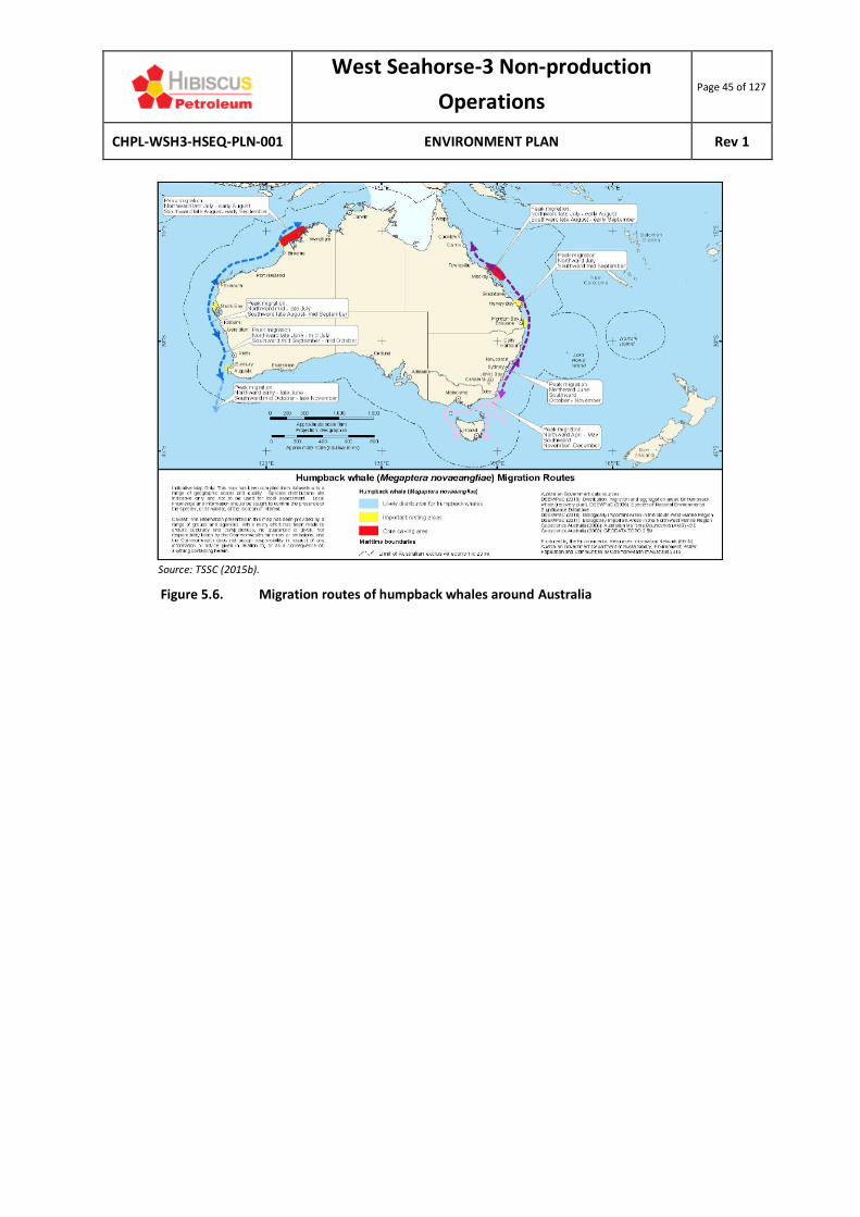
West Seahorse-3 Non-production
Operations Page 45 of 127
CHPL-WSH3-HSEQ-PLN-001 ENVIRONMENT PLAN Rev 1
Source: TSSC (2015b).
Figure 5.6. Migration routes of humpback whales around Australia

West Seahorse-3 Non-production
Operations Page 46 of 127
CHPL-WSH3-HSEQ-PLN-001 ENVIRONMENT PLAN Rev 1
Figure 5.7. Cetacean and great white shark BIAs in and around the activity area

West Seahorse-3 Non-production
Operations Page 47 of 127
CHPL-WSH3-HSEQ-PLN-001 ENVIRONMENT PLAN Rev 1
Dolphins (EPBC Act: Listed marine species)
None of the five species of dolphin listed in the PMST results are listed as threatened under the EPBC Act of FFG Act. Many dolphins are cosmopolitan species that are generally restricted to continental shelf environments. A brief description of these dolphin species is provided below.
• The dusky dolphin (Lagenorhynchus obscures) is primarily found from approximately 55°S to 26°S, though sometimes further north associated with cold currents. They are considered to be primarily an inshore species but can also be oceanic when cold currents are present (Gill et al., 2000; Ross, 2006). Only 13 reports of the dusky dolphin have been made in Australia since 1828, and key locations are yet to be identified (Bannister et al., 1996).
• The common dolphin (Delphinus delphis) is an abundant species, widely distributed from tropical to cool temperate waters, and generally further offshore than the bottlenose, although small groups may venture close to the coast and enter bays and inlets. They have been recorded in waters off all Australian states and territories. Stranding statistics indicate that common dolphins are active in Bass Strait at all times of the year, though less so in winter (DoEE, 2018h).
• The bottlenose dolphin (Tursiops truncatus) has a worldwide distribution from tropical to temperate waters. There are two forms of bottlenose dolphin, a nearshore form and an offshore form. The nearshore form occurs in southern Australia (DoEE, 2018h). Most populations are relatively discrete and reside in particular areas, such as individual resident populations in Port Phillip Bay (256 km west of the activity area) and Westernport Bay (195 km west of the activity area).
• Risso’s dolphin (Grampus griseus) is a widely distributed species found in deep waters of the continental slope and outer shelf from the tropics to temperate regions. This species prefers warm temperate to tropical waters with depths greater than 1,000 m (Bannister et al., 1996). In Australia, the species has been recorded from all states except Tasmania and the Northern Territory. Fraser Island (off the southern Queensland coast) has the only suspected ‘resident’ population in Australia (Bannister et al., 1996).
• The killer whale (Orcinus orca) (the largest member of the dolphin family) is thought to be the most cosmopolitan of all cetaceans and appear to be more common in cold, deep waters, though they have often been observed along the continental slope and shelf particularly near seal colonies (Bannister et al., 1996). The only recognised key locality in Australia is Macquarie Island and Heard Island in the Southern Ocean (Bannister et al., 1996). It is possible that killer whales may occur in the activity area.
5.4.6 PINNIPEDS
There are two pinniped species recorded under the EPBC Act PMST as potentially occurring within the activity area (Table 5.4) (DoEE, 2019d). These species are not listed as threatened under the FFG Act.
Table 5.4. EPBC Act-listed pinnipeds that may occur in the activity area
Scientific name
Common name
EPBC Act status FFG Act
status
BIA within the
EMBA?
Recovery Plan in place?
Listed threatened
species
Listed migratory
species
Listed marine species
Arctocephalus forsteri
New Zealand fur-seal
- - Yes - - -
Arctocephalus pusillus
Australian fur-seal
- - Yes - - -

West Seahorse-3 Non-production
Operations Page 48 of 127
CHPL-WSH3-HSEQ-PLN-001 ENVIRONMENT PLAN Rev 1
New Zealand fur-seal (Arctocephalus forsteri) (EPBC Act: Listed marine, FFG Act: Not listed) New Zealand fur-seals (also known as long-nosed fur-seals) are mostly found in central South Australian waters (Kangaroo Island to South Eyre Peninsula) with 77% of their population found here (Shaughnessy, 1999).
Haul-out sites in Bass Strait, as reported by Barton et al (2012) and OSRA mapping, are listed below (all of which occur outside the activity area):
• Beware Reef (111 km northeast of the activity area);
• Kanowna Island (155 km southwest of the activity area) - ~300 individuals;
• The Hogan Islands Group (125 km southwest of the activity area); and
• West Moncoeur Island (south of Wilson’s Promontory, 149 km southwest of the activity area).
There is no BIA for the New Zealand fur-seal in Bass Strait. Given the relatively close proximity of the activity area to breeding colonies and haul-out sites and the far-ranging behaviour of New Zealand fur-seals, it is likely that the species feeds within the activity area. However, there are no islands or rock outcrops within the activity area, so a resident population is unlikely to occur. These waters are unlikely to represent important feeding or breeding habitat.
Australian fur-seal (Arctocephalus pusillus) (EPBC Act: Listed marine, FFG Act: Not listed) The Australian fur-seal has a relatively restricted distribution around the islands of Bass Strait, parts of Tasmania and southern Victoria. There are 10 established breeding colonies of the Australian fur-seal that are restricted to islands in the Bass Strait; six occurring off the coast of Victoria and four off the coast of Tasmania (DoEE, 2019). The largest of the established colonies occur at Lady Julia Percy Island (26% of the breeding population and 491 km west of the activity area) and at Seal Rocks in Victoria (25% of the breeding population and 223 km west-southwest of the activity area) (DoEE, 2019h). These areas are not located within the activity area.
5.4.7 REPTILES
Three species of marine turtle are listed under the EPBC Act as potentially occurring in the activity area, as listed in Table 5.5 (DoEE, 2019d). No BIAs for turtles occur within Bass Strait. Environment Australia (2003) reports that the turtles known to occur in Victorian waters are considered to be rare vagrants outside their usual range. No turtles are listed as threatened under the FFG Act 1988 (Vic), except for the leatherback turtle. Table 5.5 EPBC Act-listed marine reptiles that may occur in the activity area
Scientific Name Common
Name
EPBC Act status
FFG Act
status
BIA within
the EMBA?
Recovery Plan in place?
Listed threatened
species
Listed migratory
species
Listed marine species
Caretta caretta Loggerhead turtle
Endangered Yes Yes - -
Generic RP in place for all
marine

West Seahorse-3 Non-production
Operations Page 49 of 127
CHPL-WSH3-HSEQ-PLN-001 ENVIRONMENT PLAN Rev 1
Chelonia mydas Green turtle Vulnerable Yes Yes - -
turtle species, +
AS for leather-
back turtle
Dermochelys coriacea
Leatherback turtle
Endangered Yes Yes T -
*Refer to Table 5.2 for key and definitions.
The loggerhead (Caretta caretta) and green (Chelonia mydas) turtle species noted in the PMST results are typically distributed in sub-tropical and tropical waters including eastern, northern and western Australia (DoEE, 2017). There are no known turtle nesting beaches for these species within Victoria and as such the activity area is unlikely to represent important habitat (DoEE, 2017). The leatherback turtle (Dermochelys coriacea) is widely distributed throughout tropical, sub-tropical and temperate waters of Australia (DoEE, 2017). No major nesting has been recorded in Australia, with isolated nesting recorded in the Northern Territory, Queensland and northern NSW (DoEE, 2017). This species nests only in the tropics. The DoEE (2017) maps the leatherback turtles as having a known or likely range within Bass Strait, and a migration pathway in southern waters. The waters of the activity area do not represent critical habitat for the species, though it may occur in low numbers during migration.
5.4.8 AVIFAUNA
Thirty-three (33) bird species (seabirds and shorebirds) are listed under the EPBC Act as potentially occurring in the activity area (DoEE, 2019d) (Table 5.6). The majority of these are listed as migratory and marine species. The focus of this section is true seabirds. Shorebird species are not relevant given that the activity area does not intersect the shoreline. Seabirds are those species of bird whose normal habitat and food source is derived from the sea, whether that be coastal or offshore, while shorebirds spend most of their time (nesting, feeding and breeding) on the shoreline.
Table 5.6 EPBC Act-listed marine reptiles that may occur in the activity area
Scientific Name
Common Name
EPBC Act status FFG Act
status
BIA within the
Activity Area?
Recovery Plan in place?
Listed threatened
species
Listed migratory
species
Listed marine species
True seabirds (25 species)
Albatross
Diomedea antipodensis
Antipodean albatross
V Yes Yes - Foraging Generic RP in place for all albatross in Australia, + AS for all albatross
Diomedea gibsoni
Gibson’s albatross
V Yes Yes - Foraging
Diomedea epomophora (sensu stricto)
Southern royal albatross
V Yes Yes T Foraging
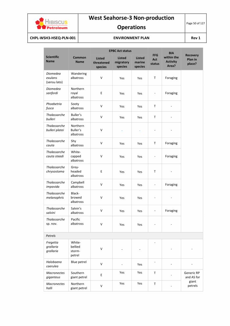
West Seahorse-3 Non-production
Operations Page 50 of 127
CHPL-WSH3-HSEQ-PLN-001 ENVIRONMENT PLAN Rev 1
Scientific Name
Common Name
EPBC Act status FFG Act
status
BIA within the
Activity Area?
Recovery Plan in place?
Listed threatened
species
Listed migratory
species
Listed marine species
Diomedea exulans (sensu lato)
Wandering albatross V Yes Yes T Foraging
Diomedea sanfordi
Northern royal albatross
E Yes Yes - Foraging
Phoebetria fusca
Sooty albatross
V Yes Yes T -
Thalassarche bulleri
Buller’s albatross
V Yes Yes T -
Thalassarche bulleri platei
Northern Buller’s albatross
V - - - -
Thalassarche cauta
Shy albatross
V Yes Yes T Foraging
Thalassarche cauta steadi
White-capped albatross
V Yes Yes - Foraging
Thalassarche chrysostoma
Grey-headed albatross
E Yes Yes T -
Thalassarche impavida
Campbell albatross
V Yes Yes - Foraging
Thalassarche melanophris
Black-browed albatross
V Yes Yes - -
Thalassarche salvini
Salvin’s albatross
V Yes Yes - Foraging
Thalassarche sp. nov.
Pacific albatross
V Yes Yes - -
Petrels
Fregetta grallaria grallaria
White-bellied storm-petrel
V - -
-
- -
Halobaena caerulea
Blue petrel V - Yes
- - -
Macronectes giganteus
Southern giant petrel
E Yes Yes T
- Generic RP and AS for
giant petrels
Macronectes halli
Northern giant petrel
V Yes Yes T
-

West Seahorse-3 Non-production
Operations Page 51 of 127
CHPL-WSH3-HSEQ-PLN-001 ENVIRONMENT PLAN Rev 1
Scientific Name
Common Name
EPBC Act status FFG Act
status
BIA within the
Activity Area?
Recovery Plan in place?
Listed threatened
species
Listed migratory
species
Listed marine species
Pterodroma leucoptera leucoptera
Gould’s petrel E - - - - RP
Other seabirds
Ardenna carneipes
Flesh-footed shearwater
-
Yes Yes
- - -
Catharacta skua
Great skua - -
Yes - - -
Pachyptila turtur subantarctica
Fairy prion (southern) V - - - - CA
Pandion haliaetus
Osprey -
Yes Yes - - -
Puffinus griseus
Sooty shearwater
- Yes Yes - - -
True shorebirds (8 species)
Actitis hypoleucos
Common sandpiper
- Yes Yes - - -
Calidris acuminata
Sharp-tailed sandpiper
- Yes Yes - - -
Calidris canutus
Red knot E Yes Yes - -
Calidris ferruginea
Curlew sandpiper
CE Yes Yes T - -
Calidris melanotos
Pectoral sandpiper
- Yes Yes - - -
Numenius madagascariensis
Eastern curlew CE Yes Yes T - CA
Sterna (Sternula) nereis nereis
Australian fairy tern V - - T - CA
Thinornis rubricollis rubricollis
Hooded plover (eastern)
V Yes Yes T - AS
*Refer to Table 5.2 for key and definitions.
West Seahorse-3 Non-production
Operations Page 52 of 127
CHPL-WSH3-HSEQ-PLN-001 ENVIRONMENT PLAN Rev 1
Exclusively Seabirds Albatross (EPBC Act: Endangered & vulnerable, listed migratory, FFG Act: many listed as threatened) Albatrosses (and giant-petrels) are among the most dispersive and oceanic of all birds, spending more than 95% of their time foraging at sea in search of prey and usually only returning to land (remote islands) to breed. Only five species of albatross and the southern and northern giant petrel are known to breed within Australia. Breeding within Australian territory occurs on the isolated islands of Antarctica (Giganteus Island, Hawker Island and Frazier islands) and the Southern Ocean (Heard Island, McDonald Island, Macquarie Island, Bishop and Clerk Islands), as well as islands off the south coast of Tasmania and Albatross Island off the north-west coast of Tasmania in Bass Strait (DSEWPC, 2011). These locations are each hundreds of kilometres away from the activity area. The PMST results (DoEE, 2019d) indicates that species foraging, feeding or related behaviours exist within the activity area for nine of the albatross species which are noted in Table 5.6, with foraging taking place throughout all of Bass Strait. Given these species’ ability to cover vast ocean distances while foraging, it is possible they may overfly and forage in the vicinity of the activity area. Petrels (EPBC Act: Vulnerable and endangered, some listed migratory) The five petrel species listed in Table 5.6 as potentially flying over the activity area are widely distributed throughout the southern hemisphere. They nest on isolated islands and breed on sub-Antarctic and Antarctic islands. The northern giant-petrel and southern giant-petrel share the same breeding areas listed for the albatross (DSEWPaC, 2011). Outside the breeding season (October to February), petrels disperse widely and move north into sub-tropical waters (DSEWPaC, 2011). Most petrel species feed on krill, squid, fish, other small seabirds and marine mammals (DSEWPaC, 2011). No breeding colonies or nesting areas for the listed petrel species are located in or near the activity area.
The National Conservation Values Atlas (DoEE, 2019j) indicates that there are no BIAs for the listed petrel species in or around Bass Strait, with the nearest being that of a foraging BIA for the southern giant petrel (Macronectes giganteus), which occurs off the southern NSW coast (outside the activity area). Other seabirds Other seabirds listed in the PMST that may occur within the activity area are described here.
• The shearwater species (flesh-footed and sooty) are trans-equatorial migrants widely distributed across the Pacific and Atlantic oceans and is known to inhabit the waters of Australia where they feed on fish. Both species have breeding populations on Lord Howe Island (off NSW). The flesh-footed shearwater breeds in burrows on sloping ground in coastal forest, scrubland, shrubland or grassland. Thirty-nine (39) of the 41 islands on which this species breeds lie off the coast of southern Western Australia. It is possible these species may overfly the activity area.
• The great skua (Catharacta skua) is a large migratory seabird distributed throughout all southern Australian waters (though not listed as migratory under the EPBC Act). This species breeds in summer on nested elevated grasslands or sheltered rocky areas on sub-Antarctic islands, with most adult birds leaving their colonies in winter. Great skuas feed on other seabirds, fish, molluscs and crustaceans, and may be present in the activity area and EMBA (though scarce) during winter (Flegg, 2002).
• The southern fairy prion (Pachyptila turtur subantarctica) is mainly found offshore. The species diet is comprised mostly of crustaceans (especially krill), but occasionally includes some fish and

West Seahorse-3 Non-production
Operations Page 53 of 127
CHPL-WSH3-HSEQ-PLN-001 ENVIRONMENT PLAN Rev 1
squid. It feeds mainly by surface-seizing and dipping, but can also catch prey by surface-plunging or pattering (DoEE, 2019h). In Australia, it is known to breed only on Macquarie, Bishop and Clerk islands (over 2,000 km southeast of the activity area) (DoEE, 2019h).
• The osprey (Pandion haliaetus) is a common, medium-sized raptor that is present around the entire Australian coastline, with the breeding range restricted to the north coast of Australia (including many offshore islands) and an isolated breeding population in South Australia (DoEE, 2019h). Breeding occurs from April to February. Ospreys occur mostly in coastal areas but occasionally travel inland along waterways, where they feed on fish, molluscs, crustaceans, reptiles, birds and mammals. Due to their broad habitat, osprey may be present in the activity area.
Shorebirds and Coastal Species The avifauna species listed under ‘True Shorebirds’ in Table 5.6 typically utilise coastal habitats for feeding, nesting, roosting and, where appropriate, migration. Given that the activity area occurs approximately 13 km offshore and represents habitat not typically utilised by the listed species, shorebirds and coastal species are not described further in this EP.
5.4.9 MARINE PESTS
Invasive Marine Species (IMS) are defined as non-native marine plants or animals that harm Australia’s marine environment, social amenity or industries that use the marine environment, or have the potential to do so if they were to be introduced, established (that is, forming self-sustaining populations) or spread in Australia’s marine environment (DAWR, 2018). In the South-east Marine Region, 115 marine pest species have been introduced and an additional 84 have been identified as possible introductions, or ‘cryptogenic’ species (NOO, 2002). Several introduced species have become pests either by displacing native species, dominating habitats or causing algal blooms. Marine pests known to occur in South Gippsland, according to ParksVic (2015) include:
• Pacific oyster (Crassostrea gigas) – small number of this oyster species are reported to occur in Western Port Bay and at Tidal River in the Wilsons Promontory National Park.
• Northern pacific seastar (Asterias amurensis) – prefer soft sediment habitat, but also use artificial structures and rocky reefs, living in water depths usually less than 25 m (but up to 200 m water depths). It is thought to have been introduced in 1995 through ballast water from Japan.
• New Zealand screw shell (Maoricolpus roseus) – lies on or partially buried in sand, mud or gravel in waters up to 130 m deep. It can densely blanket the sea floor with live and dead shells and compete with native scallops and other shellfish for food. This species is present in eastern Bass Strait, forming extensive and dense beds on sandy seabeds (Patil et al., 2004). It is known to occur in the Point Hicks Marine National Park.
• European shore crab (Carcinus maenas) – prefers intertidal areas, bays, estuaries, mudflats and subtidal seagrass beds, but occurs in waters up to 60 m deep. It is presumed to occur on the intertidal reefs of all the marine national parks in Gippsland, except the Ninety Mile Beach MNP (which has no intertidal reef).
5.5 CULTURAL HERITAGE VALUES
Cultural heritage can be broadly defined as the legacy of physical science artefacts and intangible attributes of a group or society that are inherited from past generations, maintained in the present and bestowed for the benefit of future generations. Cultural heritage includes tangible culture (such
West Seahorse-3 Non-production
Operations Page 54 of 127
CHPL-WSH3-HSEQ-PLN-001 ENVIRONMENT PLAN Rev 1
as buildings, monuments, landscapes, books, works of art, and artefacts), intangible culture (such as folklore, traditions, language, and knowledge) and natural heritage (including culturally significant landscapes). This section describes the cultural heritage values of the activity area, which is broadly categorised as Aboriginal and non-Aboriginal (maritime archaeology).
5.5.1 ABORIGINAL HERITAGE
Aboriginal people have occupied Gippsland for at least 18,000 years and probably for over 40,000 years (OMV, 2003). The coastline adjacent to the activity area is occupied by the Gunaikurnai language group, which comprises five distinct clans; the Brataualung, the Brayalaulung, the Tatungalung, the Brabalung and the Krautungalung (Basslink, 2001). Estimates of the number of clanspeople in the Gunaikurnai are between 3,000 and 5,000 prior to European contact (Basslink, 2001). The Gippsland coastline is of significant Aboriginal cultural heritage significance. Coastal fishing is an important part of Aboriginal culture, with fishing methods including hand gathering, lines, rods and reels, nets, traps and spears (DoE, 2015a). The Victorian Aboriginal Heritage Register contains details of Aboriginal cultural heritage places and objects areas along the coastline, however this is not publicly accessible as it contains culturally sensitive information.
5.5.2 MARITIME ARCHAEOLOGICAL HERITAGE
Shipwrecks (together with their associated relics) over 75 years old are protected within Commonwealth waters under the Underwater Cultural Heritage Act 2018 and in Victorian waters under the Victorian Heritage Act 1995 (Vic). There are no shipwrecks mapped as occurring in the activity area (DoEE, 2019k).
5.6 SOCIO-ECONOMIC ENVIRONMENT
This section describes the social and economic environment of the activity area. Given the exclusively offshore nature of the activity area and the lack of an oil spill EMBA, the onshore socio-economic environment is only briefly described.
5.6.1 COASTAL SETTLEMENTS
The coastline adjacent to the activity area is sparsely populated with the adjoining townships of Golden Beach and Paradise Beach being the closest. These towns are located within the Wellington Shire Council. The Australian Bureau of Statistics (ABS) indicates that the populations of Golden Beach and Paradise Beach are 293 and 160, respectively. In Golden Beach, 68% of the 461 private dwellings are unoccupied, while 72% of the 308 private dwellings in Paradise Beach are unoccupied. These towns have very small resident populations, with housing catering primarily to the holiday market, with shacks used by holidaymakers, along with the many vacant blocks used for camping. Camping among the sand dunes is also available along this section of coastline.
West Seahorse-3 Non-production
Operations Page 55 of 127
CHPL-WSH3-HSEQ-PLN-001 ENVIRONMENT PLAN Rev 1
5.6.2 NATIVE TITLE
A search of the National Native Title Tribunal (NNTT) database identifies that there is Native Title Determination registered over much of the coastline adjacent to the activity area, as well as over the jurisdiction of state waters, this being for the Gunai/Kurnai People (VCD2010/001).
5.6.3 COMMERCIAL FISHING
Several Commonwealth and Victorian commercial fisheries are licensed to operate in and around the activity area. These are described in the following sections. Commonwealth-managed Fisheries Commonwealth fisheries are managed by the AFMA under the Fisheries Management Act 1991 (Cth). Their jurisdiction covers the area of ocean from 3 nm from the coast out to the 200 nm limit (the extent of the Australian Fishing Zone, AFZ). Commonwealth commercial fisheries with jurisdictions to fish the activity area are the:
• Bass Strait Central Zone Scallop Fishery;
• Eastern Tune and Billfish Fishery;
• Eastern Skipjack Tuna Fishery;
• Southern Bluefin Tuna Fishery;
• Small Pelagic Fishery (eastern sub-area);
• Southern Squid Jig Fishery; and
• Southern and Eastern Scalefish and Shark (SESS), incorporating; o Gillnet and Shark Hook sector. o South East Trawl sector. o Scalefish Hook sector.
According to the WSH-3 PSZ issued by the Victorian Government on 19 June 2008, “all vessels other than vessels operated by authorised persons” are prohibited from entering the PSZ by law. As such, no commercial fishing should occur within the activity area. Nevertheless, Table 5.7 summarises the key facts and figures of Commonwealth-managed fisheries with jurisdiction to fish in the waters immediately adjacent the activity area.
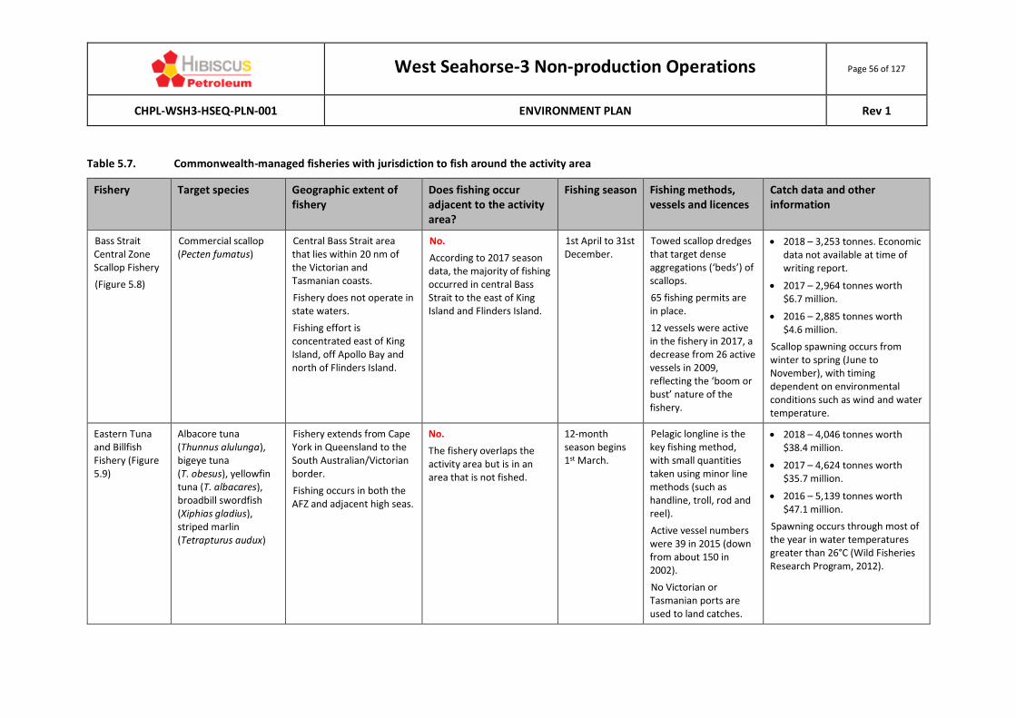
West Seahorse-3 Non-production Operations Page 56 of 127
CHPL-WSH3-HSEQ-PLN-001 ENVIRONMENT PLAN Rev 1
Table 5.7. Commonwealth-managed fisheries with jurisdiction to fish around the activity area
Fishery Target species Geographic extent of fishery
Does fishing occur adjacent to the activity area?
Fishing season Fishing methods, vessels and licences
Catch data and other information
Bass Strait Central Zone Scallop Fishery
(Figure 5.8)
Commercial scallop (Pecten fumatus)
Central Bass Strait area that lies within 20 nm of the Victorian and Tasmanian coasts.
Fishery does not operate in state waters.
Fishing effort is concentrated east of King Island, off Apollo Bay and north of Flinders Island.
No.
According to 2017 season data, the majority of fishing occurred in central Bass Strait to the east of King Island and Flinders Island.
1st April to 31st December.
Towed scallop dredges that target dense aggregations (‘beds’) of scallops.
65 fishing permits are in place.
12 vessels were active in the fishery in 2017, a decrease from 26 active vessels in 2009, reflecting the ‘boom or bust’ nature of the fishery.
• 2018 – 3,253 tonnes. Economic data not available at time of writing report.
• 2017 – 2,964 tonnes worth $6.7 million.
• 2016 – 2,885 tonnes worth $4.6 million.
Scallop spawning occurs from winter to spring (June to November), with timing dependent on environmental conditions such as wind and water temperature.
Eastern Tuna and Billfish Fishery (Figure 5.9)
Albacore tuna (Thunnus alulunga), bigeye tuna (T. obesus), yellowfin tuna (T. albacares), broadbill swordfish (Xiphias gladius), striped marlin (Tetrapturus audux)
Fishery extends from Cape York in Queensland to the South Australian/Victorian border.
Fishing occurs in both the AFZ and adjacent high seas.
No.
The fishery overlaps the activity area but is in an area that is not fished.
12-month season begins 1st March.
Pelagic longline is the key fishing method, with small quantities taken using minor line methods (such as handline, troll, rod and reel).
Active vessel numbers were 39 in 2015 (down from about 150 in 2002).
No Victorian or Tasmanian ports are used to land catches.
• 2018 – 4,046 tonnes worth $38.4 million.
• 2017 – 4,624 tonnes worth $35.7 million.
• 2016 – 5,139 tonnes worth $47.1 million.
Spawning occurs through most of the year in water temperatures greater than 26°C (Wild Fisheries Research Program, 2012).

West Seahorse-3 Non-production Operations Page 57 of 127
CHPL-WSH3-HSEQ-PLN-001 ENVIRONMENT PLAN Rev 1
Fishery Target species Geographic extent of fishery
Does fishing occur adjacent to the activity area?
Fishing season Fishing methods, vessels and licences
Catch data and other information
Eastern Skipjack Tuna Fishery
Skipjack tuna (Katsuwonus pelamis)
Extends from the border of Victoria and South Australia to Cape York, Queensland.
No.
The fishery is not currently active, as such no fishing is currently being undertaken in this fishery.
Not currently active.
Purse seine fishing gear is used in this fishery.
There are 19 permits in the eastern zone, though no vessels currently work the fishery.
Port Lincoln was the main landing port until its tuna cannery closed down.
Not currently active.
Southern Bluefin Tuna
(Figure 5.10)
Southern bluefin tuna (Thunnus maccoyii)
The fishery extends throughout all waters of the AFZ.
AFMA manages Southern Bluefin Tuna stocks in Victorian state waters under agreements set up within the OCS (DEH, 2004).
The nearest fishing effort is concentrated along the NSW south coast around the 200 m depth contour.
No.
The fishery overlaps the activity area but is in an area that is not fished.
12-month season begins 1st December.
Purse sein catch in the Great Australian Bight for transfer to aquaculture farms off Port Lincoln in South Australia (five to eight vessels consistently fish this area). Port Lincoln is the primary landing port.
On the east coast, pelagic longline fishing is the key fishing method.
2017-18 – 38 active vessels.
2016-17 – 22 active vessels.
No recent fishing effort in Bass Strait. The latest data for the east coast pelagic longline catches are:
• 2017-18 – 6,159 tonnes worth $39.73 million.
• 2016-17 – 5,334 tonnes worth $38.57 million.
• 2015-16 – 5,636 tonnes worth $37.29 million.
•

West Seahorse-3 Non-production Operations Page 58 of 127
CHPL-WSH3-HSEQ-PLN-001 ENVIRONMENT PLAN Rev 1
Fishery Target species Geographic extent of fishery
Does fishing occur adjacent to the activity area?
Fishing season Fishing methods, vessels and licences
Catch data and other information
Small Pelagic Fishery (eastern and western sub-area)
(Figure 5.11)
Australian sardine (Sardinops sagax), jack mackerel (Trachurus declivis), blue mackerel (Scomber australasicus), redbait (Emmelichthys nitidus)
Operates in Commonwealth waters extending from southern Queensland around southern Western Australia.
No.
The fishery overlaps the activity area but is in an area that is not fished.
12-month season begins 1st May.
Purse seine and mid-water trawl, with the latter being the main method.
Thirty (30) entities held licences in 2018-19 using four active vessels.
The main landing ports are in Tasmania, South Australia and New South Wales, along with Geelong in Victoria.
A Total Allowable Commercial Catch (TACC) in recent years has not been reached. Catch values are confidential due to the small number of fishers.
• 2018-19 – 9,424 tonnes.
• 2017-18 – 5,713 tonnes.
• 2016-17 – 8,038 tonnes.
Southern Squid Jig Fishery
(Figure 5.12)
Arrow squid (Nototodarus gouldi)
The fishery extends from the SA/WA border east to southern Queensland.
AFMA does not control squid fishing in Victorian state waters.
There is no fishing near the activity area, with most fishing takes place off Portland, southwest Victoria.
No.
The fishery overlaps the activity area but is in an area that is not fished.
Starts in February and ends in June. The season starts off the Port Phillip Bay heads and slowly moves westwards to Portland as the season progresses, following the natural migration of the squid (SIV, 2016).
Squid jigging is the fishing method used, mainly at night time and in water depths of 60 to 120 m.
High-powered lamps are used to attract squid.
Portland and Queenscliff are the primary landing ports.
2016 – 7 active vessels.
2015 – 7 active vessels.
The species’ short life span, fast growth and sensitivity to environmental conditions result in strongly fluctuating stock sizes.
• 2018 – 1,649 tonnes worth $5.26 million.
• 2017 – 828 tonnes worth $2.24 million.
• 2016 – 981 tonnes worth $2.57 million.
No recent fishing effort near the activity area.

West Seahorse-3 Non-production Operations Page 59 of 127
CHPL-WSH3-HSEQ-PLN-001 ENVIRONMENT PLAN Rev 1
Fishery Target species Geographic extent of fishery
Does fishing occur adjacent to the activity area?
Fishing season Fishing methods, vessels and licences
Catch data and other information
Southern and Eastern Scalefish and Shark (SESS) Fishery
Shark Gillnet and Shark Hook Sector
(Figure 5.13 and 5.14)
Gummy shark (Mustelus antarcticus) is the key target species, with bycatch of elephant fish (Callorhinchus milii), sawshark (Pristiophorus cirratus, P. nudipinnis), and school shark (Galeorhinus galeus).
Waters from the NSW/Victorian border westward to the SA/WA border, including the waters around Tasmania, from the low water mark to the extent of the AFZ.
Most fishing occurs in waters adjacent to the coastline in Bass Strait, with a low to medium fishing intensity over the activity area.
Yes.
From the 2017-2018 season data, fishing appears to occur adjacent to the activity area.
12-month season, beginning 1st May.
Demersal gillnet and a variety of line methods.
2017-18 – 74 permits and 76 active vessels.
2016-17 – 74 permits and 62 active vessels.
2015-16 – 74 permits and 61 active vessels.
Landing ports in Victoria are Lakes Entrance, San Remo and Port Welshpool.
In 2015-16, the SESS Fishery was the largest Commonwealth fishery in terms of volume produced.
• 2018-19 – 2,126 tonnes with value not available at time of reporting.
• 2017-18 – 2,216 tonnes worth $19.1 million.
• 2016-17 – 2,118 tonnes worth $18.3 million.

West Seahorse-3 Non-production Operations Page 60 of 127
CHPL-WSH3-HSEQ-PLN-001 ENVIRONMENT PLAN Rev 1
Fishery Target species Geographic extent of fishery
Does fishing occur adjacent to the activity area?
Fishing season Fishing methods, vessels and licences
Catch data and other information
Commonwealth Trawl Sector (CTS)
(Figure 5.15)
Key species targeted are eastern school whiting (Sillago flindersi), flathead (Platycephalus richardsoni) and gummy shark (Mustelus antarcticus).
Covers the area of the AFZ extending southward from Barrenjoey Point (north of Sydney) around the New South Wales, Victorian and Tasmanian coastlines to Cape Jervis in South Australia.
Yes.
From the 2017-2018 season data, fishing appears to occur adjacent to the activity area.
12-month season begins 1st May.
Highest catches from September to April.
Multi gear fishery, but predominantly demersal otter trawl and Danish-seine methods.
Primary landing ports in NSW, and Lakes Entrance and Portland in Victoria.
For 2017-2018, there were 57 trawl fishing rights with 50 active vessels.
Logbook catches have been gradually declining since 2001.
• 2018-19 – 8,454 tonnes with no value assigned at time of writing report.
• 2017-18 – 8,631 tonnes worth $41.86 million.
• 2016-17 – 8,691 tonnes, worth $46.42 million.
Scalefish Hook Sector (SHS)
(Figure 5.17)
Key species targeted are gummy shark (Mustelus antarcticus), elephantfish (Callorhinchus milii) and draughtboard shark (Cephaloscyllium laticeps).
Includes all waters off South Australia, Victoria and Tasmania from 3 nm to the extent of the AFZ.
No.
The location of the activity area is outside the area of recent fishing effort.
12-month season begins 1st May.
Effort highest from January to July.
Multi gear fishery, using different gear types in different areas or depth ranges.
Predominantly demersal longline fishing methods and demersal gillnets.
For 2017-18, there were 37 fishing rights 29 active vessels.
Primary landing ports in NSW, and Lakes Entrance and Portland in Victoria.
Logbook catches have been gradually declining since 2006 and are now <2,000 t/year.
Catch data is combined with that for the CTS.
Sources: Patterson et al (2019, 2018; 2017; 2016).

West Seahorse-3 Non-production
Operations Page 61 of 127
CHPL-WSH3-HSEQ-PLN-001 ENVIRONMENT PLAN Rev 1
Source: Patterson et al 2019.
Figure 5.8. Jurisdiction and intensity of the Bass Strait Central Zone Scallop Fishery, 2018
Source: Patterson et al 2019.
Figure 5.9. Jurisdiction and fishing intensity of the Eastern Tuna and Billfish Fishery, 2018
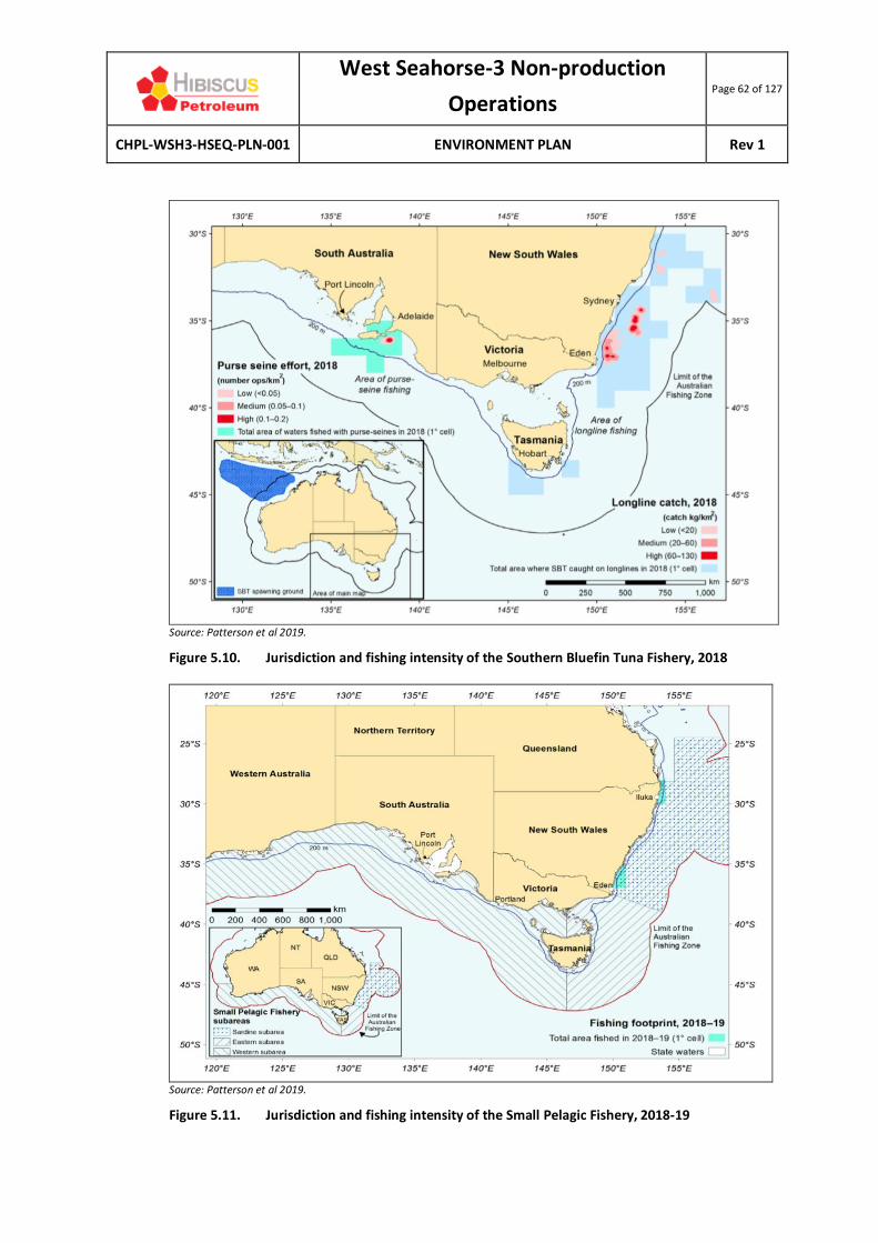
West Seahorse-3 Non-production
Operations Page 62 of 127
CHPL-WSH3-HSEQ-PLN-001 ENVIRONMENT PLAN Rev 1
Source: Patterson et al 2019.
Figure 5.10. Jurisdiction and fishing intensity of the Southern Bluefin Tuna Fishery, 2018
Source: Patterson et al 2019.
Figure 5.11. Jurisdiction and fishing intensity of the Small Pelagic Fishery, 2018-19

West Seahorse-3 Non-production
Operations Page 63 of 127
CHPL-WSH3-HSEQ-PLN-001 ENVIRONMENT PLAN Rev 1
Source: Patterson et al 2019.
Figure 5.12. Jurisdiction and fishing intensity of the Southern Squid Jig Fishery, 2018
Source: Patterson et al 2019.
Figure 5.13. Jurisdiction and fishing intensity of the SESS Fishery (Shark gillnet sector), 2018-19
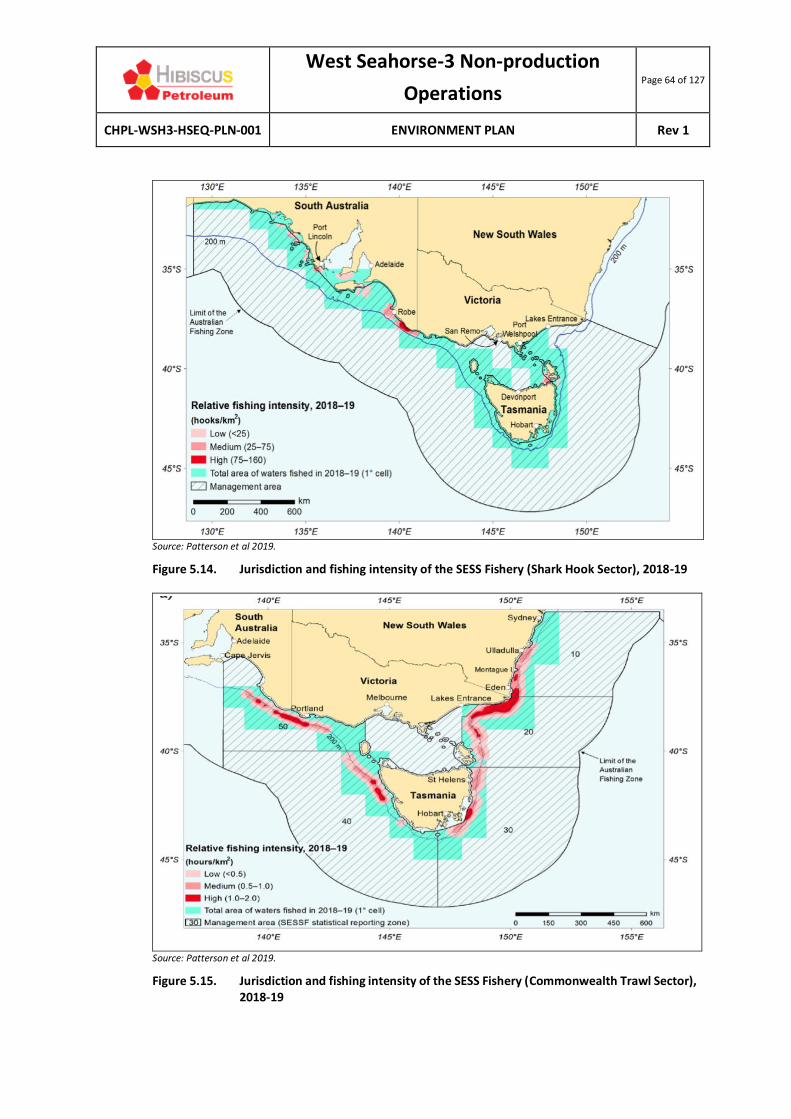
West Seahorse-3 Non-production
Operations Page 64 of 127
CHPL-WSH3-HSEQ-PLN-001 ENVIRONMENT PLAN Rev 1
Source: Patterson et al 2019.
Figure 5.14. Jurisdiction and fishing intensity of the SESS Fishery (Shark Hook Sector), 2018-19
Source: Patterson et al 2019.
Figure 5.15. Jurisdiction and fishing intensity of the SESS Fishery (Commonwealth Trawl Sector), 2018-19

West Seahorse-3 Non-production
Operations Page 65 of 127
CHPL-WSH3-HSEQ-PLN-001 ENVIRONMENT PLAN Rev 1
Figure 5.16. Fishing intensity of the SESS Fishery (Commonwealth Trawl Sector), 2017-18.

West Seahorse-3 Non-production
Operations Page 66 of 127
CHPL-WSH3-HSEQ-PLN-001 ENVIRONMENT PLAN Rev 1
Source: Patterson et al 2019.
Figure 5.17. Jurisdiction and fishing intensity of the SESS Fishery (Scalefish hook sector), 2018-19
Source: Patterson et al 2019.
Figure 5.18. Jurisdiction and fishing intensity of the SESS Fishery (Danish-seine operations), 2018-19 (data combined with the Commonwealth Trawl Sector)

West Seahorse-3 Non-production
Operations Page 67 of 127
CHPL-WSH3-HSEQ-PLN-001 ENVIRONMENT PLAN Rev 1
Victorian-managed fisheries The activity area intersects the VFA catch and effort grid cell E40. Victorian-managed commercial fisheries with access licences that authorise harvest in the waters adjacent to the activity area include the following (noting that not all operate in the area):
• Ocean Scallop;
• Rock Lobster (Eastern zone);
• Ocean Access (general, all species);
• Ocean Purse Seine (noted by VFA as being the most active fishery in the region);
• Trawl (inshore);
• Abalone (central zone) (does not operate in the activity area);
• Wrasse (does not operate in the activity area); and
• Banded Morwong (by permit) (does not operate in the activity area).
As noted for the Commonwealth fisheries, the WSH-3 PSZ issued by the Victorian Government on 19 June 2008 prohibits “all vessels other than vessels operated by authorised persons” from entering the PSZ by law. As such, no commercial or recreational fishing should occur within the activity area. Nevertheless, Table 5.8 summarises the key facts and figures of the Victorian-managed fisheries with jurisdiction to fish in the waters immediately adjacent the activity area.
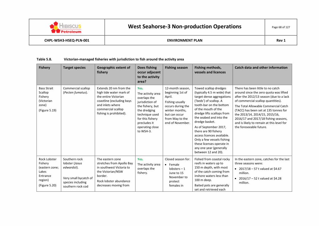
West Seahorse-3 Non-production Operations Page 68 of 127
CHPL-WSH3-HSEQ-PLN-001 ENVIRONMENT PLAN Rev 1
Table 5.8. Victorian-managed fisheries with jurisdiction to fish around the activity area
Fishery Target species Geographic extent of fishery
Does fishing occur adjacent to the activity area?
Fishing season Fishing methods, vessels and licences
Catch data and other information
Bass Strait Scallop Fishery (Victorian zone)
(Figure 5.19)
Commercial scallop (Pecten fumatus).
Extends 20 nm from the high tide water mark of the entire Victorian coastline (excluding bays and inlets where commercial scallop fishing is prohibited).
Yes.
The activity area overlaps the jurisdiction of the fishery, but the dredging technique used for this fishery precludes it operating close to WSH-3.
12-month season, beginning 1st of April.
Fishing usually occurs during the winter months, but can occur from May to the end of November.
Towed scallop dredges (typically 4.5 m wide) that target dense aggregations (‘beds’) of scallop. A tooth-bar on the bottom of the mouth of the dredge lifts scallops from the seabed and into the dredge basket.
As of September 2017, there are 90 fishery access licences available. Only a few vessels fishing these licenses operate in any one year (generally between 12 and 20).
There has been little to no catch around since the zero quota was lifted after the 2012/13 season (due to a lack of commercial scallop quantities).
The Total Allowable Commercial Catch (TACC) has been set at 135 tonnes for the 2013/14, 2014/15, 2015/16, 2016/17 and 2017/18 fishing seasons, and is likely to remain at this level for the foreseeable future.
Rock Lobster Fishery (eastern zone; Lakes Entrance region)
(Figure 5.20)
Southern rock lobster (Jasus edwardsii).
Very small bycatch of species including southern rock cod
The eastern zone stretches from Apollo Bay in southwest Victoria to the Victorian/NSW border.
Rock lobster abundance decreases moving from
Yes.
The activity area overlaps the fishery.
Closed season for:
• Female lobsters – 1 June to 15 November to protect females in
Fished from coastal rocky reefs in waters up to 150 m depth, with most of the catch coming from inshore waters less than 100 m deep.
Baited pots are generally set and retrieved each
In the eastern zone, catches for the last three seasons were:
• 2017/18 – 57 t valued at $4.67 million.
• 2016/17 – 52 t valued at $4.28 million.
West Seahorse-3 Non-production Operations Page 69 of 127
CHPL-WSH3-HSEQ-PLN-001 ENVIRONMENT PLAN Rev 1
(Lotella and Pseudophycis spp), hermit crab (family Paguroidea), leatherjacket (Monacanthidae spp) and octopus (Octopus spp).
western Victoria to eastern Victoria.
Larval release occurs across the southern continental shelf, which is a high-current area, facilitating dispersal. The pelagic phyllosoma larval phase lasts around 12–18 months.
berry during spawning period.
• Male lobsters – 15 September to 15 November to protect males during their moulting period when soft shells increase their vulnerability.
Catches are generally highest from August to January.
day, marked with a surface buoy.
As of September 2017, there were 36 fishery access licences in the eastern zone.
• 2015/16 – 58 t valued at $5.1 million.
Abalone Fishery (central zone)
(Figure 5.21)
Blacklip abalone (Haliotis rubra) is the primary target, with greenlip abalone (H. laevigata) taken as a bycatch.
The Victorian Central Abalone Zone is located between Lakes Entrance and the mouth of the Hopkins River.
Most abalone live on rocky reefs from the shoreline to depths of 30 m. The WSH-3 well is located in water depth of 39.5m.
Yes.
The location of the activity area is present in the jurisdiction of the fishery.
12-month season, beginning 1st of April.
Abalone diving activity occurs close to shoreline (generally no greater than 30 m) using hookah gear (breathing air supplied via hose connected to an air compressor on the vessel). Commercial divers do not use SCUBA gear.
Divers use an iron bar to prise abalone from rocks.
In the central zone, catches for the last three seasons were (economic value data unavailable):
• 2017/18 – 277 t.
• 2016/17 – 280 t.
• 2015/16 – 306 t.

West Seahorse-3 Non-production Operations Page 70 of 127
CHPL-WSH3-HSEQ-PLN-001 ENVIRONMENT PLAN Rev 1
As of September 2017, there are 34 fishery access licences in the central zone.
For the central zone, the 2017/18 TACC is 274 tonnes (blacklip) and 3.4 tonnes (greenlip).
Wrasse Fishery (Lakes Entrance region)
Blue-throat wrasse (Notolabrus tetricus), saddled wrasse (N. fucicola), orange-spotted wrasse (N. parilus).
Entire Victorian coastline out to 20 nm (excluding marine reserves, bays and inlets).
In recent years, catches have been highest off the central coast (Port Phillip Heads, Western Port and Wilson’s Promontory) and west coast (Portland).
Unknown
Licences were made transferrable from 1st April 2017, so fishing effort could be activated in the area.
Year-round. Handline fishing (excluding longline), rock lobster pots (if in possession of a rock lobster access fishing licence).
Preferred water depths for blue-throat wrasse is 20-40 m, while saddled wrasse prefer depths of 10-30 m.
There are 22 fishery access licences.
Catches of blue-throat wrasse in Victoria for the last three seasons were:
• 2017/18 – 38 t valued at $767,0000.
• 2016/17 – 24 t valued at $557,000.
• 2015/16 – 24 t valued at $512,000.
Multi-species Ocean Fishery
Ocean Access (or Ocean General) Fishery
Gummy shark (Mustelus antarcticus), school shark (Galeorhinus galeus), Australian salmon (Arripis trutta), snapper (Pagrus auratus).
Entire Victorian coastline, excluding marine reserves, bays and inlets.
Yes.
The location of the activity area is present in the jurisdiction of the fishery.
Year-round.
Most fishing undertaken off Lakes Entrance occurs between April and July.
Utilises mainly longlines (200 hook limit), but also haul seine nets (maximum length of 460 m) and mesh nets (maximum length of 2,500 m per licence).
There is insufficient catch data (catch data is combined with other fisheries and therefore unable to be distinguished on a standalone basis).

West Seahorse-3 Non-production Operations Page 71 of 127
CHPL-WSH3-HSEQ-PLN-001 ENVIRONMENT PLAN Rev 1
Small bycatch of flathead (Platycephalidae spp).
There are 171 fishery access licences.
Fishing usually conducted as day trips from small vessels (<10 m in length).
Ocean Purse Seine Fishery
Australian sardine (Sardinops sagax), Australian salmon (Arripis trutta) and sandy sprat (Hyperlophus vittatus) are the main species.
Southern anchovy (Engraulis australis) caught in some years.
Entire Victorian coastline, excluding marine reserves, bays and inlets.
Yes.
The location of the activity area is present in the jurisdiction of the fishery.
Year-round. Purse seine, which is generally a highly selective method that targets one species at a time, thereby minimising bycatch. Purse seines do not touch the seabed. A lampara net may also be used.
Only one licence is active in Victorian waters (based out of Lakes Entrance), with fishing focused close to shore and during the day. This licence is held by Mitchelson Fisheries Pty Ltd, a family business that catches primarily sardines, salmon, mackeral, sandy sprat, anchovy and white bait using the Maasbanker purse seine vessel.
Confidential data (due to operation of only one fisher).
Inshore Trawl Fishery
Key species are eastern king prawn (Penaeus plebejus),
Entire Victorian coastline, excluding marine reserves, bays and inlets.
Yes.
The location of the activity area
Year-round, although the majority of prawn
Otter-board trawls with no more than a maximum head-line length of 33 m,
The catch of eastern school prawn in 2015 was 75 t, the largest or the previous 10 years.

West Seahorse-3 Non-production Operations Page 72 of 127
CHPL-WSH3-HSEQ-PLN-001 ENVIRONMENT PLAN Rev 1
Sources: VFA (2017; 2018, 2019).
school prawn (Metapenaeus macleayi) and shovelnose lobster/Balmain bug (Ibacus peronii).
Minor bycatch of sand flathead (Platcephalus bassensis), school whiting (Sillago bassensis) and gummy shark (Mustelus antarcticus).
Most operators are based at Lakes Entrance.
is present in the jurisdiction of the fishery.
fishing occurs in the warmer months up until Easter.
or single mesh nets are used.
At June 2018, there were 54 fishery access licences, with only about 15 active to various degrees.
Banded Morwong Fishery
Banded morwong (Cheilodactylus spectabilis).
Some fish are also landed as byproduct from the Ocean Access Fishery.
Extent is uncertain.
The banded morwong is a temperate reef species. The absence of reef in the activity area suggests fishing may be limited or non-existent.
Yes.
The location of the activity area is present in the jurisdiction of the fishery.
Unknown. Uses large-mesh gillnets.
The most recent stock assessment (undertaken in 2012) has not been published because of the limited number of operators and concerns about confidentiality. Catch data examined from 2002–12 concluded that there was a clear downward trend in biomass since the mid-2000s (catch per unit effort may have fallen by up to 48% from the peak).
The total catch is currently less than 2.5 tonnes/year (catches are now limited to 625 fish per operator).
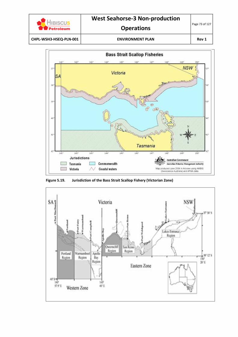
West Seahorse-3 Non-production
Operations Page 73 of 127
CHPL-WSH3-HSEQ-PLN-001 ENVIRONMENT PLAN Rev 1
Figure 5.19. Jurisdiction of the Bass Strait Scallop Fishery (Victorian Zone)

West Seahorse-3 Non-production
Operations Page 74 of 127
CHPL-WSH3-HSEQ-PLN-001 ENVIRONMENT PLAN Rev 1
Figure 5.20. Jurisdiction of the Rock lobster fishery (eastern zone, Lakes Entrance region)
Figure 5.21. Jurisdiction of the Abalone fishery (central zone)
West Seahorse-3 Non-production
Operations Page 75 of 127
CHPL-WSH3-HSEQ-PLN-001 ENVIRONMENT PLAN Rev 1
5.6.4 RECREATIONAL FISHING
Recreational fishing along the Gippsland coast typically targets snapper, King George whiting, flathead, bream, sharks, tuna, calamari, and Australian salmon. Recreational fishing and boating is largely confined to the Gippsland Lakes and nearshore coastal waters. As Bass Strait is relatively shallow, the water currents through the Bass Strait can create unpredictable seas, reducing the numbers of recreational boats from venturing long distances into the Bass Strait from shore. VRFish has stated that small boats are likely to fish around the nearshore reef areas, while larger game fishing boats are likely to fish further out to sea and use nearby ports and boat ramps for launching. There are no boat ramps adjacent to the activity area, though stakeholder consultation indicates that recreational fishers often carry small ‘tinnies’ (aluminium-hulled boats) over the sand dunes in order to access the beach, with the sand dune clearing for the ROS at Delray Beach providing one of the more suitable access points. As noted, the WSH-3 PSZ prohibits unauthorised vessels from entering the safety zone by law and as such recreational fishing should not occur within the activity area (noting that recreational fishers are unlikely to be aware of the PSZ).
5.6.5 TOURISM
Marine-based tourism and recreation in the Bass Strait is primarily associated with recreational fishing and boating (see previous section). The Gippsland Lakes (comprising Lake Victoria, Lake King, and Lake Wellington, together with other smaller lakes, marshes and lagoons) are the primary tourist attraction in the region. The communities adjacent to this network of lakes are popular tourist towns for their boating and fishing activities, along with bushwalking, bird watching and other nature-focused activities. Towns including Lakes Entrance, Metung, Loch Sport, Golden Beach and Lake Tyers are especially popular in summer.
5.6.6 PETROLEUM INFRASTRUCTURE, EXPLORATION AND PRODUCTION
In 2018, Victoria accounted for 17% of Australia’s petroleum liquids production (APPEA, 2017). However, production has been trending down since it peaked in 2000. Victoria accounted for 10% of Australia’s conventional gas production in 2018, most of which is from the Gippsland Basin (APPEA, 2019). Both oil and gas production from the Gippsland Basin are in decline. The Gippsland Basin has 24 offshore production licenses, 5 exploration permits and 5 retention leases (NOPTA, 2019) and a total of 22 offshore petroleum production platforms have been installed in Bass Strait since first production was established in the 1960s (excluding subsea production wells) (Figure 5.22).

West Seahorse-3 Non-production
Operations Page 76 of 127
CHPL-WSH3-HSEQ-PLN-001 ENVIRONMENT PLAN Rev 1
Figure 5.22. Petroleum infrastructure and development in the Gippsland offshore region
West Seahorse-3 Non-production
Operations Page 77 of 127
CHPL-WSH3-HSEQ-PLN-001 ENVIRONMENT PLAN Rev 1
The TasGas pipeline, a pipeline that provides gas from Victoria to Tasmania, is located 26 km southwest of the activity area (it makes landfall just east of Seaspray, on the eastern edge of the Gippsland Lakes). Petroleum production from the offshore Gippsland Basin is centred on production from the EARPL oil and gas fields, operator for the Gippsland Basin Joint Venture. EARPL produces oil and gas from 23 platforms and subsea developments, hundreds of wells and some 600 km of associated subsea pipelines, tied back to the Longford Gas Plant and Long Island Point. Production first commenced in 1969 from the Barracouta field. The latest fields to come into production were the Kipper-Tuna-Turrum oil and gas fields in 2013.
5.6.7 COMMERICAL SHIPPING
The South-east Marine Region (which includes Bass Strait) is one of the busiest shipping regions in Australia (DoE, 2015a). Shipping consists of international and coastal cargo trade, passenger services and cargo and vehicular ferry services across Bass Strait (DoE, 2015a). Lakes Entrance is an important fishing port for the region (DoE, 2015a). The activity area is located entirely within the Bass Strait ‘Area to be Avoided’ (ATBA) (Figure 5.23). This area is a routing measure that ships in excess of 200 gross tonnes should avoid due to the high concentration of offshore petroleum infrastructure (oil and gas platforms and pipelines, as described in Section 5.6.6) that can provide a navigational hazard. The total area of the ATBA is 5,650 km2. Operators of vessels greater than 200 gross tonnes must apply to NOPSEMA to enter and be present within the ATBA (NOPSEMA, 2016). AMSA has indicated that high traffic volume shipping areas are located south of the activity area (see Figure 5.23). AMSA has provided historic AIS traffic plot based off data collected between January 2016 and January 2017 (excludes small domestic commercial vessels such as fishing trawlers and coastal craft). It indicates very light shipping activity occurs through the activity area, with higher traffic volume shipping areas located to the south of the activity area and immediately south of the ATBA. AMSA advises that interactions between the source vessel and large commercial ships is expected to be minimal due to the ATBA. To the immediate seaward side of the ATBA exist two traffic separation schemes, implemented by AMSA to enhance safety of navigation around the ATBA by separating shipping into one-direction lanes for vessels heading northeast and those heading southwest. One separation area is located south of Wilson’s Promontory, and the other south of the Kingfisher B platform (DIBP, 2017), 66 km southeast of the activity area.

West Seahorse-3 Non-production
Operations Page 78 of 127
CHPL-WSH3-HSEQ-PLN-001 ENVIRONMENT PLAN Rev 1
Figure 5.23. Commercial shipping traffic adjacent to the VIC/L31 permit

West Seahorse-3 Non-production
Operations Page 79 of 127
CHPL-WSH3-HSEQ-PLN-001 ENVIRONMENT PLAN Rev 1
5.6.8 DEFENCE ACTIVITIES
Defence activities that may take place in the region include transit of naval vessels, training exercises, hydrographic survey, surveillance and enforcement, and search and rescue. There are no defence training areas within the EMBA (DoE, 2015a). The activity area is located beneath Defence Restricted Airspace R258D (Figure 5.24), with no records of unexploded ordinance in or around the activity area.
Source: AMSIS (2017).
Figure 5.24. Restricted airspace over the activity area

West Seahorse-3 Non-production
Operations Page 80 of 127
CHPL-WSH3-HSEQ-PLN-001 ENVIRONMENT PLAN Rev 1
6 IMPACT AND RISK ASSESSMENT METHODOLOGY
This chapter describes the environmental impact and risk assessment methodology employed in this EP in accordance with Regulation 13(5) of the OPGGS(E). CHPL, as a wholly owned subsidiary of HPB, uses the HPB HSEQ Procedure Hazard Identification and Risk Management (HPB-HSEQ-GEN-PCD01) for undertaking risk assessments; this methodology is explained in detail here. HPB’s risk management process aligns with the principles of ISO 31000:2009 Risk Management – Principles and Guidelines. This process is consistent with the steps outlined below and is illustrated visually in Figure 6.1. Each step in this risk assessment process is described in this chapter.
Figure 6.1. ISO 31000 Risk Management Process
6.1 COMMUNICATE AND CONSULT
In accordance with Regulation 14(9) of the OPGGS(E) and Regulation 16(8) of the OPGGS Regulations, CHPL has consulted with relevant persons (stakeholders) in the development of this EP to determine whether their functions, activities and interests are impacted by, or may impact on the the WSH-3 well. The stakeholder consultation process is described in Chapter 4.
6.2 ESTABLISH THE CONTEXT
The first step in the risk assessment process is to establish the context. This involves:
• Understanding the regulatory framework in which the activity takes place (described in the ‘Legislation and Guidelines’ in Chapter 3);
• Defining the activities that will cause impacts and create risks (outlined in the ‘Activity Description’ in Chapter 2);
• Understanding the concerns of stakeholders and incorporating those concerns into the design of the activity where appropriate (outlined in Chapter 4, ‘Stakeholder Consultation’); and

West Seahorse-3 Non-production
Operations Page 81 of 127
CHPL-WSH3-HSEQ-PLN-001 ENVIRONMENT PLAN Rev 1
• Describing the environment in which the activity takes place (the ‘Existing Environment’ is described in Chapter 5).
Once the context has been established, the hazards of the activity can be identified, along with the impacts and risks of these hazards. This process is described in following sections.
6.3 IDENTIFY THE RISKS
The HBP HSEQ Procedure describes the following steps when identifying hazards:
• Identify the activities and the potential impacts associated with them;
• Identify the sensitive environmental resources at risk within and adjacent to the operational area;
• Identify the environmental consequences of each potential impact, corresponding to the maximum reasonable impact;
• Identify the likelihood (probability) of occurrence of each potential environmental impact (i.e., the probability of the event occurring);
• Identify applicable control measures; and
• Assign a level of risk to each potential environmental impact using a risk matrix.
In accordance with this framework, all risks must be reduced to a level that is considered to be ALARP (see Section 6.5.1). Risk identification and assessment was undertaken to examine the environmental hazards and their associated impacts and risks arising from the WSH-3 activity, which are assessed throughout Chapter 7.
6.3.1 DEFINITIONS
For context, Table 6.1 provides the definitions of impacts and risk according to the OPGGS(E) and OPGGS Regulations and international risk management standards. The OPGGS(E) Regulations 13(5)(6) require that the EP detail and evaluate the environmental impacts and risks for an activity, including control measures used to reduce the impacts and risks of the activity to ALARP and an acceptable level. This must include impacts and risks arising directly or indirectly from all activity operations (i.e., planned events) or potential emergency or incident conditions (i.e., incident events). NOPSEMA distinguishes between environmental impacts and risks. Environmental impact is defined in Table 6.1.
Table 6.1. Definitions of impact and risk
Source Impact Risk
OPGGS(E)
Any change to the environment, whether adverse or beneficial, that wholly or partially results from an activity.
Not defined.
ISO AS/NZS31000: 2018 (Risk management – Principles and guidelines)
Not defined.
The effect of uncertainty on objectives.

West Seahorse-3 Non-production
Operations Page 82 of 127
CHPL-WSH3-HSEQ-PLN-001 ENVIRONMENT PLAN Rev 1
For this activity, CHPL has determined that impacts and risks are defined as follows:
• Impacts result from planned events – there will be consequences (known or unknown) associated with the event occurring. Impacts are an inherent part of the activity. For example, there is displacement of third-party marine users due to the presence of the PSZ.
o For impacts, only a consequence is assigned in this EP (likelihood is irrelevant given
that the event does occur) (as defined in Table 6.2).
• Risks result from unplanned events – there may be consequences if an unplanned event occurs. Risks are not an inherent part of the activity. For example, if the PSZ is ignored/breached, fishing equipment used in trawling activities may be damaged by the wellhead, but this is not a certainty. The risk of this event is determined by multiplying the consequence of the impact by the likelihood of this event (Table 6.3) happening.
o For risks, the consequence and likelihood are combined to determine the risk rating
(Table 6.4).
6.4 ANALYSE THE RISKS
After the impacts and risks have been identified, environmental performance outcomes (EPO) (or objectives) are developed to provide a measurable level of performance for each environmental hazard to ensure that the environmental impacts and risks are managed to be ALARP and acceptable. EPO are assigned in Chapter 7 for the impacts and risks relevant to this activity.
6.5 EVALUATE THE RISKS
The purpose of impact and risk evaluation (herein referred to simply as risk assessment) is to assist in making decisions, based on the outcomes of analysis, about the sorts of controls required to reduce an impact or risk to ALARP. Planned and unplanned events are subject to risk assessment in the same manner. CHPL’s risk assessment process is described below and was followed in the risk identification and assessment session described in Section 6.3:
• Identify and describe the risks (see Chapter 7);
ISO AS/NZS 14001: 2016 (Environmental management systems – Requirements with guidance for use)
Not defined. The effect of uncertainty on objectives.
ISO AS/NZS 4360: 2004 (Risk management)
Not defined. The chance of something happening that will have an impact on objectives.
HB203: 2012
(Managing environment-related risk)
Any change to the environment or a component of the environment, whether adverse or beneficial, wholly or partly resulting from an organisation’s environmental aspects.
The effect of uncertainty on objectives.
The level of risk can be expressed in terms of a combination of the consequences and the likelihoods of those consequences occurring.

West Seahorse-3 Non-production
Operations Page 83 of 127
CHPL-WSH3-HSEQ-PLN-001 ENVIRONMENT PLAN Rev 1
• Determine the maximum credible consequence (to the natural environment and community/social/cultural heritage) arising from the impact or risk without introducing additional controls. This determination is provided in the risk assessments in Chapter 7;
• Adopt controls for each impact or risk;
• Undertake an assessment of the consequence of the impact or risk, corresponding to the maximum credible impact across the consequence categories (see Table 6.2) considering the controls identified and their effectiveness;
• Identify the likelihood of occurrence of those consequences (‘remote’ through to ‘very likely’), considering the controls identified and their effectiveness, as outlined in Table 6.3; and
• For risks, multiply the consequence and likelihood to determine the overall risk ranking, outlined in Table 6.4 (with Table 6.5 describing the risk bands).
Table 6.2. HPB definition of consequence
Risk Focus
Negligible Minor Moderate Major Severe Catastrophic
Financial Less than $1M
Loss from $1-$2M
Loss from $2 to $10M
Loss from $10M to $20M
Loss from $20M to $50M
Loss >$50M
Social Minor, temporary impact to a community or areas/items of cultural significance
Minor, short-term (<5 years) impact to a community or areas/items of cultural significance
Moderate medium term (5 to 10 years) impact to a community or highly valued areas/assets/items of cultural significance
Major long-term (10 years) impact to a community or social infrastructure or highly valued areas/items of cultural significance
Serious, long-term (>10 years) impact to the community, social infrastructure or highly valued areas/items of significance
Permanent long-term impact to a community or social infrastructure or highly valued areas/items of international cultural significance
Reputat- ional
No impact Short-term local concern
National bad mention short-term concern, scrutiny of asset
Significant impact, national media coverage, operations restricted or curtailed
Persistent national concern, operations severely restricted
International media coverage, Company at stake
Environ-mental
Slight and temporary <1 year – localised effect on ecosystem, species or habitat
Minor short-term (1 to 2 years) impacts but not affecting ecosystem or function
Moderate, medium term (2 to 5 years) impacts but not affecting ecosystem function
Major long term (5 to 10 years) impact on ecosystems, species or habitat
Serious long term (> 10 years) impact on highly valued ecosystems, species or habitat
Permanent impact on highly valued ecosystems or habitat
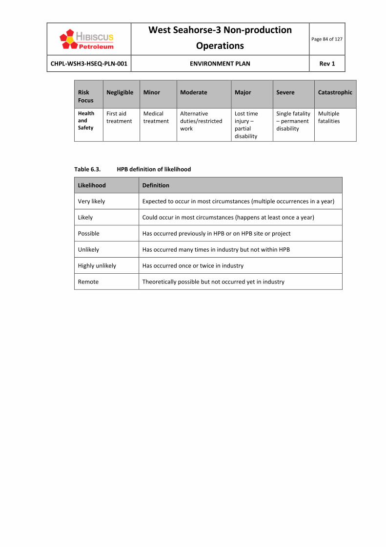
West Seahorse-3 Non-production
Operations Page 84 of 127
CHPL-WSH3-HSEQ-PLN-001 ENVIRONMENT PLAN Rev 1
Risk Focus
Negligible Minor Moderate Major Severe Catastrophic
Health and Safety
First aid treatment
Medical treatment
Alternative duties/restricted work
Lost time injury – partial disability
Single fatality – permanent disability
Multiple fatalities
Table 6.3. HPB definition of likelihood
Likelihood Definition
Very likely Expected to occur in most circumstances (multiple occurrences in a year)
Likely Could occur in most circumstances (happens at least once a year)
Possible Has occurred previously in HPB or on HPB site or project
Unlikely Has occurred many times in industry but not within HPB
Highly unlikely Has occurred once or twice in industry
Remote Theoretically possible but not occurred yet in industry

West Seahorse-3 Non-production Operations Page 85 of 127
CHPL-WSH3-HSEQ-PLN-001 ENVIRONMENT PLAN Rev 1
Table 6.4. HPB risk assessment matrix
Consequence
Negligible Minor Moderate Major Severe Catastrophic
Like
liho
od
Very likely Medium High Very high Very high Severe Severe
Likely Medium High High Very high Very high Severe
Possible Low Medium High High Very high Very high
Unlikely Low Medium Medium High High Very high
Highly unlikely
Low Low Medium Medium High High
Remote Low Low Low Low Medium Medium
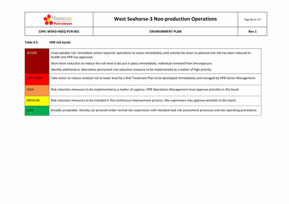
West Seahorse-3 Non-production Operations Page 86 of 127
CHPL-WSH3-HSEQ-PLN-001 ENVIRONMENT PLAN Rev 1
Table 6.5. HPB risk bands
SEVERE Unacceptable risk. Immediate action required; operations to cease immediately until activity has been re-planned and risk has been reduced to ALARP and HPB has approved.
Short-term reduction to reduce the risk level to be put in place immediately, individual removed from the exposure.
Identify additional or alternative permanent risk reduction measure to be implemented as a matter of high priority.
VERY HIGH Take action to reduce residual risk to lower level by a Risk Treatment Plan to be developed immediately and managed by HPB Senior Management.
HIGH Risk reduction measures to be implemented as a matter of urgency. HPB Operations Management must approve activities in this band.
MEDIUM Risk reduction measures to be included in this continuous improvement process. Site supervisors may approve activities in this band.
LOW Broadly acceptable. Activity can proceed under normal site supervision with standard task risk assessment processes and site operating procedures.

West Seahorse-3 Non-production
Operations Page 87 of 127
CHPL-WSH3-HSEQ-PLN-001 ENVIRONMENT PLAN Rev 1
6.5.1 DEMONSTRATION OF ALARP
The ALARP principle states that it must be possible to demonstrate that the cost involved in reducing the risk further would be grossly disproportionate to the benefit gained. The ALARP principle arises from the fact that infinite time, effort and money could be spent attempting to reduce an impact or risk to zero. This concept is shown diagrammatically in Figure 6.2.
Source: CER (2015).
Figure 6.2. The ALARP Principle
CHPL’s approach to demonstrating ALARP includes:
• Systematically identify and assess all potential environmental impacts and risks associated with the activity;
• Where relevant, apply industry ‘good practice’ controls to manage impacts and risks; • Assess the effectiveness of the controls in place and determine whether the controls are
adequate according to the ‘hierarchy of control’ principle; and
• For higher order impacts and risks, implement further controls if feasible and reasonably practicable to do so.
NOPSEMA’s Environment Plan Decision Making Guideline (GL1721, Rev 5, June 2018) states that in order to demonstrate ALARP, a titleholder must be able to implement all available control measures where the cost is not grossly disproportionate to the environmental benefit gained from implementing the control measure.

West Seahorse-3 Non-production
Operations Page 88 of 127
CHPL-WSH3-HSEQ-PLN-001 ENVIRONMENT PLAN Rev 1
There is no universally accepted guidance to applying the ALARP principle to environmental assessments. For this EP, the guidance provided in NOPSEMA’s Environment Plan Decision Making Guideline has been applied, and augmented where deemed necessary. The level of ALARP assessment is dependent upon the:
• Residual impact and risk level (high versus low); and
• The degree of uncertainty associated with the assessed impact or risk.
An iterative risk evaluation process is employed until such time as any further reduction in the residual risk ranking is not reasonably practicable to implement. At this point, the impact or risk is reduced to ALARP. The determination of ALARP is outlined in Table 6.6.
Table 6.6. Alignment of ALARP with impacts (using consequence ranking) and risks (using risk ranking)
Consequence ranking
Negligible Minor Moderate Major Severe/Catastrophic
ALARP level – planned event
Broadly acceptable Tolerable if
ALARP Intolerable
Residual impact category
Lower order Higher order
Risk ranking Low Medium High Very high Severe
ALARP level - unplanned event
Broadly acceptable Tolerable if
ALARP Intolerable
Residual risk category
Lower order risks Higher order risk
Hierarchy of Controls CHPL demonstrates ALARP, in part, by adopting the ‘Hierarchy of Controls’ philosophy (Figure 6.3). The Hierarchy of Controls is a system used across hazardous industries to minimise or eliminate exposure to hazards. The hierarchy of controls is, in order of effectiveness:
• Elimination;
• Substitution;
• Engineering controls;
• Administrative controls; and
• Personal protective equipment (PPE) – this has not been included here as it is specific to the assessment of safety risks rather than environmental management.
Although commonly used in the evaluation of occupational health and safety hazard control, the Hierarchy of Controls philosophy is also a useful framework to evaluate potential environmental controls to ensure reasonable and practicable solutions have not been overlooked.

West Seahorse-3 Non-production
Operations Page 89 of 127
CHPL-WSH3-HSEQ-PLN-001 ENVIRONMENT PLAN Rev 1
Figure 6.3. The Hierarchy of Controls
When deciding on whether to implement the proposed impact/risk reduction measure, CHPL considers the following issues:
• Does it provide a clear or measurable reduction in risk? • Is it technically feasible and can it be implemented?
• Will it be supported and utilised by site personnel?
• Is it consistent with national or industry standards and practices?
• Does it introduce additional risk in other operational areas (e.g., will the implementation of an environmental risk reduction measure have an adverse impact on safety)?
• Will the change be effective, taking into account the:
o Current level of risk (i.e., with the existing controls);
o Amount of additional risk reduction that the control will deliver;
o Level of confidence that the risk reduction impact will be achieved; and
o Resources, schedule and cost required to implement the control.
Reducing impacts and risks to ALARP is an ongoing process and new risk reduction measures may be identified at any time, including during operations. CHPL actively encourages recording and review of observations through the HSE management system (HSEMS) in the incident management system (MyOSH). Incidents and lessons learned within HPB and from the wider industry are reviewed and utilised to identify hazards and controls.
Trieste 3D Seismic Survey EP CDN/ID 17315667
Released on 04/07/2018 - Revision 3 – Issue for regulator assessment Document Custodian is LE – Development - Geophysical
Lattice Energy Limited: ABN 66 007 845 338 Page 123
Once printed, this is an uncontrolled document unless issued
and stamped Controlled Copy or issued under a transmittal Based on template: OEUP-INT1000-TMP-BUS-004Revision 019/05/2014Upstream Information Management & Engineering Systems Manager
Table 6.5. ALARP determination
Risk ranking Low Medium High Severe Extreme
ALARP level Broadly
acceptable Tolerable if ALARP Intolerable
Lattice has elected to demonstrate ALARP by adopting the ‘Hierarchy of Controls’ philosophy. The ‘Hierarchy of Controls’ is a system used in industry to minimise or eliminate exposure to hazards. The
hierarchy of controls is, in order of effectiveness:
· Elimination;
· Substitution;
· Engineering controls; and
· Administrative controls.
Although commonly used in the evaluation of occupational health and safety hazard control, the Hierarchy of Controls (Figure 6.4) philosophy is also a useful framework to evaluate potential
environmental controls to ensure reasonable and practicable solutions have not been overlooked. The fifth step in the process, the use of personal protective equipment (PPE), has not been included here as it is specific to the assessment of safety risks rather than environmental management.
Figure 6.4. Hierarchy of controls
When deciding on whether to implement the proposed impact/risk reduction measure, the following issues are considered:
· Does it provide a clear or measurable reduction in risk?
· Is it technically feasible and can it be implemented?
· Will it be supported and utilised by site personnel?
· Is it consistent with national or industry standards and practices?
· Does it introduce additional risk in other operational areas (e.g., will the implementation of an
environmental risk reduction measure have an adverse impact on safety)?
· Will the change be effective taking into account the:
o Current level of risk i.e. with the existing controls;
o Amount of additional risk reduction that the control will deliver;
o Level of confidence that the risk reduction impact will be achieved;

West Seahorse-3 Non-production
Operations Page 90 of 127
CHPL-WSH3-HSEQ-PLN-001 ENVIRONMENT PLAN Rev 1
6.5.2 RESIDUAL IMPACT AND RISK LEVELS
The following section details the guidance provided in NOPSEMA’s Environment Plan Decision Making Guideline. Lower-order Environmental Impacts and Risks NOPSEMA defines lower-order environmental impacts and risks as those where the environment or receptor is not formally managed, less vulnerable, widely distributed, not protected and/or threatened and there is confidence in the effectiveness of adopted control measures. Impacts and risks are considered to be lower-order and ALARP when, using the HPB risk matrix (see Table 6.4), the impact consequence is rated as ‘negligible’, ‘minor’ or ‘moderate’ or risks are rated as ‘low’, ‘medium’ or ‘high’ (see also Table 6.6). In these cases, applying ‘good industry practice’ (see Uncertainty of Impacts and Risks) is sufficient to manage the risk. Higher-order Environmental Impacts and Risks NOPSEMA defines higher-order environmental impacts and risks as those that are not lower order risks or impacts (i.e., where the environment or receptor is formally managed, vulnerable, restricted in distribution, protected or threatened and there is little confidence in the effectiveness of adopted control measures). Impacts and risks are considered to be higher-order when, using the HPB risk matrix (see Table 6.4), the impact consequence is rated as ‘major’, ‘severe’ or ‘catastrophic’, or when the risk is rated as ‘very high’ or ‘severe’ (see also Table 6.3). In these cases, further controls must be considered.
6.5.3 UNCERTAINTY OF IMPACTS AND RISKS
Based upon the level of uncertainty associated with the impact or risk, the following framework, adapted by NOPSEMA (2015) from the Guidance on Risk Related Decision Making (Oil & Gas UK, 2014) (Figure 6.4) provides the decision-making framework to establish ALARP. This framework provides appropriate tools, commensurate to the level of uncertainty or novelty associated with the impact or risk (referred to as the Decision Type A, B or C) and is detailed further in Table 6.7. The decision type is selected based on an informed decision around the uncertainty of the risk. Decision types and methodologies to establish ALARP are outlined in Figure 6.4.

West Seahorse-3 Non-production
Operations Page 91 of 127
CHPL-WSH3-HSEQ-PLN-001 ENVIRONMENT PLAN Rev 1
Source: CER (2015).
Figure 6.4. Impact and risk ‘uncertainty’ decision-making framework
Table 6.7. Impact and risk ‘uncertainty’ decision types and tools
Decision type
Description Decision-making tools
A Activity
Nothing new or unusual.
Represents normal business.
Well-understood activity.
Good practice is well defined.
Risk & uncertainty
Risks are well understood.
Uncertainty is minimal.
Stakeholder influence
No conflict with company values.
No partner interest.
No significant media interest.
Good industry practice
Identifies the requirements of legislation, codes and standards that are to be complied with for the activity.
Applies the ‘Hierarchy of Controls’ philosophy, which is a system used in the industry to identify effective controls to minimise or eliminate exposure to impacts or risks.
Identifies further engineering control standards and guidelines that may be applied over and above that required to meet the legislation, codes and standards.
B Activity
New to the organisation or geographical area.
In addition to decision type A:
Engineering risk-based tools
Engineering risk-based tools to assess the results of probabilistic analyses

West Seahorse-3 Non-production
Operations Page 92 of 127
CHPL-WSH3-HSEQ-PLN-001 ENVIRONMENT PLAN Rev 1
Decision type
Description Decision-making tools
Infrequent or non-standard activity.
Good practice not well defined.
Risk & uncertainty
Risks amenable to assessment using well-established data and methods.
Some uncertainty.
Stakeholder influence
No conflict with company values.
Some partner interest.
Some persons may object.
May attract local media attention.
such as modelling, quantitative risk assessment and/or cost benefit analysis to support the selection of control measures identified during the risk assessment process.
C Activity
New and unproven invention, design, development or application.
Prototype or first use.
No established good practice for whole activity.
Risk & uncertainty
Significant uncertainty in risk.
Data or assessment methodologies unproven.
No consensus amongst subject matter experts.
Stakeholder influence
Potential conflict with company values.
Significant partner interest.
Pressure groups likely to object.
Likely to attract adverse attention from national or international media.
In addition to decision type A and B:
Precautionary Principle
Application of the Precautionary Principle is to be applied when good industry practice and engineering risk-based tools fail to address uncertainties.
The decision-making tools outlined in Table 6.7 are explained further below. Good Industry Practice In the absence of an Australian definition, the OGUK (2014) and the Irish Commission for Energy Regulation (CER) (2015) define ‘Good Practice’ as:
‘The recognised risk management practices and measures that are used by competent organisations to manage well-understood hazards arising from their activities’.
NOPSEMA has not endorsed any ‘approved codes of practice’ or standards to give them a legal status in terms of good practice. Good practice is taken to refer to any well-defined and established standard
West Seahorse-3 Non-production
Operations Page 93 of 127
CHPL-WSH3-HSEQ-PLN-001 ENVIRONMENT PLAN Rev 1
or codes of practice adopted by an industrial/occupational sector, including ‘learnings’ from incidents that may yet to be incorporated into standards. Good practice can also be used as the generic term for those standards for controlling risk that have been judged and recognised as satisfying the law when applied to a particular relevant case in an appropriate manner. Sources of good practice, adapted from CER (2015) include:
• Commonwealth legislation and regulations (outlined in Section 3.2);
• Relevant government policies (outlined in Section 3.3);
• Relevant government guidance (outlined in Section 3.3);
• Relevant industry standards (outlined in Section 3.4 and Section 3.5); and
• Relevant international conventions (outlined in Section 3.4).
Good practice also requires that hazard management is considered in a hierarchy, with the concept being that it is inherently safer to eliminate a hazard than to reduce its frequency or manage its consequences (CER, 2015). This being the case, the ‘Hierarchy of Controls’ philosophy is applied to reduce the risks associated with hazards (described in Section 6.5.1). Engineering Risk Assessment All impacts and risks that require assessment beyond that of good practice (i.e., decision type A) are subject to an engineering risk assessment. Engineering risk-based tools can include, but are not limited to, engineering analysis (e.g., structural, fatigue, mooring, process simulation) and consequence modelling (e.g., ship collision, dropped object) CER (2015). A cost-benefit analysis to support the selection of control measures identified during the risk assessment process may also be undertaken. Precautionary Principle All impacts and risks that do meet decision type A or type B and require assessment beyond that of good practice and engineering risk assessment are subject to the ‘Precautionary Principle’. CER (2015) states that if the assessment, taking account of all available engineering and scientific evidence, is insufficient, inconclusive or uncertain, then the precautionary principle should be adopted in the hazard management process. While there is no globally recognised definition of the Precautionary Principle, it is generally accepted to mean:
Uncertain analysis is replaced by conservative assumptions which will increase the likelihood of a risk reduction measure being implemented.
The degree to which this principle is adopted should be commensurate with the level of uncertainty in the assessment and the level of danger (hazard consequences) believed to be possible. Under the precautionary principle, environmental considerations are expected to take precedence over economic considerations, meaning that an environmental control measure is more likely to be implemented. In this decision context, the decision could have significant economic consequences to an organisation.
6.5.4 DEMONSTRATION OF ACCEPTABILITY
Regulation 13(5)(c) of the OPGGS(E) require the EP to demonstrate that environmental impacts and risks are acceptable.
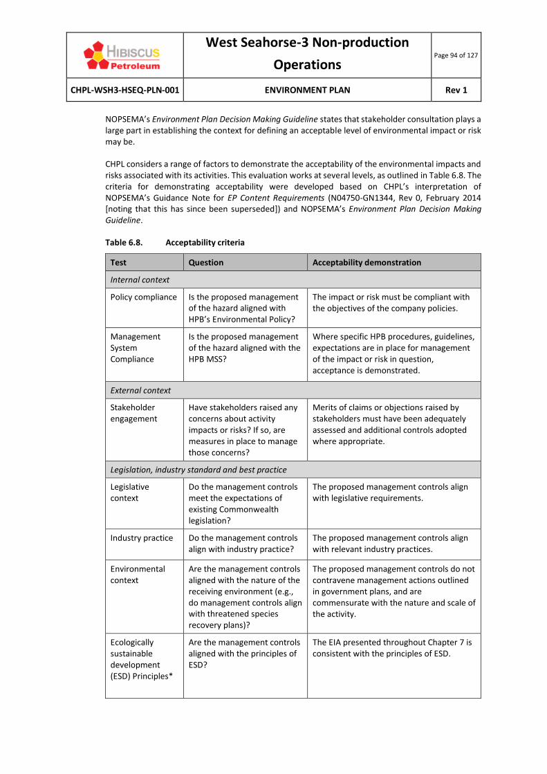
West Seahorse-3 Non-production
Operations Page 94 of 127
CHPL-WSH3-HSEQ-PLN-001 ENVIRONMENT PLAN Rev 1
NOPSEMA’s Environment Plan Decision Making Guideline states that stakeholder consultation plays a large part in establishing the context for defining an acceptable level of environmental impact or risk may be. CHPL considers a range of factors to demonstrate the acceptability of the environmental impacts and risks associated with its activities. This evaluation works at several levels, as outlined in Table 6.8. The criteria for demonstrating acceptability were developed based on CHPL’s interpretation of NOPSEMA’s Guidance Note for EP Content Requirements (N04750-GN1344, Rev 0, February 2014 [noting that this has since been superseded]) and NOPSEMA’s Environment Plan Decision Making Guideline.
Table 6.8. Acceptability criteria
Test Question Acceptability demonstration
Internal context
Policy compliance
Is the proposed management of the hazard aligned with HPB’s Environmental Policy?
The impact or risk must be compliant with the objectives of the company policies.
Management System Compliance
Is the proposed management of the hazard aligned with the HPB MSS?
Where specific HPB procedures, guidelines, expectations are in place for management of the impact or risk in question, acceptance is demonstrated.
External context
Stakeholder engagement
Have stakeholders raised any concerns about activity impacts or risks? If so, are measures in place to manage those concerns?
Merits of claims or objections raised by stakeholders must have been adequately assessed and additional controls adopted where appropriate.
Legislation, industry standard and best practice
Legislative context
Do the management controls meet the expectations of existing Commonwealth legislation?
The proposed management controls align with legislative requirements.
Industry practice
Do the management controls align with industry practice?
The proposed management controls align with relevant industry practices.
Environmental context
Are the management controls aligned with the nature of the receiving environment (e.g., do management controls align with threatened species recovery plans)?
The proposed management controls do not contravene management actions outlined in government plans, and are commensurate with the nature and scale of the activity.
Ecologically sustainable development (ESD) Principles*
Are the management controls aligned with the principles of ESD?
The EIA presented throughout Chapter 7 is consistent with the principles of ESD.

West Seahorse-3 Non-production
Operations Page 95 of 127
CHPL-WSH3-HSEQ-PLN-001 ENVIRONMENT PLAN Rev 1
* See Table 6.9 for further information.
6.5.5 PRINCIPLES OF ECOLOGICALLY SUSTAINABLE DEVELOPMENT
Based on Australia’s National Strategy for Ecologically Sustainable Development (Council of Australian Governments, 1992), Section 3A of the EPBC Act defines ESD as:
Using, conserving and enhancing the community’s resources so that ecological processes, on which life depends, are maintained and the total quality of life, now and in the future, can be increased.
Table 6.9 outlines the principles of ESD as defined under the EPBC Act and describes how this EP aligns with these principles.
Table 6.9. Principles of Ecologically Sustainable Development
Principle EP Demonstration
A Decision-making processes should effectively integrate both long-term and short-term economic, environmental, social and equitable considerations.
This principle is inherently met through the EP assessment process.
B If there are threats of serious or irreversible environmental damage, lack of full scientific certainty should not be used as a reason for postponing measures to prevent environmental degradation.
Serious or irreversible environmental damage resulting from CHPL operations has been eliminated through the activity design (see Chapter 2). None of the residual impacts are rated higher than ‘negligible’ and none of the residual risks are rated higher than ‘low.’
Scientific certainty has been maximised by employing an activity area as a risk assessment boundary.
C The present generation should ensure that the health, diversity and productivity of the environment is maintained or enhanced for the benefit of future generations.
The EP assessment methodology ensures that risks from the activity are ALARP and acceptable.
D The conservation of biodiversity and ecological integrity should be a fundamental consideration in decision making.
This principal is considered for each hazard in the adoption of environmental controls (i.e., EPO and EPS) that aim to minimise environmental harm.
There is a strong focus in this EP on conserving biodiversity and ecological integrity by understanding the marine environment (Chapter 5) and implementing controls to minimise impacts and risks (Chapter 7).
E Improved valuation, pricing and incentive mechanisms should be promoted.
This principle is not relevant to this activity.

West Seahorse-3 Non-production
Operations Page 96 of 127
CHPL-WSH3-HSEQ-PLN-001 ENVIRONMENT PLAN Rev 1
6.6 TREAT THE RISKS
The impacts and risks associated with the activity are assessed in Chapter 7, together with their control measures (i.e., measures to prevent, minimise and mitigate impacts and risks).
6.7 MONITOR AND REVIEW
Monitoring and review activities are described in detail in the Implementation Strategy (Chapter 8).
West Seahorse-3 Non-production
Operations Page 97 of 127
CHPL-WSH3-HSEQ-PLN-001 ENVIRONMENT PLAN Rev 1
7 ENVIRONMENTAL IMPACT AND RISK ASSESSMENT
This chapter presents the EIA and ERA for the environmental impacts and risks identified for the activity using the methodology described in Chapter 6 as required under Regulations 13(5) of the OPGGS(E). This chapter also presents the environmental performance outcomes (EPO), environmental performance standards (EPS) and measurement criteria required to manage the identified impacts and risks.
The following definitions are used in this section, as defined in Regulation 4 of the OPPGS(E):
• EPO – a measurable level of performance required for the management of environmental aspects of an activity to ensure that environmental impacts and risks will be of an acceptable level (i.e., a statement of the environmental objective).
• EPS – a statement of the performance required of a control measure.
• Measurement criteria (not defined in the regulations) – defines the measure by which environmental performance will be measured to determine whether the EPO has been met.
As noted in Section 2.6, WSH-3 is plugged in accordance with international standards and the risk of hydrocarbon release to the surface is the same as a permanently abandoned well (i.e., it is not a credible risk). As such, no vessel-based inspection activities have been undertaken since the well was TA’d in 2008, and none are proposed, so this EP does not assess the impacts and risks of activities associated with periodic vessel-based inspection activities. The EIA and ERA is therefore limited to the physical presence of the WSH-3 wellhead on the seabed and associated its PSZ.
7.1 IMPACT: SEABED DISPLACEMENT
7.1.1 HAZARD
Retaining the WSH-3 wellhead structure on the seabed while it remains TA results in seabed displacement. The wellhead and associated trash cap protrude 2 m above the seabed and measures 1.1 m in diameter (see Figure 2.2). This directly displaces 0.86 m2 of seabed habitat (unconsolidated sediments) typical of the eastern Bass Strait continental shelf.
7.1.2 KNOWN AND POTENTIAL ENVIRONMENTAL IMPACTS
The known and potential environmental impacts of seabed displacement are:
• Highly localised loss of habitat;
• Highly localised smothering of benthic habitats and infauna; and
• Creation of new hard substrate habitat.
7.1.3 EVALUATION OF ENVIRONMENTAL IMPACTS
The area of seabed that is disturbed is miniscule (0.86 m2) compared with the overall extent of the sandy seabed habitat in the region and broader Bass Strait environment. Mortality of benthic fauna in areas directly disturbed is considered to be very small compared with the overall extent of similar habitat in the region. Given the miniscule area of seabed affected, there are no long-term impacts on the diversity and abundance of benthic fauna or ecosystem functioning.

West Seahorse-3 Non-production
Operations Page 98 of 127
CHPL-WSH3-HSEQ-PLN-001 ENVIRONMENT PLAN Rev 1
The WSH-3 wellhead can offer a long-term benefit of providing habitat for marine life and a localised increase in biodiversity. Studies have shown that the ecology of the Gulf of Mexico is enhanced by using abandoned oil and gas facility platform jackets as artificial reef (Fikes, 2013). In this case, the WSH-3 wellhead provides hard substrate as habitat in an area otherwise dominated by sandy sediments. Barnacles, corals and other species that require hard substrates to attached to are likely to have colonised the wellhead since it was installed 11 years ago.
7.1.4 IMPACTS TO MNES
Seabed displacements has not and will not have a ‘significant’ impact to any of the applicable MNES, as outlined in the box below.
AMPs Nationally threatened species Migratory species
Section 5.2.1 Section 5.4 Section 5.4
X X X
There are no AMPs within the activity area.
Habitat modification will not result in any significant effects to populations of threatened or migratory fauna.
‘Significant impact’ is defined in DoE (2013) as ‘an impact which is important, notable, or of consequence, having regard to its context or intensity. Whether or not an action is likely to have a significant impact depends upon the sensitivity, value and quality of the environment, which is impacted, and upon the sensitivity, duration, magnitude and geographic extent of the impacts.’
‘Likely’ is defined in DoE (2013) as ‘it is not necessary for a significant impact to have a greater than 50% chance of it happening; it is sufficient if a significant impact on the environment is a real or not remote chance or possibility.’
7.1.5 IMPACTS TO OTHER AREAS OF CONSERVATION SIGNIFICANCE
Seabed displacement has not and will not have a ‘significant’ impact to any other areas of applicable conservation significance, as outlined in the box below.
KEF (Upwelling East of Eden) State marine parks
Section 5.2.7 Section 5.2.9
X X
None of these features occur within the activity area.
7.1.6 IMPACT ASSESSMENT
Table 7.1 presents the impact assessment for seabed displacement.
Table 7.1 Impact assessment for seabed displacement.
Summary
Summary of impacts Displacement of seabed sediments.
Addition of hard substrate.
Extent of impact Highly localised – diameter of wellhead (0.86 m2).

West Seahorse-3 Non-production
Operations Page 99 of 127
CHPL-WSH3-HSEQ-PLN-001 ENVIRONMENT PLAN Rev 1
Duration of impact Long-term (life of asset).
Level of certainty of impacts
HIGH – the impacts of seabed displacement are well known.
Impact decision framework context
A – nothing new or unusual, represents business as usual, well understood activity, good practice is well defined.
Impact consequence (inherent)
Negligible
Environmental Controls and Performance Measurement
EPO EPS Measurement criteria
Seabed displacement is limited to the area occupied by the wellhead.
Post-wellhead installation imagery confirms displacement is limited to the footprint of the wellhead.
Impact consequence (residual)
Negligible
Demonstration of ALARP
A ‘negligible’ residual impact consequence rating is considered to be ALARP and a ‘lower order’ impact. A demonstration of ALARP is therefore not required.
Demonstration of Acceptability
Policy compliance HPB Environment Policy objectives are met (most notably with regard to legislative compliance).
Management system compliance
Chapter 8 describes the EP implementation strategy to be employed for this activity.
Stakeholder engagement
Stakeholder consultation has been undertaken (see Chapter 4), with no concerns expressed regarding seabed displacement.
Legislative context The performance standards outlined in this EP align with the requirements of the:
• OPGGS Act 2006 (Cth):
o Section 280(2) – a person carrying on activities in an offshore area under the permit must carry on those activities in a manner that does not interfere with….the conservation of the resources of the sea and seabed…..to a greater extent than is necessary for the reasonable exercise of the rights and performance of the duties of the first person.
Industry practice
The consideration and adoption of the controls outlined in the below-listed codes of practice and guidelines demonstrates that BPEM is being implemented for this activity.
Health, Safety and Environmental Case Guidelines for Mobile Offshore Drilling Units (IADC, 2015)
There is no specific guidance regarding TA wells.
Section 2.3.6.1 (environmental protection) states that location- and well- specific environmental protection plans should be prepared. The EP satisfies this requirement.

West Seahorse-3 Non-production
Operations Page 100 of 127
CHPL-WSH3-HSEQ-PLN-001 ENVIRONMENT PLAN Rev 1
Environmental, Health and Safety Guidelines for Offshore Oil and Gas Development (World Bank Group, 2015)
This guideline contains no specific guidance regarding seabed displacement.
However, it does state that abandoned wells must be plugged to prevent fluid migration within the wellbore. While the WSH-3 is only temporarily abandoned, it does meet this requirement.
Environmental management in oil and gas exploration and production (UNEP IE, 1997)
The environmental protection measures listed in this guideline specify the use of environmental assessment to identify protected areas and sensitivities. The EP has addressed this in Chapters 5 and 7.
APPEA CoEP (2008) The APPEA CoEP lists the following objective for production activities:
• To reduce the impacts to benthic communities to acceptable levels and to ALARP.
The EPS listed in this table meet this objective.
Environmental context
Marine reserve management plans
Not triggered by this hazard.
Species Conservation Advice/ Recovery Plans/ Threat Abatement Plans
Not triggered by this hazard.
ESD principles The EIA presented throughout this EP demonstrates that ESD principles (a), (b), (c) and (d) are met (noting that principle (e) is not relevant).
Principle B: Is there a threat of serious or irreversible environmental damage?
No.
Principle D: Is there scientific uncertainty as to the environmental damage?
No.
Environmental Monitoring
None required.
Record Keeping
Post-installation ROV images.

West Seahorse-3 Non-production
Operations Page 101 of 127
CHPL-WSH3-HSEQ-PLN-001 ENVIRONMENT PLAN Rev 1
7.2 RISK: DISPLACEMENT OF OR INTERFERENCE WITH THIRD-PARTY VESSELS AND ACTIVITIES
7.2.1 HAZARD
A 300-m radius PSZ is gazetted around the WSH-3 well to minimise the risk of damage to the well from third-party vessels (e.g., commercial fishing vessels) and minimise risk of damage to those vessels (e.g., as a result of trawl gear becoming entangled on the wellhead). The WSH-3 wellhead represents a potential hazard to fishing equipment should the PSZ be breached. It may also represent a loss of catch (and thus economic losses) should fishing equipment become snagged on the wellhead and damaged. Note that this section addresses displacement or interference in a socio-economic sense. Given that the temporary abandonment design of WSH-3 (as noted in Section 2.6) renders vessel-based maintenance and inspection activities unnecessary, vessel collision hazard (and consequent diesel spill impacts) are not addressed in this EP.
7.2.2 KNOWN AND POTENTIAL SOCIO-ECONOMIC IMPACTS
The risk of displacement of or interference with third-party vessels and fishing activities is damage to or loss of fishing equipment and/or loss of commercial fish catches (resulting in financial loss) as a result of collision or entanglement with the wellhead. The gazetted PSZ enforces a 300-m exclusion zone (0.283 km2) to maximise safety in the area immediately around the wellhead and to reduce the risk of fishing equipment being damaged on the wellhead structure. Receptors most at risk are:
• Commercial fishing vessels; and
• Commercial fishing equipment (e.g., trawl nets).
The risk of displacing merchant vessels is very low given that the activity area occurs within the Bass Strait ATBA, which prohibits vessels greater than 200 gross tonnes being present in the ATBA without NOPSEMA’s permission.
7.2.3 EVALUATION OF ENVIRONMENTAL RISKS
Displacement to third-party vessels The presence of the WSH-3 well and its PSZ excludes other users of the marine environment in order to protect the wellhead and for the safety of other marine users. However, displacement of third-party vessels by the WSH-3 well is unlikely because the activity area is:
• Contained entirely within the Bass Strait ATBA; and
• Distant from the Bass Strait shipping fairway (see Section 5.6.7).
If displacement was to occur, it would result in a negligible increase in travel time and fuel cost at most, but in the context of an entire journey, this is not considered significant.
The consequence of displacing other users, such as commercial and/or recreational fishers, is considered negligible given the sparse use of the area by fishers (see Section 5.6.3) and the very small excluded area (0.283 km2) compared to the total area of fishing grounds.

West Seahorse-3 Non-production
Operations Page 102 of 127
CHPL-WSH3-HSEQ-PLN-001 ENVIRONMENT PLAN Rev 1
Damage to or loss of fishing equipment and loss of catch Commercial fishing vessels are prohibited from operating within the PSZ. Interactions between the WSH-3 wellhead and fishing vessels is likely to be minimal, because:
• The PSZ has been in effect since June 2008 (without any reported incidents to date);
• There is a low level of fishing in the activity area;
• The PSZ is located entirely within the Bass Strait ATBA; and
• Large vessels use sophisticated navigation aids, which will include the presence of the WSH-3 PSZ.
Vessel collision (or more likely given the water depth, entanglement of trawl fishing gear) with the WSH-3 wellhead may result in gear becoming detached from the fishing vessel and the loss of any associated catch (the Commonwealth SESS fishery is active in the activity area). In addition to the cost of repairing or replacing this equipment, it could also result in the loss of income from any fish that were previously caught during that fishing expedition. This risk is negated through:
• Maintaining the PSZ for the length of the activity;
• Communicating the location of the WSH-3 wellhead with fisheries stakeholders; and
• Ensuring the WSH-3 wellhead is marked on navigation charts.
7.2.4 RISKS TO MNES
The displacement of or interference with third-party vessels and activities will not have a ‘significant’ impact to the applicable MNES, as outlined in the box below.
AMPs Nationally threatened species Migratory species
Section 5.2.1 Section 5.4 Section 5.4
X X X
The displacement of or interference with third-party vessels will have no impacts on MNES.
7.2.5 RISKS TO OTHER AREAS OF CONSERVATION SIGNIFICANCE
The displacement of or interference with third-party vessels and activities will not have a ‘significant’ impact to any other applicable areas of conservation significance, as outlined in the box below.
KEF (Upwelling East of Eden) State marine parks
Section 5.2.7 Section 5.2.9
X X
None of these features occur within the activity area.
7.2.6 IMPACT ASSESSMENT
Table 7.2 presents the impact assessment for the displacement of or interference with third-party vessels.

West Seahorse-3 Non-production
Operations Page 103 of 127
CHPL-WSH3-HSEQ-PLN-001 ENVIRONMENT PLAN Rev 1
Table 7.2 Impact assessment for the displacement of or interference with third-party vessels
Summary
Summary of impacts Damage to or loss of fishing equipment.
Loss of commercial fish catches.
Displacement of vessels.
Extent of impact Highly localised – immediately around vessels.
Duration of impact Short-term (minutes for a third-party vessel detour) to medium-term (replacement of damaged fishing equipment).
Level of certainty of impacts
HIGH – The Bass Strait Area to be Avoided was established in acknowledgement of the risk posed by merchant vessels and petroleum infrastructure and smaller vessels.
Impact decision framework context
A – nothing new or unusual, represents business as usual, well understood activity, good practice is well defined.
Risk rating (inherent)
Risk focus Consequence
(financial) Likelihood Risk rating
Displacement Negligible Likely Medium
Interference Minor Unlikely Medium
Environmental Controls and Performance Measurement
EPO EPS Measurement criteria
Prevent damage to vessels and commercial fishing equipment from the WSH-3 wellhead.
The WSH-3 PSZ remains gazetted. A copy of the WSH-3 PSZ is readily available.
The location of the WSH-3 well is marked on navigation charts to assist other marine users in identifying the PSZ.
WSH-3 is marked on relevant Bass Strait navigational charts.
There is no damage to the WSH-3 wellhead.
A trash cap remains fitted to the well to protect it against damage from third-party interactions.
No reported incidents of damage from fishing equipment.
Comply with Section 572 of the OPGGS Act if the well is to be abandoned.
The wellhead and trash cap are removed to surface, with the well cut several metres below the seabed to remove any risk of interference with third parties.
ROV footage confirms the cut well bore does not protrude above the seabed.
Prepare a well abandonment/ decommissioning EP for acceptance by NOPSEMA prior to such an activity commencing.
Well abandonment/ decommissioning EP and acceptance letter is available.
Impact consequence (residual)
Risk focus Consequence (financial)
Likelihood Risk rating

West Seahorse-3 Non-production
Operations Page 104 of 127
CHPL-WSH3-HSEQ-PLN-001 ENVIRONMENT PLAN Rev 1
Displacement Negligible Unlikely Low
Interference Minor Highly unlikely Low
Demonstration of ALARP
A ‘low’ residual impact consequence rating is considered to be ALARP and a ‘lower order’ impact. A demonstration of ALARP is therefore not required.
Demonstration of Acceptability
Policy compliance HPB Environment Policy objectives are met (most notably with regard to legislative compliance).
Management system compliance
Chapter 8 describes the EP implementation strategy to be employed for this activity.
Stakeholder engagement
Stakeholder consultation has been undertaken (see Chapter 4), with no concerns expressed regarding displacement or interference.
Legislative context The EPS outlined in this EP align with the requirements of:
• OPGGS Act 2006 (Cth):
o Section 280(2) – requires that a person carrying on activities in an offshore area under the permit, lease licence, authority or consent must carry on those activities in a manner that does not interfere with navigation or fishing (among others).
o Part 6.6 (Safety zones and the area to be avoided).
• Navigation Act 2012 (Cth):
o Chapter 6 (Safety of navigation).
Industry practice The consideration and adoption of the controls outlined in the below-listed codes of practice and guidelines demonstrates that BPEM is being implemented for this activity.
Health, Safety and Environmental Case Guidelines for Mobile Offshore Drilling Units (IADC, 2015)
There is no specific guidance regarding vessel interference or displacement.
Section 2.3.6.1 (environmental protection) states that location- and well- specific environmental protection plans should be prepared. The EP satisfies this requirement.
Environmental, Health and Safety Guidelines for Offshore Oil and Gas Development (World Bank Group, 2015)
There is no specific guidance regarding management of vessel interference or displacement.
Environmental management in oil and gas exploration and production (UNEP IE, 1997)
The environmental protection measures listed in this guideline specify the use of environmental assessment to identify protected areas and sensitivities. The EP has addressed this in Chapters 5 and 7.

West Seahorse-3 Non-production
Operations Page 105 of 127
CHPL-WSH3-HSEQ-PLN-001 ENVIRONMENT PLAN Rev 1
APPEA CoEP (2008) The APPEA CoEP lists the following objective for production activities:
• To reduce risks to public safety to ALARP and to an acceptable level.
The EPS listed in this table meet these objectives.
Environmental context
Marine reserve management plans
Not triggered by this hazard.
Species Conservation Advice/ Recovery Plans/ Threat Abatement Plans
Not triggered by this hazard.
ESD principles The EIA presented throughout this EP demonstrates that ESD principles (a), (b), (c) and (d) are met (noting that principle (e) is not relevant).
Principle B: Is there a threat of serious or irreversible environmental damage?
No.
Principle D: Is there scientific uncertainty as to the environmental damage?
No.
Environmental Monitoring
None required.
Record Keeping
PSZ gazettal.
Navigation charts.
Incident reports.
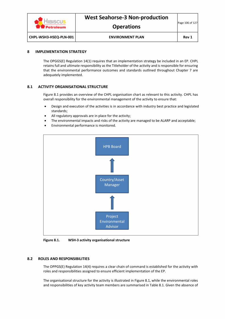
West Seahorse-3 Non-production
Operations Page 106 of 127
CHPL-WSH3-HSEQ-PLN-001 ENVIRONMENT PLAN Rev 1
8 IMPLEMENTATION STRATEGY
The OPGGS(E) Regulation 14(1) requires that an implementation strategy be included in an EP. CHPL retains full and ultimate responsibility as the Titleholder of the activity and is responsible for ensuring that the environmental performance outcomes and standards outlined throughout Chapter 7 are adequately implemented.
8.1 ACTIVITY ORGANISATIONAL STRUCTURE
Figure 8.1 provides an overview of the CHPL organisation chart as relevant to this activity. CHPL has overall responsibility for the environmental management of the activity to ensure that:
• Design and execution of the activities is in accordance with industry best practice and legislated standards;
• All regulatory approvals are in place for the activity;
• The environmental impacts and risks of the activity are managed to be ALARP and acceptable;
• Environmental performance is monitored.
Figure 8.1. WSH-3 activity organisational structure
8.2 ROLES AND RESPONSIBILITIES
The OPPGS(E) Regulation 14(4) requires a clear chain of command is established for the activity with roles and responsibilities assigned to ensure efficient implementation of the EP. The organisational structure for the activity is illustrated in Figure 8.1, while the environmental roles and responsibilities of key activity team members are summarised in Table 8.1. Given the absence of
Country/Asset Manager
HPB Board
Project Environmental
Advisor
West Seahorse-3 Non-production
Operations Page 107 of 127
CHPL-WSH3-HSEQ-PLN-001 ENVIRONMENT PLAN Rev 1
additional contractors required to perform on-water activities (such as vessel-based maintenance and inspection activities), the organisational structure is small for this activity. The personnel fulfilling the roles in Table 8.1 each have over 20 years’ experience in managing petroleum activities and are cognisant of their environmental roles and responsibilities.
Table 8.1. Roles and Responsibilities for the activity
Role Environmental responsibilities
HBP CEO • Ensures CHPL is adequately resourced to implement the EPS in this EP.
CHPL In-Country Manager
• Ensures that contractors have appropriate equipment and systems in place to undertake activities in accordance with industry best practice and this EP.
• Undertakes consultation with government personnel.
• Facilitates clear communication between CHPL and the Project Environmental Advisor.
• Ensures compliance with this EP.
• Prepares and issues routine and incident reports for submission to NOPSEMA.
• Approves the Environmental Performance Report for submission to NOPSEMA.
• Approves the end-of-activity notification for submission to NOPSEMA.
Project Environmental Advisor
• Prepares this EP.
• Undertakes stakeholder consultation.
• Plans for the implementation of the EP.
• Assists in the preparation of external regulatory reports required.
• Assists with review, investigation and reporting of environmental incidents.
8.3 ENVIRONMENTAL MANAGEMENT SYSTEM
The OPPGS(E) Regulation 14(3) requires that an implementation strategy describe the environmental management system for the activity, which is described in this section. For this activity, CHPL adopts the HPB Management System Standards (MSS) (HPB-SP-CPL-SD01), which provides a framework for HSE management at HPB (and subsidiary) sites. The MSS applies to all aspects of operation and maintenance activities and includes contractors and other third parties operating on site. The MSS is designed specifically to:
• Provide a set of performance standards covering the various aspects (or ‘elements’) of health, safety, security, environment (HSSE) and quality management, which are managed to ensure complete coverage of the assets and activities controlled by HPB.
• Provide an auditable trail from management’s policy statements of HSSE and Quality through the MSS to the documents that define the physical activities on the operating sites managed by HPB.
• Be consistent with the international good practice standards for oil and gas operating companies for HSSE and Quality management.
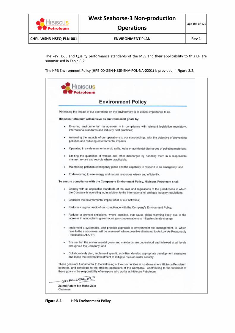
West Seahorse-3 Non-production
Operations Page 108 of 127
CHPL-WSH3-HSEQ-PLN-001 ENVIRONMENT PLAN Rev 1
The key HSSE and Quality performance standards of the MSS and their applicability to this EP are summarised in Table 8.2.
The HPB Environment Policy (HPB-00-GEN-HSSE-ENV-POL-NA-0001) is provided in Figure 8.2.
Figure 8.2. HPB Environment Policy

West Seahorse-3 Non-production
Operations Page 109 of 127
CHPL-WSH3-HSEQ-PLN-001 ENVIRONMENT PLAN Rev 1
Table 8.2. Summary of the HPB MSS
Standard Description
1 Leadership, Policy, Objectives and Compliance
This standard ensures there is an HPB Policy that is consistent with and meets the requirements of the governing legislation in all HPB operating jurisdictions.
The preparation of this EP is consistent with meeting governing legislative requirements.
2 Organisation Responsibility
This standard addresses the commitment to an effective organisational structure for the implementation of the policies and objectives with a clear reporting line for ultimate responsibility to the Directors of HPB.
The organisational responsibility is illustrated in this EP in Figure 8.1.
3 Information Management and Document Control
This standard addresses the need for information on the configuration and capabilities of processes and facilities, properties of materials handled, HSSE hazards, business critical matters and regulatory requirements to be used in managing risk and complying with laws and regulations.
Information and document management is implemented in this activity through adherence to HPB’s Management System Document Numbering and Control Procedure (HPB-IMG-GEN-PCD-01).
4 Risk Assessment and Risk Management
The aim of this standard is to prevent or minimise the likelihood of a hazardous event occurring by systematically identifying hazards.
This has been implemented for this EP as described in Chapters 2, 6 and 7.
5 Operating Procedures This standard provides for a healthy, safe and environmentally responsible and business efficient operation through the establishment of well-defined procedures.
Relevant procedures have been referred and adhered to throughout this EP.
6 Communications, Consultation and Community Involvement
This standard provides for effective participation and consultative mechanisms that promote active communication and involvement of all personnel in the management of HSSE, the control of workplace hazards and engagement with the community’s expectations and concerns.
The consultation method employed for this EP is described in Chapter 4.
7 Employee Selection, Competency, Health and Training
This standard provides the requirements for employee selection in order to ensure that the HPB operations meet all laws and regulations, are safe, environmentally responsible, protect health and meet business requirements.
Training, competency and selection relevant to this EP is described in Section 8.4.

West Seahorse-3 Non-production
Operations Page 110 of 127
CHPL-WSH3-HSEQ-PLN-001 ENVIRONMENT PLAN Rev 1
Standard Description
8 Contractor and Support Services
This standard ensures that all contractors perform work in a healthy, safe and environmentally sound manner and compatible with the company’s policies and objectives.
The selection of contractors for this activity is described in Section 8.4.
9 Procurement This standard ensures that purchased products meet specified requirements and purchasing is carried out in accordance with procedures, which include third party supplier selection, ordering, and verification of product and traceability.
This standard is not relevant to this activity.
10 Design, Construction, Commissioning, Decommissioning and Abandonment
This standard ensures a system is in place to provide for the decommissioning and the long-term shutdown or abandonment of facilities.
The status of the WSH-3 well is described in Chapter 2; plugging and abandonment of the well is a future activity not considered in this EP.
11 Maintenance, Inspection, Testing and Modification
This standard ensures the provision of maintenance and inspection programmes that maintain plant, equipment, structures and vessels in a safe and environmentally responsible condition.
This standard is not relevant to this activity.
12 Change Management This standard ensures a system is in place that manages both temporary and permanent changes covering the organisation, procedures, engineering, facilities and materials.
The change management procedure for this activity is described in Section 8.9.
13 Emergency Response This standard ensures emergency plans and procedures are in place to ensure the safety and protection of the employee, contractors, community, environment, and assets.
Emergency response plans specific to WSH-3 are not required.
14 Incident Reporting and Investigation
This standard ensures a system is in place to report and then investigate each incident or near-miss incident which resulted in or could have reasonably resulted in a situation detrimental to the health and safety of personnel, the environment in which they work or have a significant impact on the business.
Incident recording and reporting relevant to this activity is described in Section 8.7 of this EP.
15 Managing Materials, Waste and Discharges
This standard provides for a system to be in place that ensures the handle, use or disposal of materials involved with operations do so in a healthy, safe and environmentally responsible manner.
This standard is not relevant to this activity.
16 Performance Monitoring
This standard ensures a system is in place to monitor and assess operating performance to ensure that the processes
West Seahorse-3 Non-production
Operations Page 111 of 127
CHPL-WSH3-HSEQ-PLN-001 ENVIRONMENT PLAN Rev 1
Standard Description
and systems adopted are effective in meeting HPB policies and objectives, and legislative requirements.
Performance reporting is described in Section 8.7.2 of this EP.
8.4 TRAINING AND AWARENESS
The OPPGS(E) Regulation 14(5) requires that employees and contractors working on the activity are aware of their environmental responsibilities in accordance with the EP.
Because WSH-3 is plugged in accordance with international standards (as described throughout Chapter 2), vessel-based inspection activities are not required. As such, no auditing, assurance or inspection of vessels will be conducted as part of this activity. As such, site-specific training, environmental inductions, oil spill response training and toolbox talks are not required for this activity and are therefore not described in this EP.
8.5 ENVIRONMENTAL EMERGENCIES AND PREPAREDNESS
The OPPGS(E) Regulation 14(8) requires the development, implementation and testing of an Oil Pollution Emergency Plan (OPEP). Because WSH-3 is plugged in accordance with international standards (as described throughout Chapter 2) the risk of hydrocarbon release from WSH-3 is the same as a permanently abandoned well. This, combined with an absence of on-water vessel-based maintenance and inspection activities renders the implementation and testing of an OPEP and associated Oil Spill Monitoring Plan (OSMP) unnecessary for this activity.
8.6 ROUTINE RECORDING AND REPORTING
8.6.1 Internal
All environmental near-misses and incidents, including non-compliances with the EP EPO and EPS, will be communicated and reviewed internally in accordance with Standard 14 and 16 of the HPB MSS. On a day-to-basis, there is no requirement for daily, weekly, monthly or quarterly reviews and reporting with regard to the non-production phase of WSH-3. Where incidents qualify as externally recordable or reportable incidents, they will be appropriately notified as described in Section 8.7.
8.6.2 External
Regulation 11A of the OPGGS specifies that consultation with relevant authorities, persons and organisations must take place in the course of preparing an EP. This consultation includes an implicit obligation to report on the progress of the activity. Table 8.3 outlines the routine reporting obligations that CHPL will undertake with external organisations.

West Seahorse-3 Non-production
Operations Page 112 of 127
CHPL-WSH3-HSEQ-PLN-001 ENVIRONMENT PLAN Rev 1
Table 8.3. External routine reporting obligations
Requirement Timing Contact details OPGGS(E)
Submit an annual performance report to NOPSEMA.
Annually [email protected] Reg 26C
Notify NOPSEMA of the end of the operation of the EP.
Submit with EP Performance Report.
[email protected] Reg 25A
8.6.3 INCIDENT RECORDING AND REPORTING
Regulation 4 of the OPGGS(E) defines the following incident types:
• Recordable incident – a breach of an EPO or EPS in the EP that applies to the activity that is not a reportable incident.
• Reportable incident – means an incident relating to the activity, that has caused, or has the potential to cause, moderate to significant environmental damage.
CHPL interprets ‘moderate to significant’ environmental damage as being those consequences in the HPB consequence definitions (see Table 6.1) as having a consequence of ‘major’, ‘severe’ or ‘catastrophic.’ There are no impacts or risks with these consequences (as outlined throughout Chapter 7). Table 8.4 presents CHPL’s reporting obligations in the case of recordable and reportable incidents.
Table 8.4. External reportable incident reporting obligations
Requirement Timing Contact
Recordable incidents
As a minimum, the written recordable report must contain:
• A record of all recordable incidents that occurred during the calendar month; and
• All material facts and circumstances concerning the recordable incidents that the titleholder knows or is able, by reasonable search or enquiry, to find out; and
• Any action taken to avoid or mitigate any adverse environment impacts of the recordable incidents; and
• The corrective action that has been taken, or is proposed to be taken, to stop, control or remedy the recordable incident; and
• The action that has been taken, or is proposed to be taken, to prevent a similar incident occurring in the future.
As soon as practicable after the end of the calendar month, and in any case not later than 15 days after the end of the calendar month.
West Seahorse-3 Non-production
Operations Page 113 of 127
CHPL-WSH3-HSEQ-PLN-001 ENVIRONMENT PLAN Rev 1
Requirement Timing Contact
Reportable incidents – verbal notification
Reportable incidents are defined in the paragraph preceding this table.
The notification must contain:
• All material fact and circumstances concerning the incident.
• Any action taken to avoid or mitigate the adverse environmental impact of the incident.
• The corrective action that has been taken or is proposed to be taken to stop control or remedy the reportable incident.
Within 2 hrs of becoming aware of the incident.
Phone: (08) 6461 7090
Reportable incidents – written notification
A written report must follow a verbal notification of a reportable incident to NOPSEMA. As a minimum, the written report must contain:
• All material facts and circumstances concerning the reportable incident that the titleholder knows or is able, by reasonable search or enquiry, to find out.
• Any action taken to avoid or mitigate any adverse environment impacts.
• The corrective action that has been taken, or is proposed to be taken, to stop, control or remedy the incident.
• The action that has been taken, or is proposed to be taken, to prevent a similar incident occurring in the future.
As soon as practicable, and in any case not later than 3 days after the first occurrence of the reportable incident.
8.6.4 ENVIRONMENTAL PERFORMANCE REPORTING
In accordance with OPGGS(E) Regulation 14(2), CHPL will submit to NOPSEMA an annual Environmental Performance Report. Given the simplicity of this activity, this report will take the form of a letter to notify NOPSEMA whether the EPO have been met during the reporting period. In accordance with OPGGS(E) Regulation 26B(4), given the non-production nature of this activity, CHPL will report recordable environmental incidents to NOPSEMA on a ‘by exception’ basis rather than monthly.
8.7 CHANGE MANAGEMENT
CHPL adopts the HPB Management of Change Procedure (HPB-SP-DOC-PCD02) that defines the method, level of documentation required and process for initiating changes to CHPL work programs. All Management of Change (MOC) must undergo a risk hazard review, where severity and probability

West Seahorse-3 Non-production
Operations Page 114 of 127
CHPL-WSH3-HSEQ-PLN-001 ENVIRONMENT PLAN Rev 1
of the change to the program are reviewed, considered and, if required, mitigated. Once an MOC has been generated, it must be submitted to the relevant facilitator for documenting and tracking. Due to the very nature of the non-production activity described in this EP, any work undertaken on the well will be classified as a new activity and thus result in the need for a new EP. As such, MOC is not expected to be utilised while the well remains plugged.
8.8 MONITORING, AUDITING, ASSURANCE AND INSPECTIONS
The OPGGS(E) Regulation 14(6) requires that monitoring, auditing, management of non-conformance and review of environmental performance are described in an EP. Because WSH-3 is plugged in accordance with international standards, vessel-based inspection activities are not required. As such, no auditing, assurance or inspection is required of the well, the wellhead or of vessels (that could be used to undertake inspections and monitoring).

West Seahorse-3 Non-production
Operations Page 115 of 127
CHPL-WSH3-HSEQ-PLN-001 ENVIRONMENT PLAN Rev 1
9 REFERENCES
APPEA. 2019. Key Statistics 2019. Australian Petroleum Production and Exploration Association. Canberra. Baker, A. 1985. Pygmy right whale Caperea marginata (Gray, 1846). In: Ridgway, S H and Harrison, R. (eds.)
Handbook of Marine Mammals Vol. 3: The Sirenians and Baleen Whales. Academic Press, London. Bannister, J.L., Kemper, C.M. and Warnecke R.M. 1996. The Action Plan for Australian Cetaceans. The Director
of National Parks and Wildlife Biodiversity Group. Environment Australia. Canberra. Barton, J., Pope, A. and Howe, S. 2012. Marine Natural Values Study Vol 2: Marine Protected Areas of the
Flinders and Twofold Shelf Bioregions. Parks Victoria Technical Series. Number 79. Parks Victoria. Melbourne.
Basslink. 2001. Basslink Draft Integrated Impact Assessment Statement. Main Report. Prepared by NSR
Environmental Consultants Pty Ltd for Basslink Pty Ltd. BoM. 2017. Climate Statistics for Australian Locations: Lakes Entrance. A WWW database accessed at
http://www.bom.gov.au/climate/averages/tables/cw084083.shtml. Bureau of Meteorology. Butler, A., Harris, P., Lyne, V. Heap, A., Passlow, V. and Smith, R. 2001. An interim, draft bioregionalization for
the continental slope and deeper waters of the South-East Marine Region of Australia. Report to the National Oceans Office. CSIRO Marine Research, Geoscience Australia, Hobart.
Butler, A., Althaus, F., Furlani, D. and Ridgway, K. 2002. Assessment of the Conservation Values of the Bonney
Upwelling Area – A component of the Commonwealth Marine Conservation Assessment Progra 2002-2004. Report to Environment Australia. CSIRO Marine Research, Hobart.
Carlyon, K., Pemberton, D. and Rudman, T. 2011. Islands of the Hogan Group, Bass Strait: Biodiversity and Oil
Spill Response Survey. Resource Management and Conservation Division, DPIPWE, Hobart, Nature Conservation Report Series 11/03.
CER. 2015. ALARP Guidance. Part of the Petroleum Safety Framework and the Gas Safety Regulatory
Framework. The Commission for Energy Regulation. Dublin. Charlton-Robb, K., Gershwin, L., Thompson, R., Austin, J., Owen, K. and McKechnie, S. 2011. A New Dolphin
Species, the Burrunan Dolphin Tursiops australis sp. nov., Endemic to Southern Australian Coastal Waters. PLoS ONE 6(9): e24047.
Charlton, C.M., Guggenheimer, S.N. and Burnell, S.R. 2014. Long term Southern Right Whale population
monitoring at the Head of the Great Australian Bight, South Australia (1991-2013). Report to the Department of Environment, Australian Antarctic Division, Australian Marine Mammal Centre.
Cooper Energy. 2017. Quarterly Report for 3 months to 30 June 2017. A WWW document accessed at
http://www.cooperenergy.com.au/Upload/Documents/ ReportsItem/2017.07.26-Quarterly-Report-Q417.pdf. Cooper Energy. Adelaide.
DAWR. 2018. Marine Pest Plan 2018-2023. National Strategic Plan for Marine Pest Biosecurity. Department of
Agriculture and Water Resources. Canberra. DELWP. 2015. Action Statement No 257. Australian Grayling Prototroctes maraena. Department of
Environment, Land, Water and Planning. Melbourne.

West Seahorse-3 Non-production
Operations Page 116 of 127
CHPL-WSH3-HSEQ-PLN-001 ENVIRONMENT PLAN Rev 1
DIBP. 2017. Bass Strait Area to be Avoided. A WWW document accessed at
https://www.border.gov.au/AustralianBorderForce/Documents/Bass%20Strait%20Area%20to%20be%20Avoided%20Industry%20information%20sheet.pdf. Department of Immigration and Border Protection.
DoE. 2015a. South-east Marine Regional Profile. A WWW document accessed at
http://www.environment.gov.au/system/files/resources/7a110303-f9c7-44e4-b337-00cb2e4b9fbf/files/south-east-marine-region-profile.pdf. Department of the Environment. Canberra.
DoE. 2015b. Conservation Management Plan for the Blue Whale. A Recovery Plan under the Environment
Protection and Biodiversity Conservation Act 1999. Department of the Environment. Canberra.
DoEE. 2017. Recovery Plan for Marine Turtles in Australia. A WWW database accessed at
http://www.environment.gov.au/marine/publications/recovery-plan-marine-turtles-australia-2017. Department of the Environment and Energy. Canberra.
DoEE. 2019a. Australia’s World Heritage List. A WWW database accessed at
http://www.environment.gov.au/heritage/places/world-heritage-list. Department of the Environment and Energy. Canberra.
DoEE. 2019b. Australia’s National Heritage List. A WWW database accessed at
http://www.environment.gov.au/heritage/places/national-heritage-list. Department of the Environment and Energy. Canberra.
DoEE. 2019c. Australian Ramsar Wetlands. A WWW database accessed at
http://www.environment.gov.au/cgi-bin/wetlands/alphablist.pl. Department of the Environment and Energy. Canberra.
DoEE. 2019d. EPBC Act Protected Matters Search Tool. A WWW database accessed at
http://www.environment.gov.au/epbc/pmst/. Department of the Environment and Energy. Canberra. DoEE. 2019e. Australia’s Commonwealth Heritage List. A WWW database accessed at
http://www.environment.gov.au/topics/heritage/heritage-places/ commonwealth-heritage-list. Department of the Environment. Canberra.
DoEE. 2019f. Key Ecological Features. A WWW database accessed at https://www.environment.gov.au/sprat-
public/action/kef/search. Department of the Environment and Energy. Canberra. DoEE. 2019g. Nationally Important Wetlands. A WWW database accessed at
http://www.environment.gov.au/cgi-bin/wetlands/search.pl?smode=DOIW. Department of the Environment and Energy. Canberra.
DoEE. 2019h. Biologically Important Areas. A WWW database accessed at
http://www.environment.gov.au/marine/marine-species/bias. Department of the Environment and Energy. Canberra.
DoEE. 2019i. Species profile threats database. A WWW database accessed at
http://www.environment.gov.au/cgi-bin/sprat/public/sprat.pl. Department of the Environment and Energy. Canberra.
DoEE. 2019j. National Conservation Values Atlas. Department of the Environment and Energy. Canberra.

West Seahorse-3 Non-production
Operations Page 117 of 127
CHPL-WSH3-HSEQ-PLN-001 ENVIRONMENT PLAN Rev 1
DoEE. 2019k. Australian National Shipwreck Database. A WWW database accessed at
https://dmzapp17p.ris.environment.gov.au/shipwreck/public/wreck/search. Department of the Environment and Energy. Canberra.
DSE. 2003. Great White Shark Action Statement. Department of Sustainability and Environment. Melbourne. DSEWPC. 2011. National Recovery Plan for Threatened Albatrosses and Giant Petrels 2011-2016. Department
of Sustainability, Environment, Water, Population and Communities. Australian Antarctic Division. Canberra.
DSEWPC. 2012. Conservation Management Plan for the Southern Right Whale 2011-21. Department of
Sustainability, Environment, Water, Population and Communities. Canberra. DSEWPC. 2013. Recovery Plan for the White Shark (Carcharodon carcharias). Department of Sustainability,
Environment, Water, Population and Communities. Canberra. ESDSC. 1992. National Strategy for Ecologically Sustainable Development. Ecologically Sustainable
Development Steering Committee. A WWW document accessed at http://www.deh.gov.au/esd/nationalnsesd/strategy/index.html.
Fandry, C. B. 1983. Model for the three-dimensional structure of wind driven and tidal circulation in Bass Strait.
Aust. J. Mar. Freshwater Res. 34:121–141. Fikes, 2013. Artificial Reefs: Restoration Beyond Recreation? National Wildlife Federation. A WWW document
accessed in 2013 at https://blog.nwf.org/2013/11/artificial-reefs-restoration-beyond recreation/?ga=2.253566473.1054657022.1545519779-801650638.1545519779.
Flegg, J. 2002. Photographic Field Guide Birds of Australia. Second Edition. Reed New Holland. Sydney. Fugro. 2007. Report for the Sea Lion-1 Site Survey. Fugro Survey Job No: P0635-8. Prepared by Fugro for
Australian Drilling Associates, Melbourne. Geoscience Australia. 2017. Gippsland Basin. A WWW database accessed at http://www.ga.gov.au/scientific-
topics/energy/province-sedimentary-basin-geology/petroleum/offshore-southern-australia/Gippsland. Geoscience Australia. Canberra.
Gill, P. and Morrice, M. 2003. Cetacean Observations. Blue Whale Compliance Aerial Surveys. Santos Ltd
Seismic Survey Program Vic/P51 and P52. November-December 2002. Report to Santos Ltd. Gill, P.C., Kemper, C.M., Talbot, M. and Lyons, S.A. 2008. Large group of pygmy right whales seen in a shelf
upwelling region off Victoria, Australia. Marine Mammal Science 24(4): 962-968. Harris, P.T. and Heap, A. 2009. Geomorphology and Holocene sedimentology of the Tasmanian continental
margin. J. Geo. Soc. Aus. Holdgate, G., Wallace, M., Gallagher, S., Smith, A., Keene, J., Moore, D. and Shafik. 2003. Plio-Pleistocene
tectonics and eustasy in the Gippsland Basin, southeast Australia: evidence from magnetic imagery and marine geological data. Australian Journal of Earth Sciences. 50, 403-426.
Horwood, J. 1987. The sei whale: Population biology, ecology, and management. Croom Helm, Sydney.

West Seahorse-3 Non-production
Operations Page 118 of 127
CHPL-WSH3-HSEQ-PLN-001 ENVIRONMENT PLAN Rev 1
Hume F., Hindell M.A., Pemberton D. and Gales R. 2004. Spatial and temporal variation in the diet of a high
trophic level predator, the Australian fur seal (Arctocephalus pusillus doriferus). Mar. Biol. 144(3): 407-415.
IMCRA. 1998. Interim Marine and Coastal Regionalisation for Australia: An ecosystem-based classification for
marine and coastal environments. IMCRA Technical Group. Version 3.3. Jones, I.S.F. 1980. Tidal and Wind-driven Currents in Bass Strait. Aus. J. Mar. Freshwater Res. 31. 109-17. Jones, I.S.F. and Padman, L. 1983. Semidiurnal internal tides in eastern Bass Strait. Aust. J. Mar. Freshwater Res
34:159–171. Kimmerer, W.J. and McKinnon, A.D. 1984. Zooplankton abundances in Bass Strait and western Victorian shelf
waters, March 1983. Proceedings of the Royal Society of Victoria. 96(3): 161-167. Kirkwood, R., Warneke, R.M., Arnould. J.P. 2009. Recolonization of Bass Strait, Australia, by the New Zealand
fur seal, Arctocephalus forsteri. Marine Mammal Science 25(2): 441–449. LCC. 1993. Marine and Coastal Descriptive Report (special investigation). Land Conservation Council. June
1993. Limpus, C.J. 2008a. A biological review of Australian Marine Turtles. 1. Loggerhead Turtle Caretta caretta
(Linneaus). Queensland Environment Protection Agency. Limpus, C.J. 2008b. A Biological Review of Australian Marine Turtles. Green Turtle, Chelonia mydas (Linnaeus).
Prepared for the Queensland Environment Protection Agency. Limpus, C.J. 2009. A Biological Review of Australian Marine Turtles. Leatherback Turtle, Dermochelys coriacea
(Vandelli). Prepared for the Queensland Environment Protection Agency. McCauley, R.D. and Duncan, A.J. 2001. Marine Acoustic Effects Study, Blue Whale Feeding Aggregations, Otway
Basin, Bass Strait Victoria. Prepared for: Ecos Consulting. Curtin University Centre for Marine Science and Technology.
McInnes, K. L. and Hubbert, G. D. 2003. A numerical modelling study of storm surges in Bass Strait. Australian
Meteorological Magazine 52(3). McLeay, L.J., Sorokin, S.J., Rogers, P.J. and Ward, T.M. 2003. Benthic Protection Zone of the Great Australian
Bight Marine Park: 1. Literature Review. Prepared by the South Australian Research and Development Institute. Final report to the National Parks and Wildlife South Australia and the Commonwealth Department of the Environment and Heritage.
Museums Victoria. 2019. Fishes of Australia database. A WWW database accessed at
http://fishesofaustralia.net.au. Museums Victoria. Melbourne. NNTT. 2018. Search register of Native Title claims. A WWW database accessed at
http://www.nntt.gov.au/searchRegApps/NativeTitleRegisters/Pages/Search-Register-of-Native-Title-Claims.aspx. National Native Title Tribunal.

West Seahorse-3 Non-production
Operations Page 119 of 127
CHPL-WSH3-HSEQ-PLN-001 ENVIRONMENT PLAN Rev 1
NOPTA. 2019. Petroleum Titles interactive map. A WWW database accessed at http://www.nopta.gov.au/maps-and-public-data/interactive-map.html. National Offshore Petroleum Titles Administrator. Perth.
NOPSEMA. 2016. Petroleum Safety Zones and the Area to be Avoided. Guidance Note. N04800-GB1695 Rev 0,
October 2016. National Offshore Petroleum Titles Administrator. Perth. OMV. 2001. Patricia Baleen Gas Field Development. Environment Effects Statement-Public Environment
Report. OMV Australia Pty Ltd. ParksVic. 2015. Marine Pests in Victoria: A Quick Reference Guide. A WWW document accessed at
https://parkweb.vic.gov.au/__data/assets/pdf_file/0010/720559/Marine-pests-Victoria-reference-guide.pdf. Parks Victoria. Kew.
Parry G. D., Campbell, S.J. and Hobday, D.K. 1989. Marine resources off East Gippsland, southeastern Australia.
Marine Science Laboratories, Queenscliff. Technical Report No. 72, 166 pp. Patterson, H., Williams, A., Woodhams, J. and Curtotti, R. 2019. Fishery status reports 2019. Australian Bureau
of Agricultural and Resource Economics and Sciences, Canberra. Patterson, H., Larcombe, J., Nicol, S. and Curtotti, R. 2018. Fishery status reports 2018. Australian Bureau of
Agricultural and Resource Economics and Sciences, Canberra. Patterson, H., Noriega, R., Georgeson, L., Larcombe, J. and Curtotti, R. 2017. Fishery status reports 2017.
Australian Bureau of Agricultural and Resource Economics and Sciences. Canberra. Patterson, H., Noriega, R., Georgeson, L., Stobutski, I. and Curtotti, R. 2016. Fishery status reports 2016.
Australian Bureau of Agricultural and Resource Economics and Sciences. Canberra. Poore, G.C.B., Wilson, R.S., Gomon, M. and Lu, C.C. 1985. Museum of Victoria Bass Strait Survey, 1979-1984.
Museum of Victoria, Melbourne. Reilly, S.B., Bannister, J.L., Best, P.B., Brown, M., Brownell Jr, R.L., Butterworth, D.S, Clapham, D.J., Cooke, J.,
Donovan, G.P., Urbán, J. and Zerbini, A.N. 2008. Caperea marginata. In: IUCN Red List of Threatened Species. Version 2011.2.
Ross, G.J.B. 2006. Review of the Conservation Status of Australia's Smaller Whales and Dolphins. Report to the
Australian Department of the Environment and Heritage. Canberra. Shaughnessy, P.D.1999. The action plan for Australian seals. CSIRO Wildlife and Ecology.
TSSC. 2015a. Conservation Advice – Rhincodon typus (whale shark). A WWW document accessed at
http://www.environment.gov.au/biodiversity/threatened/species/pubs/66680-conservation-advice-01102015.pdf. Threatened Species Scientific Committee.
TSSC. 2015b. Conservation Advice – Megaptera novaeangliae (humpback whale). A WWW document accessed
at http://www.environment.gov.au/biodiversity/threatened/species/pubs/38-conservation-advice-10102015.pdf. Threatened Species Scientific Committee.
Turnpenny, A.W.H. and Nedwell, J.R. 1994. The effects on marine fish, diving mammals and birds of
underwater sound generated by seismic surveys. Fawley Aquatec Research Laboratories Ltd. Consultancy Report. FCR 089/94.

West Seahorse-3 Non-production
Operations Page 120 of 127
CHPL-WSH3-HSEQ-PLN-001 ENVIRONMENT PLAN Rev 1
VFA. 2018. Commercial fisheries. A WWW database accessed at https://vfa.vic.gov.au/commercial-fishing.
Victorian Fisheries Authority. Melbourne. Watson, C.F. and Chaloupka, M.Y. 1982. Zooplankton of Bass Strait: Species Composition, Systematics and
Artificial key to Species. Tasmanian Institute of Marine Science Technical Report No. 1. WDCS. 2004. Oceans of Noise. Whales and Dolphin Conservation Society. United Kingdom. Wilson, R. and Poore, G. 1987. The Bass Strait survey: biological sampling stations, 1979-1984. Occasional
papers from the Museum of Victoria 3, 1–14.
Appendix 1 Stakeholder Information Flyer

Thursday, October 31, 2019 at 4:32:16 PM Australian Eastern Daylight Time
Page 1 of 5
Subject: West Seahorse-3 Suspended Well Invite to CommentDate: Wednesday, 2 October 2019 at 4:39:01 pm Australian Eastern Standard Time From: Carnarvon Hibiscus Pty LtdTo:
WEST SEAHORSE-3 SUSPENDED WELL
Invite to Comment
SUMMARY
Carnarvon Hibiscus Pty Limited (CHPL), a wholly owned subsidiary of Hibiscus Petroleum Berhad
(Hibiscus Petroleum), is the titleholder of production license VIC/L31 in eastern Bass Strait. The West
Seahorse-3 (WSH-3) well is located within this license area and is temporarily abandoned (suspended).
WSH-3 was originally drilled in 2008 by 3D Oil Limited (3D Oil) and temporarily abandoned in accordance
with international standards. There have been no further works on WSH-3 since this time.
In accordance with its obligations under the Commonwealth Offshore Petroleum and Greenhouse Gas
Storage Act 2006 (OPGGS Act), CHPL is developing an Environment Plan (EP) to continue the non-
production operations phase of WSH-3 until such time that it is completed as a producing well or it is
permanently abandoned. CHPL is seeking to engage with relevant persons whose functions, interests or
activities may be affected by the existence of the WSH-3 suspended well.
LOCATION
The WSH-3 wellhead is located in eastern Bass Strait approximately 13 km off the Gippsland coast in a
water depth of 39.5 m (see location map below).
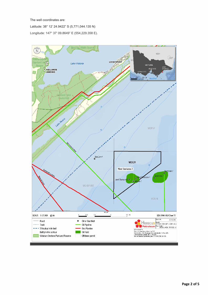
Page 2 of 5
The well coordinates are:
Latitude: 38° 12’ 24.9422” S (5,771,044.135 N)
Longitude: 147° 37’ 09.8649” E (554,229.358 E).

Page 3 of 5
WSH-3 location
WELL HISTORY
WSH-3 was originally drilled by 3D Oil in early 2008 in the then Exploration Permit VIC/P57.
The objectives of the well were to appraise and develop the oil-bearing sandstones of the Latrobe Group
in the West Seahorse field, originally discovered by drilling the West Seahorse-1 well in 1981. The well
confirmed the presence of oil in a high-quality reservoir.
Following completion of the well, WSH-3 was successfully temporarily abandoned in early May 2008 in
accordance with international well integrity standards, which involved the installation and testing of four
cement plugs to prevent any hydrocarbons flowing to surface. A temporary abandonment cap was
installed over the conductor casing and protrudes 2 m above the seabed and measures approximately 1.1
m in diameter (see image below). This cap is designed to prevent damage to the wellhead from marine
growth and third-party activities (such as trawler drag or anchor drop). Since CHPL’s acquisition of
VIC/L31, there have been no further works on WSH-3.

Page 4 of 5
WSH-3 well and temporary abandonment cap
THE TITLEHOLDER
Hibiscus Petroleum is Malaysia’s first listed independent oil and gas exploration and production company
and is headquartered in Kuala Lumpur. Its key activities are focused on monetising producing oilfields and
growing its portfolio of development and production assets.
Australia holds significant potential for Hibiscus Petroleum’s future development plans, with a focus on the
proven and probable reserves in the West Seahorse Field under the VIC/L31 production licence.
CHPL acquired the VIC/P57 permit in December 2012 and successfully applied for a Production Licence
(VIC/L31) over a portion of the block holding the West Seahorse Field, which was granted by the National
Offshore Petroleum Titles Authority (NOPTA) in December 2013. In September 2014 CHPL purchased 3D
Oil’s share in the permit. CHPL has since been the 100% titleholder and Operator of VIC/L31.
ENVIRONMENTAL CONSIDERATIONS AND REGULATORY APPROVALS
CHPL is cognisant of the ecological and socio-economic values of the Gippsland marine environment and
is currently developing an EP for submission to the National Offshore Petroleum Safety and
Environmental Management Authority (NOPSEMA) for acceptance. The EP will describe the known and
potential impacts and risks on the environment of the well and detail control measures to manage these
impacts and risks.
CHPL will not be undertaking any vessel-based inspection and maintenance activities on WSH-3. A
300-m radius Petroleum Safety Zone (PSZ) (0.283 km2) has been in place around the well since 2008,
and this is the defined area of impact for this activity. The impacts arising as a result of the non-production
operations phase are limited to those associated with the physical presence of the well (and the temporary
abandonment cap) and its associated PSZ (such as the exclusion of trawling activity in this PSZ).
STAKEHOLDER CONSULTATION
Under the OPGGS Act and associated environmental regulations, the operator of an activity must engage
with ‘relevant persons’ (i.e., government agencies, organisations and individuals) whose functions,
interests or activities may be affected by an offshore petroleum activity.
You have been identified as a relevant person for this activity. The purpose of this email is to inform you of
the presence of WSH-3, establish a communication channel and determine whether you may be impacted
by the presence of the well.

Page 5 of 5
Accordingly, CHPL invites your comments on the existence of this suspended well to enable it to fully
consider the potential impacts of this activity, which will assist in refining the control measures in the EP
that aim to protect the environment and minimise disruption to marine users.
Should CHPL not receive a response from you in the coming weeks, we will endeavour to make contact
with you to solicit your views.
If you would like further information about CHPL’s WSH-3 suspended well operations or would like to
provide feedback on how your functions, interests or activities may be affected by the well, please contact
us using the details provided below. The EP for this activity will be submitted in early November 2019.
CONTACT DETAILS
Giulio Pinzone
Project Environmental Advisor
Aventus Consulting Pty Ltd
0409 772 170
This email was sent to [email protected] why did I get this? unsubscribe from this list update subscription preferences
Aventus Consulting · 307/75 Tulip Street · Cheltenham, Vic 3192 · Australia