caribbean sea volume ii - kp44.org
TRANSCRIPT

PUB.
(ENROUTE)SAILING DIRECTIONS
★
148
★
CARIBBEAN SEAVOLUME II
Prepared and published by theL GEOSPATIAL-INTELLIGENCE A
NATIONA GENCYBethesda, Maryland
© COPYRIGHT 2004 BY THE UNITED STATES GOVERNMENTNO COPYRIGHT CLAIMED UNDER TITLE 17 U.S.C.
2004
EIGHTH EDITION
For sale by the Superintendent of Documents, U.S. Government Printing Office
Internet: http://bookstore.gpo.gov Phone: toll free (866) 512-1800; DC area (202) 512-1800Fax: (202) 512-2250 Mail Stop: SSOP, Washington, DC 20402-0001

ck,sly
d
utrt,arestal
1sed
yen-ay
oteds,d totheeiral
eters.s
xi-ers
d-y-.thewebis-
-ht
ehichalow-idesin
tale
S.n,ea
Preface
0.0 Pub. 148, Sailing Directions, (Enroute) Caribbean Sea,Volume II, Eighth Edition, 2004, is issued for use inconjunction with Pub. 140, Sailing Directions (PlanningGuide) North Atlantic Ocean, North Sea, Baltic Sea, and theMediterranean Sea. Companion volumes are Pubs. 141, 142,143, 145, and 147.0.0 This publication has been corrected to 27 November 2004,including Notice to Mariners No. 48 of 2004.
Explanatory Remarks
0.0 Sailing Directions are published by the National Geospatial-Intelligence Agency (NGA), under the authority of Departmentof Defense Directive 5105.40, dated 12 December 1988, andpursuant to the authority contained in U. S. Code Title 10,Sections 2791 and 2792 and Title 44, Section 1336. SailingDirections, covering the harbors, coasts, and waters of theworld, provide information that cannot be shown graphicallyon nautical charts and is not readily available elsewhere.0.0 Sailing Directions (Enroute) include detailed coastal andport approach information which supplements the largest scalechart produced by the National Geospatial-IntelligenceAgency. This publication is divided into geographic areascalled “Sectors.”0.0 Bearings.—Bearings are true, and are expressed in degreesfrom 000˚ (north) to 360˚, measured clockwise. Generalbearings are expressed by initial letters of points of the com-pass (e.g. N, NNE, NE, etc.). Adjective and adverb endingshave been discarded. Wherever precise bearings are intendeddegrees are used.0.0 Coastal Features.—It is assumed that the majority of shipshave radar. Available coastal descriptions and views, useful forradar and visual piloting are included in geographic sequencein each Sector.0.0 Corrective Information.— Corrective information and othercomments about this publication can be forwarded to NGA, asfollows:0.0 1. Mailing address:
0.0Maritime Division0.0National Geospatial-Intelligence Agency0.0ST D 440.04600 Sangamore Road0.0Bethesda MD 20816-5003
0.0 2. E-mail address:[email protected]
0.0 New editions of Sailing Directions are corrected through thedate of the publication shown above. Important information toamend material in the publication is available as a PublicationDigital Update (PDU) from the NGA Maritime Divisionwebsite.
0.0NGA Maritime Division Website (PDUs)http://164.214.12.145/sdr
0.0
0.0 Courses.—Courses are true, and are expressed in the samemanner as bearings. The directives “steer” and “make good” acourse mean, without exception, to proceed from a point oforigin along a track having the identical meridianal angle as thedesignated course. Vessels following the directives must allow
for every influence tending to cause deviation from such traand navigate so that the designated course is continuoubeing made good.0.0 Currents.—Current directions are the true directions towarwhich currents set.0.0 Dangers.—As a rule outer dangers are fully described, binner dangers which are well-charted are, for the most paomitted. Numerous offshore dangers, grouped together,mentioned only in general terms. Dangers adjacent to a coapassage or fairway are described.0.0 Distances.—Distances are expressed in nautical miles ofminute of latitude. Distances of less than 1 mile are expresin meters, or tenths of miles.0.0 Geographic Names.—Geographic names are generallthose used by the nation having sovereignty. Names in partheses following another name are alternate names that mappear on some charts. In general, alternate names are quonly in the principal description of the place. Diacritical marksuch as accents, cedillas, and circumflexes, which are relatespecific letters in certain foreign languages, are not used ininterest of typographical simplicity. Geographic names or thspellings do not necessarily reflect recognition of the politicstatus of an area by the United States Government.0.0 Heights.—Heights are referred to the plane of referencused for that purpose on the charts and are expressed in me0.0 Index-Gazetteer.—Navigational features and place-nameare listed alphabetically in the back of the book. The appromate position, along with the Sector and paragraph numb(e.g.1.1), facilitate location in the text.0.0 Internet Links.— This publication provides internet links toweb sites concerned with maritime navigational safety, incluing but not limited to, Federal government sites, foreign Hdrographic Offices, and foreign public/private port facilitiesNGA makes no claims, promises, or guarantees concerningaccuracy, completeness, or adequacy of the contents of thesites and expressly disclaims any liability for errors and omsions of these web sites.0.0 Light and Fog Signals.—Lights and fog signals are not described, and light sectors are not usually defined. The LigLists should be consulted for complete information.0.0 Ports.—Directions for entering ports are depicted wherappropriate by means of chartlets, sketches, and photos, wfacilitate positive identification of landmarks and navigationaids. These chartlets and sketches are not always to scale, hever, and should be used only as a general informational guin conjunction with the best scale chart. Specific port facilitieare omitted from the standard format. They are tabulatedPub. 150, World Port Index.0.0 Radio Navigational Aids.—Radio navigational aids are nodescribed in detail. Publication No. 117 Radio NavigationAids and NOAA Publication, Selected Worldwide MarinBroadcasts, should be consulted.0.0 Sales.—For sale by the Superintendent of Documents, U.Government Printing Office, Mail Stop: SSOP, WashingtoDC 20402-0001. Phone: toll free (866) 512-1800, DC ar(202) 512-1800.
0.0GPO Bookstore Website0.0http://bookstore.gpo.gov
Pub. 148 III

is
and
u-
u-
0.0 Soundings.—Soundings are referred to the datum of thecharts and are expressed in meters.0.0 Special Warnings.—A Special Warning may be in force forthe geographic area covered by this publication. SpecialWarnings are printed in the weekly Notice to Mariners uponpromulgation and are reprinted annually in Notice to MarinersNo. 1. A listing of Special Warnings currently in force isprinted in each weekly Notice to Mariners, Section III, Broad-cast Warnings, along with the notice number of promulgation.Special Warnings are also available on the Maritime Divisionwebsite.
0.0NGA Maritime Division Website (Special Warnings)http://164.214.12.145/warn/warn_j_query.html
0.0 Wind Directions.—Wind directions are the true directionsfrom which winds blow.
Reference List
0.0 The principal sources examined in the preparation of thpublication were:0.0 British Hydrographic Department Sailing Directions.0.0 Various port handbooks.0.0 Reports from United States Naval and merchant vesselsvarious shipping companies.0.0 Other U.S. Government publications, reports, and docments.0.0 Charts, light lists, tide and current tables, and other docments in possession of the Agency.
IV Pub. 148

Contents
IIIIIIII
I
ngers 31
49
5
How to Keep this Book Corrected . . . . . . . . . . . . . . . . . . . . . . . . . . . . . . . . . . . . . . . . . . . . . . . . . . . . . . . . . . . . . . . . . . . . . . . . . . . IPreface. . . . . . . . . . . . . . . . . . . . . . . . . . . . . . . . . . . . . . . . . . . . . . . . . . . . . . . . . . . . . . . . . . . . . . . . . . . . . . . . . . . . . . . . . . . . . . . . Chartlet—Sector Limits . . . . . . . . . . . . . . . . . . . . . . . . . . . . . . . . . . . . . . . . . . . . . . . . . . . . . . . . . . . . . . . . . . . . . . . . . . . . . . . . . VConversion Tables. . . . . . . . . . . . . . . . . . . . . . . . . . . . . . . . . . . . . . . . . . . . . . . . . . . . . . . . . . . . . . . . . . . . . . . . . . . . . . . . . . . . . VISailing Directions Information and Suggestion Sheet . . . . . . . . . . . . . . . . . . . . . . . . . . . . . . . . . . . . . . . . . . . . . . . . . . . . . . . . . . . IXAbbreviations . . . . . . . . . . . . . . . . . . . . . . . . . . . . . . . . . . . . . . . . . . . . . . . . . . . . . . . . . . . . . . . . . . . . . . . . . . . . . . . . . . . . . . . . . . X
Sector 1
Trinidad and Tobago and the Coast of Venezuela—The Gulf of Paria and the Rio Orinoco . . . . . . . . . . . . . . . . . . . . . . . . . . . . . . 1
Sector 2
Aruba, Bonaire, Curacao, and the Coast of Venezuela—Punta Penas to Cabo San Roman, with Off-lying Islands and Da
Sector 3
Golfo de Venezuela and Lago de Maracaibo . . . . . . . . . . . . . . . . . . . . . . . . . . . . . . . . . . . . . . . . . . . . . . . . . . . . . . . . . . . . . . . . . . 59
Sector 4
Coasts of Colombia and Panama—Punta Gallinas to and including the Panama Canal . . . . . . . . . . . . . . . . . . . . . . . . . . . . . . . . . 69
Sector 5
Coasts of Panama, Costa Rica, and Nicaragua—The Panama Canal to Cabo Gras a Dios . . . . . . . . . . . . . . . . . . . . . . . . . . . . . . . 87
Sector 6
Coasts of Honduras, Guatemala, Belize, and Mexico—Cabo Gracias a Dios to Cabo Catoche . . . . . . . . . . . . . . . . . . . . . . . . . . 107
Sector 7
Coast of Mexico—Cabo Catoche to the Rio Grande . . . . . . . . . . . . . . . . . . . . . . . . . . . . . . . . . . . . . . . . . . . . . . . . . . . . . . . . . . . 133
Glossaries . . . . . . . . . . . . . . . . . . . . . . . . . . . . . . . . . . . . . . . . . . . . . . . . . . . . . . . . . . . . . . . . . . . . . . . . . . . . . . . . . . . . . . . . . . . . 1
Index—Gazetteer . . . . . . . . . . . . . . . . . . . . . . . . . . . . . . . . . . . . . . . . . . . . . . . . . . . . . . . . . . . . . . . . . . . . . . . . . . . . . . . . . . . . . . 15
Pub. 148 V

Pub. 148
VII
0.0SECTOR LIMITS—PUB.148
Conversion Tables
Feet to MetersFeet 0 1 2 3 4 5 6 7 8 9
0 0.00 0.30 0.61 0.91 1.22 1.52 1.83 2.13 2.44 2.7410 3.05 3.35 3.66 3.96 4.27 4.57 4.88 5.18 5.49 5.7920 6.10 6.40 6.71 7.01 7.32 7.62 7.92 8.23 8.53 8.8430 9.14 9.45 9.75 10.06 10.36 10.67 10.97 11.28 11.58 11.8940 12.19 12.50 12.80 13.11 13.41 13.72 14.02 14.33 14.63 14.9350 15.24 15.54 15.85 16.15 16.46 16.76 17.07 17.37 17.68 17.9860 18.29 18.59 18.90 19.20 19.51 19.81 20.12 20.42 20.73 21.0370 21.34 21.64 21.95 22.25 22.55 22.86 23.16 23.47 23.77 24.0880 24.38 24.69 24.99 25.30 25.60 25.91 26.21 26.52 26.82 27.13 90 27.43 27.74 28.04 28.35 28.65 28.96 29.26 29.57 29.87 30.17
Fathoms to MetersFathoms 0 1 2 3 4 5 6 7 8 9
0 0.00 1.83 3.66 5.49 7.32 9.14 10.97 12.80 14.63 16.4610 18.29 20.12 21.95 23.77 25.60 27.43 29.26 31.09 32.92 34.7520 36.58 38.40 40.23 42.06 43.89 45.72 47.55 49.38 51.21 53.03
30 54.86 56.69 58.52 60.35 62.18 64.01 65.84 67.67 69.49 71.3240 73.15 74.98 76.81 78.64 80.47 82.30 84.12 85.95 87.78 89.61 50 91.44 93.27 95.10 96.93 98.75 100.58 102.41 104.24 106.07 107.90 60 109.73 111.56 113.39 115.21 117.04 118.87 120.70 122.53 124.36 126.1970 128.02 129.85 131.67 133.50 135.33 137.16 138.99 140.82 142.65 144.4780 146.30 148.13 149.96 151.79 153.62 155.45 157.28 159.11 160.93 162.7690 164.59 166.42 168.25 170.08 171.91 173.74 175.56 177.39 179.22 181.05
Meters to FeetMeters 0 1 2 3 4 5 6 7 8 9
0 0.00 3.28 6.56 9.84 13.12 16.40 19.68 22.97 26.25 29.5310 32.81 36.09 39.37 42.65 45.93 49.21 52.49 55.77 59.06 62.3420 65.62 68.90 72.18 75.46 78.74 82.02 85.30 88.58 91.86 95.1430 98.42 101.71 104.99 108.27 111.55 114.83 118.11 121.39 124.67 127.9540 131.23 134.51 137.80 141.08 144.36 147.64 150.92 154.20 157.48 160.7650 164.04 167.32 170.60 173.88 177.16 180.45 183.73 187.01 190.29 193.5760 196.85 200.13 203.41 206.69 209.97 213.25 216.54 219.82 223.10 226.38 70 229.66 232.94 236.22 239.50 242.78 246.06 249.34 252.62 255.90 259.19 80 262.47 265.75 269.03 272.31 275.59 278.87 282.15 285.43 288.71 291.9990 295.28 298.56 301.84 305.12 308.40 311.68 314.96 318.24 321.52 324.80
Meters to FathomsMeters 0 1 2 3 4 5 6 7 8 9
0 0.00 0.55 1.09 1.64 2.19 2.73 3.28 3.83 4.37 4.9210 5.47 6.01 6.56 7.11 7.66 8.20 8.75 9.30 9.84 10.3920 10.94 11.48 12.03 12.58 13.12 13.67 14.22 14.76 15.31 15.8630 16.40 16.95 17.50 18.04 18.59 19.14 19.68 20.23 20.78 21.3340 21.87 22.42 22.97 23.51 24.06 24.61 25.15 25.70 26.25 26.7950 27.34 27.89 28.43 28.98 29.53 30.07 30.62 31.17 31.71 32.2660 32.81 33.36 33.90 34.45 35.00 35.54 36.09 36.64 37.18 37.7370 38.28 38.82 39.37 39.92 40.46 41.01 41.56 42.10 42.65 43.2080 43.74 44.29 44.84 45.38 45.93 46.48 47.03 47.57 48.12 48.6790 49.21 49.76 50.31 50.85 51.40 51.95 52.49 53.04 53.59 54.13
VIII Pub. 148

Abbreviations
The following abbreviations may be used in the text:
Units˚C degree(s) Centigrade km kilometer(s)cm centimeter(s) m meter(s)cu.m. cubic meter(s) mb millibarsdwt deadweight tons MHz megahertzFEU forty-foot equivalent units mm millimeter(s)grt gross registered tons nrt net registered tonskHz kilohertz TEU twenty-foot equivalent units
DirectionsN north S southNNE northnortheast SSW southsouthwestNE northeast SW southwestENE eastnortheast WSW westsouthwestE east W westESE eastsoutheast WNW westnorthwestSE southeast NW northwestSSE southsoutheast NNW northnorthwest
Vessel typesLASH Lighter Aboard Ship ro-ro Roll-on Roll-offLNG Liquified Natural Gas ULCC Ultra Large Crude CarrierLPG Liquified Petroleum Gas VLCC Very Large Crude CarrierOBO Ore/Bulk/Oil
TimeETA estimated time of arrival GMT Greenwich Mean TimeETD estimated time of departure UTC Coordinated Universal Time
Water levelMSL mean sea level LWS low water springsHW high water MHWN mean high water neapsLW low water MHWS mean high water springsMHW mean high water MLWN mean low water neapsMLW mean low water MLWS mean low water springsHWN high water neaps HAT highest astronomical tideHWS high water springs LAT lowest astronomical tideLWN low water neaps
CommunicationsD/F direction finder MF medium frequencyR/T radiotelephone HF high frequencyGMDSS Global Maritime Distress and Safety System VHF very high frequencyLF low frequency UHF ultra high frequency
NavigationLANBY Large Automatic Navigation Buoy SPM Single Point MooringNAVSAT Navigation Satellite TSS Traffic Separation SchemeODAS Ocean Data Acquisition System VTC Vessel Traffic CenterSBM Single Buoy Mooring VTS Vessel Traffic Service
MiscellaneousCOLREGS Collision RegulationsIALA International Association of Lighthouse
AuthoritiesNo./Nos.PA
Number/NumbersPosition approximate
IHO International Hydrographic Office PD Position doubtfulIMO International Maritime Organization Pub. Publicationloa length overall St./Ste. Saint/Sainte
Pub. 148 XI


1
1.Trinidad and Tobago and the Coast of Venezuela—The Gulf of Paria and the
Rio Orinoco
Pub. 148
1.0Additional chart coverage may be found in CATP2, Catalog of Nautical Charts.
SECTOR1 — CHART INFORMATION


3
thethein
llyentarethby aas
he
m-lly
sthearyheds
theedsartter
e isyth.
2.5to
tondh
byof,
tsdn inheerald-w-
ao
SECTOR 1
TRINIDAD AND TOBAGO AND THE COAST OF VENEZUELA—THE GULF OF PARIA ANDTHE RIO ORINOCO
1.0 Plan.—This sector first describes Tobago and then the N, E,and S coasts of Trinidad. The approaches to the Gulf of Pariaare then described, including Dragons Mouth and SerpentsMouth. The W coast of Trinidad and the W shores of the Gulfare then described in a N to S sequence. The tributaries of theRio Orinoco flowing into the Gulf of Paria and its S approachare described with the Gulf of Paria. The Boca Grande water-way of the Rio Orinoco is described separately.
General Remarks
1.1 Tobago, the outermost island described in this sector,is 26 miles long and lies 19 miles NNE of Trinidad. Trinidadand Tobago is an independent member state of the BritishCommonwealth.1.1 Trinidad, the second largest and southernmost island of theWest Indies, lies 7 miles from the NE extremity of Venezuela.It is 50 miles long, 37 miles wide, and is crossed by twomountain systems. Port of Spain, the principal commercialport, is situated on the W coast of the island.1.1 Vessels passing between Tobago and Trinidad must avoidDrew Bank (11˚05'N., 60˚50'W.) and the shoals lying on it.Less water than charted was reported (1986) to lie on this bank.The bank and several unmarked off-lying dangers lying off theE coast of Trinidad require prudent navigation when in thisvicinity. Vessels may stay clear of Drew Bank by keepingoutside the 40m curve, which may best be seen on the chart.1.1 The Gulf of Paria lies between Trinidad and the mainlandcoast of Venezuela. Several ports are situated within the gulf.1.1 The Venezuelan river ports of Caripito and Pedernales areentered through river entrances, which lie in the SW and S partof the gulf.1.1 Vessels proceeding to the ports within the gulf generallyprefer to use the Boca Grande Channel of the Dragons Mouthdue to the intricate passages of Serpents Mouth and thenumerous oil platforms and drilling rigs situated in the middleand S parts of the gulf.1.1 The Boca Grande waterway of the Rio Orinoco, which lies110 miles SE of Serpents Mouth, is the only improved andmaintained channel for vessels proceeding to Palua, PuertoOrdaz, and Ciudad Bolivar.1.1 Winds—Weather.—The area covered by this sector lies atthe SW end of the NE trade wind system of the North Atlantic.Over the open sea to the N of 10˚N, winds from the E and NEpredominate for most of the year. These winds do not generallyexceed force 6, except in heavy squalls. Land and sea breezesoccur along the mainland coast and to some extent aroundTrinidad; however, they are seldom strong enough to do morethan modify the prevailing trade wind.1.1 The main hurricane season in the E part of the Caribbeanusually occurs from the beginning of August to mid-September, but has been known to occur as early as June and aslate as November. The storms usually do not come S of 12˚N,
but a heavy swell and rough seas may be experienced alongcoastal area. Only one hurricane passed S of Trinidad inyears from 1901 to 1963, and the only one to affect Trinidadthese years did so in the month of June.1.1 Squalls of varying intensity are rather common, especiathose associated with thunderstorms, which are more frequnear the land than over the open sea. White squalls, whichsqualls with little or no cloud, may occur in any season, boalong the coast and at sea, and are usually accompaniedturbulent sea which rapidly subsides when the squall hpassed.1.1 Fog is practically unknown at sea and is uncommon on tcoast.1.1 Temperatures are almost uniformly high and, when accopanied by high humidity, can cause some discomfort especiain calm conditions.1.1 Tides—Currents.—The surface currents described in thisector are governed by the North Equatorial Current andSouth Equatorial Current. Current speeds and directions vonly slightly with the seasons and generally set W or NW. Tgreatest local variations in the current pattern result from winand storms.1.1 Off the N coasts of Trinidad and the Peninsula de Paria,current becomes strongest from July to October, with speranging between 1.5 and 2 knots. River discharges in the E pof Venezuela exert considerable influence on coastal wamovements, especially during the rainy season. The samtrue of the water flowing into the Gulf of Paria during the rainseason through Serpents Mouth and out of Dragons MouThe rate of the currents at such times may range from 2 toknots. The current turns W and joins the Equatorial Currentthe N of Dragons Mouth.1.1 Under normal weather conditions, the tidal currents flow inthe Gulf of Paria from both ends through Dragons Mouth aSerpents Mouth while the tide is rising. They flow out througboth channels while the tide is falling.
Tobago
1.2 Tobago(11˚15'N., 60˚40'W.), lying 19 miles NNE ofTrinidad, has steep-to coasts and, in places, is indentedbays, some of which are suitable as anchorages. A ridgeirregular mountains, which attains an elevation of 582mextends almost two thirds of the length of the island from iNE extremity. The summits of this ridge are mostly roundeand do not have any of the volcanic features that can be seesome of the islands to the N. The slope on the N side of tridge is generally steep, but on the S side there are sevfertile valleys which lie between the spurs of the hills extening to the coast. The SW section of the island consists of lolying plains, from which numerous hills rise.1.2 During the winter, the NW side of the island is subject toground swell which occasionally breaks heavily over Bucco
Pub. 148

4 Sector 1. Trinidad and Tobago —The Gulf of Paria and the Rio Orinoco
eralay.l
ee.ile
enofn
nd
e,d
ers
k
om’sse-e
k’s
.2e-
Reef and Drew Bank, SW of Crown Point. At such times,vessels have to leave the bays on that side of the island. The SEside of the island is continually exposed to a heavy swell.1.2 Scarborough, at Rockly Bay on the SW side of the island, isthe chief town, while Charlottesville, at Man-of-War Bay onthe NE side of the island, is the largest.1.2 Anchorage can be taken in Man-of-War Bay, Great CourlandBay, King’s Bay, and Rockly Bay. The latter bay is most fre-quented by vessels; however, King’s Bay is deeper and pro-vides shelter from prevailing winds.1.2 The Saint Giles Islands (Melville Islands) (11˚21'N.,60˚31'W.), a rocky and steep-to group, lie 0.5 mile N of the NEextremity of Tobago. The southernmost and largest island is114m high. Marble Island, the N of the group, is 45m high andalmost white. London Bridge is 49m high and the W island ofthe group. It is formed by a prominent rock, shaped like anarch. A light is shown from the E end of the Saint Giles Is-lands.1.2 A rock, awash, lies midway between the largest island of theSaint Giles group and the NE extremity of Tobago. PointedRock lies close NE of the latter point. There is a least depth of27m in the channels lying on either side of the rock, awash, butthey are both narrow and a considerable current sets throughthem. Vessels are advised to pass N of the Saint Giles Islandsoutside of the 40m curve.
1.3 Man-of-War Bay (11˚19'N., 60˚34'W.) is enteredbetween North Point, located 1.8 miles WSW of the Nextremity of Tobago, and Corvo Point, 1.5 miles WSW. Itrecedes about 1 mile to the head. A reef fringes North Pointand extends up to 0.1 mile N of it. An islet lies near the sea-ward extremity of this reef. Booby Island, 33m high and steep-to, lies near the head of the bay and a detached patch, with adepth of 4.3m, lies close NE of it.1.3 A light is shown at the head of the bay, 0.7 mile E of BoobyIsland.
1.3 The E and S shores of the bay are fronted by a reef. Sevabove-water rocks lie on this reef and on all sides of the bAn islet, 37m high, lies 0.5 mile ESE of Corvo Point; CardinaRock, which dries 0.5m, lies 0.2 mile E of the point.1.3 Charlottesville (11˚19'N., 60˚33'W.) is situated in the SEcorner of Man-of-War Bay and may be identified by somscattered small houses and a row of bungalows on the shor1.3 Hermitage House stands on the SW side of the bay, 0.8 mSW of Corvo Point. This conspicuous dwelling has a greroof and is surrounded by trees. An anchorage, with depths22 to 33m, lies within Man-of-War Bay. Smaller vessels caanchor close inshore.1.3 Between Corvo Point andCourland Point (11˚13'N.,60˚47'W.), 13.5 miles SW, the coast is generally steep-to arocky.1.3 The Brothers, consisting of two rocks, lie close offshorabout 2 miles W of Corvo Point, and are 5m high. Two isolaterocks, which break, lie in the vicinity of the 40m curve, WSWof The Brothers. The passage leading between The Brothand The Sisters should not be attempted.1.3 The Sisters(11˚20'N., 60˚39'W.), a group of rocks, lie 3.5miles W of Corvo Point and are marked by a light. The N rocof this group is 30m high.1.3 This part of the coast is indented by several small bays. Frthe NE they are Bloody Bay, Parlatuvier Bay, EnglishmanBay, Castara Bay, King Peter’s Bay, and Fromager Bay. Thebays only afford anchorage to small craft with local knowledge. Castara Bay, lying 7.5 miles SW of Corvo Point, is thonly one that affords any shelter.
1.4 Great Courland Bay (11˚12'N., 60˚47'W.), a slightindentation, is entered between Courland Point and HawBill, 0.8 mile SSW. A light is shown from Courland Point.1.4 Barrel of Beef, a rock, has a depth of 0.6m and lies about 0mile SSW of Courland Point. A rock, above-water, lies btween the latter point and Barrel of Beef.
The Saint Giles Islands to Little Tobago
Pub. 148

Sector 1. Trinidad and Tobago —The Gulf of Paria and the Rio Orinoco 5
kyge.n,f,
hengre-
un-
tsat
n.2
Wd.ist
ys
1.3eg
to
dyvers
.5s
enss
nf
-er
chedut
of
d
1.4 Plymouth is situated in the NE corner of Great CourlandBay. The church, a wooden building with a red roof and a smallspire, stands in the SW part of the town. The remains of an oldfort stand on the S side of Courland Point. A pier, in ruins,extends from the shore abreast of the town.1.4 Anchorage can be taken, in a depth of 18m, about 0.5 mileSW of Courland Point. Small vessels can anchor closer in. Novessels should anchor in depths of less than 13m. When thewind is from the NE, a swell sets into the bay, but the holdingground is good. This is the principal anchorage on the NW sideof Tobago.
1.4 Stone Haven Bay is entered between Hawk’s Bill and RocPoint, l mile SW. It is exposed and of little use as an anchora1.4 Little Courland Bay (Mount Irvine Bay) is entered betweeRocky Point and Booby Point, 1 mile SW. A rock, 11m highlies close off the latter point. A white house, with a red roostands on high ground about 0.8 mile ESE of Booby Point.1.4 Anchorage can be obtained, in a depth of 13m, within tNE part of the bay. The berth lies with the white house beari166˚ and about 0.8 mile distant. This anchorage, although pferable to that in Great Courland Bay, may at times becometenable.1.4 Caution.—Care should be taken to avoid numerous fish neand traps which may be encountered in the N part of GreCourland Bay.
1.5 Pigeon Point (11˚10'N., 60˚50'W.) is located 1.8miles WSW of Booby Point; Buccoo Bay is formed betweethe two points. A shoal, with a depth of 0.6m, lies about 0mile W of Booby Point and breaks in heavy weather.1.5 Buccoo Reef extends about 1.3 miles N and 0.5 mile Nfrom Pigeon Point. Its outer edge dries and is clearly defineA small and sandy islet, 0.6m high, lies on the NE part of threef. According to local information, the position of this islemay vary with changing weather conditions. Lighted buomark the N and W extremities of the reef.1.5 Milford Bay, marked by a light close N of the airfield at itshead, is entered between Pigeon Point and Sandy Point,miles S. A rock, with a depth of 1.8m, lies on the edge of thshore bank, about 0.5 mile NNE of Sandy Point. A landinplace is situated about 0.1 mile SSW of Pigeon Point.1.5 When approaching Milford Bay, care should be taken notround Crown Point or Buccoo Reef too closely.
1.5 Crown Point (11˚09'N., 60˚51'W.) (World Port Index No.11697), marked by a light, is located 0.5 mile SSW of SanPoint and forms the SW extremity of Tobago. The 5m curlies about 0.4 mile offshore to the S of this point and breakeform on the ledge.1.5 An SPM (National Petroleum Buoy) is moored about 0mile WNW of the light, in a depth of 14m. Berthing takeplace in daylight hours only.1.5 Caution.—Three submarine cables, which may best be seon the chart, extend SSW from the head of Milford Bay acroGalleons Passage to Trinidad.1.5 Anchorage is prohibited within 0.2 mile of the cables iMilford Bay and vessels should not anchor within 2 miles othe cables in Galleons Passage.
1.5 Tyrrel’s Bay (11˚18'N., 60˚32'W.) lies between a point located 2.5 miles S of the N extremity of Tobago and anothpoint, 0.8 mile SSE. Its shores are fringed by reefs whiextend up to about 0.3 mile seaward in places. A detachshoal, with two above-water rocks lying on it, is located abo0.3 mile ENE of the N entrance point of the bay.
1.6 Little Tobago (11˚18'N., 60˚30'W.), an irregularly-shaped island, is 141m high and lies 1 mile offshore, ETyrrel’s Bay. Black Rock lies 0.5 mile NE of the N extremityof this island; Long Rock lies about 1 mile W of it. Goat Islanlies in the mouth of the bay, 0.5 mile W of the island. The W
Englishman’s Bay
Parlatuvier Bay
Pub. 148

6 Sector 1. Trinidad and Tobago —The Gulf of Paria and the Rio Orinoco
iso-
.5f0.5is
-r-
w-g
ssed
ideof
hich
allthebe
isttyW
ishasels.his
m-
sghWinart
a
edd.
ion.W
toan-ous
pof.,ce
side of Goat Island is fringed with reefs and numerous above-water rocks lie close off it’s N and S ends.1.6 Several above and below-water rocks lie within 1 mile S ofLittle Tobago. Depths of 37 to 55m lie in the channels leadingbetween Little Tobago and Goat Island, and between GoatIsland and Tobago. The N current setting in these channelsattains rates of 2.5 to 4 knots.1.6 Anchorage can be taken, in depths of 26 to 44m, in themiddle of Tyrrel’s Bay, W of Goat Island.1.6 The channel leading between South Rock (11˚17'N.,60˚31'W.) and Little Tobago should be avoided. The currentdivides SW of Little Tobago and sets through the channel at aconsiderable rate.1.6 From the S entrance point of Tyrrel’s Bay, the coast trends1.5 miles S to Cape Gracias-a-Dios (11˚16'N., 60˚32'W.) andthen about 1 mile SSW to Pedro Point. This stretch of shoreshould be avoided by small craft as the current setting con-stantly against the wind raises a rough sea.1.6 King’s Bay (11˚15'N., 60˚33'W.) is entered between PedroPoint and a point located 1.3 miles SW. The bay extends about1 mile NW. A detached shoal patch, with a depth of 11.9m, liesin the middle of the bay, WNW of Pedro Point. A shoal, with adepth of 6.1m, and a rock, with a depth of 2.7m, lie about 0.2mile NE and about 0.3 mile NW, respectively, of the abovepatch.1.6 The best anchorage in Tobago may be obtained withinKing’s Bay, which is sheltered from the prevailing winds. Thebest berth lies near the head of the bay, in depths of 22 to 37m,fine sand, with practically no tidal current.1.6 Queen’s Island (11˚14'N., 60˚33'W.), which is 55m high,lies close offshore, about 0.5 mile SSW of the SW entrancepoint of King’s Bay. A rock, which dries 0.6m, lies about 0.1mile S of the island; another rock, 3m high, lies close N of it.1.6 Queen’s Bay, entered close W of Queen’s Island, has severalshoal patches lying across its entrance, but provides anchorageto small craft with local knowledge.1.6 Roxborough Rock, 16m high, lies 0.8 mile WSW of Queen’sIsland. Richmond Island, 44m high, lies 0.2 mile offshore, 2.3miles SW of Queen’s Island. This island is divided into twoparts, with a hummock on each. The bight lying between thisisland and Queen’s Island is known as Carapuse Bay.1.6 Mangrove Bay, Richmond Bay, and Goldsborough Bay lieSW of Richmond Island. These bays afford anchorage to smallvessels with local knowledge.1.6 Goldsborough Bay and the coast extending for about 1 mileSW of it is bordered by Great River Shoal (11˚12'N.,60˚37'W.). This shoal has depths 4.5 to 9m; the sea breaksheavily over it during strong ESE winds.
1.7 Granby Point (11˚11'N., 60˚40'W.), surmounted bythe ruins of a fort, is located 4.3 miles SW of Richmond Island.Smith Island, marked by a light, lies about 0.1 mile ESE of thepoint. This island is 15m high; a rock lies close SW of it.1.7 Barbados Bay lies NW of Granby Point. Hillsborough Bay islocated W of the point. The latter bay is clear of dangers andprovides anchorage, in a depth of 11m, within its E part.1.7 A bank extends about 0.5 mile E from the coast, 1.3 milesSSW of the head of Hillsborough Bay. It has a least depth of6.5m, which breaks during a strong breeze.
1.7 Minster Point, located 2.5 miles WSW of Granby Point,52m high. Minster Bay is entered between this point and Baclet Point, 0.8 mile SW. A rock, which dries 0.5m, lies about 0mile WSW of Minster Point. Minster Rock is composed oseveral large boulders. It has a least depth of 2m and liesmile SSW of Minster Point. This rock usually breaks andmarked by a lighted buoy moored close WSW of it.
1.7 Rockly Bay (11˚10'N., 60˚44'W.) is entered between Bacolet Point and Lowlands Point, 3.8 miles SW. The town of Scaborough, fronted by a port area, stands in its NW part. Lolands Point, which is 14m high, is fronted by a reef extendinup to 0.1 mile seaward.1.7 Red Rocks, 4m high, lie in the W part of the bay, 1.5 mileW of Bacolet Point. Middle Shoal, with a depth of 3.5m, lienear the approach to Scarborough, about 0.5 mile NE of RRocks.1.7 The clear part of the roadstead, which lies along the NE sof the bay, has depths of 11 to 29m. The middle and W partsthe bay are encumbered by numerous unmarked shoals wbreak with fresh trade winds.
1.8 Scarborough(11˚11'N., 60˚44'W.) (World Port IndexNo. 11700), a small port, includes a roadstead and a sminner harbor at the head of the bay. Large vessels anchor inroadstead and work cargo via lighters. The lighters mustarranged in advance from Port of Spain, Trinidad.1.8 Depths—Limitations.—The harbor is formed by a break-water which protects a wharf fronting its N side. The wharf140m long and has a depth of 4.6m alongside at LW. A jeextends 0.1 mile SSW from the N side of the harbor. Itsface, which is 180m long, has a depth of 9m alongside andused by passenger vessels. Its E face, which is 150m long,a depth of 8.5m alongside and is used by general cargo vessSeveral ro-ro berths are situated at the landward end of tberth.1.8 Vessels of up to 200m in length and 8m draft can be accomodated in the harbor.1.8 Aspect.—Fort George, along with several radio towerstanding close N of it, is conspicuous from seaward. BurleiHouse, a white building with a flat roof, stands 1.3 miles WSof the town and is prominent. It is reported that the buildingsthe town do not show up well until vessels reach the upper pof the bay.1.8 A light is shown from the head of the breakwater. A marinand a fishing boat harbor lie close N of the breakwater.1.8 Pilotage.—Pilotage is compulsory. Pilots must be requestat least 48 hours in advance through Port of Spain, TrinidaVessels should contact the North Post Coast Radio StatPilots can be contacted by VHF and board about 0.3 mile Sof Lodge Point (11˚10'N., 60˚44'W.).1.8 Anchorage.—Anchorage can be taken, in depths of 1129m, mud and sand, near the head of Rockly Bay. Thesechorages are safe, but the trade winds send in a continuswell, making lighterage work difficult.1.8 Directions.—Vessels approaching from the SW should keeFort George Light bearing less than 012˚ until they are clearthe shoals extending ESE from Red Rocks (11˚10'N60˚45'W.). They should then steer on the lighted entran
Pub. 148

Sector 1. Trinidad and Tobago —The Gulf of Paria and the Rio Orinoco 7
ofnsdur-
,hera
Ely
chde.e
ute
itwall
arecesest
ost.l,liesofnt.astrae E
-
ithichenigsit.
hehedrips
ets.rtea.
riaseby
eng
range toward the anchorage. Vessels approaching from the Eshould stay clear of Minster Rock and then proceed as above.
1.9 Columbus Point(11˚08'N., 60˚48'W.), the S extrem-ity of Tobago, is located 5.3 miles WSW of Bacolet Point. It islow and fringed with reefs.1.9 Petit Trou, a small and foul bay, is entered close W ofLowlands Point, E of Columbus Point. A rocky bank, withdepths of less than 5.5m, extends 0.5 mile E and about 0.1 mileS from the E entrance of the bay.1.9 Crown Point is located 2.8 miles WNW of Columbus Point.A shoal flat extends up to about 1 mile offshore between thesetwo points. Heavy breakers may be seen on the W edge of thisflat, close off the point, even in the calmest weather.1.9 Drew Bank (11˚05'N., 60˚50'W.), lying within the 40mcurve, extends 4 miles S and then 7 miles W from a positionlocated 2 miles S of Crown Point. It was reported (1986) thatless water than charted was found on this bank.1.9 Wasp Shoal, with a depth of 4.8m, lies on the N extremity ofDrew Bank. It was reported (1986) that a depth of 1.5m wasfound in the vicinity of this shoal. The shoal is usually markedby overfalls and may cause unexpected and heavy breakers toform even in the calmest weather. The fairway of the channelleading between Wasp Shoal and Crown Point has depths of15.8 to 33m. The tidal current in this channel sets strongly tothe W.1.9 Drew Shoal (11˚05'N., 60˚54'W.), with a least depth of 6m,lies near the SW extremity of Drew Bank. A ripple usuallyexists at the edge, and the whole NW side of the bank can beidentified when the tidal current is running strongly.
Trinidad
1.10 Trinidad (10˚30'N., 61˚15'W.), the southernmost is-land of the West Indies, is separated from Tobago by GalleonsPassage. The island lies with Gallera Point, its NE extremity,
located 19 miles SSW of Crown Point, Tobago. The GulfParia indents the W side of the island. This gulf containumerous safe anchorages for all classes of vessels, evening the hurricane season.1.10 A ridge of heavily-wooded mountains, 450 to 940m highextends along the N side of the island. El Cerro del Aripo, ttallest peak, is 940m high and rises 21 miles WSW of GalePoint. Mount Tacuche, 936m high, stands 10 miles W ofCerro del Aripo. The interior of the island is low and swampto the S of the ridge.1.10 The S side of the island is bordered by a range of hills whiare considerably lower than the mountains along the N siTrinity Hill, 304m high, stands 8 miles W of Galeota Point, thSE extremity.1.10 Naparima Hill, 177m high, stands close to the coast abo130 miles ENE of Punta del Arenal, the SW extremity of thisland. It is the only elevation along the W coast.1.10 The N coast of Trinidad is rocky and the sea breaks onwith such violence that it is impossible to land, except at a feplaces under favorable conditions. The best shelter for smvessels is in Maracas Bay.1.10 The E coast of Trinidad is so straight that no anchoragesprovided for large vessels, although there are a few plawhere small vessels can find temporary shelter. The banchorage is in Cocos Bay, W of L’Ebranche Rocks.1.10 The S coast of Trinidad has very few off-lying dangers.1.10 The approaches to the N coast are generally clear, with mof the fringing dangers lying no more than 0.5 mile offshore1.10 Delaware Bank (10˚50'N., 60˚25'W.), a detached shoaextends for about 3 miles. It has a least depth of 27m andcentered 29 miles E of Galera Point. A shoal, with a depth14.6m, was reported to lie about 34.5 miles E of Galera Poi1.10 Emerald Shoals, a coral bank about 6 miles long, has a ledepth of 5.5m on its N part and lies 16 miles ESE of GalePoint. Prospector Patch, with a least depth of 11m, lies closof this bank.1.10 Caution.—Many drilling platforms, well heads, and pipelines exist off the coasts of Trinidad.
1.11 Darien Rock(10˚32'N., 60˚38'W.), lying 14 miles Sof Emerald Shoals, is a detached and steep-to rocky head wa least depth of 2.4m. A wreck is located on this danger, whis occasionally marked by rips and breakers. Whapproaching this rocky head from the S, the numerous oil rin the vicinity make very useful marks for navigating around
1.11 Manzanilla Bank (10˚24'N., 60˚54'W.), with depths of lessthan 20m, extends about 17 miles ENE from Point Radix. Tseaward end of this bank, which consists of several detacpatches, has depths of 12 to 20m, coral. The current causesand a confused sea over parts of this bank.1.11 Tides—Currents.—The South Equatorial Current enters thCaribbean Sea setting in a WNW direction at a rate of 3 knoThis current divides off the SE coast of Trinidad, with one pasetting N along the E coast and then W into the Caribbean SThe other part flows W along the S coast into the Gulf of Paand then N, finally emerging through Dragons Mouth. Clooffshore and within the gulf, they may be reversed or offsetlocal tidal currents.1.11 Along the N coast of Trinidad, E of Grande Riviere Bay, thE setting tidal currents are overcome by W currents setti
Fort George Light
Pub. 148

8 Sector 1. Trinidad and Tobago —The Gulf of Paria and the Rio Orinoco
eerecksnt.tom,ile
ot
d,ar, isE
between the island and Tobago. Close inshore, between GrandeRiviere Bay and Chupara Point, the E tidal current sets alongthe coast for the last 2 hours of the ebb and sometimes for thewhole duration. The E tidal current is always prevalent W ofChupara Point.1.11 The current increases in strength and its direction becomesmore N as Entrada Point is approached. The rate of the W tidalcurrent decreases as Entrada Point is approached, but is greateroffshore than near the coast.
1.11 Off the N entrance to the Gulf of Paria, the N and NW set-ting tidal currents attain rates of 2 to 3 knots according to theseason of the year.1.11 A branch of the Guiana Current sets through SerpentsMouth. This current turns N into the gulf and emerges throughDragons Mouth to rejoin the main body of the West GuianaCurrent, along the N coast of Trinidad.
1.11 Tidal currents in the N entrance to the Gulf of Paria seldomexceed a rate of 1 knot at springs.1.11 Off the N entrance to the Gulf of Paria, the N flow attains arate of 2 to 3 knots depending upon the season, the strength ofthe current, and the outflow from the Rio Orinoco. The outflowfrom this river is strongest between July and October. Rates ofup to 5 knots may be experienced between the islands lying offthe W coast of Trinidad.
1.12 Galera Point (10˚50'N., 60˚55'W.), 15m high, isrocky and covered by coconut palms. Neptune Rock, awash,lies 0.5 mile E of the point and always breaks. This dangershould be given a berth of at least 1 mile because the currentsets strongly toward it. The point is marked by a light and thestructure has been reported to be radar conspicuous.1.12 Mormacland Bank, with a least depth of 20m, lies with itsshallowest part located 3.8 miles N of Galera Point.1.12 A bank, with a depth of 17m, and a detached shoal, with adepth of 13.5m, lie 3 miles NNW and about 1 mile N,respectively, of Galera Point.
1.12 Toco Bay (10˚50'N., 60˚57'W.) is entered between ReefsPoint, located 1.8 miles W of Galera Point, and a group ofabove-water rocks lying close offshore, 1.5 miles WSW. Aheavy swell rolls into this bay and it is not recommended as ananchorage.1.12 Grande Riviere Bay, lying 6 miles W of Toco Bay, affordstemporary anchorage, in a depth of 16.5m. The berth lies withthe E end of a sandy beach at the head bearing 166˚ and the Eentrance point bearing 086˚.
1.12 Grand Matelot Point (10˚49'N., 61˚08'W.) is located 5miles WSW of the W entrance of Grande Riviere Bay. Thcoast between is high and rocky, though in a few places thare sandy beaches. A number of above and below-water rofront the coast and lie within the 10m curve. A light is showfrom Petite Matelot Point, 1.5 miles E of Grand Matelot Poin1.12 From Grand Matelot Point, the coast trends 13.5 miles WChupara Point. Vessels may anchor, in depths of up to 33mostly mud, anywhere off this stretch of coast and up to 1 moffshore.1.12 Machapure Rock, awash, lies 9 miles W of Grand MatelPoint and is the outermost danger off this part of the coast.
1.13 Chupara Point (10˚49'N., 61˚22'W.), marked by alight, the most prominent headland on the N coast of Trinidais steep, cliffy, and 118m high. It is reported to be radconspicuous. Filette Point, the NE extremity of the headlandfronted by above-water rocks extending up to about 0.5 mileof it. A reef, which usually breaks, extends up to 0.3 mile Wfrom the W extremity.
Galera Point from NE
Galera Point Light
Pub. 148

Sector 1. Trinidad and Tobago —The Gulf of Paria and the Rio Orinoco 9
in
A.
ofs-ofheones
en0
cheerentteaks
fhe.3
n-mE
tois
chhek,
enly
intay.heheithkepthof
,ld,
ixtheAilesebyn
1.13 Chupara Bay is entered between Chupara Point and Aber-cromby Point, 2.5 miles SW. It affords anchorage sheltered byChupara Point, but is not recommended. A radio mast, 61mhigh, stands 5.8 miles SSE of Chupara Bay.
Las Cuevas Bay is entered between Abercromby Point andLas Cuevas Point, 1.3 miles W. It provides anchorage withAbercromby Point bearing 065˚ and 0.3 mile distant, but isexposed to the prevailing N wind.1.13 Maracas Bay (10˚46'N., 61˚26'W.), entered 1.5 miles W ofLas Cuevas Bay, has a depth of 29m in its entrance andgradually shoals to a depth of 9m near the head. This bay,though open to the N, affords better shelter in its SE cornerthan any other anchorage along this coast. However, beingunder high land, the winds experienced here are variable.1.13 La Vache Islet, 55m high, lies 4 miles W of Las Cuevas Pointand close off a small point that separates Balata Bay from LaVache Bay. Neither of these two bays provides safe anchorage,nor do Morne Mal d’Estomac Bay and Sainte Cite Bay, lyingfarther W, because of the heavy swell setting into them.
1.14 Maravaca Islet (Saint d’Eau Islet) (10˚46'N.,61˚31'W.), 113m high, lies 0.5 mile N of Medine Point, whichseparates Morne Mal d’Estomac Bay from Sainte Cite Bay.The islet is wooded and marked by a light.1.14 The coast between Medine Point and Corozal Point, 6 milesWSW, is bold, rocky, and without shelter. A conspicuous whitetower stands on Corozal Point and a disused satellite trackingantenna, 35m high, stands 0.3 mile S of it.1.14 North Post Signal Station stands, with its flagstaff andprominent radio masts, on a hill, 2.8 miles E of Corozal Point.It was reported (1990) that an artificial reef had been estab-lished within 0.3 mile of Corozal Point.1.14 Maqueripe Bay, entered 1 mile SW of Corozal Point, has abelow-water rock lying close N of its NE entrance point. Twoother rocks, which break, lie off its SW side. In good weather,anchorage can be taken, in a depth of 44m, about 2.5 miles Wof this bay.1.14 Gas Platform Hibiscus(11˚08'N., 61˚40'W.), lighted with aracon, is situated about 25 miles NW of Chupara Point andabout 24 miles N of Entrada Point. A submarine pipelineextents S from the platform to shore passing between MonosIsland and Entrada Point across the Gulf of Paria and ashorenear Point Fortin, as seen on the chart.
1.15 Entrada Point (10˚43'N., 61˚40'W.), the NWextremity of Trinidad, is located 4.3 miles SW of CorozalPoint. A peak, 539m high, rises 2.3 miles E of the point and itseasternmost summit is surmounted by a prominent radio tower.
The E coast of Trinidad between Galera Point and GaleotaPoint, 42 miles S, consists of one rocky stretch with threesandy beaches, each about 10 miles long. These beaches areseparated by irregular points of moderate height. A heavy surfrolls in along this entire section of the coast. Cumana Bay, withsandy beaches at its head, lies 3 miles SW of Galera Point andGuayamaya Point is located 1.8 miles S of it. The coast be-tween the latter point and Islet a Bateau, lying 3.5 miles SW, iscliffy up to within 0.8 mile of the islet and then it becomessandy.1.15 Balandra Bay, entered close S of Islet a Bateau, has a sandybeach at the head. A black building, with a red roof, stands on
its N shore. Small vessels with local knowledge can anchor,a depth of about 5m, off the N shore of the bay.1.15 Saline Bay (10˚42'N., 61˚01'W.), lying W of Fronton deSaline, provides shelter to small craft with local knowledge.rocky islet, 12m high, fronts Fronton de Saline, 1.8 miles SW1.15 Matura Point, located at the base of the N rangemountains, is the termination of the rocky coast. A river dicharges 1 mile SW of the point. The coast to the S consistsan almost straight, sandy shore lined with coconut palms. Tsea breaks on this stretch with such violence that landingany part of it is impracticable. The Oropuche River discharg4.5 miles S of Matura Point.1.15 Matura Bay lies S of Saline Bay and is entered betweMatura Point and Manzanilla Point (10˚31'N., 61˚01'W.), 1miles S. The coast between Matura Point and the OropuRiver consists of low red sand cliffs. Between the latter rivand Manzanilla Point, the coast rises in a series of promincliffs, 15 to 24m high, which are streaked with red and whiand backed by dense jungle. Several prominent wooded pestand within 12 miles WSW of Manzanilla Point.1.15 McMillan Rock (10˚37'N., 60˚59'W.), with a least depth o7.5m, lies about 2.5 miles E of the mouth of the OropucRiver. An isolated shoal, with a depth of 7.5m, lies about 1miles SE of this rock.
1.16 Manzanilla Bay(10˚30'N., 61˚01'W.) is formed closeW of Manzanilla Point. It consists of a small and sandy indetation protected on the E side by some rocky islets, up to 5high. Two wedge-shaped rocks, 5m high, lie about 0.1 mileof Manzanilla Point. A reef, which dries 0.3m, extends upabout 0.5 mile E of the point and breaks heavily. A lightdisplayed ESE of Brigand Hill.1.16 L’Ebranche Rocks (10˚30'N., 60˚59'W.) lie on a shoalbank, 2.3 miles SE of Manzanilla Point. These rocks, whidry 1.2m, always break. A small rock, awash, lies near textremity of the shoal bank, 0.8 mile W of the rocks. The banwhich usually breaks, extends up to 0.5 mile NE fromL’Ebranche Rocks. Near its edge, the depths decrease suddfrom 20m to 4.5m.1.16 Cocos Bay is formed between Manzanilla Point and PoRadix, 11.3 miles SSE, and encompasses Manzanilla BSeveral rivers discharge into this bay. The Ortoire River, tlargest in Trinidad, enters the bay close W of Radix Point. Tshores of the bay are low and sandy. They are fringed wcoconut palms which extend up to 0.5 mile offshore and malanding almost impossible. Anchorage can be taken, in a deof 9m, mud, W of L’Ebranche Rocks and 1.8 miles SSWManzanilla Point.
1.16 Radix Point (10˚20'N., 60˚58'W.), a prominent headlandseparates Cocos Bay from Mayaro Bay. It is 91m high, boradar conspicuous, and has high cliffs on three sides.1.16 Mayaro Bay, a shallow indentation, is formed between RadPoint and Galeota Point, 12 miles SSW. The beach lying atN end of this bay is sandy and fringed with coconut palms.chapel, almost hidden by trees, stands on the coast, 5 mSSW of Radix Point. From a point located 2 miles S of thchapel, the beach extending to Galeota Point is backedcliffs, 6 to 12m high. These cliffs are densely wooded with aoccasional tall palm.
Pub. 148

10 Sector 1. Trinidad and Tobago —The Gulf of Paria and the Rio Orinoco
,
eralttcharet
ofr
ns.urthent.andndtedBay.edys-.
of
m,k,sith
ilesg
ck5
ntaut
as
idees.re-entsto
me
tle
ntof
al
1.16 Heavy breakers occur along the entire length of this part ofthe coast and prevent landing at any time. A strong S currentsets inshore.1.16 A prominent radio tower stands 6 miles N of Galeota Point.1.16 Tourmaline Shoals encumber the N part of Mayaro Bay andform a bank of foul ground, with depths of 5.5 to 10m, whichextends to within 2 miles of the shore. This bank extends towithin 2.5 miles ENE of the chapel.1.16 Caution.—An extensive oil and gas field, with productionplatforms, extends up to 22 miles ENE and 20 miles E of Gale-ota Point. Numerous submarine pipelines lie in this vicinityand extend between the platforms and Galeota Point. Anotherplatform is reported to be situated about 30 miles ESE of Gale-ota Point. The northeasternmost group of platforms in the areaare reported to be radar conspicuous. Anchorage is prohibitedwithin 0.5 mile of the platforms.
1.17 Galeota Point (10˚08'N., 61˚00'W.) (World PortIndex No. 11772), the SE extremity of Trinidad, is the site ofan offshore terminal. The point is formed by a narrow promon-tory. Its outer end, which is 64m high, is connected to themainland by lower land. The seaward side of the point is com-posed of white cone-shaped cliffs, which appear as islandsfrom a distance. Three detached rocks, about 7m high, lie closeoff the SW side of the promontory. An area of foul groundextends up to about 0.5 mile SE of the point. The point shouldbe given a wide berth as the current in this vicinity sets towardit.1.17 Depths—Limitations.—An SBM is moored in a depth of29m about 2.5 miles SSW of Galeota Point. The buoy is 11min diameter, marked by a light, and equipped with a radarreflector. It is connected to the shore by a submarine pipelinewhich extends NNE. The buoy is designed to handle tankers upto a maximum of 250,000 dwt.
1.17 Vessels bound for the terminal should pass E and S of the oilrigs in the area, E of Galeota Point, and then approach GaleotaPoint with a heading between 040˚ and 050˚.1.17 Pilotage.—Pilotage is compulsory. The pilot and loadingmaster can be contacted by VHF and usually board about 3 or4 miles SW of Galeota Point. Vessels should send an ETA atleast 72 hours in advance and confirmation messages 24 hoursand 12 hours before arrival. Vessels are normally berthedduring daylight hours only.1.17 Anchorage.—Anchorage is prohibited within 1 mile of theSBM and 0.5 mile of the submarine pipeline.
1.18 Guayaguayare Bay(10˚08'N., 61˚02'W.) is enteredbetween Galeota Point and Gran Cayo Point, 4.3 miles WSW.It is a sandy and shallow bight which affords shelter in the Epart to small vessels with local knowledge. A jetty extendsabout 0.3 mile SW from the W side of Galeota Point and has adepth of 4m alongside its outer part.1.18 Anchorage can be taken, in a depth of 8.2m, good holdingground, about 1 mile SW of Galeota Point.1.18 In the channel leading between Trinidad and the mainland, Sof Galeota Point, the W current attains a rate of 1.5 to 2 knots,increasing to 3 knots in the vicinity of Serpents Mouth.1.18 The coast between Gran Cayo Point and Cape Casa Cruz,6.5 miles WSW, is steep and rocky. It is fronted by shoals
extending up to about 1 mile offshore in places. Trinity Hills304m high, rises about 0.8 mile inland.1.18 From Cape Casa Cruz, the coast, which is steep with sevslight indentations, trends 6 miles W to Moruga Poin(10˚05'N., 61˚16'W.). Several sandy beaches fringe this streof the coast and are separated by projecting points, whichfronted by rocks. A light is located close NW of La Lune Poinmidway along this section of coast. The hills standing WTrinity Hills gradually decrease in height. The Moruga Rivedischarges close W of Moruga Point.
1.19 Taparo Point (10˚04'N., 61˚38'W.), marked by alight, is located 22 miles W of the Moruga River. This sectioof the coast is 31 to 46m high and covered by low shrubOccasional distinctive outcrops of yellow sandstone occalong this stretch. A number of prominent houses stand onheights of Palo Seco Bay, 2.5 miles ENE of Taparo PoiAnchorage can be taken as convenient over a bottom of sand mud anywhere off this coast between Moruga Point aTaparo Point. A moored storage tanker, with a racon, is locaon the Venezuelan side of the channel opposite Palo Seco 1.19 Erin Bay (Herine Bay) is entered between Erin Point, locat1 mile W of Taparo Point, and Islote Point, 8 miles W. This bamay be identified by three conspicuous cliffs. Quoin Cliff rise3 miles NW of Erin Point. It is 49m high, red, and wedgeshaped. A red cliff, 80m high, rises 2 miles W of Quoin CliffA white cliff, 23m high, rises 1.5 miles W of the red cliff.1.19 La Fabiana, a prominent flat-topped hill, rises 2.5 miles NErin Point and is 117m high.1.19 Erin Bay is bordered by a bank, with depths of less than 5which lies about 1.5 miles offshore. A reef lies on this banabout 4.5 miles W of Erin Point. At times, a volcanic islet ireported to be formed on the reef. An isolated shoal bank, wa least depth of 7.3m, lies 3.8 miles S of the reef.1.19 The coast between Islote Point and Punta del Arenal, 9 mW, is low and sandy, except for some mud and clay cliffs risin3.8 miles W of the former point.1.19 Punta del Arenal is marked by a light; a dangerous wrelies about 1.8 miles SE of it. A wreck, which dries, lies 1.miles SW of Galfa Point.1.19 None of the bays formed between Taparo Point and Pudel Arenal provide shelter from the prevailing ESE wind, bthe holding ground is good and anchorage may be takenconvenient.
The Gulf of Paria
1.20 TheGulf of Paria (10˚25'N., 61˚48'W.), an extensivebody of water with moderate depths, is bordered on its E sby Trinidad and by the coast of Venezuela on its other sidThe gulf has two entrances. Dragons Mouth is the N and pferred entrance, and Serpents Mouth is the S entrance. SerpMouth, although not as safe as Dragons Mouth, is availablevessels of moderate draft. It is advisable to exercise extrecare when using this passage, especially at night.1.20 Vessels proceeding to Port of Spain from the E save littime by using Serpents Mouth.1.20 The ports within the gulf are important as transshipmecenters for bauxite, iron ore, and petroleum products. PortSpain, situated on the W side of Trinidad, is the princip
Pub. 148

Sector 1. Trinidad and Tobago —The Gulf of Paria and the Rio Orinoco 11
ap-
e,st,raleralto
ingAtnsut
seyndbese
W
ea-ri-be
ald in
ngedngen-ats.nst asth,
.heomtheduehe
1s of
setnd.uch
d.
s-andea
commercial port. Chaguaramas Bay and Carenage Baysprovide bauxite terminals. Pointe-a-Pierre, La Brea, Brighton,and Point Fortin are important oil terminals. Puerto de Hierroand Guiria are situated on the S side of the Peninsula de Paria.The latter port serves as a pilot station for vessels proceeding tothe Venezuelan river ports of Caripito and Pedernales, situatedin the SW part of the gulf.1.20 Depths—Limitations.—The fairways of the channels lead-ing through Dragons Mouth have general depths in excess of20m. Boca Grande, the largest and W of the four channels, isthe preferred channel.1.20 Western Channel, the principal channel leading through Ser-pents Mouth, has depths of 11 to 22m in its central part, but isbordered by unmarked shoals on both sides of the fairway.1.20 The central part of the gulf has depths of 18 to 37m, but itsW part is shoal. The approaches to most of the ports and term-inals have depths of less than 18m.
Tides—Currents.—A branch of the South EquatorialCurrent and the fresh water discharged from the tributaries ofthe Rio Orinoco enter the gulf through Serpents Mouth andcontrol the general water movement within the gulf. During theflood season of the Rio Orinoco (May to October), fresh waterflows in abundance into the gulf from these tributaries. Itdilutes the sea making the surface water almost fresh anddirects the currents toward the northernmost entrance.1.20 Rates of 2 to 3 knots have been observed in March and April.During the rainy season, the strength of the current is probablygreater by reason of the increased outflow from the Orinocosystem. Off the Venezuelan coast from Punta Baja, the currentsets W at a rate of 1 to 2 knots with no appreciable tidal effect.1.20 Off Punta de Arenal, the surface currents set constantly NWat a rate of 1 to 3 knots and slacken at about the time of LW. Astrong SE undercurrent has been observed to set below a depthof 9m. At the same time a SW current of yellowish muddywater, in contrast with the usual olive-green NW current,makes its appearance off Corral Point and passes S round thepoint, sometimes reaching as far as Wolf Rock. Vessels lying atanchor off Corral Point usually swing with their bows to the Nuntil 2 to 3 hours after LW.1.20 In Middle Channel, about halfway between Punta del Arenaland Soldado Rock, the currents set NW at 1.5 knots and thetidal currents NE and SW at 0.8 knot. The NE currents run forabout 5 hours after the time of HW at Georgetown, Guiana.1.20 To the NE of a line extending NW from Punta del Arenal,the currents are affected by the tides, both in direction andstrength, and are irregular until NE of Los Gallos Point. To theNE of Los Gallos Point, the currents have been observed to betidal with rates of 0.5 knot to 1.5 knots. The ebb current setsNE for 9 hours after HW, and the flood SW for 3 hours beforeHW. Later observations give the same rates, but with thecurrents running for 6 hours after HW and LW, respectively.1.20 In Western Channel, the NW currents attain rates of 3 to 4knots over the shoals on the SW side of the channel.1.20 The general current circulation within the gulf is N, emerg-ing through Dragons Mouth. During the period of influx offresh water from the Orinoco system, a compensating salineundercurrent enters through the Dragons Mouth setting S andSW. However, during the dry season, both the surface and un-der currents are directed N when the influx of fresh water de-
creases and the incoming saline undercurrent almost dispears.
1.20 Between Port of Spain and Brighton outside the 20m curvthe tidal currents are not well defined. During July and Augua SW current was observed running continuously for sevedays. At other times little or no current was observed in eithdirection. In the dry season (November to June), the tidcurrents set S on the flood and N on the ebb. From JuneNovember, the tidal currents are irregular, sometimes bereversed in direction, setting N or S continuously for days.other times there is little or no current. These variatioapparently depend upon the influx of the river systems, bcannot be predicted with any certainty.1.20 On the E side of the gulf, the tidal currents from DragonMouth and Serpents Mouth meet just E of Brighton, but thare irregular. Between Brighton and Cedros Point in June aJuly, the currents setting SW and NE were observed tostronger at neaps than at springs. Off Guapo Bay, thecurrents attain rates of 1 to 2 knots.1.20 In the W part of the gulf, the tidal currents set betweenand SW on the flood and between E and NE on the ebb.1.20 Additional current data is given with the port information.
Off the northernmost entrance of the gulf, the N and NWtidal currents attain rates of 2 to 3 knots according to the sson and the strength of the current and water levels of the Onoco system. Between July and October, the influence mayfelt 15 to 20 miles offshore. The water in the gulf for severmiles outside this entrance has a muddy appearance, anOctober the water becomes reddish in color.1.20 The opposing tidal and ocean currents produce stroripples, which from aloft may be seen extending in long curvlines for several miles outside the gulf, gradually approachithe entrance as the S flood increases its strength. In thetrance, these ripples often become a race, dangerous to bo1.20 In Boca Grande from July to October, the S tidal current rufor 4 hours at springs, but its rate seldom exceeds 0.5 knothe N ocean current is then at its maximum strengaugmented by the influx of the swollen Orinoco systemDuring this period, the N tidal currents, accelerated by tocean currents, run for 8 hours at a rate of 2 to 3 knots. FrNovember to June, the tidal currents have more effect asocean current is then reduced, but they are at times variableto various river levels. Strong rips occur in Boca Grande in tarea of Isla Patos.1.20 In Boca de Navios, the S flood current seldom exceedsknot. The N ebb, accelerated by ocean currents, attains rate2.5 to 3.5 knots.1.20 In Boca de Huevos, the N ocean currents are seldom offby the S flood currents, except on the E side of Huevos IslaThe ebb current attains a rate of 3 to 4 knots, and even as mas 5 knots in the rainy season.1.20 In Boca de Monos, there is no S current during the flooRates of 2 to 3 knots are attained during the N ebb current.1.20 Pilotage.—Pilotage is compulsory for all ports and terminalon the W coast of Trinidad within the Gulf of Paria. This includes Chaguaramas Bay, Saint Peter’s Bay, Grier Channelbasin at Port of Spain, the oil jetty at Pointe-a-Pierre, La BrPier, Brighton Pier, and Point Fortin Oil Pier.
Pub. 148

12 Sector 1. Trinidad and Tobago —The Gulf of Paria and the Rio Orinoco
his-tothe
redelss-intss
len. Inr, ahe
nsnces
h,its
lan
enplo-
rhe
W.5
1.20 Pilots from Port of Spain will, if required, board vessels out-side of the above port areas, including Dragons Mouth, pro-vided prior notice has been sent by radio.1.20 Pilotage is compulsory for vessels proceeding to the Vene-zuelan river ports and pilots must be embarked at Guiria.1.20 Additional pilotage information is given with each port de-scription.1.20 Caution.—Oil wells and drilling platforms form a serioushazard to navigation within the gulf. Some platforms aremoved frequently and Notice to Mariners should be consulted.1.20 Extreme care is advised when navigating within the gulf asthe newly erected platforms may not be charted. Vessels shouldmake every effort to obtain the latest corrected charts of thearea prior to entry.
Dragons Mouth
1.21 Dragons Mouth(10˚42'N., 61˚45'W.), the N entranceto the Gulf of Paria, is formed between Entrada Point, the NWextremity of Trinidad, and Punta Penas, the NE extremity ofVenezuela.1.21 Dragons Mouth is divided into four channels by three islandswhich, from E to W, are Monos Island, Huevos Island, andChacachacare Island.1.21 Boca de Monos(10˚42'N., 61˚40'W.) is formed betweenTrinidad and Monos Island, 0.5 mile W. The island is thicklywooded and 287m high. The fairway channel of Boca deMonos is about 0.2 mile wide. Strong and irregular eddiesoccur off the points and this passage is not recommended.1.21 Le Chapeau, marked by a light, lies 0.1 mile NE of MonosIsland, on the W side of the N entrance to Boca de Monos. Aspit, with a depth of less than 1.2m, extends up to about 0.1mile SE from the SE extremity of Monos Island.1.21 Caution.—A dumping ground for explosives, which maybest be seen on the chart, lies centered 3.5 miles E of PuntaPenas.
1.22 Boca de Huevos(10˚41'N., 61˚42'W.) is about 0.8mile wide and deep. This channel separates Monos Island fromHuevos Island, which is the smallest and central of the islandsforming Dragons Mouth.1.22 Huevos Island, divided into two parts by Boca Sin Entrada,is joined near its center by a narrow neck of drying sand. Arock, 27m high, lies close off the NE extremity of Huevos andfoul ground, with depths of less than 1.8m, extends up to about0.1 mile E of its E extremity. A light is shown from the Sextremity of the island.1.22 Chacachacare Island (10˚41'N., 61˚45'W.), thicklywooded, is connected near its center by a low isthmus. Boca deNavios, a deep and clear channel, is about 0.8 mile wide andleads between the S extremity of Huevos Island and the Eextremity of Chacachacare Island.1.22 The NE side of Chacachacare Island between La Lue Pointand Point Girod, 1.8 miles SE, rises abruptly to heights of 183to 240m. Point Girod is composed of prominent, red cliffs. TheSW extremity of the island terminates in a perpendicular cliff,126m high.
1.23 Diamond Rock (10˚40'N., 61˚46'W.), composed ofcoral, lies about 0.3 mile W of the SW extremity of Chaca-
chacare Island and a lighted buoy is moored close W of it. Tbuoy was reported (1997) to be missing. The rock is steepand has a least depth of 1.8m. The other dangers that fringecoasts of the island lie no more than 0.1 mile offshore.1.23 Chacachacare Bay, on the E side of the island, is entebetween Point Girod and Point Romain, 0.8 mile SW. Vessmay anchor, in depths of 24 to 29m, mud, within the bay. Vesels approaching this anchorage from the S should favor PoRomain until within the bay as a strong current sets NE acrothe entrance.
1.23 Boca Grande (10˚42'N., 61˚48'W.), the principal channeleading into the Gulf of Paria, is about 5.8 miles wide betwethe NW extremity of Chacachacare Island and Punta Penasgeneral, the depths in the channel are over 16m. Howeveshoal, with a least depth of 14.3m, lies near the middle of tchannel, 2.8 miles W of Chacachacare Island.1.23 Promontorio de Paria, rising on the W side of the DragoMouth, is 299m high and appears as an island from a distato the NW or SE. La Islette, a small islet, is 70m high and lieclose N of the N extremity of the promontory. A rock, awaslies about 0.3 mile NE of Punta Penas and tide rips form invicinity.1.23 Punta Cerezo, 134m high, is located on the Venezuecoast, 2.5 miles SSW of Punta Penas.1.23 Caution.—A dumping ground area, which may best be seon the chart, has been established for both wrecks and exsives off the SE coast of Chacachacare Island.
1.24 Garza Rocks(10˚41'N., 61˚53'W.) lie close togethe0.3 mile offshore, about 0.8 mile SSW of Punta Cerezo. Tlargest rock in this group is 66m high.1.24 From close W of Garza Rocks, the coast extends 1 mile SSto Punta Garcitas, which rises to a height of 342m about 0
Chacachacare Light
Pub. 148
Sector 1. Trinidad and Tobago —The Gulf of Paria and the Rio Orinoco 13
bytoa
.2y
uterhin
andS
W
of
,lf
leesthe
edleph
thet.ht
-of
eis
mile N. Several red cliffs stand between Punta Penas and PuntaGarcitas.1.24 Isla Patos(10˚38'N., 61˚52'W.), a thickly-wooded islet, lies2.5 miles SSE of Punta Garcitas. This islet is 100m high andmarked by a light. A racon is situated at the light structure. Aflagstaff surmounts a summit in the W part of the islet.1.24 Strong tide rips are usually encountered about 0.5 mile S ofthe SE extremity of the islet and about 2 miles NE of the sameextremity.1.24 Caution.—Several oil platforms are situated 13 miles S ofIsla Patos. Due to the many obstructions, wells, rigs, andsubmerged pipelines in the vicinity, vessels are advised toavoid the area whenever possible.1.24 Deep-draft vessels entering Boca Grande should transit inthe designated area as indicated on the chart.
Serpents Mouth
1.25 Serpents Mouth, the S entrance to the Gulf of Paria, isapproached between the S coast of Trinidad and the shoals ex-tending about 4 miles off the coast of Venezuela.1.25 Icacos Point (10˚04'N., 61˚54'W.), the SW extremity ofTrinidad, is low, flat, and forms the N entrance point of Ser-pents Mouth. Punta del Arenal is the SW extremity of thispoint and Corral Point is located 1 mile N of it.1.25 Serpents Mouth, though not as safe as Dragons Mouth, isaccessible by day to vessels of moderate size and draft. Vesselsproceeding from Port of Spain to Demerara will shorten thetime taken for the passage by avoiding much of the adversecurrent encountered when taking the usual route around the Nand E sides of Trinidad, although the distance is about thesame. At night, this passage through Serpents Mouth can bedangerous. The currents are strong and variable, and must beavoided, particularly during the rainy season, between themiddle of April and the middle of October. Continuous moni-toring of the vessel’s position is absolutely necessary.
1.26 Green Hill (10˚04'N., 61˚52'W.), 65m high, is located4.3 miles ENE of Punta del Arenal; a beacon, 34m high, standsclose NE of it. This hill and the beacon are conspicuous whenapproaching Serpents Mouth from the E.1.26 From Punta del Arenal, the coast of Icacos Point extends 1mile N to Corral Point and then 1.8 miles NE to Los Gallos
Point. The latter point is yellow, cliffy, and 18m high. Thecoast between Corral Point and Los Gallos Point is fringeda bank, with depths of less than 5.5m which extends upabout 0.8 mile offshore. During N winds, the sea breaksconsiderable distance offshore in this area.1.26 Los Gallos Rocks, up to 15m high, extend up to about 0mile W from the point and are marked by a lighted buomoored 1 mile W.1.26 A bank, with depths of less than 20m, extends up to abo6.8 miles W from Punta del Arenal. A number of above-watrocks and shoal patches, with depths of less than 5m, lie witthe limits of this bank.1.26 Soldado Rock(10˚04'N., 62˚01'W.), 36m high, lies on thebank, about 5.3 miles WNW of Corral Point. It is marked bylight and appears like a sail from a distance. Pelican Rocks aSoutheast Rocks, similar groups about 2m high, lie 1 mileand 0.8 mile SSE, respectively, of Soldado Rock.1.26 A detached shoal, with a least depth of 4.7m, lies on the Sside of Western Channel, 3.4 miles WSW of Pelican Rocks.1.26 Southeast Ledge, an isolated shoal with a least depth3.7m, lies about 2 miles SE of Soldado Rock.1.26 Three Fathom Bank (10˚03'N., 61˚57'W.), with a leastdepth of 3.4m, lies 0.3 mile W of Corral Point. Wolf Rockwith a depth of 1.2m, lies 0.4 mile NW of Punta del ArenaLight. Demerara Shoal, with a depth of 4.6m, lies 1 mile N othe light.1.26 An isolated patch, with a depth of 3.4m, lies about 0.5 miNW of Demerara Shoal. The positions of other shoal patchwithin the Three Fathom Bank area may best be seen onchart.1.26 Access to the Gulf of Paria from Serpents Mouth may bmade through Eastern Channel, Second Channel, MidChannel, or Western Channel described below in paragra1.27. Vessels other than those of shallow draft should avoidshoal, with a depth of 7.3m, lying 5.5 miles SW of Erin PoinA dangerous wreck lies 1.8 miles SE of Punta del Arenal Ligand should also be avoided.
1.27 Eastern Channel(10˚02'N., 61˚56'W.), entered between Punta del Arenal and Wolf Rock, has a least depth6.1m.1.27 Second Channel, lying between Wolf Rock and ThreFathom Bank, leads either E or W of Demerara Shoal. Th
Icacos Point from W
Serpents Mouth from SE
Pub. 148

14 Sector 1. Trinidad and Tobago —The Gulf of Paria and the Rio Orinoco
sde
sort.
ta
dnt,m,
pa-.
dsd.
parof
forar
W
ointof aintay
spartheiereThendre
s aisof
u,parhe
300ngulyghRe-te.
channel has a least depth of 7m in its entrance, but vessels withdrafts of up to 7.6m can transit through it.1.27 Middle Channel leads between Three Fathom Bank and theshoals lying SE of Soldado Rock. This channel has a leastdepth of 5.8m, but vessels with drafts of up to 7.9m can makethe transit.
1.27 Western Channel leads between the shoal patches lying SWof Pelican Rocks and the shoals fronting the coast of Vene-zuela. This channel is wide and deep, but it must be used withcaution as the NW currents run at rates of 3 to 4 knots, at times,over the dangerous patches on its SW side.1.27 Directions.—Approaching Serpents Mouth from the E, theS coast of Trinidad should be favored to avoid the incompletelysurveyed coast of Venezuela, where uncharted dangers mayexist.1.27 Having passed Galeota Point, vessels should keep about 3miles off the coast of Trinidad and in depths of 18 to 27m untilSW of Erin Point, where depths on the N side of the fairwaydecrease to 9 to 11m.1.27 Eastern Channel should be entered by rounding Punta delArenal at a distance of 0.2 mile, passing midway between thepoint and Wolf Rock, and then passing E of Demerara Shoal.Punta del Arenal should not be brought to bear more than 166˚until vessels have cleared the 5m curve, W of Icacos Point.This channel is narrow and may be partially obstructed by ves-sels at anchor.
1.28 Middle Channel is the one most generally used forvessels with suitable draft. After rounding Punta del Arenal ata distance of 0.5 to 1 mile, vessels should steer for SoldadoRock until Cedros Point is in line with the outermost of the LosGallos Rocks, bearing 061˚. Then, allowing for the current,vessels should steer to make good a course of about 342˚. Theyshould proceed, passing midway between the lighted buoymarking Three Fathom Bank and the lighted buoy moored 1.3miles WNW, until clear of all dangers to the N of SoldadoRock.
1.28 Vessels of light draft with local knowledge may, in fairweather, cross the outer part of the bank, with depths of lessthan 9m, lying NW of Icacos Point when Los Gallos Rocksbear more than 090˚.1.28 Anchorage.—Good anchorage can be taken between IcacosPoint and Soldado Rock in convenient depths. The only placesmooth water can be depended upon, if there is wind, is underthe lee of Icacos Point, between Punta del Arenal and CorralPoint.
1.28 Caution.—Soldado Marine Oil Field lies NE of the termina-tion of the above directions. Navigation is restricted within thelimits of this oil field and vessels are advised not to approachwithin the area bound by Lighted Buoy A through LightedBuoy E.1.28 It was reported (1997) that Lighted Buoy A through LightedBuoy E were missing. Numerous other buoys marking dangersin this area were also reported (1997) to be missing.
Trinidad—West Coast—Entrada Point to Port ofSpain
1.29 From Entrada Point, the W coast of Trinidad trend1.8 miles S to Punta Delgado and forms the E side of BocaMonos.1.29 FromPunta Delgado(10˚41'N., 61˚40'W.), the coast trend2 miles E to Point Gourde and then continues 6 miles E to Pof Spain. Point Gourde is formed by a peninsula, 141m high1.29 Teteron Rock, which dries 0.9m, lies close W of PunDelgado and is marked by a light.1.29 Gasparillo Islet (10˚40'N., 61˚39'W.), 42m high and markeby a light on its SW extremity, lies close S of San Jose Poi0.8 miles SE of Punta Delgado. A shoal, with a depth of 8.8lies about 0.2 mile ENE of this islet.1.29 Gaspar Grande Island, 103m high, lies 0.5 mile S of Gasrillo Islet; its W end is located 1 mile S of Punta DelgadoScorpion Ledge, with a depth of 3m over its extremity, extenup to about 0.2 mile seaward from the SE side of the islanThe channel leading between Gasparillo Islet and GasGrande Island has depths of 31 to 48m. The channel lying Ethe island has depths of 31 to 37m and is clear, exceptScorpion Ledge. Lights are displayed at Epsolon Point, nethe SW extremity of the island, and at Reyna Point, the Nextremity.
Chaguaramas Bay (10˚41'N., 61˚39'W.)
World Port Index No. 11710
1.30 Chaguaramas Bay is entered between San Jose Pand San Carlos Point, 1.3 miles SE. The port area consistscoastal natural harbor which is protected on the E side by PoGourde. A bauxite terminal is situated on the E side of the band naval facilities stand on the N side of the bay.1.30 Tides—Currents.—The flood current flows through Bocade Monos, E around Punta Delgado, and then between GaGrande Island and the coast of Trinidad. The current strikesW side of Point Gourde and is deflected Pier No. 4 and PNo. 5, and in the bay to the W of them. This portion of thcurrent is weak and confined to an area close to the shore.ebb current flows W between Gaspar Grande Island aTrinidad, and then N through Boca de Monos. Eddies acaused in the bay to the W of Pier No. 4 and Pier No. 5, aportion of the current is deflected N by Gasparillo Islet. As thcurrent weakens and the S current builds up at the N endBoca de Monos, a tidal surge, known locally as the Re-Mosometimes occurs. It moves E through the channel N of GasGrande Island and is clearly visible as a marked line on tsurface.1.30 The Re-Mou arrives in Chaguaramas Bay betweenminutes and 1 hour after local LW and runs for 20 to 3minutes. It is irregular in occurrence and erratic in rate, varyibetween 1 and 5 knots. In general, the surge is strongest in Jand August and weakest in January through March, thoumaximum rates can occur at any season. As soon as theMou has dissipated, the tidal current settles to its normal ra
Pub. 148

Sector 1. Trinidad and Tobago —The Gulf of Paria and the Rio Orinoco 15
el,ic-
e
h
yr.
e-stof
i-
aysingally
heout
d to
ndarf
of
toh. It
is
dg-ulking
. Itelide.
e is
fse
1.30 Depths—Limitations.—The Main Wharf, 275m long, pro-vides two berths and has a depth of 10.6m alongside. Berthingand unberthing should be avoided between LW and 1 hour 30minutes after LW.1.30 The North Wharf, 122m long, has a depth of 7.6m alongside.1.30 Vessels of up to 164,540 dwt and 295m in length can beaccommodated in the port.1.30 A floating repair dock for vessels of up to 11,000 dwt and170m in length is available.1.30 Pilotage.—Pilotage is compulsory for vessels using the piersor wharves. Pilots can be contacted by VHF and board about 1mile S of Cronstadt Islet. Vessels should send a request forpilotage and an ETA 72 hours, 48 hours, and 24 hours in ad-vance.
1.30 Anchorage.—Authorized vessels can anchor, in a depth of26m, about 0.5 mile N of the E extremity of Gaspar GrandeIsland. However, this berth is not advisable due to strong cur-rents. In addition, numerous other vessels are generally an-chored in the vicinity. The safest and best anchorage for ves-sels awaiting repairs is located about 1.5 miles S of CronstadtIslet.
1.31 The Diego Islands (10˚39'N., 61˚38'W.), consistingof Cronstadt Islet and Carrera Islet, lie 0.4 mile S of PointGourde. Some prominent buildings stand on both islets.1.31 Depths—Limitations.—A quay, 61m long, fronts the Wside of Cronstadt Islet and has a depth of 13.7m alongside.Vessels of up to 122m in length can berth at this quay by over-hanging each end.1.31 A penal colony is situated on Carrera Islet.1.31 The intervening channel leading between the islets and PointGourde is deep and clear of dangers.1.31 Pilotage.—Pilotage is compulsory to the quay and berthingis carried out during daylight only. The pilot usually boardsabout 0.5 mile SW of the pier head.1.31 Caution.—Submarine cables connect Carrera Islet, CronstatIslet, and Point Gourde.
1.32 TheFive Islands (Las Cotorras) (Quarantine Islands)(10˚39'N., 61˚36'W.) are in reality six islets. However, CraigIslet, the smallest, is joined to Caledonia Islet, the largest, by anarrow drying reef. This group lies 1.3 miles E of Carrera Isleton two detached shoals, with depths of less than 5m. CaledoniaIslet, the N, is 25m high, and Nelson Islet, the S, is 11m high.Buildings stand on all these islets except one.
1.32 Carenage Bay (10˚41'N., 61˚36'W.) lies between AlicePoint, the E extremity of Point Gourde, and Point Sinet,located on the mainland 1 mile ENE. An extensive shoal, withdepths of 2.1 to 5.5m, lies with its SW extremity located 0.4mile NE of Alice Point.1.32 Depths—Limitations.—Pier No. 1 has collapsed and con-stitutes an obstruction to navigation. Pier No. 2 is in ruins andits range marks have been discontinued.1.32 A bauxite plant stands close E of Point Sinet; a pier projectsS from the shore in its vicinity. It is 297m long on the W sideand 206m long on the E side. The berth on the W side is forloading and the berth on the E side is for discharging. Vesselsof up to 35,000 dwt and 7m draft can be accommodated.
1.32 A lighted range, bearing 042˚14', indicates the channdredged to a depth of 11m, leading to the berths. A conspuous tank stands 0.1 mile NNW of the rear range structure.1.32 Caution.—A submarine cable extends E, parallel to thshore, and crosses under the pier close to its head.1.32 At times, the range lights may be difficult to distinguisbecause of thick bauxite dust.
1.32 Martin Point (10˚40'N., 61˚34'W.), located 2.3 miles ESEof the bauxite plant, lies at the W limit of Port of Spain. A balies between Martin Point and the mouth of the Maraval Rive
Port of Spain (10˚39'N., 61˚31'W.)
World Port Index No. 11720
1.33 Port of Spain is a natural coastal port situated in thNE corner of the Gulf of Paria. It is the principal port for vessels in Trinidad and one of the most important ports in the WeIndies. Ample berthing spaces are provided for all classesvessels.1.33 The city is the capital and the seat of Government of Trindad and Tobago.1.33 Winds—Weather.—The prevailing winds are from the E;however, strong W winds accompanied by rough seas moccur without warning from July to October. The E windovercome the effect of the tidal currents and the current settout of the Rio Caroni, so that vessels in the roadstead usulie heading E.1.33 Tides—Currents.—The tides rise 1.2m at springs and 0.9mat neaps.1.33 The flood tidal current sets SE at a rate of 0.5 knot and tebb current sets in the reverse direction at the same rate. Ab4 miles SW of the harbor area, the currents have been founbe irregular and of considerable strength.1.33 Depths—Limitations.—The city and the harbor area arefronted by a shore bank with depths of less than 5m.1.33 Grier Channel, 165m wide, has a least depth of 9.8m aleads through the shore bank to a basin fronting Kings Whand Kings Wharf extension. This basin has general depths9.5 to 10.2m.1.33 There are eight berths, numbered 1 through 8 from SENW. Kings Wharf, which contains Berth No. 1 through BertNo. 6, is 0.6 mile long and has depths of 8 to 9.8m alongsideis used by general cargo vessels and cruise ships.1.33 Berth No. 6 and Berth No. 6A form a container terminal. It0.2 mile long and has depths of 9.5 to 10m alongside.1.33 Kings Wharf extension, which contains Berth No. 7 anBerth No. 8, is 0.2 mile long and has a depth of 9.5m alonside. Berth No. 7 is unused. Berth No. 8 is used by breakband ro-ro vessels. Berth No. 8A is used by vessels carryrice.1.33 Sea Lots Channel, 80m wide, has a least depth of 6.7mlies 1 mile SE of, and parallel to, Grier Channel. This channleads to a dredged basin. Several finger piers, with alongsdepths of 1.8 to 4.5m, project S from the N side of this basin1.33 Vessels of up to 9.7m draft can be accommodated. Therno restriction for length.1.33 Aspect.—The city is built on the shore at the S extremity oa flat plain, at the base of the Saint Ann Mountains. The
Pub. 148
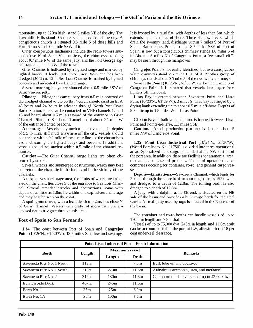
16 Sector 1. Trinidad and Tobago —The Gulf of Paria and the Rio Orinoco
hchofofof
s
usofs.fom
sasaof
as
alofa,
reaes-
ridelso
Eeelof
to
after
dwt
mountains, up to 620m high, stand 3 miles NE of the city. TheLaventille Hills stand 0.5 mile E of the center of the city. Aconspicuous church is situated 0.5 mile S of these hills andFort Picton stands 0.2 mile SSW of it.1.33 Other conspicuous landmarks include the radio towers situ-ated close N of Saint Vincent Jetty, the chimneys standingabout 0.7 mile NW of the same jetty, and the Fort George sig-nal station situated NW of the town.1.33 Grier Channel is indicated by a lighted range and marked bylighted buoys. It leads ENE into Grier Basin and has beendredged (2002) to 12m. Sea Lots Channel is marked by lightedbeacons and indicated by a lighted range.1.33 Several mooring buoys are situated about 0.5 mile SSW ofSaint Vincent jetty.1.33 Pilotage.—Pilotage is compulsory from 0.5 mile seaward ofthe dredged channel to the berths. Vessels should send an ETA48 hours and 24 hours in advance through North Post CoastRadio Station. Pilots can be contacted on VHF channels 12 and16 and board about 0.5 mile seaward of the entrance to GrierChannel. Pilots for Sea Lots Channel board about 0.1 mile Wof the entrance lighted beacons.1.33 Anchorage.—Vessels may anchor as convenient, in depthsof 5.5 to 11m, stiff mud, anywhere off the city. Vessels shouldnot anchor within 0.1 mile of the center lines of the channels toavoid obscuring the lighted buoys and beacons. In addition,vessels should not anchor within 0.5 mile of the channel en-trances.1.33 Caution.—The Grier Channel range lights are often ob-scured by smoke.1.33 Several wrecks and submerged obstructions, which may bestbe seen on the chart, lie in the basin and in the vicinity of thechannels.1.33 An explosives anchorage area, the limits of which are indic-ated on the chart, lies close S of the entrance to Sea Lots Chan-nel. Several stranded wrecks and obstructions, some withdepths of as little as 3.8m, lie within this explosives anchorageand may best be seen on the chart.1.33 A spoil ground area, with a least depth of 4.2m, lies close Nof Grier Channel. Vessels with drafts of more than 3m areadvised not to navigate through this area.
Port of Spain to San Fernando
1.34 The coast between Port of Spain andCangrejosPoint (10˚26'N., 61˚30'W.), 13.5 miles S, is low and swampy.
It is fronted by a mud flat, with depths of less than 5m, whicextends up to 2 miles offshore. Three shallow rivers, whidrain the swampy land, discharge within 7 miles S of PortSpain. Barrancones Point, located 8.5 miles SSE of PortSpain, is low, but a conspicuous chimney stands 1.8 miles Sit. About 1.5 miles N of Cangrejos Point, a few small cliffmay be seen through the mangroves.
1.34 Cangrejos Point is not easily identified, but two conspicuowhite chimneys stand 2.5 miles ESE of it. Another groupchimneys stands about 0.5 mile S of the two white chimney1.34 Savonetta Point(10˚25'N., 61˚30'W.) is located 1 mile S oCangrejos Point. It is reported that vessels load sugar frlighters off this point.1.34 Lisas Bay is entered between Savonetta Point and LiPoint (10˚23'N., 61˚29'W.), 2 miles S. This bay is fringed bydrying bank extending up to about 0.5 mile offshore. Depths5.5m lie up to 1.5 miles W of Lisas Point.
1.34 Claxton Bay, a shallow indentation, is formed between LisPoint and Pointe-a-Pierre, 3.3 miles SSE.1.34 Caution.—An oil production platform is situated about 5miles NW of Cangrejos Point.
1.35 Point Lisas Industrial Port (10˚24'N., 61˚30'W.)(World Port Index No. 11750) is divided into three operationareas. Specialized bulk cargo is handled at the NW sectionthe port area. In addition, there are facilities for ammonia, uremethanol, and base oil products. The third operational acomprises docking for container, ro-ro, and general cargo vsels.1.35 Depths—Limitations.—Savonetta Channel, which leads fo2 miles through the shore bank to a turning basin, is 152m wand dredged to a depth of 12.8m. The turning basin is adredged to a depth of 12.8m.1.35 A jetty, with a dolphin at its SE end, is situated on the Nside of the basin and provides a bulk cargo berth for the stworks. A small jetty used by tugs is situated in the N cornerthe basin.
1.35 The container and ro-ro berths can handle vessels of up170m in length and 7.8m draft.1.35 Vessels of up to 75,000 dwt, 243m in length, and 11.6m drcan be accommodated at the port at LW, allowing for a 10 pcent underkeel clearance.
Point Lisas Industrial Port—Berth Information
Berth LengthMaximum vessel
RemarksLength Draft
Savonetta Pier No. 1 North 115m — 7.0m Bulk lube oil and additives
Savonetta Pier No. 1 South 310m 220m 11.6m Anhydrous ammonia, urea, and methanol
Savonetta Pier No. 2 312m 180m 11.6m Can accommodate vessels of up to 42,000
Iron Carbide Dock 407m 245m 11.6m
Berth No. 1 35m 25m 6.0m
Berth No. 1A 30m 100m 5.0m
Pub. 148

Sector 1. Trinidad and Tobago —The Gulf of Paria and the Rio Orinoco 17
fayand
ral
ingghing
atefor
nalare
tolatebeex-n a
men-re
theenset
thetent.
byfac-
sn
itss a
1.35 Aspect.—A lighted range, bearing 052˚16', indicates thechannel leading through the shore bank to the turning basin.1.35 A prominent steel plant stands about 0.3 mile inland fromthe port.1.35 Pilotage.—Pilotage is compulsory. Pilots can be contactedby VHF and board about 1 mile W of the entrance to thedredged channel. Vessels should send an ETA together with arequest for pilot 5 days, 4 days, 3 days, 48 hours, 24 hours, and12 hours prior to arrival.1.35 Anchorage.—Anchorage areas for inbound and outboundvessels are situated NW of the channel entrance. When the portis congested, vessels may be requested to anchor at Port ofSpain Roadstead before proceeding to Point Lisas IndustrialPort.
1.36 Lisas Point Port(10˚23'N., 61˚29'W.) is located S ofPoint Lisas Industrial Port and should not be confused with thelatter. This is a Hydro-Agri port formerly known as Fedchem,Point Lisa.1.36 Depths—Limitations.—The port is entered through a 250mwide approach channel using lighted beacons in line 091˚20' aslead marks. The channel is dredged to 12.8m up to the Tringendeep water terminal and turning basin. Thereafter the channelis dredged to 8.8m to the inner berths and turning basin.1.36 Tringen II provides berths for loading ammonia on the Nside of the entrance to the inner channel and Hydro-AgriTurning Basin. The terminal can accomodate vessels of 220mlength and 11.6m draft.1.36 Jetty No. 1, in the inner harbor on the N side, can accom-modate vessels of 170m length and 8.7m draft. This berth is forloading butane and natural gas.1.36 Jetty No. 2, in the inner harbor on the foreshore, can accom-modate vessels of 171m overall length and 8.7m draft. Thisberth handles ammonia, molassas, bulk sugar, sulphuric acid,caustic soda, and voranol.1.36 Pilotage.—Pilotage is compulsory. Vessels should send theirETA 48 hours, 24 hours, and 12 hours in advance of arrival.Pilots board at the entrance to the Lisas Point approach chan-nel.1.36 Anchorage.—Anchorage areas for inbound and outboundvessels is found as charted S of the entrance channel.
1.37 Claxton Bay Marine Terminal (10˚21'N., 61˚28'W.)is situated 1.5 miles N of Pointe-a-Pierre and is used forloading cement. The terminal is approached through a channeldredged to a depth of 6.4m (1985). This channel is marked bylighted beacons and leads to a turning basin. A lighted range,bearing 081˚25', indicates the fairway leading to a loading pierand a ro-ro berth, at the E end of the basin. It is reported thatpilots for this terminal can be embarked at Lisas Point Port.
1.37 Caution.—From a point on the shore located 0.2 mile S othe rear range light, a disused submarine pipeline, which mbest be seen on the chart, extends about 1 mile seawardparallels the dredged channel.
Pointe-a-Pierre (10˚19'N., 61˚28'W.)
World Port Index No. 11730
1.38 Pointe-a-Pierre is an open roadstead, with seveberths and terminals for tankers.1.38 Winds—Weather.—From January to March, NE or E byNE winds predominate. They are at their strongest, averag12 to 15 knots. From August to October, the winds, althouvariable, are mainly E or SE and are at their weakest, averag7 to 8 knots. In other months, the winds tend to be intermediboth in direction and force between the values quotedspring and autumn.1.38 Squalls of varying intensity are common during the seasotorrential rains from June to October. These rain squallsoften accompanied by sudden shifts in wind direction.1.38 The hurricane season is from the beginning of Augustmid-September, but they may occur as early as June or asas November. It is unusual for the coasts of Trinidad todirectly affected by these hurricanes, although, they mayperience heavy swells and sometimes rough seas whehurricane crosses to the N of the island.
1.38 Tides—Currents.—Off the pipeline jetty, both the N and Stidal currents attain rates of 0.5 to 1 knot. Outside the 20curve, the tidal currents are not well defined. During thmonths of July and August, a SW current was observed runing continuously for several days, while at other times thewas little or no current either way.1.38 The tidal currents between November and June set S onflood and N on the ebb, with rates of 0.5 to 1 knot. BetweJune and November, the tidal currents are irregular and mayN or S for several days with rates considerably in excess ofaverage on occasions, but at certain times they are nonexis
1.38 Depths—Limitations.—The berthing facilities consist oftwo jetties and three offshore island berths, connectedpipeline with the S jetty, which extends from the shore. All othese facilities are served by several oil terminals and cancommodate a number of tankers simultaneously.1.38 The main, or N jetty, is about 0.5 mile long and extendWNW from the shore. The S jetty, a viaduct supported opiles, has dolphin-type Berth No. 1 through Berth No. 4 onN side and Berth No. 2S on its S side. The main channel hacontrolling depth of 12.4m.
Berth No. 2 165m 70m 4.5m
Berth No. 3 — 105m 6.5m
Berth No. 4 110m 170m 7.8m
Point Lisas Industrial Port—Berth Information
Berth LengthMaximum vessel
RemarksLength Draft
Pub. 148

18 Sector 1. Trinidad and Tobago —The Gulf of Paria and the Rio Orinoco
t toent
-a-s E.x-.8ms aas
,k,g
me
oier
inte
to 3re,
ses
Laat
otsalt E
,oy
ofile
sta
9mtedaft
y
1.38 The berthing limitations are given in the accompanyingtable.
1.38 An SPM is moored 3.3 miles WNW of the N jetty in a depthof 24m. It can accommodate vessels of up to 285,000 dwt and22.4m draft.1.38 Aspect.—Naparima Hill, 177m high, rises 2.5 miles S of theroot of the N jetty at Pointe-a-Pierre and is conspicuous. Aconspicuous water tank stands about 0.5 mile ENE of Pointe-a-Pierre. Three chimneys, each 81m high, stand 1 mile SE of thewater tank; a similar chimney, 80m high, is situated 1 mileWSW of them.1.38 The hills which extend NE from Pointe-a-Pierre have beenreported to be radar conspicuous.1.38 The oil terminals are not clearly visible from a distance, butthe landmarks may be useful.1.38 Pilotage.—Pilotage is compulsory within 0.5 mile seawardof the oil installation at Pointe-a-Pierre and for all berthing andunberthing, including passage to the SPM.1.38 Vessels using the berths embark pilots about 1.4 miles SE ofthe SPM. Vessels should send an ETA 72 hours, 48 hours, and24 hours in advance. If the ETA changes by more than 2 hours,an amended ETA message should be sent immediately. Vesselsshould contact the terminal on VHF channel 16 at least 2 hoursbefore arrival. Tugs are required for berthing and unberthing.1.38 Vessels proceeding to the SPM usually embark pilots about 2miles W of it. Vessels must keep their engines at immediatereadiness while at the buoy. The emergency signal to stoppumping is a continuous blast on the whistle.1.38 Anchorage.—An anchorage, restricted to vessels of 200,000dwt or more and for ship to ship transfer operations, lies 1.5miles SSW of the SPM.1.38 Other vessels should anchor at least 1 mile E of the aboveanchorage. Transshipment anchorages, which may best be seenon the chart, have been established 4 miles W of the head ofthe viaduct.1.38 Caution.—Vessels are prohibited from anchoring within 1mile of the SPM or within 0.3 mile of the pipelines, as indi-cated on the chart. In addition, vessels are forbidden to crossany of the submarine pipelines lying off Pointe-a-Pierre.
1.38 Vessels in the vicinity of Pointe-a-Pierre are requested nouse VHF channels 6 and 10, which are used for transshipmoperations.
1.39 San Fernando (10˚17'N., 61˚28'W.) (World PortIndex No. 11740) stands on the coast, 2.5 miles S of PointePierre. It can be easily identified by Naparima Hill, which riseclose E, and Mon Chagrin, 85m high, which stands 0.4 mile1.39 The port is used by small coasters. A pier, 122m long, etends from the shore abreast the town and has a depth of 1alongside. An approach channel leads to the pier and haleast depth of 1.8m. It was reported (1986) that the channel wdisused and the buoys removed.
1.39 Hughes Rock(10˚17'N., 61˚30'W.), with a depth of 1.2mlies 1.8 miles WSW of the head of the pier. Farallon Roc4.6m high, lies 0.3 miles SW of the pier. A wooden buildinand a flagstaff stand on this rock.1.39 A drying reef, with the remains of several piles about 0.6high on it, lies close off Bontour Point, about 0.5 mile S of thhead of the pier.1.39 Anchorage.—Anchorage can be taken, in depths of 7 t13m, between 1.3 miles and 2 miles from the head of the pwith the summit of Naparima Hill bearing 107˚.
San Fernando to Cedros Point
1.40 The coast between San Fernando and Pitch Po(10˚15'N., 61˚37'W.), 9 miles WSW, is bordered by OropuchBank. This bank has depths of less than 5m and extends upmiles offshore. A conspicuous white shed stands on the shoabout 3 miles SW of San Fernando.1.40 Pitch Shoal, a small patch with a least depth of 7m, lies clooff the NE side of Oropuche Bank, 1 mile WSW of HugheRock.
1.41 Brighton (10˚15'N., 61˚38'W.) (World Port Index No.11760) is a natural coastal harbor. It consists of the piers atBrea, situated E of Pitch Point, and the pier and facilitiesBrighton, on the W side of Pitch Point.1.41 Tides—Currents.—The tidal currents off the pier at Brigh-ton are strong. The SW current attains a rate of 1.5 to 2.5 knand the NE current attains a rate of 1 to 1.5 knots. The tidcurrents from Dragons Mouth and Serpents Mouth meet jusof Brighton, but they are irregular.1.41 Depths—Limitations.—The pier at La Brea extends N froma point located 0.2 mile SE of Pitch Point. It is 0.4 mile longbut reported (1985) to be disused and unsafe. A mooring buis situated 0.1 mile NW of the pier head.1.41 Two mooring buoys are situated about 0.5 mile NNEPointe d’Or and a submarine pipeline extends about 0.3 mNNW from the former pier to the 10m contour.1.41 Brighton Pier extends 0.2 mile NNW from the shore abreaof Brighton. The head of this pier lies in an area dredged todepth of 10.1m. The E side of the pier has depths of 6.6 toand the W side has depths of 6.6 to 7.5m. It was repor(1987) that vessels of up to 182m in length and 8.5m drcould be handled at this pier.1.41 Brighton Pier is brightly illuminated at night and is usuallvisible from any part of the Gulf of Paria.
Pointe-a-Pierre Berthing Limitations
Berth No. Length Draft Size
1 219m 11.4m 50,000 dwt
2N 236m 11.3m 63,000 dwt
2S 122m 6.7m 7,000 dwt
3N 195m 10.7m 35,000 dwt
3S 107m 6.1m 3,000 dwt
4 107m 7.0m 5,000 dwt
5 274m 12.6m 100,000 dwt
6N 289m 15.5m 120,000 dwt
6S 289m 15.5m 120,000 dwt
7 213m 9.1m 35,000 dwt
8 173m 6.0m 25,000 dwt
Pub. 148

Sector 1. Trinidad and Tobago —The Gulf of Paria and the Rio Orinoco 19
els
ofuschc-
inn-,
y
tck
is1
nt.
.5mofd
geul
sLos
esa
eW.
iles
0m
SW,ank,Wareherent
1.41 A flagstaff and a hotel, standing on the slope of a hill closeSE of the root of Brighton Pier, are conspicuous from seaward.Eight chimneys, with several tanks in their vicinity, stand S ofthe root of the pier and are conspicuous. A prominent silver-colored tank stands at an elevation of 67m, 0.5 mile SE of thehotel.1.41 Aspect.—A lighted range, bearing 139˚15', is situated atBrighton and indicates the approach channel.1.41 Pilotage.—Pilotage is compulsory for vessels berthing at LaBrea or Brighton. Pilots can be contacted by VHF and boardabout 2 miles off Brighton Pier.1.41 Anchorage.—Anchorage can be taken, in depths of 13 to15m, mud, about 0.8 mile NE of Brighton Pier.1.41 Caution.—Anchorage is prohibited in the vicinity of thesubmarine pipeline as charted.1.41 A spoil ground is located W of and parallel to the approachlane, as best seen on the chart.1.41 Oil drilling operations take place within 2.5 miles NEthrough N to SW of Brighton Pier. Numerous drilling plat-forms, obstructions, and submarine pipelines may be encount-ered in this area.
1.42 Guapo Bay is a slight indentation in the coast formedbetween Point Galba (10˚15'N., 61˚38'W.), located 0.5 mileSW of the root of Brighton Pier, and Point Fortin, 4.5 milesSW. This bay is shallow and its E part is encumbered by abank, which dries. Pelican Rocks, 1.5m high, lie on the bank, 1mile SW of Point Galba.1.42 Point Fortin (10˚11'N., 61˚41'W.) (World Port Index No.11770), an oil-loading terminal, has a loading pier situated atthe seaward end of an illuminated viaduct. This viaduct carriesa pipeline and extends 1.8 miles NNW from Point Fortin.There are two arms at its head.1.42 Tides—Currents.—The currents off the jetty heads set 250˚on the flood and 055˚ on the ebb. The current turns about thetime of HW at Georgetown. The maximum rate is about 0.5knot at springs.1.42 Depths—Limitations.—Berth No. 1, on the seaward side ofthe NE arm, is 213m long and has a depth of 11.9m alongside.It can accommodate vessels of up to 45,000 grt.1.42 Berth No. 2, on the seaward side of the SW arm, is 213mlong and has a depth of 10.9m alongside. It can accommodatevessels of up to 25,000 grt.1.42 Berth No. 3, on the inner arm of the SW side, is 91m longand has a depth of 10.5m alongside. It can accommodate ves-sels of up to 6,000 grt.1.42 Berth No. 4, on the W side of the viaduct and about 0.8 milefrom its root, is 91m long and has a depth of 4.4m alongside. Itcan accommodate vessels of up to 3,000 grt.1.42 Berth No. 5, an offshore loading terminal for large tankers, issituated about 0.8 mile N of Berth No. 1. Tankers up to 259min length and 16m draft can be handled here but are berthed byday only.1.42 A submarine cable extends between the head of the jetty andthe offshore mooring buoys situated about 0.8 mile NNE.1.42 Pilotage.—Pilotage is compulsory. Pilots can be contactedby VHF and board about 0.5 to 1.0 mile NW of the jetty light.Vessels should send ETA messages 72 hours, 48 hours, and 24hours in advance. Changes of 1 hour in the ETA should be
reported. Tugs are available and required for berthing vessof more than 30,000 dwt at the outer berths.1.42 There is a port radio station at Point Fortin.1.42 Caution.—Soldado Marine Oil Fields lie up to 10 miles offthe coast between Point Fortin and Icacos Point, the SW endTrinidad, 14 miles WSW. Within this area there are numerodrilling platforms and associated structures, many of whiexhibit lights. Many submarine pipelines connect these strutures and converge on a landing place in Irois Bay.1.42 The oil field has been declared a restricted area, withwhich navigation is prohibited to all vessels except those conected with oil field operations and small craft. Anchoringtrawling, and all seabed operations are prohibited.1.42 The N and W limits of the restricted area are marked blighted buoys.1.42 A further group of lighted oil platforms and wells exisbetween 1 mile and 5 miles from the W to NE of Soldado Rooutside the Soldado Restricted Area. A submarine pipelinelaid ENE between this group and Riser Platform No.(10˚10'N., 61˚51'W.).
1.43 Irois Bay (10˚10'N., 61˚44'W.), which is shallow, is aslight indentation in the coast. It is formed between PoiFortin and Point Rouge (10˚09'N., 61˚47'W.), 6.8 miles WSWChallenger Shoal, a detached patch, has a least depth of 5and lies 2 miles N of Point Rouge. Several shoal heads lie Sa line extending from Point Fortin to Challenger Shoal anvessels should not proceed S of this line.1.43 Granville Bay, a slight indentation, lies between Point Rouand Cedros Point, 2 miles WSW. This bay is fronted by foground which extends up to 1 mile offshore.1.43 Cedros Bay(10˚07'N., 61˚52'W.), a shallow indentation, hadepths of less than 5m and lies between Cedros Point andGallos Point, 5.8 miles SW.1.43 Barrel of Beef, a rock with a depth of 1.5m, lies 1 milWNW of Cedros Point. Loo Reef, with a depth of 1.8m, lieclose W of Barrel of Beef and is marked on its N side bylighted beacon.1.43 A shoal, with a least depth of 4.6m, lies 0.8 mile NW of thabove beacon. The remains of a light structure stand close N
The Gulf of Paria—West Side—Punta Penas toPunta Mata Redonda
1.44 Punta Penas(10˚44'N., 61˚51'W.) is the E extremityof the Peninsula de Paria; Punta Garcitas is located 5 mSSW of it.1.44 Caution.—A lighted buoy (ODAS) is situated about 10miles NNW of Punta Penas. Vessels should keep at least 20away from this buoy.
1.45 Ensenada Cariaquita (10˚40'N., 61˚54'W.) isentered between Punta Garcitas and Punta Picua, 0.8 mileand provides good anchorage to small vessels. The shore bwith depths of 5m or less, extends up to about 0.1 mile WNof Punta Garcitas. Rocks, with depths of less than 1.8m,located close N and about 0.2 mile WNW of Punta Picua. Thead of the bay is shoal and, at times, a considerable cursets across the entrance to the bay.
Pub. 148

20 Sector 1. Trinidad and Tobago —The Gulf of Paria and the Rio Orinoco
drmal.ck
,
ay
3.3S
heaendspthta
N
arts
atere
niersis
N
er
-ite
h
r-ria.rs,
tedyIted,
theng
in
1.45 The coast between Punta Picua and the entrance to PuertoMacuro, 2 miles SW, is composed of red cliffs in places.1.45 A shoal, with a depth of 10.4m, lies about 0.5 mile ESE ofthe SW entrance point of Puerto Macuro.
1.46 Puerto Macuro(10˚39'N., 61˚56'W.), formerly Cris-tobal Colon, is divided into two parts by a point, which has apier in ruins at its outer end. The E part is known as EnsenadaAricagua while the W part is known as Ensenada Macuro. Thetown of Macuro stands at the head of Ensenada Macuro.1.46 Tides—Currents.—The tidal currents in Puerto Macuroattain rates of 1 to 2 knots. The flood current runs clockwisearound the harbor; the ebb current runs counterclockwise. Thelatter current attains the greater rate and reaches its maximum2 hours before LW by the shore. In the middle of the bay, slackwater occurs 1 hour after the stand of the tide.1.46 Depths—Limitations.—A wharf extends 165m ENE from apoint on the shore located 0.3 mile NNE of the W entrance toPuerto Macuro. It has been reported that vessels of up to 7.9mdraft can berth alongside. Two mooring buoys lie close N ofthe wharf; one mooring buoy lies close S of the wharf.1.46 Regulations.—In Venezuelan territorial waters, the Vene-zuelan flag must be continuously displayed at the fore. Atnight, on request, the vessel’s name must be signaled by light.1.46 Anchorage.—Small vessels can anchor anywhere in the bay,but large vessels should anchor just outside a line joining theentrance points.1.46 Except in cases of shipwreck or “force majeure,” vessels areprohibited from anchoring within the territorial waters, exceptoff these ports or places used for commerce.
1.47 The coast between Puerto Macuro and Punta Carmo-na, 12 miles W, is indented by several small bays and backedby a mountain range with peaks up to 1,073m high. Largespurs extend S from this mountain range and terminate inpoints which form deep gorges at the head of some of the bays.1.47 Puerto de Hierro (10˚38'N., 62˚05'W.) (World Port IndexNo. 12275), a natural coastal harbor, is located 9 miles W ofPuerto Macuro and formed by a small bight. The port, undercontrol of the Venezuelan Navy, is primarily an ore-transshipment facility.1.47 Tides—Currents.—The tidal currents set W on the floodtide and E on the ebb at rates up to 2.5 knots.1.47 Depths—Limitations.—The ore-loading pier extends 400mSSW from the E side of the bight. The E side of the pier hasdepths of 5.2 to 7.9m over a usable length of 210m. The W sideof the pier has depths of 3.3 to 4.6m over a usable length of182m. Dolphins are situated off the head of the pier and ashoal, with a depth of 4m, lies adjacent to them.1.47 A small pier, with depths of 3m along its E side, extends76m S from a point located close W of the root of the ore pier.1.47 The bay has been reported to have been dredged to a depth of12.8m, but the 5m curve lies within the approach to the W sideof the pier and depths of up to 8.1m lie in the approach on the Eside.1.47 The maximum size of vessel permitted to enter the port is45,000 dwt.1.47 Aspect.—The pier, with its towers and oil storage tanks, isprominent when seen from the S and W. At night, a group oflights above the port may be seen at a distance of 20 miles.
1.47 Pilotage.—Pilotage is compulsory. Pilots may be obtainefrom Guiria. Vessels should give 72 hours notice and confior amend their ETA 48 hours and 24 hours before arrivVessels are berthed by day or night, but normally only at slawater.1.47 Anchorage.—Anchorage can be taken, in a depth of 16msand, good holding ground, about 1 mile S of the pier head.1.47 Directions.—Entry is difficult and berthing only at slackwater is recommended. Vessels should enter with as little won as possible and approach the pier on a heading of 021˚.1.47 Caution.—It was reported that silting occurs in the harbor.
1.47 Punta Carmona (10˚38'N., 62˚09'W.) is located 3 miles Wof Puerto de Hierro. From the former point, the coast trendsmiles W to Punta Juan Diego, then 3 miles W and 2.5 milesto Punta El Rincon, and then 2 miles S to Punta Guiria. Tbight in the coast lying NE of Punta Guiria is fronted byshoal area. This area has depths of less than 11m and extup to 2.5 miles offshore. A detached shoal, with a least deof 5.8m, was reported (1940) to lie about 1 mile SE of PunGuiria.
1.48 Guiria (10˚34'N., 62˚18'W.) (World Port Index No.12270), a small harbor protected by breakwaters, lies closeof Punta Guiria.1.48 The town stands on a low plain. The port is important aspilot boarding station for vessels proceeding to the river poon the S side of the Gulf of Paria.1.48 Depths—Limitations.—There are depths of 5 to 6m withinthe breakwaters, except alongside the berths, where less wmay be found. A shoal patch, with a depth of 3.2m, lies in thcenter of the harbor.1.48 A quay, 140m long with refrigeration facilities, is situated othe inner side of the S breakwater near its head. Three pproject N from the breakwater, W of the quay. The W pierused by vessels carrying dangerous cargo.1.48 A quay, 170m long, is situated on the inner side of thebreakwater, 0.5 mile from its head.1.48 Four piers project from the W side of the harbor. The N piis reserved for naval vessels.
1.48 Aspect.—The port may be identified by the prominent redroofed towers of a church. Several radio towers and a whtank stand on the high cliffs, close N of the town.1.48 Recalada Guiria Light, shown from a white tower witorange bands, 12m high, stands 1 mile N of the port.1.48 Pilotage.—Pilots for Maturin Bar, the Rio San Juan, Pedenales Bar, and the Orinoco Delta can be obtained at GuiIncoming vessels must request pilot service by radio 72 hou48 hours, and 24 hours prior to arrival. Pilots can be contacby VHF and usually board in the vicinity of the lighted buomoored 2 miles ESE of the town, within 1 hour after arrival.is not necessary to anchor. If for any reason the pilot is delayvessels can anchor in the vicinity of the buoy.
1.48 Vessels approaching Guiria should identify themselves tosignal station and not proceed inshore of the pilot boardistation at the above lighted buoy.1.48 Anchorage.—Anchorage can be taken E of the harbor,depths of 10 to 11m, mud, good holding ground.
Pub. 148

Sector 1. Trinidad and Tobago —The Gulf of Paria and the Rio Orinoco 21
Pub. 148

22 Sector 1. Trinidad and Tobago —The Gulf of Paria and the Rio Orinoco
y.is
nh
W
a
en
l-7mnd
-
ftof
ndves-
dlot
.)
ynta
re
day-usta, 22ich
ises,hense
rs.gre,er-
, is'N.,stis
1.49 The coast between Punta Guiria and Punta Guara-guara (10˚32'N., 62˚19'W.), 2.5 miles SW, is cliffy and tree-covered.1.49 Between Punta Guaraguara and Punta Arenas, 23 miles SW,the W part of the Gulf of Paria is almost entirely encumberedby shoals and fringing flats. There are no commercially-sig-nificant ports within this area.1.49 Three detached shoals, with depths of less than 10m, liebetween 6.5 miles and 9 miles SW of Punta Guaraguara.Vessels bound for Barra de Maturin are advised to pass E ofthese patches. It was reported that lesser depths than charted liein the vicinity of, and on the above-described patches.1.49 TheRio San Juan(10˚15'N., 62˚36'W.) discharges into theGulf of Paria between Punta Arenas (10˚20'N., 62˚38'W.) andPunta Campana, 6.5 miles SSE.1.49 Barra de Maturin (Maturin Bar) lies across the mouth of thisriver and has a dredged channel with a least depth of 7.9m. Itwas reported (1995) that vessels with drafts up to 10m werepermitted to use this channel.1.49 It was reported (1993) that silting had changed the shape ofthe charted coastline in the vicinity of Punta Campana. Alighted buoy is moored about 9 miles NE of Punta Campanaand marks the entrance to the dredged channel. From this buoyto Punta Gorda, located 4.5 miles SSW of Punta Campana,each reach of the dredged channel is indicated by lightedranges. A number of beacons are situated in the vicinity of thechannel and should not be confused with the range lights.1.49 From a point located 2 miles SSE of Punta Gorda (10˚10'N.,62˚38'W.), the channel has depths in excess of 11m as far asPunta Carner, 32 miles upriver.1.49 The Cano Frances joins the Rio San Juan, 20 miles above itsmouth. It is about 230m wide and trends SW for almost 13miles. It is joined here by the shallow and narrow the RioGuarapiche, which trends W for 3.5 miles to the CanoColorado. From the junction of the Cano Frances and the RioGuarapiche, a stream, known as the Cano dos Aguas, trends ina N direction and joins the Rio San Juan 7 miles below PuntaCarner. One-way traffic is operated in the Rio San Juan aboveits junction with the Cano Frances at Punta Marieta. Inboundvessels required to wait may anchor in this area.1.49 The Rio Guanoco empties into the Rio San Juan, close W ofPunta Carner. The village of Guanoco stands on the W bank ofthe Rio Guanoco, 3 miles above the junction.1.49 Caution.—Vessels are advised that the currents are strongover the bar and within the river.
1.50 Guanoco(10˚10'N., 62˚56'W.) (World Port Index No.12290) is situated at the base of two hills, 107m and 76m high.A large deposit of pitch is located here.1.50 Depths—Limitations.—A wharf, with a depth of 7.6malongside, fronts Guanoco. The approach to Guanoco throughthe Rio Guanoco is only suitable for vessels with local know-ledge. The river is about 140m wide and has depths of 3 to9.1m in the fairway. The controlling depth in the channel is5.5m.1.50 The river above the mouth of the Rio Cicaro is narrow. Ves-sels are turned at this junction and towed stern first about 0.8mile up to the wharf at Guanoco. Vessels should moor theirsterns very securely because of the strong currents. Vessels upto 85m in length can negotiate the turns when loaded.
1.50 Pilotage.—Pilotage in the Rio San Juan is compulsorPilots can be obtained at Guiria, but 3 days advance noticerequired.1.50 FromPunta Carner (10˚07'N., 62˚57'W.), the Rio San Juatrends in a SW direction and then NW to Caripito, whicstands 51 miles above the entrance to the river.
1.51 Caripito (10˚10'N., 63˚02'W.) (World Port Index No.12280) is situated on a tributary of the Rio San Juan, 3 milesof the river. It is connected to the port area by rail and road.1.51 Depths—Limitations.—Vessels entering are restricted tomaximum draft of not more than 10.4m.1.51 Three piers and a wharf front the W bank of the river. Thwharf, which is known as Muelle No. 1, is 107m long. It caaccommodate vessels of up to 137m long and 7m draft.1.51 Muelle No. 2 and Muelle No. 3 are T-head piers, with dophins situated close off their faces. They have a depth of 10.alongside. Vessels of up to 61,000 dwt, 230m in length, a10.3m draft can be accommodated at these piers.1.51 Muelle No. 4 is situated upstream of Muelle No. 1. Its Thead is 12.2m long and has a depth of 4.3m alongside.1.51 Tankers of up to 52,000 dwt, 225m in length, and 10m dracan be accommodated within the port. The usual methodberthing is for vessels to proceed up river from the piers aturn around. If necessary, arrangements can be made forsels to top off seaward of Barra de Maturin.1.51 Pilotage.—Pilotage is compulsory. Pilots are embarked andisembarked at the port of Guiria. Vessels awaiting a pishould proceed to the Guiria Sea Buoy (10˚33'N., 62˚15'Wand display the usual signals.1.51 Anchorage.—Vessels unable to berth at Caripito usuallanchor about 0.5 mile upriver. However, at times, the curreattains a rate of 3.5 knots. Anchorage is also available, indepth of 14m, about 0.3 mile upstream.1.51 Caution.—It was reported (1995) that many beacons weunlit or destroyed completely.
Mouths of the Rio Orinoco within the Gulf ofParia
1.52 From Punta Campana to Punta Mata Redon(10˚12'N., 62˚31'W.), 5 miles SE, the coast is fringed by a dring mud bank extending up to 0.8 mile seaward. A dangerowreck, marked by a buoy, is located 9.5 miles E of Punta MaRedonda. Between Punta Mata Redonda and Punta Toletemiles SE, the coast is indented by a large shallow bay, whhas depths of 5m and less over its entire area. The baylargely filled with mud flats and is navigable only by thsmallest craft. The W of the intricate network of waterwaywhich intersect the delta of the Orinoco, lies at the S end of tbay. Nearly the entire shore of the bay is covered by a degrowth of trees of uniform height.1.52 Several islands lie within the bay and are separated by riveFrom W to E, these rivers are the Cano Jacao, the Cano Vathe Cano Mananito, the Cano Manamo, and the Rio Pednales.1.52 The Rio Pedernales, the most important of these riversentered between Isla Cotorra and Punta Tolete (10˚0262˚12'W.), 1 mile E. It was reported that the bar had a leadepth of 3.4m, but silting causes rapid changes. The bottom
Pub. 148

Sector 1. Trinidad and Tobago —The Gulf of Paria and the Rio Orinoco 23
lesrs
wsead
-. Itthe
thsbar,, ad bea,ible.
de15forof
outofe
ets.is a
t 6ent
the
e-ax-in
e
isto
he
nddl. Ittaer
ingversels12in
asWurs
soft with good holding ground. Three lighted buoys mark theentrance of the Rio Pedernales. Buoy No. 1 is moored in posi-tion 10˚04'N,62˚07'W1.52 Within the bar, the Rio Pedernales divides into two channels.The E channel leads to the Cano Pedernales and the W channelto the Cano Manamo. The latter channel is used by coastal ves-sels.1.52 The tides rise about 1.6m at springs and 1.2m at neaps.1.52 When the river is low, the currents in the vicinity of the barare weak and set in a NE and SW direction. Within the bar,slack water occurs 1 hour 30 minutes after the stand. Thecurrents usually set in the direction of the channels and attainrates of 2 to 3 knots.
1.53 Puerto Pedernales(9˚59'N., 62˚15'W.) (World PortIndex No. 12300) stands on the N end of Isla Pedernales, 4.5miles SW of Punta Tolete.1.53 Oil installations are situated in the vicinity of Puerto Peder-nales. Capure, 0.8 mile NE of Puerto Pedernales, is the site of aT-head pier which is used by small tankers with drafts up to4m. An older wharf is situated about midway between Capureand Punta Tolete.1.53 Pilotage.—Pilotage is compulsory. Pilots embark at Guiriaand will take vessels upriver as far as Ciudad Bolivar.1.53 Anchorage.—Anchorage is also available, in a depth of 9m,fine gray sand, abeam of a village situated about 1 mile SW ofPunta Tolete.
Punta Tolete to Punta Baja
1.54 The coast that forms the S side of Serpents Mouthextends 80 miles E and SE to Punta Baja and encompasses partof the delta of the Rio Orinoco. This part of the coast has beenonly partially surveyed. Depths of 18m have been reported tolie 4 to 5 miles off the W section of the coast, decreasinggradually toward the shore. Similar depths are reported to lieup to 13 miles off the E part of this coast.1.54 Punta Bombeador (9˚55'N., 61˚40'W.) is located 34 milesESE of Punta Tolete and has a bank, with a least depth of 2.7m,extending 3 miles NW from it. A channel leads in a SW direc-tion through this bank to the mouth of the Cano Macareo. Themaintenance of this channel has been discontinued and thenavigational aids removed. Local knowledge is required.1.54 The Cano Macareo is entered S of Punta Pescador (9˚53'N.,61˚39'W.), about 1.5 miles SSE of Punta Bombeadar. It con-nects with the Rio Orinoco and is used by shallow draft ves-sels. Pilotage is compulsory. The current at the mouth of theriver attains a rate of 2 knots from December through April and3 knots from May through November.1.54 The coast between Punta Bombeador and Punta Baja, 48miles SE, is intersected by several shallow waterways andfronted foul ground extending up to 6 miles offshore in places.
The Rio Orinoco Delta
1.55 From Punta Baja (9˚31'N., 60˚58'W.), the coast ofVenezuela extends 64 miles SE to Punta Barima. This latterpoint is located at the SE end of the delta of the Rio Orinoco.1.55 A light with a racon has been reported (2004) to be situated0.6 mile SSE of the old light structure on Punta Barima.
1.55 The delta has its origin at a point below Barrancas, 120 miupriver from Punta Barima, and is comprised of several riveand streams.1.55 Boca Grande, the main entrance to the Rio Orinoco, flothrough the S side of the delta and has two channels which lthrough it.1.55 The coast in the vicinity of Boca Grande is difficult to distinguish and it is advisable to take soundings continuouslyhas been reported that vessels can go aground to the N ofmouth while still out of sight of land. Approaching BocaGrande from the N, vessels are usually in shallow depbefore any landmarks are sighted. In the approach to thethe bottom consists of soft gray mud. During heavy weatherhigh and dangerous sea breaks over the bar. Care shoultaken not to approach within 2.5 miles of Punta Barimbecause discolored water makes the steep-to banks invisThe bar extends up to about 20 miles seaward.
The channel leads over Boca Grande bar into the Rio Granbranch of the Rio Orinoco off Punta Yatica. It then extendsmiles to the Brazo Imataca reach, which leads S and Wabout 47 miles, and rejoins the Rio Grande near the villageSacupana. The channel then follows the Rio Grande for ab36 miles to the bifurcation of the Rio Macareo, passing NIsla Tortola. The channel then follows the main fairway of thRio Orinoco for 53 miles from Barrancas to Matanzas.1.55 Tides—Currents.—In the approach to Boca Grande, thSouth Equatorial Current sets NW at a rate of 1 to 3 knoBetween the discolored river water and the sea water, theredistinct line which moves with the tides. At HW, the line is indepths of 7 to 9m and in depths of 11 to 14m at LW.1.55 For a short distance offshore, the currents set for abouhours each way and allowance must be made for the W currwhen crossing the bar.1.55 A choppy sea is raised in depths of less than 18m whenprevailing winds are NE.1.55 The seasonal rise of the Rio Orinoco and its tributaries bgins immediately after the vernal equinox and reaches its mimum height in July and August. The lowest level is reachedmid-November through mid-April, but at Ciudad Bolivar, thriver is low from December to March.1.55 At Barrancas, at the head of the delta, the maximum riseabout 9.1m. Above Barrancas, the normal rise is estimatedbe about 15.2m, varying according to the width of the river, tnumber of tributaries, and the distance from the sea.1.55 The average annual rise at Ciudad Bolivar is 12.8m.1.55 Depths—Limitations.—The North Channel leadingthrough Boca Grande is available to shallow draft vessels asmall craft. A lighted buoy located 9 miles NW of the dredgechannel approach buoy marks the entrance to the N channejoins the water of the dredged channel, 6 miles NNW of PunBarima. It was reported (1990) that this channel no longexists.1.55 The South Channel is used by deep-draft vessels proceedto Puerto Ordaz and the iron ore port, located 157 miles uprifrom Punta Barima. The South Channel is also used by vesproceeding to Matanzas, another iron ore port, situatedmiles farther upstream. The bar channel depth is maintainedaccordance with the authorized draft in the upper river and hbeen reported to vary between 9.9m and 13.7m at LW and Hstages, respectively. The waterway is open to shipping 24 ho
Pub. 148
24 Sector 1. Trinidad and Tobago —The Gulf of Paria and the Rio Orinoco
Pub. 148

Sector 1. Trinidad and Tobago —The Gulf of Paria and the Rio Orinoco 25
Pub. 148

26 Sector 1. Trinidad and Tobago —The Gulf of Paria and the Rio Orinoco
ntaan
the
to
,nd
elseiraer,. In
engedse
io
ong
l isport
selhe
rt
.o-
sel
o86
ll-tain
14,
at
a day and, except for the dredged channel section, two-waytraffic can be handled. Vessels should contact Puerto OrdazPort Radio before attempting transit and entry of the port.1.55 The river is maintained and marked from the dredged SouthChannel Lighted Buoy to Matanzas for vessels with drafts ofup to 12.8m (1987), under optimum river level and tide con-ditions. Under extreme low river conditions, the authorizeddraft should not be more than 9m. The months of the lowestwater level in the river are March and April. The highest waterlevel occurs from July to October.1.55 The daily authorized draft is promulgated by the Port Cap-tain of the Rio Orinoco, by means of a bulletin in Spanish andEnglish. The maximum authorized draft is subject to the ves-sel’s maximum fresh water load line.1.55 Vessels with drafts up to 2.3m can, at all times, reach CiudadBolivar. From May to January inclusive, vessels with drafts upto 4.6m have no difficulty ascending to this city, but the bestmonths are said to be from June to October.
Pilotage.—During the passage over the bar and within theriver, vessels must maintain a continuous radio watch. Radiostations are situated at the pilot station, Punta Barima, andPuerto Ordaz. These stations provide voice communicationsalong the entire route. The River Officer at Puerto Ordaz, byreference to the mile numbers of the navigational aids, pro-vides continuous radio information of the latest positions ofvessels in the dredged channels and the river. Vessels mustreport their positions in the river hourly to Puerto Ordaz, fromwhere all traffic is controlled.1.55 Vessels should not enter the dredged channel until per-mission is received from the pilot station or Radio MarinaPuerto Ordaz. Vessels without permission are required to re-main at anchorage 1 mile W of the approach buoys for either Nor S channel. Once permission is granted vessels should sendtheir ETA at Lighted Buoy No. 28 to the pilot station. Once inthe New Barima channel, position reports are due every hour.1.55 Pilotage is compulsory for transiting the Rio Orinoco. Sub-ject to a vessel’s ETA being reported by radio, the pilot willboard in the vicinity of Lighted Buoy No. 28, about 5 miles Wof Punta Barima. The ETA should be sent as soon as possibleand again 24 hours in advance of arrival at Punta Barima.Actual arrival at the Approach Buoy should be reported to thepilot stations by voice radio and the position of the vessel re-ported hourly until the pilot is embarked.1.55 Pilots board and disembark vessels in the vicinity of Mile 36,due to sea conditions at the sea buoy which prevent boardingfrom small boats. Once the pilot boards vessels should send thename and time of boarding to the pilot station.1.55 The pilot stations at Palua and Ciudad Bolivar are in radiocommunication with the stations at Punta Barima and PuertoOrdaz.1.55 The pilot usually remains on board the vessel for the returntrip, unless the duration of stay is expected to be lengthy.
Regulations.—Outbound vessels have the right of way.1.55 Vessels entering the river must carry only clean ballast.1.55 Vessels must display the Venezuelan flag at all times fromthe time of entry into the approach channel leading into the RioOrinoco.1.55 No vessel is allowed to anchor in the narrow channels of theriver or close to a turn.
1.55 All vessels needing to anchor in the area between PuBarima and Mile 137, at the junction of the Cano Macareo, cdo so; however, vessels must anchor as close as possible toright hand bank.1.55 Emergency anchorage must be taken in such a way asavoid obstructing the channel.1.55 River regulations provide for anchoring, as follows:
1.55 During HW stage, usually from May 15 to November 15anchorage can be taken at the junction of the Rio Orinoco athe Rio Caroni, within 1 mile of the ore loading berth.1.55 Prior to entering the dredged channel from seaward, vessmust contact Puerto Ordaz port radio station and report thname, nationality, and ETA off the pilot station at PuntBarima. Vessels will then be given instructions either to entanchor, or wait for an outbound vessel to clear the channelthe waterway, the outbound vessel is privileged.1.55 Signals.—Vessels should exercise extreme care whmeeting or passing dredges. Dredges working in the dredchannel through the bar in the approach to the Rio Orinoco uthe International Code of Signals. Those working in the ROrinoco use the signals described below:
1. Vessels approaching a dredge should sound one land three short blasts.
2. If the dredge then sounds one short blast, the vesseto direct course to starboard and keep the dredge on thebow.
3. If the dredge then sounds two short blasts, the vesis to direct course to port and keep the dredge on tstarboard bow.
4. If the dredge then sounds two long and two shoblasts, the vessel must not pass the dredge.
5. The dredge signal must be answered by the vessel6. If two vessels are approaching the dredge from opp
site directions, the dredge will answer the outbound vesfirst.
1.55 The operating frequencies for YVM Marine Radio in PuertOrdaz are 468 kHz, 4192 kHz, 6265 kHz, 6320 kHz, and 83kHz.1.55 The GMT-CQ and frequencies are:
a. 472kHzb. 4322 kHz—0300, 0900c. 6372.5 kHzd. 5 kHz—1200e. 8453 kHz—0030, 1430, 2000
1.55 Upon contact with YVM Marine Radio Station, vessels wireceive all navigational information for transit of the Rio Orinoco, and also channel clearance upon request to Port Capat Ciudad Bolivar.1.55 Vessels may also contact the port on VHF channels 6, 13,and 16.1.55 Anchorage.—Anchorage can be taken, in a depth of 26m,Matanzas, about 0.8 mile NE of the head of the pier.
Mile marker Depth
139.3 to 140.4 12.8 to 20.0m
150.1 to 151.7 22.0 to 27.4m
178.0 to 179.0 23.8m
Pub. 148

Sector 1. Trinidad and Tobago —The Gulf of Paria and the Rio Orinoco 27
omessar-
sere isft at
ni
fi-f afor
ithail-
an-ithd,
grt,ro-
hep-
1.55 The river is narrow at Ciudad Bolivar and there are depths of27 to 55m at low river stage. Anchorage can be taken with asingle anchor, in a depth of 12.8m, about 0.2 mile E of themarket place and 0.2 mile offshore. This berth is out of themain river current and vessels will not swing more than 45˚.The currents attain a rate of 5 knots between August andDecember.1.55 Good temporary anchorage can be taken in the vicinity ofthe lighted approach buoy, clear of the entrance. This buoy,equipped with a racon, is the landfall for the dredged channel.Secure anchorage can be taken off Punta Barima with thedisused lighthouse bearing 100˚ and distant 4 miles.
1.55 Caution.—It was reported (1993) that some of the lightedranges were inadequate. Night transit is not recommended.1.55 It was reported (1986) that strandings in the Rio Orinoco hadincreased significantly. The river is navigable by large vesselsup to about 200 miles above the sea buoy. Over most of thisdistance, vessels must negotiate a narrow channel, said to beonly 99m wide between buoys, which is subject to strong crosscurrents. The variation in the channel depths is considerable,varying according to season in the upper river above Mile 44,and tidal below.1.55 A feature of the Rio Orinoco is that the bottom consists of alayer of very soft mud, virtually in suspension and partlymobile, which is known locally as the “calambrina.” The con-sistency of this mud is such that it shows on most echosounders, but the depth shown depends partly on the frequencyof transmission. The “calambrina” is more pronounced in thesummer months, when rainfall in the interior is high, bringingdown sediment in the river. The existence of the "calambrina"and its mobility makes it difficult to calculate the actual depthof water in the channel.1.55 Vessels are warned that the “calambrina” may severely hin-der their passage across the bar. Vessels with drafts of morethan 7.5m are likely to have to force a passage through a layerof mud, 1m or more thick, with a consequent loss of speed upto 50 per cent.1.55 The Instituto Nacional de Canalizaciones (INC) publishesdaily bulletins that give the controlling depths, authorizeddrafts, etc., for the river.1.55 All navigational aids are numbered on the chart with theirdistance in miles from the seaward entrance to the dredgedchannel through Boca Grande.1.55 The dredged channel is 30 miles long and 122m wide. Thechannel is marked by lighted beacons and lighted buoys; how-ever, it was reported that many of these aids differ from thosecharted. Up-to-date information will be given by the radiostation at Puerto Ordaz. Many of the lighted ranges werereported (1986) to be defective and the channel is not recom-mended for deep-draft vessels at night.1.55 River distances.—The river distances are given below.
The Rio Orinoco—Port Terminal Facilities
1.56 Only the more important port facilities of the Rio Ori-noco are included. They are described in ascending order frthe seaward to the head of the navigable waterway. Unlotherwise indicated, the distances shown are from Punta Bima.1.56 San Felix (8˚22'N., 62˚40'W.), a general cargo port, frontthe S bank of the river, 153 miles upstream. A floating piextends from the shore abreast the settlement. Its outer fac123m long and can accommodate vessels of up to 8.8m dralow river.
1.57 Palua (8˚22'N., 62˚41'W.) (World Port Index No.12330) stands on the E side of the junction of the Rio Caroand the Rio Orinoco, 155 miles above Punta Barima.1.57 Berthing alongside the iron ore terminal presents no difculty, except when the river currents are strong. The use otug is advisable at such times. Tugs are generally useddocking and undocking, with a third tug used for vessels wdrafts in excess of 10.9m when undocking. Four tugs are avable at the port. Docking is always done port side-to.1.57 The berthing facilities at the ore loading terminal consist ofpier, about 0.2 mile long, which is aligned upstream and dowstream in the general direction of the current. Vessels wmaximum drafts ranging from 9.7m to 13.1m can be handledepending upon the river stage. Vessels of up to 100,000274m in length, and 34m beam can be accommodated, pvided that ballast can be moved to allow proper loading.
1.58 Puerto Ordaz(8˚21'N., 62˚43'W.) (World Port IndexNo. 12335), an important ore-loading terminal, stands at tjunction of the Rio Caroni and the Rio Orinoco, 157 miles u
PositionsDistancebetweenpositions
Totaldistance
from PuntaBarima
Boca Grande Waterway En-trance (sea buoy) to PuntaBarima
27 27
Punta Barima to Punta Yatica 15 15
Punta Yatica to Curiapo 18 33
Curiapo to Sacupana 48 81
Sacupana to Barrancas 35 116
Barrancas to Los Castillos 18 134
Los Castillos to San Felix 19 153
San Felix to Pulua 2 155
Palua to Puerto Ordaz 2 157
San Felix to Matanzas 16 169
Matanzas to Ciudad Bolivar 43 212
Ciudad Bolivar to Muitaco 62 274
Muitaco to Quanare 17 291
Quanare to Boca del Inferno 12 303
Boca del Inferno to Mapire 16 319
Mapire to Puerto Ayacucho 310 629
PositionsDistancebetweenpositions
Totaldistance
from PuntaBarima
Pub. 148

28 Sector 1. Trinidad and Tobago —The Gulf of Paria and the Rio Orinoco
ten
thethe
10ile
besbem
r at
the
ar,dsstus
gtwoghay
hetheoff
stream from Punta Barima. A dam extends into the Rio Caronijust above the terminal.1.58 Depths—Limitations.—The port facilities are approachedthrough a buoyed channel and a turning basin, which are main-tained by dredging to a depth sufficient to accommodate ves-sels of up to 10m draft. The width of the turning basin variesbetween 488m and 610m. The ore-loading wharf, which pro-vides three berths, is 575m long and has a depth of 12.1malongside.1.58 Between Mile 165 and Mile 167 there are five private term-inals.1.58 Punta Cuchillo Oil Terminal consists of a T-headed platform,20m long, with two mooring dolphins. It can accommodatevessels of up to 47,000 dwt. The platform has a depth of 12.2malongside at low river, when the current is negligible. At highriver, the current in mid-channel attains a rate up to 6 knots.The loading depth is controlled by the stage of the river in thechannel.1.58 Interalumina Terminal has a concrete pier, 350m long. It canaccommodate vessels of up to 60,000 dwt, with drafts ofbetween 9.8m and 12.8m. To berth, it is recommended that theturning basin at Matanzas be used.1.58 Alcasa Terminal has a loading pier, 45m long, with severaloff-lying buoys. It can accommodate vessels of up to 45,000dwt ,with drafts of between 8.8m and 12.5m, depending on thestage of the river.1.58 Vencemos Terminal is situated on the E side of the river,about 0.4 mile SW of Alcasa Terminal.1.58 Venalum Terminal is situated on the S bank of the river andhandles alumina and aluminum ingots. The terminal consists ofa quay, 215m long, with a depth of 12m alongside at LW.1.58 Caution.—Berthing is difficult at the facilities because ofthe strong currents, therefore, a docking pilot and tug are used.
Several barges are available should it be necessary to lighvessels in the case of grounding.1.58 The channel buoys are moved as necessary to providelargest navigable area, depending on the water level inriver.
1.59 Puerto Mantanzas (8˚17'N., 62˚51'W.), an ore-loading terminal, is situated on the S bank of the river, aboutmiles above Puerto Ordaz. A concrete pier, about 0.7 mlong, provides eight berths.1.59 Vessels of up to about 30,000 dwt and 182m long canhandled ,with drafts up to 7.9m at LW and 9.1m at HW. It wareported (1986) that vessels with drafts up to 12.5m canhandled during the rainy season and with drafts up to 8.5during the dry season. Berthing can be carried out by day onight, although the use of a tug is required.1.59 An anchorage area is situated 1 mile downstream fromquay.
1.60 Ciudad Bolivar (8˚08'N., 63˚33'W.) (World PortIndex No. 12340), a port and the capital of the State of Bolivis the head of ocean navigation on the Rio Orinoco. It stanabout 212 miles from Punta Barima. This city is the monotable of those on the Rio Orinoco and a very conspicuocathedral is situated in it.1.60 Depths—Limitations.—The berthing facilities consist of awharf extending along the shore, fronted by two floatinstages. These stages provide two berths. The larger of thehas a depth of 4.6m alongside at low river and 9.1m at hiriver. It can handle vessels of up to 91m in length. Vessels mnot sit on the bottom in the vicinity of the berths because triver bed is both uneven and steep. Vessels should approachberths stemming the current. Vessels can also berth close
Ciudad Bolivar
Pub. 148

Sector 1. Trinidad and Tobago —The Gulf of Paria and the Rio Orinoco 29
of
the river bank and work cargo over temporary gangways riggedto the shore.1.60 Anchorage.—A depth of 33m lies close offshore at meanriver level. Vessels usually obtain anchorage near the E sectionof the city. This anchorage area is restricted as the middlethe river is deep.
Pub. 148


31
2.Aruba, Bonaire, Curacao, and the Coast of Venezuela—Punta Penas to Cabo
San Roman, with Off-lying Islands and Dangers
Pub. 148
2.0Additional chart coverage may be found in CATP2, Catalog of Nautical Charts.
SECTOR2 — CHART INFORMATION


33
gh
ies.00,e
indsdesrd.
erer. Inin
herretheoreinanke
onofthsble
ion.˚ toe
ytheavyine.g
theestsry
-
staleseper-
NW2
then,th
cted
SECTOR 2
ARUBA, BONAIRE, CURACAO, AND THE COAST OF VENEZUELA—PUNTA PENAS TO CABOSAN ROMAN, WITH OFF-LYING ISLANDS AND DANGERS
2.0 Plan.—This sector describes the N coast of Venezuela fromPunta Penas to Cabo San Roman and includes the off-lyingislands and dangers. The off-lying islands and dangers are de-scribed first and are then followed by a description of the Vene-zuelan coast. The descriptive sequence is from E to W.
General Remarks
2.1 Vessels navigating along this coast between PuntaPenas and Cabo Codera should experience no difficulty.Vessels can pass N of the off-lying islands and dangers,proceeding through Canal Margarita, a fairly deep coastalchannel that leads between Isla de Margarita, to the N, and IslaCoche and Isla Cubagua, to the S. This passage is marked bylighted aids for night transit.2.1 Although there are no navigational lights on some of the off-lying dangers, most of these islets and rocks are of sufficientheight to give reasonable radar returns. Care should be taken toclear the vicinity of Cumberland Bank, which has shoal heads,and the vicinity of La Sola and Roca del Norte, rocks which arelow, steep-to, and detached. Mariners should bear in mind thatthe general set of the current is to the W.2.1 Puerto La Cruz, with deep-draft oil terminal facilities, is oneof the major oil ports of Venezuela. Guanta is one of the moreimportant cargo ports. Puerto Carupano and Puerto Sucre, theport terminal for Cumano, are two smaller ports situated alongthis section of coast. Oil and cement terminals can be foundwithin Bahia de Pertigalete.2.1 Vessels navigating between Cabo Codera and Cabo SanRoman experienced no difficulty in clearing the off-lyingislands. Most of the islands are steep-to, prominent, marked bylights, and make excellent radar targets. Care should be takento navigate with caution when in the vicinity of Los Roquesand Islas de Aves, because of the dangerous reefs and low caysin their vicinity.2.1 The coast between Cabo Codera and Golfo Triste is backedby a high mountainous range and is generally bold. The nearshore dangers, expect for Farallon Centinela, lie within 2 milesof the coast. Between Golfo Triste and Cabo San Roman, thehills and terrain are lower and quite dispersed, with low landbeing found in places. Between Punta Tucacas and PuntaZamura there are detached dangers on the coastal bank whichextends up to 5 miles offshore in places. The more importantports to be found along this section of coast are LaGuaira andPuerto Cabello. The islands of Aruba and Curacao are im-portant oil refining centers.2.1 Winds—Weather.—The trade winds in the area are almostconstant throughout the year. Moving in a clockwise directionaround the Arquipelago dos Acores, they produce throughoutthe year a predominant wind regime that varies between NEand SE, depending on location and season. The tendency is forpredominantly NE winds in autumn and winter, and more Ewinds in the spring and summer months. There is generally an
increase in the force of these winds from mid-summer throuthe winter, and a falling off in velocity in spring and earlysummer. Wind speeds average 8 to 12 knots in most localitThe strongest breeze of the day usually occurs around 14with a speed two to three times that occurring during thpredawn hours.2.1 Land and sea breezes have a noticeable bearing on the wover the island areas, adding force to the E winds of the traon the windward shores, and decreasing velocities to leewaSuch effects are more important over the larger islands whtemperature contrasts between land and water are strongesuch localities these winds are generally directed offshorethe morning at all locations regardless of average weatsituations, while later in the day these offshore winds aobscured or reversed by the stronger onshore velocities oftrades. The morning land breezes are generally unnoticed mthan 6 miles at sea. Beyond this limit the trade winds agabecome the dominant control factor. With the passage ofoccasional tropical cyclone, the strong circulatory winds taprecedence over any local influences.2.1 Squalls accompanied by thunder and lightning are commthroughout the area, but are most frequent in the vicinityland. These storms usually occur during the summer monand are usually proceeded by sultry weather and light variawinds.2.1 Temperatures are of secondary importance over this regAir temperatures over coastal areas average about 23.926.7˚C in the winter months and from 26.7˚ to 29.4˚C in thsummer.2.1 The dry season prevails from January through April or Maand the rainy season covers the rest of the year. Summer iswettest season and is usually accompanied by frequent heshowers interspersed with periods of fair weather and sunshIn general rain occurs at night or during the early morninhours at sea and in the afternoon over the land areas.2.1 During the summer, thunderstorms are numerous withfrequency varying from place to place. The number is greatover the larger islands and particularly in mountainousections. Thunderstorm activity is less frequent during the dseason, because of the lower vertical cloud development.2.1 Visibility is generally good throughout this area, often exceeding 30 miles.2.1 Hurricanes are very seldom a threat to the islands and coaarea described in this sector. They generally pass N of thwaters and only occasional heavy rain and seas are exienced.2.1 Tides—Currents.—The currents in the offing betweenPunta Penas and Cabo San Roman generally set W to Wand attain rates of 1 to 1.5 knots. Occasionally, rates up toknots may be experienced depending upon influences ofwind. There appears to be very little seasonal variatioalthough tropical storms cause some periodic variation in boset and rate. Rates of less than 1 knot can normally be expe
Pub. 148
34 Sector 2. Aruba, Bonaire, Curacao, and Coast of Venezuela—Punta Penas to Cabo San Roman
0.2
m
0.8
lielend
e.t of.,ile0.5
ay
Sdar W.
ofalaofying
et,isdar
ata
eriderelesm,
oterusbe
ale
0.5d
toes
ofbe
,w
S of the bank joining Isla de Margarita and Isla de Tortuga.Close to the coast between Puerto La Cruz and Cabo Codera,slight countercurrents have been experienced, but these arenormally weak and apparently influenced by the wind andhydrography.2.1 From September through December, in the vicinity of LaGuaira, this countercurrent may reach speeds of 2.5 knots attimes.
Off-lying Islands and Dangers
2.2 Los Testigos(11˚23'N., 63˚07'W.), a group of severalislets and above-water rocks, lie near the Panama Canal-to-Trinidad shipping lanes. The group has no commercialimportance except for fishermen and goat herders who inhabitsome of the larger islands. Isla Testigo Grande, the largestisland, rises to a prominent hill, 246m high, in its NW part. Alight is shown from the summit of this island. The channelsleading between some of these islands are deep and clear.2.2 The current in the vicinity of Los Testigos often attains aconsiderable rate setting between W and NW. In August, itsrate may be as much as 1.5 knots; in February, it has beenfound to set NNW at a rate of 2 knots; and in July, it may attaina rate of up to 3 knots.2.2 Anchorage can be taken, in depths of 25 to 29m, mud, withthe summit of Isla Testigo Grande bearing 072˚ and the Wextremity of Isla Iguana (11˚22'N., 63˚08'W.) bearing 182˚.The above-water rocks fronting the NW point of Isla TestigoGrande must be avoided when approaching this anchoragefrom the NW.2.2 Approaching from the SE, care should be taken in the pass-age lying between Isla Testigo Grande and Isla Iguana. Passmidway between the islet close E of Isla Iguana and a smallislet off the outer end of a reef, which extends 0.3 mile fromthe SW side of Isla Testigo Grande. The fairway of this passagehas a least depth of 11.3m in mid-channel. Isla Testigo Grandehas been reported to be a good radar target up to 22 miles andidentifiable, with charted features, by radar at 18 miles. Addi-tional lights are displayed on Isla Testigos Grande and IslaIguana.2.2 Caution.—The N islands of Los Testigos are surrounded byrelatively deep water. They should be given a wide berth atnight due to the constant W current.2.2 Many banks and shoals, with depths of less than 20m, lie upto 19 miles S of Isla Testigo Grande. Depths less than chartedmay exist; therefore, vessels with drafts exceeding 5.5m shouldavoid this area.
2.3 Cumberland Bank (11˚12'N., 63˚08'W.), whichconsists of Daring Shoal on its N part and Green Bank off its Eside, lies 3 to 14 miles S and SSE of Los Testigos. Depths of7.3 to 11m lie over these dangers. The bank is unmarked byany aids to navigation.
2.3 Los Frailes (11˚12'N., 63˚44'W.), a group of rocky islets, lie7 to 9 miles ENE of Cabo de La Isla, the N extremity of Isla deMargarita. These islets have sparse scrub vegetation and aresteep-to. The S islet of the group is the largest and rises to anelevation of 91m. Los Frailes has been reported to be radarconspicuous. A light is displayed from the islets.
2.3 Anchorage can be taken, in depths of 9 to 14.6m, aboutmile off the SW side of this islet.2.3 Roca del Norte (North Rock) (11˚16'N., 63˚45'W.) lies 3miles N of Los Frailes. It is small, detached, steep-to, and 3high.2.3 Isla La Sola, a detached, steep-to rock, 8m high, lies 1miles ENE of Roca del Norte.
2.4 La Blanquilla (11˚52'N., 64˚36'W.), an island, 18mhigh, appears flat from seaward. The fringing dangerswithin 0.2 mile of the W and S sides of the island and 0.5 miof the N and E sides. Clumps of trees and rocky outcrops staon the island. A light is shown from the middle of the S shor2.4 The best anchorage is off a sandy beach on the W coasthe island, 1.3 miles NE of Punta de La Aguada (11˚51'N64˚39'W.). Vessels anchor, in a depth of 14m, about 0.4 moff the beach, with a house standing among coconut palmsmile inland bearing 090˚.2.4 A red-roofed house stands at the head of a cove, midwalong the S coast of the island.2.4 Anchorage can be taken, in a depth of 26m, about 0.4 mileof the house. La Blanquilla has been reported to be raprominent and shows up better when approaching from the2.4 Islas Los Hermanos(11˚47'N., 64˚25'W.), a chain of sevenbarren and rocky islets, lie within 7 miles E and 12 miles SEthe E side of La Blanquilla. They consist of Isla La Orquill(11˚50'N., 64˚26'W.), Isla Los Morochos, Isla Grueso, IsPico (Isla Pando), Isla Fondeadero, and Isla Chiquito. Allthe islets are fairly steep-to and have clear, deep passages lbetween them.2.4 A shoal patch, with a depth of 14.6m, lies 0.9 mile E of thSE extremity of Isla Grueso. This latter islet is the largesattaining a height of 198m. Isla Chiquito, the S and lowest,the smallest islet. Isla Grueso has been reported to be raprominent.2.4 Isla La Tortuga (10˚56'N., 65˚18'W.) is barren and rises toheight of over 40m. Punta Oriental, the E extremity, and PunArenas, the W extremity, are both low, but distinct. The formpoint may safely be passed at a distance of 0.3 mile. The S sof the island is bold and steep-to, but its W and NW sides afringed by a sand and coral shoal that extends up to 2 mioffshore. Another detached shoal area, with a depth of 18.3lies 3 miles WNW of Punta Arenas. Las Tortuguillas, twsmall islets, and Cayo Herradura, a small cay, lie near the ouedge of this shoal. Several radio towers stand in variolocations on the island. La Tortuga has been reported toradar conspicuous. Lights are displayed from Punta Orientand Cayo Herradura.2.4 Anchorage can be taken, in a depth of 14.6m, sand, aboutmiles NW of Punta Arenas, with that point bearing 140˚ anthe center of the W islet of Las Tortuguillas bearing 007˚.
2.5 Farallon Centinela (10˚49'N., 66˚05'W.), a prom-inent light-colored rock, marked by a light with racon, risesan elevation of 28m. Its NE side is steep, but its SW side slopgradually to the sea. A rock, which breaks, lies 0.3 mile NWFarallon Centinela. Farallon Centinela has been reported toa poor radar target.2.5 La Orchilla (11˚48'N., 66˚08'W.) is generally low and flatbut has seven distinct hills on its N side intersected by lo
Pub. 148

Sector 2. Aruba, Bonaire, Curacao, and Coast of Venezuela—Punta Penas to Cabo San Roman35
theearal.,pic-
se
ofWE
N.,
of
ingytold
ings
e. ItA
upersdeals.de
geenhe
valleys. These hills are visible from a distance of 15 miles, andwhen first sighted from the N or S, appear as separate islands.A hill, 80m high, stands on the W end of the island and CerroWalker, the summit of the island, rises to a height of 139mabout 1 mile E of this hill. Two fairly high hills stand near theNE extremity of the island. A low plain, with mud flats, lies Sof the hills. Four lights are shown from the island, as best seenon the chart.2.5 Caution.—Due to an established naval base, the area aroundLa Orchilla is restricted and closed to general navigation.
2.6 Cayo Nordeste(11˚52'N., 66˚06'W.) is the largest ofseveral cays lying on a bank extending NNE from the NE endof La Orchilla. Some ruined buildings can be seen on the N endof Cayo Nordeste. A shoal patch, with a depth of 17m, lies onthe bank, 5 miles NNE of the N extremity of Cayo Nordeste.
2.6 Puerto Orchilla (11˚51'N., 66˚06'W.) lies between the Npart of Cayo Nordeste and the cays to the W. La Orchilla hasbeen reported to be radar prominent.
Banco Burgano (11˚50'N., 65˚55'W.), a small detachedbank with a reported least depth of 23m, lies 10 miles E of LaOrchilla.
Islas Los Roques
2.7 Islas Los Roques(11˚50'N., 66˚43'W.), a group ofmany cays on an extensive and dangerous coral reef, lies 22miles W of La Orchilla. The cays are all low and do not exceedheights of 7m, except El Roque, on the N extremity of the reef.This latter cay rises to a height of 116m at its W end. Scrubcovers the cays, and is taller in the E and S parts of the group.Lights are shown from El Roque, about 1 mile ESE of its Wextremity; from the SE point of Cayo Grande, the SE island ofthe group; and from the W extremity (11˚50'N., 66˚57'W.) ofthe W cay of the group.2.7 Off Islas Los Roques, the current is generally WNW, with anaverage rate of 1 to 1.5 knots. Close inshore the currents arevariable both in direction and rate, especially off the S and Wsides of the group. An E countercurrent has been observed N ofthe group.2.7 The N extremity of El Roque (11˚58'N., 66˚41'W.), bearing077˚ or more, clears most dangers off the N side of Islas LosRoques. This bearing does not clear a 14m shoal lying invicinity of (11˚55'N., 66˚56'W.), which is the northwestern-most danger off Islas Los Roques.2.7 A detached shoal patch, with a depth of 10m, has beenreported to lie 5.8 miles N of El Roque Light. Vessels passingE of Islas Los Roques should stay in depths of not less than90m. As it is a lee shore, it is not advisable to approach the reefcloser than 2 miles. The S side of the group is steep-to, the200m curve lying 0.3 to 0.8 mile offshore. Vessels passingalong the SW side of the group should also stay in depths ofnot less than 200m, because of the close proximity of thisdepth to the fringing dangers.
2.8 Puerto El Roque(11˚57'N., 66˚39'W.), an area lyingnear the N part of Los Roques and formed by a group of caysof which El Roque is the W, provides good anchorage to ves-sels with local knowledge under ordinary weather conditions.Four channels lead into Puerto El Roque. Vessels can anchor
almost anywhere in this sheltered area. The best berth is incenter of the E part, in depths of 16 to 25m, within an arabout 0.3 mile in radius. Care should be taken to avoid a cospit extending 0.2 mile S from a small cay (11˚57'N66˚39'W.). El Roque has been reported to be radar consuous.2.8 Directions.—To enter Puerto El Roque, a vessel should uCanal del Sur (11˚56'N., 66˚39'W.).2.8 If approaching from the E, pass not less than 1 mile NCayo Frances (11˚58'N., 66˚39'W.) and round the prominentextremity of El Roque at a distance of 0.5 mile. Then steer Sto pass 0.8 mile SW of El Roque and Cayo Namans (11˚56'66˚40'W.).
Isla de Aves(12˚00'N., 67˚24'W.) lies about 28 miles WNWof the W cay of Islas Los Roques. It consists of two groupslow cays lying on dangerous coral reefs, 8.5 miles apart.2.8 Caution.—Great care must be observed when approachthis group of cays, especially from the N, and normally theshould be given a wide berth. Depths of 200m or more arebe found about 0.3 to 1.8 miles off all sides. Vessels shouobserve the 200m curve and keep clear of the cays. Soundmust be taken continuously while transiting this area.
2.9 Ave de Barlovento (11˚58'N., 67˚26'W.), the Egroup, is an area of reefs and shoals nearly circular in shapis about 5 miles in diameter, with three cays on its SW part.light is shown from the S cay. The E and N sides of the groconsist of an almost continuous drying reef. Heavy breakoccur along this reef. Several channels on the W side of AveBarlovento lead from seaward between the reefs and shoThey should not be attempted without local knowledge. AveBarlovento has been reported to be radar prominent.2.9 Ave de Sotavento(12˚00'N., 67˚40'W.), the W group, is anarea of reefs and shoals WNW of Ave de Barlovento. A larcay on its S side is covered with mangroves. An unbrokdrying reef extends from this cay along the E and N sides of t
El Roque Light (unlit)
Pub. 148

36 Sector 2. Aruba, Bonaire, Curacao, and Coast of Venezuela—Punta Penas to Cabo San Roman
d 1ces a
tsWase
5mm-andgth.and
s
a
s.8
ura-lay
1
;e-
ebeS
ais-
yds,ep-
nees
r-W
toeis
malf
hr,atg
er.ier.
group. A heavy surf breaks along the entire length of thisdrying reef, and foul ground extends almost 0.5 mile from it.Ave de Sotavento has been reported to be radar prominent. Alight with a racon is shown from a NW cay.2.9 There is a good clear passage, about 5.5 miles wide and withdepths of 200 to 900m, lying between Ave de Sotavento andAve de Barlovento.
Bonaire
2.10 Bonaire (12˚09'N., 68˚17'W.), the E island of theNetherlands Antilles, is rugged, uneven, and moderately highin its N part, but low and sandy in its S part. The trees on someparts of the island grow in clumps and have the appearance ofMartello towers when first sighted. Brandaris, a peak rising 2.5miles SSW of the NW extremity of the island, is 240m highand is often mistaken for a similar high peak at the NW end ofCuracao. The coasts of this island are steep-to, with clearwater, and free from dangers. The wind on the W coast ofBonaire is predominately E or SE, and there is hardly any swellalongside the piers or at the anchorage. When a hurricanepasses close to the island, the wind becomes variable and thepiers are then untenable. The currents in the offing and aroundthe points of this island are generally W. On days with littlewind, a weak current setting mostly parallel with the coast willbe found in Rede Kralendijk, on the W side of the island. Alocal magnetic anomaly was reported (1947) to have beenobserved between 10 and 15 miles N of Bonaire. Bonaire hasbeen reported to be radar conspicuous.
2.11 Lacre Point(12˚01'N., 68˚15'W.), the S extremity ofthe island, is low and fringed by a sand and coral reef. Thispoint has been reported to be radar prominent.2.11 A stranded wreck lies 1 mile ENE of Lacre Point. FromLacre Point, the E coast of the island extends 12 miles NNE toBoca Spelonk, the NE extremity of the island which is markedby a light. A shallow bay, available only to small craft, indentsthe coast about 4.5 miles N of Lacre Point.2.11 Ceru Grandi (12˚11'N., 68˚15'W.), a peak 117m high,stands near the SE end of the mountain range located 3.8 milesSW of Boca Spelonk. From Boca Spelonk, the coast extends0.5 mile N and 12 miles WNW to Malmok, the N extremity ofthe islands. Several small open bays lie along this section ofcoast. Three fairly high peaks stand within 2 miles S and SE ofthe N extremity of the island. Other high peaks stand within 3.3miles and 4 miles SSE of the same extremity. From Malmok,the W coast of the island extends 5 miles S and 9 miles SE toKralendijk. Fairly high hills border this section of coast a shortdistance inland.2.11 Klein Bonaire (12˚09'N., 68˚19'W.), a low, rocky islet, isseparated from the coast to the E by Rede Kralendijk, a narrowchannel, with a least navigable width of 0.2 mile.2.11 A partially-obscured light is situated on the W end of theislet.
2.12 Kralendijk (12˚09'N., 68˚17'W.) (World Port IndexNo. 11780), the capital and government seat of Bonaire, is asmall town with substantial trade and tourism.2.12 Depths—Limitations.—The port provides alongside berth-ing for large vessels. The berthing facilities consist of two L-
shaped piers and a ro-ro terminal. The North Pier, situatemile SSE of Palu Lechi, is of concrete construction; its W fais 68m long and has a depth of 10.3m alongside. There idepth of 5.5m along the E side.2.12 The South Pier is situated 0.2 mile S of the North Pier. Ihead is 120m long. There is a depth of 12.2m alongside itsside at LW. A dolphin situated close N of South Pier servesthe outer berthing dolphin of a ro-ro berth lying between thNorth Pier and South Pier. There is a depth alongside of 5.and vessels up to 5,000 grt and 91m in length can be accomodated. The North Pier is reserved for passenger vesselscan accommodate vessels up to 30,000 grt and 225m in lenThe South Pier can accommodate vessels up to 100,000 grt320m in length.2.12 Bonoil Mooring, which consists of two mooring buoys, lieabout 3 miles N of Kralendijik.2.12 Aspect.—Landmarks consist of a fort, a memorial column,radio tower, and a high-roofed house near the shore.2.12 Pilotage.—Pilotage is compulsory, being available 24 hourRequests for a pilot, giving the vessel’s ETA 72 hours, 4hours, and 24 hours in advance, should be sent through Ccao Coast Radio Station to the vessel’s agent, who will rethe information to the terminal management. Pilots boardmile SW of the pier.2.12 Pilotage is compulsory for arrival at the Bonoil Mooringhowever, vessels may depart without a pilot by prior agrement.2.12 Anchorage.—The coast of Bonaire is so steep-to that thonly anchorage is in Rede Kralendijk. The roadstead canapproached either N or S of Klein Bonaire; however, theapproach is more convenient.2.12 Anchoring is prohibited from the high water line up todepth of 60m anywhere around Bonaire Island unless permsion is granted by the harbormaster.2.12 Should a W wind arise, it is advisable to get underwaimmediately and proceed to deep water. Strong SW winwhich make the anchorage unsafe, may be experienced in Stember, October, and early November.2.12 It has been reported (1999) that as a result of HurricaLenny, depths may differ from those charted in the approachto Kralendjik. Anchoring without the permission of the harbomaster is prohibited around the whole island between the Hline and the 60m depth contour.
2.13 Zoutsteiger Pier(12˚05'N., 68˚17'W.) is a T-headedpier situated 4 miles S of Kralendijk. The pier is restrictedthe loading of salt. Vessels of up to 40,000 dwt can baccommodated alongside in a depth of 13.7m. Pilotagecompulsory. The pilot boards 1.5 miles W of the pier.2.13 Goto Oil Terminal (Bopec Terminal) (12˚13'N., 68˚23'W.)(World Port Index No. 11781), operated by Bonaire PetroleuCorporation, maintains a marine petroleum transfer terminon the S coast of the NW part of Bonaire, 7.5 miles NW oKralendijk. The berthing facility consists of two oil piers, eacwith a platform flanked by dolphins at its head. At No. 1 Piethe platform is 40m long with a depth of 33.5m alongside;No. 2 Pier, 0.3 mile E of No. 1 Pier, the platform is 15m lonwith a depth of 18.3m alongside.2.13 There are no length or beam restrictions at either piTankers up to 516,000 dwt can be accommodated at No. 1 P
Pub. 148

Sector 2. Aruba, Bonaire, Curacao, and Coast of Venezuela—Punta Penas to Cabo San Roman37
sllyngts.
indeventhndof
fis
enand
and
jas to.3ve,rode,tof
rd,ntdisWcthas
t-mt.tsdleyw,
t. Aisoffk isrchheropre.
in
red9˚
No anchoring is possible. If the berth is occupied, vesselsshould remain within VHF range pending instructions.2.13 Pilotage.—Pilotage is compulsory and is available 24 hours.The pilot boards about 1.5 miles SW of the piers. An ETAshould be forwarded 72 hours in advance, with a confirmationsent 48 hours and 24 hours before arrival.2.13 Tankers from Africa, the Mediterranean, or the Middle Eastshould also give their ETA 10 days and 5 days in advance.Vessels should contact the pilot on VHF channel 16 whenwithin 30 miles of the terminal.2.13 Tugs are compulsory. Two tugs are used for vessels up to150,000 dwt, three for vessels between 150,000 and 320,000dwt, and four for vessels over 350,000 dwt.2.13 Caution.—Tankers should keep more than 3 miles off theradio station (12˚13.1'N., 68˚19.2'W.) to avoid danger from in-duction sparks, due to strong radiation from the transmitter.
Curacao
2.14 Curacao(12˚10'N., 68˚58'W.), lying 35 miles off thecoast of Venezuela, is the seat of government for the Nether-lands Antilles. Four harbors in Curacao provide accommoda-tion for vessels. Willemstad, the main harbor, lies on the Scoast in the middle of the island. It consists of Sint Anna BaaiChannel and the adjacent inner bay, which is known asSchottegat.2.14 Caracasbaai, an open bay, lies 5 miles E of Willemstad andthe harbor of Fuikbaai lies 2 miles farther E. Bullenbaai,another open bay, lies 8 miles W of Willemstad.
2.14 Curacao has a large oil refining complex. Shipping opera-tions consist of tanker delivery of crude oil to the refineries,shipment of refined petroleum products, bunkering, generalcargo, and passenger trade.2.14 Winds—Weather.—The prevailing winds are ENE or ESE,at an average velocity of 11 to 16 knots. The average tempera-ture is 28˚C. The wet season, which has an annual rain fall of675mm, lasts from mid-October to mid-February.2.14 Hurricanes are a very rare occurrence.
2.14 Tides—Currents.—The tidal range in the ports and bays iabout 0.3m. The currents in the vicinity of Curacao generaset to the W, but set strongly around the salient points. Alothe SW coast, the currents may attain rates of 2 to 3 knoOccasionally, the current may set E against the prevailing wand it creates a short choppy sea that breaks on the shorewhen the wind is light. It is important to give the coast a berof at least 2 miles because of the currents. Local currents fouwithin the bays are described under the principal descriptionthose places.
2.15 From Punt Kanon (Oostpunt), the SE extremity oCuracao, the coast extends 32 miles NW to Noordpunt androcky, but generally low. The NE coast of Curacao has not beclosely examined. It is exposed to heavy seas and swellsshould be given a wide berth.2.15 Sint Joris Baai (12˚08'N., 68˚48'W.), which leads intolagoon, is the largest of a number of small indentations ainlets along this coast.2.15 Boca Plaja Canoa(12˚11'N., 68˚52'W.), 4.5 miles NW ofSint Joris Baai, is a small indentation. Between Boca PlaCanoa and Plaja Grande, 14 miles NW, the coast recedeform Bocht van Hato. The main airport is situated at Hato, 5miles W of Boca Plaja Grande. Boca Ascencion, a small colies 2.5 miles S of Plaja Grande. The village of San Pedstands 1.5 miles SSE of Boca Ascencion. From Plaja Granthe coast extends 3 miles NNW and then 5 miles WNWNoordpunt (12˚24'N., 69˚09'W.), the NW extremity oCuracao. A light is displayed from Noordpunt.2.15 Aspect.—Curacao presents a barren aspect from seawawith numerous hills standing along its entire length. SiChristoffelberg, the highest hill, rises to a height of 372m anis the first object sighted in the approach from the N or W. Thpeak is often mistaken for Brandaris, which rises in the Npart of Bonaire. Sint Barbara, 194m high, is the first objeseen in the approach from the E. The island of Curacaobeen reported to be radar conspicuous.2.15 Tafelberg, 230m high, rises 1.8 miles SE of Sint Chrisoffelberg and is also conspicuous. Sint Antonieberg, 172high, stands 2 miles farther SE of Tafelberg and is prominen2.15 The NW coast from Noordpunt to Kaap Sint Marie consisof a succession of seldom-used small indentations. The midpart of the SW coast from Bullen Baai to Willemstad is fairlregular and steep-to. From Willemstad SE, the coast is lobacked by hills, and fairly steep-to.2.15 Westpuntbaai (12˚22'N., 69˚09'W.), with the small villageof San Pedro at its head, is entered 1.5 miles S of Noordpunlight is shown at its head. A large church in this villagevisible between some high rocks. Small vessels can anchorthe village, but care is necessary because the shore bannarrow. This anchorage should be approached with the chubearing 070˚ and with the anchor lowered to 50m. When tanchor takes hold about 0.1 mile offshore, back down and da second anchor to prevent swinging too close to the shoCurrents within the bay are negligible.2.15 Temporary anchorage can be taken by small vesselsKnipbaai, about 1.5 miles S of Westpuntbaai.2.15 Boca Santa Cruz(Sint Kruisbaai) (12˚18'N., 69˚09'W.), asmall landlocked harbor used only by sailing vessels, is enteabout 2 miles S of Knipbaai. It is entered on a course of 07
Zoutsteiger Pier
Pub. 148

38 Sector 2. Aruba, Bonaire, Curacao, and Coast of Venezuela—Punta Penas to Cabo San Roman
wt,rgoith
dofisaai
are
tt-e
andon
bets.tod toin
andorredareort
ofnanger
with the anchor lowered to 35m, steering for the S entrancepoint of the harbor. The anchor will take hold about 0.2 mileoffshore.2.15 Daaibooibaai, a small bay located 7 miles SE of Boca SantaCruz, provides temporary anchorage to small craft.
2.16 Bullenbaai (Curacao Oil Terminal) (12˚11'N.,69˚01'W.) (World Port Index No. 11820) is an open roadsteadwhich is spacious, with great depths in its central part. Thelargest vessels can enter the port safely. An oil-loadingcomplex is situated on its E side.2.16 Gasoline and benzene produced at the Willemstad refineriesare shipped from this terminal. Large oil tanks and the terminalfacilities are prominent from the offing. At night, these installa-tions are brightly illuminated.
2.16 Winds—Weather.—The high hills backing this bay provideprotection from the prevailing winds.2.16 Depths—Limitations.—Bullenbaai has been developed as atransshipment terminal at which tankers up to 530,000 dwt candischarge crude oil for loading and shipment by smallertankers. There are six berths on the NE side of the bay. Eachberth consists of a pier extending about 122m from the shore;at each pier head there is a platform flanked by berthing dol-phins and with mooring dolphins nearer the shore. Depthsalongside are approximate.2.16 Berth information can be found in the accompanying table.
2.16 Pilotage.—Pilotage is compulsory. The pilot embarks 0.5mile S of Kaap Sint Marie. An ETA should be forwarded 72hours in advance, with any alteration of more than 6 hours sentimmediately; the ETA should be confirmed 24 hours beforearrival. Ships are berthed at night as well as by day, port side-to. Tugs are compulsory. Ships must be adequately ballasted toensure good maneuverability. Ships should contact Fort NassauSignal Station on VHF channel 16 when approaching theterminal.2.16 Anchorage.—There is no anchorage in Bullenbaai. Vesselsawaiting berths are to remain in the vicinity within VHF radiorange.
2.16 St. Michielbaii (12˚09'N., 69˚01'W.), a natural open bayprotected from the winds and sea, lies 4.5 miles SE of Bullen-baii. An SPM buoy is moored close to the shore in a depth of
39m. This buoy provides a berth for vessels up to 350,000 dwhich, because of draft, quarantine, or dangerous carestrictions cannot enter port. Vessels are moored stern-to wboth anchors down and the bow to seaward.
Willemstad (12˚07'N., 68˚56'W.)
World Port Index No. 11810
2.17 The port of Willemstad comprises Sint Anna Baai ana large inner bay called Schottegat. Together they form onethe best harbors in the West Indies. Administrative controlalso maintained over Bullenbaai (paragraph 2.16), Caracasb(paragraph 2.18), and Fuikbaai (paragraph 2.19), whichdescribed separately.2.17 Asiento, an irregular peninsula on the N side of the Schoegat, is the site of several large oil refineries. Most of thgeneral cargo berths are situated in Sint Anna Baai, repaircargo berths on the E side of Schottegat, and tanker berthsthe N and W parts of Schottegat.
Tides—Currents
2.17 The tidal rise normally is only 0.3m.2.17 The currents off the entrance usually set to the W, but mayvariable at times. The W current may attain rates up to 4 knoThe stronger currents may make it difficult for large vesselsenter because of the narrow entrance. Vessels are requireenter at slow speed, but with sufficient headway to maintacontrol. The current becomes negligible in Sint Anna Baai.
Depths—Limitations
2.17 Vessels having lengths up to 280m, beams up to 42.6m,drafts up to 13.7m may transit Sint Anna Baai inboundoutbound. Occasionally, vessels 304m in length have entethe harbor. The mid-channel depths through Sint Anna Baai14.9 to 24m. The navigable portion of the entrance to the pis 264m wide and has a minimum depth of 14.9m.2.17 Once past the pontoon bridge, which hinges on the W sidethe bay and swings inward, berths line both sides of Sint AnBaai and are used for general cargo, bunkering, and passevessels.
Bullenbaii Berth Information
Berth Depthalongside
Maximum vessel
Size Length
No. 1 VLCCJetty 21.0m 250,000 dwt 341m
No. 2 Jetty 12.8m 70,000 dwt 259m
No. 3 Jetty 17.0m 100,000 dwt 274m
No. 4 Jetty * 28.4m 530,000 dwt 411m
No. 5 Jetty 19.2m 100,000 dwt 274m
No. 6 Jetty 28.6m 530,000 dwt 350m
* Situated 109m offshore.
Willemstad—Sint Anna Baai Berth Information
Berth Length Depthalongside Remarks
Grotewerf 217m 9.4mCruise terminals.Located on the Eside of Sint annaBaai
Kleinewerf 140m 7.3m
Salazarwerf 110m 7.3m
Handelskade — 5.4m
Matheywerf 198m 6.5 to7.1m
Alongside depthsof 10m have beenreported
Westwerf I 146m 7.6m
Westwerf II 132m 11.0m
Pub. 148

Sector 2. Aruba, Bonaire, Curacao, and Coast of Venezuela—Punta Penas to Cabo San Roman39
otr-ao
beA
8mthto
grt
toon
inte.
nytherto
heas
2.17 The fixed road bridge, about 0.5 mile NNE of the entrance,has a vertical clearance of 55m.2.17 Beyond Sint Anna Baai is an adjacent inner bay known asSchottegat. Schottegat has piers on its N side, used mostly bytankers berthing at the refinery and storage tank facilities. TheE and deeper part of the harbor has depths of 10.6 to 18m in itsmiddle and is used generally by ocean-going vessels.2.17 Ten oil berths extend from Pier 1 in Baai van Valentijn(12˚07'N., 68˚56'W.), to the E side of the Asiento Peninsula, 1mile E; dolphins are situated off some of these piers. Smalltankers, which bring oil from Venezuela, use the westernmostpiers. An obstruction, marked close E by a lighted buoy, lies0.1 mile NE of No. 8 Pier at the SE extremity of the AsientoPeninsula.2.17 At the E part of Schottegat is Admiral Brionwerven, whichhas six berths providing a total of 915m of docking space, witha depth of 10.4m alongside. Two special platforms for ro-roand container ships are situated close S. Vessels with drafts of7 to 10.1m can be handled. These platforms are also the moor-ing berths for ferries running between Curacao, Venezuela,Aruba, and Bonaire.2.17 A container terminal, including some ro-ro facilities, is situ-ated close S of Admiral Brionwerven and has a depth of 10.4malongside.
Aspect
2.17 Sint Anna Baai may be identified from a great distance byDrie Gebroeders, a group of three hills which stand between1.8 miles and 3 miles NW of its entrance. In addition to twoforts at the entrance to Sint Anna Baai, Fort Amsterdam(Nassau) on the S side of Schottegat, a little over 0.8 mile NNEof Waterfort, is readily identified. The fixed bridge spanningSint Anna Baai is situated about 0.4 mile SW of FortAmsterdam (Nassau). A prominent chimney painted yellow,with a black top, stands near the coast about 1 mile WNW ofRiffort. Another chimney stands close E of it. A conspicuousstadium stands on the W side of the entrance to Sint AnnaBaai, and a conspicuous windmill 1.3 miles ENE.2.17 The markers of the range line, bearing 042˚, were reported(1998) to be difficult to identify. More recent reports (2001)report no difficulties identifying this range. The range estab-lished on the W side of Sint Anna Baai, in line bearing 023˚30',provides the preferred approach.
Pilotage
2.17 Pilotage is compulsory for all vessels over 50 grt. The pilboards about 1 mile SW of the piers. An ETA should be fowarded 48 hours and 24 hours prior to arrival through CuracCoast Radio Station.2.17 Fort Nassau, the harbor traffic control center, shouldcontacted when within range on VHF chan-nels 16 and 12.24-hour watch is maintained.
Regulations
2.17 Tugs are compulsory for dry cargo vessels more than 22in length berthing at Willemstad. Tankers up to 244m in lengor more require three tugs; those over 16,000 grt and up213m in length require two tugs. Tankers 3,000 to 16,000require 1 tug.
2.17 Vessels bound for Willemstad must give advance noticethe harbormaster as to the amount and nature of explosivesboard. Vessels with such cargo are not allowed to enter SAnna Baai and are usually sent to Caracasbaai for discharg
2.17 Both anchors should be ready for immediate use. Adefects of engines, steering gear, anchor gear, or any odefect, which will affect maneuverability, should be reportedthe harbormaster prior to entering.
Signals
Vessel Movement Signals.—The signal station at FortNassau (12˚07'N., 68˚56'W.) displays signals governing tmovement of vessels within Sint Anna Baai and Schottegat,follows:
Nieuwewerf 170m 10.0m
Motetwerf 189m 10.0mSituated close N ofthe Queen JuliannaBridge
Oranjewerf 160m 5.8m
PrinsHendrikWerf 212m 10.4m
Willemstad—Sint Anna Baai Berth Information
Berth Length Depthalongside Remarks
Day Night Meaning
Black ball(half mast) One white light One or more ships may
depart.
Black ball Two red lightsThe bridge will beopened for one or moreoutbound ships.
Black balland red flag Two red lights
The bridge will beopened for one or moreoutbound ships.
Red flag * One red light *
The last outbound shipis entering Sint AnnaBaai and followingships must not enter thebay.
Red flag andblack cone
One red lightover two whitelights
The last outbound shipis passing NieuweWharf and the bridgewill remain open forone or more inboundships.
Pub. 148

40 Sector 2. Aruba, Bonaire, Curacao, and Coast of Venezuela—Punta Penas to Cabo San Roman
d
nr.a
ip
u-
re
el,
a
her
rof
hee
ts
-is
d
e-
is
is
et,A
-th
2.17 Note.—The International Answering pennant is not shownsimultaneously with other signals and is not shown for a periodto exceed 1 minute.
2.17 Bridge Signals.—The following signals are given from thepontoon bridge at the entrance to Sint Anna Baai:
1. Blue flag, by day, or one blue light, at night—Thebridge will be opened in about 5 minutes.
2. One long blast on siren (tone is muffled from 2200 to0600)—The bridge will be opened within 1 minute and theland traffic must be stopped.
3. Four long blasts on siren—The bridge either cannot orwill not be opened.
2.17 The following signals for the bridge attendant are displayedat the harbor office:
2.17 Harbor Signals (made by vessels).—The following signalsmay be given by vessels:
1. A black ball, by day, or one white light over one relight, at night—The ship wants to shift.
Note.—Either signal is to be followed immediately by along blast on the whistle or siren. It can only be given whethe signals at Fort Nassau indicate that the harbor is clea
2. Two long blasts on whistle or siren—The ship wantspilot immediately.
3. Three long blasts on whistle or siren—The shrequests the bridge to be opened.
4. Four long blasts on the whistle or siren—The manevering of the ship has been stopped for the time being.
5. Ten short blasts on whistle or siren—There is a fiaboard the ship.
6. Morse code signal “K” on whistle or siren—Shiprequests permission to block Sint Anna Baai Channpreparatory to mooring or unmooring.
7. Morse code signal “B” on whistle or siren—Shipreports Sint Anna Baai Channel now open again.
8. Morse code signal “X” on whistle or siren—A tug isrequested.
9. Morse code signal “V” on whistle or siren whennavigating in Sint Anna Baai—Ship is blocking Sint AnnBaai.
10. Morse code signal “V” on whistle or siren whennavigating in the Schottegat—Ship is unmaneuverable; otships should keep clear.
2.17 All vessels are prohibited from sounding their whistles osirens in the harbor area between 2200 and 0600. The limitsthe above harbor area extend from Nieuwe Wharf to tentrance. During these hours the following signals will bdisplayed:
1. Two red lights (vertically disposed)—Ship requespermission to get underway.
2. Extinguishing of above lights—When leaving, request that the bridge be opened. In the event the shipentering or shifting, that the harbor is now clear again.
2.17 Storm Signals.—The following storm signals are shownfrom the lighthouse at Riffort:
1. Red flag with white background—Storm expecteover Curacao.
2. Two red flags with black background or one whitlight between two red lights (vertically disposed)—Hurricane expected over Curacao.
3. Green pennant below Signal 2—Hurricane exists orexpected in the Caribbean Sea between 60˚ and 65˚W.
4. Black pennant below Signal 2—Hurricane exists orexpected in the Caribbean Sea between 65˚ and 70˚W.
2.17 Current Signals.—Two current meters are attached to thtwo lights situated 0.1 mile and 0.2 mile W of Waterford Lighwhich stands on the E entrance point of Sint Anna Baai.third meter, visible only from within Sint Anna Baai, is situated on the inner wall of Waterford. The direction and streng
Black coneTwo white lightsvertically dis-posed
In the event the bridgeis closed, it will beopened for one or moreinbound ships; in casethe bridge is alreadyopen for outboundships, the last ship ispassing the bridge.
Green flagand blackcone
One green lightThe bridge is open forone or more incboundships.
Green flag One green light
The last inbound ship ispassing the buoy andships that follow are notallowed to enter.
Red flagover greenflag
One red lightover one greenlight
The harbor is closedbecause of a maneu-vering ship.
Green flagover red flag
One green lightover one redlight
The harbor is closedbecause of unexpectedcircumstances.
Blackcylinder
Two green lightsvertically dis-posed
A ship is shifting berth
InternationalAnsweringpennant orMorse codesignal “R”
Morse codesignal “R”
Request from a ship fora pilot or a tugboat hasbeen seen or heard.
Code flag“N”
Yellow flashinglight
A naval ship or shipsmay enter or leave theharbor.
* Signal will be shown until last ship has passed the bridge.
Day Night Meaning
Green flag One green light The bridge attendantmust close the bridge.
Day Night Meaning
Red flag One red lightThe bridge attendantmust keep the bridgeopen.
Day Night Meaning
Pub. 148

Sector 2. Aruba, Bonaire, Curacao, and Coast of Venezuela—Punta Penas to Cabo San Roman41
ed
lsed
geat
rs
rea-
leastof
pthng,ly
orof
he
ur-E
ort-
lley
eby
afe
5.5ofnd
es,hen
lly
ty,d
s;elyW
m.
of the current is indicated by colored lights, displayedvertically, from the meters as follows:
1. Red, white, red, green—More than 2 knots, west-going.
2. White, red, green—1.5 to 2 knots, westgoing.3. Red, green—1 to 1.5 knots, westgoing.4. Green—0 to 1 knot, westgoing.5. Green, orange—0 to 1 knot, eastgoing.
2.17 It was reported (1995) that the above current meters areinoperative. It has been reported (2001) that the signals forvessel movement in the harbor are not always in use and thatthe pilot controls the use of signals.
Anchorage
2.17 Generally, there are no anchorage areas in Willemstad Har-bor.
Directions
2.17 Approach the entrance with the lighted beacons in line,bearing 023˚30'. This course leads between the lighted beaconson either side of the entrance. Having cleared these beacons,alter course passing in mid-channel through the pontoon bridgeopening. Maintain sufficient headway to overcome any adverseeffect of the wind and current. The traffic signals must bestrictly observed, because with vessels berthed on both sides ofSint Anna Baai, the fairway is too narrow for large vessels tosafely pass each other.
2.18 Caracasbaai(12˚04'N., 68˚52'W.) (World Port IndexNo. 11800), an open roadstead, lies about 5 miles ESE ofWillemstad and has oil berthing facilities for shipping fuel oiland diesel oil in bulk. Passenger and cargo vessels also use theharbor.2.18 Winds—Weather.—The NE trades are constant exceptduring the months of August through October, when theybecome light and variable. The currents, which are strong attimes, set NW across the bay entrance.2.18 Depths—Limitations.—The harbor is dredged to a depth of14.3m. Vessels with a maximum length of 320m and a draft of13.7m may be accommodated.2.18 Berthing facilities, on the E side of the bay, consist of PierNo. 2 and Pier No. 3, about 0.2 mile SSE. These T-headedpiers have concrete quays and are flanked by dolphins. Vesselsberth port side-to. The piers also serve as a passenger terminal.Pier No. 2 has a depth of 15.7m alongside; Pier No. 3 has adepth of 13.7m alongside.2.18 Tugs are based at Willemstad and are provided automaticallyfor berthing only. Two tugs are used for tankers more than20,000 grt and for passenger liners and cargo vessels more than30,000 grt.2.18 The 10m curve lies up to 135m off the N and E shores;outside this curve the depths increase sharply.2.18 Aspect.—Tafelberg (Santa Barbara), a 196m hill standingabout 1.8 miles E of Caracasbaai, and Fort Beekenburg, on theE side of the bay, are good landmarks from seaward. A formerquarantine building standing on the E entrance point isprominent. The large tanks and the terminal facilities are
visible for a considerable distance and are brightly illuminatat night.2.18 Spaanse Haven(12˚04'N., 68˚51'W.) is a narrow channeleading into Spaanse Water, an irregular-shaped harbor usolely by yachts.2.18 The obscure entrance is identified by a cluster of oil storatanks standing on top and fringing the side of the hill thforms the left bank of the entrance.2.18 Pilotage.—Pilotage is compulsory and is available 24 houThe pilot boards 1 mile off Lijhoek (12˚04'N., 68˚52'W.).2.18 Anchorage.—The depths in the bay are too great foanchoring. Vessels awaiting a berth should remain well sward until ordered to come alongside.
2.19 Fuikbaai (12˚03'N., 68˚50'W.), a narrow lagoon, isused as a phosphate-exporting center. The entrance has anavigable width of 44.8m. Vessels with a length in excess116m or a draft in excess of 7.3m cannot enter. The dealongside the loading berth is 8.5m. There is a berth, 25m loavailable for handling explosives or other cargo; however, onsmall vessels with a maximum draft of 4.3m can moalongside. Vessels of greater draft can moor with the helpfloats placed between the ship and the quay.2.19 Two lighted beacons, in line bearing 027˚30', lead into tlagoon.2.19 Generally, there is a strong W current in the approach. Ding some months, usually August through October, strongcurrents are encountered. These currents are of great impance to vessels entering the lagoon.
2.20 Newport(12˚03'N., 68˚50'W.) is a small port lying onthe NE side of the lagoon, just N of Fuikbaai. It has a smaphosphate wharf, with an alongside depth of 8.5m. A chimnand a flagstaff are prominent landmarks.2.20 Pilotage.—Pilotage is compulsory. The pilot boards 0.5 milS of the entrance or in Caracasbaai. The harbor is enteredday only. The vessel must be properly ballasted to ensure smaneuvering.
2.20 The coast between Fuikbaai and Punt Kanon, aboutmiles E, is low and bordered by three lagoons. This sectioncoast is steep-to and depths of over 200m are to be fouwithin 0.5 mile of the shore. To avoid damage to the beachvessels are requested to proceed at a moderate speed wwithin 3 miles of the S coast of Curacao.2.20 Klein Curacao (11˚59'N., 68˚39'W.), lying 6 miles ESE ofPunt Kanon, is a low, bare, flat island. It is steep-to, especiaon the E side. This island is radar prominent.
Aruba
2.21 Aruba (12˚30'N., 70˚00'W.), on which only sparsevegetation grows, lies with Punta Basora, its SE extremilocated 42 miles W of the N extremity of Curacao. The islanis slightly hilly, with a few isolated peaks.2.21 The NE coast of Aruba is rocky and indented by small coveit is exposed to heavy breakers and should not be closapproached. The SW and W coasts are low. Much of the Scoast is fronted by barrier reefs, with lagoons inside the
Pub. 148

42 Sector 2. Aruba, Bonaire, Curacao, and Coast of Venezuela—Punta Penas to Cabo San Roman
p,isgpth
5eedd,
oilusrt.wnd
ms
mi-t a
eil-h
er-
le.is
ofgthof
3s:
e
ith1.8m6m
Some of the reefs are covered with mangroves. Aruba has beenreported to be radar conspicuous.2.21 Winds—Weather.—Although Aruba is generally con-sidered to be outside the hurricane belt of the Caribbean,destructive hurricanes struck the island in 1954 and 1955. Theprevailing NE winds carry dense smoke seaward from the oilrefineries, and at times the resultant haze may be such that theisland is not visible until within 6 miles.2.21 Tides—Currents.—In the vicinity of Aruba, the currentsusually set W at a rate of 0.5 to 1 knot, although around thepoints greater rates may be attained. Off Sint Nicolaas Baai,when the trade winds are strong, the currents may attain ratesof up to 3 knots. When the trade wind is weak or with variableW winds (usually October to December) the currents may set Eand attain a rate of up to 2 knots.2.21 Aspect.—Jamanota and Hooiberg, the two highest peaks,rise to elevations of 176 and 167m, respectively, 6 miles and9.5 miles NW of Punta Basora. These peaks are goodlandmarks from seaward, but become partially obscured by thedense smoke from the oil refineries at times.2.21 Caution.—Many small fishing vessels may be foundanchored off the S coast of Aruba at distances up to 3 milesoffshore. Some of the vessels may display no lights.2.21 To avoid the risk of pollution to the beaches on the W andSW coasts, tankers are advised not to anchor offshore betweenthe entrance to Haven Barcadera and the N extremity of theisland.2.21 It was reported (1947) that a local magnetic disturbanceoccurred between Aruba and the mainland.
2.22 Ceru Colorado (12˚25'N., 69˚52'W.), a very darkhill, rises close NW of Punta Basora and has been reported tobe radar conspicuous.2.22 From Ceru Colorado, the E side of Aruba extends 4.3 milesNNW and then 4.8 miles NW to Noordkaap. Depths of 18mand less lie within 1 mile S, 0.8 mile E, and 1.5 miles NNE ofPunta Basora. Two shoal heads, with depths of 9m and 10m,respectively, lie 0.5 mile ENE and 1 mile NE of Punta Basora.2.22 Two water towers stand 0.5 mile N and a conspicuous tank issituated 3 miles NW of Ceru Colorado.2.22 A range of hills, with peaks between 143 to 176m high,extends 4.3 miles S from a position located 0.5 mile S ofNoordkaap.
2.22 From Noordkaap, the coast extends 8 miles NW to the Nextremity of the island. California, about 0.5 mile ESE, is theNE extremity of Noordwestpunt, a peninsula forming the NWextremity of the island.2.22 From Punta Basora, the SW coast of Aruba extends about 1mile W to a low sandy point from which a barrier reef, onwhich there are several low cays, extends about 0.8 mile W toIndiaanskop, a small island, marked by a light. The barrier reef,with a long, narrow island on it, then extends about 0.5 mileNW to the S entrance to Sint Nicolaas Baai.2.22 A channel, 135m wide, has been dredged through the barrierreef about 0.5 mile NW of Indiaanskop; there is a least depth of12.8m in the fairway of the channel. Lighted beacons lie oneach side of the entrance to the channel. A lighted range stands0.4 mile NNE of Indiaanskop and in line, bearing 087˚, leadsthrough the dredged channel.
2.22 On the N side of the lagoon, 0.5 mile NNW of Indiaanskothere is a pier, with 91m of berths, flanked by dolphins. Itused by dry cargo vessels with drafts up to 9.4m. A turninarea, about 180m wide, lies S of the pier and has a least deof 9.7m.
Sint Nicolaas Baai (12˚26'N., 69˚54'W.)
World Port Index No. 11830
2.23 The port of Sint Nicolaas Baai, which is situated 2.miles WNW of Punt Basora, has an oil terminal with a largrefinery. It imports and transships crude oil and exports refinproducts. Protected on its SW side by a long, narrow islanand a reef; the port can be identified, by day, by the largetanks and, at night, by the ample lighting. Three conspicuowhite chimneys stand on the shore in the SE part of the poAn aluminum-colored chimney, which stands near three yellotanks, is situated about 0.5 mile ENE of the NW entrance ais very conspicuous.2.23 The controlling depth in the entrance is 13.4m. Maximuarrival draft is 12.2m, while maximum departure draft i12.5m.2.23 Tides—Currents.—The tidal rise normally is about 0.2mand the maximum rise is about 0.5m. The movement is sediurnal. The maximum current near the terminal sets W arate of 1 knot.2.23 The W currents found just off Sint Nicolaas Baai and thReef Berths can reach a velocity of 3 knots during the prevaing NE winds. However, during certain times of the year witvariable winds, the current may set vessels to the E.2.23 In general, the currents can be unpredictable. Countcurrents also may exist from 0.2 to 2 miles off the coast.2.23 Depths—Limitations.—Vessels berthing at the principapiers enter by the NW entrance and depart by the S entranc2.23 West Pier, L-shaped, with a depth of 10.1m alongside,situated on the N side of the bay, 0.4 mile within the NWentrance; there are dolphins up to 0.2 mile W of the W endthe pier head. The pier can handle vessels up to 198m in lenwith drafts up to 9.8m. There is a boat quay situated close Wthe root of West Pier.2.23 Finger Pier No. 1, Finger Pier No. 2, and Finger Pier No.are situated SE of West Pier and have the following limitation
2.23 Reef Berth No. 1 and Reef Berth No. 2 project from thshore 0.5 mile and 1 mile, respectively, WNW of the NWentrance to Sint Nicolaas Baai. Each is a T-headed jetty woff-lying dolphins for berthing large tankers. Reef Berth No.can accommodate vessels up to 366m in length and 22draft. Reef Berth No. 2 can accommodate vessels up to 42
Pier Max. draft Max. loa Max. size
3 (N side) 12.2m 259m 90,000 dwt
3 (S side) 12.5m 274m 90,000 dwt
2 Not used
1 (N side) 11.9m 227m 50,000 dwt
1 (S side) 11.9m 227m 50,000 dwt
Pub. 148

Sector 2. Aruba, Bonaire, Curacao, and Coast of Venezuela—Punta Penas to Cabo San Roman43
al
all
e
,.onthethe
of
edideac-ast
ids.rier
ityhes-cir-re-
tOnthan
ednd
in length and 28.9m draft. Vessels berth port side-to. Vesselsshould be ready to get underway on short notice.2.23 Pilotage.—Pilotage is compulsory for merchant vessels. Thepilot boards 1.5 miles WSW of the NW entrance channel forvessels calling at the inner harbor or dry cargo piers. Vesselscalling at Reef Berth No. 1 or Reef Berth No. 2 embark thepilot about 2 miles SW of the respective berth. Day and nightservice is provided. Communication is available on VHFchannels 12, 14, and 16.2.23 Regulations.—Local harbor regulations are in force and acopy should be obtained from the facility or the agent.
2.23 Anchorage.—Anchorage may be taken on the narrowshorebank outside the harbor, but it is advisable to employ apilot. Pilots are available for daylight anchoring only. As a rule,vessels should not anchor E of Indiaanskop because the roughsea found there makes it difficult for the pilot boat and tugs togo alongside.2.23 Designated anchorage areas, which can best be seen on thechart, exist off Sint Nicolaas Baai.2.23 Anchorage is prohibited between the coast and an arc with aradius 0.5 mile centered 0.5 mile WNW of the NW entrancepoint of the channel.2.23 It has been reported that good anchorage can be taken, in adepth of 56m, sand and coral, with the light on the SE side ofthe N entrance bearing 322˚ and the signal station bearing016˚.2.23 Vessels over 20,000 dwt should proceed to a position about10 miles WSW of the harbor entrance and anchor, in depths of36 to 43m.2.23 Caution.—Due to traffic at the refineries, it is recommendedthat vessels remain at least 2 miles off the coast when transitingthis area.
2.24 Commandeurs Baai(12˚27'N., 69˚57'W.) lies withinthe lagoon immediately NW of Sint Nicolaas Baai. Theentrance to Commandeurs Baai, at the W end of the lagoon, isformed by a narrow channel. This channel has a least depth of2.7m and leads through the barrier reef. There are depths of 3
to 12m in the navigable part of the lagoon. It is used by locfisherman and only suitable for small craft.2.24 Spaans Lagoen(12˚28'N., 69˚58'W.), located 2 miles NWof Commandeurs Baai, is marked by a prominent group of tchimneys standing on its NW entrance point.2.24 Pilotage.—Pilotage is compulsory and always available. Thpilot boards about 0.5 mile W of the Reef Berths.2.24 Anchorage.—Anchorage can be taken, in a depth of 50moff the barrier reef, with the group of chimneys bearing 346˚2.24 Caution.—A submarine cable, which may best be seenthe chart, lies across the W entrance, about 0.2 mile withinentrance. A submarine pipeline, which may best be seen onchart, lies across the entrance, close E of the cable.
2.25 Haven Barcadera(12˚29'N., 70˚00'W.) is situatedabout 2 miles NW of Spaans Lagoen and about 3 miles SEOranjestad.2.25 The harbor comprises a deep-water quay, with a dredgapproach through the barrier reef; the quay has alongsdepths of 8.9 to 10.6m. Vessels up to 185m in length can becommodated. The harbor entrance is 183m wide with a ledepth of 11m in the channel.2.25 The harbor and approach are marked by navigational aLighted range beacons, bearing 093˚, lead through the barreef into the harbor.2.25 Winds—Weather.—Winds slightly S of E usually prevailand, if strong, affect the maneuvering of vessels in the vicinof the quay. The wind usually diminishes before dawn and tfirst hours of daylight are the most favorable for entering. Vesels enter and depart 24 hours. However, under favorablecumstances, the maneuvering time will be shorter and thefore early morning berthing is desirable.2.25 Tides—Currents.—To the W of the barrier reef, the currensets W at a rate of 1 to 2 knots, but rarely exceeds 3 knots.occasion, an E set may be experienced at a rate of no more2 knots.2.25 Pilotage.—Pilots are available 24 hours and can be obtainfrom Oranjestad. A tug can be obtained from Oranjestad aits services are strongly recommended.
Sint Nicolaas Baai
Pub. 148

44 Sector 2. Aruba, Bonaire, Curacao, and Coast of Venezuela—Punta Penas to Cabo San Roman
en
t at
n
lhis
2.5t
ndsup
nrve
nandutheby
isvoidthe
de,
fsehe
-
insbo
thees
cky,inas,y ase
he
s ofts.
int,ts
Paarden Baai (12˚31'N., 70˚02'W.)
World Port Index No. 11840
2.26 Paarden Baai, a narrow bay protected on its W side bythe barrier reef, is the harbor area for Oranjestad, theadministrative seat of government for Aruba.2.26 Vessels usually enter through the N channel and departthrough the S channel. Both channels have a least width of 0.1mile. The N channel has a least depth of 11.2m and the Schannel has a least depth of 10m. Vessels up to 250m in lengthcan enter, but their draft should not exceed 10m. Minimumdrafts are in force for tankers arriving or sailing in ballast. Theuse of tugs is advisable for large vessels and vessels in ballast.2.26 Tides—Currents.—Off the port there is a W current. It hasa rate of about 1 to 2 knots, but rarely exceeds 3 knots. Thereare times when there is no current or an E set may be experi-enced. This set attains a velocity of 2 knots at times. On occa-sions, when the W set is strong, an E set of 0.5 knot may beexperienced within the harbor, but this is rarely noticed be-cause the wind is much stronger and in the opposite direction.2.26 Depths—Limitations.—The entrance channel, the navig-able part of the harbor, and the harbor berths have depths of11m that are maintained by dredging.2.26 The berthing facilities consist of two basins, Westhaven andOosthaven, separated by a projecting wharf. The main wharf issituated SE of the basins.2.26 Both basins have berths, 167m and 198m long, with leastdepths of 8.8m alongside. The main wharf, 527m long, extendsSE from the SE entrance point of Oosthaven. There is a leastdepth of 9.5m alongside the SW part of this wharf, and 4.9malongside the SE part. The container terminal has depths of 11to 11.2m alongside.2.26 The head of Westhaven comprises a ferry terminal and a ro-ro berth. A container berth is situated NW of the harbor office,which stands at the entrance to Westhaven. A wreck, markedby a yellow buoy, is found in the channel approximately 165mW of the head of the pier containing charted Berth H.2.26 Aspect.—Oranjestad can be identified by a conspicuouswater tower with a prominent church standing close NW of it.2.26 Pilotage.—Pilotage is compulsory for vessels over 50 grtand is available at all times. Request for pilot should be madethrough Curacao Coast Radio Station until within VHF range,giving 48 hours notice of ETA. Oranjestad Port Radiomaintains a 24-hour watch on VHF channels 11, 14, and 16.The pilot boards in position 12˚31.3'N, 70˚04.1'W. Vesselsshould approach this channel as near as is prudent and make alee for the pilot boat.2.26 Anchorage.—Paarden Baai provides anchorage W and S ofthe main wharf.2.26 Anchorages, suitable even for the deepest draft vessels, aresituated outside the protecting reef along the length of the Wand SW coast. Because of the sharply shelving nature of thebottom in this area, it is recommended that the services of apilot be obtained when letting go and weighing anchor.2.26 Caution.—Within the bay, the trend of the channel is almostacross the direction of the prevailing wind, so that large vesselsand those in ballast must exercise great caution, especially atnight, to avoid the reef to leeward. Some difficulty may beexperienced in berthing at the main wharf when the trade wind
is blowing, and it is then preferable to enter either Westhavor Oosthaven, head to the wind.2.26 It was reported (1991) that lesser depths than charted exisall Oranjestad harbor berths.
2.27 Manshebu (12˚32'N., 70˚04'W.), also known asWestpunt, is the W extremity of Aruba. This point has beereported to be radar prominent.2.27 Druif (12˚32'N., 70˚04'W.), the site of a former bulk oiterminal and refinery, stands on the SW side of the point. Tarea can be identified by two conspicuous hotels.2.27 From Manshebu, the coast extends 2.8 miles N and thenmiles NNW to the N extremity of Aruba. This section of coashas no barrier reef, but is fronted by a shorebank which exteup to 0.8 mile seaward in places. Depths of less than 20m lieto 1 mile offshore.2.27 Anchorage.—Vessels awaiting instructions are ofterequested to anchor W of Noordwest Punt in order to consebunkers.2.27 A restricted anchorage area, the limits of which are showon the chart, extends W from the coast between ManshebuBasiruti. It is reserved for the use of vessels carrying orepairs, tank cleaning, etc. It is the only anchorage in tvicinity of Aruba where these operations can be effectedVLCCs and ULCCs.2.27 A pilot must be employed for these anchorages, as careneeded not to obstruct the approach to Oranjestad and to aan abandoned submarine cable extending W and N fromcoast close S of Basiruti.2.27 Caution.—Offshore dangers lying on the coastal bank anpositioned relative to Pos Chikitu (12˚33.7'N., 70˚03.7'W.) aras follows:
1. A stony shoal depth of 1.5m—0.5 mile W.2. A 2.2m shoal—0.6 mile NW.3. A dangerous wreck—0.8 mile NNW.
2.27 In addition, stranded wrecks lie 1 mile and 2.5 miles N oPos Chikitu; each is marked by a lighted buoy moored cloSW. A wreck, with a least depth of 6.1m, lies close SSE of tN stranded wreck.
Coast of Venezuela—Punta Penas to Punta Escarceo
2.28 The coast betweenPunta Penas(10˚44'N., 61˚51'W.)and Cabo Mala Pascua, 67 miles W, is backed by mountamore than 1,200m high and completely covered by trees. CaMala Pascua is not prominent. Large spurs branch fromcentral ridge and terminate in bold points, forming deep gorgat the heads of the bays. Generally the coast is bold and rowith no off-lying dangers. Rocks fringe this section of coastplaces, but usually lie close offshore. Cabo Tres Puntlocated 17.3 miles E of Cabo Mala Pascua and marked blight, is bold and salient. Two conspicuous peaks stand clotogether, 6 miles ESE of this cape. The W peak, which is thighest, rises to an elevation of 1,257m.2.28 Ensenada Unare (10˚44'N., 62˚45'W.), entered 3 milesWSW of Cabo Tres Puntas, is a small roadstead, with depthless than 5.5m, extending 0.3 mile from both entrance poinSome shelter is provided in the lee of the NE entrance powhich can be identified by a small conical hill surmounting i
Pub. 148

Sector 2. Aruba, Bonaire, Curacao, and Coast of Venezuela—Punta Penas to Cabo San Roman45
denda-
ofisa
esin
rros.
edda
es
1.5.,
thehem
lda,efoul
t 1
heand
giveile.
dy
'N.,o
ilesc-
.5mdendy
ofbyla
outer part. The shore of the bay consists of a white, sandybeach, 1.8 miles long, through the middle of which flows astream. Landing in Ensenada Unare is best effected in the leeof the NE entrance point, but a surf usually makes it difficult.2.28 Puerto Rio Caribe (10˚42'N., 63˚07'W.), a small town,stands on the shores of Bahia Caribe, about 4 miles W of PuntaFrayle (10˚43'N., 63˚02'W.), a low rocky point.2.28 Anchorage.—Small craft with local knowledge can anchorin this bay, in depths 11 to 13m, in the lee of the E entrancepoint.
2.29 Morro Puerto Santo (10˚43'N., 63˚10'W.), a T-shaped headland, is about 90m high at its outer part and isjoined to the mainland by a low sandspit on which the villageof Puerto Santo stands. The headland, with Isleta del PuertoSanto, marked by a light, lying close off its W side, appearsdetached from seaward and provides a good landmark. MontePuerto Santo, a 1,058m high peak, rises 6 miles S of theheadland and is prominent.2.29 Anchorage can be taken W of the isthmus, in depths of 6 to10m, mud, keeping W of the meridian of the W side of Isletadel Puerto Santo and between 0.2 mile and 0.4 mile off the Sshore of the bay.2.29 The coast between Morro del Puerto Santo and PuntaHernan Vasquez is bordered by depths of less than 11m, up to 1mile offshore.
2.30 Puerto Carupano(10˚40'N., 63˚15'W.) (World PortIndex No. 12260) consists of a pier protected by a breakwateron its NE side. Only vessels of limited draft can be accom-modated.2.30 Vessels approaching from the E or W should keep in depthsof 11m or greater until N of the breakwater because of the foulground lying off the coast E of Punta Hernan Vasquez andbecause of the many dangerous shoal heads that lie up to 1 mileoffshore, W of the breakwater head.2.30 Morro del Puerto Santo and Punta del Tacquien are the mostsalient and prominent points to be seen from seaward. Theradio masts standing 0.8 mile S of the breakwater, the cathe-dral, and the church with twin spires situated in the town are allprominent marks.2.30 Depths—Limitations.—There are general depths of 7.9 to9.1m in the approach to the port and a depth of 8.5m over thebar. Vessels intending to moor alongside the pier should nothave drafts in excess of 6.1m aft and 5.5m forward in order toavoid striking the bottom in a heavy swell. Warping buoys aremoored off both sides of the pier.2.30 The berthing facilities consist of a finger pier, 246m long and25m wide, protected by a breakwater. On either side of the pierare berths for general cargo, both 123m long. The pier on theW side has a depth of 7.3m alongside and the pier on the E sidehas a depth of 6.4m alongside.2.30 Pilotage.—Pilotage is compulsory. Pilots are available 24hours and board vessels about 0.5 mile N of the breakwaterhead.2.30 Anchorage.—Anchorage can be taken, in a depth of 8m,mud, about 0.2 mile NNW of the breakwater head with the Wspire of the twin-spired church bearing 168˚ and Isleta Jarro,close off Punta Salinas, bearing 263˚. Smaller vessels cananchor closer in.
2.31 The coast between Puerto Carupano and MorroChacopata, 33 miles W, is bordered by fringing rocks adangers which lie within 1.5 miles of the coast. Islas Garrpatas forms the outermost danger.2.31 Morro Blanco (10˚41'N., 63˚20'W.), a rocky promontorycovered with dense growth, is located about 4.5 miles WPuerto Carupano. Punta Padilla, 2 miles W of Morro Blanco,not conspicuous, but it can be identified by a 46m islet withround summit and a gray rock formation at its base that liclose off it. Small vessels with local knowledge can anchorthe small bay lying W of Morro Blanco.2.31 Cerro San Jose, 1,030m high, stands 10 miles S of MoBlanco and is a good landmark when not obscured by cloud
2.31 Punta de Tacquien(10˚41'N., 63˚23'W.), 2.3 miles WNWof Punta Padilla, is salient and rises to a rounded hill coverwith vegetation and ending in gray, rocky bluffs. Rocks extenup to 0.2 mile off the point and, being white, are visible fromconsiderable distance offshore.2.31 Ensenada Garrapatal (10˚39'N., 63˚26'W.), a small baywith shallow depths and a village standing on its E side, li1.5 miles SW of Punta de Tacquien.2.31 Islas Garrapatas(10˚41'N., 63˚28'W.), three rocks up to 7mhigh, lie near the outer end of a foul area that extends aboutmiles from the main coast at Morro de Lebranche (10˚41'N63˚28'W.). Vessels should not attempt to pass inshore ofrocks as breakers have been reported to occur between tand the coast.
2.32 Ensenada La Esmeralda(10˚39'N., 63˚30'W.) isentered 4 miles SW of Islas Garrapatas. Punta Esmeratogether with Isla Esmeralda close off it, form the E side of thbay. Isletas Cascabel, three islets and some adjacent rocks,the E side of the bay.2.32 Anchorage can be taken, in a depth of 11m, mud, aboumile N of the village of Saucedo, with the tangent of the NWside of Isla Esmeralda bearing 060˚ and the W islet of tIsletas Cascabel group bearing 103˚. This latter islet is barewhite.2.32 Vessels approaching Ensenada La Esmeralda shouldIslas Garrapatas and Isla Esmeralda a berth of at least 0.5 m2.32 The coast between Ensenada La Esmeralda andPuntaGuarapotura (10˚39'N., 63˚42'W.), a bold and rocky headlan13 miles W, consists of red cliffs, 12 to 45m high, broken boccasional sandy beaches. Punta Manzanillo (10˚3863˚35'W.) and Punta Gorda, 1.5 miles W, are difficult tidentify.2.32 Between Punta Guarapotura and Escudo Blanco, 2.5 mW, there are cliffs up to 18m high, which are white and distintive in places.2.32 Morro de Chacopata (10˚42'N., 63˚49'W.) stands on the Nextremity of a headland from which a light is shown, about 4miles NW of Escudo Blanco. The headland is bold, rocky, 50high, and reddish in color. The coast between MorroChacopata and Escudo Blanco is low and backed by a saplain.
2.33 Bahia Chacopata is a bay lying close W and SWMorro de Chacopata and is shoal. It should only be usedvessels of shallow draft with local knowledge. The islands Is
Pub. 148

46 Sector 2. Aruba, Bonaire, Curacao, and Coast of Venezuela—Punta Penas to Cabo San Roman
than
,ndesss
sy.ar,eelilesastWof
tog
e-
itakya
to.8.5e lah,lies
bo
Caribe and Islote Lobos lie within 3.8 miles WSW of Morro deChacopata.2.33 Anchorage can be taken, in depths of 9 to 11m, about 0.8mile SE of Islote Lobos.2.33 Islotes la Tuna, the only off-lying dangers located off the Ncoast of Peninsula de Araya, lie about 9.3 miles WSW ofMorro de Chacopata. These islets are low and bare, the middleand highest being white and the other two being brown.2.33 The current off the N side of the peninsula generally sets W,with a rate seldom exceeding 0.5 knot.2.33 Punta Tuna (10˚38'N., 63˚57'W.) lies on the N shore ofPeninsula de Araya, about 2.5 miles SE of the southernmostislet of Islotes la Tuna. Punta Morros de la Pena, a rockyheadland, lies about 6 miles W of Punta Tuna. Between theheadland and Punta Gorda, 2.5 miles WSW, the coast is rocky.2.33 Ensenada Salinas, with a sandy beach, is entered betweenPunta Gorda and Punta Guachin, a low and rocky bluff 5 milesW. Between Ensenada Salinas and Punta Escarceo, 8 miles W,the coast is low, rising gradually toward that point.
Isla de Margarita
2.34 Isla de Margarita (11˚00'N., 64˚00'W.) is the largestof a group of islands, known as Nueva Esparata, lying withinan area extending 35 miles from the coast. The other islands ofthe group are Isla Coche, Isla Cubagua, and Los Frailes.2.34 Isla de Margarita consists of two rocky mountainous sectionsjoined together by a low sandy isthmus, about 2.5 miles wide.When seen from a short distance N or S, the island appears astwo separate islands. Picos de Maria Guevara are two hillsstanding in the middle of the S side of the isthmus. They areprominent when viewed from the N or S.2.34 The E and largest part of Isla de Margarita rises to Cerro SanJuan, a peak 988m high, near the E end of Cerros de la Vega deMargarita, a mountain range. This part of the island containsseveral summits with valleys in between them. La Asuncion,the capital, stands on the NE side of the mountain range.2.34 The W part of Isla de Margarita consists of Cerros delMacanao, another mountain range with four peaks. The highestsummit rises to a height of 1,160m. These peaks make excel-lent landmarks. This part of the island is scantily populated,whereas the E part is heavily populated.
2.35 Cabo de La Isla(Cabo Negro) (11˚10'N., 63˚53'W.),the N extremity of Isla de Margarita, marked by a light, has asmall islet lying close NE of it. A shoal, with a least depth of9.4m, lies about 7.5 miles NW of the cape.2.35 Punta Galera, a high point, forms the N extremity of CerroGalera and stands about 6.8 miles SW of Cabo de La Isla. IslaGalera, a small islet, lies 1.3 miles NNE of this point.2.35 Bahia de San Juangriego(11˚05'N., 64˚00'W.), a small bayfringed by shoals which extend up to 1 mile offshore, liesbetween Punta Galera and Punta Maria Libre, 3.3 miles SW.The town of Juangriego stands at the head of the bay. Aprominent red church, with twin spires, stands in the town anda prominent white monument is situated 1 mile S of PuntaGalera.2.35 Sheltered anchorage can be taken, in a depth of 11m, in thelee of Cerro Galera with the monument bearing 105˚, distant 1mile.
2.35 Caution.—Care should be taken to avoid a rocky shoal, wia least depth of 3.6m, lying near the middle of Bahia de SJuangriego, 1 mile W of the church.
2.36 Bahia Norte (Ensenada La Guardia) (11˚02'N.64˚05'W.) indents the coast between Punta Maria Libre aPunta de Tigre (Punta Tunar), marked by a light, 11 milWNW. Depths shoal from 27m in the entrance to 11m and lenear the head.2.36 The village of La Guardia, with a prominent church, standalong the SE shore. The head of the bay is low and swamp2.36 The coast between Punta de Tigre and Morro del Robled11.5 miles W, is clear and free of off-lying dangers. A largshoal, with depths of 18m and less, lies between Morro dRobledar and Punta Arenas, 4.5 miles S, and extends 10 mNW from the coast. Bajio Ostial, a detached patch, has a ledepth of 8.3m, and lies within this shoal, about 5.5 miles Nof Punta Arenas. A 12.2m shoal patch lies 2 miles WNWBajio Ostial.
2.36 Vessels are advised to pass to the W of Bajio Ostial duethe shallow patches reported to lie E of Bajio Ostial. Stayin10 miles seaward of Morra del Robledar will clear the abovmentioned dangers.2.36 From Cabo de La Isla, the E coast of Isla de Margarextends 4 miles S to Cabo Blanco, a defined light gray rocpoint. Isletas del Cabo lie within 1.3 miles SE of Cabo de LIsla. Two above-water rocks lie off Cabo Blanco. PuerFermin, a small village, stands 0.5 mile SW of Cabo Blanco2.36 The coast between Cabo Blanco and Punta de la Ballena,miles SSE, consists of an unbroken sandy beach. Punta dBallena is a rocky headland marked by a light, 70m higconnected to the shore by a sandy pit. A 12.2m shoal patchabout 0.4 mile SE of Punta de la Ballena.2.36 Cerro del Balantia, 657m high, stands 4.8 miles S of CaBlanco.
Isla de Margarita Light
Pub. 148

Sector 2. Aruba, Bonaire, Curacao, and Coast of Venezuela—Punta Penas to Cabo San Roman47
nrede.as.a
nt
n
ad,rtars.
m
,rth,-l-
lurs,orn-
a
ilesleay.Thehe
shem,
Wof
t ischnta
2.37 Bahia Pampatar(10˚59'N., 63˚50'W.), fringed by asandy beach, is entered between Punta de la Ballena and Morrode Puerto Moreno, 3.8 miles WSW. Depths within the bay are5.5m and less within 0.3 mile off the shore in places.Otherwise, the bay is clear of dangers. Isla Blanco, 30m highand prominent, lies 2 miles SSW of Punta de la Ballena. Thisislet has a white top and a dark base.2.37 A fort, with two towers, stands on the shore and is a goodlandmark. The cathedral, with a square tower, and the custom-house, a prominent gray building, stand close NW of the fort.
2.37 Pampatar (10˚59'N., 63˚48'W.) (World Port Index No.12240) is situated in the NW part of the bay. The port has asmall pier used for landing cargo. This pier was reported(1991) to be dilapidated.2.37 Pilotage.—Pilots embark seaward of a line joining Punta dela Ballena and Morro de Puerto Moreno.2.37 Anchorage.—Good anchorage can be taken, in a depth of7m, about 1 mile WSW of Punta de la Ballena. Cargo isusually worked into barges at this anchorage.2.37 Puerto Moreno, a shallow bay with a sandy beach at its head,lies between Morro de Puerto Moreno and a point about 2miles NNE.2.37 Caution.—It was reported (1994) that large concentrationsof fishing boats and their gear may be encountered betweenPunta de la Ballena and Punta Mosquito.
2.38 Bahia La Mar (10˚55'N., 63˚50'W.) indents the coastbetween Morro de Puerto Moreno and Punta Mosquito, 5 milesSW. The head of the bay is foul up to 0.3 mile offshore, withdepths of less than 9m.2.38 Punta Mosquito, marked by a light, is barren and reddish-brown in color. This point appears as an island from a distancebecause of the low land behind it.2.38 Anchorage can be taken, in a depth of 9m, with the church inthe town bearing 000˚ and the S extremity of Morro de PuertoMoreno bearing 061˚.2.38 Porlamar (10˚57'N., 63˚51'W.) (World Port Index No.12250), the principal town of Isla de Margarita, is situated onthe N side of the bay. The church in the town and the two radiomasts on the shore are good landmarks.2.38 Two piers, with shallow depths alongside, extend from theshore abreast the town. Cargo is discharged into barges at theanchorage.
2.39 Punta Carnero(10˚53'N., 64˚01'W.) is reported to bea tank farm complex. A finger pier fronts the tank farm andextends 0.5 mile offshore. Small tankers and gas carriers canberth alongside its head.2.39 The tank farm also provides a sea berth for larger tankers,about 0.5 mile SSW of the pier head. This sea berth, which isilluminated at night, consists of mooring and breasting dol-phins connected by catwalks. A prohibited anchorage area liesbetween the tank farm sea berth and Punta Carnero, as bestseen on the chart.2.39 From Punta Mosquito, the coast extends 10 miles W to PuntaMangle, a low sandy point. The dense, green mangroves onthis latter point help to identify it. Laguna Marites dischargesalong this section of the coast, about 3 miles W of PuntaMosquito.
2.39 Bahia Guamache(10˚53'N., 64˚05'W.) is entered betweePunta Mangle and Punta de Piedras, 3 miles NW. It is bordeby shoal ground which extends up to 1 mile off the N shorThe village of Tubores stands close E of Punta de PiedrAnchorage can be taken about 1 mile S of this village, indepth of 9m, clear of the charted ferry routes. A promineradio mast stands 1.3 miles E of Punta de Piedras.2.39 Caution.—A dangerous wreck is reported to lie in positio10˚53'07''N, 64˚07'06''W.
2.40 Puerto El Guamache(10˚52'N., 64˚04'W.), situatedon the S coast of Isla de Margarita, is in an open roadstewith one berth for general cargo, and an oil terminal. The pohas an ambitious development plan over the next several ye2.40 Depths—Limitations.—For vessels bound for the cargopier, the maximum dimensions are 122m in length and 10.1draft.2.40 Vessels up to 35,000 dwt, with a maximum draft of 10.8mcan be accommodated at the oil terminal. There is one be122m long, with mooring dolphins at either end. The oil terminal consists of an offshore platform, with one breasting dophin and two mooring dolphins.2.40 Pilotage.—Pilotage is compulsory. Pilot embarks on arrivaor at the anchorage. An ETA message should be sent 72 ho48 hours, and 24 hours in advance through call signs ITTYVG. Vessels will maintain their engines on standby at the achorage. The port office is equipped with VHF channel 16.2.40 Anchorage.—Anchorage is available on the W side of PuntMangle at Bahia Guamache, in depths of 14 to 20m.
2.41 Bahia de Mangle (10˚56'N., 64˚10'W.) is enteredbetween Punta de Piedras and Punta Manzanillo, 6.5 mWNW. It is bordered by shoals which extend up to 1 mioffshore. Laguna Grande discharges into the N part of this bThe shores of the bay are low and covered by mangroves.village of Boca del Rio stands on the N side of the bay, on tW side of the entrance to the lagoon.2.41 A rock, with a depth of 2m or less, whose position iapproximate, lies near the head of Bahia de Mangle in tapproaches to Boca del Rio. A spit, with a least depth of 9.1extends about 1.8 miles S from Punta Manzanillo.2.41 From Punta Manzanillo, the coast extends about 12 milesto Puntas Arenas. The village of El Manglillo stands close EPunta Negra, 5 miles W of Punta Manzanillo.2.41 Between Punta Manzanillo and Punta Negra, the coasbordered by a bank, with depths of less than 5.5m, whiextends up to 1 mile offshore. Between Punta Negra and PuArenas, this bank is about 0.5 mile wide and is steep-to.
Punta Mangle from SW
Pub. 148

48 Sector 2. Aruba, Bonaire, Curacao, and Coast of Venezuela—Punta Penas to Cabo San Roman
,lt-
And
6mng-
tos.
stt
ilesforff-
nd
deto
by
ndt-
h-nd
aa
t-werumd-
laina at
2.41 A dangerous wreck lies in the middle of Bahia de Mangle.
2.42 Canal de Margarita (10˚50'N., 64˚00'W.) liesbetween Isla de Margarita and the mainland. It has a leastdepth of 16.5m in mid-channel. Large vessels can use thefairway leading between Isla de Margarita, on the N side, andIsla Coche and Isla Cubagua, on the S. The passage lyingbetween these latter two islands and the mainland isoccasionally used by coasters, but it is not recommended bythose without local knowledge. The N fairway is marked bylighted buoys.
Directions.—From a position 2 miles S of Punta Mosquito,steer 268˚ for about 10.5 miles to a position about 0.7 mile S ofthe lighted buoy moored 0.5 mile SSW of Punta Mangle. Fromthis position, steer 285˚ for 5.3 miles until the light on the Nend of the spit extending from the E end of Isla Cubagua bears180˚. Then steer 270˚ for 2.3 miles until the light on PuntaPalanqueta bears 180˚, distant 2 miles. A W course will thenlead into deep water clear of all dangers. The above tracks leadthrough Canal de Margarita and over a least depth of 22m.
2.43 Isla Coche(10˚46'N., 63˚56'W.) is bare and mesa-shaped, with 61m high cliffs. Shoals, with depths of less than9m, extend SE from Isla Coche to the mainland. A shoal, withdepths of less than 1.8m, extends about 1.3 miles N from a lowspit that forms the NW extremity of Isla Coche. Islotes LaTuna, Isla Los Lobos, and Isla Caribe stand in the fairwaybetween Isla Coche and the mainland.2.43 Anchorage can be taken outside the reefs which border IslaCoche, but the best berth lies off the SW extremity, in a depthof 12m.
2.44 Isla Cubagua(10˚49'N., 64˚11'W.), bare, flat-topped,with 24m high bluffs, lies 8.5 miles W of Isla Coche. Shoals,with depths of less than 9m, extend up to 1.8 miles E from theE extremity and up to 1.8 miles S from the island. Lights aredisplayed from Punta Brasil and Punta Charagato on the Ncoast of the island.2.44 Caution.—It is advised to use extreme caution when navi-gating this area, as many uncharted dangers may exist.
Coast of Venezuela—Punta Escarceo to PuertoSucre
2.45 The coast of Venezuela from Punta Escarceo extendsabout 2.8 miles SW to Punta Araya and is low and sandy.There are some scattered huts in the vicinity of the latter point.The SW extremity of Punta Araya is known as Punta Chica.
2.45 Bajo de Araya (10˚39'N., 64˚18'W.), a shoal with depths of1.2 to 5.5m, extends about 2.3 miles WNW from the coastbetween Punta Escarceo and Punta Araya. The sea breaks overthe shallow heads on this shoal bank with strong winds, and itshould be given a wide berth. This bank is fairly steep-to andsoundings cannot be relied on to give warning of its proximity.The bank is marked on its NW extremity by a lighted buoy.2.45 The stretch of coast between Morro de Chacopata to the Eand Punta Araya to the W is known as Peninsula de Araya.This peninsula separates Canal de Margarita to the N fromGolfo de Carioco to the S. The peninsula is hilly in its E part,but low in its W part.
2.45 Araya (10˚34'N., 64˚17'W.) (World Port Index No. 12230)a town about 4 miles SSE of Punta Araya, is the site of a saworks. Punta Piedras, 2.8 miles NNW of the town, is bold.pier, 122m long, extends from the shore abreast the town ahas a depth of 7.3m alongside its outer end. A quay, 39long, is situated at the saltworks and has a depth of 10m aloside.2.45 Pilotage.—Pilotage is compulsory. Pilots board at PuerSucre. Berthing is carried out before 0900 due to high wind
2.46 From Araya to Punta Arena, 4.5 miles SSE, the coais fronted by bluffs, 15 to 18m high. A light is situated abou3.5 miles S of Araya, on the coast near Punta Arena.
2.46 Golfo de Cariaco (10˚30'N., 64˚00'W.) is a large, narrowbay entered between Punta Arena and Punta Carenero, 3 mSE. The general depths range from 18 to 73m, and exceptthe fringing shoals along the shores, the bay is clear of olying dangers.2.46 The N shore of the gulf is backed by steep mountains alined with small towns and fishing hamlets.2.46 Laguna Grande del Obispo, an irregular inlet on the N siof the bay, has depths of 25 to 36m in the entrance and 9.127m in the central basin. Both entrance points are fringedextending reefs.2.46 The S shore of the gulf is backed by several villages afarmland on a plain, from which rise the foothills of a mounain range. Many streams flow into the gulf along this shore.
2.47 Puerto Sucre(10˚28'N., 64˚11'W.) (World Port IndexNo. 12220), the port terminal for Cumana, is principally a fising terminal, but is used by oil companies to land cargo aequipment for the oil fields inland.2.47 Castillo San Antonio, a large rectangular building withwhite foundation and yellowish-brown upper part, stands onhill in the E part of Cumana and is conspicuous. A lighcolored shed is situated on the head of the pier, a water tostands at the root of the northernmost pier, and an alumintank is situated close E of Morro Colorado. All these lanmarks are conspicuous.2.47 Puerto Sucre and Cumana are situated on a short pthrough which the Rio Manzanares flows and enters the se
Punta Arena Light
Pub. 148

Sector 2. Aruba, Bonaire, Curacao, and Coast of Venezuela—Punta Penas to Cabo San Roman49
oreeS
aearg
allyre,
thd.z is
toong
Sof
ferti-h,
le
.5itsndaof
a,Ws
eseer ay
anae of
fofof
ealer
Punta Carenero, 0.5 mile N of the port. Mountains back theplain 3 to 4 miles S and E of Cumana. Morro Colorado, withprominent red cliffs, rises close inland, 1.3 miles S of the port.2.47 The main pier at Puerto Sucre projects SW from the coast fornearly 0.2 mile. A berth on the NW side of the outer end of thepier is for large vessels, up to 130m in length, and has depths of7 to 13m alongside. The berth on the SE side is 160m long andhas a depth of 6m alongside. Vessels secure heading NE.Maneuvering space abreast the inshore berth is restricted bythe shore bank. There is a ro-ro berth at the head of the pier.2.47 Pilotage.—Pilotage is compulsory and is available to assistin anchoring. Pilots usually board incoming vessels in theroadstead and are available 24 hours.2.47 Anchorage.—Anchorage can be taken, in a depth of 27m,about 1 mile SW of the pier head. This anchorage should beapproached by heading for Morro Colorado on course of 147˚.The holding ground is good, over a bottom of sand and mud.
Puerto Sucre to Puerto La Cruz
2.48 On the coast between Puerto Sucre and Bahia dePertigalete, 26 miles SW, there are no ports of importance,although there are several fairly deep bays and inlets. Severalfishing villages are situated along this section of coast.2.48 From Puerto Sucre to Punta Piedras, 3.5 miles SW, the coastis low, sandy, and then cliffy in places to Barranca deMochima, about 6 miles W.2.48 Cerro Escondido (10˚23'N., 64˚17'W.), 183m high andconical, is the best landmark from seaward and stands 3 milesSE of Barranca de Mochima.2.48 Puerto Mochima (10˚24'N., 64˚21'W.), an inlet, is enteredW of Barranca de Mochima. It is one of the best harbors on thispart of the coast, but it is narrow. The shores of the inlet aresteep-to in many places, with the only off-lying dangers beingclose inshore or in some of the many creeks and coves. Thevillage of Mochima stands at the head of the inlet, but has nocommercial importance.2.48 Anchorage can be taken 1.5 miles within the E side of theentrance, but the swinging room is restricted.2.48 Punta Tigrillo, 2.5 miles WSW of the entrance to PuertoMochima, rises to a dome-shaped hill, 61m high.
2.48 Islas Caracas(10˚22'N., 64˚25'W.), a group of four islands,lies in the N part of Ensenada Tigrillo, an irregular bay formedbetween Punta Tigrillo and Punta Gorda, 5 miles SW. Theseislands rise up to 183m high, are fairly steep-to, and areintersected by deep passages. Isla Picuda Grande, the W islandof the group, has several rocks lying up to 0.5 mile off its Nend and is 122m high.2.48 Bajio Caracas(10˚24'N., 64˚27'W.), a dangerous unmarkedshoal with depths of less than 1m, lies 1.5 miles NNE of the Nextremity of Isla Caraca del Oeste. A detached 2m patch lies0.3 mile NNE of the same point.
2.49 Golfo de Santa Fe(10˚18'N., 64˚26'W.) is enteredbetween a point, located 1 mile S of Punta Gorda (10˚20'N.,64˚28'W.), and Punta del Escarpado Rojo, a red-cliffed point 3miles SSE of Punta Gorda. The bay is generally clear ofdangers and has depths of 36 to 73m. An above-water rock liesabout 1 mile SSE of the N entrance point.
2.49 The N shore is barren except for cactus, whereas the S shis wooded and cliffy in places. The fishing village of Santa Fstands on the W bank of a river, about 2 miles E of theentrance point.2.49 Bahia Cruz (10˚16'N., 64˚27'W.), the bight between Puntdel Escarpado Rojo and Punta Cruz, about 1 mile SSW, is clof dangers up to 0.1 mile offshore, except for a shoal fringinthe former point. Good anchorage is provided.2.49 Ensenada Harapos(10˚15'N., 64˚29'W.), the bay betweenPunta Cruz and Punta Comona, about 4.5 miles W, is generclear except for a shoal that extends about 0.4 mile offsho1.8 miles E of the latter point.2.49 Islas Harapos(10˚16'N., 64˚29'W.), two narrow islets abou12m high, lie 0.8 mile W of Punta Cruz. A 7.5m shoal patclies 0.3 mile ENE of the E extremity of the easternmost islanThe passage leading between this patch and Punta Cruabout 0.3 mile wide and has a depth of 51m.2.49 Two above-water rocks lie 0.2 mile off the W end of the Wisland of Islas Harapos. Depths of less than 18m extend up0.4 mile W of this island. Foul ground, which joins the twislands, extends 0.2 mile S from an above-water rock lyibetween them.2.49 Shoal patches, with depths of 0.9m and 2.3m, lie 0.2 mileand about 0.3 mile WSW, respectively, of the W extremitythe easternmost island.2.49 Bahia de Comona(10˚15'N., 64˚32'W.), deep and clear odangers, is entered between Punta Comona and Punta Pgalete, 0.8 mile W. A saddle-backed mountain, 1,030m higrises 2.5 miles inland of this bay.2.49 Caution.—Dangerous shoals lie 1.3 miles NE and 0.9 miE of Punta Comona.
2.50 Isla Picuda Chica(10˚18'N., 64˚34'W.), marked by alight, lies in the approach to Bahia de Pertigalete, about 3miles NNW of Punta Pertigalete, and can be identified byreddish color. Isla Cachicamo lies 1 mile SE of this island ais small in extent. Isla Quirica, 32m high, lies 1 mile SW of IslPicuda Chica and has a below-water rock located close NWit.2.50 Isla Chimana Chica, the E island of the Islas Chimanwhich extends a little over 6 miles W, stands about 0.3 mileof Isla Quirica. A dangerous rocky ledge, with some rockawash, extends 0.5 mile NNE from Chimana Chica.2.50 Isla Chimana Segunda, 114m high in its central part, liclose W of Chimana Chica. A dark rock lies on a ledgextending 0.2 mile W from the W end of this island. Thpassage lying W of this rock has a least depth of 12.8m oveleast width of 0.3 mile; it is seldom used and then only bsmall vessels. A charted Danger Zone between Isla ChimSegunda and Isla Chimana Chica should be avoided becausthe shoals it encompasses.2.50 Isla Monos (10˚16'N., 64˚33'W.), 191m high, lies close N oPunta Pertigalete. Isla Tiguitigue, a small islet, lies close NIsla Monos. A detached 9.8m patch lies about 0.8 mile SWthe islet.2.50 Bahia de Pertigalete(10˚15'N., 64˚34'W.) is the site of anoil-loading terminal and a cement-exporting facility. Islas dPlata, three in number, lie in the W part of the bay on a shospit which extends about 0.8 mile E from the W shore. Othislets border the W end of the S shore.
Pub. 148

50 Sector 2. Aruba, Bonaire, Curacao, and Coast of Venezuela—Punta Penas to Cabo San Roman
totin
ised
einno
2tsndydel
e.h
he
fof
utmh a
to
f
-
ostheesentare
ElOilends in
gandels.asad
2.51 Pamatacual(10˚14'N., 64˚34'W.) (World Port IndexNo. 12210) has an oil-loading pier which extends 213m NNEfrom the S shore of the bay.2.51 Depths—Limitations.—The pier is 114m long and has adepth of 10m alongside. An oil pipeline lies parallel to thispier, about 135m to the W. Its seaward end is marked by abuoy. Vessels berth heading NE with both anchors out and thestern secured to mooring buoys. Tankers up to 244m in lengthand 15.2m draft can be accommodated.2.51 A narrow buoyed channel lies on the W side of the bay andto the W of the shoal spit with the Islas de Plata located on it.This channel should not be used without local knowledge.2.51 A large pier extends from the shore in the SE part of the bayabout 0.5 mile SE of the E end of Islas de Plata. A cement-loading berth is situated N of the pier and has mooring buoyslying off each side. The berth is 158m long and has a depth of11.9m alongside. It can accommodate vessels up to 150m inlength. A T-head pier extends from the northernmost islet ofthose bordering the W end of the S shore of the bay.2.51 Aspect.—A tower, 46m high, stands on a hill, with anelevation of 457m, about 2.5 miles SSW of Punta Pertigalete.2.51 Pilotage.—A pilot must be embarked at Puerto La Cruz.Vessels are berthed during daylight hours only.2.51 Directions.—A vessel entering the bay should do so on aSW course, keeping midway between the E entrance point andIslas de Plata. When entering from the W, Punta Guanta shouldbe given a berth of at least 0.2 mile, and a vessel should passabout that distance E of the Islas de Plata.
2.52 Guanta(10˚15'N., 64˚35'W.) (World Port Index No.12200) lies within Bahia Guanta and is the major general cargofacility for the E part of Venezuela. The bay provides a naturalsheltered harbor with berthing facilities situated along the Sshore.2.52 Winds—Weather.—The winds are generally from the NE,but vessels are cautioned that S winds may be experiencedfrom June to September. Within the harbor, swells do not affectcargo operations.2.52 Tides—Currents.—Currents within the bay are negligible;the tidal rise is about 0.4m.2.52 Depths—Limitations.—The entrance channel leads S be-tween Isla Pitahaya, on the W side, and Round Island (IslaRedonda), on the E side, and is about 180m wide. Lights markboth entrance islands. Reefs and rocks lie on the W side of theentrance channel and extend about 0.2 mile S from Isla Pita-haya.2.52 The E side of the channel between Round Island and PuntaQueque, about 0.4 mile S, is fouled by a reef with some isletson it. Reefs encumber the SW part of the bay.
2.52 The E berth is 232m long and has a depth of 7.6m alongside;the W berth is 320m long and has a depth of 11.2m alongside;and the middle berth is 322m long and has a depth of 8.2malongside.2.52 Vessels normally berth port side-to at the W pier and star-board side-to at the E pier. The Customhouse, a large stonebuilding, stands near this wharf and is prominent from sea-ward.2.52 A small pier is situated on the E side of Bahia Guanta andhas a depth of 7.6m alongside.
2.52 Pilotage.—Pilotage is compulsory. Pilots embark at PuerLa Cruz, 1 mile offshore, but are available during daylighhours only. An ETA should be sent 48 hours and 24 hoursadvance to “Meneven Puerto La Cruz” by VHF. Berthingcarried out during daylight only, but departure can be arrangfor any time.2.52 Anchorage.—Anchorage for Guanta is available in Bahia dPozuelos. Vessels awaiting a pilot or berth may anchor,depths of 14 to 24m, protected, within the bay. There aresize limitations for the anchorage.
2.53 Isla Chimana Grande (10˚18'N., 64˚40'W.) is thelargest of a group of rocky islands extending a little over 1miles W from the W extremity of Isla Cachicamo. Its coasare precipitous, except at landslides on the N side and at sabeaches at the heads of coves on the S side. Isla ChimanaSur lies 0.3 mile S of the E extremity of Isla Chimana GrandIts SW end is formed by a bold headland, 95m high, whicterminates in Punta Baregan, the SW extremity.2.53 Isla Chimana del Oeste(10˚18'N., 64˚41'W.) is joined tothe NW end of Isla Chimana Grande by a shallow bank on tmiddle of which there is an islet.2.53 Morro Pelotas is a dark-colored islet lying 0.1 mile NW oIsla Chimana del Oeste; a light is shown from the summitthe islet.2.53 Cayo Borracho (10˚18'N., 64˚45'W.), located 2.5 miles Wof Morro Pelotas, is rocky, precipitous, and almost withovegetation. The island, 376m high, is easily identified froseaward and can be seen at a great distance. A light witracon is located at the summit of the island.2.53 A W set, with a rate of 0.8 knot, has been reported (1994)occur off the N end of the island.2.53 Two islets lie on a shallow bank extending nearly 1 mile Wfrom the NW side of Cayo Borracho.2.53 A rock, with a depth of 2m or less, lies about 0.5 mile SW othe SW extremity of El Borracho (10˚16'N., 64˚45'W.).2.53 Los Borrachitos, lying 1 mile SW of El Borracho, are steepto on their SW sides.
Puerto La Cruz (10˚14'N., 64˚38'W.)
World Port Index No. 12185
2.54 The Puerto La Cruz area consists of the Los Cocterminals, on the SE shore of Bahia de Pozuelos, andGuaraguao and El Chaure terminals at Bahia Bergantin. Thterminals form the outlet for the second most importapetroleum center of Venezuela. The Los Cocos terminalsdistribution centers for coastal needs. The Guaraguao andChaure terminals are operated by the Mene GrandeCompany and the Sinclair Oil Company, respectively. Thformer company acts as agent for several large oil firms amanages the largest terminal which has general cargo berthaddition to berths for large tankers.2.54 Depths—Limitations.—The main entrance channel leadininto Bahia de Pozuelos leads S between Morro PelotasCayo Borracho and must be used by all deep-draft vessThis channel is 2 miles wide, clear of all dangers, and hdepths of 18.3 to 54.9m in the fairway. Depths in the roadstewithin the bay range from 9.1 to 36.6m.
Pub. 148

Sector 2. Aruba, Bonaire, Curacao, and Coast of Venezuela—Punta Penas to Cabo San Roman51
sa
nandyalt
lyoast
io
thendofby
t is
aisels
be
ub-dels
aofdthe
-re--ds
sers,beA
fod
drm-ffic
2.54 The entrance fairway into Bahia Bergantin leads E betweenIsla Burro (10˚15'N., 64˚38'W.) and the berthing facilities tothe S. This channel is clear of dangers, except for a detached8.7m patch on the S side of the fairway, about 0.3 mile SW ofIsla Burro. Shoal depths extend about 115m S from Isla Burro,and depths of 9.1 to 11m extend almost 0.5 mile WNW fromthe W end of the Guaraguao cargo wharf. The reefs withinBahia Bergantin are clearly visible during the day time and aremarked by aids. Vessels moor starboard side-to in BahiaBergantin.2.54 Aspect.—The adjacent islands, which lie in the approaches,are all moderately-high and rocky with sparse vegetation. Theradio towers situated 4 miles SW and 3 miles S of the town ofPuerto La Cruz are prominent. Cayo Borracho (10˚18'N.,64˚45'W.) and the lighthouse on the summit of Morro Pelotas,2 miles E, may be easily identified. Within Bahia de Pozuelos,the cranes and control tower at the Guaranguao Terminal areprominent as well as the oil tanks standing about 0.8 mile NEof Puerto La Cruz.
Depths—Limitations.—Guaraguao (10˚14'N., 64˚38'W.),situated in the SW part of Bahia Bergantin, consists of oilberths and the cargo berth of Puerto La Cruz.2.54 Berth No. 1 to Berth No. 3, numbered from the W, extendalong a wharf that is 823m long. Vessels up to 50,000 dwt and11.6m draft can moor at these berths.2.54 Berth No. 4 and Berth No. 5, situated close E of the wharf,are formed by a T-headed pier, with mooring dolphins spacedon each side of its head. Vessels up to 120,000 dwt and 14.5mdraft can be handled at these berths.2.54 A wharf for general cargo is situated between PuntaGuaraguao and the oil loading wharf. It is 207m long and has adepth of 7.6m alongside.2.54 El Chaure (10˚15'N., 64˚37'W.) (World Port Index No.12190), a terminal in the SE part of the bay, is considered to beBerth No. 6 of Puerto La Cruz. It consists of a wharf, 30mlong, with mooring dolphins on each side. Vessels up to 60,000dwt and 12.2m draft can be handled here. The use of tugs ismandatory.2.54 A pier at Los Cocos (10˚13'N., 64˚39'W.) extends 168mfrom the shore at the SW end of Puerto La Cruz and serves asan oil terminal. Its outer end is 15m long, with a depth of 8malongside. Two clusters of dolphins stand parallel to and oneither side of the pier head.2.54 A ferry pier, situated close E of the oil pier, extends 120moffshore and has depths up to 3.7m alongside.2.54 Pilotage.—Pilotage is compulsory. An ETA should be given72 hours, 48 hours, and 24 hours in advance to “CorpovenPuerto La Cruz” through Puerto La Guaira coast radio station.Pilots board in Bahia de Pozuelos within an anchorage areacentered 2.5 miles NE of Morro de Barcelona.2.54 Anchorage.—Anchorage can be taken, in depths of 14 to22m, within Bahia de Pozuelos, W and WNW of Isla Burro.The anchorage areas may best be seen on the chart.2.54 Directions.—The channels on each side of Isla Burro can beused, but the normal entrance for vessels with drafts less than9.1m is through the S channel. The current is negligible, butwind strength in the afternoon and evening should beconsidered. The NE channel is used by vessels with drafts of9.1m and greater. Such vessels should enter by steering a SSEcourse to pass midway between the charted aids.
Puerto La Cruz to Cabo Codera
2.55 The coast from Puerto La Cruz extends 3.2 mileWSW to a small spit located 0.5 mile W of the village of LLecheria.2.55 Bahia de Barcelona is entered between Morro de Barceloand Punta Chacopata, 15 miles WSW. Between the low sashore of the bay and the foothills inland there are extensive sflats.2.55 Morro de Barcelona (10˚13'N., 64˚43'W.), located about 4miles W of Puerto La Cruz, is rocky, 157m high, and heavicovered with cactus. Several radio towers stand near the cbetween these points.2.55 The town of Barcelona stands on the SW bank of the RNeveri, about 4.5 miles S of Morro de Barcelona.2.55 The coast between Morro de Barcelona and the mouth ofRio Uchire is bordered by depths of 11m and less which extebetween 1 mile and 2.5 miles offshore in places. The W halfthis section of coast is bordered by shallow lagoons frontednarrow strips of sandy beach.
2.56 Puerto Jose(10˚06'N., 64˚51'W.) (World Port IndexNo. 12180) is situated at the W end of Bahia de Barcelona. Ia terminal for loading refined petroleum products.2.56 Depths—Limitations.—The approach channel is 150mwide, with a minimum depth of 13.6m.2.56 A pier extends 1,440m N from the shore. At its outer end isberth on either side of the terminal platform. Each berth270m long and dredged to a depth of 13.8m alongside. Vessup to 42,000 dwt, 210m in length, and 10.3m draft canaccommodated.2.56 An SPM buoy, connected to storage tanks on shore by a smarine pipeline, is situated 1.8 miles NNE of Fairway LighteBuoy. The least depth of water around the SPM is 22m. Vessup to 150,000 dwt can be accommodated.2.56 An offshore terminal for loading crude oil lies in position10˚08.6'N 64˚49.6'W. There are two berths, each havinglength of 335m, which are able to accommodate vessels80,000 to 250,000 dwt, with a maximum length of 350m andraft up to 22.8m. Vessels usually berth starboard side-to atW berth and port side-to at the E berth.2.56 Aspect.—Fairway Lighted Buoy is moored 1.2 miles NNEof the terminal.2.56 Pilotage.—Pilotage is compulsory. The pilots and the terminal may be contacted on VHF channels 14 and 16. Pilots pfer docking during daylight hours only. Maximum-sized vessels are only berthed during daylight hours and in wind speeof less than Force 7.2.56 Pilots board about 1.5 miles N of the Petroterminal Joplatform. An ETA should be sent 7 days, 72 hours, 48 houand 24 hours in advance. Contact with the terminal mustestablished at least 4 hours prior to arrival, confirming the ETor providing any changes.2.56 Anchorage.—Anchorage may be obtained in the W part oBahia de Pozuelos. The bay is well-sheltered with goholding ground, mud and sand bottom.2.56 Directions.—A Vessel Traffic System has been establishein the navigable waters between Bergantin Bay and Jose Teinal. The service will advise vessels of safety hazards, trarecommendations, and environmental regulations in effect.
Pub. 148

52 Sector 2. Aruba, Bonaire, Curacao, and Coast of Venezuela—Punta Penas to Cabo San Roman
is
lhtsod
6m,e
ofthe
f
tfsn
it
Errond
yort
red
2.56 Vessels should approach the terminal from the NE on abearing of 228˚, leaving the SPM buoy and its outer mooringbuoy to starboard.
2.57 Islas Piritu (10˚10'N., 64˚57'W.), two in number, arelow and sandy. They lie 13 miles WSW of Morro de Barce-lona. The narrow channel lying between the islands has a leastdepth of 9.1m, but should not be attempted without localknowledge.2.57 A light is shown from the W extremity of the W island. Thepassage lying between these islands and the coast is about 1.3miles wide at its narrowest part and is clear in mid-channel,except for an 8.5m shoal which lies about 1.3 miles S of the Eextremity of the E island.
2.57 Puerto Piritu (10˚04'N., 65˚02'W.), a small fishing portavailable only to small craft, is situated on the coast about 7.5miles SW of Islas Piritu.2.57 Cerro Unare (10˚05'N., 65˚15'W.), 579m high, stands nearthe coast about 12.5 miles W of Puerto Piritu. From anydistance, this prominent peak appears as an isolated promon-tory because of the low coast in the vicinity.2.57 The coast between the Rio Uchire and the Rio Curiepe,about 45 miles NW, is generally low and swampy, but backedby high hills inland. Laguna de Tacarigua, a shallow lagoon,lies about midway along this stretch of coast. The small townof Rio Chico stands a few miles NW of the W end of thislagoon, and the town of Higuerote is situated 12 miles fartherNW. A spit, with a depth of 4m at its outer end, extends about 1mile NE from this latter town. A drying rock stands on this spitabout 0.5 mile offshore.2.57 Anchorage can be taken, in a depth of 10m, about 1 mile Eof the town. During daylight hours, the spit and the rock areclearly visible.
2.58 Puerto Carenero (10˚32'N., 66˚07'W.), situated 4miles NNW of Higuerote, consists of a small town fronted by ashallow harbor. The berthing facilities are available only tosmall vessels of shallow draft.2.58 Anchorage can be taken, in a depth of 9m, mud, about 0.4mile SW of the E entrance point of the harbor.2.58 Cabo Codera (10˚35'N., 66˚03'W.), a prominent steep-toheadland, is 264m high and marked by a light.2.58 Farallon Centinela (10˚49'N., 66˚05'W.), a light-coloredrock, 28m high, lies about 14 miles N of Cabo Codera. The NEside of the rock is steep, but its SW side slopes gradually. Arock, on which the sea breaks, lies 0.3 mile NNW of FarallonCentinela. A light, with a racon, is located on this rock.
Cabo Codera to Puerto La Guaira
2.59 Between Cabo Codera and Puerto La Guaira, 52 milesW, the coast is generally bold, rocky, and marked by a fewprojecting salient points that are prominent. Rocks fringe thissection of coast, but most lie close offshore. The outermostdanger is a breaking rock which lies 1 mile E of Punta Mas-parro (10˚39'N., 66˚14'W.).2.59 Ensenada de Corsarios(10˚35'N., 66˚04'W.), a small openbay entered close W of Cabo Codera, provides anchorage, in adepth of 12m, about 0.4 mile offshore, SW of Punta El Morro,
the NW extremity of the cape. The W shore of the bayfronted by foul ground.2.59 Bahia Chuspa (10˚37'N., 66˚20'W.), an open bay fouaround its shores, lies 16.5 miles W of Cabo Codera. The ligin the village of Chuspa, in the SE part of the bay, form a golandmark at night.2.59 Banco Sabana, a detached shoal with a least depth oflies in the entrance to this bay, about 3.5 miles WNW of thvillage of Chuspa.2.59 Anchorage can be taken 0.5 mile offshore in the vicinityPunta Chuspa, the E entrance point to Bahia Chuspa, butholding ground is only fair.2.59 A light is located on the coast 2 miles W of the village oCaruao.2.59 Punta Naiguata (10˚37'N., 66˚45'W.) is the first prominenpoint W of Bahia Chuspa. A village stands on high red blufwithin and somewhat E of the point. A coconut plantatiosituated near the point is prominent.2.59 A light is shown 0.8 mile SW of Punta Naiguata; however,is of low visibility and almost obscured by shore lights.
Punta Caraballeda (10˚37'N., 66˚51'W.) can be identifiedby a palm grove and a plantation with two chimneys. Thechimney can be seen from up to 10 miles offshore. CeNaiguata, 2,765m high, stands 5.6 miles SSE of the point ais the most prominent peak along this coast.
Puerto La Guaira (10˚37'N., 66˚56'W.)
World Port Index No. 12150
2.60 Puerto La Guaira, an artificial harbor protected bbreakwaters, is the principal port of Venezuela and the seapfor Caracas, the capital of the country. The harbor is shelte
Farallon Centinela Light
Pub. 148

Sector 2. Aruba, Bonaire, Curacao, and Coast of Venezuela—Punta Penas to Cabo San Roman53
of
ing.ts.ve
on
en-as
n
Atindrd.dilers,uld
,nal
sNtheinsed
rearea.eanta
heis-
rald to
by a N breakwater, 0.8 mile long. There are depths of 12 to19m at the entrance to the harbor. There are a total of 27 berthsin the port. The main commercial quays have depths of 5.5 to11m alongside.2.60 Winds—Weather.—The prevailing winds are the NE trades,which blow with great regularity from February to June. Calmsand W winds frequently occur from July to October.2.60 Usually, once or twice a year during the autumn months,Calderetas, which are hot, sharp blasts from the mountains,have sufficient force to be dangerous to vessels not secured inthe harbor. These winds are not of long duration.2.60 Although Puerto La Guaira lies S of the hurricane belt, theeffects of these tropical storms are occasionally felt in theharbor. During the hurricane season, vessels should be pre-pared to get underway on short notice.
2.60 Tides—Currents.—The diurnal range at springs is about0.3m. The currents in the offing set to the W and near the coastare weak, seldom exceeding a rate of 0.3 knot. An inshorecountercurrent may be experienced during the prevalence ofcalms and variable winds, especially during the autumnmonths, and may attain a rate of 2.5 knots.2.60 Heavy and dangerous seas are experienced from October toMarch and result from strong gales in the Atlantic Ocean or theCaribbean Sea. They take the form of heavy ground swells,and, in the most severe cases, of long rollers usually coming ingroups of three or four at infrequent intervals. These rollershave enormous force and destructive power and can causegreat damage. The rollers at times begin to show in depths of12m in lines about 2 miles long, gradually rising as theyapproach the coast. It has been reported that at Puerto LaGuaira, a heavy ground swell of a dangerous nature is almostalways preceded by calms or variable winds. During therollers, there is a considerable scend in the harbor.2.60 Depths—Limitations.—In the roadstead outside theentrance, there are general depths of 12 to 36m, decreasing todepths of 11 to 14.6m between the breakwater heads. There aredepths of 7 to 14.3m over the greater part of the harbor.2.60 The berthing facilities are situated on the S side of the innerpart of N breakwater and around the entire perimeter of theharbor. They are numbered in a clockwise direction. Portfacilities at La Guaira have been expanded on the S side of theNorth (extended) Breakwater. Additional berths are providedalongside the Eas Pier and the West Pier, which project into theharbor. All of the berths have dredged depths of 10.7malongside, with the exception of the berths situated in the E endof the harbor, where the depths may be less because of silting.It was reported that shoal patches, with depths of 9.1m, existalongside most of those piers. Also, as a result of constructionalong the S side of the North Breakwater, depths of less than6.1m exist within 60m of the breakwater.2.60 The old oil pier on the inner side of the West Breakwater isfor the exclusive use of naval vessels.
2.60 Within the harbor, there is a turning basin with a diameter402m.2.60 Vessels are required to use tugs for berthing and unberth2.60 Aspect.—A vessel approaching from the N will first sighthe high mountains in the interior in the vicinity of CaracaPico Avila, 3.5 miles SSE of Puerto La Guaira, has a distinctitip at its summit.2.60 A cylindrical building standing close E of Pico Avila isconspicuous from seaward. At night, the obstruction lightsthis building are a good mark.2.60 On closer approach, several landmarks are readily idtifiable and are positioned from the root of the N breakwater,follows:
1. A grain elevator close E2. Three stacks, the E of which is situated 0.3 mile E3. A long stone building of fortress-type constructio
situated about 0.3 mile SSE.2.60 There are numerous other prominent buildings in the city.night, the lights of cars descending down the mountain behthe city can be seen from a considerable distance to seawa2.60 Pilotage.—Pilotage is compulsory. Pilots can be contacteon VHF channel 12 or 16 and board from a tug about 0.2 mNW of the entrance. An ETA must be sent 72 hours, 48 houand 24 hours before arrival. Changes of 6 hours in ETA shobe promptly reported.2.60 Signals.—A signal station is situated at El Vigia (10˚36'N.66˚56'W.) and communicates with vessels by the InternatioCode of Signals.2.60 Anchorage.—The anchorage area off Puerto La Guaira lie0.2 mile N of the head of North Mole and extends 2 milesand E. The area is best seen on the chart. It is exposed fromW through N to E, but is generally considered safe exceptwinter, the season of rollers. The anchorages should be uonly temporarily.2.60 Vessels carrying explosives should anchor in a restricted acentered about 0.4 mile at the SE corner of the anchorage a2.60 Caution.—Due to submarine cables, which may best bseen on the chart, anchoring and fishing are prohibited inarea, about 0.5 mile wide, extending 2.5 miles NNE of PunMulatos.2.60 Numerous fishing boats may be encountered in tapproaches to La Guaira. Many are not lighted and only dplay their lights upon the approach of another vessel.
Puerto La Guaira to Puerto Cabello
2.61 Cabo Blanco(10˚37'N., 66˚59'W.), located 2.5 milesW of Puerto La Guaira, is rocky, bold, and prominent. Severadio towers stand on this cape. The cape has been reportebe a poor radar target.
Berths Depths Function
North Mole 1 10.9m Ro-ro terminal.
North Mole 2-5 8.8-10.9m General cargo.
Grain Berth 6-7 7.9-9.4m
Raymond Quay 9-12 5.5-8.5m General cargo.
Vargas Quay 14-19 5.5-8.8m General cargo.
Passenger Terminal 20-24 8.8-9.7m
Fishing Dock 25 4.5m
Navy Quay 26 8.5m
Berths Depths Function
Pub. 148

54 Sector 2. Aruba, Bonaire, Curacao, and Coast of Venezuela—Punta Penas to Cabo San Roman
the
disd.
.-
nd
vatof
rfr.
andto
heiesgeta
ealan
he
ll
ta
ahenccur
t
ut
s athe
an
htofee
2.61 Punta Calera, located 2 miles W of Cabo Blanco, is flat,relatively low, and can be identified by a cane plantationsituated close inshore of it.2.61 Catia La Mar (10˚36'N., 67˚02'W.) (World Port Index No.12145), a village, is situated 1.3 miles SW of Punta Calera andhas a T-head jetty extending from the shore. The head of thisjetty has a depth of about 7m alongside. A conspicuous housestands E of the jetty and a flat tableland rises behind thevillage. A tank farm stands SW of the root of the breakwaterand four cement silos stand near the root of the jetty.2.61 Three offshore oil berths, marked by mooring buoys, lie Wand SW of the jetty.2.61 Anchorage should be taken, in depths of 12 to 18m, N of theoutermost buoy. Vessels wishing to enter Catia La Mar shouldeither anchor or wait N of 10˚36'50"N.
2.62 From Catia La Mar to Puerto La Cruz, 18.5 miles W,the coastal range stands farther inland and is not as high as theterrain to the E. A conspicuous power station stands near thecoast about 6.8 miles W of Catia La Mar. This power station isserved by an offshore oil terminal marked by five lightedbuoys.2.62 Puerto La Cruz (10˚33'N., 67˚21'W.), a small cove withmoderate depths, indents the coast only a short distance andhas no commercial value. This port should not be confusedwith the port of the same name which lies 165 miles E ofPuerto La Guaira.2.62 Morro Choroni (10˚31'N., 67˚36'W.) is a rounded headlandwhich can readily be distinguished from up to 10 milesoffshore. It appears detached from the lower land in thevicinity and rises to an elevation of 76m. La Mesa, a flat-topped peak, rises to an elevation of 2,240m, about 9.3 milesSSE of the point.2.62 Puerto de Ocumare(10˚29'N., 67˚46'W.), a small cove, hasa depth of 14.6m in the entrance decreasing to 7.3m about 0.3mile from its head. Pico Cucharonal, a prominent peak, is1,850m high and stands 9.8 miles SSW of the port.
Puerto Turiamo (10˚27'N., 67˚51'W.) is entered betweenPunta Turiamo and Punta Cambiador, about 1.3 miles W, andextends 2 miles S to its head.2.62 Caution.—Due to a naval base, the area around Isla Turiamois restricted and closed to general navigation. The RestrictedArea is best seen on the chart.
2.63 The coast from Puerto Turiamo to Puerto Cabello isrocky and bluffy to Punta El Penon, and then low and sandy toPunta Brava (10˚30'N., 68˚01'W.). Roca Lavendera (10˚29'N.,67˚54'W.), a dangerous rock, lies 0.2 mile NE of PuntaYapascua.2.63 Five islands lie within 1.3 miles of the coast between PuntaEl Penon and Punta Brava; they are Isla Larga, Isla SantoDomingo, Isla Alcatraz, Isla Raton, and Isla del Rey. All are ofsand and coral formation covered by scrub and grass.2.63 With the exception of Isla Raton, safe channels, with a leastdepth of 14.6m, exist in the passages between these islands.2.63 Isla Larga (10˚29'N., 67˚57'W.), the E and largest island,lies 1 mile NW of Punta El Penon.2.63 Good anchorage can be taken between this island and themainland, in depths of 18 to 22m, sand and mud, with the Wextremity of the island bearing 339˚, distant 0.5 to 0.8 mile.
Charted shoals and reefs encumber the SW approach toisland.2.63 Isla Alcatraz (10˚30'N., 67˚58'W.), the next largest islanand the N, lies 1.3 miles NW of Isla Larga. A large part of thisland is occupied by a lagoon with its entrance at the NW enA light and racon mark the SE entrance to the lagoon.2.63 A shoal, with a depth of 13m, lies 1 mile E of Isla LargaAnother 13m shoal lies 0.5 mile S of Isla Alcatraz. A dangerous wreck lies 3 miles NW of Isla Alcatraz.2.63 Caution.—Submarine cables, best seen on the chart, exteE and NE from the coast SE of Isla Raton.
2.64 Puerto Borburata (10˚29'N., 67˚59'W.) (World PortIndex No. 12130), a small cove, lies 1.5 miles E of Punta Braand is the site of an oil terminal. There are depths of 9.114.6m in the fairway leading to the terminal over a width o135m.2.64 The berthing facilities consist of a dolphin berth and a whaA lighted range, in line bearing 140˚, leads in to the harboThe berth can accommodate tankers up to 180m in length9.4m draft. The small wharf can accommodate tankers up122m in length and 6.1m draft. It was reported (1987) that twharf was not in use. Vessels intending to use these facilitshould obtain a pilot and clearance at Puerto Cabello. Pilotais compulsory, but vessels must anchor 1 mile N of PunBrava to await instructions from the port authority.
Puerto Cabello (10˚29'N., 68˚00'W.)
World Port Index No. 12120
2.65 Puerto Cabello, the third ranking port of importancin Venezuela, provides facilities for the handling of genercargo, containers, bulk cargo, and chemicals. It consists ofartificially-improved lagoon, with the commercial facilities inits outer part and a repair yard in its inner part.2.65 Due to many changes reported in the hydrography of tharbor, local knowledge is essential for entering.2.65 Ample alongside berthing facilities are available for aclasses of vessels.2.65 Depths—Limitations.—In the approach to the harbor, thedepths shoal gradually from 36m, about 3 miles NW of PunBrava, to 16.5m off the harbor entrance.2.65 Bajo Larne, with a depth of 5.9m, lies 0.3 mile NE of IslGoaigoaza W of the harbor entrance.. This shoal breaks wany sea is raised. Discolored water has been reported to oabout 0.3 mile NW of Punta Brava.2.65 A dangerous wreck lies about 2.5 miles NNE of the lighshown on Islas Goaigoaza.2.65 A tanker wharf called Venterminales S.A. extends abo645m NE from shore about 0.4 mile SE of Islas Goaigoaza.2.65 The 100m wide entrance channel, which leads W to E, hadredged depth of 9.1m. There are depths of 7 to 12.8m inharbor.2.65 Vessels up to 35,000 grt, 230m in length, and 10m draft center the port.2.65 A concrete marginal wharf, 1,025m long, provides eigberths for vessels with drafts up to 10m and forms the N sidethe outer harbor. A swinging basin, 0.3 mile wide, lies N of thE end of this wharf. There is another basin lying NE of th
Pub. 148

Sector 2. Aruba, Bonaire, Curacao, and Coast of Venezuela—Punta Penas to Cabo San Roman55
re
mOn
swinging basin with two piers at its head and a wharf on its Wside2.65 A channel, at the E end of the concrete wharf, leads 0.2 mileS into a basin, which is dredged to a depth of 8.7m. The W side
of the channel (E pier) and the N side of the basin (S pier) aquayed, but depths are sufficient only for small vessels.2.65 From the SE corner of the swinging basin, a channel, 137wide, leads to a dockyard. It is dredged to a depth of 11m.
Puerto Cabello
Venterminales S.A. Wharf
Pub. 148

56 Sector 2. Aruba, Bonaire, Curacao, and Coast of Venezuela—Punta Penas to Cabo San Roman
dntsellt af
isbleerns
2m
6m
of
g
ityoatus
ledsbey.ite
eTAursme24Felsme.r
serhe
ee
ortsg,ate
intdof
ally
the SW side of this channel is a bulk cargo wharf, 405m long,which can accommodate vessels with drafts up to 10.6m.2.65 A submarine pipeline for discharging petroleum productsextends about 0.3 mile N from the shore near a control station,a little over 0.4 mile SW of the entrance to Puerto Cabello. Abuoy, moored close N of the seaward end of the pipeline, marksthe position for letting go the port anchor. Tankers up to 40,000dwt, 198m in length, and 10.4m draft can be handled at thisberth. A ro-ro berth is also available.2.65 Aspect.—The first landmark to be sighted will be FortinSolano, a fort-like structure situated on a high hill, about 1.3miles SSW of the harbor entrance. This structure can be seenfrom a distance of 20 miles on a clear day. A light is foundclose WNW of the fort. On closer approach, the lighthouse onPunta Brava will be seen.
2.65 Several oil tanks and a water tower, with a power plantstanding in their vicinity, are situated 1.8 miles W of the harborentrance.2.65 Pilotage.—Pilotage is compulsory for merchant vessels andhighly recommended for all other vessels. Pilots board 0.5 to0.8 mile off Punta Bravo Light. Pilots can be contacted onVHF channel 8, 10, or 16.2.65 Vessels waiting for a pilot should do so in the area lyingbetween 10˚31'N and the coast, and between 68˚00'W and68˚02'W, excluding the entrance channel. Vessels may eitheranchor or remain underway, but stopped. Pilots will board inthe order of arrival.2.65 Anchorage.—The bay lying W of Puerto Cabello, betweenPunta Brava and Bajo Larne, provides anchorage, in depths of11 to 20m, sand and mud. Vessels should anchor clear of theentrance channel. Anchorage areas designated Alpha, Bravo,and Charlie are best seen on the chart. A quarantine anchorageis located close E of Isla Goaigoaza.
Puerto Cabello to Puerto Chichiriviche
2.66 Golfo Triste (10˚40'N., 68˚13'W.), a large open bodyof water with fairly regular depths, lies between Punta Bravaand Punta Tucacas, 25 miles NNW. Several off-lying cays andshoals in the NW part of the gulf lie within 5 miles offshoreand can be considered dangers. Between Cayo del Sur andCayo del Medio and close NE of the latter, are depths of lessthan 5.5m. Depths of 3.7 to 7.3m lie up to 0.5 mile NNE ofCayo del Norte. Except for these cays and the shoal depths inthe vicinity of Punta Tucacas, the gulf is free of dangers. Thebottom is sand and mud, and shoals gradually and uniformlytoward the shore.2.66 The prevailing currents set W and are forced out to the N bythe cays and the coast in the vicinity of Punta Tucacas. An Ecurrent with eddies has been observed in the S part of the gulf.2.66 The coastal range descends to a plain W of El Palito and thelow coast is fronted by a sandy beach on which the surf isalmost continuous. Several rivers discharge discolored waterinto the gulf, which may extend up to 3 miles offshore and givethe appearance of shoals.
2.67 El Palito (10˚30'N., 68˚07'W.) (World Port Index No.12115), an oil terminal, stands on Punta Chavez, about 6.8miles W of Punta Brava.
2.67 Tides—Currents.—Heavy swells may be encountered anvessels should be prepared to get underway at a momenotice. During January through March, heavy sea and swconditions may delay berthing. The currents usually set W arate of 1 knot in the vicinity of the pier. The normal range othe tide is about 0.3m.2.67 Depths—Limitations—The terminal consists of two piersextending from Punta Chavez. A total of 825m of pier spaceavailable at the E pier; there is 1,451m of pier space availaat the W pier. A total of four berths are available. The E picontains Berth No. 1 and Berth No. 2. The W pier contaiBerth No. 3 and Berth No. 4.2.67 Berth No. 1 can accomodate vessels of 228m length, 12.draft, and 65,000 tons dispalcement.2.67 Berth No. 2 can accomodate vessels of 210m length, 11.draft, and 65,000 tons displacement.2.67 Berth No. 3 and Berth No. 4 can accomodate vessels250m length, 14.6m draft, and 110,000 tons displacement.2.67 A refinery stands close S of Punta Chavez.2.67 Aspect.—Lights are shown from towers, 24m high, standinon the NW and SE sides of the E pier head.2.67 Three chimneys, each showing a flashing high intenslight, are situated at the refinery. A prominent flare is alssituated at the refinery. When approaching the terminalnight, the navigational aids are often obscured by numerobackground lights.2.67 The chimney lights and the flare are reported to be visibfrom about 20 miles to seaward. A group of five tanks stanabout 1.2 miles SSE of the E pier head. They are reported topainted white and visible from 20 miles seaward on a clear da2.67 Three conspicuous chimneys, painted in red and whbands, stand 2 miles W of the terminal near Punta Moron.2.67 Pilotage.—Pilotage is compulsory. Pilots board at thanchorage and are available any time, day or night. An Eshould be sent by radio to Puerto Cabello at least 72 hoprior to arrival. The message should include the estimated tito discharge ballast. This ETA should also be confirmedhours prior to arrival. Vessels should call the terminal on VHchannel 6 or 16 at least 4 hours prior to actual arrival. Vessare berthed from sunrise to sunset, but may depart at any ti2.67 Anchorage.—Anchorage can be obtained 0.5 to 1 mile N oW of the E pier head.
2.68 The Rio Aroa (10˚41'N., 68˚18'W.) is located 11.8miles NW of the disused Moron Terminal. This river iavailable only to shallow-draft vessels which transport coppore from a mine inland to coastal vessels anchored off tmouth.2.68 Tucacas (10˚48'N., 68˚19'W.) stands on the W entrancpoint of an extensive shallow lagoon on the NW side of thGolfo Triste. It was once an important shipping center fcopper ore, but due to silting only a depth of 1m exisalongside the town wharf. There is a private wharf, 120m lonwith a depth of 5.5m alongside its head. It can accommodvessels up to 80m in length.2.68 Punta Tucacas(10˚52'N., 68˚14'W.), low and wooded, isnot prominent. Several low sandy cays lie close off this poare practically indistinguishable. A conspicuous, woodemountain range extends about 5 miles W along the N sidethe peninsula forming the point. The ridge decreases gradu
Pub. 148

Sector 2. Aruba, Bonaire, Curacao, and Coast of Venezuela—Punta Penas to Cabo San Roman57
l of
taly.en-
ua,nta
n
ofyoay,
wnd
utsa
ofhan
10g
senon
th
s a.
ing
oute
lo,ndend
ith
t. A
in height to the E and terminates rather abruptly at its E end.This ridge provides a fair landmark for offshore navigation,particularly from the N or S.2.68 Small vessels can take sheltered anchorage, in depths of 16to 20m, close SW of Cayo Sombrero, which lies close E ofPunta Tucacas. This anchorage should be approached from theS.2.68 Caution.—Vessels passing Punta Tucacas are advised tokeep outside of the 40m curve, because of the numerous shoalheads, with depth of 7.3 to 9.1m, which lie up to 3 miles SE, 2miles E, and 2.5 miles NE of Cayo Sombrero. Vessels shouldnot change course to the W until Cayo Borracho (10˚58'N.,68˚15'W.) bears 270˚, distant 5 miles, because of the 10.4mshoal lying about 2.8 miles NNE of this latter cay.
2.69 Punta Chichiriviche (Punta Varadero) (10˚55'N.,68˚16'W.), a low and mangrove-covered peninsula, issurrounded by drying flats. It is connected to Punta Tucacas tothe S by a narrow neck of land. Banco Lavendera, a 2.7m shoalpatch, lies about 1 mile E of the point.2.69 Cayo Borracho stands 3.3 miles N of Punta Chichirivicheand is considerably higher than the other cays in the area. Thecays are more easily distinguished than the mainland.
2.70 Puerto Chichiriviche (10˚55'N., 68˚16'W.) (WorldPort Index No. 12100) must be approached between dangerousshoals and reef-fringed cays, some of which are buoyed. Thechannel should not be attempted at night. It is dredged to adepth of 9.8m.2.70 Tides—Currents.—Heavy swells at the entrance raiserough seas within the harbor.2.70 Depths—Limitations.—A 120m long wharf, with a depthof 7.3m alongside its head, fronts Puerto Chichiriviche. It canaccommodate vessels up to 80m in length. The wharf isapproached through a channel, marked by lighted buoys, that isdredged to a depth of 9.8m.2.70 Aspect.—A prominent church spire and a house, with ablack and white roof, stand in the village. An oil tank situatedclose SW of the pier and a windmill standing 0.4 mile SW ofthe church are also prominent landmarks.2.70 Pilotage.—Pilots and clearance must be obtained at PuertoCabello.2.70 Anchorage.—Anchorage can be taken, in a depth of 9.1m,mud and sand, N of a line joining the pier and Punta Chichi-riviche, and 0.2 mile off the W shore of the harbor. Cargo isworked from lighters at the anchorage.2.70 Directions.—To obtain maximum depth, approach from theENE. From a position about 5 miles off the entrance, steer withthe tangent of the NW side of Punta Chichiriviche in line,bearing 245˚, with the oil tank behind the pier. When about 0.5mile off Cayo Pelon, the church spire and the house with theblack and white roof will come in line bearing 270˚. Altercourse to this latter range and pass between Cayo Pelon andCayo Peraza. This range may be kept open to the N about 2˚ toincrease the distance off the ledge off Cayo Pelon. When CayoPelon is abeam to the S, alter course to 234˚ with the oil tankdead ahead and Cayo Peraza dead astern. This latter coursewill lead to the pier or the anchorage. Smart handling of thevessel is required when passing between the cays. With afollowing sea, the steering should be carefully watched and
sufficient speed must be maintained to ensure proper controthe vessel.
Puerto Chichiriviche to Cabo San Roman
2.71 The coast between Puerto Chichiriviche and PunSan Juan, 16.5 miles NNW, is low and flat. Some fairdistinctive hills, up to 92m high, rise several miles inlandCayo Borracho and adjacent shoals have been previously mtioned in paragraph 2.69. The only other danger is La Piraga pinnacle on a reef, which is located about 1 mile SE of PuSan Juan.2.71 Punta San Juan(11˚11'N., 68˚24'W.), with Cayo San Jualying close NW of it, is low with no distinctive features.Obstruction lights were reported to be displayed at the headBahia San Juan, a small bay on the NW side of the point. Cadel Noroeste, a small reef-fringed and scrub-covered cstands 3 miles NW of the NW extremity of the point.2.71 The coast for about 4 miles NW of Punta San Juan is loand fronted by a sandy beach, but further NW the labecomes hilly with red clay bluffs.
2.72 Punta Aguide(11˚21'N., 68˚42'W.), a red clay bluff,is located 19.5 miles NW of Punta San Juan. It is 23m high bis prominent only from the E. A village and some palm treestand on the point. Bajo Aguide and Bajo Uveros, each withdepth of 1.8m, lie about 4 miles NE and NW, respectively,the point. Vessels should not proceed into depths of less t40m when passing this point.2.72 The coast between Punta Aguide and Punta Zamuro,miles NW, is alternately bluff and low, and backed by rollinhills inland. Both points are marked by lights.2.72 Caution.—An extensive area dangerous to navigation liewithin an area extending 14 miles N from Cayo Noroeste, th22.8 miles W, then 3 miles S to Punta Zamuro as best seenthe chart.
2.73 Punta Zamuro (11˚27'N., 68˚50'W.) is low andinconspic-uous, but may be identified by a small village wiscattered buildings on it.2.73 Punta Sabana, about 17 miles WNW of Punta Zamuro, harounded knoll which appears prominent only from the E or W2.73 Punta Manzanillo (11˚32'N., 69˚16'W.) is a high bluffsloping to the W; it appears as the outer end of a ridge attainhigher elevations to the S.2.73 Cerro de Ricoa, a 457m high prominent peak, stands ab7.5 miles SE of the point. This peak is the E summit of thcoastal range which extends 20 miles to the W.
2.74 Puerto Cumarebo(11˚29'N., 69˚21'W.) (World PortIndex No. 12090), situated 5.8 miles SW of Punta Manzanilconsists of the roadstead fronting the town of Cumarebo athe oil terminal at Tucupido, about 2 miles NE of the town. Thchurch steeple and light at Cumarebo, and the oil tanks apier at Tucupido, are prominent.2.74 Banco Cumarebo, a shoal extending 2.5 miles in extent wa least depth of 10.4m, lies 6 miles NNW of Cumarebo.2.74 An oil pier, 1,200m long, extends NNW from the shore aTucupido and has a depth of 6.7m alongside its outer endplatform, at the outer end, has a dolphin on either side of it.
Pub. 148
58 Sector 2. Aruba, Bonaire, Curacao, and Coast of Venezuela—Punta Penas to Cabo San Roman
deed
ilesn
butanis-
re-is-en
b-
s,2
les
, 19ut
-A
,d
2.74 Pilotage.—Pilotage is compulsory. The pilot boards 1 mileoff the pier head.2.74 Anchorage.—Anchorage can be taken, in a depth of 11m,about 1.3 miles N of the town.2.74 The coast between Puerto Cumarebo and Punta Taimataima,9.5 miles W, consists of sandy beaches backed by irregularsandstone bluffs and sand dunes.2.74 Punta Taimataima (11˚30'N., 69˚31'W.), a high roundedbluff, is easily identified as the coast turns abruptly SW from itto form Bahia Vela de Coro. A light is shown from PuntaTaimataima. The structure is difficult to identify from the off-ing against the background of trees.
2.75 Le Vela(11˚28'N., 69˚35'W.) (World Port Index No.12080) stands in the SE corner of Bahia Vela de Coro. It is theport for the town of Coro. There is a pier situated 1.8 miles NEof La Vela, with ro-ro facilities and a depth of 6.1m alongside.The customhouse, a conspicuous white building with a red roofwith “Aduana” painted in white on its top, stands in La Vela.2.75 Pilotage.—Pilotage is compulsory. Vessels bound for thisport should await the pilot either at anchor or underway 2 milesN of the lighted buoy moored about 1 mile NW of the light-house on Punta Taimataima.2.75 Anchorage.—Anchorage can be taken, according to draft, inthe roadstead off the town in the vicinity of the lighted buoymoored about 1 mile NW of the town. This anchorage may beapproached by sounding as it is clear of dangers. With only amoderate breeze, a considerable sea is experienced in this bay.Punta Taimataima provides little shelter and breakers arenearly always present at the head of the bay.
2.76 The coast between La Vela and a point on the shore 19miles NW forms the E side of Istmo de Medanos.
2.76 This isthmus is 2 to 3 miles wide and connects PeninsulaParaguana to the mainland. It consists of low sand hills markby swampy land and lagoons.2.76 The E side of Peninsula de Paraguana extends about 33 mNNW from the NE side of Istmo de Midanos to Cabo SaRoman. This section of coast is generally low and sandy,with few distinguishing marks. Cerro Santa Ana rises toelevation of 853m, about 11 miles SW of Punta Adicora, andvisible for about 60 miles on a clear day. However, it is frequently covered by clouds. During the winter, haze usually pvents this conspicuous peak from being visible from over a dtance of 30 miles. A conspicuous group of buildings have bereported to stand 9 miles N of Cerro Santa Ana.2.76 Caution.—An abnormal magnetic disturbance has been oserved between Puerto Cumarebo and La Vela.
2.77 Punta Adicora(11˚56'N., 69˚48'W.), with the villageof Adicora standing on it, is low and fringed by a reef. Reefsome awash, lie within the 10m curve in this area and up tomiles offshore between this point and Punta Bravo, 3.8 miNNW. A light is shown from Punta Adicora.2.77 The coast between Punta Adicora and Cabo San Romanmiles NNW, is generally low and backed by a plateau, abo30m high.
2.77 Punta Brava (12˚00'N., 69˚50'W.), though low and inconspicuous, is marked by a distinctive clump of mangroves.prominent white house stands 3.5 miles WSW of the point.2.77 Punta Tomatey (Punta Tumatey) (12˚10'N., 69˚56'W.)located 11.8 miles NNW of Punta Brava, is low, sandy, ancovered with sparse scrub.2.77 Cabo San Roman (12˚11'N., 70˚00'W.) is described inparagraph 3.3.
Pub. 148

59
3.Golfo de Venezuela and Lago de Maracaibo
3.0Additional chart coverage may be found in CATP2, Catalog of Nautical Charts.
SECTOR3 — CHART INFORMATION
Pub. 148


61
ndis
ess.in
ssofnotnelwithoff
idegersthea3
to.,of
l,nain
--
e
heby
W,cky
el-Lasof
Latbo
SECTOR 3
GOLFO DE VENEZUELA AND LAGO DE MARACAIBO
3.0 Plan.—This sector describes Golfo de Venezuela (Mara-caibo) and Lago de Maracaibo. The E and W side of the gulfare described in an N to S sequence. The lake is described fromits N approaches.
General Remarks
3.1 Golfo de Venezuela and Lago de Maracaibo form theoutlet of one of the world’s most important petroleum produc-ing regions. Both crude and refined oil products are exported.The region supplies the important refineries at both Aruba andCuracao, the ports at Amuay, Las Piedras, and Puerto Cardonon Peninsula de Paraguana, and various ports in North Americaand Europe. The oil terminals within the gulf are situated alongthe E shore; the major terminals within the lake are similarlysituated. Large tankers can be accommodated at some of theterminals within the gulf and lake.3.1 Golfo de Venezuela is bordered to the E by Peninsula deParaguana and to the W by Peninsula de La Guajira. Theimportant oil ports of Bahia de Amuay, Bahia de Las Piedras,International Puerto Paraguana, and Puerto Cardon stand onthe W side of Peninsula de Paraguana. Golfete de Coro, alarge, foul, shallow bay lies along the S side of the peninsulaand has no commercial importance. Ensenada de Calabozo, anextensive but relatively unimportant open bay, indents the SEside of Peninsula de La Guajira. Lago de Maracaibo isapproached through a dredged channel at the head of the gulf.3.1 Maracaibo, the principal city and port bordering the lake, is aport of entry.3.1 Winds—Weather.—The weather is very irregular. Theannual mean temperature is about 28˚C. Winds in the vicinityof the outer channel are stronger from November through Apriland invariably from the NE quadrant. They vary in intensityfrom 10 to 55 knots, with the strongest winds being exper-ienced in the late evening during February to April. During themonths of June through August, the zone experiences frequentlocal squalls, generally from the E, known locally as “chu-bacos,” which can suddenly spring up with gusts up to 50knots. These squalls usually occur in the late afternoon and thefirst part of the night lasting for 30 minutes to 1 hour. Theyhave been experienced also outside the aforementioned sessionof normal occurrence. During “chubacos,” no maneuver can beeffected.3.1 The rainy season is generally from May through October.Rains are intense from May through October. Rains are intensebut of short duration and are concentrated in the months ofMay, June, and August. Annual precipitation ranges from 460to 500mm.3.1 Tides—Currents.—The currents generally set W off thegulf entrance and attain rates up to 3.5 knots. An E set has beenexperienced in October and November between Punta Gal-leons and Los Monges. Apparently, there is a circulation S intothe W part of the gulf, because the currents along the SE coastof Peninsula de la Guajira set SW and turn E along the S side
of the gulf as far as Punta Punas, where they turn N adissipate in the middle of the gulf. Along the S shore the axof the flow is just outside the 10m curve, where it sometimattains a rate of 1 knot during the strength of the trade wind3.1 Along the E shore of the gulf the currents set SW and attarates of 0.5 to 1 knot.3.1 Depths—Limitations.—Depths range between 30m, lying10 miles N of the entrance points of the gulf, and 10m and lelying within 0.5 to 8 miles of the shores in places. The S halfEnsenada de Calabozo has depths of less than 20m lyingmore than 5 miles offshore. The dredged entrance chanleading to Lago de Maracaibo passes through a shoal area,depths of 11m and less, which extends up to about 6 milesthe SW shore of the gulf.
Off-lying Dangers
3.2 Los Monjes(12˚26'N., 70˚54'W.), a group of barrenislets and rocks, lies in the approach to the gulf, on the W sof the entrance. The channels which lie between these danare deep and clear. Monjes del Sur, the two S islets ofgroup, are steep-to, with one being 70m high. A light, withracon, is shown from Monjes del Sur. Monjes del Este, lyingmiles ENE of Monjes del Sur, is 43m high and also steep-Monjes del Norte, lying 7.3 miles NNW of Monjes del Esteconsists of five rocks, the largest being 41m high. The rocksthe group are difficult to distinguish at night.3.2 A pinnacle rock, awash, the position of which is doubtfuwas reported to lie about 18 miles S of Monjes del Sur. Aunsuccessful search was made for this rock in 1940 and agin 1970.3.2 Discolored water, with yellow patches, is frequently encountered within the gulf. In the outer part, it has no significance.3.2 Caution.—Unlighted fishing boats, with nets out, may bencountered up to 8 miles offshore in this area.
Golfo de Venezuela—East and Southeast Coasts
3.3 Cabo San Roman(12˚11'N., 70˚00'W.), composedof red cliffs, is the N extremity of Peninsula de Paraguana. Tsea breaks heavily on the fringing rocks. The cape, markeda light, has been reported to be radar prominent.3.3 From Cabo San Roman to Punta Macolla, 14 miles WSthe coast consists of sand dunes interspersed with low rocliffs. Rocky ledges extend up to 1 mile offshore in places.3.3 Anchorage can be taken, in depths of less than 18m, shtered from E breezes, between Cabo San Roman and PuntaCruces, 9.5 miles WSW.Vessels should not anchor in a depthless than 11m as the shorebank is steep-to.3.3 Punta Macolla (12˚06'N., 70˚13'W.) is surmounted by asand dune, 15m high. A few mangroves and the town ofMacolla stand on this point. A light is shown from the poinand is sometimes visible across the peninsula from E of Ca
Pub. 148

62 Sector 3. Golfo de Venezuela and Lago de Maracaibo
arere
to2cts
gthm-rth
inatrth
s..lsd.rd
edto
ceofkenkenilelenta
the
hes.to
drasreden-ventaoy;
hondeier.it
art
x-
San Roman. Vessels should round this point at a distance of atleast 3 miles to avoid the rocky ledges which extend up to 0.8mile seaward. A dangerous wreck lies 10 miles SW of thepoint.3.3 At Punta Jacuque, 7 miles SSW of Punta Macolla, there is a2.9m shoal about 1.3 miles offshore. A dangerous wreck liesclose to this shoal, 3 miles offshore. The area is always markedby discolored water and occasionally by breakers.3.3 From Punta Macolla to Punta Salinas, 14 miles SSW, thecoast is bordered by foul ground which extends up to 1.5 milesoffshore in places. Punta Salinas consists of a sand spit, withmangrove trees on it. A conspicuous house stands on the shoreof the Bahia Salinas, close E of the point.3.3 Bahia Salinas is sheltered from winds between the NNE andSSE. Good anchorage can be found, in depths of 5 to 18m,close SE of Punta Salinas. No current is felt in the bay.3.3 Bahia Los Taques(Punta Estanques) (11˚49'N., 70˚16'W.),entered close E of Punta Los Taques (Punta Estanques), has thetown of Los Taques at its head. A prominent church stands inthe town and a conspicuous water tower stands 0.5 mile E of it.3.3 Anchorage can be taken, in depths of 9 to 13m, sand andshells, within the bay. The anchorage is approached until a con-spicuous white house on a cliff just SE of the town bears 075˚.A ship repair yard, consisting of a jetty and several buildings,has been established 2 miles SE of Punta Los Taques.3.3 Caution.—Vessels transiting between Punta Macolla andPunta Los Taques should remain at least 6 miles clear of thecoast. The coastal area between the two points is reserved forthe use of shallow draft fishing vessels.
3.4 Bahia de Amuay(11˚45'N., 70˚14'W.), entered be-tween Punta Chiraguara and Punta Adaro, lies 4.5 miles SSEof Punta Los Tacques. It consists of a large landlocked bay,foul in its N and S parts. The port facilities lie directly E of theentrance points and are used almost exclusively by largetankers loading oil products.3.4 Amuay (11˚45'N., 70˚14'W.) (World Port Index No. 12070)lies in the NW portion of the bay. The entrance to the bay isfouled by a detached shoal, with depths of 2.1 to 5.2m, whichlies close N of the fairway, about midway between the entrancepoints. Punta Judibana, which has berthing facilities extendingfrom it, has a conspicuous white house about 1 mile E of it anda similar house 1.5 miles SSE of it. A conspicuous water tankstands 2.3 miles NNE of the same point.3.4 The entrance channel leading to port facilities has a dredgeddepth of 13.4m over a width of 0.1 mile and is marked by alighted range in line bearing 075˚. The channel is marked bylighted buoys.3.4 Winds—Weather.—There is little rainfall at Amuay, whereannual precipitation averages 300mm. The rainy season usu-ally coincides with the Caribbean hurricane season, from Au-gust to November, although Amuay lies S of the usual hurric-ane track. During these months, calms are often experiencedand winds from a W direction may be expected. Normal windsare steady from the NE, average force 4, with a maximum offorce 8. Temperatures average about 30˚C, with little variationfrom day to night or season to season.3.4 Depths—Limitations.—The berthing facilities consist offour finger piers connected to Punta Judibana by a common
causeway. Each pier provides a berth on each side; theynumbered 1 to 8 from the S to N. Crude oil and fuel oil ahandled at all eight berths.3.4 Berth No. 1 and Berth No. 2 can accommodate ships up305m in length and 13.1m draft. Berth No. 1 and Berth No.each have a 112,000 dwt maximum for departure. Gas produare handled at Berth No. 1.3.4 Berth No. 3 can accommodate vessels up to 198m in lenand 12.2m draft. Berth No. 4 through Berth No. 6 can accomodate vessels up to 213m in length and 12.2m draft. BeNo. 7 and Berth No. 8 can accomodate vessels up to 261mlength and 11.4m draft. Flaked and liquid sulphur is handledBerth No. 3. General cargo is handled at Berth No. 3 and BeNo. 4.3.4 Pilotage.—Pilotage is compulsory and is available 24 hourPilots board from a tug about 1.5 miles WNW of Punta Adaro3.4 The numerical pennant of the International Code of Signaindicating the order of arrival of a vessel should be displayePennant No. 1 indicates the first arrival. Vessels should forwatheir ETA at least 72 hours in advance to Amuay.3.4 Signals.—A signal station stands on Punta Culata, situatclose NE of Punta Adaro, and will give berthing instructionsarriving vessels.3.4 Anchorage.—Good anchorage can be taken off the entranto the bay, in depths of 18 to 32m, in the charted area WPunta Chiraguara, heavy sand and silt, but care should be tanot to obstruct the entrance channel. Care should also be tato avoid a patch, with a depth of 8.8m, located about 0.8 mWNW of Punta Chiraguara. Additional anchorage is availabin the charted reserved anchorage area close W of PuAdaro. Small vessels can anchor within the bay, but clear ofturning basin off the finger piers.
3.5 From Punta Adaro (11˚44'N., 70˚14'W.), the coasttrends nearly 2 miles SSE to Punta Piedras, a low point. Tcoast to within 0.5 mile of Punta Piedras is bordered by cliffThere are no dangers outside the 10m curve, which lies 0.30.5 mile off this part of the coast.3.5 Bahia Boca de Las Piedras, entered between Punta Pieand the N extremity of Punta Carirubana to the S, is a sheltebay. There are depths of 9m about midway between thetrance points, gradually shoaling toward the shores. MeneShoal, with a least depth of 4.7m, lies 0.8 mile SW of PunPiedras. The shoal is marked on its SW side by a lighted buvessels should pass at least 0.2 mile clear of the shoal.
3.6 Las Piedras(11˚43'N., 70˚13'W.) (World Port IndexNo. 12060) is a village standing on the NW side of the bay.3.6 Depths—Limitations.—Muelle Naval projects about 0.5mile WNW from the S part of the bay. Tanker berths, eac198m long, with a depth of 9.1m alongside, are situatedeither side of the pier head. Additional berths, with alongsidepths of 7 to 8m, are situated farther inshore along the pStrong NE trade winds during the winter sometimes makedifficult for a vessel to go alongside this pier.3.6 Muelle de las Piedras extends 350m WSW from the N pof the bay.3.6 Muelle de Avencasa projects 350m WSW from the N etremity of Punta Avencasa.
Pub. 148

Sector 3. Golfo de Venezuela and Lago de Maracaibo 63
el0.2
,ithing
-boutusal
o dendrveis
a
esin
ishe
)llAta
ofA1.5n-W
y al is
ntaois
od
ilesdy,
of
hite
SE,int
ilesanta
gh
3.6 Aspect.—A conspicuous 12m high sand hill stands on PuntaAvencasa; a noticeable monument is situated close WSW of it.A light is shown from the head of Muelle Naval.3.6 Pilotage.—Pilotage is compulsory and is available 24 hours.Pilots board 1.5 miles WNW of the SSW pier head from apower boat.3.6 Anchorage.—Anchorage can be taken about 1 mile NW ofMuelle Naval, in depths of 16 to 24m, sand or mud. This hold-ing ground is poor, so vessels may find better holding groundcloser to the pier in a depth of 11m. However, vessels generallydo not have to anchor, but go directly alongside.3.6 Caution.—Two submarine cables, best seen on the chart,encumber the middle of the bay.
3.7 Caleta Guaranao(11˚40'N., 70˚13'W.), a small coveopen to the W, lies 2 miles S of Boca de Las Piedras. The headof the cove is low and sandy, but the coast N and S is cliffy.3.7 An obstruction lies close SSW of the W extremity of thepier.Three detached shoals, with depths ranging from 3.6 to4.7m, lie 0.2 to 0.5 mile SW of the pier complex.3.7 Aspect.—A water tower stands close inland of PuntaGuaranao, the N entrance point; a similar tower stands SE ofthe root of the port pier.3.7 Pilotage.—Pilotage is compulsory. The pilot boards 0.5 to1.0 mile W of the pier head. Vessels should provide an ETA atleast 72 hours in advance of arrival. The pilots and port utilizeVHF channels 12 and 16.3.7 Pilots for vessels bound for Lago de Maracaibo board offCaleta Guaranao. The pilot station is operated from LasPiedras and also provides service for Cardon.3.7 Anchorage.—Anchorage can be taken, in a depth of 9m,mud and sand, about 0.5 mile offshore.3.7 Caution.— A stranded wreck is located 0.2 mile WNW ofPunta Zarobon.
3.8 Puerto Cardon (11˚37'N., 70˚14'W.) (World PortIndex No. 12050) is entered between Punta Gorda to the N andPunta Cardon to the S. It is the site of a large oil refinery andseveral piers. Punta Cardon is a low, sandy spit with a villageon it.3.8 In the approach to the berthing facilities, there are no off-lying dangers. Depths of 12.2m and greater exist off the endsof all the piers.3.8 Depths—Limitations.—There are four general cargo pierswith alongside depths of 6.7 to 9.1m. Two of the piers are180m long, the third pier is 159m long, and the fourth pier is120m long. There are two additional piers, 170m and 50mlong, for coastal vessels.3.8 Aspect.—Two prominent 122m high chimneys stand 1.5miles E of Punta Gorda. Two red and white banded chimneysstand near the root of Pier No. 1. A white church stands 0.3mile ESE of Punta Botija and two radio masts stand close N ofit. The gas flares and the lights of the refinery are conspicuousat night.3.8 Pilotage.—Pilotage is compulsory. Pilots board from a tug,0.5 to 0.8 mile off the pier heads, and operate on 24 hours.Vessels requiring berthing must give at least 72 hours advancenotice of arrival. Because of the strong prevailing winds, ves-sels of over 9,000 grt must be ballasted prior to going along-side the piers.
3.8 Vessels should maintain a listening watch on VHF chann12. A signal station, whose position is approximate, standsmile ESE of the root of Pier No. 2.3.8 Anchorage.—Within 2 miles W of the heads of the jettiesanchorage can be obtained, in depths up to 30m, mud, wsome patches of small stones, sand and shells; the holdground is reported to be good.
3.9 Golfete de Coro(11˚35'N., 70˚00'W.) is entered between Punta Cardon and Punta Codore (Punta de Cauca), a16 miles SSW. It is shallow, unsurveyed, fouled by numerocoral heads, and available only to small craft with locknowledge.3.9 The coast between Punta Codore and the entrance to LagMaracaibo, about 80 miles WSW, is low, backed by sadunes, and occasionally interspersed by cliffs. The 10m culies between 2.5 miles and 5 miles offshore; the bottomfairly regular.3.9 The mountains which stand in the interior can be seen fromconsiderable distance in clear weather.3.9 From Cerro de la Teta, a 1,253m high peak rising 35 milESE of Punta Codore, a range extends SW, decreasingelevation toward Lago de Maracaibo.3.9 Zararida, a village with several large red-roofed buildings,situated 12 miles WSW of Punta Codore at the mouth of tRio Zazarida.3.9 Punta Borojo (Punta Cienagas) (11˚11'N., 70˚52'W.consists of a bluff point rising to a prominent 35m high hiclose inland. A coastal light is shown 4 miles E of the point.12m high hill rises close to the coast, 19.5 miles SW of PunBorojo. A white church with a steeple stands in the villageCasigua, about 4 miles inland and 8 miles E of the latter hill.dangerous wreck, parts of which show above water, lies 2miles NNW of Casigua; the wreck is reported to be radar cospicuous. An additional dangerous wreck lies 20.5 miles NNof Casigua. A stranded wreck lies 23 miles NW of Casigua.
3.10 Punta Gallinas(12˚28'N., 71˚40'W.), the N extremityof Peninsula de La Guajira, is low, inconspicuous, marked blight, and fronted by a sandy beach. A detached 7.3m shoalocated 8.0 miles ENE of the point.3.10 From Punta Gallinas, the coast trends 5.5 miles E to PuTaroa. The first part of this coast is low and difficult tdistinguish, but from about 2 miles W of Punta Taroa, itrocky, with cliffs from 15 to 18m high. Close SW of PuntaTaroa is Puerto Taroa, in which a small bay affords goanchorage for small craft with local knowledge.3.10 Between Punta Taroa and Cabo Falso, located 16.5 mESE and marked by a light, the coast is generally low, sanand fringed by foul ground.3.10 A stranded wreck was reported (1985) to lie close NECabo Falso and to be radar conspicuous.3.10 A customs house stands near the cape; a conspicuous whouse is situated on the beach about 4.5 miles SE of it.3.10 Between Cabo Falso and Cabo Chichibacoa, 6.5 milesthe coast is backed by sand dunes for 4 miles. The latter poconsists of 12m high rocky cliffs.3.10 Between Cabo Chichibacoa and Punta Espada, 14 mSSE, the coast is backed by sand dunes as far as Punta de SCruz and then is rocky in places. A pyramidal peak, 414m hi
Pub. 148

64 Sector 3. Golfo de Venezuela and Lago de Maracaibo
the
anden-o 3
ken
thisofy ofrn-ke.df
terto
perisd
heessr
edndowto
terlaea
anups.lathe
s ofceese
ls8an-
g/
and conspicuous from the SE, stands 8.8 miles SSW of CaboChichibacoa. This coast is fringed by reefs in places.3.10 Sierra de Macuira, a mountain range extending W and inlandof Punta Espada, has several high peaks. The most prominentpeak is 820m high and stands 14 miles W of the point. Pan deAzucar, 300m high and 5.5 miles WSW of the same point, isthe E peak of this range.3.10 Punta Espada(12˚05'N., 71˚07'W.), marked by a light, isthe E extremity of Peninsula de La Guajira. Between this pointand Punta Castilletes, 18.5 miles SW, the coast is rocky forabout 8 miles and fringed by foul ground which extends up to1.8 miles offshore in places. This section of coast should begiven a wide berth when passing because of the irregular coralbottom.
3.11 Castilletes Anchorage(11˚49'N., 71˚20'W.), whichlies between Punta Castilletes and Punta Perrett to the S, isencumbered by numerous shoals and rocks and has beendeclared a danger area to shipping. The village of Castilletes issituated 0.8 mile N of Punta Castilletes; conspicuous flat-topped cliffs stand in the vicinity. Isla Fuerte, small in extent,lies near the middle of the bight located between the twoentrance points. A detached 8.5m shoal lies 3 miles SE ofPunta Perrett.3.11 Ensenada de Calabozo(11˚24'N., 71˚40'W.), the large bayforming the SW part of Golfo de Venezuela, recedes betweenPunta Perrett and the NE side of Isla San Carlos, 50 milesSSW. The NW side of the bay is backed by a few sand dunesand several mountain peaks with defined summits. The prin-cipal peak is 615m high and stands 27.5 miles WSW of PuntaPerrett. The W and SW shores of the bay are low and frontedby a sandy beach.3.11 The 10m curve lies 1 to 3 miles off the N shore and 1 to 1.5miles off the W and SW shores. There are few known dangerswithin the bay, including an obstruction reported to lie about18 miles NNW of the E end of Isla San Carlos. A wreck,marked by a buoy, is located 10 miles SSE of Punta Bandola. Awreck lies 9.5 miles NNE of Lighted Buoy EM. Ensenada deCalabozo has no commercial value to shipping,except as atemporary anchorage.
Lago de Maracaibo
3.12 Lago de Maracaibo, an extensive and almost land-locked body of water, is approached through a dredged chan-nel. It leads S through Bahia de Tablazo and between the is-lands separating the shallow bay from Golfo de Venezuela.3.12 The approach and the fairways of the various channels aremarked by navigational aids. The deepening of the channels bycontinuous dredging has made the lake accessible to largetankers at the various oil terminals.3.12 Numerous submarine cables are laid across the channel.3.12 Maracaibo, the second largest general cargo port in Vene-zuela, is situated on the W side of the strait, 37 miles S of theouter sea buoy. Puerto Miranda, Cabimas, La Salina, Bacha-quero, and San Lorenzo are the largest of the oil terminalssituated within the lake proper.3.12 Tides—Currents.—The tide ranges decrease toward thehead of the lake and the influences are not felt above La Salina,where the range is negligible. There is about 0.3m difference
between the range at Isla Zapara and the inner part ofdredged channel.3.12 Tide gauges are situated at Malecon and at Beacon E34Beacon T43. The tidal currents are generally weak at thetrance channel, but under some conditions, rates of up tknots have been observed.3.12 Depths—Limitations.—Outer Channel begins at LightedBuoy EM (11˚14'N., 71˚34'W.). Pairs of lighted buoys marthe channel S to Isla Zapara, a distance of 14 miles. Whentering and leaving the channel, vessels must leavelighted buoy to port. This channel is dredged to a depth12.8m. The depths are subject to constant change and a copthe latest depth bulletin, published by the Venezuelan govement, should be obtained by vessels planning to enter the laIt should be kept in mind that the controlling depths indicatein this bulletin refer to a 60m wide track lying on each side othe channel centerline.3.12 Inner Channel continues on the same course as OuChannel for about 10 miles, where the direction changes150˚. The entire length of Inner Channel is 12 miles.3.12 At Punta de Palmas, the dredged channel joins the deestrait leading into the lake proper; however, this channeldivided into two marked fairways for inbound and outbountraffic.
3.12 Within the lake, the channel depths in the middle part of tlake are in excess of 30m. The depths in the various accchannels leading to oil terminals vary with the particulaterminal.3.12 Vessels must take care to stay within the limits of the markfairways. Inbound vessels must not use fairways for outboutraffic, and must not, under any circumstances, cross the bof outbound vessels. Where vessels must cross fairwaysreach terminals, outbound traffic has the right-of-way.
Aspect.—Few details of the coast can be seen from the oubuoy, which is moored 14 miles N of the lake entrance. IsSan Carlos, on the W side of the entrance, is low, with somsand dunes and low vegetation. Castillo San Carlos, withpilot station, stands on the E end of the island. Isla SBernardo and Isla Pajaros are both low. Isla Toas, with hillsto 122m high, lies 1 mile S of the E part of Isla San CarloThree framework towers stand on a hill on the W part of IsToas. A cross stands on the summit of a hill, 76m high, nearE end of the island.3.12 Isla Zapara, on the E side of the entrance channel, consistsand dunes. A breakwater lining the E side of the entranextends N from the NW end of Isla Zapara. The sand dunattain heights of 32m toward the E part of the island; a villagis situated on the S side.3.12 Pilotage.—Pilotage is compulsory from Lighted Buoy EMinbound to any port area or terminal within the lake. Vesseshould provide their ETA at Lighted Buoy EM 72 hoursand 4hours in advance and request permission to enter Outer Chnel 24 hours and 12 hours in advance.3.12 Pilots board off Punta Guaranao within the pilot embarkindisembarking zone bound by the following positions:
a. 11˚40.0'N, 70˚15.5'W.b. 11˚41.5'N, 70˚15.5'W.c. 11˚41.5'N, 70˚16.5'W.d. 11˚40.0'N, 70˚16.5'W.
Pub. 148

Sector 3. Golfo de Venezuela and Lago de Maracaibo 65
ml,d
ls;thebutipstono
be-eryhenim-
r-butre-
ter
g in
rtto
is
is
als
3.12 The government pilot station is situated at the SE end of IslaSan Carlos. Radiotelephone or VHF channel 16 contact withthe pilot station is to be established when within 10 miles ofLighted Buoy EM. A shift to VHF channel 12 or 14 will bedirected. The pilot station should be advised of the ETA atLighted Buoy EM and Buoy 28, draft, and destination. Per-mission to enter Outer Channel should be requested during thiscall.3.12 Masters are warned to keep adequate speed in Outer Chan-nel, even when embarking the pilot, as strong cross cur-rentsare encountered near Isla San Carlos and Isla Zapara. Pilotboats are fast and are fitted with a flying bridge.3.12 Maracaibo Pilotage Regulations require that inbound tank-ers, in ballast, while crossing the bar, shall not have greaterthan 2.4m difference between the fore and aft drafts. Unlessthis requirement is met, the pilot will not board the vessel.3.12 The average speed of the vessels within the navigationchannels will be 10 knots, and its masters and official pilotsremain authorized to alter the same if required by navigationalsafety.3.12 Vessels will keep a continuous watch on VHF channel 16 atdisposition of the official pilot, until arriving at the port of des-tination within Lago de Maracaibo, and when outbound, untilthe pilot has disembarked.3.12 Masters will report to the Pilot Station at 5 mile intervals,referencing starboard hand buoys when underway in thechannel.3.12 Loaded vessels in outbound navigation within OuterChannel will have priority over vessels entering the samechannel. Therefore, the inbound vessels should not meet out-bound vessels within the “critical zone” included betweenBuoys B21-B22 and Buoys E33-E34.
3.12 Regulations.—The following are extracts from the regu-lations issued by the Captain of the Port.
1. To define which vessels give way, the channels areclassed as Primary Channels or Secondary Channels:
a. Primary Channels include Outer Channel, froLighted Buoy B1 to Lighted Buoy E31; Inner Channefrom Lighted Buoy E31 to Lighted Beacon T55; anMaracaibo Lake, from Lighted Beacon T55 to 10˚37'N.
b. Secondary Channels lead from Primary Channeminor channels are the access or exit channels toSecondary Channels. Ships not in any of the channels,about to enter one, give way to ships in the channel. Shentering major channels from minor ones give wayships already in the major channel. In Inner Channel,vessel shall pass another except in emergency.2. The maximum speed for vessels in the reaches
tween Isla Zapara and Punta de Palmas is 10 knots. Evvessel navigating the channel should decrease speed wpassing or being passed by another vessel in order to elinate the effect of suction.
3. A vessel engaged in towing another will not be pemitted to pass another vessel in any part of the channel,must give way to vessels passing it who have made the pscribed signals, providing circumstances permit.
4. Vessels entering in ballast must have no greadifference in draft forward and aft than 2.4m.
5. The distance apart of vessels in the channel passinthe same direction should be 1 mile.
3.12 Signals.—A signal station is situated on the tower of the foon the E end of Isla San Carlos. All vessels are requiredsalute the fort by dipping the ensign during daylight hours.3.12 The following traffic light signals are displayed at night fromthe yardarm of the above signal station:
1. One red light—Entry prohibited.2. One green light—Entry permitted.3. Two green lights—A vessel is aground, but there
passage inward.4. Two red lights—A vessel is aground and entry
prohibited.3.12 Vessels navigating in the pilotage zone may use the signlisted in the accompanying table.
Lago de Maracaibo—Pilotage Zone Signals
Whistle signal Additional day signal Meaning
One long blast and one short blast A cone, with point up, displayed atthe starboard yardarm I am proceeding at full speed
Three short blasts and one long blast A cone, with point up, displayedmidway up the starboard yardarm I am proceeding at half speed
Three short blasts and one long blast, repeatedtwice
A cone, with point down, displayedat the starboard yardarm I am proceeding at quarter speed
One short blast, two long blasts, and one shortblast
A cylinder displayed at the portyardarm My engines are stopped
One long blast and three short blasts Allow me to pass Allow me to pass
One long blast — You may pass me
Two long blasts and two short blasts — You cannot pass me
One long blast and four short blasts and theimmediate hoisting of the signals prescribed bythe Regulations for the Prevention of Colli-sions at Sea
— I am aground or not under control
Pub. 148

66 Sector 3. Golfo de Venezuela and Lago de Maracaibo
to
inillmo-
men
ja-dg-
e
vees
achge.iore
he.8wt,
hed
theidean
ads of
wt
trm-g
3.12 Anchorage.—Vessels can anchor, in depths of 15 to 18m, inthe vicinity of Lighted Buoy EM when waiting for the tide.Good ground tackle is necessary because of sea and weatherconditions that may be encountered.3.12 Vessels are to anchor under the direction of the Port Captain.3.12 If a vessel finds it necessary to anchor in the pilotage zone,anchorage must be taken in such a way so as not to obstructtraffic.3.12 Caution.—The General Raphael Urdaneta Bridge, con-nected to both shores by a causeway, crosses the channel at aposition close S of Punta Piedra. The maximum speed allowedin the approaches to and between the bridge piers is 5 knots.The vertical clearance of the bridge over the fairway of thechannel is 45.1m.3.12 Numerous uncharted oil rigs and drilling platforms are situ-ated outside the channel fairways in Lago de Maracaibo. Theirlights and positions may be subject to frequent change. Vesselsmust strictly adhere to fairways to avoid collision with thesestructures.3.12 Vessels must use extreme care in anchoring within the laketo avoid anchoring in the vicinity of submerged pipelines andcables.3.12 The traffic concentration within the lake is dense. Small ves-sels will be encountered crossing the main fairways to thenumerous small terminals in the lake area.3.12 Dredges may be encountered at work in the main entrancechannels. Ships are required to stop their engines and proceedat slow speed when passing these vessels.
Ports and Terminals in Lago de Maracaibo
3.13 Palmarejo de Mara(10˚48'N., 71˚40'W.) is a smallterminal that comprises an oil pier and a tank farm. There arefour berths, but only the northernmost outer berth is used; theother three berths are no longer in use. This N berth is 129mlong and has a depth of 6.5m alongside. Depths in the ap-proaches from the SE are 5.5 to 7.3m. The terminal is usedprimarily by local tankers.
3.14 Puerto Miranda (10˚46'N., 71˚33'W.) (World PortIndex No. 12035) is an oil terminal that consists of two jettieswhose inner ends are joined and met by a causeway runningfrom the shore and extending to the SW.3.14 Tides—Currents.—The tidal range at this terminal is about0.3m. The current, which sets at right angles to the pier, can attimes be very strong and subject to sudden change. The ebbruns for 7 or 8 hours while the flood runs for 4 to 5 hours.
3.14 On arrival at Puerto Miranda, a berthing master will boardassist in docking the vessel as well as in undocking.3.14 Depths—Limitations.—Pier 1 (Jetty No. 2), with twoberths on each side, will accommodate vessels up to 277.5mlength and 11m draft at either outer berth. The inner berths waccomodate vessels up to 174m in length with a maximudraft of 7.3m. Vessels up to 60,000 dwt have been accommdated.3.14 Pier 2 (Jetty No. 3) will accommodate vessels up to 277.5in length and 12m draft. Vessels up to 115,000 dwt have beaccommodated at either berth.3.14 The jetties are each 488m long. The turning basin lying adcent to these jetties has a depth of 12.8m maintained by dreing.
3.14 Anchorage.—The anchorage is situated 1 mile NW of thterminal and is marked by buoys. The bottom is soft mud.3.14 Directions.—When approaching from the S, vessels leathe primary channel after passing W of Lighted Buoy B65. Thmaximum permitted draft in this approach is 10.4m. It habeen reported (1992) that Canal Puerto Miranda, the approchannel, is no longer in use and is now part of the N anchoraA new channel, marked by buoys, leads from Canal Interbetween Lighted Buoy B61 and Lighted Buoy B63 through thS anchorage to the berths.
3.15 El Tablazo(10˚45'N., 71˚32'W.) is situated 1 mile Eof Puerto Miranda and handles petrochemical products. Tport, with two main jetties, each extending approximately 0mile SW from the shore, can handle vessels up to 50,000 d198m in length, and 9m draft.3.15 The port is approached by a channel running NE from tmain channel in the vicinity of Lighted Buoy B63 and LighteBuoy B64.3.15 The jetties have berths on either side. On the N side ofSolid Cargo Pier, there is a berth, 200m long, with an alongsdepth of 8.5m. The S side has a berth, 259m long, withalongside depth of 8.8m. Dry cargo is handled at this jetty.3.15 The Liquid Cargo Pier has a berth, 261m long, at its heand berths, each 240m long, on both sides. There are depth8.9m alongside the jetty. Bulk liquid vessels up to 50,000 dmay be accommodated.
3.15 Altagracia (La Estacada) (10˚42'N., 71˚32'W.) (World PorIndex No. 12045) has a berth used as a crude oil storage teinal; it is only used for loading in an emergency. The moorinbuoys have been removed.
One short blast repeated at short intervals —I am to starboard of the channel;you can pass with care on my portside
Two short blasts repeated at short intervals —I am to port of the channel; youcan pass with care on mystarboard side
Four long blasts repeated at short intervals — I am obstructing the channel; donot attempt to pass
Lago de Maracaibo—Pilotage Zone Signals
Whistle signal Additional day signal Meaning
Pub. 148

Sector 3. Golfo de Venezuela and Lago de Maracaibo 67
of
m.h to
dsofmbe
a-ber
les
ofantivebe
gth.ur,ow
neon,s aW
notm-Thembe
hs,omr, ax-d
einels
e-ierhepth
3.16 Maracaibo (10˚38'N., 71˚36'W.) (World Port IndexNo. 11960), the second-largest city and cargo handling port inVenezuela, stands on the W side of the lake, about 20 miles Sof Isla San Carlos. The chief export is crude oil, but coffee isalso exported in major quantities.3.16 Winds—Weather.—Squalls, known locally as chubascos,occur most frequently between May and August, usually be-tween 1400 and 1900, and last from about 30 minutes to 1hour. Winds in the squall are generally S to SE and may attaina velocity of nearly 50 knots. A heavy rain usually followsthese squalls.3.16 Depths—Limitations.—The following berthing facilitiesare situated on the N side of Bahia de Maracaibo:
3.16 Pilotage.—Pilotage is compulsory. Vessels should send anETA message 72 hours prior to arrival. Messages are normallysent through Radio Curacao (PJC). A harbor pilot will boardafter clearance at the anchorage and take the vessel alongsideone of the wharves. No vessel with explosives aboard isallowed in the dock area. The pilot may be contacted by VHF.3.16 Anchorage.—There are two anchorage areas off the port forlarge vessels and one for smaller vessels. There are generaldepths of 6.5 to 15.7m in the anchorages, which may best beseen on the chart. An explosives anchorage area, which mayalso best be seen on the chart, lies centered about 2 miles SE ofthe harbor berths.
3.17 Punta Piedra(10˚35'N., 71˚36'W.) is a terminal thatconsists of an offshore oil mooring berth, with mooring buoysmoored about 0.3 mile E of the T-head pier. Vessels up to35,000 dwt, 175m in length, and 9.1m draft can use this berth.Berthing is by day only; unberthing is by day or night.3.17 A jetty extends 0.5 mile ENE from a position 0.3 mile S ofthe W root of the General Rafael Urdaneta Bridge. Four moor-ing buoys are reported to lie off the head of the jetty.
3.18 Bajo Grande(10˚31'N., 71˚38'W.) (World Port IndexNo. 12034) is a terminal that consists of an offshore oil plat-form with three loading berths.3.18 Berth No. 1 is 229m long and has an alongside depth of 12m.It can accommodate tankers up to 55,000 dwt.
3.18 Berth No. 2 is 229m long and has an alongside depth9.7m. It can accommodate tankers up to 36,000 dwt.3.18 Berth No. 3 is 260m long and has an alongside depth of 12It can accommodate tankers up to 85,000 dwt. The approacthis berth has a dredged depth of 13.7m.
3.18 Muelle de Caballetes, a natural gas liquid terminal, exten1.8 miles E from a point on the shore a little over 1 mile SBajo Grande. A berthing platform at the head of the pier is 21long. Vessels up to 213m in length and 11m draft canhandled.
3.19 Punta de Palmas(10˚24'N., 71˚34'W.) (World PortIndex No. 12032) is situated 15 miles S of the port of Marcaibo. Punta de Palmas del Sur, situated close N, has a numof oil tanks and a submarine pipeline which extends 4.5 miSE to Punta de Palmas platform.3.19 Berth No. 1 and Berth No. 2, each consisting of two pairsmooring buoys, are situated close E of the platform. They caccommodate vessels up to 254m in length, with respecdrafts up to 11.6m and 11.4m. Vessels up to 80,000 dwt canhandled.3.19 Berth No. 3 can be used by vessels up to 271.5m in lenand 12.8m draft. Vessels up to 100,000 dwt can be handled3.19 Material Dock, on the S shore of Punta de Palmas del Sconsists of two barges secured together. Only small shalldraft vessels can be accommodated.
3.20 Cabimas(10˚23'N., 71˚29'W.) (World Port Index No.12030) andLa Salina (10˚22'N., 71˚28'W.) (World Port IndexNo. 12025) are oil terminals that are operated by the MeGrande Oil Company and the Creole Petroleum Corporatirespectively. The access channel leading to the berths haleast depth of 12.8m. There are two piers at Cabimas; the Npier has only a depth of 4.6m alongside its outer end and isused. The SE pier, with a depth of 4.3m alongside, can accomodate three small lake tankers and a small cargo vessel.offshore oil berth, which is 203m long, has a depth of 10.7alongside. Vessels up to 202m in length and 10.4m draft canhandled.
3.20 The La Salina Terminal consists of an artificial island, wittwo finger piers extending from its SW side. These pierdesignated No. 6 Pier and No. 7 Pier, extend about 335m frthe island and have depths of 12.5m alongside. Howevedepth of 10.3m exists on the S side of No. 7 Pier, lying approimately 68m from its root. Tankers up to 274.5m in length an11.9m draft can be accommodated alongside.3.20 Pier No. 3 is an offshore loading facility situated W of the Wextremity of the artificial island. Two berths are available at thpier. The W berth will accommodate vessels up to 210mlength and 7.9m draft. The E berth will accommodate vessup to 175m in length and 7.9m draft.
3.21 Lagunillas (10˚08'N., 71˚15'W.) (World Port IndexNo. 12000) is a terminal consisting of two piers and is frquented only by small lake tankers. The Creole Petroleum Pis 869m long and has depths of 4.9 to 6.1m alongside. TVenezuelan Oil Concessions Pier is 549m long and has a deof 5.2m alongside.
No. Length Depth Remarks
1 106m 4.5m General cargo
2 106m 4.5m General cargo
3 159m 4.5m General cargo
4 159m 6.7m General cargo
5 135m 7.6m General cargo
6 135m 7.6m General cargo
7 135m 7.6m General cargo
8 135m 7.6m General Cargo
9 120m 7.6m General cargo
10 120m 6.7m Grain
11 120m 6.7m Container
Pub. 148

68 Sector 3. Golfo de Venezuela and Lago de Maracaibo
r.et.
rac-geds anial
fee-
rn-aN.
eke
3.22 Bachaquero(9˚57'N., 71˚10'W.) (World Port IndexNo. 11990) terminal is operated by both the Shell OilCompany and the Mene Grande Oil Company; it consists of apier extending about 0.8 mile SW from the shore and has twoberths on each side of its outer end. The N and S outer berthswill accommodate vessels up to 20,000 dwt and 10.4m draftwith respective lengths up to 186m and 181m. The inner berthshave less water alongside.3.22 An anchorage area for Bachaquero is situated about 0.5 mileSW of the pier. A mooring buoy is situated in the anchorage.
3.23 San Lorenzo(9˚47'N., 71˚04'W.) (World Port IndexNo. 11980) is situated about 10 miles SSE of Bachaquero.3.23 Depths—Limitations.—A pier at San Lorenzo, with dol-phins, extends about 0.5 mile SW from the shore and has aberth on each side of its outer end. The terminal is used onlyfor handling crude oil and its product. Vessels up to 20,000 dwtcan be berthed alongside. Maximum permissible drafts are9.1m on the S side of the pier and 7.1m on the N side. Vesselsup to 170m in length may use the N side of the pier and vesselsup to 202m in length may use the S side. Tugs are required formooring.
3.23 Aspect.—A lighted range, bearing 050˚30', leads to the pie3.23 Anchorage.—Anchorage is available in the approach to thterminal in accordance with depths available and ship’s draf
3.24 Le Ceiba(9˚28'N., 71˚04'W.) is a cement port. PieNo. 1 is 170m long and has an alongside depth of 7m; it cancommodate vessels up to 8,000 dwt. Coastal bulk and bagcement vessels are berthed. Pier No. 2 is 180m long and haalongside depth of 11.5m; it can accommodate commercvessels up to 30,000 dwt.
3.24 Coloncha (9˚12'N., 71˚45'W.), situated at the SW end oLago de Maracaibo, is an oil terminal. A submarine pipelinextends 1.3 miles E from the shore to a platform. Another pipline extends 4 miles ENE from the shore to a platform.3.24 An offshore loading berth is situated close E of the eastemost platform. It consists of four mooring buoys and hasdepth of 10.7m alongside. Tankers are berthed headingAnchorage can also be obtained off Coloncha.3.24 A number of other small oil terminals are situated on thshores of the lake. They are available only to shallow-draft latankers; local knowledge is required to reach them.
Pub. 148

69
4.Coasts of Colombia and Panama—Punta Gallinas to and including the Panama
Canal
Pub. 148
4.0Additional chart coverage may be found in CATP2, Catalog of Nautical Charts.
SECTOR4 — CHART INFORMATION


71
eis
oftlyheis
ing
ur-o-he
the.d-x-0
cur-eas
4
sta-heensndytoathebyt.isthetheitsdrea,ed
nal,sthent.le,flu-rs.sose
SECTOR 4
COASTS OF COLOMBIA AND PANAMA —PUNTA GALLINAS TO AND INCLUDING THEPANAMA CANAL
4.0 Plan.—This sector describes the N coasts of Colombia andPanama, from Punta Gallinas to and including the PanamaCanal. The descriptive sequence is from E to W.
General Remarks
4.1 Punta Gallinas and the Panama Canal in Panama, theE and W limits of the coastal area described, are about 530miles apart in an approximate WSW-ENE direction. FromPunta Gallinas, the coast first extends generally WSW for 205miles to the mouth of the Rio Magdalena; then for about 200miles and with considerable irregularity, it extends SW, sharplyS, then SW again to Punta Caribana, the E entrance point ofGolfo de Uraba.4.1 Golfo de Uraba, with Bahia Colombia at its head, is a deep-water indentation 25 miles wide at its entrance, which extends25 miles S from Punta Caribana. From Cabo Tiburon, thegulf’s W entrance point, the coast extends NW for about 53miles to Punta Brava, then WNW and W for 90 miles to PuntaMan-zanillo, the only indentations of any consequence areGolfo de San Blas, and of lesser importance are Santa Martaand Covenas.4.1 Along this coastal stretch there are several bays of navig-ational importance and many sheltered anchorages. The majorports are Barranquilla and Cartagena; ports of lesser import-ance are Santa Marta and Covenas.4.1 The N coast of Panama, between Punta Manzanilla and theentrance to the Panama Canal, extends SW for 27 miles. It isindented by numerous bays and backed by a mountainoustopography for the first 22 miles; the remainder is lowlands.All of this coast is bordered by many closely off-lying islandsand reefs.4.1 Limon Bay, the principal bay, comprises the N inner ap-proach to the Panama Canal and includes the harbors of CocoSolo, Colon, and Cristobal.4.1 The Panama Canal, traversing the Isthmus of Panama in a SEdirection for approximately 45 miles, connects Limon Bay onthe Atlantic side to Panama Bay on the Pacific side.
4.1 Winds—Weather.— Except for the extreme E portion, thisentire area is clear of the usual hurricane paths. The prevailingwinds are the NE trades, which frequently assume a N or Edirection, also a gusty character close inshore. These windsflow strongly from December to March and to a much lesserdegree in the months of July and August. For the most part thewinds are of a greater variety. The dry season is from Novem-ber and December to April and May, often varying consider-ably and with the period of the E portion not entirely coin-ciding with that of the W. During the dry season, the winds arestronger and the climate is more favorable.4.1 The wet season, comprising the other months of the year, ishot and humid and there is a great deal of evaporation. Duringthe heavy rain squalls, many of which are of torrential inten-
sity, the wind often flows with great fury for short periods. Thannual amount of rainfall is much higher in the W part of tharea.4.1 During the dry season, the wind may freshen to a velocity15 knots in the vicinity of the Panama Canal, but frequenexceeds 20 knots for a period of 24 hours or more. During twet season in the same locality, the average wind velocityabout 8 knots, but greater velocities are experienced durpassing local rain squalls.4.1 The Northers occasionally reach as far S as Limon Bay, ding the NE trade wind season, occurring from October or Nvember to April, inclusive. They are strong and steady from tNE to the NW, blowing toward the equatorial belt of lowpressure from an anticyclonic area of high pressure lying toN. When at their worse, they generally flow from the NWTheir approach cannot be foretold either by barometric reaings or otherwise, and they last from 1 to 5 days, but their maimum strength, when the wind velocity may reach 30 to 4knots, rarely exceeds 24 hours duration. The average ocrence of Northers is barely 1 per year, but the swells and sthat accompany them are heavy.4.1 In the vicinity of Cristobal, fogs rarely average more thanor 5 a year and normally are of short duration.
4.1 Tides—Currents.—The current along the Caribbean coaof South America is a continuation of that part of the Equtorial Current which enters the Caribbean Sea by way of tGulf of Paria and the various passages, which lie betweTrinidad and Martinique. Off Punta Gallinas, its velocity ibetween 1 knot and 1.5 knots, at this point its W directiobegins to include the S. From Cabo de La Vela the main boof the current sets generally to the W, sometimes incliningthe WSW, and it diminishes in velocity as it expands overgreater area. On nearing the mouth of the Rio Magdalenacurrent is sometimes diverted to the NE, caused probablythe discharge from that river and by a coastal countercurren4.1 West of the Rio Magdalena, a part of the main currentdeflected SE into the Golfo de Uraba; between this part andshore is the countercurrent. Off the Islas San Bernardocountercurrent has a velocity of 0.4 to 1.5 knots anddirection is usually NE. From Golfo de Morrosquillo, SW anW, the coastal current is the general countercurrent of the athe average velocity being from 1 to 2 knots, and in confinplaces 2.5 to 3 knots.4.1 In the approach to Punta Manzanillo and the Panama Cafrom the vicinity of the mouth of the Rio Magdalena, it habeen observed that there are various components both ofmain Equatorial Current and of the general countercurreThere also are certain irregularities, largely unpredictabmost probably due in greater or lesser measure to the inences of winds and to the discharge of rain swollen riveOccasionally, the normal current circulation may becomestrongly affected that its direction may completely rever
Pub. 148

72 Sector 4. Coasts of Colombia and Panama —Punta Gallinas to and Including the Panama Canal
Wa
e
is
2stl iseof
d, is. Arth
n-
nd
t,Aile
a
yd
52F
in
ghees-
edge,
x-inanulk
F
ethehe
itself while a hurricane is in progress to the N. The N galeswhich occur from time to time in the W Caribbean are verylikely to accelerate the countercurrent, the reaction to such anacceleration may temporarily discharge the normal currentpattern over a very wide area.4.1 So complex are the convergence, divergence, and other char-acteristics of the Caribbean current system that navigators ofthis area are cautioned to be especially alert at all times, takingnothing for granted and not hesitate to change quickly to asafer course should there seem to be even the slightest possi-bility of running into danger because of current vagaries.
Punta Gallinas to Puerto Bolivar
4.2 Punta Gallinas (12˚28'N., 71˚40'W.) has been pre-viously described in paragraph 3.10. A shoal, with a depth of11.9m, was reported to lie 13 miles W of Punta Gallinas.
4.2 Bahia Hondita (12˚24'N., 71˚44'W.), a small indentationabout 5.5 miles SW of Punta Gallinas, is shallow and of nocommercial importance. Punta Soldado is the rocky S entrancepoint to the bay. A conspicuous white house stands on thepoint.4.2 Anchorage can be taken about 1 mile NW of Punta Soldado,in a depth of 12.8m, sand and gravel.4.2 Bahia Honda, adjoining Bahia Hondita to the SW, is con-siderably larger and has depths of 9 to 12m in its central part.Anchorage can be taken in this bay, but it is reported to be lesssheltered than off Bahia Hondita.
4.2 Punta Canon(12˚23'N., 71˚49'W.), the W entrance point toBahia Honda, is bordered by very steep cliffs, 30m high, andsurmounted by imposing hillocks which are easily identifiedfrom seaward. Banco Boca, a rocky area with two rocks withless than 1.8m, lies about 1 mile ENE of Punta Canon. BancoBoca can be seen during a smooth sea. An 11m depth lies 0.5mile N of Banco Boca. Vessels entering the bay should passclose E of these two dangers. The E shore of this bay is low,sandy, and constantly changing due to high winds and chang-ing sands.4.2 From Punta Canon, the coast trends about 10.5 miles SW toPunta Coco, the NE entrance of Bahia de Portete. This stretchof coast is low, sandy, and bordered by rocky shoals. Thecoastal bank, as defined by the 30m curve, lies up to 3 miles offthis coast.4.2 Puerto Chico, a small bay, lies 1.5 miles SW of Punta Canon.A 4.6m high islet is located in Puerto Chico. Punta Coco risesto a prominent, rocky hill about 18m high.4.2 Punta Gran Tonel, the SW entrance to Bahia de Portete, isbordered on its E and S sides by cliffs, 15 to 27m high.
4.2 Bahia de Portete (12˚15'N., 71˚55'W.), located about 10miles SW of Bahia Honda, is entered between Punta Coco andMedia Luna, a cliffy point 1 mile SSW. Local knowledge isnecessary when entering the bay.4.2 Caution.—The Columbian authorities have advised vesselsto exercise care when sailing within coastal waters in depths ofless than 30m, as the hydrographic information shown on thecharts is derived from old survey data.
Puerto Bolivar (12˚16'N., 71˚57'W.)
World Port Index No. 11946
4.3 Puerto Bolivar is situated on Bahia de Portete’s Sentrance point. The harbor has berths which will handlevariety of cargo, but handles mostly bulk coal.4.3 Winds—Weather.—The prevailing winds here, from theNE or NNE, are usually light in the morning, but may increasto force 6 by evening.4.3 Tides—Currents.— Tidal and current information for theport is not available at present, but the average tidal rangereported to be 0.3m.4.3 Depths—Limitations.—The dredged channel, enteredmiles NNW of the bay’s SW entrance point, shows a leacharted depth of 17.4m as far as the coal berth. The channe1.9 miles long and 225m wide. A turning basin lies S of thcoal berth; it has a radius of 600m and a dredged depth11.5m.4.3 The coal pier will handle vessels up to 270m in length anhas an alongside depth of 19.5m. A ro-ro berth, 100m longsituated alongside a floating pontoon SSE of the coal berthcommodities pier, 280m long, is situated SSE of the coal beand can handle vessels up to 15,000 dwt and 11m draft.4.3 Tankers up to 25,000 dwt utilize the pier’s E face, while geeral cargo vessels berth along the W face.4.3 Vessels up to 150,000 dwt, 300m in length, 45m beam, a17m draft can be accommodated in the port.4.3 Aspect.—Piles of coal lie on the bays SW entrance poinwhile two white tanks stand close S of the commodities pier.conspicuous red and white checkered tank stands 1.3 mfurther SSW.4.3 The dredged channel is marked by lighted buoys andlighted range.4.3 It was reported (1995) that Buoy No. 5, Buoy No. 6, BuoNo. 7, and Buoy No. 8 are missing; Buoy No. 2 is unlit; anBuoy No. 3 is off station.4.3 Pilotage.—Pilotage is compulsory. The pilot boards 2.miles NW of Buoy No. 2. Vessels should send an ETA 7hours prior to arrival. Vessels should establish contact on VHchannel 14 or 16 at least 2 hours prior to arrival to obtaberthing assignment.4.3 Regulations.—See Pub. 140, Sailing Directions (PlanninGuide) North Atlantic Ocean, Baltic Sea, North Sea, and tMediterranean Sea for details on regulations pertaining to vsels in Colombian waters.4.3 Entry to the port is restricted. Permission should be obtainfrom the port authorities before proceeding to the anchoraquarantine area, or the piers.4.3 Bulk cargo vessels arriving in ballast are restricted to a maimum draft of 9m, as they are swung in the turning basbefore being berthed. Arriving vessels must be carrying cleballast in segregated tanks, with their holds swept clean. Bvessels must be gas free.4.3 Signals.—The port authorities may be contacted on VHchannel 14 or 16 for berthing or anchoring instructions.4.3 Anchorage.—The anchorages are open to NE winds. Thcharted general anchorage area, situated 2 miles NW ofbay’s SW entrance point, has depths of 5 to 27m, sand. T
Pub. 148

Sector 4. Coasts of Colombia and Panama —Punta Gallinas to and Including the Panama Canal73
e 2.11ea-
eheis
st-
ishisber
tesat.0
a.
sles
ntaer,
anoafseonen
lieThearehen
jadar
lesioills.rts
rk-a
rksance
Quarantine Anchorage area, centered 5.3 miles W of the samepoint, has depths of 11 to 37m, sand.4.3 Caution.—Caution is advised in the entrance channel, as avessel reported encountering a SW cross-channel set. The cur-rent reportedly caused a leeway of 10˚ until Buoy No. 7 andBuoy No. 8 were passed.
Puerto Bolivar to Cabo de La Aguja
4.4 Pilon de Azucar, 10.8 miles W of the entrance toBahia de Portete, is a very prominent, sharp, rocky hill rising toa height of 81m. A white statute, 6m high, stands on thesummit of this hill.4.4 From Pilon de Azucar, the rocky coast trends about 3 milesSW to Cabo de La Vela (12˚13'N., 72˚10'W.), which isbordered by very steep cliffs on its N side. It is topped by a fewconspicuous rocky hills, 45 to 81m high. Cabo de La Vela islow and sandy on its S side.4.4 Isla Cusachon, a small low islet, lies close W of the cape.Cerros del Carpentero, a group of hills, rise to a considerableheight about 5.5 miles SE of the cape and about 17 miles S. Ashort distance inland there is an unusual conical hill, mostlychalky in appearance.4.4 Cabo de La Vela is marked by a light and reported to beradar conspicuous. A dangerous wreck lies 2 miles SSW of thecape.4.4 Anchorage.—Anchorage, partially sheltered from the windand seas, can be taken S of the outer extremity of the cape, indepths of 12 to 16.5m. Care must be taken to avoid the dan-gerous wreck S of the anchorage.
4.5 Punta Carrizal (12˚01'N., 72˚11'W.), located 13.5miles S of Cabo de La Vela, is a low, rounded point.
Punta Castilletes(11˚50'N., 72˚20'W.) lies 24 miles SSWof Cabo de La Vela. This part of the coast is low and PuntaCastilletes can only be recognized by a clump of mangrovesnear it. Cerro de Los Remedios stands 16 miles inland and 5miles farther NE is Cerro de Carrizal. These hills are the onlyelevations between Cerros del Carpintero, near Cabo de LaVela, and Cabo San Augustin, 105 miles SW.
Manaure (11˚46'N., 72˚27'W.), an open roadstead for load-ing bulk salt, lies about midway between Punta Castilletes andPunta Manaure, about 13 miles WSW. Vessels approach fromthe N and anchor, as convenient, 2 miles from a pier. Cargo isloaded from lighters at the anchorage. A light is shown, at anelevation of 27m, at Punta Manaure.4.5 The coast between Punta Manaure and Punta de La Cruz, 13miles WSW, has several small projections. Shallow waterextends up to 2 miles offshore and vessels are cautioned totransit the area outside the 20m curve, which lies 3.5 milesfrom the shore.4.5 Caution.—A submarine gas pipeline extends 6 miles NNWfrom the coast, originating 8 miles WSW of Punta Manaure.This pipeline is marked by orange buoys and a drilling plat-form (11˚47'13"N., 72˚46'51"W.) is situated at its seaward end.Precautions must be taken when navigating near this restrictedarea.
4.6 Bajo Pajaro (11˚43'N., 72˚44'W.), 8 miles W ofPunta Manaure, is a dangerous sand bank, with depths of 3.7m
between it and the shore. The outer edge is reported to limiles offshore and is reportedly always marked by breakers4.6 Between Punta La Vela and the mouth of Riohacha, aboutmiles SW, the coast is low and presents no conspicuous ftures.4.6 Riohacha (11˚34'N., 72˚55'W.), with the town of the samname along its banks, lies 24 miles SW of Punta Manaure. Triver is reported to have a navigable depth of 3.7m, but cargolightered out to the anchorage to be loaded. Only small coaers frequent this port. A light is shown W of the town.4.6 Anchorage.—A general and quarantine anchorage areasituated 4.5 miles NNW of Riohacha, as seen on the chart. Tanchorage is exposed and is not recommended from Decemto May because of the heavy swells which set in.
4.7 Punta Caricare, 16 miles SW of Riohacha, separatwo large lagoons. Banco Navio Quebrado, a shoal withdepth of less than 3.7m, lies about 2.5 miles NW of this poin4.7 From Riohacha to Dibulla, the coast extends SW for 3miles and then takes a W direction for about 39 miles to CaboSan Juan de Guia. This latter cape is radar conspicuous.4.7 Anchorage can be taken off a small town near DibullVessels anchor more comfortably here than at Riohacha.4.7 La Mesa is a very prominent flat-topped hill standing 2 mileinland, about midway between Cabo San Augustin, 15.5 miW of Dibulla, and Punta Don Diego, 7.5 miles farther W. Asteep-to 14.6m bank is reported to lie about 3 miles N of PuDon Diego. A dangerous wreck, with two masts above watlies 2 miles NNW of the point.
4.7 Sierra Nevada de Santa Marta(10˚49'N., 73˚48'W.) areremarkable high mountains standing 25 miles S of Cabo SAugustin. The most prominent are two snow-capped sugar-lpeaks, the highest having an elevation of 5,700m. Themountains constitute the only really conspicuous landmarksthis coast for over 100 miles in either direction and can be seclearly for a great distance offshore.4.7 Los Ancones are a group of small islets and coves whichbetween Cabo San Juan de Guia and Cabo de La Aguja.coves are free from dangers and provide good shelter. Theyseparated by bold rugged headlands that are steep-to. Wviewed from the W, they appear as a group of islands.
Cabo de La Aguja to Santa Marta
4.8 Cabo de La Aguja (11˚18'N., 74˚12'W.) is a shortbold projecting headland, with Islote del Cabo de La Agulocated close N of it. The cape has been reported to be raconspicuous.4.8 From Cabo de La Aguja to Punta Canoas, about 90 miSW, the coast is generally low and flat. West of the RMagdalena, the flatness is relieved by a series of coastal hPuerto de Barranquilla and Santa Marta are the only two poof any commercial importance along this section of coast.4.8 Ancon De Taganga(11˚16'N., 74˚12'W.), 2.3 miles S ofCabo de La Aguja, is surrounded by high land. Some remaable white cliffs stand in the vicinity and can be seen fordistance of 10 to 12 miles offshore. These cliffs are good mafor Santa Marta, as there are no others of the same appearon this part of the coast.
Pub. 148

74 Sector 4. Coasts of Colombia and Panama —Punta Gallinas to and Including the Panama Canal
for
theneW
nce.4
ile
dalds,ng
.5s San
ndff-
liong,
-inted
ne
eAAe
ars1
4.8 Islote del Cabo de La Aguja, a small irregular islet, liesabout 0.5 mile N of Cabo de La Aguja. The fairway betweenthem is fouled by two above-water rocks. Two above-waterrocks lie within 0.5 mile W and NW of the islet.
Santa Marta (11˚15'N., 74˚13'W.)
World Port Index No. 11940
4.9 Santa Marta, a small commercially-important port,stands in the NE corner of Bahia Santa Marta. This bay con-sists of an open roadstead protected from the prevailing NEwinds.4.9 Winds—Weather.—The prevailing winds are the NortheastTrade Winds, which assume a gusty character when they reachthe port after passing through the hills. Between the months ofMarch and December, a local wind extending 2 to 3 miles off-shore blows from the SW between 1000 to 1300.4.9 Tides—Currents.—There is no regular tide in Bahia SantaMarta, but in the month of March the water has been known torise about 1.2m.4.9 Depths—Limitations.—Except for the shoal on which IslaEl Morro stands, the depths in the approach are deep andregular. Banco Pobea, as defined by the 5m curve, is a coastalbank that extends up to 0.3 mile off the E shore of the bay. Itwas reported extending W because of the silt flowing from theriver close S of the town. There are general depths of 9 to 37mand nowhere in the approach to the berthing facilities are thecharted depths less than 9m.4.9 The cove at the N end of Bahia Santa Marta has seven quays,numbered 1 through 5 from seaward on the E side and 6 and 7on the W side.
4.9 Aspect.—The town of Santa Marta stands on the E shore ofthe bay. Isla El Morro (Morro Grande), a precipitous islet, 61mhigh, with the ruins of a fort on it, lies in the NW part of BahiaSanta Marta. Two rocks, awash, lie close W of the islet. Alight, with a racon, is shown from the island4.9 Morro Chico, a conical rocky islet, 25m high, stands close Wof the N entrance to Santa Marta.4.9 Inland of the extensive plain that fronts the shore are thelofty Sierra Nevada de Santa Marta that rise 40 miles SE of thetown. These peaks are good marks for vessels intending toenter the bay. In the event these peaks are obscured, SanQuemedo, the highest mountain at the S end of the range
behind the town, will be visible and may be used as a markentering the bay.4.9 A cathedral, with one dome, situated near the center oftown and a radio tower N of it are conspicuous. A white stomonument stands on the summit of a hill, about 0.8 mile NNof the cathedral. Several tanks also stand in this vicinity.4.9 Pilotage.—Pilotage is compulsory for all vessels larger tha200 grt. Vessels should send their ETA 24 hours in advanVessels should contact port control, on VHF channel 11,hours prior to arrival. Pilots usually board vessels 0.4 mSSW of Isla El Morro Light.4.9 Anchorage.—Vessels will find good anchorage as charteSE of Isla el Morro, in depths of 38 to 49m, with the cathedrbearing 090˚ or less. Because of the Northeast Trade Winvessels should allow a good scope of chain due to the strowinds, the depths, and the shelving bottom.
Santa Marta to Puerto de Barranquilla
4.10 Between Santa Marta and the Rio Magdalena, 37miles WSW, a bay is formed by the coast receding 14.5 mileto San Juan de Cienaga and then extending regularly WNWadditional 35 miles. The S shore consists of low, marshy labacked by extensive shallow lagoons. There are no known olying dangers seaward of the 20m curve.4.10 Punta Gaira (11˚13'N., 74˚14'W.) is a bluff, with twoabove-water rocks lying close off it. Cliffs, with occasionasandy beaches, border the coast for 0.8 mile in a NE directfrom Punta Gaira. There is a quay for barges, 110m lonwhich has a depth of 5.5m alongside.
4.11 Pozos Colorados(11˚09'N., 74˚15'W.) (World PortIndex No. 11935) is an offshore loading berth for oil.4.11 Depths—Limitations.—The berth consists of seven mooring buoys. It can handle vessels up to 70,000 dwt, 250mlength, and 18m draft. Several conspicuous tanks are situaon the shore NE of this offshore berth; a submarine pipeliextends from the berth NE to the shore near the tanks.4.11 Aspect.—A conspicuous church, with a spire, stands in thtown of San Juan de Cienaga, 8 miles S of the oil berth.lighted range, in line bearing 085.5˚ leads to the berth.lighted SPM, with a racon, is located NW of the sub-marinpipeline.4.11 Pilotage.—Pilotage is compulsory and Pozos Colorados isport of entry. Vessels should provide an ETA at least 24 houin advance of arrival. The pilot boards from a launch about
Santa Marta Berth Information
Quay Length Depth
1 (old 6) 100m 4.5m
2 (old 1) 180m 10.9m
3 (old 2) 140m 10.9m
4 (old 3) 240m 12.1m
5 94m 6.1m
6 (old 4) 150m 18.2m
7 (old 5) 156m 10.6m
Isla El Morro
Pub. 148

Sector 4. Coasts of Colombia and Panama —Punta Gallinas to and Including the Panama Canal75
eheet 1
erndheor-en
deof
lingad.ile
ai-ndiza
atflat,3
s 2dse
ater
s.dsohe
ilot
tos-
SWndof ater.toW
er-edndng
seare
S.of
mile seaward of the offshore berth. Ships will not be berthed atnight.4.11 Anchorage.—Anchorage can be taken S of the terminal, in adepth of 7.3m, with the church spire situated 2.5 miles WSWof Cienaga bearing 160˚, distant 2.5 miles. Vessels arriving atnight anchor 1 mile seaward of the terminal.
4.12 Puerto Zuniga(11˚08'N., 74˚13'W.) is an open road-stead port for the export of coal located on the coast S of PozosColorados. Vessels anchor 1 to 2 miles offshore, where they areloaded by barges and floating cranes. The port consists of twoadditional facilities—Puerto Prodeco (Puerto Carbonero) andPuerto Drummond (Puerto Carbonero de la Loma). PuertoProdeco has two berths, identified as Alpha Bravo and AlphaSur. Both are contained in an anchorage 2 to 2.5 miles W andNW of the T-head shore terminal. Puerto Drummond has twolighted mooring buoys on the SW limit of the same anchorageapproximately 3.5 miles NW of its pier.
4.12 The coast between Puerto Zuniga and Punta Faro, 40 milesto the W, is low and swampy. It fronts the lagoon CienagaGrande de Santa Marta. The coast is undergoing constantchange and charted depths may be inaccurate. Caution is ad-vised in the vicinity of this stretch of coastline.
Puerto de Barranquilla (11˚00'N., 74˚48'W.)
World Port Index No. 11930
4.13 Puerto de Barranquilla comprises the outer 10 milesof the Rio Magdalena, which is the main artery of commercialtraffic of Colombia. The wharves and the city are situated 10.5miles within the river mouth which is navigable under normalconditions for a distance of 800 miles inland. Small local ves-sels can ascend to the city of Dorada, 592 miles upriver.4.13 Winds—Weather.—The Northeast Trade Winds blowstrongly from December to March and again, but to a lesserextent, from July to August. Winds from the other direction aregenerally light. The locality is out of the hurricane area.4.13 At times, entry cannot be made when the trade winds blow.Generally, these winds and accompanying seas moderateduring the night so that the early morning hours are the mostdesirable time of entry.4.13 Tides—Currents.—The tidal range is about 0.3m at theriver entrance, but is very irregular. The rise has very littleeffect on the river current which always flows out.4.13 When the water level is low in the river, generally fromFebruary to April and August to October, the river current doesnot exceed 2 knots. When the water level is high in the river,generally in July and November, the current attains a velocityof up to 6 knots, and floating debris and logs are encountered.The discolored water discharged from the river may be seen along distance seaward of the entrance.4.13 An ocean current, which varies according to the direction ofthe wind, sets across the river entrance. It normally sets E, butduring the period of the Northeast Trade Winds, there is aslight increase in the height and a noticeable steeping andshortening of the waves. This is greatest at high river and on arising tide during the period of the NE trades. At such times, anentering vessel is best navigated at a good speed.
4.13 Depths—Limitations.—The approaches are deep and th20m curve lies close N of the breakwaters at the mouth of triver. A shoal, with a depth of 7.5m, lies 2.3 miles WNW of thhead of the W breakwater; and dangerous wrecks lie aboumile WSW and close NNE of the W breakwater.4.13 Mariners are cautioned not to attempt to enter the rivwithout the most recent information concerning depths aother conditions from the local authorities, as depths in tentrance are subject to silting. The maximum draft is authized by the port administration on the basis of soundings takevery other day.4.13 The maximum size vessels allowed to enter PuertoBarranquilla are 187m in length, 27m in beam, and a draft8.5m. Dredging operations are continuous. Extensive shoahas been reported immediately W of the W breakwater heLess water than charted was reported (1974) to lie about 1 mNE of the E breakwater.4.13 It has been reported (1997) that a 150m wide channel, mntained to a depth of 9.4m and marked by lighted ranges abuoys, extends from the river entrance at Bocas de Cen(11˚06'N., 74˚51'W.) to Puerto Barranquilla.4.13 Aspect.—The coast E of the river entrance consists of flsand dunes. To the W of the entrance, the coast consists ofpartly wooded islands. An old disused lighthouse standsmiles SE of the entrance and a conspicuous building standmiles farther E. A conspicuous white sand hill, 8m high, stan1 mile E of the old lighthouse. A conspicuous pilot housstands 0.3 mile SSE of the W breakwater head. The breakwheads are reported to be radar prominent.4.13 Pilotage.—Pilotage is compulsory for all merchant vesselAn ETA should be sent 24 hours in advance. The pilot boar1.5 miles WNW of the breakwater; if the pilot is unable tboard because of heavy swell, the pilot vessel will lead tvessel into the river.4.13 Pilots can be contacted on VHF channel 13 and 16. The pvessel can be contacted on VHF channel 14.4.13 Anchorage.—Anchorage can be taken, in depths of 1822m, as close as 0.8 mile W of W breakwater. However, vesels are advised that a dangerous wreck lies about 1 mile Wof the head of the W breakwater. This wreck is not visible avessels are advised that when anchoring, a safe distanceleast 1.5 miles should be maintained from the W breakwatVessels are also advised to obtain good soundings prioranchoring because the depths increase rapidly to the N andof this anchorage.
Puerto de Barranquilla to Punta Canoas
4.14 The coast between the Rio Magdalena and Punta Hmosa, 13 miles SW, is formed by a succession of flat, woodlands. Isla Verde, the W of these islands, is a low spot of lacovered at all stages of the tide, with its S extremity extendiSW.4.14 Caution.—Because of the constant changing limits of theislands and the submarine cables in the vicinity, vesselsadvised to navigate with care when in this vicinity.
Bahia de Sabanilla(11˚00'N., 75˚00'W.) recedes 4 miles Ebetween Isla Verde and Punta Morro Hermosa, 2.5 milesThis point, marked by a light, rises in steps to an elevation
Pub. 148

76 Sector 4. Coasts of Colombia and Panama —Punta Gallinas to and Including the Panama Canal
ies9m
off-s a
ast-aveh of
thenaheilesg
.redslaslagseshef
eruc-ted
then
isre-on,he
snd
tsat
thsheast
itsenthem
124m and is yellowish. Depths of 9 to 18m exist in the centralpart of the bay, but are reported to be much less around theshores because of silting. A stranded wreck is located 4.5 milesW of Punta Sabanilla. Vessels are cautioned not to approachwithin 1 mile of the pier head at Puerto Colombia, in the SEpart of the bay. This port was formerly used by commercialvessels, but is no longer in service.4.14 It has been reported that no shelter is provided from the pre-vailing winds within the bay in sufficient depths for a vessel tolie with safety. Winds up to 20 to 25 knots can generate seas upto 2.4 to 3m.4.14 Between Punta Morro Hermosa and Punta de La Garita, thecoast extends about 4 miles S and then about 15 miles SW.Hills up to 122m high stand close to the coast with higher hillsinland. Except for a detached 7.3m shoal lying about 4.5 milesNE of Punta de La Garita, depths of over 9m extend to within1.5 miles of the shore.4.14 An unnamed point, located 6 miles SW of Punta Hermosa, isreported to be radar prominent.4.14 Punta de La Garita (10˚48'N., 75˚16'W.) is a low, sandyprojection. A conspicuous tower and a building stand 0.8 mileS of this point.4.14 Between Punta de La Garita and Punta Canoas, the coastextends 21 miles SW and is bordered by a large coastal bank.This bank, including the detached dangers with depths of 6.4mlying off its outer end, extends up to 8 miles seaward, about 11miles W of Punta de La Garita.4.14 This section of coast is generally low and sandy, withlagoons close within the beaches in places, but a group of hillsapproach the coast 8 miles SW of Punta de La Garita and also15 miles SW of the point.
Punta Canoas to Cartagena
4.15 Punta Canoas(10˚34'N., 75˚31'W.), low and rocky,is closely backed by hills. Several shoal depths lie within 1.5miles of the point.4.15 Between Punta Canoas and Punta Caribana, 143 miles SW,the coast extends S for 70 miles to the small port of Covenas, inthe S part of Golfo de Morrosquillo. It then extends for 25miles in a general W direction and continues S for an addi-tional 64 miles. This coast presents a varied aspect of high,steep land, narrow coastal plains, low shores covered withmangroves, and prominent hilly landmarks. There are severalbays and inlets off this section of coast, the most importantbeing Bahia de Cartagena, in which lies the port of Cartagena.There are numerous small towns and villages along this stretchof coast, but the aids to navigation are sparse.4.15 Caution.—Several submarine exercise areas, which maybest be seen on the charts, lie 13 miles WNW and 18 miles Wof the summit of Isla Tierra Bomba, just N of the S entrancepoint of Bahia de Cartagena. As these areas are reserved for theColombian Navy, vessels are requested to navigate with careand keep a good lookout in this vicinity.4.15
4.15 Between Punta Canoas and the city of Cartagena, 8.5 milesS, the coast is low to Punta Manzanilla, a conspicuous gray andwhite cliff, 46m high, about 4 miles S. Punta Manzanilla isreported to be radar prominent.
4.15 Banco Playa Grande, as defined by the 20m curve, lbetween 3 and 5 miles offshore and has depths of less thanextending up to 3.5 miles WSW from Cartagena.4.15 Bancos de Salmedina(10˚23'N., 75˚40'W.), two detachedshoal areas of sand and coral, lie between 3 and 6.5 milesshore, about 14 miles SW of Punta Canoas. The W bank hareported least depth of 4.5m and is separated from the eernmost bank by a passage, about 1 mile wide. Breakers hbeen reported over this bank. The E bank has a least dept4m and is marked by a light on its NW side.
Cartagena (10˚25'N., 75˚32'W.)
World Port Index No. 11910
4.16 Cartagena, the largest and most secure harbor onN coast of Colombia, lies in the E part of Bahia de Cartageto the E of Isla Tierra Bomba and Isla Draga. Boca Chica, tentrance to the bay, lies between these two islands 6.8 mSSW of the city of Cartagena. Ample alongside berthinfacilities are provided for vessels of all classes able to enter4.16 Bahia de Cartagena is an irregularly-formed bay, shelteon its E side by the mainland and on the W and S sides by ITierra Bomba. A submerged rock wall extends between ITierra Bomba and the W point of Boca Grande, providinshelter for the N anchorage area. This submerged wall encloan inner harbor, an outer harbor, the bight in the N part of tbay, the facilities fronting the city, and the oil terminal oMamonal.4.16 Most of the shoals which lie in the outer parts of both thinner and outer harbor, and which are considered to be obsttions to vessels entering and leaving, are marked by lighbuoys.
4.16 Winds—Weather.—In the season of strong winds, fromJanuary to June, the sea breeze sets in from the W andveers NW; at about noon, it blows parallel to the coast.4.16 During the wet season, from April to October, the climatehot, and in the early morning, land breezes are usually pceded by rain squalls of short duration. During the dry seasfrom November to March, the winds are stronger and tclimate more healthful.
4.16 Tides—Currents.—The mean HW interval at Cartagena i11 hours 42 minutes. The maximum range is about 0.8m athe mean range is 0.3m.4.16 The tidal current off the entrance to the inner harbor seESE during the flood at a velocity of 0.5 knot and to the Wthe same velocity during the maximum ebb.
4.16 Depths—Limitations.—The entrance channel throughBoca Chica has a general depth of 11.9m. The general depin the outer harbor are 23.8 to 29.3m and 10 to 18.3m in tinner harbor. The E channel of the inner harbor has a ledepth of 11.9m.4.16 The port authorities at Cartagena would like to prohibpassage of medium and deep-draft vessels through the prechannel at Boca Chica due to the deteriorating effect of tchannel. The maximum draft allowed via Boca Chica is 11.4
Pub. 148

Sector 4. Coasts of Colombia and Panama —Punta Gallinas to and Including the Panama Canal77
, as
e-gis
sndss,meillreredea,le
nter,taillo
dealalreee
tse.
caels
r,tainr.
the
and the channel cannot be easily deepened due to the rockbottom.4.16 Pier facilities at the Maritime Terminal are, as follows:
4.16 Mamonal is a zone of privately-owned industrial berthssituated 5 miles S of Cartagena. The facilities are, as follows:
4.16 There are two oil terminals in the bay. Refinery Terminal(Mamonal Oil Terminal) consists of a T-head loading platformconnected to the shore by a trestle. Nester Pineda Terminal(Ecopetrol Oil Terminal) consists of an isolated loadingplatform connected to the shore by seven submarine pipelines.The mooring master boards about 0.5 mile off each facility andremains onboard throughout the stay of the vessel.
4.16 The size vessels that can safely berth at each terminal arefollows:
4.16 Colklinker Terminal (10˚20.3'N., 75˚30.7'W.), a coal and cment terminal, consists of an L-shaped jetty with berthinspace of 230m. The maximum draft permitted alongside11.4m.4.16 Aspect.—Colina de La Popa, a 156m high hill with the ruinof an old convent and an illuminated cross near the top, sta1 mile E of the city. The city has many conspicuous spirestacks, and towers. Obstruction lights are displayed from soof these towers. The radio tower at the summit of the h(10˚20.5'N., 75˚34.7'W.) and the tower at the pilot station areported to be conspicuous. A hotel, with twin spires which ailluminated at night, stands near the beach on Castillo GranSW of the city. As there are many high-rise hotels in the arethis hotel is conspicuous in daylight because of its low profiand red tile roof. The summit of Isla Tierra Bomba is 84mhigh.4.16 Radar prominent landmarks include the cliffs on the W poiof Isla Tierra Bomba, Fort San Fernando, the Mamonal oil pithe water tower E of Isla Bruja, the tank N of the oil pier, PunChabo, Punta de La Playa de Viente, and Punta CastGrande.4.16 Pilotage.—Pilotage is compulsory for merchant vessels anis available 24 hours. The pilot boards 0.8 mile SW of thfairway light buoy, in the entrance to Boca Chica. The signfor a pilot by day is the prescribed signal from the InternationCode of Signals and also four long blasts for tankers and thlong blasts for all other vessels. It is advisable to notify thpilotage office 24 hours prior to arrival to avoid delay. Pilocan be contacted on VHF channels 11, 13, and 16 at anytim4.16 Regulations.—Vessels should not pass one another in BoChica. Vessels entering the harbor should give way to vessleaving the harbor.4.16 Anchorage.—There is good anchorage in the outer harboin a depth of 27m, mud and good holding ground, SW of PunCastillo Grande. In the inner harbor there is anchorage,depths of 14 to 16.5m, mud, about 0.3 mile SW of the W pieA restricted anchorage for naval vessels is situated E ofnaval base and N of Punta Castillo Grande.
Berth Length Depth alongside
1 202m 6.4m
East Pier 40m 9.5m
2 202m 9.5m
3 184m 9.1m
4 134m 8.3m
West Pier 40m 10.6m
5 202m 11.8m
6 184m 11.8m
7 258m 12.2m
8 268m 12.2m
Berth Length Depthalongside Remarks
Meat — 6.7m Maximum vessellength is 152m.
CementFactory 150m 12.2m
Maximum vessellength is 170m.Maximum draft is10.36m.
Soda SolvayCompany 70m 9.4m
Abocol 152m 7.3m
Petroquimica 70m 7.6m
BASF 76m 7.9m
Maximum vessellength is 152m.Vessels enterduring daylighthours only.
Dow — 8.5m
Maximum vessellength is 152m.Vessels enterduring daylighthours only.
Maximum Minimum
Refinery Terminal
Length 260m 150m
Beam 38m 19.8m
Draft 10.97 —
Size 85,000 dwt 12,000 dwt
Nestor Pineda Terminal
Length 260m 175m
Beam 38m 25m
Draft 10.97m —
Size 85,000 dwt 25,000 dwt
Pub. 148

78 Sector 4. Coasts of Colombia and Panama —Punta Gallinas to and Including the Panama Canal
no
ntaesando;d a
ler,dnas
de.s
ingoy-24-
oryng
etab-try,a, asud.e
-de10aiduld
M.r
5es
lsa
ea
n
nebestine
4.16 There are additional specialized anchorage areas for tankersand vessels using Mamonal Port; these are best seen on thecharts.4.16 Caution.—A restricted area, reserved for naval operationsof the Colombian Navy, lies in the SW approach to Bahia deCartagena and may best be seen on the chart. Mariners are re-quested to navigate with care and to stay clear of the restrictedarea.
Cartagena to Golfo de Uraba
4.17 Islas del Rosario(10˚11'N., 75˚45'W.) consist ofseveral islands standing on the detached banks that extend upto 9.5 miles W through points lying 6.3 miles NW from PuntaBaru. Isla Tesoro, marked by a light, the northernmost island ofthe group, is small, sandy, and surrounded by foul groundwhich extends up to about 0.8 mile offshore. A bank, with aleast depth of 5.5m, lies with its shallowest part about 1.8 milesNNE of Isla Tesoro.4.17 Isla del Rosario, the southernmost island of the group, lies 5miles W of Punta Baru, is marked by a light, and is coveredwith palm trees. Isla Grande, the largest of the group, is lowand lies 2.3 miles ENE of Isla del Rosario.4.17 The depths between the islands are very irregular and thereare many rocks and reefs. The outermost bank lies 3.3 miles Wof Isla del Rosario and has a least depth of 11.6m.4.17 Regulations.—A national marine park called Corales delRosario encompasses the waters surrounding Isla del Rosario,Banjo Tortuquilla, Islas San Bernardo, and the waters betweenthem.4.17 Ships, barges, fishing vessels, and major coastal craft are for-bidden to sail through the channels between Isla Arena, PuntaBaru, and Isla Grande.4.17 Caution.—These banks, as well as Bajio Tortuga, describedbelow in paragraph 4.18, constitute a danger in the S approachto Bahia de Cartagena and should be given a wide berth.4.17 The channel between and inside the islands and shoalsshould not be attempted without local knowledge.4.17 Depths in the vicinity of Islas del Rosario, Bajio Tortuga,and W of Isla Baru may be less than charted.4.17 A dangerous obstruction was reported (2003) to lie about 7.5miles W of Isla Rosario.
4.18 Bajio Tortuga (10˚05'N., 75˚52'W.), with depths of4.6 to 18.3m, lies between 3 miles and 9.5 miles SW of Isla delRosario.4.18 Isla San Bernardo are a group of low rocks, wooded cays,and shoal banks that extend up to 13.5 miles W through about14.5 miles NW from Punta San Bernardo (9˚42'N., 75˚42'W.).Isla Tintipan, the northernmost cay of the group and thelargest, lies 9.3 miles NW of Punta San Bernardo. The south-ernmost cay, Isla Ceycen, lies 9.8 miles W of the same point.4.18 Canal Salamanquilla is a narrow navigable channel, withdepths of 20.1m, between the coastal bank extending N fromPunta San Bernardo and the bank surrounding the E cay of thegroup 3.3 miles NW of the point. Another channel, about 1mile wide and with a least depth of 29.3m, lies between thelatter bank and the shoals surrounding the main group of cays.4.18 Between Punta Baru and Punta San Bernardo, a low sandypoint, about 26 miles S, the coast recedes about 9 miles NE to
form Bahia de Barbacoas, about 7 miles E. This bay hascommercial importance to shipping.4.18 Golfo De Morrosquillo (9˚35'N., 75˚40'W.) recedes about 8to 10 miles E between Punta San Bernardo and PuMestizos, 7 miles SSW. The low coast is fringed by mangrovand wooded swamps. A conspicuous tank and a church stin the town of Tolu, 12.5 miles SE of Punta San Bernardseveral small jetty walls, which are radar conspicuous, extenshort distance from the beach just in front of the town.4.18 Roca Morrosquillo (9˚36'N., 76˚00'W.), a coral shoaconsisting of two heads, one with a depth of 9.1m, the othlocated 0.3 mile N, with a depth of 21m, is marked by a lightebuoy and a racon. The shoal lies in the approaches to CoveOffshore Oil Terminal.
4.19 Covenas(9˚25'N., 75˚41'W.) (World Port Index No.11900), an oil-loading port, stands on the S side of GolfoMorrosquillo. A water tank in the village is a good landmark4.19 Pilotage.—Pilotage is compulsory. A docking master boardvessels from a tug/pilot boat and leaves the dock on sightthe vessel. The pilot embarks about 2.5 miles NE of BuTLU-3, which is marked by a light with a racon, or at the anchorage. An ETA should be sent 72 hours, 48 hours, andhours in advance. Mooring is limited to daylight hours; however, unmooring can be undertaken at any time. A compulsarrival safety inspection will be conducted by the cargo loadimaster.4.19 Anchorage.—Vessels awaiting customs and quarantininspection should anchor in the quarantine anchorage eslished as best seen on the chart. After being cleared for envessels may proceed E to the designated anchorage areshown on the chart, and anchor, in depths of 30 to 36m, mStrong SE winds prevail in Golfo de Morrosquillo during thmonth of December.4.19 Caution.—Anchorage and all other bottom activity is prohibited in the area spanning Punta Bolivar and PuntaPiedras, extending in a NW direction for a distance of aboutmiles from the pier head. Submarine pipelines have been lin this area for the purpose of cargo transfer. Reference shobe made to the chart.
4.20 Covenas Offshore Tanker Terminal (9˚31.7'N.,75˚47.2'W.), lying NW of Puerto Covenas, consists of an SPIt is situated about 9.8 miles NW of Covenas. A TankeLoading Unit (TLU), consisting of an SPM, is moored 6.miles NNW of Covenas. Two more units are moored 7.8 milNW of Covenas.4.20 Tankers may berth by day or at night. At the SPM, vesseare limited to 180,000 dwt, a maximum length of 300m, andmaximum draft of 35m. They are also limited to a minimumsize of 55,000 dwt, and a minimum length of 220m. At thTLU, vessels are limited to a maximum length of 300m andmaximum draft of 25m.4.20 Pilotage.—Pilotage is as previously described in the sectiocovering Covenas in paragraph 4.19.4.20 Regulations.—Vessels are warned that they risk prosecutioif they anchor, travel, or carry out other activities affecting thsea bed within the restricted areas. Such areas, which maybe seen on the chart, are situated in the vicinity of submarpipelines.
Pub. 148

Sector 4. Coasts of Colombia and Panama —Punta Gallinas to and Including the Panama Canal79
h,9
28ed
ndrtedres
N.heostheralots
af up
on00ht-Sin--
uch
ilesisy aeler
anst
heded
toofionthasat
offIn3p
lf,
ekesThe
4.20 Anchorage.—Anchorage areas were previously described inthe discussion for Covenas in paragraph 4.19.
4.21 Bahia de Cispata (Bahia Zispata) (9˚25'N.,75˚47'W.), with the Rio Sinu flowing into its head, lies be-tween Punta Mestizos and Punta Bello, about 3.4 miles E. Atall prominent stack stands in the ruins of a village on the SEside of the bay. Small craft, with the aid of a pilot from Carta-gena, can navigate several miles up the river. It was reportedthat depths of 4.6m, or less than charted, lie within the 10mcurve in Bahia de Cispata.4.21 Between Punta Mestizos and Punta Piedras, 18 miles WSW,the coast is low and fringed by mangroves. The 10m curve liesup to 4 miles offshore.4.21 Isla Fuerte (9˚23'N., 76˚11'W.), a low, wooded islet, liesabout 6.5 miles WNW of Punta Piedras and is surrounded byfoul ground that extends up to 2.5 miles from the S side andnearly 1.5 miles from its W side. The islet is difficult todistinguish when approaching from the W. A village stands onits S side. A light is shown from the island.4.21 Bushnell Shoal, with a least depth of 11.9m, lies about 9.5miles WNW of Isla Fuerte. In addition to the above dangers,there are several detached depths of less than 18m lying sea-ward of the 20m curve.
4.22 Punta Piedra(9˚20'N., 76˚05'W.) is the extremity ofa bold headland which extends SW for 3 miles and terminatesat Punta de La Rada.4.22 Punta Broqueles, a rocky projection fringed by a reef extend-ing about 0.3 mile seaward, lies about 8 miles SW of PuntaPiedra. Bajio Toro, with a least depth of 1.2m, lies 1.3 miles Nof the point. Farallon, a group of rocks, up to 5m high, lies 1.8miles SW of the point. Two isolated depths of at least 6m lie 6miles SW of the point.4.22 Cerro Tortugon, a 208m high, prominent, conical hill, standsclose to the coast, 13 miles SSW of Punta Broqueles. Yuca, avillage with a conspicuous white church, is situated on thecoast 2.5 miles N of Cerro Tortugon.4.22 Isla Tortuguilla (9˚02'N., 76˚20'W.), a small wooded islet,lies 5 miles W of Cerro Tortugon. Depths of less than 9m liewithin 0.8 mile of the islet. A light is shown from the NWextremity of the island.4.22 Punta Arboletes (8˚53'N., 76˚26'W.), a prominent lowwooded point, lies 14 miles SW of Cerro Tortugon. CerroMaconda, a prominent hill, stands 5 miles E of the point.4.22 Punta San Juan(8˚48'N., 76˚31'W.), conspicuous from theNE and SW, stands 7 miles SW of Punta Arboletes. A villagestands close N of Punta San Juan.4.22 Punta Sabanilla(8˚44'N., 76˚38'W.), a low point, is located15 miles SW of Punta Arboletes. Cerros de Sabanillas, a groupof hills, rises 2.5 miles SSE of the point. The highest hill risesto an elevation of 248m. A bank, with unknown depths, liesabout 5 miles W of Punta Sabanilla. Punta Giganton, a low andsandy point, lies 1.3 miles SSW of Punta Sabanilla.
Golfo de Uraba
4.23 Punta Caribana(8˚37'N., 76˚53'W.), the E entrancepoint of Golfo de Uraba, is low, wooded, and marked by alight. Cerro Aguila stands close within the point and is an
excellent landmark. Foul ground, with some rocks awasextends 3.8 miles NNW from the point. The 20m curve liesmiles N and 4 miles W of the point.4.23 The coast between Punta Caribana and Cabo Tiburon,miles W, recedes 45 miles S to form Golfo de Uraba. Thshores of the gulf are generally low, heavily-wooded, answampy on the E, S, and SW sides, and hilly, with coves asandy beaches, on the NW side. The coastline was repo(1985) to have extended seaward on both the E and W shoof Golfo de Uraba, especially between 8˚00'N and 8˚10'Loss of depth due to sedimentation from the mouth of tAtrato River has been found in Golfo de Uraba, SE of Isla LMuertos. Serrania del Darien is a mountain range backingcoastal plain on the W side about 12 to 15 miles inland. Severivers discharge into the gulf. The delta of the Rio Atratextends into the gulf from the SW side, forming a bight at ihead called Bahia Colombia.4.23 Winds—Weather.—Between Punta Caiman and PuntRevesa, a current has been observed to set N at a velocity oto 2 knots.4.23 Chocosanas is the name of S storms which are very commfrom June to October. They occur most frequently from 22to 2400 and are preceded by light N winds and general ligning around the horizon. The wind gradually shifts from N toincreasing in force. The main storm center lasts about 30 mutes, with winds attaining nearly hurricane force. It is accompanied by heavy rain and electrical disturbances, and as mas 160mm of rain may fall during one storm.4.23 From Punta Caribana, the low coast extends about 5.5 mSW to Punta Arenas del Norte (8˚33'N., 76˚56'W.), whichthe W end of a sandy, steep-to peninsula which is marked blight. A stranded wreck lies 0.3 mile NW of Punta Arenas dNorte. It has been reported (1994) that this wreck is no longvisible.4.23 Between Punta Arenas del Norte and Punta Caim(8˚16'N., 76˚46'W.), a low sandy point 19.5 miles SE, the coarecedes 4.5 miles SE and is low, with several hills near tshore. Punta Uraba, a rocky bluff with a village on it, is locatemidway between the two points. A radar conspicuous strandwreck lies about 1.5 miles NNW of Punta Caiman.4.23 From Punta Caiman, the coast extends S for 12.8 milesPunta las Vacas (8˚04'N., 76˚44'W.), the N entrance pointBahia Turbo. The coast between the latter point and a positlying 5.5 miles N was reported (1983) to be extending W, wiconsiderable reef build up. It also was reported that a point hbeen formed at this position, and the Rio Turbo flows outthis point.4.23 Depths—Limitations.—There are general depths of 18 t64m in Bahia Colombia. The 10m curve lies up to 1.8 miles othe E shore of the gulf and up to 1.5 miles off the W shore.the vicinity of the Rio Atrato, the 10m curve lies up to 2.miles offshore; in the W part of the bay, the 10m curve lies uto 3 miles offshore.4.23 There are several small islets along the W side of the gubut they all lie within the 10m curve.4.23 Turbo (8˚06'N., 76˚43'W.) (World Port Index No. 11880) issituated 1.5 miles NE of Punta las Vacas.4.23 Pilotage.—Pilotage is compulsory in Bahia Colombia. Thpilot embarks at the anchorage W of Punta las Vacas and tathe vessel to the appropriate loading anchorage in the bay.
Pub. 148

80 Sector 4. Coasts of Colombia and Panama —Punta Gallinas to and Including the Panama Canal
ly,re.
esergt
eage
to.to
.5 tof a
W,5
etsland,to.nin-idetheve
.8nta
toula
nlieslaerd-
4m
ntion
lyess-in
hi-ve
an.,
bys E
n the
vessel’s ETA messages may be sent through Baranquillaradio.There are no port facilities. Ships load from lightersusing mechanical conveyors.4.23 Anchorage.—Vessels anchor about 1.8 miles W of Punta lasVacas, in a depth of 13m, to await the boarding officials. Thereare two additional charted anchorages in the S and SW parts ofthe bay.
4.24 Between Cabo Tiburon, the W entrance point ofGolfo de Uraba, and Punta Yerbasal, at the N end of the deltaof the Rio Atrato, 35 miles SE, the W coast of Golfo de Urabais rocky, rugged, and backed by heavily-wooded slopes. Thereare many bluffs and some sandy beaches and coves. Severalislets and rocks lie within 1.5 miles offshore.
Acandi (8˚31'N., 77˚16'W.) (World Port Index No. 11870)lies at the mouth of the Rio Acandi, 11 miles SE of CaboTiburon.4.24 Terron de Azucar is an excellent landmark located betweenCabo Tiburon and Acandi. It is a precipitous dark rock lying1.3 miles offshore, about midway between the two positions. Adetached 6.8m depth lies 0.3 mile NNW of the rock. A rockyridge, over which the sea breaks in heavy weather, connectsTerron de Azucar with the coast.4.24 Between Acandi and Punta de La Goleta, a steep rocky point8 miles SE, there is a sandy beach that is broken by the hillsextending to the shore nearly 2 miles SE of the town. Two largerocks, 7m high, stand 0.5 mile NNE of the point.4.24 From Punta de La Goleta, the coast resumes its rugged andbold character and continues 13.3 miles SE to Playa Tarena, alow sandy beach that extends an additional 5.5 miles to PuntaYerbasal. Several rocks and islets lie within 1 mile of thiscoast.4.24 Isla Napu (8˚25'N., 77˚07'W.), a steep and rocky island,covered with brush and small trees, lies 2.8 miles ESE of Puntade La Goleta.4.24 The delta of the Rio Atrato, one of the largest rivers in SouthAmerica, lies between the vicinity of Punta Revesa (PuntaYerbasal) (8˚16'N., 76˚57'W.) and a position 15 miles S. Thislarge area is mangrove-covered swampy land extending up to6.5 miles E of the general trend of the coast. Isla Los Muertos(8˚08'N., 76˚50'W.), a small, wooded islet lying 10.5 miles SEof Punta Yerbasal, is the easternmost feature of the delta and isthe only solid ground in the whole area. Shoaling was reported(1982) E of Isla Los Muertos. Shoaling was also reported off asalient point located 6.8 miles SSW of the island. The river hasseveral principal mouths, the largest being the Boca Tarena, 2miles W of Punta Revesa.
Golfo de Uraba to the Panama Canal
4.25 Cabo Tiburon (8˚41'N., 77˚22'W.), the W entrancepoint of Golfo de Uraba, is a bold, steep-to promontory, whichrises to a height of 123m a short distance inland. On its NWextremity are two concrete beacons which mark the boundarybetween Colombia and Panama. The seaward beacon stands ona pinnacle rock. A light, with a racon, is shown from the cape.4.25 Between Cabo Tiburon and Punta Carreto, 12 miles NW, thecoast recedes about 3.5 miles W then NW to form a bight inwhich are several small coves. There are few dangers here.With the exception of a 10m shoal and a steep-to 19m coral
bank lying 1.5 and 7.5 miles NE of Punta Carreto, respectivethe 20m curve follows the trend of the coast at 1 mile offshoIn heavy weather, the sea breaks on this shoal.4.25 Puerto Obaldia, a small cove in which there is a village, li4 miles W of Cabo Tiburon. The intervening coast is rathsteep-to and rocky, with steep heavily-wooded hills risininland. A prominent rock lies 1 mile N of the E entrance poinof the cove.
4.26 Puerto Perme(8˚45'N., 77˚32'W.), a narrow cove,lies 8 miles NW of Puerto Obaldia. A village is situated 1 milSSW of Puerto Perme. The port is abandoned, but anchorcan be taken, in a depth of 9.7m, in the center of the cove.4.26 Puerto Carreto, a small cove, lies close W of Punta CarreTwo steep-to rocky patches lie 2.5 miles N of Punta Carreand break with fresh breezes. There are general depths of 516.5m in the cove. A small village stands near the mouth oriver on the W side of the cove.4.26 Between Puerto Carreto and Punta Brava, 39.5 miles Nthe coast is fronted by many dangers which extend up tomiles offshore. Some of the projecting headlands and islmake good landmarks. Punta Escoces, a remarkable headrises to a 177m summit about 5.5 miles NW of Puerto Carre4.26 Between Punta Escoces and Punta Sasardi, another pesula 9 miles NW, there are several roadsteads which provanchorage. Islas Sasardi, a group of high islets, lie oncoastal bank within 2.5 miles of the coast between the abopoints. Bahia Caledonia lies W of Ilha de Oro, a high islet 3miles NW of Punta Escoces. Bahia Sasardi lies SW of PuSasardi. The approaches to these roadsteads are intricate.4.26 From Punta Sasardi, the coast extends about 25 miles NWPunta Brava. About midway between these points, a peninsprojects NW from the coast.4.26 All of the known dangers lie up to 4 miles offshore betweePunta Sasardi and Punta Brava. Isla de Pinos, 122m high,0.3 mile offshore about 2.5 miles NW of Punta Sasardi. IsPajaros, a low islet surrounded by reefs, lies 2.5 miles farthNW. It was reported that Isla Pajaros is an outstanding lanmark as it is densely wooded, with coconut trees about 2high.4.26 Caution.—Much of the coastal area between Cabo Tiburoand Punta Brava has not been surveyed. Extreme caushould be used in approaching this stretch of coast.
4.27 Between Punta Brava (9˚15'N., 78˚03'W.) andPunta Mandinga (9˚28'N., 78˚58'W.), 57 miles WNW, thecoast is fronted by the Archipielago De San Blas, a closebordered group of cays, reefs, and banks lying within 10 milof the coast. The village of Rio Diablo stands on two small ilands close offshore 34 miles WNW of Punta Brava. Depthsthe vicinity are reported to be less than charted.4.27 There are a number of navigable channels in the Arcpielago de San Blas, and vessels with local knowledge halittle trouble navigating them. The E approach to Golfo de SBlas is made through this group via Canal Caobo (9˚33'N78˚40'W.) and Canal Mayflower (9˚33'N., 78˚45'W.).4.27 Golfo de San Blas(9˚30'N., 79˚00'W.) lies between PuntaSan Blas and Punta Mandinga, and is entered from the NCanal de San Blas, which leads in adequate depths 2.5 mileof Punta San Blas. There are numerous detached dangers i
Pub. 148

Sector 4. Coasts of Colombia and Panama —Punta Gallinas to and Including the Panama Canal81
tas S
e1m
dade
oa
the
aitsis
utf
dsis
farepan
he
ep-ednd
nd11mall
ize
tlesksere
tom
ae bydar
outhe
S and W parts of the gulf. Numerous creeks and rivers dis-charge into this gulf, but their entrances are obstructed by bars.The N shore of the gulf is swampy and fringed with man-groves. The S shore is low, but E of Punta Mandinga the highland approaches the coast.4.27 Islas Robeson, a group of small islands, lie in the SW part ofthe Golfo de San Blas. Between these islands and the W side ofthe gulf lies Bajo Alden (9˚28'N., 79˚03'W.). A channel, whichis not buoyed, leads through Bajo Alden to a roadstead off theSW shore of the gulf. The entrance of this channel lies 1.3miles WNW of the westernmost island of Islas Ammen. Thechannel is about 270m wide and has depths of 18 to 35m.Caution should be exercised to avoid the 1.5m depth lying 1.5miles W of the westernmost of the Islas Ammen.4.27 An man-made stone and coral island stands on a reef 0.3mile SW of Sail Rock (9˚33'N., 78˚57'W.), on the W side ofCanal de San Blas. This island shows clearly on radar. Astranded wreck lies close E of Sail Rock.4.27 Isla Porvenir lies 0.3 mile NNW of Sail Rock. A governmentstation compound, with two conspicuous buff-colored build-ings and several lesser structures, stands on the W side of theislet. All vessels transiting in and out of Golfo de San Blasmust contact this station.4.27 Caution.—There are no charted navigation aids in the Golfode San Blas. Extreme caution is advised when navigating in thearea.
4.28 Punta San Blas(9˚34'N., 78˚58'W.) has a low ex-tremity. A hill, 46m high, rises 0.5 mile NW of its E extremity.A 61m hill, which is the highest of a group of four hills, risesl.5 miles WSW of the E extremity. A conspicuous tower stands0.8 mile SW of the extremity.4.28 Between Punta San Blas and Punta Macolla, (9˚36'N.,79˚26'W.), 28 miles W, the coast is low and wooded, but in thevicinity of the latter point, the mountains approach the coast.Two conspicuous peaks stand here and rise to high elevations.Several villages stand along this stretch of coast.
Piedra de Culebra (9˚34'N., 79˚13'W.) lies 0.5 mile N ofthe extremity of a projecting peninsula near Palmira. The isletis easily recognized and shows up dark against the mainland.4.28 The depths off this section of coast are very irregular; bankswith depths of 9m are found up to 6 miles offshore. A coralarea lies, awash, about 2 miles offshore, about 9 miles WNWof Punta San Blas; depths of 3.7 to 5.6m lie within 0.8 mileNNW of the coral area. Several small islets lie within 0.5 mileof the shore.4.28 Punta Macolla is bold, high, and easily identified. From theW, it appears as a dark bluff.4.28 Punta Pescador(9˚36'N., 79˚28'W.) is a reef-fringed pointclose W of Punta Macolla. La Providencia Shoal, a bank with aleast depth of 8m, lies 3 miles N of the point.
4.29 Bahia San Cristobal (9˚37'N., 79˚30'W.), enteredbetween Punta Pescador and Punta Manzanillo, 5 miles WNW,is divided into several small bights. There are a number ofdangers in the bay, the outermost being some rocks, nearlyawash, 2.3 miles W of Punta Pescador and some bare blackrocks, the highest about 1.4m high, lying 1.8 miles SE of PuntaManzanillo. Depths of 9 to 18m exist within the bay.
4.29 Bahia Nombre de Dios(9˚35'N., 79˚28'W.), a small shallowbay with depths of 1.8 to 8.2m, lies about 1 mile SW of PunPescador. A narrow channel, with a least depth of 5.8m, leadinto the bay. A village is situated on the S side of the bay.4.29 A pier, about 180m long, is situated on the W side of thentrance to Bahia Nombre de Dios and has a depth of 6.alongside its head.4.29 Anchorage can be taken, in a depth of 12m, within RaPlaya de Damas, close N of the entrance to Bahia NombreDios.4.29 Punta Manzanillo (9˚38'N., 79˚33'W.), the N extremity ofthe coast of Panama, is a high, precipitous projection with twconical hillocks resembling a saddle. It is the termination ofmountain ridge that extends along the coast to the mouth ofRio Piedras.4.29 Los Magotes De Manzanillo(9˚38'N., 79˚32'W.) consistsof two islets and some rocks lying within 1 mile NE of PuntManzanillo. Mogote de Afuera, the outer islet, has a tree onsummit and is 11m high. Magote de Adentro, the inner islet,wooded, round topped, and 41m high.
4.30 Bajos Mafu, with a depth less than 1.8m, lies abo0.3 mile NW of Punta Manzanilla within a bank with depths oless than 18m. The sea generally breaks over these rocks.4.30 Isla Grande (9˚38'N., 79˚34'W.), a high palm tree-covereisland, lies 1 mile W of Punta Manzanillo. Foul ground extendalong all except its NE side. Isla Grande, marked by a light,reported to be radar conspicuous.4.30 Cayo Tambor, a small flat-topped islet, lies 0.3 mile NNW oIsla Grande and is connected to it by reefs, some of whichabove-water. The islet gives the appearance of an invertedfrom the NE. Its N end is higher than the S end.4.30 A confused sea and tide rips are nearly always found in tvicinity of the islet.4.30 Between Punta Manzanillo and Punta Cacique, a high, steto projection backed by twin projections, the coast is indentby several small bays and is fronted by a number of islands ashoals.
4.31 Puerto Garote (9˚36'N., 79˚35'W.), a small harborentered 0.5 mile W of Isla Grande, is formed by the coast aseveral off-lying islands. The narrow entrance has depths ofto 22m. The inlet leading into the harbor has a depth of 10.3and there is a depth of 6.1m in the center of the harbor. A smpier extends from the shore of the harbor.4.31 Anchorage can be taken in this harbor by one moderate-svessel.4.31 La Lavandera (9˚38'N., 79˚36'W.), two rocks with a leasdepth of 0.9m, lie in the approach to Puerto Garote, 1.3 miW of the W end of Isla Grande. The sea almost always breaon La Lavandera; however, when the sea is very smooth, thmay not be a break for 15 to 20 minutes.4.31 Las Farallones, a group of rocks, some submerged, lie up2 miles offshore NNW of Punta Cacique. Farallon Sucio, 24high, is the largest of these rocks and displays a light. Fromdistance, the rocks appear as one and are easily discernibltheir bare whiteness. Farallon Sucio is reported to be raprominent.4.31 The coast between Punta Cacique and Punta Mantilla, ab4.8 miles SW, is high and indented by several bays. With t
Pub. 148

82 Sector 4. Coasts of Colombia and Panama —Punta Gallinas to and Including the Panama Canal
el
fmjogN
ita,ndia
he
mileh
t
heN
k-cof
.2),ralhe
dsahiastnd.ofce.ofTheB
lh
er-as,ms.
te
geds-
exception of the coastal bank that extends up to 1 mile off-shore, about midway between the above points and on whichare the two conspicuous islets of Duarte, the coast is fairlysteep-to, the 20m curve lying up to about 0.2 mile offshore.
Punta Esperanza(9˚37'N., 79˚38'W.), located 1 mile WSWof Punta Cacique, and Punta Sabanilla, about 1.5 miles furtherWSW, are both cliffy.4.31 Piedras La Gallina, two dangerous rocks, lie close together0.1 mile offshore and 0.5 mile NE of Punta Mantilla. IslaDrake, a small islet 21m high, lies 0.1 mile offshore and 0.3mile SW of Punta Mantilla. Its W extremity appears as a de-tached rock. Bajo Salmedina, a coral reef on which the seabreaks, lies on a bank located 0.3 mile WSW of Punta Man-tilla.
4.32 Portobelo(9˚33'N., 79˚40'W.) (World Port Index No.9880), a good harbor of refuge, is entered between Iron CastlePoint and Punta Coco, 0.3 mile S. The depths in this baydecrease from 23.8 to 25.6m in the entrance to about 11m inthe inner part WNW of the town.4.32 The N and S sides of the harbor rise to hills, 182 to 396mhigh, which provide shelter. The head of the harbor is swampy.Depths may be less than charted because of silting. A con-spicuous church, with a large red roof and a small white tower,stands in Portobelo. Deep-draft vessels can take shelteredanchorage in Portobelo.4.32 Between Punta Coco and Galeta Point, the N extremity ofGaleta Island, 14.5 miles SW, the coast extends irregularly andis high for the first 6.5 miles as far as the mouth of the RioPiedras (9˚27'N., 79˚44'W.). It then gradually diminishes inheight and becomes low and fringed by mangroves.4.32 Caution.—Vessels without local knowledge should stay atleast 3 miles offshore and even further at night in this area.
4.32 Isla Los Mogotes lie close SW of Punta Coco. The outermostand larger of these islands is 48m high. Punta Gorda, whichrises to a height of 47m close S of its extremity, lies 4.3 milesSW of Isla Los Mogotes. From Punta Gorda, the coastgradually becomes very low and fringed with mangroves as ittrends SW about 6 miles to Cayos Naranjo. Cayos Naranjo aretwo reef-fringed heavily-wooded islets.
4.33 Bahia de las Minas(9˚24'N., 79˚49'W.) (World PortIndex No. 9875), which is encumbered by numerous islands,islets, and reefs, recedes S about 2.5 miles. Several riversdischarge along the shores of the bay. A large refinery issituated on the E shore of Isla Payardi in the SE part of the bay.Tidal variation in the port is less than 0.3m.4.33 Depths—Limitations.—Tankers up to 60,000 dwt, with amaximum length of 240m and a maximum draft of 11.8m, canbe accommodated. The dry cargo quay is 90m long and has analongside depth of 7.5m; it is used only by ro-ro vessels with amaximum length of 180m.4.33 Aspect.—A stack, which emits a gas flare, is situated nearthe SE end of Payardi Island. This flare, which has beenreported to be visible up to 20 miles seaward, is an excellentlandmark.4.33 Pilotage.—Vessels intending to enter should radio their ETAat least 24 hours prior to arrival. Pilotage is compulsory. Thepilot boards in the vicinity of Approach Lighted Buoy. Com-
munications may be established with the pilot on VHF chann10, 12, 14, or 16.4.33 Anchorage.—Vessels awaiting a pilot can anchor to the E oNo. 1 Buoy, in a depth of 18m, taking care to avoid an 11patch lying about 0.8 mile W of the S end of Cayo NaranAbajo. Vessels can also anchor WNW of No. 1 Buoy, avoidina dangerous wreck lying SW of this buoy and marked on theside by a lighted buoy.
4.34 The coast between Galeta Point and Punta Margar2 miles SW, is formed by the N and W coasts of Galeta Islaand Margarita Island, and the smaller Isla Palma Med(9˚24'N., 79˚53'W.) which lies between them. Reefs fringe tshores of these three low, mangrove-covered islands.4.34 Penas Guapas, on which the sea breaks, lies about 0.8ENE of Galeta Point. A rock, with a depth of 1.8m and whicalso breaks, lies 0.3 mile N of Galeta Point.4.34 Caution.—Vessels without local knowledge should stay aleast 3 miles offshore in this area.
BetweenPunta Margarita (9˚23'N., 79˚53'W.) and PuntaToro, 3.8 miles WSW, the coast recedes 4 miles S to tentrance of the Panama Canal and forms Bahia Limon. Theside of this bay is nearly enclosed by two extensive breawaters. Bahia Manzanillo, which includes the harbor of CoSolo, lies in the E part of Bahia Limon. The harbors oCristobal and Colon lie in Bahia Limon.4.34 Between Punta Toro and Brujas Point (see paragraph 5the coast extends 2.5 miles SW and is fringed by a drying coreef. The 10m curve extends up to 0.5 mile offshore and tcoast is backed by comparatively high wooded land.
The Panama Canal—Atlantic Approach
4.35 The Atlantic approach to the Panama Canal leafrom the Caribbean Sea and passes through the length of BLimon, which is protected by two breakwaters known, as EaBreakwater and West Breakwater, extending across its N eThe 20m curve trends WSW from a position about 2 miles NPunta Margarita and lies 1 mile N of the breakwater entranThis entrance is about 0.3 mile wide and lies in the middlethe bay between the seaward ends of the breakwaters.entrance channel is buoyed according to the IALA Regionsystem.4.35 Winds—Weather.—The climatological year in the canaarea is customarily divided into a wet season (April througDecember) and a dry season (December through April). Avage rainfall during the dry season is about 110mm, wherethat of the wet season is about 1,690mm, with the maximuprecipitation occurring during daylight hours in both seasonUniformly high temperature and humidity make the climaoppressive.
Puerto Cristobal (9˚21'N., 79˚55'W.)
World Port Index No. 9860
4.36 Puerto Cristobal is the Atlantic terminus of thePanama Canal. The harbor of Cristobal consists of the dredarea S of Muelle Cristobal and includes the inlet, S of Cri
Pub. 148

Sector 4. Coasts of Colombia and Panama —Punta Gallinas to and Including the Panama Canal83
ehorbesel
ed
beas.
eepery
onto
he5a
rede.esof
Theof
ub.nd
kedlenelm
ortlytheels
me
b-
theinath
onun
tobal, which leads to the old French Canal. Three piers extendSW from Muelle Cristobal; a signal station is situated near thehead of the westernmost of these piers. There are numerouspiers, a dry dock, and a marine railway on the E side of theinlet. The harbor of Puerto Colon occupies a 0.5 mile squarearea just N of Muelle Cristobal. Several piers and wharves aresituated along the shore of the city of Colon. Colon has a largeinternational free trade zone.4.36 Tides—Currents.—The greatest variation in range is 0.6m.The range is frequently more affected by the direction of thewind than by any other factor. Fresh NW winds may causesome current setting SE in Bahia Limon.4.36 An E set across the channel outside the entrance is normallyencountered. Shallow water effect frequently causes vessels torespond adversely.4.36 Depths—Limitations.—From the 20m curve N of thebreakwater entrance, the depths gradually decrease to about13m between the breakwaters, and to a least depth in thedredged entrance channel of 13m. The S part of Bahia Limonis shallow; this area is also used as a spoil area. A shoal areahere uncovers. Several wrecks lie in this part of the bay.4.36 In the harbor of Puerto Cristobal, there are depths of 11.3 to14m up to the piers of Muelle Cristobal and depths of 7.9 to11.9m in the fairway leading to those in the inlet S of Cristobal.Muelle Cristobal can accommodate vessels up to 314m inlength and 12.2m draft.4.36 The harbor of Puerto Colon has depths of 7.9 to 11.3m. Thefacilities at Coco Solo are restricted to local traffic; the quayshave depths alongside of 2.6 to 7.5m.4.36 Aspect.—There are numerous charted conspicuous tanks,flag staffs, and other marks. The hotel on the NW side ofColon, and the tanks on the S side of Punta Coco Solo (9˚23'N.,79˚53'W.), are particularly prominent. The entrance betweenthe breakwaters has been reported to be radar prominent.4.36 Pilotage.—Pilotage is compulsory for the Panama Canal,including Puerto Cristobal. Pilots board either on arriving in-side the breakwaters or at the anchorage. Pilots leave outboundvessels after passing the lighted beacon W of Muelle Cristobaland when the vessel is steadied on its course; however, pilotswill accompany vessels to a position just inside the breakwaterentrance if desired.4.36 An ETA is required to be sent at least 72 hours in advance.Vessels approaching the canal from the Atlantic must report 12hours before arrival at Puerto Cristobal any change of 1 hour ormore in their ETA.4.36 If requested and at extra expense, pilots will meet vesselsoutside the breakwaters and will take outbound vessels outthrough the breakwaters. Vessels should provide a good lee forthe pilot boat if boarding a pilot outside the breakwater.4.36 Regulations.—All vessels must hoist their designator sig-nals during daylight when approaching and entering BahiaLimon. Vessels so equipped must call the signal station onVHF channel 12. All other vessels may use International Codeand flashing light. Vessels shall, until a pilot boards, maintain acontinuous watch on VHF channel 12.4.36 Vessels approaching the Panama Canal shall communicateby radio with the Navigation Division not less than 48 hours inadvance of arrival.4.36 No vessel may approach within 1 mile of the breakwater en-trance until it has identified itself.
4.36 Anchorage.—During periods of harbor congestion, largdeep-draft vessels and/or any vessel so directed may ancoutside the breakwater in the approved area. Vessels willgiven a definite time to enter the breakwater, where the veswill be met by transit pilots and boarding officials.4.36 Anchorage is prohibited in or near the axis of the dredgchannel.4.36 Caution.—A submarine telephone cable, which may bestseen on the chart, lies W of the approved anchorage areMariners anchoring W of the approved anchorages should kclear of this cable. Additional information on the cable can bobtained by contacting the cable landing station at BattePratt, which monitors VHF channel 12.4.36 Vessels required to remain underway outside Bahia Limare cautioned to keep N of the breakwaters until it is clearenter.
The Panama Canal
4.37 The Panama Canal, a lock-type canal traversing tIsthmus of Panama in a SE direction for approximately 4miles, connects Bahia Limon on the Atlantic side with PanamBay on the Pacific side. The ports of entry for the canal aCristobal, on the Atlantic side, and Balboa, on the Pacific si4.37 The former Panama Canal Zone, a strip of land 10 milwide, ceased to exist on 1 October 1979 when the RepublicPanama shared control of the canal with the United States.administration of the Canal is now the sole responsibilityPanama.4.37 The port of Balboa and its approaches are described in P153, Sailing Directions (Enroute) West Coasts of Mexico aCentral America.4.37 The canal is largely made possible by the Gatun Lawatershed and the Rio Chagres, which lie about in the midof the Isthmus of Panama. The greater part of the canal chanis at the level of Gatun Lake, the surface of which is 25.9above sea level.4.37 In transiting the canal, a vessel is raised in three steps,lockages, to the level of Gatun Lake and is subsequenlowered in three steps to sea level on the other side ofisthmus. The flights of locks are in duplicate, enabling vessto pass in opposite directions simultaneously.
Local authorities should always be contacted to confirconditions of all aids to navigation and other conditions in thcanal. Additional information may be obtained from the wesite of the Panama Canal Authority.
Depths—Limitations
4.37 The project depth for the Panama Canal is 12.8m, butcontrolling depth is 12.2m in the Pacific approach and 12.4mthe Atlantic approach channel. There is a depth of 11.9mmean LW below the Miraflores Locks in the Pacific approacchannel.4.37 The maximum draft allowed to transit the canal dependsthe depth of water in Gatun Lake. Since the depth of Gat
Panama Canal Authority (ACP) Home Page
http://www.pancanal.com
Pub. 148

84 Sector 4. Coasts of Colombia and Panama —Punta Gallinas to and Including the Panama Canal
edch
s ad asl-
gedm
aeyveler
invesselsp-
n--
elane,ndical
toin a.
reuelilehile
gvel
thehes a
is
stedredAted
Lake varies with the seasons, the latest information on draftlimitations should be consulted before a deep-draft transit.4.37 At the Atlantic entrance, the tidal flow extends to GatunLocks, but currents due to their influence alone are slight.Fresh NW winds may cause some current in Limon Bay settingSE toward the harbor berths, and spilling at Gatun Lockscauses strong currents for a short time in the channel imme-diately below the locks.4.37 In the Gatun Lake section, the canal currents may be causedby winds and flood inflow, but they are seldom strong enoughto greatly affect shipping. Currents in Gaillard Cut producedby water being drawn at Pedro Miguel Locks, may attain avelocity of 1.5 knots.4.37 At the Pacific entrance, the tidal flow extends to MirafloresLocks, and currents with a velocity of 1 knot or more, usuallysetting parallel with the channel are frequently observed.4.37 The maximum overall length, including bulbous bow, forcommercial or non-commercial vessels acceptable for regulartransit is 289.6m; passenger and container vessels may have anoverall length of up to 294.1m. The maximum length overallfor integrated tug-barge combinations is 274.3m, including thetug. The maximum aggregate overall length for non-self-propelled vessels, including accompanying tugs, is 259.1m; thetugs must lock through with the vessel.4.37 The maximum beam for commercial or non commercialvessels and integrated tug barge combinations is 32.3m;however, a beam of up to 32.6m may be permitted with priorpermission on a one time delivery basis, provided that thedeepest point of immersion does not exceed 11.3m TropicalFresh Water (TFW). The maximum beam for non-selfpropelledvessels is 30.5m.4.37 The maximum allowable height for any vessel transiting thecanal or entering the port of Balboa at any state of the tide is57.9m, measured from the waterline to its highest point; withprior permission on a case-by-case basis, the maximum allow-able height may be increased to 62.5m.4.37 The maximum permissible draft for canal transit is 12mTFW at Gatun Lake level 24.8m or higher; however, maximumdraft may be reduced, depending on the level of Gatun Lake.Draft limits on vessels are also subject to vessel design criteria(i.e., bilge radius information to determine clearance of rubberfenders on lock walls) and vessel handling criteria.4.37 Vessels should be aware that restrictions other than thosedescribed above may be imposed on certain vessels.4.37 Drafts of over 11.3m (TFS) are authorized to individualvessels in reply to written requests to Marine Director, PanamaCanal Commission, Balboa, Panama, after the vesselsunderwater hull designs have been examined and the handlingcharacteristics have been assessed, based upon actual transit ofeach vessel.4.37 Hull measurements of vessels, with a draft exceeding 10.8mintending to make an initial transit of the canal, are required bythe canal authorities at least 2 weeks in advance so that thevessel’s maximum authorized transit draft may he calculated.Specifications and criteria may be received from the CanalCommission upon request.4.37 The factors which limit the lengths of vessels permitted totransit the canal are the radii to turns in reaches of Gaillard Cutand the 305m length of the lock chambers.
4.37 The Panama Canal Commission should be informsufficiently in advance of each expected initial transit of sularge vessels and of expected repeated transits.4.37 The canal can handle about 42 vessels through lockageday, but a greater number of vessels may be accommodateit is possible to lock through two or more small vessels simutaneously in one chamber.4.37 Gatun Locks and approach.—In transiting the canal fromthe Atlantic to the Pacific, a vessel passes through a dredchannel, 152m wide and about 6 miles long, leading S frojust inside the breakwater entrance to the Gatun Locks.4.37 The lock consisting of three flights of chambers raisevessel from sea level to Gatun Lake, a distance of 25.9m. Thare double locks, about 1 mile long and 33m wide, and haintermediary gates which can shorten the length for smalvessels, thereby conserving water.4.37 The minimum depth over the sills of the locks is 12.2msalt water and 13.2m in fresh water. The lock gates and valare electrically operated from a central control station. A vesis moored to electric towing locomotives which run on trackon both sides of the lock, pulling the vessel through and keeing it in position.4.37 The entire operation is directed by a lock master on the ceter wall. All of the canal lock chambers are similar in dimensions and method of operation.4.37 Gatun Lake.—From the upper of the Gatun Locks, a vessproceeds under its own power for about 21 miles throughirregular channel in Gatun Lake to Gaillard Cut. Gatun Lak163 square miles in area, is one of the artificial lakes aprovides water to operate the locks and to generate electrpower for the canal operating area.4.37 The channel through the lake varies in width from 152305m and is 13.7 to 25.9m in depth. There is an anchorage,depth of 21.9m, in Gatun Lake, about 1 mile SE of the locks4.37 Gaillard Cut to Miraflores Locks.— From Gatun Lake, avessel continues for about 7 miles through Gaillard Cut, whethe channel is 152m wide and 13.7m deep, to Pedro MigLocks. The single flight of double chambers is about 0.8 mlong and drops 9.4m to the level of Miraflores Lake, througwhich a channel 229m wide, 13.7m deep, and about 1 mlong, leads to Miraflores Locks.4.37 Miraflores Locks and Pacific approach.— MirafloresLock consists of two flights of double locks, about 1 mile lonand with a drop of 16.4m, depending upon the tide, to the leof the Pacific Ocean.4.37 From these locks, a channel leads about 7 miles E toPacific. It is 198m wide at the lock end and 366m wide at tseaward end. The fairway is 12.1m deep at MLWS, but haleast depth of 11.8m.4.37 The total length of the canal from entrance to entranceabout 44.5 miles.
Aspect
4.37 The system of lighting and buoyage in the canal utilizerange lights, generally green, in the longest reaches and lighbuoys and beacons along the sides showing, in general,lights on one side and green lights on the other. The IALMaritime Buoyage System (Region B) has been implemen
Pub. 148

Sector 4. Coasts of Colombia and Panama —Punta Gallinas to and Including the Panama Canal85
hviaions.a
ual.2e
sich
isealoa
toset ofe.
forh
sit.all
on-
be
ngmthe
il-
fety,eorndor
2veis
eed
hema.forakear-
in the canal. The direction of buoyage changes at Pedro MiguelLocks (9˚01'N., 79˚37'W.).4.37 The aids to navigation are numbered in five sections, asfollows:
1. The Atlantic entrance to Gatun Locks.2. Gatun Locks through Gatun Lake to Gaillard Cut.3. Gaillard Cut to Pedro Miguel Locks.4. Miraflores Lake.5. The Pacific entrance to Miraflores Locks.
4.37 The range towers are cylindrical, concrete structures or steeltowers set a little to the right of the axis of the canal, so thatvessels going in opposite directions on their respective headranges will have room to pass.4.37 Lighted buoys and beacons are placed under the sides of thecanal and across Gatun Lake at intervals of less than 1 mile andat all turns. In Gaillard Cut, lights are placed at 152m intervalson each bank. These lights are fixed green on the E bank andfixed red on the W bank.4.37 Detailed descriptions of signals, aids, courses, and distancesthrough the various reaches of the canal and the information onparticular currents that may be expected are given in the PilotHandbook, which is issued by canal authorities to all pilots.
Pilotage
Pilotage is compulsory, except when exempted by theAdministrator, and no vessel is allowed to pass through theCanal, enter or leave a terminal port, or maneuver within theCanal Operating Area without having a Panama Canal pilot onboard. Pilots will meet vessels just inside the Atlantic break-waters or off the seaward end of the dredged channel at thePacific entrance. The pilot assigned to a vessel shall have con-trol of the navigation and movement of such vessel; however,this does not exonerate the master from the precautionsrequired by the practice of seamen, and the master or themaster’s qualified representative must be present at all times onthe bridge to keep the pilot informed concerning the individualpeculiarities in the handling of the vessel. When the master andthe pilot assigned to his vessel differ in the interpretation of arule or regulation, the master must accept and abide by thepilot’s interpretation.4.37 A vessel desiring a pilot to meet it outside the Atlanticbreakwaters should remain there and contact the canalauthorities by VHF; it should be noted that pilots are rarelydispatched outside the breakwater. A charge is made for thisservice.4.37 Pilotage is free for vessels passing through the canal intransit only, but part pilotage will be charged if the port facili-ties at either terminal are used. No pilotage will be charged if atransiting vessel stopping in the stream at either terminal solelyfor supplies or limited amounts of mail. Specific regulationsare in force concerning pilot ladders; mariners should consultcurrent regulations contained in the Code of Federal Regu-lations, Title 35.
Regulations
Vessels bound for the Panama Canal are required to give thePort Captain at Cristobal or Balboa 96 hours advance notice byradio of their ETA at either terminal port. All items of this
required information not previously communicated througagents otherwise shall be transmitted to the Port Captainshore radio station as shown in Pub. 117, Radio NavigatAids, using the phonetic alphabet letters to identify the item4.37 The following additional information shall be transmitted viradio to the Port Captain from all vessels as applicable:
1. Vessels approaching from the Pacific shall report acttime of passing Cape Mala (7˚28'N., 80˚00'W.) and speed
2. Vessels approaching from the Atlantic shall report 1hours prior to arrival any change of 1 hour or more in thETA.
3. Any other matters of importance and interest.4.37 Timely receipt of the required information will facilitate thetransit of docking of your vessel. Failure to comply with thiregulation subjects a vessel to costly delay, since vessels whdo comply will receive priority over those which do not.4.37 All vessels must hoist their designator signals and otherwidentify themselves to the signal station on Muelle CristobPier No. 6, or to the signal station on Flamenco Island, Balbbefore being permitted to enter the harbors.4.37 Before beginning the canal transit, vessels are requiredhave four mooring lines of suitable strength ready for uduring transit. These lines are for emergency use in the evena power failure in the locomotive or parting of a towing cablThey are to be distributed, as follows:
1. One on each bow.2. One on each quarter of the vessel.
4.37 Vessels must use manila, hemp, or synthetic fiber linesmooring to piers, lock walls, or buoys during transit. Botanchors are to be ready for letting go at all times.4.37 Bitts, chocks, cleats, and capstans are to be clear for tranPersonnel not engaged with lockage are to stand clear ofgear used; the Panama Canal Commission will not be respsible for injuries resulting from nonobservance of this rule.4.37 All vessels operating in Panama Canal waters mustequipped with bridge-operated VHF R/T.4.37 All vessels greater than 300 gross tons or over 20m lomust be equipped with an Automatic Identification Syste(AIS) transponder installed that meets the standards set byInternational Maritime Organization. Rental units are avaable. Warships are not exempt.4.37 Vessels carrying dangerous cargoes shall test alarms, saand shut down devices within 24 hours prior to arrival. Thresult of this test including a detailed list of discrepanciesdefects is brought to the attention of the boarding officers ais to be recorded in the ship’s log which is to be available finspection.4.37 Ships shall exhibit an all-round red light at night visible formiles, and by day a red flag if carrying flammable or explosicommodities. The International single flag hoist signal “T"raised if the vessels cargo is toxic or radioactive.
4.37 Boarding party.—Inbound vessels will be boarded insidthe Atlantic breakwaters or off the seaward edge of the dredgchannel at the Pacific entrance by a boarding officer of tPanama Canal Commission and/or the Republic of PanaThe boarding officer shall perform the duties of admeasurerthe purpose of determining Panama Canal tolls and shall minspections for the purpose of ensuring compliance with quantine, immigration, customs laws, and regulations.
Pub. 148

86 Sector 4. Coasts of Colombia and Panama —Punta Gallinas to and Including the Panama Canal
-tainrd
gha
theill
neB,tleutent
ngig-thethehallnal
maut-r-
inertoof
ande-ro
eustthethe
4.37 When a vessel is not boarded immediately on arrival, it shallanchor in the designated anchorage and await the boardingofficer.4.37 Admeasurement.—Vessels shall provide themselves withthe proper tonnage certificate based on the rules for PanamaCanal measurement. Admeasurement may be made and therequired certificate issued by the Admeasurer of the Canal, theU.S. Coast Guard in the largest U.S. ports, and by certaindesignated officers aboard.4.37 Tonnage Certificates, presented at the Panama Canal, shallbe retained by the Canal authorities and shall be subject toreview and corrections. Vessels arriving without a currenttonnage certificate may be subject to delay for measurement bythe Canal authorities.
4.37 Quarantine.—All vessels are subject to quarantine and untilgranted free pratique shall fly a yellow flag from the foremasthead and observe all other requirements of vessels actuallyquarantined. Provisional pratique will be granted those vesselsnot held in quarantine, but subject to further quarantineprocedure or observation. The termination of provisionalpratique places the vessel in free pratique. Under certain con-ditions pratique may be withdrawn by the quarantine officer.Masters of vessels should familiarize themselves with thequarantine regulations and requirements for the Panama Canaland the ports of Colon and Panama.4.37 Under certain conditions and at the discretion of the Chief,Division of Preventative Medicine, radio provisional pratiquemay be granted to vessels intending to transit the canal, with-out taking or landing either cargo or persons.4.37 The master of a vessel should make application for suchpratique by radio to the Chief, Division of PreventativeMedicine in time to have the request reach that officer between0800 and 1600 on the day before pratique is desired. The re-quest shall give the names of the ports visited in the last 15days, and a statement describing any sickness on board, andthat the vessel intends to transit the canal, without taking on orlanding either cargo or persons. Such pratique shall not beconsidered as granted until a reply to that effect has beenreceived from the Chief, Division of Preventative Medicine.4.37 Before a vessel is allowed to proceed through the canal orleave a port of the Panama Canal, the quarantine officer shallfurnish the master with a Certificate of Pratique or its equiva-lent in the form of a radio message.
4.37 Hours of operation.—Tankers and vessels carrying hazardous cargo are dispatched at the discretion of the Port Capand normally are not permitted until they can clear GaillaCut before dark.4.37 Canal authorities may dispatch vessels in any order throuthe canal and at any time they see fit. Priority of arrival atterminal does not give any vessel the right to pass throughcanal ahead of another that may arrive later, although, this wbe a consideration in determining the order of passage.4.37 Note.—All vessels should have onboard not less than ocopy of the current regulations contained in Subchapters A,and C of Chapter 1 of the Code of Federal Regulations, Ti35, Panama Canal. Vessels arriving for the first time withosuch regulations aboard shall obtain them through their agas soon as practicable after arrival.4.37 Radio communications.—The Panama Canal Commissiorigidly controls radio communications in the Canal OperatinAreas, so far as it affects navigation in the Canal and contuous waters. Requirements in this regard are indicated inCode of Federal Regulations, Title 35, Panama Canal andFederal Register. Vessels approaching or leaving the area scommunicate to the Port Captain concerned through the CaRadio Station (call letters HPN), situated at Balboa.4.37 All radio communications between vessels in the PanaCanal Operating Area and other vessels or places within or oside the Canal Operating Area shall be carried on by fowarding through the Balboa radio station.4.37 Vessels in transit.—Except for emergency traffic androutine bridge-to-bridge VHF communications, no vesselstransit through the Canal shall communicate with any othstation, local or distant. This restriction does not applygovernment vessels of the United States or the RepublicPanama. Radio transmitters, radars, diathermy machines,all other frequency emitting devices shall be closed down btween the N end of Empire Reach and the N end of PedMiguel Locks.
Caution
4.37 Many factors combine to make the Atlantic terminus of thPanama Canal a difficult area to navigate safely. Mariners mbe alert for frequent vessel movements not only to and fromcanal, but also to and from anchorages inside and outside ofbreakwaters.
Pub. 148

87
5.Coasts of Panama, Costa Rica, and Nicaragua—The Panama
Canal to Cabo Gras a Dios
5.0Additional chart coverage may be found in CATP2, Catalog of Nautical Charts.
SECTOR5 — CHART INFORMATION
Pub. 148


89
asonofthe
erllshoseica,ale
cedle,henar.
-ofto
be-ito
1.5
oft ahein
isnd
er--andcu-oseoin
1mis
en-
toof
n-
of.
ce.entaw,
SECTOR 5
COASTS OF PANAMA, COSTA RICA, AND NICARAGUA—THE PANAMA CANAL TO CABOGRACIAS A DIOS
5.0 Plan.—This sector describes the N and E coasts of CentralAmerica from Brujas Point, Panama to Cabo Gracias a Dios,Honduras, including Cayos de Perlas and Cayos Misquitos. Itthen describes Isla de San Andres, Isla de Providencia, andother off-lying islets, banks, and dangers. The descriptivesequence is W then N.
General Remarks
5.1 This sector includes that part of the Central Americancoast which lies between the Panama Canal and Cabo Graciasa Dios, 383 miles NNW. It includes a part of the N coast ofPanama and the E coasts of Costa Rica and Nicaragua.5.1 The coast, which is low with occasional bold promontoriesand bluffs, is indented by several large lagoons. Aids to naviga-tion are sparse, but sufficient to allow for safe navigation to theimportant commercial ports.5.1 Depths along the coast are ample from Brujas Point to Puntadel Mona, with the 200m curve lying from 3 to 11 milesoffshore, except in the vicinity of Escudo de Veraguas, where itlies 20 miles offshore. From about 30 miles S of Punta delMona, the 200m curve extends generally NE to a positionabout 29 miles E of that point. From there, the 200m curvecontinues NE to a position about 90 miles E of Cabo Gracias aDios. Within this curve, N of Punta del Mona, the depths arevery irregular and range from 20 to 55m. There are numerousoff-lying dangers, cays, and islets between Punta del Mona andup to about 65 miles N of Bluefields, where they become lessfrequent. The outermost of these lie about 60 miles offshore.Between Puerto Cabezas and Cabo Gracias a Dios, thesedangers again become very numerous.
5.1 The western Caribbean, outside the 200m curve off Nicar-agua and Honduras, is fouled and marked by scattered banks,cays, and islands. Cayos de Albuquerque, located 107 miles Eof Bluefields, and Serranilla Bank, located 187 miles ENE ofCabo Gracias a Dios, are the S and E dangers of those de-scribed in this sector. Rosalind Bank and the dangers W andNW of it are described beginning in paragraph 6.4.5.1 Many of the cays and islands are on banks that are steep-toand composed of coral. These banks should be approachedwith caution at all times and given a wide berth at night. Theaids to navigation are few and unreliable, and the currents arefairly swift and unpredictable, especially after storms.5.1 Winds—Weather.—In the area covered by this sector, theNortheast Trade Winds prevail during most of the year, al-though strong N winds are frequent and may reach gale forcefor short periods of time, especially during the winter months.5.1 There is clear sunny weather over the whole area, exceptduring the wet season, which prevails from May or June untilNovember or December. This season is usually marked by fre-quent heavy rain squalls and thunderstorms of short duration.Sea fog seldom occurs in any part of the area.
5.1 Several hurricanes cross the Caribbean Sea during the sefrom June to November, but very rarely do they travel S15˚N. However, rough seas and heavy swells occur duringpassage of a hurricane further N.5.1 During the season of the northers, which occur from Octobto April, heavy rain accompanied by rough seas and swemay be experienced by vessels in exposed coastal areas. Tnorthers which do reach the coasts of Nicaragua, Costa Rand Panama are usually short-lived and seldom reach gforce.5.1 While fogs are rare, the frequent heavy rains may reduvisibility as much as the thickest fogs. The summits of inlanpeaks are usually enveloped in clouds and seldom visibexcept at dawn or on sudden cessations of heavy rains, wthe atmosphere will almost instantly become remarkably cle5.1 Tides—Currents.—Throughout the year, the highly constant offshore Equatorial Current sets WNW at a mean rate0.5 to 1 knot. A few currents in the area have been observedset at a rate of 2 knots; the maximum rate reported wastween 3 and 4 knots. As the current approaches MosquBank, the greater part is deflected NW at a mean rate ofknots.5.1 The main current sets through the off-lying islands SSerranilla Bank in directions mostly between NW and SW amean rate of 1 knot and a maximum rate of 2 to 3 knots. Tgreater part then sets N to NW around Mosquito Bank but,the vicinity of Isla de Providencia, a part of the currentdeflected SW toward San Juan del Norte, where it turns S alater rounds Golfo de Los Mosquito continuing E as a countcurrent with a mean rate of 1 knot. Over Mosquito Bank, inshore of these deflected currents, the currents are variableto a large degree dependent on the prevailing winds. In partilar, a norther may cause a current of 0.5 to 1 knot to set S clinshore along the entire bank S of Cabo Gracias a Dios to jthe countercurrent in the vicinity of San Juan del Norte.
Brujas Point to Punta Valiente
5.2 Brujas Point (9˚21'N., 79˚59'W.) is a bold rockywooded headland. Brujas Rock, a bush-covered rock, 1high, stands close offshore about 0.5 mile NE of the point. Itprominent when open of the point and its sides are perpdicular.5.2 From Brujas Point, the coast extends about 2.5 miles SSWthe entrance to the Rio Chigress. The coastline consistsrocky bluffs topped with thick vegetation. There are no cospicuous features visible from seaward.5.2 The Rio Chigress is the outlet for the surplus watersGatun Lake. The flow is regulated by spillways in Gatun DamThree promontories stand on the N side of the river entranThe N promontory is 37m high. The S promontory, about thsame height, is marked by the ruins of a fort and a castle. PuArenas, on the S side of the river entrance, consists of a lo
Pub. 148

90 Sector 5. Coasts of Panama, Costa Rica, and Nicaragua
theosain
ightthee
ntad
tlyndndiles
dianiso, adsheoneillsofhore
todya
-eblege
eea.lesliea
a.of
ryscoly
an,row
, ar alumis
isish
sandy beach backed by trees. Heavy breakers extend off thebeach. The town of Chigress stands on the N bank of this river.
Lajas Reef, a rocky ledge nearly awash in the fairway for theRio Chigress, lies 0.1 mile W of the W extremity of the Spromontory. Two channels lead on either side of Lajas Reefand then across a bar into the river. There was a reported(1952) least depth of 3m in the channel E of the ledge and 4.3min the channel W of the ledge. Four beacons, with a diagonalblack stripe on each, stand on the S side of the entrance. Onepair of beacons, in line bearing 156˚, leads through the Echannel and another pair of beacons, in line bearing 130˚, leadsthrough the W channel. Another pair of beacons stand on the Ebank of the river and, in line bearing 101˚, lead from theintersection of the two entrance channels into the river.5.2 Anchorage can be taken off the river, in a depth of 18m,mud, with the ruins of the fort and castle bearing 123˚ andBrujas Rock bearing 055˚.5.2 From Punta Arenas to Punta Boca de la Furnia, 0.8 mileWSW, the coast is low and sandy. The mouth of a small creeklies E of the point. A rock, awash, and some below-water rockslie off the mouth of the creek.
5.3 From Punta Boca de la Furnia to Los Morrillos, wherethe coast rises, a group of above-water rocks lies close off anabrupt cliff, 0.5 mile WSW of Los Morrillos. From LosMorrillos to the Rio Pina, about 2.5 miles farther SW, the coastis fronted by red clay banks. The village of Pina stands on theN side of this river.5.3 Morro Guisao, a rocky promontory 15m high, is located 2.8miles SW of Pina. The village of Lagarto is situated on the Sside of the entrance to the Rio Lagarto, 0.8 mile farther SW.5.3 Between the Rio Lagarto and Punta Rincon, about 43 milesSW, the coast continues low with a few occasional cliffs. Arange of hills rises about midway along this stretch of coast andbacks the shore for a distance of 18 miles.5.3 From Lagarto, the coast extends WSW for about 3 miles tothe Rio Salud and continues in the same direction for 8.5 milesto a ridge of low, red cliffs about 0.5 mile long, with a 108mround hill in the middle of them. The coast then extends 2.5miles SW to the village of Donoso, on the E bank of the RioMiguel.
5.3 The Rio Mangle, 8 miles farther SSW is marked by a low,rocky point on the E side of the entrance. Behind this point theSierra de Miguel de La Borda rises abruptly to a height of180m and continues to its 473m high summit 5 miles SSE ofthe river mouth.5.3 Pilon de Miguel de La Borda rises to an isolated conicalpeak, 509m high, 15 miles SE of the entrance to the RioMangle.5.3 From Punta Platanal, 3.5 miles W of the Rio Mangle, thecoast extends 5 miles SW to the Rio Cocle del Norte, with thevillage of the same name on its E bank.5.3 Sierra de Cocle de Norte(9˚02'N., 80˚34'W.) rises to aconical peak, 436m high, 4 miles S of the mouth of the river ofthe same name.
5.4 Punta Rincon (9˚01'N., 80˚41'W.), a bold, rocky,headland, rises to a height of 168m about 0.8 mile inland, and aheight of 244m, 3 miles to the S.
5.4 Between Punta Rincon and Punta Icaca, 58 miles W,coast is indented 12 miles S by the head of the Golfo de LMosquitos. This entire stretch of coast is backed by a mountrange which follows the coast for almost its entire length.5.4 From Punta Rincon, the coast gradually decreases in heand extends 19 miles SW to the Rio Concepcion, which hastown of Concepcion on its E bank. About 1.5 miles SW of thriver entrance there is a conspicuous red cliff, 30m high. PuZapatero, a low, sandy point 1 mile W of the river, is markeby breakers which extend about 0.5 mile offshore.5.4 The Cordillera de Veragua, a mountain range, rises abrupto a height of 318m about 4 miles WSW of Punta Zapatero a2 miles inland. This range attains a height of over 2,133m atraverses the Isthmus of Panama for a distance of 70 mfrom E to W about 15 miles from the coast.
5.5 Silla de Veragua, at the E extremity of the range an20 miles SSE of Punta Rincon, rises from the Panamanplain to a height of 1,350m. When viewed from the NW thmountain resembles a double peak or saddle. Castle Chocmountain rising 15 miles W of Silla de Veragua, ascenalmost perpendicularly to a flat 1,933m summit which has tappearance of a huge square castle with a small tower atangle. From the base of Castle Choco, irregular wooded hextend NW and attain an elevation of 948m, 6 miles SSWPunta Zapatero. The base of this range then backs the sand extends to about 8 miles S of Punta Icaca.5.5 From Punta Zapatero, the coast extends 3.5 miles WSWthe Rio Bejuco. The river discharges into the head of a sanbay, about 0.8 mile wide. The W entrance point of the bay ishigh, rocky bluff.5.5 From a position 4 miles W of the Rio Bejuco, some prominent red cliffs, 30 to 61m high, extend 2.5 miles W. When thsun shines on these cliffs they glitter and sometimes resemwhite sails. The E cliff has been likened to the stern of a larship.5.5 A high, bold, rocky headland lies 0.8 mile E of where thRio Candelaria (8˚48'N., 81˚11'W.) discharges into the sThe Rio Calovebora discharges through a wide valley 2 miW of the Rio Candelaria. Some red cliffs, topped by trees,about 0.8 mile W of the river. A ridge rises gradually toheight of 797m, 5 miles SE of the river mouth.
5.6 Punta Coaica(8˚48'N., 81˚17'W.), low and sandy, isthe S point of the coast on this side of the Isthmus of PanamFrom this point, the coast extends W about 7 miles to a ridgered cliffs, and then 4.5 miles farther W to a bold promontoconsisting of two bold headlands close together. Punta Penade Guapan lies 1.5 miles farther W. All three bluffs rise steepto rounded cones, 213 to 245m high. Pico del Rey Buppstanding 4 miles S of Punta Penasco de Guapan, is a narhill, 758m high, backed by a higher mountain.5.6 From a position 2 miles W of Punta Penasco de Guapanlow sandy beach extends NW in a very regular sweep fodistance of 19 miles and terminates at Punta Icaca (Coco PPoint) (9˚02'N., 81˚43'W.). The entrance to the Rio Canalocated 1.5 miles SE of Punta Icaca.5.6 Escudo De Veraguas(9˚06'N., 81˚34'W.) is located with itsW extremity lying 10 miles ENE of Punta Icaca. This islandlow and wooded, the trees being 30 to 55m high. Redd
Pub. 148

Sector 5. Coasts of Panama, Costa Rica, and Nicaragua 91
yndentench
dthethen-
us
reto
, ais
ofity
reiesndmileonoja
sereenndenEths
int.ofut
d,byn
f an
heith
ud,
iddnd
nte-th
brown cliffs, 12 to 15m high, stand on the E side of the island.A light is shown from this side of the island. The W and S sidesof the island are low and swampy, with dark sandy beaches.5.6 Tides—Currents.—During the daytime, there is usually aW current in the anchorage. There is usually a NW currentbetween Escudo de Veraguas and the mainland.5.6 Anchorage.— Vessels can anchor off the SW extremity ofthe island, but the holding ground is poor and may not be safeat all times.
5.7 The coast between Punta Icaca and Punta Valiente isirregular and extends 14.5 miles NW along Peninsula Valiente.Reefs fringe Punta Icaca and Punta Vieja Isabel (Old BessPoint), 3 miles NW. The wooded coast about midway betweenthese two points rises to a height of 142m.5.7 Punta Gorda de Tobobo, a bold headland 152m high, stands5 miles NW of Punta Vieja Isabel. An irregular shoal bight,with a dangerous reef extending across it, lies between thesetwo points.5.7 Cayo de Platanos(Big Plantain Cay) (9˚08'N., 81˚48'W.)lies near the outer edge of a rocky reef which extends 1 mileNE from Punta Gorda de Tobobo. Tobobo Bank, a detachedshoal with a least depth of 12.8m and marked by heavy rollers,lies about 5.5 miles E of Cayo de Platanos.5.7 From Punta Gorda de Tobobo, the bold high coast extends 5miles NW to Punta Chiriqui. Several rugged islets lie close offthis latter point. From Punta Chiriqui, the coast extends 2.3miles W to Punta Valiente.
Punta Valiente to Punta Terraba
5.8 Between Punta Valiente and Punta Terraba, thecurrent sets SE at a velocity of about 2 knots. Currents settingE at velocities of 1 to 2 knots will be encountered in theapproaches to Canal del Tigre and Boca del Toro.5.8 Punta Valiente (9˚11'N., 81˚55'W.), a bold, densely-woodedpoint, rises to an elevation of 152 to 183m on the E side of theE entrance to Laguna de Chiriqui. Foul ground extends 1.3miles W from the point and continues S about 1.8 miles to theentrance to Bluefield Creek. Cayos Valiente, a group of isletsextending about 0.3 mile in an E-W direction, lie on the N partof this reef. Virginia Rocks lie on the W edge of the reef 1.3miles WSW of Punta Valiente, and Bluefield Rock, a smallblack rock 9.8m high, stands on the S edge about 1.5 miles S ofthe point.5.8 Pico Valiente(9˚10'N., 81˚55'W.), a conspicuous 213m highhill, stands 1 mile S of Punta Valiente.5.8 Cayos Tigre(Tiger Cays) (9˚13'N., 81˚55'W.), consisting ofseveral red clay islets about 1 mile long in a E-W direction, lie1.8 miles N of Punta Valiente. Roca Tigre, a detached smallrock, marked by a beacon, equipped with a racon, lies 2.5 milesNNW of Punta Valiente. Reventazones Tigre, a small rockawash, over which the sea usually breaks, together with severalshoal patches, lies on a bank within 0.8 mile NW of RocaTigre. During calm weather, Reventazones Tigre cannot alwaysbe seen.5.8 A 7m coral patch lies 0.3 mile WNW of ReventazonesTiger.
5.9 Laguna de Chiriqui (8˚56'N., 82˚07'W.) (World PortIndex No. 9825), a deep bay, is 30 miles long, lies in an E-W
direction, and is 10 miles wide. It is bound on the E side bPeninsula Valiente, on the S and W sides by the mainland, aon the N side by Isla Popa, Isla Cayo de Agua, and the adjacislands and reefs. Canal del Tigre, which lies betwePeninsula Valiente and Cayo de Agua, is the main approachannel.5.9 The N side of the lagoon, including the entrance, is fringeby detached shoals. These lie up to about 5 miles S ofentrance and along the E shore of the lagoon. The W end oflagoon, S of the fringing reefs, is almost entirely clear of dagers.5.9 The low shores of the lagoon are indented by numerosmall bays and rivers and are marked by several villages.5.9 Canal Valiente (9˚12'N., 81˚55'W.), the NE approachchannel leading into Canal del Tigre, lies between Cayos Tigand the W end of Cayos Valiente, and has depths of 12.818.3m in the fairway on either side of Reventazones Valiente5.5m shoal area about 0.8 mile NW of Virginia Rocks. Thereusually a very heavy swell in the channel.5.9 The flood current in Canal Valiente sets SW at a velocity0.5 to 1 knot; the ebb sets in the opposite direction at a velocof 1 to 2 knots.
5.10 Canal del Tigre(Tiger Channel) (9˚11'N., 81˚59'W.),the N approach to Laguna de Chiriqui, lies between Roca Tigand the SE side of Cayos Zapatilla to the W. This channel lbetween two 40m curves which converge from E and W aextends S between Reventazones Tigre, awash, about 0.5WNW of Roca Tigre, and Cayos Zapatilla. It enters the lagobetween Punta Bluefield to the E and Punta Piedra R(9˚09'N., 82˚00'W.) to the W.5.10 Channel depths range from 36 to 72m, but some lesdepths may be encountered. The channel fairway has bdredged to an effective depth of 18.3m. Inside the lagoon aon the W side of the channel an extensive shoal lies betwe2.5 miles S and 5 miles SW of Punta Piedra Roja. On theside of the channel, there are two detached shoals, with depof 5.5m and less, which lie 2.5 and 4 miles S of the same po5.10 Another channel leads into the lagoon between the W sideCayo de Agua and Isla Popa (9˚10'N., 82˚08'W.) to the W, bis not recommended without local knowledge.5.10 Bluefield Creek, entered 1.5 miles N of Punta Bluefielextends 2 miles E to its head and is considerably narrowedfringing reefs. Cayos del Toro, a small group of islets, lies othe S side of the approach to this creek on the outer edge oarea of foul ground which extends l mile NNW and N fromPunta Bluefield. Densely-wooded hills rise on the N side of tcreek. The head of the creek is swampy and fringed wmangroves.5.10 Sheltered anchorage can be taken, in a depth of 20m, mwith Bluefield Rock bearing 292˚, distant 0.7 mile.5.10 Caution.—When entering the creek, vessels should avothe 5.5 m shoal depth lying about l.3 miles W of BluefielRock. Areas of uncharted shoals lie SW of Isla Agua aPeninsula Valiente as seen on the chart.
5.11 TheRio Cricamale (8˚59'N., 81˚55'W.) has its mouthlying close W of Cricamale, a village which stands on a saliepoint backed by trees up to 37m high. A low mangrovcovered cay located W of this point divides the river mou
Pub. 148

92 Sector 5. Coasts of Panama, Costa Rica, and Nicaragua
ntaplit
palaa
herre
o,
-A
ilesndse
nde
the
lslantoary
s.arlyt,slaal
,tohf
nd.,
ed
isndstoneheial
ingendfree
into two channels. The Rio Biarra enters the lagoon close W ofa defined point lying 5 miles WSW of the Rio Cricamale.5.11 The S side of the lagoon extends irregularly W from the RioCricamale for 20 miles to Punta Muerto (9˚00'N., 82˚15'W.).The principal settlement of Chiriqui Grande is situated midwayalong this stretch of coast and is reported to be radarprominent.5.11 Tides—Currents.—Tidal currents are seldom experiencedwithin Laguna de Chiriqui, but a N set may be caused by therivers. In the dry season, from March to June, off the mouth ofthe Rio Cricamale and as far as the entrance to Canal del Tigre,the ebb current attains velocities of 0.5 to 1 knot; there is aweak flood current on the rising tide.5.11 Depths—Limitations.—Two SPM offshore oil facilities aresituated just offshore, NNE and NE of Chiriqui Grande village.Submerged pipelines extend from the shoreside facility, closeN of Chiriqui Grande, to these terminals.The facility canaccept vessels of 30,000 dwt at the pier and 150,000 dwt at theSPM. The depth in the approach channel is 36.6m. The con-trolling depths at the SPMs is 22m.5.11 A general cargo terminal has been constructed at ChiriquiGrande.5.11 Pilotage.—Pilotage is compulsory. Pilots board in Canal delTigre, 2.8 miles WSW of Roca Tigre. Pilots should be request-ed at least 72 hours in advance. If the ETA changes by morethan 4 hours, a new ETA should be sent. When inside 50 milesof the terminal, a vessel should contact the oil terminal bycalling “Rambala Control” on VHF channel 16. Pilots can becontacted on VHF channel 14 by calling “Chiriqui GrandePilots.”
5.11 Vessels may proceed directly through the buoyed channel tothe anchorages in the lagoon. Outbound vessels have priority inthe channel. A berthing master is mandatory when securing tothe SPMs. The pilot remains on board during loading opera-tions. Vessels anchored within the lagoon should minimize theuse of VHF channel 13.5.11 Anchorage.—Secure anchorage can be taken in most partsof Laguna de Chiriqui. Vessels can anchor, in depths of 12.8 to18m, mud, SE of the pier at Eureka (8˚57'N., 82˚07'W.).5.11 There are also three anchorage berths available for vesselsawaiting their turn at the SBMs.5.11 The E berth (8˚59'18"N., 81˚59'30"W.) has a depth of 27m,the middle berth (8˚59'48"N., 82˚01'30"W.) has a depth of35m, and the W berth (9˚00'18"N., 82˚03'30"W.) has a depthof 40m.5.11 Caution.—Focused attention is required in entering thelagoon because the water in the entrance is not very clear andshoals may not be seen. Since the shoals are steep-to,soundings are of little help. The water lying S of the entrance isreported to be clear and shoals may be seen.
5.12 From Punta Muerto, the W side of the lagoon extendsabout 10 miles N to Monkey Cay (9˚10'N., 82˚15'W.) near thehead of Ensenada Uyama. Several villages which serve theplantations inland stand along this stretch of coast. The greaterpart of the S and W sides of the lagoon are low and swampy,but toward the W part of the S shore the land rises to severalhigh peaks 3 miles inland. Along the W shore, the land rises toa height of 457m, 4 miles inland.
5.12 The N coast of the lagoon between Monkey Cay and PuPiedra Roja, 15 miles E, passes along the S coasts of Isla SHill (9˚09'N., 82˚10'W.), Isla Popa, and Isla Cayo Agua.5.12 The S part of Isla Popa rises to a height of 115m; Cerro Pois a prominent 109m high peak in the NE part of the island. IsSplit Hill, 1.3 miles long, lies between the SW end of Isla Popand the mainland to the W. Two narrow channels lead on eitside of this island into the Bahia de Almirante, but both requilocal knowledge.
5.13 Isla Bastimentos(9˚18'N., 82˚08'W.), from its Eextremity of Punta Patino, extends 8 miles NW to Cabo Torthe E entrance point of Boca del Toro.5.13 Cabo Toro (Punta Toro) (9˚22'N., 82˚12'W.), a bold headland, terminates to the N in a conspicuous, 35m high rock.steep-to, breaking reef fringes the point and extends 1.5 mSW around Punta Bastimentos, which is low and sandy, athe W end of Isla Bastimentos. Roca Toro lies, awash, cloNE of Cabo Toro; several rocks lie up to about 1 mile ESE aSE of the point. A shoal depth of 6.6m lies 1 mile ENE of thpoint.5.13 A ridge of irregular hills standing on the N side of IslaBastimentos attains an elevation of 122m, but the S side ofisland is low.5.13 Crawl Cay Channel (9˚14'N., 82˚08'W.), fouled by severacays and shoal depths, lies between the S end of IBastimentos and the N end of Isla Popa, and extends W ithe E part of Bahia de Amirante. Local knowledge is necessto enter this channel.5.13 Cayo Nancy(9˚19'N., 82˚11'W.) lies with Hospital Point, itsNW extremity, located 0.8 mile SSW of Punta BastimentoThe densely-wooded island extends 3.5 miles SE and is nejoined to a W projection of Isla Bastimentos. Hospital Bighan encumbered inlet, lies between Cayo Nancy and IBastimentos. The bight should not be entered without locknowledge.
5.14 Isla Colon (9˚25'N., 82˚17'W.), densely-woodedabout 6.5 miles long, and from 3 to 4 miles wide, risesheights of 61 to 122m. From Long Bay Point, a 16m higrocky bluff, located 2.8 miles NW of Cabo Toro, the N coast othe island, extends 4.2 miles NW to Punta Norte, low arocky, and then 2.3 miles WSW to Punta Cauro (9˚26'N82˚19'W.). The SE part of the island is a low peninsula.5.14 Cayo Carenero (9˚21'N., 82˚14'W.), a low, narrow islandfringed by foul ground up to about 0.3 mile E, lies close off thE side of Bocas del Toro. Roca Norte, 6.4m high anconspicuous, stands close N of Cayo Carenero.5.14 Bahia de Almirante, 15 miles long and 10 miles wide,bound by Isla Popa, Isla Bastimentos, and the adjacent islaand dangers to the E; Isla Colon to the N; and the mainlandthe S and W. The commercial port of Almirante and the towof Bocas del Toro are the only two towns of any size within thbay. Several small towns and villages are found along tshores of the bay, but they have little or no commercimportance.5.14 Isla San Cristobal, the largest of several islands found withthe bay, lies almost in the middle and divides it into three larbights. The E end of the bay is fringed by numerous cays areefs, whereas the central and SW parts are comparatively
Pub. 148

Sector 5. Coasts of Panama, Costa Rica, and Nicaragua 93
isethtaastea
ndit isnot
mtaut
taocklinehelahe
to-
dendithliney.de
SEisis
0.5
eof
,g 1de
s 3nitsandile
lck.A
d-itsre
of dangers. General depths within the bay are 12.8 to 27.4m,but less water is encountered in the NW and SE bights.5.14 The irregular coast forms numerous bights and lagoons, intowhich several rivers discharge. The S side of the bay is backed2 miles inland by a table ridge, which ranges in height from533 to 614m and which extends 15 miles from the SE to theNW. The mainland SE and the islands to the E and N rise toheights of about 150m, but the mainland coast at the NW endof the bay is low.
5.15 Canal de Bocas del Toro(9˚20'N., 82˚15'W.), theprincipal entrance channel, lies between Cabo Toro and LongBay Point and is about 0.8 mile wide between Isla Bastimentosand Cayo Carenero. However, both sides are fringed by coralreefs and detached shoals which narrow the navigable width ofthe channel.5.15 The buoyed channel between Lighted Buoy No. 1 andLighted Buoy No. 2, as far S as Lighted Buoy No. 5 andLighted Buoy No. 6, has a depth of 9.1m. From there, it hasdepths in excess of 12.2m, except for the 9.7m patch whichextends 90m S of Lighted Buoy No. 7, a 7.5m patch lying closeE of Lighted Beacon No. 8, and the W edge of Dry Reef, whichextends, with a depth of 8.4m, close SW of Lighted BeaconNo. 9. This latter beacon was reported (1995) to be missing.5.15 Nancy Shoal(Bajo Solarte) (9˚20'N., 82˚13'W.), with a leastdepth of 2.5m, lies about midway between Punta Bastimentosand Hospital Point and extends about 0.5 mile NNW. NancyRock (Roca Solarte), a reef with a depth of less than 1.8m andon which the sea generally breaks, lies on the S end of thisshoal.5.15 Shepherd Bank (Bajo Garcia) fronts the S end of Bocas delToro, about 0.8 mile SW of Hospital Point, and has a leastdepth of 5m. Clear channels pass SE and NW of this bank.Pallas Shoal, a detached shoal with a least depth of 5m, liesabout 0.5 mile SSW of the S extremity of Cayo Carenero.5.15 A current, which enters Bahia de Almirante through Bocadel Drago and emerges through Bocas del Toro, sets SE alongthe S side of Isla Colon. As a result, the ebb is increased andthe flood is decreased in Canal de Bocas del Toro. A velocity of1 knot is sometimes encountered. In the approach to Canal deBocas del Toro, a SE setting current with a velocity of 1 to 2knots will be encountered.
5.16 Boca del Drago(9˚25'N., 82˚20'W.), the W entranceleading into Bahia de Almirante, lies between the W end of IslaColon and the mainland to the W. This passage is 0.8 to 1.3miles wide, but the channel is only about 0.3 mile widebetween the 10m curves in the entrance and about 340m wideat its narrow-est part. Because of the sharp turns and lack ofnavigational aids, it is not advisable for a vessel other than oneof shallow draft to attempt to enter without a pilot.5.16 Sail Rock, Wreck Rock, and Swan Cay, all above-waterdangers, lie between 2 miles and 2.3 miles NE of Punta Cauro,on the E side of the approach, and have been reported to beradar prominent. These features could be as much as 100m outof position to the SW and should be given a wide berth.5.16 The E side of the channel between Punta Cauro and LimePoint, a low and sandy point about 1 mile SSW, is fringed byshoal ground and detached shoals which extend up to 1 mileoffshore.
5.17 Punta Sarabeta(9˚26'N., 82˚20'W.), the W entrancepoint of Boca del Drago, lies 1 mile W of Punta Cauro andfringed by foul ground extending about 0.8 mile E into thchannel. Five Fathom Bank, small in extent, with a least depof 9.1m, lies on the W side of the approach 1 mile NE of PunSarabeta. Mandeville Rock, a dangerous pinnacle with a ledepth of 2.4m, lies 0.5 mile ENE of the same point. The soccasionally breaks over this danger.5.17 The currents in Boca del Drago are irregular in set avelocity. When a strong current sets E outside the passagedeflected into the passage where it attains a velocity of 1 kon the flood, but is inappreciable during the ebb.5.17 The W part of Bahia de Almirante extends 14 miles S froPunta Anton on the W side of Boca del Drago. PunPondsock, the E extremity of a peninsula, is located abomidway along the W side of the bay and 3 miles W of PunJuan. An inner bay, which is entered between Punta Pondsand Juan Point (Punta Juan), extends 6.3 miles S from ajoining those points to the head of Logan Bight, and about tsame distance WNW from the middle of the W side of IsCristobal to the head of Ensenada Ambrusio, a bight with tport of Almirante at its head.5.17 Laguna Porras andLaguna Palos(9˚14'N., 82˚15'W.), twoalmost landlocked bodies of water at the S end of Isla Crisbal, are available only to small craft with local knowledge.5.17 Ensenada Shepherd lies in the SW side of BahiaAlmirante between Punta de Pargo (9˚12'N., 82˚19'W.) aPunta de Gallinazo, 3.8 miles NW. Isla Pastores, together wseveral small cays, lies across the entrance to this bay on ajoining the two above points. Two channels lead into the baThe NW channel lying between Isla Pastores and PuntaGallinazo is fouled by an extending shoal, whereas thechannel lying between Cayo Roldan and Punta de Pargodeep and clear, except for a detached 14.6m depth whichlocated near mid-channel.5.17 Anchorage can be taken, in a depth of 22m, mud, aboutmile S of the middle part of Isla Pastores.
5.18 Split Hill, 336m high, stands 2.1 miles SE of Punta dPargo. Middle Channel Hill, 106m high, stands on the E partIsla Pastores. Both of these peaks are prominent.5.18 Sister Cays (9˚16'N., 82˚21'W.), two reef-fringed isletsstand near the outer end of an area of foul ground extendinmile SE from the coast, about midway between PuntaGallinazo and Punta Pondsock, 3.2 miles NNE.5.18 Ensenada Ambrosio(Ambrosio Bight) (9˚16'N., 82˚22'W.),entered between Punta Gallinazo and Sister Cays, extendmiles NW to the port of Almirante at its head. Depths withithe bay range from 27m in the entrance to a depth of 10m athead. There are several cays located close along its shoresa 9.2m shoal lies at the mouth of Ensenada Ambrosio, 1 mSSE of Gerechow Cay.
5.18 Pondsock Reef(9˚17'N., 82˚20'W.) lies on an area of fouground extending about 1.5 miles ESE from Punta PondsoTwo above-water wrecks lie near the SE end of the reef.lighted beacon marks the SE end of the reef.5.18 The W shore of Bahia de Almirante between Punta Ponsock and Punta Donato, 5.3 miles N, recedes 2.5 miles W inmiddle part. All of the dangers between the two points a
Pub. 148

94 Sector 5. Coasts of Panama, Costa Rica, and Nicaragua
adanaofideard
as
n
tothe
f
ofef-nd1
.,20ralnta
aak.
intdess
r ofndthofico
contained within the 10m curve, which lies between 0.5 and1.3 miles offshore.5.18 The N side of the W part of Bahia de Almirante is borderedby the SW coast of Isla de Colon, which extends 6.5 miles SEbetween Punta Rancho and Mangrove Point, the SE extremityof the island. The 10m curve lies about 0.1 mile offshorebetween these two points and contains most of the dangers. An18.3m shoal patch lies 0.8 mile offshore, about 3 miles NW ofMangrove Point; NW of this patch, about 0.5 mile offshore,there are several detached reefs with depths of less than 1.8m.5.18 Anchorage.—Vessels can anchor practically anywhere inBahia de Almirante and in many places can lie safely closeoffshore. Inside Boca del Drago, good anchorage can be takenS and W of Lime Point, in depths of 9 to 13m, mud.
5.19 Bocas del Toro (9˚21'N., 82˚14'W.) (World PortIndex No. 9840) lies at the inner end of Canal de Bocas delToro, on the E extremity of the low peninsula at the SW end ofIsla de Colon. It consists of an inner anchorage and an outeranchorage lying SE of the town. There are no alongsideberthing facilities for vessels and cargo must be worked intobarges. The town has one pier, 53m long, with a depth of 6.4malongside; it is used by barges and small coastal vessels.5.19 Pilotage.—Pilotage is compulsory for Canal de Bocas delToro and advisable for Boca del Drago. Pilots are stationed atBocas del Toro and board about 1.3 miles NNW of Cabo Toro.The pilot should be requested on VHF channel 16 when about30 miles off. The pilot boat can be contacted on VHF channel12.5.19 Anchorage.—Vessels can anchor as convenient in the outeranchorage, in depths of 22 to 24m, mud, about 0.5 mile fromPallas Shoal and 0.8 mile S of Cayo Carenero. Good inneranchorage can be found, in depths of 13 to 18m, about 0.2 mileSSW of Cayo Carenero, but vessels approaching this anchor-age must avoid Pallas Shoal and the patches within it. Smallvessels can anchor off the town.5.19 Caution.—Muddy water in the approaches to Canal deBocas del Toro may obscure the shoals. The sea never breaksacross the entrance. Allowance should be made for the Ecurrent at the entrance. A 0.9m shoal lies at the extremity of aspit extending about 1 mile NW from Punta Coco (9˚18'N.,82˚16'W.), the NE extremity of Isla San Cristobal.
5.20 Almirante (9˚18'N., 82˚24'W.) (World Port Index No.9830), a banana-loading port, stands at the head of EnsenAmbrosio in the SW corner of Bahia de Almirante. The banaberth is 199m long and has a maximum depth alongside9.1m. The general cargo quay is 107m long and has alongsdepths of 9.7 to 10.3m. Vessels are advised to moor starboside-to.5.20 The morning has been reported to be the best time to berthhigh winds usually prevail the rest of the day.5.20 Pilotage.—For pilotage information, see Bocas del Toro iparagraph 5.19.5.20 Anchorage.—Good anchorage can be taken, in depths up27m, within the bay. Anchorage can also be taken close offpier, in depths of 15 to 18m.5.20 Caution.—A shoal depth of 7.8m lies close S of the E end othe quay.
Punta Terraba to Punta Mono
5.21 Punta Terraba (9˚26'N., 82˚21'W.) is the NWextremity of a small, wooded peninsula forming the W sidethe entrance to Boca del Drago. The N side of the point is refringed and usually marked by heavy breakers. Foul grouextends about 0.5 mile from the W side of the point and up tomile S from it.5.21 Between Punta Terraba and Punta Mona (9˚38'N82˚37'W.), a conspicuous broad headland of white cliffsmiles NW, the coast is low, regular, and broken by severivers. Isla Mona, a 27m high rock, lies close SE of the poiand may be identified by the hole worn through it by seaction. Immediately behind the point, Monkey Hills rise toheight of 155m and 11 miles SW of it stands a 948m high pe
5.21 Between Punta Mona and Punta Cahuita, a low rocky polocated 13 miles NW, the coast extends irregularly and recein its middle part to form an embankment. An isolated hill risesteeply from the sea to a height of 218m, about one quartethe distance along this section of coast. Punta Uva, low arocky, lies 4 miles W of Punta Mona. Several shoals, widepths of 10 to 14.6m, lie between 2 miles and 4 miles SEPunta Cahuita. This point is bordered by a breaking reef. PVargas, 347m high, stands 5 miles SW of Punta Cahuita.
Almirante (Bocas del Toro)
Pub. 148

Sector 5. Coasts of Panama, Costa Rica, and Nicaragua 95
8
lsdioe
tsuld
usodAlam,lg-
r-
ell
illa,ndtirest
ore.hstala
re,
ilyioisomer
-
nedasanachrthe
orasheis
l isry,
disthe
5.21 Punta Blanca (10˚00'N., 83˚02'W.), 20 miles NW of PuntaCahuita, is a bold white, cliffy point 122m high; it is the NEextremity of a promontory extending 0.5 mile E from thegeneral line of the coast. A prominent 1,375m high peak of theMatama range rises 15 miles SSW of Punta Blanca. Isla Uvita,small in extent, lies on a coral reef lying 0.8 mile E of PuntaLimon. A dangerous wreck lies 0.3 mile E of Punta Blanca.
5.22 Puerto Limon (10˚00'N., 83˚01'W.) (World PortIndex No. 9810), an open coastal harbor, is the principal CostaRican port on the Caribbean coast. Bananas and cocoa are theprincipal exports, but a considerable amount of general cargo isalso handled. It is safe and of easy access.5.22 Winds—Weather.—A typical Central American climateprevails in the Puerto Limon area. The annual mean dailytemperature is 31˚C. The annual mean relative humidity is 85per cent. The rainfall is heavy, frequently torrential, and vary-ing from 2,600 to 4,800mm per year. Fog occurs only in theearly mornings and is generally very light.5.22 Tides—Currents.—A S setting current is generally experi-enced between Isla Uvita and Puerto Limon. During the dryseason, it attains a velocity of less than 1 knot, and 0.7 to 1.2knots in the rainy season. During the rainy season, there is astrong discharge from the mouth of the rivers in the NW part ofthe bay.5.22 Between Punta Terraba and Puerto Limon, the current setsSE. A 2 knot current setting ESE was experienced by a vesselapproaching Puerto Limon from the E.
5.22 Depths—Limitations.—Vessels with drafts up to 9.5m andlengths up to 210m can be accommodated in Puerto Limon. Atsome berths, vessels are held off by hauling off buoys becauseof the scend. An offshore anchor is also used when the scend isheavy.5.22 The Metallic Pier has four berths. Bananas are loaded atBerth No. 1, which is 182m long and has an alongside depth of10m. Berth No. 2 and Berth No. 3 are general cargo berths andare 122m and 137m long, respectively. They have alongsidedepths of 7.6 to 9.1m. Berth No. 4 has a depth of 6m alongsideand is used for general cargo.5.22 The National Pier forms Berth No. 5 and Berth No. 6. BerthNo. 5 is used for general cargo. It is 90m long and has depthsof 3.6 to 4.8m alongside. Berth No. 6 is fitted with a ro-roramp. It is 90m long and has an alongside depth of 8.8m. Con-tainers are also handled at Berth No. 6.5.22 Berth No. 7 to Berth No. 9 are situated at the Seventy Pier,which is used for general cargo. Berth No. 7 is 152m long andhas a depth of 9m alongside. Berth No. 8 is 152m long and hasa depth of 8.5m alongside. Berth No. 9 is 60m long and has adepth of 6m alongside.5.22 Berth No. 10 and Berth No. 11 are located at the AlamenPier Terminal. Berth No. 10 has a depth of 10m alongside;Berth No. 11 has a depth of 11m alongside.5.22 A shoal, with a depth of 3.3m, lies close off the seaward endof Berth No. 11.5.22 Aspect.—In approaching the port, the sugarloaf peak at theE end of Matama range is prominent, although the coast hasbeen reported to be a poor radar target. At night, the loom ofthe bright lights on the piers can be seen well out to sea,beyond the range of any of the aids to navigation. The piers are
reported to be easily identifiable by day at a distance ofmiles.5.22 Pilotage.—Pilotage is compulsory for merchant vessegoing alongside the wharves. Pilots may be ordered by raprior to arrival or summoned by sounding four blasts on thwhistle or siren. The pilot boards 1 mile off the harbor. Pilocan be contacted on VHF channels 14 and 16. An ETA shobe sent 24 hours in advance.5.22 Anchorage.—There is anchorage, clear of the dangerowrecks, 1.5 mile SE of Puerto Limon. This anchorage has goholding ground and receives partial shelter from Isla Uvita.good berth is reported to be 1 mile S of the S extremity of IsUvita. Anchorage can also be taken, in depths of 12 to 16.5about 0.4 mile WNW of the S extremity of Isla Uvita. A vessethat anchored about 1 mile S of Isla Uvita experienced draging in E and NE winds, but found good holding ground father E, about 1.4 miles SSE of Isla Uvita.5.22 Caution.—The anchorage and piers are exposed to swand surging may be encountered pierside.
5.23 The coast between Punta Blanca and Punta Cast58 miles NW, is low, bordered by a dark sandy beach, abacked by numerous lagoons which parallel almost the encoast 1 mile inland. There is no protection from the NortheaTrade Winds and a continuous heavy surf breaks on the shDepths of 5.5m are found 0.5 mile offshore, but the deptincrease gradually to the 200m curve which follows the coastrend 6 to 7 miles offshore. Excellent holding ground, overbottom of dark green mud, can be found 3 to 4 miles offshoin a depth of about 36m.
Bahia de Moin (10˚00'N., 83˚05'W.) lies 3 miles W of PuntaBlanca and indents the coast 1 mile. Isla Pajaros, heavwooded and 30m high, lies off the E entrance point and the RMoin discharges into the SE part of the bay. A bare rocklocated close off the NW side of Isla Pajaros. A light is alsshown from this same side of the islet. Depths range fro18.3m at the entrance to 5.5m about 0.2 mile NW of the rivmouth. A 9.1m shoal lies 0.8 mile WSW of Isla Pajaros.
5.24 Puerto Moin (10˚00'N., 83˚05'W.) (World Port IndexNo. 9805) lies on the E side of Bahia de Moin, N of the entrance to the lagoon.5.24 Depths—Limitations.—A channel, 200m wide, with adredged depth of 15m, leads to the berths. The port is desigfor banana exportation and the importation of crude oil. It hfour berths. The berth for tankers is 190m long and hasalongside depth of 9.6m. The two berths for bananas are e160m long and have alongside depths of 9m. The fourth beis for ro-ro vessels and is 190m in length, with alongsiddepths of 9.0m. It has a 30m wide ro-ro ramp.5.24 There is no turning basin and vessels must be towed inout. It was reported (2001) that a Navy frigate-size vessel wable to back out of the port having moored port side-to at ttanker pier. There is a continual alongside surge, but itreported to be not as strong as in Puerto Limon.The swelmost pronounced during N winds in December and Januawhich can cause vessels to surge alongside the berths.5.24 Aspect.—Range lights are shown from short towers markewith black and white horizontal stripes. The front markerseen from seaward between the rooftops of two buildings at
Pub. 148

96 Sector 5. Coasts of Panama, Costa Rica, and Nicaragua
ak.or a
les).torsedS
h,is
m
ioE,omit isg
ndh as
pier. The rear marker stands on a small hill and may bepartially obscured by brush. It has been reported (2001) thatthe range is useless, with the rear mark totally obscured bybrush, and the front mark not visible if any vessel is alreadyusing the piers.5.24 Pilotage.—Pilots are obtained from Puerto Limon and boardabout 1 mile NNE of the channel entrance buoys. Berthing isrestricted to daylight hours only. Vessels should arrive before1500; pilots will not board before 0600.5.24 Anchorage.—Anchorage is located in the charted area N ofthe port. The holding ground of packed sand was reported ex-cellent (2001).5.24 Caution.—Depths have been reported (1993) to be as muchas 1.5m less than charted due to earthquake activity.
5.25 From Bahia de Moin, the coast extends 25 miles NWto the outlet of the Rio Parismina (10˚19'N., 83˚21'W.). Twoother rivers, the Rio Matina and the Rio Pacuare, lie along thisstretch of coast. This portion of coastline should be navigatedwith caution. A heavy swell always rolls in from the NE andbreaks heavily on the beach.5.25 Volcan Turrialba (10˚01'N., 83˚45'W.), a 3,460m highinactive volcano, stands 30 miles WSW of the mouth of theRio Parismina. When seen from the E, the peak and craterappear clearly defined, with the hollow of the crater being onthe N side. The volcano is generally hidden by clouds.
5.25 Monte Irazu, 3,627m high, stands close S of the above peOn a clear day, these conspicuous peaks can be seen fconsiderable distance.5.25 From the Rio Parasmina, the low coast extends 31 miNNW to the mouth of the Rio Colorado (10˚46'N., 83˚35'W.This shallow river leads inland to the Rio San Juan and thenLago de Nicaragua. The mud carried out by this river discolothe sea for some distance. A prominent two story red-roofbuilding stands in the village of Barra del Colorado, on thebank near the mouth of the Rio Colorado.5.25 Cerro de Las Lomas, a prominent ridge of hills, 354m higrises 10 miles N of the Rio Parismina and 4 miles inland. Thridge of hills is usually covered by mist rising from themarshes around them. An easily-identified conical hill, 213high, stands between them and the shore.
5.25 Cerro Tortuguero (10˚35'N., 83˚30'W.), a small isolatedhill, 137m high, stands on the coast 18 miles NNW of the RParismina. This hill is a useful mark. When seen from the Nit appears wedge-shaped, with the higher end to the E. Frthe E and SE, it appears as a rounded lump as broad ashigh, rising almost perpendicularly on its S side, but slopingradually N and terminating in one or two hillocks.5.25 The current along the coast between Bahia de Moin aPunta Castillo sets SE and increases from 1 knot to as muc3 knots as it approaches the bay.
Puerto Moin
Pub. 148

Sector 5. Coasts of Panama, Costa Rica, and Nicaragua 97
he
es
t
N
nt.andda.
Sf
nshe
,e tothefsluff
SWlanlede.
s,ond
alsa
ter0.5.5
s a.7mce,
ach
ses
vyor toin
5.26 Punta Castillo (10˚56'N., 83˚40'W.), a low pointmarked by breakers located 10 miles NNW of the RioColorado, has the entrance to San Juan del Norte lying 2.8miles W of it. Morris Shoal, 4 miles long and 1 mile wide, lies10 miles E of this point and has depths of 18.3 to 22m, oversoft mud.
San Juan del Norte(10˚56'N., 83˚42'W.) is located W ofPunta Castillo. This place is notable as the proposed Atlanticterminus of the Nicaraguan ship canal. The harbor of San Juandel Norte has been closed to shipping because of silting and isnow available only to small craft. The village and theabandoned equipment are now obscured by trees.5.26 The best anchorage off San Juan del Norte, in depths of 18 to20m, mud and sand, lies about 3.5 miles NW of Punta Castillo.
Punta Mono to Bluefields
5.27 Punta Mono(11˚36'N., 83˚40'W.) is the S extremityof a bold, rocky peninsula which extends 1.5 miles SE and is 2miles wide. Red Hill, 30m high and red in color, stands in themiddle of the promontory 1 mile NNE of Punta Mono. Redcliffs extend 1 mile NW from Black Bluff, on the NE end ofthe promontory. Shoal water and several cays lie within 1 mileof Punta Mono.5.27 Isla del Pajaro Bobo(11˚30'N., 83˚43'W.), a 47m high islet,is wooded and lies 5.8 miles SW of Punta Mono and 3 milesoffshore. When seen from the E it appears as a small greenconical hill, but from the S it appears wedge-shaped, with thehigher end to the W.
Tides—Currents.—Between Punta Mono and Punta Gorda,the currents on the edge of the 200m curve are affected by theEquatorial Current, and generally from the vicinity of Isla deProvidencia, part of the current recurves to the SW, while themain flow continues NW across Miskito Bank. Subsequently,the currents along the coast are variable and subject to greatand sudden change, being influenced to a large extent by thewind; however, they tend to run S at a velocity varying from0.5 to 3 knots. This S set has at times reversed its direction forseveral days before resuming its normal flow.5.27 The current is stronger in the vicinity of Punta Mono, whereit sometimes sets E, then between Cayos de Perlas and PuertoCabezas. Between Puerto Cabezas and Punta Gorda, thecurrent is variable, but tends to set N; however, it too may becompletely reserved by a norther. A countercurrent setting Smay be experienced close inshore.5.27 Aspect.—The unusually low aspect of the coast is broken bya few bluffs and low hills. Several lagoons and numerous riversindent the shore and there is an occasional village.5.27 Caution.—Numerous dangerous reefs and cays lie off thiscoast.
5.28 From Black Bluff (11˚37'N., 83˚39'W.), on the NEextremity of a promontory, the low swampy coast extends 10miles N to a ridge of low red cliffs which terminate 1 milefarther N at Green Point. A small ridge of low red cliffs liesabout 1 mile S of Green Point. The coast continues 12 miles Nfrom Green Point to El Bluff, on the E side of the mainentrance to Laguna de Bluefields. A shallow S entrance liesabout 4 miles N of Green Point and leads into the lagoon, from
which Isla La Venada extends 8 miles to the N entrance. Tsea usually breaks heavily on the bar at the S entrance.5.28 Silk Grass Cay, wooded and 18m high at its SW end, liabout 1 mile SSE of Black Bluff.5.28 French Cay (11˚44'N., 83˚37'W.), a small, wooded islewith a flat summit, 27m high, lies 7.5 miles NNE of BlackBluff on the N part of a narrow reef, 1.3 miles long.5.28 Sister Cays, consisting of three small islets, lies 8.5 milesof Black Bluff.5.28 Breaking reefs lie 3 miles SE and 2.5 miles E of Green Poi5.28 Cayo de la Paloma, reef-fringed and 33m high, withsaddle-shaped summit, lies 1.5 miles ENE of Green Point ais the largest cay in this vicinity. White Rock, 15m high anprominent, is located 0.5 mile NNW of Cayo de la PalomTrees cover this rock.5.28 Guano Cay, composed of red cliffs on its sides, lies 7 milesof El Bluff. Two breaking reefs lie 2 miles and 4.3 miles N othis cay.5.28 Caution.—There are many reefs and dangers, the positioof which can best be seen on the chart, in the vicinity of tabove cays.
5.29 El Bluff (12˚00'N., 83˚41'W.), a bold promontory43m high and wooded, stands on the E side of the entrancLaguna De Bluefields and is connected to the mainland toN by a narrow strip of land known as the Haulover. Red clifstand on the E side of the promontory. From seaward, the bhas the appearance of an island.5.29 The lagoon entrance lies between Schooner Point, on theside of El Bluff, and Deer Point, on the N end of Isla deVenado. Cayo Casaba, a low and wooded islet with Isla SDemetri, a smaller islet located close W of it, lies in the middof the entrance. The navigable channel is 0.1 to 0.2 mile wi
5.30 Bluefields (12˚01'N., 83˚45'W.) (World Port IndexNo. 9770) is situated on the W side of Laguna de Bluefield3.5 miles inside the entrance. The port for the town standsthe W and NW sides of El Bluff, where all cargo is handled anthen lightered to the town by barge.5.30 On the bar extending S from Schooner Point, there islimiting depth of 3.4m. The recommended draft for vesseentering at LW is not more than 2.7m; however, vessels withdraft of 3.7m have entered at HW with a calm sea. Deep wain the harbor is confined to an area off the wharves that ismile long and 0.1 mile wide. Depths in this area range from 5to 9m. Elsewhere, the depths are less than 5.5m.5.30 A wharf fronts the NW side of El Bluff. It is 183m long andhas a depth of 6.1m alongside. The E end of this wharf haberth, 114m long, which can accommodate vessels up to 3draft. Booth Dock, a T-head pier 122m long across the fafronts the W side of El Bluff and is used only by small craft. Adangerous wreck with exposed masts encumbers the approto Booth Docks.5.30 In the approach to the port, a conspicuous white housituated on the NW side of El Bluff and the radio towerstanding in the town of Bluefield are good landmarks.5.30 Winds—Weather.—From the middle of June throughAugust, the NE wind is steady and very fresh raising a heasea and swell. The strong S current causes vessels at anchswing across the wind and roll and pitch uncomfortably. Ra
Pub. 148
98 Sector 5. Coasts of Panama, Costa Rica, and Nicaragua
ofd
1deby
tathere.om-
l3.5ied
alles
vi-and
iblenyerss
s it
e.5Wto.out
byey,mys.
alof
las,Wts
Eand
eand
eicate
is heavy and frequent, coming up in fresh squalls which followclosely upon one another.5.30 From the first of September through October, the weatherbecomes variable with intervals of calms and frequent offshorewinds. During this period heavy thunderstorms from the WSWare frequent.5.30 From October, the wind begins to blow from the NE againaccompanied by rain squalls and in early November it becomesstronger from the N with a considerable sea. At this time, thenorthers may be expected, which generally attain the greatestviolence from NW to N.5.30 Tides—Currents.—The current usually sets S off theentrance at a velocity of 1.5 to 2 knots, but at times it mayreverse itself at reduced strength for a day at a time for noapparent reason.5.30 Pilotage.—Pilotage is compulsory. Pilots usually boardabout 0.5 mile seaward of El Bluff. Pilots can be contacted onVHF channel 16.5.30 Anchorage.—Good anchorage can be taken, in a depth of7m, about 1.5 miles S of El Bluff. The bottom is soft mud, withexcellent holding ground. Vessels should use the starboardanchor because they will invariably lie heading N with thewind on the starboard bow. The anchorage area will bedesignated by the pilot.5.30 Inside the bar, there is a good, though confined, anchorage,in a depth of 8m, close W of the wharf on the NW side of ElBluff.
Bluefields to Punta de Perlas
5.31 Blowing Rock (12˚02'N., 83˚02'W.), 1.2m high andwith a hole in its center through which water is occasionallyforced like the spouting of a whale, lies 38 miles E of El Bluff.5.31 A shoal, with a depth of 10.1m, is located 22 miles E ofBlowing Rock. Another shoal, with a depth of 20m, lies 3.5miles SW of Blowing Rock.5.31 Isla Grande del Maiz (12˚10'N., 83˚03'W.) (World PortIndex No. 9775), 2.5 miles long and 2 miles wide, lies 38 milesENE of El Bluff. Mount Pleasant rises to a 113m wooded peakin the middle of the N part of the island. A 30m high, rocky,bluff stands at the S end of the island. The island is fringed byfoul ground extending 0.3 mile to 1.5 miles offshore.5.31 A wreck that lies stranded 1.3 miles NNE of the summit ofMount Pleasant is reported to be radar prominent.5.31 Anchorage can be taken in Southwest Bay, on the SW side ofthe island, in depths of 8 to 9m; in Brig Bay, on the W side ofthe island, in depths of 9 to 11m; and in Long Bay, on the SEside of the island, in a depth of 9m. Care should be taken toavoid the reefs and shoal patches in or near these anchorages.5.31 A pier, which is 98m long and has depths of 2.1 to 4malongside, extends from the shore in the vicinity of a shrimp-processing plant at the head of Southwest Bay. Thisconspicuous building is lighted at night. A similar building,also lighted at night, stands at the head of Brig Bay.
Isla Pequena del Maiz(12˚18'N., 82˚59'W.), 0.5 mile long,0.5 mile wide, and 38m high, stands 7.5 miles NNE of IslaGrande del Maiz. The N and E sides of the island are fringedby reefs extending 0.5 to 1 mile offshore. The W side of theisland is fairly steep-to seaward of the 10m curve, which liesbetween 0.2 mile and 0.5 mile offshore.
5.31 Anchorage can be taken in Pelican Bay, on the SW sidethe island, in a depth of 11m, with the W tangent of the islanbearing 342˚ and the S tangent of the island bearing 106˚.
5.32 From El Bluff, the low and swampy coast extends 2miles N to Punta Mosquito, the N entrance point of LagunaPerlas. This lagoon is 1 to 6 miles wide and navigable onlyboats.5.32 Between El Bluff and Punta de Perlas, 6 miles E of PunMosquito, most of the coastal dangers are contained within10m, curve which lies between 1 mile and 4.5 miles offshoPunta de Perlas, bordered by a white sandy beach, is a prinent projection when seen from the S.
Cayos de Perlas
5.33 Cayos de Perlas(12˚29'N., 83˚19'W.) and severareefs lie between Punta de Perlas and a position lying 1miles E. They extend 12 miles N. All of the cays and reefs lwithin the 20m curve, which follows the irregular coastal trenin this vicinity a distance of 8 to 17 miles offshore. Severdetached patches, with depths of 12 to 18m, lie up to 2 miseaward of the 20m curve to the E of these cays.5.33 Although there are depths of 11 to 18m in this area, nagation is very hazardous because of the numerous charteduncharted reefs and shoals, some of which may not be visbecause of the turbid waters. Although soundings in maplaces show a muddy bottom, it is only a thin covering ovcoral; trippling gear and a buoy should be used to prevent loof the anchor.5.33 It is evident that because of the dangers within these cayis prudent to avoid them entirely and pass to the E.
Seal Cay(12˚25'N., 83˚17'W.), the southeasternmost of thCayos de Perlas, is a small coral ridge 0.9m high, lying 12miles E of Punta de Perlas. Foul ground extends 0.5 mile Nand 1 mile SSW from the cay, but the SE side is steep-Several 9m shoal patches lie within 1.8 miles S through ab4.5 miles SW of the cay.5.33 The S limits of the Cayos de Perlas are markedColumbilla Cay, a steep-to reef-fringed islet, 33m high to thtops of the trees, lying 6.5 miles SW of Seal Cay. Maroon Caa similar islet on the edge of a reef extending 2 miles E froPunta de Perlas, stands at the SW extremity of these caMaroon Knoll, with a least depth of 5.5m, together with severdetached 7.3 to 9.1m patches, lies up to 2.5 miles SSEMaroon Cay.
5.33 Boden Reef(12˚30'N., 83˚19'W.), 0.8 mile long and with aleast depth of 4.3m, lies on the E edge of the Cayos de Perabout midway between Seal Cay and the NE Cays 8 miles Nof Seal Cay. The NE Cays, a small group of reef-fringed islewith several rocks, awash, lying 1 mile NW, mark the Nextremity of the Cayos de Perlas. Numerous rocks, awash,3 to 5.5m patches lie up to 5 miles WSW of these cays.5.33 Within the limits indicated above lie the Crawl Cays and thTungawarra Cays, as well as numerous other small caysshoals.5.33 Although ample depths exist throughout the limits of thCayos de Perlas, the numerous unmarked dangers and intrchannels make it advisable to pass well E of them.
Pub. 148

Sector 5. Coasts of Panama, Costa Rica, and Nicaragua 99
dsdeepof
SE
ed
d atelssa
toof
eeier.the
fing
l.E
io
hef aule
les
theNusto
ers
erthea
le
ier
5.33 Good anchorage can be taken about 0.3 mile SW of LittleTungawarra Cay. This anchorage should be approached fromthe S. Other anchorages may be found in the lee of the largercays.5.33 Two detached 7.3m depths and a shoal, with depths of 3 to9m, lie 5 miles N of Cays de Perlas and between 4.5 miles and8.2 miles offshore.
Punta de Perlas to Puerto Cabezas
5.34 Cayman Roca(12˚05'N., 83˚39'W.), a small rock,8m high and marked by a red conical tower, lies 6 miles NNEof El Bluff. False Bluff, a green mound, 18m high, stands on asmall point of red bluffs about 12 miles N of El Bluff.5.34 Cerro Cucra (12˚15'N., 83˚46'W.), isolated and 192m high,rises 16 miles NNW of El Bluff and is a good landmark for theapproach to Bluefields.5.34 The Rio Grande (12˚54'N., 83˚32'W.) is navigable bybarges up to 106 miles upstream. A depth of 1.5m exists on thebar at the entrance to the river. The village of Rio Grande issituated on the N bank of the river close within the entrance. Afruit station and a wharf lie on the S bank. Two radio towersstanding on the S side of the entrance are conspicuous; thevilage of Sandy Bay, situated 3.5 miles N, is a fairly good land-mark.
5.35 Great King Cay (12˚45'N., 83˚21'W.) is 21m highand the largest of a group of islets lying 12 miles N of theCayos de Perlas and 9 to 13 miles offshore. Little King Cay,10m high, stands 0.8 mile E of Great King Cay. Rocky Cays,two in number, lie 1 mile NW and Little Tyra Cay, 2.4m hightogether with a detached 3.9m patch, lie between 2 miles and 3miles WSW of Great King Cay.5.35 Great Tyra Cay (12˚52'N., 83˚23'W.), 18m high to the topsof the trees and with foul ground extending 0.5 mile N from it,is the largest of a group of islets and shoals which lie 8 miles Nof Great King Cay. Seal Cay, two barren rocks 3m high, lies0.8 mile S of Great Tyra Cay. A dangerous shoal patch lies 1mile E of Seal Cay; several detached reefs lie between 1 mileand 3 miles SW of Great Tyra Cay. There are two detachedshoals lying 1 mile and 5 miles NW of Great Tyra Cay.5.35 Roca Tyra, 2.4m high and steep-to on its E side, lies 4.5miles NE of Great Tyra Cay. Numerous detached reefs andshoals, over which the sea breaks, lie up to 3.5 miles W and 1mile N of Tyra Rock.
5.36 Cayos Man O War(13˚01'N., 83˚23'W.), a cluster ofislets, with the largest being 15m high, lies 11 miles offshore,6.8 miles NW of Tyara Rock. An old oil barge, formerly usedas a storage tank, stands on the W cay. A sheltered bight on theW side of this cay has pilings where vessels formerly mooredto load lightered cargo. Depths alongside range from 4 to 6.7m.5.36 Numerous detached reefs and shoals lie up to 3 miles SSWand WNW of Cayos Man O War. A 9.1m depth lies 5 milesWSW and two 9.1m depths lie 6 and 7 miles WNW of thecays. A coral head, with a depth of less than 7.3m, lies 2 milesW of Cayos Man O War.5.36 Egg Rock(13˚02'N., 83˚22'W.), 1.8m high and steep-to, lies1.4 miles NE of Cayos Man O War.5.36 A dangerous shoal lies 13 miles NNW of Cayos Man O War.
5.36 Caution.—Many vessels have reported striking coral heainside the 20m curve in the vicinity of Cayos Man O War anbetween them and Puerto Cabezas. It is advisable to kseaward of the 20m curve when navigating along this partthe coast. A shoal, with a depth of 6.4m, lies about 49 milesof Puerto Cabezas.
5.37 Puerto Isabel (13˚22'N., 83˚34'W.) (World PortIndex No. 9765), an open roadstead and a privately-ownport, is situated about 28 miles N of the Rio Grande.5.37 Tides—Currents.—From March to April, the current sets ina N direction at a velocity of 1 to 2 knots; from May toFebruary it sets in a S direction at the same velocity.5.37 Depths—Limitations.—A pier, extending 0.5 mile E fromthe shore abreast of the town, has a berth, 76m long, situateits outer end, with depths of 4.6 to 5.2m alongside. Vessberth port side-to on the S side of the pier, with their bowheading E, using the anchor and running a wire rope tomooring dolphin off the head of the pier. Only vessels up4.6m draft can berth due to the heavy E swell. The N sidethe pier is shoal.5.37 Aspect.—Landmarks consist of the houses in the town, throil tanks, and a conspicuous ore loader standing on the pLighted range beacons, in line bearing 276˚, are situated onpier.5.37 Pilotage.—No pilots are available and berthing is limited todaylight hours.5.37 Anchorage.—Anchorage can be taken about 0.3 mile E othe pier head, in depths of 5.5 to 7.3m, hard sand, good holdground.
5.38 The Rio Prinzapolca (13˚25'N., 83˚34'W.), with asmall village on its S bank, lies 10 miles N of Puerto IsabeShoal water, with depths of less than 1.8m, extends 1 milefrom the river mouth.
TheRio Walpasixa (Rio Hualpasixa) (13˚29'N., 83˚33'W.),with a village situated at its entrance, lies 4 miles N of the RPrinzapolca.5.38 The sea breaks heavily on a bar at the river mouth. Tvillage of Wounta stands on the S side of the entrance osmall lagoon located 4 miles N of the Rio Walpasixa. Foground extends about 3 miles E from a position just N of thlagoon entrance. Two shoals lie about 6 miles and 11 miNNE of Wounta.
5.38 Several prominent mounds, each 24m high, stand nearcoast 14 miles N of Wounta. From a position lying 11 milesof the Rio Grande to a position E of these mounds, numerodangers are contained within the 20m curve, but from therePuerto Cabezas, it is comparatively free of charted dangwithin the 10m curve, which lies 2 to 4 miles offshore.5.38 The Rio Wawa (Rio Huahua) (13˚53'N., 83˚27'W.) dis-charges 21 miles N of Wounta. After heavy rains, muddy rivwater discolors the sea for some distance offshore. FromRio Wawa, the coast extends 10 miles N to Bragman Bluff,bold headland, 30m high, with red cliffs extending 0.5 mialong its E edge.
5.39 Puerto Cabezas(14˚01'N., 83˚23'W.) (World PortIndex No. 9760) consists of an open roadstead fronted by a p
Pub. 148

100 Sector 5. Coasts of Panama, Costa Rica, and Nicaragua
a,ofof
nde Eofesnd
theile
mndth
iss
llas
entinges
n,omeareeep
sa26usnd
eithndyoseefs.),.5el
ofe.,
e
us
extending SE from Bragmans Bluff. The principal exports arebananas and lumber.5.39 Tides—Currents.—The current in the vicinity of the piersets S or SSW at a velocity of 1.3 knots. Current signals aredisplayed at the head of the pier to facilitate berthing.5.39 Depths—Limitations.—In the vicinity of the port, depths of5.5m lie up to about 0.5 mile offshore and depths of 9m lie 1 to2 miles offshore. Isolated depths of 8 to 9m are found outsidethe 10m curve, about 1.8 miles SE and 2 to 3 miles E of thebluff. A number of wrecks lie 0.3 to 0.7 mile E and ESE of thehead of the jetty. They can best be seen on the chart.5.39 Government Wharf extends 0.5 mile SE from the S extrem-ity of Bragman Bluff. It is a wooden pier, 683m long and 8.4mwide, with a depth of 6.7m alongside the seaward end. Vesselsup to 91m in length and 4.3m draft can be handled.5.39 A sandbar, with a depth of 5.2m, was reported (1985) to lieclose SW of the wharf.
Aspect.—Several water towers, the radio towers on the Eside of the town, and several chimneys in its SE part are prom-inent landmarks.
At night, the glare of the lights in the town may be seen longbefore the navigational lights can be identified. The beach isreported to form a poor radar target, although the railroad carson the siding are reported to be radar conspicuous. The pier isalso reported to be radar conspicuous.5.39 Pilotage.—Pilotage is compulsory. Pilots will berth vesselsonly during daylight hours. An ETA should be sent 24 hours inadvance. The pilot boards 1 mile off the port.5.39 Anchorage.—Anchorage can be taken off the end of thepier, in depths of 6 to 9m, mud, good holding ground. Good an-chorage can also be taken, in a depth of 8m, with the pier headbearing 319˚, distant 0.4 mile. Care should be taken to avoid anobstruction lying 0.5 mile ESE of the pier head. There ispractically no shelter from the wind and sea.
Puerto Cabezas to Punta Gorda
5.40 The coast between Puerto Cabezas and Punta Gorda,23 miles NE, is low and wooded, with few distinguishingmarks other than the mouth of the Rio Hueson, lying 8.8 milesNE of Puerto Cabezas. A prominent steeple stands 2.8 milesSW of the mouth of the Rio Hueson.5.40 Most of the dangers that lie adjacent to this section of coastare contained within the 10m curve, which lies between 1 mileand 2 miles offshore. Some shoal patches, with depths of 7.3 to10m, lie outside that curve, but within 2 miles of the shore. Anarrow shoal, with a least depth of 7.3m, extends 1.3 miles Sfrom a position located 2 miles SE of Punta Gorda.5.40 The W edge of the reefs and other dangers, which are a partof the Cayos Miskitos, lies 7.5 miles E of Punta Gorda andextends SE to a position located 29 miles E of the mouth of theRio Hueson.
Punta Gorda (14˚21'N., 83˚12'W.) is a low wooded pointwith almost no identifying features. About 5 miles NNW of thepoint, there is a conspicuous ridge, 7m high, which parallelsthe shore 1 mile inland for a distance of 2 miles. The 10mcurve lies less than 1 mile offshore; there are depths of 14.6 to20.1m in Miskito Channel between Punta Gorda and the W ofthe Cayos Miskitos, 7.5 miles E.
Cayos Miskitos and the Surrounding Cays andReefs
5.41 From a position located 72 miles E of Punta Gordthe 200m curve extends NE to a position lying 92 miles ECabo Gracias a Dios. Inside this curve, the water of this partMiskito Bank shoals rapidly to depths of less than 37m, athere are numerous patches and banks between it and thedge of Cayos Miskitos, 40 to 50 miles offshore. The largestthese banks extends 12 miles N from a position lying 63 milNE of Punta Gorda and is 6 miles wide. Between the cays athe mainland, most of the dangers are contained within10m curve, which follows the coastal trend between 0.5 mand 4 miles offshore.5.41 In the deep water off the edge of the 200m curve, the bottois formed of fine sand, sometimes with a few broken shells, aon the E part of the Miskito Bank coral sand is prevalent wisome coarser areas of small, flat, white stones. The bottomgenerally rocky within small patches lying in depths of lesthan 18m.5.41 The NE part of the bank consists of fine sand with smablack specks and minute shells, which merges into blue mudthe cays are approached. In places, this bottom sedimbecomes pale and so soft as to be washed off the soundlead; near the cays it may be light gray in color. The beachare formed of finely broken shells.5.41 The numerous cays are small, with little or no vegetatiohaving been stripped by heavy seas and gales; however, sof the larger ones are wooded. Many of the cays and reefssteep-to on the windward side, and there are numerous dcuts which may provide sheltered anchorage.
5.42 The Cayos Miskitos group, consisting of CayoMiskitos and the surrounding cays and reefs, lies withincircle, with a radius of 19 miles, centered on the largest cay,miles E of Punta Gorda. Approach to this area is dangerofrom any direction because of the many detached reefs ashoals and the lack of any navigational aids.5.42 Cayos Miskitos(14˚23'N., 82˚46'W.), the largest cays of thgroup, consists of one main island, 2.5 miles in diameter, wseveral smaller islands and islets lying adjacent to it aseveral others separated from it by a shallow lagoon. CaMiskitos, extending 5.5 miles NE, lies near the middle of thCayos Miskitos group and in the center of the S half of a rewhich extends 19 miles NNE from a position located 21 mileE of Punta Gorda. Porgee Channel (14˚26'N., 82˚41'Wnarrow and intricate, bisects the reef from E to W, about 0mile NE of the NE island. To the N of the cays, the channwidens into a bay with depths of 12 to 18m.5.42 Blue Channel (14˚25'N., 82˚50'W.), about 1.5 to 3 mileswide, has depths of 9 to 25m and runs parallel to the W sideMiskito Reef (14˚28'N., 82˚42'W.) and between it and thMorrison Dennis Cays, the Ualpatara Reefs (14˚27'N82˚58'W.), and others which extend 12 miles N.
5.43 Hamkera (14˚34'N., 82˚58'W.), a small group ofislets and reefs, lies 15 miles NNW of Cayos Miskitos on thNW limits of the reef and the Cayos Miskitos group. FromOuter Mohegan, the largest of the Hamkera group, numero
Pub. 148

Sector 5. Coasts of Panama, Costa Rica, and Nicaragua 101
oat
e
be
esesndsa
rals
s-a-
e,ndnd
ut
eretheofe.
s a
es atto
theare
ngceedrthe
hee S
nt.andds
the
hed tovily
detached reefs extend about 3.5 miles N to several rocksawash.5.43 Auiapuni Reef (14˚31'N., 83˚05'W.), a group of shoalpatches 1.5 miles in extent, lies 7.5 miles SW of OuterMohegan and at the W extremity of the Cayos Miskitos group.Depths over this reef are 4.8 to 8.5m.5.43 Tsiankualaia Rock (14˚20'N., 83˚04'W.), with a depth of2.7m, lies on the SW side of the Cayos Miskitos group, 7.8miles E of Punta Gorda. Several rocks, with depths of less than1.8m, lie within 0.5 mile S and SE of this rock. Waham Cay,0.9m high, lies 3.5 miles NNE of the rock. Toro Cay andKisura Cay, two similar islets, lie 2 miles NNW and 2 miles N,respectively, of Waham Cay.5.43 Alice-Agnes Rocks, several rocks awash, with detached 7.3and 8.2m patches within 1 mile of them, lie on the SW limits ofthe Cayos Miskitos group, 13 miles WSW of Cayos Miskitosand about the same distance SE of Punta Gorda.
5.44 Ned Thomas Cay(14˚10'N., 82˚48'W.) and TheWitties lie in the center of a group of reefs about 8 miles inextent, 11.5 miles S of Cayos Miskitos. Sea Devil Reef, a 5.9mshoal patch, and Franklin Reef, a 4.6m shoal patch, lie on the Slimits of the Cayos Miskitos group, 3.5 miles SW and 4 milesSSE of The Witties.5.44 Southeast Rock(14˚10'N., 82˚29'W.), with a least depth of2.7m, lies on a 10m bank 1 mile in extent, 19.5 miles E ofCayos Miskitos, at the SE extremity of the group. A 9.1m shoalpatch lies 3 miles SE of the rock, and there are depths of 10mnear the 20m curve, about 5.5 miles farther SE. A 4m shoalpatch was reported (1975) to lie about 12 miles SE of the rock.5.44 From Southeast Rock, the E edge of the Cayos Miskitosgroup extends 32 miles N to the NE extremity of the group,where a 6.7m shoal patch is located.5.44 Hannibal Shoals(14˚26'N., 82˚31'W.), with a least depth of7.6m, lie on the E edge of the Cayos Miskitos group, 13.3miles E of Cayos Miskitos.5.44 Within the described limits of the Cayos Miskitos groupmany other reefs and shoals exist, and although there aredepths of 11 to 25m in the vicinity of these dangers, navigationthroughout this area is difficult and dangerous.
5.45 Edinburgh Reef (14˚50'N., 82˚39'W.), 4 miles longand awash, lies about 8.3 miles N of the N limits of the CayosMiskitos group. Edinburgh Cay lies detached about 1.5 milesWNW of the SW end of Edinburgh Reef. Edinburgh Channel,lying between Edinburgh Reef and the reefs to the S, is a clearpassage with depths of 14 to 27m.5.45 Cock Rocks, a group of several drying rocks 0.5 mile inextent, lies 4.5 miles N of Edinburgh Reef. A 7.3m shoal patchand a 12.2m shoal patch lie 2.5 miles E and 4 miles SE,respectively, of these rocks.
Punta Gorda to Cabo Gracias a Dios
5.46 Between Punta Gorda, described in paragraph 5.40,and Cabo Gracias a Dios, 39 miles N, the low coast is indented7 miles W by a gradual bight. Several streams and riversdischarge along this coast and there are a few settlements.5.46 Between Punta Gorda and Cabo Gracias a Dios, the normalset of the current over Miskito Bank is NW, at a velocity of 0.3
to 0.8 knot. In the vicinity of Cayos Miskitos, the set is more tthe N, and between Kisura Cay and Ualpatara Reefs it sets Na velocity of 1 knot. Inside the 20m curve and close to thcoast, a countercurrent setting S may be experienced.5.46 The currents near this coast are variable and at times maycompletely reversed.
5.47 From Punta Gorda, the low coast extends 26 milNNW to Laguna Huani, fronted by a shallow entrance 2 milwide and partly obstructed by islands; the coast then exte15 miles NE to Cabo Gracias a Dios. With the exception ofridge 5 miles N of Punta Gorda, and the mouths of seveshallow rivers, the coast is low, with few distinguishing markother than groups of trees, 9 to 21m high.5.47 The Sandy River, a narrow river leading into a lagoon, dicharges 7 miles N of Punta Gorda; another river, the Rio Teikpalaga, discharges 13 miles farther NNW.5.47 Most of the dangers are contained within the 10m curvwhich lies 0.5 to 1 mile off the coast between Punta Gorda aa position 15 miles NNW, where it extends N to the cape alies up to 4 miles offshore.
Uatlatara Rocks (14˚34'N., 83˚12'W.), two dangerouspinnacles with a least depth of 5.8m, lie 3 miles offshore, abo12.5 miles N of Punta Gorda.5.47 Between the Rio Teikapalga and Cabo Gracias a Dios, thare numerous 9m shoal patches lying up to 1 mile outside10m curve. A bank, with a depth of 10.5m, lies 8.5 miles Ethe Laguna Huani entrance. It is 4 miles long and 2 miles widA 9.1m shoal patch lies about 4.3 miles SE of Cabo GraciaDios.5.47 TheRio Coco(14˚59'N., 83˚10'W.), which discharges on thS side of Cabo Gracias a Dios, is obstructed by several cayits mouth. The bar has a depth of 1.8m, but this is subjectchange because of silting.
5.48 Cabo Gracias a Dios(15˚00'N., 83˚10'W.) (WorldPort Index No. 9750), a small town, stands on the S side ofcape and is the seat of the governor. Timber and bananasexported on vessels which call irregularly. Vessels desirilocal assistance in sending a boat across the bar should proto a position E of the town and signal by whistle, light, oradio. They should then anchor close S of the bar to awaitpilot.5.48 Except for several radio masts standing in the town, tbuildings cannot be seen by vessels approaching from thdue to heavy foliage.
Cayos de Albuquerque and Cayos del Este Sud-este
5.49 Cayos de Albuquerque(12˚10'N., 81˚51'W.) lie 111miles ENE of Punta Mono on a bank about 5 miles in exteThe edge of this bank is steep-to and has depths of 18mless within the edge of the 200m curve. Numerous rocky heaand drying reefs exist, particularly near the E and S sides ofbank.5.49 Cayo del Norte and Cayo del Sur, near the E side of tbank, are about 1.8m and 1.2m high and have been reportebe radar prominent. Both cays have been reported to be hea
Pub. 148

102 Sector 5. Coasts of Panama, Costa Rica, and Nicaragua
ofreta
llyn itble
as
cre
hehis
to
gf
toanba
e
tan a
ofheat
Nur
mep,e
ndefilesd ofngen
es.5
thsoal
a,the
wooded with palm trees, 18m high. A light is shown fromCayo del Norte.
5.50 Cayos del Este Sudeste(12˚24'N., 81˚28'W.), 7 mileslong and 2 miles wide, lie on a coral bank lying 24 miles ENEof Cayos de Albuquerque. A reef extends across the bank 1.5miles within the N end. North and E of this reef the depthsrange from 9 to 31m, coral and sand, to the edge of the bank.The E side of the reef is steep-to and extends 2 miles S to abight indenting the E side. A broken reef continues S to about 1mile within the bank’s S extremity. Between this reef and the Send of the bank, the depths range from 11 to 23.8m, sand, coraland rock. The middle and W parts of the bank have numerousshallow patches. A stranded wreck lies on this reef, 3.3 milesNW of Cayo Bolivar Light.5.50 Cayo del Este lies on the SE portion of the bank. The cay,about 0.3 mile long and 1.2m high, is thickly wooded withpalm trees. Cayo Bolivar, 1.3 miles W of Cayo del Este, is1.8m high with several palm trees on it. West Cay, 0.4 mileWNW of Cayo del Este, is very small and low. Cayo Arena is asmall dry sandbank 1.3 miles NW of Cayo del Este. Huts havebeen erected on these cays by fishermen. Cayo Arena isreported to be radar conspicuous.5.50 Anchorage can be taken on the W part of the bank, but onlynear the edge.
Isla de San Andres
5.51 Isla de San Andres(12˚33'N., 81˚43'W.) lies 16miles WNW of Cayos del Este Sudeste. It is about 7 miles longand 1.5 miles wide, and is marked by a ridge of hills extendingfrom near its N end to within 1.5 miles of its S end. Three flat-topped summits rise above this ridge. These summits appear asonly two hills when viewed from the N or S. A cliff at the Nend of the ridge is distinctive. The island is reported to be radarconspicuous.5.51 Punta Norte (12˚36'N., 81˚42'W.), the N extremity of Islade San Andres, is fringed by foul ground which extends about1 mile N from it. Blowing Rocks, low rocks over which the seabreaks heavily during N winds, lie 0.8 mile N of the point.5.51 Cayo Johnny (Cayo Sucre), low, small, and covered by palmtrees, lies on the NW end of a detached reef 1 mile ENE ofPunta Norte. The coastal reef which lies 0.5 mile N and E ofCayo Sucre extends 4 miles S to a position about 1.8 milesENE of Punta Sterthemberg. The S side of the reef is indentedby a narrow irregular channel which leads N to Bahia de SanAndres, 2.3 miles N. South of Punta Sterthemberg, the coastalreef nowhere lies more than 0.3 mile offshore. The W side ofthe island is steep-to and free of dangers.
Punta Sur (12˚29'N., 81˚44'W.), the S extremity of Isla deSan Andres, is of moderate elevation, wooded, and marked bya light. The W side of the island is composed mainly of rockycliffs and is indented 2.5 miles N of Punta Sur by Rada ElCove.5.51 Temporary anchorage can be taken about 0.3 mile W andSW of the cove, in a depth of 13m, sand, but the swingingroom is restricted. Although the holding ground is reportedgood, this anchorage is not recommended during the season ofthe northers.
5.51 The principal town is San Andres, situated on the N sidethe island. A small pier used by lighters extends from the shoSE of the town. San Luis, a small village, stands S of PunSterthemberg.5.51 On the N end of Isla de San Andres, the current generasets strongly to the W, except during and after northers, whesets S. This may be considered a locality where variacurrents exist. It was reported (1959) that an unusual E set wexperienced between Cristobal and Isla de San Andres.
5.52 Bahia de San Andres(12˚35'N., 81˚42'W.) is formedon its E side by the coastal reef extending S from Cayo Suand by the W side of Isla de San Andres.5.52 Depths—Limitations.—A wharf, 300m long, is reported tohave depths of 6.7 to 8.5m alongside. It lies parallel to tshore in the SW part of the bay. The channel leading to twharf is entered about 2.3 miles S of the bay and is reportedbe available to small vessels with drafts up to 4.6m.5.52 Pilotage.—Pilotage is compulsory, but is available durindaylight hours only. The pilot boards in the vicinity oApproach Lighted Buoy.5.52 Anchorage.—Anchorage can be taken, in depths of 5.59m, in the bight at the entrance to the harbor. Anchorage calso be taken, in a depth of 11m, sand, SW of Cayo Cordo(12˚33'N., 81˚41'W.).5.52 Caution.—Shoal depths are reported (1997) to exist in thentrance to the bay.
Isla de Providencia
5.53 Isla de Providencia (13˚21'N., 81˚22'W.) lies 50miles NNE of Isla de San Andres. Together with Isla SanCatalina, close off its N end, these islands extend 4.5 miles iN - S direction. The mountainous center rises to three peaksabout the same elevation, the highest being 363m high. Tislands lie on a bank, as defined by the 200m curve, thextends 10.5 miles N and 3 miles S from them. Theextremity of Isla de Providencia is Jones Point. On a spextending S from this point stands Spit Hill, 168m high. Frothe NW or SE, a rocky chasm, about 18m wide and 24m deis prominent on Split Hill. Isla de Providencia is reported to bradar conspicuous.5.53 A reef lies within 2 miles of the E and S sides of the island aup to 8 miles N from its N side. Between the N end of the reand the outer edge of the bank, about 2 miles N and 2.8 mNE, there are general depths of 11 to 36m; between the S enthe reef and the edge of the bank, 1.8 miles S, the depths rafrom 7.3 to 95m. The W side of the island is foul, except for aarea about 1.5 miles in extent W of Catalina Harbor.5.53 Low Cay (13˚32'N., 81˚21'W.), which shows a light, islocated on the NW extremity of the reef 8.5 miles N of JonPoint. A reef, which dries in places, extends up to about 0mile S from it.5.53 Good anchorage can be taken 1 mile S of Low Cay, in depof 11 to 18m, sand. Care should be taken to avoid the shpatches in the vicinity.5.53 Basalt Cay and Palm Cay, 0.3 mile N of Isla Santa Catalinare small with moderate elevations. Palm trees stand onlatter island. A light is shown from Palm Cay.
Pub. 148

Sector 5. Coasts of Panama, Costa Rica, and Nicaragua 103
ishe
ryngy,
theilethsngofbutredthedar
geto
eofa
ilesgre
theersesek,m.all
dthe
o be
es
thsAis
ysng.5
fndd
htlehe1)
5.54 Catalina Harbor (Bahia Catalina) (13˚23'N.,81˚23'W.) (World Port Index No. 9730), on the W side of the Npart of Isla de Providencia, is 1 mile long and 0.5 mile wide. Itprovides sheltered anchorage to vessels with drafts up to 4.6m.The greater part of the harbor is shoal and depths of 5.5m andmore can be found in a small area off the SW side of Isla SantaCatalina. Morgan Head, the W extremity of Isla Santa Catalina,is a prominent 12m high black rock.5.54 Isabel Village (13˚23'N., 81˚22'W.), the chief settlement ofIsla de Providencia, is situated close SE of Isla Santa Catalina.5.54 Anchorage.—Sheltered anchorage from the prevailingwinds can be taken, in depths of 5.5 to 8m, close SW of IslaSanta Catalina. Anchorage can be taken on the outer part of thebank, in a depth of 9m, with Morgan Head bearing 143˚ andthe two small cays N of Isla Santa Catalina nearly in linebearing 094˚. Anchorage can also be taken, in a depth of 11m,about 1.3 miles SW of the above anchorage on the outer part ofthe bank with Alligator Point, the W extremity of Isla deProvidencia, bearing 168˚, and the N extremity of Isla SantaCatalina bearing 072˚. Isolated shallow depths may exist in thisarea.5.54 Caution.—Caution must be exercised, as the depths havebeen reported to be as much as 0.6m less than charted. Strongand irregular currents exist in the vicinity of Isla de Provi-dencia and should be guarded against by vessels passingthrough this area.
Off-lying Dangers and Banks
5.55 From a position lying 25 miles S ofPunta del Mono(Monkey Point) (11˚36'N., 83˚40'W.), the 200m curve extendsNNE to a position 28 miles E of that point, and then extendsNNE to a position lying 72 miles E of Punta Gorda. This areais part of the Miskito Bank, which lies between the coast andthe 200m curve to the E. A detached shoal, with depths of 10 to18m, lies 65 miles ENE of Punta Mono and 8 miles E of the200m curve.5.55 The depths within the 200m curve are irregular and numer-ous cays, islands, and other dangers exist. In the E edge of thebank, depths of 36 to 55m will be found, but there are numer-ous 9 to 18m detached steep-to patches and some with depthsas little as 1.8m. The greater part of the bank has depths of 24to 33m. During a gale, the water over the fine sand or muddybottom near the cays becomes turbid.5.55 The turtle fishermen in this area know most of the rocks withdepths of 11m or less, and are adept at estimating within 0.9mthe depth of a rock 1 mile distant. Under ordinary conditions,they can pilot a vessel at slow speed clear of all dangerouspatches. In navigating over the bank, it is advantageous to havethe observer aloft, the sun directly overhead, no haze or mist,and clear smooth water.5.55 Coral reefs in these waters may grow about 6cm annually,and depths may be formed which are less than those charted.5.55 Most dangers are contained within the 200m curve, whichfollows somewhat irregularly the coastal trend from 2 to 17miles offshore between Punta Mono and a position 13 miles Sof Puerto Cabezas.5.55 A 9.1m shoal depth, located on a bank with depths up to20m, about 4 miles in extent, lies 16 miles NE of Punta delMono; a similar shoal depth lies 20 miles NNE of the bank.
5.55 Caution.—Great care is required when navigating in tharea due to the unreliability and/or age of the surveys, tgrowth of reefs, and reports of new shoals.
5.56 Roncador Bank(13˚34'N., 80˚04'W.) lies with its Npart located 75 miles ENE of Isla de Providencia. This vesteep-to bank, as defined by the 200m curve, is 7 miles loand has a maximum width of 3.5 miles. Roncador Cacomposed of sand and blocks of coral, lies on the N part ofbank and is 4m high. With the exception of an area 0.5 mwide within the E edge of the bank, where the general deprange from 9 to over 73m, the bank is covered by reefs, dryisandbanks, and coral heads. A light is shown from the N endthe bank. The SW part of the bank has more regular depths,numerous coral heads and shallow depths lie scattethroughout the area. A conspicuous stranded wreck lies onS end of Roncador Bank and has been reported to be raconspicuous.5.56 Anchorage.—Good anchorage can be taken on the W edof the bank, in depths of 9 to 13m, but care should be takenavoid the coral heads which are easily seen.5.56 Caution.—A large area of discolored water, having thappearance of a shoal, was reported to lie 7 miles NWRoncador Cay. In 1980, it was reported that a shoal, withdepth of 9.1m, was located 7 miles NNW of Roncador Cay
5.57 Serrana Bank (14˚24'N., 80˚16'W.), an extensivedangerous shoal area, lies with its SW end located 45 mNNW of Roncador Cay. This steep-to bank is 20 miles lonand 6 miles wide. All sides except the W and SW edges afringed by a nearly unbroken reef. The sea breaking overreef on the E side of the bank is visible for several miles farththan the cays which stand on it. Mariners are advised to uextreme caution when in the vicinity of Serrana Bank becauof the strong currents. On the W and SW parts of the banthere are numerous heads of live coral, with depths of only 1This part of the bank should be avoided by all except smcraft with local knowledge.
5.57 Southwest Cay (14˚16'N., 80˚24'W.), composed of sancovered with grass and stunted brushwood, is 10m high andlargest cay on Serrana Bank. This cay has been reported tradar conspicuous. A light is shown from the cay.5.57 Eclipse Rock, a steep-to pinnacle with a depth of 4.6m, li0.4 mile WSW of Southwest Cay.5.57 Temporary anchorage can be taken by small craft, in depof 13 to 16.5m, about 0.6 mile NNW of Southwest Cay.steep-to reef extends 9 miles NE from Southwest Cay,partially protected by the windward reefs and is not alwavisible. A 0.6m high ledge stands on the edge of the reef lyi6 miles NE of Southwest Cay. A drying sandbank lies 1miles farther NE.5.57 North Cay (14˚28'N., 80˚17'W.), located 13.5 miles NE oSouthwest Cay, lies on the N end of the reef and is small alow. An object resembling a light pylon was reported to stanon or near this cay. It should not be mistaken for the ligstructure on Southwest Cay. A reef, which is only visibduring N winds or strong trade winds, extends 3 miles from tcay in a SW direction. A stranded wreck was reported (197to lie 1 mile SW of North Cay.
Pub. 148

104 Sector 5. Coasts of Panama, Costa Rica, and Nicaragua
iles
s Sst
eis
redend.e
nes
le
Wnd
t 1he
gay85).
Ebyarehe
tof
htsets
of)e
asasellrs.ofaren-ingk.N
es,ck,of
est
atl,
age
5.57 Turtle fishermen visit this area from March to August. Onoccasion, the masts of their vessels and their temporary hutsmay be sighted before the reefs themselves.5.57 South Channel (14˚21'N., 80˚15'W.), about midway alongthe SE side of Serrana Bank, is about 0.3 mile wide betweenthe cays and fringing dangers which lie on either side. Depthsin the fairway range from 7.3 to 12.8m. Care should be taken toavoid several 3.7m shoal patches which lie within the reef.5.57 Temporary anchorage can be taken by small craft, in a depthof 8m, about 1 mile NE of the channel entrance or just withinthe entrance in a depth 12m about midway between the cays.
5.57 East Channel (14˚21'N., 80˚11'W.), 4 miles E of SouthChannel, is about 0.5 mile wide between the fringing dangersand has depths of 18.3 to 25.6m in the fairway. East Cay lies onthe W side of the entrance and a spur of the reef extends about2 miles N from it.5.57 Anchorage can be taken by small craft, in depths of 13 to16.5m, about 0.8 mile NE of East Cay.5.57 The current sets in and out of South Channel and EastChannel at a velocity of 1.5 to 2 knots.5.57 An extensive bank, with a least known depth of 52m, wasdiscovered (1973) lying about 25 miles ESE of Southwest Cay.
5.58 Quita Sueno Bank(14˚15'N., 81˚15'W.) lies with itsS end located 39 miles NNE of Isla de Providencia and is verysteep-to and dangerous. This bank, as defined by the 200mcurve, extends 34 miles N and has a maximum width of 13.5miles. Depths over this bank, exclusive of the 22 mile long reefwhich lies along its E side, range from 11 to 57m. From time totime, lesser depths have been reported to exist on this bank.5.58 Good anchorage can be taken, in depths of 18 to 25m, clearsand and coral, W of the rocky ground that lies near the middleof the reef.5.58 The two wrecks which lie stranded near mid bank arereported to be radar prominent. An additional stranded wrecklies in the SE corner of the reef.5.58 Caution.—Great caution should be exercised by vesselspassing E of Quita Sueno Bank, as the current here setsstrongly to the W and on to the bank. Care is also requiredsince the description of this area is based on inadequatesurveys.5.58 A detached shoal, with depths of 5.2 to 6.8m, lies about 14miles WNW of the N edge of the reef. A vessel struck a coralhead about 14 miles SW and a dangerous below-water rock ischarted 19 miles SSW of the N edge of the reef. It seemsprobable that another unsurveyed reef exists W of Quita SuenoBank. A shoal depth of 18.3m was reported (1964) to lie 38miles WNW of Quita Sueno Light.
5.59 Serranilla Bank (15˚55'N., 79˚54'W.) lies 78 milesNNE of Serrana Bank. This bank, as defined by the 200mcurve, is 24 miles long, 20 miles wide, and very steep-to. Withthe exception of the shoal area in the vicinity of the cays on theE and S parts of the bank, there are general depths of 9 to 37m.5.59 There is no perceptible current on this bank, but a currentgenerally sets WNW at a rate of 0.3 to 1 knot.5.59 East Cay(15˚52'N., 79˚44'W.), the easternmost above-waterfeature on Serranilla Bank, is a small bush-covered cay, 2.1mhigh, that lies 3 miles W of the E edge of the bank. Foul
ground, consisting of reefs and coral heads, extends 2.5 mN through NE from the cay.5.59 Northeast Breaker, a coral ledge with a rock, awash, on itedge, lies 1 mile W of the edge of the bank, 3 miles NE of EaCay.5.59 Beacon Cay(15˚47'N., 79˚50'W.), the largest of the threcays on the bank, lies 7.5 miles SW of East Cay, andcomposed of sand and coral. This 2.4m high cay is covewith grass and is marked by a coral stone beacon on its W 5.59 A light is shown from Beacon Cay. A shoal, existencdoubtful, with a depth of 2.2m, lies 5 miles S of the light.5.59 There are numerous obstructions in the area lying N of a lijoining East Cay and Beacon Cay, and within the limits of linedrawn 4.5 miles NW from each cay. A small 2.1m cay, MiddCay, lies in this foul area almost 2 miles W of East Cay.5.59 A 15.5m shoal, existence doubtful, is charted 36 miles Sof the light, midway between Serrana Bank and RosaliBank.5.59 Good anchorage can be taken, in a depth of 11m, aboumile NW of Beacon Cay, but care should be taken to avoid tcoral heads.5.59 West Breaker (15˚48'N., 79˚59'W.), a dangerous breakinledge about 0.6m high, lies almost 8 miles W of Beacon Cand is the W danger on the bank. It has been reported (19that West Breaker extends 2 miles W of its charted position
5.60 Alice Shoal (16˚05'N., 79˚18'W.), located NE ofSerranilla Bank, with a least depth of 11m, coral, lies at theedge of a circular bank about 10 miles in extent as definedthe 200m curve. Depths over the greater part of the bankless than 36m. The bottom is fine white sand. Rips mark tedges of the bank.5.60 Currents in the vicinity of the bank attain a velocity of abou2 knots. An observation of short duration taken at the E edgethe bank revealed a set NE at a velocity of 1 knot with ligESE breezes. This current probably is a countercurrent thatacross the bank.5.60 A depth of 96.9m was reported (1973) to lie 6 miles ESEthe E extremity of Alice Shoal. Unconfirmed reports (1983indicate that depths on the W part of Alice Shoal may bconsiderably less than charted.5.60 Bajo Nuevo (15˚53'N., 78˚33'W.), about 5 miles wide, is 14miles long. It has been reported (1967) that Bajo Nuevo hextended W to about position 15˚48'N, 78˚55'W. The bank hnot been completely examined and its SW end is not wdefined. The NW side of the bank is clear of known dangeDepths of 3.7m are reported to extend up to 10 miles WBajo Nuevo. Seals gather on the reefs of the bank andhunted in March and April. East Reef and West Reef, cosisting of numerous rocky heads and separated by an openabout 0.5 mile wide, extend along the SE side of the banThey are over 2.5 miles wide and steep-to on the SE andsides. Sand accumulates on the reefs and forms low ridgbarely awash. At times these wash away. A stranded wrewhich is reported to be radar conspicuous, lies at the NE endEast Reef. Another stranded wreck lies on the W end of WReef.5.60 Low Cay (15˚52'N., 78˚39'W.), 1.5m high and barren, liesthe N end of West Reef. It is composed of broken coradriftwood, and sand. In moderate weather, exposed anchor
Pub. 148

Sector 5. Coasts of Panama, Costa Rica, and Nicaragua 105
a
can be taken, in depths of 12 to 14m, sand and coral, about 1.5miles W of Low Cay. The anchorage should be approachedfrom the W. Care must be taken to avoid a 3.7m coral head thatlies 2 miles WSW of the cay and the foul ground between. Thecurrent in the vicinity of the bank sets W and SW and attainsvelocity of 2 knots.5.60 Bajo Nuevo Light is shown from a tower standing on LowCay.
Pub. 148


107
6.Coasts of Honduras, Guatemala, Belize, and Mexico—Cabo Gracias a Dios to
Cabo Catoche
Pub. 148
6.0Additional chart coverage may be found in CATP2, Catalog of Nautical Charts.
SECTOR6 — CHART INFORMATION


109
tonredegth
ptryof4
nnt
ng
rehee-
hent
rlyera-tion
e,rulesedh
rseay931,his
st-nd
es.p-an
ongWca.
SECTOR 6
COASTS OF HONDURAS, GUATEMALA, BELIZE, AND MEXICO—CABO GRACIAS A DIOSTO CABO CATOCHE
6.0 Plan.—This sector describes the Caribbean coasts of Hon-duras, Guatemala, Belize, and Mexico from Cabo Gracias aDios to Cabo Catoche. It includes the off-lying islands, banks,and other dangers. The descriptive sequence from CaboGracias a Dios is W, then N.
General Remarks
6.1 The coasts between Cabo Gracias a Dios and CaboCatoche, 450 miles NW, together with the off-lying islands,banks, and other dangers are described in this sector. The coastbetween Cabo Gracias a Dios and the W head of Bahia deAmatique, 345 miles WNW, extends 130 miles NW to CaboCamaron and then 235 miles W to the head of the bay. Thecoast of Honduras comprises 320 miles of this coast and thecoast of Guatemala comprises the remaining 45 miles. Thecoast is generally low, swampy, and fronted by sandy beach.Cays and banks extend offshore up to 72 miles E, through N,from Cabo Gracias a Dios. Those banks and islands which lieseaward of the 200m curve are described separately under off-lying depths and dangers.6.1 An irregular chain of mountains, Sierras La Cruz, risesabruptly from the lowlands about 10 miles S of Cabo Camaronand extends along the entire W part of this coast. This rangereaches the coast in some localities and in others recedes up to20 miles inland.6.1 Few navigational lights are shown along this coast. Severalpeaks of the above-mentioned range are prominent landmarksin this area.6.1 The principal ports within this area are Puerto Castilla, LaCeiba, Tela, and Puerto Cortes in Honduras and Puerto Barriosand Santo Tomas de Castilla in Guatemala. Few shelteredanchorages are to be found along this section of coast.6.1 The coasts of Belize and Mexico extend NNE for a distanceof 375 miles from the head of Bahia de Amatique to CaboCatoche, the NE extremity of Peninsula de Yucatan. This coast,with the exception of the S part, is low and offers few prom-inent landmarks to the offshore navigator. The coast of Belize,a distance of 165 miles to the Mexican boundary, is indented inseveral places by shallow bays.6.1 This coast is fronted by a barrier reef that lies up to 22 milesoffshore, and by cays and reefs which lie up to 45 milesoffshore. The cays and reefs are of the most dangerous type, asthey are low and very steep-to. The Mexican part of the coast,formed by the E side of Peninsula de Yucatan, is generallysteep-to and clear of off-lying dangers with the exception ofBanco Chinchoro, 25 miles E of Majaqual, and the banks anddangers off the N part of this coast between Puerto Morelosand Cabo Catoche. Lights are shown on the principal off-lyingislands and dangers and on some of the principal points alongthe coast. The major port within this area is Belize City, Belize.There are several good anchorages off this coast.
6.1 Winds—Weather.—The winds along the Honduran coasare E throughout the year, with a pronounced diurnal variatiin the late night and early morning calms, and light offshowinds are frequent. During the day and into the night, the trawinds are prevalent, sometimes attaining considerable strenin the afternoon.6.1 Seldom do strong winds blow in the early morning, exceduring the months of November and December. Nearly eveyear during these months, there are a few days with N windsgale force and with heavy rain continuing throughout the 2hours.6.1 Rainfall is plentiful throughout the year, with a maximum iNovember and a minimum in March through May. The amouincreases from E to W.6.1 The climate is hot and humid, with the temperature rangifrom 23˚C in January to 27˚C in May.6.1 Along the coast of Belize, the prevailing winds or trades aE or SE. They reach their gales and constancy in July. Tvelocity of the trade wind averages 10 to 13 knots, but frquently increases to 30 knots or more.6.1 From October to January, N winds predominate and taverage velocity is slightly lower. Northers are quite frequeduring these months.6.1 The diurnal variation as observed at Belize City is not neaas evident at Tela, Honduras, although there is some acceltion during the day due to the sea breeze and some deceleraduring the night and early morning due to the land breeze.6.1 Tropical cyclones that form in the W Caribbean during Junlate September, October, and early November do not as aattain sufficient strength to be damaging until they have pasBelize. Of those which form in the Atlantic and pass througthe Caribbean, occasionally one may follow a more S couand pass inland. A well-developed storm of this type mcause great damage. The hurricane of September 10, 1which passed through Belize, is an outstanding example of ttype.6.1 Rainfall is abundant throughout the year, with the leaamount falling in March, April, and May. The amount increases from N to S, averaging 1,252mm at Corozal a4,290mm at Punta Gorda.6.1 The climate would be very oppressive were it not for thprevailing winds which blow off the sea during the hot monthMay to September are the warmest, with an average of temerature of 27˚C; December and January the coolest, withaverage temperature of 23˚C.
Off-lying Banks and Islands
6.2 The 200m curve lies up to 134 miles ENE of CabGracias a Dios, then extends 105 miles NW to a position lyi125 miles NE of the cape. From this position, it extends Stoward the coast to a position lying 18 miles N of Punta Patu
Pub. 148

110 Sector 6. Coasts of Honduras, Guatemala, Belize, and Mexico
earndhed is8mWtwo
ous.W
l-ff-
,
ichndidof
sees,e W
tn-he
87nk
ths
reinglie
onde,xi-da
fle Eof
d
a,siles
This area contains numerous cays, reefs, and other dangers andis generally known as the N part of the Miskito Bank.6.2 The 200m curve, from its position N of Punta Patuca,extends 104 miles W to a position lying 8 miles N of PuntaCaxinas.6.2 The outer edge of the 200m curve is steep-to on all sides andcontains general depths of 18 to 64m within its limits. In thedeep water off the edge of the bank, the bottom is mostly coralsand with a few small broken shells. The E and NE parts of thebank have similar bottoms. In the vicinity of small patches,where the depths decrease to less than 18m, the bottom isgenerally rocky. As the cays are approached, the bottomchanges from fine sand and minute shells to blue mud. Nearerthe cays, this bottom has been reported to be of a light graycolor which is easily agitated.6.2 The numerous cays on the bank are small and have little orno vegetation. In heavy weather, the sea breaks completelyacross them. The cays and reefs are generally steep-to on thewindward side, but slope gradually on the lee side. Whennavigating over the bank, it is advantageous to have anobserver aloft, the sun directly overhead, the sea clear andsmooth, and no haze or mist.6.2 Caution.—Coral reefs in this region have been known togrow at a rate of about 6cm annually, and depths less thancharted may be encountered. Seaward of the 200m curve,which defines the limits of the N part of Miskito Bank, thereare several banks and two small islands which lie NE, N, andNW of Cabo Gracias a Dios. These dangers are described first,followed by a description of the dangers within the 200mcurve.
6.3 Rosalind Bank (16˚26'N., 80˚31'W.) lies with its Sextremity located 167 miles ENE of Cabo Gracias a Dios. Thisbank, as defined by the 200m curve, is 63 miles long and 35miles wide. General depths range from 18 to 37m, coarse sandand coral.6.3 Several 7.3 to 11m patches lie on a 14 mile long coral ledgelocated 2 miles within the SE edge of the bank. A detached11m patch lies near the SW edge of the bank, 13.5 miles WNWof the S end of this ledge. A depth of 10.9m, first reported in1983, lies close to the N edge of the bank.6.3 Tides—Currents.—The current generally sets NW at avelocity of 1.5 knots over Rosalind Bank. On striking the ledgenear the SE edge, it causes a race which has the appearance ofbreakers.6.3 Caution.—An extensive bank, 41 miles long and 10 mileswide, lies 11 miles W of Rosalind Bank. Depths over this bankrange from 7 to 66m. The shallowest detached patches arefound along the E edge of the bank. A detached 11m patch lieson the N part of the bank.
Thunder Knoll (16˚27'N., 81˚20'W.), about 11 miles inextent and composed of coral sand, lies 4 miles W of the N partof Rosalind Bank. Depths over this bank range from 11 to 27m.Two detached shoals, with depths of 12.8 to 15.5m and 35 to37m, lie between 4.5 miles and 8.5 miles W of Thunder Knoll.A detached 11m patch was reported to lie about 4 miles SW ofthe SW part of Thunder Knoll.
6.4 Islas Santanilla(Swan Islands) (17˚25'N., 83˚56'W.)(World Port Index No. 9720), located 150 miles NNW of Cabo
Gracias a Dios, are two small islands lying close together nthe W part of a narrow bank about 18 miles long. The E islais 1.5 miles long, 18m high, and has a bold rocky shore. Tisland is densely covered by trees and bushes. The W islan1.8 miles long and flat, and covered also by trees about 1high. A Honduran Navy post and a cattle farm exist on the Send of the W island. A narrow foul passage separates theislands.6.4 Islas Santanilla have been reported to be radar conspicuA light with an aeronautical radiobeacon stands on the Nside of the W island.6.4 Pilotage.—Pilotage is not compulsory, but pilots are avaiable, if requested, both by day and night, about 0.5 mile oshore.6.4 Anchorage.—Anchorage can be taken, in a depth of 12moff the sandy bay at the W end of the W island.6.4 It is necessary, in fair weather, to select a clear berth, whcan easily be done by eye, but the NW extremity of the islamust not be brought to bear more than 054˚ in order to avothe foul ground on the N edge of the bank, which has a depthabout 8.2m6.4 During N winds, sheltered anchorage can be taken cloinshore S of the W end of the island; during S and SW galanchorage can be taken N of the island, nearer the E than thend.6.4 Caution.—A bank, with depths of 27 to 91m, extends abou13 miles E from a position about 44 miles SE of Islas Satanilla. In 1972, a 8m patch was reported to lie about in tcenter of this bank.
6.5 Misteriosa Bank (18˚51'N., 83˚50'W.), about 24miles long and from 2 to 7 miles wide, lies centered aboutmiles N of Islas Santanilla. Depths over this reddish coral barange from 12.8 to 49m.6.5 Rosario Bank (18˚30'N., 84˚04'W.), about 10 miles inextent, lies about 62 miles N of Islas Santanillaand has depof 18 to 64m.6.5 In the general vicinity of the above two banks, there aseveral other small banks and patches, with depths rangfrom 20 to 64m. A detached 7.3m patch was reported toabout 6 miles E of the E side of Rosario Bank.
6.5 Arrecife de La Media Luna (Half Moon Reef) (15˚13'N.,82˚38'W.) has its N extremity about 34 miles ENE of CabGracias a Dios and forms the N end of a group of reefs acays which lie on a bank, as defined by the 20m curvextending 20 miles S to Cock Rocks. This bank has a mamum width of about 11 miles, 6 miles S of its N end. LogwooCay (Cayo Modera) stands on the W side of Arrecife de LMedia Luna.6.5 Cayo Media Luna (Half Moon Cay) lies about 2.5 miles S oLogwood Cay; a crescent-shaped reef extends about 0.5 miand then 0.8 mile N from it. A coral patch, with a least depth8.2m, lies about 2.5 miles E of Cayo Media Luna.6.5 A coral patch, with a least depth of 12.8m, lies 7 miles NNWof the N end of Arrecife de La Media Luna. A 7.3m detachepatch was reported to lie close W of the 12.8m patch.6.5 Bobel Cay stands about 4 miles SSE of Cayo Media Lunand Hall Rock, with a depth of 6.4m, lies about 2.5 milefarther SSE. Two cays stand close together between 6.3 m
Pub. 148
Sector 6. Coasts of Honduras, Guatemala, Belize, and Mexico 111
ithboutut
a
,a
nedin
his
yis
teefdE
st
of
alysay,parta
dsralinut
inillo.4m
fnk,as
esrt
ay,e Eut
erf.n
N,ofoffmofis
and 7 miles ESE of Cayo Media Luna. Several rocky heads liein the vicinity of these cays.6.5 Savanna Cut, a narrow passage with depths of 11 to 18.3m,lies between Arrecife de la Media Luna and Savanna Reefs(15˚10'N., 82˚25'W.), about 5 miles E.6.5 South Cay, an isolated cay, lies 6 miles SW of SavannaReefs. Isolated rocks lie 4 miles ENE and 2 miles WNW,respectively, from South Cay.6.5 Alargate Reef (Arrecife Alagardo), the E visible danger onMiskito Bank, lies about 5 miles E of Savanna Reefs. The seabreaks heavily on this reef. During the season of fresh NEwinds, there is often a strong set toward the E side of the reef,which adds considerably to its danger. It has been reported(1986) that Alargate Reef lies 2 miles E of its charted position.
6.6 Banco del Cabo (Main Cape Shoal) (15˚16'N.,82˚57'W.), nearly awash in places and steep-to, lies about 17miles NE of Cabo Gracias a Dios. This shoal is about 4 milesin length, but the sea seldom breaks over it. The discoloredwater may be seen from aloft in clear weather.6.6 Main Cape Channel, the passage between Banco del Caboand Arrecife de La Media Luna, is clear of known dangers andhas general depths of 18 to 29m.6.6 A 7.3m patch was reported in 1970 to lie about 13 miles NEof the N end of Banco del Cabo.
6.6 Gorda Bank (15˚36'N., 82˚13'W.), with depths of less than20.1m, extends about 52 miles NW from a position about 18miles ENE of the NE extremity of Alargate Reef. Lesser depthsthan charted may exist on this bank. The bottom is clearlyvisible. On its N side there are a number of patches of flatcoral, covered with dark weed, but the depths appear to beregular. Vessels of deep draft should avoid this bank.6.6 In 1981, lesser depths than those charted were reportedbetween position 15˚40'N, 82˚08'W and position 15˚07'N,82˚00'W. Also in 1981, a depth of 10.1m, whose position isapproximate, was reported to lie about 14 miles N of the Sextremity of Gorda Bank.6.6 Cay Gorda (15˚52'N., 82˚24'W.) stands on the N edge ofGorda Bank. This barren cay is 4m high and composed ofsand, broken coral, and large stones. A reef extends about 1.8miles NW from it, but its E and S sides are steep-to.6.6 Caution.—An obstruction lies about 4.5 miles SW of CayoGorda.
6.7 Farrall Rock, 5 miles E of Cay Gorda, breaks only inheavy weather and can be identified by its dark appearance, incontrast to the white sandy bottom of the bank on which it lies.The two parts of the stranded wreck near the rock werereported to be radar prominent.6.7 Bancos del Cabo Falso(False Cape Bank) (15˚32'N.,83˚03'W.), a dangerous, steep-to, breaking bank, lies about 32miles NNE of Cabo Gracias a Dios. A 16.4m patch wasreported to lie 9 miles SSW of the S end of Bancos del CaboFalso.6.7 Cayos Cocorocuma(15˚43'N., 83˚00'W.), a reef about 5miles long and convex-shaped to the E, lies about 44 milesNNE of Cabo Gracias a Dios. A detached coral patch thatbreaks lies about 0.8 mile W of its N end. A group of sevensmall cays, not over 0.6m high and about 1 mile in extent, lie
on the S end of the reef. The S and largest cay is covered wbushes and some coconut trees on its E end. Another cay, a1 mile N of this cay, has a square clump of brushwood, abo4.6m high, which resembles an isolated rock when seen fromdistance.
6.8 Cayos Pichones(Pigeon Cays) (15˚45'N., 82˚56'W.)two in number, lie 3 miles E of Cayos Cocorocuma. The W issmall islet at the S end of a dangerous, steep-to, half-mooreef, about 0.8 mile in extent, over which the sea breaksheavy weather. A steep-to reef lies about 2.8 miles SE of tislet.6.8 Banco Vivorillo (Vivario Bank) (15˚54'N., 83˚22'W.), acoral bank about 10 miles long, lies with its NW extremitabout 59 miles N of Cabo Gracias a Dios. Depths over thbank range from 2.7 to 10m.6.8 Cayos Vivorillo (Vivario Cays) (15˚50'N., 83˚18'W.) consisof several tree and bush-covered cays which lie on a coral rat the SE end of Banco Vivorillo. A light stands at the SE enof this reef. A continuous line of breakers front the steep-toside of the reef. Practically all of this reef is usually dry or juawash.6.8 A coral ledge, with a depth of 9.6m, lies about 22 miles WCayos Vivorillo.6.8 Cayos Becerro(15˚55'N., 83˚16'W.), about 5.5 miles NNEof Cayos Vivorillo, consists of eight small cays lying on a corledge about 3.5 miles long and 1 mile wide. The sea alwabreaks along the E and N sides of this reef. Grand Becerro Cthe largest cay, consists of two parts and stands near the Sof the ledge. This cay is covered with mangroves andconspicuous palm tree stands on its W side.6.8 El Becerro, a rock over which the sea usually breaks, stan1.2 miles SE of the largest cay, mentioned above, on a coreef with depths of 3.7 to 9m. Several 16.5m patches lie with1.5 miles E of this rock. Rocky pinnacles, with a depth of abo9m, lie 5.5 miles NNE of El Becerro.6.8 Hannibal Banks, two small shoals about 0.8 mile apart, liethe SE part of the passage which lies between Cayos Vivorand Cayos Becerro. The N shoal has a least depth of 10while the S shoal has a least depth of 12.8m.6.8 Cayos Caratasca(16˚02'N., 83˚20'W.) consist of a group oseven small cays which lie in about the middle of a shoal baabout 9 miles NW of Cayos Becerro. The S of these cays hsome vegetation, but the others are barren.
6.9 Cayos Cajones(Drawers) (16˚06'N., 83˚13'W.), asteep-to reef about 13 miles long in an E and W direction, licentered about 11 miles N of El Becerro. The narrow W panearly always dries, but it does not always break. A small cwith bushes and coconut trees, stands about 3 miles W of thend of the reef. A 7m patch was reported (1970) to lie abo5.5 miles NW of the middle part of Cayos Cajones. Anothpatch 9.1m lies about 6 miles S of the same part of this ree6.9 Caution.—Too much care cannot be taken wheapproaching Cayos Cajones. Vessels approaching from theat night or in hazy weather, should not venture into depthsless than 55m. Depths of 37m may be found about 4 milesthe reef. It is reported that seaward of this depth, the bottoconsists of mud, while inside this depth, the bottom consistscoral and sand. Off the NW end of Cayos Cajones, the mud
Pub. 148

112 Sector 6. Coasts of Honduras, Guatemala, Belize, and Mexico
isdsouteton,of
ahe
ron,a
mtalars,lly
onBrusofees
isce
ally4mow
Wctsd asoatsdesethethe
,or
rsare
outS.a
to
W1
a-e
reported to be so soft that it is difficult to even obtain a sampleof the bottom.6.9 During the season of fresh NE winds, there is often a strongset toward the N side of Cayos Cajones, which adds consider-ably to the danger.6.9 A coral ledge, about 5 miles wide and 7 miles long, liesabout 26 miles ENE of Punta Patuca and has general depths of12.8 to 16.5m. A 10m patch lies in the center of this ledge.
Cabo Gracias a Dios to Punta Patuca
6.10 Cabo Gracias a Dios(15˚00'N., 83˚09'W.) is low,swampy, and covered with trees. The radio masts, up to 46mhigh, which stand close W of the disused lighthouse are thebest landmarks in this area during the day.6.10 Caution.—Lesser depths than charted have been reported tolie 4 miles SE and between 4 miles and 10 miles E of the cape.Vessels should stay at least 10 miles from the cape and, in thickweather, should keep in depths of more than 18m.
Between Cabo Gracias a Dios and Cabo Falso, about 16miles NW, the coast is low, swampy, and covered with stuntedtrees and brushwood.6.10 Cabo Falso(15˚12'N., 83˚20'W.) is a low point backed byseveral isolated trees and brushwood. It should be approachedwith caution as a hard sand bank, with depths of less than5.5m, extends about 3 miles NE from it; the sea usually breaksover this bank and the inner part dries in places. The 10m curvelies about 6.5 miles NE of Cabo Falso.6.10 Caution.—The area in the vicinity of Cabo Falso has notbeen thoroughly examined and passing vessels should give it awide berth.
The Rio Cruta, lying about 3.5 miles NW of Cabo Falso, ismarked at its shallow mouth by high trees which have theappearance of a bluff. When viewed from the W they may bemistaken for Cabo Falso. In 1973, the mouth of the river waseasily identified by radar.6.10 A light is shown from the mouth of the river.
6.11 Punta Patuca(15˚49'N., 84˚17'W.), a low prominentpoint, lies about 64 miles NW of the Rio Cruta. The coastpresents the same low general aspect as the coast SE of the RioCruta.6.11 The entrance to the Laguna Caratasca lies about 27 milesWNW of the Rio Cruta and can be identified by a large groupof 27m high trees on either side. This large fresh water lagoonparallels the coast for about 35 miles and is separated from thesea by a narrow low thinly-wooded ridge of sand. In 1973, theprominent point on the E side of the entrance to LagunaCaratasca was reported to be radar prominent.6.11 Estero Tabacunta, the W outlet for the Laguna Caratasca, liesabout 28 miles NW of the above entrance. Both entrances arefronted by shallow bars, but the latter entrance has a channelwith a depth of 1.8m. Low white sand cliffs in the vicinity ofEstero Tabacunta serve to identify this part of the coast.6.11 The Rio Patuca lies about 9 miles NNW of Estero Taba-cunta; Punta Patuca is the W entrance point. The river, about150 miles in length, is one of the largest rivers in Honduras.
6.11 The mouth of the Rio Patuca is about 200m wide, butdifficult to make out unless a vessel is close-in. A light stanat the mouth of the Rio Patuca. The depth over the bar is ab1.8m during the dry season, and from 2.4 to 3m during the wseason. The outgoing current, even during the dry seasattains a rate of 1.5 knots. The only landmarks are a serieslight-colored bluffs which stand SE of the river mouth andlow, rounded hill in which the land to the E seems to end. TE entrance point of the river is low and sandy.
Punta Patuca to Punta Caxinas
6.12 The coast between Punta Patuca and Cabo Camaabout 44 miles WNW, is low, thickly wooded, and fronted bysandy beach.6.12 Cerro Payas (Poyas Peak) (15˚45'N., 84˚56'W.), a 1,128peak, rises abruptly from low land about 37 miles W of PunPatuca and forms the E end of the Sierras La Cruz, an irregumountain chain. This peak is frequently obscured by cloudbut Pico Panoche, 625m high, about 5 miles to the N, is usuavisible. A vessel proceeding W will sight these peaks soafter passing Punta Patuca. The entrance to the Laguna deis located at the W end of the lagoon, about 22 miles WPunta Patuca, and is marked on its W side by a clump of trhigher than those elsewhere in the vicinity. The entrancedifficult to make out from seaward. The bar across the entranhas depths of 1.8 to 2.1m during the dry season and is usufronted by heavy breakers. There are depths of 3 to 3.within the lagoon, but there are many shoals and shalldepths.
6.12 The Rio Sico discharges into the sea about 16 miles WNof the entrance to the Laguna de Brus. The bar which obstruits entrance has a least depth of 1.5m in the dry season anmuch as 2.7m in the rainy season, and is only passable by bduring moderate weather. The land rises abruptly on both siof this river and the mountains approach fairly close to thcoast. The flat, swampy part of Honduras ends here andland to the W is traversed by numerous ridges, which reachcoast in places.
6.13 Cabo Camaron(16˚00'N., 85˚00'W.), marked by alight, which lies about 5 miles WNW of the Rio Sico, is a lowrounded point topped by trees 24m high. The land is flat fsome distance inland.6.13 Because of the low sand bars on either side of the rivebetween Cabo Camaron and Punta Caxinas, approachesadvised only for small boats assisted by local knowledge.6.13 The coast between Cabo Camaron and the Rio Aquan, ab42 miles W, is indented by a bight that extends about 6 milesThe E part of the bight is low and sandy and the W part islow, thinly-wooded beach topped by some sand hills, 1218m high.6.13 From Cabo Camaron, the coast trends about 15 miles WSto Piedracito, a small, distinctive rocky bluff, and then about 1miles W to Cabeza Piedra Grande.6.13 Iriona, a small settlement, stands 8 miles SW of Cabo Camron. Iriona is the seat of government for the territory E to thNicaraguan border.
Pub. 148
Sector 6. Coasts of Honduras, Guatemala, Belize, and Mexico 113
s
sheheds.of
enslarentS
gof
earchrendefs,
nd,NEs.efs,SE
aa
e;ndintoose
ees
liesf,E
awond
asage
outhe.5m.
ndstm,he
6.13 A lower ridge of mountains rises S of Iriona and extends Wto a position close S of Cabeza Piedra Grande.6.13 From a position about midway between Cabo Camaron andPiedracito, as far W as Cabeza Piedra Grande, the lower slopesof the mountains inland nearly reach the coast.
6.14 Cerro Sangrelaya (15˚52'N., 85˚09'W.), 1,875mhigh, stands about 5 miles SE of Piedracito; a conical peak,960m high, rises 7 miles S of the same point. A saddle-shapedsummit stands about 5 miles SW of the latter peak.6.14 Cabeza Piedra Grande (15˚54'N., 85˚29'W.) is a rockybluff about 122m high. From Cabeza Piedra Grande, the coasttrends about 35 miles WNW to Punta Caxinas (16˚02'N.,86˚01'W.), which shows a light, and is located at the Wextremity of Cabo de Honduras, which is a narrow neck of lowland about 5 miles in length. The cape is bordered by a beachwith some scattered, scantily-wooded sand hills, 12 to 18 high.6.14 Depths of 73m are found up to 17 miles offshore along themiddle of this stretch of course, which then decrease to 18.3mabout 3 miles offshore; the soundings are sparse. Within 17miles of Cabo de Honduras, the depths become irregular, withshoals between 9.1m and 18.3m to the NE, 17.4m to the N, and9.1 to 17.2m to the NW of the Cape.6.14 The mountain range S of Cabeza Piedra Grande extends Wfor about 14 miles and then appears to terminate ratherabruptly in a saddle-shaped summit, 762m high, about 8 milesS of the mouth of the Rio Aquan. A sugarloaf peak, of muchless elevation, stands W of the summit. A wide valley liesbetween this peak and Montanas de Trujillo.
6.15 The Rio Aquan (Rio Aguan) enters the sea by twomouths about 2.5 miles apart and extends about 120 milesinland. The E mouth lies about 16 miles WNW of CabezaPiedra Grande. Both entrances have shallow depths. The E sideof the entrance forms a distinct point, and about 3 miles SE ofit and close to the coast is a hill about 24m high. It appearsround when seen from the E or W, but from the N its W endappears as a flattened summit and its E end as a sugarloaf hill,separated by a chasm.6.15 The settlement of Santa Rosa de Aquan stands on the E bankof the river, about 1 mile within the E entrance.6.15 Vessels bound for the Rio Aquan should call at Trujillo forclearance in entering and departing.6.15 Anchorage.—Anchorage can be taken, in a depth of about8m, about 1 mile off the mouth of the river. The anchorageshould be approached from the NE and continuous soundingsshould be taken.6.15 Between the Rio Aquan and Punta Caxinas (Punta Castilla),about 16 miles WNW, the coast is low and has no prominentfeatures.
Islas de la Bahia (Bay Islands)
6.16 Islas de La Bahia consist of Isla Guanaja, Isla Roatan,Isla Utila, and three small islands. They front the coast for adistance of 75 miles in a WSW direction from a position about30 miles NNE of Punta Castilla. The group belongs to Hon-duras.6.16 Winds—Weather.—The prevailing winds on the sheltered Sside of the islands are from the SE and at times attain a maxi-
mum velocity of 45 knots. During the winter months, the windmay come from any direction.6.16 Tides—Currents.—The currents in and around the islandare extremely uncertain, particularly during the summer. TEquatorial Current N of the islands sets W, but when tnorthers have ceased, its surface influence is felt on the islanThe countercurrent generally sets in the opposite direction Sthe islands.6.16 The currents in the area may be greatly altered or evreversed by winds and tides. The range of the tropic tide at IRoatan is greater than anywhere else in the area. The curwith a rising tide sets W and N, and with a falling tide setsand E. A counterclockwise eddy is observed N of Isla Utila.
6.17 Isla de Guanaja (Bonacca Island) (16˚28'N.,85˚54'W.), the E island of the group, is about 8.3 miles lonand 2.5 miles wide at its widest part. The island is composedrugged, densely-wooded hills that rise to a height of 365m nits center. The NE extremity consists of a bold peninsula whiterminates in East Cliff, 31m high and of an ochre color. OchBluff, at the SW end of the island, is of the same height acolor. Several anchorages are available within the coastal reespecially on the SE side of the island.6.17 The island stands on a very steep-to bank of coral and saas defined by the 200m curve, which extends about 5 milesfrom East Cliff and from 0.8 to 2.8 miles from its other sideThe depths on the bank are irregular and numerous reshoals, and small cays fringe the island, especially on itsside.6.17 Between East Cliff and a position about 4.3 miles SSW,chain of small low wooded cays lies on the outer edge offringing reef. These cays lie from about 0.5 to 1 mile offshorthe intervening area is interspersed with foul ground ashoals. Various openings between some of the reefs leadgood anchorages, but their use is not recommended to thwithout local knowledge.6.17 Swift Ridge andLark Ridge (16˚25'N., 85˚53'W.), about 1mile long with a depth of 2.7m, lie about 4 miles ENE of OchrBluff. They usually break in heavy weather and at other timare easily seen from aloft.6.17 Southwest Cay (Cayo Suroeste), small and tree-covered,on a rocky reef about 3.3 miles E of Ochre Bluff. A rocky reewith general depths of 5.5 to 7.3m, extends about 0.3 milefrom its E side. A 5.5m patch lies 1 mile SW of the SWextremity of the cay.6.17 Pond Cay (16˚26'N., 85˚54'W.), a small cay marked bylight, stands 1.5 miles N of Southwest Cay. Sheen Cays, tislands joined by a bridge, with a settlement on them, stabetween Pond Cay and Isla de Guanaja.6.17 Carib Sand Bore, a reef separated from Pond Cay bynarrow deep passage, extends about 1.8 miles SW. The pashas depths of 18 to 31m and is clear of known dangers.6.17 Good anchorage can be taken, in depths of 18 to 20m, ab0.5 mile W of Pond Cay. Other good anchorages exist in tarea between Pond and Sheen Cays, in depths of 7 to 16This entire area has a sand and coral bottom.6.17 Anchorage can be taken about 0.5 mile W of Carib SaBore, in a depth of 11m, with the N extremity of SouthweCay bearing 116˚. Smaller vessels can anchor, in 5.5 to 7.3on the same bearing, about 0.8 mile W of Southwest Cay. T
Pub. 148

114 Sector 6. Coasts of Honduras, Guatemala, Belize, and Mexico
the
ile
alof
talf 6
ceier
tobys, inf a
theishehekse
ll.thenn a
andof,
ay.the
2)eof
fr-
nk,s
ofar-
Eon
fethe
reith
or
reef that extends SW from Carib Sand Bore should be given awide berth when approaching these anchorages.6.17 The area between Southwest Cay and Ochre Bluff providessheltered anchorages from northers, but care must be taken toavoid the many shoals.6.17 Southwest Cay should be approached from the S and acourse laid between the cay and Swift Ridge, putting Pond Cayon the port bow. The reef that extends SW from Pond Cay andthe N side of Carib Sand Bore are both steep-to; the water isdeep and clear alongside. The reefs are clearly seen.
6.18 Guanaja(16˚26'N., 85˚54'W.) (World Port Index No.9710), a small settlement, stands on Sheen Cays, 0.3 mile offthe SE side of the island. Some of the buildings stand on pilesaround the cays. In 1953, the controlling depth in the approachchannels and entrance was 9.1m. In 1948, a vessel with a draftof 6.7m entered and anchored within 0.3 mile of the piers.Three small piers off the settlement have depths of 3 to 5.5malongside.6.18 The usual anchorage lies about 0.3 mile W of the settlement.Vessels are met by fishermen about 0.5 mile E of Pond Cay,who direct them to the loading places. The settlement can becontacted by radiotelephone. Recommended courses to theanchorages are shown on the chart.
6.19 Isla de Roatan (16˚25'N., 86˚23'W.), the largestisland of the group, stands about 15 miles W of Isla Guanajaand is about 28 miles long and 2 miles wide. Isla Morat andIsla Barbareta stand close off its E end.6.19 The island is densely-wooded and hilly, with general heightsof 91 to 152m. A 224m peak rises about 7 miles from the E endof the island while a 244m peak rises about 6 miles from the Wend of the island.6.19 Punta Oeste is the SW extremity of the island. A light isshown from the point. A conspicuous white church, with a redroof and a square bell tower, stands about 2 miles ENE ofPunta Oeste. Coxen Road and Puerto Real, both on the S shore,provide the best anchorage for larger vessels. Other bays andcoves indent the S side of the island, but are available only tosmall craft. The population of the island is concentrated alongthe S shore.
6.19 The W and SW parts of the island are steep-to, but elsewherethe island is fringed by a steep-to reef that extends up to 1 mileoffshore. Isla Barbareta, off the E end of the island, is frontedby a reef that lies up to about 2 miles off its E and S sides.6.19 The only other known off-lying dangers lie off the coast inthe vicinity of Coxen Road.
6.20 Puerto Real(16˚24'N., 86˚17'W.), a small harbor onthe S side of the island, provides anchorage, in depths of 9 to18m. Shelter is provided from the S by George Reef, GeorgeCay, and Long Reef. George Reef extends about 1 mile Wfrom the E side of the harbor and George Cay, low andwooded, with the ruins of a fort at its W end, stands about230m from the W end of the reef. Long Reef, separated fromGeorge Reef by a channel about 0.1 mile wide, is a nearly dryledge, 0.8 mile long, that protects the W side of the harbor.6.20 In 1938, the 0.1 mile wide channel between the reefs had areported depths of 5.5 to 8.2m. The eye is sufficient guide, as
the reefs are steep-to and easily seen. A good landmark is224m peak that stands about 0.8 mile W of the harbor.6.20 The best anchorage is in a depth of 11m, sand, about 0.4 mNW of George Cay.6.20 Oak Ridge Harbor is located about 4 miles W of Puerto Reand is entered through a narrow channel, with a least depth6.1m, which leads N to the anchorage off the town. Coasvessels, with drafts up to 4.9m, can anchor here, in depths oto 7.6m.6.20 A conspicuous, stranded wreck lies close W of the entranof the channel and is a good mark in the approach. A pextends from the shore of the harbor.
6.21 French Harbor stands about 10 miles W of PuerReal. The town of French Harbor is almost surroundedwater, as an extensive lagoon backs it. There are anchoragedepths of 22 to 36m, but local knowledge or the services olocal pilot is necessary.6.21 Coxen Reef(16˚18'N., 86˚35'W.), the principal harbor onthe island, occupies the E part of a bight on the S shore ofisland, about 3.8 miles ENE of Punta Oeste. Its W sidebordered by dark, 6.1m high cliffs, and its E and S sides by treef upon which Coxen Cay stands. Carib Point, about in tmiddle of the bight, has high coconut trees on it. HendricHill, a conspicuous 91m hill, stands about 0.5 mile N of thpoint. A 274m peak rises about 0.8 mile NE of Hendricks HiCoxen Hole is the name of the settlement on the shore ofbight N of Coxen Cay. A small craft anchorage NE of CoxeCay is also referred to as Coxen Hole. Coxen Cay stands oreef that extends 0.8 mile SW from the E side of the bight.6.21 Banco Becerro (Seal Bank), nearly awash near its centerwith depths of 2.7 to 5.5m elsewhere, lies about 0.3 mile SWCoxen Cay. A 275m wide channel, with depths of 9.1 to 18mleads between Banco Becerro and the reef SW of Coxen CThe use of this channel is not recommended because ofdangers which lie S and SE of the entrance.6.21 An isolated shoal, with a depth of 9.1m, was reported (196to lie about 11 miles SSE of the light at the SW end of thisland. A 15m shoal was reported (1985) to lie 4.5 miles SWthe light.6.21 Banco Smith (16˚17'N., 86˚35'W.), with a least depth o5.5m, lies about 1 mile SSW of Coxen Cay and Banco Codelia, which dries, lies about the same distance ESE. A baabout 1 mile in extent with depths of 5.5 to 22m, lies 1.5 mileSE of Coxen Cay.6.21 Daring Shoal, a detached 4.6m patch, lies 2.5 miles ECoxen Cay and is reported joined to Banco Cordelia by a nrow ridge with depths of less than 18m.6.21 Pilotage.—Pilots are available and board about 2 miles ENof Punta Oeste Light. The signal for a pilot is one long blastthe whistle or siren in addition to the prescribed flag hoist.6.21 Anchorage.—The best anchorage lies off the NW side oCoxen Cay, in a depth of 12m, with the SW extremity of thcay bearing 156˚. Other good anchorages are available invicinity, in depths of 26 to 29m, but they are generally moexposed. The bottom in Coxen Road is sand interspersed wcoral beds.
6.22 Coxen Hole (16˚18'N., 86˚35'W.) is the principalsettlement and port on the island. It is the only port of entry f
Pub. 148

Sector 6. Coasts of Honduras, Guatemala, Belize, and Mexico 115
ds,N
nd
dsw,ges,10,
rvely-nas
ofseronta
ad.on
dots.r-
a-m
ilem
.dn-
y,oreto3
,ins
ur-the
lsarele,
ir
the Islas de La Bahia, and is also the seat of government.Vessels must enter here first before proceeding to the otherislands in the group. A small wharf fronts the settlement andhas depths of 1.8 to 3m alongside.6.22 It was reported (2004) that a dock is situated in the harbor.The S side, with an alongside depth of 10.7m, can accommo-date a vessel up to 365m long.
6.23 Isla de Utila (16˚06'N., 86˚56'W.), the W island ofthe group, stands about 18 miles SW of Isla de Roatan. The is-land is about 7.5 miles long and varies from 1.3 to 2.8 mileswide. It is generally low, swampy, and thickly wooded, is andmarked by a range of 18 to 21m high hills near its E end.Pumpkin Hill, 88m high and conical, stands near the NE ex-tremity of the island. A disused black framework light structurestands near the W extremity of the island.6.23 The island, with the exception of its SW side, is relativelysteep-to and has general depths of 29 to 37m lying about 0.1mile offshore; in many places deep water extends to the shore.The N side of the island is indented by several shallow bays.6.23 An area of foul ground extends about 4.8 miles SW from theSW side of the island and is about 3 to 4 miles wide. Severalgood anchorages lie within this area, but their use is restrictedto those with local knowledge.6.23 A 12.8m shoal was reported (1973) to lie 10 miles NW of theW end of Isla de Utila and an 11m shoal was reported to lieabout 7 miles SSW of the same point.6.23 An 11m patch lies about 6.5 miles S of the SE extremity ofthe island, with several soundings of 12.8 to 14.6m being foundin between.
6.24 Puerto Este (East Harbor) (16˚06'N., 86˚54'W.)(World Port Index No. 9665), the principal and only deep-water harbor on the island, stands about 1 mile W of the 6mblack and red cliffs that form the SE extremity of Isla de Utila.The harbor is about 0.8 mile in extent and provides anchorage,in depths of 7 to 11m, clay over coral.6.24 The entrance leading into the harbor is narrowed to a widthof 275m by reefs extending from the E and W sides of theharbor. Depths in the entrance channel range from 9.1 to 11m,shoaling to a depth of 7.3m about 0.2 mile from the shorewithin the harbor. Sheltered anchorage is available for two orthree moderate-size vessels.6.24 Pilotage is compulsory and reliable pilots are available andshould be used. Pilots board vessels about 0.5 to 1 mileseaward of the entrance. The signal for a pilot is one long blaston the whistle or siren.
6.24 The entrance must be navigated by eye to avoid the reefs oneither side of the entrance and two small coral heads that liewithin the harbor, about 0.3 mile from the E shore. A churchsteeple, in line bearing 020˚ with a prominent tree, is theleading mark used by local pilots.6.24 It was reported that to enter the harbor a vessel should steer040˚, passing about 0.1 mile off a stake on the coral reef on theE side of the entrance. Careful use of the lead is important.6.24 There is a small settlement at Puerto Este. Cargo is lighteredin large canoes.
Punta Caxinas to Puerto la Ceiba
6.25 Punta Caxinas(16˚02'N., 86˚01'W.), a low roundedpoint with a narrow beach backed by swamps and woostands at the W extremity of Cabo de Honduras and is theentrance point to Bahia de Trujillo.6.25 Bahia de Trujillo is 7 miles wide between Punta Caxinas athe coast to the S, and recedes 5 miles to the E.6.25 The coast from the S entrance point of Bahia Trujillo extenW for 115 miles to Punta Caballos. The shore is generally lowooded, and bordered by sandy beaches. Mountain ranthat reach the shore in some localities and recede up tomiles in others back the coast from Bahia Trujillo to Telaabout 85 miles W. South of Tela, the mountain ranges cuinland and extend to the SW. An extensive low, densewooded plain lies between the base of the ranges and Montade Omoa, about 30 miles to the W.6.25 The above ranges rise to high prominent peaks S and SWBahia de Trujillo and S and SE of Punta Congrejal. Thepeaks are good landmarks from the offing, particularly CerCongrejal, a 2,454m peak that stands 10 miles SW of PuCongrejal.6.25 Few navigational aids exist along this stretch of coast.
6.26 Bahia de Trujillo (15˚58'N., 86˚00'W.) is about 7miles wide at its entrance and recedes 5 miles E to its hePuerto Castilla stands on the N side of the bay and Trujillothe SE side.6.26 Within Bahia de Trujillo, there is very little current duringcalms or E winds; with W winds the current sets E ancounterclockwise around the bay at rates ranging up to 2 kn6.26 During strong NW to NE winds, a heavy swell is expeienced in the bay.
A shallow channel at the E end of the bay leads into a spcious lagoon. Depths in the central part of the bay range fro11.9 to 56m. An 18m depth was reported (1984) to lie 1 mSSW of the W extremity of Cabo de Honduras and a 10depth was reported to lie 2.3 miles WNW of the same point6.26 The 20m curve lies just off the pier at Puerto Castilla anextends E and W about 0.3 mile offshore. Callo Blanco, a dagerous reef, lies about 5 miles S of Punta Caxinas.6.26 The N and E shores of Bahia de Trujillo are low, swampand wooded; they offer no prominent landmarks. The S shis backed by a high mountain chain which extends almostthe shore at Trujillo. Pico Colentura, a 975m peak, standsmiles S of the town and the Vigia, or lookout hill, 762m highstands at the NE end of the mountain chain. These mountaare sometimes referred to as Montanas de Trujillo.6.26 The tank situated in Puerto Castilla is higher than the srounding vegetation and can be seen about 12 miles fromN.6.26 The twin spires of the church in Trujillo are conspicuous.6.26 Pilotage is compulsory when entering Bahia Trujillo. Vessemay enter and depart only during daylight hours. Vesselsadvised that there are only a few navigational aids availaband those few are unreliable.6.26 Vessels approaching Bahia de Trujillo should direct thecourse to pass 1 to 1.5 miles off Punta Caxinas.
Pub. 148

116 Sector 6. Coasts of Honduras, Guatemala, Belize, and Mexico
h a
Se-s a
le24bean
utafof
he
ervearentaio
thf
e Et ofithA
. A
,e,SWpthsf
,
e.
n-earedtchat
salg
6.27 Puerto Castilla (16˚00'N., 85˚58'W.) (World PortIndex No. 9690) stands about 2 miles SE of Punta Caxinas onthe N side of Bahia de Trujillo. There is a marginal wharf,150m long and 38m wide, with a depth alongside of 14m.6.27 Pilotage is compulsory for vessels over 300 grt. Pilots mustbe ordered 24 hours in advance. The port and pilots utilizeVHF channel 16.6.27 Anchorage, sheltered from all except W winds, may be takenabout 0.2 mile S of the pier head at Puerto Castilla, in a depthof 30m, hard sand and mud.
6.28 Trujillo (15˚55'N., 85˚57'W.) (World Port Index No.9680), a port of entry, stands on a slight eminence, with a smallfort in front, on the S side of Bahia de Trujillo. The town pier is61m long and has a least depth of 4.9m alongside its S face.The coast between Bahia Trujillo and Punta Catchabutan,about 27 miles W, is indented by Ensenada Quemada, a bightthat recedes about 5 miles S from the general line of the coast.Shoals extend from both entrance points and the depths off thebight are irregular and necessitate caution. The bight itself isapparently clear of dangers.
6.28 High rugged wooded mountains back the coast from BahiaTrujillo to Balfate, a small town on the S shore of EnsenadaQuemada. These mountains nearly reach the shore just S ofBalfate. In the vicinity of the town the shore is rocky, uneven,and heavily wooded.6.28 Between Punta Catchabutan and Punta Congrejal, about 17miles to the W, the coast is low, wooded, and backed by a highmountain chain. This chain rises to Cerro Nana Cruz, a 1,859mpeak, located 9 miles SE of Punta Congrejal.
6.29 Punta Congrejal (15˚47'N., 86˚51'W.), a low sandypoint, is marked by the trunks of trees. Discolored water fromthe Rio Congrejal extends some distance seaward from thepoint. Depths of less than 11m extend up to 1.5 miles off thispoint. A tall tree, prominent from the E, stands about 0.8 mileW of the point.6.29 The mountain chain that backs this part of the coast rises toCerro Nana Cruz, SE of Punta Congrejal, and to CerroCongrejal (Bonito Peak), about 10 miles SW of the point. This2,454m peak, when seen from the NE, appears above theneighboring mountains as a well-defined, sharp cone, but whenseen from the NW, a small flat shoulder projects E just belowthe summit.
Puerto la Ceiba (15˚46'N., 86˚50'W.)
World Port Index No. 9670
6.30 Puerto la Ceiba, an open roadstead, is situated about 1mile SW of Punta Congrejal. It is one of the principal ports ofHonduras and is a port of entry.6.30 Winds—Weather.—The prevailing winds during the dayare NE while the prevailing winds at night are SW. Normallythe weather is calm with gentle breezes, except during theseason of the northers, when winds of gale force occur.6.30 Tides—Currents.—The current in the area has beenreported to be W, attaining a velocity of 2 knots at times.During the northers the current sets S.
6.30 Depths—Limitations.—The 10m curve lies about 0.3 to 0.5mile offshore, decreasing gradually to the shore. Vessels witmaximum draft of 8m can enter the harbor.6.30 Berthing is available on both sides of a finger pier. Theberth is for side-door loading. The N berth is used for unrstricted operations. The wooden pier is 434m long and hadepth of 6m alongside.6.30 Pilotage.—Pilotage is compulsory. Pilots board about 1 miNW of the pier. Vessels should send ETA no more thanhours and no less than 8 hours prior to arrival. Pilot shouldrequested 2 hours prior to arrival. Docking and undocking cbe done at anytime.6.30 Anchorage.—Vessels may anchor as convenient, banchorage is prohibited E of the pier. In 1985, a vessel withdraft of 10.7m anchored 1 mile NW of the pier, in a depth o15m, sand and mud, good holding ground. On the approacha norther, vessels are advised to proceed to sea.6.30 Caution.—A vessel with a maximum draft of 5.5m wassighted laying aground about 0.3 mile NE of the pier head; tdepth in this position is 10.4m.
Off-lying Banks and Islands
6.31 The 200m curve generally follows the trend of thcoast and lies up to 24 miles offshore; N of Punta Sal, the cuturns abruptly and extends S to the coast. Soundingsirregular in the area within the curve between Tela and PuSal. West of Punta Sal, the 200m curve lies 1 mile off the RUlua and about 4 miles N of Punta Caballos.6.31 A 9.1m patch lies 7 miles WNW of Punta Caxinas; a depof 14.6m lies 4.5 miles NW of the same point. A depth o17.4m lies 7.5 miles N of Punta Caxinas.6.31 Cayos Cochinos(15˚58'N., 86˚34'W.) lie about 9 miles N ofPunta Catchabutan and 27 miles W of Punta Caxinas. Thisland of the group is densely wooded and rises to a heigh131m. The N side of the island is steep-to, but a coral spit, wdepths of 7.3 to 11m, extends 1.3 miles from the E side.group of cays and rocks lies a short distance off the S sidelight stands on the E side of the island of Cochino Grande.6.31 Cochino Pequeno, another island lying 1 mile farther SWrises to a height of 152m; it is wooded. A steep-to coral ledgwith numerous cays and sandbanks, extends about 3 milesfrom the islands. The channel between the islands has deof 26 to 29m. Depths of 7.6 to 11.3m lie off the NW side othese two islands.6.31 Banco Providencia(15˚55'N., 86˚38'W.), a dangerous banklies 9 miles NW of Punta Catchabutan.6.31 Caution.—Dangerous uncharted shoals are likely to bencountered anywhere within the 200m contour in this area
6.32 Banco Salmedina(15˚55'N., 87˚05'W.) lies 25 milesW of Banco Providencia and 10 miles offshore; it is a dagerous steep-to coral patch. There is a least depth of 0.6m nits E end, which breaks when there is any swell. A detach7.3m patch lies about 1 mile SSE of the bank and a 4.6m palies 6 miles NE of it. The bank should be given a berth ofleast 2 miles.6.32 Winds—Weather.—The winds along the coast of Honduraare E throughout most of the year, with a pronounced diurnvariation. Calms and light offshore winds are frequent durin
Pub. 148

Sector 6. Coasts of Honduras, Guatemala, Belize, and Mexico 117
therteders,
rainbersea
toeddh
t 22de
ndre
hetorthe
heill
ioy aof
itta
ur,
oilessthe
teds.
ffd.
ofhes,uses.8als
the late night and early morning. Strong winds seldom blow inthe early morning, except during the months of November andDecember. During these months, there are several days with Nwinds that attain gale force.6.32 Tides—Currents.—The usual set of the current off thiscoast is E within the 200m curve. This current is uncertain,however, due to the influence of the tides and winds.
Puerto la Ceiba to Punta Caballos
6.33 Between Punta Congrejal and Punta Izapo, about 34miles to the W, the flat coastal plain gradually widens as themountains become more sloping and recede inland. There areswamps and marshes a short distance inland and numerousstreams discharge into the sea. The shore is covered with treesand thick vegetation that almost reaches the water’s edge.6.33 Punta Izapo (Obispo) (15˚51'N., 87˚23'W.), a bluff, rocky,tree-covered headland, is the termination of a conspicuous,conical, grassy hill. The Clerks, a group of rocks 6m high, lieclose off the point; depths of 37m lie within 0.5 mile or less ofthe rocks.6.33 The entire area from the NE through N to NW of PuntaIzapo have depths as little as 6.4m; these depths may best beseen on the chart.6.33 Punta El Triunfo, a bold rocky projection, stands about 4miles SW of Punta Izapo.
6.33 Bahia de Tela(15˚47'N., 87˚27'W.), entered between PuntaEl Triunfo and Punta Sal, about 12.5 miles NW, is bordered bya low sandy coast, but is backed by a high mountain ridge,about 8 miles S of Punta Izapo. A mountain range, 610 to914m high, backs the coast in the vicinity of Tela, but just W ofthe town it veers inland and extends S.6.33 Laguana de los Micos, a large, shallow, body of water, backsthe bay and is entered about 6 miles NW of Tela.
6.34 Tela (15˚47'N., 87˚27'W.) (World Port Index No.9660), an open roadstead, is situated in the SE part of Bahia deTela, close within the E entrance point. This is the secondranking port in Honduras.6.34 Winds—Weather.—The prevailing winds are E and NE, butseveral strong northers may be experienced in the wintermonths. During a N wind of any significance, it is impossibleto remain at the pier.6.34 The average tidal range is about 0.3m, but the water level isalso raised or lowered by the wind. The current off the pier hasbeen reported to set W in the morning and E in the afternoon.6.34 Depths—Limitations.—A pier, about 610m long, extendsN from shore abreast the town. There is 222m of berthingspace available on the E side with depths of 7.6 to 9.5m along-side. There is 146m of berthing space on the W side, withdepths of 9.1 to 10.7m alongside. Vessels up to 175m in lengthand 9.4m draft can be accommodated alongside.6.34 It is reported that a tanker, with a maximum length of 183mand a draft of 10.4m, has been handled alongside the pier.6.34 Aspect.—A few houses and a prominent bridge standing Eof the pier are the first objects to be sighted on approaching thetown.6.34 Pilotage.—Pilotage is compulsory for vessels over 300 grt.Pilots are available and embark about 1.8 miles NNW of the
pier head. The approach to the pilot station should be fromN, passing between the 9.1m and 8m shoal depths chaabout 4.3 miles N and 5.3 miles NNW, respectively, of thpierhead. An ETA should be sent 96 hours, 72 hours, 48 houand 24 hours in advance.6.34 Anchorage.—Anchorage can be taken N or NW of the piehead, in depths of 14 to 18m. It is recommended that the mengines remain on standby during the months from Decemto May at this anchorage, as the vessel may need to put toquickly due to an occasional and sudden build up of swell.
6.35 Punta Sal(15˚55'N., 87˚36'W.), a bold rocky prom-ontory, projects about 2 miles NE from the coast and riseswooded, irregular hills. It appears as an island when viewagainst the low land to the S. A light is shown from the N enof Punta Sal. Four islets, similar to The Clerks, but muchigher, lie about 0.5 mile off the E extremity of the point.6.35 The coast between Punta Sal and Punta Caballos, aboumiles WSW, is low, sandy, and densely-wooded. MontanasOmoa back the latter part of this coast.6.35 Puerto Escondido, a cove, lies 2 miles SW of Punta Sal, athe entrance to Laguna Tinto lies 1 mile farther SW; they aavailable only to small coasters.6.35 Punta Ulua, a low-defined point, stands on the E side of tentrance to the Rio Ulua, about 4 miles W of the entranceLaguna Tinto. This large river is navigable by small rivesteamers for about 139 miles. The muddy discharge fromriver discolors the sea for some distance offshore.6.35 The Rio Chamelecon entrance, about 6 miles WSW of tRio Ulua, may be identified by an isolated 194m conical hnearby.6.35 Punta Caballos stands about 9 miles WSW of the RChamelecon. The low, wooded intervening coast is backed bmountain range. Shoals border about 5 miles of this sectioncoast and extend up to 2.3 miles offshore in places.6.35 The 20m curve lies about 0.5 mile off Punta Sal, whileruns close under Punta Ulua. About 8 miles SSW of PunUlua, a dangerous rock lies close within the 10m contoabout 1 mile offshore.6.35 A dangerous below-water rock lies 1.5 miles NW of CerrCardona and a 12.8m shoal was reported (1960) 1.5 mfarther NW. A shoal, with a depth of 9.1m, lies about 3.3 mileWNW of Cerro Cardona. These dangers are best seen onchart.6.35 Shoals, with depths of 9.1m and 10.1m, have been repor2.5 miles NNE and 3 miles N, respectively, of Punta Caballo6.35 Anchorage.—Anchorage may be taken about 0.5 mile oLaguna Tinto in moderate weather, in a depth of 14m, muThe bottom is rocky farther out.
Punta Caballos to Puerto Cortes
6.36 Punta Caballos (15˚50'N., 87˚58'W.) is the Wextremity of a low, wooded peninsula that forms the N sidethe harbor of Puerto Cortes. Numerous detached shoal patcwith depths of 8.2 to 15.5m, have been reported at variotimes to lie within an area bounded by a line extending 4 milWSW from Punta Caballos Light, then 4.5 miles N, then 3miles E, and then S to the shore. The positions of these shocan best be seen on the chart.
Pub. 148

118 Sector 6. Coasts of Honduras, Guatemala, Belize, and Mexico
egs.g
is
aWin
nd
nd
lk
se
nd
onofs
rtoare
nrs
ialainrt atugs
eya
anileace0.5
ty
.,isk,ile
Wges
ffsingnt-
6.36 The coast from Punta Caballos to Cabo Tres Puntas, 39miles WNW, forms a bight that indents the coast about 11miles to the S. Puerto Cortes occupies the E part of this bightwhile Ensenada de Omoa occupies the S part. The RioMotagua enters the sea near the W part of Ensenada de Omoaand forms the boundary between Honduras and Guatemala.The E side of the bight is bounded by the base of the Montanasde Omoa, which rise to several prominent peaks. This rangeextends inland to the SW from the head of the bight and theland to the W becomes low and swampy.6.36 Bahia de Amatique (Honduras Bay) is entered between CaboTres Puntas and Punta Gorda, about 13.5 miles NW. The E sideof the bay recedes about 13 miles S to the narrow entrance ofBahia de Santo Tomas, which recedes an additional 2.5 milesto its head. The W side of the bay extends about 23 miles NW,then curves NE for 10 miles to Punta Gorda. The SarstoonRiver, which defines the boundary between Guatemala andBelize, lies about 5 miles SSE of the W head of the bay.6.36 The coast of Belize extends about 102 miles NNE betweenPunta Gorda and Belize City.6.36 This coast is fronted by a barrier reef which lies from 10 to22 miles offshore, and numerous cays, reefs, and shoals areinterspersed in the area between the barrier reef and the coast.The passages between these dangers and the coast are knownas the Inner or Main Channel.6.36 Few landmarks are to be found along the coast and on thecays, but lights mark most of the principal points along thecoast and some of the cays and off-lying dangers.6.36 The 200m curve lies about 4 miles NW of Punta Caballosand follows the general trend of the coast for about 18 miles toa position 6 miles NNW of the Rio Motagua. From this latterposition it extends 13 miles to the shoals S of the S part of thebarrier reef off the coast of Belize. It then extends in a generalN direction for 94 miles to a position about 8 miles E of BelizeCity.6.36 In the approach to Punta Caballos, Cerro Cardona (15˚53'N.,87˚51'W.), an isolated conical hill 158m high, is located 7.5miles ENE of the point. Several radio masts situated on thepoint are good landmarks.6.36 Caution.—Care is necessary when navigating in the vicinityof Punta Caballos as the area has not been completely exam-ined.
Puerto Cortes (15˚50'N., 87˚57'W.)
World Port Index No. 9650
6.37 Puerto Cortes, the major importing town of Honduras,is situated on the N side of the Bahia de Cortes, close withinthe S side of the peninsula terminating at Punta Caballos.6.37 Winds—Weather.—The prevailing winds are from the Eand NE. West and SW winds raise moderate to heavy surfwithin the bay. The harbor is sheltered from northers, butstorms are infrequent.6.37 Tides—Currents.—The current within the harbors isuncertain and large vessels approaching the piers should do sowith caution, as unexpected currents and winds may beexperienced. The current is often contrary to the wind. It hasbeen reported a significant E current was experienced 2 milesN of Punta Caballos.
6.37 Depths—Limitations.—The North Channel access to thterminal is 1,200m long and 400m wide. It has a controllindepth of 11m and is marked by beacons and lighted beacon6.37 Pier No. 1, Texaco Oil Terminal, is used for discharginclean products, LPG, and fuel oil.6.37 Pier No. 1A is the molassas and bulk liquids pier. Itlocated between Pier No. 1 and Pier No. 2.6.37 Pier No. 2, the old banana wharf, is 247m long and hasdepth of 9.1m alongside. A 2.7m shoal lies close S of theend of the pier. This pier has been reported (1993) to beruins and out of service.6.37 Pier No. 3, the general cargo and ro-ro pier, is 182m long ahas an alongside depth of 9.1m.6.37 Pier No. 4, the general cargo and ro-ro pier, is 323m long ahas an alongside depth of 9.1m.6.37 Pier No. 5, a container terminal that also handles dry bucargo, is 323m long and has an alongside depth of 10.1m.6.37 The piers are exposed to W and SW winds, which may cauberthing problems.6.37 The maximum drafts allowable are 13.1m at Pier No. 1 a9.1m for the general cargo berths.6.37 Aspect.—On approaching Puerto Cortes, the radio mastsPunta Caballos; the towers of the refinery, about 0.3 mile Ethe light on Punta Caballos; Saddle Hill, 536m high, 5 mileSSE of Punta Caballos; the red roof of the hotel in PueCortes; and the water tank 2.3 miles SE of Punta Caballosgood landmarks.6.37 Pilotage.—Pilotage is compulsory for vessels greater tha300 grt. An ETA is required 72 hours, 48 hours, and 24 houprior to arrival.6.37 Vessels will be given clearance from 0600 to 2000. Specarrangements may be made with local authorities to obtclearance at any other time. Vessels may enter and depaany time provided prior arrangements have been made. Tare required for vessels of more than 1,000 grt.6.37 Pilots may be contacted on VHF channels 16 and 6. Thwill embark 2 miles N of Punta Omoa, 1 mile NNW of PuntCaballos or 0.5 mile WSW of the piers.6.37 Anchorage.—Good anchorage, sheltered from northers, cbe taken, in depths of 11 to 16.5m, mud or sand, about 0.5 mfrom shore. Once a vessel enters the bay and no berthing sphas been indicated, the vessel should anchor more thanmile from the closest pier and await the official boarding parfor clearance.
Puerto Cortes to Puerto Barrios
6.38 For about 2 miles WSW of Punta Caballos (15˚50'N87˚58'W.), the coast, which is low, sandy, and wooded,backed by high wooded mountains; it is fronted by a banwith depths of less than 5m, which extends up to nearly 1 moffshore.6.38 The Rio Tulian discharges into the bay, about 2.5 miles SSof Punta Caballos; the Rio Chivana, a small stream discharinto the bay about 1.8 miles farther WSW.6.38 Punta de Omoa (15˚47'N., 88˚03'W.) is a low, but prom-inent, point about 6.3 miles SW of Punta Caballos. Red clistand on the coast about 3 miles E of the point; the intervenlow sandy coast is backed by high, wooded ground and mouains. A disused lighthouse stands on Punta de Omoa.
Pub. 148

Sector 6. Coasts of Honduras, Guatemala, Belize, and Mexico 119
of
mxeefE
E
.8
ithly,
ang
dsnto
ut 2
theilesat,theay.y,iso
,losethe
-thebymy
t aityiodsSEis
d
tongrey a
6.38 Omoa, a small sheltered port, stands close S of Punta deOmoa. A small wharf fronts the town.6.38 Ensenada de Omoa is a bight which lies between Punta deOmoa and the mouth of the Rio Montagua, about 10.5 milesWSW. There are depths of 37 to 55m lying about 1 mileoffshore, and the bight is clear of any known dangers. A heavyswell rolls in after northers.6.38 The mountain range that backs this section of coast is knownas Montanas de Omoa. This range terminates about 9 milesSW of the head of Ensenada de Omoa in Pico de Montagua, a2,228m peak. The other prominent peaks in this range areusually obscured. The two most useful peaks are Saddle Hill, Sof Punta Caballos, and a prominent 997m peak which standsabout 3.5 miles S of Omoa and has a sharp cone. When viewedfrom the NW, this peak has a small shoulder projecting from it,just below the summit.6.38 Caution.—A submarine pipeline extends from the shore to agroup of mooring buoys about 0.5 mile N of Punta de Omoa.
6.39 The Rio Montagua (15˚44'N., 88˚13'W.), a fairlylarge, shallow river is navigable by river boats up to about 35miles above its mouth. This river marks the boundary betweenHonduras and Guatemala.6.39 Between the Rio Montagua and Cabo Tres Puntas, about 27miles NW, the low, swampy coast is bordered by a dark sandybeach backed by trees.6.39 The Rio San Francisco del Mar discharges about 14 milesNW of the Rio Montagua; a branch of this river leads to BahiaLa Graciosa.6.39 A conspicuous 183m high tableland stands about 8 milesSW of the mouth of this river.6.39 Cabo Tres Puntas (Cape Three Points) (15˚58'N.,88˚37'W.), a prominent well-wooded point, is the NW extrem-ity of a low, wooded peninsula about 11 miles long which bor-ders the NE side of Bahia de Amatique. A conspicuous towerstands on the cape. Steep-to foul ground, which usually breaks,extends about 0.5 mile W from the cape.6.39 A detached 11m patch lies about 2.5 miles ENE of CaboTres Puntas; a detached 14.6m shoal patch lies about 3 milesfarther in the same direction.
Bahia de Amatique
6.40 Bahia de Amatique (Honduras Bay) (15˚56'N.,88˚44'W.) is entered between Cabo Tres Puntas and PuntaGorda, about 13.5 miles NW. It has general depths of 9 to 31mover its central part, shoaling gradually toward the shore. The Eside of the bay recedes about 13 miles S to the narrow entranceof Bahia de Santo Tomas de Castilla, which recedes anadditional 2.5 miles S to its head. The land on the E side of thebay is generally flat, swampy, and densely wooded. From theentrance to Bahia de Santo Tomas de Castilla, the W side of thebay extends about 23 miles NW and then about 10 miles NE toPunta Gorda. The land on the W side of the bay is higher,densely wooded, and backed by mountain ranges.6.40 From Cabo Tres Puntas the E side of the bay extends about1.5 miles SSE to Punta Manabique, and then about 5.8 milesSE to Firewood point.6.40 Bahia La Graciosa (Hospital Bight) is a shallow bight thatrecedes about 4 miles to the SE and is entered between
Firewood Point and Punta Manglar. A sand bar, with a depth4.3m, extends across the entrance.6.40 Ox Tongue Shoal(15˚53'N., 88˚38'W.), a narrow shoal withdepths of 5.5m and less, extends about 7.5 miles WNW froPunta Manglar. A light stands on the W extremity of OTongue Shoal. It has been reported (1984) that due to rbuildup, this light should be kept at least 1.3 miles to thewhen entering or leaving port.6.40 Heredia Shoal, with a least depth of 5.5m, lies 3 miles SSof Ox Tongue Shoal and is marked by a light on the N side.6.40 Shoals, with depths of 8.5m and 12.8m, lie 3.3 miles and 4miles SE, respectively, of Heredia Shoal Light.6.40 Joseph John Shoal, with a depth of 4m, and Key Shoal, wa depth of 4.6m, lie 1 mile SW and 1.8 miles SW, respectivefrom Heredia Shoal.6.40 Bajo Villedo (15˚45'N., 88˚37'W.), marked by a light, hasleast charted depth of 4.7m; it lies W of the range lights leadito Puerto Santo Tomas de Castilla.6.40 From Punta Manglar, the low and swampy coast extenabout 7.5 miles SSW to the E entrance point of Bahia de SaTomas de Castilla.6.40 Good anchorage can be taken, in depths of 9 to 10m, abomiles N of Bajo Villedo.6.40 Bahia de Santo Tomas de Castilla is entered betweenpoint mentioned above and Punta Palma, about 1.5 mWNW. Its densely-wooded shores are bordered by a mud flleaving a navigable basin about 2 miles in extent between5m curves. There are general depths of 5.3 to 10.5m in the bAn isolated 4.1m patch is located in the W side of the baabout 0.8 mile SSE from Punta Palma. Although the bayopen to the N, it is quite safe as winds from that direction dnot affect this part of the coast.
Puerto Barrios (15˚44'N., 88˚36'W.)
World Port Index No. 9620
6.41 Puerto Barrios, the principal port of Guatemalastands on the E side of Bahia de Santo Tomas de Castilla, cwithin the entrance. This port handles about 75 per cent ofimport trade of Guatemala.6.41 Winds—Weather.—Land and sea breezes are the predominating winds at Puerto Barrios. The sea breeze blows fromN quadrant during daylight hours and gradually diminishesevening. The land breeze blows from the S quadrant froabout midnight until sunrise. This regular cycle is altered bnorthers which occur during the winter months.6.41 Tides—Currents.—The current off the pier is reported to bediurnal in nature. During the morning, the current sets NW arate of 0.4 knots and occasionally at 2.3 knots. The velocincreases after a strong norther has abated and during perof heavy rain. In the afternoon, the current reverses and setsat a rate of 0.2 to 0.6 knots. The mean rise and fall of the tideless than 0.3m.6.41 Depths—Limitations.—The approach channel was dredgeto a depth of 11m in 1996.6.41 A pier, 305m long, extends W from the shore in PuerBarrios. A submerged ruined extension of this jetty, extendi335m further WNW, is marked by lighted buoys. There aberths on both sides of the pier. Berth position is indicated b
Pub. 148
120 Sector 6. Coasts of Honduras, Guatemala, Belize, and Mexico
ted
N.,eof
is
ay.
boutile
est
vyith
om
inans
d
e-isf
ntaeisofonme
alaedthe
sendt 1
ored;hea
white flag. There is a minimum depth of 7.3m on the N sideanda minimum depth of 9.2m on the S side.6.41 Aspect.—The most conspicuous landmarks to be seen whenapproaching Puerto Barrios are the pier and the buildings of thetown.6.41 Pilotage.—Pilotage is compulsory. The pilot embarks in thevicinity of Bajo Villedo; if requested, the pilot will embark inthe vicinity of Cabo Tres Puntas. Entry is normally permittedonly in daylight, but can be arranged at night if sufficient noticeis given. Departure is permitted at any time. An ETA should besent 72 hours and 24 hours in advance.6.41 Regulations.—Port regulations require that a vessel soundthree long blasts on the whistle or siren when requesting theport officials to board. When the quarantine flag is hauleddown, one short blast must be sounded.6.41 Two long blasts are required on arrival off the pier. Two longblasts and two short blasts are sounded when the vessel isberthed alongside.6.41 Anchorage.—There is unlimited anchorage space availableSSW of the pier, clear of the channel, in depths of 5.6 to 7.5m,mud. The holding ground is not good.6.41 Anchorage is prohibited N of the pier due to inbound traffic.6.41 Directions.—A dredged channel leads S from a positionlocated 2 miles NNE of Bajo Villedo. Range lights at SantoTomas de Castilla, bearing 188˚, indicate this channel.
Puerto Santo Tomas de Castilla(15˚42'N., 88˚37'W.)
World Port Index No. 9625
6.42 Puerto Santo Tomas de Castilla, a modern generalcargo port, is approached through a dredged channel. It is themain port of entry for Guatemala.6.42 Winds—Weather.—Sea breezes predominate between 1100and sunset, reaching force 4, or occasionally force 6, at about1500; at other times it is calm, or there are light S winds. Thispattern is disturbed by the passage of a depression to the N,when squalls and SW winds may be expected.6.42 Tides—Currents.—A weak current, seldom exceeding 0.5knot, sets SW across the turning basin.6.42 Depths—Limitations.—The berthing facility consists of asingle wharf, about 914m long, with a depth of 10.1malongside. Six vessels, each up to 152m in length, can berthalongside, but it is usual for vessels to moor stern to the wharfbecause of limited maneuvering room and the strong onshorewinds. Vessels with drafts up to 11m can safely enter port andmoor alongside the pier. There is a berth for tankers withdepths of 9 to 11m.6.42 The approach channel was dredged to a depth of 11m in1993.6.42 It has been reported (1993) that the turning area off the wharfhas been extended about 400m to the NE and was dredged to adepth of 11m. The wharf is being extended by a further 500m.There are transit markers on the W side of the port to assist inletting go the anchor when berthing. Anchors are liable to drag.6.42 Pilotage.—Pilotage is compulsory for vessels of greater than500 grt. An ETA is required 72 hours and 24 hours in advance.Pilot boards on request off Cabo Tres Puntas or 1 to 3 miles Nof Bajo Villedo.
6.42 Anchorage.—Anchorage can be taken S of the pier aPuerto Barrios, in the center of the bay, clear of the dredgchannel.
Puerto Santo Tomas de Castilla to Belize City
6.43 Between Punta Palma and Punta Herreria (15˚49'88˚44'W.), about 7 miles NW, the S shore of Bahia dAmatique is backed by high ground that reaches an elevation341m about 3 miles S of Livingston Bay. The entire terrainheavily wooded.6.43 Livingston Bay is entered between Punta Herreria andpoint 1.3 miles NW. The Rio Dulce enters the head of the baThe 2m curve extends across the entrance to the bay and a0.5 mile farther seaward. The 5m curve lies about 0.5 mfarther seaward.
6.44 Livingston (15˚50'N., 88˚45'W.) (World Port IndexNo. 9610) is important for the transit of goods by river from thinterior. The winds in the area are mostly NE and are mooften strong from May to September, with frequent heathunder squalls at night. The air is moist in all seasons, wMay to October being the unhealthiest time.6.44 A channel 1.8m deep, marked by buoys, leads to the custhouse wharf at Livingston.6.44 Vessels usually anchor about 2 miles NE of the town,depths of 7.3 to 11m, soft sand. Cargo is worked by the meof lighters.6.44 The Rio Quehueche(15˚51'N., 88˚46'W.) discharges intothe sea, about 1.3 miles NW of Livingston. It may be identifieby a waterfall about 1 mile NW of it. A refinery, with fourconspicuous chimneys, is situated l mile NW of Livingston.
6.44 Punta Cocoli (15˚53'N., 88˚49'W.) is a prominent roundbluff located 3.8 miles NW of the entrance to the Rio Quhueche. The Rio Cocoli flows into the sea 0.8 mile SW of thbluff. Vessels can anchor 1 mile NW of the bluff, in a depth o7m.6.44 From Punta Cocoli, the coast trends 2.5 miles WSW to PuSan Martin and then about 3 miles NNW to the mouth of thSarstoon River. The coast is low, but about 2 miles inland itbacked by heavily-wooded mountains which rise to a height425m, about 2.8 miles SSW of the mouth of the SarstoRiver. The mountains extend about 6 miles W at the saheight.6.44 The Sarstoon River forms the boundary between Guatemand Belize. The river’s banks are low, swampy, and coverwith mangroves. The entrance is about 0.5 mile wide, andbar, which generally breaks heavily, has a depth of 1.8m.6.44 The depths off the mouth of the Sarstoon River decrearegularly towards the coast. Depths of less than 11m exteabout 4 miles ENE, and depths of less than 5.5m lie aboumile ENE from the river’s mouth.
6.45 Between the Sarstoon River andOrange Point(16˚05'N., 88˚49'W.), 12 miles NNE, the coast and the land fa considerable distance inland are flat and densely woodsome trees reach a height of 61m. About 9 miles NNW of tmouth of the Sarstoon River, a small isolated hill rises toheight of 122m.
Pub. 148

Sector 6. Coasts of Honduras, Guatemala, Belize, and Mexico 121
nds.ay
fen
ast
-. A
c-E
seyile
ains lie
htof. A
ese
t 3ch
st
les3
fthee
Sndage.of
lespy,ndvests a
ghof
ndof
6.45 From the mouth of the Sarstoon River, the coast trends about5 miles NNW to the mouth of the Temash River, then about 5miles NE to Mother Point, a prominent high bluff. Red cliffsare formed between the Temash River and Mother Point. TheMoho River enters the sea about 1.5 miles NNE of MotherPoint. Orange Point lies about 2.8 miles NE of the mouth of theMoho River; Punta Gorda lies about 1.5 miles farther NNE.6.45 Orange Point is readily identified, as the land in the vicinityis about 9m high, and falls abruptly to the coast. Punta Gorda ismarked by a light.6.45 The sea breaks heavily on the bars of the Moho River and theTemash River. Their banks are swampy and fringed withimpenetrable mangroves for about 40 or 50 miles, where theybecome firm and covered with mahogany trees. The current inthese rivers attain a rate of 1 knot.6.45 Between the Temash River and Orange Point are a numberof off-lying patches, the positions of which may best be seenon the chart.6.45 Several anchorages are available off the mouths of the rivers.The depths in the channels leading to the anchorages are deep,but intricate, and the water is muddy; they should not beattempted without local knowledge.6.45 A small pier lies close SE of Punta Gorda Light.
6.46 BetweenPunta Gorda (16˚06'N., 88˚48'W.) and theMonkey River, about 26 miles NE, the flat, densely-woodedcoast is indented by numerous shallow bays and bights.6.46 Gorda Hill, a conspicuous saddle-shaped hill, 222m high,stands about 2.8 miles NNW of Punta Gorda. A mountainrange rises to an elevation of 305m about 6 miles W of GordaHill. This range forms part of a chain of mountains thatparallels the coast, lying from 10 to 20 miles inland, to within13 miles SW of Belize City.6.46 The 20m curve lies about 7 miles SE of Punta Gorda andextends in a general NE direction about 17 miles to a position 5miles SE of Punta Negra. It then extends in an irregular NNEdirection to a position 5.5 miles SE of the Monkey River. Thearea within this curve is foul and is interspersed with numerouscays and shoals.6.46 TheSnake Cays(16˚12'N., 88˚32'W.), which lie just outsidethe 20m curve, S of Punta Negra, are about 8 miles long fromSW-NE direction and about 4 miles wide. They consist of fourdensely-wooded cays and numerous shoal patches with depthsof 2 to 9m. East Snake Cay, marked by a light, is the farthestNE; it has trees about 27m high.
6.47 Pork and Doughboy Point(16˚11'N., 88˚44'W.) liesabout 6 miles NE of Punta Gorda.The Rio Grande flows intothe sea about 2.3 miles SSW of Pork and Doughboy Point.6.47 Port Honduras, an extensive, but foul bay, is formed betweenPork and Doughboy Point and Punta Icacos (Ycacos Point),about 9.5 miles NE.6.47 The Deep River (Rio Hondo) flows into the N part of PortHonduras, about 4.5 miles NW of Punta Icacos. There aredepths of 0.6m over the bar, and of 3.7 to 5.5m within it. Thereis anchorage for vessels with local knowledge, in depths of4.5m, off the W side of the entrance to the Deep River.6.47 Punta Icacos(16˚15'N., 88˚35'W.) is the S extremity of asmall cay located close S of a tongue of land which extends 1mile S; the cay is covered with pine trees.
6.47 Wilson Cay is located about 0.8 mile S of Punta Icacos, aabout 1.5 miles WNW of the same point are Bedford CayThere are numerous cays in Port Honduras; their positions mbest be seen on the chart.6.47 Punta Negra (16˚16'N., 88˚33'W.) is a conspicuous blufwhich stands about 2.8 miles NE of Punta Icacos. BetwePunta Negra and the Monkey River, 6.5 miles NNE, the cois more elevated and is bordered by a sandy beach.6.47 The Monkey River may be identified by some of the prominent houses in the town, centered principally on the S banklight is situated on the S bank of the river at its entrance.6.47 From the Monkey River, the coast extends in a NNE diretion about 11 miles to Placentia Point, then continues NNanother 19 miles to Sittee Point.6.47 The 20m curve in the vicinity of the Monkey River is ill-defined and follows no definite limit. The 10m curve off thicoast is defined and lies 1 mile E of the mouth of the MonkRiver, about the same distance off Placentia Point and 0.5 moff Sittee Point. Vessels that use the Inner Channel or the MChannel should keep outside its limits, as numerous dangerwithin the curve.
6.48 Monkey Shoal(16˚23'N., 88˚25'W.), a 4m patch witha 5.5m patch close W of it, lies about 4 miles ENE of the ligat the Monkey River. A 6.5m patch lies about 0.7 mile SSWMonkey Shoal; other isolated shoal patches lie in this arealighted buoy is moored 1 mile E of Monkey Shoal.6.48 A 5.5m patch and a 5m patch lie 2 miles SSW and 2.3 milENE, respectively, from Monkey Shoal; they lie close E of thMain Channel.6.48 Penguin Shoals, with a least charted depth of 3m, lie aboumiles NNE of Monkey Shoal. There is a 7.5m detached patabout 1.3 miles E of the 3m depth.6.48 Middle Shoal, 0.5 mile NNE of Penguin Shoals, has a leadepth of 4m; a lighted buoy is moored 1 mile NE of it.6.48 Potts Shoal, with a least depth of 3.7m, lies about 1.5 miN of Middle Shoal. A shoal, with a depth of 5.6m, lies 1.miles SE of Potts Shoal.
6.48 Bugle Cays (16˚29'N., 88˚19'W.) lie about 3 miles SE oPlacentia Point; these two cays are located on the E side ofchannel. Without local knowledge, these cays will not bdistinguished from a distance of more than 4 miles.6.48 Shoals, with depths of 1.8 to 5.5m, extend about 4.8 milesof Bugle Cays. The Narrows lie between these dangers aPotts Shoal and the other dangers on the W side of the passThe narrows are about 1.5 miles wide with general depths10 to 26m.6.48 From the Monkey River, the coast extends about 11 miNNE to the entrance to Placentia Lagoon and is low, swamand wooded. This shore is fringed by low, wooded cays aintersected by numerous small creeks and streams. HarCay, about 2 miles S of the entrance to Placentia Lagoon, haconspicuous 24m wooded table hill on it.
6.49 Big Creek (16˚30'N., 88˚25'W.), a narrow river, liesabout 2.5 miles W of Placentia Point. It is approached throua buoyed channel, dredged to a depth of 6.7m, entered EHarvest Cay. A small pier, about 10m long across the face awith a depth of 5.5m alongside, extends from the right bank
Pub. 148

122 Sector 6. Coasts of Honduras, Guatemala, Belize, and Mexico
lesE
d ahehe
2
esEnn
94)
nnissi-
dsnyteof
ndoodthe
0.5
tot.h
en
Nr
ws.
of
fill,5.3ret oforofftedrier
fa
the creek. Vessels up to 70m in length can berth port side-toheading downstream.6.49 Pilotage.—Pilotage is compulsory. Pilots will board offEnglish Cay at the entrance to Belize City, provided priorarrangements have been made through the respective agents. Avessel with no appointed agent can sometimes contact the pilotstation on 2182 kHz, but Belize Customs Control maintains aconstant watch on 2750 kHz. Vessels consigned to Eurocaribe(local) can make contact on 2182 kHz or VHF channel 16. Thesmall boats used are owned by the individual pilots.6.49 Placentia Lagoon, a shallow body of water bordered on itsseaward side by a narrow ridge of low land, parallels the coastfor about 10 miles. Placentia Point is the S extremity of thisridge. Placentia Cay stands close E of this point.6.49 Anchorage.—Anchorage may be taken, close inside the10m curve, about 0.3 mile S of Placentia Cay.6.49 Caution.—The buoys marking the channel may be unlit.
6.50 FromPlacentia Point(18˚31'N., 88˚22'W.), the coasttrends 8.8 miles NNE to Jonathan Point. A series of small baysare formed on this coast by Rum Point, False Point, and RockyPoint, which lie 1.8, 4.3, and 5.3 miles N, respectively, ofPlacentia Point.6.50 From Jonathan Point, the coast trends about 4 miles N to themouth of South Stann Creek, then about 3 miles N to theentrance to Sapodilla Lagoon. The 10m curve lies up to 1.5miles off this part of the coast.6.50 The coast between Placentia Point and the mouth of SouthStann Creek is backed by an extensive plain of ridges from 15to 30m high, bound about 10 miles inland by mountains whichreach a height of 1,122m, about 18 miles W of SapodillaLagoon. Two peaks, 620m and 512mhigh, rise about 11.3miles NW and 9.5 miles WSW, respectively, of the entrance toSapodilla Lagoon.
6.51 False Cay(16˚36'N., 88˚20'W.) lies about 0.8 mileoffshore and about 5 miles NNE of Placentia Point. The cay islow, narrow, and covered with bushes and palms. Foul groundextends about 0.3 mile from it NE through E to its SW side.The W and NW side is steep-to, with depths up to 10mbetween it and the shore. Sheltered anchorage may be foundoff the W side of False Cay in depths of 10m.6.51 A pier extends about 150m from shore at the village ofRiversdale, about 2.8 miles N of Jonathan Point.6.51 South Stann Creek flows into the sea across a shallow barabout 2 miles NNE of Riversdale.6.51 Anchorage may be taken about 0.5 mile NE of its mouth, ina depth of 7m.6.51 Sittee Point (16˚48'N., 88˚15'W.), marked by a light, is adefined wooded point extending about 0.8 mile from the coast;it forms the S entrance point to the Sittee River.
6.51 The Sittee River (16˚48'N., 88˚15'W.) has a depth of 0.9mover the bar at its entrance; dead tree stumps rise from thebottom. Depths of less than 5.5m extend about 0.5 mile E fromthe river.6.51 There are some ledges located 3.8 miles SE and 4 miles NEof the light on Sittee Point; there are least depths of 4m and4.5m, respectively, on these ledges. The ledges restrict thefairway of the Inner Channel to 3 miles.
6.51 False Sittee Point, a narrow projection of land, stands 2 miNNW of Sittee Point. Shoal ground extends about 0.8 mileand NE from the point.6.51 Commerce Bight, entered between False Sittee Point anpoint about 6.5 miles NNE, recedes about 3 miles W. Tdepths within the bight decrease gradually from 11m in tentrance to 5.5m about 0.3 to 0.5 mile offshore.6.51 A conspicuous white building stands close to the coastmiles NNW of False Sittee Point.6.51 A pier, with depths of 1.5m alongside the W and S sides, li0.5 mile E of the mouth of Yemeri Creek, about 5.3 miles NNof False Sittee Point. A road connects the pier with StaCreek Town, about 2.3 miles NE. A light stands on the pier.6.51 Caution.—Less water than charted has been reported (19to lie within Commerce Bight.
6.52 Stann Creek Town(16˚58'N., 88˚13'W.) stands closeN of Commerce Bight, on the N and S sides of North StaCreek. The village, which fronts the coast for about 1 mile,the seat of government for the district of Stann Creek. A redent officer resides here.6.52 A jetty, about 122m long, available only to boats, stanabout 0.3 mile NNW of the mouth of the creek. There are maprominent buildings between the jetty and the creek. A privajetty, about 183m long, is situated 0.5 mile S of the mouththe creek.6.52 In 1972, it was reported that a church with a white tower, aa conspicuous square tank on a metal framework tower, stin the town. Two conspicuous radio mast stands close W oftank.6.52 Anchorage can be taken, in a depth of 7.3m, less thanmile off the entrance to North Stann Creek.6.52 From North Stann Creek, the coast trends 6.3 miles NNWColson Point (17˚04'N., 88˚15'W.), which is marked by a lighThe 10m curve lies about 2.3 miles off this point. A rock, wita depth of 2m, lies 0.3 mile NNW of the point.6.52 From Colson Point, the coast trends about 1.3 miles W, thturns NNW. The Mullins River flows into the sea 2.8 miles NWof Colson Point. A town, by the same name, stands on theside of the mouth of the Mullins River. The bar of this riveshifts frequently and is dangerous.
6.53 The Manatee River (17˚13'N., 88˚18'W.) enters thesea about 7.8 miles N of the Mullins River; it leads to a shallolagoon. The bar of this river shifts frequently and is dangerouA light is occasionally exhibited from a post on the S sidethe river mouth.6.53 Dolphin Head, a 122m high hill, rises about 5 miles NW oManatee River Light. The Paps, 107m high, and Saddle Habout 91m high, are hummocks located about 2 miles andmiles NNW, respectively, of Dolphin Head. These heights athe N terminus of the mountain range that backs the coasBelize. The coast to the N and the terrain well into the interiis low and swampy in places. The 10m curve lies 3.8 milesthe mouth of the Manatee River. There are several isolapatches between the 10m curve and the W edge of the barreef; their positions may best be seen on the chart.6.53 Mutine Shoal (17˚15'N., 88˚09'W.), with a least depth o6m, lies 9 miles E of the Manatee River,; another shoal, withleast depth of 6m, lies 7.5 miles ENE.
Pub. 148
Sector 6. Coasts of Honduras, Guatemala, Belize, and Mexico 123
t 4
fn-to,
cknern
f isand
may.
ileof
fay
3s
E
1.5tedneleye
esoseedd isrrierthenel
ds6sare
reofin
ter2.5
6.53 Belize City is situated on the S branch of the Belize River,about 17 miles NNE of the Manatee River. The Rio Sibunflows into the sea about 12 miles NNE of the Manatee River.The 10m curve is irregular off this section of the coast. Itslimits may best be seen on the chart.
6.54 The barrier reef which fronts the coast of Belize lieswith its seaward or E side, from 10 to 22 miles off the coast. Itextends from the Sapodilla Cays, which lie about 31 miles E ofPunta Gorda, in a general N direction for about 118 miles toAmbergris Cay. Abreast of Belize City, the barrier reef liesabout 8 miles offshore. There are general depths of 1.8 to 5.5mon the reef, but numerous small cays, rocks, and coral banksare interspersed along its entire length. The seaward side isextremely steep-to, with depths of over 200m close off theouter edge. A heavy sea usually breaks along the entireseaward extremity. In the area off the W side of the reefbetween Sapodilla Cays and Blue Ground Range, about 44miles NNE, foul ground and numerous cays and shoals extendW to the fairway of Inner Channel or Main Channel. In thevicinity of Blue Ground Range, the W side of the barrier reefbecomes regular and fairly steep-to as it extends N to thedangers on the S side of Belize City.6.54 Navigation through the various intricate openings in thebarrier reef should not be attempted without local knowledgeor the assistance of a pilot. The following description of thecays and dangers which comprise the barrier reef is given withthe view of assisting the mariner in the use of these variousopenings in the event of necessity.6.54 Many of the cays have been planted with coconut palms andsome have houses on them. Hurricanes periodically devastatethe area or some part of it, and the descriptions of the cayswhich follow may require update. Though the vegetationnormally recovers quickly, the shape of individual cays may hepermanently altered and some may disappear completely.
6.55 Sapodilla Cays(16˚07'N., 88˚16'W.) are a group ofsmall cays located about 20 miles SE of Punta Icacos. Thisgroup is the farthest S on the barrier reef off the coast ofBelize.6.55 The barrier reefs extend about 32 miles NNE from SapodillaCays to Gladden Spit. Some of the cays in this area are notdescribed, but the location of all the cays may be seen on thechart. Sapodilla Cays extend about 3.8 miles NE fromSapodilla Cay to Grass Cay.6.55 Sapodilla Cay (16˚05'N., 88˚17'W.) has a conspicuousclump of coconut trees on it. Hunting Cay and Nicolas Cay, themiddle cays of the group and which are separated by a passagethrough the reef, are densely wooded with coconut trees andare inhabited. There are numerous dangerous heads and irregu-lar depths that range from 3.7 to 55m in an area that extendsfrom 5 miles SW through 8.5 miles W of Sapodilla Cay.Several detached shoal patches, with depths of 7.3 to 17.4m, liebetween 7.8 miles S through 6.5 miles SSW of Sapodilla Cay.6.55 Seal Cay(16˚10'N., 88˚20'W.), an islet with a few trees onit, is located on the NE part of a small circular reef enclosing alagoon. The former Seal Cays, 2.5 miles S, are reported to havebeen destroyed by a hurricane in 1945, and in 1972, only asand bar remained. Shoal patches, with depths of 4.6 to 8.2m,
lie in the area W and N of the ledge and extend up to aboumiles off.6.55 Lawrence Rock (16˚10'N., 88˚24'W.), with a least depth o1.2m, lies about 3.3 miles W of Seal Cay. This rock is dagerous because the water over it is not sufficiently discoloredindicate its position. A 5.5m coral patch, about 1 mile SSWand an 11m patch, about 1.8 miles WNW, of Lawrence Roare the SW dangers on the E side of the entrance of InChannel or Main Channel. The ground is foul betweeLawrence Rock and Seal Cay.6.55 Between Sapodilla Cays and Gladden Spit, the barrier reegenerally broken and there are numerous cays, rocks,openings along its entire length.
6.56 Ranguana Cay (16˚20'N., 88˚10'W.) lies aboutmidway along this section of the reef and about 1.3 miles frothe seaward side. Trees up to 15.2m high cover the cRanguana Entrance, an opening through the reef about 0.3 mwide, lies about 1.5 miles SE of the cays. There are depths6.1 to 7.3m in this passage.6.56 Pompion Cay (16˚24'N., 88˚06'W.), actually a group owooded islands, stands about 4.8 miles NE of Ranguana Cand is reported to be inhabited.6.56 Little Water Cay and Hatchet Cay, both wooded, lie aboutmiles N and 4.3 miles NNE of Pompion Cay. The two cayhave been reported to be good radar targets.
6.56 Gladden Spit (16˚31'N., 87˚59'W.) is the E projection of thebarrier reef. This spit has been reported to lie about 2 milesof its charted position.6.56 The entrances to Gladden Cay and Queen Cay lie aboutmiles and 4.5 miles SW of Gladden Spit and have least chardepths of 2.5m and 4m. These openings lead to Inner Chanor Main Channel through narrow intricate passages. Thshould not be attempted without local knowledge or thservices of a pilot.6.56 Victoria Channel is the navigable passage which libetween the dangers extending E from Bugle Cays and thextending W from Gladden Spit. Victoria Channel may be usas an alternate route to Inner Channel or Main Channel anthe passage through which vessels passing through the bareef by Queen Cay Entrance, Gladden Entrance, andsmaller openings in the reef to the S can reach Inner Chanor Main Channel.6.56 For about 14 miles, to South Cut, the barrier reef extenNNW in a solid coral barrier, with no cays; then for aboutmiles farther NNW to Water Cay, it is broken, with numeroudry sandbanks and some above-water rocky heads. Thereseveral cuts along this part of the barrier reef, which aavailable to small vessels with local knowledge. The W sidethe reef is irregular and the area W to Inner Channel or MaChannel is interspersed with numerous cays and shoals.
6.57 South Water Cay (16˚49'N., 88˚05'W.) is a fairlylarge, wooded cay, with trees about 18m high.6.57 Blue Ground Range(16˚48'N., 88˚09'W.) is a group of cayslocated on the W side of the barrier reef opposite South WaCay and about 5.5 miles E of Sittee Point; they are aboutmiles in extent in a N and S direction.
Pub. 148

124 Sector 6. Coasts of Honduras, Guatemala, Belize, and Mexico
to-
s-leon
ef.
t.teerof
rtythe
ereof
alouton-
andof
t,teon
6.57 Tobacco Cay(16˚54'N., 88˚04'W.), a small wooded cay, hastrees on it which reach a height of 21m. The cay lies on the Nside of Tobacco Cay Entrance, 5 miles N of South Water Cay.6.57 Tobacco Reef, which is nearly dry in many places, liesbetween South Water Cay and Tobacco Cay Entrance.
Tobacco Cay Entrance is a 4m passage that leads W towardTobacco Range, 1 mile W of the entrance; the passage leads toInner Channel or Main Channel, and enters the channel about2.5 miles N of Cocoa Plum Cay (16˚53'N., 88˚07'W.).6.57 From Tobacco Cay to Glory Cay, about 12.5 miles N, thereef is almost continuous and practically dry; this section of thereef is known as Columbus Reef.6.57 Cross Cay, with trees 18m high, and Columbus Cay, withtrees 15m high, lie close W of the barrier reef 5 miles and 6.5miles NNE, respectively, of Tobacco Cay. Several cays lie Wof Crosss Cay and Columbus Cay.
6.58 Glory Cay (17˚06'N., 88˚01'W.), small and sandy, islocated 0.7 mile NW of Columbus Reef. Southern Long Cay,which is wooded, is located inside the barrier reef; it lies about1 mile SW of Glory Cay.6.58 From Glory Cay the barrier reef, which is broken in manyplaces, trends NNW about 28 miles to Saint Georges Cay. Thecays W of the barrier reef and NW to NNW of Glory Cay arewooded.6.58 Skiff Sand (17˚13'N., 88˚03'W.), 1m high, lies 7.3 milesNNW of Glory Cay. Rendezvous Cay stands about 1.5 miles Nof Skiff Sand in the middle of a break in the barrier reef; it iscovered with bushes; coconut trees, 13.7m high, and a clumpof palm trees, 14m high, stand on the cay.
6.58 Bluefield Range, a group of mangrove-covered cays, standnear the W side of the barrier reef, WNW of Skiff Sand.6.58 The barrier reef between Rendezvous Cay and English Cay,about 5 miles N, is broken and marked by numerous banks,cays, and coral reefs. Immediately N of English Cay is EasternChannel.6.58 Goffs Cay, 1.3 miles NNE of English Cay, is small andsandy; a coral head, which dries, lies about 0.5 mile SE of it.6.58 Paunch Cay (17˚24'N., 88˚02'W.), which is barren, liesclose to the edge of the reef about 3 miles N of Goffs Cay.6.58 From Paunch Cay, the reef, which is steep-to, extends about9.5 miles N to Saint George’s Cay, skirting Drowned Cays at adistance of 1 to 2 miles.6.58 Saint George’s Cay lies about 2.5 miles N of Drowned Caysand about 1.5 miles within the edge of the reef; it is low andsandy and is easily identified by the houses and coconut palmson it.
6.59 The dangers which lie off this part of the barrier reefconsist of Glover Reef, Lighthouse Reef, and the Turneffe Is-lands.6.59 Glover Reef (16˚50'N., 87˚47'W.) lies with its S extremityabout 13 miles NNE of Gladden Spit; it is about 14 miles longand 6 miles wide. It presents a barrier reef which is impassable,except for a small opening at its S extremity. A light is shownon the SW cay, near the opening in the reef. The reef is a largecoral atoll with a number of low, wooded cays and soundingsgive little or no indication of approaching danger.
6.59 The N point of the reef is known as Amounme Point. A lighis exhibited on the NE edge of the reef 4 miles SE of Amunme Point.6.59 Caution.—Glover Reef must be approached with care, epecially from the N, as the reef is low and not always visibfrom a distance. A strong W current has been experiencedseveral occasions between Glover Reef and Lighthouse Re
6.60 Southwest Cays(16˚43'N., 87˚51'W.) are the farthesS of the five cays located on the S extremity of Glover Reef6.60 The opening, close W of Southwest Cays, will accommodavessels with local knowledge and drafts up to 3.7m. Largvessels can find temporary anchorage about 1.5 miles WSouthwest Cay, in depths of 11 to 12.8m.6.60 Lighthouse Reef(17˚16'N., 87˚32'W.), the farthest E dangeoff this coast, lies about 13.5 miles NNE of the NE extremiof Glover Reef. The reef is steep-to and unbroken except invicinity of Half Moon Cay, and is marked by several cays.6.60 Lighthouse Reef should be approached with caution, as this considerable doubt about the exact position of the edgesthe reef.6.60 Half Moon Cay (17˚12'N., 87˚32'W.), marked by a light,lies within the reef near its SE extremity. Numerous corheads surround the islet, but there is a shallow opening ab0.5 mile to the W. The islet has been reported to be radar cspicuous.
6.60 Good anchorage can be taken, in a depth of 9m, sandmud, about 0.2 to 0.3 mile off the sandy beach on the S sideHalf Moon Cay.6.60 Sandbore Cay (17˚28'N., 87˚30'W.), a tree-covered islelies near the N extremity of Lighthouse Reef. Four small whibuildings and a wooden jetty stands close to the lighthouse
Half Moon Cay Light
Pub. 148

Sector 6. Coasts of Honduras, Guatemala, Belize, and Mexico 125
eef
rl orsidehebe
ale a
ofbent,intgs
r a
elay
uldm,e
he
tos
-ndan
ery
zeear
for.8t 20yabe.,
yfor.d tondof
e
lereareef
the N side of the cay. Northern Cay, about 0.8 mile SW ofSandbore Cay, is wooded.
6.61 TheTurneffe Islands (17˚22'N., 87˚51'W.), which lieabout 12 miles W of Lighthouse Reef, are an extensive groupof mangrove-covered islands and cays which lie on a coral andsand reef. The barrier reef surrounding these islands is about30 miles long and up to 10 miles wide. These islands are soclosely grouped together that from a distance they appear asone large flat island. It was reported (1964) that radar returnsfrom Grand Point, the S end of the islands, may be easilymistaken for Cay Bokel.6.61 The reef that fringes this group lies at an average distance of0.5 mile off the E side and 1 mile off the W side. The reef onthe W side is awash in many places, but the seaward edge onall sides is steep-to. There are several shallow openings andnumerous lagoons between the various islands, which are usedby small craft with local knowledge.6.61 Caution.—The E side of the Turneffe Islands is chartedfrom old surveys and should be approached with caution.
6.62 Cay Bokel (17˚10'N., 87˚54'W.), a small patch ofsand, stands at the S extremity of the reef extending S fromGrand Point. A vessel reported grounding about 0.8 mileWNW of Cay Bokel Light.6.62 There are several detached cays near the S extremity of thereef, but from a distance they appear as part of the main groupof islands. On one of these, Big Cay Bokel, there are severalfishing lodges.6.62 Several detached cays stand on the reef N of the main groupof islands. Mauger Cay (17˚36'N., 87˚46'W.) is the northern-most. The lighthouse on this cay is prominent.6.62 Good anchorage can be taken during E wind,s in depth of16.5m, sand, with Cay Bokel Light bearing 103˚, distant 0.8mile. Vessels of moderate draft can anchor about 2.8 milesNNW of Cay Bokel off an opening between the cays. Greatcare is necessary not to get into depths of less than 9 to 11mand to avoid the numerous rocky patches.6.62 In the vicinity of Glover Reef, Lighthouse Reef, and theTurneffe Islands, the currents during November, December,and January depend on the winds; a N current is experiencedduring W winds, while a S current is experienced with Nwinds.6.62 During February and March, the currents usually set N at arate of about 1.5 knots. In April and May, the currents usuallyset S, at a rate of 1.5 knots. In June, July, and August, thecurrent usually sets N at a rate of 1.5 knots, which increases to2 knots during September and October.
6.63 From Saint George’s Cay, the reef trends about 19miles N to abreast the S end of Ambergris Cay; it is steep-to.6.63 The area W of the barrier reef between these two cays isshoal; the general depths vary from 1.2 to 4.6m. Numerouscays are located in this shoal area; their position may best beseen on the chart.6.63 Ambergris Cay (18˚02'N., 87˚55'W.) is low and swampy;its N end is separated from the mainland by Boca BacalarChico, a narrow boat channel, but the island appears to be partof the coast. The reef skirts Reef Point, the E extremity of theisland, at a distance of 0.5 to 1.5 miles, then it gradually
approaches the coast of the mainland about 9 miles N of RPoint.6.63 Directions.—Vessels proceeding N to, or S from, Belize ocalling at places on the coast, can do so by Inner ChanneMain Channel, a deep channel between the cays on the Wof the barrier reef and the mainland. The least depth in tchannel was reported to be 10.1m in 1972, but 7.3m shouldconsidered as a prudent controlling depth.6.63 To enter Inner Channel or Main Channel from the S,vessel’s position should be accurately determined to enabcourse to be shaped to clear all the dangers S and WSapodilla Cay (16˚05'N., 88˚17'W.). East Snake Cay shouldsteered for bearing 339˚ and when it is about 4.3 miles distacourse may be shaped for The Narrows off Placentia Po(16˚31'N., 88˚22'W.). In approaching The Narrows, soundinwill not indicate the position owing to the irregularity of thebottom.6.63 In the vicinity of Monkey Shoal (16˚23'N., 88˚25'W.) avessel should keep a little E of the track which passes nea7.3m patch in Penguin Shoals area.6.63 After passing about 0.5 mile W of Bugle Cay, a vessshould steer to pass about 3.8 miles W of Cocoa Plum C(16˚53'N., 88˚07'W.). From abeam this cay, a vessel shosteer N for about 27 miles in charted depths of 14.5 to 18.5passing about 1 mile W of a 6m patch, 7.5 miles ENE of thmouth of the Manatee River, then steer mid-channel to tentrance to Southern Grennels Channel.6.63 Vessels generally leave Belize in the evening in orderarrive off Placentia Point early on the following morning, so ato have full daylight while finding their way through The Narrows. With the establishment of lights on various points, awith proper precautions, vessels with local knowledge cmake a safe passage through The Narrows.6.63 Caution.—The current generally sets strongly toward thbarrier reef, accompanied by a heavy swell, so that evepossible caution should be observed in this area.
6.64 Victoria Channel.—Victoria Channel, about 45miles in length, is an alternate route for approaching BeliCity from the S. There are charted depths of 7.5m in and nthis channel.6.64 To enter Victoria Channel from the S, proceed as directedInner Channel or Main Channel. When in a position about 2miles SE of East Snake Cay, a vessel should steer NE aboumiles to a position about 3.3 miles S of Laughing Bird Ca(16˚26'N., 88˚12'W.). From this position, continue NNE toposition about 3 miles NE of the cay, when course shouldchanged to the N, passing 1 mile E of Moho Cay (16˚30'N88˚10'W.). Continue N about 1 mile until Quamino Ca(16˚39'N., 88˚13'W.) bears 330˚, when it should be steeredWhen abreast Crawl Cay, a WNW course should be steerepass midway between the reefs extending N from that cay athe reef extending S from Quamino Cay. When a vessel is Wthe S extremity of the reefs off Quamino Cay, follow thdirections for Inner Channel or Main Channel to Belize City.6.64 Eastern Channel.—When approaching Eastern Channefrom the N, steer for a position about 7.5 miles W of MaugCay (17˚36'N., 87˚46'W.). Steer a SSW course to pass nmid-channel between the Turneffe Islands and the barrier runtil the lights on English Cay are in line 300˚.
Pub. 148

126 Sector 6. Coasts of Honduras, Guatemala, Belize, and Mexico
gge,. A
5thethe
rntedm.oe
yreotthe
orzene
,m,heach
sehishe15
6.64 When approaching Eastern Channel from the S, steer for aposition 2.8 miles S of Cay Bokel (17˚10'N., 87˚54'W.), thendirect a mid-channel course between Turneffe Islands Reef andRendezvous Cay, until the lights on English Cay are in line.6.64 To enter Eastern Channel, steer for the lights on English Cay,bearing 300˚, until the E side of Water Cay (17˚23'N.,88˚04'W.) bears 340˚. Alter course to this heading and main-tain it until Eastern Channel opens WNW. Then proceedthrough the sinuous passage maintaining a mid-channel courseuntil One Man Cay Channel is reached. The E entrance to OneMan Cay Channel is about 0.2 mile wide between the reefs;each reef is marked by a light. Steer a NW course through thechannel until Robinson Point (17˚22'N., 88˚12'W.), marked bya light, bears 233˚, then steer as required to the anchorage.6.64 Pilots will embark about 2 miles E of English Cay. It isreported pilots do not consider the lights in Eastern Channelsatisfactory for nighttime passage and therefore night arrivalsand departures should be avoided. However, freighters havemade night arrivals using radar with no apparent difficulty.
Belize City (17˚30'N., 88˚11'W.)
World Port Index No. 9590
6.65 Belize City, a roadstead harbor with limited portfacilities, stands between the coast and the barrier reef at the Nend of Inner Channel or Main Channel. It can be approached aspreviously described. This city, which is the principal port ofBelize, is situated on both sides of Haulover Creek, the Sentrance of the Belize River. Berthing facilities in the port areavailable only for small craft. Other vessels handle cargo at theanchorages S of the city.6.65 Winds—Weather.—East and SE winds prevail from themiddle of February to the end of September, with the greatestperiod of calm at the end of February. Northeast through NWwinds prevail during the rest of the year. The average windvelocity is about 10 knots. Northers are most likely to occur inNovember and December, but they rarely exceed force 4 or 5.6.65 Tides—Currents.—The current generally sets S through theharbor at a rate of 1.5 knots, but during the season of thenorthers this rate may increase to 3 knots. North currents whichattain a velocity of 1.5 to 2 knots may be experienced duringthe rainy season.6.65 The mean range of the tide is negligible. East winds raise thewater level and N winds lower it; however, during northers, thefall may be as much as 0.6 to 0.8m.6.65 Depths—Limitations.—Belize City Harbor consists of aroadstead about 7.5 miles in extent, with depths ranging from5.5 to 12.8m. The 5m curve within the roadstead follows thegeneral trend of the W side of the barrier reef and The Flat onthe S side of the roadstead. On the W side of the roadstead, the5m curve extends up to 2 miles offshore; on the N side of theroadstead, it extends E to the barrier reef from a position about0.5 mile S of Belize City.6.65 There are many isolated patches within the roadstead, withdepths from 3.4 to 5.5m; some of these patches are marked bylights. For their exact positions, refer to the chart.6.65 There are several wharves lining the shore at Belize City, butnone are available for deep-draft vessels. The wharf at FortGeorge, on the N side of Haulover Creek, is the largest; it is
about 457m long, with depths of 0.3 to 1.8m alongside. KinPier, a T-head pier situated about 1.5 miles SW of Fort Georis 66.4m long at the head and has an alongside depth of 5mro-ro ramp is situated on the NW side of the T-head.6.65 An offshore oil terminal, formed by mooring buoys, lies 0.mile SE of the T-head pier. Vessels moor heading ESE. Inabsence of tugs, difficulty may be experienced unlessweather is calm.6.65 The controlling depth to the anchorage through EasteChannel and One Man Cay Channel is 9.8m. It was repor(1981) that the maximum draft allowed in the harbor was 5.86.65 Aspect.—A group of white tanks, stacks, and two high radimasts in the vicinity of Belize City are conspicuous from thoffing.
6.65 Pilotage.—Pilotage is compulsory. The licensed Belize Citpilots maintain a station and a lookout on English Cay, but aavailable only during daylight hours. Vessels awaiting a pilshould keep clear of the reefs because of the strong set ofcurrent.6.65 An ETA should be sent 24 hours in advance.6.65 Vessels proceeding either N or S through Inner ChannelMain Channel must make prior arrangements with the BeliCity pilots. The pilot vessel is equipped with a radiotelephoand can be contacted on VHF channel 16.
6.65 Anchorage.—Anchorage may be taken, in a depth of 6mmud, about 1.3 miles SSE of Fort George and in a depth of 8mud, about 2.8 miles SSW of the same point. However, tpilot should be consulted as to the best anchorage for evessel.
Belize City to Puerto Morelos
6.66 The coast from the Belize City peninsula extendabout 22 miles NNE to the Northern River, which may bconsidered as the W entrance point of Chetumal Bay. Tcoast is low and covered with mangroves which extend to tshore. Shoal water, interspersed with cays, extends up tomiles offshore.
English Cay Light
Pub. 148

Sector 6. Coasts of Honduras, Guatemala, Belize, and Mexico 127
dot
the
catooutite
tas
efn-
out
ayoalkythelly
is a
mev--s.fwredt 1so
o.2mnd
nk
e.is
dof
ntais
r ain
6.66 Chetumal Bay is entered between the Northern River andCangrejo Cay, which stands about 10 miles to the E. AmbergrisCay forms the SE side of Chetumal Bay and lies with its Sextremity about 2 miles NE of Cangrejo Cay.6.66 The coast from the S extremity of Ambergris Cay extendsabout 90 miles NNE to Punta Herrero and is low, flat, anddensely wooded. Virtually all of this coast is bordered by asteep-to reef that extends from 1 to 1.5 miles offshore.6.66 Banco Chinchorro, an extensive steep-to bank about 26miles long, lies 16 miles off this coast.6.66 No sheltered anchorages for deep-draft vessels are availablealong this coast.6.66 Caution.—The shallow depths which extend off this part ofthe coast from Belize to Corozal as far as the barrier reef, about13 miles E, limit this area to small craft.
6.67 The Northern River connects Northern River Lagoonwith the sea, but it is of no importance.6.67 Peter’s Bluff, a low cay covered with trees, lies with its Sextremity about 2.5 miles N of Fort George; Riders Cay, anislet, lies close off its N extremity.6.67 Rock Point (17˚40'N., 88˚15'W.) is located about 12 milesNNW of Fort George. Hicks Cays lie E of Rock Point andabout mid-way between the coast and the barrier reef.6.67 The barrier reefs E of Belize City to Ambergris Cay havebeen discussed.6.67 The Chetumal Bay (Bahia Chetumal) coast, N of theentrance between Cangrejo Cay (17˚52'N., 88˚02'W.) and theNorthern River, is low, swampy, and densely wooded, exceptbetween the Hondo River and the Rio San Jose, where there aresome red cliffs and moderately-high land. The bay is enteredthrough the barrier reef abreast the N extremity of Cay Corker(17˚47'N., 88˚01'W.) and Cangrejo Cay, 4 miles N.6.67 An intricate channel, with a least charted depth of 1.8m,leads from the entrance to the mouth of the Hondo River. Partsof the channel are marked by stake beacons, but its use isrecommended only to those with local knowledge.
6.68 Corozal (18˚22'N., 88˚24'W.), a small town, standsnear the W head of the bay and is fronted by a small pier, witha depth of 1.2m alongside. Anchorage can be taken about275m to the SE of the pier.6.68 Consejo Point, about 8 miles NE of Corozal, is the Sentrance point to the Hondo River. A small settlement standsnearby.6.68 The Hondo River enters Chetumal Bay between ConsejoPoint and Payo Obispo, a settlement about 2.5 miles to the N.This river forms part of the boundary between Belize andMexico, and is navigable by small craft with drafts less than1.2m for about 70 miles. A bar, with a depth of 1.5m, fronts theriver mouth.6.68 Payo Obispo(Ciudad Chetumal) (18˚30'N., 88˚17'W.) is thesite of a Mexican Naval Base, which maintains the radiostation in the town.6.68 A T-head pier, about 39.6m long and 24.4m across the face,with a depth of 1.8m alongside the face and 0.9m alongside itsW side, extends from the shore abreast the town. Five lighters,up to 150 grt, and six tugs are used for loading and dischargingcargo from vessels anchored off the W side of Cay Corker. Nolicensed pilots are available.
6.68 Chetumal Bay extends about 26 miles NNE from the HonRiver. It narrows at its N part; the Rio Kik flows into the N parof the bay.
6.69 Boca Bacalar Chico(18˚11'N., 87˚52'W.), a narrowboat passage, separates the N end of Ambergris Cay frommainland.6.69 Xcalax, a small coastal port, stands about 6 miles N of BoBacalar Chico. Vessels with local knowledge and drafts up4.5m can enter and anchor inside the reef, in a depth of ab5.5m. The bottom consists of mud, rock, and patches of whsand, providing good holding ground.6.69 From Xcalax, the coast trends about 65 miles NNE to PunHerrero; it is low, flat, and wooded, with the tops of the treebeing about 18.3 to 24m high.6.69 Nearly all of this stretch of the coast is fronted by a rewhich lies from 1 to 1.5 miles offshore. There are several chanels through the reef, but they should not be attempted withlocal knowledge.
6.70 Banco Chinchorro (18˚35'N., 87˚27'W.), a danger-ous steep-to shoal, lies about 28 miles NE of Ambergris Cand from 14 to 16 miles offshore. The greater part of the shhas depths which range from 1.8 to 7.3m, with numerous rocheads and sand banks. The stranded wrecks which lie alongE side of the shoal were reported conspicuous both visuaand by radar. It has been reported that Banco Chinchorrogood radar target for southbound vessels.6.70 Cayo Lobos, a small cay about 0.8 mile inside the 200curve, stands near the S extremity of Banco Chinchorro. Seral openings, available only to small craft with local knowledge, cut through the reef to the W and NW of Cayos Lobo6.70 Cayo Centro (18˚36'N., 87˚20'W.) stands in the middle oBanco Chinchorro, about 1.5 miles from its E side. This locay is composed of sand about 2.5 miles long and is covewith bushes and coconut trees. A salt water lagoon, aboumile long, lies in the middle of the cay. A strong, dangeroucurrent sets into Firefly Bight, about 2 miles SE of CayCentro.6.70 Cayo Norte (18˚45'N., 87˚19'W.), two long cays, lie withinthe reef about 1.5 miles S of the N extremity of BancChinchorro. Dense vegetation and trees, about 12.2 to 15high, cover the cays. A disused lighthouse and building staclose S of the light on Cayo Norte.6.70 There are a number of wrecks on the E side of the bawhich have been reported to be radar prominent.6.70 Caution.—In the vicinity of Banco Chinchorro there isusually a very strong current that sets toward its entire E sid6.70 The passage between Banco Chinchorro and the coast Wclear of dangers and has depths of 183 to 1,024m.
6.71 Punta Herrero (19˚18'N., 87˚26'W.), the S entrancepoint of Bahia del Espiritu Santo, is fronted by foul grounwhich extends up to about 1 mile offshore. In the entrancethe bay to the N the area is generally foul.
Bahia del Espiritu Santo (19˚22'N., 87˚28'W.), enteredbetween Punta Herrero, which is marked by a light, and PuTupac about 11 miles N, recedes about 16 miles SW andabout 7 to 10 miles wide. The depths in the entrance and foshort distance within the bay range from 6.1 to 9.1m, but
Pub. 148

128 Sector 6. Coasts of Honduras, Guatemala, Belize, and Mexico
pa-ta
deedthe
8fA
the
d to
ofas
e
isthes,ise
ller.he
he,ol-
dsis
l
ier.i-
ofioW,l
ge
nhsunteis
ator-
ting
1943, it was reported that the actual depths in this area were13.7 to 14.6m. The general depths within the bay range from2.4 to 4.6m, about 2.8 miles NW of Punta Herrero.6.71 There is anchorage, in a depth of 4m, within the outer part ofthe bay under the reefs at the entrance.6.71 From Punta Tupac, the coast, which is bordered by a rockyledge, trends about 7.8 miles NNE to Punta Pajaros (19˚34'N.,87˚25'W.). A drying reef extends about 0.5 mile E from PuntaPajaros, which is also marked by a light.6.71 Depths of less than 9.1m lie up to 0.6 mile off this part of thecoast, and depths of less than 200m extend between 1 mile and1.3 miles offshore.
6.71 Bahia de La Ascension(19˚41'N., 87˚30'W.) is enteredbetween Punta Hualaxtoc (19˚37'N., 87˚28'W.), about 3.3miles NW of Punta Pajaros, and Punta Allen, about 8 miles N.The bay recedes about 16 miles SW and is from 5 to 11 mileswide.6.71 The entrance of the bay is obstructed by a bar with a depth of2.4m. Cayo Culebra consists of a group of mangrove cayswhich stand in the middle of the entrance just within the bar.Two yellow range beacons stand on these cays. An openingabout 2 miles wide leads through the reef stretching across theentrance. Depths of 5.5 to 6.7m are found in this opening andas far W as the seaward side of the bar. There are depths of 3 to5.5m within the bar, but the inner reaches of the bay have notbeen examined.6.71 The opening between Cayo Culebra and Punta Hualaxtoc isshallow and should not be attempted. The opening N of CayoCulebra is about 3.8 miles wide.
6.72 The coast between Bahia de La Ascension and PuntaYaan is quite regular, low, and densely wooded..6.72 Punta Yaan (20˚11'N., 87˚27'W.) is conspicuous as the onlycliffs along this coast are located here. They are about 24mhigh and front the coast for about 3 miles. The ruins of a largesquare watchtower stand at their N end.6.72 Tancah, a small settlement fronted by a white sandy beach,stands about 4 miles NNE of Punta Yaan. A conspicuous, smallstone temple on a truncated pyramid stands about 0.5 mileinland and is overgrown with vegetation. A small pier extendsfrom the shore abreast of the settlement.
6.72 The coast between Tancah and Puerto Morelos extends about45 miles NE and again becomes low and flat. The trees alongthis part of the coast are about 15m high.6.72 The only known off-lying dangers are Isla de Cozumel andCozumel Bank, which together front this coast for almost 30miles and lie from 9 to 13 miles offshore.
Isla de Cozumel
6.73 Isla de Cozumel (20˚26'N., 86˚53'W.), low anddensely-wooded, extends 24 miles NE from its S extremity,which lies 25 miles ENE of Punta Yaan. The average width ofthis island is about 9 miles. Isla de Cozumel is a major touristcenter.6.73 Punta Celerain (South Point), low, but defined, is fringed bya steep-to reef which extends about 0.5 mile offshore. A light isshown from the point.
6.73 The E side of the island, composed of sandy beaches serated by rocky points, extends about 24 miles NE to PunMolas. The 200m curve lies about 1 mile offshore.6.73 The W side of the island extends about 8 miles NNW anthen about 13 miles NNE to its NW extremity. The 200m curvlies from about 0.8 to 0.5 mile offshore. The shore is borderby a narrow coral beach and vegetation extends almost towaters edge.6.73 Caleta Bay, a small fairly deep body of water, lies aboutmiles SSW of the NW extremity of the island (3 miles SSW oSan Miguel). The entrance channel is narrow and shoal.wharf, some buildings, and fuel tanks stand on the shores ofbay, and a conspicuous hotel stands close SW of it.6.73 The passage between Isla de Cozumel and the mainlanthe W has depths of 200m and is clear of dangers.
6.74 San Miguel de Cozumel (20˚30'N., 86˚58'W.)(World Port Index No. 9550) stands about 3 miles NNECaleta Bay. It is the principal settlement on the island. It wreported that San Miguel is a free port6.74 Tides—Currents.—Strong currents of up to 3.5 knots havbeen reported (2000) in the vicinity of the pier.6.74 Depths—Limitations.—The International Pier (MuelleConsorcio), formerly known as Mulle del Transbordador,situated about 1 mile NE of Caleta Bay. It is L-shaped, widepths of 12.8m and 14m alongside the E and W sidrespectively. The pier can accommodate deep-draft and cruships up to 244m in length. A second L-shaped pier, MueTerminal TMM, stands close NE of the International PieThere are facilities for ro-ro vessels; a vehicle ferry runs to tmainland.6.74 The Fiscal Pier extends NW from the shore adjacent to ttown, about 1 mile NE of the old lighthouse; it is 55m longwith a depth of about 3.4m alongside the head. There is a dphin berth for small tankers near the old lighthouse.6.74 Punta Langosta Pier, 600m long and L-shaped, extenseaward from the shore NE of the Governor’s Palace andprimarily for use by passenger vessels.6.74 Aspect.—A new light tower stands NE of the InternationaPier.6.74 A conspicuous hotel stands close E of the International PA conspicuous clock tower, painted white and dimly illumnated at night, stands near the root of the pier at the townSan Miguel. A blue-domed water tower and a framework radtower, both conspicuous, stand close NE and 0.5 mile Srespectively, of the clock tower. A prominent airport controtower stands about 1.5 mile NE of the town.6.74 Pilotage.—Pilotage is compulsory and is available durindaylight hours only. Pilots board about 3 miles NW of thberth, or as requested.6.74 Anchorage.—There is good anchorage off San Miguel, idepths of 9 to 11m, from 0.1 to 0.2 mile offshore. Four bertare available. Use of the anchorage should take into accothe proximity of the airport runway. It is inappropriate to usthe anchorage closest to the runway when a NW windblowing.6.74 Additional anchorages are available off the Town QuayPlaya del Carmen on the mainland. These are overflow anchages for use when the port is crowded and vessels are waito enter.
Pub. 148
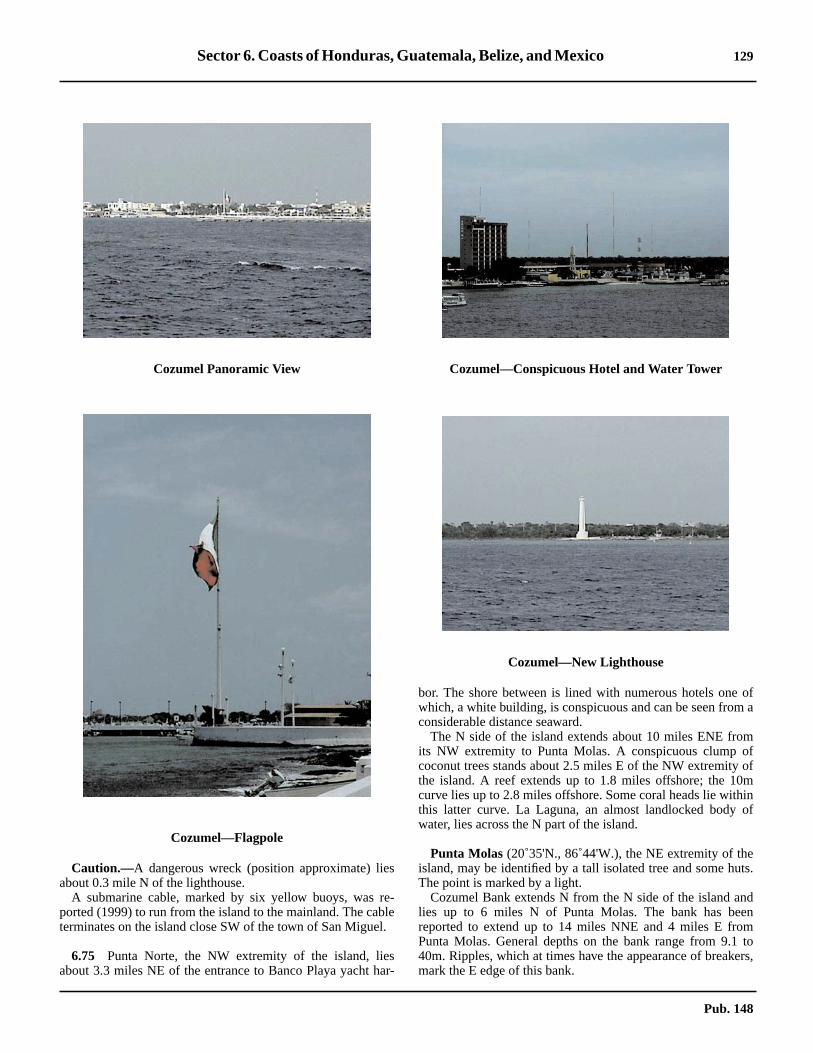
Sector 6. Coasts of Honduras, Guatemala, Belize, and Mexico 129
ofa
mfofminof
ts.
ndenm
toers,
6.74 Caution.—A dangerous wreck (position approximate) liesabout 0.3 mile N of the lighthouse.6.74 A submarine cable, marked by six yellow buoys, was re-ported (1999) to run from the island to the mainland. The cableterminates on the island close SW of the town of San Miguel.
6.75 Punta Norte, the NW extremity of the island, liesabout 3.3 miles NE of the entrance to Banco Playa yacht har-
bor. The shore between is lined with numerous hotels onewhich, a white building, is conspicuous and can be seen fromconsiderable distance seaward.6.75 The N side of the island extends about 10 miles ENE froits NW extremity to Punta Molas. A conspicuous clump ococonut trees stands about 2.5 miles E of the NW extremitythe island. A reef extends up to 1.8 miles offshore; the 10curve lies up to 2.8 miles offshore. Some coral heads lie withthis latter curve. La Laguna, an almost landlocked bodywater, lies across the N part of the island.
6.75 Punta Molas (20˚35'N., 86˚44'W.), the NE extremity of theisland, may be identified by a tall isolated tree and some huThe point is marked by a light.6.75 Cozumel Bank extends N from the N side of the island alies up to 6 miles N of Punta Molas. The bank has bereported to extend up to 14 miles NNE and 4 miles E froPunta Molas. General depths on the bank range from 9.140m. Ripples, which at times have the appearance of breakmark the E edge of this bank.
Cozumel Panoramic View
Cozumel—Flagpole
Cozumel—Conspicuous Hotel and Water Tower
Cozumel—New Lighthouse
Pub. 148

130 Sector 6. Coasts of Honduras, Guatemala, Belize, and Mexico
Coz
umel
—N
orth
Inte
rnat
iona
l Pie
r
Pub. 148

Sector 6. Coasts of Honduras, Guatemala, Belize, and Mexico 131
ndreas
outeAdses
E.ityd;adsW
0.3nsout
thee
bay
allca
elsthe
rth
iles
ndith
4
teng
asofof
ie
Stoown-a
Puerto Morelos to Cabo Catoche
6.76 Puerto Morelos (20˚51'N., 86˚54'W.) (World PortIndex No. 9540) is a small fishing and ferry port with depths of6.7 to 10.1m. The village of Puerto Morelos stands on themainland about 1.5 miles N of the entrance and is protected byreefs which lie 0.3 mile offshore abreast the village and up to 1mile offshore abreast the S part of the harbor. Some of thesereefs are 0.6 to 0.9m high in places. A small pier, with a depthof 4.9m alongside its head, extends from the shore N of thevillage.6.76 The coast should be approached from the E to a positionabout 1.8 miles S of the light, which stands N of the village.When this light bears 024˚, a vessel should steer for it on thatbearing, which leads over a least charted depth of 7.9m, butdepths of 1.8m less than charted have been reported in thischannel.6.76 Anchorage can be taken abreast the village, in depths of 8 to9m, but it is advisable that vessels moor.6.76 The coast between Puerto Morelos and Cabo Catocheextends about 14 miles NE and then curves NNW for 36 milesto Cabo Catoche. The terrain is generally low and wooded.Sand hills stand along some parts of the coast. The terrain inthe N part of this area becomes more elevated, with trees up to40m above the sea.6.76 Caution.—The 200m curve, which lies about 2 miles SE ofPuerto Morelos, gradually extends from the coast and liesabout 37 miles E of Cabo Catoche.6.76 The coast about 5 miles SW of Puerto Morelos is fringed bya steep-to reef which extends up to 1.3 miles offshore.6.76 Numerous islands, cays, and other dangers lie within thearea enclosed by the 200m curve, which lies between 1 mileand 15 miles offshore between Puerto Morelos and CaboCatoche.
6.77 Isla Cancun (21˚05'N., 86˚47'W.) stands about 14miles NNE of Puerto Morelos and is composed of sand hills 12to 18m high. The N and S extremities of this island curve to theW and almost reach the mainland. There are two bridgesconnecting the island with the mainland. A 1970 report statedthat the S end of the island appeared to be connected to themainland when viewed by radar.6.77 A conspicuous tower, marked by a red fixed obstructionlight, and a structure in the shape of a truncated pyramid standnear Punta Cancun. Another tower, marked by a red fixedobstruction light, stands 2.8 miles SSW of the point.6.77 Isla Cancun encloses a series of interconnected lagoonshaving shallow channels to the sea. A natural harbor for smallcraft is located S of Punta Nizue, the S extremity of the island,and is protected by a reef. Local knowledge is required to enterit.
6.78 Isla Mujeres (21˚14'N., 86˚45'W.), which standsabout 4.5 miles NNE of Isla Cancun, is about 4 miles long,low, narrow, and wooded. The S part is slightly elevated andhas trees about 27m above the sea. The ruins of a square watchtower stand near the S part of the island. The E side of theisland is composed of fairly steep-to rocky shelves andterminates at its N end in Roca El Yungue (Anvil Rock), which
is square, black, and about 1.8m high. Some white cliffs staabout midway along the E side of the island. A large, squawhite hotel stands on the N extremity of the island and hbeen reported to be a good radar target.6.78 Puerto Juarez, a small town on the mainland, stands ab5.5 miles WSW of the light on the S end of Isla Mujeres. Thtown serves as a terminal for ferries servicing Isla Mujeres.pier, about 244m long, with a depth of 1.8m alongside, extenfrom the shore abreast of the town. A ferry service for vehicloperates from Punta Sam, 3 miles N of Puerto Juarez.
6.79 Bahia de Mujeres(21˚13'N., 86˚46'W.) lies betweenIsla Mujeres and the mainland; it is entered between the Nextremity of Isla Cancun and the S extremity of Isla Mujeres6.79 A sand bank extends about 2 miles W from the S extremof Isla Mujeres, then trends N about 2 miles toward the islanthe 5m curve marks this sandbank. There are many coral heon this bank; some of them near the S end nearly dry. The Sedge of this bank is marked by a lighted buoy.6.79 A passage between this bank and the shoals W is aboutmile wide and leads N past Puerto Mujeres, where it joiCanal las Pailas, passing N of Isla Mujeres to deep water ab0.5 mile N of Roca El Yunque.6.79 The general depths in the area between Isla Mujeres andmainland are from 2 to 8m; only vessels with local knowledgshould attempt this passage.6.79 A charted submarine cable and aquaduct cross thebetween Punta Sam and Isla Mujeres.6.79 Puerto Mujeres (21˚16'N., 86˚45'W.) is situated at the Nend of Isla Mujeres, on its W side. The harbor lies in a smbay entered between the NW extremity of the island and RoLa Carbonera, about 0.5 mile S. A channel for small vessleads through the shoal which extend across the entrance tobay. There are six quays, with depths of 2.4m, and a ferry bein the bay.6.79 There is an anchorage in Bahia de Mujeres, about 2.3 mW of the S extremity of Isla Mujeres, in depths of 6 to 7m.
6.80 Arrowsmith Bank (21˚05'N., 86˚25'W.) lies about 16miles E of Isla Cancun. The bank is about 17 miles long afrom 1.5 to 5 miles wide. There are depths to 16.4 to 38m, wthe shallowest part lying on the center of its E part.6.80 The E edge of the bank is reported (1981) to lie aboutmiles farther E than charted.6.80 A NNE current sets across Arrowsmith Bank, attaining a raof from 2 to 3 knots; the S end of the bank is marked by strorips.6.80 In 1980, it was reported that an area of heavily breaking sewas observed, centered in position 20˚50'N, 86˚35'W, SArrowsmith Bank; there was a moderate SE wind at the timethe observation.6.80 A shoal, with a depth of 8.2m, was reported (1960) to lnear the NE extremity of Arrowsmith Bank.6.80 From a position on the coast about 5 miles W of theextremity of Isla Mujeres, the coast trends about 3.5 miles Na narrow ridge of sand about 2m high, which connects a narrneck of land about 4 miles long with the mainland. The contiuation, about 5 miles farther N, is known as Isla Blanc(21˚22'N., 86˚49'W.).
Pub. 148

132 Sector 6. Coasts of Honduras, Guatemala, Belize, and Mexico
iealof
t 8elyea.hisndsN
6.80 From the S end of the ridge of sand, a reef fringes the coast,extending past Isla Blanca to Isla Contoy, about 4 miles fartherN; there are one or two openings for boats in it.
6.81 Isla Contoy (21˚30'N., 86˚49'W.) stands about 4miles NNE of Isla Blanca and 6.5 miles offshore. Its E side iscomposed of a narrow ridge of sand hills covered with bushesand trees to within 1.5 miles of its NW extremity. A narrowridge of coral, with depths of 5.5m, extends about 3 milesNNW from two rocks close off the NW extremity of the island.The greater part of the W side of the island is intersected bynumerous small lagoons. The island is a bird sanctuary.
6.81 A bank, with a depth of 27m, was reported (1946) to labout 17 miles ENE of the N extremity of Isla Contoy. A shodepth of 18.3m was reported (1968) to lie about 16 miles NEthe N end of the island.6.81 FromCayo Sucio(21˚25'N., 86˚53'W.), which lies close offthe coast 3 miles NW of Isla Blanca, the coast trends aboumiles NW. This coastal section is more elevated and denswooded, with some trees standing 37 to 40m above the sThe conspicuous ruins of a church stand at the N end of tstretch of coast. From the ruins of the church, the coast exteabout 6 miles WNW to abreast Cabo Catoche, which is theextremity of Isla Holbox.
Pub. 148

133
7.Coast of Mexico—Cabo Catoche to the Rio Grande
Pub. 148
7.0Additional chart coverage may be found in CATP2, Catalog of Nautical Charts.
SECTOR7 — CHART INFORMATION


135
N,
o-is
tionsber.andutindg
re-va-
-mllyen
re-
er,ts.
s isl N
t ofenhere,heseto
0re-
NW
mWgitee
mncefm
SECTOR 7
COAST OF MEXICO—CABO CATOCHE TO THE RIO GRANDE
7.0 Plan.—This sector describes the coast of Mexico from CaboCatoche W along the N coast of Peninsula de Yucatan, then Sand W around the shores of the Bay of Campeche, and then Nto the Rio Grande.
General Remarks
7.1 The E coast of Mexico between Cabo Catoche and theRio Grande extends WNW for 615 miles.7.1 Peninsula de Yucatan, which forms the SE side of Mexico,has as its E side the coast between Chetumal Bay and CaboCatoche. The N coast of the peninsula extends in a general Wdirection for about 190 miles between Cabo Catoche and PuntaBoxcohuo. The W side of the peninsula extends 105 miles Sfrom Punta Boxcohuo and then an additional 78 miles SW tothe W entrance of Laguna de Terminos. The N and W sides ofthe peninsula are low and arid, and have very few conspicuouslandmarks.7.1 Banco de Campeche, an extensive coastal bank, as definedby the 200m curve, extends up to 155 miles N from the N sideof Peninsula de Yucatan and as far as 120 miles from the Wside of the peninsula. This bank is very steep-to, has irregulardepths, and many cays, shoals, and reefs are found within itslimits.7.1 Between Punta Boxcohuo, the NW extremity of thepeninsula, and Cabo Rojo, 390 miles W, the coast recedes 195miles S to form the Bay of Campeche. The E side of the gulf isformed by Peninsula de Yucatan, the S side by the coastbetween Laguna de Terminos and Punta Zapotitlan, and the Wside by the coast between Punta Zapotitlan and Cabo Rojo. Thelow E and S coasts of the gulf are indented by several lagoons.The coastal plain on the W side of the gulf is backed bymountain ranges rising 10 miles inland. The S and W parts ofthe gulf have regular depths and few off-lying dangers. Numer-ous rivers discharge into the gulf along its S and W shores.7.1 From Cabo Rojo, the E coast of Mexico extends farther Nfor 270 miles to the Rio Grande. This section of coast ismarked at irregular intervals by low sand hills and woodedhummocks. Several large lagoons lie adjacent to the coast.Ranges of hills, several of which make good landmarks, standfarther inland.7.1 Puerto Veracruz, Tampico, and Coatzacoalcos are the prin-cipal ports for large vessels, but there are also several smallports for vessels with shallow drafts.7.1 Winds—Weather.—The prevailing winds come from direc-tions between the NE and SE, but are interrupted by northersduring the cooler months of the year and by tropical cyclonesfrom June to November. Northers generally last about 1 to 2days, but severe storms last for 2 to 5 days.7.1 Along the E and N coasts of Peninsula de Yucatan, the tradewind freshens in the afternoon and diminishes and shifts to theSE late at night and in the early morning.7.1 Along the W coast, from 1000 to 1400, the interval ofchange from the land to the sea breeze, the wind falls gradually
to nearly a calm and gradually springs up again from theand at about 1500 is established from the NE.7.1 Rainfall varies from 500 to 1,000mm along the coast. Prgreso has an average annual fall of 470mm. Precipitationheaviest near Coatzacoalcos and decreases in both direcalong the coast. In general, the maximum occurs in Septem7.1 Ships’ observations taken in the area between the coast20˚N, 95˚W show early winds predominate for all months bSeptember, October, and November, when the prevailing wis NE. Average wind velocities range from 8 to 12 knots, beinsomewhat higher from October to March. Gales are most fquent in October and November, when 4 per cent of obsertions report winds of force 8 or higher.7.1 In the vicinity of Puerto Veracruz and N to 25˚N, the prevailing winds are E, with a large percentage of N winds froSeptember to April. The latter period, but more especiabeginning with October, is known as the norther season, whthe trades are frequently interrupted by northers. Themainder of the year is known as the trade wind season.7.1 Wind velocities average considerably higher during thmonths of October through April, being highest in Decembewhen ships’ observations show an average velocity of 12 kno7.1 Fog is frequent, but most likely in March.7.1 The climate is hot and humid, although the oppressivenesconsiderably lessened during the norther season when coowinds are felt.7.1 Tides—Currents.—The main offshore current sets Wacross Banco de Campeche, 20 to 30 miles from the N coasPeninsula de Yucatan, at a velocity of 0.5 to 1.5 knots. It thsets SW across the Bay of Campeche and N, following ttrend of the coast to the Rio Grande, 20 to 30 miles offshodecreasing somewhat in velocity. From October to May, tcurrent circles the Bay of Campeche in a counterclockwidirection a distance of 10 to 30 miles offshore at a rate of 0.30.5 knot.7.1 Off the mouth of the Rio Grande and anywhere within 10miles of the coast, the current is mainly governed by the pvailing wind, setting N in the summer and S in the winter.
Banco de Campeche
7.2 Banco de Campeche extends 155 miles N from thecoast of Peninsula de Yucatan and 120 miles W from itsside.7.2 From a position lying 35 miles E of Cabo Catoche, the 200curve, which defines the limits of this bank, extends N and Nfor 170 miles, then irregularly W and SW to a position lyin140 miles NW of Punta Boxcohuo. It then extends S quregularly at a distance of 120 miles off the W side of thpeninsula.7.2 From a position lying 14 miles N of Cabo Catoche, the 20curve extends W along the N side of the peninsula at a distaof 12 to 18 miles offshore to a position lying 24 miles N oPunta Boxcohuo. On the W side of the peninsula, the 20
Pub. 148

136 Sector 7. Coast of Mexico—Cabo Catoche to the Rio Grande
toez.kedbeala
la
-the
le-is
ater.
of
of
dile
hell
1.3afhl iseof
Eaya
lieoalW
as-
11)s
e
iso 5rWist
lrt
curve extends SW and S at a distance of 20 to 38 miles off-shore. All of the dangers contained within this curve aredescribed under the principal description of the coastal fea-tures. This steep-to bank has very irregular depths and ismarked on its E and N edges by heavy ripples and a confusedsea. Some of the dangers within the limits of the bank aremarked by discolored water.7.2 Banco de Campeche has not been surveyed for many yearsand, as reports of new shoals are constantly received, it isreasonable to assume that many more dangers exist than areshown on the charts.
7.2 The following shoals were reported in the years indicatedwith the distances and bearings from Cabo Catoche (21˚36'N.,87˚04'W.):
1. A 6.4m shoal (1932), 13 miles N.2. An 18m shoal (1968), 25.5 miles ENE.3. A 12.8m shoal (1960), with a 16.5m depth (1967)
close E of it, 38 miles NNE.4. A 25.6m patch (1973), 33.5 miles NE. Several shoals,
with depths of 27 to 58m, lie within 6 miles N through NE ofthis shoal.
5. A depth of 11m (1971), 58 miles N.6. A depth of 22m (1957), 61 miles N.7. A shoal bank, with depths of 110 to 200m (1959),
about 120 miles N. An 8.2m patch was reported (1961) to lieon the S end of this shoal bank.
8. A 14.6m depth (1968), 111 miles N.9. A 27.4m depth (1946), 30 miles E.
7.2 The following shoals were reported in the years indicatedwith the distances and bearings from Punta Yalkubul(21˚32'N., 88˚37'W.):
1. A small shoal patch (1921), depth unknown, 39 milesNNE.
2. Aeolus Shoal, with a depth of 9.1m, 31 miles N.3. Iphigenia Rock, with a depth of 14.6m, 26 miles N.4. Bajos Nortes, two coral banks with depths of 20.1 to
36.6m, lie 5 miles apart, 100 miles N. A 5.5m patch wasreported (1907) to lie on the southernmost bank.
5. Granville Shoal, with a depth of 8.2m, about 45 milesWNW. A 12.8m patch lies 10 miles N of Granville Shoal. A17.4m patch lies 20 miles SSW of Granville Shoal.
7.3 Arrecife Alacran (22˚29'N., 89˚42'W.), a steep-tohalf-moon shaped reef, lies 34 miles NW of Granville Shoal.The reef covers an area extending 14 miles N and 10 miles E.The NE side of the reef is composed of a compact mass ofcoral, awash, on which the sea breaks heavily. The SW side iscomposed of detached coral heads and sandbanks, with deepwater between some of the features. Soundings give noindication of the proximity of the reef. Isla Chica and IslaPajaros, two small low cays lying 0.3 mile apart, stand near theS end of the reef. Isla Desterrada, a small cay 3m high markedby a light, is located 3 miles within the N edge of the reef.
Isla Perez, a narrow cay 0.5 mile long and 4.3m high, islocated 1.8 miles within the S edge of Arrecife Alacran. Thiscay is marked by a light with a racon. The light tower is fullyvisible when approaching from the W and is reported to beradar conspicuous. A gray masonry tower stands adjacent tothe light tower.
7.3 Anchorage can be taken by small vessels, in depths of 1118m, fine sand, mud and coral, about 0.3 mile E of Isla PerThe anchorage is approached from the S through an unmarchannel with a depth of 7.3m. This channel should notattempted without local knowledge. In 1977, a vessel withdraft of 5.5m anchored about 2 miles, bearing 093˚, from IsPerez Light, in a depth of 44m, good holding ground.7.3 Isla Desertora, a small cay 4m high, lies 3 miles NW of IsPerez.7.3 The current usually sets W in the vicinity of Arrecife Alacran at a rate of 1 knot, but may set N or S, depending ondirection of the wind.7.3 Arrecife Madagascar (21˚26'N., 90˚18'W.), a narrow coraledge, with a least depth of 2.7m, lies 69 miles SSW of Arrcife Alacran. The sea does not break on this ledge, whichcovered with weeds and appears the same color as the wTwo 12.8m patches lie 2 miles and 3 miles W of the ledge.7.3 Breakers were reported (1909) about 6 miles NNEArrecife Madagascar.7.3 Arrecife de La Serpiente (Snake Rock), with a least depth8.2m, lies 11.5 miles W of Arrecife Madagascar.
7.4 Cayo Arenas(22˚07'N., 91˚24'W.), a guano-coverecay 6m high, lies on the SE edge of a detached reef, 0.8 mlong. A ledge extends 5 miles W from the cay. The horns of treef extend 0.5 mile NW and 0.3 mile W from the cay. A smawharf stands on the NW side of the cay. A detached reef,miles long, with a rocky patch, 2.1m high, on its S end andsmall coral patch, 0.6m high, off its NW end, lies 1 mile E oCayo Arenas. A stranded wreck lies 0.2 mile W of a light, wita racon, which stands on the reef. The intervening channeabout 0.5 mile wide at its N entrance. At its S end lie threcoral patches, with a depth of 4.1 to 8.2m, about 0.3 mile SECayo Arenas.7.4 A 11m patch was reported (1968) to lie about 15 miles ENof Cayo Arenas. A 14.6m patch lies 3 miles W of the same cand a 29.2m patch lies 19 miles E of the cay. A shoal, withleast depth of 27.4m, lies about 18 miles ENE of the cay.7.4 Several shoals, with depths between 14.6m and 21.9m,between 29 miles and 53 miles SSE of Cayo Arenas. Shpatches, with depths of 12.8m and 18.3m, lie 60 miles SSand 54 miles SW, respectively from Cayo Arenas.7.4 A detached pinnacle, with a depth of less than 20m, wreported (1961) to lie 24 miles NW of Cayo Arenas. A detached bank, with depths of 45.7 to 54.9m, was reported (19to lie 43 miles NNW of Bajo Nuevo. A depth of 23.7m wareported (1982) to exist 13 miles WNW of Bajo Nuevo.7.4 Anchorage.—Anchorage may be found as charted in thchannel, in depths of 15 to 27m, close E of the light.
7.5 Cayo Nuevo(21˚50'N., 92˚05'W.), with a depth ofless than 1.8m, lies 40 miles WSW of Cayo Arenas andmarked by breakers. Depths of less than 36m extend up tmiles off the reef’s NE side and up to 3 miles off the othesides of this reef. A detached 18.3m patch lies 25 miles NNof Cayo Nuevo. A depth of 23.5m was reported (1982) to ex13 miles WNW of Bajo Nuevo.7.5 Banco Ingleses(21˚49'N., 91˚56'W.), two banks of coraand sand with depths of 9 to 34m, lie with their shallowest palocated 8 miles SE of Cayo Nuevo.
Pub. 148

Sector 7. Coast of Mexico—Cabo Catoche to the Rio Grande 137
ee
of5
ocan
and
-me
S
ed
-ea,
f
ntaislowed, ac-
all
ds4
rveas
re.ersip-
entst
terhect
,heWsEa.
of
7.5 Arrecifes Triangulos (20˚57'N., 92˚14'W.) consists of twogroups of coral reefs lying 6 miles apart, which lie 53 miles Sof Cayo Nuevo. Depths of 49 to 53m exist in the channelbetween them.7.5 Triangulo Oeste, a reef 0.8 mile long, with a cay 3.4m highon its SW end, has a ledge with depths of 11 to 16.5m extend-ing NE from the cay. Seal Bank, a ledge with a least depth of12.8m, lies 1.5 miles farther NE.7.5 A disused lighthouse stands near the light on the cay near theSW end of Triangulo Oeste.7.5 A dangerous wreck lies 22 miles NE of the light on Tri-angulo Oeste.7.5 Triangulo Este (20˚55'N., 92˚13'W.) andTriangulo Sur(20˚54'N., 92˚14'W.), which nearly dry, are separated by achannel 0.2 mile wide, with depths of 10 to 20m. A cay, 7.3mhigh, stands on the S end of Triangulo Este. A stranded wrecklies on the E edge of Triangulo Sur. A reef extends 1 mile NEfrom the cay, and a coral ledge extends about 1 mile fartherNE. Triangulo Sur has a ledge extending about 1 mile SW fromthe SW cay of several which stand on it.7.5 An 11m patch was reported (1916) to lie 25 miles NNE ofTriangulo Este. A rock, awash, was reported (1921) to lie 7miles S of this patch. A detached 14.6m patch lies aboutmidway between these two dangers.7.5 Anchorage.—Anchorage can be taken, in a depth of 13m,about 1 mile SW of the SW cay on Triangulo Sur.
7.6 Banco Ciudad Condal, a detached shoal with a depthof 11m, lies 8 miles S of Triangulo Este.7.6 In 1977, a depth of 33m was reported to lie 6 miles SE ofBanco Ciudad Condal.7.6 Obispo Norte (20˚29'N., 92˚12'W.) and Obispo Sur, twodangerous shoals with general depths of 7 to 18m, lie 25 milesS of Triangulo Este and are marked by discolored water. Apassage, about l.3 miles wide with a depth of 51m, separatesthe shoals. Obispo Norte has a depth of 4.5m lying near its Nend. A dangerous wreck lies between the two shoals.7.6 Banco Pera (20˚42'N., 91˚56'W.) and Banco Nuevo, twoshoal banks with least depths of 16.4m and 14.6m, respect-ively, lie 28 miles and 38 miles SE, respectively, of TrianguloOeste.7.6 Cayos Arcas(20˚13'N., 91˚58'W.), the S dangers of Bancode Campeche, are a group of three islets which lie 44 milesSSE of Triangulo Este.7.6 Cayo del Centro, the N and largest, is composed of sand andrises at its S end to a height of 6m. It lies on the SE end of areef which extends about 1 mile NW and 0.5 mile W from it;this reef is encumbered by foul ground and is always visible.The islet is scantily-covered with grass. Bushes and severalclumps of palms are also present. A pair of lighted rangebeacons, in line bearing 107˚, stand on the cay.7.6 Anchorage can be taken, in depths of 11 to 18m, coral androck, about 1 mile WNW of the cay on the alignment of therange.7.6 Cayo del Este, a small cay, 3m high, lies on a detached reeflying 0.3 mile SE of Cayo del Centro. The intervening channelhas depths of 11 to 25.6m.7.6 Cayo del Oeste, a small 2m high cay, lies on a smalldetached reef about 0.8 mile W of the S end of Cayo del Cen-tro. The narrow intervening passage has depths of 6.4 to 91m.
7.7 Cayos Arcas Terminal(20˚10'N., 91˚59'W.) (WorldPort Index No. 9395) lies close SW of the cays within thlimits of an Area to be Avoided associated with a marinoilfield. Two distribution platforms are situated at the N enda submarine pipeline carrying oil from the marine oil field, 4miles S. Operations are conducted 24 hours.7.7 Depths—Limitations.—Submarine pipelines are laid fromthe above platforms to two SPMs within the terminal area. Twmoored storage tankers are also in use. The mooring buoysaccommodate vessels up to 275,000 dwt., 347m in length,21.3m draft.7.7 Pilotage.—Pilotage is compulsory. Pilots are available Monday through Saturday from 0800 to 1800 and on Sunday fro0800 to 1200. An ETA should be sent to PEMEX through thagent prior to arrival at the terminal.7.7 A pilot will board inbound vessels 2.5 miles SE of theSBM or 2.5 miles SW of the platform.7.7 Anchorage.—Vessels can obtain anchorage in the chartanchorage area SE of the terminal.7.7 Directions.—On approaching the terminal, masters of inbound tankers should head directly for the anchorage arwhere vessels will be boarded by a mooring master.
Cabo Catoche to Punta Boxcohuo
7.8 Cabo Catoche (21˚36'N., 87˚04'W.), a sand pro-jection on the N point of Isla Holbox, is fringed by depths o5.5 to 9m which extend 10 miles N and NE.7.8 The coast from Cabo Catoche extends 85 miles W to PuYalkubul, and then 105 miles WSW to Punta Boxcohuo. Thsection borders the N coast of Peninsula de Yucatan and isand arid, with few conspicuous landmarks. Many detachshoals and patches fringe this coast. Lagartos Lagoonnarrow, shallow lagoon, lies parallel to almost all of this setion of coast.7.8 Progreso is the only port of any importance. Several smvillages lie on the coast.7.8 The 20m curve lies 14 miles N of Cabo Catoche and extenW along the coast 12 to 18 miles offshore to a position 2miles N of Punta Boxcohuo. The dangers seaward of this cuhave been previously described. A shallow coastal bank,defined by the 5m curve, fronts this coast 1 to 5 miles offshoIrregular depths lie between the 5 and 20m curves. The dangwithin the 20m curve are described under the principal descrtion of the coastal features.7.8 Between Cabo Catoche and Punta Boxcohuo, the currsets W at a rate of 0.5 to 1 knot, following the trend of the coa30 miles offshore.7.8 The mean rise at springs ranges from 0.4 to 0.7m. The waon the off-lying banks is influenced by the winds, as well as ttides. The effect of the latter may be offset by the wind effefor a period of several days.7.8 Isla Holbox (21˚33'N., 87˚14'W.) is one of a chain of lownarrow islands which front the coast between Cabo Catocand Boca de Conil to the W. Punta Francisca is the Nextremity of the island. A chain of cays, fronted by numerousand ridges, with depths of 2.4 to 9.1m, extends 8 miles Nfrom Cabo Catoche and 9 miles NW from Punta FranciscBajo Corsario, with a least depth of 4.6m, lies 8 miles NPunta Francisca.
Pub. 148

138 Sector 7. Coast of Mexico—Cabo Catoche to the Rio Grande
ide
de
. It
l;
is
b-ta.gsos
gh,at
asts ah
-to.
ilenelssl
Wilotse
4
ar
With
7.8 Boca de Conil(21˚29'N., 87˚35'W.), 3 miles wide, is the Wentrance to Laguna de Yalahua, a shallow body of water lyingbetween Isla Holbox and the mainland. Foul ground extends 7miles NW from Boca de Conil.7.8 The low, sandy coast between Boca de Conil and Cuyo, 16miles W, is marked by conspicuous groves of trees near its Eend.7.8 Cuyo (21˚32'N., 87˚41'W.), a town, is fronted by a wharf,107m long, with a depth of 2.1m alongside its outer end. Itstands on the narrow strip of land between the sea and thelagoon which parallels this coast. El Cuyo, a 12m high hill,stands close to the town. A 3.7m shoal lies 5 miles N of thetown.
7.9 Las Coloradas(21˚37'N., 88˚01'W.), fronted by anopen roadstead, has two small piers. The principal export issalt, which is barged out to the anchorage. From the N, depthsin the approach are 7.3 to 9.1m and are quite regular, with noknown dangers in the immediate vicinity. The two piers arereported to be radar conspicuous.7.9 The coast between Cuyo and the Rio Lagartos, 30 miles W,is fronted by a low, sandy beach. The Rio Lagartos is the outletof the narrow lagoon that parallels this coast.7.9 Alert Patch, with a least depth of 4.6m, lies 14 miles NW ofthe Rio Lagartos entrance. The existence of this shoal is doubt-ful.7.9 Bajo Antonieta, a shoal which uncovers 0.6m, lies 4 milesWNW of the Rio Lagartos. Between the Rio Lagartos andPunta Yalkubul, 22 miles W, the coast is more elevated, being52m higher 6 miles E of the point.7.9 Punta Yalkubul (21˚32'N., 88˚37'W.) is low and marked bytrees. Bajo Carmelita, a shoal with depths of less than 4.6m,lies 11 miles NW of the point. Bajo Pawashick, a shoal with aleast depth of 2.7m, lies 9 miles W of the point.7.9 The coast between Punta Yalkubul and Punta Arenas, 13miles SW, remains low. A shallow lagoon entrance lies close Eof the latter point.7.9 Dzilam (Silan), a small town fronted by a pier, is situated 6miles W of Punta Arenas.7.9 Between Punta Arenas and Progreso, 48 miles W, the coastconsists of low sandy beach, slightly wooded, and backed byswampy ground. A prominent coastal light is shown 2 miles SEof the village of Telchac. Several additional villages lie alongthis section of coast.7.9 Chicxulub, a small village fronted by a pier, is situated 2miles E of Progreso.
7.10 Progreso(21˚17'N., 89˚40'W.) (World Port Index No.9510) is the most important port on Peninsula de Yucatan.7.10 Winds—Weather.—The prevailing winds are from the NEto SE. Northers occur between October and March.7.10 Tides—Currents.—The current sets to the W. The tidalrange is 0.4m.7.10 Depth—Limitations.—In the approach to the port from N,vessels will pass through a dredged channel, with a depth of11.6m, extending 4 miles N of Terminal Remota. TerminalRemota has been reported (2004) to have seven berths pro-tected by an artificial island. Berth No. 3, Berth No. 4, andBerth No. 5 have an alongside depth of 7.8m. Berth No. 6 and
Berth No. 8 are PEMEX tanker docks and have an alongsdepth of 11.6m.7.10 The Cruise Ship Pier has two berths, with an alongsidepth of 11.6m.7.10 Muelle Fiscal is on the causeway about 1 mile from shoreis 204m long and has an alongside depth of 4.9m.7.10 About 1 mile from shore on the causeway is Muelle Fiscait is 204m long and has analongside depth of4.9m.7.10 Pino Suarez Pier, close W of the root of the causeway,lighted and has an alongside depth of 2.7m.7.10 A turning circle, marked by lighted buoys, has been estalished for vessels approaching the berths at Terminal Remo7.10 Aspect.—A lighted causeway and pier about 3 miles lonruns from Terminal Remota to the shore just N of ProgresLight. Terminal Remota is marked by lights, one of which haa racon.7.10 When approaching Progreso, a square tower, 18m histands close W of the light. East of the town, and somewhdetached from it, is a large square building close to the coand partly surrounded by trees. The town itself appears agroup of low gray or white buildings. The piers, together witthe warehouses on them, are prominent.7.10 Pilotage.—Pilotage is compulsory for vessels going alongside the pier or shifting anchorage. Pilots are available 08001800 Monday through Friday and 0800 to 1300 on Saturday7.10 For vessels with a draft of 7m or greater, pilots board 1 mN of the fairway buoy at the entrance to the dredged chanabout 4 miles N of Terminal Remota.If a vessel has a draft lethan 7m they board the pilot about 1 mile NW of TerminaRemota.7.10 Vessels of less than 7m draft may use the close outsideedge of the dredged outer channel to reach the inner pboarding area if it is busy. Shallow draft vessels may also uthis W edge of the dredged channel departing.7.10 Regulations.—Vessels should provide an ETA at least 2hours in advance of arrival.7.10 Signals.—Storm signals are displayed from a flagstaff nethe light.7.10 Anchorage.—Good anchorage can be taken 1.5 miles Nof the entrance buoy, in depths of 9 to 15m, by vessels w
Telchac Light
Pub. 148

Sector 7. Coast of Mexico—Cabo Catoche to the Rio Grande 139
ntrolour
trol
eor-
ndaslso
l-s,
ithrousds
d,nker
ds,out
theearelse
e
sly5byntaph
nds
of
andlie
drafts up to 6.1m. Vessels with drafts of 4.8m or less cananchor 2.5 miles NW of Terminal Remota, in a depth of 6.4m.7.10 Caution.—Due to the dumping of construction material,mariners are cautioned to avoid the N side of the TerminalRemota and the E and W sides of the mole, as shown on thechart. A dangerous wreck lies about 1 mile NNW of ProgrssoLight
7.11 Puerto de Yukalpeten(21˚17'N., 89˚43'W.), 3 milesW of Progreso, is used primarily by fishing vessels and yachts.The E breakwater extends approximately 0.1 mile from theshore, while the W breakwater is less prominent. The accesschannel and the berths alongside the two piers are dredged to aleast depth of 3m.7.11 The coast between Puerto de Yukalpeten and Sisal, about 20miles WSW, is marked by several villages and is more woodedthan elsewhere in the vicinity. The village of Sisal is nownearly abandoned.
7.11 Arrecife Sisal (21˚21'N., 90˚09'W.), a coral reef with anobstruction on it, lies 12 miles NNW of Sisal and may bemarked by discolored water under certain weather conditions.A 6.4m coral shoal lies 6.5 miles WNW of Sisal.7.11 The coast between Sisal and Punta Boxcohuo, 17 miles SW,is low and sandy. A building in ruins, 5 miles SW of Sisal, isthe only conspicuous landmark.7.11 The coast between Sisal and a position lying 5 miles S ofCelestun is radar conspicuous.
Punta Boxcohuo to Punta Buey
7.12 Punta Boxcohuo (21˚02'N., 90˚18'W.), the NWextremity of Peninsula de Yucatan, is a low, sandy projection.Several shoals are reported to lie near the 10m curve, about 9miles seaward of the point. A 2.7m shoal lies 3 miles N of thepoint. A shoal, depth unknown, has been reported to lie 20miles WNW of the light on the point.7.12 The section of coast forming the W side of Peninsula deYucatan and the E side of the Bay of Campeche extends 13miles SSW from Punta Boxcohuo to Celestun, then 60 milesfurther S to the town of Campeche. A wide and shallow bankfronts this portion of the coast, preventing even light-draftvessels from sighting the shore.
7.12 Between Campeche and Punta Morro, 13 miles SW, andChampoton, 20 miles farther S, the coast is bolder and backedby prominent ridges of hills.7.12 Between Champoton and Punta Xicalango, 80 miles SW, thecoast is low, wooded, and fronted by a continuous sandy beach.Laguna de Terminos indents the S part of this coast. For adistance of 30 miles SW of Champoton, numerous sand andshell patches, with depths of 4.3 to 9.1m, extend as far as 12miles offshore.7.12 From Punta Xicalango, the coast extending W for about 45miles to Punta Buey is low and free of dangers. There are nocommercial ports along this section of coast.7.12 Regulations.—A mandatory Maritime Traffic Control Sys-tem serves the Bay of Campeche. The system includes Areas tobe Avoided surrounding the marine oil fields and at CayoArcas, precautionary areas at track junctions, and specified
traffic lanes. These areas are best seen on the chart. CoCenters are located at Cayo Arcas, Dos Bocas, and at fadditional platforms, designated IXTOC1, AKAL-C, KU1, andECO1.7.12 Vessels intending to enter an area should report to a ConCenter 1 hour prior to entry with the following information:
1. Vessel name.2. Port of registry.3. Vessel number.4. Name of owner (company).5. Master’s name.6. Destination.7. Port of departure.8. Displacement.9. Draft.10. Type of cargo.
7.12 Within the area, vessels must follow instructions from thControl Center. Permission must be obtained prior to anching.7.12 Radar surveillance is maintained between Cayo Arcas aDos Bocas and in their approaches. Vessels will be guidedneeded within the radar surveillance area. Control Centers aserve as information centers for the area.7.12 Caution.—Offshore oil fields are being extensively deveoped in the Bay of Campeche. Mobile drilling rigs, platformand associated structures, sometimes unlit, sometimes wracons, may be encountered anywhere in the area. Numesubmarine pipelines, many uncharted, exist within the oilfieland between them and the shore.7.12 Most of the platforms are in a specific Area to be Avoidewhose boundaries are best seen on the chart. A storage tais moored NNE of the NE boundary of the area.
7.12 A major offshore oil field is situated between 40 miles an58 miles SSW of Cayos Arcas. Several production platforminterconnected by submarine pipelines, are situated throughthis area. A submarine pipeline extends SW betweencentral platform (19˚24'N., 92˚02'W.) and a terminal on thcoast at Barra de dos Bocas. Ship movements in the areacontrolled by a Maritime Controller on a 24-hour basis.Vesseplanning to enter the area should report to the MaritimController on VHF channel 16 and comply with the MaritimController’s directions.
The depths seaward of the 20m curve have been previoudescribed. The depths within this curve, which lies up to 3miles offshore, are irregular. The coastal bank, as definedthe 5m curve, extends up to 12 miles offshore between PuBoxcohuo and Champoton, which is described in paragra7.15.
7.13 Bancos de Champoton(19˚23'N., 90˚50'W.), agroup of detached patches with depths of 4.3 to 8.2m, exte10 to 15 miles W from Champoton.7.13 Bancos de Sabancuy(19˚10'N., 91˚16'W.), a group ofpatches with depths of 4.3 to 9.1m, lies 32 miles SWChampoton and extends up to 12 miles offshore.
7.13 Between Punta Boxcohuo and Celestun, the coast is lowsandy. Two shoal patches, with depths of 8.2m and 9.1m,about 16 miles W of Celestun.
Pub. 148

140 Sector 7. Coast of Mexico—Cabo Catoche to the Rio Grande
the2530
ose
n alls.ortitydeed
-nd9˚,the
th.5ceg
th
and
loe
g
Eer
,so
oteof
, antaby
S,an
igh
nort5m
kyahe
7.13 There is seldom any current off the W side of Peninsula deYucatan.7.13 During the rainy season, from June to September, squallsdevelop at times with considerable force.7.13 The prevailing winds are from directions between the NEand SE.7.13 Real de Las Salinas(20˚45'N., 90˚26'W.), the W entrance tothe lagoon which parallels the N coast of Peninsula de Yucatan,lies 6 miles S of Celestun.
7.13 Between Real de Las Salinas and Campeche, 55 miles toS, the low coast is bordered by swampy ground for aboutmiles and then becomes more elevated, rising to heights ofto 85m N of Campeche. Isla de Piedras, 9m high, stands cloffshore, 23 miles N of Campeche.
7.14 Campeche(19˚51'N., 90˚33'W.) (World Port IndexNo. 9500), the capital of the state of Campeche, stands oplain bordered on three sides by a small amphitheater of hiFort San Jose stands on the NE outskirts of the city and FSan Miguel stands on the SW perimeter of the city. The cserves as the distributing point for the W coast of PeninsulaYucatan. Sisal is the principal export. Port facilities are locatat the town of Lerma, 3.5 miles SW of Campeche.7.14 Depths—Limitations.—Vessels are restricted to a maximum draft of 10m and must stay in the channel due to sabars in the port approach. A lighted range, in line bearing 13leads into the port. The seaward safe water buoy markingrange has been reported missing (2001).7.14 Muelle Castillo Breton, a pier about 500m long, with a depof 3.6m alongside, extends from the village of Lerma, 3miles SW of Campeche. The pier has 213m of berthing spaat its outer end, 122m of which is reserved for local fishinvessels.7.14 Muelle Fiscal (Muelle Pemex) is 521m long and has a depof 5.1m alongside.7.14 Muelle Unidad Pesquera has a depth of 4.2m alongsideis used exclusively by fishing vessels.7.14 Puerto de Abrigo is situated 0.3 mile SE of Muelle CastilBreton; there is a small pier about 0.3 mile NE of the samjetty.7.14 Pilotage.—Pilotage is compulsory for vessels berthinalongside.7.14 Signals.—A signal station is situated atop Fort San Jose Nof Campeche Light. A blue flag indicates threatening weathwhile a red flag indicates that the port is closed.7.14 Anchorage.—Anchorage can be taken, in a depth of 6.4mabout 11.8 miles W of Campeche. This anchorage is notsubject to the effects of northers as are other gulf ports.7.14 Caution.—Vessels approaching the anchorage should nthat dangerous wrecks lie 10 miles NW and 18 miles WPunta Mastun.
7.15 Between Campeche and Punta Mastun Grandewooded, 129m high headland about 9 miles SW, and PuMorro, 5 miles farther SSW, the coast is bold and backedridges of hills.7.15 Between Punta Morro and the Rio Champoton, 20 milesthe coast is backed by a ridge of hills that are more broken ththose to the N. The ridge terminates in a prominent, 110m hhill about 8 miles S of the river.
7.15 Champoton (19˚22'N., 90˚43'W.), a small village, stands othe S side of the entrance to the Rio Champoton. An old fand two churches stand in the town. Observation Cay, 1.high, lies close off the river entrance.7.15 The river is entered passing S of Observation Cay, a rocislet which lies 0.2 mile off the mouth of the river. There isdepth of 0.9m over the bar and depths of 6 to 7m inside triver.
Cayo Arcas Platform
Platform Akal-C
Pub. 148

Sector 7. Coast of Mexico—Cabo Catoche to the Rio Grande 141
oft.enesanstvyrgert
dsf ae
ng
at a
ut
ioby
astngd ofbe
out.8ry.tedhetot 3
ey,
isith
dt 1e
,els
va.ge
7.15 Between the Rio Champoton and Barra de Puerto Real, 55miles SW, the low, wooded coast is fronted by a continuousstretch of sandy beach. Numerous sand and shell patches, withdepths of 2.4 to 5.5m, lie up to 5 miles off this section of coast.
7.15 Barra de Puerto Real (18˚47'N., 91˚30'W.), the E entranceto Laguna de Terminos, is 2 miles wide and has depths of 1.8to 3.7m. A pair of lighted beacons, in line bearing 151˚, standon Punta del Tigre on the N side of the entrance. A shallow,breaking spit extends 2.5 miles WNW from the point. Achannel for vessels with drafts of less than 3m leads to ananchorage off Punta del Tigre, but should not be attemptedwithout local knowledge. A road connects Isla Aguada on theE side of the entrance with the coast SE of Purerto Real on theW side.7.15 Isla del Carmen, low and sparsely wooded, fronts Laguna deTerminos between Barra de Puerto Real and Barra Principal,the W entrance of the lagoon, lying 20 miles WSW.
7.16 Ciudad del Carmen (18˚39'N., 91˚50'W.) (WorldPort Index No. 9490) consists of numerous jetties and wharveswhich project from the W shore of the town. There is a dredgedfishing vessel haven to the N of the jetties. A naval base issituated to the S of the harbor.7.16 Depths—Limitations.—The Fiscal Berth, 350m long, hasan alongside depth of 3.7m and is used mainly by offshorepetroleum companies.7.16 Barra Principal is 6 miles wide between Punta Vigia, 0.5mile SE of the SW end of Isla del Carmen, and Punta Xica-lango, on the opposite side of the entrance. A breaking spitextends 4.5 miles NW from Punta Vigia and depths of 1.8 to3.7m extend 3 miles N from Punta Xicalango. A buoyedchannel, with depths of 3.7 to 4.3m, leads through these shoalsto the town of Ciudad del Carmen, on the SE side of PuntaVigia. A rock bar in the channel limits the size of vessels usingthe port to a draft of 3.7m.7.16 Aspect.—Two lighted beacons, in line bearing 180˚, standon the W side of the entrance and indicate the fairway of thischannel.
7.16 Pilotage.—Pilotage is compulsory.7.16 Anchorage.—Good anchorage can be taken, in depths of 7to 9m, about 8 miles NNW of Punta Vigia. The mud bottom isgood holding ground, but this anchorage is not safe during theseason of the northers.7.16 Secure anchorage can be taken off the town in depths of 9 to11.9m, keeping clear of the approach to the wharves. Anchor-age is also recommended 6 miles N of Punta Vigia, in a depthof 4.9m.7.16 Between Barra Principal and the Rio Grijalva, 46 miles W,the coast is low and has no prominent features.7.16 Caution.—Considerable changes to depths, navigationalaids, and the coastline have taken place in the approaches toCiudad del Carmen. The most recent editions of appropriatecharts should be consulted.7.16 A precautionary area is situated about 10 miles N of Ciudaddel Carmen. Only petroleum exploration and exploitationactivities and transiting fishing vessels are allowed in this area,as seen on the chart.
Punta Buey to Coatzacoalcos
7.17 Punta Buey (18˚39'N., 92˚43'W.) is a low pointwhich has been reported to be extending N and NW. Depths5.5 to 7.3m extend about 1.5 miles N and NW from the poin7.17 The coast recedes 8 miles SW from Punta Buey, thextends in a general WSW direction for a distance of 95 milto Coatzacoalcos, then W for 10 miles and then NNW foradditional 25 miles to Punta Zapotitlan. This low, marshy coais indented by several lagoons and is covered with very heavegetation, except in the tidal marshes. Several rivers dischainto the gulf, and hills stand 3 to 8 miles inland on the W paof this coast.7.17 The 20m curve lies 7 miles NW of Punta Buey and extenalong the coast 2 to 4 miles offshore. With the exception oshoal, with a least depth of 7.9m, which lies 5 miles NW of thmouth of the Rio Coatzacoalcos, there are no known off-lyidangers.7.17 From October to March, the current near the shore sets Erate of 1 to l.5 knots.7.17 The winds tend to blow from the N. Northers occur at abo8 day intervals between October and March.
7.18 Frontera (Alvaro Obregon) (18˚35'N., 92˚39'W.)(World Port Index No. 9440) stands on the E bank of the RGrijalva, 5 miles S of the entrance. The port is used mainlysmall coastal vessels.7.18 Tides—Currents.—There is only one tidal rise every 24hours. The tidal rise is 0.6 to 1.2m at springs.7.18 When the river is at its highest level, the bar has the ledepth over it; and when it is at its lowest, the channel beicontracted, is flushed out and becomes deeper. At the enthe rainy season in December, the least depths mayexpected, but the first norther will increase the depth by ab0.9m and again a freshet may reduce it by a similar amount7.18 Depths—Limitations.—Depths of less than 5m extend 0.mile N and 1 mile NW from the E entrance point, and similadepths extend 1.5 miles N and 0.5 mile W from Punta BueThe bar, which lies N of the entrance points, has been repordredged to a depth of 4.6m. The buoyed channel within triver has a navigable width of about 230m with depths of 3.74.9m. The preferred channel passes E of Isla Buey, aboumiles S of the entrance.7.18 Grijalva Canal, which crosses the peninsula S of Punta Buwas a former river entrance, but is no longer used.7.18 Fiscal Wharf, which parallels the shore abreast the town,300m long and has a depth of 5.5m alongside. Vessels wdrafts up to 4.6m have entered the port.7.18 Pilotage.—Pilotage is compulsory. Pilots are summonefrom the lighthouse for vessels arriving before 2200. At leashour is required for the pilot launch to go from the town to thanchorage off the canal entrance.7.18 Anchorage.—Anchorage can be taken, in depths of 7 to 9mseaward of the bar. On the approach of a norther, vessshould proceed to sea until it has passed.7.18 Anchorage may be obtained off the W entrance to Grijalcanal. Care must be taken to avoid the wrecks in the vicinity7.18 Anchorage can be taken in the river off the town. Anchoraberths are allocated by the port authorities.
Pub. 148

142 Sector 7. Coast of Mexico—Cabo Catoche to the Rio Grande
heionen
llsithesareic-
-ngh.ort.
in
thatbly
oreth
dem.ide
za-nd-pth
dle.end
elll
4le
ofg,
d ofses.rith.5eis
serm,the
7.18 Caution.—An overhead cable, with a vertical clearance of36m, spans the river close N of Frontera.
7.19 Between Punta Buey and Coatzacoalcos, 100 milesWSW, the coast is low, fairly steep-to, and bordered bymangroves and palm trees.7.19 The Rio Gonzalez (18˚26'N., 93˚04'W.), 23 miles SW ofPunta Buey, is a shallow river. It can be navigated by light-draftvessels up to 90 miles inland. Barra de Chiltepec, marked by alight, is the E entrance of this river and has the village ofChiltepec on its W entrance point. Small coastal vesselsfrequent this port, but a local pilot is necessary.7.19 Barra de Dos Bocas, the entrance leading into a lagoon, lies3.5 miles W of the Rio Gonzalez.7.19 A dangerous wreck lies about 9 miles NE of Barra de DosBocas.
7.20 Dos Bocas Terminal(18˚25'N., 93˚08'W.), situated 5miles W of Chiltepec Light, lies at the SW end of the sub-marine pipeline extending from the marine oil field.7.20 Depths—Limitations.—At the terminal there is a berth1,100m long, with a maximum alongside depth of 5.2m. TwoSPM moorings for tankers up to 250,000 dwt are situated indepths of 22m, about 11 miles N of the terminal. Submarinepipelines extend S from the mooring buoys to the shore.7.20 Pilotage.—Pilotage is compulsory. Pilots are available from0800 to 1800, Monday to Saturday, and from 0800 to 1200 onSunday. Vessels should send ETA 72 hours, 48 hours, and 24hours in advance of arrival. Any change of ETA of more than12 hours should be reported. Pilots board 2 miles N or NW ofthe tanker SPM buoys.7.20 Anchorage.—An anchorage for vessels waiting to berth iscentered in position 18˚45.2'N, 93˚10.5'W, 7 miles N of thetanker anchorage.7.20 Anchoring is prohibited within an area shown on the chartenclosing the moorings and submarine pipelines.
7.21 Barra de Tupilco (18˚26'N., 93˚25'W.), a shallowentrance leading into a lagoon, lies 16 miles W of Barra de DosBocas. A disused tower stands on the E side of the entrance.7.21 Laguna del Carmen, a lagoon, lies 26 miles W of Barra deTupilco. A rock, awash, was reported (1976) to lie 17 milesNNW of Laguna del Carmen.7.21 TheRio Tonala (18˚13'N., 94˚08'W.), with depths of 2.4 to3m on the bar at its entrance, lies 16 miles W of Laguna delCarmen. Each river entrance point is marked by a conspicuoussand hill. A light is shown from the W entrance. Small vesselswith drafts up to 2.4m can enter the river, but local knowledgeis necessary. Vessels anchor within the above-mentioned riversto load mahogany.7.21 An SPM is reported to be situated about 3 miles NE ofCoatzacoalcos harbor entrance.
Coatzacoalcos (18˚08'N., 94˚25'W.)
World Port Index No. 9405
7.22 Coatzacoalcos, formerly known as Puerto Mexico,stands on the W bank of the Rio Coatzacoalcos, close withinthe entrance, and is a first port of entry. The free port stands on
the same side of the river, S of the town. On the E side of tentrance is a round hill. The town, with its buildings and radtowers, is prominent from seaward. Low land fronts the hills oeither side. Approaching from seaward, several high dark grehills will be observed E of the entrance. Some low sandhiappear W of the entrance, the tops of which are covered wgreen vegetation. The water is muddy for about 1.5 miloutside the heads of the breakwater. The breakwatersconspicuous. The E side of the river mouth is radar conspuous at 40 miles.7.22 Winds—Weather.—The port of Coatzacoalcos is occasionally closed, in some cases for 2 or 3 days, during stronorthers, which generally occur from November to MarcThese storms can raise the water level considerably in the p7.22 Tides—Currents.—Strong currents may be encounteredthe vicinity of the port.7.22 Depths—Limitations.—The maximum allowable draft ofvessels crossing the entrance bar is 11.3m. It was reportedthe depths over the bar were liable to decrease considerabecause of unusually strong currents setting to the W, but mso when the river is flooding, from June to October, when bocurrents are strong.7.22 The approach channel from the entrance to DarsenaPajaritos is dredged to a depth of 14m over a width of 100The channel leading to the Rio Coatzacoalcos is 200m wand dredged to a depth of 10m.7.22 A wharf, about 1,943m long with depths of 6.4 to 9.7malongside, borders the W bank of the river abreast of Coatcoalcos. The wharf consists of nine alongside berths for haling cargo. The largest berth is 190m long and has a dealongside of 9.7m.7.22 There are also 14 tanker berths. The largest can hanvessels up to 200,000 dwt, 250m in length, and 12.8m draft7.22 Pilotage.—Pilotage is compulsory. Vessels may contact thpilot on VHF channels 10, 11, 14, and 16. Vessels should sean ETA 24 hours prior to arrival. The pilot will meet the vess2 miles N of the breakwater; during foul weather the pilot wimeet the vessel inside the breakwater.7.22 Pilotage for vessels up to 220m in length is available 2hours. Pilotage for vessels over 220m in length is availabonly from 0600 to 1700.7.22 Caution.—Because of the strong currents, all vessels2,500 grt or greater are required to employ a tug for berthinundocking, or maneuvering within the limits of the harbor.
7.23 Pajaritos(18˚09'N., 94˚25'W.) (World Port Index No.9400) consists of the Pemex Wharves, which are composefour concrete finger piers, with a berth on either side. Thepiers are situated within the SW part of Darsena de Pajarito7.23 Tides—Currents.—Offshore, the current sets NW, but neathe breakwaters it sets E. The current in the river varies wthe stage of the tide, attaining its maximum rate of 5 to 5knots about 2 hours after HW. During the first 3 hours of thflood, the rate ranges from 2.5 to 3 knots. The rise of the tideabout 0.6m.7.23 Depths—Limitations.—In the approach to the port, depthof 16m are encountered within 1 mile N of the breakwatheads. They shoal gradually to general depths of 9 to 10.4between the breakwaters and the navigable channel withinriver.
Pub. 148

Sector 7. Coast of Mexico—Cabo Catoche to the Rio Grande 143
.se,
tiltoe is
led.e
12
-
iles8
rd,
ileut
on
ndss,oreous.
of
gi-
.,
4eof
e3.5s
ed,f
7.23 The channel leading to the existing berths and the turningbasin is dredged to a depth of 14m at MLW.7.23 In the E part of Darsena de Pajaritos there is a quay, 425mlong. Vessels up to 35,000 grt and 10m draft can be accommo-dated.7.23 Pilotage.—Pilotage is compulsory. The pilot boat will meetvessels 0.5 to 3 miles off the breakwater. A vessel should notapproach the breakwaters too closely, due to the strong cur-rents which set across the entrance.7.23 Pilotage for vessels up to 220m long is available 24 hours.Pilotage for vessels over 220m long is available only from0600 to 1700.7.23 An ETA should be sent soon after departure from the lastport of call but at least 24 hours before arrival.7.23 Anchorage.—The anchorage areas in the vicinity of the portmay best be seen on the chart. It was reported that the holdingground in the anchorages was poor and during a N wind mostvessels dragged their anchors.7.23 Two anchorage areas, designated E and W, have beenestablished for vessels both entering and sailing fromCoatzacoalcos and Pajaritos, and for vessels operating at theSPM buoy.7.23 Directions.—The landfall should be made E of the riverentrance because the current usually sets to the W or NW. Attimes, an E current has been observed near the breakwaterheads. By day, the town can be identified by the smoke over it,and at night by the glare of the lights. Having sighted the lightson the heads of the breakwaters, a vessel should steer for aposition about 1.5 miles NNW of the breakwaters. From thisposition, the lighted range beacons should be brought to bear162˚, which leads through the entrance channel. Care shouldbe taken to strictly adhere to this alignment because the depthsshoal in places a short distance from it. The edges of thechannel are defined by range beacons. When abeam of theferry landing on the E bank of the river, course may be alteredas required for the desired berth.
7.24 Nanchital, Concepcion, and Minatitlan, all oil-loadingfacilities, lie upriver from Coatzacoalcos. A bridge spans theRio Coatzacoalcos about 2.8 miles from the entrance. It has acentral lifting span which is opened for traffic at 1100 daily forabout 1 hour.7.24 Nanchital (18˚04'N., 94˚25'W.) (World Port Index No.9410) is situated 6.5 miles above the river entrance, on the Ebank of the Rio Coatzacoalcos. The river channel is availablefor vessels with drafts up to 8.2m. The port has two T-headedpiers, with depths of 8 to 9m alongside and a marginal quay,239m long, with a depth of 8m alongside. A tug usually ac-companies vessels proceeding to Nanchital as far as the Coat-zacoalcos Bridge.7.24 The maximum vertical clearance is 29.9m due to the heightof the bridge. Vessels are able to turn a little beyond this port,where the river is about 140m wide and has a dredged depth of10.7m. Vessels up to 177m in length and 8.4m draft can behandled.7.24 Concepcion (17˚37'N., 92˚49'W.) (World Port Index No.9430), a similar oil-loading facility, stands on the Rio Uspa-napa, 24 miles above its junction with the Rio Coatzacoalcos,which is 3 miles above Nanchital. Vessels up to 91.4m inlength and 4.7m draft can be accommodated.
7.24 Minatitlan (18˚00'N., 94˚32'W.) (World Port Index No.9420), 14 miles above Nanchital, is the site of an oil refinery7.24 Depths—Limitations.—There are several T-head pieravailable. There is a turning basin, 850m long and 190m widwhich has depths of 7 to 11m.7.24 Vessels proceeding to Minatitlan unload at Nanchital untheir draft is reduced to 6.4m, then proceed to Minatitlandischarge the remainder of their cargo; the reverse procedurused when loading and outbound.7.24 Vessels up to 145m in length and 6.4m draft can be hand7.24 Pilotage.—Pilotage is compulsory. The pilot boards off thentrance to Coatzacoalcos.
Coatzacoalcos to Puerto Veracruz
7.25 Between Coatzacoalcos and the Rio Barilla, aboutmiles W, the coast is low and unvaried.7.25 The Rio Barilla is the entrance of a lagoon which is connected to Coatzacoalcos by a river S of the city.7.25 Punta San Juan(18˚17'N., 94˚37'W.), 5 miles N of the RioBarilla, has a small islet lying close off it.7.25 Between Punta San Juan and Punta Zapotitlan, 20 mNNW, the coast is backed by mountain ranges rising 3 tomiles inland. Cerro San Martin, conspicuous from seawastands 8 miles inland W of Punta San Juan.
Punta Zapotitlan (18˚33'N., 94˚48'W.), marked by a light,is a prominent point bordered by a reef which extends 0.5 moffshore. A 21.9m shoal patch was reported (1950) to lie abo13 miles NNE of the point.7.25 An old disused lighthouse stands near the light structurethe point.7.25 The coast between Punta Zapotitlan and Cabo Rojo extein a general NW direction for 230 miles. Mountain rangewith some conspicuous peaks, back the coastal plain. The mprominent coastal features and dangers are lighted. Numerislets, shoals, and other dangers lie off this section of coast
7.26 Arrecife Santiaguillo (19˚09'N., 95˚48'W.), 2m high,lies 11 miles ENE of Punta Coyal, at the NE end of a groupreefs. The reef is marked by a light with a racon.7.26 Arrecife Anegadilla, the outermost reef of the group lyinoff Punta Coyal, is located 0.5 mile ESE of Arrecife Santaguillo.7.26 Arrecife Anegada de Afuera (19˚09'N., 95˚51'W.), 2.5miles long, lies about 1.5 miles WNW of Arrecife SantiaguilloA small reef with a cay, Isla Topatillo, on it close, off its S endis located on Arrecife Anegada de Afuera.7.26 Arrecife Cabeza, 3.5 miles long and 1.5 miles wide, liesmiles SSW of Arrecife Santiaguillo. Lights are shown from thNW and SE extremities of the reef. The passages E and Wthis reef have depths of 29 to 36.6m.7.26 Arrecife de Enmedio, with shoal patches close off its W sidand a small reef and another patch close off its N end, liesmiles NE of Punta Coyal. A small cay, marked by a light, lieon the S end of the reef.7.26 Arrecife Rizo, 1.5 miles long, lies 1.5 miles SSE of Arrecifde Enmedio. A spit, with a depth of 2m over its outer enextends a little more than 0.5 mile N from the N extremity oArrecife Rizo. A light marks the SE extremity of the reef.
Pub. 148

144 Sector 7. Coast of Mexico—Cabo Catoche to the Rio Grande
is
ctsntausW
f
beer.at
fca
,thile.ts;
it.3m
onint.
tofege
20lf
dee
of
2.8hesly
auchldthe
is-
7.26 Arrecife Chopas (19˚05'N., 95˚58'W.), 3.3 miles long, lies 2miles N of Punta Coyal. A small reef lies close S IslaSalmedina, a grass-covered cay, on the S end of the reef.Several small reefs lie close off the N and NW ends.7.26 Arrecife Blanca, 0.3 mile in extent with a small cay on it, lies1 mile W of Arrecife Chopas.7.26 Vessels without local knowledge should not attempt thepassages between Arrecife Rizo, Arrecife de Emmedio, andArrecife Chopas. Foul ground lies in the passage betweenArrecife Chopas and Arrecife Blanca. This passage should notbe used.7.26 Caution.—An Area to be Avoided, the limits of which maybest be seen on the chart, has been established around the reefsin order to protect the National Marine Park, including theReef System of Veracruz, from the risk of pollution. All vesselsgreater than 500 grt and all vessels carrying oil, chemicals,toxic cargo, or nuclear cargo should avoid this area.7.26 The group of reefs which lie in the approach to PuertoVeracruz are described under the principal description of thatport in paragraph 7.32.
7.27 Bajo Blake (20˚45'N., 96˚58'W.), a shoal with adepth of 9m, lies 13 miles SE of Punta de Piedras.7.27 An obstruction was reported (1923) to lie about 13 milesENE of Punta de Piedras. A depth of 7m was reported (1967)to lie the same distance ESE of the same point. The existenceof the 8.9m shoal reported to lie 18 miles NE of Punta dePiedras is doubtful. A depth of 7.5m lies 3.3 miles NNW ofBajo Blake.
Arrecife Tuxpan (21˚01'N., 97˚12'W.), a small steep-to reefwith a low cay on it, lies 6 miles ENE of the Rio de Tuxpan. Alight, with a racon, is shown on the S side of the reef.7.27 Arrecife Enmedio, a small reef, lies 3 miles NW of ArrecifeTuxpan.7.27 Arrecife Tanguijo, a small steep-to drying reef, lies 7 milesNW of Arrecife Tuxpan. A light is shown from the NW part ofthe reef. The passages between the above reefs are clear of anyknown dangers.7.27 Isla Lobos (21˚28'N., 97˚13'W.), a small islet 9m high, lies 9miles SE of Cabo Rojo. A reef extends 1 mile N from it. Alight, with a racon, is shown from the SW tip of the island.7.27 Arrecife Medio, a small steep-to reef marked by a light, lies3 miles NW of Isla Lobos Light.7.27 Arrecife Blanquilla, a breaking reef with a drying sandbankon it, lies 6 miles NW of Isla Lobos. A light stands on the reef.7.27 The passages between the above reefs have depths of 17.4 to51m, but the passage between Arrecife Blanquilla and thecoast nearCabo Rojo (21˚33'N., 97˚20'W.) is of doubtfulsafety, as the soundings are irregular.7.27 The currents off this coast are variable, uncertain, andusually dependent on the force and direction of the wind.7.27 The coastal current usually sets S in the winter and N in thesummer.7.27 The trade winds blow from NE to ESE. After the season ofthe northers, from October to March, there are light N breezes,calms, squally rains, and intermittent thick weather up to themiddle of August, when the trades resume again.
7.28 Between Punta Zapotitlan and Alvarado, 56 milesWNW, the first 33 miles of coast is backed by ranges of hills
rising 3 to 8 miles inland. The remaining part of the coastlower, being composed of sand hills 15 to 61m high.7.28 Barra Sontecomapan, a bar with a depth of 1.8m, obstruthe entrance of Laguna Sontecomapan, 10 miles W of PuZapotitlan. The entrance may be identified by a conspicuoumbrella-shaped tree which stands on a bluff a little to theof it.7.28 Punta El Barco, a bold, rounded bluff, rises 15 miles WNWof Punta Zapotitlan.7.28 Punta Roca Partida (18˚42'N., 95˚11'W.), marked by alight, consists of perpendicular cliffs located 8 miles WNW oPunta El Barco. A rocky islet lies close off the point.7.28 Volcan San Martin (18˚33'N., 95˚12'W.), 10 miles S ofPunta Roca Partida, is a 1,650m high volcano, which canreadily distinguished from a great distance in clear weathWhen active, the column of smoke by day and the flamesnight make this volcano an excellent landmark.
7.29 Alvarado (18˚47'N., 95˚46'W.) (World Port IndexNo. 9390), primarily a fishing port, lies within the entrance oa lagoon of the same name lying 32 miles WNW of Punta RoPartida.7.29 Depths—Limitations.—A shoal, with a least depth of 4.2mlies 1.7 miles N of the E entrance point. Two patches, widepths of 2.4m and 2.1m, lie in mid-channel, about 0.3 mNW and 0.8 mile SSW, respectively, of the E entrance point7.29 The bar is located about 0.5 mile outside the entrance poinit is constantly shifting and the sea nearly always breaks on7.29 The river is navigable by vessels having drafts less thanfor a distance of 24 miles upriver.7.29 In 1985, a depth of 8m was reported over the bar.7.29 Aspect.—A conspicuous sandy bluff and a beacon standthe E entrance point. A beacon stands on the W entrance po7.29 Pilotage.—Pilotage is compulsory.7.29 Anchorage.—Anchorage can be taken, in depths of 1822m, about 2.5 miles seaward of the bar, but it is not saduring the winter or in the season of the northers. Anchoracan also be taken, in depths of 5.5 to 11m, off Alvarado.
7.30 The coast between Alvarado and Punta Coyol,miles NW, is bordered by two large lagoons along its S haand by low land along its NW half.7.30 Punta Coyol (19˚03'N., 95˚58'W.) is a blunt point composeof low sand hills. An 80m high sand hill rises 3 miles W of thpoint. The village of Anton Lizardo stands on the N side of thpoint.7.30 Arrecife El Giote extends 0.8 mile from the coast close WAnton Lizardo.7.30 Anton Lizardo Anchorage (19˚04'N., 95˚59'W.), lyingbetween Arrecife Chopas and Punta Coyol, has depths of 1to 20m, sand and mud, and provides protection from tnorthers. The reefs NE of Punta Coyol have been previoudescribed in paragraph 7.26.7.30 Directions.—During the winter months, there is frequentlyhaze which obscures the land until near the reefs. Under sconditions, it is safer to make the land to the W, where it is boand clear of dangers, and proceed to the anchorage throughW channel.7.30 Under ordinary conditions, the reefs are marked and thereno difficulty in entering from either the E or W. A vessel hav
Pub. 148

Sector 7. Coast of Mexico—Cabo Catoche to the Rio Grande 145
of
oeeed
silych
gto
hedhe
thefter
.nd
stalin-ur-
on-dsNe
gen-m
ithindeacem
0me
cans a
-ro
pth
de
of
ide
ing sighted Arrecife Santiaguillo Light, if approaching fromthe NE, should steer to pass about 2 miles E of it; after havingpassed E and S of Arrecife Cabeza, a course should then besteered to pass about 0.8 mile S of Arrecife Rizo Light. WhenIsla Blanca Light bears 299˚, it should be steered for on thatbearing and anchorage taken as convenient. Care should betaken to avoid the 10.4m patch about 1.5 miles S of ArrecifeCabeza and the 9.8m patch lying 1.8 miles SSE of IsletaSalmedina.7.30 A vessel approaching from the N should steer to pass at least1 mile E of Arrecife Anegada de la Adentro and round IslaBlanca at a distance of 0.5 mile. When Arrecife Rizo Lightbears 107˚, it should be steered for on that bearing andanchorage taken as convenient.
7.31 Between Punta Coyol and Punta Mocambo, 9 milesNW, the coast recedes 2 miles to form a sandy bay bordered bylow sand hills. A reef lies about 0.8 mile SE of PuntaMocambo. The Rio Jamapa, with depths of 0.9 to 1.8m overthe bar, discharges into the gulf 2.5 miles S of Punta Mocambo.7.31 The coast between Punta Mocambo and Puerto Veracruz, 4miles NW, is low and sandy.7.31 Arrecife Anegada de Adentro (19˚14'N., 96˚04'W.), theoutermost reef, is 1 mile long, 0.3 mile wide, and lies 4 milesENE of the harbor entrance. Two shoal patches, with depths of7.8 to 9.6m, lie within about 0.3 mile of the SW edge of thereef.7.31 It was reported (1994) that a conspicuous wreck lies on the Send of the reef. Another wreck is reported to lie about 0.6 mileNW of the conspicuous wreck.7.31 Isla Verde, a low white cay marked by a light, stands on the Send of a reef lying 1.5 miles SSW of Arrecife Anegada deAdentro. The intervening channel is about 1 mile wide and hasdepths of 25 to 36m.7.31 Bajo Paducah (19˚12'N., 96˚05'W.), a shoal with a leastdepth of 8.9m, lies about 0.3 mile W of the N end of the reef onwhich Isla Verde lies.7.31 Arrecife de Pajaros, 1 mile long, lies 1.3 mile WSW of IslaVerde. A light is displayed from the NW tip of the reef. Theintervening channel has depths of 20 to 29m.7.31 Isla de Sacrificios, a small cay, lies on the S end of a reefclose S of Arrecife de Pajaros. A light, with a racon, is shownfrom the island. The passage between Isla de Sacrificios andArrecife de Pajaros is narrow and foul.7.31 Bajo Mersey (19˚11'N., 96˚06'W.), with a least depth of4.5m, lies 0.8 mile NW of Isla de Sacraficios. Shoals with aleast depth of a little over 6m, extend up to about 0.3 mile NWfrom Bajo Mersey.7.31 Arrecife Blanquilla, 0.5 mile in extent, lies 1.8 miles W ofArrecife Anegada de Adentro. Two shoal patches, with depthsof 15m and 16m, lie about 0.8 mile WNW and 1 mile NW,respectively, of Arrecife Blanquilla. A 9.7m shoal patch lies0.5 mile E of the root of the NE breakwater. The channelbetween Arrecife Blanquilla and Arrecife Anegada de Adentrois 1.5 miles wide and has depths of 16 to 40m. The channel Wof Arrecife Blanquilla is about 0.8 mile wide and has depths of18 to 31m.7.31 Arrecife La Gallega extends 1.3 miles N from the N side ofthe harbor. Arrecife Galleguilla, marked by a light, lies closeNE of its N end.
7.31 Arrecife Hornos extends about 0.3 mile E from the rootSE breakwater.
Puerto Veracruz (19˚12'N., 96˚08'W.)
World Port Index No. 9380
7.32 Puerto Veracruz, one of the principal ports of Mexicand a port of entry, is an artificial harbor protected on thrsides by breakwaters. Ample berthing facilities are providfor all classes of vessels.7.32 Winds—Weather.—With the exception of the land breezeat night, the winds usually blow from seaward and are heavsaturated with moisture causing a high humidity rate. Marand April are the least humid months.7.32 Offshore, the trade winds blow from NE to the ESE. Durinthe season of the northers, from October to March, winds up50 knots occur, making it impossible for vessels to enter tharbor. After April, there are light N winds, calms, squalls, anunsettled weather until about the middle of August, when ttrades again resume.7.32 Land and sea breezes regularly alternate, even inintervals between the northers. The former begins shortly asunset; the latter begins about 0900.7.32 Tides—Currents.—The diurnal range of the tide is 0.5mThe water level is appreciably influenced by the force adirection of the wind.7.32 The tidal currents are weak and are overcome by the coacurrents which are also affected by the winds. During the wter, the current usually sets S and in the opposite direction ding the summer.7.32 Depths—Limitations.—In normal weather conditions,there are no restrictions on entry or departure. The sole csideration is the draft of the vessel since, if the draft excee8.8m, the time of the tide must be considered; after a strongwind, a vessel with a draft of more than 7.3m must wait for thtide. The access channel has depths of 10 to 12m.7.32 In the basin formed by the above reefs, the depths ranfrom 18 to 40m. The 20m curve lies 0.8 mile off the harbor etrance, with the depths shoaling gradually to a depth of 10.5between the breakwater heads. There are general depths wthe harbor of 7.3 to 9.1m, with depths of 7.3 to 11m alongsithe wharves and piers. Considerable silting has taken plwithin the harbor and only vessels with a maximum draft of 9are able to enter.7.32 Several piers are available and have depths of 9 to 1alongside. Muelle No. 1, Muelle No. 2, and Muelle No. 6 ar360 to 724m long. They have depths alongside of 10m andaccommodate container and bulk vessels. Muelle No. 4 ibulk cargo berth and has a depth alongside of 9.1m.7.32 Berth No. 7 accommodates general, container, and rocargo and has an alongside depth of 9.4m.7.32 The cement wharf is 365m long and has an alongside deof 9.4m.7.32 The aluminum wharf is 180m long and has an alongsidepth of 10m.7.32 The grain wharf is 185m long and has an alongside depth9.4m.7.32 The container terminal is 340m long and has an alongsdepth of 9.4m.
Pub. 148

146 Sector 7. Coast of Mexico—Cabo Catoche to the Rio Grande
lesed
ostaiss
-.8
iles
y
,ioioof
ef-ge
W,
erss.astftsce.ea
es,
ce,
-e-
e
5at
htbe
gt.ofarare
tos.
7.32 The molasses wharf is 90m long and has an alongside depthof 9.4m.7.32 The Astillero Wharf is 1,129m long and has an alongsidedepth of 9.4m.7.32 Additional berths with shallower depths are available forsmall coastal vessels and fishing craft.7.32 Aspect.—Volcan Citaletepet (Pico de Orizaba), 5,303mhigh, rises 63 miles W of the city. This inactive volcano has acrater 3.5 miles in circumference, which can easily bedistinguished from a considerable distance on a clear day.7.32 Cerro Nauhcampatepetl, 4,280m high, is located 25 milesNNE of the above volcano and has a peculiar shape. Snow fallson isolated spots at elevations of 3,650m or greater.7.32 A prominent high radio tower stands 0.8 mile S of the root ofthe SE breakwater.
The steep-to reefs in the approach to Puerto Veracruz breakand are easily identified in clear weather from aloft.
7.32 Pilotage.—Pilotage is compulsory, but is available onlyfrom 0800 to 1800. Vessels should send their ETA 24 hours inadvance, via the agent, stating vessel name, flag, and draft.Pilotage should be ordered through the agent at least 2 hours inadvance. The pilot boards 3 miles E of Isla Verde. Berthing,shifting berth, or anchoring within the harbor must be doneunder the supervision of a pilot.7.32 Regulations.—A Traffic Separation Scheme (TSS) has beenestablished in the approaches to Veracruz. In normal weather,there are no restrictions on entry or departure, the soleconsideration being the draft of the vessel. If the vessel has adraft of more than 8.8m, the tide must be taken intoconsideration. After a strong N wind, a vessel with a draft ofmore than 7.3m must wait for the tide.7.32 Anchoring in the main channel or the harbor entrance isprohibited. All ship movements within the harbor require per-mission from the captain of the port. Vessels must give advancenotice if wishing to enter the harbor at night.7.32 Vessels over 2,500 grt require a tug for maneuvering withinthe harbor.7.32 Anchorage.—Vessels anchor in a designated area, the limitsof which may best be seen on the chart, situated ESE ofVeracruz.7.32 Directions.—To enter the harbor, the cathedral dome about0.4 mile WSW of Benito Juarez tower should be steered for ona heading of 261˚; at night, the light on the head of Muro dePescadores bearing 270, until the light on the E corner ofMuelle de La Terminal bears 290˚, leads through the entrancein mid-channel between the breakwater heads. A course canthen be steered for the anchorage.
Puerto Veracruz to the Rio Tuxpan
7.33 Between Arrecife La Gallega, which extends N fromPuerto Veracruz, and Punta Gorda, 3 miles NW, the coastrecedes 2 miles forming Bahia de Veragua.7.33 From Punta Gorda, the coast extends 6.8 miles WNW toPunta Antigua, on the S side of the entrance to the Rio de LaAntigua, and then 9.5 miles to Punta Zempoala. Punta Antiguahas been reported to be radar conspicuous.7.33 Bajo Zempoala, with depths of 4.9 to 7.9m, lies 4 miles N ofPunta Zempoala and 2 miles offshore.
7.33 Between Punta Zempoala and Punta del Morro, 25 miNNW, the coast has several reef-fringed points and is markby several conspicuous peaks.7.33 Pico Zempoala(19˚33'N., 96˚27'W.), the S peak, is 701mhigh and stands about 10 miles NW of Punta Zempoala. LDos Antriscos, a peak 799m high, rises 5 miles SW of Pundel Morro. A bare chimney rock, 267m high and prominent,located 2 miles WNW of Punta Penon, which lies 9 mileNNW of Punta Zempoala.7.33 Isla Bernal Chico (19˚40'N., 96˚23'W.), 44m high, liesclose offshore, 12 miles NNW of Punta Zempoala. A prominent bare rocky hill, over 90m high, stands on the coast 1miles WSW of this island.7.33 The coast between Punta Gorda and the Rio Nautla, 30 mNW, and the Rio Tecolutla lying 18 miles farther NW, isfronted by a narrow thickly-wooded strip of land paralleled ba narrow lagoon. A range of hills rises 5 miles inland.7.33 Dos Hermanos(20˚06'N., 96˚52'W.), a conspicuous peakrises to an elevation of 357m about 9 miles SSW of the RNautla. Cerro Burras stands about 9 miles SW of the RTecolutla. A dangerous wreck lies 4 miles E of the N sidethe mouth of the Rio Tecolutla.7.33 Between the Rio Tecolutla and Punta de Piedras, a refringed point located 25 miles NW, several rivers discharinto the gulf from the lagoon which backs the coast.7.33 Between Punta de Piedras and the Rio Tuxpan, 9 miles Nthe coast is 30m high.
7.34 The Rio Tuxpan (20˚58'N., 97˚19'W.) has a maxi-mum depth of 4.9m over the bar and is fronted by breakwatwhich extend 0.3 mile offshore from the entrance pointWithin the bar, the depths increase considerably. The ledepth, as far as the town of Tuxpan, is 2.7m. Vessels with draup to 2.1m can proceed as far as 36 miles above the entran7.34 Depths—Limitations.—Situated 5 miles above the entrancto the river, Tuxpan has a Fiscal Wharf, 160m long, withdepth of 4.9m alongside. There are two additional wharv17m and 70m long, with depths of 4.9m alongside.7.34 On the S side of the river, 3 miles upstream of the entranthere is a petroleum pier, with a depth of 8.3m alongside.7.34 SPM No. 1 is moored 4 miles ENE of Rio Tuxpan North Entrance Light. SPM No. 2 is moored 4 miles NE of the samlight. SPM No. 3 is moored about 1 mile N of Bajo de Tanguijo.7.34 Aspect.—Several tall stacks and oil tanks standing on thbanks of the river are conspicuous from seaward.7.34 Pilotage.—Pilotage is compulsory; the pilot boards 2 to 2.miles from the harbor entrance. Vessels should send an ETAleast 24 hours in advance.7.34 Movements into and out of the port are restricted to daylighours. Vessels up to a maximum length of 190m canhandled.7.34 Anchorage.—The anchorage area for vessels awaitinberths is centered about 4 miles E of Rio Tuxpan North Ligh7.34 Anchorage can be taken off the river entrance, in a depth13m, mud, with the lighthouse bearing 234˚ keeping well cleof the charted anchorage prohibited area. The currentsstrong and unpredictable off the river entrance.7.34 Directions.—Vessels from the S can approach the coastwithin 5 miles and sight the previously-mentioned landmark
Pub. 148

Sector 7. Coast of Mexico—Cabo Catoche to the Rio Grande 147
ior
esofanbleto
es
lly
sum
lt
af 6er
enter
heheen
ayas ag.th
er.ri-
g-co
eof
of
thenean
a
esel
7.34 A vessel approaching from the N should pass E and S ofBajo de Tuxpan and approach with Tuxpan Light bearing 257˚.Bajo de Tuxpan is clearly visible by day in clear weather. Inhazy visibility, when the lights are visible, a vessel should keepin depths of 27m or greater, anchor, and then await clearweather.7.34 Caution.—The navigational lights at the river entrance arehard to identify and may often be confused with the numerouslights of fishing vessels found in the vicinity.
The Rio Tuxpan to Tampico
7.35 Between the Rio Tuxpan and Cabo Rojo, the lowcoast extends NW for a distance of 19 miles, then NNE anadditional 18 miles, forming a bight called Puerto Lobos. Thisbight provides some protection from the northers which blowwith considerable strength during the winter. A vessel withlocal knowledge can ride out the gale by using both anchors.
Cabo Rojo (21˚33'N., 97˚20'W.), a blunt headland com-posed of sand hills, 11m high, is bordered by a reef whichextends 1.8 miles E from it. There are general depths of 18 to46m lying about 4 to 5 miles offshore.7.35 The coast extends NW for a distance of 49 miles from CaboRojo to the Rio Panuco, then 160 miles N and an additional 67miles NNE to the Rio Grande. In general, the coast is com-posed of sand dunes and wooded hummocks. Mountain rangeswith conspicuous peaks lie farther inland along the S part ofthis coast. Several extensive lagoons, separated from the coastby narrow strips of land, lie along this section and through itseveral rivers discharge into the gulf.7.35 Tampico, a major oil port, lies within the entrance of the RioPanuco.7.35 The 20m curve lies 4 miles E of Cabo Rojo and follows thecoast 2 to 5 miles offshore to a position lying 9 miles E of theRio Grande.7.35 With the following exceptions, all of the dangers lie withinthe 20m curve and are described under the principal descrip-tion of the coastal features:
1. An obstruction reported (1921) to exist about 32 milesE of the mouth of the Rio Panuco
2. A shoal, with a depth of 10m, lying 25 miles E of theentrance to Tampico harbor.
3. An isolated 2.5m shoal lying 5 miles SSE of theentrance to Tampico harbor.
7.35 During the winter, the current sets N; they set in the oppositedirection during the summer. About 15 to 20 miles offshore,the current generally sets N at a rate of 1 knot. The winds areESE from August to April and E from April to June. Duringthe summer, the land breezes blow from midnight to 0900 andthen yield to the sea breezes as far N as 26˚N, where themountain ranges terminate.7.35 Between Cabo Rojo and the Rio Panuco, 49 miles NW, thecoast is bordered by a narrow strip of land, 100m to 5 mileswide, fronting Laguna de Tamiahua. Canal del Chijol crossesthis lagoon and is frequented by small craft going from Tuxpanto Tampico. The sand hills backing the coast 4 miles N of CaboRojo are 21m high and rise to heights of 106m about 18 milesfarther N. The coast then becomes very low as far N as the RioPanuco.
Tampico (22˚16'N., 97˚50'W.)
World Port Index No. 9360
7.36 Tampico consists of the lower reaches of the RPanuco, from a position lying 1 mile E of the breakwateheads, for a distance of 15 miles to a position lying 9 milabove Ciudad de Tampico. This city stands on the N bankthe river about 5 miles above the entrance. The port,important center of the petroleum industry, has a consideracommercial trade. Ample berthing facilities are availablehandle all classes of vessels alongside the river wharves.7.36 Winds—Weather.—Hot SW winds blow in the months ofMarch and April and usually begin about 1100 and sometimlast until 1500 or 1600, and then back to the ESE.7.36 Northers are frequent during the winter season and usualast 8 to 24 hours. At such times the port is closed.7.36 Tides—Currents.—The tides are irregular and in thevicinity of the bar are greatly affected by the prevailing windand the rate of discharge from the Rio Panuco. The maximrise above MLW is about 0.6m.7.36 The general current in the Gulf of Mexico begins to be febetween S and SE about 1.5 miles offshore.7.36 The Rio Panuco current, when the river is in flood, attainsvelocity of 8.5 knots between the sea walls and a velocity oknots in the upper reaches. Normally, the current in the rivflows at a rate of 3 knots.7.36 Depths—Limitations.—The depths in the approaches arsubject to frequent changes and vessels should not ewithout a pilot.7.36 Uncharted dangers are reported to lie within 3 miles of tcoast to the S and within 2 miles of the coast to the N of tmouth of the Rio Panuco. Considerable shoaling has bereported to extend up to 3 miles from the S breakwater.7.36 A channel, 110m wide, leads across the bar and midwbetween the breakwaters into the river. The entrance bar hcontrolling depth of 11m and is maintained by dredginDuring the rainy season when the river is flooding, this depwill decrease due to heavy silting.7.36 The principal wharves are situated on the N bank of the rivThe public wharves provide about 850m of berthage; the pvate wharves provide about 2,285m of berthage.7.36 A mineral ore-loading berth, 152m long with a depth alonside of 9.7m, is situated on the N bank close S of TampiLight.7.36 Ciudad Madero, on the N bank about 1.5 miles within thriver, is the principal oil terminal. It has an alongside depth9.7m and can accommodate vessels up to 240m in length.7.36 The Tergosa Terminal, which handles grain, has 500mberthage with an alongside depth of 8.2m.7.36 Fiscal Wharf, a general cargo berth, lies on the S side ofcity. It is situated 6 miles within the entrance and has niberths with alongside depths of 7.6 to 9.3m. Containers calso be handled here.7.36 Cementos Anahuac, 3.5 miles W of Fiscal Wharf, hasberth, 500m long, with an alongside depth of 8.5m.7.36 Puente Tampico, with a vertical clearance of 48m, crossthe river about 1.5 miles SW of the entrance to Canal dChijol.
Pub. 148

148 Sector 7. Coast of Mexico—Cabo Catoche to the Rio Grande
rra30h.N
tedal-
to
and
sy
z, a52
uss
otod
aso,1
na.aast
of
St 3
itedis
7.36 Aspect.—The harbor area may be identified by thenumerous chimneys and tanks of the oil refineries. The hills tothe S of the river are grass-covered and higher than those to theN, which are composed of whitish-gray sand. On closerapproach, Tampico Light, standing on the N side of the riverentrance, and the light structures situated on the breakwaterheads will be sighted.7.36 Pilotage.—Pilotage is compulsory for merchant vessels.Weather permitting, pilots board vessels by day or night from alaunch about 2 miles outside the breakwater. Vessels mayanchor there while awaiting the pilot. An ETA should be sent24 hours in advance.
7.36 Anchorage.—Anchorage can be taken within the river, butpermission must be obtained. Several prohibited anchorageareas, which may be best seen on the chart, lie in theapproaches.7.36 Directions.—Vessels should enter with the lighted rangebeacons bearing 256˚30', keeping a little N of the range toavoid the shoals. The current sets N across the entrance attimes and vessels should enter at a sufficient speed to offset it.7.36 Caution.—The smoke from the refineries may make themain white light appear red when the wind is from the SW andthe humidity is high.7.36 Several offshore platforms stand about 18 miles E of theentrance to the Rio Panuco. A number of submarine pipelineslie in this area and extend W to the shore.7.36 A fish haven marked by a lighted buoy was reported (2004)to be situated about 11 miles NNE of La Barra Light.
Tampico to the Rio Grande
7.37 Altamira (22˚25'N., 97˚55'W.), a general cargo term-inal, is situated 14 miles NNW of La Berra Light. It consists ofa wet dock with berths for 16 vessels. The controlling depth inthe approaches is 12.5m. There is a marginal quay, 250m long,with a depth alongside of 13m and ro-ro facilities.7.37 The port handles bulk, container, and general cargo. Vesselsup to 50,000 dwt, 210m in length, and 10m draft can beaccommodated.7.37 Pilotage is compulsory. The pilot boards 2 miles E of thebreakwater as seen on the chart.
7.38 Between Tampico and Barra de Chavarria and Bade La Trinidad, two shallow lagoon entrances lying 23 andmiles N, the coast is backed by wooded hills, about 60m higA 5.5m shoal patch was reported (1912) to lie about 9 milesof the Tampico harbor entrance. An obstruction was repor(1928) to lie 17 miles N of the Tampico harbor entrance. Shlow water lies up to 1.5 miles offshore between the entrancesthe lagoons.7.38 Cerro Metate (22˚47'N., 97˚58'W.), a flat-topped hill, 264mhigh, is located 32 miles NNW of Tampico.7.38 Between Barra de La Trinidad and Barra del Torda,shallow lagoon entrance lying 18 miles N, the coast is low asandy. Some rocks lie up to 2 miles offshore in places.7.38 Between Barra del Torda and the Rio Indios Morale(23˚24'N., 97˚46'W.), 28 miles N, the coast is backed bwooded hummocks, 21m high. From abreast Punta Jererange of hills, Sierra de San Jose de Las Rusias, extendsmiles N at a distance of 7 to 12 miles inland. A conspicuosugarloaf peak is located 18 miles SW of the Rio IndioMorales.7.38 The coast between the Rio Indios Morales and the Rio SLa Marina, 21 miles N, is bordered by a narrow strip of lanthat fronts a lagoon.7.38 Between the Rio Soto La Marina and Boquillas Cerrad(25˚02'N., 97˚30'W.), 77 miles N, and the Rio San Fernand25 miles farther NNE, the coast is bordered by a strip of landto 5 miles wide fronting Laguna de La Madre. The high hills ithe interior terminate 24 miles N of the Rio Soto de La Marin7.38 A shoal, 3 miles in extent, lies 25 miles N of the Rio Soto LMarina. It is located about 2 miles offshore and has a ledepth of 4.6m.7.38 Boquillas Cerradas are four nearly closed entrancesLaguna de La Madre.7.38 The Rio San Fernando(25˚23'N., 97˚23'W.), with a depthof 0.9m on the bar, drains a lagoon in the interior.7.38 A shoal, 3 miles long, with a least depth of 3m, lies with itsend located 5 miles N of the Rio San Fernando and aboumiles offshore.7.38 The Rio Grande (25˚58'N., 97˚09'W.), lying 36 miles N ofthe Rio San Fernando, forms the boundary between the UnStates and Mexico. By international agreement, the riverclosed to navigation.
Pub. 148

Glossaries 149
GlossariesDutch
gtte
a
dl
s
hn
std
ealltdt
lrtddse
eln
alelsk
dy)nerpre
ssy
t
DUTCH English
Aaan .......................................................................at, near, on
Bbaak .......................................................................... beaconberg.................................................................mountain, hillbinnen,......................................................................... innerblauwe .......................................................................... bluebol ................................................................................. ballboom ............................................................................. treebocht.............................................................bay, bend, lightbosch .......................................................................... forestboschje ................................................... small wood, brushbreed ........................................................................... broadbrug ........................................................................... bridgebuiten............................................................................ outerbult ............................................................................. hump
Ddam.............................................................dam, breakwaterde, den ............................................................................ thediep............................................................................... deepdijk ................................................................................ dikedorp .......................................................................... villagedraaikalk....................................................................... eddydrempel .......................................................................... bardric .............................................................................. threedrichoek................................................................... triangledroogte ........................................................................ shoalduin ................................................................dune, sandhilldwars ........................................................... across, athwart
Eeiland.......................................................................... island
Ffriesche...................................................................... frisian
Ggat ............................................................................channelgeul...............................................................narrow channelgroei ........................................................................... greengronden .................................................................. groundsgroot ............................................................................ great
Hhaven ......................................................................... harborhelft ............................................................................... halfhet................................................................................... theheuvel ............................................................................. hillhoek ....................................................................cape, pointhoofd ............................................................................ headhoog.............................................................................. high
Kkaap ...............................................................cape, headlandkake ..............................................................................quaykegel ............................................................................. conekil ............................................................................channelklein .............................................................................smallklip ............................................................................... rockkop ................................................................................headkreek ............................................................................creekkromme ....................................................................crookedkust .............................................................................. coast
Llaag, lage ........................................................................ lowlang .............................................................................. lonlicht .............................................................................. lighloods ............................................................................. piloloodswezen .............................................................pilotag
Mmeer ..................................................................... inland semiddel, midden ........................................................ middlemodder ......................................................................... mumolen ............................................................................ mil
Nnauw ........................................................................narrownieuw ............................................................................. newnoord ........................................................................... nortnoorder ................................................................... norther
Ooost ................................................................................ eaoud ................................................................................. ol
Ppeilschaal .............................................................. tide gagplaat ............................................................................. shoplaatje................................................................. small shoaplat ................................................................................. flapolder ........................................................... reclaimed lanpunt ............................................................................. poin
Rrak ........................................................................... channerechthoekig ........................................................rectangulareddingboot ............................................................. lifeboarede ...................................................................... roadstearode, rood....................................................................... rerots .............................................................................. rockrug ............................................................................... ridgruitvormig ................................................. diamond-shaped
Sschaar ...................................................................... channscherm ....................................................................... screeschor ............................................................................ shoschutaluis ............................................................... lock gatseinen ....................................................................... signasluis ...............................................................................locsmal .......................................................................... narrowspits, spitse ...............................................................pointespoorweg ..................................................................railwastaart ............................................................. tail (of a bankstad ...............................................................................towsteen ............................................................................ stonsteiger ....................................................................jetty, piesteile ............................................................................ steestrand ................................................................beach, shostroom ..........................................................current, stream
Ttoegang ...................................................................... accetramweg .................................................................tramwa
U
uit ................................................................................... ou
DUTCH English
Pub. 148

150 Glossaries
tyy
n
k
da
ryh
Vvaart .............................................................................canalvaarwater ................................................................. fairwayvalsch ........................................................................... falsevan ................................................................................... ofveerboot........................................................................ ferryverklikker .......................................................warning lightvlakte ....................................................... flat below surfacevliegtuigen ................................................................aircraft
Wwad ....................................................... drying coastal bankwal...................................................................... banks, wall
DUTCH English
watergetijden .................................................... tidal currenwaterweg .............................................................. waterwaweg ................................................................................wawerk ............................................................................ workwester ...................................................................... westerwit, witte ..................................................................... whitewrak ........................................................................... wrec
Z
zand .............................................................................. sanzee .................................................................................. sezeegat ....................................................................... estuazuid .............................................................................sout
DUTCH English
Pub. 148

Glossaries 151
French
tkd
in
ese)n
lee
inrhmrk
ff
erls
fetdee
d)
kp
len)
lfel
chnyee
halrll
et
FRENCH English
Aabri, abrite ..................................................shelter, shelteredaiguille ....................................................................... needleaimante, e ...............................................................magneticamer ......................................................... landmark, beaconamont ....................................................upstream, landmarkanse ...................................................................... bay, creekappontement.............................................. wharf, pier, quayargile ..............................................................................clayatterrissage ......................................... making land, landfallaval ..................................................... downstream, seawardavant port ..............................................................outer portazur.................................................................................blue
Bbabord ............................................................................ portbaie..........................................................................bay, gulfbalisage ................................................................beaconagebalise ......................................................................... beaconbanc..............................................................bank, sandbankbarre ................................................................................ barbasse............................................................................. shoalbasse mer............................................................... low waterbassin ................................................................. basin, dockbassin a flot .............................................. wet basin or dockbassin d'echouage..............tidal basin where vessels groundbateau de sauvetag ................................................... lifeboatblanc, he.......................................................................whitebleu, bleue......................................................................bluebois...............................................................................woodbouche.........................................................mouth of a riverbouee.............................................................................buoybouee a cloche........................................................bell buoybouee a sifflet ................................................... whistle buoybouee lumineuse .................................................. light buoyboussole ..................................................................compassbrisant; brisants ...........................................shoals; breakersbrise-lames..........................................................breakwaterbrouillard................................................................ fog, mistbrume .............................................................................. fog
Ccaboteur..................................................................... coastercale de radoub ...............................................marine railwaycap.................................................................cape, headlandchamp-de-tir....................................................... firing rangechapelle ...................................................................... chapelcharbon...........................................................................coalchasse.........................a discharge of water from a reservoirchateau ........................................................................ castlechaussee ...................................................... bank, causewaychemin de fer ........................................................... railroadcheminee .................................................................chimneychenal ....................................................................... channelclocher....................................................................... steeplecoffre .............................................................. mooring buoycolline.............................................................................. hillcompas ....................................................................compasscoquilles ...................................................................... shellscote............................................................................... coastcourant ...................................................................... currentcourant de flot ..........................................flood tidal current
courant de jusant.........................................ebb tidal currencrique ........................................................................... creecrue .............................................................. freshet or floo
Ddarse............................................................................. basdetroit...............................................................strait, narrowdigue ......................................................... breakwater, moldouane..............................................................customhoudroit..................................................................... right (sidedue d'albe ..................................................................dolphi
Eechelle...........................................................................scaechelle de maree .................................................. tide gaugecluse ...............................................lock of a canal or basecueil................................................................rock, breakeeglise..........................................................................churcencablure.................................... cable's length, about 200entree .......................................... entrance, mouth of a riveepave ...........................................................................wrecepi ..............................................................small jetty, groinescarpe, e ...................................................................... bluetale.................................... (of tide) slack; (of wind) settledetang............................................................................... laketiage............................................ low-water mark of a riveetier .............................. creek that can receive small vesse
Ffalaise............................................................................. cliffanal ..........................................................harbor lighthousfeu ................................................................................. lighfeu permanent .....a light constantly burning and unwatchefin, e ................................................................................finfleche............................................................................. soirfleuve ................................................................river, streamflot.................................................................................floofoc ........................................................................... jib (sailfond........................................................................... bottomforme de radoub.......................................................drydocfosse................................................................. ditch, a dee
Ggaleta......................................................................... shinggare ............................................................................ statiogauche................................................................... left (sidegolfe ............................................................................... gugoulet ..........................................................narrow entrancgravier .........................................................................gravegreve ................................................................. sandy beagril de carenage........................................................gridirogris .................................................................................gragros .............................................................................coarsguet ...................................................................watch-hous
Hhaut .........................................................................tall, highaut-fond....................................................................a shohaute mer .............................................................high watehoule ............................................................................ swe
I
hile .......................................................................island, islhilot................................................................................ isle
FRENCH English
Pub. 148

152 Glossaries
tkla
rf
adlltfrfkrdt
dst
)th
rd
drtd
y
dk
dn
e
Jjaune...........................................................................yellowjetee............................................................................... jettyjusant...............................................................................ebb
Llac................................................................................... lake
Mmadrague................................................................tunny netmarias............................................................ swamp, marshmaree...............................................................................tidemaree descendante .............................................. falling tidemaree montante.................................................... rising tidemassif ........................................... main group of mountainsmat ................................................................................mastmole ..................................................................... mole, piermortes eaux.......................................................... neap tidesmouillage ............................................................. anchoragemoulin ............................................................................ millmusoir .....................................................................pierhead
Nniveau............................................................................ levelnoeud............................................................................. knotnoir, noire.....................................................................blacknouveau, nouvel .............................................................new
Ooccidental, e ............................................................. westernonde.............................................................................. waveoriental, e .................................................................. easternouest .............................................................................. west
Ppasse.................................................. pass, fairway, channelpatente de sante................................................ bill of healthpertuis......................................................... opening or straitpetit, e...........................................................................smallphare.................................................................... .lighthousepic..................................................................................peakpierre ............................................................................ stonepin ..................................................................pine or fir treeplage..................................................................shore, beachplateau.................................... tableland, or flat below waterpleine mer ............................................................high water
FRENCH English
pointe ............................................................................poinpont ...................................................................bridge, decpresq'ile................................................................. peninsu
Qquai ....................................................................quay, wha
Rrade .............................................................. road, roadsterafale ........................................................................... squaraz (bas breton) ........ a name given to a violent tidal currenrecif .................................................................................reeressac ............................................................................. suroche ..............................................................................rocrocher ....................................... rock, generally above waterouge ................................................................................reruisseau ...................................................................... rivule
Ssable .............................................................................. sansalines ................................... salt-water lagoons, salt workseche ................................................................dry shelf, flaseuil........................................................... sill (as of a docksud................................................................................ sou
Ttemps............................................................... time, weathetenue............................................................. holding grounterre-plein...................................... leveled ground, platformtete ............................................................................... heatour...............................................................................towetourelle .....................................................small tower, turretribord ....................................................................starboar
U
usine.......................................................................... factorV
val ...................................................................narrow valleyvase ................................................................................muvasiere ................................................................... mudbanvent ...............................................................................winvert ...............................................................................greevieux, vieil, vieille ............................................. old, ancientville ............................................................................... townvive-eau................................................................spring tid
FRENCH English
Pub. 148

Glossaries 153
Spanish
ke
ineker
ekekrkitd
edt
edritrrt
efaty
hdt
enkd
t
eeee
nd
lint
kgh
SPANISH English
Aabrigo ........................................................................ shelteraduana ............................................................. customhouseaguas muertas....................................................... neap tidesaguas vivas ......................................................... spring tidesaguja.......................................................................... needlealbufera ..................................................................tidal lakealdea................................................. small village, a hamletalfaque............................................................ sandbank, baralmadraba.........................................................tunny fisheryalto ............................................................................. heightamarillo ..................................................................... yellowarena............................................................................. sandarrabal ....................................................................... suburbarrecife .......................................................................... reefarroyo ........................................................................ rivuletastillero.................................................................. dockyardatalaya ....................................................... an elevated place
Bbabor ............................................................................. portbahia............................................................................... baybajamar.................................................................. low waterbajo............................................................ shoal, under, lowbaliza........................................................................ beaconbanco............................................................................ bankbarlovento ............................................................ windwardbarra ............................ bar at the mouth of a river or harborbarrio.............................................suburb, district of a townblanco.......................................................................... whitebote sal avidas.......................................................... lifeboatboya.............................................................................. buoybraza......................................................................... fathombrujula .................................................................... compassbruma ..................................................................... fog, hazebuque............................................................................. ship
Ccabezo ......................................................... summit of a hillcabo........................................................... cape or headlandcala .......................................................... creek or small baycaleta ............................................................................ covecamino de hierro ...................................................... railwaycampanario.....................................................steeple, belfrycanal ............................................................channel or straitcapilla........................................................................ chapelcarabineros ........................... a post of military coast guardscarbon de piedra............................................................ coalcarrazon...............................................dark, cloudy weathercarta de sanidad................................................ bill of heallhcasa............................................................................. housecascada.................................................................. waterfallcascajo........................................................................ gravelcaserio ......................................................... series of housescaseta..................................................................small housecastillo......................................................................... castlecerro ................................................................................ hillchico.............................................................................smallciudad....................................................................city, townco......................................................................... rock, shoalconcha ........................................................................ a shellcontrastes ............... winds blowing from opposite direction
cubierta ......................................................................... deccueva ............................................................................. cav
Ddarsena............................................................ dock or basdique .................................................................... dock, dikdique seco ............................................................... drydocdraga ........................................................................ dredg
Eensenada............................................................bay or creermita ................................................................... hermitagescollo........................................................................... rocespigon..............................................a kind of wharf or pieestero.................................................................. small creeestrecho........................................................................ straestribor ...................................................................starboar
Ffanal .................................................................... lighthousfango ............................................................................. mufaro............................................................................... lighferrocarril ................................................................. railwayfondeadero .......................................................... anchoragfondo............................................................ bottom, grounfraile.............................................................................. friafreo............................................................................... strafuente ............................................ fountain, spring of watefuerte.............................................................................. fo
Ggarita .............................................................. lookout housgolfo............................................................................... gulgrande .......................................................................... gregris ................................................................................ gra
Iiglesia........................................................................ churcisla.............................................................................. islanisleta.............................................................................. isle
Llago ............................................................................... laklaguna........................................................................ lagoolaja ...........................................................................flat roclimo............................................................................... mulugar ....................................................village or small townluz ................................................................................ ligh
Mmalecon..........................................................................dikmarea ..............................................................................tidmarea creciente ......................................................flood tidmarea menguante.....................................................ebb tidmeridional............................................................... southermesa....................................................................... tablelanmolino............................................................................ milmontana .................................................................mountamonte ..........................................................................mounmuelle .............................................................. mole or jetty
N
negro ............................................................................ blacniebla .............................................................................. fonorte ............................................................................. nort
SPANISH English
Pub. 148

154 Glossaries
rrkd
ynthyneth
drr
ildn
d
ze
Oola................................................................................. waveoriente ............................................................................ east
Ppardo ............................................................................. graypena.........................................................rock or large stonepenon............................................... rock or rocky mountainpequena ........................................................................smallpicacho......................................................................summitpico................................................................................peakpiedra ............................................................................ rockpiloto ............................................................................. pilotpiloto practico ..a harbor pilot (practico is often used alone)placer..............................................................sandbank, cayplaya............................................................................ beachpleamar.................................................................high waterponiente......................................................................... westpromontono....................................... headland, promontorypueblo...............................................................town, villagepuente......................................................................... bridgepuerto ............................................................................. portpunta............................................................................. point
Qquinta ............................................................. country house
Rreclada.........................................................making the landrestinga........................................................................... reefria .......................................................... the mouth of a river
SPANISH English
ribera....................................... the shore, the bank of a riverio.................................................................................. riveroca ................................................................................rocrojo...................................................................................re
Ssaco ................................................................................basalina......................................................................... saltpasanidad........................................................................healseno..................................................................... gulf or baseptentrional............................................................ northersierra ............................................................ mountain ridgsud, sur......................................................................... sou
T
temporal .......................................................................stormterral...................................................................... land wintiempo ...................................................................... weathetorre..............................................................................towe
V
variacion .................................................................variationvela.................................................................................. savendaval .......................................................strong sea winverde ............................................................................greeviejo .................................................................................olviento ............................................................................windvigia ............................................ a lookout, doubtful shoalsvilla ............................................................................... townvirazon ................................................................. sea bree
SPANISH English
Pub. 148

155
How to use the Index—Gazetteer
Geographic names of navigational features are generally those used by the nation having sovereignty and are listedalphabetically. Diacritical marks, such as accents, cedillas, and circumflexes, which are related to specific letters in certain foreignlanguages, are not used in the interest of typographical simplicity.
Geographic names or their spellings do not necessarily reflect recognition of the political status of an area by the United StatesGovernment. Positions are approximate and are intended merely as locators to facilitate reference to the charts.
To use as a Gazetteernote the position and Sector number of the feature and refer to the Chart Information diagram for theSector. Plot the approximate position of the feature on this diagram and note the approximate chart number.
To use as an Indexof features described in the text note the paragraph number at the right. To locate this feature on the bestscale chart use the Gazetteer procedure above.
Index—Gazetteer
Position˚ ' ˚ '
Position˚ ' ˚ '
Sec.Para
Sec.Para
AACANDI 8 31 N 77 16 W 4.24ALICE SHOAL 16 05 N 79 18 W 5.60ALMIRANTE 9 18 N 82 24 W 5.20ALTAGRACIA 10 42 N 71 32 W 3.15ALTAMIRA 22 25 N 97 55 W 7.37ALVARADO 18 47 N 95 46 W 7.29ALVARO OBREGON 18 35 N 92 39 W 7.18AMBERGRIS CAY 18 02 N 87 55 W 6.63AMBROSIO BIGHT 9 16 N 82 22 W 5.18AMUAY 11 45 N 70 14 W 3.4ANCON DE TAGANGA 11 16 N 74 12 W 4.8ANTON LIZARDO ANCHORAGE 19 04 N 95 59 W 7.30ARAYA 10 34 N 64 17 W 2.45ARRECIFE ALACRAN 22 29 N 89 42 W 7.3ARRECIFE ANEGADA DE ADENTRO 19 14 N 96 04 W 7.31ARRECIFE ANEGADA DE AFUERA 19 09 N 95 51 W 7.26ARRECIFE CHOPAS 19 05 N 95 58 W 7.26ARRECIFE DE LA MEDIA LUNA 15 13 N 82 38 W 6.5ARRECIFE MADAGASCAR 21 26 N 90 18 W 7.3ARRECIFE SANTIAGUILLO 19 09 N 95 48 W 7.26ARRECIFE SISAL 21 21 N 90 09 W 7.11ARRECIFES TRIANGULOS 20 57 N 92 14 W 7.5ARROWSMITH BANK 21 05 N 86 25 W 6.80ARUBA 10 30 N 70 00 W 2.21AUIAPUNI REEF 14 31 N 83 05 W 5.43AVE DE BARLOVENTO 11 58 N 67 26 W 2.9AVE DE SOTAVENTO 12 00 N 67 40 W 2.9AYO SUCIO 21 25 N 86 53 W 6.81
BBAAI VAN VALENTIJN 12 07 N 68 56 W 2.17BACHAQUERO 9 57 N 71 10 W 3.22BAHIA CATALINA 13 23 N 81 23 W 5.54BAHIA CHUSPA 10 37 N 66 20 W 2.59BAHIA CISPATA 9 25 N 75 47 W 4.21BAHIA CRUZ 10 16 N 64 27 W 2.49BAHIA DE AMATIQUE 15 56 N 88 44 W 6.40BAHIA DE AMUAY 11 45 N 70 14 W 3.4BAHIA DE COMONA 10 15 N 64 32 W 2.49BAHIA DE LA ASCENSION 19 41 N 87 30 W 6.71BAHIA DE LAS MINAS 9 24 N 49 49 W 4.33BAHIA DE MANGLE 10 56 N 64 10 W 2.41BAHIA DE MOIN 10 00 N 83 05 W 5.23BAHIA DE MUJERES 21 13 N 86 46 W 6.79BAHIA DE PERTIGALETE 10 15 N 64 34 W 2.50BAHIA DE PORTETE 12 15 N 71 55 W 4.2BAHIA DE SABANILLA 11 00 N 75 00 W 4.14BAHIA DE SAN ANDRES 12 35 N 81 42 W 5.52BAHIA DE SAN JUANGRIEGO 11 05 N 64 00 W 2.35BAHIA DE TELA 15 47 N 87 27 W 6.33BAHIA DE TRUJILLO 15 58 N 86 00 W 6.26BAHIA DE ZISPATA 9 25 N 75 47 W 4.21BAHIA DEL ESPIRITU SANTO 19 22 N 87 28 W 6.71BAHIA ESTANQUES 11 49 N 70 16 W 3.3BAHIA GUAMACHE 10 53 N 64 05 W 2.39
BAHIA HARAPOS 10 15 N 64 29 W 2.49BAHIA HONDITA 12 24 N 71 44 W 4.2BAHIA LA MAR 10 55 N 63 50 W 2.38BAHIA NOMBRE DE DIOS 9 35 N 79 28 W 4.29BAHIA NORTE 11 02 N 64 05 W 2.36BAHIA PAMPATAR 10 59 N 63 50 W 2.37BAHIA SAN CRISTOBAL 9 37 N 79 30 W 4.29BAJIO CARACA 10 24 N 64 27 W 2.48BAJIO TORTUGA 10 05 N 75 52 W 4.18BAJO ALDEN 9 28 N 79 03 W 4.27BAJO BLAKE 20 45 N 96 58 W 7.27BAJO DE ARAYA 10 39 N 64 18 W 2.45BAJO DE TUXPAN 21 01 N 97 12 W 7.27BAJO GRANDE 10 31 N 71 38 W 3.18BAJO MERSEY 19 11 N 96 06 W 7.31BAJO NUEVO 15 53 N 78 33 W 5.60BAJO NUEVO 21 50 N 92 05 W 7.5BAJO PADUCAH 19 12 N 96 05 W 7.31BAJO PAJARO 11 43 N 72 44 W 4.6BAJO SOLARTE 9 20 N 82 13 W 5.15BAJO VILLEDO 15 45 N 88 37 W 6.40BANCO BURGANO 11 50 N 65 55 W 2.6BANCO CHINCHORRO 18 35 N 87 27 W 6.70BANCO DEL CABO 15 16 N 82 57 W 6.6BANCO PERA 20 42 N 91 56 W 7.6BANCO PROVIDENCIA 15 55 N 86 38 W 6.31BANCO SALMEDINA 15 55 N 87 05 W 6.32BANCO SMITH 16 17 N 86 35 W 6.21BANCO VIVORILLO 15 54 N 83 22 W 6.8BANCOS DE CHAMPOTON 19 23 N 90 50 W 7.13BANCOS DE SABANCUY 19 10 N 91 16 W 7.13BANCOS DE SALMEDINA 10 23 N 75 40 W 4.15BANCOS DEL CABO FALSO 15 32 N 83 03 W 6.7BANCOS INGLESES 21 49 N 91 56 W 7.5BARRA DE PUERTO REAL 18 47 N 91 30 W 7.15BARRA DE TUPILCO 18 26 N 93 25 W 7.21BEACON CAY 15 47 N 79 50 W 5.59BELIZE CITY 17 30 N 88 11 W 6.65BIG CREEK 16 30 N 88 25 W 6.49BLACK BLUFF 11 37 N 83 39 W 5.28BLOWING ROCK 12 02 N 83 02 W 5.31BLUE CHANNEL 14 25 N 82 50 W 5.42BLUE GROUND RANGE 16 48 N 88 09 W 6.57BLUEFIELDS 12 01 N 83 45 W 5.30BOCA BACALAR CHICO 18 11 N 87 52 W 6.69BOCA DE CONIL 21 29 N 87 35 W 7.8BOCA DE HUEVOS 10 41 N 61 42 W 1.22BOCA DE MONOS 10 42 N 61 40 W 1.21BOCA DEL DRAGO 9 25 N 82 20 W 5.16BOCA GRANDE 10 42 N 61 48 W 1.23BOCA PLAJA CANOA 12 11 N 68 52 W 2.15BOCA SANTA CRUZ 12 18 N 69 09 W 2.15BOCAS DE CENIZA 11 06 N 74 51 W 4.13BOCAS DEL TORO 9 21 N 82 14 W 5.19BODEN REEF 12 30 N 83 19 W 5.33BONACCA ISLAND 16 28 N 85 54 W 6.17BONAIRE 12 09 N 68 17 W 2.10BOPEC TERMINAL 12 13 N 68 23 W 2.13BOQUILLAS CERRADAS 25 02 N 97 30 W 7.38
Pub. 148

156 Index—Gazetteer
Position PositionSec. Sec.
˚ ' ˚ ' ˚ ' ˚ 'Para ParaBRIGHTON 10 15 N 61 38 W 1.41BRUJAS POINT 9 21 N 79 59 W 5.2BUGLE CAYS 16 29 N 88 19 W 6.48BULLENBAAI 12 11 N 69 01 W 2.16
CCABEZA PIEDRA GRANDE 15 54 N 85 29 W 6.14CABIMAS 10 23 N 71 29 W 3.20CABO BLANCO 10 37 N 66 59 W 2.61CABO CAMARON 16 00 N 85 00 W 6.13CABO CATOCHE 21 36 N 87 04 W 7.2, 7.8CABO CODERA 10 35 N 66 03 W 2.58CABO DE LA AGUJA 11 18 N 74 12 W 4.8CABO DE LA ISLA 11 10 N 63 53 W 2.35CABO DE LA VELA 12 13 N 72 10 W 4.4CABO FALSO 15 12 N 83 20 W 6.10CABO GRACIAS A DIOS 15 00 N 83 09 W 6.10CABO GRACIAS A DIOS 15 00 N 83 10 W 5.48CABO NEGRO 11 10 N 63 53 W 2.35CABO ROJO 21 33 N 97 20 W 7.27,
7.35CABO SAN ROMAN 12 11 N 70 00 W 3.3CABO TIBURON 8 41 N 77 22 W 4.25CABO TORO 9 22 N 82 12 W 5.13CABO TRES PUNTAS 15 58 N 88 37 W 6.39CALETA GUARANAO 11 40 N 70 13 W 3.7CAMPECHE 19 51 N 90 33 W 7.14CANAL CAOBAS 9 33 N 78 40 W 4.27CANAL DE BOCAS DEL TORO 9 20 N 82 15 W 5.15CANAL DE MARGARITA 10 50 N 64 00 W 2.42CANAL DEL SUR 11 56 N 66 39 W 2.8CANAL DEL TIGRE 9 11 N 81 59 W 5.10CANAL MAYFLOWER 9 33 N 78 45 W 4.27CANAL VALIENTE 9 12 N 81 55 W 5.9CANGREJO CAY 17 52 N 88 02 W 6.67CANGREJOS POINT 10 26 N 61 30 W 1.34CAPE GRACIAS-A-DIOS 11 14 N 60 32 W 1.6CAPE MALA 7 28 N 80 00 W 1.CAPE THREE POINTS 15 58 N 88 37 W 6.39CARACASBAAI 12 04 N 68 52 W 2.18CARENAGE BAY 10 41 N 61 36 W 1.32CARIPITO 10 10 N 63 02 W 1.51CARMEN 18 39 N 91 50 W 7.16CARTAGENA 10 25 N 75 32 W 4.16CASTILLETES ANCHORAGE 11 49 N 71 20 W 3.11CATALINA HARBOR 13 23 N 81 23 W 5.54CATIA LA MAR 10 36 N 67 02 W 2.61CAY BOKEL 17 10 N 87 54 W 6.62,
6.64CAY CORKER 17 47 N 88 01 W 6.67CAYMAN ROCA 12 05 N 83 39 W 5.34CAYO ARCAS TERMINAL 20 10 N 91 59 W 7.7CAYO ARENAS 22 07 N 91 24 W 7.4CAYO BORRACHA 10 18 N 64 45 W 2.53,
2.54CAYO BORRACHO 10 58 N 68 15 W 2.68CAYO CARENERO 9 21 N 82 14 W 5.14CAYO CENTRO 18 36 N 87 20 W 6.70CAYO CORDOBA 12 33 N 81 41 W 5.52CAYO DE PLATANOS 9 08 N 81 48 W 5.7CAYO FRANCES 11 58 N 66 39 W 2.8CAYO GORDA 15 52 N 82 24 W 6.6CAYO NAMANS 11 56 N 66 40 W 2.8CAYO NORDESTE 11 52 N 66 06 W 2.6CAYO NORTE 18 45 N 87 19 W 6.70CAYO SOLARTE 9 19 N 82 11 W 5.13CAYOS ARCAS 20 13 N 91 58 W 7.6CAYOS BECERRO 15 55 N 83 16 W 6.8CAYOS CAJONES 16 06 N 83 13 W 6.9CAYOS CARATASCA 16 02 N 83 20 W 6.8CAYOS COCHINOS 15 58 N 86 34 W 6.31CAYOS COCOROCUMA 15 43 N 83 00 W 6.7CAYOS DE ALBUQUERQUE 12 10 N 81 51 W 5.49CAYOS DE PERLAS 12 29 N 83 19 W 5.33CAYOS DEL ESTE SUDESTE 12 24 N 81 28 W 5.50CAYOS MAN O WAR 13 01 N 83 23 W 5.36CAYOS MISKITOS 14 23 N 82 46 W 5.42CAYOS PICHONES 15 45 N 82 56 W 6.8CAYOS TIGRE 9 13 N 81 55 W 5.8CAYOS VIVORILLO 15 50 N 83 18 W 6.8
CEDROS BAY 10 07 N 61 52 W 1.43CERRO CARDONA 15 53 N 87 51 W 6.36CERRO ESCONDIDO 10 23 N 64 17 W 2.48CERRO METATE 22 47 N 97 58 W 7.38CERRO PAYAS 15 45 N 84 56 W 6.12CERRO SANGRELAYA 15 52 N 85 09 W 6.14CERRO TORTUGUERO 10 35 N 83 30 W 5.25CERRO UNARE 10 05 N 65 15 W 2.57CERU COLORADO 12 25 N 69 52 W 2.22CERU GRANI 12 11 N 68 15 W 2.11CHACACHACARE ISLAND 10 41 N 61 45 W 1.22CHAGUARAMAS BAY 10 40 N 1 39 W 1.30CHAMPOTON 19 22 N 90 43 W 7.15CHARLOTTESVILLE 11 19 N 60 33 W 1.3CHIMANA DEL OESTE 10 18 N 64 41 W 2.53CHIMANA GRANDE 10 18 N 64 40 W 2.53CHUPARA POINT 10 49 N 61 22 W 1.13,
1.14CIUDAD BOLIVAR 8 08 N 63 33 W 1.60CIUDAD CHETUMAL 18 30 N 88 17 W 6.68CLAXTON BAY MARINE TERMINAL 10 21 N 61 28 W 1.37COATZACOALCOS 18 08 N 94 25 W 7.22COCO PLUM POINT 9 02 N 81 43 W 5.6COCOA PLUM CAY 16 53 N 88 07 W 6.57COLONCHA 9 12 N 71 45 W 3.24COLSON POINT 17 04 N 88 15 W 6.52COLUMBUS POINT 11 08 N 60 48 W 1.9COMMANDEURS BAAI 12 27 N 69 57 W 2.24CONCEPCION, 17 37 N 92 49 W 7.24COROZAL 18 22 N 88 24 W 6.68COURLAND POINT 11 13 N 60 47 W 1.3COVENAS 9 25 N 75 41 W 4.19COVENAS TANKER TERMINAL 9 31.7 N 75 47.2 W 4.20COXEN HOLE 16 18 N 86 35 W 6.22COXEN REEF 16 18 N 86 35 W 6.21CRAWL CAY CHANNEL 9 14 N 82 08 W 5.13CROWN POINT 11 09 N 60 51 W 1.5CUMBERLAND BANK 11 12 N 63 08 W 2.3CURACAO 12 10 N 68 58 W 2.15CURACAO OIL TERMINAL 12 11 N 69 01 W 2.16CUYO 21 32 N 87 41 W 7.8
DDARIEN ROCK 10 32 N 60 38 W 1.11DELAWARE BANK 10 50 N 60 25 W 1.10DIAMOND ROCK 10 40 N 61 46 W 1.23DIEGO ISLANDS 10 39 N 61 38 W 1.31DOS BOCAS TERMINAL 18 25 N 93 08 W 7.20DOS HERMANOS 20 06 N 96 52 W 7.33DRAGONS MOUTH 10 42 N 61 45 W 1.21DREW BANK 11 05 N 60 50 W 1.1, 1.9DREW SHOAL 11 05 N 60 54 W 1.9DRUIF 12 32 N 70 04 W 2.27
EEAST CAY 15 52 N 79 44 W 5.59EAST CAY CHANNEL 14 21 N 80 11 W 5.57EAST HARBOR 16 06 N 86 54 W 6.24EASTERN CHANNEL 10 02 N 61 56 W 1.27EDINBURGH REEF 14 50 N 82 39 W 5.45EGG ROCK 13 02 N 83 22 W 5.36EL BLUFF 12 00 N 83 41 W 5.29EL BORRACHO 10 16 N 64 45 W 2.53EL CHAURE 10 15 N 64 37 W 2.54EL PALITO 10 30 N 68 07 W 2.67EL ROQUE 11 58 N 66 41 W 2.7EL TABLAZO 10 45 N 71 32 W 3.15EL VIGIA 10 36 N 66 56 W 2.60EM LIGHTED BUOY 11 14 N 71 34 W 3.12ENSENADA AMBROSIO 9 16 N 82 22 W 5.18ENSENADA CARIAQUITA 10 40 N 61 54 W 1.45ENSENADA DE CALABOZO 11 24 N 71 40 W 3.11ENSENADA DE CORSARIOS 10 35 N 66 04 W 2.59ENSENADA GARRAPATA 10 39 N 63 26 W 2.31ENSENADA LA ESMERALDA 10 39 N 63 30 W 2.32ENSENADA LA GUARDIA 11 02 N 64 05 W 2.36ENSENADA UNARE 10 44 N 62 45 W 2.28ENTRADA POINT 10 43 N 61 40 W 1.15
Pub. 148

Index—Gazetteer 157
Position PositionSec. Sec.
˚ ' ˚ ' ˚ ' ˚ 'Para ParaESCUDO DE VERAGUAS 9 06 N 81 34 W 5.6EUREKA 8 57 N 82 07 W 5.11
FFALSE CAPE BANK 15 32 N 83 03 W 6.7FALSE CAY 16 36 N 88 20 W 6.51FARALLON CENTINELA 10 49 N 66 05 W 2.5,
2.58FIVE ISLANDS 10 39 N 61 36 W 1.32FORT NASSAU 12 07 N 68 56 W 2.17FRENCH CAY 11 44 N 83 37 W 5.28FRONTERA 18 35 N 92 39 W 7.18FUIKBAAI 12 03 N 68 50 W 2.19
GGALEOTA POINT 10 08 N 61 00 W 1.17GALERA POINT 10 50 N 60 55 W 1.12GARZA ROCKS 10 41 N 61 53 W 1.24GASPARILLO ISLET 10 40 N 61 39 W 1.29GLADDEN SPIT 16 31 N 87 59 W 6.56GLORY CAY 17 06 N 88 01 W 6.58GLOVER REEF 16 50 N 87 47 W 6.59GOLFETE DE CORO 11 35 N 70 00 W 3.9GOLFO DE CARIACO 10 30 N 64 00 W 2.46GOLFO DE MORROSQUILLO 9 35 N 75 40 W 4.18GOLFO DE SAN BLAS 9 30 N 79 00 W 4.27GOLFO DE SANTA FE 10 18 N 64 26 W 2.49GOLFO TRISTE 10 40 N 68 13 W 2.66GORDA BANK 15 36 N 82 13 W 6.6GOTO OIL TERMINAL 12 13 N 68 23 W 2.13GRANBY POINT 11 11 N 60 40 W 1.7GRAND MATELOT POINT 10 49 N 61 08 W 1.12GREAT COURLAND BAY 11 12 N 60 47 W 1.4GREAT KING CAY 12 45 N 83 21 W 5.35GREAT RIVER SHOAL 11 12 N 60 37 W 1.6GREAT TYRA CAY 12 52 N 83 23 W 5.35GREEN HILL 10 04 N 61 52 W 1.26GUANAJA 16 26 N 85 54 W 6.18GUANOCO 10 10 N 62 56 W 1.50GUARAGUAO 10 14 N 64 38 W 2.54GUAYAGUAYARE BAY 10 08 N 61 02 W 1.18GUIRIA 10 34 N 62 18 W 1.48GUIRIA SEA BUOY 10 33 N 62 15 W 1.51GULF OF PARIA 10 25 N 61 48 W 1.20GUNTA 10 15 N 64 35 W 2.52
HHALF MOON CAY 17 12 N 87 32 W 6.60HALF MOON REEF 15 13 N 82 38 W 6.5HAMKERA 14 34 N 82 58 W 5.43HANNIBAL SHOALS 14 26 N 82 31 W 5.44HAVEN BARCADERA 12 29 N 70 00 W 2.25HOBBIES 16 06 N 83 13 W 6.9HONDURAS BAY 15 56 N 88 44 W 6.40HUALPASIXA 13 29 N 83 33 W 5.38HUGHES ROCK 10 17 N 61 30 W 1.39
IICACOS POINT 10 04 N 61 54 W 1.25IROIS BAY 10 10 N 61 44 W 1.43ISABEL VILLAGE 13 23 N 81 22 W 5.54ISLA ALCATRAZ 10 30 N 67 58 W 2.63ISLA BASTIMENTOS 9 18 N 82 08 W 5.13ISLA BERNAL CHICO 19 40 N 96 23 W 7.33ISLA BLANCA 21 22 N 86 49 W 6.80ISLA BURRO 10 15 N 64 38 W 2.54ISLA CANCUN 21 05 N 86 47 W 6.77ISLA COCHE 10 46 N 63 56 W 2.43ISLA COLON 9 25 N 82 17 W 5.14ISLA CONTOY 21 30 N 86 49 W 6.81ISLA CUBAGUA 10 49 N 64 11 W 2.44ISLA DE AVES 12 00 N 67 24 W 2.8ISLA DE COZUMEL 20 26 N 86 53 W 6.73ISLA DE GUANAJA 16 28 N 85 54 W 6.17
ISLA DE MARGARITA 11 00 N 64 00 W 2.34ISLA DE PROVIDENCIA 13 21 N 81 22 W 5.53ISLA DE ROATAN 16 25 N 86 23 W 6.19ISLA DE SAN ANDRES 12 33 N 81 43 W 5.51ISLA DE UTILA 16 06 N 86 56 W 6.23ISLA DEL MAIZ PEQUENA 12 18 N 82 59 W 5.31ISLA DEL PAJARO BOBO 11 30 N 83 43 W 5.27ISLA FUERTE 9 23 N 76 11 W 4.21ISLA GRANDE 9 38 N 79 34 W 4.30ISLA HOLBOX 21 33 N 87 14 W 7.8ISLA IGUANA 11 22 N 63 08 W 2.2ISLA LA ORQUILLA 11 50 N 64 26 W 2.4ISLA LA TORTUGA 10 56 N 65 18 W 2.4ISLA LARGA 10 29 N 67 57 W 2.63ISLA LOBOS 21 28 N 97 13 W 7.27ISLA LOS MUERTOS 8 08 N 76 50 W 4.24ISLA MONOS 10 16 N 64 33 W 2.50ISLA MUJERES 21 14 N 86 45 W 6.78ISLA NAPU 8 25 N 77 07 W 4.24ISLA PALMA MEDIA 9 24 N 79 53 W 4.34ISLA PATOS 10 38 N 61 52 W 1.24ISLA PICUDA CHICA 10 18 N 64 34 W 2.50ISLA PIRITU 10 10 N 64 57 W 2.57ISLA POPA 9 10 N 82 08 W 5.10ISLA TORTUGUILLA 9 02 N 76 20 W 4.22ISLAS CARACA 10 22 N 64 25 W 2.48ISLAS DEL ROSARIO 10 11 N 75 45 W 4.17ISLAS GARRAPATAS 10 41 N 63 28 W 2.31ISLAS HARAPOS 10 16 N 64 29 W 2.49ISLAS LOS ROQUES 11 50 N 66 43 W 2.7ISLAS SANTANILLA 17 25 N 83 56 W 6.4ISLETA CULEBRA 9 34 N 79 13 W 4.28IZAPO 15 51 N 87 23 W 6.33
KKING'S BAY 11 15 N 60 33 W 1.6KLEIN BONAIRE 12 09 N 68 19 W 2.11KLEIN CURACAO 11 59 N 68 39 W 2.20KRALENDIJK 12 09 N 68 17 W 2.12
LL'EBRANCHE ROCKS 10 30 N 60 59 W 1.16LA BLANQUILLA 11 52 N 64 36 W 2.4LA ESTACADA 10 42 N 71 32 W 3.15LA LAVANDERA 9 38 N 79 36 W 4.31LA ORCHILLA 11 48 N 66 08 W 2.5LA SALINA 10 22 N 71 28 W 3.20LACRE POINT 12 01 N 68 15 W 2.11LAGUNA DE CHIRIQUI 8 56 N 82 07 W 5.9LAGUNA PALOS 9 14 N 82 15 W 5.17LAGUNILLAS 10 08 N 71 15 W 3.21LARK RIDGE 16 25 N 85 53 W 6.17LAS COLORADAS 21 37 N 88 01 W 7.9LAS COTORRAS 10 39 N 61 36 W 1.32LAS PIEDRAS 11 43 N 70 13 W 3.6LAUGHING BIRD CAY 16 26 N 88 12 W 6.64LAWRENCE ROCK 16 10 N 88 24 W 6.55LE CEIBA 9 28 N 71 04 W 3.24LE VELA 11 28 N 69 35 W 2.75LIGHTHOUSE REEF 17 16 N 87 32 W 6.60LIJHOEK 12 04 N 68 52 W 2.18LISAS POINT 10 23 N 61 29 W 1.34LITTLE TOBAGO 11 18 N 60 30 W 1.6LIVINGSTON 15 50 N 88 45 W 6.44LODGE POINT 11 10 N 60 44 W 1.8LOS COCOS 10 13 N 64 39 W 2.54LOS FRAILES 11 12 N 63 44 W 2.3LOS HERMANOS 11 47 N 64 25 W 2.4LOS MAGOTES DE MANZANILLO 9 38 N 79 32 W 4.29LOS MONJES 12 26 N 70 54 W 3.2LOS TESTIGOS 11 23 N 63 07 W 2.2LOW CAY 13 32 N 81 21 W 5.53LOW CAY 15 52 N 78 39 W 5.60
MMAIN CAPE SHOAL 15 16 N 82 57 W 6.6
Pub. 148

158 Index—Gazetteer
Position PositionSec. Sec.
˚ ' ˚ ' ˚ ' ˚ 'Para ParaMANATEE RIVER 17 13 N 88 18 W 6.53MANAURE 11 46 N 72 27 W 4.5MAN-OF-WAR BAY 11 19 N 60 34 W 1.3MANSHEBU 12 32 N 70 04 W 2.27MANZANILLA BANK 10 24 N 60 54 W 1.11MANZANILLA BAY 10 30 N 61 01 W 1.16MANZANILLA POINT 10 31 N 61 01 W 1.15MARACAIBO 10 38 N 71 36 W 3.16MARACAS BAY 10 46 N 61 26 W 1.13MARAVACA ISLET 10 46 N 61 31 W 1.14MARTIN POINT 10 40 N 61 34 W 1.32MAUGER CAY 17 36 N 87 46 W 6.62,
6.64MCMILLAN ROCK 10 37 N 60 59 W 1.15MELVILLE ISLANDS 11 21 N 60 31 W 1.2MINATITLAN 18 00 N 94 32 W 7.24MISKITO REEF 14 28 N 82 42 W 5.42MISTERIOSA BANK 18 51 N 83 50 W 6.5MOHO CAY 16 30 N 88 10 W 6.64MONKEY CAY 9 10 N 82 15 W 5.12MONKEY SHOAL 16 23 N 88 25 W 6.48,
6.63MONTE CUCRA 12 15 N 83 46 W 5.34MORRO BLANCO 10 41 N 63 20 W 2.31MORRO CHORONI 10 31 N 67 36 W 2.62MORRO DE BARCELONA 10 13 N 64 43 W 2.55MORRO DE CHACOPATA 10 42 N 63 49 W 2.32MORRO DE LEBRANCHE 10 41 N 63 28 W 2.31MORRO DEL PUERTO SANTO 10 43 N 63 10 W 2.29MORUGA POINT 10 05 N 61 16 W 1.18MUTINE SHOAL 17 15 N 88 09 W 6.53
NNANCHITAL 18 04 N 94 25 W 7.24NANCY SHOAL 9 20 N 82 13 W 5.15NED THOMAS CAY 14 10 N 82 48 W 5.44NEWPORT 12 03 N 68 50 W 2.20NOORDPUNT 12 24 N 69 09 W 2.15NORTH CAY 14 28 N 80 17 W 5.57NORTH ROCK 11 16 N 63 45 W 2.3
OOBISPO NORTE 20 29 N 92 12 W 7.6ORANGE POINT 16 05 N 88 49 W 6.45OUTHWEST CAYS 16 43 N 87 51 W 6.60OX TONGUE SHOAL 15 53 N 88 38 W 6.40
PPAARDEN BAAI 12 31 N 70 02 W 2.26PAJARITOS 18 09 N 94 25 W 7.23PALMAREJO 10 48 N 71 40 W 3.13PALUA 8 22 N 62 41 W 1.57PAMATACUAL 10 14 N 64 34 W 2.51PAMPATAR 10 59 N 63 48 W 2.37PAUNCH CAY 17 24 N 88 02 W 6.58PAYO OBISPO 18 30 N 88 17 W 6.68PEDRO MIGUEL LOCKS 9 01 N 79 37 W 4.37PICO ZEMPOALA 19 33 N 96 27 W 7.33PIGEON CAYS 15 45 N 82 56 W 6.8PIGEON POINT 11 10 N 60 50 W 1.5PITCH POINT 10 15 N 61 37 W 1.40PLACENTIA POINT 16 31 N 88 22 W 6.63PLACENTIA POINT 18 31 N 88 22 W 6.50PLANTAIN CAY 9 08 N 81 48 W 5.7PLUM CAY 16 53 N 88 07 W 6.63POINT FORTIN 10 11 N 61 41 W 1.42POINT GALBA 10 15 N 61 38 W 1.42POINT LISAS INDUSTRIAL PORT 10 24 N 61 30 W 1.35POINT ROUGE 10 09 N 61 47 W 1.43POINTE-A-PIERRE 10 19 N 1 28 W 1.38POMPION CAY 16 24 N 88 06 W 6.56POND CAY 16 26 N 85 54 W 6.17PONDSOCK REEF 9 17 N 82 20 W 5.18PORGEE CHANNEL 14 26 N 82 41 W 5.42PORK AND DOUGHBOY POINT 16 11 N 88 44 W 6.47PORLAMAR 10 57 N 63 51 W 2.38
PORT LISAS POINT 10 23 N 61 29 W 1.36PORT OF SPAIN 10 39 N 1 31 W 1.33PORTOBELO 9 33 N 79 40 W 4.32POS CHIKITU 12 33.7 N 70 03.7 W 2.27POYAS PEAK 15 45 N 84 56 W 6.12POZOS COLORADOS 11 09 N 74 15 W 4.11,
4.12PROGRESO 21 17 N 89 40 W 7.10PUERTO BARRIOS 15 44 N 88 36 W 6.41PUERTO BOLIVAR 12 16 N 71 57 W 4.3PUERTO BORBURATA 10 29 N 67 59 W 2.64PUERTO CABELLO 10 29 N 68 00 W 2.65PUERTO CABEZAS 14 01 N 83 23 W 5.39PUERTO CARDON 11 37 N 70 14 W 3.8PUERTO CARRENERO 10 32 N 66 07 W 2.58PUERTO CARUPANO 10 40 N 63 15 W 2.30PUERTO CASTILLA 16 00 N 85 58 W 6.27PUERTO CHICHIRIVICHE 10 55 N 68 16 W 2.70PUERTO CORTES 15 50 N 87 57 W 6.37PUERTO CRISTOBAL 9 21 N 79 55 W 4.36PUERTO CUMAREBO 11 29 N 69 21 W 2.74PUERTO DE BARRANQUILLA 11 00 N 74 48 W 4.13PUERTO DE HIERRO 10 38 N 62 05 W 1.47PUERTO DE OCUMARE 10 29 N 67 46 W 2.62PUERTO DE YUKALPETEN 21 17 N 89 43 W 7.11PUERTO EL GUAMACHE 10 52 N 64 04 W 2.40PUERTO EL ROQUE 11 57 N 66 39 W 2.8PUERTO ESTE 16 06 N 86 54 W 6.24PUERTO GAROTE 9 36 N 79 35 W 4.31PUERTO ISABEL 13 22 N 83 34 W 5.37PUERTO JOSE 10 06 N 64 51 W 2.56PUERTO LA CEIBA 15 46 N 86 50 W 6.30PUERTO LA CRUZ 10 14 N 64 38 W 2.54PUERTO LA CRUZ 10 33 N 67 21 W 2.62PUERTO LA GUAIRO 10 37 N 66 56 W 2.60PUERTO LIMON 10 00 N 83 01 W 5.22PUERTO MACURO 10 39 N 61 56 W 1.46PUERTO MANTANZAS 8 17 N 62 51 W 1.59PUERTO MIRANDA 10 46 N 71 33 W 3.14PUERTO MOCHIMA 10 24 N 64 21 W 2.48PUERTO MOIN 10 00 N 83 05 W 5.24PUERTO MORELOS 20 51 N 86 54 W 6.76PUERTO MUJERES 21 16 N 86 45 W 6.79PUERTO ORCHILLA 11 51 N 66 06 W 2.6PUERTO ORDAZ 8 21 N 62 43 W 1.58PUERTO PEDERNALES 9 59 N 62 15 W 1.53PUERTO PERME 8 45 N 77 32 W 4.26PUERTO PIRITU 10 04 N 65 02 W 2.57PUERTO REAL 16 25 N 86 19 W 6.20PUERTO RIO CARIBE 10 42 N 63 07 W 2.28PUERTO SANTO TOMAS DE CASTILLA 15 42 N 88 37 W 6.42PUERTO SUCRE 10 28 N 64 11 W 2.47PUERTO TURIAMO 10 27 N 67 51 W 2.62PUERTO VERACRUZ 19 12 N 96 08 W 7.32PUNTA ADARO 11 44 N 70 14 W 3.5PUNTA ADICORA 11 56 N 69 48 W 2.77PUNTA AGUIDE 11 21 N 68 42 W 2.72PUNTA ARBOLETES 8 53 N 76 26 W 4.22PUNTA ARENAS 10 20 N 62 38 W 1.49PUNTA ARENAS DEL NORTE 8 33 N 76 56 W 4.23PUNTA BAJA 9 31 N 60 58 W 1.55PUNTA BLANCA 10 00 N 83 02 W 5.21PUNTA BOMBEADOR 9 55 N 61 40 W 1.54PUNTA BOROJO 11 11 N 70 52 W 3.9PUNTA BOXCOHUO 21 02 N 90 18 W 7.12PUNTA BRAVA 10 30 N 68 01 W 2.63PUNTA BRAVA 12 00 N 69 50 W 2.77PUNTA BRAVA 9 15 N 78 03 W 4.27PUNTA BUEY 18 39 N 92 43 W 7.17PUNTA CABALLOS 15 50 N 87 58 W 6.36,
6.38PUNTA CAIMAN 8 16 N 76 46 W 4.23PUNTA CANOAS 10 34 N 75 31 W 4.15PUNTA CANON 12 23 N 71 49 W 4.2PUNTA CARABALLEDA 10 37 N 66 51 W 2.59PUNTA CARIBANA 8 37 N 76 53 W 4.23PUNTA CARMONA 10 38 N 62 09 W 1.47PUNTA CARNER 10 07 N 62 57 W 1.50PUNTA CARNERO 10 53 N 64 01 W 2.39PUNTA CARRIZAL 12 01 N 72 11 W 4.5PUNTA CASTILLETES 11 50 N 72 20 W 4.5PUNTA CASTILLO 10 56 N 83 40 W 5.26
Pub. 148

Index—Gazetteer 159
Position PositionSec. Sec.
˚ ' ˚ ' ˚ ' ˚ 'Para ParaPUNTA CAURO 9 26 N 82 19 W 5.14PUNTA CAXINAS 16 02 N 86 01 W 6.14,
6.25PUNTA CAYO DE AGUA 9 09 N 82 00 W 5.10PUNTA CHICHIRIVICHE 10 55 N 68 16 W 2.69PUNTA CIENAGAS 11 11 N 70 52 W 3.9PUNTA COAICA 8 48 N 81 17 W 5.6PUNTA COCO 9 18 N 82 16 W 5.19PUNTA COCO SOLO 9 23 N 79 53 W 4.36PUNTA COCOLI 15 53 N 88 49 W 6.44PUNTA CONGREJAL 15 47 N 86 51 W 6.29PUNTA COYAL 19 03 N 95 58 W 7.30PUNTA DE LA AGUADA 11 51 N 64 39 W 2.4PUNTA DE LA GARITA 10 48 N 75 16 W 4.14PUNTA DE OMOA 15 47 N 88 03 W 6.38PUNTA DE PALMAS 10 24 N 71 34 W 3.19PUNTA DE PARGO 9 12 N 82 19 W 5.17PUNTA DEL TACQUIEN 10 41 N 63 23 W 2.31PUNTA DELGADO 10 41 N 61 40 W 1.29PUNTA ESPADA 12 05 N 71 07 W 3.10PUNTA ESPERANZA 9 37 N 79 38 W 4.31PUNTA FRAYLE 10 43 N 63 02 W 2.28PUNTA GAIRA 11 13 N 74 14 W 4.10PUNTA GALLINAS 12 28 N 71 40 W 3.10,
4.2PUNTA GORDA 10 10 N 62 38 W 1.49PUNTA GORDA 10 20 N 64 28 W 2.49PUNTA GORDA 14 21 N 83 12 W 5.40PUNTA GORDA 16 06 N 88 48 W 6.46PUNTA GUARAGUARA 10 32 N 62 19 W 1.49PUNTA GUARAPOTURA 10 39 N 63 42 W 2.32PUNTA HERRERIA 15 49 N 88 44 W 6.43PUNTA HERRERO 19 18 N 87 26 W 6.71PUNTA ICACA 9 02 N 81 43 W 5.6PUNTA LAS VACAS 8 04 N 76 44 W 4.23PUNTA MACOLLA 12 06 N 70 13 W 3.3PUNTA MACOLLA, 9 36 N 79 26 W 4.28PUNTA MANDINGA 9 28 N 78 58 W 4.27PUNTA MANZANILLA 9 38 N 79 33 W 4.29PUNTA MANZANILLO 10 38 N 63 35 W 2.32PUNTA MANZANILLO 11 32 N 69 16 W 2.73PUNTA MARGARITA 9 23 N 79 53 W 4.34PUNTA MASPARRO 10 39 N 66 14 W 2.59PUNTA MATA REDONDA 10 12 N 62 31 W 1.52PUNTA MICO 11 36 N 83 40 W 5.55PUNTA MOLAS 20 35 N 86 44 W 6.75PUNTA MONA 9 38 N 82 37 W 5.21PUNTA MONO 11 36 N 83 40 W 5.27PUNTA MUERTO 9 00 N 82 15 W 5.11PUNTA NAIGUATA 10 37 N 66 45 W 2.59PUNTA NEGRA 16 16 N 88 33 W 6.47PUNTA NOHKU 19 37 N 87 28 W 6.71PUNTA NORTE 12 36 N 81 42 W 5.51PUNTA OBISPO 15 51 N 87 23 W 6.33PUNTA PAJAROS 19 34 N 87 25 W 6.71PUNTA PATUCA 15 49 N 84 17 W 6.11PUNTA PENAS 10 44 N 61 51 W 1.44,
2.28PUNTA PESCADOR 9 36 N 79 28 W 4.28PUNTA PESCADOR 9 53 N 61 39 W 1.54PUNTA PIEDRAS 10 35 N 71 36 W 3.17PUNTA PIEDRAS 9 20 N 76 05 W 4.22PUNTA REVESA 8 16 N 76 57 W 4.24PUNTA RINCON 9 01 N 80 41 W 5.4PUNTA ROCA PARTIDA 18 42 N 95 11 W 7.28PUNTA SABANILLA 8 44 N 76 38 W 4.22PUNTA SAL 15 55 N 87 36 W 6.35PUNTA SAN BERNARDO 9 42 N 75 42 W 4.18PUNTA SAN BLAS 9 34 N 78 58 W 4.28PUNTA SAN JUAN 11 11 N 68 24 W 2.71PUNTA SAN JUAN 18 17 N 94 37 W 7.25PUNTA SAN JUAN 8 48 N 76 31 W 4.22PUNTA SARABETA 9 26 N 82 20 W 5.17PUNTA SUR 12 29 N 81 44 W 5.51PUNTA TAIMATAIMA 11 30 N 69 31 W 2.74PUNTA TERRABA 9 26 N 82 21 W 5.21PUNTA TOLETE 10 02 N 62 12 W 1.52PUNTA TOMATEY 12 10 N 69 56 W 2.77PUNTA TORO 9 22 N 82 12 W 5.13PUNTA TUCACAS 10 52 N 68 14 W 2.68PUNTA TUMATEY 12 10 N 69 56 W 2.77PUNTA TUNA 10 38 N 63 57 W 2.33
PUNTA VALIENTE 9 11 N 81 55 W 5.8PUNTA VARADERO 10 55 N 68 16 W 2.69PUNTA YAAN 20 11 N 87 27 W 6.72PUNTA YALKUBUL 21 32 N 88 37 W 7.2, 7.9PUNTA YCACOS 16 15 N 88 35 W 6.47PUNTA YERBASAL 8 16 N 76 57 W 4.24PUNTA ZAMURO 11 27 N 68 50 W 2.73PUNTA ZAPOTITLAN 18 33 N 94 48 W 7.25
QQUAMINO CAY 16 39 N 88 13 W 6.64QUARANTINE ISLANDS 10 39 N 61 36 W 1.32QUEEN'S ISLAND 11 14 N 60 33 W 1.6QUITA SUENO BANK 14 15 N 81 15 W 5.58
RRADIX POINT 10 20 N 60 58 W 1.16RANGUANA CAY 16 20 N 88 10 W 6.56REAL DE LAS SALINAS 20 45 N 90 26 W 7.13RED ROCKS 11 10 N 60 45 W 1.8RIO AROA 10 41 N 68 18 W 2.68RIO CANDELARIA 8 48 N 81 11 W 5.5RIO COCO 14 59 N 83 10 W 5.47RIO COLORADO 10 46 N 83 35 W 5.25RIO CRICAMALE 8 59 N 81 55 W 5.11RIO GONZALEZ 18 26 N 93 04 W 7.19RIO GRANDE 12 54 N 83 32 W 5.34RIO HUAHUA 13 53 N 83 27 W 5.38RIO INDIOS MORALES 23 24 N 97 46 W 7.38RIO MONTAGUA 15 44 N 88 13 W 6.39RIO PARISMINA 10 19 N 83 21 W 5.25RIO PIEDRAS 9 27 N 79 44 W 4.32RIO PRINZAPOLCA 13 25 N 83 34 W 5.38RIO QUEHUECHE 15 51 N 88 46 W 6.44RIO SAN FERNANDO 25 23 N 97 23 W 7.38RIO SAN JUAN 10 15 N 62 36 W 1.49RIO TONALA 18 13 N 94 08 W 7.21RIO TUXPAN 20 58 N 97 19 W 7.34RIO WALPASIXA 13 29 N 83 33 W 5.38RIOHACHA 11 34 N 72 55 W 4.6RISER PLATFORM NO. 1 10 10 N 61 51 W 1.42ROBINSON POINT 17 22 N 88 12 W 6.64ROCA DEL NORTE 11 16 N 63 45 W 2.3ROCA LAVENDERA 10 29 N 67 54 W 2.63ROCA MORROSQUILLO 9 36 N 76 00 W 4.18ROCK POINT 17 40 N 88 15 W 6.67ROCKLY BAY 11 10 N 60 44 W 1.7RONCADOR BANK 13 34 N 80 04 W 5.56ROSALIND BANK 16 26 N 80 31 W 6.3ROSARIO BANK 18 30 N 84 04 W 6.5
SSAIL ROCK 9 33 N 78 57 W 4.27SAINT D'EAU ISLET 10 46 N 61 31 W 1.14SAINT GILES ISLANDS 11 21 N 60 31 W 1.2SALINE BAY 10 42 N 61 01 W 1.15SAN FELIX 8 22 N 62 40 W 1.56SAN FERNANDO 10 17 N 61 28 W 1.39SAN JUAN DEL NORTE 10 56 N 83 42 W 5.26SAN LORENZO 9 47 N 71 04 W 3.23SANDBORE CAY 17 28 N 87 30 W 6.60SANTA MARTA 11 15 N 74 13 W 4.9SAPODILLA CAY 16 05 N 88 17 W 6.55,
6.63SAPODILLA CAYS 16 07 N 88 16 W 6.55SAVANNA REEFS 15 10 N 82 25 W 6.5SAVONETTA POINT 10 25 N 61 30 W 1.34SCARBOROUGH 11 11 N 60 44 W 1.8SEAL CAY 12 25 N 83 17 W 5.33SEAL CAY 16 10 N 88 20 W 6.55SERRANA BANK 14 24 N 80 16 W 5.57SERRANILLA BANK 15 55 N 79 54 W 5.59SIERRA DE COCLE DE NORTE 9 02 N 80 34 W 5.3SIERRA NEVADA DE SANTA MARTA 10 49 N 73 48 W 4.7SINT JORIS BAAI 12 08 N 68 48 W 2.15SINT KRUISBAAI 12 18 N 69 09 W 2.15
Pub. 148

160 Index—Gazetteer
Position PositionSec. Sec.
˚ ' ˚ ' ˚ ' ˚ 'Para ParaSINT NICOLAAS BAAI 12 26 N 69 54 W 2.23SISTER CAYS 9 16 N 82 21 W 5.18SITTEE POINT 16 48 N 88 15 W 6.51SITTEE RIVER 16 48 N 88 15 W 6.51SKIFF SAND 17 13 N 88 03 W 6.58SLA DEL MAIZ GRANDE 12 10 N 83 03 W 5.31SOLDADO ROCK 10 04 N 62 01 W 1.26SOUTH CAY CHANNEL 14 21 N 80 15 W 5.57SOUTH ROCK 11 17 N 60 31 W 1.6SOUTHEAST ROCK 14 10 N 82 29 W 5.44SOUTHWEST CAY 14 16 N 80 24 W 5.57SPAANS LAGOEN 12 28 N 69 58 W 2.24SPAANSE HAVEN 12 04 N 68 51 W 2.18SPLIT HILL 9 09 N 82 10 W 5.12ST. MICHIELBAII 12 09 N 69 01 W 2.16STANN CREEK TOWN 16 58 N 88 13 W 6.52SWAN ISLANDS 17 25 N 83 56 W 6.4
TTAMPICO 22 16 N 97 50 W 7.36TAPARO POINT 10 04 N 61 38 W 1.19TELA 15 47 N 87 27 W 6.34THE RIO GRANDE 25 58 N 97 09 W 7.38THE SISTERS 11 20 N 60 39 W 1.3THREE FATHOM BANK 10 03 N 61 57 W 1.26THUNDER KNOLL 16 27 N 81 20 W 6.3TIGER CAYS 9 13 N 81 55 W 5.8TIGER CHANNEL 9 11 N 81 59 W 5.10TOBACCO CAY 16 54 N 88 04 W 6.57TOBAGO 11 15 N 60 40 W 1.2TOCO BAY 10 50 N 60 57 W 1.12TRIANGULO ESTE 20 55 N 92 13 W 7.5TRIANGULO SUR 20 54 N 92 14 W 7.5TRINIDAD 10 30 N 61 15 W 1.10
TRUJILLO 15 55 N 85 57 W 6.28TSIANKUALAIA ROCK 14 20 N 83 04 W 5.43TUCACAS 10 48 N 68 19 W 2.68TURBO 8 06 N 76 43 W 4.23TURNEFFE ISLANDS 17 22 N 87 51 W 6.61TYRREL'S BAY 11 18 N 60 32 W 1.5
UUATLATARA ROCKS 14 34 N 83 12 W 5.47
VVALIENTE PEAK 9 10 N 81 55 W 5.8VALPATARA REEFS 14 27 N 82 58 W 5.42VIVARIO BANK 15 54 N 83 22 W 6.8VIVARIO CAYS 15 50 N 83 18 W 6.8VOLCAN SAN MARTIN TUXTLA 18 33 N 95 12 W 7.28VOLCAN TURRIALBA 10 01 N 83 45 W 5.25
WWATER CAY 16 49 N 88 05 W 6.57WATER CAY 17 23 N 88 04 W 6.64WEST BREAKER 15 48 N 79 59 W 5.59WESTPUNTBAAI 12 22 N 69 09 W 2.15WILLEMSTAD 12 07 N 68 56 W 2.17
ZZOUTSTEIGER PIER 12 05 N 68 17 W 2.13
Pub. 148