canadian transit company ambassador bridge enhancement
TRANSCRIPT
CANADIAN TRANSIT COMPANY Ambassador Bridge Enhancement Project
ENVIRONMENTAL IMPACT STATEMENT
AMBASSADOR BRIDGE ENHANCEMENT PROJECT
Replacement Span and Plaza Expansion
Submitted by: Avalon Consulting Professionals of Ontario, LLC
35 Jarvis Street, Suite 202 Fort Erie, Ontario
L2A 2S3
Submitted to: TRANSPORT CANADA Place de Ville, Tower C
330 Sparks Ottawa, Ontario
K1A 0N5
Submitted in December 2007, updated on April 11, 2011, and revised in May 2012

CANADIAN TRANSIT COMPANY Ambassador Bridge Enhancement Project
May 2012
Table of Contents
1.0 PROJECT DESCRIPTION .............................................................................................. 1
1.1 Project Description ................................................................................................. 1
1.2 Project Justification-Need / Alternatives to the Project ............................................ 3
1.2.1 Project Justification ...................................................................................... 3
1.2.2 Alternatives to the Project ............................................................................ 6
1.2.3 Alternative Means of Carrying out the Project .............................................. 8
2.0 CEAA TRIGGER ........................................................................................................... 12
3.0 SCOPE OF PROJECT AND SCOPE OF ASSESSMENT.............................................. 13
3.1 Scope of Project ................................................................................................... 13
3.2 Scope of Assessment ........................................................................................... 13
3.3 Construction ......................................................................................................... 17
3.3.1 Cable-Stayed Bridge Construction ............................................................. 17
3.3.2 Stages of Construction ............................................................................... 18
3.4 Operations ........................................................................................................... 24
3.5 Traffic ................................................................................................................... 27
3.6 Environmental Management ................................................................................. 30
3.7 Canada Border Services Agency.......................................................................... 31
4.0 DESCRIPTION OF EXISTING ENVIRONMENT ........................................................... 35
4.1 Air Quality and Climate ......................................................................................... 37
4.2 Surface Water ...................................................................................................... 40
4.3 Groundwater ........................................................................................................ 41
4.4 Surface and Subsurface Geology and Soils ......................................................... 41
4.5 Vegetation and Vegetation Communities .............................................................. 42
4.6 Fish and Fish Habitat ........................................................................................... 42
4.7 Wildlife and Wildlife Habitat .................................................................................. 43

CANADIAN TRANSIT COMPANY Ambassador Bridge Enhancement Project
May 2012
4.8 Species at Risk .................................................................................................... 44
4.9 Noise and Vibration .............................................................................................. 44
4.10 Socioeconomic ..................................................................................................... 52
4.11 Structures and Sites of Significance ..................................................................... 53
4.12 Human Health ...................................................................................................... 54
4.13 Contaminated Sites and Waste Management....................................................... 54
4.14 Navigation ............................................................................................................ 54
4.15 Current Use Of Lands And Resources For Traditional Purposes By Aboriginal Peoples ................................................................................................................ 54
5.0 ENVIRONMENTAL EFFECTS AND MITIGATION......................................................... 55
5.1 Air Quality and Climate ......................................................................................... 56
5.1.1 Construction .............................................................................................. 56
5.1.2 Operation ................................................................................................... 59
5.2 Surface Water ...................................................................................................... 60
5.2.1 Construction .............................................................................................. 60
5.2.2 Operation ................................................................................................... 61
5.3 Groundwater ........................................................................................................ 61
5.3.1 Construction .............................................................................................. 61
5.3.2 Operation ................................................................................................... 62
5.4 Surface and Subsurface Geology and Soils ......................................................... 63
5.4.1 Construction .............................................................................................. 63
5.4.2 Operation ................................................................................................... 63
5.5 Vegetation and Vegetation Communities .............................................................. 64
5.5.1 Construction .............................................................................................. 64
5.5.2 Operation ................................................................................................... 65
5.6 Fish and Fish Habitat ........................................................................................... 65

CANADIAN TRANSIT COMPANY Ambassador Bridge Enhancement Project
May 2012
5.6.1 Construction .............................................................................................. 65
5.6.2 Operation ................................................................................................... 65
5.7 Wildlife and Wildlife Habitat .................................................................................. 66
5.7.1 Construction .............................................................................................. 66
5.7.2 Operation ................................................................................................... 67
5.8 Species at Risk .................................................................................................... 67
5.8.1 Construction .............................................................................................. 67
5.8.2 Operation ................................................................................................... 68
5.9 Noise and Vibration .............................................................................................. 69
5.9.1 Noise ......................................................................................................... 69
5.9.1.1 Construction ............................................................................... 69
5.9.1.2 Operation .................................................................................... 70
5.9.2 Vibration .................................................................................................... 74
5.9.2.1 Construction ............................................................................... 74
5.9.2.2 Operation .................................................................................... 75
5.10 Socioeconomic ..................................................................................................... 75
5.10.1 Land Use ................................................................................................... 75
5.10.1.1 Construction ............................................................................... 75
5.10.1.2 Operation .................................................................................... 77
5.10.2 Social and Economic ................................................................................. 78
5.10.2.1 Construction ............................................................................... 78
5.10.2.2 Operation .................................................................................... 78
5.10.3 Aesthetics .................................................................................................. 79
5.10.3.1 Construction ............................................................................... 79
5.10.3.2 Operation .................................................................................... 79
5.11 Structures and Sites of Significance ..................................................................... 80

CANADIAN TRANSIT COMPANY Ambassador Bridge Enhancement Project
May 2012
5.11.1 Heritage Sites ............................................................................................ 80
5.11.1.1 Construction ............................................................................... 80
5.11.1.2 Operation .................................................................................... 81
5.12 Archaeology ......................................................................................................... 81
5.12.1 Construction .............................................................................................. 81
5.12.2 Operation ................................................................................................... 82
5.13 Human Health ...................................................................................................... 82
5.13.1 Construction .............................................................................................. 82
5.13.2 Operation ................................................................................................... 82
5.14 Contaminated Sites and Waste Management....................................................... 83
5.14.1 Construction .............................................................................................. 83
5.14.2 Operation ................................................................................................... 83
5.15 Navigation ............................................................................................................ 84
5.15.1 Construction .............................................................................................. 84
5.15.2 Operation ................................................................................................... 84
5.16 Current Use of Lands and Resources for Traditional Purposes by Aboriginal Peoples ................................................................................................................ 84
5.16.1 Construction .............................................................................................. 84
5.16.2 Operation ................................................................................................... 85
5.17 Transboundary Impacts ........................................................................................ 86
5.17.1 Air Quality .................................................................................................. 86
5.17.2 Noise ......................................................................................................... 88
5.18 Summary of Residual Effects ............................................................................... 89
5.19 Summary of Mitigation and Commitments ............................................................ 95
6.0 CUMULATIVE EFFECTS ............................................................................................ 104
6.1 Cumulative Effects – Foreseeable Future Projects ............................................. 104

CANADIAN TRANSIT COMPANY Ambassador Bridge Enhancement Project
May 2012
6.2 Cumulative Effects – Past and Current Projects ................................................. 105
6.2.1 Natural Environment ................................................................................ 106
6.2.2 Physical Environment .............................................................................. 107
6.2.3 Cultural Environment ............................................................................... 108
6.2.4 Land Use ................................................................................................. 108
6.3 Cumulative Effects - Scenarios .......................................................................... 110
6.3.1 Air Quality Cumulative Effects Assessment ............................................. 111
6.3.2 Noise and Vibration Cumulative Effects Assessment ............................... 112
6.3.3 Water Quality Cumulative Effects Assessment ........................................ 113
7.0 DETAILED TECHNICAL DOCUMENTS ...................................................................... 115
7.1 Air Quality and Climate ....................................................................................... 115
7.2 Surface Water .................................................................................................... 120
7.2.1 Study Area and Timeframes .................................................................... 120
7.2.2 Surface Water Quality and Quantity ......................................................... 121
7.2.3 Sediment Quality ..................................................................................... 126
7.2.4 Fish Communities and Habitat ................................................................. 131
7.2.5 Aquatic Plant Communities ...................................................................... 137
7.2.6 Species at Risk ........................................................................................ 138
7.2.7 Ecological Risk Assessment .................................................................... 139
7.2.8 Valued Ecosystem Components .............................................................. 140
7.2.9 Likely Effects on Surface Water Quality ................................................... 143
7.2.10 Likely Effects on Floodplains .................................................................... 145
7.2.11 Likely Effects on Fish Communities and Habitat ...................................... 146
7.2.12 Likely Effects on Aquatic Plants ............................................................... 148
7.2.13 Supplemental Administrative Considerations ........................................... 149

CANADIAN TRANSIT COMPANY Ambassador Bridge Enhancement Project
May 2012
7.2.14 Summary of Adverse Residual Effects ..................................................... 150
7.3 Surface and Subsurface Geology and Soils ....................................................... 150
7.3.1 Geology and Groundwater Environment .................................................. 150
7.3.1.1 Study Area and Timeframes ..................................................... 150
7.3.1.2 Physical Setting ........................................................................ 151
7.3.1.3 Soil Quality ............................................................................... 154
7.3.1.4 Groundwater Flow .................................................................... 155
7.3.1.5 Groundwater Quality ................................................................. 155
7.3.1.6 Drainage Water Quality ............................................................. 156
7.3.1.7 Contaminated Sites and Waste Management ........................... 156
7.3.1.8 Valued Ecosystem Components (VECS) .................................. 158
7.3.1.9 Screening for Potential Project-Environmental Effects .............. 164
7.3.1.10 Evaluation for Likely Environmental Change ............................. 164
7.3.1.11 Likely Effects on Soil and Bedrock Quality ................................ 165
7.3.1.12 Likely Effects on Groundwater Flow .......................................... 168
7.3.1.13 Likely Effects on Groundwater Quality ...................................... 170
7.3.1.14 Likely Effects on Drainage Water Quality .................................. 170
7.3.1.15 Likely Effects on Contaminated Sites and Waste Management 171
7.3.1.16 Summary of Residual Adverse Effects on VECs ....................... 172
7.4 Terrestrial Environment ...................................................................................... 175
7.4.1 Study Area ............................................................................................... 175
7.4.2 Vegetation Communities .......................................................................... 176
7.4.3 Wildlife Communities ............................................................................... 181
7.4.4 Wildlife Habitat ......................................................................................... 190
7.4.5 Species at Risk ........................................................................................ 191
7.4.6 Valued Ecosystem Components .............................................................. 193
CANADIAN TRANSIT COMPANY Ambassador Bridge Enhancement Project
May 2012
7.4.6.1 Assessment of Likely Environmental Effects ............................. 197
7.4.6.2 Vegetative Communities ........................................................... 197
7.4.6.3 Wildlife Habitats ........................................................................ 199
7.4.6.4 Wildlife Communities ................................................................ 199
7.4.6.5 Species at Risk ......................................................................... 203
7.4.6.6 Summary of Residual Adverse Effects on VECs ....................... 203
7.5 Noise and Vibration ............................................................................................ 206
7.6 Socioeconomic Conditions ................................................................................. 208
7.6.1 Environmental Assessment Boundaries ................................................... 209
7.6.2 Residual Environmental Effects Rating Criteria ........................................ 210
7.6.3 Existing Conditions .................................................................................. 210
7.6.4 Environmental Effects Analysis ................................................................ 215
7.6.5 Project-VEC Interactions .......................................................................... 215
7.6.6 Summary of Residual Effects ................................................................... 229
7.6.7 Likely Effects............................................................................................ 231
7.7 Archaeological .................................................................................................... 246
7.8 Navigation .......................................................................................................... 249
7.8.1 Study Area and Timeframes .................................................................... 250
7.8.2 Administrative Considerations .................................................................. 250
7.8.3 Valued Ecosystem Components .............................................................. 252
7.9 Mitigation Compliance Monitoring and Follow-up Programs ............................... 256
7.9.1 Air Quality ................................................................................................ 256
7.9.2 Peregrine Falcons .................................................................................... 256
7.10 Public Consultation ............................................................................................ 259
CANADIAN TRANSIT COMPANY Ambassador Bridge Enhancement Project
May 2012
List of Figures Figure 1: Ranking of Alternative Alignments .............................................................................11
Figure 2: Project Footprint ........................................................................................................15
Figure 3: Study Area Boundaries .............................................................................................16
Figure 4: Pier Table Construction .............................................................................................20
Figure 5: Cantilever Erection ....................................................................................................21
Figure 6: Placing Deck Panels .................................................................................................21
Figure 7: Stay Cable Anchor at Deck Level ..............................................................................22
Figure 8: Back Span Continuity ................................................................................................22
Figure 9: Completed Bridge .....................................................................................................22
Figure 10: Projected Regional Traffic in 2030 ..........................................................................28
Figure 11: Projected Regional Traffic in 2030 with Six Additional Lanes ..................................29
Figure 12: Representative of Noise Sensitive Receptors ..........................................................45
Figure 13: Location of Heritage Sites .......................................................................................53
Figure 14: Natural Heritage Areas and Creeks in the Regional Study Area ............................ 122
Figure 15: Overburden Thickness .......................................................................................... 159
Figure 16: Bedrock Geology ................................................................................................... 160
Figure 17: Seismic Hazard Map of Canada – Geologic Survey of Canada (2005) .................. 161
Figure 18: 1985-2007 - Seismic data within 100 km radius of the City of Windsor .................. 162
Figure 19: Location of Windsor’s Water Intake and STP Ouflows in the Detroit River ............ 163
Figure 20: Mining Sites .......................................................................................................... 167
Figure 21: Canadian Migratory Flyways ................................................................................. 183
Figure 22: US Migratory Flyways ........................................................................................... 184
Figure 23: 2009 Migratory Waterfowl Banding Summary ....................................................... 187
Figure 24: 2010 Migratory Waterfowl Banding Summary ....................................................... 188
Figure 25: Tree Preservation Plan.......................................................................................... 195
CANADIAN TRANSIT COMPANY Ambassador Bridge Enhancement Project
May 2012
Figure 26: Simulation of the Proposed Project ....................................................................... 237
Figure 27: Photo Key Map ..................................................................................................... 240
Figure 28: Simulation of Visual Effect from Assumption Park ................................................. 241
Figure 29: Simulation of Visual Effect from McKee Park ........................................................ 242
Figure 30: Simulation of Visual Effect from Assumption Church ............................................. 243
Figure 31: Simulation of Visual Impact on Mackenzie Hall ..................................................... 244
Figure 32: Simulation of Visual Effect from Mason-Girardot Manor ........................................ 245
Figure 33: Simulation of Visual Effect from Huron Church Road ............................................ 246
CANADIAN TRANSIT COMPANY Ambassador Bridge Enhancement Project
May 2012
List of Tables
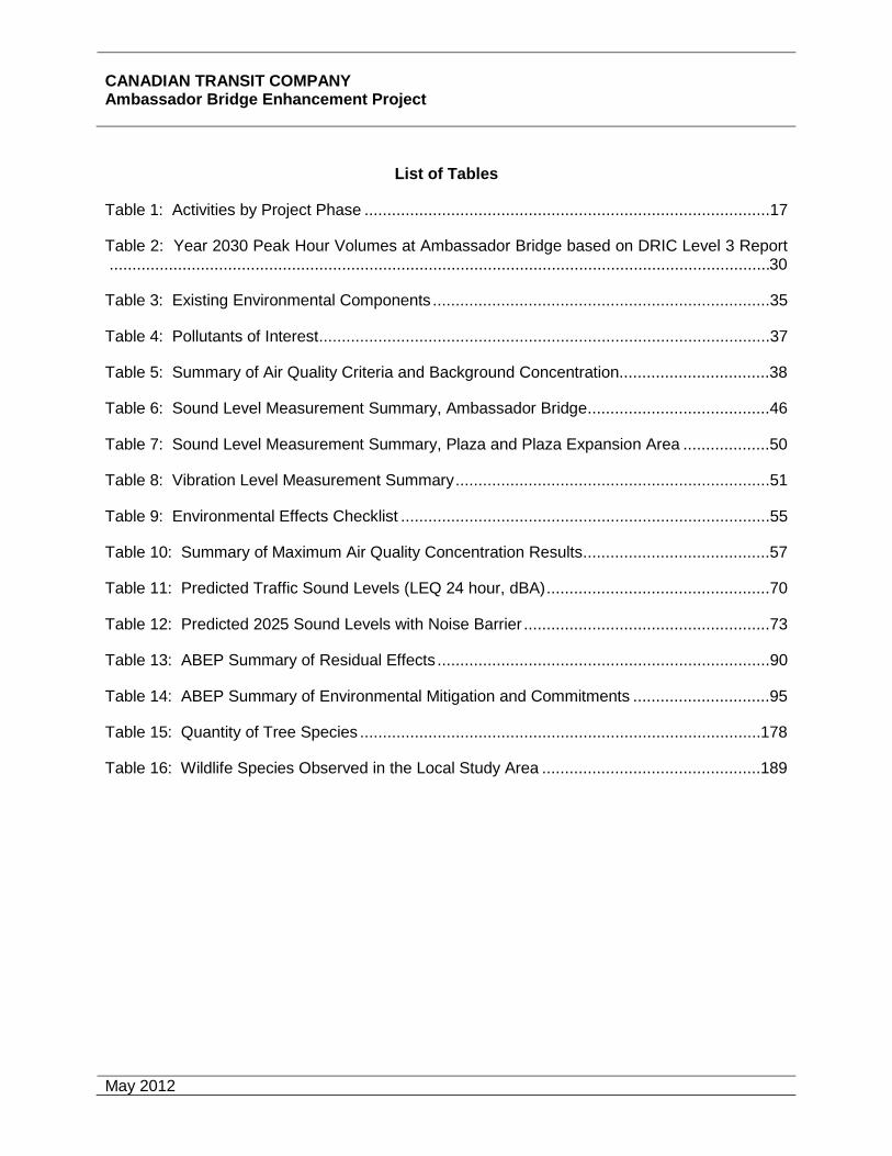
Table 1: Activities by Project Phase .........................................................................................17
Table 2: Year 2030 Peak Hour Volumes at Ambassador Bridge based on DRIC Level 3 Report .................................................................................................................................................30
Table 3: Existing Environmental Components ..........................................................................35
Table 4: Pollutants of Interest ...................................................................................................37
Table 5: Summary of Air Quality Criteria and Background Concentration.................................38
Table 6: Sound Level Measurement Summary, Ambassador Bridge ........................................46
Table 7: Sound Level Measurement Summary, Plaza and Plaza Expansion Area ...................50
Table 8: Vibration Level Measurement Summary .....................................................................51
Table 9: Environmental Effects Checklist .................................................................................55
Table 10: Summary of Maximum Air Quality Concentration Results .........................................57
Table 11: Predicted Traffic Sound Levels (LEQ 24 hour, dBA) .................................................70
Table 12: Predicted 2025 Sound Levels with Noise Barrier ......................................................73
Table 13: ABEP Summary of Residual Effects .........................................................................90
Table 14: ABEP Summary of Environmental Mitigation and Commitments ..............................95
Table 15: Quantity of Tree Species ........................................................................................ 178
Table 16: Wildlife Species Observed in the Local Study Area ................................................ 189
CANADIAN TRANSIT COMPANY Ambassador Bridge Enhancement Project
May 2012
List of Appendices
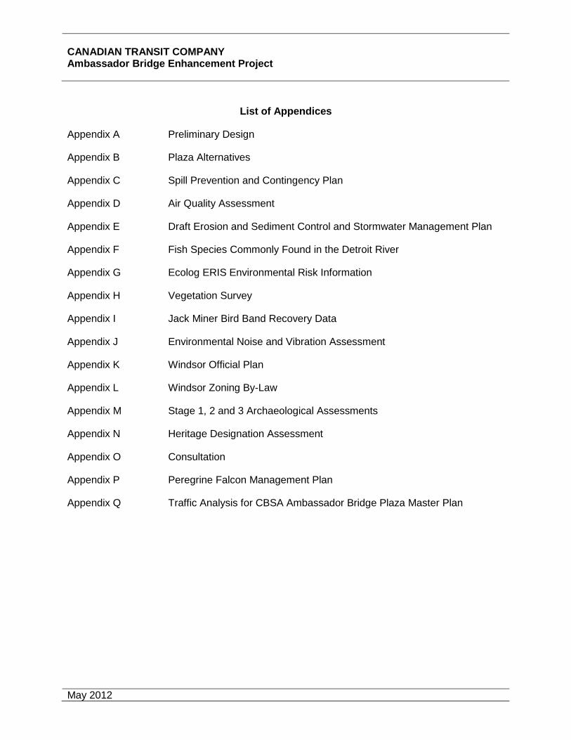
Appendix A Preliminary Design
Appendix B Plaza Alternatives
Appendix C Spill Prevention and Contingency Plan
Appendix D Air Quality Assessment
Appendix E Draft Erosion and Sediment Control and Stormwater Management Plan
Appendix F Fish Species Commonly Found in the Detroit River
Appendix G Ecolog ERIS Environmental Risk Information
Appendix H Vegetation Survey
Appendix I Jack Miner Bird Band Recovery Data
Appendix J Environmental Noise and Vibration Assessment
Appendix K Windsor Official Plan
Appendix L Windsor Zoning By-Law
Appendix M Stage 1, 2 and 3 Archaeological Assessments
Appendix N Heritage Designation Assessment
Appendix O Consultation
Appendix P Peregrine Falcon Management Plan
Appendix Q Traffic Analysis for CBSA Ambassador Bridge Plaza Master Plan

CANADIAN TRANSIT COMPANY Ambassador Bridge Enhancement Project
May 2012
ENVIRONMENTAL IMPACT STATEMENT
SUMMARY
A. PROJECT IDENTIFICATION
Project Title / Type: Replacement Span and Plaza Expansion
Cost Estimate: Approximately $600 million
Project Location: City of Windsor, Ontario, Canada
Project Scheduling:
• Estimated Work Start Date: Spring 2013
• Estimated Work Completion Date: Fall 2015
• Estimated Transfer Date (if applicable): N/A
CEAA Trigger: Federal Permit required under Navigable Waters Protection Act and crossing of lots owned by Windsor Port Authority.
EA Start Date: July 18, 2006
CEAR No.: 06-10-21100 TC File No.:
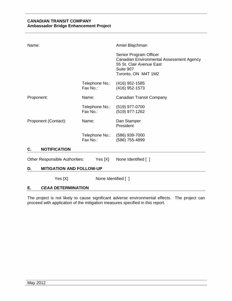
B. CONTACTS
Transport Canada: Name: Ms. Cathy Hainsworth Manager, Environmental Assessment Surface Infrastructure Programs
Transport Canada Place de Ville (AHSA) Tower C 330 Sparks St. Ottawa, ON K1A 0N5 Telephone No.: (613) 990-5792 Fax No.: (613) 990-9369
Other Agencies (Contact): Name: David Cree President and Chief Executive Officer Windsor Port Authority #502 Westcourt Place Windsor, ON N9A 6V2
Telephone No. (519) 258-5741 Fax No.: (519) 258-5905
CANADIAN TRANSIT COMPANY Ambassador Bridge Enhancement Project
May 2012
Name: Amiel Blajchman
Senior Program Officer Canadian Environmental Assessment Agency 55 St. Clair Avenue East Suite 907 Toronto, ON M4T 1M2
Telephone No.: (416) 952-1585 Fax No.: (416) 952-1573
Proponent: Name: Canadian Transit Company
Telephone No.: (519) 977-0700 Fax No.: (519) 977-1262
Proponent (Contact): Name: Dan Stamper President
Telephone No.: (586) 939-7000 Fax No.: (586) 755-4899
C. NOTIFICATION
Other Responsible Authorities: Yes [X] None Identified [ ]
D. MITIGATION AND FOLLOW-UP
Yes [X] None Identified [ ]
E. CEAA DETERMINATION
The project is not likely to cause significant adverse environmental effects. The project can proceed with application of the mitigation measures specified in this report.

CANADIAN TRANSIT COMPANY Ambassador Bridge Enhancement Project
May 2012
1
1.0 PROJECT DESCRIPTION
This report is a Screening-Level Environmental Assessment for the construction and operation of a new international bridge across the Detroit River parallel to the existing Ambassador Bridge (interim improvements) and expansion of the Windsor Plaza (ultimate improvements) at some time in the future, if and when necessary (“Project”). The new bridge crossing will connect into the existing plazas and infrastructure in both Canada and the United States. Improvements to the plazas are not necessary to accommodate the additional span. However, in response to requests made by the Canadian Border Services Agency (CBSA), the Canadian Transit Company (CTC) has included in this report an assessment of the environmental impacts related to expanding the current Windsor Plaza. For purposes of evaluating the environmental impacts of the ABEP, a worst-case scenario was used that assumed both the plaza and bridge would be under construction and operation at the same time. The concept plans for the alternatives developed by CBSA for the plaza expansion are included in Appendix B. Transport Canada and the Windsor Port Authority, the federal Responsible Authorities ("RA") delegated preparation of the Environmental Impact Statement ("EIS") to the Canadian Transit Company, the Proponent. Avalon Consulting, with the assistance of PLW Planning and Environmental Consulting, Ortech Environmental, HGC Engineering, Museum of Ontario Archaeology and N. K Becker Incorporated ("Study Team") have undertaken this EIS on behalf of CTC. The EIS also provides responses to issues raised by the public and reviewers of the Project including Transport Canada and Environment Canada.
1.1 Project Description
The Ambassador Bridge is one of the busiest international border crossings in North America and a vital link for both Canada and the United States. The Ambassador Bridge corridor served approximately 7.2 million vehicles in 2010 with 2.7 million of those being trucks and buses.
The Ambassador Bridge that links the City of Windsor with the City of Detroit became operational on November 11, 1929. When the Ambassador Bridge was constructed it was state-of-the-art for the twentieth century. Eighty-one years later, the Ambassador Bridge continues to stand as a majestic structure on the Windsor-Detroit sky line.
The Ambassador Bridge was built with private sector funds in 1929 and continues to be a safe border crossing and functions as one of the busiest international crossings. It is critical to plan for the future with the proposed replacement span taking into account the importance of this international crossing, the level of use, and the age of the Ambassador Bridge.
Twenty-five percent of Canada's imports and exports flow over the existing Ambassador Bridge. There is no question that this crossing is a vital link in the local and national economy. Tens of thousands of jobs are supported directly or indirectly by the Ambassador Bridge.
The CTC is proposing to construct a new six-lane cable-stayed bridge, located approximately 30.5 metres (100 feet) west of the centre line of the existing Ambassador Bridge to the centre line of the proposed bridge which is referred to as the replacement span. The proposed cable-stayed construction is state-of-the-art construction for the twenty-first century and will create another magnificent landmark for the Windsor-Detroit sky line. The construction of the
CANADIAN TRANSIT COMPANY Ambassador Bridge Enhancement Project
May 2012
2
replacement span is considered the interim improvement and will occur in Phase I of the Project.
The proposed bridge will connect to the existing plazas in Canada and the United States. Improvements will be made to the plaza in Canada as shown in the drawings contained in Appendix B. All impacts from the plaza reconstruction and operation are included in the Environmental Assessment for the second span and will be constructed once the final design is developed between CBSA and CTC. No further modifications are required to the plaza in Detroit.
The existing Ambassador Bridge is over eighty years old, and it is no longer economical to operate without undertaking significant upgrades to continue to move traffic efficiently. Also, the Ambassador Bridge lacks dedicated FAST/NEXUS lanes, an amenity that has been requested by the Customs authorities of both the United States and Canada. It is not feasible to widen the structure of the existing Ambassador Bridge to accommodate the addition of these lanes. The original safety shoulders constructed eighty-one years ago, no longer meet current standards. The construction of the replacement span will improve traffic flow, mitigate noise impacts and air pollution, and be safer for drivers, while ensuring the continued viability of this vital international corridor.
The proposed Project, similar to the Ambassador Bridge, will be funded entirely through private funds, meaning that no municipal, state, provincial, or federal tax funds are required. The construction of the proposed Project will maintain southwestern Ontario's world class international corridor and keep vehicular traffic flowing efficiently and effectively across the Windsor-Detroit border.
The Project is a bridge approximately 2,130 metres (7,000 feet) in length with about 670 metres (2,200 feet) traversing the Detroit River from tower to tower. The bridge will be a minimum of 46 metres (152 feet) in height above the Detroit River, with the same minimal clearance of the existing Ambassador Bridge and have no impacts on navigational clearance requirements of either Canada or the United States. The location of the Canadian tower will be approximately 30.5 metres (100 feet) south of the Detroit River and the United States tower will be situated approximately 30.5 metres (100 feet) north of the Detroit River. The height of each tower will be approximately 177.6 metres (582 feet) above existing ground level. The total width of the bridge will be approximately 31 metres (102 feet). Each of the six lanes will be 3.6 metres (12 feet) wide. The proposed Project is planned to be wide enough to accommodate two shoulders in each direction. The outside shoulders will be 1.8 metres (6 feet) wide and the inside shoulders 2.4 metres (8 feet) wide. There is no pedestrian sidewalk proposed for the replacement span (see preliminary plans in Appendix A).
The replacement span is proposed to be a cable-stayed bridge that will be supported on cast-in-place concrete substructure elements with foundations on bedrock. The proposed Project will have six-lanes and new safety shoulders and will be able to accommodate modern vehicles. The central median barrier will offer more safety, and the proposed six-lane design will facilitate better traffic flow back and forth across the border. Two of the six lanes will be dedicated to the low-risk FAST/NEXUS traffic, allowing for faster clearance of that traffic and leaving four lanes for general and non-FAST commercial traffic.

CANADIAN TRANSIT COMPANY Ambassador Bridge Enhancement Project
May 2012
3
The Ambassador Bridge will remain standing and continue to act as a landmark for the City of Windsor area. Once the proposed replacement span is operational, the existing Ambassador Bridge will be taken out of service. It will then be rehabilitated, maintained and used for redundancy and emergency traffic and approved public events.
The plaza in Windsor was recently modified to include nine additional Primary Inspection Lanes (PIL) both within the original plaza footprint and on the west side of Huron Church Road. These improvements were completed in 2007. Ultimate improvements to the plaza could include, at some point in the future, moving secondary inspection services back to the plaza along with commercial inspection area and office, traveler office and inspection parking spaces, additional Primary Inspection Lanes (PIL), and a Vehicle and Cargo Inspection System (VACIS) (see plaza expansion concept alternatives in Appendix B).
In addition, a green space will be developed between the plaza and the nearby community of Sandwich on the east side of Indian Road. This green buffer area will create a security buffer around the Windsor Plaza while providing additional green space for the community.
The proposed replacement span is anticipated to cost approximately $600 million dollars of private funds. This estimated cost includes the property acquisition along with the construction of the entire replacement span including the linkages into the existing Canadian and United States' plazas and the ultimate plaza expansion.
Section 4.0 of this EIS describes the existing environmental features of the site proposed for the replacement span and additional space required for the ultimate improvements to the plaza. Section 5.0 describes the environmental effects along with any proposed mitigation measures for the Project and ultimate improvements to the Windsor Plaza. The Project has very minor environmental impacts and is located within an urbanized area that has been significantly impacted by existing development. Nevertheless potential archaeological finds, stormwater management and sediment and erosion control produce the majority of the Project's potential natural environment impacts, as discussed in Section 5.0 of this Screening Report.
1.2 Project Justification-Need / Alternatives to the Project
1.2.1 Project Justification
The Ambassador Bridge corridor not only serves the transportation needs of the City of Windsor and the City of Detroit, it serves as a major north-south link between the Province of Ontario and the State of Michigan, and the crucial trade link between Canada and the United States. The Ambassador Bridge corridor connects southern Ontario to the U.S. Interstate Highway network.
The continued operation of the Ambassador Bridge corridor is critical to the flow of international trade between Canada and the United States, and connects Canada’s road network with the U.S. interstate highway system. More than one-quarter of Canada – United States surface trade crosses the border in the Detroit area and the majority of this trade is transported by trucks.
The proposed construction and operation of the replacement span along with the removal of the existing Ambassador Bridge from service is not being proposed to expand the capacity of the Ambassador Bridge corridor. In fact, traffic levels at the Ambassador Bridge crossing in 2010

CANADIAN TRANSIT COMPANY Ambassador Bridge Enhancement Project
May 2012
4
were 42% lower than traffic levels in 1999. Instead, the proposed replacement span will allow the Ambassador Bridge corridor to retain, and more efficiently and safely service the vehicles crossing the Ambassador Bridge.
The six-lane, cable-stayed design of the proposed replacement span allows for the efficient and smooth flow of vehicles across the Ambassador Bridge corridor. The proposed FAST/NEXUS lanes along with freer flow of traffic offered by the proposed replacement span will reduce travel time significantly at the Ambassador Bridge corridor. This, in turn, will contribute to the fulfillment of the Federal, Provincial and City’s objective to foster and promote economic development growth.
The purpose of the Project is to:
• Improve the structure to facilitate the movement of vehicles and ensure the continued free flow of goods between Canada and the United States;
• Upgrade efficiency through the provision of FAST/NEXUS lanes;
• Meet current highway standards; and
• Preserve the existing Ambassador Bridge structure.
Improved Structure
The existing Ambassador Bridge continues to be well maintained and is proven to be structurally sound. However, the age of the Ambassador Bridge is eighty-one years old and is increasingly requiring substantial maintenance. The continual maintenance undertaken by the CTC ensures that the Ambassador Bridge remains in operable condition for the commercial and passenger traffic. Maintenance is becoming increasingly difficult and often requires the closure of one lane which reduces the Ambassador Bridge to three lanes and slows the free flow of traffic. The replacement span will provide a six lane crossing, including two lanes dedicated to FAST/NEXUS, and ensure the consistent movement of vehicles across the border.
More Efficient Border Crossing Programs
The Canadian Border Services Agency (“CBSA”) has developed two programs in collaboration with its American counterparts; FAST and NEXUS. The Free and Secure Trade (FAST) program is a joint Canada-United States initiative involving the CBSA and United States Customs and Border Protection (CBP).
The Free and Secure Trade (FAST) program is a joint Canada-United States initiative involving the Canada Border Services Agency and the United States Customs and Border Protection (CBP). FAST supports moving pre-approved eligible goods across the border quickly and verifying trade compliance away from the border. It is a commercial process offered to pre-approved importers, carriers, and registered drivers. Shipments for approved companies, transported by approved carriers using registered drivers, will be cleared into either country with greater speed and certainty, and at a reduced cost of compliance.
FAST, which is based on sound risk management techniques, focuses on greater speed and certainty at the border and reduces the cost of compliance by:

CANADIAN TRANSIT COMPANY Ambassador Bridge Enhancement Project
May 2012
5
• Reducing the information requirements for customs/border clearance;
• Eliminating the need for importers to transmit data for each transaction;
• Dedicating lanes for FAST clearances;
• Reducing the rate of border examinations;
• Verifying trade compliance away from the border; and
• Streamlining accounting and payment processes for all goods imported by approved importers (in Canada only).
NEXUS is designed to expedite the border clearance process for low-risk, pre-approved travellers into Canada and the United States. The CBSA and CBP are cooperating in this joint venture to simplify border crossings for members, while enhancing security.
To become a member in this program, you must:
• Submit an application and go through a registration process;
• Satisfy the eligibility criteria;
• Be admissible in Canada and the United States; and
• Pass risk assessments by both countries.
The FAST and NEXUS programs are designed to facilitate and expedite the movement of low risk commercial goods and travellers across the border.
Without the ability to dedicate a FAST and NEXUS lane on the existing Ambassador Bridge, trucks participating in these pre-clearance programs are forced to wait in line behind the no-participating trucks and other vehicles to reach the customs’ inspection station. The inability to provide a dedicated FAST and NEXUS lane significantly reduces the efficiency of these programs. The proposed replacement span would considerably improve the flow of commercial goods and passenger traffic by allowing the anticipated benefits of the FAST/NEXUS programs to be achieved. Both the Canadian and American customs agencies have requested that the replacement span include a dedicated FAST/NEXUS lane in each direction.
Improved Safety Features
As an eighty-one year old structure, the existing Ambassador Bridge does not reflect modern highway standards. Modern standards dictate that highways be constructed with lanes that are 3.6 metres (12 feet) wide and provide safety shoulders. The existing Ambassador Bridge as constructed in the 1920’s, has 3.0 and 3.35 metre wide lanes (10 and 11 feet) and does not have any safety shoulders. The lack of safety shoulders on the Ambassador Bridge causes significant disruptions in the flow of traffic when a vehicle breaks down or an accident occurs.
The replacement span is proposed to be constructed with safety shoulders on both sides of the outer travel lanes. The travel lanes proposed on the replacement span will be 3.6 metres (12 feet) in width and meet current highway design standards.

CANADIAN TRANSIT COMPANY Ambassador Bridge Enhancement Project
May 2012
6
Preserve the Ambassador Bridge
The Ambassador Bridge will be preserved and is listed as a heritage structure by the Ontario Ministry of Culture and eligible for listing on the United States Register of Historic Places.
When the replacement span becomes operational, the existing Ambassador Bridge will be taken out of service to be rehabilitated and made available as a redundant resource for operational vehicles and emergency situations or approved public events. The redundancy will ensure that the Ambassador Bridge corridor continues to function in its role as a vital border crossing for Canada and the United States and remains functional in all types of situations.
1.2.2 Alternatives to the Project
Since the 1920’s the Ambassador Bridge border crossing has continued to operate an efficient crossing to promote economic development. The objective of the proposed Project is to contribute to the promotion of economic development by improving efficiency while enhancing motorist safety.
Prior to consideration of alignment alternatives, the Study Team considered other possible ways to satisfy travel and freight transport demands and improve safety along the Ambassador Bridge corridor between the Cities of Windsor and Detroit. Four Alternatives to the Project were examined. The following provides a discussion of the Alternatives that were considered.
1. “do nothing” scenario;
2. corridor alternatives;
3. a tunnel alternative; and
4. alternative modes of transportation.
5. As discussed below, these alternatives to the Project failed to achieve the Project objective and were rejected as non-viable alternatives.
1. Do Nothing Scenario
The “do nothing” alternative consists of simply maintaining the existing Ambassador Bridge and continuing with routine maintenance and upkeep.
The inability to provide the dedicated FAST/NEXUS lanes, wider travelling lanes and safety shoulders on the Ambassador Bridge can result in major traffic backups and problems when any impediment to traffic flow is encountered. This problem cannot be resolved with the existing structure and will become compounded over time resulting in an adverse impact on trade and an increase in air and noise pollution due to traffic congestion and idling vehicles.
The economic costs associated with the “do nothing” alternative also continues to increase every year as more and more repairs and maintenance is required on the Ambassador Bridge. It is anticipated that billions of dollars could be lost each year by both Canada and the United States economies as a result of the constraints faced by the Ambassador Bridge and the continued lack of dedicated FAST/NEXUS lanes.
CANADIAN TRANSIT COMPANY Ambassador Bridge Enhancement Project
May 2012
7
The construction of a replacement span, as opposed to improving the Ambassador Bridge, provides all of the advantages of structural redundancy. Currently, should an emergency occur on the Ambassador Bridge, there is no alternative in the vicinity to immediate re-route truck traffic avoiding lengthy and costly delays. The redundancy provided by the proposed replacement span ensures that the Ambassador Bridge corridor remain functional even if a problem were to occur.
The “do nothing” alternative was not considered feasible and did not achieve the Project objective for the following reasons:
• FAST/NEXUS lanes cannot be accommodated;
• on-going maintenance requirements; and
• decreased functionality and safety due to narrow lanes and lack of safety shoulders.
2. Corridor Alternatives
The purpose of the proposed replacement span is to maintain the capacity of the existing Ambassador Bridge corridor and improve efficiency by providing dedicated lanes restricted to low risk trucks, wider lanes, and safety shoulders.
A capacity expansion project is currently underway in the Region where numerous alternative corridors are being explored by the bi-national Detroit River International Crossing Study (“DRIC”). Unlike the proposed replacement span, the stated purpose of DRIC is to provide additional capacity to meet projected future traffic demands.
The purpose of the project is to ensure that the existing Ambassador Bridge continues to provide efficient service and serve the community as it has done for more than eight decades. Recognizing that this corridor is critically important to the economies of both Ontario and Michigan as well as Canada and the United States. Currently, this corridor depends on the efficacy of the eighty-one year old bridge that possesses four lanes of traffic with no safety shoulders. While this bridge continues to perform exceptionally well and is North America's busiest trade corridor, it is unrealistic to expect this structure to indefinitely deliver the major economic benefits to both countries that it has done for decades. The purpose of the Ambassador Bridge Enhancement Project is to simply replace the existing span, ensure the continued operation of the corridor, and improve the functionality of both the span and the plaza.
The proposed Project simply modifies the existing crossing by replacing the lanes of an eighty-one year old structure that connect to the existing plazas in the Cities of Windsor and Detroit. Other alternative corridors are not considered a feasible alternative as they have substantial social and cultural impacts on existing communities, do not represent a cost effective solution and would have substantial socioeconomic and environmental impacts.
3. Tunnel Alternative
The tunnel alternative was assessed and found to have minimal aesthetic impacts on the community and Ambassador Bridge. There are however, several significant disadvantages to the tunnel alternative including the significantly higher construction costs, decreased functionality and increased security concerns.

CANADIAN TRANSIT COMPANY Ambassador Bridge Enhancement Project
May 2012
8
Major engineering challenges make the tunnel alternative impractical and not feasible to construct. A tunnel alternative cannot be constructed in such a manner that it can elevate out from the Detroit River at a 5% grade and connect to the existing Windsor or Detroit plazas while maintaining the current local roadways. Major expansion and reconstruction to both plazas would be required to facilitate the construction of a tunnel.
With a tunnel alternative, the existing plaza cannot support the tunnel, so new plazas in another location will need to be constructed. The requirement for new plaza construction would require substantial intrusion into the urbanized environment on both sides of the border and possibly divide existing communities. Reconstruction of both plazas would unnecessarily increase the overall costs and impacts of the Project and disrupt plaza operations and existing traffic flow.
The environmental impacts of a tunnel are significantly greater than those associated with the replacement span. Tunnels concentrate air pollution at the specific source points where ventilation is provided. The disbursement of the air pollution then takes greater distances and time to reduce the concentrations of air particulates to acceptable levels.
The cost of constructing a tunnel, along with the requirement for new plazas in addition to the environmental effects on air and the existing communities would be significant. Therefore, the tunnel option is not considered a viable alternative.
4. Alternative Modes of Transportation
While other modes of transport such as air transit and marine are available to satisfy the needs of personal travel and commercial transport, the feasibility of using these alternatives must be taken into account. Air and marine transport are considered to be costly alternatives for most travelers and the least sustainable method of travel. The object of the replacement span is to provide a six-lane controlled access border crossing that cannot be met by other modes of transportation. Other modes of transportation are not feasible alternatives to the Project.
1.2.3 Alternative Means of Carrying out the Project
Various alignment alternatives were considered prior to determining the preferable alignment. Alignment alternatives include construction on the same centreline as the existing alignment, east of the existing alignment, west of the existing alignment or in a different corridor entirely.
The selection of the preferable alignment alternative took into account the impacts on both Canada and the United States. The criteria utilized in evaluating the alignment alternatives included:
• environmental impacts;
• relocations;
• impacts during construction;
• economic impact;
• functionality; and
• costs.

CANADIAN TRANSIT COMPANY Ambassador Bridge Enhancement Project
May 2012
9
Replace Ambassador Bridge on Current Alignment
The existing Ambassador Bridge is a suspension bridge with two main catenary cables used to support the structure over the Detroit River. There is no feasible method of replacing the existing Ambassador Bridge in the same location without causing havoc on traffic flows during the construction period. A second structure in the same location would require the Ambassador Bridge to be closed and result in considerable disruptions to trade and commerce between Canada and the United States and does not represent a practical option.
Furthermore, the removal of the Ambassador Bridge is not viewed as a preferable option due to its historical significance. The Ambassador Bridge is listed as a historical structure by the Ontario Ministry of Culture and is eligible for listing on the United States National Register of Historic Places. Upgrading the Ambassador Bridge would compromise the historic integrity of the structure. Other environmental effects of building a new bridge in the existing corridor are expected to be negligible.
The addition of the proposed replacement span, as opposed to improving the Ambassador Bridge, also creates structural redundancy.
Closing the Ambassador Bridge entirely during the construction period is neither desirable nor feasible and taking into account the impacts on the economies of Canada and the United States. Therefore, this alternative was not considered a feasible alignment option.
Construct New Structure on the East Alignment
Construction of a new span immediately to the east of the Ambassador Bridge would require that the replacement span land in the United States in the area where trucks are currently being processed and require the complete reconfiguration and reconstruction of both the Canadian and United States plazas to allow this processing to take place in another location. The east alignment would require the acquisition of several commercial and residential properties to the east of the Windsor Plaza and would have significant impacts on the heritage resource of Assumption Church and encroach into the University of Windsor lands. Huron Church Road would need to be relocated to the west.
This alternative is not feasible due to the significant impacts on heritage resources in the area (Assumption Church) and the University of Windsor. Major reconstruction would be required to the Windsor Plaza, additional acquisitions of existing residential and commercial properties would be necessary and would also result in increased air and noise pollution on sensitive resources. This alternative is not practical from either a functional or economical perspective.
Construct New Structure on the West Alignment
Constructing a new span immediately to the west of the Ambassador Bridge was found to be the preferable alignment during the preparation of this EIS. The west alignment does not require any changes, modifications or expansions to the existing Windsor Plaza.
There are minimum environmental effects from the western alignment before, during and after construction. Environmental impacts are negligible as only the construction of the new span, connecting to the existing plazas is required. Also, no piers are located in the Detroit River.

CANADIAN TRANSIT COMPANY Ambassador Bridge Enhancement Project
May 2012
10
The land required for the Project is already owned by the CTC. The CTC is proposing to develop a green buffer area between the plaza and the nearby community of Sandwich. This green buffer area is part of the Project and is being undertaken by the CTC to create a security buffer around the Windsor Plaza while providing green area. The westerly alignment also moves the traffic flow away from the University of Windsor and Assumption Church and results in a reduction of impacts on these areas as compared to the other alignments considered.
Preferable Alignment
The six-lane cable stayed bridge on the western alignment was selected as the preferable alternative and found to provide the most benefits while having the least amount of impact. The western alignment ranks the highest when considering environmental and economic impacts including construction costs and ranks the highest amongst all the alternatives considered (Figure 1 ranking of alternative alignments).
The purpose of the proposed Project is to maintain the existing Ambassador Bridge corridor and improve operations wherever possible. Higher traffic volumes are not expected as a result of the proposed Project. The purpose of the proposed replacement span is not to add any additional capacity, but to facilitate the flow of traffic. The Replacement span will tie directly into the existing plazas on each side of the border in the first phase of construction. During the 2nd phase, the ultimate plaza build-out will be constructed. The construction of the Replacement span can take place without requiring closure of any local roads while meeting the needs of the Canada Border Services Agency by implementing the FAST/NEXUS and other potential low risk traveler programs.
Plaza Alternatives
The Windsor Plaza was expanded in 2006 to include three additional customs booths and in 2007 work was completed on an additional six customs booths, bringing the total to nine (9) new customs booths at the Windsor Plaza, all within the original plaza footprint and on the west side of Huron Church Road. These improvements have the flexibility to meet current traffic needs. With traffic volumes down 42% since 1999, the existing Windsor Plaza will be able to accommodate the replacement span and will not require additional booths or PIL’s in the reasonably foreseeable future. Several concepts are being considered for the ultimate plaza configuration including the concepts developed by the CBSA and presented in Appendix B. Ultimate improvements to the plaza could include, at some point in the future, moving secondary inspection services on site, commercial inspection area and office, traveler office and inspection parking spaces, additional Primary Inspection Lanes (PIL), and a VACIS (see plaza expansion concept alternatives in Appendix B). The final locations for buildings and parking lots will be made during the design phase. For purposes of this Environmental Study, the ultimate plaza configuration is modeled to determine the environmental impacts associated with the ultimate build-out. The reconstruction and expansion of the plaza will be implemented when traffic and conditions require the improvements take place but all environmental impacts associated with the ultimate plaza configuration are proposed to be designed, permitted and implemented during the first phase of construction.

CANADIAN TRANSIT COMPANY Ambassador Bridge Enhancement Project
May 2012
11
Figure 1: Ranking of Alternative Alignments

CANADIAN TRANSIT COMPANY Ambassador Bridge Enhancement Project
May 2012
12
2.0 CEAA TRIGGER
_________ Transport Canada is the proponent of the Project.
_________ Transport Canada / Infrastructure Canada proposes to fund part or all of the Project.
_________ Transport Canada proposes to sell, lease, or otherwise dispose of land for the Project.
____X____ Transport Canada proposes to issue a permit, approval or other authorization on the CEAA Law List Regulations.

CANADIAN TRANSIT COMPANY Ambassador Bridge Enhancement Project
May 2012
13
3.0 SCOPE OF PROJECT AND SCOPE OF ASSESSMENT
3.1 Scope of Project
Under the Canadian Environmental Assessment Act ("CEAA"), "Scope of Project" refers to those components of the proposal that should be considered part of the Project for the purposes of the assessment. The scope includes physical works and activities.
Transport Canada has confirmed that it is a responsible authority (”RA") under CEAA for this environmental assessment ("EA") as the Project requires an approval under the Navigable Waters Protection Act, which is identified on the Law List Regulations. The Windsor Port Authority ("WPA") has also identified the need for an environmental assessment, as the Project crosses over federal lots in Windsor, Ontario. As the WPA is a Prescribed Authority, the Canada Port Authority Environmental Assessment Regulations apply.
The Project is not described on the Comprehensive Study List Regulations, nor on the Exclusion List Regulations, as a result, section 18(1) requires that Transport Canada and the WPA ensure that a screening-level assessment of the proposed Project is conducted. The proposed Project has not been referred directly to a mediation or panel review.
The Scope of the proposed Project as determined by the responsible authorities (Transport Canada and WPA) includes the following components:
• Construction and operation of a six-lane bridge across the Detroit River, designed to provide navigational clearances in accordance with U.S. and Canadian requirements; preliminary designs have no piers in the water as described in the Ambassador Bridge Proposed Project Report; and
• Construction and operation of any modification and/or expansion of the CBSA Port of Entry Plaza and associated infrastructure, to meet current and future border management requirements of the CBSA over the planning horizon of the border crossing.
• In addition, the study process is moving forward in the United States according to their rules and regulations. The United States Coast Guard is the lead agency for the approval of the environmental studies and they have been provided with all documents and studies that have been requested.
3.2 Scope of Assessment
The study area boundaries for the replacement span and plaza improvements (Project) are defined as the project footprint which extends approximately 2,130 metres (7,000 feet) in length between the Cities of Windsor, Ontario and Detroit, Michigan. The project footprint includes the Windsor Plaza, Indian Road, the area between Indian Road and the plaza as well as one parcel south of Mill Street and one parcel south of College Avenue and north of Millen Street and follows the existing Ambassador Bridge over Wyandotte Street, Peter Street, University Avenue, Sandwich Street, crosses the Detroit River and connects directly to the Detroit Plaza. The total
CANADIAN TRANSIT COMPANY Ambassador Bridge Enhancement Project
May 2012
14
project footprint, including existing and expanded portions, is approximately 243,980 m2 (2,626,179 ft2) in size. The footprint of the proposed bridge only is approximately 25,081 m2 (269,970 ft2) in size. The footprint of the expanded portion for the plaza only (excluding footprint of the existing plaza) is approximately 77,293 m2 (831,975 ft2) in size. The proposed green area along Indian Road is approximately 21,257 m2 (228,808 ft2) in size. The entire Project will add approximately 48,173 m2 of impervious area and 21,257 m2 of green area. Figure 2 depicts the boundaries of the project footprint. Figure 3 depicts the study area boundaries.
The entire Project is located within UTM Zone 17 and falls between the following UTM coordinates:
Location
Northing
Easting
Southwest Corner 329369.288 4684862.145
Southeast Corner 330070.319 4685175.635
Northwest Corner 328729.952 4687565.606
Northeast Corner 328730.983 4687909.096
For the purposes of impact assessment, the study area to be examined will extend approximately 200 metres (657 feet) from the proposed Project footprint. Depending on the factors identified in the section 16(1) of the CEAA and the EA Guidelines dated August 2007 the area of impact assessment will vary according to the study being undertaken and the spatial extent of the potential environmental effects.
The temporal boundary for most analyses included present day, construction (2013-2015) and operation (any time after 2015). The air and noise analyses required a future build date to be analyzed to discern impacts. The air quality analysis identified year 2015 as the construction date and year 2025 as the future build year. Standard practice for an air quality study is to model 20 years in the future after construction is complete. The noise study identified 2010 as the existing year (for current traffic noise impacts) and 2025 as the future build year.
Table 1 generally summarizes the project activities by project phase. For details on each activity and phase, see Sections 5, 6 and 7 of this document. Once the proposed new span is in place, the existing Ambassador Bridge will be rehabilitated. A bridge inspection will be completed at that time to determine what needs to be rehabilitated on the existing Ambassador Bridge.

CANADIAN TRANSIT COMPANY Ambassador Bridge Enhancement Project
May 2012
15
Figure 2: Project Footprint

CANADIAN TRANSIT COMPANY Ambassador Bridge Enhancement Project
May 2012
16
Figure 3: Study Area Boundaries

CANADIAN TRANSIT COMPANY Ambassador Bridge Enhancement Project
May 2012
17
Table 1: Activities by Project Phase
PROJECT PHASE PROJECT COMPONENTS
Core Project Components Ancillary Works Other Projects and Activities
Construction - Stormwater management facility - Preparation of the site, including clearing and grubbing -Demolition of homes - Excavation for footings - Construction of drilled shafts - Installation of piles - Main tower construction - Construction of piers - Cable-stays - Construction of superstructure - Pouring of deck - Pouring of barrier railings - Installation of lighting - Painting and final site cleanup
- Production of concrete - Surplus material management - Equipment storage areas - Material stockpiling - Utility relocation as required - Erosion and sediment control measures
Operation/ Maintenance
- Winter de-icing operations -Operation stormwater management - Infrastructure maintenance - Storm drainage system repairs - Security and perimeter control
-Equipment maintenance/operations
-Surplus material management
Accidents/ Malfunctions
- Vehicular accidents - Spills -Fire Suppression and prevention
Not applicable
3.3 Construction
3.3.1 Cable-Stayed Bridge Construction
The proposed Project crossing the Detroit River will be a three span (Canadian approach, main span, United States’ approach), cable-stayed bridge with a main span length of just under 670 metres (2,200 feet). The superstructure will be constructed by using the balanced cantilever method of construction. Using this method, construction begins at the pylon on each side of the river and reaches out in either direction in repetitive phases until the advancing cantilevers reach the anchor piers in the side spans and the main span cantilevers meet at mid-span. When full cantilevers are constructed, the superstructure is made continuous with the result being the three span cable-stayed bridge.
The superstructure of the new bridge will be a composite steel and concrete deck supported by the stay cables. The principal framing system consists of a longitudinal steel edge girder on each side of the superstructure to carry the primary bending moments along the bridge and

CANADIAN TRANSIT COMPANY Ambassador Bridge Enhancement Project
May 2012
18
contain the anchorage locations for the cable stays. The longitudinal edge girders are connected transversely by steel floor beams spaced at approximately 4.3 metres (14 feet). The deck slab is comprised of 200 millimetres (8 inches) thick precast, pre-stressed concrete panels. The panels are temporarily supported on the steel framing system while cast-in-place concrete pours are made over the edge girders and transverse floor beams to make the system act compositely.
Approach spans that lead up to the cable stayed portion of the structure from the plazas in each country will be constructed concurrently with the construction of the three span cable stayed bridge over the river. In Canada, 10 spans of approximately 45 metres (150 feet) will be required and in the United States three spans will be required to connect the plazas to the cable stayed bridge.
3.3.2 Stages of Construction
There are several stages in any bridge construction project. The components of the proposed Project are interrelated and work in each stage may overlap with work in other stages. Within each stage of the project there are also various activities that will be undertaken. While some of the work is specialized in its nature, equipment and personnel will move between stages of the project.
The stages of construction for this project include: preparation of the site, excavation for the footings, construction of the drilled shafts and installation of the piles, construction of the piers, construction of the superstructure, pouring of the deck overlay, pouring of the barrier railings, installation of the lighting, painting and final cleanup and ultimately the maintenance and operation of the facility.
A first aid safety station will be established at the construction site prior to the commencement of construction on the project. Where feasible, all materials, equipment and supplies will be produced or hired from local sources to minimize shipping and stockpiling requirements.
Tower Pier Foundation Construction
Construction begins by first constructing the foundation system for the two main towers, one on each side of the river. The foundation system consists of drilled shafts approximately 35 metres (120 feet) to 45 metres (140 feet) deep founded in solid bedrock. These shafts are constructed by using a truck or track mounted large diameter rotary auger used to drill through the overburden down and into the rock. The sides of the drilled shaft are braced with a steel casing to prevent the collapse of the hole during and after drilling. Once the hole has been drilled to the planned depth and the casing installed, a round steel reinforcement cage with vertical and horizontal deformed steel bars is placed into the hole. The bars that form the cage for the shaft are tied together near the site and then lifted and placed in the excavated shaft from a truck or track mounted crane. After the steel reinforcement cage is in place, the shaft is filled with high strength concrete delivered to the site by concrete trucks. Approximately eighteen shafts will be required for each tower with each containing about 100 cubic metres (125 cu yds) of concrete. Alternatively, the builder may choose to instead deliver the aggregate, cement and other materials to an on-site concrete batch plant located near the United States Plaza with the concrete then manufactured directly on-site rather than trucked to the construction site from an offsite plant.
CANADIAN TRANSIT COMPANY Ambassador Bridge Enhancement Project
May 2012
19
The concrete is placed using a long flexible tube that extends to the bottom of the shaft so that the concrete is poured beginning at the bottom of the shaft and then extending to the top, thereby preventing any groundwater from being trapped in the shaft.
After all shafts are in place and the concrete has attained its required strength, a footing is constructed over the top of the drilled shafts such that the tops of the shafts extend several feet up into the bottom of the footing to provide a rigid connection. This footing is designed and constructed to distribute the loads to each of the drilled shafts so than no single shaft is overloaded and to provide a flat surface to begin construction of the vertical portion of the tower piers. Construction of the footing begins by placing formwork around the perimeter of the planned footing area followed by the placement and tying of the reinforcement steel placed inside the concrete footing to provide the necessary tensile capacity required to ensure adequate distribution of loads to the drilled shafts. Once the reinforcement has been placed and tied, the concrete is poured inside the perimeter formwork, encapsulating the reinforcement steel and the top several feet of each drilled shaft. Steel reinforcement bars are also placed such that they extend vertically from the top of the concrete footing to provide a positive rigid connection to the vertical tower construction that will begin in the next phase. The estimated volume of concrete required for each of the two tower pier footings is 3,500 cubic metres (4,500 cu yds). Concrete may be delivered to the site in concrete trucks or, the builder may choose to instead deliver the aggregate, cement and other materials to an onsite concrete batch plant located near the United States Plaza.
Pylon Construction
Once the concrete footing has attained adequate strength to receive the dead load from the construction of the vertical portion of the tower, placement and tying of the vertical reinforcement begins. This reinforcement is lapped and tied to the reinforcement bars that extend vertically from the footing that was poured in the previous stage. Once the reinforcement has been placed and tied, the erection of the formwork in the shape of the planned pylon begins.
An alternative method that may be used by the builder is to place and tie the reinforcement cage near the pylon and then use a truck or track mounted crane to lift the cage and place it inside the formwork. Several vertical lifts or phased concrete pours then take place until the pylon has reached its planned height. The total estimated volume of concrete required for the construction of each pylon is on the order of 12,000 cubic metres (15,000 cu yds). Concrete may be delivered to the site in concrete trucks or, the builder may choose to instead deliver the aggregate, cement and other materials to an onsite concrete batch plant located near the United States Plaza.
Pier Table Construction
Upon completion of the construction of the tower pier pylon, erection of the cable-stayed superstructure in the main span of the bridge begins. The first structural elements to be erected are the steel edge girders and transverse floor beams that make up the Pier Table. The Pier Table consists of one edge girder on each side of the superstructure with four transverse floor beams spaced at approximately 4.3 metres (14 feet) bolted to the edge girders. The longitudinal edge girders weigh an estimated 1,200 kilograms per metre (800 lbs/ft) near midspan and 1,500 kilograms per metre (1,000 lbs/ft) near the pylon and the transverse floor beams approximately

CANADIAN TRANSIT COMPANY Ambassador Bridge Enhancement Project
May 2012
20
16,000 kilograms (35,000 lbs) each. Bracing will also be required in each bay to stabilize the superstructure framing and to aid in the erection of the segments. The Pier Table provides a stable working area from which balanced cantilever construction can begin. These steel girders are fabricated offsite and then trucked with one girder per truck to the construction site where they will be raised to their final position from a crane located on the ground near the base of the tower piers.
As shown in Figure 4, the Pier Table extends for some distance in either direction from the pylon in cantilever. Temporary supports are erected to provide overturning stability to the Pier Table. The temporary supports can extend the full distance to the ground as shown in Figure 4, or they can be configured as a moment resisting frame between the Pier Table and pylon. The moment resisting frame option requires that the pylon base resist out of balance moments in flexure, therefore, the pylon will need to be designed and constructed to be capable of resisting such moments.
Once all of the girders are erected and temporarily supported, the construction of the Pier Table is completed by the placement of precast concrete deck panels and cast-in-place concrete to provide composite behaviour. An estimated 200 cubic metres (250 cu yds) of concrete is required to construct the pier table at each pylon. These items are delivered by truck and lifted into place from a crane on the ground.
Figure 4: Pier Table Construction
Balanced Cantilever Construction
Balanced cantilever construction begins after completion of the Pier Table. Traveling derrick cranes or erection girders are assembled on the Pier Table and positioned to lift superstructure members on either side of the pylon. Typical cycles of construction take place from stay cable to stay cable with segments added on alternating ends of the cantilever to balance the load as close as possible on each side of the pylon.
A typical cycle of construction begins with the advancement of the derrick cranes to the free end of the cantilevers. Depending on the size and weight of the segment to be erected between the stay cables, the segment could be partially assembled in the shop or at the site prior to delivery to the end of the cantilever. For the back span cantilevers located over land, the materials are delivered via trucks and for the main span cantilever extending over the river, the materials are delivered via barges using the waterway.
Cables are lowered from the derrick cranes located on the cantilever to the girders on the truck or barge where they are connected to the section which is then raised to the deck level and secured to the end of the cantilever using bolted splices. If the section was not fully assembled ahead of time, the cranes then lift the transverse floor beams which are bolted to the longitudinal edge girders. For segments located over the waterway which are to be delivered via barges, delivery times and durations are carefully coordinated with shipping interests to
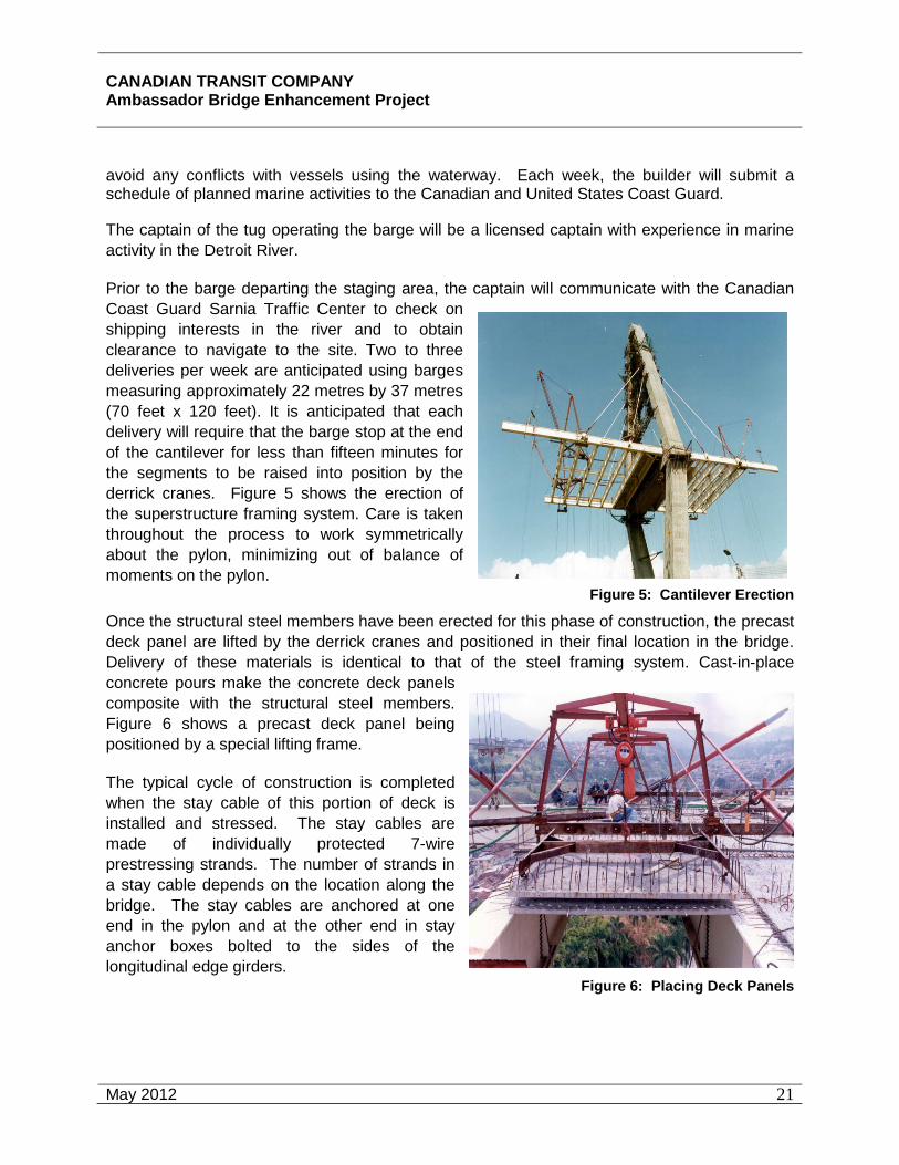
CANADIAN TRANSIT COMPANY Ambassador Bridge Enhancement Project
May 2012
21
avoid any conflicts with vessels using the waterway. Each week, the builder will submit a schedule of planned marine activities to the Canadian and United States Coast Guard.
The captain of the tug operating the barge will be a licensed captain with experience in marine activity in the Detroit River.
Prior to the barge departing the staging area, the captain will communicate with the Canadian Coast Guard Sarnia Traffic Center to check on shipping interests in the river and to obtain clearance to navigate to the site. Two to three deliveries per week are anticipated using barges measuring approximately 22 metres by 37 metres (70 feet x 120 feet). It is anticipated that each delivery will require that the barge stop at the end of the cantilever for less than fifteen minutes for the segments to be raised into position by the derrick cranes. Figure 5 shows the erection of the superstructure framing system. Care is taken throughout the process to work symmetrically about the pylon, minimizing out of balance of moments on the pylon.
Figure 5: Cantilever Erection
Once the structural steel members have been erected for this phase of construction, the precast deck panel are lifted by the derrick cranes and positioned in their final location in the bridge. Delivery of these materials is identical to that of the steel framing system. Cast-in-place concrete pours make the concrete deck panels composite with the structural steel members. Figure 6 shows a precast deck panel being positioned by a special lifting frame.
The typical cycle of construction is completed when the stay cable of this portion of deck is installed and stressed. The stay cables are made of individually protected 7-wire prestressing strands. The number of strands in a stay cable depends on the location along the bridge. The stay cables are anchored at one end in the pylon and at the other end in stay anchor boxes bolted to the sides of the longitudinal edge girders.
Figure 6: Placing Deck Panels

CANADIAN TRANSIT COMPANY Ambassador Bridge Enhancement Project
May 2012
22
The stay cables vary in length with the shortest stays being approximately 65 metres (210 feet) long and the longest approximately 340 metres (1100 feet). Figure 7 shows a typical stay cable anchored in a stay anchor box.
Erection of individual segments followed by installation and stressing of the stay cables continues in a balanced fashion until the two main span cantilevers nearly meet in the middle.
Figure 7: Stay Cable Anchor at Deck Level
Back Span and Main Span Continuity
The optimum layout of a three span cable-stayed bridge typically uses back span lengths that are between 40% and 45% of the main span length. The site conditions and setting of the proposed Project allows for this optimal span layout. As a result, as balanced cantilever construction continues, the leading edges of the cantilevers will reach the anchor piers in the back spans before they meet in the middle of the main span. When the back span reaches the anchor piers, the superstructure is tied down to counteract overturning moments as the main span cantilevers are completed. Back stays that reach from the top of the pylon to the superstructure above the anchor piers are stressed and adjusted as necessary while construction continues. Figure 8 is an example of the back span continuity.
Figure 8: Back Span Continuity
Once the main span cantilevers extend sufficiently close to one another, sections of the longitudinal edge girders are erected and spliced at either end to the free ends of the cantilevers making the girders continuous. The remaining floor beams and concrete deck panels are placed and secured. With all members in place, there is typically one last re-stressing of the stay cables to produce the desired state of stress in the bridge. Figure 9 shows a complete three span cable stayed bridge.
Figure 9: Completed Bridge
CANADIAN TRANSIT COMPANY Ambassador Bridge Enhancement Project
May 2012
23
Construction of Approach Spans
Construction of the approach spans will take place concurrently with the construction of the cable stayed spans. In the first construction phase, driven friction piles will be installed in the area where the footing is to be supported. These piles are estimated to be 450 millimetres (18 feet) to 610 millimetres (24 inches) square pre-stressed, precast concrete and approximately 30 metres (100 feet) long.
A total of twelve to eighteen piles supporting three footings are expected at each of the pier locations. After completion of the pile installation, the cast in place concrete footing will be poured. Each footing is estimated to require 45 m3 (60 cu yds) of concrete for a total of 135 m3 (180 cu yds) at each pier. After completion of the footings, the remaining substructure will be formed and poured. An average pier will require approximately 300 m3 (400 cu yds) of concrete. After completion of the substructure the girders will be erected. A total of seven lines of girders spaced at approximately 4 m (14 ft) are expected in each span. Preliminary design indicates that 1.4 m (54 ft) deep pre-stressed, precast concrete beams will be the most effective and each of these girders will be delivered by truck. The forming and placement of reinforcement for the deck construction will follow behind the beam erection. The deck will be cast in place and require an estimated 3,000 cubic metres (4,000 cu yds) in Canada and 900 m3 (1,100 cu yds) in the United States.
Operational Phase
Advantages to cable stayed structures include their inherent durability. Most concrete elements are in a state of compression under routine loading conditions resulting in an additional level of protection against the environment. Consequently, maintenance of the bridge deck and tower is expected to be minimal. The exposed steel components of the bridge will periodically require repainting and the final design of the bridge will include features that aid in future painting operations. Other routine maintenance procedures related to the lighting, striping, sealing and other features that may require routine replacement periodically.
The latest technological advancements will be implemented in the design of the structure to allow its health to be constantly monitored. In addition, the bridge will be thoroughly inspected annually to ensure that any issues related to corrosion or other detrimental affects are discovered early and promptly rectified.
Operations will be significantly upgraded with the addition of dedicated lanes for the low risk commercial travelers that are currently unavailable on the existing bridge. Lane widths are increased from the existing substandard width of 3.0 and 3.35 metre wide lanes (10 and 11 feet) to 3.66 metres (12 feet). Safety shoulders are not present on the existing bridge but will be included on the new bridge. This will allow maintenance and operations personnel to perform their tasks while not affecting the operation of the facility. It will also provide a location for disabled vehicles to reside without significantly impeding traffic flow until they can be safely removed. All other operations of the facility will remain fundamentally unchanged with the existing traffic being simply shifted to the west.
CANADIAN TRANSIT COMPANY Ambassador Bridge Enhancement Project
May 2012
24
During winter months after snow events, the bridge deck is currently plowed and sanded with clean sands to improve traction and safety on the facility. This practice will be continued on the new facility. With the addition of safety shoulders on the new structure, this operation will be greatly improved.
Bridge washing will normally take place in the spring to remove the debris that has accumulated on the bridge deck through the winter. A dry sweep/vacuuming to remove the sands and other debris will be conducted followed by pressure washing if necessary in accordance with current practice.
Plaza Improvements
When traffic volumes and other conditions require the expansion of the plaza, the ultimate plaza layout shown in Appendix B will be constructed. These improvements could include additional parking spaces, commercial inspection area and office, traveler office and inspection parking spaces, additional Primary Inspection Lanes (PIL), and VACIS. This construction will involve the excavation and removal of the existing topsoil followed by the compaction of the existing ground prior to placing about 6,500 tons of poured in place concrete to construct the pavement in the parking areas. One and two story building will be constructed utilizing slab on grade construction methodologies.
3.4 Operations
All necessary precautions will be taken to prevent the occurrence of malfunctions and accidental events that may occur throughout all phases of the Project and to minimize environmental effects should they occur.
Accidental events with the greatest potential for environmental effects include:
• spills of hydrocarbons or other hazardous materials;
• failure of erosion and sediment control measures;
• fires;
• vehicular collisions; and
• possible disturbance of archaeological resources.
It is extremely difficult to predict the precise nature and severity of these events. However, the likelihood of serious accident events or those causing significant adverse environmental effects is low, particularly since the construction and operation procedures for the proposed replacement span will be conducted with in accordance to all applicable and relevant regulations, guidelines and accepted industry procedure.
Accidents
Accidents that may occur during construction, operation and maintenance of the replacement span and improved plaza are addressed by provincial legislation, policies and procedures. Any accidents that occur in the Windsor Plaza or Canadian side of the replacement span will be immediately reported to the Windsor Police Department. The Windsor Police Department is

CANADIAN TRANSIT COMPANY Ambassador Bridge Enhancement Project
May 2012
25
responsible for producing a formal accident report. The proposed replacement span and plaza improvements will improve traffic safety and operations and will reduce vehicular accidents within the project limits.
If any vehicular accidents occur during the construction phase they will be immediately reported to the Windsor and / or Detroit City Police who are responsible for producing accident reports. The proposed Project will increase traffic safety and operations and will reduce vehicular accidents within the project limits.
Hazardous Material Spill
On-site spills or accidental releases of pollutants or contaminants could result from releases of fuels, hydrocarbons (i.e. hydraulic oil, motor oil, etc), or antifreeze from construction machinery or a barge capsizing or sinking. Accidents involving motorists and marine operators are also possible. These spills are usually highly localized and easily cleaned up by onsite crews using standard equipment. In the unlikely event of a large spill, soil contamination may occur thereby potentially adversely affecting the quality of the surrounding land uses. Groundwater and surface water contamination may also occur in the event of a large spill, however this is unlikely given the site conditions. In the unlikely event of an accident with a barge, there is the potential for adverse effects to surface water, fish and fish habitat and navigation.
CTC will design erosion and sediment control systems for bridge construction during the design phase of this project to ensure best construction practices are employed to reduce the potential for spills to contaminate the ground or surface water. Maintenance, fuelling and storage will occur at least 30 m from watercourses/ drains. This will ensure that impacts on the Detroit River from sedimentation and erosion are avoided during construction. During operation, all runoff from the bridge will be collected and directed to either a new stormwater treatment facility or will be tied into existing stormwater collection systems wherever possible. This will prevent impacts on aquatic organisms from road runoff contaminants including particulates, metals, organic compounds, oils and grease, thermal pollutants and salts. The system will also ensure that any materials spilled as a result of motor vehicle accidents are collected and conveyed to the appropriate treatment facility.
The Spills Prevention and Contingency Plan in Appendix C contains the best management practices to minimize the likelihood of a spill. Spills of hydrocarbons or other hazardous materials will be handled in accordance with applicable regulations and procedures and in full compliance with all legislative requirements.
If a spill occurs in the Detroit River, the potential for short term toxicity to juvenile aquatic species does exist. However, with no substructure elements for the new bridge located in the Detroit River and the superstructure at a higher elevation than the existing bridge, spills from waterborne vessels as a result of collision with the new structure are not possible. Therefore, spill volumes are limited to that which can be transported on the highway system. Based on the operational history of the existing facility, proposed stormwater collection facility on the proposed bridge, and the velocities within the Detroit River, the mortality rate for mature aquatic species is not expected to increase and effects will be negligible.
Construction equipment will be inspected frequently to ensure no possible fuel and hydraulic system leaks. Any leaks discovered will be repaired immediately. Refuelling and equipment

CANADIAN TRANSIT COMPANY Ambassador Bridge Enhancement Project
May 2012
26
maintenance will be conducted away from residential and known cultural or heritage properties, and not within 30.5 metres (100 feet) of the Detroit River.
The CTC also has the ability to block catch basins resulting in the prevention of access to the stormwater management system. The proposed oil and grit separators provide for a measure of spill control with the provision of approximately 37,850 litres (10,000 US gallon) total volume for spill containment.
In the unlikely event of larger spills, such as major accidents during operation, the appropriate emergency response procedures will be utilized to minimize potential environmental effects including provisions for containment at outfall locations such as turbidity barrier for containment at the outfall location and inflatable bag plugs for closing off storm drain outlets. Emergency response and contingency planning are accepted and effective means to limit the severity of environmental effects. These plans and procedures will be implemented in accordance with the Spills Prevention and Contingency Plan and supported through training programs. With the implementation of this mitigation, the likelihood of a spill that would cause short-term toxicity to juvenile fish species is low.
Erosion, Sediment and Stormwater Discharge
A potential exists for failure of erosion and sediment control structures due to heavy precipitation events. Such a failure could result in a release of a large quantity of sediment-laden runoff with potential adverse effects on fish and fish habitat.
The most probable accidents that could occur are the spillage of brine groundwater and the loss of control and excessive discharge of stormwater runoff. Possible failure of the containment system for groundwater containing high dissolved solids or sediment laden runoff discharging into the Detroit River will also negatively impact fish and fish habitat, in addition to an increased pH for affected soils until remediation occurs.
Given the low hydraulic conductivity of the soils/fill in the Project area and the absence of a shallow water table in the over burden the risk of brine groundwater contaminating other groundwater sources is very low.
A Stormwater Management Plan will be developed during final design of the Project to accommodate runoff and will be tailored to accommodate the various grading and elevation changes that may occur during construction. The existing facility is currently connected to the City of Windsor’s storm and sewer system. During the design phase, the intent for the Project is to simply modify the connections as necessary to maintain this connection to the City’s system. The Stormwater Pollution Prevention Handbook will be consulted to assist in the development of the Stormwater Management Plan. The Plan will be designed to prevent the discharge of sediment and other construction debris into the waters of the Detroit River. This Plan will be developed to accommodate runoff that will occur during the operation of the project. It will be tailored to accommodate the amount of stormwater runoff that will be generated by the increase in impervious surface as a result of the deck of the bridge. Stormwater runoff will be managed in such a way as to limit the amount to the levels that were present at the predevelopment stage. Stormwater will be treated at an “Enhanced” level as described in the MOE’s Stormwater Management Manual and in accordance with the applicable regulatory standards.

CANADIAN TRANSIT COMPANY Ambassador Bridge Enhancement Project
May 2012
27
The CTC has operated the current Ambassador Bridge in an incident free manner since the opening of the bridge. No structural failures of any of the bridge components have occurred to cause an accident or malfunction in over eighty-one years.
An erosion and sediment control plan along with a stormwater management plan will be implemented to reduce the potential for the accidental discharge of sediment or excessive erosion.
Fire and Explosion
Fires may result in habitat loss, sensory disturbance, direct mortality to wildlife, loss or damage of property, and loss or damage to archaeological and heritage resources. Material management including fuel and other hazardous materials and operational procedures including storage, handling and transfer will reduce the potential for and extent of accidental fires related to the Project. In the unlikely event of a fire, local emergency response and fire-fighting capability will be able to reduce the severity and extent of damage. Fire prevention procedures are considered in the Spills Prevention and Contingency Plan.
Given the volume of fuel contained in vehicles and equipment, the severity of the discharge would be minor and quickly dissipate.
Disturbance of Archaeological Features
The possibility of encountering archaeological features within the project area does exist given the known history of the study area. A thorough Stage 1, 2, and 3 investigation by a licensed archaeologist have been completed. In the unlikely event that historically significant areas are encountered, work will be stopped immediately and a licensed archaeologist will be consulted to evaluate the situation and provide guidance to minimize project effects.
Any and all construction activities undertaken in the Study Area shall be monitored by a licensed archaeologist.
Taking into consideration the urban nature of the Project area and the level of disturbance that occurred during the construction of the original Ambassador Bridge it is unlikely that the proposed Project will further degrade the archaeological and cultural heritage of the area.
3.5 Traffic
One purpose of the ABEP is to upgrade the existing crossing to meet current regulatory standards for lane and shoulder widths and to include FAST lanes on the new structure at the request of the U.S. and Canadian governments. Recent traffic studies have been completed for the Detroit River International Crossing Study (DRIC), the bi-national study for a new crossing of the Detroit River. The DRIC Study participants are the Transport Canada, Ontario Ministry of Transportation, Federal Highway Administration, and the Michigan Department of Transportation. Three relevant reports have been posted on the DRIC website at http://www.partnershipborderstudy.com/. The first report, “Detroit River International Crossing Study Travel Demand Forecasts” was completed in September 2005 and established the total cross border unconstrained travel demand. Since these are the demand volumes, they
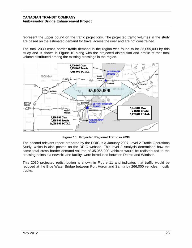
CANADIAN TRANSIT COMPANY Ambassador Bridge Enhancement Project
May 2012
28
represent the upper bound on the traffic projections. The projected traffic volumes in the study are based on the estimated demand for travel across the river and are not constrained.
The total 2030 cross border traffic demand in the region was found to be 35,055,000 by this study and is shown in Figure 10 along with the projected distribution and profile of that total volume distributed among the existing crossings in the region.
Figure 10: Projected Regional Traffic in 2030
The second relevant report prepared by the DRIC is a January 2007 Level 2 Traffic Operations Study, which is also posted on the DRIC website. This level 2 Analysis determined how the same total cross border demand volume of 35,055,000 vehicles would be redistributed to the crossing points if a new six lane facility were introduced between Detroit and Windsor.
This 2030 projected redistribution is shown in Figure 11 and indicates that traffic would be reduced at the Blue Water Bridge between Port Huron and Sarnia by 266,000 vehicles, mostly trucks.
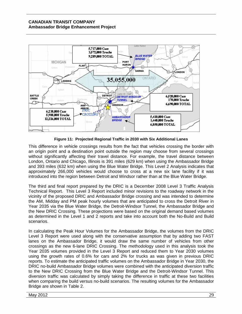
CANADIAN TRANSIT COMPANY Ambassador Bridge Enhancement Project
May 2012
29
Figure 11: Projected Regional Traffic in 2030 with Six Additional Lanes
This difference in vehicle crossings results from the fact that vehicles crossing the border with an origin point and a destination point outside the region may choose from several crossings without significantly affecting their travel distance. For example, the travel distance between London, Ontario and Chicago, Illinois is 391 miles (629 km) when using the Ambassador Bridge and 393 miles (632 km) when using the Blue Water Bridge. This Level 2 Analysis indicates that approximately 266,000 vehicles would choose to cross at a new six lane facility if it was introduced into the region between Detroit and Windsor rather than at the Blue Water Bridge.
The third and final report prepared by the DRIC is a December 2008 Level 3 Traffic Analysis Technical Report. This Level 3 Report included minor revisions to the roadway network in the vicinity of the proposed DRIC and Ambassador Bridge crossing and was intended to determine the AM, Midday and PM peak hourly volumes that are anticipated to cross the Detroit River in Year 2035 via the Blue Water Bridge, the Detroit-Windsor Tunnel, the Ambassador Bridge and the New DRIC Crossing. These projections were based on the original demand based volumes as determined in the Level 1 and 2 reports and take into account both the No-Build and Build scenarios.
In calculating the Peak Hour Volumes for the Ambassador Bridge, the volumes from the DRIC Level 3 Report were used along with the conservative assumption that by adding two FAST lanes on the Ambassador Bridge, it would draw the same number of vehicles from other crossings as the new 6-lane DRIC Crossing. The methodology used in this analysis took the Year 2035 volumes provided in the Level 3 Report and reduced them to Year 2030 volumes using the growth rates of 0.6% for cars and 2% for trucks as was given in previous DRIC reports. To estimate the anticipated traffic volumes on the Ambassador Bridge in Year 2030, the DRIC no-build Ambassador Bridge volumes were combined with the anticipated diversion traffic to the New DRIC Crossing from the Blue Water Bridge and the Detroit-Windsor Tunnel. This diversion traffic was calculated by simply taking the difference in traffic at these two facilities when comparing the build versus no-build scenarios. The resulting volumes for the Ambassador Bridge are shown in Table 2.

CANADIAN TRANSIT COMPANY Ambassador Bridge Enhancement Project
May 2012
30
AM PeakMidday PeakPM PeakAM PeakMidday PeakPM PeakAM PeakMidday PeakPM PeakAM PeakMidday PeakPM Peak
126212582732497
55796410
363521762008
3590305442625255
17968589351071
4403340316203000
Total PCE's
US to Canada Canada to US Total350725
508 602
646765
Cars
Trucks
Total
2830137124802130
16831432
612
20651110
Year 2030 Peak Hour Volumes Ambassador Bridge Only - Including Diversion from BWB and DWT
Table 2: Year 2030 Peak Hour Volumes at Ambassador Bridge based on DRIC Level 3 Report
* 1 Truck = 2.5 PCE (Passenger Car Equivalents)
Based on an analysis of this Level 3 Report, the PM peak hour shows the worst case in terms of total traffic with approximately 1,432 trucks and approximately 2,830 cars resulting in 6410 PCE’s crossing the Ambassador Bridge during the year 2030 PM peak hour.
For purposes of evaluating the environmental impacts of the ABEP, a worst-case scenario was used. Specifically, the entire projected demand-based volumes from the DRIC studies were used without reduction. These unconstrained demand-based volumes were then inflated by the entire additional volume predicted to be captured from the Blue Water Bridge and the Detroit-Windsor Tunnel by the DRIC Level 2 and 3 Analysis, even though the ABEP would only add two lanes to the system, rather than the six lanes assumed in the DRIC analysis and even though those two additional lanes at the Ambassador Bridge are restricted to FAST traffic. Based on these conservative assumptions, an upper bound 2030 volume using the ABEP is established at 7,358,000 trucks and 9,113,000 cars for a total of 16,471,000 vehicles.
Since the unconstrained demand volumes were used, as well as the entire volume redistributed from the Blue Water Bridge and the Detroit-Windsor Tunnel, this volume is reasonably considered the upper bound for cross border traffic at the Ambassador Bridge. In fact, the actual 2007 volumes experienced at the Ambassador Bridge were approximately 15% lower than that projected in the 2004 DRIC study, underscoring that the numbers used for the analysis here were likely higher than would actually be experienced. The use of high-end traffic volume assumptions is not unreasonable for a project such as the Project to determine the environmental impacts of the Project and whether there would be any exceedence of the standards and requirements related to air quality and noise resulting from the assumed level of traffic using the facility.
3.6 Environmental Management
Environmental protection measures have been developed by the CTC as a result of legislative requirements and the goal of improving bridge design and construction methods and procedures, and to minimize the impacts from the proposed Project on the environment.
Environmentally responsible design elements of the proposed Project, including construction techniques, slope stability, stormwater management along with sediment and erosion control,

CANADIAN TRANSIT COMPANY Ambassador Bridge Enhancement Project
May 2012
31
will be made during the design stage following the guidance of this environmental impact statement and implemented during construction activities.
The construction of the proposed replacement span and plaza improvements will occur under contract through a tendering process. The contract documents contain a description of the work, the standards under which it is to be carried out, and the expected results. Construction specifications not only focus on design details, but also refer to best management practices and contain environmental protection measures as outlined in the Spills Prevention and Contingency Plan. Site specific protection measures are detailed in the Plans and Particular Specifications of the contract. All contractors will be qualified for the work and will receive the appropriate environmental awareness training. The CTC will be responsible for following the contract specifications and complying with all the requirements of the Spills Prevention and Contingency Plan, as well as all legislated standards.
To ensure compliance with environmental standards and regulations, regular inspections and monitoring will be performed through consultation with the appropriate regulatory authority on the proper environmental practices. In addition, an Environmental Protection Plan (EPP) will be developed during the design phase. The EPP will be developed prior to final design beginning and will be updated with the various design phases. Throughout the construction and operation of the Project, the work will be performed and completed in conformance with the EPP. This will include specific mitigation measures to control erosion and sedimentation as per all applicable federal, provincial and local guidelines and any permit stipulations.
Environmental protection control measures employed during construction will be inspected regularly. The CTC will either provide inspectors, or employ an independent agent for inspection and supervision services. Improperly installed or damaged environmental controls will be corrected immediately upon discovery. Inspections of the site to ensure compliance will be conducted before and after major rain storm events.
Machinery will be regularly inspected to ensure that they are properly maintained and to minimize the potential for accidental leaks and/or discharges. Employees and subcontractors will be required to implement appropriate control measures to minimize the potential for any leaks during construction activities.
Emergency situations involving the accidental release of hazardous materials to the environment, discovery of contamination, discovery of archaeological resources, and fires will follow the Spills Prevention and Contingency Plan provided in Appendix C.
Environmental protection procedures and measures will be observed and employed throughout the lifetime of the replacement span and plaza expansion. The CTC will be responsible for installation, maintenance, and inspection and monitoring of environmental protection control measures during the operation and maintenance phase of the proposed replacement span.
3.7 Canada Border Services Agency
The Revised Federal Environmental Assessment Guidelines for the Project dated August 2007 require that the Study Team consider the "construction and operation of any modification and/or expansion of the..." Windsor Plaza to meet current and future border management requirements as established by CBSA.
CANADIAN TRANSIT COMPANY Ambassador Bridge Enhancement Project
May 2012
32
The Windsor Plaza, owned by the CTC is the inspection facility for vehicles entering Canada. The CBSA is responsible for providing integrated border services that support national security and public safety priorities and facilitate the free flow of persons and goods, including animals and plants that meet all requirements under the applicablelegislation. CBSA uses the facilities on the Windsor Plaza that are provided by and owned by the CTC.
The CTC has consistently worked with CBSA (and its predecessors) in a cooperative manner for more than eighty (80) years to implement security measures and facilities requested by CBSA to operate the Windsor Plaza in an efficient, safe and secure manner. The Ambassador Bridge has discussed the proposed replacement span with the CBSA to ensure that the needs of CBSA are, and continue to be, met in the future. The proposed Project should be properly viewed as a maintenance project that simply relocates the existing traffic onto a new, improved, span across the Detroit River with plaza improvements implemented when appropriate.
CBSA and the CTC have discussed the fact that plazas at international border crossings do not have standardized layouts or size requirements, primary inspection lanes and secondary facilities. The Windsor Plaza is over 40 acres in size and is not considered a generic point of entry as it has been operational for approximately eighty (80) years. There have been numerous changes, improvements and expansions to the plaza over the years.
The CTC has, and continues to, work together with CBSA to reduce congestion, increase safety and facilitate processing of all vehicles in an efficient manner. Several programs are underway and have been successfully implemented to reduce the processing time required by CBSA. Many more of these initiatives are currently being discussed between the CTC and the CBSA.
The Windsor Plaza was approved in 2006 to include nine (9) additional customs booths located on the east and west side of the Huron Church Road. These improvements have the flexibility to meet current traffic needs. With traffic volumes down 42% since 1999, the existing Windsor Plaza will be able to accommodate the replacement span and will not require additional booths or PIL’s in the reasonably foreseeable future. Several concepts are being considered for the ultimate plaza configuration including the concepts developed by the CBSA and presented in Appendix B. Improvements to the plaza could include, at some point in the future, additional parking spaces, commercial inspection area and office, traveler office and inspection parking spaces, additional Primary Inspection Lanes (PIL), and VACIS. The final locations for buildings and parking lots will be made during the design phase. For purposes of this Environmental Study, the ultimate plaza configuration is modeled to determine the environmental impacts associated with the ultimate buildout. The reconstruction and expansion of the plaza will be implemented when traffic and any other conditions require the improvements take place but all environmental impacts associated with the ultimate plaza configuration are proposed to be designed, permitted and implemented during the first phase of construction.

CANADIAN TRANSIT COMPANY Ambassador Bridge Enhancement Project
April 2011
33
Environmental Effects Matrix
Phase: Construction & Operation
Accident / Malfunction
Valued Ecosystem Component
Potential Environmental Effects
Mitigation
Mag
nitu
de
Geo
grap
hic
Exte
nt
Dur
atio
n
Rev
ersi
bilit
y
Ecol
ogic
al/S
ocio
-C
ultu
ral a
nd
Econ
omic
C
onte
xt
On-site spill or accidental release of pollutants or contaminants
Fish Habitat / Water Quality
Short term toxicity to juvenile aquatic species
Operational management features limit spills to small volumes and ensure timely clean-up Spills Prevention and Contingency Plan in Appendix C limits the consequences of any accidents to short duration Develop and implement Environmental Protection Plan
1
1
1
R
3
Fire and Explosion
Air Quality
Human Health
Discharge of carbon oxides and hydrocarbons Discharge would be minor and quickly dissipate
Spills Prevention and Contingency Plan in Appendix C limits the consequences of any accidents to short duration Develop and implement Environmental Protection Plan
1
1
1
R
3
Erosion, Sediment & Stormwater discharge
Fish Habitat / Water Quality
Temporary increased mortality of sensitive aquatic organisms
Containment and erosion and sediment control structures inspected and maintained regularly Spills Prevention and Contingency Plan in Appendix C limits migration and speeds the clean-up Develop and implement Environmental Protection Plan
1
1
1
R
3
Disturbance of Archaeological features
Social / Cultural Environment
Disturbance of artifacts or archaeological sites
Stage I, II, and III archaeological investigations completed All reasonable measures will be employed to avoid further disturbance
1
1
1
R
3

CANADIAN TRANSIT COMPANY Ambassador Bridge Enhancement Project
April 2011
34
Environmental Effects Matrix
Phase: Construction & Operation
Accident / Malfunction
Valued Ecosystem Component
Potential Environmental Effects
Mitigation
Mag
nitu
de
Geo
grap
hic
Exte
nt
Dur
atio
n
Rev
ersi
bilit
y
Ecol
ogic
al/S
ocio
-C
ultu
ral a
nd
Econ
omic
C
onte
xt
Key:
Magnitude: 1 = Low; e.g.. localized, specific group, one generation or less 2 = Medium; e.g.. portion of population, 1-2 generations, unpredictable 3 = High; e.g.. entire population
Geographic Extent: 1 = <1km2
2 = 1-10 km2 3 = 11-100 km2 Duration: 1 = <30 days 2 = 1-12 months 3 = 13-36 months 4 = 37-72 months 5 = >72 months Reversibility: R = Reversible I = Irreversible
Ecological/Socio-cultural and Economic Context (Existing Conditions): 1 = natural and undisturbed 2 = some evidence of human effect on natural environment 3 = high level of human interaction with little natural environment

CANADIAN TRANSIT COMPANY Ambassador Bridge Enhancement Project
May 2012
35
4.0 DESCRIPTION OF EXISTING ENVIRONMENT
Table 3 below summarizes the existing environmental components in the Project area. The environmental components identified are discussed and analyzed in further detail in the attached Environmental Impact Statement.
Table 3: Existing Environmental Components
Environmental Component
Component Status
Applicable to the Study Area?
Comments
Yes No N/A
Air Quality and Climate Queued vehicles result in the release of emissions that
contribute to poor air quality.
Surface Water The Detroit River is used for navigation, recreation and as a
drinking water source.
Groundwater
Groundwater is not used as a source of drinking water for the urban area. The Site Study Area is not a recharge area for underlying aquifers due to the large percentage of impervious surfaces and the unique surface aquitard.
Surface and Subsurface Geology and Soils
The surface soils of the Site Study Area primarily consist of fill materials over disturbed and undisturbed subsoils. The unconsolidated materials overlying the limestone bedrock consist of glacial tills and lacustrine clays, 30-40 metres thick.
Vegetation and Vegetation Communities
Vegetation consists of manicured grass, mature trees, shrubs and riverbank vegetation typical of an urban environmental setting.
Fish and Fish Habitat
The Detroit River is a major fish corridor that supports approximately 65 known species of fish, with reports of up to 117 species inhabiting the area.
Wildlife and Wildlife Habitat
Wildlife within the Study Area has adapted to exist within the urban environment and include species such as mice, squirrels, rabbits, skunks, opossum, raccoons, birds, and other mammals that are tolerant of humans.
Species at Risk
There are no terrestrial wildlife or fauna species at risk observed or reported in the Site Study Area. There have been reports of avian and aquatic species within the riparian corridor associated with the Detroit River.
Noise Existing noise levels have been measured and peaks are
generally between 47 dBA and 70 dBA.
Vibration
Vibration levels can be perceived by people standing on the ground but are below the range at which cosmetic damage to structures would be anticipated.

CANADIAN TRANSIT COMPANY Ambassador Bridge Enhancement Project
May 2012
36
Environmental Component
Component Status
Applicable to the Study Area?
Comments
Yes No N/A
Land Use
The Ambassador Bridge is immediately adjacent to an established international transportation corridor, residential uses are located to the west and institutional uses to the east.
Socioeconomic The Study Area is a major gateway to both Canada and the
United States.
Structures and Sites of Significance
Other than the archaeological sensitivity of the site and the existing Ambassador Bridge structure there are no other structures or sites of significance within the Local Study Area.
Human Health
Air quality issues associated with existing passenger and commercial traffic have the potential to have adverse effects on the health of sensitive individuals.
Contaminated Sites and Waste Management
There are no known contaminated sites in the Site Study Area. A licensed waste management hauler will be contracted to dispose of all waste materials generated during construction and operation.
Navigation The Detroit River is used for aquatic navigation by commercial
and recreational vehicles.
Current Uses of Lands and Resources for Traditional Purposes by Aboriginal Peoples
There are no First Nations lands or resources within the study area. However, the local First Nations' groups have an interest in potential human burials and artifacts.
Other There are no other environmental components that have been identified by the Study Team, Responsible Authority or public.

CANADIAN TRANSIT COMPANY Ambassador Bridge Enhancement Project
May 2012
37
4.1 Air Quality and Climate
The air quality for the study area was gathered from publicly available ambient air quality data spanning a five-year period for stations located within the study area for the various pollutants. Pollutants of interest are identified below on Table 4:
Table 4: Pollutants of Interest
Group Pollutants of Interest
Pollutants and Precursors
Carbon monoxide (CO) Nitrogen oxides (NOX) (include nitric oxide (NO) and nitrogen dioxide (NO2) expressed and NO2) Sulphur dioxide (SO2) Particulate matter ≤ 10 microns (10-6 meters) in diameter (PM10) Particulate matter ≤ 2.5 microns (10-6 meters) in diameter (PM2.5) volatile organic compounds expressed as non-methane hydrocarbons (NMHC)
Air Toxics Benzene (C6H6) Acetaldehyde (CH3CHO) Formaldehyde (H2CO) 1,3-butadiene (C2H4) acrolein (C3H4O) benzo(a) pyrene plus other polycyclic aromatic hydrocarbons (PAHs) listed below
Greenhouse Gases
Carbon dioxide (CO2) Nitrous oxide (N2O) Methane (CH4)
Other ground level ozone (O3)
Other PAH Compounds
Acenaphthylene acenaphthene anthracene benzo(a)anthracene benzo (b) fluoranthene benzo (g,h,i) pyrene benzo (k) fluorine chrysene dibenzo (ah) anthracene fluoranthene fluorene ideno (1,2,3-cd) pyrene naphthalene phenanthrene pyrene
The air quality criteria and ambient air quality monitoring data utilized for this study were obtained primarily from Ontario provincial and federal regulatory jurisdictions. Ambient air quality data for stations located in the study area were gathered for a five-year period, or more periods where available. This included local monitoring data from within the City of Windsor and other identified air quality studies pertinent to the study area. Data were used to the extent possible from the MOE Windsor West and Downtown monitoring sites which were considered to conservatively represent the urban area-specific background levels. The 90th percentile concentrations were selected to represent the background ambient air concentrations. The assessment of ambient air quality criteria and background concentrations are described in Table 5 below:

CANADIAN TRANSIT COMPANY Ambassador Bridge Enhancement Project
May 2012
38
Table 5: Summary of Air Quality Criteria and Background Concentration
Pollutant of Interest
Averaging Period
Air Quality Criteria µg/m3 Reference
Selected Relevant Averaging
Period
Background Concentration(1)
µg/m3 Pollutants and Precursors
CO 1 hr 36,200 MOE (Reg 419/05: Standard) 1 hr 737
8 hr 15,700 MOE (Reg 419/05: Standard)
NOx 1 hr 400 MOE (Reg 419/05: Standard) 1 hr 60
24 hr 200 MOE (Reg 419/05: Standard) 24 hr 50
SO2 1 hr 690 MOE (Reg 419/05: Standard) 1 hr 14.1
24 hr 275 MOE (Reg 419/05: Standard) 24 hr 11.2
PM10 24 hr 50 MOE (Interim AAQC) 24 hr 42
PM2.5 24 hr 30
Environment Canada (Canada Wide Standard)
24 hr 20.0
VOC (NMHC) 1 hr NA 1 hr 0.29 Air Toxics
benzene 24 hr 30
Michigan (Department of Environmental Quality) 24 hr 2.5
acetaldehyde 24 hr 500 MOE (Reg 419/05: Standard)
24 hr 2.2
24 hr 5,000
MOE (Reg 419/05: Upper Risk Threshold)
formaldehyde 24 hr 65 MOE (Reg 419/05: Standard) 24 hr 3.7
1,3-butadiene 24 hr 2
Michigan (Department of Environmental Quality)
24 hr
0.18
acrolein 1hr 4.5 MOE (Reg 419/05: Standard)
24 hr 0.14 24hr 0.4
MOE (Reg 419/05: Standard) - applicable starting 2020
24 hr 4.0
MOE (Reg 419/05: Upper Risk Threshold)

CANADIAN TRANSIT COMPANY Ambassador Bridge Enhancement Project
May 2012
39
Pollutant of Interest
Averaging Period
Air Quality Criteria µg/m3 Reference
Selected Relevant Averaging
Period
Background Concentration(1)
µg/m3
benzo (a) pyrene 24 hr 0.0011 MOE (Reg 419/05: AAQC) 24 hr 0.00054
annual 0.0003 MOE (Reg 419/05: AAQC)
Greenhouse Gases CO2 annual NA annual 650,000
N2O 24 hr 9,000 MOE (Reg 419/05: AAQC) 24 hr 560
CH4 annual NA annual 1,130 Other
ozone 1 hr 165 MOE (Reg 419/05: Standard) 1 hr < 50
8 hr 130
Environment Canada (Canada Wide Standard)
Other PAH Compounds
acenaphthylene 24 hr 35
Michigan (Department of Environmental Quality) 24 hr 0.0028
acenaphthene 24 hr 210
Michigan (Department of Environmental Quality) 24 hr 0.0025
anthracene 24 hr 1000
Michigan (Department of Environmental Quality) 24 hr 0.0018
benzo (a) anthracene 24 hr 0.36
New Hampshire (Code of Administration Rules) 24 hr 0.0008
benzo (b) fluoranthene 24 hr 0.36
New Hampshire (Code of Administration Rules) 24 hr 0.0018
benzo (g,h,i) perylene 24 hr 12
Michigan (Department of Environmental Quality) 24 hr -
benzo (k) fluoranthene - NA - -
chrysene 24 hr 0.36
New Hampshire (Code of Administration Rules) 24 hr 0.0012
dibenzo (ah) anthracene - NA - 0.00014

CANADIAN TRANSIT COMPANY Ambassador Bridge Enhancement Project
May 2012
40
Additional information pertaining to the methodology and existing air quality in the Local Study Area are provided in Section 7.1 Air Quality and Climate.
4.2 Surface Water
The Detroit River is the only surface water body in the Site Study Area. The Detroit River is used for industrial, commercial, and recreational purposes and acts as a source of drinking water for over 5 million people. The Detroit River is the receiving water body for the discharge of stormwater and treated effluents including treated sewage. Currently, the Windsor Utilities Commission operates two water treatment plants, three pumping stations, and two reservoirs that serve approximately 230,000 people in the City of Windsor, the Town of LaSalle, and part of the Town of Tecumseh. The Detroit River is also used for recreational purposes such as fishing, boating, and sightseeing, as well as providing walking and biking along its shoreline.
Canada allows the U.S. Army Corps of Engineers to maintain the navigation channels in the Detroit River by dredging sediment. All dredging areas are well upriver and downriver of the Ambassador Bridge. The dredging of the upstream navigational channel does not adversely affect the quality of sediment at the site of the proposed Project. Additional detailed information and assessment relating to surface water and sediment in the Local and Regional Study Areas are provided in Section 7.2 Surface Water.
Pollutant of Interest
Averaging Period
Air Quality Criteria µg/m3 Reference
Selected Relevant Averaging
Period
Background Concentration(1)
µg/m3
fluoranthene 24 hr 140
Michigan (Department of Environmental Quality) 24 hr 0.0064
fluorene 24 hr 140
Michigan (Department of Environmental Quality) 24 hr 0.0057
indeno (1,2,3-cd) pyrene - NA - 0.00066
naphthalene 24 hr 22.5 MOE (Reg 419/05: AAQC) 24 hr 0.50
phenanthrene 24 hr 0.71
New Hampshire (Code of Administration Rules) 24 hr 0.020
pyrene 24 hr 100
Michigan (Department of Environmental Quality) 24 hr 0.0038
Note: (1) selected as 90th percentile value of ambient air quality data, where available. For benzo (a) pyrene and other PAH species (excluding naphthalene) the average concentration plus one standard deviation was used.

CANADIAN TRANSIT COMPANY Ambassador Bridge Enhancement Project
May 2012
41
4.3 Groundwater
Four aquifer systems are described in the Region Study Area, each separated from the other in part or in whole by impervious geologic material known as an aquiclude. Three of these aquifer systems are present at the site of the proposed Project with the water table aquifer being absent in the Local Study Area as will be discussed further. They are, in stratigraphic order:
1. Water table aquifer
2. Overburden aquifer
3. Contact aquifer
4. Bedrock aquifer
The Contact aquifer is the largest by volume and areal extent and is the most important source of potable water. The Contact aquifer is described as the zone where the unconsolidated materials come in contact with the bedrock. No specific depth can be defined as the bedrock surface is uneven.
Recharge to all aquifers is mainly by infiltration of precipitation through the regional land surface. The highest rates of infiltration are in surficial sand and gravel deposits. In the Local Study Area, surface deposits are low infiltration rate fill underlain by a silty clay aquiclude. As a result, recharge rates are low or zero and the surficial units inhibit recharge of the geologic units below, including the Contact aquifer. The aquiclude also prevents upwelling of groundwater to the surface. No seeps along the vertical profile of the proposed Project soil profile have been reported in the literature reviewed, visually observed, or prior geotechnical studies commissioned by the Ambassador Bridge. If seeps are present, the most likely location would be along the banks of the Detroit River in the fill material. Their occurrence would be intermittent and require the intersection of the bank and a perched water table.
The ground water regime is divided between the unconsolidated materials of the soil and fill and the underlying sedimentary bedrock. In general, the unconsolidated material in the area consists of fill or disturbed soils overlying natural units of silty clay with embedded sand and gravel. Below this unit are thick units of glacially derived strata of interbedded silty clay, clay, sand, and gravel to a depth of 30 metres (102 feet) below grade, as determined by geotechnical borings in the Site Study Area.
Discrete, transient perched water tables are found within the surficial fill materials in the Site Study Area. The underlying natural soils are dense, silty clay with low permeability and, therefore, act as an aquiclude which excludes the presence of a continuous water table.
Additional information pertaining to the groundwater in the Local Study Area is provided in Section 7.3 Surface and Subsurface Geology and Soils.
4.4 Surface and Subsurface Geology and Soils
The geology of the Regional Study Area consists of thick unconsolidated deposits, predominantly glacial tills and lacustrine clays, overlying marine sedimentary bedrock consisting

CANADIAN TRANSIT COMPANY Ambassador Bridge Enhancement Project
May 2012
42
of interbedded limestone, dolostone and shale. The unconsolidated materials are 30 to 40 metres (98.5 to 131 feet) thick throughout the region and in the Local Study Area.
The underlying bedrock units are part of the larger regional structure called the Michigan Basin which is centered in the lower peninsula of the State of Michigan. This series of carbonate-evaporite deposits form concentric rings around the center of the basin. The result is that the bedrock, interbedded shale, limestone and dolomite, dips to the northwest. The Dundee formation underlies the Local Study Area.
Within the bedrock, starting at approximately 270 metres (886 feet) below the surface, are thick salt beds of the Salina group which have been mined since 1866 and are still mined in the Regional Study Area. Above the bedrock there are between 15 to 20 metres (50 to 65 feet) of sand, with some dense clay interbeds near its contact with the overlying silty clay units that are between 20 to 25 metres (65 to 82 feet) thick. Fill and disturbed native soils overly this at the surface. Geotechnical borings and additional information related to the surface and subsurface geology and soils is included in Section 7.3 Surface and Subsurface Geology and Soils.
4.5 Vegetation and Vegetation Communities
There are a few patches of natural or semi-natural (cultural) vegetation present in the Site Study Area. Cultural vegetation implies vegetation that has re-established following a cultural or man-made disturbance to the area. Semi-natural vegetation occurs in areas that were previously disturbed but have had time to re-establish as a community with species that would likely have occurred prior to any disturbance. Most of the Local Study Area is landscaped (i.e. mowed) with ornamental plantings. The areas for the proposed plaza expansion are either disturbed areas that have been cleared and currently consist of grass and opportunistic herbaceous plants or are already paved. McKee Park, located adjacent to the Detroit River, is the only open, non-impacted area. This park is one of a series of reclaimed parks along the Detroit River. The Ambassador Bridge is approximately 250 metres (820 feet) east of McKee Park. The proposed replacement span will be approximately 210 metres (690 feet) east of McKee Park which is within the Local Study Area.
An inventory of vegetative species in the Local Study Area was conducted and the species that were observed are identified in Section 7.4 Terrestrial.
4.6 Fish and Fish Habitat
Fish are an important resource to both Canada and the United States for the purposes of recreation and tourism. The Detroit River is considered to be one of the best places to fish for walleye in North America and it is estimated that approximately 10 million walleye come to the Detroit River from Lake Erie to spawn. The Ontario Ministry of Natural Resources (MNR) and the Michigan Department of Natural Resources (MDNR) recognize the Detroit River as an ecosystem having one of the highest diversities of wildlife and fish in all of the Great Lakes and is considered a major fish corridor.
The Lake St. Clair-Detroit River corridor has some valuable fisheries such as walleye, smallmouth bass and muskellunge; but it continues to have depressed fish stocks such as lake sturgeon, herring, and whitefish. Although the Detroit River ecosystem has shown improvements since beginning its recovery in the early 1970’s, exotic invasive species,

CANADIAN TRANSIT COMPANY Ambassador Bridge Enhancement Project
May 2012
43
contaminants, hardened shorelines, loss of habitat and land use alterations continue to challenge the physical integrity of the system and these changes often occur rapidly. Additional information pertaining to the fish and fish habitat within the Detroit River beneath the proposed project, see Section 7.2 Surface Water.
4.7 Wildlife and Wildlife Habitat
Prior to urbanization and the general development of the Windsor area that resulted in clearing of forest habitat and farming of prairie areas, a range of wildlife habituated the area including elk, black bear, wild turkey, white tailed deer, passenger pigeons, trumpeter swans and greater prairie chicken.
Wildlife in the urban and industrial areas is limited to species commonly found in urban areas such as mice, squirrels, skunks, opossum, raccoons, birds, and other species tolerant of humans.
Also included are numerous species of birds that breed in the area and several species of migrating birds. Typical species include Canada goose, mute swan, wood duck, mallard, blue-winged teal, ring-necked pheasant, Cooper’s hawk, red-tailed hawk, American kestrel, ring-billed gull, mourning dove, killdeer, belted kingfisher, red-bellied woodpecker, vireos, swallows, wrens, warblers, sparrows and many others.
The Monarch butterfly, an insect species listed as a species of special concern in Ontario, has been recorded in the Ojibway area along with 334 other species of moths and butterflies. The Ojibway Prairie habitat is not located with the Site or Local Study Areas and is about 3.7 km (2.3 miles) southwest of the proposed Project.
Twenty-eight species of mammals were also recorded in the region including Virginia opossum, little brown bat, silver-haired bat, hoary bat, northern short-tail shrew, red fox, raccoon, Norway rat, meadow jumping mouse, gray and red squirrel, striped skunk, white-tailed deer and others.
The Detroit River and surrounding area is located in the middle of the Mississippi and Atlantic flyways. Approximately three million ducks, geese, swans, and coots migrate annually through this region. The Ministry of Natural Resources (MNR) and the Michigan Department of Natural Resources recognize the Detroit River as having one of the highest diversities of wildlife, including avian species, in the Great Lakes. Over 300 bird species have been documented through numerous annual bird surveys including Christmas Bird Counts in the Detroit-Windsor area of which 150-160 are found to breed, nest or migrate throughout the Detroit River corridor. More than 29 species of waterfowl, 17 species of raptors including the bald eagle, 31 species of shorebirds and 160 species of songbirds are found along or migrate through the Detroit River corridor. Many of these avian species such as mallard, Canada goose, mourning dove, robins and others tolerate urban environments and some such as the Peregrine falcon, sparrows and swallows nest in buildings and structures.
Some 300,000 diving ducks stop in the lower Detroit River during their fall migration from Canada to the east and south each year though this area is downriver of the Site and Local Study Areas. They use the lower river ecosystem for resting and feeding on beds of water celery (Vallisneria sp.) and other submergent plant species. The coastal marshes of the Detroit River and adjacent Lake Erie have provided habitat for the highest concentration of staging
CANADIAN TRANSIT COMPANY Ambassador Bridge Enhancement Project
May 2012
44
American black ducks in North America prior to the decline in their numbers in the 1950’s. Black duck are still listed as a common species in the Detroit River marsh areas.
The wildlife habitats at and surrounding the Ambassador Bridge and Windsor Plaza are adjacent to highly developed areas including the existing bridge and plaza, the University of Windsor, commercial and residential areas, and parklands. Wildlife communities are limited due to the high degree of human intrusion and urbanization of the study area. The exception is the vegetated banks of the Detroit River that provide connectivity to the waterway and the adjacent park and open space along the river, acting as a wildlife corridor. Only the rock dove was observed on or directly adjacent to the Ambassador Bridge, though it is known that a pair of peregrine falcons nest on the existing Ambassador Bridge. The peregrine falcon is a species of special concern in Canada and is provincially threatened. The wildlife and wildlife habitat in the Site and Local Study Areas can be classified as urban. Wildlife can be found almost anywhere, even in densely populated urban areas. Many species have adapted to life in urban environments and some have formed symbiotic relationships with humans.
4.8 Species at Risk
A pair of peregrine falcons, a provincially threatened species and a species of special concern within Canada, have been nesting on the existing Ambassador Bridge since 2008. No other terrestrial species at risk exist within or adjacent to the Study Area.
The Local and Regional Study Areas provide habitat for rare and unique fish and invertebrates, many of which are considered species at risk and are therefore classified as threatened, endangered or special concern. In addition, avian species at risk have been documented within the Regional Study Area and are known to use the riparian corridor associated with the Detroit River. Additional information pertaining to aquatic species at risk can be found in Section 7.2 Surface Water and additional information pertaining to avian species at risk can be found in Section 7.5 Terrestrial Environment.
4.9 Noise and Vibration
Noise
The area surrounding the bridge includes a number of residential, commercial and institutional uses. East of the bridge are residential dwellings, the University of Windsor and Assumption Church. West of the bridge are residential dwellings, with several multi-story residential dwellings located north of Riverside Drive. Representative receptors have been selected at various locations around the bridge and plaza to assess the noise and vibration impact of the bridge Enhancement. The receptor locations are shown in Figure 12.
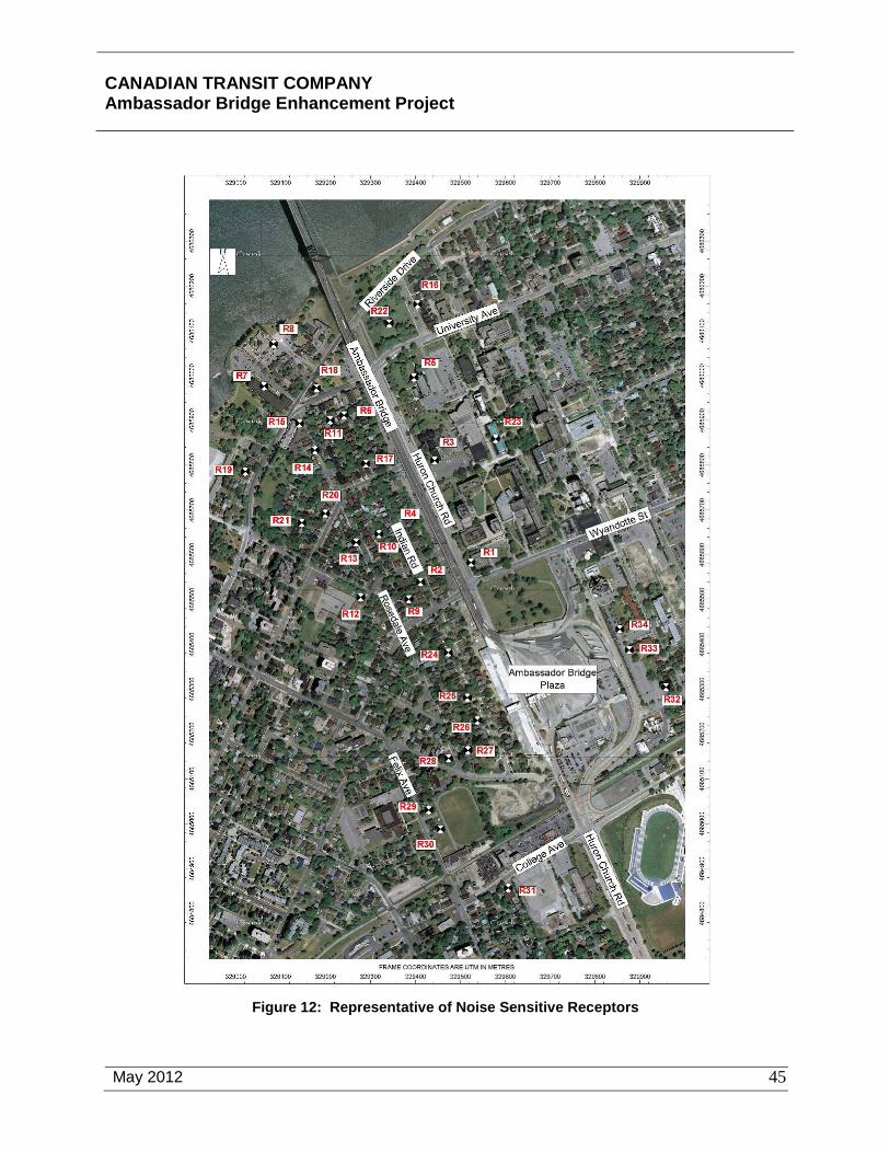
CANADIAN TRANSIT COMPANY Ambassador Bridge Enhancement Project
May 2012
45
Figure 12: Representative of Noise Sensitive Receptors

CANADIAN TRANSIT COMPANY Ambassador Bridge Enhancement Project
May 2012
46
The Ambassador Bridge and Windsor Plaza generate noise from queued vehicles and vehicles crossing the bridge structure. Existing noise levels in the Local Study Area have been measured and peak noise levels range from 47 to 70 dBA. Tables 6 and 7 below identify the noise levels and additional information can be found in Section 7.5 Noise and Vibration.
Table 6: Sound Level Measurement Summary, Ambassador Bridge
ID Description Time Leq Comments
R1 Cartier hall
May 24,2007 13:30 69 TT on Huron Church (75 dBA)
May 24, 2007, 21:00 68 Accelerating TT (65 - 74 dBA)
May 25, 2007, 10:00 69
May 25, 2007, 14:20 68
Nov 13, 2011, 01:00 66 Accelerating TT (70 - 75 dBA)
Nov 13, 2011, 03:35 64 Accelerating TT (71, 79 dBA)
R2 556 Indian Road
May 24, 2007, 14:50 60 Jake brakes (61 - 68 dBA)
May 24, 2007, 23:00 59 Accelerating TT (59 - 65 dBA)
May 25, 2007, 13:30 58
May 25, 2007, 16:30 61
Nov 13, 2011, 03:15 57 Accelerating TT (58 - 61 dBA)
Nov 13, 2011, 05:15 60

CANADIAN TRANSIT COMPANY Ambassador Bridge Enhancement Project
May 2012
47
ID Description Time Leq Comments
R3 North of Sir John
A. MacDonald Hall
May 24, 2007, 15:30 66 Accelerating TT (68 - 77 dBA)
May 24, 2007, 21:20 65
City Bus on Huron Church (72 dBA)
May 25, 2007, 11:25 66
May 25, 2007, 14:50 66
Nov 13, 2011, 01:25 63 Accelerating TT (66 - 72 dBA)
Nov 13, 2011, 03:55 64
R4 445 Indian Road
May 24, 2007, 15:55 60 Bridge Traffic (55 - 60 dBA)
May 24, 2007, 22:20 66 Jake Brakes (68, 69 dBA)
May 25, 2007, 13:40 57
May 25, 2007, 17:00 58
Nov 13, 2011, 02:50 58
Nov 13, 2011, 05:00 55

CANADIAN TRANSIT COMPANY Ambassador Bridge Enhancement Project
May 2012
48
ID Description Time Leq Comments
R5 Assumption Church
May 24, 2007, 16:20 66 Huron Church Road dominant
May 24, 2007, 21:40 63 Accelerating TT (60 - 70 dBA)
May 25, 2007, 12:00 64
May 25, 2007, 15:20 65
Nov 13, 2011,01:45 61 Accelerating TT (67 - 68 dBA)
Nov 13, 2011,04:20 62
R6 347 Indian Road
May 24, 2007, 16:50 62 Jake Brakes (62 - 67 dBA)
May 24, 2007, 22:00 61 Truck decelerating (66 - 72 dBA)
May 25, 2007, 13:05 62
May 25, 2007, 16:05 62
Nov 13, 2011, 02:30 58 Truck decelerating (70 dBA)
Nov 13, 2011, 04:55 59 Truck decelerating (75 dBA)

CANADIAN TRANSIT COMPANY Ambassador Bridge Enhancement Project
May 2012
49
ID Description Time Leq Comments
R7 Chateau Park
2990B Riverside Drive W.
May 24, 2007, 17:10 55 Bridge occasionally audible
May 24, 2007, 22:40 55 Jake Brakes (55, 56 dBA)
May 25, 2007, 10:40 59 Local HVAC units
May 25, 2007, 17:25 55
Nov 13, 2011, 02:10 55
Nov 13, 2011, 04:35 56

CANADIAN TRANSIT COMPANY Ambassador Bridge Enhancement Project
May 2012
50
Table 7: Sound Level Measurement Summary, Plaza and Plaza Expansion Area
ID Measurement Location Time Leq Comments
A Southwest corner of Plaza adjacent to noise wall 8:50 60 Trucks accelerating out of plaza
B West Plaza, north of new booths 9:00 57 Idling Trucks in Plaza
C West Plaza at start of bridge 9:10 65 Trucks accelerating/decelerating on bridge approach
D North side of Plaza 9:20 68 Trucks on bridge approach
E East of Plaza entrance off Wyandotte 10:35 63 Trucks on bridge approach
H Adjacent to Patricia Road 10:55 70 Trucks on Patricia Avenue
J Adjacent to Patricia Road at onsite truck screening 11:05 68 Trucks on Patricia Avenue
K Cartier Hall, southeast side 11:55 62 Truck traffic on bridge, cars on Wyandotte
M Student Residences on Patricia Road 12:15 59 Road traffic on Patricia Ave
N Indian Road Residence 12:30 47 Trucks in plaza, traffic on Huron Church
P At Mill St. and Rosedale Ave. 12:40 49 Traffic on Huron Church
Q Felix Street, at school track 12:50 49 Traffic on Huron Church and Felix St.
R College Ave. and Lena Ave. 13:00 54 Road traffic on College Ave.
As is typically the case in any urban environment near a busy roadway, the existing sound levels associated with the Ambassador Bridge and Windsor Plaza are presently above the Ministry of the Environment (MOE) Provincial Objective of 55 dBA at all measurement locations. Sound levels at the representative receptors near the plaza and plaza expansion lands were generally dominated by truck traffic on Huron Church Road and other local roadways.
Vibration
Trucks traveling over the Ambassador Bridge can cause vibration in the bridge structure, particularly if they pass over imperfections in the road surface. Table 8 below identifies all the locations where vibration measurements were conducted, the maximum velocity [mm/s] for each location, the acceleration frequency (Hz) and its associated value [dB re 1g], and the ISO perceptibility level for that specific frequency [dB re 1g].

CANADIAN TRANSIT COMPANY Ambassador Bridge Enhancement Project
May 2012
51
Table 8: Vibration Level Measurement Summary
ID Estimated
Distance from Bridge [m]
Peak Velocity Peak Acceleration Peak Acceleration ISO limit
[mm/s] Frequency [Hz] [dB re 1g] [dB re 1g]
R1 5 0.13 16 -57.8 -59.8
R1 20 0.11 10 -63.2 -63.8
R1 5 0.31 16 -49.9 -59.8
R1 20 0.11 10 -62.7 -63.8
R3 5 0.15 12.5 -58.1 -62.0
R3 20 0.06 5 -73.9 -65.8
R3 40 0.05 12.5 -67.2 -62.0
R3 5 0.20 12.5 -56.0 -62.0
R3 20 0.11 16 -59.1 -59.8
R3 40 0.06 12.5 -66.2 -62.0
R5 5 0.13 12.5 -59.3 -62.0
R5 20 0.09 12.5 -62.9 -62.0
R5 40 0.14 10 -61.1 -63.8
R5 80 0.03 5 -80.1 -65.8
R5 5 0.45 12.5 -48.9 -62.0
R5 20 0.15 12.5 -58.7 -61.0
R5 40 0.14 10 -61.1 -63.8
R5 80 0.06 12.5 -66.0 -61.0
The measurements indicate that groundbourne vibration levels can be perceptible at distances up to approximately 40 metres (130 feet) from the bridge. The measurements indicate that the current vibration levels are below the range at which cosmetic damage would be anticipated in neighbouring structures, although vibration may be perceptible in the neighbouring dwellings depending on the degree of amplification in the structure.

CANADIAN TRANSIT COMPANY Ambassador Bridge Enhancement Project
May 2012
52
4.10 Socioeconomic
Land Use
The existing Ambassador Bridge serves as a major international highway linking Canada and the United States. Most of the land adjacent to the existing Ambassador Bridge and Windsor Plaza is developed and used for residential, institutional and recreational purposes. The existing Ambassador Bridge, extending north-south from Detroit, Michigan to Windsor, Ontario, is located immediately east of the proposed Project.
Socioeconomic
The Local Study Area has continued to function as a tourist and trade gateway between Canada and the US. The local economy within the Local Study Area can be characterized as having high unemployment and significant property vacancies.
Aesthetics
The existing aesthetic setting for the project area consists of components of the natural environment and man-made features. The availability of the natural environment for visual appreciation is somewhat limited by the urban character of the land in the vicinity of the existing Ambassador Bridge. There is relatively little topographic relief in the area or natural landscapes that would typically be associated with a high quality natural aesthetic environment.
The most significant natural visual element in the area is the Detroit River, which provides the opportunity for the appreciation of the riverine corridor within the context of the urban environment. The Detroit River is approximately 640 metres (2,099 feet) wide in the project vicinity, providing a broad expanse of open space for long-distance visibility of the skylines of the Cities of Windsor, Ontario and Detroit, Michigan and the existing Ambassador Bridge from the shoreline.
The existing Ambassador Bridge is an international transportation link constructed in 1929 that connects the urban environments between the Cities of Windsor and Detroit. The Ambassador Bridge is a visually dominant feature that has been an element of the urban skyline for over 80 years. The bridge is styled in a mixture of Art Deco and Art Moderne architectural designs, with some Gothic architecture blended in. It is made primarily out of steel. However, the two main towers on each side of the river are made of a steel-silicon alloy which rises up from concrete piers. At night, the Ambassador Bridge is lit as an aesthetic enhancement and for safety purposes. The Ambassador Bridge also serves as a physical and symbolic gateway connection between the countries of Canada and the United States.
The Windsor Plaza will appear visually very similar with the proposed improvements as it does today. At some point in the future, the Windsor Plaza may be expanded to include additional facilities. The proposed expanded Windsor Plaza footprint is located entirely on properties owned by the CTC bordered by Mill Street to the north, College Avenue to the south, Felix Avenue to the west, and Huron Church Road to the east.
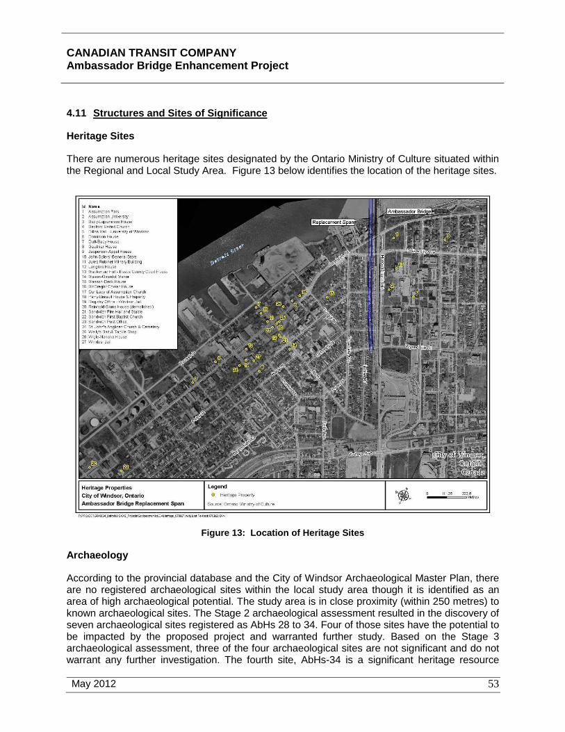
CANADIAN TRANSIT COMPANY Ambassador Bridge Enhancement Project
May 2012
53
4.11 Structures and Sites of Significance
Heritage Sites
There are numerous heritage sites designated by the Ontario Ministry of Culture situated within the Regional and Local Study Area. Figure 13 below identifies the location of the heritage sites.
Figure 13: Location of Heritage Sites
Archaeology
According to the provincial database and the City of Windsor Archaeological Master Plan, there are no registered archaeological sites within the local study area though it is identified as an area of high archaeological potential. The study area is in close proximity (within 250 metres) to known archaeological sites. The Stage 2 archaeological assessment resulted in the discovery of seven archaeological sites registered as AbHs 28 to 34. Four of those sites have the potential to be impacted by the proposed project and warranted further study. Based on the Stage 3 archaeological assessment, three of the four archaeological sites are not significant and do not warrant any further investigation. The fourth site, AbHs-34 is a significant heritage resource

CANADIAN TRANSIT COMPANY Ambassador Bridge Enhancement Project
May 2012
54
which will require avoidance or Stage 4 mitigation. Site AbHs-34 is bordered by the Ambassador Bridge to the east, on the south by Riverside Drive, on the west by a structure located at 2856 Riverside Drive (formerly Villa Maria nursing home), and on the north by the berm/slope along the south edge of the Detroit River. More detail on the Stage 1, Stage 2 and Stage 3 archaeological studies are described later in this document and in Appendix M.
4.12 Human Health
During the public consultation process several concerns were raised relating to potential health impacts from the vehicles using the Ambassador Bridge. The public is concerned with air quality associated with the queuing and idling of vehicles and their impact on human health. General queued and idling vehicles, particularly diesel trucks, tend to release increased emissions of PM, CO, CO2 and NOx that all contribute to poor air quality. As discussed in Section 7.1 Air Quality and Climate the intent of this Project is to facilitate the movement of vehicles across the Ambassador Bridge and reduce idling and queuing, and ultimately vehicle emissions.
4.13 Contaminated Sites and Waste Management
There are no known contaminated sites located within the Study Area. All waste is treated and disposed of in accordance with current regulatory requirements.
4.14 Navigation
The existing Ambassador Bridge has been situated in the area for approximately eighty-one years and has no impact on navigation.
4.15 Current Use Of Lands And Resources For Traditional Purposes By Aboriginal Peoples
Currently, the property owned by the CTC does not provide opportunities for the use of land or terrestrial resources for traditional purposes by aboriginal peoples. Aboriginal peoples are permitted to fish in the Detroit River either by boat or from the shore in the Regional Study Area. The Detroit River and shoreline within the Local Study Area do not possess any unique attributes for the current use of these resources for traditional purposes by aboriginal peoples.

CANADIAN TRANSIT COMPANY Ambassador Bridge Enhancement Project
May 2012
55
5.0 ENVIRONMENTAL EFFECTS AND MITIGATION
Table 9 below summarizes the environmental effects of the proposed Project during both construction and operation. The environmental effects identified and proposed mitigation are discussed and analyzed in further detail below.
Table 9: Environmental Effects Checklist
Environmental Component
Potential Project Effects Residual Effects
Potential Adverse Effect? Can it Be Mitigated? Is it Significant?
Yes No N/A Yes No N/A Yes No
Air Quality and Climate
Surface Water
Groundwater
Surface and Subsurface Geology and Soils
Vegetation and Vegetation Communities
Fish and Fish Habitat
Wildlife and Wildlife Habitat
Species at Risk
Noise
Vibration
Land Use
Socioeconomic
Aesthetics
Structures and Sites of Significance
Human Health
Contaminated Sites and Waste Management
Navigation
Current Uses of Lands and Resources for Traditional Purposes by Aboriginal Peoples

CANADIAN TRANSIT COMPANY Ambassador Bridge Enhancement Project
May 2012
56
5.1 Air Quality and Climate
Traffic data from publicly available sources including the City of Windsor, Canadian Transit Company and Detroit River International Crossing as described in detail in Section 3.5, was used for estimating vehicle flow and profile for existing and future scenarios. The roadway fleet data, combined with MOBILE6.2C (a model developed by United States Environmental Protection Agency (USEPA) and enhanced by Environment Canada to reflect Canadian standards) was used to develop emission factors for vehicle emissions. A USEPA Compilation of Emission factors (AP-42: Chapter 13.2) was used to develop emission factors for roadway emissions (road dust). State-of-science air dispersion modeling tools were utilized based on the Air Dispersion Modelling Guide for Ontario (ADMGO), specifically the USEPA CAL3QHCR was used to evaluate vehicle emissions and road dust and the USEPA AERMOD was used to evaluate construction activities. Cumulative effects were considered by adding the background concentration to the concentrations predicted using the dispersion models.
5.1.1 Construction
Under the future scenario, in 2015, that considers impacts from construction activities related to the Project, air quality from the combination of operation and construction emissions are predicted to occur in the local study area (within 300 m) of Huron Church Road. The potential exists for concentrations of PM10 to be marginally above the air quality criteria. Concentrations of pollutants of interest during construction have been modeled and are summarized below on Table 10.
Project planning during the construction phase demonstrates compliance with the maximum 1-hour and 24-hour NOx air quality criterion. During the construction phase, the maximum 24-hour PM10 and PM2.5 air quality concentration is predicted to be higher than the operational emission scenario for the same period (2015). The maximum concentrations during construction consider the combined impacts of construction activities vehicle emissions and roadway emissions associated with traffic on the bridge, customs plaza, Huron Church Road and Arterial Roads in the Local Study Area. Additional information pertaining to the construction effects related to air quality in the Local Study Area is provided in Section 7.1 Air Quality and Climate.
The Project will be constructed in accordance with applicable legislative standards that reflect such conditions as wind, snow, seismic, thermal and all other forces. Although unlikely depending on the timing of certain construction activities, ice jams in the Detroit River could prohibit the use of barges during construction at certain times of the year. It is recognized that severe weather could cause delays in the construction; no other impacts of the climate on the construction of the project are anticipated.

CANADIAN TRANSIT COMPANY Ambassador Bridge Enhancement Project
April 2011
57
Table 10: Summary of Maximum Air Quality Concentration Results
Pollutant Relevant Air Unitsof Interest Averaging Quality Maximum Background Maximum Maximum Background Maximum Maximum Background Maximum Maximum Background Maximum Maximum Background Maximum Maximum Background Maximum
Period Criteria Modelling Concentration Air Quality Modelling Concentration Air Quality Modelling Concentration Air Quality Modelling Concentration Air Quality Modelling Concentration Air Quality Modelling Concentration Air QualityConcentration Concentration Concentration Concentration Concentration Concentration Concentration Concentration Concentration Concentration Concentration Concentration
Pollutants and Precursors (1)
CO 1 hr 36,200 µg/m3 5039 737 5776.0 2.6 737 739.6 2.5 737 739.5 2.6 737 739.6 2.0 737 739.0 2.4 737 739.4NOx 1 hr 400 µg/m3 652 60 712 233 60 293 218 60 278 106 60 166 106 60 166 106 60 166NOx 24 hr 200 µg/m3 248 50 298 85 50 135 84 50 134 38 50 88 38 50 88 38 50 88SO2 1 hr 690 µg/m3 18 14.1 32 165 14.1 180 1.9 14.1 16 2.2 14.1 16.3 2.2 14.1 16 2.2 14.1 16SO2 24 hr 275 µg/m3 6.9 11.2 18 21 11.2 33 0.99 11.2 12 1.3 11.2 12 1.3 11.2 12 1.3 11.2 12PM10 24 hr 50 µg/m3 20 42 62 45 42 87 18 42 60 21 42 63 21 42 63 21 42 63PM2.5 24 hr 30 µg/m3 11.7 20 32 6.7 20 27 6.6 20 27 7.3 20 27 7.3 20 27 7.3 20 27VOC 1 hr NA ppm 0.50 0.29 0.79 - 0.29 0.29 0.20 0.29 0.49 0.4 0.29 0.69 0.23 0.29 0.52 0.23 0.29 0.52Air Toxicsbenzene 24 hr 30 µg/m3 6.8 2.5 9 - 2.5 2.5 3.4 2.5 5.94 2.9 2.5 5.4 2.9 2.5 5.4 2.9 2.5 5.4acetaldehyde 24 hr 500 µg/m3 1.4 2.2 3.6 - 2.2 2.2 0.66 2.2 2.9 0.72 2.2 2.9 1.3 2.2 3.5 1.3 2.2 3.5formaldehyde 24 hr 65 µg/m3 3.6 3.7 7.3 - 3.7 3.7 2.1 3.7 5.8 2.2 3.7 5.9 3.6 3.7 7.3 3.6 3.7 7.31,3-butadiene 24 hr 2 µg/m3 0.94 0.18 1.1 - 0.18 0.18 0.38 0.18 0.56 0.21 0.18 0.39 0.21 0.18 0.39 0.21 0.18 0.39acrolein(2) 24 hr 4.0 µg/m3 0.11 0.140 0.25 - 0.14 0.14 0.054 0.14 0.19 0.044 0.14 0.18 0.034 0.14 0.17 0.034 0.14 0.17benzo (a) pyrene 24 hr 0.0011 µg/m3 0.00010 0.00054 0.00064 - 0.00054 0.00054 < 0.00001 0.00054 0.00055 < 0.00001 0.00054 0.00055 < 0.00001 0.00054 0.00055 < 0.00001 0.00054 0.00055Greenhouse GasesCO2 annual NA µg/m3 - 650,000 - - 650,000 - - 650,000 - - 650,000 - - 650,000 - - 650,000 -N2O 24 hr 9,000 µg/m3 2.6 560 563 - 560 560 3.2 560 563 4.2 560 564 4.3 560 564 4.3 560 564CH4 annual NA µg/m3 - 1,130 - - 1,130 - - 1,130 - - 1,130 - - 1,130 - - 1,130 -Otherozone(3) 1 hr 165 µg/m3
Note: (1) Tier 1 assessed pollutants (shown in italics) for years 2015 and 2025 are representative of the initial study years 2011 and 2021 respectfully.Note: (2) the current acrolein air quality criteria is represented by the Upper Risk Threshold (URT) value of 4.0 µg/m3 under Ontario Regulation 419/05. The future (2020) air quality standard under Ontario Regulation 419/05 is 0.4 µg/m3. Note: (3) estimate based on the VOC / NOx ratio and ispoleth method includes background ozone.
Note: 2025 (FDN) refers to future operation of existing bridge only, 2025 (A) refers to future operation of ABEP only and 2025 (B) refers to future operation of ABEP plus existing bridge.
< 130
Baseline 2015 (Construction) 2015 (Operation) 2025 (FDN) 2025 (A) 2025 (B)
< 80 - < 80 < 130 < 130
CANADIAN TRANSIT COMPANY Ambassador Bridge Enhancement Project
May 2012
58
Mitigation
Measures to be used to manage NOx and reduce PM10 and PM2.5 air quality concentrations during construction activities include:
• review of the construction emission inventory prior to start. The construction emission modeling was based on a conservative inventory of equipment with construction activities being carried out over a period of 10 hours per day, 5 days a week during the period 2013 to 2015 and in compliance with municipal by-laws. Should greater or lesser inventory of equipment be used, the work hours may need to be adjusted accordingly;
• Implementation of a Best Management Plan (BMP) described in detail in Appendix D, Attachment 14 “Mitigation Measures for Construction Activities”, utilizing established measures outlined in reference materials such as “Best Practices for the Reduction of Air Emissions from Construction and Demolition Activities” (2005);;
• adhere to, where applicable, the “Best Practices for the Reduction of Air Emissions from Construction and Demolition Activities” developed by Environment Canada (2005);
• contract documents requiring that the BMP be used to minimize short-term impacts;
• contract documents will stipulate that heavy equipment must meet design specifications for emission controls and that licensed vehicles conform to provincial Drive Clean standards, where appropriate;
• idling of heavy equipment will be monitored and limited consistent with the municipal by-law to the extent possible;
• the contractors most polluting heavy equipment will be identified and use limited during smog advisories;
• the number and/or size of heavy equipment that will be operating simultaneously will be monitored. The river barges are predicted to be a significant contributor to the maximum NOX concentrations during construction and as such the number and/or size of these will be limited; and
• the NOX concentrations are predicted to be highest at the virtual receptors located on the water versus virtual and special receptors located on land. Restrictions will be imposed to limit the distance between operating barges and water based receptors such as pleasure boats.
• Dust suppression measures.
Additional information pertaining to the mitigation during construction related to air quality in the Local Study Area is provided in Section 7.1 Air Quality and Climate.
With the application of these mitigation measures, no significant environmental impacts are anticipated. Further a mitigation compliance and adaptive management monitoring plan has been created for this project with respect to air quality. Details on this plan can be found in

CANADIAN TRANSIT COMPANY Ambassador Bridge Enhancement Project
May 2012
59
Section 7.9 and Appendix 16 of the Air Quality Assessment report. No significant adverse residual effects are anticipated with respect to climate on the proposed Project.
5.1.2 Operation
Overall, the impacts from the Project are small compared to the background concentrations, especially in future emission scenarios. It should be noted that for both PM10 and PM2.5, the selected background is a significant fraction of the maximum air quality concentration for all scenarios. The results show a positive environmental change as the future air quality is predicted to improve with the replacement span. These improvements are both direct, due to predicted improvements in traffic flow resulting in less queuing and idling and indirect due to improved fuel standards and vehicle emission controls.
A comparison of the future 2025 “do nothing” and replacement span only scenarios, indicate that the replacement span and customs plaza will result in an improvement in air quality, notably in the area close to the bridge and the customs plaza. The greatest air quality impacts are predicted to occur along Huron Church Road, but are reduced in magnitude and aerial extent relative to the present (baseline) as more stringent fuel and vehicle emission standards take effect. In addition, the air quality in the area near the customs plaza and on the bridge is predicted to benefit from improved traffic flow due to the higher capacity of the expanded customs plaza and the new bridge. The reduced vehicle emissions appear to outweigh the increase in traffic volumes for most pollutants of interest. The reduced magnitude and aerial extent is most apparent for substances that are closely tied to the standards, such as NOx. NOx concentrations are predicted to be below the air quality criteria. The environmental effects of the proposed Project on air quality are also included on Table 10 above.
The greatest potential for improving air quality exits where air quality is impacted the most, along Huron Church Road. Comparing areas along Huron Church Road where traffic flows freely to areas with major arterial intersections suggests that air quality impacts could be reduced significantly by measures that would allow thru-traffic to flow more freely such as enhanced signal timing and/or the removal lights at key intersections. Such measures fall outside the jurisdiction of the project proponent and as such strategies for mitigation in this area were not considered in the context of the air quality assessment.
The issue of climate change is an important national and global concern that is being addressed in several ways by the Federal government. To date, no national standards have been established regarding greenhouse gases, though we have considered Canada’s target for greenhouse gas reduction and some steps towards this goal have been identified. Greenhouse gases are managed on an annual regional contribution basis and our analysis provides a regional comparison of these impacts. On this basis the project’s contributions (build vs no build) to greenhouse gas emissions are not measurable.
No piers will be constructed within the Detroit River, as a result, ice jams and high water levels will have no impact on the ABEP during operation. Though severe weather could cause delays in construction, the existing Ambassador Bridge has existed for over 81 years and has withstood severe weather conditions countless times. The proposed bridge will be constructed to meet applicable standards, policies and guidelines which specifically consider such things as wind, snow, seismic, thermal and all other forces.
CANADIAN TRANSIT COMPANY Ambassador Bridge Enhancement Project
May 2012
60
Mitigation
The operation of the replacement span and plaza improvements are expected to improve operating efficiencies, reduce back-ups and reduce truck idling and therefore emissions are predicted to be reduced over the future no-build scenario. Additional information pertaining to the operation of the Project and the impacts on air quality is provided in Section 7.1 Air Quality and Climate. No significant adverse residual effects are anticipated with respect to climate on the proposed Project.
5.2 Surface Water
5.2.1 Construction
The construction of the proposed Project will not have a significant impact on the surface water and hydrology in the study area. The proposed Project does not involve dredging, in-water blasting, in-water pile driving, pier construction or placement of shore protection in or along the Detroit River.
Construction will take place on land with only limited use of construction barges to deliver materials to the site. Maintenance, fuelling and storage will occur at least 30 m from watercourses/ drains. All contractors operating barges for the delivery of materials to the site will be in compliance with the DFO Canadian Coast Guard marine safety, pollution, and spill control requirements established to protect the aquatic ecosystem. The use of barges to deliver materials will have no significant effect on water quality, water levels or water use since no work will be taking place in the water. The only impact will be when four small “spuds” are dropped to stabilize the barges. This minor disturbance of the bottom sediment would not re-suspend high quantities of material or cause measurable water quality effects. Barges will not be operated in shallow waters that are less than the draft of the barge. There will be no need to dredge channels for use of the barges eliminating a potential source of water quality effects.
Construction of the proposed Project will impact stormwater flow within the Project Area. Construction activities such as construction and worker vehicle parking areas, material storage areas, soil staging areas, and excavation areas will disturb areas located in the Site Study Area and temporarily increase the amount of impervious surface. The removal of vegetative cover and replacement with impervious or unprotected surfaces tends to remove the areas that normally attenuate surface water quality and flow. Left unchecked this can result in faster runoff of water from the surface and erosion of soil from surrounding areas. Erodible materials can then enter a receiving water body such as the Detroit River. Soils in exposed areas can also reach the adjacent waterways when carried by wind.
Mitigation
The primary mitigative aspect of the Project related to potential environmental effects to surface water is using the design concept that does not include any permanent project components in, or immediately adjacent to, the Detroit River. Effects will be minimized by ensuring effective management of storm and surface water drainage and by stabilizing unprotected surfaces through seeding and mulching and by use of dust suppression techniques such as watering. Section 7.2 Surface Water of this report includes additional details and analysis including a sediment and erosion plan for construction.

CANADIAN TRANSIT COMPANY Ambassador Bridge Enhancement Project
May 2012
61
No significant erosion or sediment impacts are anticipated with the application of the above noted mitigation measures. Though negligible sediment may escape the project limits during construction of the Project, the residual effects on surface waters are expected to be low to none.
5.2.2 Operation
Operation of the proposed Project will result in a long-term impact on stormwater flow within the Site Study Area. The proposed Project requires the construction of new land-based piers and a new bridge deck as well as the proposed plaza improvements. Together they will permanently increase the amount of impervious surface area within the Site Study Area and thus increase the amount of runoff water. Ultimate improvements to the plaza will also require an increase in impervious area.
Mitigation
Effects can be minimized by ensuring effective management of storm and surface water drainage and by stabilizing unprotected surfaces during the operation of the project. In order to mitigate potential effects from the Project during construction and operation, the Ambassador Bridge will develop a comprehensive erosion control plan. A draft of this erosion control plan is included in Appendix E. A Spills Response Plan has also been prepared (see Appendix C Spills Prevention and Contingency Plan) to reduce the potential for adverse environmental effects during the operation of the Project as was discussed above as part of the discussion of Malfunctions and Accidents.
Stormwater management facilities will be provided to mitigate for the increase in impervious surface area and runoff water. The existing facility is currently connected to the City of Windsor’s storm and sewer system. During the design phase, the intent for the Enhancement Project is to simply modify the connections as necessary to maintain this connection to the City’s system. Stormwater will be treated at an “Enhanced” level as described in the MOE’s Stormwater Management Manual. A detailed Stormwater Management Plan will be developed during final design of this project and will address all applicable stormwater management requirements for the entire project including all new impervious surfaces. No significant impacts are anticipated with the application of the above noted mitigation measures. Further, with the implementation of sediment and erosion control systems during construction, the collection and treatment of operational stormwater runoff and the implementation of spill response plans will ensure that there are minimal to no significant adverse residual effects from the proposed Project on surface waters The Ambassador Bridge has developed a Draft Erosion and Sediment Control and Stormwater Management Plan (Appendix E) for this project. Erosion and sediment control measures will include the use of silt fence, straw bales and inlet protection at a minimum.
5.3 Groundwater
5.3.1 Construction
Site preparation work and foundation construction will have the greatest impact on groundwater, but the impact is expected to be limited to the time needed for the construction of the footings and support piers. Groundwater in the foundation excavations will be controlled to provide for
CANADIAN TRANSIT COMPANY Ambassador Bridge Enhancement Project
May 2012
62
worker safety, prevention of erosion and sedimentation issues and successful completion of the foundation. As described in Section 7.3 Surface and Subsurface Geology and Soils, groundwater discharge during construction could be substantial in volume. Artesian conditions have been confirmed in two recent borings in the Site Study Area commissioned by the Ambassador Bridge. Depending on the construction method used, the method of control may be pumping with collection, treatment and discharge and/or engineered barriers within the boring. For example, as borings are being drilled for the support piers, steel casings can be lowered into the borehole to stabilize the boring and limit potential for groundwater discharge into the boring. Any groundwater that may bypass the borehole casing will be pumped out of the casing, treated and discharged. Any residual water will be displaced up the casing when concrete is poured for the foundation and then collected when it reaches the surface. Any pumped groundwater will be treated to reduce pollutants to levels that comply with parameter threshold levels recommended in the Canadian Water Quality Guidelines for the Protection of Aquatic Life, and Policies, Guidelines, Provincial Water Quality Objectives of the (Ontario) Ministry of Environment and Energy (July, 1994) prior to discharge.
Mitigation
Depending on the construction method used, the method of control may be pumping with collection, treatment and discharge and/or engineered barriers within the boring.
No significant impacts to groundwater during construction activities are anticipated with the application of the above noted mitigation measures. No significant adverse residual effects are anticipated with the implementation of mitigation.
5.3.2 Operation
After foundation construction is completed, groundwater aquifers will be allowed to return to pre-construction conditions except for localized change in flow direction around the foundation structures in the Site Study Area. No permanent changes in groundwater conditions are expected in the Local and Regional Study Areas.
Mitigation
No significant impacts are anticipated to groundwater resources during the operation of the proposed Project. A Spills Response Plan has also been prepared (see Appendix C Spills Prevention and Contigency Plan) to reduce the potential for adverse environmental effects during the operation of the Project. Stormwater will be treated at an “Enhanced” level as described in the MOE’s Stormwater Management Manual. Further, with the implementation of sediment and erosion control systems during construction, the collection and treatment of operational stormwater runoff and the implementation of spill response plans will ensure that there are no significant adverse residual effects from the proposed Project on groundwater.

CANADIAN TRANSIT COMPANY Ambassador Bridge Enhancement Project
May 2012
63
5.4 Surface and Subsurface Geology and Soils
5.4.1 Construction
Site preparation work and foundation construction will have the greatest impact on geology. The impact is expected to be limited to the time needed for the installation of the drilled shafts and/or piles and construction of the footings for the proposed bridge and the construction outside of the existing footprint of the Windsor Plaza. The site surface will be disturbed by grading, construction of service roads, establishment of staging and stockpile areas and related construction activities for the duration of the entire construction period. All surface areas outside of the construction footprint will be restored to original or near original conditions with comparable materials after completion of construction. The surface material is mainly disturbed soil or fill, which further reduces the potential for permanent environmental change. Any surplus soil/fill will be characterized prior to its transport to an approved facility.
Excavation for the proposed Project foundations will result in localized removal of the entire thickness of the soil overburden and removal of necessary bedrock to the specifications of the foundation design. This material will be replaced by the foundation structures for the proposed Project.
The areas required for the plaza expansion are already heavily disturbed. The parcels designated for the plaza are either partially paved and will require only minor modifications to accommodate the proposed traffic or have been previously graded, though additional grading will be required. Excavation should not be necessary and no changes to the site geology are expected from improvements associated with the plaza.
Mitigation
With the exception of grouting of localized fracturing in the bedrock if fracturing occurs, no mitigation is necessary. No significant impacts are anticipated to geology and soils during the construction of the proposed Project. No significant adverse residual effects are anticipated.
5.4.2 Operation
There will be no environmental effects on surface and subsurface geology and soils during the operation of the proposed Project or the operation of the Windsor Plaza.
Mitigation
No mitigation is necessary as the operation of the Project will not result in any environmental effect. Additional information pertaining to the surface and subsurface geology and soils is provided in Section 7.3 Surface and Subsurface Geology and Soils. No significant adverse residual effects are anticipated.

CANADIAN TRANSIT COMPANY Ambassador Bridge Enhancement Project
May 2012
64
5.5 Vegetation and Vegetation Communities
5.5.1 Construction
Impacts to terrestrial vegetation are limited to the small area occupied by the support tower and piers for the bridge, areas required for the plaza expansion, and any staging and construction parking areas. The support tower will be located approximately 30.5 metres (100 feet) south of the river and will occupy approximately 553 m2 (5,946 ft2) of area. The support tower is the largest support structure. The other support piers will each occupy about 5 m2 (54 ft2). The areas of the support piers are in the parking areas that are already heavily disturbed and paved.
The areas required for the plaza expansion are already heavily disturbed and are urban in nature. The parcels designated for staff and visitor parking are currently paved and void of vegetation. The site designated for commercial parking and bus inspection was previously cleared and currently consists of grass, gravel and opportunistic herbaceous plants.
The Site Study Area has few natural heritage features as available habitat for local wildlife. The existing vegetation is limited to the street trees on Indian Road, and other local roads. The trees within the site study area represented a combination of native and non-native species that have been planted either as streetscaping, parkland or for residential privacy. There were far more ornamental and invasive species identified which is common in established urban areas as native plantings were not historically encouraged as street trees. Only three species were considered Carolinian trees, the tulip tree (Liriodendron tulipifera) and red oak (Quercus rubra) and white oak (Quercus alba). Further discussion on the types and quantities of trees found can be found in Section 7.4.2. A complete inventory of the trees found within the site study area can be found in Appendix H. There are no wetlands located in the site study area.
Loss of some trees, shrubs and open areas as a result of the proposed Project will have minimal effects, as future replanting will replace some of the losses. No long-term effects on vegetation from the project operation are anticipated. Based on the conclusions of the qualified arborist, the effect to these trees from the Project will not be significant because they do not provide preferred or suitable habitat and function. Given the existing vegetation and available habitat, it is not anticipated that there will be significant adverse residual effects on the local flora and fauna as a result of the Project.
Mitigation
Vegetation removals should occur outside the growing season to avoid loss of wildlife and wildlife habitat to the extent possible. A tree saving plan has been developed (see Section 7.4 Terrestrial Environment) to maintain some mature vegetation within the Site Study Area and the addition of a green area adjacent to Indian Road.
No significant impacts to vegetation and vegetation communities during construction activities are anticipated with the application of the above noted mitigation measures. After construction, the residual effects anticipated are positive with the addition of the green area adjacent to Indian Road.
CANADIAN TRANSIT COMPANY Ambassador Bridge Enhancement Project
May 2012
65
5.5.2 Operation
There will be no environmental effects on vegetation and vegetative communities during the operation of the proposed Project or Windsor Plaza. See Section 7.4 Terrestrial Environment for additional details.
Mitigation
No mitigation is necessary for the operation of the Project. The operation of the Project will not result in any environmental effects on vegetation and vegetation communities. Additional information pertaining to vegetation and vegetation communities is provided in Section 7.4 Terrestrial Environment. After construction, the residual effects anticipated are positive with the addition of the green area adjacent to Indian Road.
5.6 Fish and Fish Habitat
5.6.1 Construction
No adverse effects from the construction of the Project are anticipated. The Project is a cable-stayed bridge and will not involve any construction activities within the Detroit River, either along its banks or below the plane of the ordinary high water mark. There will be no piers, cofferdams, pile driving, dredging, blasting, or any discharges of fill material into the River from the proposed Project. The supporting towers for the cable stayed bridge will be located on upland property. For additional information pertaining to environmental effects associated with fish and fish habitat within the Detroit River beneath the proposed project, see Section 7.2 Surface Water.
Mitigation
No mitigation is necessary as the construction of the Project will not result in any environmental effects on fish and fish habitat during the construction of the proposed Project. Additional information pertaining to fish and fish habitat is provided in Section 7.2 Surface Water. No significant adverse residual effects are anticipated.
5.6.2 Operation
No adverse effects from the operation of the Project are anticipated. The Project is a cable-stayed bridge and will not involve any operational components within the Detroit River, either along its banks or below the plane of the ordinary high water mark. Improvements to the Windsor Plaza will not impact any aquatic environments. For additional information pertaining to environmental effects associated with fish and fish habitat within the Detroit River beneath the proposed project, see Section 7.2 Surface Water.
Mitigation
In the unlikely event of larger spills, such as major accidents during operation, emergency response procedures will be utilized to minimize potential environmental effects including provisions for the released material at outfall locations such as turbidity barrier for containment at the outfall location and inflatable bag plugs for closing off storm drain outlets. With the

CANADIAN TRANSIT COMPANY Ambassador Bridge Enhancement Project
May 2012
66
implementation of this mitigation, the likelihood of a spill that would cause short-term toxicity to fish species is low. No other mitigation is necessary as the operation of the Project will not result in any environmental effects on fish and fish habitat. Further, with the implementation of sediment and erosion control systems during construction, the collection and treatment of operational stormwater runoff and the implementation of spill response plans will ensure that there are no significant adverse residual effects from the proposed Project on fish and fish habitat.
5.7 Wildlife and Wildlife Habitat
5.7.1 Construction
Wildlife that may be impacted by the proposed Project are limited to species highly tolerant to human activities such as mice, squirrels, skunks, opossum, raccoons, birds, and other species tolerant of humans. In addition, a pair of peregrine falcons have been nesting on the existing Ambassador Bridge since 2008. During the construction period, activities such as clearing and grubbing will remove soil and vegetation and cause vibration and noise affecting the habitat and wildlife that exist at the site. Emigrating wildlife could be subjected to stress as a result of this displacement.
The type and amount of vegetation removed by the Project, including roadside trees, ornamental plantings, and landscape planting, will have no effect on wildlife habitat locally or regionally because these do not serve as linkages or corridors.
As previously stated, the areas required for the plaza expansion are already heavily disturbed and do not provide optimal wildlife habitat. The parcels designated for staff and visitor parking are currently paved and void of vegetation. The site designated for commercial parking and bus inspection was previously cleared and currently consists of grass and opportunistic herbaceous plants.
Mitigation
As discussed above a tree planting plan will be undertaken to restore wildlife habitats. In addition, the uninhabited structures located on the east side of Indian Road between Wyandotte Street and Mill Street will be demolished and replaced with a green area as part of this project to create a security buffer around the Windsor Plaza while providing a green area for the community. CTC will coordinate with the MNR regarding construction activity near the nest for the peregrine falcons. A peregrine falcon management plan has been developed for this project and can be found in Appendix P. This document will serve as internal guidance for the Ambassador Bridge to maintain species productivity and to minimize the effects on nesting peregrine falcons from maintenance, construction, and other activities associated with the Ambassador Bridge, Windsor Plaza and the proposed Project.
If necessary, CTC will limit the construction of the bridge in the vicinity of the nest during the nesting season for these birds (approximately March 15 to July 31). In addition, CTC will provide an experienced monitoring team for the peregrine falcon nest and other nesting birds to determine if construction of other elements of the project are affecting the nest and to determine when the birds flee the nest. Behavioural studies will be conducted to monitor activity and behaviour in or directly adjacent to the construction site during the breeding season. If
CANADIAN TRANSIT COMPANY Ambassador Bridge Enhancement Project
May 2012
67
vegetation removals are required between May 1 and July 31, a nest survey will be conducted by a qualified avian biologist immediately prior to commencement of construction to identify and locate active nests of migratory birds and to develop a mitigation plan, if necessary. A peregrine falcon management plan has been developed for this project and can be found in Appendix P.
No significant impacts are anticipated, as once construction activities have been completed the wildlife population will return to the study area. With the proposed mitigation above, no significant adverse residual effects are anticipated. Additional information pertaining to wildlife and wildlife habitat is provided in Section 7.4 Terrestrial Environment.
5.7.2 Operation
The new bridge structure, expanded plaza and supplemental planting will replace the urban habitat for wildlife. Species that are tolerant of human activity will continue to use the Local Study Area as habitat in a similar manner to the existing Ambassador Bridge. There is the potential for some additional loss of avian species through collision with the new bridge since it is somewhat higher than the existing structure. Nationally, the loss of birds through collisions with bridges is considerably lower in comparison to other structures. No other impacts to migratory birds are anticipated once the project is in operation. Birds and other wildlife in this area are accustomed to the noise and traffic associated with the existing bridge and plaza.
Mitigation
The bridge lighting will not be completed until the final design phase of the project. CTC will focus the bridge lighting (shielded lights) in the downward direction to minimize the potential for nighttime bird collisions with the bridge. Low intensity white strobe lights (one flash every three seconds) were found to be preferable for lighting of tall structures and buildings to reduce the potential for avian collisions. CTC will use this type of strobe lighting at the tops of the towers pending any change needed based on final design criteria and final consultation with the State Historic Preservation Office (SHPO) in the United States. No red or yellow steady lights which can disorient avian species will be used on the bridge. If colored lighting is utilized to illuminate the cables, CTC will use lower intensity, lower wavelength lighting of blue, turquoise or green, pending final design criteria. These wavelengths tend to minimize disruption of magnetic orientation in several avian species. No other mitigation is necessary as the operation of the Project will not result in any significant environmental effects. With the proposed mitigation above, no significant adverse residual effects are anticipated.
5.8 Species at Risk
5.8.1 Construction
The May 2007 and November 2010 field investigations conducted for the proposed Project demonstrated that the Local Study Area does not contain habitat suitable for the listed threatened, endangered and species of special concern. No threatened, endangered, or species of special concern, nor sign of these species, were observed during either field review conducted, though it is known that a pair of peregrine falcons nest on the structure of the existing Ambassador Bridge. The Local Study Area does not contain suitable habitat for any species at risk (See Appendix H).

CANADIAN TRANSIT COMPANY Ambassador Bridge Enhancement Project
May 2012
68
A pair of peregrine falcons has been nesting on one of the inland piers of the existing Ambassador Bridge since 2008. The location of the proposed bridge is approximately 6 metres from the nesting site. Construction of the proposed bridge could result in higher noise levels and will require a number of people to be in close proximity to the nest. Most foraging for a peregrine falcon takes place between 2 and 6 km. Suitable foraging habitat is located outside of the proposed construction zone. CTC will coordinate with the MNR regarding construction activity near the nest. Research has shown that peregrine falcons are less affected by construction at a lower elevation than the nest but more significantly affected by construction activity that occurs above the nest. If necessary, CTC will limit the construction of the bridge in the vicinity of the nest during the nesting season for these birds (approximately March 15 to July 31).
If necessary, CTC will provide an experienced monitoring team for the peregrine falcon nest and other nesting birds to determine if construction or other elements of the project are affecting the nest and to determine when the birds flee the nest. When required, behavioural studies will be conducted to monitor activity and behaviour in or directly adjacent to the construction site during the breeding season. If vegetation removals are required between May 1 and July 31, a nest survey will be conducted by a qualified avian biologist immediately prior to commencement of construction to identify and locate active nests of migratory birds and to develop a mitigation plan, if necessary.
There will be no adverse effects from construction of the Project on any threatened, endangered or species of concern including avian species, mammals, reptiles, amphibians and plants.
Mitigation
Monitoring for the peregrine falcon as discussed above will be implement to avoid impacts to the peregrine falcon. A peregrine falcon management plan has been developed for this project and can be found in Appendix P. This document will serve as internal guidance for the Ambassador Bridge to maintain species productivity and to minimize the effects on nesting peregrine falcons from maintenance, construction, and other permitted activities associated with the Ambassador Bridge, Windsor Plaza and the proposed Project. No other mitigation specifically designed to mitigate effects on species at risk is necessary as the construction of the Project will not result in any environmental effect. Additional information pertaining to species at risk is provided in Sections 7.4 Terrestrial Environment and 7.2 Surface Water. With the implementation of the above mitigation, no significant adverse residual effects are anticipated to species at risk.
5.8.2 Operation
No impacts are anticipated on species at risk and there will be no adverse effects from construction of the Project on any threatened, endangered or species of concern including avian species, mammals, reptiles, amphibians and plants.
Mitigation
No mitigation specifically designed to mitigate effects on species at risk is necessary as the construction of the Project will not result in any environmental effects. Additional information pertaining to species at risk is provided in Sections 7.4 Terrestrial Environment and 7.2 Surface Water. No significant adverse residual effects are anticipated.

CANADIAN TRANSIT COMPANY Ambassador Bridge Enhancement Project
May 2012
69
5.9 Noise and Vibration
5.9.1 Noise
5.9.1.1 Construction Construction is expected to extend over a period of approximately 2 years. The aspects of construction which are expected to produce significant sound levels in the surrounding neighborhoods are primarily related to construction of the tower and support piers which will involve excavation, pile driving, and concrete pouring. At any particular residence therefore, the highest sound levels will occur when the nearest piers are being built. Pier construction, with its related pile driving is expected to occur within a three month period to limit adverse effects as much as possible
Noise arising from construction activities are regulated by the Municipal noise Bylaws and the Ministry of the Environment Noise Pollution Control Guideline NPC 115 “Construction Equipment”. It is incumbent on the contractors to comply with these guidelines and ordinances.
Mitigation
In order to mitigate construction-related noise effects of the proposed Project, the following measures will be undertaken. Sound and vibration levels will be monitored during pile driving within 100 metres (328 feet) of the identified sensitive receptors. If exceedances are noted, reduced driving force and/or temporary noise barriers will be investigated. Time restrictions set out in the City of Windsor’s Noise Bylaw 6716 will be complied with. Construction will generally occur Monday through Friday during normal working hours and the builder will be required to comply with all applicable noise by-laws. CTC will commit to not drive pile or conduct other unusually loud activities prior to 7 am or after 9 pm. The contractor will be required to ensure that factory recommended mufflers are maintained on all construction equipment. Sound emissions from all construction equipment will comply with MOE Guideline NPC-116 “Sound Levels from Construction Equipment.” Haul routes will be designed to avoid residential neighbourhoods.
In addition, a Community Consultation Plan will be developed during the design phase of this project and will incorporate a Noise Management Plan. A CTC representative will be accessible at all times and appointed as the community contact to address any questions, concerns or complaints during construction. As part of the Noise Management Plan, CTC will retain an expert to address noise related complaints or concerns and conduct any necessary field work related to noise during construction, when necessary. The Community Consultation Plan will also include at least one public meeting prior to construction and a public website with project information and information on how to comment on the Project.
Where possible, noise barriers as described below will be installed prior to construction to help mitigate against construction noise.
• A noise barrier 3.0 meters (~ 10 feet) in height located along the west edge of the bridge extending northwards from the existing noise barrier (constructed to the west of the existing plaza during the recent plaza expansion) to a distance of approximately 120 metres north of Peter Street. The barrier could taper down to the 1.5 metre (~ 5 feet)

CANADIAN TRANSIT COMPANY Ambassador Bridge Enhancement Project
May 2012
70
high barrier at this point. The barrier would need to maintain a height of 3.0 metres (~ 10 feet) above the top of the road surface at the bridge approach.
• A noise barrier 5.5 metres (~ 18 feet) in height located along the western extent of the customs inspection plaza which could connect into the remaining portion of the existing noise barrier which was constructed to the west of the existing plaza during the recent plaza expansion.
No significant impacts relating to noise are anticipated with regulatory compliance and the application of the above noted mitigation measures. With the implementation of the proposed mitigation, no significant adverse residual effects are anticipated.
5.9.1.2 Operation Typically, for road widening projects, noise control measures would only be considered if the increase in sound level at a point of reception between the build and no-build scenarios is greater than 5 dBA ten years after completion. In the case of the new span, Health Canada has suggested that mitigation be considered if there is any significant increase in sound level at locations where ambient levels are already elevated. Mitigation measures will be undertaken for all noise sensitive receptors at which sound levels may increase by more than only 1 decibel between the build and no-build scenarios.
Noise modeling has been undertaken to assess the potential environmental effects of the proposed Project. The results include predicted noise levels at sensitive receptors during operation with and without proposed mitigation. Locations of sensitive receptors modeled can be seen on Figure 12. These results are summarized on Table 11 that follows:
Table 11: Predicted Traffic Sound Levels (LEQ 24 hour, dBA)
ID Receptor Description Existing (2010)
No Build (2025
Build (2025)
Difference between Build and Existing
Difference Between Build and No-Build
R1 Cartier Hall (Student Res) 71 75 72 1 -3
R2 Indian Road, south 66 70 71 5 1
R3 Assumption University (HS 3) 67 71 68 1 -3
R4 Indian Road, Middle 67 71 66 -1 -5
R5 Assumption Church (HS 1) 64 68 63 -1 -5
R6 Indian Road, North 65 68 62 -3 -6
R7 Harbour View Condo 60 64 63 3 -1
R8 Nursing Home 61 65 62 1 -3
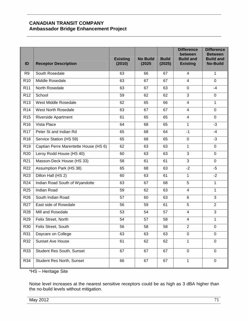
CANADIAN TRANSIT COMPANY Ambassador Bridge Enhancement Project
May 2012
71
ID Receptor Description Existing (2010)
No Build (2025
Build (2025)
Difference between Build and Existing
Difference Between Build and No-Build
R9 South Rosedale 63 66 67 4 1
R10 Middle Rosedale 63 67 67 4 0
R11 North Rosedale 63 67 63 0 -4
R12 School 59 62 62 3 0
R13 West Middle Rosedale 62 65 66 4 1
R14 West North Rosedale 63 67 67 4 0
R15 Riverside Apartment 61 65 65 4 0
R16 Vista Place 64 68 65 1 -3
R17 Peter St and Indian Rd 65 68 64 -1 -4
R18 Service Station (HS 59) 65 68 65 0 -3
R19 Captian Perre Marentette House (HS 6) 62 63 63 1 0
R20 Leroy Rodd House (HS 40) 60 63 63 3 0
R21 Masson-Deck House (HS 33) 58 61 61 3 0
R22 Assumption Park (HS 38) 65 68 63 -2 -5
R23 Dillon Hall (HS 2) 60 63 61 1 -2
R24 Indian Road South of Wyandotte 63 67 68 5 1
R25 Indian Road 59 62 63 4 1
R26 South Indian Road 57 60 63 6 3
R27 East side of Rosedale 56 59 61 5 2
R28 Mill and Rosedale 53 54 57 4 3
R29 Felix Street, North 54 57 58 4 1
R30 Felix Street, South 56 58 58 2 0
R31 Daycare on College 63 63 63 0 0
R32 Sunset Ave House 61 62 62 1 0
R33 Student Res South, Sunset 67 67 67 0 0
R34 Student Res North, Sunset 66 67 67 1 0
*HS – Heritage Site
Noise level increases at the nearest sensitive receptors could be as high as 3 dBA higher than the no-build levels without mitigation.

CANADIAN TRANSIT COMPANY Ambassador Bridge Enhancement Project
May 2012
72
Mitigation
In an effort to adhere to Health Canada’s desire to keep noise level increase to 1 dBA or less between the build and no-build scenarios, noise barriers were investigated for the bridge and inspection plaza. The following noise barriers were found to provide sufficient mitigation such that there would no significant increase in sound level between the build and no-build scenarios at any receptor. Where possible, noise barriers as described below will be installed prior to construction to help mitigate against construction noise.
• A noise barrier 3.0 meters (~ 10 feet) in height located along the west edge of the bridge extending northwards from the existing noise barrier (constructed to the west of the existing plaza during the recent plaza expansion) to a distance of approximately 120 metres north of Peter Street. The barrier could taper down to the 1.5 metre (~ 5 feet) high barrier at this point. The barrier would need to maintain a height of 3.0 metres (~ 10 feet) above the top of the road surface at the bridge approach.
• A noise barrier 5.5 metres (~ 18 feet) in height located along the western extent of the customs inspection plaza which could connect into the remaining portion of the existing noise barrier which was constructed to the west of the existing plaza during the recent plaza expansion.
Table 12 indicates that the noise barriers will reduce noise levels of all of the receptors so that no noise increases will exceed 1 dBA. Sound levels above 65 decibels would remain at receptors R1, R2, R33 and R34. Noise mitigation measures for R1 are not feasible due to the significant height of the residence building. R3 represents Assumption University which has been considered in this assessment due to its heritage status. It is not a residential building, there are no associated outdoor living areas, the existing sound levels are already above 65 dBA and the increase is minor, so additional mitigation measures beyond those inherit in the bridge design were not investigated further. Receptors R33 and R34 represent student residences on the east side of Patricia Avenue, east of the Windsor Plaza. The results indicate that road traffic on Patricia Avenue dominates the sound levels at these residences. Additional information related to the measurement and modeling of the noise effects of the proposed Project is included in Section 7.5 Noise.
In addition, the proposed deck and roadway of the bridge will be a concrete structure with a relatively smooth surface containing small grooves to facilitate stormwater runoff for safety to reduce hydroplaning potential. Expansion joints will be placed as far apart as feasible and will be constructed flush with the surface of the bridge deck. This will minimize the low frequency noise associated with traveling over the expansion joints.
No significant impacts to the study area due to increased noise resulting from construction activities are anticipated with the application of the above noted mitigation measures. With the implementation of the noise wall there is a positive residual effect as a result of the Proposed Project. All of the receptors modeled in the traffic noise study are predicted to experience the same or less noise than in the existing condition (Table 12).
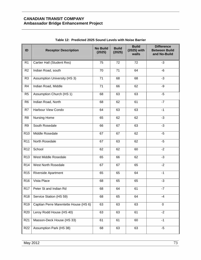
CANADIAN TRANSIT COMPANY Ambassador Bridge Enhancement Project
May 2012
73
Table 12: Predicted 2025 Sound Levels with Noise Barrier
ID Receptor Description No Build (2025)
Build (2025)
Build (2025) with
walls
Difference Between Build and No-Build
R1 Cartier Hall (Student Res) 75 72 72 -3
R2 Indian Road, south 70 71 64 -6
R3 Assumption University (HS 3) 71 68 68 -3
R4 Indian Road, Middle 71 66 62 -9
R5 Assumption Church (HS 1) 68 63 63 -5
R6 Indian Road, North 68 62 61 -7
R7 Harbour View Condo 64 63 63 -1
R8 Nursing Home 65 62 62 -3
R9 South Rosedale 66 67 63 -3
R10 Middle Rosedale 67 67 62 -5
R11 North Rosedale 67 63 62 -5
R12 School 62 62 60 -2
R13 West Middle Rosedale 65 66 62 -3
R14 West North Rosedale 67 67 65 -2
R15 Riverside Apartment 65 65 64 -1
R16 Vista Place 68 65 65 -3
R17 Peter St and Indian Rd 68 64 61 -7
R18 Service Station (HS 59) 68 65 64 -4
R19 Captian Perre Marentette House (HS 6) 63 63 63 0
R20 Leroy Rodd House (HS 40) 63 63 61 -2
R21 Masson-Deck House (HS 33) 61 61 60 -1
R22 Assumption Park (HS 38) 68 63 63 -5

CANADIAN TRANSIT COMPANY Ambassador Bridge Enhancement Project
May 2012
74
ID Receptor Description No Build (2025)
Build (2025)
Build (2025) with
walls
Difference Between Build and No-Build
R23 Dillon Hall (HS 2) 63 61 61 -2
R24 Indian Road South of Wyandotte 67 68 63 -4
R25 Indian Road 62 63 61 -1
R26 South Indian Road 60 63 60 0
R27 East side of Rosedale 59 61 59 0
R28 Mill and Rosedale 54 57 54 0
R29 Felix Street, North 57 58 56 -1
R30 Felix Street, South 58 58 56 -2
R31 Daycare on College 63 63 63 0
R32 Sunset Ave House 62 62 62 0
R33 Student Res South, Sunset 67 67 67 0
R34 Student Res North, Sunset 67 67 67 0
*HS – Heritage Site
5.9.2 Vibration
5.9.2.1 Construction Typical equipment to be used in these activities are auger drilling machine, backhoes, forklifts, dump trucks, flatbed trucks, pile drivers, concrete trucks, cranes, bobcats, concrete pumps, barges, concrete vibrators, grinders, jackhammers, pickup trucks and hand tools and equipment. Of this equipment, pile driving has the potential to produce the highest levels of impulse noise and ground borne vibration. Past experience from other similar projects indicates that during pile driving activities, sound levels can exceed 80 dBA at distances of up to approximately 100 metres (328 feet). At that distance, ground borne vibration levels can be perceptible, but are not generally sufficient to cause cosmetic or structural damage to buildings.
Mitigation
Vibration monitoring will be conducted when pile driving is taking place within 100 meters (328 feet) of a sensitive receptor, including heritage buildings. If excesses are found, reduced pile driving force and the construction of temporary noise barriers will be implemented.

CANADIAN TRANSIT COMPANY Ambassador Bridge Enhancement Project
May 2012
75
Additional information related to the measurement and modeling of the vibration effects of the proposed Project is included in Section 7.5 Noise.
No significant impacts are anticipated with the above noted mitigation measures. No significant adverse residual effects are anticipated.
5.9.2.2 Operation The conditions and makeup of the soil and the spread footing design are contributing factors to the propagation of ground borne vibration. The new span will be constructed on piles driven to bedrock. This can be a better design from a vibration standpoint because the bridge piers will not be floating but will instead be supported directly on bedrock. In addition, the proposed deck and roadway of the bridge will be a concrete structure with a relatively smooth surface containing small grooves to facilitate stormwater runoff for safety to reduce hydroplaning potential. Expansion joints will be placed as far apart as feasible and will be constructed flush with the surface of the bridge deck. This will minimize the low frequency noise associated with traveling over the expansion joints. It is likely that vibration levels will be lower after the construction of the proposed Project than pre-development.
Mitigation
In addition to designing the foundation for the new structure directly to bedrock, additional mitigation can be incorporated to ensure that there are no adverse effects during operation. To minimize the future possibility of increased vibration levels the road upgrading should ensure a smooth road surface with few imperfections.
No significant impacts are anticipated with the application of the above noted mitigation measures. With the above mentioned mitigation, residual effects relating to vibration are anticipated to be positive and improve local conditions.
5.10 Socioeconomic
5.10.1 Land Use
5.10.1.1 Construction The proposed Project will be entirely constructed on land owned by the Proponent. The selection of the proposed alignment avoids existing major institutional uses, particularly the historic Assumption Church and the University of Windsor campus. The alignment proposed for the Project will run adjacent to some existing residential development and land used for recreation purposes. The lands used for the proposed Project is comprised of approximately 63% residential land, 6% recreational land, and 31% other land uses including existing road ways. When it is deemed appropriate due to the Windsor plaza expansion, a portion of Huron Church Road will be closed and traffic will be re-routed to Indian Road between Wyandotte Street and College Avenue. Indian Road will be extended to College Avenue to facilitate traffic. The impact of these proposed changes, at some later date, have been assessed as part of this report.

CANADIAN TRANSIT COMPANY Ambassador Bridge Enhancement Project
May 2012
76
There are no commercial businesses located within the proposed Project alignment that will need to be removed during construction. Construction activities associated with the proposed Project will not interact directly with the level of commercial activity within the spatial boundaries.
The proposed Project construction will not require the purchase of any residential buildings. The row of boarded up vacant structures located east of Indian Road between Wyandotte Street and Mill Street will be converted to a green area as part of this project to create a security buffer around the Windsor Plaza.. A total of 17 houses will be demolished to accommodate the proposed plaza expansion and a total of 47 houses will be demolished along the east side of Indian Road to create a the green area. Currently, the CTC owns these houses.
Many residences are located adjacent (within 200 metres or 657 feet) to the proposed Project. The residents of these houses may experience a perceptible change in noise levels from the construction equipment during all phases of construction of the proposed Project. Residents may also be affected by air emissions and other disturbances generated by the Project. These issues and environmental effects are addressed in detail in Sections 7.1 Air Quality and Climate and 7.5 Noise and Vibration.
The recreational land uses in the vicinity of the proposed Project include hiking, bicycling and passive unorganized activities. The Detroit River is used for fishing. The construction activities associated with the proposed Project may result in a temporary disruption to fishing activities. Fishing activities can easily be accessed at an alternative location during construction. Construction activities will temporarily affect recreation trail land use in the immediate vicinity of the Project due to noise, dust and other minor disturbances during all Project activity phases and physical works. Once construction is completed all recreational activities will be restored and rehabilitated.
Mitigation
Additional improvements were identified that will be needed along Indian Road to ensure the continued operation of the study intersections at an acceptable level of service under the detour scenario. The additional needed improvements are listed below and discussed further in Appendix Q.
• Signalization of the intersection of Indian Road at Wyandotte Street.
• Signalization of the intersection of Indian Road Extended at College Avenue.
• Conversion of the eastbound shared right-through lane for the intersection of Huron Church Road at College Avenue to an exclusive right turn lane.
Based on the traffic analysis conducted with all the recommended improvements, the study intersections will operate at an acceptable level of service under the detour condition. No other mitigation related to land use beyond those already discussed for noise, air quality, and other issues will be required. No significant adverse residual effects are anticipated.

CANADIAN TRANSIT COMPANY Ambassador Bridge Enhancement Project
May 2012
77
5.10.1.2 Operation The residential and institutional land uses proximate to the proposed Enhancement Project will interact and be affected to a degree similar to or less than the current effect of the Ambassador Bridge. Land uses along Huron Church Road are expected to experience a reduction of congestion south of the plaza once the proposed Project is constructed. This will likely improve the level of service and safety along Huron Church Road and mitigate traffic noise to adjacent residents. As part of the Windsor plaza expansion, a portion of Huron Church Road will be closed and traffic will be re-routed to Indian Road between Wyandotte Street and College Avenue. Indian Road will be extended to College Avenue.
The presence of the proposed Project will interact with recreational land use due to noise and other minor disturbances in the immediate vicinity of the Project. This will only occur while crossing under the proposed replacement span, as the trails and most recreation activities are situated away from the Project.
The row of vacant, boarded up structures located east of Indian Road between Wyandotte Street and Mill Street will be converted to green space to create a security buffer around the Windsor Plaza. Many of these houses are already vacated. The remainder of the land use along Indian Road and Rosedale Avenue will remain the same. In addition, the residents of these houses may experience a perceptible change in noise levels from the additional traffic along Indian Road. This issue as well as possible impacts to local air quality are addressed in detail in Sections 7.1 Air Quality and Climate and 7.5 Noise and Vibration.
Mitigation
Additional improvements were identified that will be needed along Indian Road for the operation of the study intersections at an acceptable level of service under the detour scenario. These additional needed improvements are listed below and discussed further in Appendix Q.
• Signalization of the intersection of Indian Road at Wyandotte Street.
• Signalization of the intersection of Indian Road Extended at College Avenue.
• Conversion of the eastbound shared right-through lane for the intersection of Huron Church Road at College Avenue to an exclusive right turn lane.
Based on the traffic analysis conducted with all the recommended improvements to Indian Road, the study intersections will operate at an acceptable level of service under the detour condition.
No other mitigation related to land use beyond those already discussed for noise, air quality, and other issues will be required. There are no significant impacts anticipated with the application of the various mitigation measures. No significant adverse residual effects are anticipated.

CANADIAN TRANSIT COMPANY Ambassador Bridge Enhancement Project
May 2012
78
5.10.2 Social and Economic
5.10.2.1 Construction The benefits of the proposed Project during construction will be related to job creation and improved efficiency of the operation of the facility with the addition of the FAST/NEXUS lanes. The replacement span will result in an estimated 3,700 man-years of employment. Additional work related to the expansion of the plaza will result in an estimate 200 man-years of employment. Positive impacts on businesses are expected as a result of a large number of construction workers who will be within the Regional Study Area for the duration of the construction project. Businesses supplying consumer goods and personal services will have access to a significant new customer base. Also, as additional projects are initiated the construction workers may opt to stay in the Study Area creating a permanent increase in the customer base for business.
Mitigation
No mitigation beyond that already discussed for noise, air quality, and other issues will be required. Additional information related to the construction related effects of the proposed Project is included in Section 7.6 Socioeconomic Conditions. No significant adverse residual effects are anticipated and the residual effects are expected to improve air quality, noise, and the social environment. Due to the increase in employment, residual effects are anticipated to be positive.
5.10.2.2 Operation The existing international trade corridor will continue to serve as a significant gateway for the movement of goods and people between Canada and the US. The ongoing operation of the border crossing in this location will have a beneficial impact on job retention, business activity and economic and tourism development. The economy within the Regional Assessment Area boundaries and beyond has flourished due to cross border trade. The reductions in congestion brought about by the proposed Project will improve the provision of efficient cross border movement of goods and a greater level of assured movement of finished products for the area within the spatial boundaries. As a result there may be a higher level of comfort for industrial operations and a stemming of the relocation of those operations to other locations. The proposed Project, juxtaposed with the existing Ambassador Bridge, may act as a point of interest to tourists and result in an increase in tourism.
Mitigation
A Community Consultation Plan will be developed during the design phase and will incorporate a Noise Management Plan. A CTC representative will be accessible at all times and appointed as the community contact to address any questions, concerns or complaints during construction. No other mitigation beyond that already discussed for noise, air quality, and other issues will be required. There are no significant impacts anticipated with the application of the various mitigation measures. No significant adverse residual effects are anticipated.
CANADIAN TRANSIT COMPANY Ambassador Bridge Enhancement Project
May 2012
79
5.10.3 Aesthetics
5.10.3.1 Construction The aesthetic character of the proposed Project during construction will be evolutionary in varying stages of completion between the existing conditions described above toward the operational conditions described below. In addition to the structural elements of the proposed project, construction equipment including ground vehicles and cranes will be visible. The presence of these additional construction related elements is necessary for the completion of the construction of the proposed Project and temporary.
Mitigation
No mitigation during construction is warranted and any negative impacts resulting from construction activities will be limited in duration and not extend beyond the estimated two year construction period. No significant adverse residual effects are anticipated.
5.10.3.2 Operation The proposed Project consists of a six-lane cable-stayed bridge parallel to and approximately 30.5 metres (100 feet) to the west of the existing Ambassador Bridge. Simulations are provided in Section 7.6 Socioeconomic Conditions. The deck of the new bridge will be approximately the same height as the existing Ambassador Bridge - 46 metres (152 feet) above the Detroit River.
The towers for the proposed Project will be land-based to avoid the loss of fish habitat and potential hydraulic effects. These towers will be approximately 177 metres (582 feet) above the elevation of the Detroit River in order to accommodate the wider span and cable-stayed type of construction. The proposed Project will connect between the two existing plazas in Windsor, Ontario and Detroit, Michigan.
The proposed Project will be supported by the main tower piers and approximately 14 sets of approach bridge concrete piers spaced at approximately 43 metre (141 foot) intervals. The wider spacing allows for far fewer sets of piers to be used compared to the approximately 29 sets of steel piers for the existing Ambassador Bridge. It is anticipated that the replacement span will be lit at night as an aesthetic enhancement as well as for safety purposes in a manner consistent with and complimentary to the existing Ambassador Bridge.
Public consultation was conducted and input sought in both Canada and the U.S. regarding the design of the visual elements of the proposed Project. The preliminary design of the proposed Project has not been finalized at this time. The simulation photographs included in this section are conceptual only and incorporate a diamond shaped tower and complement the existing architecture of the Ambassador Bridge. The concept that was incorporated into the design was to provide a visually complimentary structure that was sensitive to the historic context of the Ambassador Bridge and complemented it with a new structure that is state-of-the-art for the 21st century adjacent to the Ambassador Bridge that was state-of-the-art for the early 20th century. The design of the proposed structure will incorporate non-specular materials into the design of the project components to decrease reflectivity and visibility of project features. The new span is designed to meet standards consistent with the historic character of the Ambassador Bridge.

CANADIAN TRANSIT COMPANY Ambassador Bridge Enhancement Project
May 2012
80
The Ambassador Bridge is recognized as a physical record of its time, place, and use. The proposed Project is not designed to take away from the significance of the existing Ambassador Bridge by providing a false sense of historical development. Instead, it is differentiated by using safer, modern cable-stayed bridge technology rather than replicating the suspension cable design of the original bridge.
It is also important to preserve the historic materials that characterize the existing Ambassador Bridge. The proposed Project is designed to be distinct from the Ambassador Bridge and will be compatible with the massing, size, scale and architectural features to protect the historic integrity of the property and its environment. The existing span will not be physically affected by the replacement span. In fact, the construction of the new span will extend the life of the existing span through the removal of heavy truck traffic that adversely affects the structural integrity of the existing span.
The proposed Project is differentiated from the old in that it incorporates state-of-the-art engineering. The replacement span will be of cable-stay construction in contrast to the suspension cable design of the original bridge. The replacement span substructure will be constructed primarily of concrete and the superstructure of steel and concrete permitting a clean design that will provide a visual contrast with the intricate exposed steel structure of the existing span. The proposed Project will be wider than the existing span, but will roughly parallel its course and will match its minimum clearance height and the line of its arc over the river.
There are a number of design elements that contribute to the image of the structure that can be modified to reflect the vision of the community. These elements include tower concepts, colour and texture, roadway fixtures and railings and the overall bridge lighting. Input has been sought from the public to determine the most desirable design elements.
The alternative plaza design concepts (included in Appendix B) as a proposed 25-year Plan depicts the area anticipated for use. From an aesthetics perspective, the future potential use of these lands are comparable to adjacent land uses along the commercial corridor of Huron Church Road and the existing plaza.
Mitigation
The primary mitigation factor for aesthetic effects associated with the proposed Project is the inclusion of the design elements for the proposed Project that complements the Ambassador Bridge. Hoarding and other protective measures will be used to mitigate the visual intrusion of construction. No significant adverse residual effects are anticipated. Depending on the user, residual effects could be considered positive.
5.11 Structures and Sites of Significance
5.11.1 Heritage Sites
5.11.1.1 Construction No heritage sites will be demolished or moved during the construction of the Project. Construction vehicles and Project components will be visible from several heritage properties during the construction phase. Visual impact assessment from the Project is set out in more

CANADIAN TRANSIT COMPANY Ambassador Bridge Enhancement Project
May 2012
81
detail in Section 7.6 Socioeconomic Conditions. See Appendix N for the Heritage Designation Assessment.
Mitigation
Hoarding and other protective measures will be used to mitigate the visual intrusion of construction on the surrounding area. Construction vehicles will avoid using roads located within residential and heritage areas. No significant adverse residual effects are anticipated.
5.11.1.2 Operation The Project will be visible from several heritage sites and no significant visual impacts are anticipated. The replacement span design shall be integrated and in keeping with the design of the existing Ambassador Bridge. Visual impacts are not anticipated from the expansion of the plaza. Visual impact assessment from the Project is set out in more detail in Section 7.6 Socioeconomic Conditions. See Appendix N for the Heritage Designation Assessment.
Mitigation
The integration of design elements that reflect the characteristics of the existing Ambassador Bridge will mitigate the visual impacts of the replacement span on heritage sites. There are no significant adverse visual effects of the Project on heritage sites. Visual impacts are not anticipated from the expansion of the plaza. Further discussion and visual simulations are included in Section 7.6 Socioeconomic Conditions. No significant adverse residual effects are anticipated.
5.12 Archaeology
5.12.1 Construction
The possibility of encountering archaeological features within the Project area does exist given the known history of the study area. A thorough Stage 1, Stage 2, and Stage 3 archaeological assessment has been completed for the proposed Project area (Appendix M). Based on the Stage 3 archaeological assessment, three of the four archaeological sites within close proximity to the proposed Project are not significant and do not warrant any further investigation. The fourth site, AbHs-34, may be a heritage resource requiring further investigation located within the proposed footprint of the tower pier. Site AbHs-34 is bordered by the Ambassador Bridge to the east, on the south by Riverside Drive, on the west by a structure located at 2856 Riverside Drive (formerly Villa Maria nursing home), and on the north by the berm/slope along the south edge of the Detroit River. Construction will avoid disturbing any archaeologically significant areas, wherever possible. There is very little potential for adverse environmental effects as areas identified as having archaeological potential will be avoided.
Any and all construction activities in the Study Areas shall be monitored by a licensed archaeologist. Taking into consideration the urban nature of the Project area and the level of disturbance that occurred during the construction of the original Ambassador Bridge, it is unlikely that the proposed Project will further degrade the archaeological and cultural heritage of the area.

CANADIAN TRANSIT COMPANY Ambassador Bridge Enhancement Project
May 2012
82
Mitigation
Wherever possible, all identified sites will be avoided. It is unlikely that archaeological site AbHs-34 can be avoided. If this is the case, Stage 4 mitigation at this site will be employed prior to construction beginning and through consultation with the Ministry of Culture, Aboriginal communities, and other heritage stakeholders. Stage 4 mitigation will be developed during final design but will likely involve documenting and removing the archaeological site through excavation. Documentation could include measurements, maps, drawings, and photographs. In addition, a licensed archaeologist will be at the Project site when soil disturbing activities are taking place. Should deeply buried archaeological deposits be found during construction activities, the Programs and Services Branch of the Cultural Programs Unit of the Ontario Ministry of Culture will be notified immediately. In the event that human skeletal remains are encountered during construction the proponent will immediately contact the Ontario Ministry of Culture, the Registrar or Deputy Registrar of the Cemeteries Regulation Unit of the Ministry of Consumer and Business Services, and the geographically nearest First Nation.
There are no significant impacts anticipated with the application of the mitigation measures. No significant adverse residual effects are anticipated.
5.12.2 Operation
There will be no additional soil disturbing activities required for the operation of the Project and no potential effects to archaeological resources.
Mitigation
There are no soil disturbing activities associated with the operation of the Project and no significant adverse effects will result and therefore no mitigation is required. No significant adverse residual effects are anticipated.
5.13 Human Health
5.13.1 Construction
There is the potential for increased dust, air emissions and noise from the operation of construction vehicles.
Mitigation
Measures will be undertaken to mitigate construction related air and noise effects as discussed in Sections 7.1 Air Quality and Climate and 7.5 Noise and Vibration. No significant adverse residual effects are anticipated.
5.13.2 Operation
During operation, human health can be affected from noise and air quality. Impacts from noise during operation are discussed above under the heading "Noise". Generally there will be an improvement in noise levels and any increase will be mitigated.

CANADIAN TRANSIT COMPANY Ambassador Bridge Enhancement Project
May 2012
83
Impacts on air quality are discussed above under the heading "Air Quality". Generally the design of the Project is intended to substantially improve the movement of traffic and result in a reducing in idling and queuing.
Mitigation
Measures undertaken to mitigate noise is set out in Section 7.5 Noise and Vibration and with the mitigation measures the Project does not result in any significant adverse effect relating to increased noise levels.
No mitigation is necessary as the construction of the Project will result in a net positive environmental effect during operation. Additional information pertaining to the air quality modelling is provided in Section 7.1 Air Quality and Climate. No significant adverse residual effects are anticipated.
5.14 Contaminated Sites and Waste Management
5.14.1 Construction
Excess materials will be generated during construction activities. Any excess materials will be properly managed and disposed of in accordance with existing regulatory requirements. To date, there have not been any areas of contaminated material confirmed within the proposed Project area.
Mitigation
The final contract package will emphasize reducing, reusing, and recycling of non-contaminated materials generated during construction. Disposal areas may be specified in the contract package to address any excess material generated from the Project.
In the event contaminated materials are discovered, applicable health and safety and environmental legislation describes procedures for dealing with these contaminated materials. With the application of mitigation measures noted above, no significant effects are to be expected. No significant adverse residual effects are anticipated.
5.14.2 Operation
The operation and maintenance of the Project may result in some environmental effects, as discussed above.
Mitigation
There are no significant environmental effects resulting from the operation of the Project. No significant adverse residual effects are anticipated.

CANADIAN TRANSIT COMPANY Ambassador Bridge Enhancement Project
May 2012
84
5.15 Navigation
5.15.1 Construction
Potential project-environment interactions that may be encountered during project construction include potential navigation restrictions and/or the disruption of vessel flows resulting from the necessary use of barges during the project construction period. These include the interactions between the barge while moving and anchored with:
• Lake freighters;
• Tugboats;
• Sailboats;
• Riverboats; and
• Pleasure craft.
All necessary measures to avoid/minimize these impacts will be taken in accordance with the Navigable Waters Protection Act, the Shipping Act, COLREGS, and SOR/84-335. Any barges used for construction of the Project are not expected to be any larger than the current vessels using the river now.
Mitigation
All necessary measures to avoid/minimize these impacts will be taken in accordance with the Navigable Waters Protection Act, the Shipping Act, COLREGS, and SOR/84-335. Any impacts on navigation will be mitigated through compliance with the existing regulatory regime governing navigable waters. No significant adverse residual effects are anticipated.
5.15.2 Operation
There are no impacts on navigation from the operation of the Project.
Mitigation
There are no piers placed in the Detroit River and no disruption to navigation. There are no significant adverse effects on navigation and no mitigation is required. No significant adverse residual effects are anticipated.
5.16 Current Use of Lands and Resources for Traditional Purposes by Aboriginal Peoples
5.16.1 Construction
There are four First Nations that have an interest in the Windsor area. These communities are: Aamjiwnaang, Caldwell, Wyandotte (also known as 'Wyandot'), and Walpole Island First Nations. All of these communities were provided an opportunity to participate in the consultation process. Representatives from the CanAm Indian Friendship Centre of Windsor were also contacted and provided with an opportunity to participate in the consultation process. Numerous

CANADIAN TRANSIT COMPANY Ambassador Bridge Enhancement Project
May 2012
85
letters were couriered and faxed to the Chief of each of the First Nation to request a meeting to discuss the proposed Project. Information relating to any traditional knowledge of the area to assist in identifying potential environmental effects and any relevant biophysical and historical information otherwise unavailable was also requested from each First Nation. Copies of these letters are attached as Appendix O and incorporated as part of the Public Consultation initiative discussed in Section 7.10. There has also been a Walpole Island consultation initiative. This activity consisted of a presentation to the Walpole Island Heritage Committee, a presentation and meeting with Chief and Council and a public open house meeting held on June 28, 2007 at Walpole Island United Church. The Wyandotte Nation preliminarily expressed concerns regarding impacts to burial grounds by the Project. However, after a thorough archaeological investigation that included both literature reviews and shovel testing, no burial sites were identified and thus none will be affected. No concerns have been expressed regarding the construction of the Project inhibiting the current use of land or terrestrial resources for traditional purposes by aboriginal peoples.
Mitigation
The Detroit River and shoreline within the Local Study Area do not possess any unique attributes for the current use of these resources for traditional purposes by aboriginal people. Therefore, no mitigation is necessary. No significant adverse residual effects are anticipated.
5.16.2 Operation
There are four First Nations that have an interest in the Windsor area. These communities are: Aamjiwnaang, Caldwell, Wyandotte (also known as 'Wyandot'), and Walpole Island First Nations. All of these communities were provided an opportunity to participate in the consultation process. Representatives from the CanAm Indian Friendship Centre of Windsor were also contacted and provided with an opportunity to participate in the consultation process. Numerous letters were couriered and faxed to the Chief of each of the First Nation to request a meeting to discuss the proposed Project. Information relating to any traditional knowledge of the area to assist in identifying potential environmental effects and any relevant biophysical and historical information otherwise unavailable was also requested from each First Nation. Copies of these letters are attached as Appendix O and incorporated as part of the Public Consultation initiative discussed in Section 7.10. There has also been a Walpole Island consultation initiative. This activity consisted of a presentation to the Walpole Island Heritage Committee, a presentation and meeting with Chief and Council and a public open house meeting held on June 28, 2007 at Walpole Island United Church. No concerns have been expressed regarding the operation of the Project inhibiting the current use of land or terrestrial resources for traditional purposes by aboriginal peoples.
Mitigation
The Detroit River and shoreline within the Local Study Area do not possess any unique attributes for the current use of these resources for traditional purposes by aboriginal peoples therefore, no mitigation is necessary. No significant adverse residual effects are anticipated.
CANADIAN TRANSIT COMPANY Ambassador Bridge Enhancement Project
May 2012
86
5.17 Transboundary Impacts
The Proposed Project is an international border crossing and is not entirely located in Canada. The source of emissions for the Proposed Project are mobile where all sources either came from or are going to the United States. As a result, the potential for air and noise impacts from the Proposed Project were considered the most likely causes of any transboundary effects, and have been the focus of our consideration.
To assess the transboundary impacts, environmental studies were undertaken in both Canada and the United States. The air analysis conducted by the proponent in the U.S. evaluated the entire length of the bridge from the US into Canada and concluded that the Proposed Project will not create any significant adverse air quality impacts. The noise analysis in the US extends approximately halfway across the bridge from the US Ambassador Bridge Gateway Project to the international border. Similarly, the noise and air quality analyses in Canada extended approximately halfway across the bridge to the international border. Following is a synopsis for the air quality and noise studies conducted in both countries. Complete copies of the air quality and noise studies that were conducted as part of the US Environmental Assessment are included within Appendices P and Q.
5.17.1 Air Quality
The international boundary between the US and Canada is located approximately midway across the Ambassador Bridge existing span. Transboundary impacts related to air quality was extensively studied in both countries. Weston Solutions, Inc. completed the air quality study in the US in December 2007 and Ortech Environmental completed the air quality study in Canada in November 2007, and updated the study in April 2011.
The air quality report in Windsor, completed by Ortech Environmental in November, 2007 and updated in April 2011, was based on factors for air quality and climate change outlined in the Environmental Assessment Guidelines. The existing conditions indicate that the greatest air quality impacts do not occur at the bridge or the customs plaza, but instead occur around key intersection locations along Huron Church Road. Under the future scenario, in 2015, the impacts from construction activities related to the replacement span will result in air quality in close proximity to the bridge being impacted due to emissions from construction equipment. There is a potential for concentrations of PM10 and PM2.5 to be above the air quality criteria. However, during construction numerous mitigation measures will be implemented to ensure that there is no significant adverse effect from the Proposed Project. In addition, the increased in air quality around the Ambassador Bridge in Windsor does not have any impact on transboundary air quality as it is localized due to construction activities.
Under the future scenario, in 2025 with the Ambassador Bridge referred to as “Future Do Nothing” or 2025 (FDN), the greatest air quality impacts are still predicted to occur along Huron Church Road, but are reduced in magnitude and aerial extent relative to the present (baseline) as more stringent fuel and vehicle emission standards take effect. For most pollutants of interest, the model suggests that the effect of more stringent standards outweighs the increase in traffic volumes. Again, there is no impact on transboundary air quality as these effects are all localized.

CANADIAN TRANSIT COMPANY Ambassador Bridge Enhancement Project
May 2012
87
Under the future scenario, in 2025, 10 years after construction and operation of the replacement span referred to as 2025 (A), the greatest air quality impacts are still predicted to occur along Huron Church Road, but are reduced in magnitude and aerial extent relative to the present (baseline) as more stringent fuel and vehicle emission standards take effect as described above. The air quality in the area near the customs plaza and on the bridge is predicted to benefit from improved traffic flow due to the higher capacity of the expanded customs plaza and the operation of the new bridge span. The reduced vehicle emissions appear to outweigh the increase in traffic volumes for most pollutants of interest.
The reduced magnitude and aerial extent is most apparent for substances that are closely tied to the standards, such as NOx. Under this scenario, NOx concentrations are predicted to be below the air quality criteria. A comparison of the future 2025 “do nothing” and replacement span only scenarios, indicate that the replacement span and customs plaza will result in an improvement in air quality, notably in the area close to the bridge and the customs plaza. Again, any impacts are localized and there is no impact on transboundary air quality.
To assess the long term air quality impacts from the Proposed Project in the US, an air quality study was performed using information from existing permanent air quality monitoring stations operated by MDEQ surrounding the Proposed Project and using standard calculation techniques to determine potential emissions from the new cable-stayed bridge. The MOBILE6.2 program was used to estimate annual emissions of particulate matter with diameters less than 2.5 micrometers (PM2.5), particulate matter with diameters less than 10 micrometers(PM10), carbon monoxide, nitrogen oxides, sulfur dioxide, and volatile organic compounds (VOC assumed to be HC) (as a measure of ozone) for the Proposed Project in year 2010. The 2010 and 2030 annual air emissions of all criteria pollutants from vehicle traffic on the new bridge will consist of only 0.0144% and 0.0097% of the annual emissions of criteria pollutants for Wayne County, Michigan. Based on these estimates, vehicle emissions from the Proposed Project do not result in any significant adverse air quality impacts.
An air quality dispersion modeling analysis, or “hot spot analysis”, was performed at the request of the U.S. Environmental Protection Agency (“US EPA”) and SEMCOG to assess the local and transboundary ambient air impacts from the operation of a new bridge that would relocate traffic from the existing Ambassador Bridge. The US EPA CAL3QHCR (Dated: 95221) model was used to assess the ambient air impacts from vehicular emissions, including air toxics. The CAL3QHCR maximum predicted impacts from the existing Ambassador Bridge and the proposed new bridge occur in a small area just south of the U.S. Customs Plazas. The maximum predicted impacts in the highest concentration area are less than all applicable standards and health based screening levels in the U.S. The analysis also shows that the potential transboundary air quality impacts of the Project are insignificant and there are no significant adverse transboundary effects from the Proposed Project. .
The potential for transboundary air quality impacts are deemed insignificant and the analysis undertaken by the experts conclude that there are no significant adverse effects arising from the Proposed Project. Further, the contribution from the Project Area is not a significant source of regional air pollutions in itself. The project is expected to have air quality benefits in that congestion and idling time will be reduced. There will be some short-term air quality impacts from construction, but these also are not expected to be significant and will be mitigated through dust suppression and other measures. Construction impacts will be mitigated on both sides of

CANADIAN TRANSIT COMPANY Ambassador Bridge Enhancement Project
May 2012
88
the bridge resulting in no significant adverse environmental effects and no significant adverse residual effects are anticipated.
5.17.2 Noise
A noise study was completed in Windsor by HCG Engineering in November 2007 and updated in April 2011, to consider noise from the construction and ongoing operations of the companion bridge in Canada as set out in the environmental assessment guidelines provided by Transport Canada, dated August 2007.. The noise impact of the proposed Enhancement Project for the majority of the residences is predicted to be within the Ontario Ministry of Transportation’s criteria. Sound levels will either decrease due to the beneficial features of the replacement span and increased distance for the receptors to the east, or increase by less than 5 dBA from the future no build to the future build scenario. At a number of residences located along Indian Road and Rosedale Avenue (west of the bridge), sound levels are predicted to increase by a minor amount (between 1 and 3 decibels). Generally the majority of the boarded up vacant structures on the east side of Indian Road will be removed and replaced with a green area. At all other receptors sound levels will increase by less than 1 decibel, an insignificant amount. Generally increases in sound level of less than three decibels are not perceptible to most individuals. With the proposed mitigation measures, traffic noise levels for all residences are predicted to decrease or remain the same when compared to the No-Build scenario. Therefore, there are no significant adverse environmental effects either on transboundary receptors or local receptors.
Vibration measurements indicate that vibration induced by heavy vehicles on the existing bridge is perceptible on the ground at locations near the bridge piers and may be perceptible to some residents. The replacement span is proposed to be supported on piles or shafts driven or founded in bedrock and as a result the vibration levels are anticipated to decrease. Noise and vibration impacts during construction will be controlled through compliance with the City of Windsor’s By-Laws and Ontario Ministry of the Environment (MOE) sound level limits for construction equipment. In addition, pile driving will be monitored when piles are being driven in proximity to sensitive structures.
A noise impact assessment was conducted in the U.S. by Avalon Consulting Professionals, LLC in August 2008 to determine the scope and magnitude of project related effects. The noise analysis in the U.S. extends approximately halfway across the bridge from the U.S. Ambassador Bridge Gateway Plaza to the international border.
The results of the analysis indicate that existing (2010) exterior traffic noise levels range from 53.5 to 74.0 dBA, with traffic noise levels predicted to approach, meet, or exceed the Noise Abatement Criteria (NAC) at 3 of the sites. For the No-Build Alternative (2030), exterior traffic noise levels are predicted to range from 55.9 to 76.2 dBA, with levels predicted to approach, meet, or exceed the NAC at 5 of the sites. In the future (2030), with the proposed bridge, exterior traffic noise levels are predicted to range from 56.8 to 75.7 dBA, with levels predicted to approach, meet, or exceed the NAC at 5 of the sites. All alternatives include the Ambassador Bridge Gateway Plaza Improvements.
When compared to the existing condition, exterior traffic noise levels are predicted to increase 1.4 to 4.8 dBA with the proposed Ambassador Bridge Enhancement Project. The average difference in noise levels at the 35 noise-sensitive sites between the Existing traffic noise levels and the Build Alternative is 2.5 dBA. No sites were predicted to experience a substantial

CANADIAN TRANSIT COMPANY Ambassador Bridge Enhancement Project
May 2012
89
increase (10 dBA or more) in traffic noise as a result of the project and there were no transboundary impacts.
When compared to the No-Build Alternative, exterior traffic noise levels are predicted to be almost identical to those with the improvements associated with the Ambassador Bridge Enhancement Project. The average difference in noise levels at the 35 noise-sensitive sites between the No-Build and Build Alternative is 0.13 dBA, ranging from an increase of 2.5 dBA to a decrease of 0.8 dBA. Generally increases in sound level of less than three decibels are not perceptible to most individuals.
In order to further assess the potential for transboundary impacts related to traffic noise, noise level contours were developed for the future improved bridge. These noise contours delineate the minimum distance from the improved roadway’s edge of pavement where the FHWA Activity Category B land use should occur in 2030. The extent of the 66 dBA noise level on the proposed bridge extends approximately 450 ft (137 m) from the edge of pavement. Land fall in Canada is approximately 1000 ft (305 m) from the United States border. Using this contour information, the sound levels from the proposed bridge at the United States border should decrease to 66 dBA within 450 ft (137 m) which is substantially less than the 1000 ft (305 m) distance to the closest noise sensitive site in Canada. Therefore, transboundary noise impacts from the ABEP project are not anticipated. For more details on the noise study in the U.S., see Appendix Q.
The potential for transboundary noise pollution impacts is deemed insignificant and there are no significant adverse effects. There are no significant noise impacts in the United States, and noise barriers are proposed to minimize any noise impacts in Canada. Further mitigation for transboundary noise impacts is not required. No significant adverse residual effects are anticipated.
5.18 Summary of Residual Effects
The following table summarizes the significance of residual effects before and after mitigation.

CANADIAN TRANSIT COMPANY Ambassador Bridge Enhancement Project
May 2012
90
Table 13: ABEP Summary of Residual Effects
Environmental Factor
Significance Before Mitigation*
Significance After Mitigation*
Magnitude Geographic Extent
Frequency Duration Irreversibility Ecological Context
Air Quality Low
Negative
Low
Negative
Low Less than 300 m from Project under worst case scenario
Low Short-term Reversible Air Quality within 300 m of project.
Climate Low
Negative
None Varies by climactic event
Contained to site
Varies Varies Reversible Impacts of climate on project
Surface Water Moderate
Negative
Low
Negative
Varies by precipitation event
300 m upstream and downstream of project
Varies by precipitation event
Varies by precipitation event
Reversible Surface water runoff, hydrology
Ground Water Moderate
Negative
Low
Negative
Varies by rain event
100 m radius of project
During construction
Varies by rain event
Reversible Soils, aquifer, groundwater flow
Floodplains None None None None None None None Flooding, water supply
Vegetation Communities
Low
Negative
Low
Positive
Negligible 558 m2 for support tower and piers and existing pervious area of 21,091 m2 slated for the plaza
Permanent Life of project
Irreversible for life of project
Grass, opportunistic herbaceous plants, and few ornamental and native trees.

CANADIAN TRANSIT COMPANY Ambassador Bridge Enhancement Project
May 2012
91
Environmental Factor
Significance Before Mitigation*
Significance After Mitigation*
Magnitude Geographic Extent
Frequency Duration Irreversibility Ecological Context
expansion.
Fish and Fish Habitat
Low
Negative
Low
Negative
Negligible <1 km2 Varies Life of project
Reversible (sport fish and forage fish), migration, spawning and nursery areas
Aquatic Plants Low
Negative
Low
Negative
Negligible <1 km2 Varies Life of project
Reversible Fish habitat and forage
Wildlife Low
Negative
Low
Negative
Negligible Contained to site
Varies Life of construction
Reversible Wildlife habitat and species
Bird Collisions Low
Negative
Low
Negative
Negligible Contained to site
Variable depending on paths of migration
Life of project
Irreversible for life of project
Bridge stands in path of migration corridor
Species at Risk Moderate
Negative
Low
Negative
Negligible Contained to site
Nesting season
Life of project
Irreversible for life of project
Nesting site for peregrine falcon
Noise Low
Negative
Low
Positive
0-2 dBA reduction
300 m from the proposed bridge and plaza
Variable depending on traffic levels and speeds
Life of project
Irreversible for life of project
Relatively loud, urban environment containing residential, commercial

CANADIAN TRANSIT COMPANY Ambassador Bridge Enhancement Project
May 2012
92
Environmental Factor
Significance Before Mitigation*
Significance After Mitigation*
Magnitude Geographic Extent
Frequency Duration Irreversibility Ecological Context
and institutional uses within 300 m
Vibration Low
Negative during construction; positive post construction
Low
Negative during construction; positive post construction
Barely perceptible
100 m from the proposed bridge
Variable depending on traffic levels and speeds
Life of project
Irreversible for life of project
Relatively loud, urban environment containing residential, commercial and institutional uses within 300 m
Land Use Low
Negative
Low
Negative
Negligible Within 200 m from site
Varies Life of project
Reversible Recreational uses restored after completion of construction
Economic High
Positive
High
Positive
3,900 man-years
Southwestern Ontario and Eastern Michigan
Throughout construction
During construction
Reversible Job creation; more efficient border crossing
Aesthetics Low
Positive
Low
Positive
Varies by user and vantage point
Varies by viewshed
Constant Life of project
Reversible Project will be landmark for 2 cities and a change to

CANADIAN TRANSIT COMPANY Ambassador Bridge Enhancement Project
May 2012
93
Environmental Factor
Significance Before Mitigation*
Significance After Mitigation*
Magnitude Geographic Extent
Frequency Duration Irreversibility Ecological Context
existing skyline
Heritage Sites Low
Negative
Low
Negative
None directly impacted
Varies by viewshed
Life of project
Life of project
Irreversible for life of project
Bridge may be visible from some heritage sites.
Archaeology Low
Negative
Low
Negative
One site Approximately 85m (north-south) by 25m (east-west)
Permanent Permanent Irreversible Aboriginal and historic Euro-Canadian artifacts
Contaminated Sites
Low
Negative
Low
Negative
Negligible Contained to site
Varies Life of construction
Reversible Spills, construction materials
Navigation Low
Negative during construction; none during operation
Low
Negative during construction; none during operation
Negligible Barge port of entry to the Ambassador Bridge crossing
Throughout construction of bridge
Life of construction of bridge
Reversible Freighters, tugboats, sailboats, riverboats, pleasure craft
Aboriginal Peoples
Low
Negative
Low
Negative
Negligible Contained to site
Permanent Permanent Irreversible First Nations; aboriginal archaeological artifacts; fish in

CANADIAN TRANSIT COMPANY Ambassador Bridge Enhancement Project
May 2012
94
Environmental Factor
Significance Before Mitigation*
Significance After Mitigation*
Magnitude Geographic Extent
Frequency Duration Irreversibility Ecological Context
river
Cumulative Impacts
Low
Negative
Low
Negative
Negligible Urban area within City of Windsor and surrounding communities
Constant Life of project
Varies by environmental factor
All
*Significance before/after mitigation quantified with two qualifiers: magnitude and nature of effect Magnitude: None = no residual effect; Low = minimal non-significant residual effect; High = large in scale and/or significant residual effect Nature of effect: Negative or Positive

CANADIAN TRANSIT COMPANY Ambassador Bridge Enhancement Project
May 2012
95
5.19 Summary of Mitigation and Commitments
The following table summarizes the environmental mitigation and commitments made by CTC regarding this EIS.
Table 14: ABEP Summary of Environmental Mitigation and Commitments
ID Environmental Element
Reference Section
Timeframe Summary of Environmental Mitigation and Commitments
1 Air Quality 5.1 Construction
Operation
• Various mitigation measures will be employed during construction so there is no significant adverse effect to air quality. Effects such as dust impacts will be mitigated through the use of proper controls, such as: o periodic watering of unpaved (unvegetated) areas; o periodic watering of stockpiles; o limiting speed of vehicular travel; o use of water sprays during the loading, unloading of materials; o sweeping and/or water flushing of the entrances to the construction
zones; o Use of calcium chloride.
• Implementation of a Best Management Plan (BMP). • Contract documents requiring heavy equipment to meet design
specifications for emission controls and that licensed vehicles conform to provincial Drive Clean standards, where appropriate.
• Idling of heavy equipment will be monitored and limited consistent with the municipal by-law to the extent possible.
• The contractor will be required to provide a construction schedule and plan including a list of the number and/or size of heavy equipment that will be operating simultaneously. Restrictions will be imposed to ensure the values presented in the EA are not exceeded.
• Since the NOx concentrations are predicted to be highest at the virtual receptors located on the water versus virtual and special receptors located on land, restrictions will be imposed to limit the distance between operating barges and water based receptors such as pleasure boats.

CANADIAN TRANSIT COMPANY Ambassador Bridge Enhancement Project
May 2012
96
ID Environmental Element
Reference Section
Timeframe Summary of Environmental Mitigation and Commitments
• Road sweeping practices in accordance with maintenance standards will be employed to reduce silt loading on the area road network during the operations phase.
• Implement compliance monitoring and adaptive management plan. 2 Noise and
Vibration 5.9 Construction
/Operation • A noise barrier 3.0 meters in height will be constructed on the “Jersey”
Barrier at the west edge of the roadway. It shall extend northwards from the existing noise barrier which was constructed to the west of the Inspection Plaza during the west ramp expansion project to approximately 120 metres (~ 400 feet) north of Peter Street.
• The height of the northerly portion of the existing noise barrier to the west of the plaza will be increased to 3 m (~ 10 ft) above the road surface.
• A noise barrier approximately 5.5 m (~ 18 ft) in height will be constructed along the north and west perimeter of the proposed plaza expansion area. This barrier will connect to the remaining portion of the existing noise barrier which was constructed to the west of the existing plaza during the recent plaza expansion project.
• The noise barriers will be constructed from materials and methods contained in CAN/CSA Z107.9.
• CTC commits to coordinating with schools within 300 m of the Project to create a mutually agreeable construction system to reduce the impact of noise on schools especially during exams.
• A dynamic vibration study of the bridge support structure will be undertaken when sufficient detail is available to ensure that the piers and associated support structure will not radiate significant levels of groundbourne vibration into the surrounding environment.
• Sound and vibration levels will be monitored during pile driving within 100 m of sensitive receptors. If excesses are noted, reduced driving force or equipment will be used.
• Time restrictions set out in the City of Windsor’s Noise Bylaw 6716 will be

CANADIAN TRANSIT COMPANY Ambassador Bridge Enhancement Project
May 2012
97
ID Environmental Element
Reference Section
Timeframe Summary of Environmental Mitigation and Commitments
complied with. • Pile driving or other activities that generate excessive noise will not be
conducted prior to 7 am or after 9 pm. • The contractor will be required to ensure that factory recommended mufflers
are maintained on all construction equipment. • Sound emissions from all construction equipment will comply with MOE
Guideline NPC-115 “Sound Levels from Construction Equipment.” • Haul routes will be designed to avoid residential neighbourhoods. • To the greatest extent possible, the most noise intensive construction
activities will be limited to daytime hours. • Where the sequencing of construction permits, permanent noise barriers
and/or berms may be built during the early phases of construction in order to reduce construction noise levels at receptor locations.
• A Noise Management Plan will be included in the community consultation plan. The CTC will have a presence onsite and an individual will be appointed as the community contact to address any questions, concerns or complaints.
3 Protection of Community and Neighbourhood Characteristics
5.10 Construction/Operation
• Implement a communication process during construction to manage disruption effects experienced by residents.
• A community consultation plan will be developed. A representative of CTC will be appointed as the community contact to address any questions, concerns or complaints.
• Where the sequencing of construction permits, permanent noise barriers and/or berms may be built during the early phases of construction in order to reduce construction noise levels at receptor locations.
• CTC commits to coordinating with schools within 300 m of the Project to create a mutually agreeable construction system to reduce the impact of noise on schools especially during exams.
• Implementation of the tree preservation plan.
CANADIAN TRANSIT COMPANY Ambassador Bridge Enhancement Project
May 2012
98
ID Environmental Element
Reference Section
Timeframe Summary of Environmental Mitigation and Commitments
4 Economic Impacts
5.10 Construction • Efforts will be made during the construction phase to ensure access is maintained to operating businesses.
• A community consultation plan will be developed. The CTC offices are located onsite and an individual within those offices will be appointed as the community contact to address any questions, concerns or complaints by business owners.
5 Waste and Waste Management
5.14 Construction/Operation
• The final contract package will emphasize reducing, reusing, and recycling of non-contaminated materials generated during construction.
• In the event contaminated materials are discovered, all applicable health and safety and environmental legislation will be followed and material disposed of in accordance with the regulatory requirements.
• The Spill Prevention and Contingency Plan will be used to minimize the chance of spills and enhance the reaction should a spill occur.
6 Archaeological Resources
5.12 Construction • Since archaeological site AbHs-34 cannot be avoided, Stage 4 mitigation will be employed.
• A licensed archaeologist will be at the Project site when soil disturbing activities are taking place.
• Should deeply buried archaeological deposits be found during construction activities, the Programs and Services Branch of the Cultural Programs Unit of the Ontario Ministry of Culture will be notified immediately.
• In the event that human skeletal remains are encountered during construction, the proponent will immediately contact the Ontario Ministry of Culture, the Registrar or Deputy Registrar of the Cemetaries Regulation Unit of the Ministry of Consumer and Business Services, and the geographically nearest First Nation.
7 Cultural Heritage Resources
5.11 Construction • No heritage sites will be demolished or moved during the construction of the Project.
• Hoarding and other protective measures will be used to mitigate the visual intrusion of construction on the surrounding area.

CANADIAN TRANSIT COMPANY Ambassador Bridge Enhancement Project
May 2012
99
ID Environmental Element
Reference Section
Timeframe Summary of Environmental Mitigation and Commitments
• Construction vehicles will avoid using roads located within residential and heritage areas.
8 Vegetation and Vegetation Communities
5.5 Construction/Operation
• A Tree Preservation Plan to maintain some mature vegetation will be implemented.
• Areas cleared during construction will be replanted once construction is complete to avoid erosion and sediment pollution. Only native species will be re-planted.
• Areas that should be protected during construction will be delineated prior to the start of construction and no activities will be permitted in these areas.
• Where necessary, vegetation removals will occur outside the growing season to avoid loss of wildlife and wildlife habitat to the extent possible.
9 Fish and Fish Habitat
5.6 Construction/Operation
• Construction will take place on land with some limited use of construction barges to deliver materials to the site.
• The proposed Project will not involve dredging, in-water blasting, in-water pile driving, pier construction or placement of shore protection in or along the Detroit River.
• Best management practices will be employed to reduce the potential for spills, and materials/equipment from entering water.
• Maintenance, fuelling and storage should occur at least 30 m from watercourses/ drains.
• CTC will ensure that contractors operating barges for the delivery of materials to the site are in compliance with the DFO Canadian Coast Guard marine safety, pollution, and spill control requirements established to protect the aquatic ecosystem.
• CTC will implement compliance monitoring during construction. • Any pumped groundwater will be treated to reduce pollutants to levels that
comply with parameter threshold levels recommended in the Canadian Water Quality Guidelines for the Protection of Aquatic Life, and Policies, Guidelines, Provincial Water Quality Objectives of the (Ontario) Ministry of
CANADIAN TRANSIT COMPANY Ambassador Bridge Enhancement Project
May 2012
100
ID Environmental Element
Reference Section
Timeframe Summary of Environmental Mitigation and Commitments
Environment and Energy (July, 1994) prior to discharge. • Debris should be prevented from entering watercourses/drains. • The Spill Prevention and Contingency Plan will be followed. • Sediments will be prevented from reaching sensitive areas through erosion
and sediment controls and exposed soils stabilized as soon as possible. • A stormwater management plan and erosion control plan will be developed
during design and implemented to treat run-off during operations (Appendix E).
• Stormwater management facilities will be provided to mitigate for the increase in impervious surface area and runoff water. The stormwater management facility will be sized to treat the new pavement and increase traffic volume.
• During operation, all runoff from the bridge will be collected and directed to either a new stormwater treatment facility or will be tied into existing stormwater collection systems wherever possible.
10 Wildlife and Wildlife Habitat
5.7, 5.8 Construction/Operation
• Tree Preservation Plan will be implemented to retain mature trees that provide wildlife habitat.
• Where possible, vegetation removals will occur outside the growing season to avoid loss of wildlife and wildlife habitat to the extent possible.
• CTC will limit vegetation removal between May 1 and July 31 to the extent possible in an effort to minimize harm to all wildlife including migratory birds. If vegetation removals are required between May 1 and July 31, a nest survey will be conducted by a qualified avian biologist immediately prior to commencement of construction to identify and locate active nests of migratory birds and to develop a mitigation plan, if necessary.
• CTC will coordinate with the MNR regarding construction activity near the Peregrine Falcon nest.
• Implement Peregrine Falcon Management Plan • If possible, CTC will limit the construction of the bridge in the vicinity of the

CANADIAN TRANSIT COMPANY Ambassador Bridge Enhancement Project
May 2012
101
ID Environmental Element
Reference Section
Timeframe Summary of Environmental Mitigation and Commitments
nest during the nesting season for these birds (approximately March 15 to July 31).
• CTC will provide an experienced monitoring team for the peregrine falcon nest and other nesting birds to determine if construction of other elements of the project are affecting the nest and to determine when the birds flee the nest. When necessary, behavioural studies will be conducted to monitor activity and behaviour in or directly adjacent to the construction site during the breeding season.
• CTC will focus the bridge lighting (shielded lights) in the downward direction to minimize the potential for nighttime bird collisions with the bridge.
• Low intensity white strobe lights (one flash every three seconds) were found to be preferable for lighting of tall structures and buildings to reduce the potential for avian collisions. CTC will use this type of strobe lighting at the tops of the towers pending any change needed based on final design criteria and final consultation with the State Historic Preservation Office (SHPO) in the United States.
• No red or yellow steady lights which can disorient avian species will be used on the bridge.
• If colored lighting is utilized to illuminate the cables, CTC will use lower intensity, lower wavelength lighting of blue, turquoise or green, pending final design criteria. These wavelengths tend to minimize disruption of magnetic orientation in several avian species.
11 Groundwater
5.3 Construction • Pumped groundwater will be treated to reduce pollutants to acceptable levels prior to discharge.
• Groundwater in the foundation excavations will be controlled to provide for worker safety, prevention of erosion and sedimentation issues and successful completion of the foundation.
• In areas with artesian groundwater pressures, groundwater pressure mitigation measures may include use of controlled density drilling fluids for

CANADIAN TRANSIT COMPANY Ambassador Bridge Enhancement Project
May 2012
102
ID Environmental Element
Reference Section
Timeframe Summary of Environmental Mitigation and Commitments
installation of deep foundations (e.g. drilled shafts or caissons) so as to minimize or avoid the need for dewatering.
12 Drainage and Stormwater Management
5.2 Construction/Operation
• The proposed Project will not involve dredging, in-water blasting, in-water pile driving, pier construction or placement of shore protection in or along the Detroit River.
• Construction will take place on land with some limited use of construction barges to deliver materials to the site.
• Best management practices will be employed to reduce the potential for spills, and materials/equipment from entering the surface or ground water.
• Maintenance, fuelling and storage will occur at least 30 m from watercourses/ drains.
• CTC will ensure that contractors operating barges for the delivery of materials to the site are in compliance with the DFO Canadian Coast Guard marine safety, pollution, and spill control requirements established to protect the aquatic ecosystem.
• CTC will implement compliance monitoring during construction. • Any pumped groundwater will be treated to reduce pollutants to levels that
comply with parameter threshold levels recommended in the Canadian Water Quality Guidelines for the Protection of Aquatic Life, and Policies, Guidelines, Provincial Water Quality Objectives of the (Ontario) Ministry of Environment and Energy (July, 1994) prior to discharge.
• All necessary actions will be taken to prevent debris from entering watercourses/drains.
• The Spill Prevention and Contingency Plan will be followed (Appendix C). • Sediments should be prevented from reaching sensitive areas through
erosion and sediment controls and exposed soils stabilized as soon as possible.
• A stormwater management plan and erosion control plan will be developed during design and implemented to treat run-off during operations.

CANADIAN TRANSIT COMPANY Ambassador Bridge Enhancement Project
May 2012
103
ID Environmental Element
Reference Section
Timeframe Summary of Environmental Mitigation and Commitments
• Stormwater management facilities will be provided to mitigate for the increase in impervious surface area and runoff water. The stormwater management facility will be sized to treat the new pavement and increase traffic volume.
• During operation, all runoff from the bridge will be collected and directed to either a new stormwater treatment facility or will be tied into existing stormwater collection systems.

CANADIAN TRANSIT COMPANY Ambassador Bridge Enhancement Project
May 2012
104
6.0 CUMULATIVE EFFECTS
6.1 Cumulative Effects – Foreseeable Future Projects
There are no significant projects (past, present or foreseeable) that are relevant to this proposed Project that would negatively influence residual environmental effects. The Study Area is urban and no project has been identified that will contribute significantly to cumulative environmental effects.
The Study Team does acknowledge that projects planned by local and regional governments, as well as provincial and federal agencies should be included in the consideration of reasonably foreseeable projects. The Regional Study Area is the urban area generally within the City of Windsor and surrounding communities upstream and downstream of the Ambassador Bridge, including the Towns of LaSalle, Tecumseh, and Amherstburg. This area also includes a surrounding area of rural land uses and portions of Essex County generally south of the City of Windsor. This is the area within which there is reasonable potential for cumulative effects from the proposed Project.
The Detroit River International Crossing (DRIC) project is included in the cumulative effects analysis (see Section 6.3). However, taking into account the proposed location of the DRIC project, there is no indication that the construction of the DRIC project will negatively contribute to, or impact, the environmental effects of the proposed Project.
After extensive research on planned projects within the City of Windsor, and Towns of La Salle, Tecumsah, and Amherstburg, the following projects were identified as reasonably foreseeable in the future. Within the City of Windsor, the Windsor Central Riverfront Implementation Plan – Segment 4: Canal and Marina Project and Family Aquatics Complex were identified. Within the Town of La Salle, the Malden Road Transportation, Public Safety, and Urban Design Improvement Project was identified. No projects within the Towns of Tecumseh and Amherstberg that would contribute to the cumulative effects were identified. Other projects are considered within the City of Windsor but are located greater than 10 km from the ABEP and thus, were not considered in cumulative impacts analysis.
The canal and marina project within downtown Windsor is roughly bounded by the Detroit River, University Avenue, Salter Avenue and Church Street. This project is approximately 2.25 km from the ABEP. The project includes the creation of a canal and marina similar to that of the Riverwalk in San Antonio, Texas. The City hopes that the canal and marina would revitalize that portion of town, induce business growth and bring additional tourism into Windsor. A feasibility study and business/economic plan was created but neither document considered impacts to the environment in great detail. The project would cause substantial changes to the land use within the immediately surrounding area. Though not evaluated, the project could cause substantial impacts to stormwater, fish and fish habitat and the terrestrial environment. Given the minimal impact to these factors from the Project, cumulative impacts with the canal and marina are not anticipated. Further, one of the purposes of the marina and canal are to attract

CANADIAN TRANSIT COMPANY Ambassador Bridge Enhancement Project
May 2012
105
overnight stays for persons in-transit between Canada and the United States and persons visiting the broader southwest Ontario travel region. The ABEP would enhance the tourism trade at this site. The project is still in the early stages of analysis and does not have a predicted construction date.
The Family Aquatics Centre is proposed for the same area as the canal and marina project bounded by Pitt Street, Bruce Avenue, and Church Street on land previously known as the Western Super Anchor. The aquatics centre will include a 10-lane 71-metre pool; diving boards and dive tower; spectator seating; therapy pool; water park with wave pool, lazy river, slides and kids zone; rock climbing wall, fitness area, storage and supporting amenities. Construction is expected to begin early in 2012 and be complete by June 15, 2013. The project is meant to promote active healthy living, provide a focal point for community activity, create jobs and economic diversification and help revitalize the city centre. Though not evaluated the project should have no impact to air and noise once in operation. Given its location in an urban setting, the effect to the terrestrial environment is expected to be low. Based on available information, it is unclear how stormwater will be treated but expects that it will be treated to meet all provincial requirements. Again, based on the minimal impacts expected from both this project and the ABEP, and the distance from the proposed site to the ABEP (2.3 km), cumulative impacts with the aquatics centre are not anticipated.
The Malden Road project within the Town of La Salle is located approximately 6 km south of the ABEP. The project involves a number of safety measures including widening, pedestrian facilities and intersection improvements. An environmental assessment was completed for the project and it was determined the project would have a low impact on the terrestrial and aquatic environment, high impact from a drainage perspective, medium impact to land use and no impact on cultural resources. No analysis on the physical environment, such as air and noise, were given. Though the impact to drainage is expected to be high, treatment will be provide through roadside ditches is expected to meet all provincial requirements. Similar to the DRIC project, the Malden Road project is considered remote (>2 km) from the replacement span and as such the effects are not likely to overlap with the effects of the replacement span and do not produce a cumulative effect.
Other projects are considered but are greater than 10 km from the project. Construction of a multi-use trail on Quality Way from Jefferson Boulevard to Lauzon Parkway. City Centre streetscape. No significant adverse cumulative residual effects are anticipated from any of these projects.
6.2 Cumulative Effects – Past and Current Projects
The Study Area is predominantly an urban area with some residential and institutional development around the proposed Project. There are no significant environmental features located within the Study Area, with the exception of the Detroit River which will be protected through standardized erosion /sedimentation measures as well as provisions related to spills management.
CANADIAN TRANSIT COMPANY Ambassador Bridge Enhancement Project
May 2012
106
Traffic volume has decreased since 1999, however the Ambassador Bridge is 81 years old and continued maintenance while operational is both costly and inefficient. The inability to provide FAST/NEXUS lanes on the Ambassador Bridge has resulted in some congestion and unnecessary vehicle idling within the Study Area. By constructing the replacement span to today's safety standards and dedicating two lanes (one in each direction) to preapproved FAST/NEXUS users congestion will be relieved and idling minimized, allowing for more efficient movement of traffic in this area. On a cumulative basis the proposed Project will have a neutral impact on, or will improve, the existing environmental conditions at both the local and regional levels.
6.2.1 Natural Environment
The fish and fish habitat Regional Study Area is that area where air emissions from traffic using the bridge would result in the intermediate transfer of pollutants to the adjacent waterways within Essex County, Ontario, cumulatively adding to existing sources. In the case of the proposed Project, there will be no increase in traffic, beyond that found at the existing Ambassador Bridge, and therefore the Project will not cause significant additional loading of vehicle related pollutants.
No long-term or cumulative adverse effects to aquatic and terrestrial vegetation communities and wildlife habitat are anticipated from the construction or operation of the proposed Project. Construction related impacts from noise and general construction activities including vibration will be short-term (during the construction period). A Stormwater Management Plan will be developed during final design of the Project to accommodate runoff and will be tailored to accommodate the various grading and elevation changes that may occur during construction. The existing facility is currently connected to the City of Windsor’s storm and sewer system. During the design phase, the intent for the Enhancement Project is to simply modify the connections as necessary to maintain this connection to the City’s system. The Stormwater Pollution Prevention Handbook will be consulted to assist in the development of the Stormwater Management Plan. The Plan will be designed to prevent the discharge of sediment and other construction debris into the waters of the Detroit River. This Plan will be developed to accommodate runoff that will occur during the operation of the project. It will be tailored to accommodate the amount of stormwater runoff that will be generated by the increase in impervious surface as a result of the deck of the bridge. Stormwater runoff will be managed in such a way as to limit the amount to the levels that were present at the predevelopment stage. Stormwater will be treated at an “Enhanced” level as described in the MOE’s Stormwater Management Manual.Net residual effects on the terrestrial ecosystem are not anticipated. A Spills Response Plan has also been prepared (see Appendix C Spills Prevention and Contigency Plan) to reduce the potential for adverse environmental effects during the operation of the Project that includes provisions for containment at outfall locations.
The Proposed Project does not have any significant adverse environmental effects on water quality or aquatic habitat and will therefore not add to any impacts associated with current and future projects in the area. The incremental loss of a small quantity of

CANADIAN TRANSIT COMPANY Ambassador Bridge Enhancement Project
May 2012
107
marginal terrestrial habitat from the support tower and support piers will not result in measurable cumulative impacts on the terrestrial environment.
There is the potential for some additional loss of avian species through collision with the new bridge since it is somewhat higher than the existing structure. These losses, although expected to be insignificant, will add to the cumulative loss of avian species from existing bridges, buildings, transmission lines, wind farms, communications towers and aircraft. Nationally, the loss of birds through collisions with bridges is considerably lower in comparison to other structures.
No significant adverse residual effects are anticipated to the natural environment.
6.2.2 Physical Environment
As discussed in Section 5, existing and proposed operational levels of noise exceed the World Health Organization’s (WHO) recommended thresholds for avoiding sleep disturbance for noise. Therefore, it is possible that some people during the construction stage may experience sleep disturbance. The construction of the proposed Project will be ongoing with the operation of the existing bridge, creating additional noise during construction. Construction related impacts from noise and general construction activities including vibration will be short-term (during the construction period). This cumulative impact will be mitigated through the implementation of construction time restrictions. Construction will generally occur Monday through Friday during normal working hours and the builder will be required to comply with all applicable noise by-laws. CTC will commit to not drive pile or conduct other unusually loud activities prior to 7 am or after 9 pm. In addition, the proposed noise walls will be built prior to other construction to help mitigate for construction noise as well. Thus, no significant cumulative effects are anticipated with respect to noise. Further, with the implementation of the proposed mitigation no significant adverse residual effects are anticipated. Additional sources of cumulative noise impacts are discussed in Section 6.3.
The cumulative effects of the project on air quality, and water quality are discussed in Section 6.3.
A search of the MOE Brownfield Environmental Site Registry revealed no sites in a 0.25 kilometre radius of the Site Study area. A review of historical records did not identify any activities resulting in a release of contaminants to the environment in the Site Study Area. If contamination is discovered on-site during the construction phase it will be dealt with in accordance with the statutory requirements set out in the Ontario Environmental Protection Act (R.S.O. 1990).
The final contract package will emphasize reducing, reusing, and recycling of non-contaminated materials generated during construction. No cumulative impacts related to contaminated sites and waste management are anticipated.
No significant adverse residual effects are anticipated to the physical environment.
CANADIAN TRANSIT COMPANY Ambassador Bridge Enhancement Project
May 2012
108
6.2.3 Cultural Environment
No heritage sites will be demolished or moved during the construction of the Project. The integration of design elements that reflect the characteristics of the existing Ambassador Bridge will mitigate the visual impacts of the replacement span on heritage sites. No cumulative impacts to heritage sites are anticipated..
Site AbHs-34 from the archaeology study is bordered by the Ambassador Bridge to the east, on the south by Riverside Drive, on the west by a structure located at 2856 Riverside Drive (formerly Villa Maria nursing home), and on the north by the berm/slope along the south edge of the Detroit River. This site is located within the proposed footprint of the tower pier. This site will be avoided to the extent to the possible. If archaeological site AbHs-34 cannot be avoided, Stage 4 mitigation at this site will be employed prior to construction beginning and through consultation with the Ministry of Tourism and Culture, First Nations, the local community, and other heritage stakeholders. Until the Stage 4 mitigation is completed, the extent of archaeological resources at this site is unknown. Thus the extent of potential cumulative impacts of the proposed project is difficult to quantify.
Extensive consultation with First Nations representatives has been conducted to identify opportunities for the current use of lands and resources for traditional purposes by First Nations peoples (see Section 7.10 Public Consultation). The Wyandotte Nation preliminarily expressed concerns regarding impacts to burial grounds by the Project. However, after a thorough archaeological investigation that included both literature reviews and shovel testing, no burial sites were identified and thus none will be affected. No other concerns have been expressed regarding the construction or operation of the Project inhibiting the current use of land or terrestrial resources for traditional purposes by aboriginal peoples. No cumulative impacts are anticipated to Aboriginal Peoples.
No significant adverse residual effects are anticipated to the cultural environment.
6.2.4 Land Use
The Site Study Area for the assessment of the potential cumulative environmental effects of the Project on commercial, residential and recreational land uses included the immediate area of the proposed Project and nearby (i.e. < 200 metres) residential and recreational areas adjacent to the Project where activities associated with Construction, Operation and Accidents, Malfunctions and Unplanned Events of the Project could potentially intersect with land use. The spatial boundaries for the Local Study Area, for the assessment of the potential cumulative environmental effects of the Project on land uses is defined by the University of Windsor campus to the east and the community of Sandwich to the west. The broader and Regional spatial boundaries for the proposed Project include the City of Windsor and Essex County.
The spatial boundaries for the Local Study Area, for the assessment of the potential cumulative environmental effects of the Project on land uses is defined by the University of Windsor campus to the east and the community of Sandwich to the west. The
CANADIAN TRANSIT COMPANY Ambassador Bridge Enhancement Project
May 2012
109
broader and Regional spatial boundaries for the proposed Project include the City of Windsor and Essex County. The temporal boundary for the cumulative environmental effects assessment of future projects and activities that will be carried out is 2025, beyond that, predicting other projects that will be carried out is unreliable.
This cumulative environmental effects assessment on land use focuses on residential land uses because they are the most prevalent form of land use within the Regional Assessment Area.
Historical Trends
Prior to the beginning of European settlement in the early 1800s, most of the land along the Detroit River was forested. In the succeeding years almost this entire region was cleared for farming or urban land uses. These past settlement activities greatly influenced the conditions that are currently present. By the 1890’s cleared agricultural land or urban land uses extended almost completely along both sides of the River. Remnant mature forest patches were selectively harvested by farmers during this time. There was a shift from rural (agricultural) to urban (industrial) economies around the time of the world wars and the construction of the Ambassador Bridge as younger people left the family farm for urban centres. Agriculture is still a dominate land use in the landscape, however urban land uses now occupy a high percentage of the landscape. Within agriculture there has been a shift from small family-owned farms to large-scale industrial farming.
Cumulative Environment Effects Analysis
The proposed Project does not require removal of any institutional, residential or commercial properties. There is no cumulative or incremental loss of property available for these purposes. Other projects and activities that may have environmental effects that may act cumulatively with those of the Project that have not been previously discussed include current and future highway expansions, adjacent land use and other planned development.
As part of the Windsor plaza expansion, a portion of Huron Church Road will be closed and traffic will be re-routed to Indian Road between Wyandotte Street and College Avenue. In addition, Indian Road will be extended to College Avenue. Based on the traffic analysis, the following improvements will minimize any direct impacts (Appendix Q). The proposed detour to Indian Road is not expected to cause any secondary or cumulative impacts not already discussed elsewhere (such as air and noise).
Current and Future Highway Expansions
Current and future highway expansions could have a cumulative environmental effect that will overlap with the Project, as overall land available for other land uses will be reduced. All other current and future highway projects will provide suitable compensation for the loss of land. There are benefits, however to an improved

CANADIAN TRANSIT COMPANY Ambassador Bridge Enhancement Project
May 2012
110
transportation system. A large portion of Windsor industrial productions are shipped to the US and are highly dependent on timely and efficient transportation.
Planned Developments Adjacent to the Proposed Project
There are no planned developments adjacent to the Project.
Adjacent Land Uses
Adjacent land uses that may act cumulatively with those of the Project include the commercial and residential land redevelopment in Olde Sandwich Towne. Adjacent land uses will be strongly influenced by landowner economic conditions and the market for land uses and redevelopment within the City of Windsor and in Olde Sandwich Towne in particular.
Summary of Cumulative Environmental Effects on Land Use
The environmental effects of Construction, Operation, Maintenance, Accidents, Malfunctions and Unplanned Events of the Project will be mitigated, such that the environmental effects in combination with future projects and activities likely to occur will not create a change or disruption that restricts or degrades present land uses such that the activities cannot continue to be undertaken at current levels for extended periods of time.
Therefore, the cumulative environmental effects of the Project on all types of land use for all Project phases are rated as not significant.
No significant adverse residual effects are anticipated to land use.
6.3 Cumulative Effects - Scenarios
As part of the cumulative effects assessment, all reasonably foreseeable projects including all other border infrastructure projects in the surrounding area (the Ambassador Bridge, the American side of the replacement span and the DRIC project) were considered to determine the cumulative environmental effects, if any, as a result of these projects. The guidance provided by the Canadian Environmental Assessment Agency indicated that the cumulative effects assessment should focus on the key areas of concern, along with the project-specific effects with the greatest potential to act in a cumulative fashion with other actions. The Canadian Environmental Assessment Agency (CEAA) indicated that water quality, air quality, and noise were likely three key areas that should be considered in the cumulative effects assessment.
The following range of scenarios was developed to guide the cumulative effects analysis. All of the following scenarios included the improvements to the Windsor Plaza.
1. Proposed Project and the DRIC project, both operational;
CANADIAN TRANSIT COMPANY Ambassador Bridge Enhancement Project
May 2012
111
2. Proposed Project and the Ambassador Bridge, both operational; and,
3. Proposed Project, the Ambassador Bridge and the DRIC project all operational.
Although requested to include the scenario on both the proposed Project and Ambassador Bridge being operational at the same time, the United States' plaza as currently configured is unable to accommodate this scenario since traffic lanes north of Fort Street are limited. As part of the proposed Project, the Ambassador Bridge will be taken out of service for general traffic purposes. Once the proposed Project is operational, the Ambassador Bridge will be available for special purposes such as operations and maintenance personnel to avoid any impacts on traffic flow, use by customs and immigration officials where necessary, and approved public events such as the annual marathon. The Ambassador Bridge will only be used for general traffic purposes as a "back up" or "redundant resource" in the rare occurrence that the proposed replacement span is temporarily inaccessible due to emergency circumstances or unscheduled maintenance requirements.
Due to the configuration of the approaches to the south side of the United States' plaza, the proposed replacement span and Ambassador Bridge will not be able to operate concurrently without the proponent’s undertaking without significant infrastructure modifications that require further review and governmental approvals. The connection between Fort Street and the United States' plaza is only able to transmit six lanes of traffic at one time, regardless of whether one structure or two were used for the traffic. This approach to the United States' plaza would have to be modified to accommodate more than six lanes of traffic entering or exiting the bridge. These modifications would need to be evaluated under a separate and distinct proposal and would be subject to a separate NEPA study in the United States. Therefore, using both the proposed Project and the Ambassador Bridge at the same time is not feasible without undertaking additional construction that would require further review and approvals. Review and approvals of an operating scenario allowing more than four general purpose lanes and two FAST/NEXUS lanes to operate are not being sought by the proponent at this time.
The proposed Project does not contemplate an operating scenario where more than four general purpose lanes and two FAST/NEXUS lanes are utilized for traffic at any one time.
6.3.1 Air Quality Cumulative Effects Assessment
The following discussion provides an overview of the air quality cumulative effects assessment. Further details and discussion on the air quality cumulative effects assessment and the analysis of each of the cumulative effects scenarios is set out in Section 7.1 Air Quality and Climate and Appendix D.
In summary, the Study Team understands that air quality effects from the operation of the replacement span and plaza expansion will contribute to air quality but due to more stringent fuel and vehicle emissions and improved facility operation, the air quality impacts are reduced in magnitude and aerial extent.
CANADIAN TRANSIT COMPANY Ambassador Bridge Enhancement Project
May 2012
112
For Scenarios 1 and 3, the DRIC project is considered remote (>2 km) from the replacement span and as such the effects are not likely to overlap with the effects of the replacement span and do not produce a cumulative effect. For the purpose of this cumulative effects assessment, if it is assumed that the DRIC project is implemented and that no increase in the predicted traffic volumes across the Ambassador Bridge and/or replacement span occurs, the cumulative effects including the DRIC will be less than presented in this report.
The cumulative effects of the replacement span with the existing Ambassador Bridge (Scenario 2) are described in detail in Appendix D. In summary the environmental effects associated with vehicle emissions are predicted to improve relative to the present (baseline) scenario. Although PM10 and PM2.5 vehicle emissions are predicted to decline relative to the present (baseline) due to predicted improvements in traffic flow resulting in less queuing and idling and improved fuel standards and vehicle emission controls, emissions associated with road dust are predicted to marginally increase due to increased traffic flow.
The proposed Project will provide two additional lanes for FAST/NEXUS travelers that will relieve congestion and allow for improved efficiency in the operation of vehicles, and will result in a positive impact on air quality. The proponent is aware of air quality requirements due to provincial and national ambient air quality objectives. Improving the efficiency of vehicle flow will minimize any impacts on air quality. During construction, the proponent will apply standard measures to control dust and minimize adverse air quality effects associated with construction activities.
Furthermore, initiatives relating to vehicle emissions such as the "Sulphur in Gasoline Reduction" results in beneficial effects on transportation related vehicle emissions and ambient air quality. This reduction in sulphur dioxide will result in reduced particulate emissions as well as significant reductions in carbon monoxide (CO), oxides of nitrogen (NOx) and hydrocarbon emissions. Reduction in vehicle emissions such as NOx and hydrocarbons will also result in a reduction of ozone levels in the atmosphere.
Other policy initiatives impacting future vehicle emissions include but are not limited to a 5% ethanol replacement, emission standards for passenger vehicles and light duty trucks, Canadian motorcycle emission regulations along with continuing incremental reductions in volatile organic compound emissions under the United States 1990 Clean Air Act requirements for ozone non-attainment areas. Therefore, from a cumulative effects point of view the emission levels under all the various scenarios will be reduced from current levels due to the provincial and federal initiatives.
6.3.2 Noise and Vibration Cumulative Effects Assessment
The following represents an overview of the noise and vibration cumulative effects assessment. Further details and discussion on the noise and vibration cumulative effects assessment and the analysis of each of the cumulative effects scenarios is set out in Section 7.5 Noise and Vibration.
CANADIAN TRANSIT COMPANY Ambassador Bridge Enhancement Project
May 2012
113
Concerning cumulate effects (Scenarios 1 and 3), calculations indicate that since the DRIC project would be located more than 1.5 km to the south, the sound levels it would produce at receptors in the Proposed Project study area are expected to be insignificant with respect to current levels of road traffic noise. That is, there would be no significant overlap, and no significant cumulative effect. Scenario 2 was investigated extensively in the Noise and Vibration Assessment found in Appendix J. All the traffic was considered to be travelling on the new bridge as that is the expected operational mode, with only emergency traffic travelling on the existing Ambassador Bridge, and it also represents the worst case operational scenario in the context of this study as it would cause the greatest change in sound levels (build vs. no build) at the majority of the receptors. The measured vibration levels at several receptor locations indicate that ground borne vibration caused by the passage of heavy trucks over imperfections in the road surface such as expansion joints is perceptible in the vicinity of the bridge piers and may occasionally be perceptible at nearby residential buildings. These results also reflect comments received from the neighbourhood during the public open house meetings. To minimize the future possibility of increased vibration levels, the road upgrading will ensure a smooth road surface with few imperfections. There are no negative cumulative residual effects. With the implementation of the noise wall there is a positive residual effect as a result of the Proposed Project. All of the receptors modeled in the traffic noise study are predicted to experience the same or less noise than in the existing condition.
There will be no cumulative effects as a result of the operation of the DRIC. The detailed assessment set out in Section 7.5 Noise and Vibration concludes that the impacts associated with the operation of the proposed Project along with the operation of DRIC will be localized and not result in any cumulative effects.
6.3.3 Water Quality Cumulative Effects Assessment
The following discussion provides an overview of the water quality cumulative effects assessment. Further details and discussion on the water quality cumulative effects assessment and the analysis of each of the cumulative effects scenarios is set out in Section 7.2 Surface Water Quality.
There are no anticipated water impacts associated with the construction of the proposed Project taking into account the percentage of pavement increase, seasonal fluctuations of water volumes and snow melt, effective management of ice removal, spill contingency plans, and the discharge of runoff into the City of Windsor’s storm and sewer system. With these environmental protection measures in place, potential stormwater quality impacts will effectively be attenuated and improved over existing conditions.
The Ambassador Bridge currently collects its stormwater runoff and directs it to the City of Windsor storm sewer system. The Ambassador Bridge's stormwater is then treated to MOE standards, along with the stormwater runoff from the City of Windsor, and discharged into the Detroit River. During the design phase, the intent for the

CANADIAN TRANSIT COMPANY Ambassador Bridge Enhancement Project
May 2012
114
Enhancement Project is to simply modify the connections as necessary to maintain this connection to the City’s system.The operation of the proposed Project along with the operation of the DRIC project will also result in no cumulative effects on water quality. The proposed DRIC project is also required to implement a stormwater management facility and ensure that all water permitted to enter the Detroit River meets the applicable regulatory requirements and standards.

CANADIAN TRANSIT COMPANY Ambassador Bridge Enhancement Project
May 2012
115
7.0 DETAILED TECHNICAL DOCUMENTS
7.1 Air Quality and Climate
The overall purpose of the air quality assessment is to determine if the construction and operation of the ABEP will result in any negative environmental effects and consider any mitigation measures to avoid significant environmental effects. The air quality assessment considered maximum (worst case) impacts for specific scenarios through the use of conservative model inputs and selection of maximum model outputs to develop the maximum credible air pollution emission scenarios for comparison with air quality criteria.
In conducting the assessment, the current air quality conditions were compared to air quality conditions that are expected to occur in the future. The areas surrounding the bridge, the customs plaza, and the stretch of public roadway leading from the bridge known as Huron Church Road were included in the assessment. The air quality impacts related to construction activities were also taken into account.
The Site Study Area will consist of the project footprint, identified as the area where new construction takes place. The Local Study Area is defined as the area existing outside the Site Study Area boundary, where there may be the possibility for potential environmental effects of the project on air quality. For the purpose of air quality impacts, the Local Study Area has been defined as areas within 300 m of Huron Church Road extending two kilometers from the Site Study Area to the intersection of Huron Church Road and Industrial Drive. The Regional Study Area is defined as the area within which there is the potential for cumulative effects (with other projects).
Traffic data from publicly available sources such as The City of Windsor, Canadian Transit Company and Detroit River International Crossing as described in detail in Section 3.5, was used for estimating vehicle flow and profile for existing and future scenarios. The roadway fleet data, combined with MOBILE6.2C (a model developed by United States Environmental Protection Agency (USEPA) and enhanced by Environment Canada to reflect Canadian standards) was used to develop emission factors for vehicle emissions. A USEPA Compilation of Emission factors (AP-42: Chapter 13.2) was used to develop emission factors for roadway emissions (road dust).
State-of-science air dispersion modeling tools were utilized based on the Air Dispersion Modeling Guide for Ontario (ADMGO), specifically the USEPA CAL3QHCR was used to evaluate vehicle emissions and road dust and the USEPA AERMOD was used to evaluate construction activities. Cumulative effects were considered by adding the background concentration to the concentrations predicted using the dispersion models. The key findings of the assessment were:
1. The existing conditions indicate that the greatest air quality impacts do not occur at the bridge or the customs plaza, but occur around key intersection locations along Huron Church Road. The impacts generally occur in close proximity (within

CANADIAN TRANSIT COMPANY Ambassador Bridge Enhancement Project
May 2012
116
~ <150 m) to Huron Church Road and decrease significantly with distance. Air quality modeling indicates that concentrations above the air quality criteria may occur at these locations for certain pollutants of interest (NOX, PM10 and PM2.5). Idling and acceleration of vehicles related to traffic control lights appear to be a significant contributor to the air quality impacts. Air quality impacts could be reduced by measures that would allow thru-traffic to flow more freely such as enhanced signal timing and/or the removal of lights at key intersections.
2. The existing conditions indicate that the greatest impact, aside from Huron Church Road intersections, occurs at the customs plaza. Air quality modeling indicates that concentrations above the air quality criteria could occur in close proximity to this location for certain pollutants of interest. Idling and acceleration of vehicles in the customs queue seem to be the primary contributor.
3. Under the future scenario, in 2015, that considers impacts from construction activities related to the replacement span, air quality in close proximity to the bridge will be impacted due to emissions from construction equipment. The potential exists for concentrations of PM10 to be above the air quality criteria. The project proponent plans a number of practical measures that will mitigate the construction impacts, including when, how and where the construction equipment will be deployed as discussed below and in more detail in Appendix D.
4. Under the future scenario, in 2025 with the Ambassador Bridge referred to as “Future Do Nothing” or 2025 (FDN), the greatest air quality impacts are still predicted to occur along Huron Church Road, but are reduced in magnitude and aerial extent relative to the present (baseline) as more stringent fuel and vehicle emission standards take effect. For most pollutants of interest, the model suggests that the effect of more stringent standards outweighs the increase in traffic volumes. The improvement is most apparent for substances that are closely tied to the standards, such as NOx. Under this scenario, NOx concentrations are predicted to be below the air quality criteria. The policy assumptions considered by Environment Canada in the development of the model (MOBILE 6.2C) used to estimate current and future vehicle emissions are detailed in the model documentation. Policies impacting future vehicle emissions include but are not limited to a reduction in the gasoline and diesel sulphur content to 30 ppm and 15 ppm, respectively; 5% ethanol replacement; emission standards for passenger vehicles and light duty trucks phased in according to the schedules specified in Tier 1, NLEV and Tier 2 regulations; Canadian motorcycle emission regulations phased in during the period 2006 to 2010 as well as regular incremental reductions in volatile organic compound emissions under the United States 1990 Clean Air Act Requirements for ozone non-attainments areas. It should be noted that the new emission standards for heavy duty vehicles implemented in the United States in 2007 are not accounted for in MOBILE6.2C.
5. Under the future scenario, in 2025, 10 years after construction and operation of the replacement span referred to as 2025 (A), the greatest air quality impacts are still predicted to occur along Huron Church Road, but are reduced in magnitude

CANADIAN TRANSIT COMPANY Ambassador Bridge Enhancement Project
May 2012
117
and aerial extent relative to the present (baseline) as more stringent fuel and vehicle emission standards take effect as described above. In addition, the air quality in the area near the customs plaza and on the bridge is predicted to benefit from improved traffic flow due to the higher capacity of the expanded customs plaza and the new bridge. The reduced vehicle emissions appear to outweigh the increase in traffic volumes for most pollutants of interest. The reduced magnitude and aerial extent is most apparent for substances that are closely tied to the standards, such as NOx. Under this scenario, NOx concentrations are predicted to be below the air quality criteria.
6. Under the future scenario, in 2025, 10 years after construction and operation of the replacement span plus Ambassador Bridge referred to as 2025 (B), the greatest air quality impacts are still predicted to occur along Huron Church Road, but are reduced in magnitude and aerial extent relative to the present (baseline) as more stringent fuel and vehicle emission standards take effect as described above. In addition, the air quality in the area near the customs plaza and on the bridge is predicted to benefit from improved traffic flow due to the higher capacity of the expanded customs plaza and the new bridge. The reduced vehicle emissions appear to outweigh the increase in traffic volumes for most pollutants of interest. The reduced magnitude and aerial extent is most apparent for substances that are closely tied to the standards, such as NOx. Under this scenario, NOx concentrations are predicted to be below the air quality criteria.
7. A comparison of the future 2025 “do nothing” and replacement span only scenarios, indicate that the replacement span and customs plaza will result in an improvement in air quality, notably in the area close to the bridge and the customs plaza.
8. The future 2025 replacement span plus existing Ambassador Bridge scenario results in an increase in air quality concentrations of some contaminants in the vicinity of the customs plaza relative to the other 2025 scenarios. This is due to the “worst case” nature of this “two bridge scenario” which assumes all heavy duty vehicle traffic occurs on the replacement span with all light duty vehicle traffic on the Ambassador Bridge. The increased concentration of higher emitting heavy duty vehicles along the replacement span (particularly in the southbound direction) is predicted to result in slightly higher concentrations of some pollutants of interest, particularly PM10 and PM2.5 associated with road dust, in the vicinity of the customs plaza. Operation of the replacement span plus the Ambassador Bridge has been assessed at the request of the federal EA review team.
9. The greatest potential for improving air quality exits where air quality is impacted the most, along Huron Church Road. Comparing areas along Huron Church Road where traffic flows freely to areas with major arterial intersections suggests that air quality impacts could be reduced significantly by measures that would allow thru-traffic to flow more freely such as enhanced signal timing and/or the removal lights at key intersections. Such measures fall outside the jurisdiction of

CANADIAN TRANSIT COMPANY Ambassador Bridge Enhancement Project
May 2012
118
the project proponent and as such strategies for mitigation in this area were not considered in the context of this air quality assessment.
Overall, the impacts from the Project are small compared to the background concentrations, especially in future emission scenarios. The results show a positive environmental change as the future air quality is predicted to improve with the replacement span. These improvements are both direct, due to predicted improvements in traffic flow resulting in less queuing and idling and indirect due to improved fuel standards and vehicle emission controls.
Measures to be used to manage NOx and reduce PM10 and PM2.5 air quality concentrations during construction activities include:
• review of the construction emission inventory prior to start. The construction emission modeling was based on a conservative inventory of equipment with construction activities being carried out over a period of 10 hours per day, 5 days a week during the period 2013 to 2015 and in compliance with municipal by-laws. Should greater or lesser inventory of equipment be used, the work hours may need to be adjusted accordingly;
• implementation of a Best Management Plan (BMP) described in detail in Appendix D, Attachment 14 “Mitigation Measures for Construction Activities”;
• adhere to, where applicable, the “Best Practices for the Reduction of Air Emissions from Construction and Demolition Activities” developed by Environment Canada (2005);
• contract documents requiring that the BMP be used to minimize short-term impacts;
• contract documents will stipulate that heavy equipment must meet design specifications for emission controls and that licensed vehicles conform to provincial Drive Clean standards, where appropriate;
• idling of heavy equipment will be monitored and limited consistent with the municipal by-law to the extent possible;
• the contractors most polluting heavy equipment will be identified and used at limited periods during smog advisories;
• the number and/or size of heavy equipment that will be operating simultaneously will be monitored. The river barges are predicted to be a significant contributor to the maximum NOx concentrations during construction and as such the number and/or size of these will be limited;
• the NOx concentrations are predicted to be highest at the virtual receptors located on the water versus virtual and special receptors located on land.

CANADIAN TRANSIT COMPANY Ambassador Bridge Enhancement Project
May 2012
119
Restrictions will be imposed to limit the distance between operating barges and water based receptors such as pleasure boats; and
• dust suppression measures including periodic watering of unpaved (non-vegetated) areas; periodic watering of stockpiles; limiting speed of vehicular travel; use of water sprays during the loading; unloading of materials; use of calcium chloride; sweeping and/or water flushing of the entrances to the construction zones; and road sweeping practices in accordance with maintenance standards will be employed to reduce silt loading.
With the application of these mitigation measures, no significant impacts are anticipated. Further a mitigation compliance monitoring plan has been created for this project with respect to air quality. Details on this plan can be found in Section 7.9 and Appendix 16 of the Air Quality Assessment report.
Regarding impacts of the climate on the project, Canada has a target for greenhouse gas reduction and some steps towards this goal have been identified. Greenhouse gases are managed on an annual regional contribution basis and our analysis provides a regional comparison of these impacts. On this basis the project’s contributions (build vs no build) the predicted change in greenhouse gas emissions are not measurable.
No piers will be constructed within the Detroit River, as a result, ice jams and high water levels will have no impact on the ABEP during operation. Though severe weather could cause delays in construction, the existing Ambassador Bridge has existed for over 81 years and has withstood severe weather conditions countless times. The proposed bridge will be constructed to meet applicable legislative standards which specifically include such things as wind, snow, seismic, thermal and all other forces.
Please see Appendix D that outlines in detail the Air Quality and Climate assessment along with the methodology used in assessing air quality impacts, if any, during the construction, operation and maintenance of the replacement span and plaza improvements.

CANADIAN TRANSIT COMPANY Ambassador Bridge Enhancement Project
May 2012
120
Residential Environmental Effects Summary Matrix Valued Environmental Component: AIR QUALITY AND CLIMATE
Phase
Residual Environmental Effects
Rating, Including Cumulative
Environments Effects*
Level of Confidence
Likelihood
Probability of Occurrence
Scientific Certainty
Construction NS 2 2 3
Operation P 2 1 3
Maintenance NS 2 1 3
Project Overall NS 2 1 3
Key Residual Environmental Effect Rating S Significant Adverse Environmental Effect NS Not-significant Adverse Environmental Effect P Positive Environmental Effect
Level of Confidence 1. Low Level of Confidence 2. Medium Level of Confidence 3. High Level of Confidence Probability of Occurrence: based on professional judgement 1. Low Probability of Occurrence 2. Medium Probability of Occurrence 3. High Probability of Occurrence Scientific Certainty: based on scientific information and statistical analysis or professional judgement 1. Low Level of Confidence 2. Medium Level of Confidence 3. High Level of Confidence N / A Not Applicable * As determined in consideration of established residual environmental effects rating criteria
7.2 Surface Water
7.2.1 Study Area and Timeframes
The Site Study Area is the shoreline and waters of the Detroit River immediately offshore of the proposed cable stay support tower and located near the existing bridge and the new bridge site. This is the area where disturbances, if any, to the waterway, shore or bottom will occur. The Site Study area also includes the portion of the Detroit River approximately 60 to 70 metres (200 to 230 feet) downriver of the Project, where delivery barges could anchor. The exact location of the anchoring of the barges will not be determined until the design phase has been completed. Additional information about regulatory procedures for barges may be found in Section 7.8 Navigation.
The Local Study Area is the area of the Detroit River located 300 metres (984 feet) upstream and downstream of the project site. This is an area where water quality or
CANADIAN TRANSIT COMPANY Ambassador Bridge Enhancement Project
May 2012
121
habitat effects could potentially occur if sediment were disturbed, contaminants were released or if habitat was covered through siltation.
The Regional Study Area is the Detroit River from Lake St. Clair to Lake Erie including freshwater wetlands and the mouths of Turkey Creek, the Canard River and Marentette Drain, south of Grassy Island. Creeks and tributaries are depicted on Figure 14: Natural Heritage Areas and Creeks in the Regional Study Area. The Regional Study Area downriver of the site could be affected by contaminants during construction or operation in the unlikely event of an accidental spill or if established spill controls were to fail. The upriver portion of the Regional Study Area is not likely to be affected by the Project. However, actions unrelated to the Project that occur upriver could affect water and sediment quality or the fishery of the Detroit River, potentially affecting the environment at the work site.
The construction time-frame is approximately two years. The time frame for operational effects on water quality, sediment and fish habitat and communities is the lifetime of the bridge.
7.2.2 Surface Water Quality and Quantity
Administrative Considerations
Standards and objectives are established by the Canadian Council of Ministers of the Environment (Canadian Water Quality Guidelines),1 the Province of Ontario (Clean Water Act), the U.S. Federal Government (Clean Water Act), the State of Michigan (Natural Resources and Environmental Protection Act)2, and Bi-nationally (Great Lakes Water Quality Agreement).3 The Clean Water Act protects future sources of drinking water and the Ontario Water Resources Act regulates discharges to water courses.
The Detroit River is used for industrial, commercial, and recreational purposes. It serves as a source of drinking water for over 5 million people and for industrial and commercial uses. It is the receiving water body for the discharge of stormwater and treated effluents including treated sewage. The Windsor Utilities Commission operates two water treatment plants, three pumping stations, and two reservoirs to serve about 230,000 people in the City of Windsor, the Town of LaSalle, and part of the Town of Tecumseh. The A.H. Weeks water treatment plant, located 7.5 kilometres (4.6 miles) up stream of the proposed Project, was completed in 1994, replacing an older facility built in the 1920’s. 1 Canadian Council of Ministers of the Environment, Canadian Water Quality Guidelines, 28 June, 2007
from http://www.ec.gc.ca/ceqg-rcqe/English/ceqg/default.cfm 2 State of Michigan, "Natural Resources and Environmental Protection Act," Act 451 of 1994, Part 301. 3 Great Lakes Water Quality Agreement, 1978, 27 June 2007 from
http://www.on.ec.gc.ca/greatlakes/default.asp?lang=En&n=FD65DFE5-1

CANADIAN TRANSIT COMPANY Ambassador Bridge Enhancement Project
May 2012
122
Figure 14: Natural Heritage Areas and Creeks in the Regional Study Area

CANADIAN TRANSIT COMPANY Ambassador Bridge Enhancement Project
May 2012
123
The Detroit River is used for recreational purposes such as fishing, boating, and sightseeing, as well as walking and biking along its length. It was awarded American Heritage River status in the U.S. in 1998, followed by a Canadian Heritage River System designation in 2001. It is the only river in North America possessing both designations.4 The Canadian Heritage Rivers System (CHRS) is Canada’s national river conservation program. It promotes, protects and enhances Canada’s river heritage, and ensures that Canada’s leading rivers are managed in a sustainable manner. Cooperation and public support are the strengths it builds upon and regulatory agencies consider this important designation when making decisions on projects.
The Detroit River flows approximately 51 kilometres (32 miles) from Lake St. Clair to Lake Erie with an average flow of 5,182 m3/second (183,000 ft3/second). The ordinary high water mark elevation at the Ambassador Bridge is 175.4 metres (575.4 ft) above sea level.5 The watershed associated with the river drains more than 2,000 square kilometres (772 sq. miles).
The lower part of the river is relatively shallow, comprised of many small islands, with a river bottom composed of sand and boulders. The upper 21 kilometres (13 miles) of the river is a deep channel with a sandy bottom. Normal seasonal fluctuations can create a difference in mean level of approximately 0.61 metres (2 feet); however, strong east or west winds, usually in the fall and early spring, can raise or lower the mean levels up to 1.8 metres (6 feet). The depth of the river varies from 3 to 18 metres (10 to 60 feet). The width of the river varies from 0.8 kilometres to 4.8 kilometres (0.5 miles to 3 miles) wide with an average width of 1.6 kilometres (1.0 miles).6 The width of the Detroit River at the Ambassador Bridge is approximately 670 metres (2,200 feet). The depth at the Ambassador Bridge is approximately 18 metres (60 feet).
The current of the Detroit River approximately 2.7 kilometres (1.7 miles) downstream of the proposed Project is between 0.625 m/sec (2.05 ft/sec) and 0.716 m/sec (2.35 ft/sec). The temperature of the water varies from 0° Celsius (32° F) in the winter to 22.8° Celsius (73° F) in the summer.7 Tributaries of the Detroit River in Ontario include Turkey Creek, Marentette Drain, and the Little and Canard Rivers (see Figure 14: Natural Heritage Areas and Creeks in the Regional Study Area). Both the Canard River and Turkey Creek flow in a generally westerly direction. The Canard River is the largest tributary on the Canadian side of the Detroit River. Little River flows in a northerly direction along
4 "The Detroit River," The Canadian Heritage Rivers System, 27 June 2007 <http://www.chrs.ca/Rivers/Detroit/Detroit_e.htm>. 5 Environment Canada and the United States Environmental Protection Agency, "State of the Great Lakes"
pp. 33-34. June 2005 from < http://binational.net/solec/English%20Version/Lake%20Sections/St.%20Clair%20-%20Detroit%20River%20Ecosystem%20%20tagged.pdf>
6 Ibid 7 Ibid

CANADIAN TRANSIT COMPANY Ambassador Bridge Enhancement Project
May 2012
124
the eastern side of the City of Windsor and empties into the Detroit River near its headwaters at Peche Island. Marentette Drain empties into the Detroit River south of the Town of LaSalle at Grassy Island.8
Historical and current discharges from industrial, urban, rural and agricultural land uses have greatly affected the quality of water in the Detroit River. First reports of water quality problems surfaced as early as 1860, when a large variety of industries, such as copper smelters, lumber mills and machinery production appeared along the Detroit River.9 As of 1997, approximately 13,000 commercial and industrial dischargers were connected to the Detroit wastewater treatment plant - 445 of these were considered to be major dischargers.10 In 2003, Canada’s Remedial Action Plan (RAP) Progress Report indicated that there were 76 industries and ten municipalities discharging waste water into the river or its tributaries.11 The International Joint Commission, in 1997, reported that almost 1,300 commercial and industrial discharges are served by the Windsor wastewater control plants, and about 70 of these are classified as major dischargers.
Contaminant input from the various land use areas within the City of Detroit often contain elevated levels of sediment, nutrients, bacteria, metals, and chemicals.12 These contaminants can bioaccumulate through the food chain, affecting human health, fish, and wildlife communities. Monitoring by government agencies within the St. Clair-Detroit River ecosystem shows some recent declines in concentrations of mercury, PCBs and several pesticides in water and sediments. However, levels of phosphorous and bacteria remain the same.13 Large areas of contaminant concentrations can be found in the Trenton Channel of the Detroit River which is 10 kilometres (6.2 miles) downriver of the proposed Project near Fighting Island.
Drainage from the existing four-lane Ambassador Bridge is collected and conveyed to the plazas on both sides of the River. Drainage from the Canadian plaza is conveyed to the City of Windsor stormwater system via a 375 mm (16 inch) pipe, which connects to a 8 Environment Canada, "Canada's RAP Progress Report 2003," June 2007
<http://www.on.ec.gc.ca/water/raps/report_2003/Detroit_e.html?CFID=3268863&CFTOKEN=81115208>
9 Hartig, G. Honoring Our Detroit River: Caring for Our Home. (Michigan: Cranbrook Institute of Science). 10 International Joint Commission, "Detroit River Area of Concern Status Assessment, October 1997,
June 2007 <http://www.ijc.org/php/publications/html/detroit.html>. 11 Environment Canada, "Canada’s RAP Progress Report 2003," June 2007
<http://www.on.ec.gc.ca/water/raps/report_2003/Detroit_e.html?CFID=3268863&CFTOKEN=81115208>.
12 Leney, J and Haffner, G., "2006 Status of Beneficial Use Impairments in the Detroit River," 2006, June 2007. <http://www.detroitriver.ca/meetings/2006%20BUI%20Assessment%20-%20FINAL.pdf>
13 Ibid

CANADIAN TRANSIT COMPANY Ambassador Bridge Enhancement Project
May 2012
125
2.7 metre (8.9 feet) concrete tunnel. This tunnel is part of the City of Windsor municipal stormwater collection system which discharges into the Detroit River.
The Detroit River is an international watercourse and is subject to overview by the International Joint Commission (IJC) and the provisions of the 1909 Boundary Waters Treaty between Canada and the United States of America. In 1973, the IJC designated 43 Areas of Concern (AOC) throughout the Great Lakes - the Detroit River is one of the five bi-national AOCs. In order to facilitate cleanups in AOCs, the IJC called for the development and implementation of Remedial Action Plans (RAP). Both Canada and the United States have developed and implemented a RAP for the Detroit River.
The known causes of the nine beneficial use impairments identified in the Detroit River RAP include industrial and urban development in the watershed, bacteria, polychlorinated biphenyls (PCBs), polycyclic aromatic hydrocarbons (PAHs), metals, and oils and greases.14 Combined sewer overflows (CSOs) and industrial and municipal discharges are the major sources of these contaminants.
The 2003 RAP Progress Report and the 2006 Status of Beneficial Use Impairments in the Detroit River15 indicate that although problems still remain, the future outlook for the Detroit River is positive. There have been improvements in drinking water quality with regard to taste and odour problems. Currently, the only complaints from Ontario sources are in relation to the chlorination process and increases in the levels of algae/bacteria in the river.16
Improvements have also been made with respect to meeting the most stringent regional water quality standards. Different water quality guidelines are set by each of the federal and provincial or state governments involved with the Detroit River AOC and the most stringent ones are applied. These standards and objectives are established by the Canadian Council of Ministers of the Environment (Canadian Water Quality Guidelines, as amended),17 the Province of Ontario (Clean Water Act), the U.S. Federal Government (Clean Water Act), the State of Michigan (Natural Resources and Environmental Protection Act)18, and Bi-nationally (Great Lakes Water Quality Agreement).19 The Clean 14 Environment Canada, "Canada's RAP Progress Report 2003," June 2007
<http://www.on.ec.gc.ca/water/raps/report_2003/Detroit_e.html?CFID=3268863&CFTOKEN=81115208>
15 Leney, J and Haffner, G., "2006 Status of Beneficial Use Impairments in the Detroit River," 2006, June 2007. <http://www.detroitriver.ca/meetings/2006%20BUI%20Assessment%20-%20FINAL.pdf>
16 Ibid 17 Canadian Council of Ministers of the Environment, Canadian Water Quality Guidelines, 28 June, 2007
from http://www.ec.gc.ca/ceqg-rcqe/English/ceqg/default.cfm 18 State of Michigan, "Natural Resources and Environmental Protection Act," Act 451 of 1994, Part 301. 19 Great Lakes Water Quality Agreement, 1978, 27 June 2007 from
http://www.on.ec.gc.ca/greatlakes/default.asp?lang=En&n=FD65DFE5-1
CANADIAN TRANSIT COMPANY Ambassador Bridge Enhancement Project
May 2012
126
Water Act protects future sources of drinking water and the Ontario Water Resources Act regulates discharges to water courses.
Although there are many sampling areas along the Detroit River where standards are exceeded, concentration trends of major contaminants have decreased or remain unchanged since 1996. For instance, trends in the Trenton Channel, as reported in the 2001 Detroit River RAP update, show that PCB levels may have declined while mercury levels tended to increase. However, even with the decline, an Environment Canada 2001-2004 monitoring program showed that PCBs in the Detroit River exceeded the most stringent criteria of 120 pg/L set by the Michigan Department of Environmental Quality (DEQ). Measured contaminant concentrations were low, and water quality on the Windsor shoreline can be considered moderate to good. The Trenton Channel is located over 7.6 kilometres (4.7 miles) outside of the proposed Project study area.
Sediment contamination continues to be a problem and dredging restrictions remain in effect. The least contaminated sediment and non-impacted benthic communities generally are found in the upstream (Ontario) portion of the Detroit River Area Of Concern, at the proposed Project. Overall, sediment is more contaminated on the Michigan side of the river as opposed to the Ontario side.20 More information on sediment can be found in Section 7.2.3 Sediment Quality.
The natural, cultural and recreational values of the Detroit River as a Canadian Heritage River will be preserved by the proposed Project. The existing historic Ambassador Bridge will remain in place. The new bridge will not change any characteristics of the Detroit River as it relates to current recreational use, drainage patterns or natural ecological features of the river, since the waterway will be totally spanned with no in-water structures.
7.2.3 Sediment Quality
Sediment Quality Administrative Considerations
The Canadian Council of Ministers of the Environment (CCME) released Canadian Water Quality Guidelines (CWQG) in 1987 and has amended and updated these guidelines. Over the decade following the release of the CWQG, realization that there are multiple threats to ecosystems led to a more holistic approach and eventually the development of the Canadian Environmental Quality Guidelines (CEQG). The primary focus of the CEQG is the development of national guidelines for water, sediment, and soil quality and for aquatic tissue residues as discussed below.
The Canadian Sediment Quality Guidelines for the Protection of Aquatic Life protects aquatic organisms that live in or on the sediment that forms at the bottom of lakes and
20 International Joint Commission, "Detroit River Area of Concern Status Assessment, October 1997, June
2007 <http://www.ijc.org/php/publications/html/detroit.html>.

CANADIAN TRANSIT COMPANY Ambassador Bridge Enhancement Project
May 2012
127
rivers. The guidelines and probable effect levels are flexible, interpretive tools for evaluating the toxicological significance of sediment chemistry data.
In regard to the proposed Project including the plaza improvements, no sediment will be disturbed or resuspended during construction or operations. This is because, with the exception of dropping four small anchors to stabilize delivery barges, the proposed Project does not involve in-water construction activities such as pile driving of cofferdams, dredging, or in-water blasting that would resuspend sediment. Sediment disturbance associated with the dropping of the four small anchors will be minimal.
Water quality and sediment are also controlled through federal guidelines which are effectively implemented as legislation such as the Guidelines for Canadian Drinking Water and Guidelines for Recreational Water Quality administered by Health Canada and through the Canada Water Act and Canadian Environmental Protection Act. The objective of the Recreational Water Quality Guidelines is to protect public health and keep water safe from contamination such as microbiological, chemical and physical hazards from sewage and industrial discharges among other sources.
The MOE has legislative authority to manage water under the Ontario Water Resources Act (OWRA) and the Environmental Protection Act (EPA). The OWRA is a general water management statute that governs both water quality and quantity. The OWRA regulates construction activities, discharges and any impact on waterways. The Act prohibits anyone from discharging any material into any waters that may impair the quality of the waters. The OWRA requires immediate notification to the MOE of any discharges that occur outside the normal course of events or that could impair water quality. Fines for violations under the OWRA are substantial. The EPA prohibits the discharge of contaminants to the natural environment, including water, except where specifically permitted by a Certificate of Approval.
The MOE has different levels of sediment guidelines, such as the LEL (Lowest Effect Level) and SEL (Severe Effect Level), which are used to regulate dredging activities in Ontario. The proposed Project does not include dredging or severe sediment disturbance activities (such as blasting) that would cause violations of water quality or require application of sediment guidelines. There will only be minor disturbance of the bottom during dropping of four small anchors to stabilize delivery barges. These barges will not be operated in waters that exceed the shallow draft of the vessels (about 1.0 metre or 3.3 feet).
Sediment Quality
The proposed Project is located in a stretch of the Detroit River that runs from the foot of Belle Isle downstream to the head of Fighting Island. The river channel at the proposed Project is generally broad and deep, with a deep bottom consisting of sand and clay and steep banks. The deepest areas of the channel are located at the site of the existing Ambassador Bridge, whose latitude and longitude are 42◦ 18’ 42.66” N and 83◦ 04’ 26.29” W respectively.

CANADIAN TRANSIT COMPANY Ambassador Bridge Enhancement Project
May 2012
128
In the lower reach of the Detroit River near the islands, the bottom consists of sand, clay, boulders and rock. Within a 10 kilometre (6.2 mile) reach of the river near Fighting Island, substrate in water depths less than 3 metres (9.8 feet) consists of mud, sand, gravel or vegetation on a soft or hard substrate. The 9.6 kilometre (6 mile) stretch of river downstream of Fighting Island to the south end of Bois Blanc Island consists mainly of bedrock and boulders.
Canada allows the U.S. Army Corps of Engineers to maintain the navigation channels in the Detroit River by dredging sediment. All dredging areas are well upriver and downriver of the Ambassador Bridge. Upriver, dredging takes place at the head of the Detroit River Channel.21 The dredging of the upstream navigational channel does not adversely affect the quality of sediment at the site of the proposed Project.
Downstream of the existing Ambassador Bridge, dredging occurs at two channels located at the head of Fighting Island: the Fighting Island Channel and the Trenton Channel. The Trenton Channel contains polluted stretches. Navigational dredging of these polluted areas does not affect the sediment quality at the proposed Project Site which is over 7.6 kilometres (4.7 miles) upriver.
Although considerable progress has been made with regard to sediment remediation within the Detroit River watershed, the Michigan Department of Environmental Quality estimates that approximately 2.3 million m3 (3 million yd3) of contaminated sediment remains, particularly in the Trenton Channel, and negatively effects beneficial uses in the Detroit River.
Pollutants of primary concern in the Trenton Channel are mercury, polychlorinated biphenyls (PCBs), polynuclear aromatic hydrocarbons (PAHs), heavy metals, and oil and grease. Metals of concern include cadmium, chromium, copper, lead, and zinc. In a 1999-2000 sediment study conducted by the MOE, all sites downstream of the Trenton Channel had contamination levels that exceeded the MOE Lowest Effect Level (LEL).22 In 2004, three of ten sites in the Detroit River exceeded the LEL of 0.2 micrograms per gram (µg/g) dry weight for mercury. The sites with the highest concentrations of mercury were south of Belle Isle near the Windsor shoreline and at the south end of the Trenton Channel. None of these sites are near the proposed Project with Belle Isle being about 5.5 kilometres (3.5 miles) upstream and the Trenton Channel over 7.6 kilometres (4.7 miles) downstream.
21 U.S. Army Corps of Engineers, "Revised Reconnaissance Study Section 905 (B) (WRDA 86) Analysis,
Environmental Dredging, Detroit River, Michigan," December 2001, June 2005 <http://www.lre.usace.army.mil/_storage/Pages/1711/DetroitRiver905(b).pdf>
22 Leney, J and Haffner, G., "2006 Status of Beneficial Use Impairments in the Detroit River," 2006, June 2007. <http://www.detroitriver.ca/meetings/2006%20BUI%20Assessment%20-%20FINAL.pdf>

CANADIAN TRANSIT COMPANY Ambassador Bridge Enhancement Project
May 2012
129
Canadian Side of the Detroit River
Between 1999 and 2000, there were 33 sampling sites that exceeded the MOE Sediment Quality Guidelines for PCBs. In 1998, 53 sites exceeded the MOE Sediment Quality Guidelines for PAHs. Highest concentrations of PAHs in sediment were found in the Rouge River, while 10 of the 16 sampling sites in the Detroit River itself exceeded the LEL of 4,000 nanograms per gram (ng/g) dry weight for PAH. There are few sources of PAH contamination on the Canadian side of the river, but multiple sources exist on the U.S. side. Typical sources of PAH include byproducts of incomplete combustion of coal, oil, and gas; coking byproducts; waste incineration; automotive exhausts; tar; soot; and runoff from asphalt and roads.
According to the 2006 Status Report on the Canadian Detroit River Cleanup, a 2004 sediment study of the Detroit River indicated that none of the 12 organochlorine pesticides were found at concentrations exceeding the LEL of 20 ng/g dry weight. Hexachlorobenzene (HCB) levels in sediment were found to decrease along the downstream gradient from the St. Clair River to the Detroit River, and none of the HCB sampling sites exceeded the LEL of 20 ng/g dry weight. A 1998 study of sediments showed that concentrations of dioxins and furans ranged from 69 picograms per gram (pg/g) to 1,415 pg/g dry weight. The highest concentrations were at Conner Creek at the upstream end of Belle Isle on the U.S. side of the River which is outside of the Study Area.
With the exception of manganese, lead and zinc, the average concentration of metals in sediments exceeded the respective LELs in 1999.23 In 2004, sediment concentrations of arsenic and cadmium showed significant improvement and did not exceed their respective LELs. However, from 1999 to 2004, chromium, copper, mercury, nickel and zinc did not demonstrate any significant difference in level of contamination. By far the largest discharger of metals to the Detroit River has been the Detroit Waste Water Treatment Plants and to a far lesser extent, the Wayne County Wyandotte Waste Water Treatment Plants, both of which are located in the State of Michigan. Some metal input on the Canadian side of the Detroit River can be traced to the Ford Motor Company of Canada, Ltd.24
U.S. Side of the Detroit River
The Rouge River empties into the Detroit River at the boundary between the cities of River Rouge and Detroit, upriver of Fighting Island in the United States. This area is routinely dredged and contains contaminated sediment, according the U.S. Army Corps of Engineers Reconnaissance Study. The Rouge River is located downstream of the
23 Environment Canada, USEPA, Ontario Ministry of the Environment and Michigan Department of Environmental Quality, "Detroit River Remedial Action Plan Update Report – 2001 Draft," Appendix D.
24 Leney, J and Haffner, G., "2006 Status of Beneficial Use Impairments in the Detroit River," 2006, June 2007. <http://www.detroitriver.ca/meetings/2006%20BUI%20Assessment%20-%20FINAL.pdf>

CANADIAN TRANSIT COMPANY Ambassador Bridge Enhancement Project
May 2012
130
existing Ambassador Bridge. In 1998, approximately 306,000 m3 (400,233 yd3) of contaminated sediment were removed from an impoundment on the Rouge River resulting in a ten-fold decline in PCB contamination of fish. Sediments in the lower Rouge River are contaminated with a wide range of pollutants such as lead, cyanide, barium, chromium, copper, zinc and numerous organic chemicals including PCBs.
Within the Detroit River sediments, organic compounds of concern, in addition to PCBs and PAHs, are phenols, heptachlor, hexachlorobenzene (HCB), DDT and dioxins. Suspended sediments from the Detroit River collected in 1999 and 2000 demonstrated elevated concentrations of polychlorinated dibenzo-p-dioxins and dibenzofurans (PCDDs/PCDFs), dioxin like PCBs (DLPCBs) and polychlorinated napthalenes, (PCNs) at sites in the lower reaches of the Trenton Channel.25 An additional concern is elevated levels of hexabromocyclododecane (HBCD) in suspended sediments. The elevated levels of this primary flame retardant chemical are generally associated with heavily urbanized/industrialized parts of the watershed. Much lower concentrations of HBCD are found along the Canadian shoreline, primarily across from Grosse Ile (south of the Canard River) and near Lake Erie while much higher concentrations are found along the U.S. shoreline of the Detroit River.26
PCB concentrations in sediments in 1999-2000 were highest in the lower U.S. areas of the Detroit River, and previous studies have shown that PCB sources include the Rouge River and the Detroit Waste Water Treatment Plant.27 In a 1999 study, the highest PCB levels (1.7 µg/g) were found west of Belle Isle, along the City of Windsor shoreline, along the U.S. shoreline from Ambassador Bridge to the outflows of the Rouge and Ecorse Rivers, and at the south end of the Trenton Channel.28 Overall, sediment is more contaminated on the Michigan side of the river than on the Ontario side. The least contaminated sediment and non-impacted benthic communities are generally found on the Ontario portion of the Detroit River Area of Concern.29
25 Marvin et. al, "Persistent organic pollutants in Dertoit River Suspended Sediments: polychlorinated dibenzo-p-dioxins and dibenzofurans, dioxin-like polychlorinated biphenyls and polychlorinated napthalenes," Chemosphere, Vol. 49, Issue 2, October 2002.
26 Environment Canada and USEPA, "State of the Great Lakes Conference," 2005, June 2005 <http://binational.net/solec/English/SOLEC%202004/Tagged%20PDFs/SOLG%202005%20Report/English%20Version/Lake%20Sections/St.%20Clair%20-%20Detroit%20River%20Ecosystem%20-%20tagged.pdf>
27 Marvin et. al, "Persistent organic pollutants in Dertoit River Suspended Sediments: polychlorinated dibenzo-p-dioxins and dibenzofurans, dioxin-like polychlorinated biphenyls and polychlorinated napthalenes," Chemosphere, Vol. 49, Issue 2, October 2002.
28 Leney, J and Haffner, G., "2006 Status of Beneficial Use Impairments in the Detroit River," 2006, June 2007. <http://www.detroitriver.ca/meetings/2006%20BUI%20Assessment%20-%20FINAL.pdf>
29 International Joint Commission, "Detroit River Area of Concern Status Assessment, October 1997, June 2007 <http://www.ijc.org/php/publications/html/detroit.html>.
CANADIAN TRANSIT COMPANY Ambassador Bridge Enhancement Project
May 2012
131
The International Joint Commission (IJC) reported in 1997 that almost 50 percent of the PCB loading came from sources upstream of the AOC and Michigan’s point sources, including the Detroit Waste Water Treatment Plant which comprises approximately 16 percent of the PCB input. A more recent study in 2004 showed that levels of PCBs were fairly constant along the downstream gradient from the St. Clair River to the Detroit River. However, only a limited number of sites were sampled within the Detroit River, so PCB level improvement is not necessarily demonstrated by this study.
Floodplains
The 100-year floodplain for the Detroit River extends the entire length of the river. The proposed bridge will cross the floodplain. No adverse impacts to the Detroit River or its floodplain are anticipated from the construction or operation of the Proposed Project. No construction will take place within the river or its 100-year floodplain. Bridge piers will be situated outside of the floodplain..30
7.2.4 Fish Communities and Habitat
Fish Communities and Habitat Administrative Considerations
Fish and fish habitat are protected through federal legislation. The Fisheries Act provides legislative authority for the management and regulation of fisheries (salt and fresh water) including access, control over the conditions of harvesting and enforcing regulations in addition to protecting fish and fish habitat.31 It is important to note that the Fisheries Act, in particular Section 35 of the Fisheries Act, is not about the protection of fish but rather the protection of fisheries. This is important since it relates to the protection of fish habitat that directly or indirectly supports, or has the potential to support, the subsistence of commercial or recreational fisheries.
Under the authority of the Fisheries Act, Fisheries and Oceans Canada (DFO) has decision-making authority for the conservation and protection of fish and fish habitat. Section 35 of the Fisheries Act is a general prohibition of harmful alteration, disruption, or destruction (HADD) of fish habitat. Section 34 of the Fisheries Act defines fish habitat as, “spawning grounds and nursery, rearing, food supply and migration areas on which fish depend directly or indirectly to carry out their life processes.” Fish are defined in the Fisheries Act as “shellfish, crustaceans, marine animals, the eggs, sperm, spawn, spat and juvenile stages of fish, shellfish, crustaceans and marine animals.” The Act also prohibits the deposit of a deleterious substance into waters frequented by fish, unless the deposit is authorized.
30 National Flood Insurance Program, “Flood Insurance Rate Map, City of Detroit, Michigan, Wayne County.
Community-Panel Number 260222 0030 B,” Effective date: July 2, 1981 (NFIP 1981). 31 Fisheries and Oceans Canada (DFO), The Fisheries Act, Jan 2007, <http://www.dfo-mpo.gc.ca/oceans-
habitat/habitat/policies-politique/act-acte_e.asp>.

CANADIAN TRANSIT COMPANY Ambassador Bridge Enhancement Project
May 2012
132
In 1986, DFO implemented the “Policy for the Management of Fish Habitat” (Habitat Policy) to support the habitat provisions of the Fisheries Act. The Habitat Policy is intended, in part, to counter the negative impacts that development activities can have on fish habitat and to promote sustainable development.32 This policy applies to all projects and activities in or near water, which could alter, disrupt or destroy fish habitat by chemical, physical or biological means. The Habitat Policy has the goals of conserving existing habitats, restoring damaged habitats and developing new habitats; and, the guiding principle is to achieve no net loss of the productive capacity of fish habitats. The Habitat Policy is regulated by Sections 20, 21, 22, 30, 32, 35, 37, 40, and 42 of the Fisheries Act.
In order to maintain the current level of productivity of existing habitats, the Habitat Policy includes the principle of “no net loss.” This is a working principle by which the DFO strives to balance unavoidable habitat losses with habitat replacement on a project-by-project basis so that further reductions to Canada’s fisheries resources due to habitat loss or damage may be prevented. It is important to note that prior to any consideration of providing habitat compensation, the project proponent must first obtain authorization from DFO. The DFO works with project proponents and other government agencies so that projects are designed in a way that maintains the productive capacity of fish habitats. Project proponents must pursue location and design options which will avoid impacts to fish habitat before DFO will even consider authorizing the works. The hierarchy of management options that will be sequentially reviewed by DFO from most preferred to least preferred is: relocation, redesign, mitigation and finally habitat compensation.
Penalties for violations of the Fisheries Act are considerable ranging from $100,000 to $1,000,000 and from six month to three year prison terms, depending on the nature and extent of the violation.
The Lakes and Rivers Improvement Act (LRIA) gives the Ministry of Natural Resources the mandate to manage water-related activities. The purpose of the LRIA is to manage, protect and preserve the use of the waters of lakes and rivers in Ontario and the land under them. The LRIA also regulates improvements in these waterways and provides for, among other things, management of fish, wildlife, and other natural resources dependent on such waters, the preservation of natural amenities and the suitability of the location and nature of improvements.33 The LRIA prohibits anyone from throwing, depositing, discharging any refuse or substance into a lake or river and fines for violations are substantial.
32 Fisheries and Oceans Canada (DFO), "The Policy for the Management of Fish Habitat," Jan 2007,
<http://www.dfo-mpo.gc.ca/oceans-habitat/habitat/policies-politique/management-gestion_e.asp>.
33 Lakes and Rivers Improvement Act, (LRIA) R.S.O. 1990, C.L.3, June 2007, <http://www.e-laws.gov.on.ca/DBLaws/Statutes/English/90103_e.htm>.
CANADIAN TRANSIT COMPANY Ambassador Bridge Enhancement Project
May 2012
133
The Detroit River, which is divided into the upper and lower reaches, provides habitat for aquatic vegetation (submerged and emergent plants, phytoplankton), zooplankton, benthic invertebrates and fish. Both the Ambassador Bridge and the proposed Project are located in the upper reach of the Detroit River. The upper reach is a narrow, deep channel with a steep shoreline that extends from Lake St. Clair to Fighting Island about 21 kilometres (13 miles) downstream and has a high diversity of macrozoobenthos dominated by pollution-intolerant species. These species are usually found in non-polluted habitats with relatively clean substrates. Deep channel water areas (greater than 4 metres or 13 feet) such as those near the existing Ambassador Bridge generally do not provide good habitat for submerged aquatic plants.34
The lower reach, extending from Fighting Island to Lake Erie, is a wide, shallow channel with islands. This lower section of the Detroit River a number of distinct channels, numerous shoals that support dense stands of aquatic plants, and ten small islands. This area contains nationally and internationally significant habitats and ecological features that attract as many as 29 species of waterfowl and 65 kinds of fish, with reports of up to 117 species of fish.
Benthic Macroinvertebrates
The Detroit River provides habitat for about 300 species of macrozoobenthos.35 Oligochaetes, chironomids, gastropods, ephemeropterans, tricopterans, and amphipods dominate the river on the basis of biomass. Pollution tolerant oligochaetes are the most common benthic invertebrates in the lower Detroit River. Macrozoobenthos in the lower river are considered abnormal particularly in the Trenton Channel, as indicated by low species diversity, low density and lack of pollution-intolerant species. This is typically due to eutrophication and poor sediment quality. Sediments from the Trenton Channel are highly contaminated and adult mayflies (Hexagenia) are not found in this area due to the toxicity.36
Among the most abundant species throughout the Detroit River are the chironomids. The most common taxa of chironomids are Cricotopus, Parachironomus, Parakiefferiella, Rheotanytarus, and Strictochironomus. Common gastropods include Amnicola and Elimia. Cheumatopsyche, Hydropsyche and Oecetis are the dominant tricopterans and Hyalella is the most common amphipod. Hexagenia (mayflies) are found in the Detroit River but at lower population levels than are found in Lake St. Clair. Mollusks are discussed below.
34 U.S. Fish and Wildlife Service and U.S. Environmental Protection Agency "The Detroit River, Michigan:
An Ecological Profile, Biological Report 85 (7.17)," April 1988.
35 Leney, J and Haffner, G., "2006 Status of Beneficial Use Impairments in the Detroit River," 2006, June 2007. <http://www.detroitriver.ca/meetings/2006%20BUI%20Assessment%20-%20FINAL.pdf>
36 Ibid

CANADIAN TRANSIT COMPANY Ambassador Bridge Enhancement Project
May 2012
134
Dominant benthic invertebrate taxa identified in a 1999 sampling in the Detroit River included Oligochaeta, Dreissenidae, Nematoda and Chironomidae. The range and abundance of mayflies (Hexagenia sp) had increased when compared to surveys taken in 1980 and 1991.37 According to the 2006 Status Report on the Canadian Detroit River Cleanup, there were no severely impacted benthic community zones along the Canadian shoreline in a 1991 study, but some moderately impacted zones existed. The 2006 Detroit River Canadian Cleanup status report also indicates that from the early 1980’s through 2003, the zoobenthic community has shown very little change.38 However, at 10 sampled sites in the Detroit River, the densities of oligochaetes were significantly higher in 2004 than in 1999 which indicates degraded conditions.
Historically, Lake Erie, Lake Huron and connecting waterways had one of the most abundant populations of freshwater mussels in North America.39 The loss of mollusks is an indicator of adverse environmental impacts caused by humans. Mollusks in the Detroit River have been declining for several decades. Erosion from the destruction of riparian areas, deforestation, and poor agricultural practices, as well as, the presence of exotic zebra mussel and other exotic mussels are common contributors to the decline in mussel population. Zebra and Quagga mussels are non-native invasive species from Eastern Europe that were brought to North American waterways via the ballast water of ocean going vessels.40
The mollusk species that are on the Ontario Species at Risk List or are federally or state listed in the United States as threatened, or endangered, or a species of special concern are outlined below. The ten species listed for Canada were historically found in the Detroit River. However mussel surveys conducted within the river and information from Environment Canada and DFO concerning these mussels indicates that theses species have probably been extirpated from the Detroit River. The primary cause is the impacts from zebra and Quagga mussels. 41 There will be no construction within the river as part of the proposed Project that could cause negative impacts on these species, if they were present.
37 Wood, et.al., "Benthic Invertebrates of the Detroit River as Indicators of Environmental Stress," Abstract from SETAC 21st Annual Meeting, <http://abstracts.co.allenpress.com/pweb/setac2000/document/?ID=20322>.
38 Leney, J and Haffner, G., "2006 Status of Beneficial Use Impairments in the Detroit River," 2006, June 2007. <http://www.detroitriver.ca/meetings/2006%20BUI%20Assessment%20-%20FINAL.pdf>
39 Metcalfe-Smith, et al., "Biodiversity of freshwater mussels in the lower Great Lakes Drainage Basin," Environment Canada Ecological Monitoring and Assessment Network website, 1997, June 1997 <http://www.emanrese.ca/eman/reports/publications/nm97_mussels/intro.html>.
40 Ibid 41 Ibid

CANADIAN TRANSIT COMPANY Ambassador Bridge Enhancement Project
May 2012
135
Fish
Fish are an important resource to both Canada and the United States for the purposes of recreation and tourism. The Detroit River is considered to be one of the best places to fish for walleye in North America and it is estimated that approximately 10 million walleye come to the Detroit River from Lake Erie to spawn.
The MNR and the Michigan Department of Natural Resources (MDNR) recognize the Detroit River as an ecosystem having one of the highest diversities of wildlife and fish in all of the Great Lakes.42 The Detroit River is a major fish corridor that supports about 65 known species of fish, with reports of up to 117 species inhabiting the area.
The Lake St. Clair-Detroit River corridor has some valuable fisheries such as walleye, smallmouth bass and muskellunge; but it continues to have depressed fish stocks such as lake sturgeon, herring, and whitefish. However, whitefish have been reproducing in the Detroit River, and there is recent documentation on the presence of the lake sturgeon.43 Although the Detroit River ecosystem has shown improvements since beginning its recovery in the early 1970’s, exotic invasive species, contaminants, hardened shorelines, loss of habitat and land use alterations continue to challenge the physical integrity of the system and these changes often occur rapidly.44
Canada has a “no net loss” of fish habitat policy and as previously indicated project proponents must obtain approval from DFO prior to taking any actions that could damage fish or fish habitat. Little to no damage should occur to the Detroit River as all construction will take place on land. The proposed bridge piers would be placed on land and not in the Detroit River. In addition, conventional erosion and turbidity control practices such as the use of silt fences, straw bales and mulching and seeding of disturbed areas will be developed to insure that water quality and habitat values downstream are not compromised during and after construction (Appendix E). A conceptual erosion and sediment control plan for construction is provide in Appendix E identifying the anticipated location of some of the erosion control measures. The exact locations of protective structures will be determined during final design of the project in consultation with government agencies and prior to initiation of construction.
42 International Association for Great Lakes Research, "Conserving Detroit River Habitats," Great Lakes
Science & Policy, 2007, June 2007 <http://www.iaglr.org/scipolicy/issues/detroithabitat.php>. 43 U. S. Geological Survey, "Lake Whitefish Returning to the Detroit River to Spawn; Federal Scientists
Document First Reproducing Population of Whitefish in the River since 1916," Updated August 31, 2006, June 2007 <http://soundwaves.usgs.gov/2006/08research.html>.
44 Environment Canada and the United States Environmental Protection Agency, "State of the Great Lakes" pp. 33-34. June 2005 from < http://binational.net/solec/English%20Version/Lake%20Sections/St.%20Clair%20-%20Detroit%20River%20Ecosystem%20%20tagged.pdf>. p.33
CANADIAN TRANSIT COMPANY Ambassador Bridge Enhancement Project
May 2012
136
Belle Isle, an important fish spawning and nursery habitat, is a park found in the middle of the Detroit River upstream of the Ambassador Bridge. The island serves as important breeding ground for the lake sturgeon, which is a species of special concern in Ontario and is on the Michigan state list as a threatened species. A species of special concern is one that lives in the wild in Ontario, is not endangered or threatened, but may become threatened or endangered because of a combination of biological characteristics and identified threats. The Greater Detroit American Heritage Initiative recently received $500,000 to construct an artificial reef off the coast of Belle Isle for sturgeon spawning. Belle Isle is about 5.5 kilometres (3.5 miles) upriver of the project and would not be affected.
The lower Detroit River, including Humbug Marsh, is the most important fish spawning and nursery habitat in the entire river.45 Humbug Marsh is part of the Detroit River International Wildlife Refuge and is located on the western banks of the river adjacent to the downriver end of Grosse Ile on the U.S. side of the river. This important spawning area is not within the Study Area and is at the river’s mouth in Lake Erie. More than 45 species of fish spawn in this area, including some important forage fish species such as the emerald shiner and spottail shiner.46 The proposed Project will not involve work activities within the River or any other activities adjacent to the waterway that would interfere with the migration of fish upstream and downstream to any of these spawning and nursery areas.
The Detroit River is also considered a major fish nursery area, as well as, an important migration route for fish larvae.47 Larvae move through the river in large numbers during the summer although their residence time is short because of the swift currents. In the mid-1990’s the MNR conducted a fish species survey in three areas of the River (upper, middle and lower) using electrofishing.48 More recently, the DFO sampled the Detroit River in 2003 and 2004 and resampled the MNR sites.
Although these surveys documented about 41 to 45 species of fish, other surveys have documented upwards of 65 species. Time of the year that the survey is conducted, survey locations, the particular study year and the types of sampling gear used all play a part in the species found during a given survey. The initial results of the 2003 and 2004
45 U. S. Geological Survey, "Lake Whitefish Returning to the Detroit River to Spawn; Federal Scientists
Document First Reproducing Population of Whitefish in the River since 1916," Updated August 31, 2006, June 2007 <http://soundwaves.usgs.gov/2006/08research.html>.
46 Ibid
47 Goodyear et. at., "Atlas of Spawning and Nursery Areas of Great Lakse Fishes," Vol. 8, 1982.
48 Lapointe, Nicholas W. R. et. al., " State of the Strait 2004 COnderence Report: Fish-Habitat Associations in Shallow Canadian Waters of the Detroit River, 2004, June 2007 <http://uwindsor.ca/users/k/kgd/softs.nsf/inToc/10FF8B04FF3A317885256D88005720F6>.

CANADIAN TRANSIT COMPANY Ambassador Bridge Enhancement Project
May 2012
137
survey suggest different assemblages are associated with microhabitat features, season and distance from shore. Associations with river segment and riparian features did not appear to be as strong. The spring seining data demonstrated higher abundance and species diversity at inshore sites and lower species diversity and abundance at upstream segments as compared to those downstream.
A list of fish species commonly found in the Detroit River, both historically and currently is included as part of Appendix F.
7.2.5 Aquatic Plant Communities
Plankton
Approximately 82 species of phytoplankton are found in low densities within the Detroit River. Most of the year, diatoms are dominant with blue-greens dominating in late summer. Fragilaria crotonensis and Tabellaria fenestrata are dominant diatoms and Oscillatoria sp. is a dominant blue-green. The number of different species of phytoplankton in the Detroit River is the third highest in the Great Lakes system.49 In general, plankton entering the River from Lake St. Clair are carried downstream as a “standing crop” to Lake Erie and there is little change in densities and species composition either vertically or horizontally, across the river.
Zooplankton in the Detroit River resembles those communities found in Lake St. Clair. In Lake St. Clair there are 14 taxa of copepods in the plankton and about 18 cladoceran taxa. Dominant species include Cyclops vernalis, Diaptomus ashlandi, Difflugia (protozoan), Conochilus, Keratella, Polyarthra, Synchaeta and Brachionus. Zooplankton numbers generally peak between June and September.
Aquatic Macrophytes
There are about 20 taxa of aquatic macrophytes in the Detroit River. The most abundant plants in decreasing order are Vallisneria americana, Potamogeton spp. (narrow leaf forms), Potamogeton richardsonii, Elodea canadensis (Anacharis canadensis), Myriophyllum spicatum, Potamogeton gramineus, and Heteranthera dubia (Zosterella dubia). Chara spp. are the second most abundant plant following Vallisneria, but it is not a true macrophyte in terms of being a higher aquatic plant (vascular plant); rather it is multi-cellular algae.
Other macrophytes in the River include: Potamogetons (narrow leafed), Najas flexilis, Ceratophyllum demersum, Potamogeton nodosus, Nitellopsis obtusa (a macroalga), Nitella hyalina, Potamogeton crispus, Potamogeton zosteriformis, Ranunculus longirostris, Butomus umbellatus, and Sagittaria sp. The macrophyte stands were typically found to contain about two to three species but some stands were composed of
49 U.S. Fish and Wildlife Service and U.S. Environmental Protection Agency, "The Detroit River, Michigan:
An Ecological Profile," Biological Report 85 (7.17), April 1988.
CANADIAN TRANSIT COMPANY Ambassador Bridge Enhancement Project
May 2012
138
up to eleven species. Most of the submerged aquatic plant beds were located in waters less than 7 metres (23 feet) deep.50 None of these plants are listed as threatened and endangered or as a species of concern on the June 2006 Ontario Species at Risk List or on schedules 1 through 5 in Bill 184, The Endangered Species Act.
Suitable habitat for swamp rose-mallow (Hibiscus moscheutos), a special concern species, has been identified in several wetland areas including Canard Marsh, the Detroit River Marshes, and Fighting Island Wetland.51 These wetlands are all 8.0 kilometres (5 mi) or greater downstream of the proposed Project. The proposed Project does not involve work or activities within areas that provide suitable habitat for aquatic plants.
7.2.6 Species at Risk
The Local and Regional Study Areas provide habitat for rare and unique fish and invertebrates, many of which are considered species at risk and are therefore classified as threatened, endangered or special concern. The national assessment process for these species at risk takes place under the auspices of the Committee on the Status of Endangered Wildlife in Canada (COSEWIC). Ontario has been an active participant on the Committee since its inception. The MNR has compiled a list of official status designations assigned to 182 native species (terrestrial and aquatic) which are applicable at the provincial level.52
The provincial review process is implemented by the MNR’s Committee on the Status of Species at Risk in Ontario (COSSARO). Bill 184, the Endangered Species Act, 2007, received Royal Assent on May 17, 2007. The goal of the Endangered Species Act is to broaden the scope of Ontario’s existing Endangered Species Act and to strengthen protection and recovery measures. The Endangered Species Act also has the goals of providing greater accountability to the public, demonstrating clear results and including the necessary provisions to support protection within.53
In addition to threatened, endangered and species of concern protected in Canada under various legislation, many of the same species that use the Detroit River to satisfy some of their life cycle requirements are covered by legislation in the United States at both the national and state levels. Lists of threatened, endangered and species of concern in Canada and the United States that may inhabit the regional area are found in the tables below. 50 Ibid 51 Transport Canada, Ontario Ministry of Transportation, U.S. Federal Highway Administration and Michigan
Department of Transportation, "Detroit River International Crossing: Environmental Overview Paper-Canadian Existing Conditions," Natural Sciences, Vol. 2, June 2005.
52 Ontario Ministry of Natural Resources, Species at Risk in Ontario List (SARO), June 30, 2006. 53 Bill 184, Endangered Species Act, 2007, Schedules 1,2,3,4 and 5, March 20, 2007.

CANADIAN TRANSIT COMPANY Ambassador Bridge Enhancement Project
May 2012
139
Aquatic plants that are listed as threatened, endangered, or species of concern are found in the table contained in this section. The May 2007 field investigation conducted at the project site demonstrated that the project site does not contain habitat suitable for listed threatened, endangered and species of special concern. The swamp rose mallow (Hibiscus moscheutos), a species of concern, is found in the Detroit River and Canard River Marshes and Fighting Island Wetland. The swamp rose mallow is a species on SARA and is listed both nationally and provincially. Several provincially, regionally, and/or locally significant species are also present in these wetlands.54 None of these wetlands are near the proposed Project.
Historically, Lake Erie, Lake Huron and their connecting waterways had one of the most abundant populations of freshwater mussels in North America. The absence or decline of mollusks is an indicator of adverse environmental impacts caused by humans.55 Mollusks in the Detroit River have been declining for several decades. Erosion from the destruction of riparian areas, deforestation, and poor agricultural practices, as well as the presence of the exotic zebra mussel and other exotic mussels, are common contributors to the decline in mussel populations.
Mollusk species listed as threatened, or endangered, or a species of concern in the Province of Ontario and Wayne County, Michigan are attached. The round pigtoe mussel population that is listed in the table below is found within Lake St. Clair around Walpole Island and is entirely within the territory of the Walpole Island First Nation.56 Human disturbance of the round pigtoe mussel habitat is strictly regulated and kept to a minimum. This species inhabits an area well upriver of the Project site and is not within the Regional Study area. As indicated previously in this report, the ten species of mussels that are listed and historically were found in the Detroit River are likely extirpated from the river. Given that there will be no construction taking place in the Detroit River; potential negative impacts to these species are not anticipated even if they are present.
7.2.7 Ecological Risk Assessment
Existing risks to the aquatic ecosystems include past developments within the City of Windsor and City of Detroit that resulted in loss or impairment of beneficial uses of the aquatic resources. Historical and current discharges into the Detroit River from industrial, urban, rural and agricultural lands have greatly affected the water and sediment quality of the Detroit River with adverse effects on the fisheries. Major
54 Transport Canada, Ontario Ministry of Transportation, U.S. Federal Highway Administration and
Michigan Department of Transportation, "Detroit River International Crossing: Environmental Overview Paper-Canadian Existing Conditions," Natural Sciences, Vol. 2, June 2005.
55 Metcalfe-Smith, et al., "Biodiversity of freshwater mussels in the lower Great Lakes Drainage Basin," Environment Canada Ecological Monitoring and Assessment Network website, 1997, June 1997 <http://www.emanrese.ca/eman/reports/publications/nm97_mussels/intro.html>.
56 Ontario’s Biodiversity: Species at Risk, Round Pigtoe, June 2007 <http://www.rom.on.ca/ontario/risk.php?doc_type=fact&lang=&id=304>.

CANADIAN TRANSIT COMPANY Ambassador Bridge Enhancement Project
May 2012
140
environmental issues include combined sewer overflows; municipal, industrial and non-point source discharges; contaminated sediment; habitat loss and degradation; restrictions on fish consumption; impairment of the benthic community; restrictions on dredging activities; and water quality standards that are exceeded.
The proposed Project does not involve any activities within the Detroit River that would result in filling and loss of habitat or any activities that would disturb sediment or destroy benthic communities. The proposed Project will also not interfere with, or affect fish migration, or spawning and nursery areas.
With no substructure elements for the new bridge located in the Detroit River and the superstructure at a higher elevation than the existing bridge, spills from waterborne vessels as a result of collision with the new structure are not possible. Spill volumes are limited to that which can be transported on the highway system. In the unlikely event of larger contaminant spills, from major accidents during operation, emergency response procedures will be utilized to minimize potential environmental effects including provisions for containment at outfall locations such as turbidity barrier for containment at the outfall location and inflatable bag plugs for closing off storm drain outlets. With the implementation of this mitigation, the likelihood of a spill that would cause short-term toxicity to fish species is low.
Upland activities with potential to pose a risk to the aquatic environment include erosion and sedimentation during the construction phase and roadway runoff. The Project Proponent will design erosion and sediment control systems to capture eroded soils prior to reaching the waterway by using silt fences, straw bales, and detention areas. Disturbed areas will be immediately seeded and mulched to reduce the potential for water and wind erosion of soils. Erosion and sediment control measures are identified in Appendix E. Operational runoff water will be collected and conveyed to a treatment system designed to meet Ontario provincial stormwater management requirements. These treatment measures will be subject to approval under the OWRA. These measures will ensure that effects on valued ecosystem components are low. The proposed Project will cause no measurable risk to aquatic organisms in the water column or for benthic invertebrates in the sediment.
7.2.8 Valued Ecosystem Components
The following have been identified as valued ecosystem components (VEC):
• Freshwater wetlands and vegetated shallows (see aquatic macrophytes, above for location)
• Benthic macroinvertebrate community
• Fish (sport fish and forage fish), migration, spawning and nursery areas
• Aquatic species diversity
• Species at risk
• Riparian vegetation
• Water Quality

CANADIAN TRANSIT COMPANY Ambassador Bridge Enhancement Project
May 2012
141
Environmental Effects Matrix Phase: Construction and Operation
Project Activity
Valued Ecosystem Component
Potential Environmental Effects
Mitigation
Mag
nitu
de
Geo
grap
hic
Exte
nt
Dur
atio
n
Rev
ersi
bilit
y
Ecol
ogic
al/S
ocio
-C
ultu
ral a
nd
Eco
nom
ic C
onte
xt
Noise and Human Intrusion during Construction
Freshwater Wetlands and Vegetated Shallows
Benthic Macro invertebrate Community
Fish (sport fish and forage fish), migration, spawning and nursery areas
Species at Risk
Increased turbidity lower water quality
Adverse change in habitat quality
loss of fish and fish habitat, habitat fragmentation loss of species diversity
Adverse change in habitat quality
No in water construction 1
1
3
R
3

CANADIAN TRANSIT COMPANY Ambassador Bridge Enhancement Project
May 2012
142
Environmental Effects Matrix Phase: Construction and Operation
Project Activity
Valued Ecosystem Component
Potential Environmental Effects
Mitigation
Mag
nitu
de
Geo
grap
hic
Exte
nt
Dur
atio
n
Rev
ersi
bilit
y
Ecol
ogic
al/S
ocio
-C
ultu
ral a
nd
Eco
nom
ic C
onte
xt
Dropping Barge spuds during delivery of Construction Materials
Fish Habitat
Lower Water Quality Increased Turbidity
Minimize size of anchors to smallest effective size
1 1 1 R 3
Key:
Magnitude: 1 = Low; e.g. localized, specific group, one generation or less 2 = Medium; e.g. portion of population, 1-2 generations, unpredictable 3 = High; e.g. entire population
Geographic Extent: 1 = <1 km2 2 = 1-10 km2 3 = 11-100 km2 4 = 101 – 1,000 km2 5 = 1,001 – 10,000 km2 6 = >10,000 km2
Duration:
1= <30 days 2 = 1-12 months 3 = 13-36 months 4 = 37-72 months 5 = >72 months
Reversibility:
R = Reversible I = Irreversible
Ecological/Socio-cultural and Economic Context (Existing Conditions):
1 = natural and undisturbed 2 = some evidence of human effect on natural environment 3 = high level of human interaction
CANADIAN TRANSIT COMPANY Ambassador Bridge Enhancement Project
May 2012
143
7.2.9 Likely Effects on Surface Water Quality
No adverse impacts to water quality (including drinking water supplies) are anticipated from the construction or operation of the proposed Project. The proposed Project does not involve dredging, in-water blasting, in-water pile driving, pier construction or placement of shore protection in or along the Detroit River. There are no activities that would disturb and re-suspend significant amounts of bottom sediment or result in any changes to water levels, flow, currents or water quantities.
Construction will take place on land with only limited use of construction barges to deliver materials to the site. The number of deliveries depends on the size and capacity of the barges owned or operated by the selected contractor. The use of barges to deliver materials will have no significant effect on water quality, water levels or water use since no work will be taking place in the water. The displacement of the construction barge and related water level and wave effects will be less than the majority of the commercial traffic (including barges) that is currently navigating the Detroit River. This is due to the decreased draft of the barges, low travel speed, and lack of water ballast capacity. The only impact will be when four small anchors are dropped to stabilize the barges. This minor disturbance of the bottom sediment would not resuspend high quantities of material or cause measurable water quality effects.
Barges will not be operated in shallow waters that are less than the draft of the barge. There will be no need to dredge channels for use of the barges eliminating a potential source of water quality effects. Barges will be required to meet all MOE, Transport Canada and U.S. Coast Guard standards for the protection of the aquatic environment; as such, no hazardous materials will be transferred from barges to the land. In this regard, the Canada Shipping Act as administered by Transport Canada, controls pollution from ships by imposing penalties for dumping pollutants or failing to report a spill. The contractor will also be required to prepare a spill response plan that meets the requirements of the Transport Canada and U.S. Coast Guard. Through the Environmental Protection Act, MOE requires the spill of pollutants to be reported and cleaned up promptly and establishes a liability on the party at fault. The Ontario Water Resources Act also governs unlawful discharges to watercourses.
The proposed Project will not affect the water treatment plant, reservoirs or any supplies at Amherstburg, the only water treatment plant downstream of the proposed Project on the Detroit River, during construction or operation. During construction, sediment and erosion control measures will be used to prevent water quality and water supply impacts and operational runoff will be collected and conveyed to a treatment facility.
Construction and operation of the proposed Project will impact stormwater flow within the Project Area. Construction activities such as construction and worker vehicle parking areas, material storage areas, soil staging areas, and excavation areas will disturb areas located in the Site Study Area and temporarily increase the amount of impervious surfaces. The removal of vegetative cover and replacement with impervious or unprotected surfaces tends to remove the areas that normally attenuate surface water quality and flow. Left unchecked this can result in faster runoff of water from the surface

CANADIAN TRANSIT COMPANY Ambassador Bridge Enhancement Project
May 2012
144
and erosion of soil from surrounding areas. Erodible materials can then enter a receiving water body such as the Detroit River. Soils in exposed areas can also reach the adjacent waterways when carried by wind. Effects can be minimized by ensuring effective management of storm and surface water drainage and by stabilizing unprotected surfaces through seeding and mulching and by use of dust suppression techniques such as watering. See Appendix E of this report for more information on the sediment and erosion plan.
Operation of the proposed Project will result in a long term impact on stormwater flow within the Site Study Area. The proposed Project requires the construction of new land-based piers, a new bridge deck and an expanded plaza. Together they will permanently increase the amount of impervious surface area within the Site Study Area and thus increase the amount of runoff water, which will be treated on-site by way of a dedicated treatment system. Stormwater will be treated at an “Enhanced” level as described in the MOE’s Stormwater Management Manual.
The proposed Project will be designed in accordance with Section 52 of the Ontario Water Resources Act which is administered by the MOE. Section 52 addresses the issue of stormwater runoff and its effect on water quality. The MOE also has legislative authority under the Ontario Environmental Protection Act to manage water. Certificates of Approval are required from MOE for facilities that release or discharge contaminants to ground and surface waters. In designing the stormwater management plan, the Stormwater Pollution Prevention Handbook (2001) developed through the collaboration of a number of organizations including the MOE will be used and the appropriate Certificate of Approval obtained.57
In order to reduce the environmental effect of runoff water, sand will be the primary deicing control used on the bridge, primarily to provide traction. Plans will be developed to reduce the impact of deicing materials on the aquatic ecosystem for the proposed Project. These plans may include specifications for proper application rates including Electronic Spreader Controls, use of high speed spreaders for less scatter and bounce of materials, proper training of employees in application of these materials and calibration of spreader equipment. The de-icing methods will be consistent with past methods that have proven to be effective for the operation of the Ambassador Bridge. All sand will be captured in the stormwater management facility or manually collected to prevent sand from entering the Detroit River.
With the proposed mitigation, no significant adverse residual effects are anticipated to surface waters.
57 Ontario Ministry of the Environment, "Stormwater Pollution Prevention Handbook," December 2001
<http://www.ene.gov.on.ca/envision/gp/4224e_1.pdf>.

CANADIAN TRANSIT COMPANY Ambassador Bridge Enhancement Project
May 2012
145
7.2.10 Likely Effects on Floodplains
No adverse impacts to the Detroit River or its floodplain are anticipated from the construction or operation of the proposed project. No construction will take place within the river or its 100-year floodplain. Bridge piers will be sited outside of the floodplain while the bridge will be constructed at a minimum of 46 metres (152 feet) above the ordinary high water level of the Detroit River, which is 175.38 metres or 575.4 feet.58
Mitigation
In order to mitigate potential effects from the proposed Project during construction and operation, the Ambassador Bridge will develop a comprehensive erosion control plan in accordance with MOE Guideline B-6, Guidelines for Evaluating Construction Activities Impacting on Water Resources. The Ambassador Bridge has developed a Draft Erosion and Sediment Control and Stormwater Management Plan (Appendix E) for this project. Erosion and sediment control measures will include the use of silt fence, straw bales and inlet protection at a minimum. This plan will be reviewed and revised during the design of the project. This will ensure that effects on the Detroit River from sedimentation and erosion are minimized during construction. The erosion and sediment control systems will be designed to ensure that the Canadian Council of Ministers of the Environment (CCME) Environmental Quality Guidelines, Guidelines for Canadian Drinking Water Quality, and the Provincial Water Quality Objectives (PWQO) for protecting existing and potential uses of a water body are not compromised. The PWQO are often used in deriving waste effluent requirements contained in Certificates of Approval and other regulator instruments to control effluent discharges. Erosion control will include the use of stockpiles, fixed vehicle entry/exit points, sealing of manholes, catch basin protection, filtering by use of straw bales and silt curtains and slope gradient control as outlined in sections 5.4 and 5.5 of MOE Guideline B-6.
During operation, all runoff from the proposed Project and the Ambassador Bridge will be collected. The Ambassador Bridge is partnering with the Green Corridor Group to develop an innovative method of accommodating additional stormwater runoff from new impervious surfaces using supplemental vegetation. This will involve a combination of conventional collection methods using drain intakes, manholes, and piping with filtration via natural ponds and drainage ways. This infiltration system may result in a new discharge to the Detroit River and require the issuance of a Certificate of Approval by the MOE. The discharge will be situated beneath the proposed Project. The design of the operational stormwater management system will meet all legislative and statutory requirements including the MOE’s Stormwater Management Planning and Design Manual (March 2003).
Residual effects from the proposed Project will include some temporary interference with public access to the shoreline during construction and minor effects from eroded soil that is not captured by the erosion and sediment control system. Since only small amounts of soil are expected to avoid capture by the erosion and sediment control system, the effects on water quality will be imperceptible. No significant adverse residual effects are anticipated to the floodplain.

CANADIAN TRANSIT COMPANY Ambassador Bridge Enhancement Project
May 2012
146
7.2.11 Likely Effects on Fish Communities and Habitat
No adverse effects from the construction of the proposed Project are anticipated. The Project is a cable-stayed bridge and will not involve any construction activities within the Detroit River, either along its banks or below the plane of the ordinary high water mark. There will be no piers, cofferdams, pile driving, dredging, blasting, or any discharges of fill material into the River from the proposed Project. The supporting towers for the cable stayed bridge will be located on upland property. The proposed plaza improvements are located sufficiently inland and no wetlands or surface waters are located within the proposed footprint of the plaza.
The tower on the City of Windsor side of the Detroit River will be located approximately 30 metres (100 feet) south of the riverbank, while the tower on the City of Detroit side will be located approximately 30 metres (100 feet) north of the riverbank. Since there will be no construction equipment, structures or major activities within the waterway, no effects on fish communities, fish migration, food supplies, spawning and nursery areas or benthic habitat will occur. The only anticipated effect on benthic habitat during construction will be a minor disturbance caused by dropping of anchors to stabilize a delivery barge as outlined below. This disturbance will not lead to violations of Ontario Water Quality Objectives established by the MOE for the protection of aquatic life. In addition, there will be no effect on zooplankton communities during construction because no significant turbidity or any release of contaminants from the sediment to the water column will occur due to the erosion and sediment control plan as outlined in Appendix E.
The Local Study Area is defined as the river area adjacent to the tower sites and downstream of the project site for several kilometres. The only potential sources of impact on the Local Study Area are erosion and sedimentation from upland construction, roadway runoff during operation and potential vehicle accidents (both automobile and truck). Any sand used for deicing/traction in the winter will be cleaned and collected from the bridge and will not enter the waterway. The mitigation described below will ensure that effects on fish and fish habitat in the local study area are minimal and very short term, on the order of several hours, intermittently.
The fish and fish habitat Regional Study Area is that area where air emissions from traffic using the bridge would result in the intermediate transfer of pollutants to the adjacent waterways within Essex County, Ontario, cumulatively adding to existing sources. In the case of the proposed Project, there will be no increase in traffic, beyond that found at the existing Ambassador Bridge, and therefore the Project will not cause significant additional loading of vehicle related pollutants.
The construction plan for the proposed Project may include the use of barges to deliver materials to the site (see Section 7.2 Surface Water for more information). The Ambassador Bridge will ensure that contractors operating barges for the delivery of materials to the site are in compliance with MOE, Transport Canada and U.S. Coast Guard marine safety, pollution and spill control requirements to protect the aquatic ecosystem. In this regard, the Canada Shipping Act as administered by Transport

CANADIAN TRANSIT COMPANY Ambassador Bridge Enhancement Project
May 2012
147
Canada, controls pollution from ships by imposing penalties for dumping pollutants or failing to report a spill. The contractor will also be required to prepare a Spill Response Plan (SRP) that meets the requirements of the Transport Canada and U.S. Coast Guard.
Through the Environmental Protection Act, the MOE requires the spill of pollutants to be reported and cleaned up forthwith and establishes a liability on the party at fault. The MOE must be notified immediately of any discharges that occur outside the normal course of events or that could impair water quality. By using barges, there will be no need to dredge any new channels for access.
Mitigation
The Ambassador Bridge will design erosion and sediment control systems to comply with the provincial stormwater management guidelines/requirements and best practices for winter de-icing. These plans are in Appendix E. The proposed Project will be designed in accordance with the Ontario Water Resources Act which is administered by the MOE. Section 52 addresses the issue of stormwater runoff and its effect on water quality. The MOE also has legislative authority under the Environmental Protection Act to manage water. Certificates of Approval are required from MOE for facilities that release discharge contaminants to ground and surface waters. In designing the stormwater management plan, the Stormwater Pollution Prevention Handbook developed through the collaboration of a number of organizations including the MOE will be used.
Typically, erosion control practices include use of dust suppression measures, silt fences, diversions, temporary ground covers, retention systems and similar control measures. Throughout the project area, daily inspection of established erosion and sedimentation works will take place to ensure that they are in proper order. Additional information on erosion and sediment control for the Project may be found in Appendix E of this report.
CTC does not use deicing chemicals on the facility and has no intention of changing this practice when the ABEP is constructed. Sand will be the only de-icing control used on the bridge, primarily to provide traction. Sand will be cleaned up from the bridge and will be either manually collected or captured in the stormwater management facility so that it will not enter the Detroit River and will not impact the aquatic system within the river. Salt is considered a contaminant. The project proponent will not use salt for deicing the proposed Project. Deicing procedures with sand are not directly controlled under the Environmental Protection Act; however, there is general environmental protection legislation that prohibits contamination. Additionally, runoff from the bridge that could contain contaminants from motor vehicles, including salts and sands, will be collected and conveyed to a dedicated treatment facility.
These procedures and control systems will ensure that impacts on the Detroit River from salt, sedimentation and erosion are avoided or minimized during construction and operation. During operation, all runoff from the bridge will be collected and directed to the stormwater treatment facility. This will prevent impacts on aquatic organisms from road runoff contaminants including particulates, metals, organic compounds, oils and

CANADIAN TRANSIT COMPANY Ambassador Bridge Enhancement Project
May 2012
148
grease, thermal pollutants and salts. The system will also ensure that any materials that spill as a result of motor vehicle accidents are collected and conveyed to a treatment facility.
The implementation of sediment and erosion control systems during construction, the collection and treatment of operational stormwater runoff and the implementation of spill response plans will ensure there are no significant adverse residual effects from the proposed Project on the aquatic ecosystem or its inhabitants. The DFO “no net loss” policy for fish habitat is intended in part to counter negative impacts on fish habitat and to conserve existing habitats. The Project will not result in the loss of habitat or create adverse effects on the fisheries of the Detroit River. As such the Project Proponent is not proposing any habitat replacement or enhancements at this time.
7.2.12 Likely Effects on Aquatic Plants
There are no areas vegetated with aquatic plants, either submergent plants, floating leaved plants or emergent wetland plants found within work areas for the proposed Project. In addition there are no activities that would cause measurable disturbance of bottom sediment or cause high levels of turbidity that could affect aquatic plants downriver of the site. The closest wetland area is the Turkey Creek Wetland PSW, downriver of the Ambassador Bridge at the mouth of the Turkey Creek in the Detroit River. This wetland is about 7.6 kilometres (4.7 miles) downstream of the Project. No effects on aquatic plants from the Project are anticipated.
Mitigation
The same mitigation mentioned above (Section 7.2.11 Surface Water) will ensure that submerged aquatic plants downriver are not affected by siltation and erosion from upland construction and from any contaminants in road runoff.
With the implementation of sediment and erosion control systems during construction, the collection and treatment of operational stormwater runoff and the implementation of spill response plans will ensure that there are no significant adverse residual effects from the proposed Project on aquatic plants.
Likely Effects on Species at Risk
No adverse effects from the proposed Project on aquatic species at risk are anticipated. Although there is some suitable habitat for endangered, threatened and species of concern within the Detroit River and other nearby waterways, the proposed Project does not involve any in-water work that would disturb the habitat or otherwise adversely affect such species. There will be no construction of structures (piers, docks, shore protection) within the Detroit River or other nearby waters, no dredging or pile driving within the Detroit River and no in-water blasting operations. Thus, there are no activities that would disturb and resuspend bottom sediment, create in-water vibration or shock waves,

CANADIAN TRANSIT COMPANY Ambassador Bridge Enhancement Project
May 2012
149
or result in any changes to water levels, flow, currents or water quantities that would affect aquatic habitats or fish and invertebrate species.
Construction will take place on land, with only limited need for use of construction barges. Barges will be used to deliver materials to the site. No dredging of access channels for the barges is anticipated. The impact of using the barge on sediment will be minimal and far less than the passage of larger cargo ships that travel through the area. The draft of the barge will typically be approximately 1 m (3.3 ft) and it will not travel in water depths shallower than the barge draft thereby avoiding sediment suspension. No hazardous materials will be transferred from barges to the land.
With the implementation of sediment and erosion control systems during construction, the collection and treatment of operational stormwater runoff and the implementation of spill response plans will ensure that there are no significant adverse residual effects from the proposed Project on species at risk.
7.2.13 Supplemental Administrative Considerations
Barges will be required to meet all MOE, Transport Canada and U.S. Coast Guard marine safety, pollution and spill control requirements to protect the aquatic environment. In this regard, the Canada Shipping Act as administered by Transport Canada controls pollution from ships by imposing penalties for dumping pollutants or failing to report a spill. The contractor will also be required to prepare a spill response plan, if applicable, that meets the requirements of the Transport Canada and U.S. Coast Guard. Through the Environmental Protection Act, MOE requires the spill of pollutants to be reported and cleaned up promptly and establishes a liability on the party at fault. Therefore, no effects on species at risk are anticipated from use of barges to deliver materials.
The only potential sources of effects on the aquatic ecosystem are erosion and sedimentation from upland construction activities and from roadway runoff during operations. The Project Proponent will design sediment and erosion control systems to comply with the Ontario Water Resources Act and the Ontario Provincial Water Quality Objectives. Additionally, the high flow of the Detroit River would carry any uncaptured particles downstream reducing the potential for high particulate concentrations in the water column.
During operation activities, the only sources of potential effects would be from spills that occur during vehicle accidents. The Project Proponent will comply with the Environmental Protection Act and Ontario Water Resources Act regarding spill requirements. Motor vehicle spills will be handled through an emergency Spill Prevention and Contingency Plan. See Section 3.4 Operations (Accidents and Malfunctions) for further information about spills.
As indicated in Section 7.2 Surface Water, operational stormwater will be collected and conveyed to a treatment facility designed and constructed by the project proponent. Stormwater treatment will prevent impacts on aquatic organisms, including any species at risk, from roadway pollutants such as metals, organic materials, particulates, salts, oil

CANADIAN TRANSIT COMPANY Ambassador Bridge Enhancement Project
May 2012
150
and grease, and thermal pollutants. The systems will be designed to meet the requirements of the Ontario Water Resources Act, Ontario Provincial Water Quality Objectives (the Blue Book) and Canadian Environmental Quality Guidelines published by the Canadian Council of Ministers of the Environment for the protection of water quality and aquatic organisms.
7.2.14 Summary of Adverse Residual Effects
The residual effects on surface waters are minimal. Best management practices, including erosion and sediment control devices, will be utilized during construction. Runoff will be captured in a stormwater treatment facility. No runoff will drain directly to the Detroit River. While some suspended solid may ultimately end up on the Detroit River, the magnitude of suspended solids is expected to be so small that impacts to the river and its inhabitants is expected to be minimal to none. With the implementation of sediment and erosion control systems during construction, the collection and treatment of operational stormwater runoff and the implementation of spill response plans will ensure that there are no significant adverse residual effects from the proposed Project on Surface Waters.
7.3 Surface and Subsurface Geology and Soils
7.3.1 Geology and Groundwater Environment
7.3.1.1 Study Area and Timeframes The proposed Project footprint or Site Study Area for geology and groundwater is the area where the bridge and its foundations will be constructed in the City of Windsor, Ontario along the bank of the Detroit River and areas that will be incorporated into the Windsor Plaza.
The Local Study Area is defined by the area within a 100 metre (328 foot) radius of the Site Study Area. This distance is estimated to be the limit of construction related effects to geology and groundwater given the site characteristics described in Section 7.2 Surface Water. This is most relevant during the construction period of the proposed Project. During the post-construction operation of the proposed Project, no significant impacts are anticipated.
The Regional Study Area for geology and groundwater is the Windsor city limits, given the relatively small size of the proposed Project foundation elements compared to the vast areal extent of the geology and groundwater systems which extend beyond the Essex, Chatham-Kent Regions. The proposed Project impacts would be negligible beyond the Local Study Area.
The timeframe most relevant to the study area is during construction when there will be excavations involving geology and groundwater to construct the bridge foundation piers. The piers in the post-construction operational period are passive in nature by virtue of their stable and non-reactive function, and, therefore, will have minimal potential for environmental impact. The proposed improvements to the Windsor Plaza will occur at

CANADIAN TRANSIT COMPANY Ambassador Bridge Enhancement Project
May 2012
151
some time in the future as agreed to by the CBSA and CTC. In summary, the potential for impact of the proposed Project will be of the same order as that of the adjacent existing bridge and plaza which have been in operation for over 80 years.
7.3.1.2 Physical Setting
Geology
The regional geology, as reported in the 2004 Essex Region/Chatham-Kent Region Groundwater Study (ECK), is described as thick unconsolidated deposits, predominantly glacial tills and lacustrine clays, overlying marine sedimentary bedrock consisting of interbedded limestone, dolostone and shale.58 The unconsolidated materials are 30 to 40 metres (98.5 to 131 feet) thick throughout the region and in the proposed Project area (See Figure 15 at the end of this section).
The underlying bedrock units are part of the larger regional structure called the Michigan Basin which is centered in the lower peninsula of the State of Michigan. This series of carbonate-evaporite deposits form concentric rings around the centre of the basin. The result is that the bedrock, interbedded shale, limestone and dolomite, dips to the northwest. The regional occurrence of bedrock, as mapped by the Ontario Ministry of Northern Development and Mines, can be seen in Figure 16 at the end of this section. This figure indicates that the Dundee formation underlies the proposed Project area. This formation is described in a boring log for the Ambassador Bridge Plaza as a calcareous limestone with natural hydrocarbon staining and occasional porous zones. The presence of natural hydrocarbons is to be expected as commercial quantities of hydrocarbons are found in the bedrock elsewhere in the Regional Study Area and in the United States.
Within the bedrock, starting at approximately 270 metres (886 feet) below the surface, are thick salt beds of the Salina group which have been mined since 1866 and are still mined in the Regional Study Area. Above the bedrock there are between 15 to 20 metres (50 to 65 feet) of sand, with some dense clay interbeds near its contact with the overlying silty clay units that are between 20 to 25 metres (65 to 82 feet) thick. Fill and disturbed native soils overly this at the surface. The area topography is gently rolling and is similar to that in the United States across the Detroit River. The slope is flat to moderate.
Seismic Conditions
The Windsor area has a low seismic risk factor according to the 2005 National Building Code of Canada seismic hazard maps (Figure 17).59 The proposed Project is located in 58 Dillon Consulting Limited, Golder Associates, Ltd., Essex Region Conservation Authority and Municipality
of Chatham-Kent, "Essex Region /Chatham-Kent Region Groundwater Study," December 2004.
59 Earthquakes Canada, Simplified Seismic Hazard Map for Canada, 24 Aug 2007 <http://earthquakescanada.nrcan.gc.ca/zones/eastcan_e.php#CSZ>.
CANADIAN TRANSIT COMPANY Ambassador Bridge Enhancement Project
May 2012
152
what is known as the Southern Great Lakes Seismic Zone. This region has a low to moderate level of seismicity when compared to more active seismic zones to the east, along the Ottawa River and in Quebec. Over the past 30 years, the annual average was 2 to 3 seismic events of magnitude 2.5 or larger recorded in the southern Great Lakes region.60 Three moderate sized (magnitude 5) events have occurred in the 250 years of European settlement of this region, all of them in the United States - 1929, Attica, New York, 1986, near Cleveland, Ohio, and 1998, near the Pennsylvania/Ohio border.61 All three of these earthquakes were widely felt in southern Ontario but caused no damage in Ontario. A detailed search of Natural Resources Canada’s Earthquake Database from 1985 to 2007 resulted in 20 seismic events occurring within a 100 kilometre radius of the City of Windsor (Figure 18).62
None of the 20 events reported exceeded a magnitude of 2. Magnitude is a measure of the amount of energy released during a seismic event and is most commonly expressed using the Richter Scale. It is also related to the overall amount of damage an earthquake is likely to cause. It is very unlikely that an earthquake of magnitude less than 5 could cause any damage to structures such as the proposed Project.63
60 Earthquakes Canada, Earthquake Zones in Eastern Canada. 24 Aug 2007
<http://earthquakescanada.nrcan.gc.ca/zones/eastcan_e.php#CSZ>. 61 Earthquakes Canada, Earthquake Zones in Eastern Canada. 24 Aug 2007
<http://earthquakescanada.nrcan.gc.ca/zones/eastcan_e.php#CSZ>. 62 Earthquakes Canada, GSC, Earthquake Search (On-line Bulletin), 24 August 2007
http://seismo.nrcan.gc.ca/stnsdata/nedb/bull_e.php>. 63 Earthquakes Canada. Index 1 – Seismic Sources – Earthquakes, Nuclear Blasts, Mining Events. 24
August 2007 <http://earthquakescanada.nrcan.gc.ca/gen_info/faq_e.php#magnitude>.

CANADIAN TRANSIT COMPANY Ambassador Bridge Enhancement Project
May 2012
153
Groundwater
Groundwater conditions in the Essex Region are well known and described in a document published by the Essex Region Conservation Authority in 2004. This document, entitled Essex Region/Chatham-Kent Region Groundwater Study (ECK), contains the results of a comprehensive investigation and evaluation of the groundwater resources in the subject area.
The terrain is typically flat with down-cut rivers and streams providing the only topographic relief. Slopes greater than 3% are rare. The lowest elevation is approximately 175 metres (574 feet) above sea level (a.s.l.) along the shore of the Detroit River and Lake Erie. The highest elevation is near Ridgetown, to the southeast, where it is approximately 220 metres (722 feet) a.s.l. The ECK reports that the surficial glacially derived deposits are the predominant control of the hydrogeology in the region. The water table is in the overburden and is in equilibrium with surficial water bodies. The regional depth to the water table is typically less than 5 metres (16 feet) below grade.
Four aquifer systems are described in the Essex Region each separated from the other in part or in whole by impervious geologic material known as an aquiclude. Three of these aquifer systems are present at the site of the proposed Project with the water table aquifer being absent in the Local Study Area as will be discussed further. They are, in stratigraphic order:
1. Water table aquifer
2. Overburden aquifer
3. Contact aquifer
4. Bedrock aquifer
The Contact aquifer is the largest by volume and areal extent and is the most important source of potable water. The Contact aquifer is described as the zone where the unconsolidated materials come in contact with the bedrock. No specific depth can be defined as the bedrock surface is uneven.
Recharge to all aquifers is mainly by infiltration of precipitation through the regional land surface. The highest rates of infiltration are in surficial sand and gravel deposits. In the Local Study Area, surface deposits are low infiltration rate fill underlain by a silty clay aquiclude. As a result, recharge rates are low or zero and the surficial units inhibit recharge of the geologic units below, including the Contact aquifer. The ECK report describes the area of the proposed Project as a non-recharge area for regional aquifers. The aquiclude also prevents upwelling of groundwater to the surface. No seeps along the vertical profile of the proposed Project soil profile have been reported in the literature reviewed, visually observed, or prior geotechnical studies commissioned by the Ambassador Bridge. If seeps are present, the most likely location would be along the

CANADIAN TRANSIT COMPANY Ambassador Bridge Enhancement Project
May 2012
154
banks of the Detroit River in the fill material. Their occurrence would be intermittent and require the intersection of the bank and a perched water table.
Regional groundwater in the near surface materials typically flows from topographic highs to the nearest surface water body. In the proposed Project area, groundwater generally flows toward the Detroit River.
The ground water regime is divided between the unconsolidated materials of the soil and fill and the underlying sedimentary bedrock. In general, the unconsolidated material in the proposed Project area consists of fill or disturbed soils overlying natural units of silty clay with embedded sand and gravel. Below this unit are thick units of glacially derived strata of interbedded silty clay, clay, sand, and gravel to a depth of 30 metres (102 feet) below grade, as determined by geotechnical borings in the Site Study Area.
According to the ECK, the water table in the area of the proposed Project is estimated to be within 4 to 6 metres (13 to 19.5 feet) of the ground surface. In the Site Study Area, discrete, transient perched water tables are found within the surficial fill materials. The underlying natural soils are dense, silty clay with low permeability and, therefore, act as an aquiclude which excludes the presence of a continuous water table.
The dense silty clay aquiclude is underlain by interbedded sand and clay containing a much greater quantity of water which may result in artesian conditions. A monitoring well screened in the sand at the north end of the Ambassador Bridge Canadian Plaza Expansion Project near Wyandotte Street appears to confirm this, with a water level of 176.7 metres (579 feet) a.s.l, while the elevation of the Detroit River is approximately 175.0 metres (574 feet) a.s.l. Artesian conditions in the bedrock were also encountered in the Site Study Area during the installation of two borings by the project proponent.
7.3.1.3 Soil Quality The surface of the proposed Project area is primarily fill or disturbed soil. There is less than ten percent of the Site Study Area consisting of a natural soil profile. The Site Study Area supports parklands, lawns and hedgerow trees. The remainder of the Site Study Area consists of buildings and roadways. No agricultural activity is supported by this land.
The Soil Survey of Essex County 1949 classifies the soil of the replacement span area as Brookston Clay (Bc).64 It is described as compact gritty clay with few stones. The topography is generally level with poor natural drainage. At the time of the survey, the area was predominantly developed for residential uses adjacent to the existing Ambassador Bridge.
The Soil Survey of Essex County 1949 classifies the soil of the plaza expansion as largely consisting of Brookston Clay (Bc) with some Buford Loam (Bg).65 Buford Loam is 64 Richards et. al., "Soil Survey of Essex County," Report No. 11 of the Ontario Soil Survey, January 1949. 65 Richards et. al., "Soil Survey of Essex County," Report No. 11 of the Ontario Soil Survey, January 1949.

CANADIAN TRANSIT COMPANY Ambassador Bridge Enhancement Project
May 2012
155
described as brown gravelly loam with reddish brown clay loam and grey stratified sand and gravel with many cobblestones. It is found on undulating to rolling topography with good natural drainage.
7.3.1.4 Groundwater Flow As described previously, there are four aquifers identified in the region. However, within the Site Study Area, the conditions are somewhat different. The water table aquifer is essentially nonexistent, with the near-surface heavy clays acting as an aquiclude yielding little water. As described in Section 5.4 Surface and Subsurface Geology and Soils there may be localized perched water tables in the fill units. Whatever flow of groundwater exists in the heavy clay and the fill material above it, the flow would be toward the nearest major water body, the Detroit River, provided there is direct hydraulic connection between the river and the units. Given the low hydraulic conductivity of the clay, the rate of discharge to the river would be low.
Below the dense clay is the group of sand units that can yield water under artesian conditions. As stated previously, the artesian conditions have been verified in a monitoring well that was installed for the previous Ambassador Bridge Canadian Plaza Expansion Project near the south end of the Site Study Area. Groundwater flow in these units would not necessarily be toward the Detroit River as they are confined by the overlying dense clay aquiclude. Direction of flow would be determined by the structure and composition of the aquifer and the adjacent geologic units.
Below the sand units, the Contact aquifer may be present below the Site Study Area. If this aquifer is present, it is not utilized as a drinking water source. The ECK report is not specific with regard to the direction of groundwater flow in this aquifer. The direction of flow throughout the broad areal extent of this aquifer is controlled by the actual hydrogeologic conditions existing at each location such as lithology, hydraulic connection, topography and geologic structure. In the vicinity of the proposed Project, the Contact aquifer would be isolated by the thick clay aquiclude near the ground surface.
In the bedrock, the ECK describes the bedrock aquifer as those units separated and distinct from the Contact aquifer, with sufficient permeability to transmit groundwater to wells, typically fractured limestones and dolostones. Few data points are located within the bedrock and thus, the direction of flow is not well known. Two geotechnical borings were recently installed in the Site Study Area by the Ambassador Bridge. Water bearing strata were discovered in the bedrock One was located approximately 3.3 metres (10 feet) below the soil bedrock contact. The second was located more than 6.5 metres below the soil-bedrock contact. Based on structural considerations, flow direction is anticipated to be northwest toward the center of the Michigan Basin with a significant artesian component.
7.3.1.5 Groundwater Quality Except for discrete and transient perched watertables in fill units, there is no free water available in the natural surface soil materials for a representative chemical analysis of water quality in the Site Study Area.

CANADIAN TRANSIT COMPANY Ambassador Bridge Enhancement Project
May 2012
156
In two municipal water supplies, Highgate and Ridgetown, several kilometres to the east of the proposed Project, the water supply is from the Contact aquifer. Chemical analyses in the ECK indicate provincial guidelines are met, except for occasional exceedances for chloride, iron and fluoride. Other ground water quality parameters such as hardness and total dissolved solids were reported to be high. The preceding groundwater quality parameters are thought to be attributable to composition of the natural materials. Bedrock aquifers tend to have lower quality including occurrences of methane gas, salt and sulphurous water. Glacial overburden aquifers tend to provide higher water quality. In the Regional Study Area, all drinking water supply originates from the Detroit River, the Windsor municipal surface water source (See Figure 19).
7.3.1.6 Drainage Water Quality Drainage Water is defined as runoff water, ground water seepage to the surface and water contained in ditches.66 No seepage zones or ditches are present within the Site Study Area and runoff is currently collected and transmitted to the City of Windsor storm sewer system. The existing Ambassador Bridge is a structure with an impermeable surface. Any precipitation incident to the bridge surface is collected, treated and discharged as stormwater. Stormwater is addressed in Sections 7.2 Surface Water and 7.3 Surface and Subsurface Geology and Soils of this document. Additionally, the existing bridge plaza is mainly an impervious surface that directs surface drainage to catch basins and manholes for conveyance to the stormwater system of the City of Windsor. This occurs via a 375 mm (16 inch) pipe which connects to a 2.7 metre (8.9 feet) concrete tunnel. The tunnel is part of the City of Windsor stormwater collection system which discharges into the Detroit River.
7.3.1.7 Contaminated Sites and Waste Management
Contaminated Sites
The identification of contaminated sites on or near the project property was made by reviewing public databases and reviewing site history. A review of databases was performed by a commercial firm, Ecologeris,67 using a search radius of 0.25 kilometres (0.15 miles) from the proposed Project area, to identify all known sites listed that have released contaminants to the environment. The search was limited only by the completeness of the databases.
The Ontario Occurrence Reporting Information System listed several incidents immediately adjacent to the proposed Project property. A spill on 4/6/1997 occurred near Canada Customs at the Ambassador Bridge with no listed impact. A spill of 3.7 liters of fuel occurred on 10/3/1999 at the intersection of Huron Church Road and 66 Transport Canada, "Revised Federal Environmental Assessment Guidelines, Under the Canadian
Environmental Assessment Act for the Ambassador Bridge Enhancement Project," 2006. 67 Ecologeris, "Database Report-Ambassador Bridge, Huron Church Road, Windsor, Ontario, Custom
Report 0.25km Search Radius," January 2011.

CANADIAN TRANSIT COMPANY Ambassador Bridge Enhancement Project
May 2012
157
College Street with possible environmental impact. This spill was cleaned up. Another spill occurred in 1995 at the Detroit River below the Ambassador Bridge in which an environmental impact was confirmed. Seven additional spills have occurred within the Canadian Customs Plaza or the Ambassador Bridge between the years 1988 and 2008 that had no environmental impacts or impacts were not confirmed. Two spills occurred on the Ambassador Bridge in 2006 and 2007 with possible environmental impacts; though both spills were cleaned up. A spill of 50 gallons of diesel fuel occurred on 5/23/2007 with confirmed environmental impact.
The Technical Standards and Safety Authority database has 8 listings for fuel storage tanks within 0.25 km of the proposed Project. None of these storage tanks are within the Site Study Area or Local Study Area.
The National Pollutant Release Inventory has no listings for the existing project property. The only listed releases were to air from the University of Windsor facilities.
Nineteen permitted discharge operations were listed within the 0.25 kilometre (0.15 mile) radius under Ministry of the Environment (MOE) Certificates of Approval. Fifty-eight facilities were listed as regulated waste generators under Ontario Regulation 347 Waste Generators Summary. The locations of these sites are listed in the Ecologeris Report included as Appendix G. No Mineral Locations or Ontario Gas and Oil wells were listed within the search radius.
A search of the MOE Environmental Site Registry revealed no sites in a 0.25 kilometre radius of the Site Study area. A review of historical records did not identify any activities resulting in a release of contaminants to the environment in the Site Study Area. 8
If contamination is discovered on-site during the construction phase it will be evaluated according to the guidance provided by the Ontario Environmental Protection Act (R.S.O. 1990), and Ontario Regulation 153/04 Record of Site Condition.
Waste Management
Currently the waste managed in the Project area is generated in the existing buildings and is the responsibility of the building operators. Sanitary waste from these buildings is discharged to the municipal sanitary sewer system.
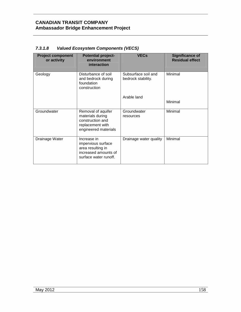
CANADIAN TRANSIT COMPANY Ambassador Bridge Enhancement Project
May 2012
158
7.3.1.8 Valued Ecosystem Components (VECS) Project component
or activity Potential project-
environment interaction
VECs Significance of Residual effect
Geology Disturbance of soil and bedrock during foundation construction
Subsurface soil and bedrock stability.
Arable land
Minimal
Minimal
Groundwater Removal of aquifer materials during construction and replacement with engineered materials
Groundwater resources
Minimal
Drainage Water Increase in impervious surface area resulting in increased amounts of surface water runoff.
Drainage water quality Minimal
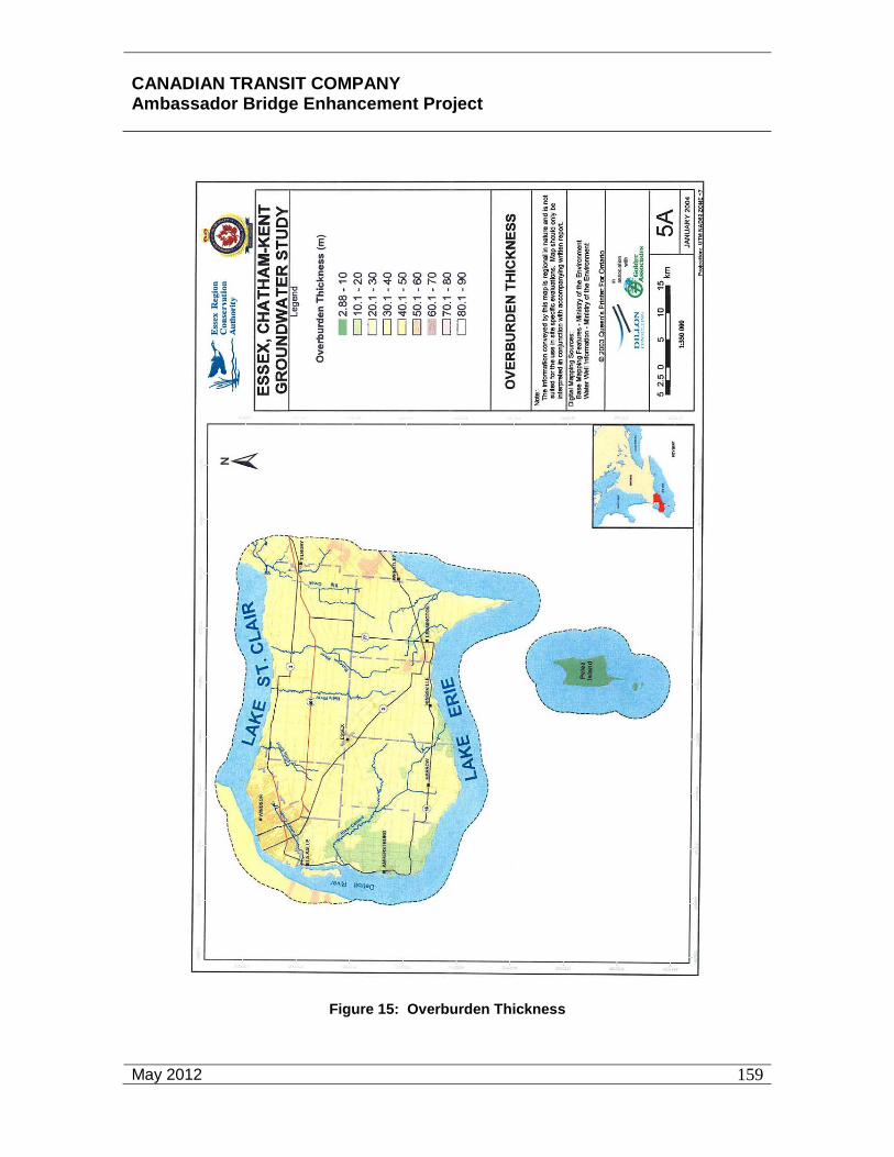
CANADIAN TRANSIT COMPANY Ambassador Bridge Enhancement Project
May 2012
159
Figure 15: Overburden Thickness

CANADIAN TRANSIT COMPANY Ambassador Bridge Enhancement Project
May 2012
160
Figure 16: Bedrock Geology

CANADIAN TRANSIT COMPANY Ambassador Bridge Enhancement Project
May 2012
161
Figure 17: Seismic Hazard Map of Canada – Geologic Survey of Canada (2005)
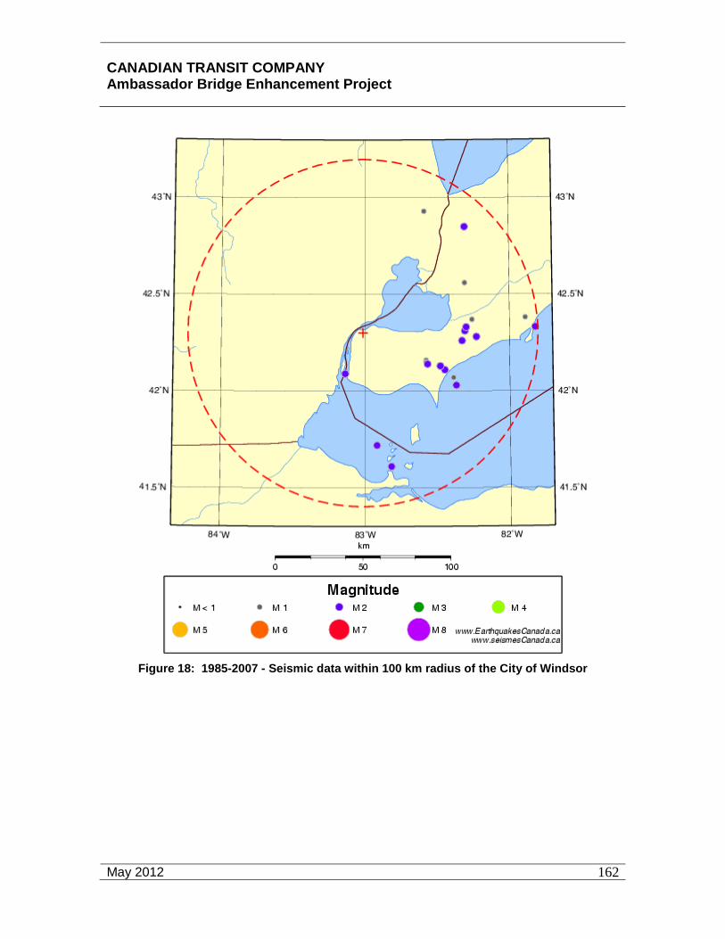
CANADIAN TRANSIT COMPANY Ambassador Bridge Enhancement Project
May 2012
162
Figure 18: 1985-2007 - Seismic data within 100 km radius of the City of Windsor

CANADIAN TRANSIT COMPANY Ambassador Bridge Enhancement Project
May 2012
163
Figure 19: Location of Windsor’s Water Intake and STP Ouflows in the Detroit River
CANADIAN TRANSIT COMPANY Ambassador Bridge Enhancement Project
May 2012
164
7.3.1.9 Screening for Potential Project-Environmental Effects The Site Study Area for geology and groundwater is relatively small (See Section 7.3 Surface and Subsurface Geology and Soils), but is the only area where activities will directly disturb soil, bedrock and groundwater. Excavation, caisson installation and/or pile driving will be necessary to construct the bridge piers. Minor shallow excavations will be required for the buildings and parking areas in the expanded plaza areas. The potential for impacts will be greatest during the construction time period for these piers.
The geology of the Local and Regional Study Areas is in a physically and structurally stable state as described in Section 7.3 Geology and Groundwater Environment. Groundwater is divided into distinct aquifers and an aquiclude, with each aquifer exhibiting its own characteristics. No short-term impacts from the proposed Project, either locally or regionally, are anticipated.
The temporal and spatial scale of the proposed Project is so miniscule relative to the geographic extent of the geologic and groundwater systems in the area as described in Section 7.3 Geology and Groundwater Environment that no substantial long term effects are expected.
7.3.1.10 Evaluation for Likely Environmental Change
Construction and Development
Site preparation work, as described below, and foundation construction will have the greatest impact on geology and groundwater, but the impact is expected to be limited to the time needed for the construction of the footings and support piers. The site surface will be disturbed by grading, construction of service roads, establishment of staging and stockpile areas and related construction activities for the duration of the entire construction period. All surface areas not within the construction footprint will be restored to original or near original conditions with comparable materials after completion of construction. The surface material is mainly disturbed soil or fill, which further reduces the potential for permanent environmental change. Any surplus soil/fill will be characterized prior to its transport to an approved facility.
Excavation for the proposed Project foundations will result in localized removal of the entire thickness of the soil overburden and removal of necessary bedrock to the specifications of the foundation design. This material will be replaced by the foundation structures for the proposed Project. This will include grouting of localized fracturing in the bedrock if fracturing occurs. Except for the permanent removal of the geologic materials from the excavation during foundation construction and localized rock fracturing, no other permanent environmental changes to the site geology are expected. As stated in the paragraph above, any surplus excavated materials will be characterized before disposal at an approved facility.
Groundwater in the foundation excavations will be controlled to provide for worker safety, prevention of erosion and sedimentation issues and successful completion of the foundation. As described in Section 7.3 Geology and Groundwater Environment

CANADIAN TRANSIT COMPANY Ambassador Bridge Enhancement Project
May 2012
165
groundwater discharge during construction could be substantial in volume. Artesian conditions have been confirmed in two recent borings in the Site Study Area commissioned by the Ambassador Bridge. Depending on the construction method used the method of control may be pumping with collection, treatment and discharge and/or engineered barriers within the boring. For example, as borings are being drilled for the support piers, steel casings can be lowered into the borehole to stabilize the boring and limit potential for groundwater discharge into the boring. Any groundwater that may bypass the borehole casing will be pumped out of the casing, treated and discharged. Any residual water will be displaced up the casing when concrete is poured for the foundation and then collected when it reaches the surface. After foundation construction is completed, groundwater aquifers will be allowed to return to pre-construction conditions except for localized change in flow direction around the foundation structures. It is important to note that groundwater is not used for drinking water within the City of Windsor. Therefore, no permanent changes in groundwater conditions are expected in the Local and Regional Study Areas.
Monitoring Phase
During the operational phase of the proposed Project, no activities affecting geology are required. Impacts to groundwater will be limited to preventing project-related stormwater from infiltrating into surface soil. Any stormwater generated by the proposed Project will be collected, treated and discharged according to an approved Certificate of Approval issued by the MOE. The goal of the operational phase of the proposed Project is to allow geologic and groundwater conditions to return to preconstruction levels.
7.3.1.11 Likely Effects on Soil and Bedrock Quality The soil in the Site Study Area will undergo disturbance during the construction phase. The site surface will be disturbed by grading, paving, construction of service roads, establishment of staging and stockpile areas, foundation excavations and related construction activities. The composition of the existing soil is disturbed native soil, amended with topsoil and historic fill materials. This soil mixture is a result of multiple site uses over time.
There will be some loss of surface area as a result of the construction of the foundation structures. A total of 553 m2 (5,946 ft2) for the support tower and about 5 m2 (54 ft2) for each support pier will be lost. This loss is unavoidable but all of the support piers will be located in areas that are already paved. For the primary towers, drilled shafts are anticipated where the loss of the soil material below the surface unit extends to a depth of 30 to 40 metres (98.5 to 131 feet) below grade where it contacts the bedrock. This material consists of a series of interbedded glacial and glacial lacustrine deposits with little or no commercial or cultural value. Their removal will have no impact on the geologic conditions of the surrounding soil material. For the support piers, the only loss of material is in the locations of the footings since they will be supported on displacement piles driven to bedrock.

CANADIAN TRANSIT COMPANY Ambassador Bridge Enhancement Project
May 2012
166
Loss of surface area from the expansion of the Windsor Plaza includes only the topsoil in the area south of Mill Street and north of College Avenue. Other areas identified for the plaza expansion are already paved.
Mitigation
• Limit construction activities to only the areas necessary for completion of the proposed Project by having clearly defined staging and construction areas. Organize work tasks to minimize surface disruption so that all soil disturbing activities to occur at a location are performed at one time to the extent possible.
• Use design specifications for engineered materials and construction methods to maximize effectiveness and limit disruption, including the use of geo-textiles and specialized construction equipment.
• Implement the required Erosion and Sediment Control Plan (see Appendix E) to control impacts of weather.
• Backfill with compatible materials (i.e. similar density to the materials that were removed) and minimize surface settlement by proper placement and compaction.
• Restore the Site Study Area, to the maximum extent practicable, to the configuration and character compatible with the surrounding land surface.
• Use excess excavated soils, where permitted, as backfill in appropriate locations elsewhere in the proposed Project or remove offsite.
The bedrock geology will be impacted by construction methods only to the extent necessary to support the foundation structures; i.e. drilling or pile driving. The engineering characteristics of the bedrock indicate compatibility of the bedrock with the construction materials (concrete and steel) planned for the foundations. The bedrock is structurally stable and the region has a low seismic risk factor according to the 2005 National Building Code of Canada seismic hazard maps. There is a possibility that naturally occurring methane gas may be present in this unit, so monitoring for gas will be addressed by the contractors as required by the Ontario Environmental Protection Act (R.S.O. 1990).
The City of Windsor Official Plan indicates that there are no mineral mining sites within 2 kilometres (1.2 miles) of the Site Study Area (See Figure 20). This is significant as there is a history of salt mining in the Regional Study Area that has contributed to some surface settlement (see Figure 20, Historical salt mining activity). The site specific geotechnical investigation concluded that no historic salt mining activity occurred at the Site Study Area nor will it adversely affect the proposed Project.
It is also significant to note that the Ambassador Bridge has not had an impact on bedrock geology, nor has the bedrock had an adverse impact on the existing bridge. The Ambassador Bridge lies within the Local Study Area for this project.

CANADIAN TRANSIT COMPANY Ambassador Bridge Enhancement Project
May 2012
167
Figure 20: Mining Sites

CANADIAN TRANSIT COMPANY Ambassador Bridge Enhancement Project
May 2012
168
Once foundation construction is complete and the new bridge is operational, the foundation will operate as a stable, non-mechanical component of the bridge structure. Based on this mode of operation, there no reasonably foreseeable environmental effects anticipated during the operational period of the bridge.
The conditions described above indicate that there will be no significant adverse residual effects on bedrock geology by the proposed Project. Therefore no mitigation is necessary.
7.3.1.12 Likely Effects on Groundwater Flow Likely effects in groundwater flow are a function of the hydrogeologic unit the groundwater is found in. To facilitate the discussion each aquifer/ water bearing unit is addressed separately.
Water Table
There is no consistent water table aquifer in the surficial material. Due to the heterogeneity of the material, fill over natural soils, water is found perched within the fill material on an intermittent basis.
Disturbance of this material during construction will have an effect only on those materials disturbed in the Site Study Area. A limited amount of water can be expected and there is no hydraulic connection between the perched units.
During the operational phase of the proposed Project, the surficial unit will remain undisturbed and pre-construction conditions will return around the foundations.
Overburden
In the overburden, the presence of a thick stratum of silty clay directly beneath the surficial material acts as an aquiclude and isolates as well as confines the aquifers in the overburden material below it. This condition serves to prevent infiltration of surficial contaminants to the aquifers, excludes the area above as a recharge zone and confines the lower aquifers to the degree that artesian conditions exist. Artesian conditions involve a tilted water bearing unit confined by impervious geologic units containing water under pressure from an elevated hydraulic head. Groundwater will rise above the top of the water bearing unit if the overlying confining layer is breached.
The potential for impacts on or by this aquifer will occur during the construction phase. If during the excavation phase, the confining layer is removed, there will be an influx of water into the excavation that will need to be controlled. The method of control will be specific to each site and the characteristics encountered there. It may include pumping, installation of casing or a combination of both. The degree of control will depend on the discharge rate of the aquifer and the geologic conditions at that location. As a result, there could be a short term change, during construction, in the flow direction, and quantity of water in the aquifer over a limited radius.

CANADIAN TRANSIT COMPANY Ambassador Bridge Enhancement Project
May 2012
169
Backfilling in this aquifer must be performed with care, utilizing materials with similar hydrogeological and engineering properties as those removed. Material with low permeability should not be placed within the aquifer zone, and fill compatible with the confining layer should be placed within the confining layer to prevent establishing hydraulic connection between the artesian aquifer and surficial materials.
After the foundation structures are in place, they will be a localized barrier to groundwater flow; however given the size of the aquifer, the barrier will cause a localized change in flow direction around the barrier and the hydrogeologic conditions in the aquifer will allow it to adjust to pre-construction conditions. These conditions can be expected to remain unaffected during the operational life of the proposed Project as no further intrusion into the subsurface is necessary.
Adherence to construction methods and use of materials specified in the design plans will prevent any negative groundwater impacts in all Study Areas both in the construction and monitoring phases of the Project.
Contact Aquifer
The presence of the Contact aquifer is projected in the 2004 Essex Region/Chatham-Kent Region Groundwater Study (ECK). The direction of flow is a factor of site specific conditions such as lithology, topography, geologic structure and hydraulic connection. The broad areal extent of the aquifer makes it possible for the flow direction to vary from one discrete point to another. This also applies to flow volume and velocity.
Due to the significant scale of the aquifer, the potential for construction and operation of the proposed Project to have a significant impact on the flow of the Contact aquifer, outside the immediate area of the foundations, is unlikely. The lack of any discernible impact on groundwater by the adjacent existing Ambassador Bridge and existing plaza serves to support this conclusion.
Bedrock
The bedrock aquifer is distinct and separate from the Contact Aquifer and has its own flow characteristics. As previously mentioned the bedrock aquifer is not used as a drinking water supply in the City of Windsor. This uniqueness protects it from the influence of foundation construction and any major impacts. Since only mechanical methods will be used to construct the foundation structures, any change in groundwater flow will be contained within the Site Study Area. This change is not considered significant based on the lack of use of the aquifer and the level of increased flow relative to the size of the aquifer.
In this case, as in the preceding aquifers, the potential for effects of the foundation construction to have an impact on groundwater flow in the bedrock aquifer is unlikely.
In summary, the impacts of the environmental effects on groundwater flow in all aquifers are localized and short term. They are well within the capacity of the aquifers to adjust

CANADIAN TRANSIT COMPANY Ambassador Bridge Enhancement Project
May 2012
170
in the post-construction period. No residual effects in the Site, Local or Regional Study Areas are anticipated and, therefore, no mitigation is required.
7.3.1.13 Likely Effects on Groundwater Quality Water quality effects are limited by a number of factors related to the proposed Project. The aquiclude beneath the surface materials protects the underlying aquifers from infiltration of contaminants from above. The isolation of perched water tables in the surface materials result in discontinuous flow of groundwater in the Site Study Area. During construction, implementation of an Erosion and Sediment Control Plan (included as Appendix E) will prevent the introduction of contaminants, if present, into groundwater. In deeper excavations, where groundwater is discharging to the excavation, it will be controlled by pumping and/or casings so contaminants, if present, will not infiltrate the aquifer.
Given these conditions, the potential for the proposed Project to have an effect on groundwater quality is limited to the Site Study Area during the construction period. The construction materials to be used will consist of concrete, steel, plastic and wood and are stable in the groundwater environment. The known water chemistry is compatible with the construction materials so long-term water quality effects are not a concern. For comparison, the existing Ambassador Bridge, which is of similar foundation construction, has not been significantly affected by groundwater conditions, nor has the bridge had any known effect on groundwater during its 81 year lifespan.
The conditions described above provide a situation where only minimal environmental effects to groundwater quality are likely at any time. No significant adverse residual effects in the Site, Local or Regional Study Areas are anticipated.
7.3.1.14 Likely Effects on Drainage Water Quality The proposed bridge, which will be constructed above the Site Study Area, will have a stormwater runoff collection, treatment and discharge system so there will be no discharge to the ground surface. The expansion of the Windsor Plaza will result in an increase in impervious surface area which would result in a long term impact on stormwater flow within the Site Study Area without proper treatment. Stormwater management facilities will be provided to mitigate for the increase in impervious surface area and runoff water. With these environmental protection measures in place, potential stormwater quality impacts will effectively be attenuated and improved over existing conditions.
The Site Study Area will be landscaped and dumping will not be permitted. A Spills Response Plan (Appendix C) will be in force to account for malfunctions and accidents and is discussed elsewhere in this document. No residual effects in the Site, Local or Regional Study Areas are anticipated and, therefore, no mitigation is required.
CANADIAN TRANSIT COMPANY Ambassador Bridge Enhancement Project
May 2012
171
7.3.1.15 Likely Effects on Contaminated Sites and Waste Management
Contaminated Sites
There are no known contaminated sites located in the Site or Local Study Areas. If an unknown waste material is discovered during construction it will trigger a response, including possible remediation, in compliance with all environmental regulations with jurisdiction in the area. Unknown waste material could be found during construction.
Mitigation
The guidance provided by the Ontario Environmental Protection Act (R.S.O. 1990), and Ontario Regulation 153/04 will be used to respond to the situation.
Waste Management
Waste management at the proposed Project site will be driven by the relevant and applicable regulations of the governmental agencies with jurisdiction over the project. The wastes generated fall under the following categories:
• Construction Waste
• Garbage
• Sewage
• Hazardous Waste
Construction waste will be collected and transported and disposed of by approved waste contractors. There are no plans to dispose of waste on-site.
Ordinary garbage will be collected, transported and disposed of by approved waste contractors. No waste material outside of regulatory guidelines is expected.
Sewage will be discharged to sanitary sewers from existing buildings or, in construction areas, will be collected in approved portable facilities and transported and disposed of by an approved contractor.
Any hazardous waste generated during construction or operation will be disposed of at approved Canadian disposal facilities. There are no plans for international shipment of hazardous wastes. Identification of hazardous waste will be in accordance with regulatory guidelines.
During construction there will be periods where wastes accumulate in on-site collection facilities prior to transport offsite for disposal. There will be potential short-term effects of odour, visual appearance and risk posed by presence of hazardous waste in the Site and Local Study Areas. The length of on-site storage will be determined by the waste regulations applicable to the waste. These effects can be mitigated by proper waste

CANADIAN TRANSIT COMPANY Ambassador Bridge Enhancement Project
May 2012
172
collection and storage procedures which will be specified in a waste management plan established by the contractors performing construction activities.
During the operational phase of the proposed Project a waste management plan will be implemented to properly manage all categories of waste generated at the project site. Similar conditions occur at the site of the Ambassador Bridge adjacent to the proposed Project and the existing plaza, and the project plan can be consistent with that used for the Ambassador Bridge.
The response to malfunctions and accidents are addressed in a separate section of this document.
After construction is completed, there will be no waste management related to the proposed Project and no residual effects will remain as all waste will be disposed of off-site. Waste management of the expanded plaza will be managed in the same manner as the existing plaza. Therefore, no mitigation will be necessary. Management of operational wastes is an ongoing part of the proposed Project. No significant adverse residual effects are anticipated.
7.3.1.16 Summary of Residual Adverse Effects on VECs The residual effects on geology are limited. Surface disruption during construction can cause erosion and sedimentation. Use of proper construction methods will prevent this and restore the Site Study Area soils and bedrock to a stable platform.
Some soil will be irretrievably lost to construction of foundation structures. The soil that will be lost is a combination of disturbed original soil, imported topsoil and various fill components brought in as the property has gone through development. The quality of the soil is not good, and the surface area remaining after the proposed Project is constructed will be restored at least to the degree of the pre-construction conditions.
Significance of Residual Effect
Minimal
The residual effects on groundwater are also limited. The groundwater resources are divided into distinct aquifers each with their own relative value. The water table consists of a group of perched units with no value as a drinking water source. In addition the Local Study Area does not serve as a recharge area for the underlying aquifers.
The lower aquifers, although they have significant quantities of water, have such a large areal extent that construction of the foundation structures will have no effect on the aquifers. Another contributing factor is that the entire Regional Study Area is on a municipal water system that does not use groundwater as its source.With the implementation of sediment and erosion control systems during construction, the collection and treatment of operational stormwater runoff and the implementation of spill response plans will ensure that there are no significant adverse residual effects from the proposed Project on Surface and Subsurface Geology and Soils.

CANADIAN TRANSIT COMPANY Ambassador Bridge Enhancement Project
April 2011
173
Environmental Effects Matrix Phase: Construction & Operation
Project Activity
Valued Ecosystem Component
Potential Environmental Effects
Mitigation
Mag
nitu
de
Geo
grap
hic
Exte
nt
D
urat
ion
Rev
ersi
bilit
y
Ecol
ogic
al/S
ocio
-C
ultu
ral a
nd
Econ
omic
Con
text
Surface Disruption during Construction
Geology
Erosion Sedimentation
Erosion and Sediment Control Plan 1
1
3
R
3
Construction of Foundation Structures
Geology
Groundwater
Loss of Soil Surface area restored to preconstruction conditions
None necessary
1
1
1
1
3
3
I
I
3
3
Operation of Completed Bridge Structure
Drainage Water Contamination of Drainage Water
Stormwater Management Plan
1
2
5
R
3

CANADIAN TRANSIT COMPANY Ambassador Bridge Enhancement Project
April 2011
174
Environmental Effects Matrix Phase: Construction & Operation
Project Activity
Valued Ecosystem Component
Potential Environmental Effects
Mitigation
Mag
nitu
de
Geo
grap
hic
Exte
nt
D
urat
ion
Rev
ersi
bilit
y
Ecol
ogic
al/S
ocio
-C
ultu
ral a
nd
Econ
omic
Con
text
Key: Magnitude: 1 = Low; e.g. affecting the available quantity or quality of groundwater, geological materials and drainage water at levels that are indiscernible from natural variation 2 = Medium; e.g. limiting the available quantity or quality of groundwater, geological materials and drainage water, such that these resources are occasionally rendered unusable to current users for periods up to two weeks at a time 3 = High; e.g. limiting the available quantity or quality of groundwater, geological materials and drainage water, such that these resources are rendered unusable or unavailable for users during the life of the project and for future generations beyond the life of the project.
Geographic Extent: 1 = <1km2
2 = 1-10 km2 3 = 11-100 km2 4 = 101 – 1,000 km2 5 = 1,001 – 10,000 km2 6 = >10,000 km2
Duration: 1= <30 days 2 = 1-12 months 3 = 13-36 months 4 = 37-72 months 5 = >72 months
Reversibility: R = Reversible I = Irreversible
Ecological/Socio-cultural and Economic Context (Existing Conditions): 1 = natural and undisturbed 2 = some evidence of human effect on natural environment 3 = high level of human interaction with little natural environment

CANADIAN TRANSIT COMPANY Ambassador Bridge Enhancement Project
May 2012
175
7.4 Terrestrial Environment
7.4.1 Study Area
The Site Study Area for the assessment of the potential environmental effects of the proposed Project on terrestrial vegetation and wildlife is the project footprint where activities associated with site preparation and construction, operation, and malfunctions and accidents of the project could result in potential environmental effects. For the purposes of this assessment, vegetation within the limits of clearing for the piers, additional sites required for the plaza expansion, roadway reconstruction, construction of parking areas, the support tower and other structures is assumed to be permanently removed. These construction activities also remove wildlife habitat in the cleared areas.
The Local Study Area for the vegetation survey and habitat analysis is defined by the area within a 100 metre (328 foot) radius of the Site Study Area. Additionally, the Local Study Area includes all of McKee Park due to its unique features and potential to provide wildlife habitat. The Local Study Area is the area immediately outside the Site Study Area where there is reasonable potential for environmental effects and includes the expected range for noise, vibration and fugitive dust emissions on vegetation and wildlife species.
The Regional Study Area is the urban area generally within the City of Windsor and surrounding communities upstream and downstream of the Ambassador Bridge, including the Towns of LaSalle, Tecumseh, and Amherstburg. This area also includes a surrounding area of rural land uses and portions of Essex County generally south of the City of Windsor. This is the area within which there is reasonable potential for cumulative effects from the proposed Project.
In the 1600’s, the Regional Study Area consisted of prairies, parklands, forests, groves and wetlands adjacent to the Detroit River. Colonization along the shoreline from the 1700’s through the 1900’s resulted in the farming of open terrain, clearing of forests, and general urbanization and development of the Site, Local, and Regional Study Areas.
Terrestrial Environment Administrative Considerations
Important legislation related to the protection of vegetation and wildlife resources includes that related to species at risk and the Migratory Birds Convention Act. The Species at Risk legislation is discussed in Section 7.4 Terrestrial Environment.
The Migratory Birds Convention Act (MBCA), 1994 and its regulations protect migratory birds, their eggs and nests. The Act regulates hunting, prevents trafficking and commercialization, and controls the uses of migratory birds through permits. The MBCA is the most important law protecting birds in Canada. The Act was updated in 1994 with provisions that strengthened enforcement and significantly increased penalties. Enforcement is shared between the provincial and federal governments. Under the MBCA, the federal government can designate an area of importance to migratory birds such as a Migratory Bird Refuge, to limit hunting and physical disturbances. In Ontario, Game Officers enforce federal wildlife laws and Conservation Officers enforce provincial

CANADIAN TRANSIT COMPANY Ambassador Bridge Enhancement Project
May 2012
176
wildlife laws. Game Officers are also empowered to enforce provincial laws. The Game Officers enforce laws that protect migratory birds, nationally significant habitat, and endangered species. Nests and eggs not protected under the MBCA may be protected under the Ontario Fish and Wildlife Conservation Act, 1977.
7.4.2 Vegetation Communities
Regional Study Area
Urbanization within the Regional Study Area has resulted in the loss of vast acreage of habitat, with clearing of over 56,655 hectares (140,000 acres) of forest lands by the 1950’s. The result was the loss of approximately 96 percent of the area wetlands and 95 percent of the original forests.68 Natural vegetation communities within the Regional Study Area are restricted to areas not currently used for residential, agricultural, commercial, institutional or industrial purposes. These natural communities are not within the Site Study Area or the Local Study Area. The closest sites are over 2.2 kilometres (1.4 miles) from the proposed Project. The majority of the natural areas are within or around designated Provincial Parks, Areas of Natural and Scientific Interest, Environmentally Significant Areas, and Candidate Natural Heritage Sites, none of which are near the proposed Project or within the Local Study Area (Figure 13). These communities are limited in size and fragmented, with little juxtaposition or connectivity to one another, thus somewhat limiting the wildlife habitat value. Factors such as little juxtaposition and connectivity make it difficult for wildlife species to move through corridors from one habitat type to another to fulfill their various life cycle requirements. What does remain is a patchwork of interspersed remnant natural heritage features including woodlots, prairies and wetlands. These habitats will not be impacted by the Project. The shrubbery along the Detroit River shoreline is the most significant zone in the Local Study Area since it does provide some connectivity with adjacent lands in the Regional Study Area. The closest Provincially Significant Wetland is the Turkey Creek Wetland located at the mouth of the creek about 7.6 kilometres (4.7 miles) downriver of the Project.
The City of Windsor still has a number of rare and unique ecological areas. These include: Peche Island Natural Park; the Carolinian Oak Stand Memorial Park; and the Ojibway Tall Prairie Complex, which includes Ojibway Park, Joy Woods, Black Oak Heritage Park, Tall Grass Prairie Park and the Spring Garden Area of Natural and Scientific Interest. This complex also includes the Ojibway Prairie Provincial Nature Reserve. None of the abovementioned ecological areas are located in the Site or Local Study Areas and none of these ecological areas will be impacted by the proposed Project.
These Carolinian forests and prairie ecosystems are unique in Canada. The Turkey Creek Wetland and Canard Marsh at the mouth of the Canard River also provide valuable habitat in the Regional Study Area and support abundant species of plants and
68 Hartman, Jim, Essex Region Conservation Authority “Habitat Rehabilitation and Proposed Projects in the Detroit River and Tributary Waters” 30 April 2007
http://www.mnsind/oriccarru?story8.html

CANADIAN TRANSIT COMPANY Ambassador Bridge Enhancement Project
May 2012
177
wildlife. These Carolinian forests are both over 7.5 km (4.6 mi) downriver (of the proposed Project and will not be affected.
Regional forest communities are found in both dry fresh upland areas and in moist to wet lowlands. The upland communities are generally dominated by oak (Quercus spp.), hickory (Carya spp.), and maple species (Acer spp.). Some associated species include sassafras (Sassafras albidum), white ash (Fraxinus americana), basswood (Tilia americana), beech (Fagus grandifolia), ironwood (Ostrya virginiana) and quaking aspen (Populus tremuloides). Two areas are Carolinian Canada Sites: Ojibway Prairie Remnants and the Canard River Kentucky Coffee-tree woods. As indicated above these forest communities are generally found in the designated natural areas and not in the Site and Local Study Areas.
Lowland forests are generally dominated by swamp white oak (Quercus bicolor), silver maple (Acer saccharinum), red maple (Acer rubrum), pin oak (Quercus palustris), red ash (Fraxinus pennsylvanica), and white elm (Ulmus americana). The lowland forests are generally found in the designated natural areas in the City of Windsor and Essex County and are not within the Site and Local Study Areas of the Project.
Typical shrub species generally found in the Regional Study Area include hawthorns (Crataegus sp.), grey dogwood (Cornus foemina ssp. racemosa), silky dogwood (C. amomum), smooth sumac (Rhus glabra) and riverbank grape (Vitis riparia). Undisturbed shrub lands are not found in the Site and Local Study Areas.
Prairie grasslands are generally dominated by big bluestem (Andropogon gerardii), tall cord grass (Spartina petcinata), ironweed (Vernonia gigantea), showy tick-trefoil (Desmodium canadense), grass-leaved goldenrod (Euthamia graminifolia) and many others. There are no prairie grasslands in the Site and Local Study Areas.
The wetland communities are typically dominated by emergent plant species such as cattail (Typha sp.) and reed-canary grass (Phalaris arundinacea) or a variety of floating leaved plants and submergent aquatic plants such as pondweeds (Potamogeton sp.) and milfoil (Myriophyllum sp.). The closest wetland area is Turkey Creek wetland and it is located over 7.5 kilometres (4.6 mi) downstream of the proposed Project.
Site and Local Study Areas
The Site Study area includes the footprint for replacement span, plaza expansion footprint and immediate surrounding areas. The Local Study Area for the vegetation study and habitat analysis is defined by the area within a 100 metre (328 foot) radius of the Site Study Area. The boundary of the Local Study Area also includes McKee Park. Upstream of the Ambassador Bridge, between the riverbank and Riverside Drive, is Assumption Park, followed by Centennial Park and the Riverfront Trail. Riverside Drive is an urban transportation corridor bordered by maintained parklands, lawns and hedgerow trees. To the south of Riverside Drive, is the University of Windsor campus. Downriver of the Ambassador Bridge are Mill and Brock Parks. The parks are not

CANADIAN TRANSIT COMPANY Ambassador Bridge Enhancement Project
May 2012
178
included in the site and local study areas; however, the proposed Project is not expected to have adverse effects on the vegetation within these parkland areas.
Field investigations and air photo interpretation determined the geographical extent, composition, structure and function of vegetation communities on and adjacent to the proposed Project. A vegetation community survey was undertaken in the Local Study Area on May 8, 2007 and again on November 30, 2010. Air photos taken in 2004, obtained from the City of Windsor, were also used to interpret and determine the limits and characteristics of vegetation communities on adjacent lands in the general vicinity of the Project site. The vegetation survey report for the May 2007 review is attached as Appendix H and is consistent with the 2010 survey. Table 15 below summarizes the quantity of tree species observed in the Local Study Area.
Table 15: Quantity of Tree Species
TREE COMMON NAME SCIENTIFIC NAME QUANTITY PRESENT IN LOCAL
STUDY AREA
Manitoba maple Acer negundo A
Norway Maple Acer plantanoides B
Silver Maple Acer saccharinum C
Horse-chestnut Aesculus hippocastanum A
Tree of Heaven Ailanthus altissima A
Grey Birch Betula populifolia A
Northern Catalpa Catalpa speciosa A
American Beech (cultivar) Fagus grandifolia x A
Honey Locust (cultivar) Gleditsia triacanthos x A
Eastern Red Cedar Juniperus virginiana B
Tulip-tree Liriodendron tulipifera A
Apple Malus pumula A
White Mulberry Morus alba B
Norway Spruce Picea abies B
Muhgo Pine Pinus mugo A
Austrian Pine Pinus nigra A

CANADIAN TRANSIT COMPANY Ambassador Bridge Enhancement Project
May 2012
179
TREE COMMON NAME SCIENTIFIC NAME QUANTITY PRESENT IN LOCAL
STUDY AREA
Scots Pine Pinus sylvestris C
Eastern Cottonwood Populus deltoides A
Sweet Cherry Prunus avium A
Sour Cherry Prunus cerasus A
Choke Cherry Prunus virginiana C
White Oak Quercus alba A
Northern Red Oak Quercus rubra A
Black Locust Robina peudoacacia A
White Willow Salix alba var. vitellina A
Common Lilac Syringa sp. C
White Cedar Thuya occidentalis A
Little Leaf Linden Tilia cordata A
American Elm Ulmus americana B
English Elm Ulmus procera A
Siberian Elm Ulmus pumila A
A = 0 – 5
B = 6 – 10
C = 11+
Land use in the Local Study Area is primarily urban and includes residential and institutional uses. There are a few patches of natural or semi-natural (cultural) vegetation present. Cultural vegetation implies vegetation that has re-established following a cultural or man-made disturbance to the area and includes, for example, invasive species and weeds. Semi-natural vegetation occurs in areas that were previously disturbed but have had time to re-establish as a community with species that would likely have occurred prior to any disturbance. Most of the Local Study Area is landscaped (i.e. mowed) with ornamental plantings. McKee Park, located adjacent to the Detroit River, is the only open, non-impacted area. This park is one of a series of reclaimed parks along the Detroit River. The Ambassador Bridge is approximately 250

CANADIAN TRANSIT COMPANY Ambassador Bridge Enhancement Project
May 2012
180
metres (820 feet) east of McKee Park. The proposed Project will be approximately 210 metres (690 feet) east of McKee Park which is within the Local Study Area.
A field investigation was performed on May 8, 2007 and November 30, 2010 to determine the limits of vegetative communities, collect information on community composition, structure and function and to identify potential habitat and Species at Risk in the area. The purpose of obtaining this field information is to determine the environmental effects of the proposed Project on vegetation. The inventory included Indian Road, adjacent streets and rear yards from Mill Street to the Detroit River and included vegetation within McKee Park. In addition, the open area south of Mill Street and the parcel north of Millen Street that are proposed to be included in the plaza expansion were included in the 2010 inventory. An inventory of roadside trees was also completed within the right-of-way to record the type and condition of natural and ornamental trees and shrubs. The basal area was recorded for larger trees that were accessible. Basal area is the cross section area of a tree stem/trunk commonly measured at breast height of 1.4 metres (4.5 ft) above ground level. Trees within rear yards were also recorded to determine the density of native species and for consideration of habitat potential.
The Ecological Land Classification (ELC) for Southern Ontario is the standard protocol applied to describe vegetation communities across the province. The ELC framework was designed to categorize vegetation communities within the context of a Site Region within Ontario. Typically, the Ecosite and Vegetation Type are described for a given Site Region. The City of Windsor falls within the 7E Site Region. In order to apply the classification system at a more detailed level, the ELC protocol defines areas based on geology, soils and vegetation. However, the refined level of classification is based on “a mappable, landscape unit that integrates a consistent set of environmental factors and vegetation characteristics” that are not met at the Project.69
Vegetation communities and individual trees identified within the study area could not be classified according to the Ecological Land Classification for Southern Ontario: First Approximation and its Application as the existing vegetation communities did not meet the criteria in terms of polygon size (i.e. minimum 1 square kilometer or 0.4 square miles), vegetation definition or soil formation (i.e. level of disturbance) for application of the classification protocol. As such, the vegetation inventoried was described based on the location. The habitat available given the vegetation was also noted in the field. A geographic query for the local area was completed to determine reports on sensitive species using the Natural Heritage Information Centre (NHIC). The NHIC compiles, maintains and distributes information on natural species, plant communities, and species of conservation concern in Ontario and information can be accessed on their website. There are several ways to search the site such as a species list or a geographic query.
69 Lee, H.T., W.D. Bakowsky, J. Riley, J. Bowles, M. Puddister, P. Uhlig, and S. McMurray, 1998. Ecological
Land Classification for Southern Ontario: first approximation and its application. Ontario Ministry of Natural Resources, Southcentral Science Section, Science Department and Transfer Branch. SCSS Field Guide FG-02.

CANADIAN TRANSIT COMPANY Ambassador Bridge Enhancement Project
May 2012
181
A geographic query was utilized to obtain information on resources near the proposed Project. As well, plant species recorded in the area were reviewed for provincial and national status.
Boulevard Trees and McKee Park
The roadside vegetation along Indian Road, adjacent streets and rear yards was inventoried from Wyandotte Street to the Detroit River. The vegetation within McKee Park was also inventoried as part of the Local Study Area. The trees along the road and within the park represented a combination of native and non-native species that have been planted either as streetscaping, parkland or for residential privacy. Most of the trees that line Indian Road and Rosedale Avenue are silver maples (Acer saccharum). The houses on the east side of Mill Street will be converted to a green area. There are no unique, endangered or threatened species within this area.
The remaining areas required for the plaza expansion are already heavily disturbed. The parcels designated for staff and visitor parking are currently paved and void of vegetation. The site designated for commercial parking and bus inspection was previously cleared and currently consists of grass and opportunistic herbaceous plants.
As indicated within the City of Windsor – Environmental Master Plan, all trees located within approximately 10 metres (33 feet) of the centre of the roadway are owned by the City of Windsor. The vegetation identified within McKee Park is owned and managed by the City of Windsor. Of the trees identified within the boulevard and park, only two species are considered Carolinian trees according to the Tree Guide provided on the City of Windsor website. Carolinian trees are unique to Canada with many species being at their northernmost range. These trees included the Tulip Tree (Liriodendron tulipifera) Red Oak (Quercus rubra) and White Oak (Quercus alba). While native Honey Locust is considered Carolinian, the species identified within the study area were cultivars. This is an ornamental and invasive species, commonly found in established urban areas as native plantings and not historically used as street trees. McKee Park is located immediately adjacent to the Detroit River. While the upland area consists of mowed grass and several mature trees, the bank vegetation is somewhat more natural and consists of a shrub and herbaceous layer primarily of invasive species.
The areas for the proposed plaza expansion are either disturbed areas that have been cleared and currently consist of grass and opportunistic herbaceous plants or are already paved. There are no defined wetland areas identified within the study area and there are no species of vegetation identified as threatened or endangered. A list of all of the species of vegetation found within the Local Study Area is presented in Appendix H.
7.4.3 Wildlife Communities
Regional Study Area
Prior to urbanization and the general development of the Windsor area that resulted in clearing of forest habitat and farming of prairie areas, a range of wildlife habituated the

CANADIAN TRANSIT COMPANY Ambassador Bridge Enhancement Project
May 2012
182
area including elk, black bear, wild turkey, white tailed deer, passenger pigeons, trumpeter swans and greater prairie chicken.
Approximately 145 species of wildlife inhabit this regional area.70 Wildlife in the urban and industrial areas is limited to species commonly found in urban areas such as mice, squirrels, skunks, opossum, raccoons, birds, and other species tolerant of humans, with the majority of the 145 species concentrated in the Natural Heritage Areas of Windsor. Of the 145 species of wildlife, 23 are herpetofauna found along creeks, within the prairie grasslands and forests of the Natural Heritage Areas. These species include the mudpuppy, American toad, western chorus frog, bullfrog, five-lined skink, painted turtle, milk snake, red-bellied snake, and eastern gartersnake, among others. The milk snake and five-lined skink are listed as special concern species in Ontario.
Also included are 98 species of birds that breed in the area and numerous species of migrating birds. Typical species include Canada goose, mute swan, wood duck, mallard, blue-winged teal, ring-necked pheasant, Cooper’s hawk, red-tailed hawk, American kestrel, ring-billed gull, mourning dove, killdeer, belted kingfisher, red-bellied woodpecker, vireos, swallows, wrens, warblers, sparrows and many others. There are two places in the region as Environmentally Significant Areas for migratory bird stopover: Fighting Island and Allied Chemical Brine Wells. Neither one of these migratory stopover areas are located within the Site or Local Study Areas.71
The Monarch butterfly, an insect species listed as a species of special concern in Ontario, has been recorded in the Ojibway area along with 334 other species of moths and butterflies. The Ojibway Prairie habitat is not located with the Site or Local Study Areas and is about 3.7 km (2.3 miles) southwest of the Project.
Twenty-eight species of mammals were also recorded in the region including Virginia opossum, little brown bat, silver-haired bat, hoary bat, northern short-tail shrew, red fox, raccoon, Norway rat, meadow jumping mouse, gray and red squirrel, striped skunk, white-tailed deer and others.72
The Detroit River and surrounding area is located in the middle of the Mississippi and Atlantic flyways (see Figures 21 and 22). Approximately three million ducks, geese, swans, and coots migrate annually through this region. The Ministry of Natural Resources (MNR) and the Michigan Department of Natural Resources recognize the Detroit River as having one of the highest diversities of wildlife, including avian species, in the Great Lakes. Over 300 bird species have been documented through numerous annual bird surveys including Christmas Bird Counts in the Detroit-Windsor area of which 150-160 are found to breed, nest or migrate throughout the Detroit River
70 Transport Canada, Ontario Ministry of Transportation, U.S. Federal Highway Administration and
Michigan Department of Transportation, "Detroit River International Crossing: Environmental Overview Paper-Canadian Existing Conditions," Natural Sciences, Vol. 2, June 2005.
71 Ibid. 72 Ibid
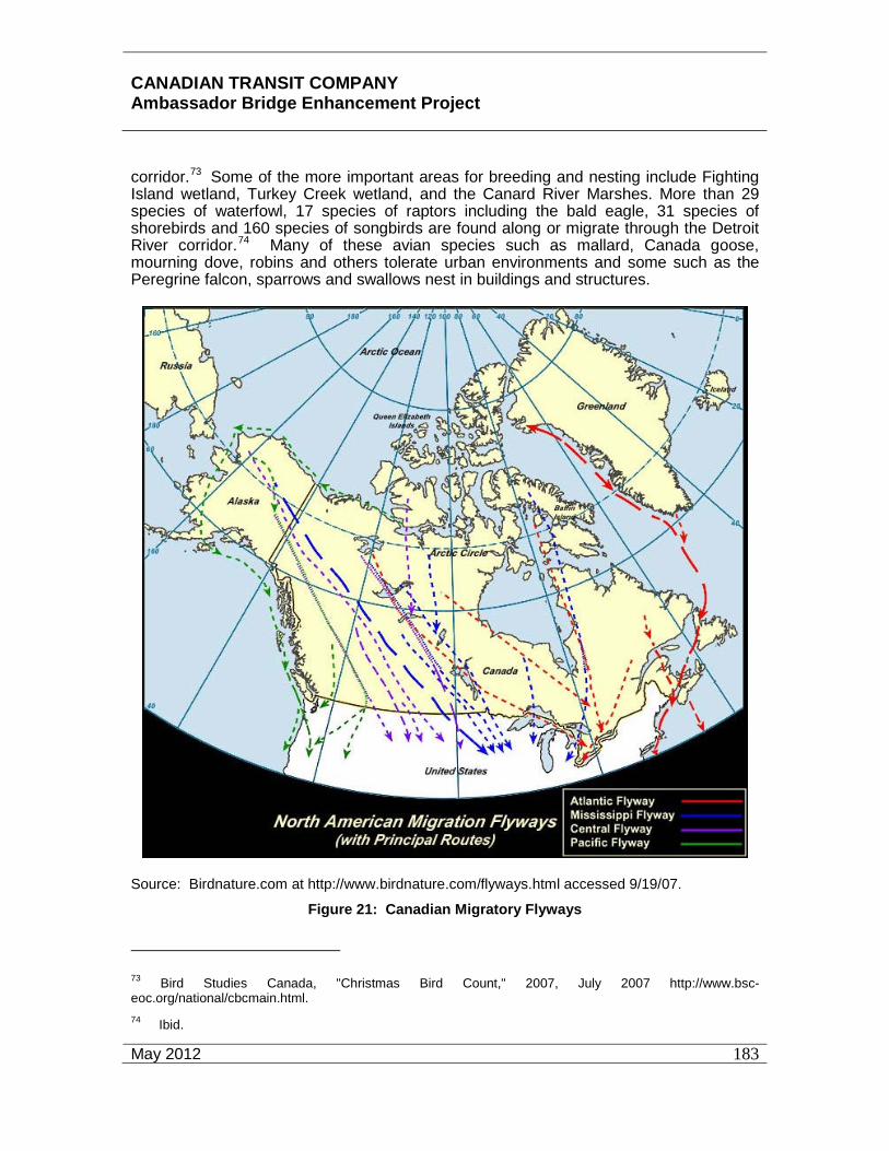
CANADIAN TRANSIT COMPANY Ambassador Bridge Enhancement Project
May 2012
183
corridor.73 Some of the more important areas for breeding and nesting include Fighting Island wetland, Turkey Creek wetland, and the Canard River Marshes. More than 29 species of waterfowl, 17 species of raptors including the bald eagle, 31 species of shorebirds and 160 species of songbirds are found along or migrate through the Detroit River corridor.74 Many of these avian species such as mallard, Canada goose, mourning dove, robins and others tolerate urban environments and some such as the Peregrine falcon, sparrows and swallows nest in buildings and structures.
Source: Birdnature.com at http://www.birdnature.com/flyways.html accessed 9/19/07. Figure 21: Canadian Migratory Flyways
73 Bird Studies Canada, "Christmas Bird Count," 2007, July 2007 http://www.bsc-eoc.org/national/cbcmain.html. 74 Ibid.

CANADIAN TRANSIT COMPANY Ambassador Bridge Enhancement Project
May 2012
184
8,260 canvasback and 7,000 common mergansers are recorded each year during the annual Christmas Source: Birdnature.com at http://www.birdnature.com/flyways.html accessed 9/19/07.
Figure 22: US Migratory Flyways
Some 300,000 diving ducks stop in the lower Detroit River during their fall migration from Canada to the east and south each year though this area is downriver of the Site and Local Study Areas. They use the lower river ecosystem for resting and feeding on beds of water celery (Vallisneria sp.) and other submergent plant species. The coastal marshes of the Detroit River and adjacent Lake Erie have provided habitat for the highest concentration of staging American black ducks in North America prior to the decline in their numbers in the 1950’s. Black duck are still listed as a common species in the Detroit River marsh areas. The closest wetland to the proposed Project is the

CANADIAN TRANSIT COMPANY Ambassador Bridge Enhancement Project
May 2012
185
Turkey Creek wetland located about 7.6 kilometres (4.7 miles) downriver. On average more than Bird Counts.75
Canada geese are also very common in the Detroit River corridor. Other avian species that have been commonly observed during bird counts in the Regional Study Area include mute swan, Tundra swan, great blue heron, ring-billed gulls, herring gulls, American coot and black-crowned night heron. The shallow, open waters of the Detroit River are an important waterfowl wintering area. Thousands of mallards, black ducks, Canada geese and swans were observed resting and feeding in the near shore waters of Grassy and Mud Islands during February 2003.76 These islands are over 10 kilometres (6.2 miles) downriver of the proposed Project Site near the head of Fighting Island. During thirty years of Christmas Bird Counts from 1975 to 2004, the ten most numerous species observed (in descending order of abundance) were canvasback, European starling, mallard, herring gull, ring-billed gull, common merganser, Canada goose, house sparrow, mourning dove, and Tundra swan.77
The importance of this area for migratory birds is recognized in the Canada-United States North American Waterfowl Management Plan that identified the Detroit River as part of one of the 34 Waterfowl Habitat Areas of Major Concern in the United States and Canada. It is also recognized in the United Nations Convention on Biological Diversity, the Western Hemispheric Shorebird Reserve Network, the Biodiversity Investment Area Program of Environment Canada and the U.S. Environmental Protection Agency. The lower Detroit River, downstream from the proposed Project, is designated as an Important Bird Area that is globally significant as a site for congregating waterfowl. While certain flight directions are consistently followed by migratory birds, the term “migration route” is a generalization, a concept referring to general movements of a species rather than an exact course followed by individual birds or a path followed by a species characterized by specific geographic or ecological boundaries. There is also considerable variation in routes chosen by specific species. However, broad, relatively exclusive, flyway belts do exist in North America. As indicated above, the Detroit River falls into two of these flyways, namely the Mississippi and Atlantic. These flyway belts are depicted on Figures 21 and 22.
The Atlantic Flyway extends from the offshore waters of the Atlantic Coast west to the Allegheny Mountains and the curving northwestward across West Virginia and north eastern Ohio in the United States. It then continues across the prairie provinces of Canada and the Northwest Territories to the Arctic Coast of Alaska.
75 Ibid. 76 "Detroit River International Wildlife Refuge Comprehensive Conservation Plan Approval," approved April 2005. 77 Bird Studies Canada, "Christmas Bird Count," 2007, July 2007 http://www.bsc-eoc.org/national/cbcmain.html.

CANADIAN TRANSIT COMPANY Ambassador Bridge Enhancement Project
May 2012
186
The eastern boundary of the Mississippi Flyway runs through the peninsula of southern Ontario to western Lake Erie and then southward through Ohio and Indiana to the Mississippi River where it closely follows the river to the mouth of the Gulf of Mexico. The western boundary is not as well defined and it merges in eastern Nebraska and western Missouri and Arkansas in the United States with the Central Flyway.
Flyways are most applicable to birds that migrate in family groups such as geese, swans and cranes, but do not appear very helpful in understanding the movements of more widely dispersing ducks or other groups of birds. The most common migration patterns include flying to northern temperate or arctic summer habitats to breed; and then returning to wintering areas in the warmer southern parts of North America.
The Jack Miner Bird Sanctuary located in Kingsville, Ontario has collected extensive data on migrating ducks and geese through a bird banding program since the early 1900’s. The bird banding program consists of capturing birds and placing a small band around one leg that contains an identification number of the bird and a number to call if the bird is captured again in a different location during its migration. The subsequent bird captures are recorded to determine the flight paths of those birds. Appendix I contains bird banding data from 1998 to the present from the Jack Miner Bird Sanctuary. The data confirms that ducks and geese migrate in a north-south movement that different species follow different paths, and to a lesser extent, the two flyways are visible. Data from the bird banding effort in years 2009 and 2010 have been plotted in Figures 23 and 24.
Waterfowl hunting and bird watching generate a substantial amount of money for cities and towns along the shoreline of the Detroit River. The lower Detroit River has an international reputation for duck hunting. Likewise, bird watching, photography and other non-consumptive uses of waterfowl bring economic benefits to the area. The proposed Project will not affect these activities.
Site and Local Study Area
The spatial boundaries for the assessment of potential impacts of the proposed Project on wildlife included the Project footprint and adjacent habitat where activities associated with construction, operations, malfunctions and accidents of the project could reasonably result in environmental effects. For the purposes of this assessment, terrestrial wildlife habitat within the limits of clearing for the piers and support tower is assumed to be permanently removed. Other areas in the Project footprint such as construction parking areas and staging areas are assumed to be changed after project construction and revegetation.
The wildlife habitats at and surrounding the Ambassador Bridge and Windsor Plaza are adjacent to highly developed areas including the existing bridge and plaza, the University of Windsor, commercial and residential areas, and parklands. Wildlife communities are limited due to the high degree of human intrusion and the fragmented and limited juxtaposition of habitats to serve various life cycle needs for wildlife species. The exception is the vegetated banks of the Detroit River that provide connectivity to the waterway and the adjacent park and open space along the river, acting as a wildlife corridor. The Project support piers will be 30.5 metres (100 feet) inland from the river

CANADIAN TRANSIT COMPANY Ambassador Bridge Enhancement Project
May 2012
187
bank. The proposed Windsor Plaza expansion is located approximately 1,220 metres (4,000 feet) from the Detroit River. The vegetation within the Site and Local Study Areas consist primarily of roadside vegetation that includes roadside trees, ornamental tree clusters and landscape plantings that serve an aesthetic function only and are neither unique nor part of the vegetation communities in this area. A detailed analysis of the above finding can be found in Appendix H.
Source: Jack Miner Bird Sanctuary (www.jackminer.com) accessed 1/11/11.
Figure 23: 2009 Migratory Waterfowl Banding Summary

CANADIAN TRANSIT COMPANY Ambassador Bridge Enhancement Project
May 2012
188
Source: Jack Miner Bird Sanctuary (www.jackminer.com) accessed 1/11/11.
Figure 24: 2010 Migratory Waterfowl Banding Summary

CANADIAN TRANSIT COMPANY Ambassador Bridge Enhancement Project
May 2012
189
A field review for wildlife species within the Local Study Area was conducted on July 28, 2007 and again in November 2010. The field review consisted of walking transects and observation from adjacent publicly accessible locations. Few wildlife species were observed during the field review, all of which were species that have adapted to urban environments. Table 16 provides a list of all animals observed and the location of the observation. The species seen most often include the Eastern gray squirrel, including one in the black phase, rock doves, juvenile and adult ring-billed seagulls, and European starlings. The European starling is a non-native species that competes with native species for nest cavities and food. One gray squirrel nest was observed along Indian Road. Only the rock dove was observed on or directly adjacent to the Ambassador Bridge, though it is known that a pair of peregrine falcons nest on the existing Ambassador Bridge. The peregrine falcon is a species at risk in Canada and is provincially threatened. No other threatened, endangered, species of special concern, or evidence of these species were observed.
Table 16: Wildlife Species Observed in the Local Study Area
Common Name Indian Road McKee Park Riverside at Student Centre
Adjacent to Bridge
American Goldfinch X X
American Robin X X
Bank Swallow X X
Canada Goose* X
Eastern Gray Squirrel X
European Starling X
House Sparrow X
Ring-billed Seagull X
Rock Dove X X X
* Evidence (scat) of Canada goose was observed only.
A 2007 survey for the Riverside Drive Vista Improvement Project, located directly adjacent to and extending upriver of the existing Ambassador Bridge recorded only 45 species of wildlife; four of these were mammals and the other 41 were avian species.78 This project was considerably larger than the proposed Project and contained more 78 City of Windsor, " Riverside Drive Vista Improvement Class Environmental Assessment," 27 Sept 2007 http://www.citywindsor.ca/documents/EngineeringCorporateProject/EnvironmentalAssessments/RiversideVista/3015Section4b.pdf.
CANADIAN TRANSIT COMPANY Ambassador Bridge Enhancement Project
May 2012
190
areas of wildlife habitat. Wildlife species in this area are limited and are of the type that would tolerate a high degree of human activity.
7.4.4 Wildlife Habitat
The wildlife and wildlife habitat in the Site and Local Study Areas can be classified as urban. Wildlife can be found almost anywhere, even in densely populated urban areas. Thus, although areas near the proposed Project contain commercial, residential and institutional development, wildlife and wildlife habitat does exist. Many species have adapted to life in urban environments and some have formed symbiotic relationships with humans. All wildlife species need four essential elements to survive: food, shelter, water and space. Abundant food and shelter and the absence of many predators have allowed many wild animals to successfully adapt to the urban environment. In the urban setting food may come from many sources both intentional and unintentional. Fruiting trees and shrubs provide both food and cover for many species throughout the summer months and some food sources can last into the winter. Mast-producing trees (those producing nuts, acorns, etc.) such as oak and beech provide a significant supply of food for squirrels and birds. Gardens and urban backyards provide various food sources for birds and rabbits. Unintentional sources of food, such as garbage, attract crows, and small to medium sized mammals. Water is provided by ponds, rivers, puddles and drainage ditches. Cover and shelter is provided by trees, shrubs, wetlands, and even buildings in the urban environment. Birds that nest in cavities can use old larger trees and even enclosed structures such as holes in buildings. Birds, such as swallows, construct nests on the sides and under eaves of buildings, while Peregrine falcons will nest on tall buildings. Animals need space to survive. For this reason only a specific number of animals can live productively in a given area (carrying capacity). Space is the most limiting habitat requirement in the urban environment, while water, food and shelter are less significant in limiting urban wildlife populations. Generally, those wildlife species that have adapted to urban environments are the ones that do not require large tracts of land to survive. The Site and Local Study areas provide some of the life cycle requirements and habitat for wildlife that are generally found in urban areas such as mice, squirrels, skunks, opossum, raccoons, birds, and other species tolerant of humans.
The rare and unique ecological areas that still exist in the region such as the Ojibway Tall Prairie Park, among others, continue to provide high quality habitat. These high value habitats have a diverse community of plant species; provide many food sources for wildlife and excellent hiding cover, nesting and rearing sites. None of these habitats are located within the Local or Site Study Areas nor will they be impacted by the proposed Project. The nearest Ojibway areas to the proposed Project are approximately 3.7 kilometres (2.3 miles) away.
The riparian habitat along the banks of the Detroit River in the Local Study Area does provide a wildlife corridor and provides better habitat value than other vegetated areas in

CANADIAN TRANSIT COMPANY Ambassador Bridge Enhancement Project
May 2012
191
the Local or Site Study Areas. It is the only portion of the Local Study Area that is potentially sensitive to impacts from the proposed Project. The remainder of the Local Study Area does not include large expanses of natural areas that would support area-sensitive or interior species.
The majority of the Local Study Area is urban and few natural heritage features are available as suitable habitat for local wildlife. Wildlife habitat throughout the study area is typically one of an urban setting with species that are tolerant of human disturbance.
Within McKee Park, the lands consist primarily of manicured grass with sporadic mature trees and bank vegetation consisting primarily of shrubs and herbaceous species. The proximity to the river provides connectivity for local wildlife to move from McKee Park and the adjacent parks along the river. Wildlife typically found in these areas includes mice, squirrels, skunks, opossum, raccoons, birds, and other species tolerant of humans.
The park and river’s edge serve as a stopover area for migratory species that are traveling along the river. Habitats providing high diversity of plants for food and cover are limited in this area and there are no forests or naturalized open spaces within the study area. Amphibian habitat is restricted to the lands adjacent to the Detroit River. The waterfront is considered to be the only environmentally sensitive area within the defined study area. Construction activities and structures associated with the proposed Project will be inland of the riparian areas and waterway. This riparian habitat will be protected from erosion and sedimentation and from construction activities.
7.4.5 Species at Risk
The May 2007 and November 2010 field investigations conducted for the proposed Project demonstrated that the Local Study Area does not contain habitat suitable for the listed threatened, endangered and species of special concern. No threatened, endangered, or species of special concern, nor sign of these species, were observed during either field review conducted, though it is known that a pair of peregrine falcons nest on the existing Ambassador Bridge. The Local Study Area does not contain suitable habitat for any species at risk (See Appendix H).
Species at Risk Administrative Considerations
The Regional Study Area provides habitat for rare and unique plants and animals, many of which are considered to be species at risk and are therefore classified with a status as either endangered, threatened or species of concern. The national assessment process for these species at risk takes place under the auspices of the Committee on the Status of Endangered Wildlife in Canada (COSEWIC). Ontario has been an active participant on the Committee since its inception. In addition, the MNR has compiled a list of official status designations assigned to 182 native species which apply to the provincial level.

CANADIAN TRANSIT COMPANY Ambassador Bridge Enhancement Project
May 2012
192
The provincial review process is implemented by the MNR Committee on the Status of Species at Risk in Ontario (COSSARO).
The Endangered Species Act, 2007, broadened the scope of Ontario’s existing endangered species act and strengthens protection and recovery measures. The Endangered Species Act contains lists of threatened and endangered species and special concern species.
The Fish and Wildlife Conservation Act protects forty-five wildlife species in the regional study area. Some of the protected species, such as bald eagle, Cooper’s hawk, red-tailed hawk and Peregrine falcon could potentially be found, occasionally as transients, at the Site and Local Study areas as they have been recorded with 10 kilometres (6.2 miles) of the Ojibway Prairie Complex and within the Detroit River. Most of the regional avian species are protected by the Migratory Birds Convention Act, and many of these such as Canada goose, Peregrine falcon, mute swan, mallard, blue winged teal and many others have been recorded in the general area of the proposed Project. The proposed Project will not result in the loss of any of these species from construction activities and disturbance.
In addition to threatened, endangered and species of concern protected in Canada under various legislative acts, many of the same species that use the Detroit River to satisfy some of their life cycle requirements are covered by legislation in the United States on both the national and state level. Lists of threatened, endangered and species of concern in Canada and the United States that may inhabit the regional area are found on the tables that follow. Many of these species have been documented in the remaining regional natural areas of the Ojibway Prairie Complex.
Ecological Risk Assessment
Existing risks to the terrestrial ecosystems include past developments within the City of Windsor that resulted in the loss of vegetated areas and wildlife habitat due to fragmentation and loss of habitat juxtaposition and continuity. Noise and human activity due to urbanization along with habitat loss have reduced the abundance of wildlife in the area considerably. Areas containing unique animals and plants in the local and regional study areas are concentrated in the natural areas and nature centres such as the Ojibway Nature Centre. These areas are at least 3.7 kilometres (2.3 miles) from the proposed Project. The proposed Project will not result in further fragmentation of habitat or cause any loss of natural or semi-natural vegetation. Loss of trees and shrubs along the boulevard (Indian Road) will have minimal impact on wildlife. This location is already developed and there will be no impacts caused by the proposed Project.
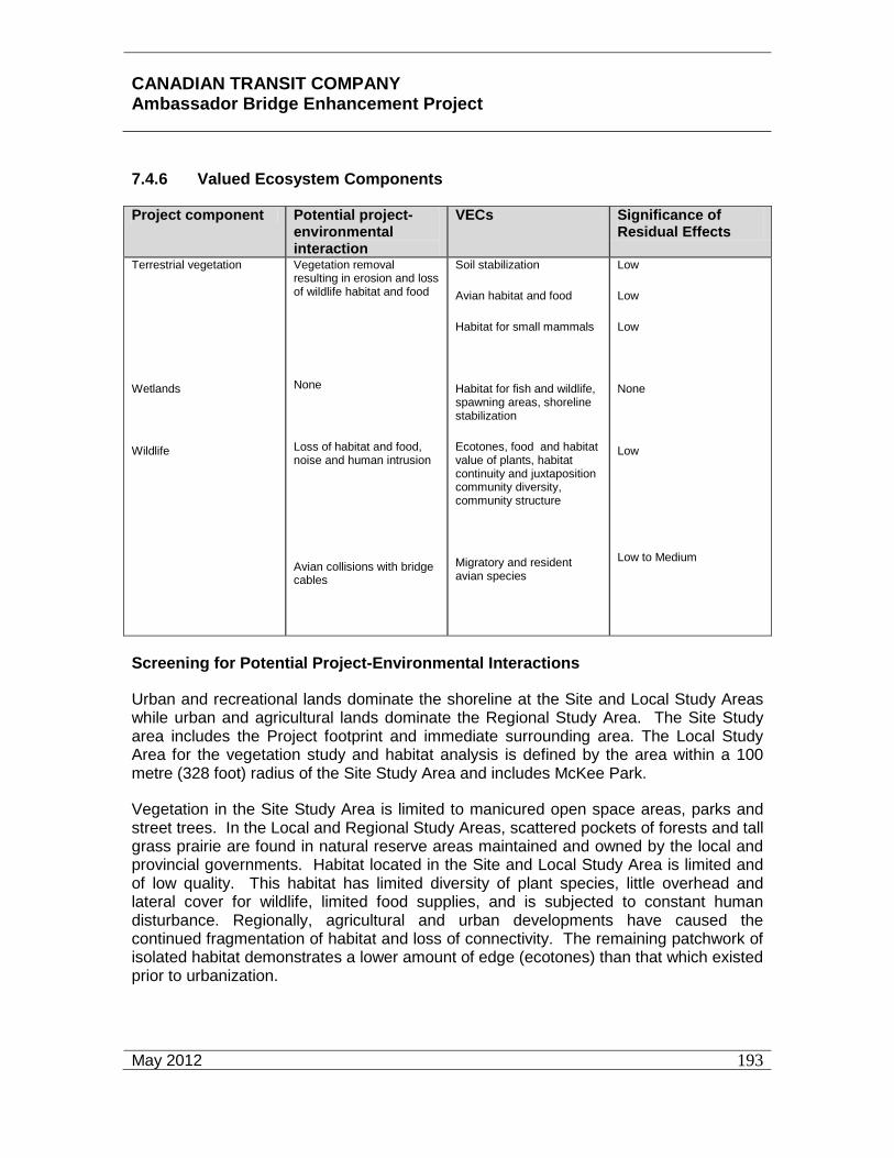
CANADIAN TRANSIT COMPANY Ambassador Bridge Enhancement Project
May 2012
193
7.4.6 Valued Ecosystem Components
Project component Potential project-environmental interaction
VECs Significance of Residual Effects
Terrestrial vegetation
Wetlands
Wildlife
Vegetation removal resulting in erosion and loss of wildlife habitat and food
None
Loss of habitat and food, noise and human intrusion
Avian collisions with bridge cables
Soil stabilization
Avian habitat and food
Habitat for small mammals
Habitat for fish and wildlife, spawning areas, shoreline stabilization
Ecotones, food and habitat value of plants, habitat continuity and juxtaposition community diversity, community structure
Migratory and resident avian species
Low
Low
Low
None
Low
Low to Medium
Screening for Potential Project-Environmental Interactions
Urban and recreational lands dominate the shoreline at the Site and Local Study Areas while urban and agricultural lands dominate the Regional Study Area. The Site Study area includes the Project footprint and immediate surrounding area. The Local Study Area for the vegetation study and habitat analysis is defined by the area within a 100 metre (328 foot) radius of the Site Study Area and includes McKee Park.
Vegetation in the Site Study Area is limited to manicured open space areas, parks and street trees. In the Local and Regional Study Areas, scattered pockets of forests and tall grass prairie are found in natural reserve areas maintained and owned by the local and provincial governments. Habitat located in the Site and Local Study Area is limited and of low quality. This habitat has limited diversity of plant species, little overhead and lateral cover for wildlife, limited food supplies, and is subjected to constant human disturbance. Regionally, agricultural and urban developments have caused the continued fragmentation of habitat and loss of connectivity. The remaining patchwork of isolated habitat demonstrates a lower amount of edge (ecotones) than that which existed prior to urbanization.

CANADIAN TRANSIT COMPANY Ambassador Bridge Enhancement Project
May 2012
194
Figure 25 demonstrates the location of trees within the project area, greater than 18 inches dbh, which will be considered for preservation. With the exception of those trees identified within the Tree Preservation Plan, all other vegetation within the direct footprint of the proposed Project will be removed as part of the project. In addition, a green area will be developed between the plaza and the nearby community of Sandwich on the east side of Indian Road. This green buffer area will create a security buffer around the Windsor Plaza.
Project impacts on community structure and diversity of both vegetation and wildlife from construction and operational effects were considered, as well the possibility of avian collisions with the cable stays. Wildlife corridors at the site are very limited due to the urban environment. Impacts during operation were also viewed in the form of runoff water and atmospheric emissions from vehicles.
A pair of peregrine falcons has been nesting on one of the inland piers of the existing Ambassador Bridge since 2008. The location of the proposed bridge is approximately 6 metres from the nesting site. Construction of the proposed bridge could result in higher noise levels and will require a number of people to be in close proximity to the nest. Most foraging for a peregrine falcon takes place between 2 and 6 km. Suitable foraging habitat is located outside of the proposed construction zone. CTC will coordinate with the MNR regarding construction activity near the nest. A peregrine falcon management plan has been developed for this project that will be implemented and can be found in Appendix P Research has shown that peregrine falcons are less affected by construction at a lower elevation than the nest but more significantly affected by construction activity that occurs above the nest. If necessary, CTC will limit the construction of the bridge in the vicinity of the nest during the nesting season for these birds (approximately March 15 to July 31).
Additionally, if necessary, CTC will provide an experienced monitoring team for the peregrine falcon nest and other nesting birds to determine if construction of other elements of the project are affecting the nest and to determine when the birds flee the nest. Behavioural studies will be conducted to monitor activity and behaviour in or directly adjacent to the construction site during the breeding season. If vegetation removals are required between May 1 and July 31, a nest survey will be conducted by a qualified avian biologist immediately prior to commencement of construction to identify and locate active nests of migratory birds and to develop a mitigation plan, if necessary.
No impacts to migratory birds are anticipated once the project is in operation. Birds and other wildlife in this area are accustomed to the noise and traffic associated with the existing bridge and plaza.
There are no substantial effects on terrestrial wildlife and wildlife habitat caused by the proposed Project. An Erosion and Sediment Control Plan to ensure areas adjacent to the work site are protected is set forth in Appendix E.

CANADIAN TRANSIT COMPANY Ambassador Bridge Enhancement Project
May 2012
195
Figure 25: Tree Preservation Plan

CANADIAN TRANSIT COMPANY Ambassador Bridge Enhancement Project
May 2012
196
Evaluation for Likely Environmental Change
Construction and Development
The construction and development of the Project will only have minimal impacts on existing roadside vegetation that includes roadside trees, ornamental tree clusters and landscape plantings. Native trees with a diameter breast height (dbh) of approximately 46 centimetres (18 inches) or greater will be preserved during construction to the extent possible. Figure 25 demonstrates the location of trees within the project area, greater than 18 inches dbh, that will be considered for preservation. As previously stated, the habitat in this area is already highly disturbed and does not contribute a significant amount of wildlife habitat. Further, given the urban environment, amount of disturbance, and species of wildlife observed within the project limits, wildlife are not dependent on the trees and other vegetation and/or habitat found within the project area for survival. Though this minimal, low quality habitat will be removed, more suitable habitat exists outside of the project limits that can be utilized by wildlife.
Most of the ornamentals are not unique and do not contribute to the natural vegetation communities in this area. Construction will result in the grading, levelling and grubbing of the Site Study Area and loss of these man made areas. Construction will also result in an increase in ambient noise levels from operation of construction equipment and some increase in fugitive dust. The Ambassador Bridge will provide mitigation to control fugitive dust and noise. Appendix E addresses dust suppression techniques and noise mitigation is discussed later in this document. Once the bridge is constructed, the main change in environmental conditions will include shading from the bridge deck and a somewhat higher structure for avian species to navigate. However, the new bridge will be in very close proximity (30.5 metres or 100 feet) to the existing bridge which already poses a navigational obstacle to avian species. Birds flying in the upriver and down river directions already experience an obstruction at the existing bridge and need to fly either under or over it. The new bridge will increase the height of the existing obstruction causing a need for avian species to fly higher to avoid collision. Information about potential avian collisions with the proposed Project is discussed in further detail below.
Monitoring Phase
If necessary, CTC will limit the construction of the bridge in the vicinity of the nest during the nesting season for the peregrine falcons birds (approximately March 15 to July 31). CTC will provide an experienced monitoring team for the peregrine falcon nest and other nesting birds to determine if construction of other elements of the project are affecting the nest and to determine when the birds flee the nest. Behavioural studies will be conducted to monitor activity and behaviour in or directly adjacent to the construction site during the breeding season. Vegetation removals should occur outside the growing season to avoid loss of wildlife and wildlife habitat to the extent possible. If vegetation removals are required between May 1 and July 31, a nest survey will be conducted by a qualified avian biologist immediately prior to commencement of construction to identify and locate active nests of migratory birds and to develop a mitigation plan, if necessary.

CANADIAN TRANSIT COMPANY Ambassador Bridge Enhancement Project
May 2012
197
There is no need for a monitoring phase if construction occurs outside of the nesting season for the peregrine falcon since the type and amount of vegetation and habitat to be lost is of marginal value and the nesting season includes the vegetative growing season. Mature trees that can be spared will be flagged for preservation as previously specified. The project proponent will develop a planting program that maximizes the use of native species to replace loss of some of the mature trees. Vegetation at the banks of the Detroit River will be left undisturbed to the extent technically feasible.
7.4.6.1 Assessment of Likely Environmental Effects No long-term or cumulative adverse effects to aquatic and terrestrial vegetation communities and wildlife habitat are anticipated from the construction or operation of the proposed Project. Construction related impacts from noise and general construction activities including vibration will be short-term (during the construction period). The existing facility is currently connected to the City of Windsor’s storm and sewer system. During the design phase, the intent for the Enhancement Project is to simply modify the connections as necessary to maintain this connection to the City’s system. The Stormwater Pollution Prevention Handbook will be consulted to assist in the development of the Stormwater Management Plan. The Plan will be designed to prevent the discharge of sediment and other construction debris into the waters of the Detroit River. This Plan will be developed to accommodate runoff that will occur during the operation of the project. It will be tailored to accommodate the amount of stormwater runoff that will be generated by the increase in impervious surface as a result of the deck of the bridge. Stormwater runoff will be managed in such a way as to limit the amount to the levels that were present at the predevelopment stage. Stormwater will be treated at an “Enhanced” level as described in the MOE’s Stormwater Management Manual. The Ambassador Bridge has created a Draft Erosion and Sediment Control and Stormwater Management Plan (Appendix E) for this project. Net residual effects on the terrestrial ecosystem are not anticipated.
7.4.6.2 Vegetative Communities The only potential impacts to terrestrial vegetation are the small area occupied by the support tower and piers for the bridge, areas required for the plaza expansion roughly located south of Mill Street and south of College Avenue, and any staging and construction parking areas. The support tower will be located approximately 30.5 metres (100 feet) south of the river and will occupy approximately 553 m2 (5,946 ft2) of area. The support tower is the largest support structure. The other support piers will each occupy about 5 m2 (54 ft2). The proposed commercial parking lot is approximately 23,000 m2 in size. The proposed staff and visitor parking lot is approximately 15,500 m2
in size.
The existing natural environment was assessed and documented in May, 2007 and November 2010 (see Appendix H). The study area has few natural heritage features or available habitat for local wildlife. The existing vegetation is limited to the street trees on Indian Road and associated side roads. The trees within the site study area represented a combination of native and non-native species that have been planted either as streetscaping, parkland or for residential privacy. There were far more ornamental and
CANADIAN TRANSIT COMPANY Ambassador Bridge Enhancement Project
May 2012
198
invasive species identified which is common in established urban areas as native plantings were not historically encouraged as street trees. Only three species were considered Carolinian trees, the tulip tree (Liriodendron tulipifera) red oak (Quercus rubra) and white oak (Quercus alba). There are no wetlands located in the site study area.
Loss of some trees, shrubs and open areas as a result of the proposed Project will have minimal effects, as future replanting will replace some of the losses. No long-term effects on vegetation from project operation are anticipated. Based on the conclusions of the qualified arborist, the effect to these trees from the Project will not be significant because they do not provide preferred or suitable habitat and function. Given the existing vegetation and available habitat, it is not anticipated that there will be significant adverse residual effects on the local flora and fauna as a result of the Project.
The following mitigation measures will assist in reducing potential for effects on vegetation near the river itself:
• All work areas will be delineated with construction fencing to restrict the equipment and construction from potentially sensitive areas (i.e. the Detroit River).
• Heavy equipment will be limited to stable areas and away from the shoreline of the Detroit River. These sensitive riparian areas will be marked on the site prior to construction.
• Best management practices related to materials storage, machinery operation and the movement of earth will be implemented during construction. These best management practices will include but not be limited to keeping hazardous or potentially erodible materials away from the shore of the Detroit River, not allowing vehicle maintenance or refuelling within 50 metres or more of a watercourse and behind or inland of protective barriers, and removing soil stockpiles on a regular basis. See Appendix E, Erosion and Sediment Control Plan.
• An Erosion and Sediment Control Plan has been prepared to ensure areas adjacent to the work site are protected (See Appendix E).
• Soils exposure time will be kept to a minimum by removing soil stockpiles on a regular basis and re-stabilizing disturbed areas as soon as practicable, generally within 24 to 48 hours.
• Silt fencing and staked hay bales will be installed in areas of soil disturbance to minimize disturbance of these areas and restrict the dumping of waste/fill materials in a potential erosion zone.

CANADIAN TRANSIT COMPANY Ambassador Bridge Enhancement Project
May 2012
199
• Use of an erosion control blanket in areas of soil disturbance will be used to provide slope protection and stabilization; seeding, sodding, and mulching material can also be effective if applied appropriately.
• Vegetation removals will occur outside of the growing season to the extent possible.
More detailed information about the aforementioned mitigation is found in the Erosion and Sediment Control Plan found in Appendix E.
7.4.6.3 Wildlife Habitats The type and amount of vegetation removed by the proposed Project, including roadside trees, ornamental plantings, and landscape planting, will have no effect on wildlife habitat locally or regionally because these do not serve as linkages or corridors. Vegetation along Indian Road and McKee Park was inventoried. Of the trees identified within the Local Study Area, only two species were considered Carolinian trees. Carolinian species are unique to only a small zone along Lakes Erie and Ontario in Canada based on the northernmost limits of many of the tree species. Many of the species are found in Canada only within this zone. The Carolinian life zone supports almost one-third of the rare, endangered and threatened species in Canada and 40 percent of Ontario’s rare plants are restricted to the Carolinian zone. The tulip tree (Liriodendron tulipifera) red oak (Quercus rubra) and white oak (Quercus alba) are Carolinian species identified in the field study for the Project; neither of these species is listed as endangered, threatened or species of concern.
The upland areas of McKee Park consist of manicured grass and planted trees. Riverbank vegetation at McKee Park was more natural and consisted of shrubs and herbaceous species. Preservation of mature native trees and riverbank vegetation in McKee Park will greatly reduce the impacts of the project. None of the mature vegetation in McKee Park will be removed. Mature native trees will be identified and flagged for preservation. The Site Study Area habitat is typical of disturbed urban areas with limited wildlife use.
Mitigation for wildlife habitat is essentially the same as that to be used to preserve vegetation. These actions include protection of the riparian zone by restricting use of heavy equipment in and along the shorelines, flagging and preserving mature trees where feasible, and implementation of the Erosion and Sediment Control Plan. The project proponent will develop a planting program that uses native species to replace loss of some of the mature trees.
7.4.6.4 Wildlife Communities Wildlife that may be impacted by the proposed Project is limited to species highly tolerant of human activities such as mice, squirrels, skunks, opossum, raccoons, birds, and other species tolerant of humans. During the construction period, activities will remove soil and vegetation and cause vibration and noise affecting the habitat and wildlife that exist at the site. Noise will be generated by trucks and other construction

CANADIAN TRANSIT COMPANY Ambassador Bridge Enhancement Project
May 2012
200
equipment and from pile driving activities. Pile driving will also generate vibrations and is discussed in a separate section. Sedentary species, such as nesting birds, could be eliminated by clearing activities while more mobile species will disperse from the area as a result of noise and general construction activities. Emigrating wildlife could be subjected to stress as a result of this displacement.
Noise and general construction activities will reduce the use of the general area by small and medium sized mammals and avians in the immediate vicinity of the construction site. Potential impacts of noise on wildlife can include impairment or loss of hearing with subsequent consequences on finding prey and avoiding predators to altered movement patterns, displacement, behavioral changes and long term stress. The responses of wildlife to anthropogenic noise are species specific. The responses can vary from almost no reaction to a virtual lack of tolerance. The species inhabiting the study area are those tolerant of human intrusion and anthropogenic noise and the effect of noise will be minimal.
The loss of the open area and some trees will not have a measurable effect on wildlife population levels in the area nor will it affect species diversity and community composition. Construction will take place from the upland areas and, therefore, no impacts on avian species feeding or resting in the river are expected.
Vegetation removals should occur outside the growing season to avoid loss of wildlife and wildlife habitat to the extent possible. If vegetation removals are required between May 1 and July 31, a nest survey will be conducted by a qualified avian biologist immediately prior to commencement of construction to identify and locate active nests of migratory birds and to develop a mitigation plan, if necessary.
Potential effects of operation on wildlife are primarily from runoff water, atmospheric emissions from vehicles and collisions by avians with the bridge structural elements. The impacts of runoff are of low magnitude and will be mitigated through the use of a dedicated treatment system. Likewise the effects from vehicle emissions will not adversely affect the wildlife within the Study Area beyond what already exists from existing traffic.
Very few studies exist on bird collisions with bridges and bridge stay structures. Most of the avian collision studies concern transmission lines, transmission towers, buildings and more recently wind turbine generators. These types of structures have been of concern due to high collision mortality of avian species in isolated cases. To date, the same level of concern and study has not been given to bridges.
One of the most comprehensive studies about avian mortality related to collisions with man-made structures involved the review of more than 1,500 publications.79 The studies that were reviewed spanned a period of 117 years from 1884-2001. These publications 79 Ove Arup & Partners Hong Kong Ltd, "Environmental Impact Assessment Report – Shenzhen Western
Corridor," Appendix 9B – Bird Collisions with Man-made Structures, 2002.

CANADIAN TRANSIT COMPANY Ambassador Bridge Enhancement Project
May 2012
201
assessed avian mortality in North America, Europe, Asia, Africa, and South America including several studies conducted in Ontario, Michigan, and other portions of the Great Lakes. This study concluded that less than 0.02% of total annual North American bird mortality is caused by bird collisions with tall, man-made structures.80
The studies show that any bird collisions over waterways do leave detectable evidence (i.e. dead birds floating on the surface). There is a lack of this type of documented bird kill evidence at major bridges crossing waterways. Some researchers have concluded that collisions with power lines over waterways are due to the invisibility of the actual cables, particularly at night. In order to resolve this problem researchers have recommended incorporating power lines into more visible structures, like bridges. Thus, bridges tend to be more visible to avians and less likely to be a problem as compared to more invisible structures such as power lines. The proposed bridge will be a highly visible, lighted structure and this will help to minimize the impact of collisions.
Birds tend to fly either over or under bridges depending to some extent on the bird species. Most birds fly over bridges. For instance, gulls and cormorants in Holland tend to fly over low bridges. Cormorants, pelicans, falcons, terns and gulls in San Francisco Bay typically fly over bridges. Some species of ducks may be vulnerable to potential collisions when flying at low altitudes due to their high flight speeds. Flying in flocks also limits the maneuverability of duck species. Studies performed in an environment similar the Detroit River (namely, the Niagara River) indicated that few waterfowl fly underneath existing bridges, but rather fly over them.81 This study is important since it is the only study that has been done in the Great Lakes region to measure flight heights of avian species in a river migration corridor using radar surveys. Most of the avian species in the Niagara River are also found in the Detroit River and the climate and riverine environments are similar. It is expected that most avian species using the Detroit River habitats would fly over both the existing Ambassador Bridge and the proposed Project.
In the Niagara River study, the mean altitude of birds observed by radar was 470 metres (1,540 feet) above ground level. Mean altitude in winter was the lowest being 233 metres (764 feet). The mean altitude of bird flocks observed by radar was 381 metres (1,250 feet) above ground level with the lowest being in winter at 233 metres (764 feet).82 The height of the proposed cable stayed bridge towers is lower than the mean flight altitudes measured in the Niagara River study, at 177 metres (582 feet). Additionally, the proposed bridge provides an obstruction at the 177 metre (582 foot) height only in the immediate vicinity of the support towers and the height is lower between the towers as the cables angle downward to the deck.
80 Ibid. 81 Yonker, T.L. and L. Landon, Marine Services Diversified, LLC, "Niagara River Crossing Project Near the
International Railroad Bridge, Buffalo, New York and Fort Erie, Ontario, Final Avian Report, Prepared for Ambassador Niagara Signature Bridge Group," 2006.
82 Ibid.
CANADIAN TRANSIT COMPANY Ambassador Bridge Enhancement Project
May 2012
202
Occasional collisions with the bridge structure and resultant mortality of some avian species may occur. The new bridge will be located directly adjacent to the existing bridge (about 24 m (80 ft) downriver) and will use cables larger than 0.1 m (4-inches) in diameter. These factors will minimize bird impacts. Cables of this size are more visible to avian species than small diameter cables. Although the new bridge will be higher than the existing one, the profile will follow the existing bridge to a great extent. The new bridge will be 55 metres (181 feet) taller than the existing bridge at the location of the support towers. This will require birds to fly higher to fly over the structure and they will expend more energy to accomplish this maneuver. The bridge height is still lower than the mean flight altitudes of avians observed in the Niagara River study and the proposed Project will not significantly increase avian mortalities from collisions.
• The existing suspension bridge is in the same corridor as the proposed Project and has been present since 1929. No reports or concerns have been raised about bird kills from the existing bridge and the proposed Project will not significantly change collision potential in the corridor. Bridges are not normally associated with high collision rates because they generally possess the following characteristics:83
• They are not usually sited on prominent topographic features (ridges, mountain peaks);
• Cable-stayed portions of bridges are associated with the more visible portions of bridges and therefore do not present as great of a threat as transmission lines which are isolated from more visible structures;
• Entire bridges are lighted, and the manner in which lights are installed can be of benefit to avoid collisions (e.g. down cast lighting as opposed to upward lighting);
• Cable-stays of bridges are larger in diameter than guy wires or transmission lines and are more visible at night; and
• Bridge cable-stays are visible at night because they can be directly lighted.
Mitigation for avian species is based on the bridge design. Cables for the proposed Project will be approximately 10 centimetres (4 inches) in diameter or greater, will be easily visible to avian species and will reduce the potential for avian collisions. Focusing the lighting (of the cable stays) in the downward direction, as proposed by the project proponent, will minimize night time avian collisions.
The bridge lighting will not be completed until the final design phase of the project. CTC will focus the bridge lighting (shielded lights) in the downward direction to minimize the potential for nighttime collisions. Low intensity white strobe lights (one flash every three 83 Ove Arup & Partners Hong Kong Ltd, "Environmental Impact Assessment Report – Shenzhen Western
Corridor," Appendix 9B – Bird Collisions with Man-made Structures, 2002.

CANADIAN TRANSIT COMPANY Ambassador Bridge Enhancement Project
May 2012
203
seconds) were found to be preferable for lighting of tall structures and buildings to reduce the potential for avian collisions. CTC will use this type of strobe lighting at the tops of the towers pending any change needed based on final design criteria and final consultation with the State Historic Preservation Office (SHPO) in the United States. No red or yellow steady lights which can disorient avian species will be used on the bridge. If colored lighting is utilized to illuminate the cables, CTC will use lower intensity, lower wavelength lighting of blue, turquoise or green, pending final design criteria. These wavelengths tend to minimize disruption of magnetic orientation in several avian species.
To address mitigation for potential impacts to the nesting peregrine falcons, CTC will provide an experienced monitoring team to determine if construction of other elements of the project are affecting the nest and to determine when the birds flee the nest. Behavioural studies will be conducted to monitor activity and behaviour in or directly adjacent to the construction site during the breeding season. If vegetation removals are required between May 1 and July 31, a nest survey will be conducted by a qualified avian biologist immediately prior to commencement of construction to identify and locate active nests of migratory birds and to develop a mitigation plan, if necessary. A peregrine falcon management plan has been developed for this project and can be found in Appendix P
No impacts to avian species or other wildlife are anticipated from the improvements to the Windsor Plaza.
7.4.6.5 Species at Risk There will be no adverse effects from construction and operation of the proposed Project on any threatened, endangered or species of concern including avians, mammals, reptiles, amphibians and plants.
7.4.6.6 Summary of Residual Adverse Effects on VECs Based on the type and quality of the habitat and the wildlife in the study area, and with the inclusion of avoidance and mitigation measures, no significant adverse residual effects are expected.

CANADIAN TRANSIT COMPANY Ambassador Bridge Enhancement Project
April 2011
204
Environmental Effects Matrix
Phase: Construction and Operation
Project Activity
Valued Ecosystem Component
Potential Environmental Effects Mitigation
Mag
nitu
de
Geo
grap
hic
Exte
nt
Dur
atio
n
Rev
ersi
bilit
y
Ecol
ogic
al/S
ocio
-C
ultu
ral
and
Ec
onom
ic C
onte
xt
Site preparation Wildlife Habitat / Wildlife Communities/ Wildlife Migration/Air Quality
Adverse change in habitat quality Habitat fragmentation and loss Emigration of wildlife and less immigration, including birds Increased noise and vibration disturbance Increase in air pollution Adverse impacts to nesting birds
Re-plant the same number of mature trees that were lost Protection of riparian zone Implement erosion control measures Construct in area that is already built up and urbanized Use best management practices to lower air and noise pollution Avoid vegetation removals within the growing season
1 1 3 R 3
Towers and Substructure construction
Wildlife Habitat / Wildlife Communities/ Wildlife Migration
Adverse change in habitat quality Habitat fragmentation and loss Emigration of wildlife and less immigration, including birds Increased noise and vibration disturbance
Re-plant the same number of mature trees that were lost Protection of riparian zone Implement erosion control measures Construct in area that is already built up and urbanized Use best management practices to lower noise pollution
1 1 3 R 3
Superstructure construction
Wildlife Habitat / Wildlife Communities/ Wildlife Migration
Adverse change in habitat quality Habitat fragmentation and loss Emigration of wildlife and less immigration, including birds Interruption in flight patterns Increased noise and vibration disturbance
Re-plant the same number of mature trees that were lost Protection of riparian zone Implement erosion control measures Construct in area that is already built up and urbanized Implement downward lighting on bridge Use best management practices to lower noise pollution
1 1 3 R 3

CANADIAN TRANSIT COMPANY Ambassador Bridge Enhancement Project
April 2011
205
Environmental Effects Matrix
Phase: Construction and Operation
Project Activity
Valued Ecosystem Component
Potential Environmental Effects Mitigation
Mag
nitu
de
Geo
grap
hic
Exte
nt
Dur
atio
n
Rev
ersi
bilit
y
Ecol
ogic
al/S
ocio
-C
ultu
ral
and
Ec
onom
ic C
onte
xt
Operation Bird Flyways and Migration
interruption in flight patterns Bird collisions Increased run-off
Implement downward lighting on bridge Construct low intensity, white strobe lighting with frequency of one flash every three seconds on towers during adverse weather conditions such as fog, rain, and mist Cable-stays are more visible than other counterparts Construct dedicated treatment system for runoff Green area between the plaza and Sandwich on the east side of Indian Road
1 1 5 R 3
Key:
Magnitude: 1 = Low; e.g. localized, specific group, one generation or less 2 = Medium; e.g. portion of population, 1-2 generations, unpredictable 3 = High; e.g. entire population
Geographic Extent: 1 = <1 km2
2 = 1-10 km2 3 = 11-100 km2 4 = 101 – 1,000 km2 5 = 1,001 – 10,000 km2 6 = >10,000 km2
Duration: 1= <30 days 2 = 1-12 months 3 = 13-36 months 4 = 37-72 months 5 = >72 months
Reversibility: R = Reversible I = Irreversible
Ecological/Socio-cultural and Economic Context (Existing Conditions): 1 = natural and undisturbed 2 = some evidence of human effect on natural environment 3 = high level of human interaction with little natural environment

CANADIAN TRANSIT COMPANY Ambassador Bridge Enhancement Project
May 2012
206
7.5 Noise and Vibration
The purpose of the noise and vibration assessment is to consider noise from the construction and ongoing operations of the replacement span and plaza improvements as set out in the environmental assessment guidelines provided by Transport Canada, dated August 2007, in consultation with the Federal EA Review Team. The assessment also considers the possibility of simultaneous traffic operations on both structures (Ambassador Bridge and Proposed Project) as well the comments received from Health Canada relating to the assessment of noise impacts and cumulative effects.
All noise sensitive receptors in the neighbourhood around the proposed Project were identified. The guidelines recommend that sound levels be determined through measurement and/or prediction at ground level in the outdoor living areas (OLA’s) of all noise sensitive receptors. Typical noise sensitive receptors include: private residences, townhouses, multiple unit buildings with OLA’s, and hospitals, nursing homes educational facilities and daycare centers where there are OLA’s. Apartment balconies, institutional buildings such as churches, hospitals and schools, cemeteries and all commercial and industrial facilities are not considered to be noise sensitive receptors with respect to the MTO guidelines.
Since there have been some concerns expressed by the local school boards concerning sound levels on school property, and by local residents concerning sound outside upper story bedroom windows and at Heritage Sites, these locations have also been treated as noise sensitive points of reception as well as the ground level spaces specified in the guideline documents.
Existing and future sound levels were determined at representative receptor locations under several different operating scenarios. Future sound levels are expected to decrease at many receptor locations with the construction of the new bridge (build vs. no build scenarios) due to bridge design features, such as exterior safety lanes and roadside Jersey Barriers. Additional mitigation in the form of a roadside noise barrier is proposed for a limited number of receptors at which sound levels are expected to increase and where the ambient sound levels are currently elevated. A noise barrier is also proposed along the north and west perimeter of the plaza expansion lands. Where possible, the noise barriers will be installed prior to other construction to help mitigate against construction noise as well.
In addition, a Community Consultation Plan will be developed during the design phase and will incorporate a Noise Management Plan. A CTC representative will be accessible at all times and appointed as the community contact to address any questions, concerns or complaints during construction. As part of the Noise Management Plan, CTC will retain an expert to address noise related complaints or concerns and conduct any necessary field work related to noise during construction, when necessary. The Community Consultation Plan will also include at least one public meeting prior to construction and a public website with project information and information on how to comment on the Project.
CANADIAN TRANSIT COMPANY Ambassador Bridge Enhancement Project
May 2012
207
Vibration measurements indicate that vibration induced by heavy vehicles on the existing bridge is perceptible on the ground at locations near the bridge piers and may be perceptible to some residents. The replacement span is proposed to be supported on piles driven to bedrock and as a result the vibration levels are anticipated to decrease.
Noise and vibration impacts during construction will be controlled through compliance with the City of Windsor’s By-Laws and MOE) sound level limits for construction equipment. In addition, pile driving can generate significant levels of ground-borne vibration, and vibration levels will be monitored when piles are being driven in proximity to sensitive structures.
Please see attached Appendix J that outlines in detail the Noise and Vibration assessment along with the methodology used in assessing the noise and vibration impacts, if any, during the construction, operation and maintenance of the replacement span. No significant impacts to the study area due to increased noise resulting from construction activities are anticipated with the application of the above noted mitigation measures. With the implementation of the noise wall there is a positive residual effect as a result of the Proposed Project. All of the receptors modeled in the traffic noise study are predicted to experience the same or less noise than in the existing condition.

CANADIAN TRANSIT COMPANY Ambassador Bridge Enhancement Project
May 2012
208
Residual Environmental Effects Summary Matrix Valued Environmental Component: NOISE AND VIBRATION
Phase
Residual Environmental Effects Rating,
Including Cumulative
Environments Effects*
Level of Confidence
Likelihood
Probability of Occurrence
Scientific Certainty
Construction NS 3 2 3
Operation NS 3 1 3
Maintenance NS 3 1 3
Accidents, malfunctions, and Unplanned events
NS 3 1 3
Project Overall NS 3 1 3
Key Residual Environmental Effect Rating S Significant Adverse Environmental Effect NS Not-significant Adverse Environmental Effect P Positive Environmental Effect
Level of Confidence 1. Low Level of Confidence 2. Medium Level of Confidence 3. High Level of Confidence Probability of Occurrence: based on professional judgement 1. Low Probability of Occurrence 2. Medium Probability of Occurrence 3. High Probability of Occurrence Scientific Certainty: based on scientific information and statistical analysis or professional judgement 1. Low Level of Confidence 2. Medium Level of Confidence 3. High Level of Confidence N / A Not Applicable * As determined in consideration of established residual environmental effects rating criteria
7.6 Socioeconomic Conditions
Project interactions with Land Use may include residential and commercial land uses in addition to institutional and recreational land use / access. Environmental effects resulting from the proposed Project on the socio-economic conditions are defined by interruptions or disruptions to current land use by Project activities in such a manner that existing land use activities are restricted or unable to continue at present levels. The assessment of land use activities is broadly defined to take into account visual and aesthetic settings, community infrastructure, community services, heritage resources and archaeological resources.

CANADIAN TRANSIT COMPANY Ambassador Bridge Enhancement Project
May 2012
209
This section considers the environmental effects of the Project activities on Land Use, including the cumulative environmental effects, if any, as a result of the Construction, Operation and Maintenance, as well as the assessment of any potential Accidents, Malfunctions and other Unplanned Events.
7.6.1 Environmental Assessment Boundaries
Spatial
The Site Study Area for the assessment of the potential cumulative environmental effects of the Project on commercial, residential and recreational land uses included the immediate area of the proposed Project and nearby (i.e. < 200 metres) residential and recreational areas adjacent to the Project where activities associated with Construction, Operation and Accidents, Malfunctions and Unplanned Events of the Project could potentially intersect with land use. The environmental effects of land use interruptions or disruptions are assessed within the context of the local community that includes the area between the Detroit River on the north, Mill Street on the south, the Ambassador Bridge and existing plaza on the east and Indian Road and its extension to the Detroit River on the west. Indian Road from Wyandotte Street south to College Avenue, including its proposed extension is also included in the Site Study Area.
The spatial boundaries for the Local Study Area, for the assessment of the potential cumulative environmental effects of the Project on land uses is defined by the University of Windsor campus to the east and the community of Sandwich to the west. The broader and Regional spatial boundaries for the proposed Project include the City of Windsor and Essex County.
Temporal
The temporal boundaries for the assessment of the potential environmental effects of the Project on land use included the construction, operation and maintenance of the proposed Project in perpetuity.
The temporal boundary for the cumulative environmental effects assessment of future projects and activities that will be carried out is 2025, beyond that, predicting other projects that will be carried out is unreliable.
Administrative and Technical
The Canadian portion of the proposed Project is located entirely within the City of Windsor. Land Use Planning within the City boundaries is regulated by the City of Windsor's comprehensive zoning by-law.
Information used in support of assessing residential, institutional, commercial and recreational land use issues was obtained during the public consultation period, mapping and property identification data, and various site visits within the spatial boundaries of the proposed Project. Knowledge of the local Study Area affected by the proposed
CANADIAN TRANSIT COMPANY Ambassador Bridge Enhancement Project
May 2012
210
Project is based on the information obtained, and the professional judgment of the Study Team.
Analyses of the market value of residential, commercial and other land uses would require very extensive and exhaustive study and research of each property. This type of analysis is not included within the environmental impact assessment, as the environmental effects of the Project can be assessed absent that type of detail. In addition, this Project is unique as the proponent owns all of the homes immediately adjacent to the proposed Project.
It is the professional judgment of the Study Team that the data available to characterize the existing land use conditions and the existing knowledge regarding the environmental effects of the Project are sufficient to support the environmental impact statement.
7.6.2 Residual Environmental Effects Rating Criteria
The definition of a significant residual environmental effect on Land Use is one where the proposed use of land for a project and related facilities is not compatible with adjacent land use activities and plans, and the proposed use of land for a project will cause a change or disruption in such a manner that it restricts or degrades present land uses to such an extent that the activities cannot continue to be undertaken at current levels for extended periods of time, and cannot be compensated.
In this case, the proposed Project will not result in significant adverse residual effects on the surrounding land uses.
7.6.3 Existing Conditions
The proposed Project will be entirely constructed on land owned by the Proponent. The selection of the proposed alignment for the replacement span avoids existing major institutional uses, particularly the historic Assumption Church and the University of Windsor campus. The alignment proposed for the Project will run adjacent to some existing residential development and land used for recreation purposes. The lands used for the proposed Project is comprised of approximately 63% residential land, 6% recreational land, and 31% other land uses including existing road ways.
The existing Ambassador Bridge serves as a major international highway linking Canada and the United States. Most of the lands adjacent to the existing Ambassador Bridge and Windsor Plaza are developed and used for residential, institutional and recreational purposes. The existing Ambassador Bridge, extending north-south from Detroit, Michigan to Windsor Ontario, is located immediately east of the Project. Traffic volumes within the Windsor Plaza averaged approximately 10,400 vehicles per day in 2010. Once the construction of the proposed Project has been completed, traffic will be diverted from the Ambassador Bridge to the replacement span.
The proposed plaza improvements to the Windsor Plaza will be largely constructed within the current footprint of the existing plaza. The proposed plaza will be expanded to include approximately 23,000 m2 south of Mill Street and approximately 15,500 m2 south

CANADIAN TRANSIT COMPANY Ambassador Bridge Enhancement Project
May 2012
211
of College Avenue between Huron Church Road and Lena Avenue. The proponent owns all of this property. The properties included in the plaza expansion are currently zoned as Industrial (40%), Commercial (35%), and Institutional (25%). These properties are currently vacant and are surrounded by residential land, existing roadways, University of Windsor property, and commercial businesses (see plaza alternatives in Appendix B).
The current land uses have been identified from recent aerial photos, geographic information mapping and regulatory authority’s documents, as well as baseline field studies and observation conducted by the Study Team for the Bridge. Land use issues and concerns were received from property owners and stakeholders through a series of public meetings organized by the CTC.
Study Area
The construction of the proposed Project will have an effect on persons living within the spatial boundaries of the Project. In order to determine the level and nature of this effect on the socio-economic environment, a baseline analysis was performed for the Study Area.
City of Windsor Planning Area
The City of Windsor Official Plan lays out the City’s goals, objectives and policies for managing and guiding physical change and the effects of that physical change on the socio-economic environment and natural environments. To address the assessment of the Project’s conformity with the City’s goals and objectives it is necessary to compare the Project against the policies of the Official Plan. A synopsis of the Official Plan is in Appendix K.
The City of Windsor Zoning By-law implements the policies of the Official Plan. The figure in Appendix L depicts the current zoning for the area in the vicinity of the Ambassador Bridge. The Ambassador Bridge is zoned “CD4.4 (Commercial Districts 4 - Ambassador Bridge)” and “G1.1 (Green Districts 1 – Public Parks)” by the City’s Zoning By-law.
Institutional Land Use
The historic Assumption Church and the University of Windsor campus are located east of the existing Ambassador Bridge. The current institutional land uses within the Local Study Area of the Project reflect the sum of the environmental effects on all past and existing projects and activities, and provide a basis for considering cumulative environmental effects of past and present projects and activities, the Project, and other future projects and activities.
Commercial Land Use
The proposed alignment was selected with due consideration to avoid existing historic, institutional and residential land uses. The proposed Project does not impact any of the existing businesses in the Assessment Area. The plaza expansion will occupy property

CANADIAN TRANSIT COMPANY Ambassador Bridge Enhancement Project
May 2012
212
within the existing footprint of the plaza and several vacant properties. There are a number of commercial establishments located south of the Project, in the Local Study Area along Huron Church Road and west of the proposed alignment along Sandwich Street within the spatial boundaries of the Project. These businesses fall into two general categories: those primarily along Huron Church Road that are focused on providing goods and services to the travelling or pass-by highway traffic for some or all their business; and those commercial establishments primarily on Sandwich Street that are not reliant on the highway traffic for their business, but instead are either focused on the local markets or external markets outside the region.
Commercial establishments have been categorized according to a windshield survey to identify commercial development. Huron Church Road has a number of commercial businesses that cater to the highway traffic including full service and fast food restaurants, service stations, hotels and motels. A number of additional businesses are located near or not directly fronting along Huron Church Road including convenience, clothing, electronic, beer and liquor and department stores. The Sandwich Street / Olde Sandwich Towne commercial establishments that are not reliant on the highway traffic exposure for their business include convenience and bicycle stores and unique locally owned restaurants.
The existing commercial land use within the Local Study Area of the Project provides a benchmark for the cumulative environmental effects, as it reflects the sum of the environmental effects on commercial land use of all past and existing projects and activities.
Residential Land Use
The selection of the location of the proposed Project minimizes potential environmental effects on residential land use. The proposed replacement span passes through land acquired by the Proponent for security purposes after the events of September 11, 2001 and avoids other residential areas. The parcels selected for the plaza expansion are currently vacant properties. As part of the project, a portion of Huron Church Road will be closed and traffic will be re-routed to Indian Road between Wyandotte Street and College Avenue. In addition, Indian Road will be extended to College Avenue. CTC does not own these roadways. There are additional residential land uses along local roads within the Local Study Area located outside, but adjacent to, the proposed Project. About 110 residences are located adjacent (within 200 metres) to the proposed replacement span. An additional 240 residences are located adjacent (within 200 metres) of the proposed plaza expansion.
The existing residential land uses within the Local Study Area of the Project provide a benchmark for the cumulative environmental effects, as it reflects the sum of the environmental effects on residential land use of all past and existing projects and activities.

CANADIAN TRANSIT COMPANY Ambassador Bridge Enhancement Project
May 2012
213
Recreational Land Use
Some of the land between the Detroit River and Assumption Church is used for passive recreational activities. The main recreational activities include the use of on-road and off-road trails and pathways for bike riding and walking and the green space used for unorganized passive recreation. The trails or walkways within the spatial boundaries of the proposed Project include the City of Windsor’s bikeway or multi-use trail system. The trail system within the spatial boundaries is part of a national trail system (Trans-Canada Trail) connecting all provinces and territories and a global trail organization. A multi-use trail follows Huron Church Road between Riverside Drive West, the Detroit River and Peter Street, where it becomes a signed route and it passes under the Ambassador Bridge. Residents and visitors use the trail for short walks and bicycle rides. This trail is also used for multi-day trips on foot or bicycle. Access to the trail system will be retained as it is at present.
Assumption Park, located east of the existing Ambassador Bridge, does not posses any play equipment or any sport fields and is only used for passive unorganized recreational activities. The Riverwalk, a 5.0 kilometre walking and cycling trail connecting a series of riverfront parks, washrooms, fishing piers, concessions and sculptures, starts east of the existing Ambassador Bridge
There is no information currently available on the level of use of the trail system or parkland.
Fishing in the Detroit River is a popular activity for Windsor residents and visitors.
The current recreational land uses within the Local Study Area of the Project reflect the sum of the environmental effects on all past and existing projects and activities, and provide a basis for considering cumulative environmental effects of past and present projects and activities, the Project, and other future projects and activities.
Visual and Aesthetic Setting
The existing aesthetic setting within the Local Study Area consists of components of the natural environment and man-made features.
The availability of the natural environment for visual appreciation is limited by the urban character of the land in the vicinity of the existing Ambassador Bridge. There is relatively little topographic relief in the area or natural landscapes that would typically be associated with a high quality natural aesthetic environment.
The most significant natural visual element in the area is the Detroit River, which provides the opportunity for the appreciation of the riverine corridor within the context of the urban environment. The Detroit River is approximately 640 metres (2,099 feet) wide in the area of the proposed project vicinity, providing a broad expanse of open space for long-distance visibility of the skylines of the Cities of Windsor, Ontario and Detroit, Michigan and the Ambassador Bridge from the shoreline.

CANADIAN TRANSIT COMPANY Ambassador Bridge Enhancement Project
May 2012
214
The Ambassador Bridge is an international transportation link constructed in 1929 that connects the urban environments between the Cities of Windsor, Ontario and Detroit, Michigan. The Ambassador Bridge is a visually dominant feature that has been an element of the urban skyline for over 80 years. The bridge is styled in a mixture of Art Deco and Art Moderne architectural designs, with some Gothic architecture blended in. It is constructed primarily out of steel. The two main towers on each side of the River are made of a steel-silicon alloy which rises up from the concrete piers. At night, the Ambassador Bridge is lit as an aesthetic enhancement and for safety purposes.
The visual significance of the Ambassador Bridge is derived from its engineering history taking into account that it represents a state-of-the art structure for the early 20th century and, at the time of its completion, the longest suspension bridge in the world. The Ambassador Bridge is significant for its prominence in the historic development of the area as a major component of the transportation infrastructure that is critical to the Canadian and US economies. The Ambassador Bridge also serves as a physical and symbolic gateway connection between the countries of Canada and the United States.
In Canada, the Ambassador Bridge travels between the community of Sandwich to the west and the University of Windsor to the east between the shoreline of the Detroit River and the customs plaza north of College Avenue. The bridge is elevated above existing grade between the river and the plaza. The structure consists of several aesthetic elements: the towers, the support cables, the bridge deck and travelway, the anchor piers and support piers.
From a distance, the most visually dominant features of the Ambassador Bridge are the two towers. Immediately adjacent to the Ambassador Bridge, the anchor pier on the north side of University Avenue West is the largest pier supporting the bridge decking with smaller steel piers at varying intervals. The smaller steel piers are approximately 46 metres (152 feet) apart near the Detroit River and approximately 15 metres (50 feet) apart near the plaza.
Other man-made visual features in the Local Study Area include the residential development to the west and southwest of the Ambassador Bridge. There are no key vantage points within the residential area immediately to the west or the southwest which includes existing vacant land. Further west of the adjacent residences on Indian Road, in the community of Sandwich, there are several designated historic structures that provide unique visual elements largely associated with their age, architectural style and historic significance to the development of the community.
Assumption Church is a historic property located immediately to the east of the existing Ambassador Bridge that has a clear visibility of many of the visual elements of the Ambassador Bridge including the Canadian tower, the decking, the anchor pier and numerous steel support piers. This church is near the northwesterly corner of the University of Windsor complex of buildings, walkways, and opens space. There is substantial mature vegetation in the front of the church (University Avenue West) that provides some screening and buffering of the visibility of the Ambassador Bridge. The

CANADIAN TRANSIT COMPANY Ambassador Bridge Enhancement Project
May 2012
215
level of buffering decreases in the winter months after the leaves have fallen from the deciduous trees.
A riverine park provides public open space to both the east and west of the existing Ambassador Bridge. This public open space is available for aesthetic appreciation of the natural character of the Detroit River, the Ambassador Bridge and the skylines of the Cities of Windsor and Detroit.
Transportation routes are man-made corridors that provide both transportation functionality and the opportunity for aesthetic appreciation of the natural and built environment. Schedule G: Civic Image of the City of Windsor’s Official Plan84 identifies civic ways and themed streets that have been deemed to be important. The civic ways and themed streets in the Project vicinity are identified on the figures contained Appendix K Civic ways include portions of Sandwich Street, Riverside Drive, Huron Church Road, Tecumseh Road West and Patricia Road. Themed streets include a portion of Sandwich Street in the older commercial centre and University Avenue and Wyandotte Street to the east of the Ambassador Bridge. The visibility of the natural and man-made environment from these areas should be considered for any new development.
7.6.4 Environmental Effects Analysis
Land use issues have been considerably mitigated by the decision to construct the Project on land that will be vacant for security purposes. This avoids all institutional and residential disruption.
7.6.5 Project-VEC Interactions
The potential interactions between Project activities, including other projects, and Land Use are indicated for each Project phase, and Accidents, Malfunctions and Unplanned Events.
The nature of these interactions is summarized in the following sections that address the potential environmental effects of each Project activity, in conjunction with other projects that have the potential to have overlapping cumulative environmental effects with the Project. 7.6.5.1 Construction
The activities associated with the construction of this Project may have an effect on Land Uses in the Study Area. The interaction of the environmental effects of construction activities and physical works of the Project with the Land Use VEC is summarized and described below. The following matrix describes the strategies aimed at mitigating these potential environmental effects.
84 City of Windsor, Official Plan, Schedule G: Civic Image, Office Consolidation, June 1, 2004.

CANADIAN TRANSIT COMPANY Ambassador Bridge Enhancement Project
May 2012
216
Environmental Effects Assessment Matrix Valued Environmental Component: LAND USE Phase: Construction
Project Activity
Potential Environmental Effects, Including Cumulative Environmental Effects
Mitigation Magnitude
Geographic Extent
Duration / Frequency
Reversibility Ecological / Socio-Cultural and Economic Context
Site Preparation
Change in Adjacent Residential Use (A)
Dust Control
Work Progression
1 1 2 / 6 R 3
Change in Recreational Use (A)
Ensure Trail Continuity
Dust Control
Work Progression
1 1 2 / 6 R 3
Change in Institutional Use (A)
Dust Control
Work Progression
1 1 2 / 6 R 3
Construction of Foundations
Change in Adjacent Residential Use (A)
Dust Control
Work Progression
1 1 2 / 6 R 3
Change in Recreational Use (A)
Ensure Trail Continuity
Dust Control
Work Progression
1 1 2 / 6 R 3
Change in Institutional Use (A)
Dust Control
Work Progression
1 1 2 / 6 R 3
Construction of Substructure (towers and piers)
Change in Adjacent Residential Use (A)
Dust Control
Work Progression
1 1 2 / 6 R 3
Change in Recreational Use (A)
Ensure Trail Continuity
Dust Control
Work Progression
1 1 2 / 6 R 3
Change in Institutional Use (A)
Dust Control
Work Progression
1 1 2 / 6 R 3

CANADIAN TRANSIT COMPANY Ambassador Bridge Enhancement Project
May 2012
217
Environmental Effects Assessment Matrix for Land Use (Construction)
Residential Land Use
The proposed Project will not result in the purchase or relocation of any residential land use. About 110 residences are located within the Site Study Area (within 200 m) to the proposed replacement span. An additional 240 residences are located within the Site Study Area (within 200 metres) of the proposed plaza expansion. Residential land use adjacent to the Project may experience a perceptible change in noise levels from the
Construction of Superstructure (cables and deck)
Change in Adjacent Residential Use (A)
Dust Control
Work Progression
1 1 3 / 6 R 3
Change in Recreational Use (A)
Ensure Trail Continuity
Dust Control
Work Progression
1 1 3 / 6 R 3
Change in Institutional Use (A)
Dust Control
Work Progression
1 1 3 / 6 R 3
Key
Magnitude
1. Low: e.g., specific group, residence or neighbourhood affected such that adjacent land use activities will not be disrupted such that current activities cannot continue even after short periods of time
2 Medium: e.g. part of a community affected such that adjacent land use activities will not be disrupted such that current activities cannot continue for extended periods of time longer than two years
3 High: e.g. community affected such that adjacent land use activities will not be disrupted such that current activities cannot continue for extended periods of time longer than two years and are not compensated
Geographic Extent
1. <1 square kilometre 2. 1 – 10 square kilometres 3. 11 – 100 square kilometres 4. 101 – 1,000 square kilometres 5. 1,001 – 10,000 square kilometres 6. >10,000 square kilometres
Duration
1. <1 month 2. 1 – 12 months 3. 13 – 36 months 4. 37 – 72 months 5. > 72 months
Frequency
1. <11 events / year 2. 11 – 50 events / year 3. 51 – 100 events / year 4. 101 – 200 events / year 5. >201 events / year 6. continuous Reversibility R Reversible I Irreversible
Ecological / Socio-cultural Context
1. Relatively pristine area or area not adversely affected by human activity 2. Some evidence of human effect on natural environment 3. High level of human interaction with little natural environment N / A Not Applicable (A) adverse (P) positive

CANADIAN TRANSIT COMPANY Ambassador Bridge Enhancement Project
May 2012
218
construction equipment during all phases of construction of the proposed Project. Residents may also be affected by air emissions and other disturbances generated by the Project. Access to residential roadways will be maintained throughout construction. Mitigation measures include application of dust control methods and work progression specifications to ensure construction activity scheduling is met and duration minimized. These issues and environmental effects are addressed in detail in Section 7.1 Air Quality and Climate and Section 7.5 Noise and Vibration. These impacts can be mitigated and are not considered significant.
Additional improvements were identified that will be needed along Indian Road for the operation of the study intersections at an acceptable level of service under the detour scenario. These additional needed improvements are listed below and discussed further in Appendix Q.
• Signalization of the intersection of Indian Road at Wyandotte Street.
• Signalization of the intersection of Indian Road Extended at College Avenue.
• Conversion of the eastbound shared right-through lane for the intersection of Huron Church Road at College Avenue to an exclusive right turn lane.
Based on the traffic analysis conducted with all the recommended improvements, the study intersections will operate at an acceptable level of service under the detour condition.
Commercial Land Use
There are no commercial businesses located within the proposed Project that will need to be removed during construction. As previously described, the location for the plaza expansion is currently zoned as commercial, light industrial, and institutional. Though these properties are currently vacant, they will be re-zoned for commercial use associated with highway/restricted use. There are no commercial uses situated in proximity to the proposed Project that will be impacted by construction activities such as noise, air emissions and dust generated by construction vehicles. Construction activities associated with the proposed Project will not interact directly with the level of commercial activity within the Study Area boundaries.
Recreational Land Use
The only environmental effect of the Project on recreational land uses during construction is the intersection of the trail system that is used for hiking and biking. Trail users would be exposed to noise, dust and other disruptions during construction temporarily affecting the quality of their experience. Potential mitigation measures during construction are to develop approaches to ensure the continuity of trail access for recreational users. In addition dust control and work progression scheduling can be specified in construction contracts to minimize the potential environmental effects of construction on Trail use.

CANADIAN TRANSIT COMPANY Ambassador Bridge Enhancement Project
May 2012
219
The design of the proposed Project will provide for the continuation of trail access through the use of signage for at-grade crossings or other means.
There may be a temporary interruption to recreational fishing at the immediately location of the proposed Project. For safety reasons public access to the Detroit River at this location will be restricted. This interruption will only affect a very small portion of the River and will be temporary.
Once construction is completed all recreational activities will be restored and rehabilitated. There are no recreational land uses in the vicinity of the existing plaza or plaza expansion.
Institutional Land Use
The proposed Project will have no impacts and will not result in the elimination of any institutional land uses. The institutional uses located adjacent (within 200 metres) to the proposed Project include Assumption Church and portions of the University of Windsor Campus. People using these institutional facilities may experience a perceptible change in noise levels from the construction equipment during all phases of construction of the proposed Project. They may also be affected by air emissions, dust and other disturbances generated by the Project. Mitigation measures include application of dust control methods and work progression specifications to ensure construction activity scheduling is met and duration minimized. These issues and environmental effects are addressed in detail in Section 7.1 Air Quality and Climate and 7.5 Noise and Vibration. Access to institutional facilities will not be disrupted during construction. It is anticipated that relatively little construction activity will take place on Sunday when Assumption Church is most active. These impacts can be mitigated and are not considered significant.
Summary - Construction
Based on the consideration of the environmental effects of the individual activities required to construct the proposed Project, the proposed mitigation measures, and the residual environmental effects rating criteria, the residual environmental effects on Land Use are rated as not significant.
Operation
The Project Land Use VEC interactions of the operation phase of the proposed Project are summarized and described below. The following matrix describes the strategies aimed at mitigating these potential environmental effects.

CANADIAN TRANSIT COMPANY Ambassador Bridge Enhancement Project
May 2012
220
Environmental Effects Assessment Matrix for Land Use (Operation)
Environmental Effects Assessment Matrix Valued Environmental Component: LAND USE Phase: Operation
Project Activity
Potential Environment al Effects, Including Cumulative Environmental Effects
Mitigation Magnitude Extent Duration / Frequency
Reversibility
Ecological / Socio-Cultural and Economic Context
Winter Safety Change in Adjacent Residential Use (A)
Implementation of Standard Winter Highway Maintenance Procedures
1 1 5 / 2 R 2
Change in Recreational Use (A)
Implementation of Standard Winter Highway Maintenance Procedures
1 1 5 / 2 R 2
Change in Institutional Use (A)
Implementation of Standard Winter Highway Maintenance Procedures
1 1 5 / 2 R 2
Presence Change in Adjacent Residential Use (P)
Implementation Of Standard Winter Highway Maintenance Procedures
1 1 5 / 2 R 2
Change in Recreational Use (P)
Implementation Of Standard Winter Highway Maintenance Procedures
1 1 5 / 2 R 2
Change in Institutional Use (P)
Implementation Of Standard Winter Highway Maintenance Procedures
1 1 5 / 2 R 2
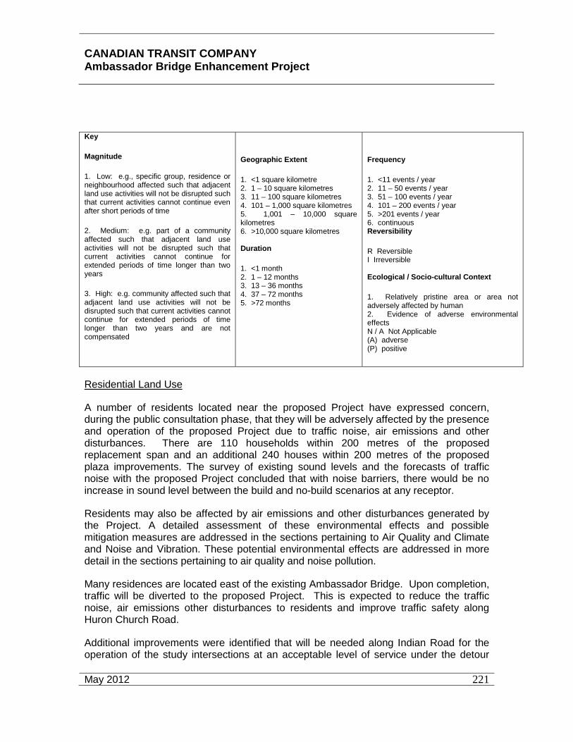
CANADIAN TRANSIT COMPANY Ambassador Bridge Enhancement Project
May 2012
221
Key
Magnitude
1. Low: e.g., specific group, residence or neighbourhood affected such that adjacent land use activities will not be disrupted such that current activities cannot continue even after short periods of time
2. Medium: e.g. part of a community affected such that adjacent land use activities will not be disrupted such that current activities cannot continue for extended periods of time longer than two years
3. High: e.g. community affected such that adjacent land use activities will not be disrupted such that current activities cannot continue for extended periods of time longer than two years and are not compensated
Geographic Extent
1. <1 square kilometre 2. 1 – 10 square kilometres 3. 11 – 100 square kilometres 4. 101 – 1,000 square kilometres 5. 1,001 – 10,000 square kilometres 6. >10,000 square kilometres Duration
1. <1 month 2. 1 – 12 months 3. 13 – 36 months 4. 37 – 72 months 5. >72 months
Frequency
1. <11 events / year 2. 11 – 50 events / year 3. 51 – 100 events / year 4. 101 – 200 events / year 5. >201 events / year 6. continuous Reversibility
R Reversible I Irreversible Ecological / Socio-cultural Context
1. Relatively pristine area or area not adversely affected by human 2. Evidence of adverse environmental effects N / A Not Applicable (A) adverse (P) positive
Residential Land Use
A number of residents located near the proposed Project have expressed concern, during the public consultation phase, that they will be adversely affected by the presence and operation of the proposed Project due to traffic noise, air emissions and other disturbances. There are 110 households within 200 metres of the proposed replacement span and an additional 240 houses within 200 metres of the proposed plaza improvements. The survey of existing sound levels and the forecasts of traffic noise with the proposed Project concluded that with noise barriers, there would be no increase in sound level between the build and no-build scenarios at any receptor.
Residents may also be affected by air emissions and other disturbances generated by the Project. A detailed assessment of these environmental effects and possible mitigation measures are addressed in the sections pertaining to Air Quality and Climate and Noise and Vibration. These potential environmental effects are addressed in more detail in the sections pertaining to air quality and noise pollution.
Many residences are located east of the existing Ambassador Bridge. Upon completion, traffic will be diverted to the proposed Project. This is expected to reduce the traffic noise, air emissions other disturbances to residents and improve traffic safety along Huron Church Road.
Additional improvements were identified that will be needed along Indian Road for the operation of the study intersections at an acceptable level of service under the detour

CANADIAN TRANSIT COMPANY Ambassador Bridge Enhancement Project
May 2012
222
scenario. These additional needed improvements are listed below and discussed further in Appendix Q.
• Signalization of the intersection of Indian Road at Wyandotte Street.
• Signalization of the intersection of Indian Road Extended at College Avenue.
• Conversion of the eastbound shared right-through lane for the intersection of Huron Church Road at College Avenue to an exclusive right turn lane.
Based on the traffic analysis conducted with all the recommended improvements, the study intersections will operate at an acceptable level of service under the detour condition.
Commercial Land Use
Commercial land use near the proposed Project is unlikely to be adversely affected during the ongoing operation of the proposed Project due to noise, dust, air emissions and other disturbances from the passing traffic. The survey of existing sound levels and the forecasts of traffic noise with the proposed Project concluded that with noise barriers, there would be no significant increase in sound level between the build and no-build scenarios at any commercial land use. A detailed assessment of these environmental effects and possible mitigation measures are addressed in Section 7.2 Air Quality and Climate and Section 7.5 Noise and Vibration.
As previously described, the location for the plaza expansion is currently zoned as commercial, light industrial, and institutional. Though these properties are currently vacant, they will be re-zoned for commercial use associated with highway/restricted use.
More importantly, the operation of the proposed Project will reduce the traffic noise, air emissions and facilitate the flow of traffic across the border. The proposed Project will also result in improvement to traffic safety (less congestion) and a reduction in air and noise emissions. No additional mitigation measures are necessary.
Recreational Land Use
The presence of the proposed Project will interact with recreational land use due to noise and other minor disturbances in the immediate vicinity of the Project. This will only occur while crossing under the proposed replacement span, as the trails and most recreation activities are situated away from the Project. Mitigation measures for trails during operation of the Project will include measures that ensure the continuity of the trail system, through the use of existing signage.
Institutional Land Use
There are several positive impacts on the institutional land uses situated within the Local Study Area. The institutional uses located adjacent (within 200 metres) to the proposed replacement span include Assumption Church and portions of the University of Windsor

CANADIAN TRANSIT COMPANY Ambassador Bridge Enhancement Project
May 2012
223
Campus. The design of the proposed bridge (cable-stayed bridge) will have a positive impact resulting in a reduction of vibration on these institutional land uses in the Study Area. The survey of existing sound levels and the forecasts of traffic noise with the proposed Project concluded that with noise barriers, there would be no significant increase in sound level between the build and no-build scenarios at any institutional land use. Air emissions, noise and vibration from the proposed Project will be moved further away from the institutional uses. No mitigation measures are necessary.
Several institutional facilities associated with the University of Windsor are located adjacent to or nearby the areas proposed for expansion of the plaza. However, the properties proposed for the plaza expansion will be used for parking. People using the institutional facilities should not perceive any noticeable change in noise levels or experience other impacts. Access to the properties within the University of Windsor will not change as a result of the plaza expansion.
There is one daycare located immediately west of the proposed parking area for the plaza expansion. The traffic noise analysis discussed in Section 7.5 indicated that noise impacts to this site will not occur.
Summary - Operation
Based on the consideration of the environmental effects of the individual activities required to operate the proposed Project, and the mitigation measure proposed along with the residual environmental effects rating criteria, the residual environmental effects on Land Use are rated as not significant.
Maintenance
The Project Land Use VEC interactions of the maintenance phase of the proposed Project are summarized and described below. The following matrix describes the strategies aimed at mitigating these potential environmental effects.
Periodic maintenance of the proposed Project, such as resurfacing of the deck or parking areas, will be required. Typically, major roadway maintenance takes place on average once every fifteen years. Bridges and major structures have longer structural refurbishment periods. These maintenance activities would create additional noise and dust which could affect adjacent land use. This issue is addressed in Section 7.1 Air Quality and Climate. The potential environmental effects of Project maintenance on Land Use are, in consideration of planned mitigation, rated not significant.

CANADIAN TRANSIT COMPANY Ambassador Bridge Enhancement Project
April 2011
224
Environmental Effects Assessment Matrix for Land Use (Maintenance)
Environmental Effects Assessment Matrix Valued Environmental Component: LAND USE Phase: Operation
Project Activity
Potential Environment al Effects, Including Cumulative Environmental Effects
Mitigation Magnitude Extent Duration / Frequency
Reversibility
Ecological / Socio-Cultural and Economic Context
Proposed Maintenance Change in Adjacent Residential Use (A)
None recommended
1 1 5 / 2 R 2
Change in Recreational Use (A)
None recommended
1 1 5 / 2 R 2
Change in Institutional Use (A)
None recommended
1 1 5 / 2 R 2
KEY MAGNITUDE 1. Low: e.g., specific group, residence or neighbourhood affected such that adjacent land use activities will not be disrupted such that current activities cannot continue even after short periods of time 2. Medium: e.g. part of a community affected such that adjacent land use activities will not be disrupted such that current activities cannot continue for extended periods of time longer than two years 3. High: e.g. community affected such that adjacent land use activities will not be disrupted such that current activities cannot continue for extended periods of time longer than two years and are not compensated
Geographic ExtenT 1. <1 square kilometre 2. 1 – 10 square kilometres 3. 11 – 100 square kilometres 4. 101 – 1,000 square kilometres 5. 1,001 – 10,000 square kilometres 6. >10,000 square kilometres Duration 1. <1 month 2. 1 – 12 months 3. 13 – 36 months 4. 37 – 72 months 5. > 72 months
Frequency 1. <11 events / year 2. 11 – 50 events / year 3. 51 – 100 events / year 4. 101 – 200 events / year 5. >201 events / year 6. continuous Reversibility R Reversible I Irreversible Ecological / Socio-cultural Context 1. Relatively pristine area or area not adversely affected by human 2. Evidence of adverse environmental effects N / A Not Applicable (A) adverse (P) positive

CANADIAN TRANSIT COMPANY Ambassador Bridge Enhancement Project
May 2012
225
Accidents, Malfunctions and Unplanned Events
The Project Land Use VEC interactions that could occur as a result of Accidents, Malfunctions and Unplanned Events are summarized and described below. The following matrix describes the strategies aimed at mitigating these potential environmental effects.
Environmental Effects Assessment Matrix for Land Use (Accidents, Malfunctions and Unplanned Events)
Environmental Effects Assessment Matrix Valued Environmental Component: LAND USE
Project Activity
Potential Environment al
Effects, Including
Cumulative Environmental
Effects
Mitigation Magnitude Extent Duration / Frequency
Reversibility Ecological / Socio-Cultural
and Economic Context
Construction Change in Adjacent Residential Use (A)
Adhere to applicable health and safety legislation Emergency response plan
1 1 1 /1 R 2
Change in Recreational Use (A)
Adhere to applicable health and safety legislation Emergency response plans
1 1 1 /1 R 2
Change in Institutional Use (A)
Adhere to applicable health and safety legislation Emergency response plan
1 1 1 /1 R 2
Operation Change in Adjacent Residential Use (A)
Adhere to applicable health and safety legislation Emergency Response Plan
1 1 1 /1 R 2
Change in Recreational Use (A)
Adhere to applicable health and safety legislation Emergency Response Plan
1 1 1 /1 R 2
Change in Institutional Use (P)
Adhere to applicable health and safety legislation Emergency Response Plan
1 1 1 /1 R 2

CANADIAN TRANSIT COMPANY Ambassador Bridge Enhancement Project
May 2012
226
Maintenance Change in Adjacent Residential Use (A)
Adhere to applicable health and safety legislation Emergency Response Plan
1 1 1 /1 R 2
Change in Recreational Use (A)
Adhere to applicable health and safety legislation Emergency Response Plan
1 1 1 /1 R 2
Change in Institutional Use (A)
Adhere to applicable health and safety legislation Emergency Response Plan
1 1 1 /1 R 2
Key
Magnitude
1. Low: e.g., specific group, residence or neighbourhood affected such that adjacent land use activities will not be disrupted such that current activities cannot continue even after short periods of time
2. Medium: e.g. part of a community affected such that adjacent land use activities will not be disrupted such that current activities cannot continue for extended periods of time longer than two years
3. High: e.g. community affected such that adjacent land use activities will not be disrupted such that current activities cannot continue for extended periods of time longer than two years and are not compensated
Geographic Extent 1. <1 square kilometre 2. 1 – 10 square kilometres 3. 11 – 100 square kilometres 4. 101 – 1,000 square kilometres 5. 1,001 – 10,000 square kilometres 6. >10,000 square kilometres Duration 1. <1 month 2. 1 – 12 months 3. 13 – 36 months 4. 37 – 72 months 5. >72 months
Frequency 1. <11 events / year 2. 11 – 50 events / year 3. 51 – 100 events / year 4. 101 – 200 events / year 5. >201 events / year 6. continuous Reversibility R Reversible I Irreversible Ecological / Socio-cultural Context 1. Relatively pristine area or area not adversely affected by human 2. Evidence of adverse environmental effects N / A Not Applicable (A) adverse (P) positive
CANADIAN TRANSIT COMPANY Ambassador Bridge Enhancement Project
May 2012
227
Residential Land Use
Accidents, malfunctions and unplanned events of the Project have the potential to interact with nearby residential land use. These interactions could occur during construction, operation and maintenance phases of the Project. Potential incidents include vehicle accidents, fire, and hazardous material spills that could affect air or water quality, and could result in a requirement to evacuate properties, property damage, injury or loss of life. One of the main purposes of the Project is to improve safety of use of the border crossing. However, as indicated above, traffic accidents may occur, albeit at a lesser rate of incidence and severity than along the existing Ambassador Bridge.
The mitigation measures include the enforcement of all applicable environmental and health and safety laws during construction, operation and maintenance. Emergency response measures (e.g. fire, rescue. ambulance, spill response) have been developed by the Ambassador Bridge to address a range of potential events. Additional discussion of hazardous material spills can be found in sections relating to Groundwater, Surface Water, and Fish and Fish Habitat.
Commercial and Institutional Land Use
Accidents, malfunctions and unplanned events could have a range of environmental effects including hazardous material spills and major vehicle accidents. One of the main purposes of the proposed Project is to improve safety of the border crossing. However, traffic accidents may occur, albeit at a lesser rate of incidence and severity than along the existing Ambassador Bridge.
The mitigation measures include the enforcement of all applicable environmental and health and safety laws during construction, operation and maintenance. Emergency response measures (e.g.., fire, rescue. ambulance, spill response) have been developed by the Ambassador Bridge to address a range of potential events. Additional discussion of hazardous material spills can be found in sections relating to Groundwater, Surface Water, and Fish and Fish Habitat.
Recreational Land Use
Accidents, malfunctions and unplanned events that may occur during construction, operation or maintenance of the Project may diminish the enjoyment / benefits of recreational land use due to noise, dust, air emissions and other undesirable conditions. Taking into account that the recreational activities adjacent to the Project are unorganized and passive, the environmental effects would be limited in magnitude and duration. Normal mitigation measures to minimize the environmental effects of the range of accidents and unplanned events would be appropriate. These include emergency response measures including fire, rescue, ambulance, and spill response.
Summary - Accidents, Malfunctions and Unplanned Events
The potential environmental effects of Accidents, Malfunctions and Unplanned Events based on planned mitigation are rated not significant.

CANADIAN TRANSIT COMPANY Ambassador Bridge Enhancement Project
May 2012
228
Potential Cumulative Environmental Effects
Assessment of Cumulative Environmental Effects
The current land uses within the assessment boundaries reflect the environmental effects on land uses of all past and present projects and activities, and provide a basis for considering cumulative environmental effects of past and present projects, the proposed Project and other future projects. These include adjacent land uses, such as adjacent residential, commercial and institutional land uses. Land is a finite resource; increases in one land use (e.g., residential / commercial / highway developments) are typically offset by losses in other land uses (e.g., agriculture), unless, as is the situation with the proposed Project, unproductive land is usable for a particular land use.
This cumulative environmental effects assessment on land use focuses on residential land uses because they are the most prevalent form of land use within the Regional Assessment Area.
Historical Trends
Prior to the beginning of European settlement in the early 1800s, most of the land along the Detroit River was forested. In the succeeding years almost this entire region was cleared for farming or urban land uses. These past settlement activities greatly influenced the conditions that are currently present. By the 1890’s cleared agricultural land or urban land uses extended almost completely along both sides of the River. Remnant mature forest patches were selectively harvested by farmers during this time. There was a shift from rural (agricultural) to urban (industrial) economies around the time of the world wars and the construction of the Ambassador Bridge as younger people left the family farm for urban centres. Agriculture is still a dominate land use in the landscape, however urban land uses now occupy a high percentage of the landscape. Within agriculture there has been a shift from small family-owned farms to large-scale industrial farming.
Cumulative Environment Effects Analysis
The proposed Project does not require removal of any institutional, residential or commercial properties. There is no cumulative or incremental loss of property available for these purposes. Other projects and activities that may have environmental effects that may act cumulatively with those of the Project that have not been previously discussed include current and future highway expansions, adjacent land use and other planned development.
As part of the project, a portion of Huron Church Road will be closed and traffic will be re-routed to Indian Road between Wyandotte Street and College Avenue. In addition, Indian Road will be extended to College Avenue. Based on the traffic analysis, the following improvements will minimize any direct impacts. The proposed detour to Indian Road is not expected to cause any secondary or cumulative impacts not already discussed elsewhere (such as air and noise).
Current and Future Highway Expansions
Current and future highway expansions could have a cumulative environmental effect that will overlap with the Project, as overall land available for other land uses will be reduced. All other current and future highway projects will provide suitable compensation for the loss of land.

CANADIAN TRANSIT COMPANY Ambassador Bridge Enhancement Project
May 2012
229
There are benefits, however to an improved transportation system. A large portion of Windsor industrial productions are shipped to the US and are highly dependent on timely and efficient transportation.
Planned Developments Adjacent to the Proposed Project
There are no planned developments adjacent to the Project.
Adjacent Land Uses
Adjacent land uses that may act cumulatively with those of the Project include the commercial and residential land redevelopment in Olde Sandwich Towne. Adjacent land uses will be strongly influenced by landowner economic conditions and the market for land uses and redevelopment within the City of Windsor and in Olde Sandwich Towne in particular.
Summary of Cumulative Environmental Effects
The environmental effects of Construction, Operation, Maintenance, Accidents, Malfunctions and Unplanned Events of the Project will be mitigated, such that the environmental effects in combination with future projects and activities likely to occur will not create a change or disruption that restricts or degrades present land uses such that the activities cannot continue to be undertaken at current levels for extended periods of time and cannot be compensated.
Therefore, the cumulative environmental effects of the Project on all types of land use for all Project phases are rated as not significant.
7.6.6 Summary of Residual Effects
The matrix below summarizes the residual environmental effects of the Project on land uses. The table also considers the level of confidence of the Study Team in this determination and the likelihood of potential environmental effects.
The residual environmental effects, including the cumulative environmental effects, of the Project on Land Use in consideration of planned mitigation, compensation and the residual environmental effects rating criteria are rated not significant.

CANADIAN TRANSIT COMPANY Ambassador Bridge Enhancement Project
May 2012
230
Residual Environmental Summary Matrix for Land Use
Residual Environmental Effects Summary Matrix
Valued Environmental Component: LAND USE
Phase Residual Environmental Effects Rating, Including Cumulative Environments Effects*
Level of Confidence Likelihood
Probability of Occurrence
Scientific Certainty
Construction NS 3 3 3
Operation NS 3 3 3
Maintenance NS 3 3 3
Accidents, Malfunctions and Unplanned Events
NS 3 2 2
Project Overall NS 3 2 3
Key
Residual Environmental Effect Rating
S Significant Adverse Environmental Effect
NS Not-significant Adverse Environmental Effect
P Positive Environmental Effect
Level of Confidence
1. Low Level of Confidence 2. Medium Level of Confidence 3. High Level of Confidence
Probability of Occurrence: based on professional judgement
1. Low Probability of Occurrence 2. Medium Probability of Occurrence 3. High Probability of Occurrence
Scientific Certainty: based on scientific information and statistical analysis or professional judgement
1. Low Level of Confidence 2. Medium Level of Confidence 3. High Level of Confidence
N / A Not Applicable
* As determined in consideration of established residual environmental effects rating criteria

CANADIAN TRANSIT COMPANY Ambassador Bridge Enhancement Project
May 2012
231
Monitoring and Follow-Up
Monitoring of the environmental effects of the operation of the Project on the residential, commercial, recreational and institutional land use within the spatial boundaries is recommended. No significant environmental effects have been identified; however, monitoring is appropriate to confirm this conclusion. This would primarily entail traffic counting, and noise monitoring as discussed in greater detail in the section pertaining to traffic noise.
7.6.7 Likely Effects
Socio Economic
Benefits of the replacement span during construction are anticipated to be related to job creation resulting in an estimated 3,700 man-years of employment and longer term job creation, job retention and tourism. Additional work related to the expansion of the plaza will result in an estimate 200 man-years of employment. Positive impacts on businesses are expected as a result of a large number of construction workers who will be within the spatial boundaries for the duration of the construction project. Businesses supplying consumer goods and personal services will have access to a significant new customer base. Also, as additional projects are initiated the construction workers may opt to stay within the Local Study Area creating a permanent increase in the customer base for business.
The ongoing operation of the border crossing in this location will have a beneficial impact on job retention, business activity and economic and tourism development. The economy within the Regional Assessment Area boundaries and beyond has flourished due to cross border trade. The reductions in congestion brought about by the proposed Project will improve the provision of efficient cross border movement of goods and a greater level of assured movement of finished products for the area within the spatial boundaries. As a result there may be a higher level of comfort for industrial operations and a stemming of the relocation of those operations to other locations. The proposed Project, juxtaposed with the existing Ambassador Bridge, may act as a point of interest to tourists and result in an increase in tourism.
The Project is anticipated to support local, provincial and federal goals for adjacent land uses and encourage new development and redevelopment through improved accessibility contributing to job creation and retention.
No businesses or residences will have to be acquired. The proposed Project will be built over land adjacent to the existing Ambassador Bridge previously cleared for security purposes and owned by the Proponent.
Since there are no projected changes in traffic volumes or transportation facilities, the Project is not expected to have any measurable impact on population growth projections.
The Ambassador Bridge, the community of Sandwich and the University of Windsor have operated in close proximity for approximately eighty (80) years and taking into account the reduction of noise, dust, vibration and air contaminants with the proposed Project, it is not anticipated there will be any significant adverse effects on the land values in the Local Study Area.

CANADIAN TRANSIT COMPANY Ambassador Bridge Enhancement Project
May 2012
232
Positive impacts are expected as a result of a large number of construction workers who will be within the spatial boundaries for the duration of the construction project. Businesses supplying consumer goods and personal services will have access to a significant new temporary customer base.
Compared to the rest of Ontario, the area within the Regional Assessment Area appears to have a larger proportion of residents in the manufacturing and construction industries commuting across the border to work at the same place each shift. Closure, increased delays or requirements to use an alternate future border crossing would have a negative effect on the commute to work routines of many residents within the spatial boundaries.
The sense of belonging to a community or neighbourhood is referred to as “community cohesion.” Disruption in day-to-day activities and patterns of movement and impacts on the general enjoyment of home and neighbourhood is assessed. “Community cohesion” would be affected by bisecting or cutting through neighbourhoods. There is no impact on community cohesion from the proposed Project. The proposed Project follows an existing, well established alignment and as a result the impact on “community cohesion” and connectivity is not significant. The existing Ambassador Bridge corridor has historically served to delineate community areas, and create separation of land uses. The proposed Project will follow the existing alignment, and all existing traffic movements will be accommodated in the design, avoiding any further or existing effects on “community cohesion.” In addition the transient nature of the large student population in rental accommodation indicates a lower level of a sense of belonging to the Sandwich neighbourhood and a much higher sense of belonging to the University of Windsor community.
The Project will not directly affect existing land use by requiring owners within the Local Study Area boundaries to change the use of their property. There may however, be temporary effects on the use of some land within the Site Study Area adjacent to the Project during construction including noise, light, dust and vibration from construction activities and vehicle movements.
Potential pedestrian and cycling amenity use of the proposed green buffer area will complement the City’s Greenway / Recreationway System and Bicycle Use Master Plan. Public access to the pedestrian and cycling trails of the riverside parks will be temporarily restricted and controlled by signage during construction of the Project that will direct pedestrians and cyclists to alternate routes.
There are no projected changes in traffic volumes on non-bridge related transportation facilities and the Project is not expected to prevent access to any properties within the Regional Study Area.
In assessing the likely effects of the Project on Land Use it is important to examine the degree to which it will hinder or assist the City in reaching its goals and objectives through the policies of the Official Plan. The Official Plan lays out the City’s goals, objectives and policies for managing and guiding physical change and the effects of that physical change on the socio-economic and natural environments. To address the assessment of the Project’s conformity with the Official Plan it is necessary to compare the Project against all of the sections of the Plan.

CANADIAN TRANSIT COMPANY Ambassador Bridge Enhancement Project
May 2012
233
In conformity with the policy, a noise and vibration study has been completed and increased setbacks are provide by the relocation of the proposed Project further away from the University of Windsor and by providing the green buffer area between the proposed Project are and nearby sensitive residential and institutional receptors than currently provided. Additional mitigation sound barriers discussed in the Official Plan such as landscaped berms, walls, buildings, and fences will also be provided as part of the proposed Project.
The proposed Project does not conflict with the Official Plan’s requirement that infrastructure undertakings include extensions and improvements to the “Recreationways” such as the Riverfront Recreationway which is intended to follow the Detroit River under the existing Ambassador Bridge span.
The proposed Project can be located entirely outside the Shoreline and Floodprone Areas and therefore, there will be no effects on wave and current patterns, water flows and levels, and water quality nor any requirement for adequate floodproofing measures to be incorporated in the proposed Project. The proposed Project can be set back an appropriate distance from the shoreline based on consideration of the type of shoreline; bank stability; angle of bank slope; degree of erosion protection, and; other relevant aspects as suggested by the Official Plan.
In keeping with the Official Plan’s Civic Image policies the proposed green buffer area will continue to provide partial screening of the University of Windsor surface parking lots west of Huron Church Road from the residences on the west side of Indian Road by the use of landscape elements.
With regard to the protection of heritage resources, as mandated by the Official Plan, the studies undertaken as part of this environmental assessment of the Project shall document the removal or mitigation of archaeological resources in advance of land disturbances.
The Project will not hinder the Official Plan’s policy encouraging the connection of land designated Waterfront Recreation to the Greenway System (Waterway Corridor).
In conformity with the Official Plan’s policy a study of the implications of the Known or Suspected Waste Disposal Site located north of Detroit Street has been completed and there are no negative implications for the Project.
The environmental assessment undertaken for the proposed Project provides information illustrating that it will be protected from the effects of a Regulatory Flood that potential upstream and downstream impacts will not significantly affect hydrology or hydraulics of the floodplain and that adequate floodproofing measures are incorporated since the towers for the Project will be located outside the floodplain.
The process of public consultation for the design of the proposed Project has sought to protect and enhance significant views and vistas particularly to and from the Ambassador Bridge as suggested by the Official Plan.
The green buffer area proposed on the east side of Indian Road could lead to the designation of a Theme Street in that location, supporting the anticipated redevelopment of the Sandwich Community.

CANADIAN TRANSIT COMPANY Ambassador Bridge Enhancement Project
May 2012
234
As there are no designated or proposed cultural heritage resources to be removed, as suggested by the Official Plan’s policies, the proposed Project maintains the character of the Sandwich Heritage Area. See also Appendix N for the Heritage Designation Assessment. The existing Ambassador Bridge contained the longest cable suspension bridge span in the world when it was built. A new cable stayed Project will have the longest cable stayed bridge span length in North America when it is built. The two structures will provide a striking side-by-side visualization of what was the state-of-the-art for the 20th century and what is the state of the art for the 21st century. The proximate juxtaposition of the new millennium architecture of the Project with the 1800’s architecture of Olde Sandwich Towne and the 1920’s architecture of the Ambassador Bridge may provide opportunities to reinforce, enhance and promote the socio-economic values of the cultural heritage resources and the image of Windsor as an international gateway as expressed by the dominance of the Ambassador Bridge and the Project.
No changes are required to the street system to accommodate the replacement span and no increases in traffic volumes are anticipated. Therefore, the Official Plan’s policy of maintaining an adequate system of Collector and Arterial roads to serve residential areas is not negatively affected.
The improved efficiency and reduced congestion resulting from the proposed Project will assist the City to ensure the construction of an additional border crossing has minimal negative social, environmental and economic impacts as suggested by Official Plan policies by enabling any new international crossing of the Detroit River to be adequately timed to have the greatest advantage taking into consideration proven need and alternate modes of transportation.
The objectives and policies in the Official Plan are intended to assist in the achievement of the Plan’s Strategic Directions. The interpretation of the Official Plan’s policies allow for a limited degree of flexibility and therefore, the boundaries between the various land use designations are approximate, except where they relate to some well-defined physical feature such as a Controlled Access Highway, Arterial Road, railway line or watercourse. Minor adjustments to these boundaries do not require an Official Plan amendment provided that the intent of the Plan is maintained. Public infrastructure and municipal facilities and services may be permitted in all areas without requiring an amendment to this Plan.
The Official Plan’s Vision, taken from “Our Vision: Our Future – The City of Windsor Community Strategic Plan” is:
“Windsor, Canada’s southernmost city and international gateway, is a diverse community of safe, caring neighbourhoods, with a vibrant economy and a healthy, sustainable environment.”
Windsor’s stated vision in the Official Plan is of the City as an international gateway, a diverse community of safe, caring neighbourhoods, a vibrant economy and a healthy, sustainable environment. The City’s commitment to this vision is reflected in an action strategy centred on four interrelated themes that include support of positive physical change in neighbourhoods which respects and improves the existing historical, physical, social, economic and environmental character of these areas. The proposed Project enhances the City’s vision of itself as an international gateway by contributing an addition to its skyline and ensuring the continued uninterrupted flow of trade between Canada and the United States.

CANADIAN TRANSIT COMPANY Ambassador Bridge Enhancement Project
May 2012
235
The proposed Project supports, and does not conflict with, the policies of the Official Plan designed to implement an action strategy centred on the interrelated themes of the Vision as enunciated in the Plan;
• “safe, caring and diverse community;
• vibrant economy; and
• sustainable, healthy environment;” 85
Historic Sandwich Towne, physically separated from the City of Windsor by the University of Windsor since its founding and the Ambassador Bridge since its construction in 1929, developed and, continues to develop several blocks to the west, its own historical character, scale, and sense of community identity in relation to these two significant factors of its past. The magnitude of the effects of the use of these two facilities has changed over time. The proposed Project is an opportunity for positive physical change to mitigate some of the negative effects of the Ambassador Bridge’s use and improve the environmental character of Historic Sandwich Towne through the reduction and buffering of the noise, dust, vibration and air pollution emissions resulting in improvements to the environment within the Local Study area, while contributing to the vibrant international gateway economy through its positive implications for job creation and job retention.
The Land Use and Roads & Bikeways Schedules of the Official Plan illustrate Lauzon Parkway as a Class I Arterial Road in the “Residential” designation. Other transportation facilities including the Patricia Street Class I Arterial Road, many Class II Arterial Roads and rail lines are illustrated in various land use designations including the Residential designation. The alignment of the Ambassador Bridge is illustrated as being in both the Residential and Waterfront Recreation designations. Some transportation facilities such as Huron Church Road, the interchange at the intersection of Huron Church Road and the E. C. Row Expressway and portions of the rail lines and yards associated with the Rail Tunnel are not in any designation on the Land Use Schedule. Other major infrastructure facilities such as pollution control plants are also illustrated in designated areas on the Land Use Schedule.
The Official Plan provides for flexibility in interpretation provided the intent of the Plan is maintained. The Project, a new span adjacent to the Ambassador Bridge, which in large measure is responsible for the creation of a major international gateway in the Windsor, will continue to help the City achieve its Official Plan’s vision of itself as an international gateway with a vibrant economy. The green buffer area will also support positive physical change in the Sandwich neighbourhood by creating a vegetative strip that will buffer noise and vibration impacts from the use of the proposed Project.
The proposed Project conforms to and supports the goals, objectives and policies of the City of Windsor Official Plan because:
85 City of Windsor, Official Plan, Office Consolidation, November 2006.
.
CANADIAN TRANSIT COMPANY Ambassador Bridge Enhancement Project
May 2012
236
• it does not limit the City’s ability to provide “Recreationways”, “Waterfront Recreation” “Community and Regional Parks”, “Open Space” and “Linkages”,
• it can be designed to avoid “Shoreline and Floodprone Areas” and “Floodplain Areas”,
• it does not affect any designated heritage property of Heritage Conservation District,
• it does not have a significant negatively effect on views and vista or the Sandwich Heritage Area,
• it does not require any changes to the road patterns within the spatial boundaries other than the diversion of Huron Church Road traffic that currently goes through the plaza to the west of the plaza,
• it continues to maximize the economic development potential provided by cross border traffic, and
• the existing Ambassador Bridge and the proposed green buffer area adjacent to the Indian Road Local Street may be used for public recreation purposes.
The proposed Project conforms to the policies of the Official Plan and supports and assists with the achievement of its Growth Concept. Typically, transportation infrastructure would be permitted within a residential designation and an Official Plan amendment may not be necessary.
The Ambassador Bridge is subject to two sets of zoning provisions, the “CD4.4 Zone” and the “G1.1 Zone” with only the former specifically permitting a motor vehicle bridge. Since the “CD4.4 Zone” specifically refers to the motor vehicle bridge use, it is anticipated that the proposed Project would have to be rezoned to the “CD4.4 Zone.”
Visual and Aesthetics
The proposed Project consists of a six-lane cable-stayed bridge parallel to and approximately 30 metres (98 feet) to the west of the existing Ambassador Bridge and improvements to the Windsor Plaza. The alternative plaza concept designs prepared by the CBSA and included in Appendix B depicts the area anticipated for use. From an aesthetics perspective, the future potential use of these lands are comparable to adjacent land uses along the commercial corridor of Huron Church Road and the existing plaza. Thus, the majority of this discussion involves the potential impacts from the proposed bridge.
A simulation of the proposed Project is provided as Figure 26. The deck of the new bridge will be approximately the same height as the existing Ambassador Bridge - 46 metres (152 feet) above the Detroit River.

CANADIAN TRANSIT COMPANY Ambassador Bridge Enhancement Project
May 2012
237
Figure 26: Simulation of the Proposed Project
The towers for the proposed Project will be land-based to avoid the loss of fish habitat and potential hydraulic effects. These towers will be approximately 177 metres (582 feet) above the elevation of the Detroit River in order to accommodate the wider span and cable-stayed type of construction. The proposed Project will connect between the two existing plazas in Windsor, Ontario and Detroit, Michigan.
The proposed Project will be supported by the main tower piers and approximately 14 sets of concrete piers spaced at approximately 43 metre (141 foot) intervals. The wider spacing allows for far fewer sets of piers to be used compared to the approximately 29 sets of steel piers for the existing Ambassador Bridge. It is anticipated that the replacement span will be lit at night as an aesthetic enhancement as well as for safety purposes in a manner consistent with and complimentary to the existing Ambassador Bridge.
Public consultation was conducted and input sought in both Canada and the U.S. regarding the design of the visual elements of the proposed Project. The preliminary design of the proposed Project has not been finalized at this time. The simulation photographs included in this section

CANADIAN TRANSIT COMPANY Ambassador Bridge Enhancement Project
May 2012
238
are conceptual only and incorporate a Diamond shaped tower to be somewhat consistent with, and complement the existing architecture of the Ambassador Bridge. The concept that was incorporated into the design was to provide a visually similar structure that was sensitive to the historic context of the Ambassador Bridge and complemented it with a new structure that is state-of-the-art for the 21st century adjacent to the Ambassador Bridge that was state-of-the-art for the early 20th century. The design of the proposed structure will incorporate non-specular materials into the design of the project components to decrease reflectivity and visibility of project features. The new span is designed to meet standards consistent with the historic character of the Ambassador Bridge.
The Ambassador Bridge is recognized as a physical record of its time, place, and use. The proposed Project is not designed to take away from the significance of the existing Ambassador Bridge by providing a false sense of historical development. Instead, it is differentiated by using safer, modern cable-stayed bridge technology rather than replicating the suspension cable design of the original bridge.
It is also important to preserve the historic materials that characterize the existing Ambassador Bridge. The proposed Project is designed to differentiate itself from the Ambassador Bridge and will be compatible with the massing, size, scale and architectural features to protect the historic integrity of the property and its environment. The existing span will not be physically affected by the replacement span. In fact, the construction of the new span will extend the life of the existing span through the removal of heavy truck traffic that adversely affects the structural integrity of the existing span.
The proposed Project is differentiated from the old in that it incorporates state-of-the-art engineering. The replacement span will be of cable-stay construction in contrast to the suspension cable design of the original bridge. The replacement span will be constructed primarily of concrete, permitting a clean design that will provide a visual contrast with the intricate exposed steel structure of the existing span. The proposed Project will be wider than the existing span, but will roughly parallel its course and will match its minimum clearance height and the line of its arc over the river.
There are a number of design elements that contribute to the image of the structure that can be modified to reflect the vision of the community. These elements include tower concepts, colour and texture, roadway fixtures and railings and the overall bridge lighting. Input will be sought from the public to determine the most desirable design elements.
As part of the process of providing a comprehensive assessment of the potential impacts of the proposed Project, a visual impact assessment was conducted. Key locations with importance were chosen to provide “key vantage points” within the view shed surrounding the Ambassador Bridge. The key vantage points were selected giving consideration to guidance to identify the sensitivity of visual receptors including:

CANADIAN TRANSIT COMPANY Ambassador Bridge Enhancement Project
May 2012
239
• The location and context of the viewpoint;
• The expectations and occupation or activity of the receptor;
• The importance of the view (which may be determined with respect to its popularity or number of people affected, its appearance in guidebooks, on tourist maps, and in the facilities provided for its enjoyment and references to it in literature or art).86
The criteria for selection included a high level of public activity such as outdoor recreation or travel conducive to the appreciation of the aesthetics of the natural and man-made environment, designated public outlooks points, features identified by adopted planning documents as visually sensitive receptors, or areas or structures of historic significance that would be incorporated in the setting of the place. Based on these criteria, the key vantage points that were selected for analysis are:
• Assumption Park;
• McKee Park;
• Assumption Church;
• Mackenzie Hall/Olde Sandwich Towne;
• Mason-Girardot Manor; and
• Huron Church Road.
These key vantage points represent the worst case scenario of visual or aesthetic effects of the proposed Project. Figure 27 depicts the key vantage points and the direction in which photographs were taken. Throughout this evaluation of aesthetic conditions and impacts, categories of visual quality and visual impact significance were systematically used. Visual quality was characterized as being poor, moderate or good. The significance of visual impacts were categorized as being low, neutral or high with the understanding that the impacts could be positive or negative.
86 The Landscape Institute with the Institute of Environmental Management and Assessment, Guidelines for Landscape and Visual Impact Assessment, Second Edition 2002.
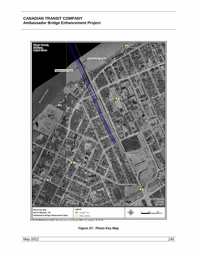
CANADIAN TRANSIT COMPANY Ambassador Bridge Enhancement Project
May 2012
240
Figure 27: Photo Key Map

CANADIAN TRANSIT COMPANY Ambassador Bridge Enhancement Project
May 2012
241
Assumption Park
Assumption Park is situated along the shoreline of the Detroit River to the east of the Ambassador Bridge. Observers at this vantage point would be engaged in active and passive outdoor recreation including the appreciation of the aesthetic environment. This public open space provides an unobstructed view of the existing Ambassador Bridge and Detroit skyline. A simulation of the visual effect of the proposed Project is provided as Figure 28. The towers, cable work and support piers will be visible behind the existing Ambassador Bridge which partially obstructs its visibility.
Figure 28: Simulation of Visual Effect from Assumption Park
The existing aesthetic quality is considered to be “good” as it includes the attractive combination of the natural character of the Detroit River and the historic man-made component of the Ambassador Bridge which is a gateway between Canada and the US. It is anticipated that the visual quality will continue to be “good” after the development of the proposed Project. The impact of the proposed Project is considered to be low and positive as it provides a visually similar structure that is behind the Ambassador Bridge, is sensitive to its historic context, and complements it with a new structure that is state-of-the-art for the 21st century adjacent to the Ambassador Bridge that was state-of-the-art for the early 20th century.
McKee Park
McKee Park is situated along the shoreline of the Detroit River to the west of the Ambassador Bridge. Observers at this vantage point would be engaged in active and passive outdoor recreation including the appreciation of the aesthetic environment. This public open space provides an unobstructed view of the existing Ambassador Bridge and Detroit skyline. A simulation of the visual effect of the proposed Project is provided as Figure 29.

CANADIAN TRANSIT COMPANY Ambassador Bridge Enhancement Project
May 2012
242
Figure 29: Simulation of Visual Effect from McKee Park
The towers, cable work and support piers will be visible in the foreground of the existing Ambassador Bridge. The existing aesthetic quality is considered to be “good” as it includes the attractive combination of the natural character of the Detroit River and the historic man-made component of the Ambassador Bridge which is a gateway between Canada and the U.S. The impact of the proposed Project is considered to be low and negative as it provides a visually similar structure that partially obstructs the visibility of the Ambassador Bridge, is sensitive to its historic context, and complements it with a new structure that is state-of-the-art for the 21st century adjacent to the Ambassador Bridge that was state-of-the-art for the early 20th century.
Assumption Church
The setting of Assumption Church has included visual elements (i.e., tower, anchor pier, decking, and support piers) of the existing Ambassador Bridge for over 80 years. The visibility of both the proposed Project within the same view would be limited to areas to the east, northeast, and southeast of Assumption Church (see Figure 30). The majority of observers at this location will most likely consist of students utilizing the parking lots to the east of the church. Additional observers will also include parishioners or others traveling between the parking areas to worship or other church-related activities or others appreciating the architecture of the historic church.

CANADIAN TRANSIT COMPANY Ambassador Bridge Enhancement Project
May 2012
243
Figure 30: Simulation of Visual Effect from Assumption Church
The proposed Project will be situated on the opposite side of the Ambassador Bridge and relocate traffic onto the new bridge where the motion will be less disruptive to the observer. The new towers will be visible from several locations to the east and north of the church. The visibility of the road deck will largely be obstructed by the existing Ambassador Bridge. The support piers will be fewer and further apart than the existing steel support piers and significantly smaller than the existing anchor pier for the Ambassador Bridge.
The existing visual quality would be considered to be “moderate” due to the mixture of historic and modern built environment, good vegetative buffering, and less exposure to the Detroit River than the riverfront parks. It is anticipated that the visual quality will continue to be “moderate” after the development of the proposed Project. The overall impact of the proposed Project is considered to be low and positive as it provides a visually similar structure that is behind the Ambassador Bridge, is sensitive to its historic context and complements it with a new structure that is state-of-the-art for the 21st century adjacent to the Ambassador Bridge that was state-of-the-art for the early 20th century.
Mackenzie Hall
Mackenzie Hall, within the Olde Sandwich Towne area on the southeast corner of Sandwich and Brock Streets, is approximately 1 km (0.6 miles) from the location of the proposed Project. This area is designated as a heritage district in the City of Windsor Official Plan.
The Olde Sandwich Towne area was part of the Huron Church Reserve purchased in 1797.87 Mackenzie Hall was formerly the County Courthouse and is a site designated under the Ontario 87 City of Windsor Planning Department, Olde Sandwich Towne Community Planning Study Report, October 2006.

CANADIAN TRANSIT COMPANY Ambassador Bridge Enhancement Project
May 2012
244
Heritage Act. The visual quality of the area is “good” with a mixture of historic structures in a relatively pedestrian friendly streetscape. The visibility of the existing Ambassador Bridge and proposed Project is obstructed or screened by local vegetation and structures for the majority of this area. However, they are also clearly visible from some vantage points (see Figure 31). While the visibility of the historic Ambassador Bridge does contribute to the setting of this area to a small degree, the visual quality of the area would continue to be “good” after the development of the proposed Project as the aesthetic value of the area is primarily derived from the closer pedestrian scale historic architecture.
Figure 31: Simulation of Visual Impact on Mackenzie Hall
The impact of the proposed Project is considered to be low and negative as it provides a visually similar structure that partially obstructs the visibility of the Ambassador Bridge, is sensitive to its historic context, and complements it with a new structure that is state-of-the-art for the 21st century adjacent to the Ambassador Bridge that was state-of-the-art for the early 20th century.
Mason-Girardot Manor
The Mason-Girardot Manor was constructed in 1879 and is designated as a heritage property. It is characteristic of the Victorian Era Italianate Style architecture. It is located at 3203 Peter Street on the southwest corner at Mill Street. This historic structure represents a vantage point further south within the Sandwich Planning District. The visibility of the existing Ambassador Bridge is very limited (see Figure 32) from this vantage point. Visibility is substantially obstructed by local vegetation and the built environment.

CANADIAN TRANSIT COMPANY Ambassador Bridge Enhancement Project
May 2012
245
Figure 32: Simulation of Visual Effect from Mason-Girardot Manor
The primary visual feature of good aesthetic quality in the area is the architecture of the Mason-Giradot house. The ability to appreciate this visual quality will not be decreased by the construction of the proposed Project as the majority of viewers will be facing toward the structure which is not in the same direction of the proposed Project. Generally the visual quality of the area is “moderate” and characteristic of an urban environment with a mixture of modern and historic styles. The visual quality from this vantage point will continue to be “moderate” after the completion of the proposed Project.
The significance of the visual impact would be categorized as “low” due to the substantial obstruction of the visibility of the proposed Project by local structures and vegetation.
Huron Church Road
Huron Church Road was considered a key vantage point as part of this assessment of the potential impact of the visibility of the proposed Project. The fact that Huron Church Road is designated as a civic way in the City of Windsor Official Plan, the high number of viewers, and the role of this transportation route and gateway between Canada and the US make it a significant vantage point. Figure 33 indicates the visibility of the proposed Project as seen from the west side of Huron Church Road near College Street. The new tower will continue to be a dominant visual feature adjacent to the existing Ambassador Bridge. The existing visual quality is considered to be “moderate” as it contains several attractive features including adjacent green space and the Ambassador Bridge in the background. However, there are several visually

CANADIAN TRANSIT COMPANY Ambassador Bridge Enhancement Project
May 2012
246
unattractive attributes of Huron Church Road associated with its vital role as the busiest border crossing between Canada and the U.S.
Figure 33: Simulation of Visual Effect from Huron Church Road
The visual quality will continue to be “moderate” after the development of the proposed Project. The impact of the proposed Project is considered to be “low” and “positive” as it provides a visually similar structure that is behind the Ambassador Bridge, is sensitive to its historic context, and complements it with a new structure that is state-of-the-art for the 21st century adjacent to the Ambassador Bridge that was state-of-the-art for the early 20th century.
7.7 Archaeological
This archaeological report as set out in Appendix M describes the nature and results of a Stage 1 archaeological background study, Stage 2 archaeological assessment, and Stage 3 archaeological investigation completed by the Museum for the proposed Project, City of Windsor, Essex County, Ontario.
All archaeological projects undertaken in Ontario must conform to the guidelines and procedures for archaeological assessments as mandated by the Ontario Ministry of Culture (1993, 2004). The Ministry’s 1993 Archaeological Assessment Technical Guidelines defines the four different stages of archaeological assessment as follows:

CANADIAN TRANSIT COMPANY Ambassador Bridge Enhancement Project
May 2012
247
Stage 1: Refers to the background or pre-survey phase of an assessment.
Stage 2: Refers to the actual field examination, and involves either surface survey or test pitting.
Stage 3: Refers to those field activities conducted when archaeological remains are encountered during a Stage 2 survey. The purpose of Stage 3 work is to gather information which will be used to delineate and evaluate the significance of the site in question, in order to determine appropriate mitigation measures.
Stage 4: Refers to mitigating the development impacts to archaeological sites, through site excavation or avoidance. This occurs once the field assessment has been completed, and the assessment report has been reviewed by the Ministry of Culture.
Purpose of the Project
The Stage 1 archaeological background study (Part 1 of the present report),Stage 2 archaeological assessment (Part 2 of the present report), and Stage 3 archaeological investigation (Part 3 of the present report) were undertaken at the request of and on behalf of the client, as part of studies being undertaken as part of the Canadian Environmental Assessment Act for the proposed Project in the City of Windsor, Ontario. That project anticipates construction of a new 6-lane wide cable stayed bridge to replace the existing Ambassador Bridge, to be built within the corridor of the existing bridge. The new bridge would be constructed approximately 30.5 metres (100 feet) to the west of the existing bridge (from centre line to centre line). The proposed Project would connect directly to the existing plaza on the Ontario side, just south of Wyandotte Street. According to preliminary design specifications, on the Ontario side of the Detroit River the new bridge would entail construction of one new pier support (Pier 6) on the parcel of land between the river and Riverside Drive, three piers (#7-9) in the space between University Avenue and Peter Street, five piers (#10-14) in the space between Peter Street and Donnelly Street, two piers (#15-16) in the space between Donnelly Street and Wyandotte Street, and three piers (17-19) south of Wyandotte Street (in the existing bridge corridor) connecting to the existing plaza. Plaza improvements are also proposed as part of the project that were taken into account in these studies. The areas for the proposed plaza expansion are either disturbed areas that have been cleared and currently consist of grass and opportunistic herbaceous plants or are already paved.
Nature and Location of the Subject Property
The Study Area includes the lands located along the west side of Huron Church Road from the existing western limit of the road allowance west to Indian Road, from Wyandotte Street north to the Detroit River. The Project anticipates the demolition of all existing houses along the east side of Indian Road from Wyandotte Street to University Avenue to create a green buffer area. All of those houses are currently owned by the CTC.
The 1939 Soils Map of Essex County shows an obvious un-natural break in soil types occurring exactly at Huron Church Road and the existing Ambassador Bridge: soils on the lands immediately east/north of Huron Church Road are classified as Brookston Clay, while soils on

CANADIAN TRANSIT COMPANY Ambassador Bridge Enhancement Project
May 2012
248
the lands immediately west/south of Huron Church Road (within the Study Area) are classified as Burford Loam. A small pocket of a third soil type, Berrien Sand, is situated just beyond the south end of the Study Area (south of Mill Street). The report within which the 1939 Soils Map was contained (Richards, Caldwell and Morwick 1949) depicted a typical soil profile of the Burford Loam series in Essex County which indicates an Ac horizon up to 6 inches (15 cm) thick overlying an A2 horizon from 12 to 18 inches (30.5 to 47.7 cm) thick overlying a B horizon up to 18 inches (47.7 cm thick); thus the combined A and B horizons can be up to 42 inches (106 cm) thick.
The terrain in the Study Area is relatively flat, varying in elevation from just under 590 feet above sea level at the Detroit River to just over 600 feet above sea level at the point where Mill Street intersects Huron Church Road, just south of the Study Area (based on 1960 1:25000 topographic map).
According to recent topographic maps, today there are no secondary or tertiary watercourses within or near the Study Area. However, some 18th century maps and sketches of the Windsor area (discussed in the Stage 1 background study, below) do in fact depict certain watercourses, one of which was identified as “Rivi_re de la Vieille Reine” on a 1749 sketch map by Joseph-Gaspard, Chaussegros de Léry, and later as “Rivi_re _ Gervais” on “Plan Topographique du Detroit” circa 1754 by de Léry (Lajeunesee 1960:liv and lviii). The 1749 sketch by de Léry identifies another watercourse as “Ruisseau de la Parise” (Paris Creek?); it was located midway between the Huron village at La Pointe de Montreal and Rivi_re de la Vieille Reine (to be discussed in the Archival Research section, below). Since these two watercourses do not appear on modern topographic maps, they must have been either filled in or buried (channelized) by urban development in the 19th and 20th centuries, or they could simply have dried up to a lower groundwater table. The Soil Map of Essex County (1939) shows a “Marsh” area located along the Detroit River, between Prospect Avenue (at the south) and the western terminus of Hill Avenue (at the north), with a protrusion of the marsh extending inland through the lands of the current West Windsor Pollution Control Plant (i.e. just south of John B Avenue and the southern terminus of Peter Street) to the ETR rail line. This marsh area (with Muck soils) was the former mouth of the “Rivi_re de la Vieille Reine” / “Rivi_re _ Gervais”. Lajeunesse (1960:liii) concluded that the mouth of this river was “near the southern limit of the present city of Windsor” (which on the 1939 soils map and 1960 topographic map was just south of the area occupied by the Water Pollution Control Plant, at McKee Street and the Ontario Hydro generating station. The “Rivi_re _ Gervais”, also known as “Rivi_re au Jarvais” and Knaggs Creek, and extensive marshlands around it, were mentioned in some of the archival documents summarized by Lajeunesse (1960:171, 179, 187), and it was depicted on a sketch map contained as part of the “Sale of the Huron Church Reserve” lands in 1800 (Lajeunesse 1960:206). The 1960 topographic map (1:25,000 scale) depicts the area of the marsh as lands below the 580 foot contour line (whereas all lands surrounding it are above the 590 foot contour line). The centre of the marsh/mouth of the watercourse is approximately one mile (1.6 km) south of the current Ambassador Bridge. According to the 18th century maps, the course of the “Rivi_re _ Gervais” was U-shaped, with the left arm of the U being the mouth; from its mouth, the watercourse went south then curved to the east and then north (the bottom of the U) to go in a northerly direction towards the Detroit River, then at the top of the right arm of the U it veered east. It appears that the “upper” course of the “Rivi_re _ Gervais” may have been in close proximity to the Study Area. The existence of former watercourses such as this can create

CANADIAN TRANSIT COMPANY Ambassador Bridge Enhancement Project
May 2012
249
zones of archaeological potential around them. However, there are no known archaeological sites located adjacent to where those watercourses were once located.
According to the provincial database and the City of Windsor Archaeological Master Plan, there are no registered archaeological sites within the local study area though it is identified as an area of high archaeological potential. The study area is in close proximity (within 250 metres) to known archaeological sites. The Stage 2 archaeological assessment resulted in the discovery of seven archaeological sites registered as AbHs 28 to 34. Four of those sites have the potential to be impacted by the proposed project and warranted further study. Based on the Stage 3 archaeological assessment, three of the four archaeological sites are not significant and do not warrant any further investigation. The fourth site, AbHs-34 is a significant heritage resource which will require avoidance or Stage 4 mitigation. Site AbHs-34 is bordered by the Ambassador Bridge to the east, on the south by Riverside Drive, on the west by a structure located at 2856 Riverside Drive (formerly Villa Maria nursing home), and on the north by the berm/slope along the south edge of the Detroit River. More detail on the Stage 1, Stage 2 and Stage 3 archaeological studies are described later in this document and in Appendix M.
If archaeological site AbHs-34 cannot be avoided, Stage 4 mitigation will be employed at the site prior to construction and through consultation with the Ministry of Culture, First Nations, and other heritage stakeholders. . Stage 4 mitigation will be developed during final design but will likely involve documenting and removing the archaeological site through excavation. Documentation could include measurements, maps, drawings, and photographs. During the construction of the Project, a licensed archaeologist will be onsite to observe activities and ensure that no previously unknown archaeological resources will be adversely affected. Should deeply buried archaeological deposits be found during construction activities, the Programs and Services Branch of the Cultural Programs Unit of the Ontario Ministry of Culture will be notified immediately. In the event that human skeletal remains are encountered during construction the proponent will immediately contact the Ontario Ministry of Culture, the Registrar or Deputy Registrar of the Cemetaries Regulation Unit of the Ministry of Consumer and Business Services, and the geographically nearest First Nation.
With the implementation of the proposed mitigation, no significant adverse residual effects are anticipated.
7.8 Navigation
The Great Lakes and the Detroit River are part of a vast system linking North America with ports and markets throughout the world. The system is the world’s longest deep-draft waterway extending from Duluth, Minnesota to the Gulf of St. Lawrence on the Atlantic Ocean, a distance of more than 3750 kilometres (2340 miles). The system was made possible by the construction of a ship canal and lock system that opened in 1855 at Sault Ste. Marie, Michigan, the development of the Welland Canal in 1829 and the completion of the St. Lawrence Seaway in 1959 (Maritime in the Great Lakes Region). On average, the U.S. and Canadian flag fleets along with overseas vessels move more than 154 million metric tons (170 million short tons) of
CANADIAN TRANSIT COMPANY Ambassador Bridge Enhancement Project
May 2012
250
cargo on the Great Lakes and approximately 40 percent of this cargo travels through the Lake St. Clair-Detroit River system. 88
The Detroit River connects Lake St. Clair to Lake Erie, flowing south-southwest for approximately 51.5 kilometres (32 miles). At the Ambassador Bridge crossing, the river is approximately 0.64 kilometres (0.4 miles) wide. A number of tributaries drain to the Detroit River. Those tributaries within the project area in Canada include Turkey Creek, Marentette Drain, the Little River and Canard River.
7.8.1 Study Area and Timeframes
The study area for the project is bound by the area of the river from the port of entry of the barges to the Ambassador Bridge crossing. Construction materials originating in Canada that will be transported to the proposed Project site will be shipped via barge from a port in the Detroit River operated by the Windsor Port Authority. Construction materials originating in the US that will be transported to the proposed Project site will be shipped via barge from a port in the Detroit River operated by the Detroit/Wayne County Port Authority.
Construction is estimated to take approximately 24 months. The timeframe for construction effects would be limited to the actual construction time of the bridge. The bridge design will employ a clear span cable stay bridge structure, and does not require the placement of piers or other structures in the Detroit River. The absence of piers and other structures means that there is minimal impact on navigation. Once the bridge construction is complete, no adverse operational effects are expected, to interfere or interrupt navigation.
Improvements to the Windsor Plaza will have no affect on any navigable waterways and are not discussed further.
7.8.2 Administrative Considerations
Competency of Operators of Pleasure Craft Regulations (SOR/99-53) is a regulation to the Canada Shipping Act, which requires the operators of pleasure craft in Canada to hold a valid Operators Card or the equivalent thereof. Specifically, Section 4 of SOR/99-53 states that a person is competent if the person has passed a Canadian Coast Guard accredited test with a mark of at least 75 per cent or has completed a boating safety course before April 1, 1999, and has received a Boating Safety Course Completion Card or other written proof of completing the course. The pleasure craft operator requirements serve to ensure that the majority of vessel traffic is aware of the navigational requirements and rights-of-way rules detailed in the Collision Regulations (CRC, VOl. XV, c. 1416). The safety of recreational boaters will be taken into account by ensuring that barge activities will take place in a manner that minimizes impacts to recreational boaters in the area through the use of licensed and qualified barge operators.
In accordance with provisions of the Canada Shipping Act as replaced by the Canada Shipping Act, 2001, (“Shipping Act”) Transport Canada has published regulations entitled Collision
89 U.S. Army Engineer District, Environment Canada and The St. Clair Region Conservation Authority, "St. Clair River and Lake St. Clair Comprehensive Management Plan," Chapter 7, June 2004.

CANADIAN TRANSIT COMPANY Ambassador Bridge Enhancement Project
May 2012
251
Regulations (CRC, VOl. XV, c. 1416) (COLREGS) and The St. Clair and Detroit River Navigation Safety Regulations (SOR/84-335). The Shipping Act is the principal piece of legislation dealing with commercial and recreational vessel use in Canadian waters. The COLREGS Schedule I addresses the conduct of vessels. Rule 18 (a), (b), and (c) requires that all other vessels avoid a vessel that is restricted in her ability to manoeuvre. All other vessels are required to keep clear of commercial shipping traffic. SOR/84-335 applies to operation of ships in the Detroit River including floating plants such as a manned barge or scow. The regulation specifies travel directions for certain channels such as restricting the West Outer channel to down bound ships. Among other things, the regulation also specifies anchorage rules. No ship is permitted to anchor in such a manner that it may swing into the channel or across steering courses. Also, no floating plant may anchor or be moored unless the operator obtains permission from the Regional Director General of the Canadian Coast Guard, the District Commander of the Ninth U.S. Coast Guard, the Captain of the Port or the Harbour Master having jurisdiction in waters in which the floating plant will operate.89
The Shipping Act, 2001, S.C. 2001, c.26 is the legislation that governs vessels in Canadian waters, barges included. The avoidance of collisions is specifically regulated by the Collision Regulation CRC, Vol. XV, c.146 (COLREGS). The operation of the barge will be required to adhere to all aspects of the regulation governing all types of vessels underway and at anchor as set out in Rules 1 through 46. Rule 9 “Navigation in Narrow Channels” sub-section (j), applies specifically to this situation and states “In the Canadian waters of a narrow channel or fairway a barge or an inconspicuous, partly submerged vessel or object shall not be navigated, moored or anchored so as to impede the safe passage of any other vessel or object using those waters”. Regulation SOR/84-335, St. Clair and Detroit River Navigation Safety Regulations will apply, particularly Rules 16 and 17 “Anchorage Rules” and Rule 19 “Towing Ships”. The barge operator will be required to meet all requirements of the Marine Certification Regulation (SOR/2007-115). The Ambassador Bridge will ensure that the barge operator is licensed and meets all regulatory requirements. The requirements of SOR/95-53 also ensure that recreational vessels are aware of their responsibilities with respect to safe navigation in the Detroit River during construction.
Notice, under the Navigable Waters Protection Act, will be given to the Chief Officer of Customs at nearby ports including the Windsor Port Authority. The Vessel Traffic Services operated by the U.S. Coast Guard, under The Ports and Waterways Safety Act and the Oil Pollution Act and in Canada under the Shipping Act, will be employed as well. A Notice to Mariners will be issued detailing the exact position of the barge and its hours of operation. The Notice to Mariners will be broadcast daily in a continuous cycle on VHF frequencies 161.65 MHz and 161.775 MHz (ch.21B, ch.83B). These services relay traffic information to other mariners using and travelling in the waterway and will be a useful tool in alerting other ship travelers to the presence of barges in the waterway. Measures to minimize navigational obstructions will be followed in accordance with the Department of Fisheries and Oceans Canada and Transport Canada. These include, but are not limited to, ensuring that a sufficient signal or light be maintained to indicate the position of the obstacle (barge). The licensed barge operators will be required to ensure that all of these measures to minimize navigational obstructions are followed. All 89 St. Clair and Detroit River Navigation Safety Rules,Canada Shipping Act, SOR/84-335, Aug. 2007,
http://www.tc.gc.ca/acts-regulations/>.
CANADIAN TRANSIT COMPANY Ambassador Bridge Enhancement Project
May 2012
252
notifications and provisions required by the St. Clair and Detroit River Navigational Safety Regulations will be fulfilled.
Navigation
The Detroit River is a major transportation artery as well as a place for recreational boaters. The exact recreational vessel counts are not recorded and only estimates can be made about the number of recreational vessels using the Detroit River in a given period of time. With a boating season extending from February to November, it is considered one of the premier boating areas in North America, with more than 12,000 marina slips for recreational boaters and an economic impact estimated at more than one billion dollars annually. The peak season for recreational boating begins around May and runs through the summer months. The Detroit River also provides year round fishing, with April and May a peak period due to the spawning season for walleye. There is an extensive boating season, the navigation of these boats will not be impeded either in the construction or operational phases of the proposed Project.
The Detroit River also provides a critical passageway for commercial ships moving between the upper and lower Great Lakes, with thousands of commercial vessels traversing its waters annually. Based on information provided by the Windsor Port Authority, there were 10,123 transits with approximately 2,800 being tugs in year 2005 and 9,943 transits with approximately 2,600 being tugs in year 2006. Most of these transits would be classified as commercial and/or government vessels. Also, there were less than 100 yachts recorded during this two year period between 2005 and 2006. The main shipping season begins in early March and ends in late January. Some commercial navigation continues throughout the winter months with the assistance of Canadian or U.S. Coast Guard icebreakers or during periods of little or no ice. 90
A variety of boats use the Detroit River including lake freighters, tugboats, sailboats, riverboats and pleasure craft. The largest of the lake freighters are approximately 305 metres (1,000 feet) in length with a width of 32 metres (105 feet). More common are boats in the 183 metre (600 feet) and 213 metre (700 feet) classes, due to the limitation of the nearby Welland Canal. Information on commercial navigation channels in the Detroit River and navigational dredging were discussed previously in Section 8.2.3.3-Sediment Quality. The main channel in the upper reaches of the Detroit River is the Fleming Channel. The channel lies to the south of Belle Isle and continues downriver past the Ambassador Bridge.
7.8.3 Valued Ecosystem Components
This section describes components of the proposed Project that could have an adverse effect to the ecosystem of the Detroit River insofar as they relate to navigation. Much of the ecosystem that existed within the Detroit River decades ago has been destroyed over the years due to rapid development and industrialization along the river. The entire corridor has been dredged extensively to create and maintain shipping channels. The environmental characteristics of the aquatic environment of the Detroit River in the vicinity of the proposed Project are discussed in detail in Section 8.2.3. The proposed barge activity during construction has the potential for
90 Ibid

CANADIAN TRANSIT COMPANY Ambassador Bridge Enhancement Project
May 2012
253
adverse effects to the existing ecosystem. Water pollution from the barge operating in the river poses the greatest risk for the ecosystem, as well as the potential for navigation interference.
Navigation
Screening for Potential Project – Environment Interactions
Potential project-environment interactions that may be encountered during project construction include potential navigation restrictions and/or the disruption of vessel flows resulting from the necessary use of barges during the project construction period. These include the interactions between the barge while moving and anchored with:
• Lake freighters;
• Tugboats;
• Sailboats;
• Riverboats; and
• Pleasure craft.
All necessary measures to avoid/minimize these impacts will be taken in accordance with the Navigable Waters Protection Act, the Shipping Act, COLREGS, and SOR/84-335.
Evaluation for Likely Environmental Change
During Construction and Development
During construction of the proposed Project, the potential for project related effects on the natural environment within the Detroit River are low. Barges will be utilized to bring equipment and construction materials such as steel and concrete to the project site. The extent of barge activity at the project site will be limited to the unloading of supplies, and no construction will occur from the barge. When barges are unloading construction materials, coordination with other vessels will be conducted in accordance with the statutory requirements to ensure that navigation with the river will not be impeded.
Assessment of Likely Environmental Effects
The proposed Project does not have any negative impacts since there are no in-water construction activities such as pile driving of cofferdams, dredging, or in-water blasting that would resuspend sediment. The proposed Project provides a minimum clearance of 46 metres (152 feet) above the ordinary high water level of the Detroit River, which is 175.4 metres (575.4 feet) (IGLD, 1985).91 The height is the same as the clearance provided by the existing Ambassador Bridge and will ensure that commercial navigation is not impeded.
91 US Army Corps of Engineers, Detroit District, Ordinary High Water Mark and Low Water Datum, 21 June 2006
<http://www.lre.usace.army.mil/_kd/go.cfm?destination=Page&pge_ID=1879&dialogue=0>.

CANADIAN TRANSIT COMPANY Ambassador Bridge Enhancement Project
May 2012
254
Summary of Residual Adverse Effects of VEC’s
Potential VEC’s include water quality, fish habitat and navigation. Based on the cable-stayed bridge structure and construction outward from the land, it is anticipated that the residual adverse effects to these VEC’s will be negligible.
No significant adverse residual effects are anticipated.

904699.v5
CANADIAN TRANSIT COMPANY Ambassador Bridge Enhancement Project
May 2012
255
Environmental Effects Assessment Matrix for Navigation (Construction) Environmental Effects Assessmenet Matrix Value Ecosystem Component: NAVIGATION Phase: Construction
Project Activity
Valued Ecosystem Component
Potential Environmental Effects
Mitigation
Mag
nitu
de
Geo
grap
hic
Exte
nt
Dur
atio
n
Rev
ersi
bilit
y
Ecol
ogic
al/S
ocio
-C
ultu
ral a
nd
Econ
omic
Con
text
Transport of Construction
Materials via
Barge in the
Detroit River
Fish Habitat / Water Quality
Adverse change in habitat quality Habitat fragmentation
No in water construction 1
1
3
R
3
Transport of Construction Materials via Barge in the Detroit River
Navigation Interruption or interference of navigation of other vessels
Coordination with other vessels to ensure navigation not impeded
1
1
3
R
3
Key:
Magnitude: 1 = Low; e.g. localized, specific group, one generation or less 2 = Medium; e.g. portion of population, 1-2 generations, unpredictable 3 = High; e.g. entire population
Geographic Extent: 1 = <1km2
2 = 1-10 km2 3 = 11-100 km2 4 = 101 – 1,000 km2 5 = 1,001 – 10,000 km2 6 = >10,000 km2
Duration: 1= <30 days 2 = 1-12 months 3 = 13-36 months 4 = 37-72 months 5 = >72 months
Reversibility: R = Reversible I = Irreversible
Ecological/Socio-cultural and Economic Context (Existing Conditions): 1 = natural and undisturbed 2 = some evidence of human effect on natural environment 3 = high level of human interaction with little natural environment

CANADIAN TRANSIT COMPANY Ambassador Bridge Enhancement Project
May 2012
256
7.9 Mitigation Compliance Monitoring and Follow-up Programs
7.9.1 Air Quality
Based upon Ontario ambient air monitoring results, exceedences of the PM10 ambient air quality criterion frequently occur throughout the province, including Windsor. Construction of the project incorporating a construction best management plan (BMP) has the potential to mitigate impacts during the construction phase of the project. The effectiveness of these measures, and the determination of whether the need to incorporate additional measures shall be determined through a monitoring and an adaptive management plan.
A proposed monitoring plan covering pre-construction, construction and operation project phases is provided in Attachment 16 of the Air Quality Assessment in Appendix D. The plan describes the methods and equipment which could be used to provide real-time air monitoring data to the project proponent.
Information obtained from the monitoring program would be used as input into an adaptive management plan whereby actions would be initiated to identify and control sources of emissions contributing to exceedences of the ambient air quality criterion. Examples of adaptive management may include:
• reducing the extent of active work areas to reduce fugitive dust emissions;
• scheduling of material deliveries and handling activities to avoid meteorological events attributed to high ambient levels;
• identify the need for additional operator training and awareness of mitigation measures to be used, and
• increased understanding of traffic flow patterns and local air quality.
7.9.2 Peregrine Falcons
Peregrine Falcons (Falco peregrinus anatum) have nested and bred on the Ambassador Bridge since 2008. The Falcons have consistently used the bridge as their territory and have bred on-site. In consideration of the status of the Peregrine Falcon as a species at risk, a follow-up program to monitor potential effects to the peregrine falcon as a result of the proposed project and to determine the effectiveness of the proposed mitigation is proposed. There is no need for a monitoring phase if construction occurs outside of the nesting season for the peregrine falcon. The entire Peregrine Falcon Management Plan can be found in Appendix P. Below is a synopsis of this plan.
Specific management zones were designed for the construction of the Project. Management zones are defined as spatial boundaries around a particular nest site where the majority of hunting, perching, and feeding activities occur during nesting. For this plan, two zones have been established, reflecting relative levels of peregrine activity, and include the Restricted Zone, and Sensitive Zone. Management zones have been determined from past monitoring efforts, the design of the bridge, and line of sight from the nest site to the activity. The final design plans for

CANADIAN TRANSIT COMPANY Ambassador Bridge Enhancement Project
May 2012
257
the Project will demarcate a non-staging zone near the nest as well as the Restricted and Sensitive Zones.
The Restricted Zone includes the nest site and extends 200 m from the nest. The objective of the restricted zone is to minimize activities and limit excessive noise disturbances (10 dBA greater than ambient). No construction staging activities will occur within the Restricted Zone. If avoidance is not possible, minimize the duration of time spent on work activities that must be conducted during the nesting season by evaluating cost effective work shift alternatives. Activities that cause excessive noise disturbances (10 dBA greater than ambient), such as pile driving, will be limited in the Restricted Zone during the nesting season (approximately March 15 to July 31). Should the fledglings leave the nest prior to July 31, limitations will be lifted.
The Sensitive Zone is the area adjacent to the Restricted Zone and extends approximately 400 m away from the nest. Human activities in this zone have less potential to cause noise disturbance because of the distance to the nest site. Activities will be minimized within the Sensitive Zone during the nesting season. For example, staging areas will be located outside of the Sensitive Zone wherever possible. Work associated with the plaza and roadway improvements are outside of the Sensitive Zone. The number of separate activities within a short time period (i.e one week) within the Sensitive or Restricted Zone will be minimized during the nesting season.
CTC will provide an experienced monitoring team for the peregrine falcon nest and other nesting birds to determine if construction of other elements of the project are affecting the nest and to determine when the birds flee the nest. Behavioural studies will be conducted to monitor activity and behaviour in or directly adjacent to the construction site during the breeding season. If vegetation removals are required between May 1 and July 31, a nest survey will be conducted by a qualified avian biologist immediately prior to commencement of construction to identify and locate active nests of migratory birds and to develop a mitigation plan, if necessary. Once the birds leave the nest, further monitoring will not be required.
In addition to the restrictions mentioned above, the following falcon best management practices/mitigation measures will be implemented during construction, as required.
1. When feasible, avoid activities within the Restricted and Sensitive Zones of the nest area that may adversely disturb the falcons.
2. If an activity has the potential to adversely impact nesting falcons and cannot be avoided during the nesting season, CTC will contact EC prior to conducting work (or as soon as possible for emergency work). CTC will coordinate with EC, MNR and/or experts to evaluate potential impacts and provide additional management recommendations for implementation.
3. CTC will inform appropriate operations, maintenance and construction personnel of the location of the nest and buffer zones prior to commencement of any work during the nesting season.
4. If avoidance during the nesting season is not possible, CTC will coordinate with EC to minimize disturbance, capture, etc., determine if a SARA Permit is warranted, and

CANADIAN TRANSIT COMPANY Ambassador Bridge Enhancement Project
May 2012
258
possibly implement with the assistance of EC and/or MNR one or more nest management alternatives described above.
5. If avoidance is not possible, minimize the duration of time spent on work activities that must be conducted in the vicinity of the nest site during the nesting season.
7. If CTC receives information that the historic nest site is not occupied by breeding peregrines, and no new nest site is occupied on the structure, then maintenance and construction activities will be considered to have no effect and may proceed with no restrictions that year.
8. If CTC receives information that an active nest site fails and is abandoned then maintenance and construction activities from that point forward will be considered to have no effect and may proceed with no restrictions for the remainder of the year (until a new nest is established).
9. No disturbance in the vicinity of the known nest site will occur regardless of the time of year, without prior coordination with EC and/or MNR, except during an emergency.
10. CTC will not permit third-party activities during the nesting season on the bridge without assessment for potential impacts and addition of specific avoidance measures in the permit if applicable.
The following types of maintenance or construction activities1 are expected to have no effect on nesting peregrine falcons and may be conducted on the structure at any time of the year without any restrictions. Effects of other activities need to be evaluated on a case-by-case basis.
• Inspections at or near ground level (except with helicopter).
• Minor culvert maintenance.
• Minor structural or road surface repairs (on the roadway or shoulder or bridge deck, without snooper cranes).
• Lawn management (no tree cutting).
• Sign replacement, repairs, and cleaning.
• Snow and ice removal and sanding.
• Special events, pedestrian (e.g., bridge pedal, foot races, walkathons, etc.).
• Sweeping of pavement
• Work outside of the nesting season that does not alter a known nest ledge
• (other than enhancements).

CANADIAN TRANSIT COMPANY Ambassador Bridge Enhancement Project
May 2012
259
1Only pertains to maintenance activities that occur on the level of the roadway or bridge traffic deck (not over the sides, underneath, or above the level of the rails of the deck). It also includes only minor repairs to the roadway, road shoulder, sidewalk, bridge traffic deck, or rails that do not involve equipment that is louder than ambient noise levels by 10 dBA (i.e., impact pile drivers, jackhammers, pneumatic wrenches, etc.) or do not involve large construction vehicles (i.e., tractors, backhoes, graders, scrapers, pavers, concrete mixers, etc.). Any work that includes use of a helicopter, lift crane, or snooper crane is not included.
7.10 Public Consultation
Consultation
Consultation is the process where interested parties are provided an opportunity to contribute to the scoping of the project and the environmental assessment as outlined in section 16(1) (c) of the Canadian Environmental Assessment Act. Public consultation also allows for interested parties to contribute local knowledge or expert advice that is useful when conducting the environmental assessment. This public consultation process includes consultation with members of the public, stakeholders, Aboriginals persons and experts.
Consultation with the Public and Stakeholders
The CTC, as part of the environmental assessment process, committed to an extensive public consultation plan. The objective of the public consultation plan was to identify all those groups necessary to ensure a public consultation that includes everyone having an interest in the proposed Project. The goal of the public consultation plan was to heighten public awareness of the proposed Project, gather input from interested parties, while providing the Ambassador Bridge the opportunity to respond to, and resolve the issues raised, in a timely manner in an effort to avoid unnecessary delays in the process while at the same time ensuring all interested parties have an opportunity to comment on the proposed Project. A copy of this Public Consultation Plan is attached in Appendix O.
Consultation with the public regarding the proposed Project has been ongoing for several years. Representatives of the proposed Project have reached out to the community since 2005 to discuss and review the proposed Project. The comments made from the public during these meetings have been considered and taken into account in conducting the studies and assessment of the environmental effects of the proposed Project.
The Ambassador Bridge held a series of public information sessions and open houses to discuss and review the proposed Project. At the public information sessions, attendees were greeted, encouraged to ask questions and to provide any comments or ask any questions on the addressed and stamped comment cards provided. Four public information sessions were held from April 16 – 19, 2007. A series of four locations were chosen throughout Windsor and the County to ensure that all members of the public interested in the proposed Project had an opportunity to attend the public information session at a convenient location. The four locations included Essex District High School, St. Francis Elementary School in Sandwich Town, the Royal Canadian Legion on Huron Church Road, and the Caboto Club in the City of Windsor.
At the public information sessions, a presentation was provided and representatives from the proposed Project consulting team and the Ambassador Bridge were available to respond to any
CANADIAN TRANSIT COMPANY Ambassador Bridge Enhancement Project
May 2012
260
issues raised by the public concerning the proposed Project. Appendix O presents a comprehensive list of the questions raised at the public information sessions and the responses provided. Public concerns raised at the public information sessions were considered by the proposed Project study team during the refinement of the recommended plan. Announcements of the sessions were made on radio and published in the local newspapers including the Windsor Star. There were also several advertisements placed in the Windsor Star over the course of the proposed Project to update the public on the progress of the technical studies and to provide information relating to the proposed Project.
The Open House meetings were held over two consecutive evenings; at the University of Windsor LaBel Building on June 25 and 26, 2007. The meetings were held to discuss the preliminary results of the technical studies. The preliminary results presented included; air quality, noise and vibration, archaeological, vegetation, wildlife, fish and fish habitat, surface water, groundwater and socioeconomic.
All members of the public who provided their contact information to a study team representative or during the public information sessions were sent a letter or an email advising of the date, time and location of the Open House. Announcements of the Open House sessions were made on the local radio station and published in the Saturday edition of the Windsor Star. During the Open House sessions, attendees were greeted and provided with an overview of the presentation, invited to view the displays of the proposed Project and speak with representatives from the Ambassador Bridge study team.
Comment cards were available and provided and those attending the public information and open house sessions and individuals were encouraged to provide any questions and/or comments on the stamped cards provided. All questions and comments received during the information sessions and public open houses were responded to by the Ambassador Bridge. Copies of these responses are included in Appendix O.
During the scoping process and for the purposes of conducting the environmental assessment, numerous stakeholders were contacted and provided with the opportunity to express issues regarding the Project and offering information to assist in the preparation of the technical studies.
Several meetings and information sessions were held with the various municipalities, local chambers of commerce, unions, business improvement areas, community groups and any other interested groups who agreed to meet with the study team representatives. Representatives from the proposed Project contacted over sixty organizations offering to meet. Meetings were held with over twenty-nine different organizations, consisting of all the organizations who agreed to meet. Throughout the entire consultation process, any concerns raised were considered and taken into account by the Study Team.
Upon completion of the reports prepared in support of the Environmental Impact Statement two open house meetings were held at McKenzie Hall and Ciociaro Club on October 1, 2007 and October 2, 2007 to discuss the final results of the various technical studies and address any remaining concerns expressed by the public. Any concerns raised at the open house meetings were considered and taken into account by the study team and the necessary revisions made to the environmental impact statement.
CANADIAN TRANSIT COMPANY Ambassador Bridge Enhancement Project
May 2012
261
The Study Team made several attempts to meet with, and discuss, the Proposed Project with the City of Windsor and its representatives. Unfortunately, the City of Windsor indicated that all communications relating to this Project were required to go through the Chief Administrative Office. After numerous attempts to arrange a meeting with City representatives and elected officials, the representatives for the proposed Project were only permitted one ten minute presentation to the Mayor and Members of Council. Other than the presentation the City of Windsor continued to deny all requests and offers to meet to discuss the Project. It is only after the October public meetings were held that the City of Windsor expressed any interest in meeting to discuss the proposed Project. A meeting was held with the City of Windsor, its representatives and technical consultants on November 15, 2007. At this meeting the Study Team presented its technical findings and draft reports and were willing to engage in meaningful discussion. However, as soon as the presentation was completed, the City of Windsor refused to maintain confidentiality over the draft technical reports and would not engage in any discussion.
The local Members of Parliament (Brian Masse, Jeff Watson, and Joe Comartin) and the local Members of Provincial Parliament (Bruce Crozier, the Honourable Sandra Pupatello, and the Honourable Dwight Duncan) were also contacted individually and provided an opportunity to meet and discuss the proposed Project. Two letters, on March 23, 2007 and May 24, 2007, were sent to these individuals requesting a meeting to provide an update and information on the environmental assessment and the proposed Project. Further to the letters, meetings were held with Brian Masse and Joe Comartin, Jeff Watson, Bruce Crozier and the Honourable Sandra Pupatello. The Honourable Dwight Duncan was not available to meet.
All issues raised during public consultation were reviewed and evaluated for their relevance to the environmental assessment for the scope of the proposed Project. This information was considered and taken into account during the preparation of the various technical studies and reports in determining the environmental effects of the proposed Project and the appropriate mitigation measures.
Consultation with First Nations
Consultation with First Nations is important in assessing any potential environmental effects of the Project on the current use of land and resources for traditional purposes by Aboriginal persons. There are four First Nations that have an interest in the Windsor area. These communities are: Aamjiwnaang, Caldwell, Wyandotte (also known as 'Wyandot'), and Walpole Island First Nations. All of these communities were provided an opportunity to participate in the consultation process. Representatives from the CanAm Indian Friendship Centre of Windsor was also contacted and provided with an opportunity to participate in the consultation process.
Letters were both couriered and faxed to the Chief of each of the First Nation to request a meeting to discuss the proposed Project. Information relating to any traditional knowledge of the area to assist in identifying potential environmental effects and any relevant biophysical and historical information otherwise unavailable was also requested. Copies of these letters are attached as Appendix O.
There has also been a Walpole Island consultation initiative. This activity consisted of a presentation to the Walpole Island Heritage Committee, a presentation and meeting with Chief and Council and a public open house meeting held on June 28, 2007 at Walpole Island United

CANADIAN TRANSIT COMPANY Ambassador Bridge Enhancement Project
May 2012
262
Church. Information relating to the Project and the results of any environmental studies were presented at the open house. Feedback sought and obtained during the consultation process is incorporated into the environmental impact statement.