camden goods yard - one housing · interchange square and the market edge ... place that adds to...
TRANSCRIPT

DRAFTCAMDEN GOODS YARDPlanning FrameworkMarch 2017
MORRISONS, GILBEY’S YARD, JUNIPER CRESCENT AND NETWORK RAIL LAND

REG
ENER
ATIO
NA
ND
PLA
CE
CONTENTS
1 Introduction to the framework 4 Purpose of the planning framework Status of the planning framework Local engagement and consultation
2. Site context 6 Location Existing site and potential development proposals History, culture and character Designations Site analysis- issues and constraints
3. The vision and strategy 17 The vision The strategy
4. Place based guidance 36 Chalk Farm Road Morrisons Interchange Square and the Market edge Gilbey’s Yard Juniper Crescent Railway edge Network Rail site and Primrose Hill Station

3
FOREWORD
Camden Goods Yard is a once in a generation opportunity to create a new mixed-use neighbourhood at the heart of the borough. This substantial area of almost 9 hectares in an advantageous location, partially within the major London Town Centre of Camden Town has the scope for redevelopment and intensification. It has the potential to provide a significant number of much needed new homes, affordable homes, varied commercial space, new public realm, open spaces and community facilities.
Redevelopment provides the chance to address the area’s significant constraints and issues. It is an opportunity to connect this highly isolated area with the Town Centre and surrounding neighbourhoods. It can create a new integrated place that adds to the area’s rich cultural identity and character, and builds a sustainable and resilient community, fit for the future.

4
1 Introduction to the framework

INTRODUCTION TO THE FRAMEWORK
Purpose of the planning frameworkSignificant redevelopment may take place in the Camden Goods Yard area in the coming years. If this occurs, the London Borough of Camden wants to ensure a strategic and coordinated approach is taken to deliver the best outcomes for our communities.
This framework sets out the Council’s vision and key objectives for this part of the borough. Prepared with input from the public and local stakeholders, it will help guide any future development within the framework area and its surroundings.
A crucial element of the framework is to consider the opportunities and challenges in a coordinated and holistic way. It aims to shape development, to enhance the area for existing communities and to provide new homes, affordable homes, jobs, open space and facilities to create an integrated and attractive place to live, work and visit.
Status of the planning framework
The emerging Camden Local Plan sets out the Council’s planning policies covering the period from 2017-2031. The Local Plan has been through the public examination process and the inspectors report is anticipated later in spring 2017, at which point the plan will have significant weight in decision making. Once adopted, it will replace the current Core Strategy and Development Policies planning documents (adopted in 2010).
It is the Council’s intention that the planning framework for Camden Goods Yard will be adopted as a Supplementary Planning Document (SPD). SPDs build upon the policies in the local plan to provide more detailed advice and specific guidance. The document will be a material consideration when assessing planning applications and in decision making.
Local engagement and consultation
This draft document has been prepared with initial input from key local groups and stakeholders and will now undergo a full 6 week public consultation and engagement process. This will provide the opportunity for the public and local groups to review the emerging framework and submit comments to the Council.
At the close of the consultation period, the draft will be updated and the final framework will be adopted by the Council as an SPD. A consultation report will be prepared to accompany the final framework.
For the latest information and how to respond please visit our website at:
www.camden.gov.uk/camdengoodsyardpf
or contact Regeneration and Place at: [email protected]
5

6
2 Site context

LOCATION
The framework area covers almost 9 hectares and is located at the heart of the borough. Part of the area is within Camden Town Centre - one of inner London’s most important centres.
The area is located by the Regents Canal, a short distance from both Chalk Farm and Camden Town tube stations and Primrose Hill open space. The area is not far from King’s Cross to the east, and Euston and the Central Activities Zone to the south.
We use this non-Ordinance Survey map in the later sections of the document where the focus is on principles rather than precise location.
7

ExISTINg AREA AND pOTENTIAL DEvELOpMENT pROpOSALS
Chalk Farm Road
Regent’s Canal
Oval R
oad
Southampton RoadNetwork Rail
Morrisons
One Housing
Market Tech Land ownership
8

Morrison’s
The Morrison’s site currently comprises the petrol filling station facing onto Chalk Farm Road and the supermarket with its associated car park. This area is relatively low density for its location within the Town Centre and has the potential to be developed for more intensive use.
Morrisons have teamed up with Barratt London and are developing proposals for the redevelopment of the land in their ownership. Emerging proposals show the replacement of the supermarket and petrol filling station within a mixed use development of homes and employment space. At the time this draft framework was prepared, plans for Morrisons were still under development with a planning application expected to follow later in 2017. One Housing
The housing estates at Gilbey’s Yard and Juniper Crescent, include 202 homes that were built in the mid 1990’s and are primarily managed by One Housing. Gilbey’s Yard is set out in terraces of flats and maisonettes, some of which front onto the canal. Juniper Crescent is a gated estate arranged around a central open space and play area.
One Housing are in the first stages of exploring the challenges and opportunities for their residents and estates, including the potential to provide more new homes. This work is at an early stage and there are no firm or agreed plans in place. One Housing has started to carry out engagement with tenants to explore aspirations for the future of the neighbourhood.
One Housing have their office headquarters at 100 Chalk Farm Road, between the Roundhouse and the Morrison’s petrol filling station. Planning permission was granted in 2015 for the redevelopment of this building to provide housing above commercial uses. The planning permission has not been implemented.
Network Rail site & Primrose Hill Station
Network Rail owns the triangular area of land between the West Coast Mainline Railway and the North London Line, the railways and the stabling sidings to the south west. The unbuilt site is used for railway storage and maintenance and includes the former Primrose Hill Station, (currently in use as a yoga studio) and the former platforms. Passenger services ceased to operate on this section of the line in 1992 and it currently serves as the freight line. The Network Rail site is safeguarded for a High Speed
2 (HS2) construction compound until 2033, but in the longer term there may be the potential for redevelopment.
The Interchange Building & Camden Mar-kets
Part of the Morrisons site overlaps with the major visitor attraction of Camden Markets. The sites share a boundary along the edge of the Stables Market, which also extends below part of the Morrisons car park. Market operator, Market Tech also owns the listed Interchange Building fronting the canal. Planning permission was granted in 2016 for significant alterations to Camden Lock Market including a new restaurant and exhibition space in the basin beneath the Interchange. Market Tech are currently redeveloping the neighbouring Hawley Wharf site to create a mixed use area including employment, housing, markets and a cinema along with a new school.
9

HISTORY, CULTURE AND CHARACTER
Industrial HeritageThe complex of railway and canal structures in the vicinity of Camden Lock represents one of the best preserved examples of 19th Century transport infrastructure in England.
Industrial transport infrastructure arrived in Camden Town with the development of the Regent’s Canal (completed in 1820) and the London and Birmingham Railway (1830’s), with the Camden Goods Depot constructed as the original London terminus for its goods traffic. The extension of the railway to Euston Square required the negotiation of a steep incline, requiring a winch to haul trains as far as Chalk Farm. This was in operation 1837-1844 and the subterranean Stationary Winding Vaults (Grade II* Listed) is all that remains. In the 1840s the Roundhouse (Grade II* Listed) was built as a locomotives engine house.
The dock basin west of the Hampstead Road Lock followed in the 1850s, serving as storage facility for the transfer of goods from canal to rail and primarily rail to road. The Interchange Building (Grade II Listed) was constructed to enhance this transfer capacity at the turn of the 20th Century, replacing a 1860s warehouse. Gin and wine merchants, Gilbey’s, are strongly associated with the depot. The Gilbey’s distillery and bottling
plant occupied buildings between Oval Road and Jamestown Road and at times used the dock basin vaults and the Roundhouse as a bonded store or warehouse.
The stables complex (Grade II/II* Listed) comprises a series of spaces and tunnels constructed for haulage and other processes involving working horses. It was constructed from the 1850s onwards, with the Horse Hospital constructed in the 1880s. This area is enclosed by the wall sometimes referred to as the ‘Great Wall of Camden’.
The lock side is home to further historic infrastructure. The canal perimeter further west contains extensions of the vaults surrounding the dock, and a horse tunnel beneath the towpath retaining wall which led to facilities, now demolished, off Princess Road. These ancillary transport networks and the accompanying transfer infrastructure, along with the Roundhouse, the Interchange and the Winding Vaults have survived.
10

The Roundhouse 1847
1846 vaults
1837 vaults
Stables
Horse hospital
Original intended alignm
ent of Southampton Rd
Intended alignment of O
val Rd
Horse tunnels
1905 vaults
1854-6 vaultsInterchange warehouse
Stationary winding engineVaults
Historic buildings and structures
11

Alternative creative cultureIn the late 20th Century, the area re-emerged as a cultural centre and became synonymous with live music, creative and alternative culture. The 1960’s and 70’s saw the re-opening of the Roundhouse an arts centre, dancehall Dingwalls hosted some of the most infamous live music acts of the era and the Camden Markets began as a small Sunday antiques, Jewellery and arts and crafts fair.
This richly creative cultural environment remains an important part of the area’s character today. The colourful markets attract thousands of visitors from across the globe and the town centre is a destination for live music and entertainment. The area hosts an important cluster of cultural and creative industries and has one of the highest numbers of start-up businesses in London.
The character of Camden Town is evolving. With major development underway and planned for the area including Hawley Wharf and Camden Town tube. The area is looking to the future as a diversified, cultural and inventive destination, attracting an array of businesses and visitors alongside residential communities.
12
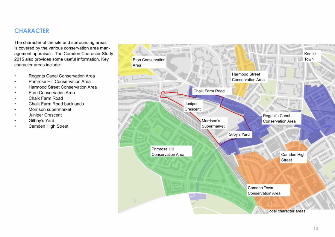
CHARACTER
The character of the site and surrounding areas is covered by the various conservation area man-agement appraisals. The Camden Character Study 2015 also provides some useful information. Key character areas include:
• Regents Canal Conservation Area• Primrose Hill Conservation Area• Harmood Street Conservation Area • Eton Conservation Area• Chalk Farm Road• Chalk Farm Road backlands• Morrison supermarket• Juniper Crescent• Gilbey’s Yard• Camden High Street
Eton ConservationArea
Morrison’s Supermarket
Camden HighStreet
Juniper Crescent
Harmood Street Conservation Area
Gilby’s Yard
Chalk Farm Road
KentishTown
Camden TownConservation Area
Primrose HillConservation Area
Regent’s CanalConservation Area
local character areas
13

DESIgNATIONS
Part of the area in within the LDF/ Draft Local Plan designated Camden Town Centre. The London Plan identifies Camden Town as a ‘Major Town Centre’. The area includes a number of conservation areas and listed buildings.
Two London View Management Framework corridors pass through the area. The corridor from Parliament Hill summit to the Palace of Westminster runs through the framework area. The other corridor is from Parliament Hill oak tree to the Palace of Westminster.
Part of the area is safeguarded for HS2, this includes the Network Rail site and access Roads.
Part of the area is also identified by Camden’s Strategic Flood Risk Assessment 2014 as being at risk of flooding.
Town Centre
HS2 safeguarding area
Listed building
Conservation area
LVMF designated view
14

SITE ANALYSIS - ISSUES
The existing area faces a number of issues and constraints. A combination of factors results in the area being an isolated island site which is disassociated from its surrounding communities and the town centre. Re-development provides the opportunity to address these issues.
Car dominatedThe area is vehicle dominated and is unwelcoming to pe-destrians
High retaining wallsRetaining walls, gates and railings are prolific around the area
Limited entrance/ exit pointsThere is only one vehicle route into the large site. The main alternative pedestrian route is via a narrow alley
Private land- no accessThe markets, roundhouse and OHG sites combine to form a barrier
Railway barriersRailways surround the site resulting in isolation
Significant level changesParts of the site are around 6m above Chalk Farm Road level but roughly the same level as Oval Road and Primrose Hill
Poor public realmThe area has poor public realm, large areas of dead frontage and lacks natural surveillance
No clear routes throughThere are no clear or legible routes into or through the site
15

Railways
Private land - no access
Limited entrances/exits
No clear routes through
Car dominated
Significant level changes
Walls/gating
Underground sewer
Poor public realm
Issues and constraints
16

17
3 The vision and strategy

THE vISION
A confident identity ... for a vibrant inner London neighbourhood that enhances the distinctive cultural energy, community and heritage of Camden Town.
An inclusive mixed-use place ... with an intensification of uses including a significant number of new homes and affordable homes, alongside a diverse range of commercial uses that build on the innovative and creative economy of Camden Town.
Exemplary urban design and excellent architecture... that creates a welcoming series of neighbourhood places.
A place that is well connected and accessible to all ... that prioritises pedestrians and cyclists, is easy to navigate and connects with public transport, reducing the need for vehicles.
An area that celebrates its rich heritage ...and preserves or enhances the setting of assets such as the Roundhouse, the Interchange and the Regent’s Canal.
A neighbourhood that promotes health and well-being ...of its communities and provides a range of open spaces, access to nature and community facilities.
An environment that feels safe and welcoming by day and night.
A green place that is environmentally sustainable and responsible. 18

A confident identity
This area brings together the traditional and the unconventional to make it one of London’s most interesting and unique places.
The town centre is a place of energy, discovery and eccentricity. It has a strong identity based on alternative culture and is renowned for its creative industries, live music, entertainment, colourful ma rkets and innovative enterprise.
It is an area of historic significance with a legacy of industrial, railway and canal heritage. It is home to the iconic Roundhouse, a landmark to the area’s industrial past and cultural evolution. It boasts traditional streets, immersive historic districts and listed buildings interspersed with quality modern development and successful housing estates.
Any new development should come forward as part of a positive vision for community and place. It should be responsive and add to the rich culture, vitality and character of its setting in terms of its design, connectivity and activity. It should respect the areas rich history and create a place orientated to the future.
The framework area is large enough that it can accommodate a character of its own. It should have
an assured and confident identity, appropriate to its advantageous location and which responds sensitively to its setting, particularly at the site’s edges.
Original design of the highest quality is encouraged, provided that development integrates sensitively with its surrounding neighbourhoods.
Camden High Street
Lock Market development
Unique mix of styles
19

An inclusive mixed-use place
The area has the potential to create a new dynamic and animated mixed-use neighbourhood, for existing and new communities to enjoy as a place to live, work and visit.
Parts of the area are currently low density and/or under-utilised and the Council will expect development to intensify the uses and density of development to a level appropriate to the town centre location.
Its location and context within easy reach of a wide range of public transport makes it suitable for a mix of new homes and a variety of commercial space to support an inclusive, dynamic and resilient community.
New and existing homes
The area should deliver a significant number of much needed new homes, including genuinely affordable homes and a range of unit types, tenures and sizes to meet Camden’s identified housing needs.
The Council expects the delivery of high quality housing and affordable housing on-site in this area, in-line with the objectives identified in the Local Plan, Camden Planning Guidance and the Intermediate Housing Strategy.
New development should provide high quality
residential environments and a good standard of residential amenity. New homes should be designed to accommodate a range of needs, be suitable for all age groups and support mixed and inclusive communities.
New residential accommodation should be designed to maximise natural light, ventilation and should provide access to private and public external amenity space.
At existing housing estates, the Council supports the exploration of options to improve the accommodation and environment for existing residents and provide much needed additional housing.
Redevelopment would only be supported where it can be demonstrated that:
• It would result in a significant increase in the number and range of homes provided on site. The Council expects this to include additional affordable social rented housing, with secure tenure and at similar rent levels to the existing.
• All existing homes and facilities would be re-provided on-site.
• It would address current issues and constraints of the area, providing a better quality of accommodation and environment for existing and future residents.
Housing development by Camden
Housing development by Camden
Any proposals should be developed in close consultation with tenants and local residents . Improving resident’s quality of life should be at the heart of any development objectives.
The Council expects the landlord (One Housing) to offer existing residents the option to return to the area on similar terms.
The impacts of development upon the amenity of residents, such as daylight/ sunlight, privacy, overlooking and impacts of construction will need to be carefully considered. Measures to minimise the impact of development during construction must be built in to any construction plan.
20

Levels of activity and associated users
Mixed use town centre commercial focus
Mixed use with more residential focus
More residential focus
Higher volume pedestrian/retail route
Spine route through site
Residential streets
21

Small employment spaces, Brixton market
Maker spaces
Commercial uses
Redevelopment creates an excellent opportunity to build upon the vibrant commercial environment of Camden Town and connect with the unique economy of the town centre. The area has the potential to provide a mix of commercial space that adds to the diversity and activity of this dynamic place and provide jobs and opportunities for local people.
Much of the Town Centre serves a national and international tourist and visitor destination. Redevelopment should help diversify the local retail and commercial offer and include the provision of goods and services aimed at local residents and workers.
The exiting supermarket serves an important function for the local community. As part of any redevelopment, retail serving the local community would need to be re-provided. Given the reputation of the area for markets, provision of market style facilities that serve a more local customer based could be considered.
Cafes, restaurants and other uses that add to the variety and diversity of the offer which bring activity to the neighbourhood at different times of the day and evening and at the weekends may also be suitable. Provision of units suitable for small and independent commercial occupiers will be particularly welcome.
The creative industries are one of the borough’s important growth sectors and Camden Town has one of the largest concentrations of start-up businesses in London. Development should seek to cultivate this type of commercial activity through the provision of a range of unit types and sizes including affordable workspace, light industrial workshops, space for small scale creative industries and a range of office accommodation including move on space so businesses can remain in the area and grow.
The mix of uses should be appropriate to their location and context. The area closest to the core of the Town Centre and on main routes is likely to be most suitable for mixed use and commercial. Whereas areas closer to the railway and existing housing estates may be more suitable for residential. Late night uses are unlikely to be appropriate due to the proximity of residential accommodation.
Large developments must contribute towards employment and training opportunities for local people and will be expected to produce an Employment and Training Strategy.
22
Mixed-use development at West Beat 1, Amsterdam

Exemplary urban design and architecture
In this important location, the Council expects an urban design and architectural response of exceptional quality.
Development should provide a series of welcoming neighbourhood places and spaces, connected by a legible street pattern and framed by well-designed buildings.
Through its design, new development should break down the isolation and unwelcoming ‘island site’ feel of the area. In terms of building layout, street pattern and design, new development should knit into the surrounding urban grain, providing comfortable transitions from existing neighbourhoods into new and creating a continuation of place.
Uses should be provided at ground floor level that activates streets and spaces. Inactive frontages should be avoided.
Development must provide a range of neighbourhood spaces, designed with clear but flexible functionality serving the varied requirements of local communities.
Buildings and landscape should be of exceptional architectural and material quality; they should provide a high level of amenity for new and future occupiers, create homes for life and should be flexible to adapt to changing requirements over time.
Development should create a greener more environmentally sustainable place.
The public realm should feel like part of Camden, avoiding prominent signage and excessive corporatisation.
Curation of public spaces should be subtle and should maintain a degree of informality characteristic to the area. Public routes should be open 24 hours a day.
Development should help to imrpove access to heritage assets and help people to understand the history of the area.
New contextual, contemporary architecture
Excellent landscape architecture
23
Mixed-use development at West Beat 1, Amsterdam
“Cultures and climates differ all over the world, but people are all the same. They’ll gather in public if you give them a good place to do it” - Jahn Gehl
Height guidance
The existing density of development in the framework area are low, with large unbuilt areas, car parking and building heights which rise to a maximum of 4 storeys. The surrounding context in terms of height is also relatively low rise typically ranging from typically 3-5 storeys with a limited number of examples of 7-11 storeys in the area of the canal and north of the high street.
Increases in height could have implications for the setting of listed buildings (including the Roundhouse and the Interchange), and on views from neighbouring conservation areas. The topography of the site and its low-medium rise context mean that any increases in height are likely to be visible and prominent in the local street scene and in long views. These issues and the exiting context mean that parts of the area will be sensitive to increased height.
The Council wants to maximise the capacity of the area and for development to achieve a density that is appropriate to the Town Centre location, maximising the delivery of new homes and jobs. With this in mind, building heights at the upper end and in some cases higher than the existing context may be acceptable, subject to development:
• Preserving or enhancing the setting of the Roundhouse, the Interchange building and other heritage assets.
• Preserving or enhancing the setting of surrounding conservation areas.
• Respecting the surrounding character, context and townscape, particularly at site edges. This should include consideration of site topography and perceived height in relation to the context.
• Creating a positive environment at street level, including an appropriate level of openness, maximising the opportunity for sunlight to reach streets and spaces and including measures to provide a comfortable micro-climate year-round.
• Demonstrating exemplary design quality and finish. Set-backs of the taller elements should be considered. This can be an effective way of reducing bulk and mass and minimising the impact of height on the street level environment.
• Preserving or enhancing important townscape and skyline views
Full details of how the above criteria have been incorporated into development proposals should be submitted to accompany any proposals.
Important views
There are a number of important views in this area that should be preserved or enhanced as part of any development proposals. Detailed view analysis will be required to be submitted as part of any proposal.
View south down Haverstock Hill including the RoundhouseHaverstock Hill provides a fantastic vantage point for viewing of some of London’s most prominent buildings. Just south of Belsize Park Station there is a direct sight line towards St. Paul’s Cathedral. Further south, the street curves to give prominent views of the Shard, the City of London and a distant view of the clock tower at St. Pancras Station. Further to the south, the townscape of Camden Town starts to feature with skyline views of the Interchange building. A short distance south of the junction with Steels Road, the Roundhouse becomes the focal point of the street scene with striking views of its prominent roof form and profile on the skyline.
Development should preserve or enhance views of these important landmark and listed buildings from Haverstock Hill. The view of the Roundhouse and its silhouette on the skyline is considered to be of particular value. Further guidance is provides in the diagrams on the following page:
24

1. Foreground - Any development in the foreground should aim to preserve the silhouette of the building, particularly the roofline. A building in this view should aim to sit below the roof line and relate to the scale and proportions of the Roundhouse
2. Backdrop - Buildings in the backdrop of the Roundhouse should aim to ‘hide’ in the ‘shadow’ of the silhouette to preserve the lines of the roof cone.
3. Height - If a taller building can be justified on the site which could be visible in views of the Roundhouse, it should be positioned to preserve the lines of the roof where possible and should create a complementary skyline composition. Materials and colour of buildings seen against the roundhouse should be of appropriate materials and colours to highlight and complement the roof.
South down Haverstock Hill
View north along Oval Road
Interchange Building City skyline from Haverstock Hill
Primrose Hill Conservation Area
1 2 3
25

View from Primrose HillLong views towards the framework area are visible from the open space of Primrose Hill.
View from Chalk Farm Road and side streets to the northDevelopment in the framework area over a certain height would be visible in the backdrop of the Town Centre from Chalk Farm Road and its surroundings. In this area, development should respect the existing urban character and streetscape. It should provide an appropriate level of openness, particularly as the current context of the high street is low-rise and open to sky. Impact on the setting of heritage features including the Stables Market and the Roundhouse will also be considered.
Views along the canalThe impact of any development on the setting of the Regent’s Canal will be a key consideration. Building heights here should follow the established pattern along this section, paying particular attention to existing parapet heights and building lines and providing an appropriate level of enclosure.
View north along Oval Road Long and near views towards the area are available from Oval Road and taller buildings would be particularly visible. From this area particular consideration will be given to the impact of any development on the townscape. Development should respect the surrounding character and built form and provide a comfortable transition of heights that is not jarring in the street scene. Development should provide a sight line through Gilbey’s Yard and the Morrisons site.
Townscape views of the Interchange buildingViews of the interchange building are available from a limited number of vantage points around the Town Centre. The Roundhouse marks the very public northern gateway to Camden Town, and the Interchange marks the more exclusive interface with the canal. Views from the canal are of particular significance, as are views of the water tower on its north east façade, which is a skyline feature.
The Morrison’s car park currently provides uninterrupted and prominent views of the Interchange. Whilst the development of the site will inevitably limit the availability of views towards this heritage asset, opportunities to preserve, enhance or frame views of the Interchange, particularly its distinctive water tower roof form will be encouraged.
Views from Primrose Hill Conservation AreaTaller buildings within the area may be visible in views from the neighbouring Primrose Hill Conservation Area. Whilst any views of development would be at some distance, it is important that the setting of the conservation area is preserved.
26

Conservation area / townscape views
Views towards listed buildings
Sensitive backdrop view
London View Management Framework view
Important views
27

Well connected and accessible to all
Development will be required to ensure that the area is better connected in all directions, including new and improved connections to the Town Centre, the high street, Primrose Hill and the canal. Connections must integrate with the established street network and create direct, accessible routes and a place that is instinctively easy to understand and navigate.
Access to the area is currently restricted to the vehicle access point from Chalk Farm Road and pedestrian/ cycle access from Oval Road, making the area isolated. The creation of additional access points and connections will be a strategic priority, particularly as the site will be required to accommodate an uplift in density.
Pedestrians and cyclists should be prioritised, creating a pleasant, legible and safe environment, with direct routes that encourage footfall. Cycle safety should be improved and new cycle hire stations provided.
The area should be accessible to all ages and all physical abilities. The topography of the area poses a real challenge for accessibility. Innovation in accessible design will be encouraged and buildings and places will be expected to meet the highest practicable standards.
Access to public transport should be maintained and improved. Local buses serving the area will need to be maintained on site in a suitable and accessible location within the area of the supermarket. New and improved routes to better connect residents to local tube and train stations will be required. In addition, opportunities should be taken to reduce or remove the roundabout (which is required to enable buses to turn around).
All new development will be required to be car-free and Council will encourage the redevelopment of existing car parks for alternative uses.
Development should future-proof for the potential reopening of the Primrose Hill over ground station to passengers if this was to become a viable prospect in the longer term.
Key priorities will include:
• Improvements to the Chalk Farm Road gateway to the area, including creating a more pedestrian/ cycle friendly environment.
• An extension of Oval Road through the site to provide a continuation of the established street pattern. A direct route should run through the Morrison’s site to Juniper Crescent and Chalk Farm Road.
• New access points via Camden Markets, particularly via the Lock Market linking new and existing communities with the town centre.
Potential link between Interchange and canal
Potential link between Oval Road and canal
28

PRIMROSE HILL PARK
PRIMROSE HILL
PRIMROSE HILL PARK
HAMPSTEAD
BELSIZE
REGENT’S PARKWEST END
Kentish Town WestStation
Kentish Town Station
Chalk Farm Station
Camden Town Station
Mornington Crescent
Camden Road Station
St Pancras Station
Belsize Station
Cam
ley StreetOval Road
Haverstock Hill
Kentish Town High Street
Camden Road
Outer C
ircle
Camden High Street
HAMPSTEADHEATH
KENTISH TOWN
CHALK FARM
CAMDEN TOWN
KINGSCROSSCENTRAL
ST PANCRAS
• Additional access points to Chalk Farm Road under or over the existing railway lines, These routes should be fully explored as part of any proposals, subject to topographical consideration and viability.
• Future-proofing for a new connection with Regent’s Park Road at the railway footbridge, providing an important strategic link with Primrose Hill.
• Improved access to the canal.
• Exploration of the potential to create a level ‘high-line’ pedestrian/ cycle link connecting the Town Centre with Primrose Hill.
• Designing appropriate servicing arrangements into any scheme that promotes good levels of residential amenity.
Strategic connections
Local connections
Pedestrian/cycle connections
Possible High-line connection
PRIMROSE HILL PARK
PRIMROSE HILL
PRIMROSE HILL PARK
HAMPSTEAD
BELSIZE
REGENT’S PARKWEST END
Kentish Town WestStation
Kentish Town Station
Chalk Farm Station
Camden Town Station
Mornington Crescent
Camden Road Station
St Pancras Station
Belsize Station
Cam
ley StreetOval Road
Haverstock Hill
Kentish Town High Street
Camden Road
Outer C
ircle
Camden High Street
HAMPSTEADHEATH
KENTISH TOWN
CHALK FARM
CAMDEN TOWN
KINGSCROSSCENTRAL
ST PANCRAS
PRIMROSE HILL PARK
PRIMROSE HILL
PRIMROSE HILL PARK
HAMPSTEAD
BELSIZE
REGENT’S PARKWEST END
Kentish Town WestStation
Kentish Town Station
Chalk Farm Station
Camden Town Station
Mornington Crescent
Camden Road Station
St Pancras Station
Belsize Station
Cam
ley StreetOval Road
Haverstock Hill
Kentish Town High Street
Camden Road
Outer C
ircle
Camden High Street
HAMPSTEADHEATH
KENTISH TOWN
CHALK FARM
CAMDEN TOWN
KINGSCROSSCENTRAL
ST PANCRAS29

An area that celebrates its rich heritage
The area is of historic significance with many historic features and assets remaining above and below ground. Historic buildings are an important feature of how people identify with the area and play an important role in sense of place and orientation.
The Roundhouse and the Interchange are landmark buildings, the Roundhouse indicating the gateway to Camden Town from the north and the more secluded Interchange marking the canal.
Development should celebrate these heritage assets, preserving and wherever possible enhancing their setting. This should include consideration of the area’s characteristic historic arrangement and topography through exploration of subterranean archaeology. Views towards historic buildings should be preserved and where possible enhanced.
Assets should be as publicly accessible as possible, allowing for as many people as possible to experience them and understand more about the history of the area. The Council would welcome measures to improve public access to the Interchange building and the Winding Vaults.
The Regents Canal, once vital to the industrial workings of the city, today provides an important walking and cycling route and a place for leisure, recreation and nature. Accessibility to the canal should be improved.
Industrial heritage as inspiration, Rotermann Tallin
contextual development Manchester
industrial heritage inspiration, Barcelona
30

contextual development Manchester
A neighbourhood that promotes health and well-being
Any development should create a place that that facilitates healthy, happy and inclusive community life.
Open and green space plays an important role in health and well-being and access to such experiences is particularly important in urban areas where access to the natural environment is restricted
Developments in this area should provide a range of public open space on site of a scale and area commensurate to the level of housing and anticipated public use. Development should provide spaces suitable for a variety of activities and meet the needs of people of all ages. This must include active green open spaces in which people can socialise, play and take physical exercise, quieter more tranquil spaces, and those that are dedicated to food growing and wildlife. Spaces for younger people would be particularly beneficial in this area. Flexible and innovative approaches that achieve multi-functionality in open space and maximise benefits will be encouraged.
Spaces should reflect the informal character of the area and should avoid the creation of overly formal, curated or managed spaces. Development should also provide generous private residential
amenity space such as roof gardens, balconies, communal gardens and courtyards.
The railways and the canal offer an opportunity for the creation of significant habitat areas and extensions to strategic wildlife corridors, particularly extending a partial corridor between the canal and Adelaide Road Nature Reserve, both Sites of Nature Conservation Interest (SINCS).Opportunities to integrate access to nature into the buildings and landscape will be encouraged.
Corridors also offer the potential for green walking and cycle routes. The potential for a high level semi-natural walking route east to west through the site linking to Primrose Hill should be explored. This could provide an additional link similar to the ‘high-line’ proposals being considered to connect King’s Cross with Camden Town.
Development should provide community provision and infrastructure in line with local requirements. This could include a flexible community hall, sports, health or other facilities. Proposals should be developed in consultation with the local community.
31

An environment that feels safe and welcoming by day and night
A sense of safety and security can be created where good levels of activity result in passive surveillance of streets and spaces. To achieve this, the area should include a varied mix of commercial units and active frontages designed to generate activity, that will attract people to walk through the area during the day, evening.
Site layouts and distribution of uses should be designed with a clear hierarchy of public and private spaces and clear permeable routes with good natural surveillance to protect residential amenity.
Within the site, provision of public toilet facilities should be explored.
Late night uses (outside of typical licensing hours) may not be appropriate, due to incompatibility with neighbouring residential accommodation.
32
“This is something every-one knows: A well-used city street is apt to be a safe street. A deserted city street is apt to be unsafe” - Jane Jacobs

A green place that is environmentally sustainable and responsible
Development should meet the highest feasible environmental standards and be forward looking to meet future demands and requirements.
Energy
All new development should meet London Plan energy targets, including zero carbon for all new residential development. Camden is working with central Government on a new decentralised energy masterplan for the area, scheduled to be completed in mid-2017. New development should take account of the study findings and support the realisation of its conclusions.
New development should maximise opportunities for renewable energy generation and secondary heat/cooling sources (for example heat from any retained supermarket cooling systems and cooling from the canal)
New development should follow the GLA “cooling hierarchy” which priorities passive cooling and discourages air conditioning systems.
Sustainability
Buildings and spaces should be flexible to changing requirements, occupiers and needs to ensure that they are adaptable and maximise their life expectancies.
Measures to maximise recycling, particularly bio-waste (food waste) from the markets, should be incorporated into any scheme.
Measures to encourage sustainable transport will be part of the design. All new development will be required to be car-free and Council will encourage the redevelopment of existing car parks for alternative uses. Cycle parking provision should be of the highest standard.
New development should minimise its impact on local air quality and meet the GLA’s proposed Air Quality Positive standard (and prior to its implementation the GLA Air Quality Neutral standard).
Any retained vehicle fuelling uses to be solely focussed on low emission charging infrastructure so that the development is fit for the future and compliant with the new Ultra Low Emission Zone for London.
Space for nature, Camley Street Natural Park
Interaction with plans and nature, the High Line, NY
Preparing for increased demand in low carbon fuel
33

Flood risk and drainage
New development should follow the Sustainable Drainage (SuDs) hierarchy to achieve greenfield run off rates and be designed to respond to the areas of flood risk identified in Camden’s Strategic Flood Risk Assessment 2014.
Changes of level across the site should be designed to minimise the risk of increased surface water run-off.
The Council will support green infrastructure such as green roofs and drought resistant planting that mitigates flood risk, improves biodiversity and provides shade.
New basement development should be subject to a detailed basement impact assessment and must take account of the proposal’s impact on ground water levels and flows and how these changes may affect existing buildings in and around the area.
Construction management
There is the potential that a number of major construction activities could be happening at the same time in the wider area, including the major infrastructure project of HS2. Construction management plans will be required to coordinate with other major development projects and keep disruption to a minimum. This should include arrangements for the removal of spoil.
Reducing plastic waste
Space for growing food
Include Sustainable Urban Derainage measures
34

Reducing plastic waste
Space for growing food
Include Sustainable Urban Derainage measures
New town centre mixed-use
Residential focused uses
New primary connection
New secondary connection
Natural focus along railway edges
New active frontage
High-line, level route
Public realm improvement
route under railway or building
Future-proof Primrose Hill Station
THE STRATEgY
35

36
4 place based guidance

1. Chalk Farm Road
2. Morrisons
3. Interchange Square and the Market edge
4. The canal abd Gilbey’s Yard
5. Juniper Crescent
6. Railway edge
7. Network Rail site and Primrose Hill Station
Character areas
1
57
23
4
6
37

AREA 1: CHALK FARM ROAD
The north side of the street is part of the core shopping frontage and includes a mix of retail, restaurants, drinking and entertainment venues and other uses some with residential at upper levels. The frontage is of mixed character with modern and more traditional style buildings of various materials, ranging from single storey units with recessed accommodation to the rear up to three storeys plus recessed roof levels.
The south side of the high street is designated as a secondary frontage. It includes the stables market, housed within the listed wall, the Morrisons Petrol Filling Station, the modern office occupied by One Housing (the tallest feature at 5 storeys) and the cultural asset and heritage feature of the Roundhouse, an important building marking the start of the Town Centre in the approach from the north and west.
The fragmented stretch from the edge of the stables market up to and including 100 Chalk Farm Road detracts from the Town Centre. There are large areas of dead frontage created by the high brick walls.
The petrol filling station dominates the environment, with a large area dedicated to this use including the entrance and exit points on to Chalk Farm Road, the slip road to the rear and all the associated traffic control measures and street furniture.
The gateway to the framework area is uninviting. The railway bridge and high boundary walls create a tunnel effect, with narrow pavements beside a sweeping roadway dominated by vehicles. There are no sight lines through to what lies beyond, discouraging footfall and creating an unwelcoming environment for pedestrians and cyclists, that feels unsafe.
Despite the poor quality of the public realm, the relatively low rise nature of the south side of the high street, combined with the low rise north side of the street creates a sense of openness in the built form.
Blank frontage around site entrance
Blank walls around and under tunnel
Car dominated area
38

Framework objectives:• Development must radically enhance this
important part of Camden Town Centre and create an inviting gateway to the framework area. This should include creating active uses at street level, improving the environment for pedestrians and cyclists and creating a welcoming visual connection to and from the high street to encourage footfall.
• Create an active and engaging high street frontage on Chalk Farm Road (south side), with a continuous frontage of new active commercial uses at ground floor level that interact with the street and add to the character, diversity and vibrancy of the town centre. Development could provide additional residential or commercial space at the upper levels.
• Promote the creation of new access points to/from Chalk Farm Road, to improve permeability, particularly at the most isolated western end to Juniper Crescent and the Network Rail site. This would require access under or over the railway viaduct and would need to be subject to consideration of topographical considerations, impact on Juniper Crescent and viability.
• Development should preserve or enhance the setting of the Roundhouse. This could include the creation of enhanced public realm and the widening of pavements. Development should maximise opportunities for new and enhanced views of the Roundhouse both within the street scene and from a distance.
• Enhance the pedestrian/ cycle environment by creating clear attractive and safe routes and cycle lanes, simplifying junctions and if possible reducing the land required for the petrol filling station.
• Include high quality building design that is appropriate to its location. Particular consideration will need to be given to the level of enclosure created by any development, ensuring that it is sympathetic to the surrounding urban form and character.
39

AREA 2: MORRISONS
There is a major opportunity to create an exciting new mixed use neighbourhood at the heart of the Town Centre.
Development must be delivered within the setting of considerably enhanced urban-realm, which connects the neighbourhood back in with surrounding communities, breaking down the isolation and creating a greener more sustainable environment that supports the health and well-being of its community.
The existing supermarket provides an important local retail function. However, the current use of the site is low intensity and the built form is incongruous in its town centre location.
Redevelopment of the site is challenging as there are a number of constraints. The supermarket sits at the raised level of the railway approximately 6m above the level of Chalk Farm Road. There is only one vehicle access point to the site, which is via the railway bridge from Chalk Farm Road. There is a secondary pedestrian and cycle access from Oval Road. The environment is vehicle dominated and pedestrian access requires the navigation of significant level changes and barriers.
A combination of these factors makes the area an ‘island site’, which is highly disconnected and isolated from its surrounding neighbourhoods. The environment is generally hard paved and poorly overlooked giving it an unwelcoming feel and leaving it vulnerable to anti-social behaviour.
40

Framework objectives:• There is a major opportunity to create an
exciting new mixed use neighbourhood at the heart of the Town Centre.
• Development should provide a significant number of new homes, including affordable homes on site. Housing should include a range of unit types and tenures and provide a high level of amenity to all residents.
• Development should provide a mix commercial floor space that picks up on unique character and adds to vibrancy/ diversity of the Town Centre. Including space for innovative and creative industries and retail/ market space, food and drink and other uses that diversify the offer of the Town Centre.
• If the supermarket is to be re-development, local retail provisions of equivalent floor space should be provided. Re-provision should be in a flexible form that is in keeping with the local character and promotes sustainable transport.
• Develop must provide a range of open spaces and community facilities on-site.
• The design of buildings and streets should integrate the site back into the surrounding urban from, break down isolation and create a cohesive neighbourhood.
• Existing bus stops and stands will need to be re-provided on site.
• To accommodate a significant uplift in density and remove the isolation of the site, additional pedestrian and cycle links must be created linking to a network of legible routes that prioritise pedestrians and cyclists, and create a safe, pleasant and legible environment innovatively addressing level changes.
• A range of publically accessible high quality and well maintained open spaces should be provided on site, a greener environment should be created and on-site community facilities.
• Opportunities for key views of the Roundhouse and Interchange should be maximised, from within the site and also in local and long views.
41

AREA 3: INTERCHANgE SqUARE AND MARKET EDgE
This area boarders Camden Lock and Stables Markets and the Interchange building. It offers an important opportunity to link the area with the Town Centre.
Re-opening a publically accessible route from Camden Lock Place via the interchange building and creating a new connection via the stables market will help to open up the area to the distinctive economic character of Camden Town and provide more direct routes connecting new and existing communities with the Town Centre.
The reopening of an access route, combined with planned improvement works at the markets, has the potential to change the dynamic of the spaces around the Interchange building and to create a new active environment. There is the potential for the creation of a new publically accessible square or amenity space, significantly enhancing the setting of this important heritage asset.
The Interchange building. Currently the public realm in this area is poor, particularly in the vicinity of The Interchange, with surfaces/ level changes, informal parking, servicing vehicles, poor maintenance and minimal levels of passive surveillance and overlooking.
Creating connections in this area is a key strategic priority. Connections are essential to linking existing and new communities, providing direct access routes to and from the high street and town centre, capitalising on the site’s proximity to this thriving commercial environment and helping to integrate the area back into its surroundings.
42

Framework objectives:
• Strategically important opportunity to connect the area with the Town Centre.
• Re-establish pedestrian connection via the Lock Market. Plus new connection via Stables Market. New connections should link in with new legible and safe pedestrian routes through the development and linking with the town centre and the canal, breaking down isolation.
• The new connections with the market and the high street create the opportunity to cultivate an interesting commercial environment.
• Development should provide significant improvements to the setting and public realm around the Interchange building. This could include creation of new square or public amenity space.
• There may be further opportunities to improve connections with the sub-surface historic fabric, network of spaces and commercial activity.
43

AREA 4: THE CANAL AND gILbEY’S YARD
In this area, there is the opportunity to explore options to improve the Gilbey’s Yard estate, including the potential to provide much needed additional homes and to improve the setting and accessibility of the canal. Any proposals would need to be fully explored in close consultation with local residents.
Gilbey’s Yard itself is a 20th century brick built postmodern housing estate of 3-4 storeys. It is a desirable location with homes arranged in rows, some fronting onto the historic cobbles of Gilbey’s Yard (and backing onto the Morrisons site) and others facing onto the Regent’s Canal with a small public playground and viewing area onto the canal.
There is a wealth of subterranean heritage below the yard, including the former horse tunnels linking through to the stables and the windings. The privately owned cobbled yard links through past the Henson building to the Interchange.
The public realm in the yard is convoluted, with informal parking, uneven surfaces, damaged cobbles and protruding bin stores. The cul-de-sac arrangement makes the area secluded and vulnerable to anti-social behaviour.
The canal today is an important pedestrian and cycle connection and place for recreation, with important links to the area’s history. The north
bank of the canal is raised, in association with the areas industrial past where goods were transferred between the railways and the canal. This part of the canal is predominantly residential, with the more commercial Camden Lock a short distance to the east. Buildings fronting the canal are typically industrial in style of up to 7 storeys with additional recessed upper levels.
To the south, the area connects with the traditional street pattern of Oval Road and views towards the BT Tower. To the north, Oval Road bridges the canal and comes to an abrupt end at Gilbey’s Yard. Only a narrow pedestrian and cycle link continues into the area of Morrisons car park.
Located at the bridge is the important local community facility, the Pirate Castle. Based in the area for 50 years, and housed in the Richard Siefert designed castle since 1977, the centre offers a range of activities for young people and the community associated with the canal.
44

Framework objectives:• The Council supports the exploration of
options to improve accommodation and the environment for existing residents much needed additional housing.
• Redevelopment will only be considered when it will result in a significant increase in the number and range of homes provided on site and where it would address current issues and constraints, providing a better quality of accommodation and environment for existing and future residents.
• The council would expect this in any developemnt re-provision of all homes and facilities on-site.
• Any proposals will need to be developed in close consultation with tenants and local residents and improving the quality of life of residents should be at the heart of any development objectives.
• Developemtn will be expected to preserve or enhance the amenity of existing residents.
• Oval Road should be extended into the Morrisons site and through the framework area, connecting the area in with the wider street pattern and helping to break down the isolation of the area. This should include improvements to access point from Gilbey’s Yard.
• DevelopmentshouldsignificantlyimprovetheenvironmentofGilbey’sYard-rationaliseparkingandstreetfurniture,improveaccessibilityforall,maintenanceandrepairworksincludingrepairofthecobbles.Anon-goingmanagementplanshouldbeconsidrered.
• Developmentshouldincludeappropriateservicingarrangementsthatminimiseimpactsonresidentialamenity.DevelopemntsshouldimproveonexistingarrangementsatGilbey’sYard.
• Developmentshouldprovideagoodlevelofnaturalsurveillance,withclearhierarchyofpublicandprivateareasandlegibleroutesforpublicfootfalltocreateasafeenvironment
• Preservingandenhancingheritagefeatures,includingthepotentialtobringingthewindingvaultsbackintouseandopeningtothepublic.
• Itshouldpreserveorenhancethesettingofthecanalandimprovepublicaccessibility.Thisshouldinclude:
• Apublicallyaccessibleviewingareaontothecanalinfrontofthecanal.
• Improvements to the existing public access and steps to the canal from Oval Road and consider additional access point on the east side of the road bridge.
• Inclusion of a connection along the western edge
45

AREA 5: jUNIpER CRESCENT
Juniper Crescent is highly isolated and faces a number of challenges. There is the opportunity to explore options to improve the estate, including the potential to provide much needed additional homes. Any proposals would need to be fully explored in close consultation with local residents.
There may be the opportunity for improvements to the layout of the estate, helping to improve the general environment, security and connectivity to the surrounding area, reducing its isolation. If redevelopment were to be considered, this would need to be the subject of a full design and consultation process led by the land owner One Housing, in consultation with residents.
The Juniper Crescent estate was built at the same time as Gilbey’s Yard. It consists of 3-4 storey socially rented homes arranged in a crescent around a central private communal courtyard open area and play space.
Juniper Crescent is extremely isolated, cut off to the north and south west by the railway and to the north by the Network Rail site. Towards Chalk Farm Road, the estate is surrounded by a high retaining wall; this combined with the later addition of security gates further divorces the estate from its surroundings and creates a fortress effect.
The estate is located in close proximity to the Roundhouse and many of the flats benefits from views onto this feature. This also means that any alterations to the estate will need to be carefully considered in terms of their impact on the setting of this important heritage asset. Juniper Crescent also has the potential to link up with any future development of the neighbouring Network Rail site. Any development at Juniper Crescent, should be future-proofed to facilitate a primary arterial link to Primrose Hill via the Network Rail site.
Juniper Crescent provides a relatively low density relative to its location. Isolation and lack of connections have led to challenges. Any development would need to offer a significantly enhanced quality of environment for existing and future residents. It should address the constraints of the area, including creating new connections and access and offer a significant increase in density whilst protecting the setting of the Roundhouse.
46

Framework objectives:• The Council supports the exploration of
options to improve accommodation and the environment for existing residents provide and to provide much needed additional housing.
• Redevelopment would only be supported where it can be demonstrated that it would result in a significant increase in the number and range of homes provided on site and where it would address current issues and constraints, providing a better quality of accommodation and environment for existing and future residents.
• If partial or full re-development where to take place, the council would expect the re-provision of all homes and facilities on-site.
• Any proposals should be developed in close consultation with tenants and local residents and improving the quality of life of residents should be at the heart of any development objectives.
• Layout and design should create a welcoming, integrated and safe environment which connects the neighbourhood into its surroundings. This should include the extension of the public spine route through the area.
• Improve connections through the estate- encourage the creation of additional access points connecting the estate with Chalk
Farm Road, future proof for continuation of Oval Road to Primrose Hill (via existing footbridge), highline green link subject to technical surveys and viability.
• Active uses such as shops or workshop units should be introduced facing outward onto Juniper Crescent at street level, with the removal of blank boundary walls and security fencing, which segregate the existing estate.
• Opportunities to maximise views and protect the setting of the Roundhouse should be incorporated into any design, as an important and desirable feature of the area.
• Any development should future-proof for the development of the neighbouring network rail site, including the continuation of a route.
47
AREA 6: RAILWAY EDgE
The railway edge to the south west of the site has both the potential to be visible in long views across the railway from the Primrose Hill Conservation area whilst also being a more secluded part of the site. Development along this edge should be designed to avoid isolated poorly overlooked areas and should be of a design quality that preserves or enhances the setting of the site in views and on the skyline.
To the south west, the site borders the West Coast Mainline railway running in and out of Euston Station. It also includes a large area currently taken up by the existing roundabout, which emphasises the dominance of vehicles and the pedestrian unfriendly feel of the place and creates a large divide between Juniper Crescent and the Morrisons site.
Any development along this edge will be visible in certain views across the railways from the conservation area in Primrose Hill and from the railway itself. However, from within the site this area has the potential to be secluded and to feel less safe. The type of development that occurs along the railway edge therefore needs to be carefully considered. The creation of a two sided street along this edge should be considered along with the creation of active uses at ground floor
level. This could include workshops or small scale industrial units which could help to add variety and provide a greater sense of overlooking throughout the day.
Railways can also provide a good location to encourage biodiversity, and being south west facing, this area may be appropriate for a natural biodiverse corridor or could be suitable for food growing and allotments, subject to appropriate levels of natural surveillance.
48

Framework objectives:• Create a safe environment, maximising
opportunities for natural surveillance and avoiding routes and areas that feel secluded or unsafe.
• Developments should enable a reduction in the area required for the roundabout and should future-proof for its potential removal or replacement with a T-junction.
• Consider the providing a biodiversity corridor and food growing corridor subject to railway buffer constraints.
• Preserve or enhance the Primrose Hill Conservation Area in views and on the skyline.
• Development in this area should ebanle the opening of the Winding Vaults to the public and provide appropriate access arrangements.
49
AREA 7: NETWORK RAIL SITE AND pRIMROSE HILL STATION
The Network Rail site is a potential longer term development opportunity. Any future development of the site would depend upon the creation of a new strategically important route connection to Primrose Hill and should be designed to enable the re-opening of Primrose Hill Station if this should become a viable opportunity in the future.
This site is a Network Rail servicing and storage area, which is safeguarded for use as a HS2 construction compound until 2033. The site has no permanent buildings, but it does include the tracks and platforms of the former Primrose Hill Station on the North London Line, which is currently used for freight and occasional passenger use by the London Overground. The former station building is located at a raised level facing onto Primrose Hill footbridge.
Due to HS2 requirements, this part of the area is unlikely to develop in the short to medium term. However, any development of neighbouring sites, such as Juniper Crescent, should allow for the development of the Network Rail site in the future.
The future development of the Network Rail site would be dependent on the provision of additional routes and connections. A pedestrian link to Regents Park Road at the footbridge over
the railway is of strategic important to unlocking development of this site, which would otherwise be considered too isolated to accommodate development.
TfL advises that there are no current plans to reopen Primrose Hill Station for passenger services and any such proposal would face significant operational and financial constraints. Circumstances in the future may well change creating a case for the re-opening of the station. Any development of the area and its surroundings should not preclude the station from being reopened in the future.
50

Framework objectives:• Any development of neighbouring sites, such
as Juniper Crescent, should allow for the development of the Network Rail site in the future.
• Development should be future-proofed so that any future re-opening of Primrose Hill Station for passenger services would be possible.
• The development of the Network Rail site is dependent on the creation of additional connections. This should include a pedestrian connection to Regent’s Park Road at the Primrose Hill footbridge.
• Interim pedestrian and cycle links, provided they can be achieved in a safe way, would be encouraged.
• Continuation of a highline and biodiversity corridor along the railways should be explored.
51

DRAFTFor the latest consultation information and updates please visit our website at:
www.camden.gov.uk/camdengoodsyardpf
or contact Regeneration and Place at:
REG
ENER
ATIO
NA
ND
PLA
CE