california ffa soil and land evaluation manual book would not have been possible without the support...
TRANSCRIPT

California FFA Soil and Land Evaluation Manual
Kelly S. CarterBrent G. HallockTerence H. CooperLogan S. Carter
Sixth Edition


Copyright © 1980, 1986, 1989, 1997, 2017California Polytechnic State University
All Rights reserved. No part of this publication may be reproduced or transmitted in any form or by any means electronic or mechanical, including photocopy, recording or any information storage and retrieval system, without written permission from the publisher.
Printed in the United States of America

This book would not have been possible without the support from Craig Stubler and the technical assistance from India Tatro. Thank you both for your help.
Acknowledgments

California FFA Soil and Land Evaluation Manual
6th Edition
Kelly S. CarterAgricultural Systems ManagementCalifornia Polytechnic State University
Brent G. Hallock
Terence H. Cooper
and
Logan S. Carter
Revised January 2017

Forward ......................................................................................................................9
Introduction ..............................................................................................................10
Chapter 1: Surface Soil ............................................................................................13
Chapter 2: Subsoil ....................................................................................................20
Chapter 3: Interpretation of Soil Features ................................................................22
Chapter 4: Accelerated Erosion ................................................................................28
Chapter 5: Topography or Lay of the Land ..............................................................31
Chapter 6: Land Capability Classification ................................................................34
Chapter 7: Land Use .................................................................................................38
Chapter 8: Major Problems in Use ...........................................................................40
Chapter 9: Land Management Needs ........................................................................41
Chapter 10: Urban Land Limitations ........................................................................45
Chapter 11: Soil and Land Evaluation Scorecard .....................................................48
Appendix A: Munsell Color Charts ...........................................................................51
Table of Contents

Figure 1: Site Selection ...........................................................................................12
Figure 2: USDA NRCS Textural Triangle ...............................................................15
Figure 3: Textural Classes for Soil and Land Evaluation ........................................15
Figure 4a, 4b, 4c: Properly Wetted Sample .............................................................14
Figure 5: USDA NRCS Texture by Feel Method ....................................................16
Fiigure 6: USDA NRCS Course Fragment Estimating ...........................................18
Figure 7: Soil Horizon Differentiation ....................................................................19
List of Figures

Table 1: Soil Thickness ..............................................................................................19
Table 2: Soil Permeability Categories .......................................................................26
Table 3: Soil Texture Water Holding Capabilities ....................................................27
Table 4: Water Holding Categories ...........................................................................27
Table 5: Accelerated Erosion Categories ..................................................................28
Table 6: Slope Ranges ...............................................................................................33
Table 7: Guide for Placing Soils in Land Capability Classes ...................................37
Table 8: Limitations of Septic Tank Filter Fields .....................................................45
Table 9: Limitations for Shrink-Swell Behavior ......................................................46
Table 10: Limitations for Foundations without Basements .....................................46
Table 11: Limitations for Local Roads and Streets ..................................................47
Table 12: Limitations for Topsoil .............................................................................47
List of Tables

9California FFA Soil and Land Evaluation Manual │Forward
This manual has been designed to prepare students for the California State FFA Soil and Land Evaluation contests held each year at California State University, Fresno and California
Polytechnic State University, San Luis Obispo. The scorecard for the Soil and Land Evaluation competition on page 48 provides a means by which students can record their observations of the soil for comparisons with other soils or to interpret soils for land use and management. When students become proficient in land judging, they gain an appreciation for the proper care and management of one of our most basic resources: the soil. References throughout this manual to “FILL IN THE BUBBLE PROVIDED” refer to the appropriate section of the soil and land evaluation scorecard. Each numbered section shown on the score card corresponds to the chapter in which the reader can find more information about that particular topic, i.e., the first heading on the score card is SURFACE SOIL, which is described in detail in Chapter One.
Forward
Photo Courtesy of Kelly Carter

10 California FFA Soil and Land Evaluation Manual │Introduction
Soil is the material that covers the earth’s surface and is a natural medium for plant growth. Soil consists of about one-half solid matter, one-fourth air, and one-fourth water. The solid portion
of the soil is composed of mineral and organic matter. Mineral matter is derived from rocks that have undergone physical and chemical weathering by such agents as heat, water, ice, and wind. Organic matter is formed as a result of plants and animals that grow, live, and decompose within the soil. Plants extract their nutrients from these minerals in the soil and use soil, water, and air as their basic building blocks. Physical processes, such as heating and cooling, freezing and thawing or wetting and drying break apart rocks and minerals into smaller and smaller pieces. Percolating water moves these fine soil particles along with soluble minerals from the surface to lower depths of the profile. Water may also transport soil materials from one surface location to another. Ice, wind, and gravity are other important processes in the movement of soil materials to new locations. Soils may develop in place from the underlying rock or from transported soil materials. When digging into a soil or examining a roadside cut, layers that nearly parallel the land surface will be evident. These layers are termed horizons, and each horizon differs in one or more ways from those above and below. Such horizons may have developed over a few months, but more likely it took thousands of years. The sum total of the horizons extending from the soil
surface downward is called the soil profile. Land judging involves identifying the soil profiles and determining which profile characteristics are important in making sound land use and management decisions.
Selecting SiteS for land JudgingMuch of the preparation associated with land judging contests is done well ahead of the contest date. A week or more before the contest, four sites should be selected that represent different conditions typical of the area. Permission to examine fields, dig pits, and to bring contestants to the site should be obtained before making final selection of the site. Maximum instructional and contest value will be obtained if the following suggestions are taken:
1. There will be four (4) sites judged for the official score of 400 points per member, 1200 per team. One of the four sites is designated as a tiebreaker in accordance with the curricular code.
Introduction

11California FFA Soil and Land Evaluation Manual │Introduction
2. All sites should be close enough so that travel time is held to a minimum. The sites should not be so close that activities at one site interfere with those at another. Sites should be readily accessible to the type of transportation available.
3. Freshly dug pits are usually more desirable than roadside cuts, railroad cuts, or gully banks, although any of these can be used if no alternatives exist. With a pit, there is less chance of site contamination by profile overburden or alteration through prolonged exposure.
4. Safety at the site should be a major concern. The chances of a serious fall or traffic hazard may rule out an otherwise ideal location because each site should present as few hazards as possible. Warning signs should be posted around the pits, or if the pits are to remain exposed overnight they should be covered to protect animals that may be grazing in the field.
5. Provide markers to show the limits of the land area to be judged. Stakes or ropes can be used to demarcate an area of at least 1000 square feet.
6. A sign should be posted indicating the original topsoil depth and if irrigation water is available.
7. Slope stakes should be set out and marked with red fagging for slope determination.
8. Ample amounts of water should be available for texturing.
9. Each profile in the site should possess as many of the following characteristics as possible:
a. Most items to be judged should be well within the range of characteristics on the score card so students can make definite choices. This particularly applies to the general slope of the area, thickness of each horizon, total effective depth, and the land capability class. A horizon around 15 inches thick is more definitely called thick than one of 19 inches or at the limits between thick and very thick. A slope of five percent is more definitely gently sloping than is one of eight percent. If variations are too wide over the whole site, a portion of it may be marked where judging is to be done to reduce variations. If borderline situations cannot be avoided, credit should be given for more than one answer. (Figure 1)
b. Each horizon should be easily identifiable by one or more measurable characteristics, such as color, texture, structure, or gravel content. Soils with excessive numbers of horizons should be avoided. If this is unavoidable it may be desirable at some sites to designate which horizons are to be included in the surface soil and subsoil. This can be accomplished by placing a nail at the boundary line of the subsoil.
10. Tapes or strings should be used to mark off a 12-inch section of each site as a “No Dig” area. This allows students in larger groups to observe the unaltered soil profile. A measuring tape or yardstick should be placed between the strings for student use.

12 California FFA Soil and Land Evaluation Manual │Introduction
11. Pits should be dug large enough so contestants have a good view of the soil and all parts of the soil profile. A pit five to six feet deep is usually adequate. Steps down into the pit should be provided at one end. Material below the bottom of the pit must be assumed to be the same as the lowest exposed layer.
12. All contestants shall be allowed forty (40) minutes at each site to complete the score card. Contestants should be divided into groups of 15 or less for efficient operations at each site. Once at the site students will be split into two smaller groups. The first group will have 10 minutes to be in the pit to evaluate it, afterward the second group will have 10 minutes to evaluate the pit. At the conclusion of those 10 minute intervals, all students within the two groups will have the remaining 20 minutes to evaluate the pit.
Figure 1: Choose sites that have easily identifiable horizonsPhoto Courtesy of Kelsey Ormonde

13California FFA Soil and Land Evaluation Manual │Surface Soil
1Surface Soil
The uppermost horizon of a soil is termed surface soil. Surface soil is altered by plowing, seedbed preparation, and crop cultivation. Most feeder roots are concentrated in this part of the soil.
The surface soil also holds most of the organic matter, applied fertilizer, and plant food necessary for plant growth. Surface soil has the important functions of anchoring plants and supplying them with their water needs. Soil and land evaluation pertains to the characteristics of surface soil which are important in determining how well plants can grow. For each item that fits the conditions most accurately, FILL IN THE BUBBLE PROVIDED.
colorColor is important in the identification of soil conditions and may have a bearing on the value of land for agricultural uses. Color gives clues to organic matter content, surface drainage, salt content, ease of air and water movement, and the general fertility level. Color is also useful in distinguishing one soil horizon from another. Soil color should be judged moist, because the contestants cannot always wait for wet soil to dry. Samples should also be undisturbed; to color break open a fresh structural unit of soil and moisten. Do not use your textured sample for color. (Water will be provided for wetting dry soils.) Munsell soil colors are grouped into the following categories. Munsell color notation will be used by the official judges to determine color. Very Dark colors may indicate an ample supply of organic matter. However, in some soils, very dark color may be due to the presence of dark minerals rather than organic matter. Munsell color names are: black, very dark gray, very dark brown, very dark grayish brown, dusky red, very dusky red, reddish black, dark reddish gray, dark reddish brown, dark gray, dark brown, dark olive brown, and dark olive gray. For a list of Munsell color notations see Appendix A. Medium or Bright colors suggest medium or fairly low amounts of organic matter and generally well-drained conditions with adequate aeration. Medium colors are more common in surface soil while bright colors more frequently occur in the subsoil. Munsell color names are: brown, dark grayish brown, yellowish brown, brownish yellow, yellow, dark red, reddish brown, red, weak red, light red, reddish gray, yellowish red, gray, reddish yellow, grayish brown, olive brown, light olive brown, strong brown, dark yellowish brown, and olive yellow. For a list of Munsell color notations see Appendix A. Very Light colors suggest low organic matter and high concentrations of lime, gypsum, or soluble salts. Sandy soils and soils of dry areas are likely to be very light colored because of low

14 California FFA Soil and Land Evaluation Manual │Surface Soil
organic matter. Munsell color names are: white, light gray, light brownish gray, very pale brown, pale brown, light brown, light yellowish brown, pinkish gray, pink, pinkish white, light reddish brown, pale red, light pink, light reddish gray, and the white page. For a list of Munsell color notations see Appendix A. Drab or Mottled colors in the surface soil generally suggest a lack of oxygen due to impeded drainage, a high water table, or poor aeration due to some other cause. An exception is the apparent mottling of the surface due to mixing with materials brought from below by ground squirrels, gophers, or other burrowing animals. In some soils the parent material may also give drab or reduced colors. Drab or reduced colors are more common in subsoils rather than in surface soil horizons except under very wet conditions. Munsell color names are: light olive, pale olive, olive, olive gray, light olive gray, olive yellow, pale yellow, yellow, the 10Y-5GY page, and Gley 1 and Gley 2 pages. For a list of Munsell color notations see Appendix A. Redox colors are combinations of two or more of these or other colors in approximately a 50/50 percent mixture where no one color dominates.
textureTexture refers to the relative proportion of particles of different sizes present in a sample of soil (Fig. 2 & 3). Texture probably has more influence on productivity, use, and management needs than any other single physical characteristic. It influences tillage, root penetration, entrance and penetration of water, water and nutrient retention, aeration, and susceptibility to erosion. Sand, silt, and clay are the three particle size separates. One of the most important factors in achieving high scores at a land judging contest is the ability to determine soil texture accurately (Fig. 4A, 4B, and 4C). A sieve can be used to help determine the soil texture. Figure 5 is the method to determine texture by feel.
Figure 4a: This soil is too dry to work into a ribbon
Photo Courtesy of Kelly Carter
Figure 4b: This soil is properly wetted for ribboning
Photo Courtesy of Kelly Carter
Figure 4c: This soil is too wet to work into a ribbon
Photo Courtesy of Kelly Carter
Photo Courtesy of USDA NRCS

15California FFA Soil and Land Evaluation Manual │Surface Soil
Figure 2: USDA -NRCS Soil Textural TriangleCourtesy of USDA NRCS
Figure 3: Textural classes for Soil and Land Evaluation

16 California FFA Soil and Land Evaluation Manual │Surface Soil
Figure 5: USDA-NRCS Texture by Feel MethodCourtesy of USDA NRCS

17California FFA Soil and Land Evaluation Manual │Surface Soil
Sand (2.0-0.05mm. diameter) has the characteristic of grittiness. When moist, individual sand grains can be both seen and felt. Soils high in sand have too many large particles to hold together well. Single grains of sand act alone and do not form clods, or the clods can be easily broken. Silt (0.05-0.002mm. diameter) has the characteristic of smoothness. When dry, silty soils feel floury. When moist, silty soils feel buttery, velvety, or slick. Silt particles stain hands and show a fingerprint. They stick together better than sand particles and dry clods break with some difficulty. Clay (under 0.002mm.) has the characteristic of stickiness. Particles stick together so readily that when clay is moistened and held on your fingertips, you’ll have difficulty separating your fingers. At the right moisture content, clay will form a thin ribbon an inch or more long when squeezed out between thumb and forefinger. Clay also forms hard, dry clods that can be broken apart only with great force. A coarse texture is dominated by the grittiness of a high sand content. While clay and silt may impart a small amount of stickiness, smoothness or staining, these qualities are secondary to the grittiness of sand when the sample is moist. Particles lack coherence, clods crumble easily, and they’re carried by wind or water when there isn’t enough protective vegetation. Coarse textures include coarse, medium, and fine sand as well as loamy sands. A medium texture is neither excessively gritty nor sticky. Properties of sand, silt, and clay may be present in more or less equal proportions, or the smoothness of the silt may dominate the other. Often short thick ribbons can be formed at the proper moisture content, but they can barely sustain their own weight. Some medium textured soils will show a fingerprint, but this is not a consistent characteristic. Medium texture soils include those ideal for tillage, entrance and storage of water, retention of nutrients as well as being ideal for plant emergence, plant growth, and root penetration. Medium textures include coarse sandy loam, sandy loam, fine sandy loam, loam, silt loam, and silt. A fine texture has more of the stickiness of clay than the grittiness of sand or the smoothness of silt, but the sand and silt are noticeably present. At the right moisture content, the soil will ribbon fairly well when pushed out between the thumb and forefinger. Ribbons that are formed will be thinner than those of medium textured soils, but they’re not as thin or as long as those formed by very fine-texture soils. Dry clods can be broken with difficulty. Entrance and percolation of water is slower than with medium or coarse textures. Plowing and cultivation are also more difficult in fine textured soils. However, water storage and nutrient retention are better. Fine textures include sandy clay loam, clay loam, and silty clay loam. A very fine texture is dominated by the stickiness of clay. Characteristics of sand and silt may be present, but they’re definitely secondary. At the right moisture level, the soil will form a long ribbon. Very fine textures show a fingerprint and stain hands. Dry clods can’t be broken between the fingers. Very fine surface textures often crust and may crack open when dry. The rate of water intake is very slow and there’s a narrow range of moisture conditions when the soil can be tilled satisfactorily. Water and nutrient retention is very good. Seedlings will have trouble pushing through the surface while roots have trouble finding enough space for expansion and air. Very fine textures include sandy clay, silty clay, and clay. Organic soils are composed largely of peat and muck with little or no mineral content. Organic soils should be judged by the amount of coarse, medium, fine, or very fine organic matter present. Well-decomposed organic matter is called humus and is not as sticky and plastic as clay. Particles are clay-sized, but the characteristics of feel are more like silt than clay.

18 California FFA Soil and Land Evaluation Manual │Surface Soil
gravel and rockRounded, angular, or flattened rock particles larger than about one-tenth of one inch (over 2.0 mm.) are important texture modifiers because they influence tillage, water and nutrient storage for plant growth. Rock fragments on the surface of the area to be judged cause excessive wear on equipment and tillage may be impractical when they are too numerous. Gravel and rock fragments within the surface horizon in soils create large pores which allow water to enter readily, but permit little water storage for plant use. Nutrient storage is also low. Gravel and rock may cover seedlings and prevent their emergence. When gravel and rock occupy less than 15 percent by volume, none to few would be marked on the scorecard. Between 15 and 35 percent would be scored moderate, between 35 and 60 percent would be scored severe, and greater than 60 percent would be scored extreme on the scorecard. Estimate the total percentage of gravel and rock fragments that are on the surface and within the surface horizon. Compare the percent found in the guide (Fig. 6) below to the rock fragments between the tapes in the soil profile and the land area to be judged. Record the percent volume of rock fragments on the score card.
Figure 6: Guide for Estimating Proportions of Course Fragments and MottelsCourtesy of USDA NRCS

19California FFA Soil and Land Evaluation Manual │Surface Soil
thickneSSThe boundary between the surface and subsurface horizons may be determined by carefully examining changes in color, texture, gravel content, structure, or other soil characteristics (Fig. 7). The boundary may be sharp and easily seen, or it may change gradually and be more difficult to locate. If judges feel the contestants cannot decipher the boundary it may be indicated by placing a nail at the boundary line in the no pick zone, prior to the contest. Generally surface soils are darker in color, coarser in texture (lower in clay), smaller in structural aggregates and have a greater concentration of roots than subsoils. Once it has been decided where the surface soil stops and the subsoil begins, the thickness should be measured at the tape from the surface to this point (Table 1). A very thick or thick surface soil is desirable for plant growth because larger amounts of organic matter, nutrients, and water can be stored. Thin or very thin surface soils generally occur on sloping uplands and often mean that erosion has occurred. Thin surface soils in bottomlands may be the result of recent accumulations or deposition of new soil material.
Figure 7: Changes in color, texture, or gravel content can help determine whe the surface and sub soil meet
Courtesy of Kelsey Omonde
Table 1: Soil Thickness

20 California FFA Soil and Land Evaluation Manual │Subsoil
The layer beneath the surface is termed the subsoil and may correspond with the B horizon in some soils. The subsoil may have accumulated clay, iron, or other materials from above. When
this occurs, it will be easily recognizable due to changes in color, texture, or structure. In other soils, the subsoil could be different in color from the surface soil. When the subsoil isn’t compacted, extra depth is provided for root growth. Further, the subsoil can hold useful reserves of plant nutrients and moisture that increase food supplies and drought resistance. Not all soils will have subsoils, especially if they’re shallow soils formed over bedrock. If a soil is uniform from the surface to bedrock layers, it wouldn’t have a subsoil. Most of the items judged for the surface are also judged for the subsoil. In addition, an estimate is made of the ease of air and water movement through this horizon. Make reference to corresponding items under the surface soil heading for information that is not repeated here. For each item choose the one block that fits the conditions most accurately FILL IN THE BUBBLE PROVIDED.
colorIn most cases, subsoil color isn’t masked by organic matter, but is produced by the minerals present in the soil. Color ranges are the same for both surface and subsoil layers and are described under surface soil in chapter one. Soil color should always be determined on a moist, undisturbed soil sample.
textureSubsoil texture is determined in the same manner as surface soil texture. The texture of the subsoil is to be taken in the middle of the subsoil. A more complete discussion of techniques for measuring soil texture is given in Chapter one. A coarse textured subsoil is not usually desirable because of low water and plant food storage. Large amounts of gravel and sand may decrease water and food storage so much that root growth is limited. A medium textured subsoil is more desirable for root growth and water and nutrient storage than a coarse textured subsoil. Aeration is normally adequate but not excessive. Medium textures are more likely to occur below coarse textured surfaces on uplands. Soils on some terrace and bottomland positions may be medium-textured throughout while others have strata of finer textures above medium textures where there has been later deposition of finer materials.
2Subsoil

21California FFA Soil and Land Evaluation Manual │Subsoil
A fine textured subsoil normally occurs below medium textured surface soils where soils have developed in place for a long time. The finer texture is caused by the downward movement of clays. This makes for adequate water and mineral storage. Root penetration is usually good and there is adequate movement of air. Very fine textured subsoils below a medium or coarse textured surface soil often results in perched water tables due to the high clay content of the subsoil. Under these conditions, water moves more readily laterally above the very fine textured material than through it. Even where the surface soil is fine or very fine, a very fine subsoil is undesirable since it creates very slow penetration of water and roots. Air may move through it so slowly that it becomes drab or mottled in color. Organic materials of peat and muck are low in mineral content and cannot be classified according to grittiness, smoothness, or stickiness of mineral particles present. Instead, organic materials should be judged by the amount of coarse, medium, fine, or very fine organic matter present.
thickneSSSubsoil thickness extends from the lower limit of the surface soil to where the subsoil changes into the parent or underlying material. As with surface soil, there may be changes in color, texture, structure, or content of sand and gravel. The lower limit may be the bedrock or where there is a change from the subsoil into the underlying parent material. The thickness should be measured at the tape. Problems that may be encountered in determining subsoil thickness are: (1) very thin (less than four inches) light-colored horizons occurring directly under surface horizons should be included with the surface; (2) thin (four to nine inches) transitional horizons which have dominant characteristics of the surface and some characteristics of the subsoil should also be included with the surface; (3) transitional horizons which have characteristics of the underlying parent material and characteristics of the subsoil should be included with the subsoil. Refer back to Table 1 for exact depth measurements
Courtesy of USDA NRCS

22 California FFA Soil and Land Evaluation Manual │Interpretation of Soil Features
Up to this point, the various important features of the surface soil or subsoil have been judged separately. In this section, these feature will be judged along with other horizons exposed in
the soil profile and in the soil pit. The material below the last exposed horizon or layer should be presumed to be the same as the last horizon or layer described. Some soils only have a single horizon above parent or underlying material. Others may have a number of distinct horizons and will have to be examined. Layer characteristics become less important with increasing depth from the surface, but any lower horizons need some examination. Each layer may have some effect on soil use or management. For each item, choose the one block that fits the conditions most accurately and FILL IN THE BUBBLE PROVIDED.
type of Material that liMitS depthMany soils do not limit the downward movement of roots and therefore permit free movement of air and water through the soil to a depth of 60 inches or more. Most often, these soils will be in landscape positions that promote soil development or accumulate soil material, such as the bottom of slopes or bottomlands where textures are neither too coarse nor too fine. Where these conditions are present, FILL IN THE BUBBLE PROVIDED in the space marked NONE. There are layers in soils that do limit the movement of roots and slow the rate of air and water movement. Where these layers are present, they should be examined as to their nature or characteristics. The material that limits depth should be checked when it occurs within 60 inches from the surface as measured at the tape. Bedrock may be either soft or hard. Soft bedrock should remain the same hardness with depth or become harder. Soft bedrock can be crushed by hand. Hard bedrock is solid, and can’t be broken easily by hand. Hardpan materials are naturally compacted or cemented materials and are often referred to as hardpans. Hardpan is a term applied to cemented layers usually made solid by calcium carbonate, silica or iron oxides. Hardpans are easily confused with solid bedrock, especially when they’re in terrace positions. Hardpans differ from bedrock in that they can be broken through to a less cemented underlying material. Clay pans that restrict root growth could also be included here.
3Interpretation of Soil Features

23California FFA Soil and Land Evaluation Manual │Interpretation of Soil Features
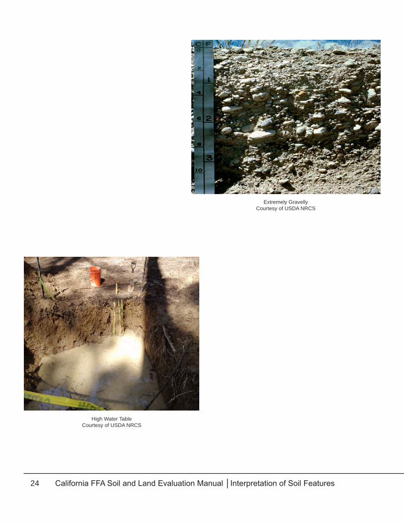
Extremely gravelly materials are evidenced by the presence of more than 60 percent gravel and rock. When they underlie a soil their lack of water and nutrients to supply plant needs limits their usefulness. Coarse sand, extremely gravelly, extremely cobbly, or extremely stony materials should be considered limiting layers. High water tables are limiting when there is standing water in the soil pit. Most plants cannot grow in standing water. The depth to the limiting layer is the depth to the water as measured at the tape. Redox features limit depth in the winter months, but these soils can be productive in the summer months.
HardpanCourtesy of USDA NRCS
BedrockCourtesy of USDA NRCS
24 California FFA Soil and Land Evaluation Manual │Interpretation of Soil Features
Extremely GravellyCourtesy of USDA NRCS
High Water TableCourtesy of USDA NRCS

25California FFA Soil and Land Evaluation Manual │Interpretation of Soil Features
parent or underlying MaterialParent or underlying material is considered to be hard, soft, or loose materials occurring below depths that roots normally penetrate. It may be similar to material from which the soil has formed or be considerably different. It may be all of one kind of material or a mixture of two or more materials. It may be weathered and altered chemically, but should not have been acted upon by plants or animals. Dense compacted claypan layers and cemented hardpans are generally excluded as parent or underlying materials. Where a hardpan is found the material underlying the hardpan will be considered the parent material. Parent materials are those from which overlying soil has developed. Hard or soft parent rock or loose parent materials most often occur below soils in the uplands. Soft or hard bedrock should not be found within 60 inches on terrace or bottomland positions. Loose or mixed parent material may occur on any landscape position. Underlying materials are materials unlike those from which the overlying soil has developed. These may be hard or soft rock but they are more often loose material. An example would be clay textured surface soil that has a gravelly sand as the underlying material. This is frequently found in flood plains. Hard bedrock includes parent or underlying materials that are hard and cannot be penetrated by a nail or knife and cannot be broken in the hand. Hard bedrock will scratch a copper penny and your fingernail. Usually a hammer is needed to break off pieces of hard bedrock unless the rock is fractured. If fractures occur in hard bedrock they should be greater than two inches apart. Hard bedrock should not be found within 60 inches on terrace or bottomland positions. Soft bedrock includes parent or underlying materials that can be broken in the hand without too much trouble. Soft bedrock will be scratched by your fingernail or easily scratched by a knife. They usually consist of clay shales, weathered granites, and other soft rocks. Soft bedrock should not be found within 60 inches on terrace or bottomland positions. Loose or mixed materials include parent or underlying materials that are not consolidated into rock or the material that limits depth is 60 inches or more from the surface as measured at the tape. They are often sands and gravels mixed together or separate. They are most frequently found beneath soils developed on bottomland or terrace positions. Loose or mixed parent material may occur on any landscape position. Organic materials are accumulations of peat or muck. Peat is brown, fibrous, and the plant parts can be identified. Muck is very dark gray or black, non-fibrous, and decomposition has proceeded far enough that its origin is not identifiable. They are mostly parent materials for overlying organic soils, but may have been buried when mineral soil was deposited on top of the organic soil.
depth of Soil favorable for root & Water penetrationThe depth of soil favorable for root growth is from the surface to some layer that limits roots. Depth may be equal to the thickness of the surface soil, the thickness of the surface and subsoil, or may include the total thickness of surface, subsoil, and parent material. The depth to which roots have penetrated where crops are growing sometimes helps in estimating depth unless the plants are normally shallow-rooted. A better measure is the depth to any limiting layer as measured at the tape

26 California FFA Soil and Land Evaluation Manual │Interpretation of Soil Features
such as bedrock, hardpan, claypan, water table, extremely gravelly, or extremely stony materials. If a limiting layer is not seen in the depth of the soil pit measured at the tape, the bottom soil shall be considered to extend beyond 60 inches.
air and Water MoveMentThe ability of the soil to allow air and water movement is called permeability. Permeability is determined on the least permeable horizon in the soil profile. Since plant roots need balanced supplies of both air and water to live and grow well, a moderate permeability is the most desirable condition. This means there’s enough air for roots to obtain adequate oxygen, but not so much that the soil is droughty. It also means there’s enough water to supply needed moisture, but not so much that plants drown for lack of air. Water movement through soil is a function of texture and structure. Texture is especially important in determining the way soil particles stick together in clumps or clusters to form structural units. For the contest we will focus on textures effect on permeability. Very Rapid should be marked in very sandy soils. The size of the openings (or pores) between the grains is large enough to allow water to enter and flow easily, but little moisture is retained. Air also flows freely through the soil and the soils are droughty. Rapid should be marked when there is an increase in clay or silt content in sandy soils. Textures included are; loamy sands, coarse sandy loam, and sandy loam. These soils have slightly more clay in them then sands so they are able to retain more water and the permeability is slower. Moderate is used when there is an even mix of sand, silt and clay. Fine sandy loam, loam, silt loam, sandy clay loam, clay loam, silty clay loam, and silt are considered a moderate permeability. These soils are able to retain enough water for good plant growth but its permeability is fast enough to provide air pockets as well. Slow is used when soil is predominately clayey. Sandy clay, clay, and silty clay are considered slow. These soils have more clay which slows water movement. These soils are more likely to be wet and not provide plant roots with enough air. When determining soil permeability, the texture within 60 inches from the surface as measured at the tape is considered. If soft or hard bedrock or dense or harder material occurs within 60 inches from the surface as measured at the tape, the permeability category is measured to the limiting layer. Table 2 clarifies the relationship between soil texture and permeability.
Table 2: Soil Permeability Categories

27California FFA Soil and Land Evaluation Manual │Interpretation of Soil Features
available Water holding capacityThe available water holding capacity of a soil is the amount of water it can hold that is available to plants. The capacity of soil to store water so it is usable by plants depends upon the texture of the surface and subsoil horizons, total depth of soil favorable for storage, ease of water movement and organic matter content. Where these and other factors are favorable, the water holding capacity is greater than where one or more factors is unfavorable. A deep soil will store more water than a shallow soil. Water storage should be determined on the upper 60 inches of soil or to a limiting layer. The percent gravel and rock from both the surface and subsoil need to be subtracted from the total volume of soil available for water storage. To determine the total available water holding capacity, the amount of water holding capacity for each different textured layer in the upper 60 inches of soil is totaled, unless a layer that restricts roots is present. In such cases, only the soil above the limiting layer is considered. (Table 3) gives guidelines for the water holding capacities for various soil textures. For example: If the first 30 inches of soil was sandy loam, it would contain 0.10 x 30” or 3 inches of water.
If the second 30 inches (30-60”) was a clay loam, it would contain 0.20 x 30” or 6 inches of water.
Adding 3” + 6” gives a total of 9 inches of available water for a high capacity (Table 4).
Remember it is necessary to subtract the amount of gravel and rock contained within the profile. For example, if the first 30 inches of soil contained 6% gravel and rock then 94% is soil; therefore, soil amount x depth x water retention or:
0.10 x 30” x 0.94 = 2.82 inches
If second 30 inches contained 30% gravel and rock then 70% is soil and the calculation is:
0.20 x 30” x 0.70 = 4.20 inches
Adding 2.82” + 4.20” gives a total of 7.02 inches of water and a water holding category of medium (Table 4).
Table 3: Water Holding Capabilities
Table 4: Water Holding Categories

28 California FFA Soil and Land Evaluation Manual │Accelerated Erosion
Accelerated erosion is caused when the vegetative cover is removed and wind and water act on the soil (Table 5). For each item, choose the one blank that fits the conditions most accurately
and FILL IN THE BUBBLE PROVIDED. The area to be judged for accelerated erosion should be the 1000 square foot area designated around the soil pit. Measurement should be taken at the tape in the “No Dig” zone. Even though erosion may be evident in adjacent fields, it is the area designated for the site that is to be judged.
aMount of eroSionMeasuring the extent of accelerated erosion is done by comparing present surface soil thickness with its original thickness. In all contests the original depth of surface soil should be provided to the contestants. Calculations are carried out by dividing the amount of soil lost by the original thickness multiplied by 100. For example, assume an original thickness of 21 inches and today 14 inches of soil surface is measured, therefore:
(21”-14”)/21” x 100= 7”/21” x 100=33% This situation would be considered severely eroded. When splash, sheet, rill, or gully erosion is active, material is carried by water to lower-lying flatter areas. Material settles out because reduced velocity reduces the carrying capacity of the water. Large volumes of water moving rapidly as in flash floods can carry high boulder, stones, and cobbles. Coarser materials always settle from running water first. Deposition is a result of sediment being deposited on the soil surface. These deposits may hinder agricultural practices if they contain a high percentage of rock fragments or are coarse textures. These deposits are generally lighter in color with less organic matter, different texture, and
4Accelerated Erosion
Table 5: Accelerated Erosion Categories

29California FFA Soil and Land Evaluation Manual │Accelerated Erosion
commonly a platy structure. Deposits thicker than nine inches would be considered evidence of damaging deposition. If the deposits are nine inches or less, incorporate the depth into the surface horizon and only describe the properties of the surface horizon not the deposition.
kind of eroSionWhen the original soil depth is more than the present soil depth, accelerated erosion has occurred. If visible signs of an active gully or stream bank are not present, select either evidence of wind erosion or evidence of sheet or rill erosion. None would be checked when the original soil depth given is the same as the surface soil horizon today. Accelerated erosion by water is caused when raindrops strike bare soil. Energy from the raindrops loosen soil particles and sets them in motion. This is called splash erosion. Water moving over bare surfaces in thin sheets carries loosened particles downhill. This is called sheet erosion. Clods and other obstructions or depressions between row crops direct flowing water into small channels. Muddy water moves faster in these channels and scrapes more soil loose from the sides and bottoms of them by a process called rill erosion. Machinery can cross these rills and remove them by the next tillage. Tail water from irrigation can also remove large quantities of surface soil. Loss of topsoil is most active on bare soils during the rainy season. Evidence of sheet or rill erosion would me marked with this kind of erosion. Rills become gullies when allowed to deepen to the point of obstruction usual farm machinery. A gully is easily noticed, as is the sloughing away of stream banks when erosion is active. Tremendous amount of soil may have been lost from an area by the time gullies have formed. Gully or stream bank erosion increases the rate of loss, disfigures the landscape, and greatly increases land use and management problems. Active gully erosion will hinder agricultural practices by preventing the cultivation of soils and the ability of equipment to cross the gully. Deposition below the gully can cover crops and good topsoil. Active stream bank erosion can cut away soil next to the stream and have a net loss of acreage for production. Stream banks that are falling into the creek or river will also add sediment and nutrients into the water and is a source of degradation of the waterway. Active gully or stream bank should be checked where the soil is exposed and not protected and will continue to erode. Accelerated wind erosion may be observed in any area where the wind blows and can make contact with bare soil. Wind traveling at 8 to 20 miles per hour separates particles from the surface and sets them in motion. They may roll along the surface, be picked up, whirled around, and bounced against the ground again, or they may become suspended in the atmosphere. Coarse sand particles are rolled while medium and fine sand particles tend to bounce. Very fine sand, silt, clay, and organic particles become suspended and some may not return to earth until the wind subsides or raindrops bring them down. Severe wind erosion piles up drifts in the lee of any obstruction such as a fencerow. Evidence of wind erosion will be checked when wind is the kind of erosion. When evidence of damaging deposition is marked choose the type of erosion that contributed to the deposition. If the deposition is at the bottom of a hill and material was moved down by sheet or rill erosion, then mark evidence of sheet or rill erosion as the kind of erosion.

30 California FFA Soil and Land Evaluation Manual │Accelerated Erosion
Sheet and Rill ErosionCourtesy of USDA NRCS
Active Gully ErosionCourtesy of USDA NRCS
Wind ErosionCourtesy of USDA NRCS

31California FFA Soil and Land Evaluation Manual │Topography or Lay of the Land
Topography has to do with the shape of the ground surface. Both landscape position and steepness of slope are judged under this heading due to their effect on land use and its management.
For each item, choose the one blank that fits the conditions most accurately and FILL IN THE BUBBLE PROVIDED.
landScape poSitionUpland includes gently rolling, sloping, hilly, or mountainous land areas which have bedrock as the parent material. Soils are often formed on these areas from underlying rock by weathering, climate, and vegetation present on the weathered material. The presence of hard or soft bedrock exposed and as measured at the tape within 60 inches from the surface is sufficient to classify an area as upland. Terrace, footslope, dune land, or old alluvial fan positions have soils which were developed from materials imported from other areas by water, wind, ice, or gravity. This position includes uplands that have soils developed in transported materials which are 60 inches or greater in depth to bedrock as measured at the tape. Terrace deposits are old water-deposited materials located above all but the highest stream overflow. They usually occur in rather narrow belts between flood plains and uplands. They may have short, sharp slopes on their lower sides or they may gradually grade into bottomlands. Terraces generally have a flat surface relief, since these are former flood plains of nearby streams. Profile development may be as good as or better than development on the hills. They are likely to have claypan or hardpan layers. Terrace deposits also border lakes, seas, and oceans, and have been exposed by changes in the water level. Dune Lands are often found on rolling or hilly reliefs and possess a sandy or silty texture. Sand dunes and loess (wind-blown silt) deposits are the landforms that most frequently result from transportation by wind. Footslopes occur at the base of the slope. Here, materials have accumulated due to the forces of gravity. Terms like soil creep, slumping, and mass movement are used to describe the process of how the parent material was moved into place. Old alluvial fans occur at the base of mountain ranges. These alluvial materials have been in place a long time. The soils developed here are similar to those developed in terrace positions. Bottomland positions are adjacent to existing streams and occur at lower elevations than terraces. They consist of the flood plains of streams and may be covered in periods of high water.
5Topography or Lay of the Land

32 California FFA Soil and Land Evaluation Manual │Topography or Lay of the Land
Soils on recent alluvial fans are often coarser since they’re materials deposited from running water at slope changes where the coarser particles settle first. There is often stratification of sediments on bottomlands. These different strata are produced by the accumulation of materials that have different textures. Profile development and horizon differences are usually weak in bottomland soils. Basin positions are flat or depressed areas in bottomland where water collects. The presence of standing water often requires bypassing these areas while planting or cultivating. Here, excessive amounts of salts accumulate where rainfall is less than 20 inches and the water has no outlet. Crops grown in basins are often stunted because of lack of aeration in the soil or salt accumulation.
SteepneSS of Slope
Slope can be measured with and Abney level, clinometer, or slope finder. You can also step 100 feet up or down the slope and sight with an ordinary hand level to determine the number of feet rise or fall. The slope finder, when attached to a board, can also be used and is permitted during state contests. These implements should be provided at each site. Percent slope is reported as the number of feet rise or fall in a horizontal distance of 100 feet. In distances under 100 feet, percent slope becomes rise over run expressed as percent. A three-foot elevation difference in 30 feet, for instance, becomes a 10 percent slope. Slopes are fitted into groups as nearly level, gently sloping, moderately sloping, strongly sloping, and steep, with each group covering a range of slopes (Table 6). Variations in slope within a group aren’t too important. However, differences between groups are enough to change the use, treatment, or management of the land.
Landscape positions including: upland, terrace, and bottomlandCourtesy of Kelly Carter

33California FFA Soil and Land Evaluation Manual │Topography or Lay of the Land
Most bottomland areas are in the nearly level category, so they have a wider range of uses than steeper areas. Similarly, gently sloping areas are more easily managed than moderately sloping, strongly sloping, or steep areas. As the percent slope increases land uses are reduced, management problems increase, and the hazard of erosion or risk of damage to the soils also increase. Slopes should be measured from the top of one stake to the top of the other stake that has been flagged with red flagging and identified for measuring slope.
Table 6: Slope Ranges

34 California FFA Soil and Land Evaluation Manual │Land Capability Classification
Land use, management practices, and crop yields are all limited by permanent soil conditions. Major factors affecting land capability include: texture, aeration, drainage, depth, position,
steepness, and soil losses. Permanent soil conditions have been used for developing eight classes with different suitability and intensities of use (Figure 7). These classes have the same meanings everywhere in the United States. The eight classes are divided into two groups of four each. The first four groups are suitable for some kind of cultivated crop. The last four groups are generally not used for crop cultivation and are more suited to less intensive uses. Within each of the two groups, limitations increase from the first to the last classes. These limitations may be in (1) the number of crops that grow well, (2) the number of successive years that the land can be used for row crops or the intensity that grazing can be practiced, (3) the kind, amount, or difficulty encountered installing management practices, or (4) the hazard in use or risk of damage. For example, Class I land with irrigation can be used for a wide variety or row crops with good farming methods, while Class IV land may deteriorate rapidly unless carefully handled or it may need extensive reclamation before use.
land Suitable for cultivated cropSClass I land is considered good land in all ways. It’s deep and nearly level, so it’s easy to work, contains no excess stones or gravel, and doesn’t wash or blow readily. Class I land holds water well but has no serious drainage or overflow problems. It’s at least moderately well supplied with nutrients and responds to fertilizer application. There’s no excess salt accumulation because Class I land is most often found in bottomland positions and can be used safely almost as desired. Good management practices are about all that is needed for Class I land. Good management practices include keeping animals and equipment off the land when it’s too wet, constructing waterways or water diversions to direct the flow of excess water coming onto the land and handling crop residues so that organic matter is returned and erosion protection is provided. Additionally, commercial fertilizers, barnyard manures, green manuring crops, gypsum, or lime to maintain fertility and soil conditions create an environment most favorable for plant growth. Class II land is considered good land, but it has one or more physical conditions that limit its use. It may be finer or coarser in texture that desirable, or it may have enough stones or gravel to interfere with tillage. The land may be only moderately deep, somewhat droughty, or have lower
6Land Capability Classification

35California FFA Soil and Land Evaluation Manual │Land Capability Classification
water holding capacities than Class I land. It may be gently sloping and fairly prone to erosion if planted in row crops for too many successive years. It may also be slightly wet or subject to overflow, or have a slight salt or alkali condition. The choice of crops may be less than with Class I land. Management practices for Class I land also apply here. There’s often a need to apply more fertilizer or to use green manure crops more frequently. Seedbed preparation may also take more time on Class II land. Farming may need to be done on the contour, with strip cropping or terracing to control runoff. Tilling or other means of drainage may be needed to remove excess water or to allow flushing of excess salts. Class III land is fairly good land but with more serious limitations than Class II land or with problems more difficult to correct. The texture may be very fine or very coarse, or stones may be more numerous. This land may be shallow, droughty, or have low fertility. Moderate slopes or severe erosion or a combination of these two conditions may be observed. Class III land can be eroded by water or wind, especially if the land is planted in row crops too many year in succession. Wetness or overflow may damage crops or delay planting every few years. Salt or alkali levels may be high enough to reduce yields and further narrow crop choices. Practices need to keep Class III land producing cultivated crops are the same as those for Classes I and II, but may be needed in greater numbers, or with greater intensity. However, these practices may be more difficult to install or maintain than on Classes I and II. Class IV land has very serious limitations that greatly restrict its use for cultivated crops. It’s stonier, shallower, steeper, or more eroded than Class II lands. The climate may limit the levels of available water for crops so that cultivation is hazardous. Some areas are very wet and are subject to frequent overflows. In general, this type of land is better used for hay, grain, or grazing instead of cultivation. Any plowing may cause serious erosion and necessitate complex conservation treatments.
land Suitable for perManent vegetationClass V land has limitations that prohibit its use for cultivated crops. Usually, Class V land is a wetland or meadow that is nearly level and not subject to erosion. It may be flooded frequently or for a long time. The soil on Class V lands is at least moderately deep and the land has few limitations for wildlife and grazing. Class VI land can be used for cultivation, but it is usually restricted to grazing or forestry. It occurs most frequently on strongly sloping or steep uplands where cultivation may cause excessive erosion. The soils are often shallow or droughty. A few areas can be very wet and subject to damaging overflow. Grazing should be delayed on this land until the plants are well established and the amount of grazing should be limited to about half the total forage. Physical conditions make range and forestry practices possible with good management. Class VII land has severe limitations that seriously restrict its use for grazing or forestry. In addition, it’s unsuitable for cultivation. It is often the stoniest, shallowest, steepest, or most eroded upland that is used for agricultural or forestry purposes. Some areas occur where the climate is too dry for more than limited grazing; a few others are too swampy. Grazing is most often limited to

36 California FFA Soil and Land Evaluation Manual │Land Capability Classification
short periods because overgrazing causes very rapid soil deterioration. Harvesting timber may be difficult and result in excessive losses if good soil management practices aren’t followed. Physical conditions make range or forestry improvement impractical. Class VIII encompasses nonagricultural lands without commercially productive vegetation. It includes cliffs, rock outcrops, sand dunes, beaches, river wash, salt-water swamps and marshes, non-irrigable desert, nearly barren wastelands, and severely gullied areas. It’s suited only for wildlife, recreation, or watershed uses. Management may be necessary to protect more valuable adjacent areas, erosion control, to control water, or to improve the area for wildlife and recreation. The first step in classifying land according to its capability is to determine whether the area can successfully support cultivated crops, or whether its limitations restrict it to permanent vegetation. The next step is to determine the intensity with which the already selected use may be practiced. This involves a choice of one of the eight classes that most accurately reflects the kind and amount of limitations present. For each item, FILL IN THE BUBBLE PROVIDED. Table 7, below, is modified from the United States Department of Agriculture – Natural Resource Conservation Service (USDA-NRCS) guidelines for placing soils into land capability classes in California. When climate, salinity, alkali (exchangeable sodium percentage) toxic substances, frost-free season, or flooding are key factors in determining the land capability cases, the highest class possible should be given for all sites. The remaining factors of effective soil depth, surface layer, permeability, drainage class, available water capacity, slope, and amount of erosion should be considered by the contestant when determining land capability classes.
Land Capability ClassificationsCourtesy of Kelly Carter

37California FFA Soil and Land Evaluation Manual │Land Capability Classification
Table 7: Guide for Placing Soils in Land Capability Classes in California

38 California FFA Soil and Land Evaluation Manual │Land Use
7Land Use
Land use closely follows capability classes. However, a range of one to a maximum of three alternate uses may be desirable for each site judged. These should include the most intensive
use possible as determined by the physical limitations and any second or third choices as well. For example, Class I land could be used in all eight ways, but the most intensive uses (in descending order) are: 1) irrigated crops, 2) building sites, and 3) non-irrigated crops. Class IV land might be used for: 1) building sites, 2) non-irrigated crops, and 3) range. Choices of land use for Class V through VII might be used for: 1) range, 2) woodland, and 3) wildlife and recreation. Irrigated crops include all uses where crops are grown when irrigation water is available. Vegetables, cotton, orchards, and vineyards are examples of irrigated crops. This category is considered the highest intensity of land use. Can be used from Class I through VI. Building sites include those areas where buildings for animals or houses without basements could be erected. This is the second highest intensity level of land use. Building sites should be checked where limitations for foundations without basements are slight or moderate. Water must be available in order to build homes. Considerations that would cause the site to have a severe limitation and not be appropriate for building sites would be: steep slopes (greater than 15 percent), severe shrink-swell potential of the soil (clay textures), and shallow soils (less than 20 inches). Non-irrigated crops include dry farmed small grains, hay, or other field crops that are usually grown without irrigation. Row crops grown without irrigation should also be considered under this category. Non-irrigated crops can be used from Class I-VI. These classes have at least 2.5 inches of water holding capacity. Range includes both native range and seeded range. This land is used to provide forage for range animals. Can be used in Classes I-VII
Irrigated CropsCourtesy of USDA NRCS

39California FFA Soil and Land Evaluation Manual │Land Use
Woodland includes areas devoted to growing trees, primarily to obtain wood products. Brushlands would not be included in this group. Areas that have timber on site could be considered woodland. Can be used in Classes I-VII Wildlife, recreation, or watershed are land uses of least intensity. This can be used on Classes I-VII.
RangeCourtesy of USDA NRCS
WildlifeCourtesy of USDA NRCS`

40 California FFA Soil and Land Evaluation Manual │Major Problems in Use
Items under this heading represent permanent limitations of the soil. They should suggest practices that need to be applied to make the land more productive regardless of use.
Very few areas are without some limitations. Where there are no limitations or where they are of a very minor nature, bubble in NONE. Where limitations occur, mark in one to three bubbles the most important limitations present. Erosion is a problem when: the slope is greater than two percent, if actual accelerated erosion has occurred, or where texture, present practices, and other soil conditions exist that could cause active water or wind erosion. There may be limitations in the kinds of crops grown or machinery used due to these conditions. Rill, gully, or streambank cutting may be noticed. Additionally, soil movement by wind may be observed. Practices should be aimed at covering the surface soil, reducing the ease by which soil particles are separated and moved, and slowing down wind or water movement near the ground surface. Slope is a problem and should be marked on anything over a two percent slope. Shallow soil problems occur in soils less than 20 inches to material that limits depth. Fineness or compaction are limitations of soils with a clay content greater than 35 percent. These soils present problems during tillage and in handling water, both on the surface and/or internally. Slow intake or crusting may limit irrigation methods. These problems may be reduced by increasing the organic matter and other good management practices. This should be marked when there is a texture of: sandy clay, clay, silty clay, and high clay content clay loams and silty clay loams. Textures of very fine and high clay content fine soils. Dense or hardpan materials are a problem that restrict roots below the surface soil. Slow water permeability and poor air movement limit this zone for root growth. Chiseling and ripping can improve this condition. When the type of material that limits depth is a hardpan select this option. Coarseness or dryness are limitations of sandy or coarse textured profiles, extremely gravelly and rocky soils; shallow soils with steep slopes; and, a soil with less than three and one-half inches of water holding capacity. Available moisture for plant use is limited in these soils. In some cases, stored plant food supplies are low or wind or water erosion may be a problem. Practices that increase available water supplies are nearly always essential if production is to be increased. Wetness or flooding are limitations produced by too much water. These may be due to a high or perched water table within 20 inches, or to a landscape position where overflow is rare or common. Practices that remove surface water, lower the water table or reduce the danger of flooding are important where these problems exist.
8Major Problems in Use

41California FFA Soil and Land Evaluation Manual │Land Management Needs
agricultural ManageMent practiceS
Land management needs apply to all capability practices. Agricultural management practices deal with practices that would be necessary to carry out profitable agricultural production. This
agricultural productivity may be intensive irrigated agriculture or less intensive rangeland uses. One to three bubbles should be marked to indicate the priority for needed management practices. NONE would be marked when none of the practices listed would be appropriate. This would be selected for lands where wildlife or watershed is the only choice for land use. Irrigation management or drainage would be marked where irrigation is going to be used for agricultural production. In some areas, soil drainage may be necessary to improve soil aeration where water tables are near the surface. When irrigation water is available this choice would be selected. Erosion control would be marked where erosion control practices are required in order to maintain agricultural productivity. These practices include contour tillage, cover crops, strip cropping, gully control, crop residue management, and windbreaks. They would be used on Class I, II, III, IV, V, or VI. Grazing management would be marked for those land areas that are intended for rangeland. Grazing management practices include fertilizing, seeding, and brush control practices (such as gully control) that are commonly used for grazing lands. It would be checked for Class III through Class VII land and range is marked for land use. Fertility improvement practices would be marked where increasing total plant food supplies would increase total agricultural production. This could be done through commercial fertilizers, barnyard manures, and green manures. Where lime is required to offset acid soils (< pH 6.0) or where sulfur or gypsum is required to correct alkaline soils, this bubble would also be checked. This would be used on land Classes I through VI. Chiseling and ripping is tillage of the soil beyond plow depth. If the tillage is within the first 18 inches, it is called chiseling. The purpose of chiseling is to loosen the rooting zone by breaking up dense, compact layers that may have developed by animals or equipment packing the surface and subsurface. Ripping is tillage with special tools, below 18 inches of soil depth, to shatter naturally compacted claypan horizons. Both forms of management can be used to break up hardpans cemented by calcium, silica, or iron. Woodland management would be marked for those land areas that would be used principally for those land areas that would be used principally for wood products. These practices
9Land Management Needs

42 California FFA Soil and Land Evaluation Manual │Land Management Needs
include planting seedlings, pruning, disease control, and use of desirable harvesting methods. Woodland management practices could be used on any class land for the production of wood products. This should be used when woodland is a choice for land use.
eroSion control practiceSErosion control practices deal with erosion control measures that are intended to reduce soil erosion. A maximum of one to three practices may be checked. If no practices are needed, mark NONE. Vegetative cover and mulches are primarily used to protect the surface of the soil from splash erosion. They provide protection during periods when the surface would be otherwise bare. This practice can be used on any soil type. Contour farming involves tillage operations such as plowing, planting, and cultivating on the contour or level across the slope. This technique is used on gently sloping through strongly sloping (2 to 25 percent) slopes. Contour farming on greater than 25 percent slopes is generally not economically feasible of the economic return is limited. This practice should not be used on land classes VII and VIII.
Terraces, diversions, and waterways are constructed to intercept water flowing down sloping land. Terraces and diversions consist of channels with a supporting ridge on the lower side constructed across the slope to intercept runoff or increase water retention in place. Waterways are outlets that are shaped, seeded, and planted to grasses to conduct water down slopes with a minimum of gully erosion. They serve as outlets for terraces and diversions.
These techniques are used on 2 to 25 percent slopes and not on land capability classes VII and VIII. Gully or streambank stabilization may be needed to reduce the speed of water where there’s excessive cutting at the bottom and sides of channels or gullies. These controls would be implemented where active erosion is evident.
irrigation MethodSIrrigation management deals with selecting the proper irrigation methods for the area being judged. If irrigation water is not available, then NONE would be marked. Flood irrigation is a possible method on soils with fine and very fine surface textured soils and slopes less than two percent. Furrow irrigation is a possible method on medium, fine, and very fine textured soils with slopes less than two percent. Sprinkler irrigation is possible on any
Vegetative CoverCourtesy of USDA NRCS
Contour FarmingCourtesy of USDA NRCS

43California FFA Soil and Land Evaluation Manual │Land Management Needs
texture soil with a slope of less than 25 percent. Drip irrigation is possible on any textured soil and on any percent of slope. This method includes above ground drip tape/line, Sub-Surface Drip Irrigation (SDI), and micro spray.
Above Ground DripCourtesy of USDA NRCS
Buried Drip TapeCourtesy of USDA NRCS
Trellised Drip LineCourtesy of USDA NRCS

44 California FFA Soil and Land Evaluation Manual │Land Management Needs
Flood IrrigationCourtesy of USDA NRCS
Furrow IrrigationCourtesy of USDA NRCS
Pivot LineCourtesy of USDA NRCS
Sprinkler LineCourtesy of USDA NRCS

45California FFA Soil and Land Evaluation Manual │Urban Land Limitations
10Urban Land Limitations
liMitationS for Septic tank abSorption fieldS
Septic tank absorption fields are subsurface systems of tile or perforated pipe that distribute effluent from a septic tank into the natural soil. The centerline depth of the tile is assumed to be
24 inches. Only the soil between depths of 24 and 72 inches is considered in making the ratings. The soil properties and site features examined are those affecting the absorption of the effluent, the construction of the system, and public health. Properties and feature that affect the absorption of the effluent are slope, permeability, depth to seasonal water table, depth to bedrock, cemented pan or ice, and susceptibility to flooding (Table 8). Stones, boulders, and a shallow depth to bedrock, ice, or cemented pans interfere with installations. Excessive slope may cause lateral seepage and surfacing of the effluent in downslope areas. Also, soil erosion and soil slippage are hazards where absorption fields are installed in sloping soils. Some soils are underlain by loose sand, gravel, or fractured bedrock at a depth of less than four feet below the distribution lines. In these soils, area water supplies may be contaminated.
Table 8: Limitations of Septic Tank Filter Fields

46 California FFA Soil and Land Evaluation Manual │Urban Land Limitations
liMitationS for Shrink-SWell behaviorShrink-swell behavior is that quality of the soil that determines its volume change with change in moisture content. The volume-changed behavior of soils is influenced by the amount of moisture change, and the amount of clay in the soil. Classification for shrink-swell behavior is based on the most limiting layer in the soil profile, unless otherwise noted (Table 9).
liMitationS for foundationS Without baSeMentSFoundations without basements are typically single-family houses, pole barns, sheds, or other farm buildings. The foundation is assumed to be spread footing of reinforced concrete built on undisturbed soil at a depth of two feet or the depth of maximum frost penetration, whichever is deeper. The limitations for foundations without basements are rated on properties affecting soil strength and settlement under a load, and those that affect excavation and construction costs (Table 10). The properties affecting soil strength and settlement are presence of a water table, flooding, shrink-swell behavior, and the compressibility of the soils. Properties influencing the ease and amount of excavation are flooding, high water table, slope, depth to bedrock or cemented pan, and the amount of coarse fragments.
liMitationS for local roadS and StreetSLocal roads and streets have limitation ratings based on the use of soils for constructing improved local roads and streets that have all weather surfacing (commonly of asphalt or concrete) and that are expected to carry automobile traffic all year (Table 11). The roads and streets consist of 1) underlying local soil material, whether cut or fill, that is called the “subgrade”, 2) the base material, lime – stabilized soil, soil – cement stabilized soil, gravel or crushed rock and 3) the actual road
Table 9: Limitations for Shrink-Swell Behavior
Table 10: Limitations for Foundations without Basements

47California FFA Soil and Land Evaluation Manual │Urban Land Limitations
surface or street pavement that is either flexible (asphalt), rigid (concrete), or gravel with binder in it. These roads and streets are graded to shed water and provide conventional drainage. (Hard surface roads are an exception, as they’re mainly built from the available soil). The properties that affect local roads and streets are those which influence the ease of excavation, grading, and traffic supporting capacity. The properties that affect the ease of excavation and grading are depth to bedrock or cemented pan, depth to water table, flooding, the amount of large stones, and slope. Properties which affect the soil’s capacity to support traffic are shrink-swell behavior, potential frost action, and depth to high water table. Soil slippage maybe a problem on certain sloping soils.
liMitationS for topSoilThe term topsoil has several meanings, but as used here, the term describes soil material used to cover an area so as to improve soil conditions for establishment and maintenance of adapted vegetation. Generally, the organic rich upper part of the soil is most desirable, however, material excavated from deeper layers is also used. In this rating, the upper 40 inches of soil material is evaluated for its use as topsoil. The soil properties that are used to rate the soils as topsoil are those that influence plant growth, the ease of excavation, loading and spreading, and those which influence the reclamation of the borrow area (Table 12).
Table 11: Limitations for Local Roads and Streets
Table 12: Limitations for Topsoil

48 California FFA Soil and Land Evaluation Manual │Soil and Land Evaluation Scorecard
The total possible score is 100 per pit, with both sides of the score card being used. There are 54 possible points on Page One and 46 possible points on Page Two. Items of major importance
or those easily measured with accuracy are given five points. The value for each item is shown next to the heading of the question. At least one bubble must be marked under each item scored to be credited for that item. Questions 1 through 17 and questions 23 through 27 require marking only one bubble. Where a single answer should be given, the contestant must MARK ONLY ONE BUBBLE. Judges may give equal credit where there is little difference between two choices. Judges are also more likely to give partial credit for a “close” answer, but only one bubble should be marked. Marking two or more blocks where only one answer is needed cancels any points possible for either item. The heading above each block of items should be carefully read to be certain whether a single answer or more than one answer is required. Where a maximum of three answers is allowed, at least one should be marked. If more than one answer is applicable, one, two, or three bubbles may be marked but do not mark more than three bubbles at any time. It will be an all or nothing answer system.
Any questions concerning the interpretationn of the guidelines for soil judging contest should be directed to:
natural reSourceS environMental ScienceS departMentcalifornia polytechnic State univerSity
San luiS obiSpo, ca 93407(805)756-2261
11Soil and Land Evaluation Scorecard

Pit #1C
ontestant: 1C
ontestant #1Team
#1C
alifornia CD
E - Soil and Land EvaluationG
roup: 1*2301001*SU
RFACE SOIL (Fill in O
NE bubble for each item
).
SUB SO
IL (Fill in ON
E bubble for each item or if no SU
BSOIL is present m
ark NO
NE for EACH
item.
1. COLO
R (5)2. TEXTU
RE (5)3. G
RAVEL AND
ROCK (3)
4. THICKN
ESS (3)
Very DarkBlack, Very Dark Gray, Very Dark Brow
n,or Dusky Red
Medium
or BrightBrow
n, Yellowish or Reddish Brow
n, Brow
n Yellow, or Red
Very LightW
hite, Light Grey, Pale Brown, Pale Red
Drab or Mottled
Light Gray, Olive, Bluish Gray, Olive Grey, Yellow
Spotted, Pale Yellow
CoarseCourse, Medium
, Fine or Loamy Sands
Medium
Sandy Loam, Loam
, Silt Loam or Silt
FineSandy Clay Loam, Clay Loam
, or Silty Clay Loam
Very FineSandy Clay, Clay, or Silty Clay
None to Few<15%
by Volume
Moderate
Affects Farming Operation 15-35%
SevereFrom
36-60%
Extreme
Prevents Farming Operation > 60%
Very Thick20 Inches or m
ore
Thick10 through 19 Inches
Thin4 through 9 Inches
Very ThinLess Than 4 Inches
INTERPRETATIO
N O
F SOIL FEATIU
RES (Fill in ON
E bubble for each item).
5. COLO
R (5)6. TEXTU
RE (5)7. TH
ICKNESS (3)
Very DarkBlack, Very Dark Gray, Dark Brow
n, Very Dark Brown,or Dusky Red
Medium
or BrightYellow
ish or Reddish Brown, Brow
n Yellow, or Red
Very LightW
hite, Light Grey, Pale Brown, Pale Red
Drab or Mottled
Light Gray, Olive, Bluish Gray, Olive Grey, Yellow Spotted, Pale Yellow
CoarseCourse, Medium
, Fine or Loamy Sands
MediumSandy Loam
, Loam, Silt Loam
or SiltFine
Sandy Clay Loam, Clay Loam
, or Silty Clay Loam Very Fine
Sandy Clay, Clay, or Silty Clay
Very Thick20 Inches or m
oreThick10 through 19 InchesThin
4 through 9 InchesVery Thin
Less Than 4 Inches
8. Type of Material that
Limits Depth (5)
9. Parent or Underlying
Material (5)
10. Depth of Soil Favorable for Roots W
ater Penetration (5)11. Air and W
ater M
ovement (5)
NoneNo Limiting
Material
BedrockSoft or Hard
HardpanCem
ented
Extremely Gravelly
Material or high w
ater table
Hard Bedrock
Soft Bedrock
Loose or Mixed M
aterial
Organic Materials
Peat or Muck
Very Deep60 inches or m
ore
Deep40 through 59 inches
Moderately Deep
20 through 39 inches
ShallowLess than 20 inches
Very Rapid Sands (course)
Rapid Loam
sands, coarse sandy loam
, sandy loam
ModerateFine sandy loam
, loam, silt loam
, silt, sandy clay loam
, clay loam,
silty clay loamSlowSandy clay, clay, silty clay
12. Available Water H
olding Capacity to 60 Inches (5)
High> 7.5 inches
Medium
5 to 7.5"
Low3.5 to 5 inches
Very LowLess Than 3.5 inches
ABD C
ABD C
ABD C
ABD C
ABD C
ABD C
ABD C
ABD C
ABD C
BCE D
None (no Subsoil)A
BCE D A
BCE D ANone (no Subsoil)
None (no Subsoil)

50 California FFA Soil and Land Evaluation Manual │Soil and Land Evaluation Scorecard
ACCELERATED ERO
SION
(Fill in ON
E bubble for each item).
13. Amount of Erosion or Evidence of D
eposition (3)14. Kind of Erosion (3)
None to SlightLess than or equal to 10%
ModerateLess than or equal to 25%
High or SevereGreater than 25%
Evidence of Damaging Deposition
None
Evidence of Sheet or Rill Erosion
Active Gully or Streambank
Erosion
Evidence of Wind Erosion
TOPO
GRAPH
Y or LAY OF LAN
D (Fill in ON
E bubble for each item).
15. Landscape Position (3)16. Steepness of Slope (5)
UplandSoil Developed From
Underlying Bedrock
Terrace, Foot Slope, Dune Land, Old Alluvial Fans
Soil From Transported M
aterials
Bottomland
Recent Alluvial Fans, Flood PlainsBasin
Nearly Level
Gently Sloping
Moderate Sloping
Strongly Sloping
Flat, Ponded or Lake Bed Deposits, Playas
Less than or equal to 25%
Greater then 25%Steep
Less than or equal to 15%
Less than or equal to 5%
Less than or equal to 2%
17. LAND CAPABILITY CLASSIFICATIO
N (Fill in O
NE bubble O
NLY). (8)
CLASS INo Special Problem
s - Very Good Land
----------Land Suitable for Cultivated Crops ------------------- Land Suitable for Perm
anent Vegetation --------
CLASS IISom
e Limitations or Problem
s-Good Land
CLASS IIIM
any Limitations or Com
plex Problems
CLASS IVVery Lim
ited in Crop Use or Very Complex
Problems
CLASS VNearly Level Grazing Land, Few
Grazing Lim
itations
CLASS VIGrazing or W
oodland- Some Restrictions
CLASS VIIRange or W
oodland - Severe Limitations
CLASS VIIIW
ildlife, Recreation, or Watershed
18. LAND U
SE (5)
Irrigated CropsBuilding SitesNon-Irrigated CropsRangeW
oodlandW
ildlife, Recreation, Watershed
19. MAJO
R PROBLEM
S IN U
SE (5)
NoneErosionSlopeShallow
Soil Problems
Fineness or Compaction
Dense or Hard PanCourseness or Dryness
Wetness or Flooding
LAND M
ANAG
EMEN
T NEED
S
None
Irrigation Managem
ent or Drainage
Erosion Control
Fertility Improvem
ent Pratices
Chiseling or Ripping
Grazing Managem
ent
20. Agricultural Managem
ent Pratices (3) (Fill in O
NE to TH
REE bubbles for identifying the MO
ST IM
PORTAN
T PROBLEM
S(S).
(Fill in 1-3 bubbles for each item Indicating the PRIO
RITY for the Practice(s) Needed)
Woodland M
anagement
None
Vegetative Cover and M
ulches
Contour Farming and/or Terraces
and Waterw
ays
Gully or Streambank
Stabilization
21. Erosion Control Practices (3)
None
Flood
Furrow
Sprinkler
Drip
22. Irrgation Method (3)
ABCDE
ABCD
ABDEF CG
BCEFH ADG
BCDEF AAC
EFH
BD
G
ABCE D
ABD C
ABD C
ABD C
(Fill in bubbles for ON
E to THREE lines
to identify the most intensive use(s).)
Soil and Land Evaluation Pit #1 (Side 2)C
ontestant: 1
Fill in one bubble on each line for Slight, Moderate, or Severe
UR
BAN
LAND
LIMITATIO
N (5)
23. Limitation for Septic Tank Filter Fields
A
SLIGH
TM
OD
ERATE
SEVERE
24. Limitations for Shrink-Sw
ell
25. Limations for Foundations w
ithout Basement
26. Limations for Local Roads and Streets
27. Limitations for Top Soil
AAAA
BBBBB
CCCCC

51California FFA Soil and Land Evaluation Manual │Appendix A
Appendix AMunsell Color Charts

52 California FFA Soil and Land Evaluation Manual │Appendix A
Very Dusky Red
Dark Reddish Gray
Dusky Red
Dark Reddish Brown
Very Dark Brown
Dark Brown
5YR 3/25YR 3/35YR 3/4
7.5YR 3/410YR 3/3
2.5YR 3/32.5YR 3/4
2.5YR 2.5/110R 2.5/1
Dark Olive BrownDark Olive Gray 5Y 3/2
2.5Y 3/32.5Y 3/210YR 3/2
5R 2.5/1
7.5R 3/4
5R 2.5/25R 2.5/35R 2.5/4
5R 3/15R 4/1
5R 3/25R 3/35R 3/4
2.5YR 2.5/2
2.5YR 3/12.5YR 4/1
10YR 2/27.5YR 3/27.5YR 3/3
5YR 2.5/1
7.5YR 3/1
7.5YR 4/110YR 4/1
5Y 4/17.5YR 2.5/27.5YR 2.5/3
7.5R 3/27.5R 3/3
10R 3/1
7.5R 2.5/37.5R 2.5/4
7.5R 4/17.5R 3/1
10R 4/1
10R 2.5/2
7.5R 2.5/1
10R 3/210R 3/310R 3/4
2.5YR 3/22.5YR 2.5/32.5YR 2.5/4
Very Dark Grayish Brown
Reddish Black
5YR 2.5/2
Very Dark
10YR 3/1
10YR 2/1
2.5Y 4/1
5Y 2.5/1
2.5Y 3/1
2.5Y 2.5/1
5Y 2.5/2
5Y 3/1
5YR 3/1
7.5YR 2.5/1
5YR 4/1
7.5R 2.5/2Black
Very Dark Gray
Dark Gray

53California FFA Soil and Land Evaluation Manual │Appendix A
RedReddish Yellow
Medium or Bright
5YR 5/2
5R 5/2
5R 5/15R 6/1
5R 4/2
2.5YR 6/1
5R 5/8
5R 5/35R5/4
5R 4/6
7.5R 5/2
2.5YR 6/82.5YR 7/6
5R 2.5/65R 3/65R 3/8
2.5YR 3/6
2.5YR 5/1
10R 3/6
10R 5/110R 6/1
Dark Red
Reddish Gray
7.5R 7/6
7.5R 3/87.5R 3/6
7.5R6/17.5R 5/1
5R 7/87.5R 6/67.5R 6/8
7.5R 7/810R 6/610R 6/8
2.5YR 4/32.5YR 4/42.5YR 5/3
7.5YR 6/1
Gray
7.5YR 7/67.5YR 7/8
5YR 7/65YR 7/8
7.5YR 6/6
10YR 5/1
Light Red
5R 6/65R 6/85R 7/6
5YR 6/65YR 6/8
5YR 5/65YR 5/85YR 5/1
7.5 YR5/1
5R 4/8
10R 7/610R 7/8
2.5YR 6/6
5R 5/6
7.5R 5/3
10R 5/2
2.5YR 4/22.5YR 5/2
10R 4/210R 4/310R 4/4
7.5R 5/4
2.5YR 7/8
5YR 5/35YR 5/45YR 4/6
2.5YR 5/45YR 4/35YR 4/4
Reddish Brown
Yellowish Red
5YR 6/1
5Y 5/15Y 6/1
Weak Red
7.5R 5/67.5R 4/87.5R 4/6
7.5YR 6/8
10R 4/6
5R 4/35R 4/4
7.5R 4/37.5R 4/2
7.5R 4/4
10YR 6/12.5Y 5/12.5Y 6/1
10R 5/310R 5/4
7.5R 5/8

54 California FFA Soil and Land Evaluation Manual │Appendix A
Red
Reddish Yellow
Olive Yellow
Grayish Brown
Brownish Yellow
Yellow
Olive Brown
Light Olive Brown
2.5YR 4/62.5YR 4/82.5YR 5/62.5YR 5/8
10YR 4/310YR 5/3
2.5Y 5/32.5Y 5/42.5Y 5/6
2.5Y 6/62.5Y 6/8
10YR 5/2
10YR 6/610YR 6/810YR 7/610YR 7/810YR 8/610YR 8/8
2.5Y 4/32.5Y 4/4
7.5YR 5/810YR 4/2
10YR 3/410YR 3/6
10YR 5/8
7.5YR 4/6
Brown
Strong Brown
Dark Grayish Brown
Dark Yellowish Brown
Yellowish Brown2.5Y 8/8
10YR 4/410YR 4/610YR 5/410YR 5/6
10R 5/8
10R 4/810R 5/6
2.5Y 7/82.5Y 8/6
2.5Y 4/2
2.5Y 5/2
2.5Y 7/6
7.5YR 8/67.5YR 4/27.5YR 4/37.5YR 4/47.5YR 5/27.5YR 5/37.5YR 5/4
7.5YR 5/6

55California FFA Soil and Land Evaluation Manual │Appendix A
Pale Red
Very Pale Brown
Pinkish White
Light Gray
Pink
Light Pink
5R 8/35R 8/4
5R 6/2
White
Light Yellowish Brown
5YR 7/35YR 7/45YR 8/35YR 8/4
5YR 8/2
7.5R 8/37.5R 8/4
10R 7/310R 7/4
10R 6/310R 6/4
2.5YR 7/2
10R 8/3
5Y 8/1
7.5R 7/4
2.5YR 6/2
7.5R 6/47.5R 7/2
2.5YR 8/1
2.5YR 8/2
5YR 8/1
5R 6/3
2.5YR 6/3
2.5YR 7/4
White Page
Light Reddish Brown
Light Brown
7.5YR 8/4
10R 8/4
5YR 7/1
2.5YR 8/32.5YR 8/4
Light Brownish gray
Pale Brown
Light Reddish Gray
10YR 6/3
5YR 6/35YR 6/4
7.5YR 7/1
7.5YR 8/2
7.5YR 7/37.5YR 7/47.5YR 8/3
10YR 7/4
10YR 6/4
10YR 7/3
7.5YR 6/37.5YR 6/410YR 6/2
2.5YR 6/4
2.5Y 7/12.5Y 7/2
10YR 8/210YR 8/310YR 8/4
10YR 7/2
2.5YR 7/3
2.5Y 8/22.5Y 8/32.5Y 8/4
2.5Y 8/1
10R 8/2
10R 7/1
10R 6/2
10R 7/2
7.5R 7/3
5R 6/45R 7/25R 7/35R 7/4
Very Light5R 7/1
5R 8/1
5YR 6/25YR 7/2
2.5YR 7/1
Pinkish Gray
7.5R 8/2
5R 8/2
7.5R 7/1
7.5R 8/1
7.5R 6/27.5R 6/3
10R 8/1
7.5YR 8/1
7.5YR 6/27.5YR 7/2
10YR 7/1
10YR 8/1
2.5Y 6/2
2.5Y 6/32.5Y 6/4
2.5Y 7/32.5Y 7/4

56 California FFA Soil and Land Evaluation Manual │Appendix A
5Y 7/15Y 7/2
Drab
Light Gray
5Y 4/2
Light Grayish Olive 10Y 6/2Light Grayish Green 5GY 6/2
Pale Yellowish Green 5GY 6/45Y 5/25Y 4/3
Olive Gray
Olive
5Y 4/45Y 5/35Y 5/45Y 5/6
10Y 4/4Light Olive Gray 5Y 6/2
5Y 6/3Pale Olive 5Y 6/4
10Y 6/45Y 6/65Y 6/8
Olive Yellow
5Y 8/4
5Y 7/35Y 7/45Y 8/2Pale Yellow 5Y 8/6
5Y 8/85Y 8/3
Yellow
Light Olive Green 5GY 5/4Dark Grayish Olive 10Y 4/2
5Y 7/85Y 7/6
Olive Green 5GY 4/4Very Dark Grayish Olive 10Y 3/2
Darks Olive 10Y 3/4
Grayish Olive 10Y 5/2Light Olive 10Y 5/4
Grayish Green 5GY 5/2
Dark Grayish Green 5GY 4/2
Gley 2 Pages
Very Dark Grayish Green 5GY 3/2Darks Olive Green 5GY 3/4
Gley 1 Pages