cadcorp sis in architecture, engineering and construction · cadcorp sis in architecture,...
TRANSCRIPT
Using Spatial Inform
ation in AEC
Cadcorp SIS in Architecture, Engineering and Construction
The challengeHistorically CAD software and GIS software were developed as solutions to different problems. CAD software was developed for the design of the built environment. It models structures using complex geometries, often in 3D, usually in a local coordinate system, and with an emphasis on precision. GIS by contrast was developed to represent existing phenomena. It represents features using simple geometries, usually in 2D, and with a much greater emphasis on attribute information. GIS tends to be used more for analysis than the creation of precise geometries.
As CAD is now developing into Building Information Modelling (BIM), and as GIS has grown to handle 3D, so the interest in linking these two worlds is greater now than ever before: BIM is seen as an important data source for built environments in GIS, and GIS is seen as an important data source for the design and integration of BIM models in a real world context. The challenge is how to share data when systems differ in terms of data model, data format, coordinate system, and attribution levels.
The solution – spatial data sharing out of the boxThe AEC profession has traditionally shared information by exchanging files amongst the individuals and the systems involved in a particular project. The trend however, is to move to server-based data sharing, based on repositories of data that can support multiple users, multiple systems, and multiple projects. Cadcorp SIS meets the needs of both current and future working practices as it supports both the file and server-based exchange of spatial data.
Cadcorp SIS is able to read directly and display over 160 GIS, CAD, graphic and database formats without the need for translation, and without the need to purchase add-on software. It can also write directly to over 45 data formats.
Supported data formats include AutoCAD DXF/DWG, MicroStation DGN, OS MasterMap®, ESRI® Shape, MapInfo TAB and MIF/MID, OGC® GML, GeoRSS, MrSID, JPEG, ECW and KML. Any ODBC, DAO or ADO compliant database or file format is supported including Microsoft Access and Microsoft Excel.
Direct database support for spatial databases includes Oracle 9i, 10g and 11g; PostGIS; SQL Server 2008; ESRI ArcSDE; ESRI Personal GeoDatabase and Intergraph GeoMedia Access Warehouse.
Once spatial data has been read into Cadcorp SIS (and that can involve little more than dragging and dropping files or reading from a spatial database) the user has access to a range of geoprocessing capabilities. The precise range will depend on the Cadcorp product which is being used, but would typically include viewing, querying, thematic mapping, printing, editing, modelling, and analysis. The user also has access to data export capabilities, allowing Cadcorp SIS to function as a data conversion engine or pre-processor, for AEC/BIM systems.
Exporting OS MasterMap to AEC/BIMAn easy-to-use DXF Exporter tool is provided in Cadcorp SIS desktop software at no extra charge. This tool allows CAD users to quickly and easily extract MasterMap and other business data in DXF format from the organisation’s spatial data store for use in their CAD software.
The DXF Exporter can perform the following tasks:
• read OS MasterMap data from any of the following databases – PostGIS, Oracle, SQL Server, ODB, Access
• read OS MasterMap data from raw files supplied by the Ordnance Survey in .gz or .gml format
• export all OS MasterMap features overlapping the SIS map window into a single DXF file
51°29'10"N 3°10'39"W
The Cadcorp Spatial Information System (Cadcorp SIS®) offers powerful data sharing capabilities between Computer Aided Design and Geographic Information Systems.
Usi
ng S
pati
al In
form
atio
n in
AEC
• export OS MasterMap features clipped to the tiles overlapping the map window. This can be either:
• 1km or 500m square tiles adhering to the OS naming convention (e.g. TL4040.dxf, TL4041.dxf etc.)
• any user specifi ed rectangular size output with sequential names (e.g. 1_1.dxf, 1_2.dxf etc.)
• control the styling within the DXF fi le by any of the following means:
• a user-determined feature table in Cadcorp SIS
• a DXF template supplied by Cadcorp
• a user-generated template
• export any number of other overlays (e.g. business data) to their own separate DXF fi les
• support a range of DXF formats
• transform the map to a local coordinate system (0,0)
• scale from metres to millimetres
Cadcorp’s data conversion capability is available for both fi le-based and server-based implementations. In a server-based implementation, Cadcorp SIS becomes more than a data conversion engine. It can also perform the role of custodian of a centralised and shared mapping database.
An intuitive user interface All Cadcorp desktop products are based on the Microsoft® Offi ce Fluent™ user interface. Users of Microsoft® Offi ce products will recognise and benefi t from the familiarity of the Cadcorp SIS user interface. Commands in Cadcorp SIS are grouped together in ‘tabs’ containing related functionality, providing an intuitive and simple interface. One of these tabs groups together all of the extensive CAD functionality available to Cadcorp SIS users, allowing AEC professionals to easily access all the available CAD functions whenever they are required.
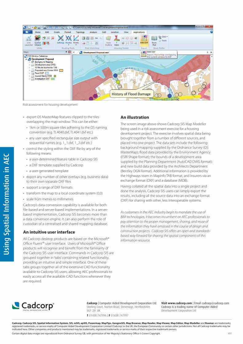
An illustration The screen image above shows Cadcorp SIS Map Modeller being used in a risk assessment exercise for a housing development project. The exercise involves spatial data being brought together from a number of diff erent sources, and placed into one project. The data sets include the following: background mapping supplied by the Ordnance Survey (OS MasterMap); fl ood data provided by the Environment Agency (ESRI Shape format); the bounds of a development area supplied by the Planning Department (AutoCAD DWG format); and new build data provided by the Architects Department (Bentley DGN format). Additional information is provided by the Highways team in MapInfo TAB format, and Insurers via an exchange format (DXF) and a database (MDB).
Having collated all the spatial data into a single project and done the analysis, Cadcorp SIS users can simply export the results, including all the source data into an exchange format (DXF) for sharing with other, less interoperable systems.
As customers in the AEC industry begin to mandate the use of BIM technologies, it becomes incumbent on AEC professionals to pay attention to the proper management, sharing, and reuse of the information they have amassed in the course of design and construction projects. Cadcorp SIS off ers an open and standards-based way forward for sharing the spatial components of this information resource.
Cadcorp | Computer Aided Development Corporation LtdSterling Court, Norton Road, Stevenage, Hertfordshire. SG1 2JY. UK
T 01438 747996 | F 01438 747997
Cadcorp, Cadcorp SIS, Spatial Information System, SIS, mSIS, apSIS, Powermap, MapTips, GeognoSIS, Map Browser, Map Reader, Map Viewer, Map Editor, Map Modeller and Roamer are trademarks, registered trademarks, or service marks of Computer Aided Development Corporation Limited (Cadcorp) in the UK, the European Community or certain other jurisdictions. Not all Cadcorp trademarks may be indicated here. Other companies and products mentioned may be trademarks, registered trademarks or service marks of their respective trademark owners.
Certain digital data images are reproduced from Ordnance Survey GB, with permission of Her Majesty’s Stationery Offi ce © Crown Copyright.
Visit www.cadcorp.com | Email [email protected] Cadcorp is a trading name of Computer Aided Development Corporation Ltd
Risk assessment for housing development
V01