c yclin g m ap - hornsby shire · pdf filec yclin g m ap u sin g th is m ap fu rth er en q u...

3
Hornsby Shire Council Cycling Map using this map further enquiries or copies of the map contact: Warning: cycling may present some risk of injury. Cyclists are recommended to always wear appropriate protective equipment. When cycling on an unfamiliar route, proceed with care. Children should be subject to parental supervision. Although every care has been taken, no responsibility is accepted for error or omissions. CUSTOMER SERVICE (02) 9847 6666 EMAIL [email protected] WEB www.hornsby.nsw.gov.au/recreation FAX (02) 9847 6999 TTY (02) 9847 6577 major cycle routes across Hornsby bike riding rules bicycle parking locations cycle paths and other cycle facilities contact details local cycle routes across Hornsby Sustainable Action Committee This map is designed to help you find the best way of getting around Hornsby by bicycle. The highlighted routes are not always the most direct routes but are usually the best for riding a bike. Marked on road cycling routes We have shown the marked cycle routes which have signs on poles or logos on the road. Useful cycling routes These are mainly routes chosen to avoid major hills or busy roads and intersections. Green routes are generally low difficulty routes. Purple or moderate difficulty routes have more traffic and are more challenging. Brown or high difficulty routes are the most challenging and should only be used by experienced cyclists. In order to follow a more direct route or to avoid busy roads it is often necessary to climb steep hills. To assist you in choosing a route we have marked the hillier sections with arrows. The arrows point up the hill so you can plan your routes accordingly. Unsealed tracks and trails suitable for mountain bikes These are mainly firetrails or management trails which can be used by mountain bikers. Conditions vary so exercise care and ride within your abilities. Cycle paths There are some cycle paths that pass through parks in Hornsby and occasionally travel on signposted shared footpaths/cycleways. These are often important links and provide low stress options for beginning cyclists. Children’s cycle tracks Several children's facilities in parks have been shown. Each is a closed track providing a safe environment and is a good place to practice riding a bike. These venues often also provide toilets and BBQ facilities for family outings. Hornsby-Pennant Hills Follow College Cs, R onto Clark Rd, L onto Malsbury Rd and continue onto Milson Pde and Sefton Rd then turn L onto Chilvers, follow signposts through lights then follow the Esplanade and Yarrara Rd to Pennant Hills. Hornsby-Bobbin Head-Turramurra (or return to Hornsby) This popular recreational route starts at Hornsby, continue northwards using the routes indicated on the map to reach Ku-ring-gai Chase Rd. A nice ride through the bushland with a steep descent to Bobbin Head where you can reward yourself with spectacular water views. A steep climb back to Turramurra then follow the backstreets to return to Hornsby. Can be busy on weekends. Westleigh-Pennant Hills Follow Quarter Sessions Rd to the south of Duffy Ave then turn right onto Timbarra Rd then travel through the bush along a wide cycleway and continue along Bellamy St and Ramsay Rd to Pennant Hills station. Hornsby currently has bicycle parking racks and rails which includes most railway stations, shopping centers and carparks. For bicycle parking locations and updates visit www.hornsby.nsw.gov.au. For details on how to hire a bike locker phone Bicycle NSW on (02) 9281 4099. Riders of bicycles should: Correctly wear an approved helmet, with straps fitting snugly under the chin. Obey all the road rules. Ride on the left side of a road unless signposted otherwise. Only ride on a footpath if aged 12 years or less or accompanying a child under 12 years age. Use a bicycle lane if one is marked on the road, unless impracticable to do so. Always use hand signals when turning or stopping. Walk, not ride, across pedestrian crossings. Travel no more than 1.5 metres apart if riding two abreast. Slow down on a cycle path when pedestrians are present and warn pedestrians of your approach. Cycle only on firetrails or management trails in bushland or parks. It is illegal to cycle on designated walking tracks. All bicycles must: Be fitted with an effective brake and a bell, horn or similar warning device. If used at night have a steady or flashing white light on the front and a red reflector and red light at the rear. Cherrybrook-Pennant Hills Start at Francis Greenway Dve near Pecan Cl in Cherrybrook and cycle up and down a steep unsealed firetrail to exit at Laurence St in Pennant Hills. Pennant Hills-Epping At the eastern end of Pennant Hills Park you can join the mostly unsealed Whale Rock Track which connects with North Epping at Boundary Rd via a firetrail, or with Macquarie University and M2 via a cycleway near Browns Waterhole. Epping-Macquarie University Cycle east along Pembroke St, cross Epping Rd at the pedestrian lights then continue along Pembroke St, walk across Terrys creek bridge to connect with Ryde Council cycleway. Small sealed cycle paths suitable for beginners Asquith, Lessing St Playground Hornsby, Holman Park Mt Colah, Parklands Oval Mt Colah, Oxley Drive Reserve Normanhurst, Charles Curtis Playground North Epping, North Epping Oval West Pennant Hills, Edward Bennett Oval Westleigh, Ruddock Park Castle Hill, Erlestoke Place Other sealed cycle paths suitable for all cyclists Asquith, Mills Park Cherrybrook, Greenway Park Hornsby Heights, Rofe Park Hornsby Heights, Crosslands Reserve Westleigh – Pennant Hills, Timbarra Cycleway Unsealed cycle tracks Arcadia, Fagan Park Hornsby Heights, Hopeville Park BMX Track Fiddletown, Coba Ridge Firetrail, end Bloodwood Rd Skate parks suitable for BMX freestyle use Cherrybrook, Greenway Park Brooklyn, Skate Ramp near Baden Powell St Hornsby Heights, Hopeville Park Baulkham Hills Council PO Box 75 Castle Hill NSW 2154 129 Showground Road Castle Hill NSW 2154 Ph: 02 9843 0555 Ku-ring-gai Council Locked Bag 1056 Pymble NSW 2073 818 Pacific Hwy Gordon NSW 2072 Ph: 02 9424 0888 Parramatta Council PO Box 32 Parramatta NSW 2124 30 Darcy Street Parramatta NSW 2124 Ph: 02 9806 5000 Ryde Council Locked Bag 2069 North Ryde NSW 1670 1 Devlin Street Ryde NSW 2112 Ph: 02 9952 8222 Bicycle NSW GPO Box 272 Sydney NSW 2001 Ph: 02 9218 5400 www.bicyclensw.org.au Bike North PO Box 719 Gladesville NSW 1675 www.bikenorth.org.au Cherrybrook Marked cycle routes along roads Purchase Rd/Eldridge St/Francis Greenway/Macquarie Dve. Connect with unsealed firetrails at various locations including Pecan Cl where you can join a steep unsealed firetrail which links with Schofields Pde in Pennant Hills. Berowra Heights Cycle along Berowra Waters Rd or along Woodcourt Rd and Alan Rd. Connect with unsealed firetrails at Ti Tree Cr, Berkeley Cl, Warrina St or off Gully Rd. Mt Colah Cycle along Excelsior Rd, Beryl Ave and Oxley Dve. Hornsby Heights Cycle along mostly marked cycle route along Galston Rd and Somerville Rd. Reach Asquith Station along Sutton Link St and Amor St. Connect with unsealed firetrails at Clarinda St, opp Rofe Park, the Outlook, Montview Pde. Asquith Cycle from Asquith to Hornsby along Haldane St/ Heath/Lockwood/Lessing/Stephen/Railway Pde. Epping Cycle along mostly marked cycle route on Norfolk Rd and parts of Oxford St. Cycle to Macquarie University by following Pembroke St to the east where you will need to walk across the Terrys Creek bridge to join with the cycleway on the Ryde side which joins Vimiera Rd. Carlingford Cycle to western end of Murray Farm Rd to join cyclepath leading to M2. This Cycling Map was an initiative of Council's Sustainable Action Committee (SAC). SAC aims to improve quality of life by making sure our community, environment and economy are respected and equitably sustained. SAC provides residents, businesses, institutions and Council with a forum to meet others who are committed to making a difference, whilst learning, making decisions, developing strategies and undertaking projects such as this Cycling Map that contribute to the Shire's vision of creating a living environment... ENJOY YOUR CYCLING and take reasonable care. ALWAYS WEAR YOUR HELMET

Upload: phamdang

Post on 25-Mar-2018

213 views

Category:

Documents


0 download

TRANSCRIPT

Hornsby Shire Council

CyclingMap

using this map

further enquiriesor copies of the map contact:

Warning: cycling may present some risk of injury.• Cyclists are recommended to always wear appropriate protective

equipment.• When cycling on an unfamiliar route, proceed with care.• Children should be subject to parental supervision.• Although every care has been taken, no responsibility is accepted for

error or omissions.

CUSTOMER SERVICE

(02) 9847 6666EMAIL

[email protected]

www.hornsby.nsw.gov.au/recreationFAX

(02) 9847 6999TTY

(02) 9847 6577

major cycle routesacross Hornsby

bike riding rules

bicycle parkinglocations

cycle paths andother cycle facilities

contact details

local cycle routesacross Hornsby

Sustainable ActionCommitteeThis map is designed to help you find the best way of

getting around Hornsby by bicycle.The highlighted

routes are not always the most direct routes but are

usually the best for riding a bike.

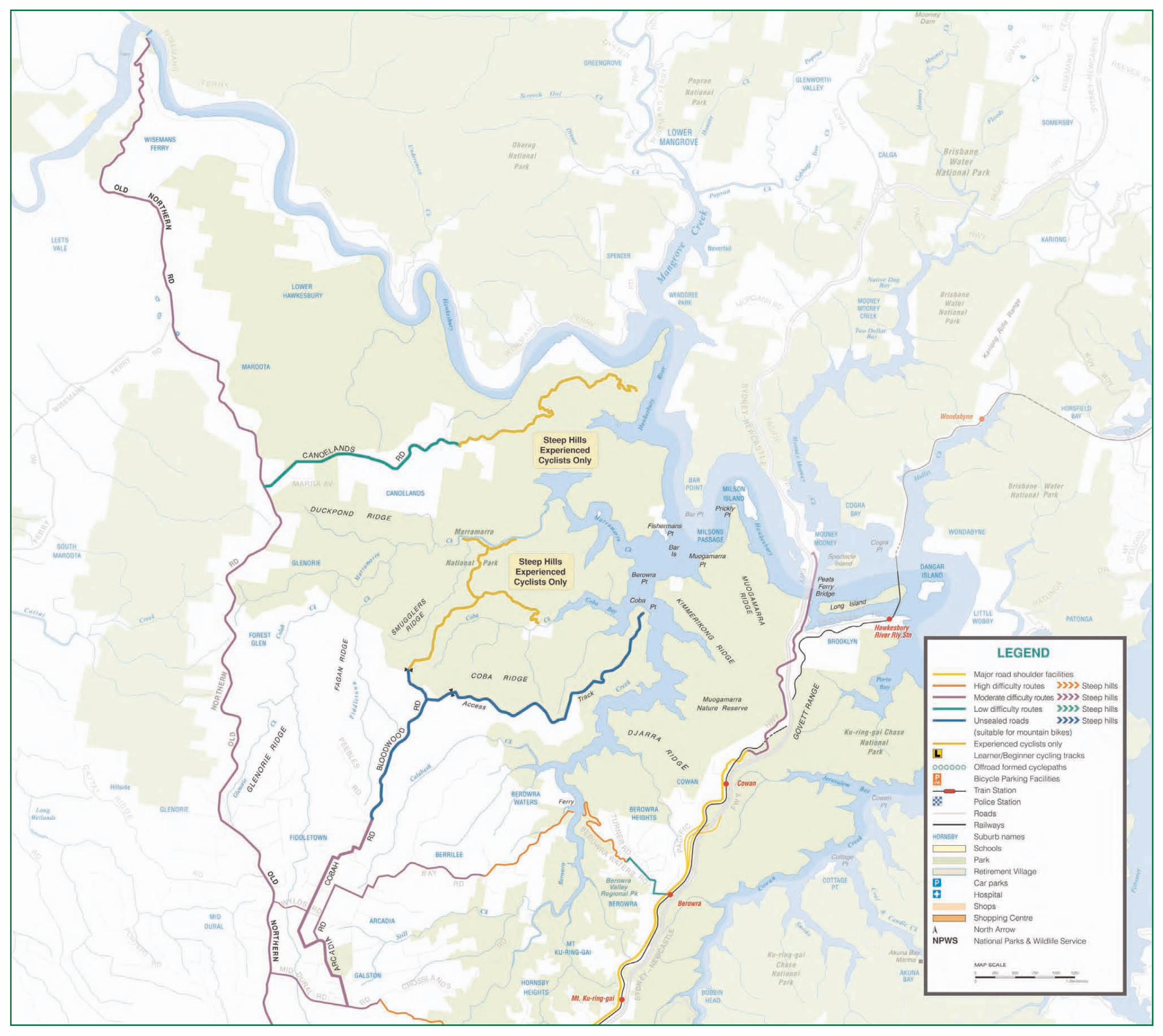
Marked on road cycling routesWe have shown the marked cycle routes which have signs on poles or logos on the road.

Useful cycling routesThese are mainly routes chosen to avoid major hills or busyroads and intersections. Green routes are generally low difficulty routes. Purple or moderate difficulty routes havemore traffic and are more challenging. Brown or high difficulty routes are the most challenging and should onlybe used by experienced cyclists. In order to follow a moredirect route or to avoid busy roads it is often necessary toclimb steep hills. To assist you in choosing a route we havemarked the hillier sections with arrows. The arrows point upthe hill so you can plan your routes accordingly.

Unsealed tracks and trails suitable for

mountain bikes These are mainly firetrails or management trails which can be used by mountain bikers. Conditions vary so exercise care and ride within your abilities.

Cycle pathsThere are some cycle paths that pass through parks in Hornsby and occasionally travel on signposted shared footpaths/cycleways. These are often important links and provide low stress options for beginning cyclists.

Children’s cycle tracksSeveral children's facilities in parks have been shown. Each is a closed track providing a safe environment and is a good place to practice riding a bike. These venues often also provide toilets and BBQ facilities for family outings.

Hornsby-Pennant HillsFollow College Cs, R onto Clark Rd, L onto Malsbury Rd and continue onto Milson Pde and Sefton Rd then turn L onto Chilvers, follow signposts through lights then follow the Esplanade and Yarrara Rd to Pennant Hills.

Hornsby-Bobbin Head-Turramurra

(or return to Hornsby)This popular recreational route starts at Hornsby, continue northwards using the routes indicated on the map to reachKu-ring-gai Chase Rd. A nice ride through the bushlandwith a steep descent to Bobbin Head where you canreward yourself with spectacular water views. A steepclimb back to Turramurra then follow the backstreets toreturn to Hornsby. Can be busy on weekends.

Westleigh-Pennant Hills Follow Quarter Sessions Rd to the south of Duffy Ave then turn right onto Timbarra Rd then travel through the bush along a wide cycleway and continue alongBellamy St and Ramsay Rd to Pennant Hills station.

Hornsby currently has bicycle parking racks and rails which includes most railway stations,shopping centers and carparks. For bicycle parking locations and updates visit www.hornsby.nsw.gov.au.

For details on how to hire a bike locker phone Bicycle NSW on (02) 9281 4099.

Riders of bicycles should:• Correctly wear an approved helmet, with

straps fitting snugly under the chin.• Obey all the road rules.• Ride on the left side of a road unless

signposted otherwise.• Only ride on a footpath if aged 12 years or less or

accompanying a child under 12 years age.• Use a bicycle lane if one is marked on the road,

unless impracticable to do so.• Always use hand signals when turning or stopping.• Walk, not ride, across pedestrian crossings.• Travel no more than 1.5 metres apart if riding two

abreast.• Slow down on a cycle path when pedestrians are

present and warn pedestrians of your approach.• Cycle only on firetrails or management trails in

bushland or parks. It is illegal to cycle on designated walking tracks.

All bicycles must:• Be fitted with an effective brake and a bell, horn or

similar warning device.• If used at night have a steady or flashing white light

on the front and a red reflector and red light at the rear.

Cherrybrook-Pennant HillsStart at Francis Greenway Dve near Pecan Cl in Cherrybrook and cycle up and down a steep unsealed firetrail to exit at Laurence St in Pennant Hills.

Pennant Hills-EppingAt the eastern end of Pennant Hills Park you can join the mostly unsealed Whale Rock Track which connects with North Epping at Boundary Rd via a firetrail, or with Macquarie University and M2 via a cycleway near Browns Waterhole.

Epping-Macquarie University Cycle east along Pembroke St, cross Epping Rd at the pedestrian lights then continue along Pembroke St, walk across Terrys creek bridge to connect with Ryde Council cycleway.

Small sealed cycle paths suitable for

beginnersAsquith, Lessing St PlaygroundHornsby, Holman ParkMt Colah, Parklands Oval Mt Colah, Oxley Drive Reserve Normanhurst, Charles Curtis PlaygroundNorth Epping, North Epping OvalWest Pennant Hills, Edward Bennett OvalWestleigh, Ruddock ParkCastle Hill, Erlestoke Place

Other sealed cycle paths suitable for all

cyclistsAsquith, Mills ParkCherrybrook, Greenway ParkHornsby Heights, Rofe ParkHornsby Heights, Crosslands ReserveWestleigh – Pennant Hills, Timbarra Cycleway

Unsealed cycle tracks Arcadia, Fagan ParkHornsby Heights, Hopeville Park BMX TrackFiddletown, Coba Ridge Firetrail, end Bloodwood Rd

Skate parks suitable for BMX freestyle use Cherrybrook, Greenway Park Brooklyn, Skate Ramp near Baden Powell St Hornsby Heights, Hopeville Park

Baulkham Hills

CouncilPO Box 75Castle Hill NSW 2154129 Showground RoadCastle Hill NSW 2154Ph: 02 9843 0555

Ku-ring-gai CouncilLocked Bag 1056Pymble NSW 2073818 Pacific HwyGordon NSW 2072Ph: 02 9424 0888

Parramatta Council PO Box 32Parramatta NSW 212430 Darcy StreetParramatta NSW 2124Ph: 02 9806 5000

Ryde Council Locked Bag 2069North Ryde NSW 16701 Devlin StreetRyde NSW 2112Ph: 02 9952 8222

Bicycle NSW GPO Box 272Sydney NSW 2001Ph: 02 9218 5400www.bicyclensw.org.au

Bike North PO Box 719Gladesville NSW 1675www.bikenorth.org.au

CherrybrookMarked cycle routes along roads Purchase Rd/Eldridge St/Francis Greenway/Macquarie Dve. Connect with unsealed firetrails at various locations including Pecan Cl where you can join a steep unsealed firetrail which links with Schofields Pde in Pennant Hills.

Berowra Heights Cycle along Berowra Waters Rd or along Woodcourt Rd and Alan Rd. Connect with unsealed firetrails at Ti Tree Cr, Berkeley Cl, Warrina St or off Gully Rd.

Mt ColahCycle along Excelsior Rd, Beryl Ave and Oxley Dve.

Hornsby Heights Cycle along mostly marked cycle route along Galston Rd and Somerville Rd. Reach Asquith Station along Sutton Link St and Amor St. Connect with unsealed firetrails at Clarinda St, opp Rofe Park, the Outlook, Montview Pde.

AsquithCycle from Asquith to Hornsby along Haldane St/Heath/Lockwood/Lessing/Stephen/Railway Pde.

Epping Cycle along mostly marked cycle route on Norfolk Rd and parts of Oxford St. Cycle to Macquarie University by following Pembroke St to the east where you will need to walk across the Terrys Creek bridge to join with the cycleway on the Ryde side which joins Vimiera Rd.

CarlingfordCycle to western end of Murray Farm Rd to join cyclepath leading to M2.

This Cycling Map was an initiative of Council'sSustainable Action Committee (SAC). SAC aims toimprove quality of life by making sure our community,environment and economy are respected and equitably sustained. SAC provides residents, businesses, institutions and Council with a forum tomeet others who are committed to making a difference, whilst learning, making decisions, developing strategies and undertaking projects suchas this Cycling Map that contribute to the Shire'svision of creating a living environment...

ENJOY

YOUR

CYCLINGand take

reasonable care.

ALWAYS

WEAR

YOUR

HELMET