by the distance most people will typically be willing ... 2008/student materials... · by the...
TRANSCRIPT

�
�. Apedestrianshed,orcatchmentarea,isdeterminedbythedistancemostpeoplewilltypicallybewillingto walk and is generally defined as a five minute walk to the centre of each neighbourhood, creating a unit of approximately ¼ mile (Watson et al. 2003). Studies at the Port of New York Authority bus terminal found that a 5-7 minute walk is typically the maximum amount people will walk although this varies somewhat depending on the trip purpose, walking environment and available time (Watsonetal.2003).
Chapter Four: Five minute walking distance to commercial services and frequent transit.
The walk to the storeNorth Americans will walk only if it’s easier than driving. The break point for walking trips seems to be the five minute walk,�which is approximately one quarter mile or 400 meters. Most people think that walking five minutes is easier then firing up the car, pulling it out of a parking space, negotiating streets, finding a place to park, and exit. Humans are incredibly sensitive to the minor benefits and costs of choosing one mode over the other, no matter how short the trip. Naturally some people will choose to make longer walks, while others will opt for the car even if the walk is ridiculously short, but the average is five minutes. Certainly people in other cultures where they do not have ready access to the car will make longer walk trips. They have no choice. But in our culture five minutes is about the maximum we can expect, no matter how much we wish it otherwise.
But the five minute rule is meaningless if there is no place to walk to. Many projects build in nature and walking trails as a means to provide walking destinations, but while these trails may be used every day by people who are in the habit of walking and jogging for exercise, the average person will use them much less regularly. For the average person the most compelling destination for regular walking is to the corner store. If a convenience store is located less than a five minute walk from home the average person will walk there many times a week to pick up bread, eggs,milk,newspapersand,darewesay,cigarettesandlotterytickets as well. In suburban sprawl locations, the five minute rule holds, but in a very different way. There you will usually find “gas and go” stores distributed evenly throughout the suburban matrix, but at five minute drive distance; these stores are usually inaccessible by foot, further exacerbating auto dependence in theselandscapes.
If the basic corner store is joined by video rentals, bakeries, taverns and cafes then all the better. It is that much more likely thatwalkingwillbeadailypartoflifefornearbyresidents.If conditions are perfect and these stores are joined by coffee shops, hairdressers, hardware stores, used book stores, fruit and vegetable stands, pizza shops, accountants, dentists, and the local Subway sandwich shop. When commercial areas reach the point at which most of your daily commercial needs can be met within walking distance, not only do you walk more but you use
The corner store below is located within a five minute walk of residences in a more densely populated neigh-bourhod. The gas station on the other hand is located within a five minute drive in a low density subdivision.
Figure X. Corner store
Figure X. Gas station
Figure X. The shaded circles above indicate a 10 minute walking radius as the crow flies. The blue lines indicate a 10 minute walking radius that follows the street network. As you can see the area that can be reached within a 10 minute walk in a dendritic street netowrk is substantially smaller than what can be accessed in the same amount of timeinaninterconnectedstreetnetwork.

2
the car significantly less. Residents of Vancouver, where most residentscansatisfytheirdailycommercialneedsonnearbystreetcar arterials, use their car s 30% less than do residents of South Surrey/Langley, BC, a newer car oriented community. Residents of Vancouver also own fewer cars, 1.25 per family compared to1.7 per family in Surrey. B.C.2Accesstocommercialservices and frequent transit seems to explain these differences, as average family income in the two communities is nearly the same.
Among sustainable community advocates the five minute walk rule has become axiomatic. However, it is usually imagined and applied as a walking distance radius or circle surrounding some fixed commercial point. This is indeed the way it works if there is only a small commercial node with one or two stores, but in Vancouver and other Streetcar Cities the situation is different. In vibrant Streetcar Cities, commercial activates spread along the streetcar arterial until in many cases they form a continuous frontageofcommercialestablishmentsmanymileslong.Whenthis occurs the five minute walk is no longer a circle but rather a continuous band that extends ¼ mile perpendicular in both directions to the streetcar arterial. The basic pattern for Streetcar Cities is a grid of streetcar arterials spaced at half mile intervals.3This means that everyone will be within a five minute or quarter milewalkofsomestreetcararterial,andoftenabletochoosebetween two. These long linear commercial corridors comprise the bulk of public realm spaces in streetcar cities. This linear public realm, so characteristic of most North American cities, has implications for our understanding of their qualitative aspects –their“senseofplace”.
Sense of place in corridors
It is not unkind to say that North American planners and urban designers have been very focused on identifying places worthy of preserving, and in fostering new places worthy of caring about. Naturally they identify a location here and a location there for their attention, and apply the best teachings of Kevin Lynch and any of a number of other planning theorists to these crucial locations. It seems likely that their training and good intentions have made it difficult to cherish the seemingly undifferentiated linear corridors that are such a humble and ubiquitous datum for our experiences in most gridded cities. It may be that this inattention to the meaning and value of the corridor came from the careful study of older European and east cost cities whose web of streets usually focused on key “five corner” intersections or squares as in Kevin Lynch’s Boston.4 Whatever the motivation, it is indeed surprising how little attention has been
2. According to Metro Vancouver’s Livable region Strategic Plan 2000 Report, 22% of households in Vancouver don’t own a car and only 26% have two or more cars while in Surrey and Delta only 5% of households don’t have a car and 52% have two or more. In January 2000 there were 1,172,866 vehicles licensed in the GVRD and an overall rate of car ownership of 1.5 cars per household across the entire region (Metro Vancouver 2000). Between 1995 and 2005 the rate of vehicle ownership per household in the GVRD has remained relatively stable at 1.5 however there is significant variation within the region (BC Stats; ICBC). The Burrard Peninsula (including the Cities of Vancouver, Burnaby, New Westminister, Port Moody, Coquitlam, and Port Coquitlam) has maintained a lower rate of vehicle ownership per household at approximately 1.25 while the rest of the GVRD, including the Cities of Abbotsford, Delta, Langley, North Vancouver, Pitt Meadows, Richmond, Surrey and White Rock, fluctuates around 1.7 vehicles per household (BC Stats; ICBC). South Surrey/Langley residents took about the same number of trips as residents in Vancouver but 88% were by automobile (Canadian Facts 2000a) as opposed to 58% in Vancouver (Canadian Facts 2000b).
3. Figure X. below shows the historic grid of streetcar arterials in Vancouver, BC distributed in regular intervals. A five minute walking distance is indicated along 4thAvenue in Kitsilano. As you can see the majority of the Vancouver is within a 5 minute walk of a historic streetcararterial.
1/2 mile
Greater Vancouver StreetCarTracks 1889 to 1928
5 minute walk
4. “Five corner” intersection: Lynch, K. (1960) “The Image of the City” MIT Press.

3
paid to this especially North American urban form: the linear commercial corridor or the streetcar arterial. If one accepts the proposition that suburban auto oriented areas are virtually devoid of public realm space, then streetcar streets were and still are the most commonly experienced and widely distributed urban public realmspaceinNorthAmerica.
What appears to outsiders to be miles of undifferentiated shops appears quite different to those who use these corridors every day. Local users do not experience the relentless miles of the corridor but rather the transition from their residential block to the more active arterial. Along the way they might pass the community school, a number of gardens, some townhouses on theblockclosertothecorridor,andthenthestreetcararterialitself. Once at the arterial they turn either 90 degrees right or 90 degrees left to take advantage of services on the two or three blocks in either direction. Thus their sense of the place is determined by their walk to the arterial and their eventual familiaritywiththeblocksimmediatelyineitherdirection.People who live two or three blocks away in one or the other direction will have a similar and overlapping, but not identical experiences. Some of the shops they use will be the same, others different. Some of the people they encounter frequently will be the same, others different. In this way corridors are quite unique and different than centers. They allow for shared and similar experiences but experiences that gradually change depending on where you reside along the corridor. Vibrant streetcar streets are experientially very rich, with busses or streetcars arriving and departing every few minutes, familiar shopkeepers sweeping sidewalks, denizens of ethnic social clubs arguing on sidewalks, school kids duck walking to the local library branch, and teens showing off to the opposite sex. They offer a unique dialectic betweenofthefreedomofactionallowedbytheapparentlyinfinite length of the corridor and the proxemic familiarity that characterizes the best of village environments. More can and should be said about these undervalued and academically overlooked spaces, but for our purposes it is only necessary to establish an argument in support of their experiential quality, as the Streetcar City principle must work in both practical and experiential terms to be of value. This discussion of the experiential value of the corridor is not intended to supplant the articulate explorations of the sense of place attributable to urban centers, just to give corridors equal standing. Rather than repeat all the eloquent arguments of Norberg-Schulz, Christopher Alexanderandothers,5 they are simply included by reference and accepted as equally valid.
4th Ave @ Bayswater St.
4th Ave @ Balaclava St.
4th Ave @ Trutch St.
4th Ave @ Blenheim St.
4th Ave @ Waterloo St.
4th Ave @ Collingwood St.
4th Ave @ Dunbar St.
4th Ave @ Alma St.
Alm
a
Dun
bar
Colli
ngw
ood
Wat
erlo
o
Blen
heim
Trut
ch
Bala
clav
a
Bays
wat
er
Mac
Don
ald
4th Avenue
The images below show the experiential diversity along the Fourth Avenue in Vancouver.
5. See: Norberg-Schulz, Christian. 1980. Genius Loci, Towards a Phenomenology of Architecture Rizzoli, New York and Alexander, Christopher. 1977. A Pattern Language: Towns, Buildings, ConstructionOxfordUniversity Press, USA.

4
Transit
Transit has a synergistic relationship with walking distance commercial. If the solitary corner store has a bus stop outside, both the store and the transit service are enhanced. The store is enhanced when bus riders pop in to buy a newspaper before jumping on the bus. The transit service is enhanced because riders can now use the trip to the bus to do morethanonething– ride to work and pick up the paper, ride back from work and pick up milk – making the bus that much more attractive. The more commercial functions at thestopthebetter,asthismakesit more even more possible to “trip chain,” meaning performingmorethanoneerrandonthesametrip.
On streetcar arterials trip chaining is even easier. Riders can hop off the bus or streetcar tostopatthepharmacy,thetoystore,theradioshack,orthewineshop,thenhopbackon to continue their trip home. In this way, stores located along highly functional streetcar corridors gain customers from both the pedestrian walking and transit users passing on thecorridor.
Bus or Streetcar Headways
For many transit authorities the seven minute headway is the Holy Grail. At headways of seven minutes or less, meaning a bus or streetcar stopping at a stop every seven minutes or less, users no longer need to consult schedules. They know that their wait will be four minutes on average, sometimes less sometimes more, but never more than seven minutes. These waits are insignificant in the minds of most riders, making it that much more likely they will use transit.
In suburban areas of Vancouver the transit authority has successfully provided bus service within a five minute walk of almost all homes (thanks to the legacy of the agricultural grid and its quarter section roads on the half mile interval). Thus the five minute access to transit is accomplished, but unfortunately not the seven minute headways. In auto oriented areas of the region transit ridership captures only a few percent of all trips. Most destinations require one or two transfers, thus taking many times longer than car trips, while destinations such as shopping malls are notoriously unfriendly for transit customers on arrival. With so many disincentives for transit built into the suburban dendritic street system it is no surprise there are so few customers. With so few customers to serve, transit officials are hard pressed to provide buses more frequently than every half hour, with buses only every hour common on many routes. At these headways users must organize their whole day around the
5
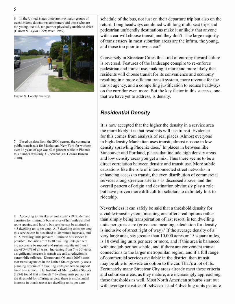
schedule of the bus, not just on their departure trip but also on the return. Long headways combined with long multi seat trips and pedestrian unfriendly destinations make it unlikely that anyone with a car will choose transit, and they don’t. The large majority of transit users in most suburban areas are the infirm, the young, andthosetoopoortoownacar.6
Conversely in Streetcar Cities this kind of entropy toward failure is reversed. Features of the landscape conspire to re-enforce pedestrian and transit use, making it more and more likely that residents will choose transit for its convenience and economy resulting in a more efficient transit system, more revenue for the transit agency, and a compelling justification to reduce headways on the corridor even more. But the key factor in this success, one that we have yet to address, is density.
Residential Density
It is now accepted that the higher the density in a service area themorelikelyitisthat residents will use transit. Evidence forthiscomesfromanalysisofrealplaces.Almost everyone in high density Manhattan uses transit, almost no-one in low densitysprawling Phoenixdoes.7 In places in between like Vancouver and Portland, places that include high densityareasand low density areas you get a mix. Thus there seems to be a direct correlation between density and transit use. More subtle causations like the role of interconnectedstreetnetworksinenhancing access to transit, the even distribution of commercialservices along streetcar arterials as discussed above, and the overall pattern of origin and destination obviously play a role but have proven more difficult for scholars to definitely link to ridership.
Nevertheless it can safely be said that a threshold density for a viable transit system, meaning one offers real options rather thansimplybeingtransportationoflastresort,istendwellingunits per gross acre (gross acre meaning calculation for density is inclusive of street right of way).8 If the average density of a very large area, say greater than 10,000 acres or 15 square miles, is 10 dwelling units per acre or more, and if this area is balanced with one job per household, and if there are convenient transit connections to the larger metropolitan region, and if a full range of commercial services available in the district, then transit may be able to provide an option to the car. That’s a lot of ifs. Fortunately many Streetcar City areas already meet these criteria and suburban areas, as they mature, are increasingly approaching those thresholds as well. Most North American suburbs start out with average densities of between 1 and 4 dwelling units per acre
6. In the United States there are two major groups of transit riders: downtown commuters and those who are too young, too old, too poor or physically unable to drive (Garrett & Taylor 1999; Wach 1989)
7. Based on data from the 2000 census, the commuter public transit rate for Manhattan, New York for workers over 16 years of age was 59.6 percent while in Phoenix this number was only 3.3 percent (US Census Bureau 2000).
8. According to Pushkarev and Zupan (1977) demand densities for minimum bus service of half mile parallel route spacing and hourly bus service can be attained at 4.5 dwelling units per acre. At 7 dwelling units per acre this service can be sustained at 30 minute intervals, and at 15 dwelling units per acre 10 minute bus service is possible. Densities of 7 to 30 dwelling units per acre are necessary to support and sustain significant transit use of 5-40% of all trips. Increasing from 7 to 30 yields a significant increase in transit use and a reduction in automobile reliance. Dittmar and Ohland (2003) state that transit agencies in the United States generally use a planning criteria of 7 dwelling units per acre to support basic bus service. The Institute of Metropolitan Studies (1994) found that although 7 dwelling units per acre is the threshold for offering service, there is a substantial increase in transit use at ten dwelling units per acre.
Figure X. Lonely bus stop
6
gross. Newer suburban areas in many parts of the nation, Las Vegas for example, are higher at about 7 dwelling units per gross acre.9 Other metropolitan areas are finding ways to add density to previously built low density areas. Vancouver and Portland for example are adding density and jobs to formerly car dependent areas in numbers that make it possible to provide additional transit service and anticipate viable commercial services in walking distance in locations that could not previously support them.
The ten dwelling unit per acre is usually an accepted figure for busses. For streetcars or trams the accepted figure is closer totwicethat.�0 Densities of 17 to 25 du per gross acre are not uncommon in Streetcar Cities and not unachievable in new communities. Also, as discussed in the chapter on Streetcar City, there are other reasons for investing in streetcar than ridership which may make streetcar an intelligent economic development strategy at average densities between 10 and 20 dwelling units pergrossacre.
The greatest opportunity for making suburbs more sustainable is alongstripcommercialcorridors.Whilewholescalealterationsof the dominant single family fabric are not conceivable in most suburban communities, the gradual intensification of low density commercial strips is. These vast areas that typically have a residential density of close to zero could easily accept redevelopment where the residential component could be 40 dwelling units per gross acre or more. Conversions of this type are already widespread in the Vancouver and Portland areas.��As
9. Currently the density of Las Vegas’ suburbs peaks between 5 and 6 dwelling units per acre (US Census 2000) but a new higher density community being built in the CDP of Summerlin will have a density of 7 dwelling units per acre (Robinson 2005).
10. The research doesn’t support the assertion that light rail requires twice the density:
Pushkarez and Zupan (!997) found that 7 to 15 dwelling units per acre can support moderate levels of convenient transit of all type including light rail which is reasonably sustained at 9 to 12 dwelling units per acre. Cercero (1984), Calthorpe (1993) and Lowe (1992) all cite 9 to 10 dwelling units per acre as the minimum density to support light rail.
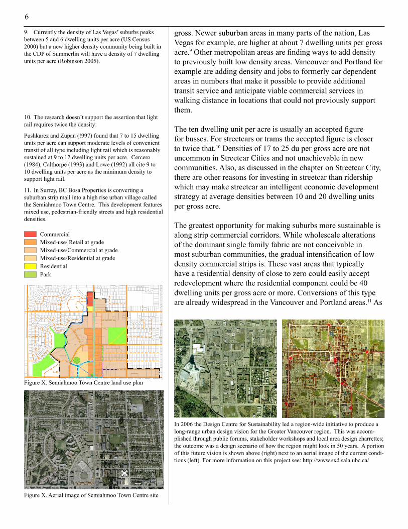
11. In Surrey, BC Bosa Properties is converting a suburban strip mall into a high rise urban village called the Semiahmoo Town Centre. This development features mixed use, pedestrian-friendly streets and high residential densities.
CommercialMixed-use/ Retail at gradeMixed-use/Commercial at gradeMixed-use/Residential at gradeResidentialPark
Figure X. Aerial image of Semiahmoo Town Centre site
Figure X. Semiahmoo Town Centre land use plan
In 2006 the Design Centre for Sustainability led a region-wide initiative to produce a long-range urban design vision for the Greater Vancouver region. This was accom-plished through public forums, stakeholder workshops and local area design charrettes; the outcome was a design scenario of how the region might look in 50 years. A portion of this future vision is shown above (right) next to an aerial image of the current condi-tions (left). For more information on this project see: http://www.sxd.sala.ubc.ca/
7
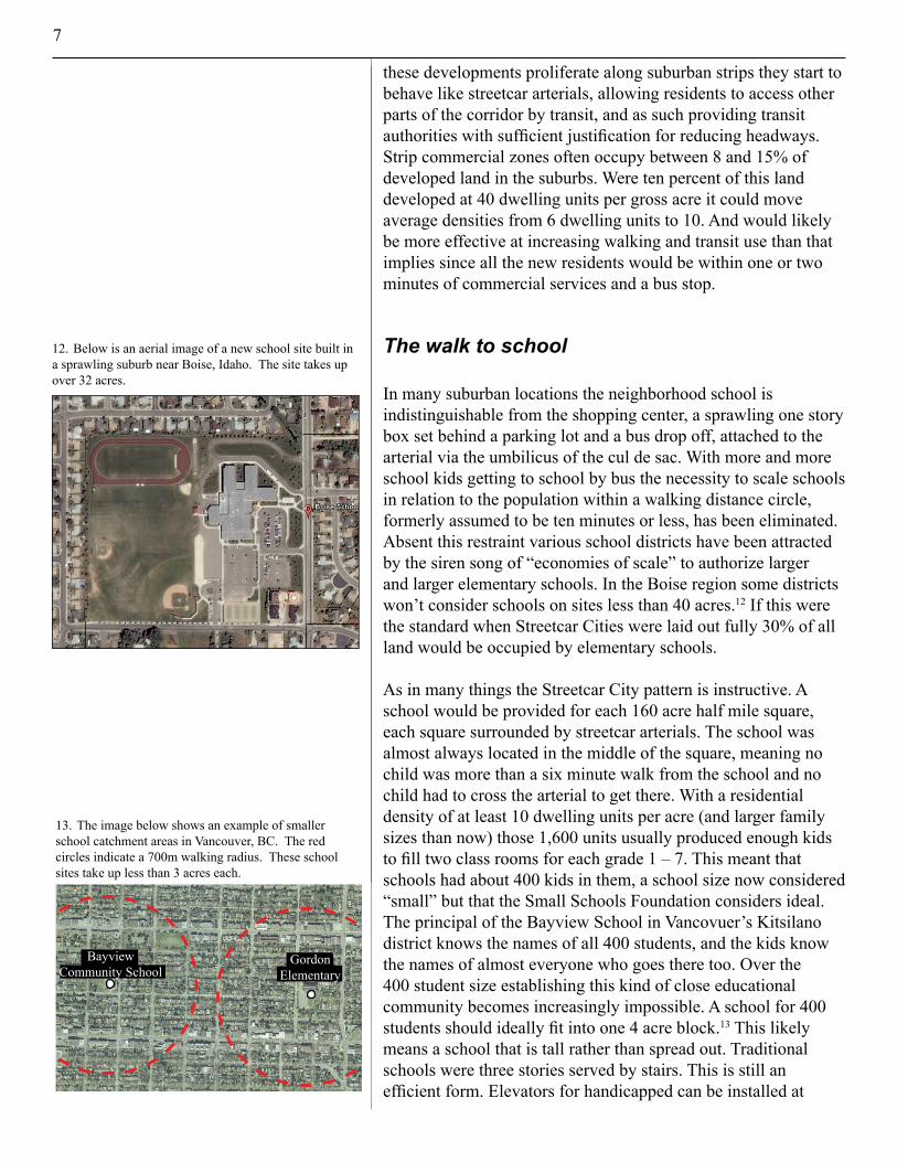
12. Below is an aerial image of a new school site built in a sprawling suburb near Boise, Idaho. The site takes up over 32 acres.
13. The image below shows an example of smaller school catchment areas in Vancouver, BC. The red circles indicate a 700m walking radius. These school sites take up less than 3 acres each.
330m
380m
Area = 335 x 385= 127 975 sq m= 32 acres
Boise School District: Treasure Valley Math and Science
Bayview Community School
Gordon Elementary
these developments proliferate along suburban strips they start to behave like streetcar arterials, allowing residents to access other parts of the corridor by transit, and as such providing transit authorities with sufficient justification for reducing headways. Strip commercial zones often occupy between 8 and 15% of developed land in the suburbs. Were ten percent of this land developed at 40 dwelling units per gross acre it could move average densities from 6 dwelling units to 10. And would likely be more effective at increasing walking and transit use than that implies since all the new residents would be within one or two minutes of commercial services and a bus stop.
The walk to school
In many suburban locations the neighborhood school is indistinguishable from the shopping center, a sprawling one story box set behind a parking lot and a bus drop off, attached to the arterial via the umbilicus of the cul de sac. With more and more school kids getting to school by bus the necessity to scale schools in relation to the population within a walking distance circle, formerly assumed to be ten minutes or less, has been eliminated. Absent this restraint various school districts have been attracted by the siren song of “economies of scale” to authorize larger and larger elementary schools. In the Boise region some districts won’t consider schools on sites less than 40 acres.�2 If this were the standard when Streetcar Cities were laid out fully 30% of all land would be occupied by elementary schools.
As in many things the Streetcar City pattern is instructive. A school would be provided for each 160 acre half mile square, each square surrounded by streetcar arterials. The school was almost always located in the middle of the square, meaning no child was more than a six minute walk from the school and no childhadtocrossthearterialtogetthere.Witharesidentialdensity of at least 10 dwelling units per acre (and larger family sizes than now) those 1,600 units usually produced enough kids to fill two class rooms for each grade 1 – 7. This meant that schools had about 400 kids in them, a school size now considered “small” but that the Small Schools Foundation considers ideal. The principal of the Bayview School in Vancovuer’s Kitsilano district knows the names of all 400 students, and the kids know the names of almost everyone who goes there too. Over the400 student size establishing this kind of close educational community becomes increasingly impossible. A school for 400 students should ideally fit into one 4 acre block.�3 This likely means a school that is tall rather than spread out. Traditional schools were three stories served by stairs. This is still an efficient form. Elevators for handicapped can be installed at

8
less cost than the building and land costs of sprawling one story schools. A three story school for 400 will have a footprint under an acre leaving three acres for recreation, enough for a large playground and a soccer field. Whatever parking is necessary should be accommodated on surrounding streets. The full perimeter of the block is usually more than ample for this purpose.
A 4 acre site will be a very hard sell with most school districts. The habit of large sites is so strong it won’t be easily overturned. The compromise is the two block site of 8 acres. The negative consequence of a two block site is that it marginally impedes interconnectivity and removes an additional 3 to 4% of land otherwise available for housing or services within the five minute walk circle, increasing the difficulty in achieving sustainable densities with the detached housing forms so heavily favored in manymetropolitanareas.
Conclusion
All of our efforts to get people out of cars and on their feet will be fruitless unless we can make walking easier than driving. And this is only possible if the things we need and want every day are within a five minute walk. If this five minute walk brings us to zones where busses and streetcars abound then it becomes equally convenient to hop on and hop off regularly, until at some point life without a car seems like not such a bad idea. None of this works without a balance between density, street network, frequent bus and streetcar headways, and even sensible locations for elementary schools. Miss one of these components and you compromise the others. Streetcar City models provide many lessons for reapplying to other newer contexts, and impel us to protect these features in landscapes where they are threatened. Creating new and retrofitting old communities for walkablility and options to the car will be the challenge of our time. The various monumental pathologies identified in the first chapter have their source in what seems like a humble decision. Should I drive to get that loaf of bread or walk? That decision amplified and repeated by many millions results in impossibly overloaded freeways and ridiculously expensive and unsustainable patterns of movement. Reconstructing our urban landscapes around the five minute walk is a key part of restoring health.