bx35 bus priority and safety improvements · bus priority corridors fordham rd/207 st/ univ....
TRANSCRIPT

1
Bx35 Bus Priority and Safety ImprovementsBronx Community Board 4 Municipal Services Committee | February 5, 2020

2
Table of Contents
• Planning & Outreach
• E.L Grant Highway
– Background
– Proposals
• E 167th St/E 168th St
– Background
– Proposals
• Next Steps
3
Planning & Outreach

4
Better Buses Action Plan
• Improve bus speeds by 25%
• Install 10-15 miles of new bus lanes per year
• Improve 5 miles of existing bus lanes per year
• Support MTA Bus Network Redesign efforts with borough bus priority plans

5
Bus Priority Corridors
Fordham Rd/207 St/
Univ. Heights Br
Gun Hill Rd
Tremont Av
Story Av
E 167-168 St
University
Av
E 149 St
E.L. Grant
Hwy
181 St /
Wash. Br
• NYCDOT analyzed Bronx
corridors to determine
where bus lanes and other
bus priority are most
needed• Both E.L. Grant Hwy and E
167th/E 168th St identified as
top Bronx corridors
• High ranking due to:
‒ High ridership & high volume of buses
‒ Slow and unreliable
bus service
‒ Important cross-
borough connections

6
Harlem River Bridge Access:
Connecting Communities
• Edward L Grant Highway identified as
priority project in the Connecting
Communities Plan (May 2018)
‒ Protected bicycle lane improves
bicycle and pedestrian safety and
enhances access to/from
Manhattan via Washington Bridge
‒ Over 350 cyclists and 515
pedestrians use the Washington
Bridge daily (7am-7pm)

7
Community Engagement to Date
Outreach
• Connecting Communities (Harlem River Bridge Access) 12 Workshops in Manhattan and the Bronx
‒ Hostos Community College on June 16, 2015 and March 23, 2016
‒ Mullaly Recreational Center on Sept 10, 2015
‒ Bronx Lebanon Hospital on March 29, 2016
On-bridge outreach
• MTA Bronx Bus Redesign / NYCDOT Better Buses Open Houses
‒ Bronx Museum on June 12, 2019
Presentation to Community Board 4 on November 26, 2019
Presentation to Community Board 3 on December 17, 2019
DOT will continue to identify and meet with community stakeholders throughout project development and implementation
8
E.L. Grant Highway

9
Background

10
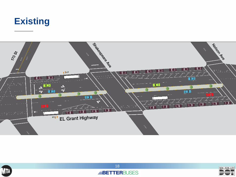
Existing Conditions
Double Parking
Unprotected Bike Lanes
Frequent Bus Service & High Ridership
Long Crossing Distances
11
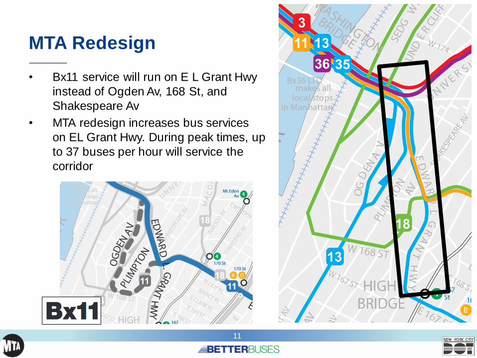
MTA Redesign
• Bx11 service will run on E L Grant Hwy
instead of Ogden Av, 168 St, and
Shakespeare Av
• MTA redesign increases bus services
on EL Grant Hwy. During peak times, up
to 37 buses per hour will service the
corridor

12
Bus Ridership
• After redesign, E L Grant Hwy will
carry over 26,000 daily passengers on the Bx11, Bx13, and Bx35‒ Total routes carry 56,000 daily
passengers
• 33% - 71% of people traveling on
corridor are on buses
• Despite high ridership, minimal space dedicated to buses,
resulting in slow bus speeds:
‒ 6.7 mph avg in AM Peak
‒ 5.7 mph avg in PM Peak
38% /
38%
39% /
37%
71% / 50%
49% / 33%
64% / 49%
% of roadway
users on buses(AM Peak / PM Peak)

13
Traffic Safety
Total
Injuries
Severe
InjuriesFatalities
Pedestrian 28 2 0
Bicyclists 15 3 0
Motor Vehicle
Occupant176 3 0
Total 219 8 0
Edward L Grant Hwy, Jerome Av – Cross Bronx Expwy
Injury Summary, 2013-2017 (5 years)
55
25
3
45
7
7
15
23
EL Grant is a Vision Zero Priority Area:
• 44 motorists, pedestrians, and
cyclists injured per year (2013-2017)
Injuries
(2013-
2017)
• Long crossing distances
• Unprotected bicycle facilities
• Wide roadway encourages speeding

14
Proposals

15
Toolbox - Transit
Bus Boarding Islands
Offset Bus LanesCenter Running Bus Lane
Physical Protection
E L Grant Hwy and Cross Bronx Expwy
161 St and Sherman AveWillis Ave and 144 St
Webster Ave and 167 St

16
Toolbox – Pedestrian and Bicycle Safety
Offset Crossings
Median Extension
Protected Bicycle Lane w/ Pedestrian Islands
4 Ave and 7 St, Brooklyn
Skillman Av and 49 St, Queens
Grand Concourse and 144 St

17
Proposed Treatment
Typical section with no bus stop:
Parking to remain
Typical section with bus stop:
No parking for the length of the bus stop
18
Existing

19
Proposed Treatment

20
Key Features of Treatment
Shorter crossing distances
Additional pedestrian refuge space
Safer bike infrastructure

21
Key Features of Treatment
Shorter crossing distances
Safer bike infrastructure
Enhanced bus stop accessibility
Additional pedestrian refuge spaceProtected bus lanes improves
bus speed and operations

22
Key Features of Treatment
Shorter crossing distances
Safer bike infrastructure
Enhanced bus stop accessibility
Additional pedestrian refuge spaceProtected bus lanes improves
bus speed and operations
Note: At bus stop locations, roadway is not wide enough to provide parking

23
Benefits of Treatment
• Improves bus speeds
and reliability
• Improves bus stop
accessibility• Shortens crossing
distances
• Enhances pedestrian
safety
• Improves bicycle safety • Reduces double parking
or barriers to bus lane
Bus
Boarding Island
Left Side
Bus Lane
161st St and Morris Ave

24
Example – Protected Bike Lane with Bus Boarding
Island
Protected
Bike Lanes
Bus
Boarding Island
Pedestrian
Island
Willis Ave and 144th St

25
Making it Work
DOT is studying additional changes to support
this design and create a safer, better functioning
corridor for all users
• Changes being studied:
1. Three left turn bans
2. New metered parking or truck loading zones
to reduce double parking and lane blocking
3. Signal timing adjustments
4. Design options to accommodate parking
• We will continue to coordinate with community
stakeholders throughout project

26
E 167th St / E168th St

27
Background

28
Corridor Background & Issues
• Bx35 carries 22,000 weekday
riders
• Important crosstown
connections to 8 bus routes
and the 4, B/D Trains
• Average bus speeds:
‒ 4.7 mph AM peak
‒ 4.3 mph PM peak
• Key issues:
‒ Congested corridor w/ slow bus speeds
‒ Double parking and
loading
‒ Vehicles blocking bus
stopsE 167th St and Morris St (looking west)

29
Bus Speeds
Source: NYCT BusTimeData (local, limited, and
SBS routes)
Bx35 Speed (mph) –AM Peak Eastbound
Bx35 Speed (mph) – PM Peak Westbound

30
Existing Conditions
Double parking and traffic at E 167th St and
Grand Concourse (looking east)Double parking at E 167th St and Morris Ave (looking west)

31
Proposals
32
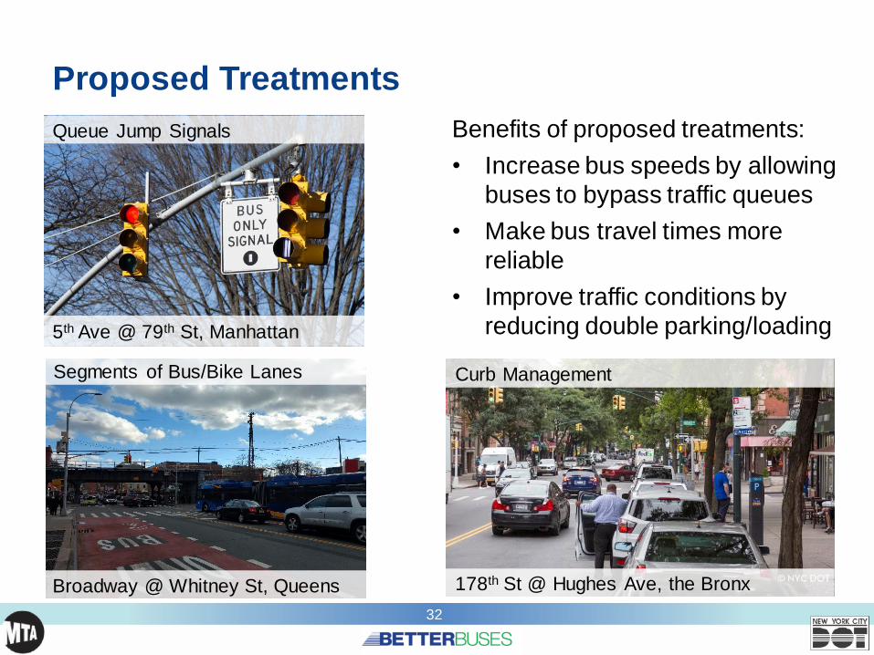
Proposed Treatments
Queue Jump Signals
Segments of Bus/Bike Lanes
5th Ave @ 79th St, Manhattan
Broadway @ Whitney St, Queens
Benefits of proposed treatments:
• Increase bus speeds by allowing
buses to bypass traffic queues
• Make bus travel times more
reliable
• Improve traffic conditions by
reducing double parking/loading
Curb Management
178th St @ Hughes Ave, the Bronx
33
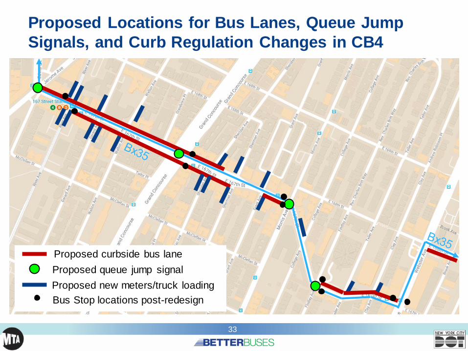
Proposed Locations for Bus Lanes, Queue Jump
Signals, and Curb Regulation Changes in CB4
Proposed curbside bus lane
Proposed queue jump signal
Proposed new meters/truck loading
Bus Stop locations post-redesign

34
Proposed Street Design
E 167th St & Gerard Ave
Existing
Proposed

35
Existing Street Design

36
Proposed Street Design

37
Making it Work
DOT is studying additional changes to
support this design and create a safer,
better functioning corridor for all users
• Changes being studied:1. New metered parking or truck loading
zones to reduce double parking and
lane blocking
2. Queue Jump Signals to allow buses to
have a jump start at certain intersections
• We will continue to coordinate with
community stakeholders throughout project
Queue Jump Signal
Broadway @ Corona Ave, Queens

38
Next Steps

39
Project Timeline
Fall 2019‒ Present potential treatments to Community Boards 3 & 4
‒ Ongoing coordination with MTA‒ Data analysis and plan development
Winter 2019/2020‒ Develop draft street design plans & continue data analysis‒ Present draft plans to Community Boards 3 & 4
‒ Continue to identify/meet with other stakeholders
Early Spring 2020‒ Develop final street design plans
‒ Share final plans with Community Boards 3 & 4
Late Spring-Fall 2020‒ Implement projects
40
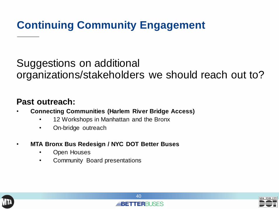
Continuing Community Engagement
Suggestions on additional organizations/stakeholders we should reach out to?
Past outreach:• Connecting Communities (Harlem River Bridge Access)
• 12 Workshops in Manhattan and the Bronx
• On-bridge outreach
• MTA Bronx Bus Redesign / NYC DOT Better Buses
• Open Houses
• Community Board presentations

4141
THANK YOU!
41
NYC DOT NYC DOT nyc_dot NYC DOT
Questions?