business and biodiversity offsets programme (bbop) bbop pilot … · anglo platinum is still...
TRANSCRIPT

Business and Biodiversity Offsets Programme (BBOP)
BBOP Pilot Project Case StudyPotgietersrust Platinums Limited (PPRust)
Forest Trends, Conservation International and the Wildlife Conservation Society provided the Secretariat for
BBOP during the first phase of the programme's work (2004 – 2008).
Publication Data
Anglo Platinum. 2009. BBOP Pilot Project Case Study. Potgietersrust Platinums Limited (PPRust).
Johannesburg, South Africa.
Available from:
www.forest-trends.org/biodiversityoffsetprogram/guidelines/angloamerican-case-study.pdf
© Anglo Platinum 2009.
Reproduction of this publication for educational or other non-commercial purposes is authorised without prior
written permission from the copyright holder provided the source is fully acknowledged.
Reproduction of this publication for resale or other commercial purposes is prohibited without prior written
permission of the copyright holder.
The findings, interpretations and conclusions expressed here are those of the authors and do not necessarily
reflect the views of Anglo Platinum. Any errors are purely the responsibility of the authors.
Cover and graphic design by Rima Design.
Left and right photos on cover - © Marc Stalmans

1
BBOP Pilot Project Case Study – PPRust
About this document
To help developers, conservation groups, communities, governments and financial institutions that wish to
consider and develop best practice related to biodiversity offsets, the Business and Biodiversity Offsets
Programme (BBOP) has prepared a set of Principles, interim guidance and resource documents1, including
pilot project case studies, of which this document2 is one. All those involved in BBOP are grateful to the
companies who volunteered pilot projects in this first phase of its work.
The ability to test methods and learn from practical experience in a set of pilot projects has played an important
role in the development of the BBOP principles on biodiversity offsets and supporting materials during the first
phase of the programme’s work (2004 – 2008). Six organisations (five companies and one city council)
volunteered to undertake pilot projects during BBOP’s first phase, with some joining at the outset, and some at
later stages. While BBOP has offered some support and technical advice to the individual pilot projects through
its Secretariat and Advisory Committee, each pilot project has been directed and managed by a team employed
or contracted by the companies and city council leading the respective projects. Each of the case studies
prepared by the pilot projects explains the approach taken and how close the project has come to completing the
design of the biodiversity offset concerned, and sets out the developer’s current thinking on the most appropriate
offset. This may change as the project teams finalise their offset design and start implementation. The nature of
the guidance used by the pilot projects has varied according to which drafts of the evolving BBOP Handbooks
were available to them at the time. This and the individual circumstances and context of each pilot project have
affected the extent to which they have used or adapted the BBOP guidance. Consequently, the case studies do
not necessarily reflect the range of interim guidance currently presented in BBOP’s Biodiversity Offset Design
Handbook, Cost-Benefit Handbook and Implementation Handbook.
Anglo Platinum is still working on the design of the proposed biodiversity offset discussed in this case study.
Consequently, none of the suggested or projected activities based on fieldwork to date represent a
commitment on the part of Anglo Platinum and its potential partners to proceed with the offset as described in
draft form in this document. This commitment is the subject of continuing internal discussions. The information
and data relating to possible offset sites, areas and activities are presented here to communicate the initial
work that has been done on a potential offset design and to illustrate one possible approach to the design of a
biodiversity offset intended to comply with the BBOP principles.
BBOP is embarking on the next phase of its work, during which we hope to collaborate with more individuals
and organisations around the world, to test and develop these and other approaches to biodiversity offsets
more widely geographically and in more industry sectors. BBOP is a collaborative programme, and we
welcome your involvement. To learn more about the programme and how to get involved please:
See: www.forest-trends.org/biodiversityoffsetprogram/
Contact: [email protected]
1 The BBOP Principles, interim guidance and resource documents, including a glossary, can be found at:
www.forest-trends.org/biodiversityoffsetprogram/guidelines/. To assist readers, a selection of terms with an entry in the BBOP Glossary has been highlighted thus: BIODIVERSITY OFFSETS. Users of the Web or CD-ROM version of this document can move their cursors over a glossary term to see the definition.
2 This case study was prepared by Marc Stalmans with contributions from Peter Coombes and Frank Pieterse.
2
BBOP Pilot Project Case Study – PPRust
Contents
Table of contents
Executive Summary 3
Summary of the PPRust pilot project 3
Applying the BBOP principles 4
1. Project Description and Background 6
2. Partners Involved in Offset Design and Implementation 7
3. Project Location and Description 8
4. Business Case for a Biodiversity Offset 13
5. Offset Design and Implementation 14
5.1 Quantifying impact losses and potential offset gains 14
5.1.1 Mitigation hierarchy and residual impact on biodiversity 14
5.1.2 Identification of potential offset areas and establishing ‘like-for-like’ (in-kind) conservation outcomes 17
5.1.3 Quantifying losses and gains in the impact and offset areas 19
5.2 Stakeholder engagement 25
5.3 Financial and institutional arrangements for long-term sustainability of the offset 25
6. Lessons Learned 27
7. Final Comments 28
8. References 29
3
BBOP Pilot Project Case Study – PPRust
Executive Summary
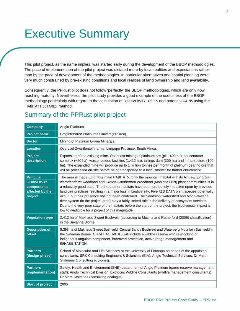
This pilot project, as the name implies, was started early during the development of the BBOP methodologies. The pace of implementation of the pilot project was dictated more by local realities and expectations rather than by the pace of development of the methodologies. In particular alternatives and spatial planning were very much constrained by pre-existing conditions and local realities of land ownership and land availability.
Consequently, the PPRust pilot does not follow ‘perfectly’ the BBOP methodologies, which are only now reaching maturity. Nevertheless, the pilot study provides a good example of the usefulness of the BBOP methodology particularly with regard to the calculation of BIODIVERSITY LOSSES and potential GAINS using the ‘HABITAT HECTARES’ method.
Summary of the PPRust pilot project
Company Anglo Platinum.
Project name Potgietersrust Platinums Limited (PPRust).
Sector Mining of Platinum Group Minerals.
Location Overysel-Zwartfontein farms, Limpopo Province, South Africa.
Project description
Expansion of the existing mine. Opencast mining of platinum ore (pit ~400 ha), concentrator complex (~50 ha), waste residue facilities (1,412 ha), tailings dam (300 ha) and infrastructure (100 ha). The expanded mine will produce up to 1 million tonnes per month of platinum bearing ore that will be processed on-site before being transported to a local smelter for further enrichment.
Principal BIODIVERSITYcomponents affected by the project
The area is made up of four main HABITATS. Only the mountain habitat with its Rhus-Euphorbia-clerodendrum woodland and Croton-Combretum Woodland (Mohlotlo Hills) plant communities is in a relatively good state. The three other habitats have been profoundly impacted upon by previous land use practices resulting in a major loss in biodiversity. Five RED DATA plant species potentially occur, but their presence has not been confirmed. The Sandsloot watershed and Mogalakwena river system (in the project area) play a fairly limited role in the delivery of ecosystem services.Due to the very poor state of the habitats before the start of the project, the biodiversity impact is low to negligible for a project of this magnitude
Vegetation type 2,413 ha of Makhado Sweet Bushveld (according to Mucina and Rutherford (2006) classification) in the Savanna Biome.
Description of offset
5,398 ha of Makhado Sweet Bushveld, Central Sandy Bushveld and Waterberg Mountain Bushveld in the Savanna Biome. OFFSET ACTIVITIES will include a wildlife reserve with re-stocking of indigenous ungulate component, improved protection, active range management and REHABILITATION.
Partners (design phase)
School of Molecular and Life Sciences at the University of Limpopo on behalf of the appointed consultants, SRK Consulting Engineers & Scientists (EIA); Anglo Technical Services; Dr Marc Stalmans (consulting ecologist).
Partners (implementation)
Safety, Health and Environment (SHE) department of Anglo Platinum (game reserve management staff); Anglo Technical Division; Ekofocus Wildlife Consultants (wildlife management consultants); Dr Marc Stalmans (consulting ecologist).
Start of project 2005

Executive Summary 4
BBOP Pilot Project Case Study – PPRust
Applying the BBOP principles
1. No net loss. The principle of NO NET LOSS was pursued in the offset by calculating the amount of
biodiversity that would be lost through the mine development (after AVOIDANCE, minimisation and
RESTORATION) and by offsetting this through sufficient gains in biodiversity in the close vicinity of the mine.
The habitat hectare approach was used to quantify the amount of biodiversity lost through the project and
gained by the offset. The loss of habitat due to the mining expansion was calculated taking into the
account the degraded nature of the habitat. The potential gains in the offset area where calculated taking
into account the improvement that can be made due to better management of the land. Six to ten
ATTRIBUTES were used for each of the four habitats to calculate a current biodiversity score as well as the
expected score post impact. A similar calculation was made for the POTENTIAL OFFSET SITES in terms of
current score and potential score following better protection and management.
2. Additional conservation outcomes. There have recently been significant losses of biodiversity on
neighbouring properties on communal land where no conservation actions such as the planned offset
activity are taking place. The biodiversity offset is thus being planned against the sharp background rate
of loss of biodiversity in the area. The resulting CONSERVATION OUTCOMES will therefore be additional to
what would occur without the project and offset.
3. Adherence to the mitigation hierarchy. The project followed the mitigation hierarchy as follows:
Avoidance – the construction of the expansion project was planned in a way that would avoid activities
taking place within 100 m of the Mohlasane and Sandsloot rivers. Instead of constructing additional
access roads to the project site, use was made of existing roads. All sites determined to be sacred sites
by the local community were identified during the impact assessments and these have been demarcated
and will be protected. Minimisation – the site to which the village will be relocated was also previously
disturbed by human activities. The site was chosen for the new village to minimise the project’s overall
FOOTPRINT on undisturbed land. Rather than developing a new smelter on-site, the existing mine and
expansion project make use of a smelter in the town of Polokwane to beneficiate their concentrate.
MITIGATION – AN ENVIRONMENTAL MANAGEMENT PLAN with detailed management actions to mitigate
environmental impacts was drawn up as part of the legally required Environmental Management Program
Report compilation.
4. Limits to what can be offset. The project area was very heavily impacted by existing settlements and
communal grazing practices prior to the proposed mining activities. Therefore, the KEY BIODIVERSITY COMPONENTS (species and habitats) will be little affected by the project. They are also well represented in
the surrounding area, including on the proposed offset sites. Consequently, virtually all the project’s
impacts can be offset.
5. Landscape context. The choices for the location of the offset were severely constrained by the land
ownership pattern in the area. Most of the land is communally owned and not available for purchase. Two
adjoining farms3 that were already owned by Anglo Platinum provide a very suitable offset having
comparable habitats. Equally good alternative farms that were also owned by Anglo Platinum could not
be evaluated as their ownership was transferred to the community as part of the land redistribution
programme in the region.
3 The basic land parcel in South Africa is the ‘farm’. Land ownership is linked to ‘farms’. Farms are blocks of varying size, mostly of
rectangular, triangular or parallelogram shape. Boundaries are generally determined by straight lines that link high points in the landscape. The ‘farms’ therefore mostly do not represent homogeneous ecological units as they cut across elevation gradients. In terms of South African law, the subdivision of these basic cadastral units requires due process. The ‘farm’ needs to be considered as a ‘package’ since sub-division along ecological lines is generally not easily feasible.

Executive Summary 5
BBOP Pilot Project Case Study – PPRust
6. Stakeholder participation. The different stakeholders were identified during the ENVIRONMENTAL IMPACTASSESSMENT (EIA) process. The most relevant stakeholders in the offset selection process are the local
villagers who were either relocated or given alternatives enabling them to access natural resources lost
through the mine expansion. The mine has a very well structured system working with communities over
the long term, and this was used to guide engagement with the relevant stakeholders.
7. Equity. The stakeholder engagement undertaken by Anglo Platinum has aimed to ensure that those
community members affected by the presence of the Project also benefit from its presence, and this
philosophy extends to the biodiversity offset. Anglo Platinum is supporting local stakeholders so they
benefit from the offset. For instance, the company is funding the development of the ECOTOURISM lodge
that forms part of the offset, but will transfer ownership to the local community. The company is also
paying for the training of villagers so they can run the lodge.
8. Long-term outcomes. The offset site was previously acquired by Anglo Platinum and there is no
ongoing cost attached to acquiring the land. PPRust will provide the operational budget for the staff,
equipment and work required to protect and manage the offset site for the long term.
9. Transparency. Anglo Platinum has worked with stakeholders to define and develop the plans for the
offset, and continues to share the results to date locally and more widely through publications such as
this case study.
10. Science and traditional knowledge. The scientific methods that have been followed to design the
offset, including the recording of key biodiversity components that include identification of local
communities’ priority values and uses and the calculation of loss and gain, are summarised in this case
study.

6
BBOP Pilot Project Case Study – PPRust
1. Project Description and Background
Potgietersrust Platinums Limited (PPRust) is a large mine owned by Anglo Platinum and worked for Platinum
Group Minerals. In 2002, an ENVIRONMENTAL IMPACT ASSESSMENT (EIA) for a proposed PPRust North
expansion was undertaken by the School of Molecular and Life Sciences at the University of Limpopo on
behalf of the appointed consultants, SRK Consulting Engineers and Scientists (SRK 2002). The EIA was
approved by the Regulating Authorities in January 2003.
A summer survey of the vegetation of the impact area was conducted in March 2003 to supplement the late
autumn survey initially undertaken for the EIA (SRK 2003). Initial biodiversity information on the offset area
was obtained through studies undertaken by Ekofocus (2004).
In 2005 a decision was taken to expand the existing mining operations (see Figure 1). The PPRust North
Expansion project (‘Overysel-Zwartfontein’) will increase milling capacity at PPRust from the current 385,000
tonnes per month (tpm) to 985,000 tpm. This will increase annual platinum production from 200,000 ounces to
430,000 ounces. The expansion is linked to a biodiversity offset pilot project under the Business and
Biodiversity Offsets Programme (BBOP).
Figure 1: Mining licence area and existing / future pits

7
BBOP Pilot Project Case Study – PPRust
2. Partners Involved in Offset Design and Implementation
The partners involved in the offset design phase were Anglo Technical Services and Dr Marc Stalmans
(consulting ecologist).
The Safety Health and Environment (SHE) department of Anglo Platinum (wildlife reserve management staff),
Anglo Technical Division, Ekofocus Wildlife Consultants (wildlife management consultants) and Dr Marc
Stalmans (consulting ecologist) were involved with the practical implementation and assessment of the offset
project.

8
BBOP Pilot Project Case Study – PPRust
3. Project Location and Description
PPRust is located approximately 25 km north-west of the town Mokopane in the Limpopo Province of South
Africa (Figure 2). This is the fourth largest province in South Africa with the fifth largest population. More than
80% of the population resides in rural areas. The Province has a very high unemployment rate of over 40%.
The economy is based on livestock farming, crop production, mining, wildlife farming, tourism and forestry (the
latter in higher-rainfall areas). The greatest potential for employment and for economic growth occurs in the
mining, agricultural and tourism sectors.
The impact area is situated in the northern savanna area of South Africa with an annual rainfall of 500 – 600
mm at an elevation of 1,080 – 1,300 m above sea level. Topography is generally gently undulating with some
hilly outcrops. The ‘natural’ vegetation would have consisted of open to closed woodland with diverse tree
flora with a canopy height of 5 – 10 m. The area would originally (more than 200 years ago) have supported
the full range of the typical charismatic African megafauna including lion, elephant, buffalo and rhino. These
large animal species, except in Protected Areas and newly stocked private reserves, have generally
disappeared from the landscape in the larger PPRust area.
The land use is characterised by peri-urban settlement, subsistence dry-land farming, communal livestock
grazing (cattle and goats) and the extractive use of other natural resources such as fuelwood (Figures 3 and
4).
The villages are of medium to large size. They are relatively densely packed but most residents still have a
large yard with vegetable gardens and they may practice some dry-land cropping within the yard.
Unemployment rates are high. Employed residents work at the nearby mine or commute daily to jobs in the
town of Mokopane (40 km). Some people work in the bigger cities of Johannesburg and Pretoria (200 km) and
may only return on a weekly or monthly basis. A large part of the population relies on social grants such as
pensions.
Existing settlements have had a substantial negative impact on the biodiversity of the area, through
conversion of the original woodlands to cropland and by communal grazing practices with high stocking rates
(Figures 3 and 4). Firewood and medicinal plants are being harvested unsustainably. The remaining small to
medium-sized antelopes and game birds are illegally hunted. These impacts pre-date mining in the impact
area. However, they may be aggravated through an influx of people seeking employment at the new mine
expansion at PPRust and at other platinum mines in the area.
As a consequence of a long and intense history of settlement, the impact area has few KEY BIODIVERSITY COMPONENTS (e.g. those that are considered of significant CONSERVATION value). Key biodiversity components
are summarised in Table 1. The PPRust project is located in an area characterised by a high loss of natural
HABITAT with the status of its terrestrial ECOSYSTEMS rated as ‘vulnerable’ to ‘endangered’ (Driver et al. 2005).
The following conclusions were made during the Impact Assessment study. The flora of the study area is not
considered to be significantly sensitive or vulnerable in a regional context, however due to its being poorly
documented it was assigned a moderate conservation value. The vegetation in the area was previously
disturbed through activities such as overgrazing, wood fuel collection, trampling and dryland crop production.
These pre-mining land uses left behind a few islands of natural vegetation which are thought to be a resource
Project Location and Description 9
BBOP Pilot Project Case Study – PPRust
of plants used by local people for medicinal purposes. Despite the degraded nature of the pre-mining
environment, the specialists’ opinion is that conservation across much of the extent of the plain’s vegetation
area of occurrence is inadequate and, due to the occurrence of mafic / ultramafic specialist species in this
habitat, its conservation requires some focus. The local communities are dependent on healthy vegetation as
a resource for many of their activities including medicinal use, firewood and as a food source. Hunting of wild
animals using dogs is a notable existing impact on the fauna of the area. Wildlife hunted in this manner tends
to take refuge on the inselbergs which occur in the area as hunting takes place in the open plains. Due to
these hunting activities, the specialists conclude that it is highly unlikely that any viable or significant
populations of wildlife will exist in the area. Common species of mammals, reptiles and bird species do occur
and no evidence was found of threatened animals during the survey. However, the specialists state that the
site provides the potential habitat for a number of RED DATA plant species, the presence of which could not be
confirmed.
The proposed offset is located 8 km to the west of the impact area (see Figure 2). The offset area has similar
environmental characteristics to the impact area although a larger proportion is mountainous. It has been
subjected to much less subsistence farming; as a result it is much more wooded than the impact area.
The offset area is not intended in any way to offset any of the primary social impacts. However, long-term
development, employment creation and provision of benefits delivered through the offset will add to the total
social package associated with the mine development.

Project Location and Description 10
BBOP Pilot Project Case Study – PPRust
N
%
%
%
SOUTHAFRICA
AFRICA
PRETORIA
JOHANNESBURG
MOKOPANE
KrugerNational
Park
BOTSWANA
100 0 100 200 Kilometers
5 0 5 10 15 Kilometers
Offset AreaMine Impact Area
Impact &Offset Area
Settlements
Settlements
SOUTHAFRICA
Settlements
Figure 2: Locality map of PPRust

Project Location and Description 11
BBOP Pilot Project Case Study – PPRust
Table 1: Key biodiversity components at PPRust (see Figure 3 for a visual representation)
Component Intrinsic values USE VALUES CULTURAL VALUES
Animal species
Potential occurrence of Red Data species – not confirmed
Rarity – conservation value (potential only – not confirmed)
Illegally hunted with domestic dogs
Plant species
Potential occurrence of five Red Data species, but not confirmed
Large diversity in mountainous habitat
Hardwoods in Acacia and Terminalia woodlands
Rarity – conservation value (potential occurrence only – not yet confirmed)
Medicinal use
Fire wood and construction wood
Medicinal and magical plants
Habitats within the Makhado Sweet Bushveld vegetation
Microphyllous (Acacia) woodlands on clay
Macrophyllous (Terminalia) woodland on sandy soils derived from granite
Mountainous habitat
Riverine habitat
Potential habitat for 5 listed Red Data plants species (presence not observed)
Rhus-Euphorbia-clerodendrum woodland and Croton-Combretum Woodland (Mohlotlo Hills) (mountain habitat)
Valued by local people for:
Residential purposes
Land for subsistence cropping
Grazing and browsing resource for cattle and goats
Firewood
Building wood
Thatch grass (roof covering)
Medicinal plants
Habitat for medicinal and magical plants
ECOSYSTEM SERVICES
Water catchment (limited role) Sandsloot watershed/ Mogalakwena river system
Mountain habitat acts as BIOTIC corridor between Waterberg and Pietersburg Plateau
The woodlands perform the following functions:
Water catchment (limited)
Carbon sequestration (limited in impact area due to low biomass)

Project Location and Description 12
BBOP Pilot Project Case Study – PPRust
Figure 3: Key values of the impact area
Key to Figure 3
1. Mountainous habitat.
2. Large hardwoods (mostly confined to culturally protected areas).
3. Scadoxus punicea (Blood Lily – bulbous herb with medicinal value).
4. Albizia anthelmintica (Worm-cure Albizia) on bottomlands.
5. Sandsloot seasonal river.
6. General view of impact area with ‘Microphyllous woodland habitat on clay soils’ in foreground (heavily
impacted with extensive cutting of trees and fallow lands) and ‘Mountainous habitat’ in background. Note
settlements at the foot of the mountains.

13
BBOP Pilot Project Case Study – PPRust
4. Business Case for a Biodiversity Offset
The offset project fits within the Safety, Health and Environment policy framework of Anglo American plc and
more specifically that of Anglo Platinum, namely to:
Conserve environmental resources;
Prevent or minimise adverse impacts arising from Anglo’s operations;
Demonstrate active stewardship of land and biodiversity;
Promote good relationships with, and enhance capacities of, the local communities of which Anglo is part;
Respect people’s culture and heritage.
The BUSINESS CASE for investing in a biodiversity offset has been driven mainly by the desire to assist the local
communities in improving their quality of life in a sustainable fashion. With high unemployment rates in the
region and a lack of conventional employment, the community has to look at alternative ideas to generate
income.
The mine and offset areas are in close proximity to the Waterberg Biosphere Reserve, which is a popular
tourist destination for both local and international tourists. This market relies on the natural beauty of the area,
its wildlife resources and the opportunity to undertake a variety of leisure activities. These may include trophy
hunting (typically by overseas hunters) and so-called biltong hunting (typically by South African hunters). The
potential exists to tap into these non-consumptive and consumptive markets. At the same time the mine’s
management wants to prevent further expansion of degraded areas that have resulted from the community’s
non-sustainable use of the natural environment.
The Savanna Biome (in which the impact area is located) is not in itself a threatened or sensitive biome at a
national scale. However, at a local level, over-utilisation of the area through human activities such as wood
collection, grazing and dryland crop production has had a significant impact on the ECOSYSTEMS. High
unemployment rates in the area place further pressure on the already degraded ecosystem as people remain
dependent on the local biodiversity for their survival needs. For these reasons, the CONSERVATION importance
of the remaining undisturbed areas has increased.
Based on the above, the specific aims and objectives of Anglo Platinum for the biodiversity offset were as
follows:
Offsetting the biodiversity losses from the impact area;
Ensuring that the offset takes the form of an ecologically viable entity;
Achieving long-term sustainability through the implementation of an appropriate land use model that
underpins a financially viable operation for the benefit of the local community.

14
BBOP Pilot Project Case Study – PPRust
5.Offset Design and Implementation
5.1 Quantifying impact losses and potential offset gains
5.1.1 Mitigation hierarchy and residual impact on biodiversity
PPRust is an operation under the Anglo Platinum umbrella. Anglo Platinum in turn operates in compliance
with Anglo American (AA) plc policies and standards. The AA plc strategy for biodiversity commits the
company to active stewardship of biodiversity, wise use of environmental resources and minimising adverse
impacts arising from the operation’s activities. This strategy supports the AA plc Safety, Health and
Environment Policy which, in addition to the above commitments, aims to promote good relationships with,
and enhance the capacities of, the local communities of which the company (operation) is a part.
It is under these high level commitments that the PPRust SHE (safety, health and environment) policy was
drafted. The PPRust policy commits the operation to minimising impacts associated with the business and
ensuring that action is taken to eliminate, minimise and control the risks associated with the business. These
commitments are made in support of the mine’s focus on continually improving the management of
environmental issues.
PPRust obtained ISO 14001 certification in October 2003. During 2005 the operation completed a Biodiversity
Action Plan (BAP), as required by AA plc. This BAP will operate within the framework of the ISO 14001
environmental management system which requires the company to continually assess and manage the
environmental impacts associated with its activities, products and services. This risk-based approach is aimed
at ensuring management attention is appropriately focused on the most significant impacts (positive and
negative) associated with the operation.
As a result of the above systems and commitments, PPRust is focused on achieving a state of no net
biodiversity loss as a result of their activities.
The mine is open cast and as such requires the complete removal of all vegetation / overburden in order to
access the ore body. The obvious result of this is a disruption and destruction of the ecosystem in the area of
the mining FOOTPRINT. Specialist studies conducted prior to mining indicated that most of the area on which
the mine was planned was already disturbed due to agricultural activities (trampling and dryland crop
production, overgrazing and fuel wood collection). These activities resulted in a low BASELINE diversity and
natural mitigation for some of the impacts to be caused by the development.
The no-go option was rejected on the basis that if the project did not continue then the positive impacts of the
mine on the local impoverished and underdeveloped community would be lost. These include, amongst
others, the following:
Direct and indirect economic benefits on a local and regional level;
Further cumulative developments which would arise due to the climate of development confidence which is
created by an operation of this magnitude;
Improved quality of life of inhabitants of the area; and

Offset Design and Implementation 15
BBOP Pilot Project Case Study – PPRust
Increased bulk service and infrastructure provision will be required to service the mine and in turn would
facilitate opportunities to provide these services to communities in the area.
Furthermore, the no-go option would not lead to any lesser impact on the natural environment. In fact,
continued over-reliance on natural resources and their over-exploitation would almost certainly lead to further
biodiversity losses.
The environmental impacts at the PPRust mine were quantified as part of the EMPR process that was
undertaken prior to commencement of construction of the mine. The significance of impacts (post mitigation)
relating to biodiversity issues ranges from ‘low’ to ‘high’ (Table 2) with certain areas and biodiversity facets
being completely altered (Table 3) (SRK 2002).
Table 2: Significance of impacts (post mitigation) relating to biodiversity issues
Impact Significance rating
Generation and potential release of dirty water leading to surface water pollution Moderate
Loss of catchment reducing availability of water to downstream users Low
Changes to water courses Low
Acid rock drainage potential of mine residue deposits Moderate
Dust generated from near surface (<20m) open pit mining High
Dust generated from tailings dams Moderate
Dust generated from waste residue management facilities Low
Dust generated from deeper (>20m) open pit mining Low
Dust generated from crushing Low
Risk of losing unknown biodiversity High
Loss and fragmentation of important habitats High
Loss or disturbance of fauna populations and their migration paths High
Loss of plant diversity (important plant populations) High
Loss / disturbance of aquatic biota Low
Loss of soil resources due to surface disturbance during construction and operation High
Loss of arable land due to construction and operation Low
Increased soil erosion due to construction and operation Low
Contamination of soils due to leaching of contaminants during operation and decommissioning Low
Visibility of mine from surrounding areas Low

Offset Design and Implementation 16
BBOP Pilot Project Case Study – PPRust
Table 3: Specific elements that are impacted upon (directly and indirectly)
Kind of impact Size Brief descriptionECOSYSTEM TYPE
Vegetation type
DIRECT IMPACT: 2,400 ha
Concentrator plant 40 ha End 2007 Old field used for grazing
Waste facilities 1,412 ha After 45 years Old fields used for grazing
Dichrostachys-Urochloa – AcaciaScrubland
Rhus-Euphorbia-clerodendrumwoodland (Mohlotlo hills)
Croton-Combretum Woodland (Mohlotlo Hills)
Watercourse fringing vegetation
Tailings facilities 300 ha Tailings dams and waste rock dumps to be constructed
Old fields used for grazing
Lopholaena -Terminalia open woodland
Mixed Bushveld
Watercourse fringing vegetation
Open pit [pre-pit temporary 40 ha contractors camp]
~400 ha Area to be completely altered for the construction of pit
Contractors camp area to be mined after initial construction
Old fields used for grazing
Watercourse fringing vegetation
Infrastructure 100 ha Roads, conveyor belts (pre 2009), office blocks and amenities, landfill site
Old fields used for grazing
Resettlement area New site for location of community
950 households to be moved
Clay Thorn Bushveld
Mixed Bushveld
All areas previously used for grazing or communal lands
Conveyers belts Conveyor belts (>2009) Old fields
Possible rail line from mine to town
Construction of railway line asalternative to road system
Feasibility study still to be done
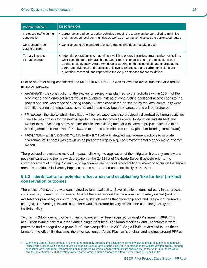
INDIRECT IMPACT DESCRIPTION
In-migration 94% of present employees come from within the area so in-migration should be limited
CUMULATIVE IMPACT of mining companies
Additional mining activities could take place due to large platinum reserves in this area
These could be sited on both disturbed and undisturbed lands
Involvement in the biosphere reserve and establishment of conservation criteria for mining companies could influence behaviour of other mining companies
Direct interaction by the conservation authorities with new mining ventures could also influence their behaviours
Offset Design and Implementation 17
BBOP Pilot Project Case Study – PPRust
INDIRECT IMPACT DESCRIPTION
Increased traffic during construction
Larger volume of construction vehicles through the area must be controlled to minimise their impact on local communities as well as ensuring vehicles stick to designated routes
Contractors (tree-cutting offsite)
Contractors to be managed to ensure tree cutting does not take place
Tertiary impacts:climate change
Industrial operations such as mining, which is energy intensive, create carbon emissions which contribute to climate change and climate change is one of the most significant threats to biodiversity. Anglo American is working on the issue of climate change at the corporate, divisional and business unit levels. Energy use and carbon emissions are quantified, recorded, and reported to the AA plc database for consolidation
Prior to an offset being considered, the MITIGATION HIERARCHY was followed to avoid, minimise and reduce
RESIDUAL IMPACTS:
AVOIDANCE - the construction of the expansion project was planned so that activities within 100 m of the
Mohlasane and Sandsloot rivers would be avoided. Instead of constructing additional access roads to the
project site, use was made of existing roads. All sites considered as sacred by the local community were
identified during the impact assessments and these have been demarcated and will be protected.
Minimising - the site to which the village will be relocated was also previously disturbed by human activities.
The site was chosen for the new village to minimise the project’s overall footprint on undisturbed land.
Rather than developing a new smelter on-site, the existing mine and expansion project make use of an
existing smelter in the town of Polokwane to process the mine’s output (a platinum-bearing concentrate).
MITIGATION – an ENVIRONMENTAL MANAGEMENT PLAN with detailed management actions to mitigate
environmental impacts was drawn up as part of the legally required Environmental Management Program
Report.
The predicted unavoidable residual impacts following the application of the mitigation hierarchy are low and
not significant due to the heavy degradation of the 2,413 ha of Makhado Sweet Bushveld prior to the
commencement of mining. No unique, irreplaceable elements of biodiversity are known to occur on the impact
area. The residual biodiversity impact can thus be regarded as theoretically OFFSETABLE.
5.1.2 Identification of potential offset areas and establishing ‘like-for-like’ (in-kind) conservation outcomes
The choice of offset area was constrained by land availability. Several options identified early in the process
could not be pursued for this reason. Most of the area around the mine is either privately owned (and not
available for purchase) or communally owned (which means that ownership and land use cannot be readily
changed). Converting this land to an offset would therefore be very difficult and complex (socially and
institutionally).
Two farms (Mooihoek and Groenfontein), however, had been acquired by Anglo Platinum in 1999. This
acquisition formed part of a larger landholding at that time. The farms Mooihoek and Groenfontein were
protected and managed as a game farm4 since acquisition. In 2005, Anglo Platinum decided to use these
farms for the offset. By that time, the other sections of Anglo Platinum’s original landholdings around PPRust
4 Within the South African context, a ‘game farm’ generally consists of a privately or company owned piece of land that is generally
fenced and stocked with a range of wildlife species. Such a farm is used solely or in combination for wildlife viewing, trophy hunting, production of wildlife meat, the breeding of animals for live sales, conservation of rare species etc. In the year 2000, there were already an estimated 7,000 privately owned game farms in South Africa with a total surface area of 16 million ha.

Offset Design and Implementation 18
BBOP Pilot Project Case Study – PPRust
were no longer available for offset purposes as they were disposed off to the local community as part of the
land restitution process.
Although partially impacted, the farms are some of the few remaining examples in the area of habitat of the
Savannah Biome in a relatively good condition. Being the surface rights owner, the mine has full management
control over these offset areas. A study was previously undertaken to determine the potential of Mooihoek and
a section of Groenfontein for game ranching. The study included evaluating the land for the identification of
potential habitat areas for game, investigating the potential for the introduction of game, investigation of
possible REHABILITATION strategies for the area and defining a management plan for future rehabilitation and
management of the area. The veld (range) CONDITION assessment concluded that a total of 286 large game
units could be accommodated on the properties. The study also concluded that the area was previously
mismanaged through cattle farming, large parts of the property are bush encroached and some areas show
signs of poor grass species composition from the previous over-utilisation.
The selected POTENTIAL OFFSET AREA and the IMPACT SITE appear quite different (visually) as the vegetation of
the impact area has been extensively transformed in the past through subsistence cultivation, livestock
grazing and extractive use of natural resources such as fuelwood. The question was therefore legitimately
posed as to whether the selected offset area would enable ‘LIKE-FOR-LIKE’ (IN-KIND) conservation relative to the
impact area (i.e. would enable the conservation (through the biodiversity offset) of the same type of
biodiversity as that affected by the project).
A thorough assessment (Stalmans 2006) was done to determine whether the habitats and vegetation of the
impact area in its ‘original’ state would have been similar to that of the proposed offset area. The assessment
analysed:
Abiotic factors. These were compared for the impact and potential offset sites. Use was made of available
GIS information such as geology, land type, elevation etc. These were mostly ‘coarse’ data as this
information was compiled on a national (large-scale) basis.
Existing vegetation classifications. Vegetation classifications (that is the formal manner in which the
vegetation of South Africa is described) were compared at impact and potential offset areas. As for abiotic
factors, these are fairly broad as they were compiled at a large scale.
Current vegetation patterns. The impact and offset areas were compared in the field with respect to
current vegetation patterns. The rationale is that in situations of similar impact and land use, a similar (or
dissimilar) remnant vegetation composition and structure or similar (or dissimilar) ‘reaction’ to the impact
would indicate that the original state in both areas was likely similar (or dissimilar). The mining area, as well
as Mooihoek and Groenfontein farms that constitute the offset area, were assessed in August 2006. A total
of 39 sites were surveyed in terms of landscape position, land use history, vegetation structure, dominant
woody and grass species, alien species etc.
Internal differences in vegetation. Differences within the potential offset area (often manifested as a
marked ‘fence line’ contrast) were assessed. These differences are mostly linked to land use history. The
presence of a certain vegetation remnant on the impact site similar to the remnant found in the offset site
would indicate that (in all likelihood) the point of departure at the impact site was similar to that found in the
‘natural’ context of the offset site.
The results of the analysis allowed an evaluation of whether the pre-settlement impact area and the potential
offset area were similar or dissimilar. If the two areas were dissimilar, then obviously the identified offset area
would not offer a valid ‘in-kind’ offset and it would need to be evaluated differently. However, if it is considered

Offset Design and Implementation 19
BBOP Pilot Project Case Study – PPRust
likely that the impact and offset areas were originally fairly similar; the identified offset area can provide a
suitable in-kind offset.
The conclusion from the initial evaluation (Stalmans 2006) was:
“The Mooihoek and Groenfontein areas represent a suitable offset for the area impacted upon by the
PPRust Mine. The current vegetation on the offset site can be used to reconstruct a ‘SYNTHETIC’ BENCHMARK for the impact area.”
5.1.3 Quantifying losses and gains in the impact and offset areas
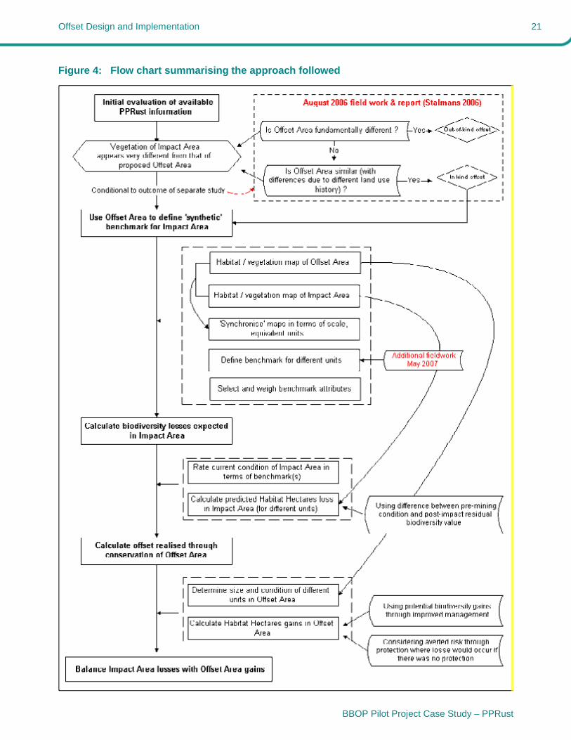
A stepwise approach was used for the quantification of losses and GAINS (see Figure 4 and Stalmans (2007)
for further information). The HABITAT HECTARES approach was used throughout. This approach was developed
by the Victorian stage government in Australia in 2002 and has since been adapted by BBOP. The habitat
hectares method uses benchmarks, or reference sites to create a multi-attribute scoring index against which
losses and gains are measured.
The original method quantifies and offsets impacts by first evaluating the existing biodiversity at the project
site, considering the potential project impacts to biodiversity and then developing an offset with a replacement
value that directly correlates to the amount of biodiversity lost. BBOP has adapted this, broadening the
concept to cover fauna as well as flora, to quantify the structural and compositional components at impact and
offset sites, and selecting some ATTRIBUTES that are also good proxies for functional aspects of biodiversity.
The available vegetation maps for the impact area (SRK 2002) and the offset area (Ekofocus 2004) were
updated and expanded using newly collected field data. The habitat and vegetation units identified for the two
areas were combined in order to find common ground that allowed direct comparison between the two areas
(Figures 5 and 6). The maps were incorporated in a GIS environment (ArcView / ArcGis) (Figure 6). A
synthetic benchmark was defined for each of the units in the impact area using information from the offset
area. This approach is considered valid following the evaluation of the degree of similarity between the two
areas prior to settlement and cultivation of the impact area (as noted in Section 5.1.2 above). The benchmark
takes into account the fact that the offset area itself is not ‘pristine’ and has suffered some degradation.
A range of 6 to 10 attributes was identified for each of the four habitats. A limited number of ‘attributes’ can,
together, capture the inherent quality of the ECOSYSTEM, serving as good proxies not only for its structure, but
also for its function.
The current CONDITION of the impact area relative to the benchmark was determined. The expected loss of
biodiversity from mining-related impacts (relative to the current status) was estimated for the impact area. For
the sake of this evaluation it has been assumed that there will be no residual biodiversity value after mining for
the habitats that fall within the impact area. This results in a score of ‘0’ for all attributes. This is an
exaggeration of loss as there are areas where some residual biodiversity will occur after rehabilitation (such
as the stockpiling area for top soil and even part of the waste rock dumps). The loss of biodiversity was then
translated into ‘habitat hectares’ (equivalent to the change in condition multiplied by the area affected by that
change).
The current CONDITION of the offset area relative to the benchmark was similarly assessed. The potential
gains through improved management were calculated and translated into habitat hectares. The loss that
would be likely to occur in the absence of the offset area being established and formally protected, was used
to calculate the additional biodiversity benefit accruing from ‘averted risk’ (through the prevention of future
risks of harm to biodiversity).

Offset Design and Implementation 20
BBOP Pilot Project Case Study – PPRust
Finally, the predicted loss (in habitat hectares) in the impact area was compared to the expected gains
through management and protection (averted risk) (in habitat hectares) in the offset area.
Three of the four habitats are sufficiently offset (Table 4). There is a considerable gain for the woodland on
clay flats. This is quite important as those particular woodlands, although not very diverse, are under great
pressure because of their suitability for cultivation and grazing. They are therefore a high conservation priority
for the area. There is a shortfall of 158 habitat hectares for the mountainous habitat. This shortfall is not
considered to present a serious negative conservation impact, because this mountainous habitat is very well
conserved in the adjoining Waterberg Biosphere. Support of the Limpopo Tourism & Parks Board on the
nearby Witvinger Nature Reserve would benefit a similar habitat.
Table 4: Summary of loss and gain at the impact and offset areas
Impact area
total loss
(habitat hectares)
Offset area
total gain
(habitat hectares)
Balance
(habitat hectares)
Woodlands on clay flats 401 831 430
Woodlands on sand flats 81 108 27
Woodlands in mountainous terrain 265 107 -158
Riverine woodlands 51 55 4
Total 798 1,101 +303
This generally positive outcome is dependent on overexploitation risks being averted in the offset area and on
targeted range management actions reversing previous degradation of the habitat (Figure 7). A strong
institutional model with sufficient financial support is thus necessary (see Section 5.3).
The offset represents a change in land use from the previous livestock grazing and occasional hunting on the
two farms that make-up the offset (Figure 7). A number of the originally occurring megafauna species have
already been reintroduced to the offset. Further management actions that are required include the restoration
of the required fire regime (higher frequency and intensity desired compared to the past), thinning of bush-
encroached woodlands, rehabilitation of eroded road and tracks, removal of invasive alien species, planting of
native species, and fuelwood lots with local communities to address underlying causes of loss of biodiversity
in the area (poverty and overuse of timber for fuelwood). The improved natural resource base will be used to
support limited trophy hunting and potentially the operation of a game lodge.
During 2007, an EIA was conducted to evaluate the proposed development of a game lodge on the offset. The
EIA for the lodge was approved by the Regulating Authorities during September 2008. This has allowed the
design and tender process to continue. The final design for the lodge has been completed and tenders
submitted. A suitable Black Economic Empowerment company was selected for the construction of the lodge.
Unfortunately, due to the current negative price of platinum and the slump in world markets the building of the
lodge has been put on hold.
If and when the lodge is built, its ownership will ultimately be transferred to the local community within the
framework of the Social Plan for the mine. This therefore ties the social and biological offsets together.
Offset Design and Implementation 21
BBOP Pilot Project Case Study – PPRust
Figure 4: Flow chart summarising the approach followed
Offset Design and Implementation 22
BBOP Pilot Project Case Study – PPRust
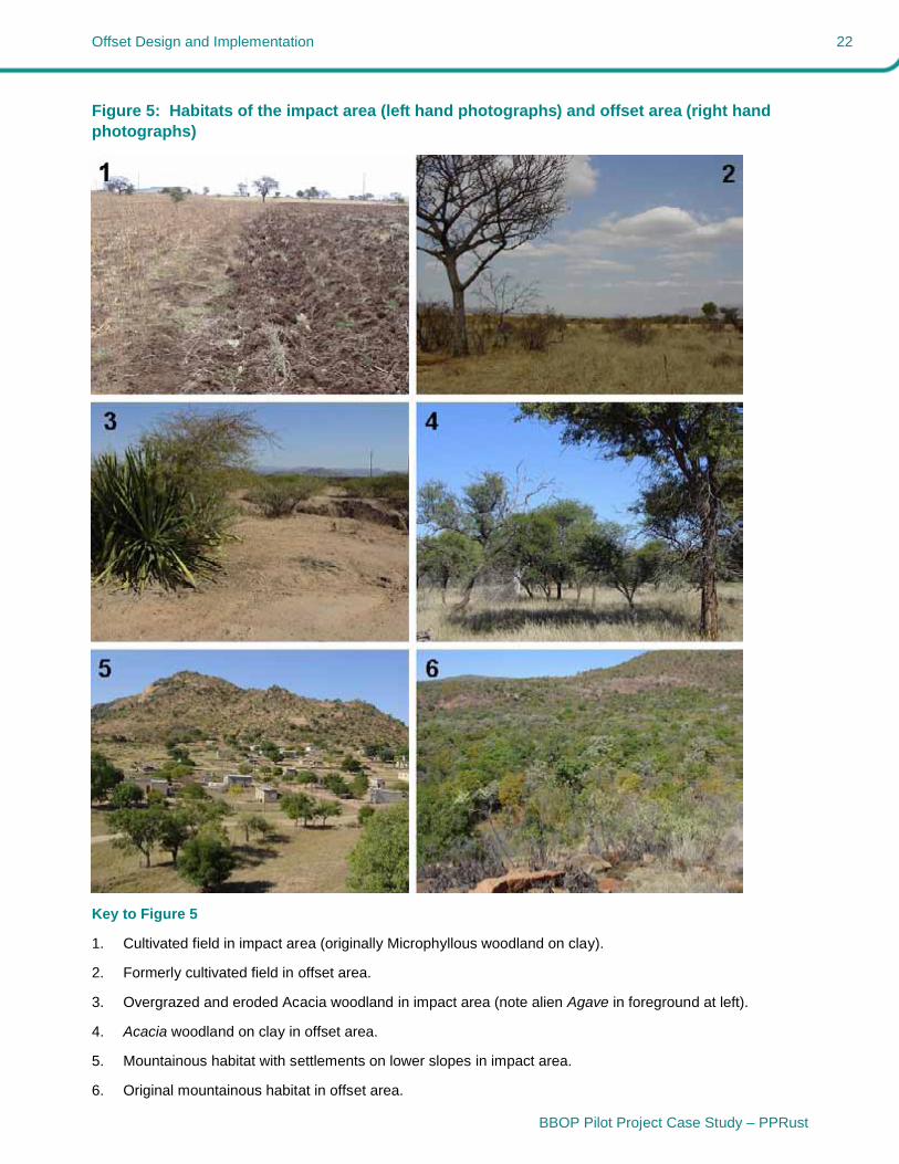
Figure 5: Habitats of the impact area (left hand photographs) and offset area (right hand photographs)
Key to Figure 5
1. Cultivated field in impact area (originally Microphyllous woodland on clay).
2. Formerly cultivated field in offset area.
3. Overgrazed and eroded Acacia woodland in impact area (note alien Agave in foreground at left).
4. Acacia woodland on clay in offset area.
5. Mountainous habitat with settlements on lower slopes in impact area.
6. Original mountainous habitat in offset area.

Offset Design and Implementation 23
BBOP Pilot Project Case Study – PPRust
Figure 6: Comparison of habitats mapped on the impact and offset areas. Note that ‘Woodlands on clay’ habitat has been totally transformed to ‘Cultivated and fallow (on clay)’ in the impact area
PPRust - habitat/vegetationWoodlands on clay (none)Cultivated & fallow (on clay)SettlementsRiverineMountainous areasTerminalia woodland on granite
Impact area
2 0 2 4 Kilometers
Offset area (habitat/vegetation)Woodlands on clayPreviously cultivated (on clay)InfrastructureRiverineMountainous areaTerminalia woodland on granite
1
2
3
3
3
4
5
6
7
8
9
1 = Open pit2 = Waste rock dump3 = Waste rock dump4 = Plant5 = Mining infrastructure6 = Tailings dam7 = New dam8 = New dam9 = Topsoil stockpile
Distance between Impact Areaand Offset Area
8 km
N
Offset Design and Implementation 24
BBOP Pilot Project Case Study – PPRust
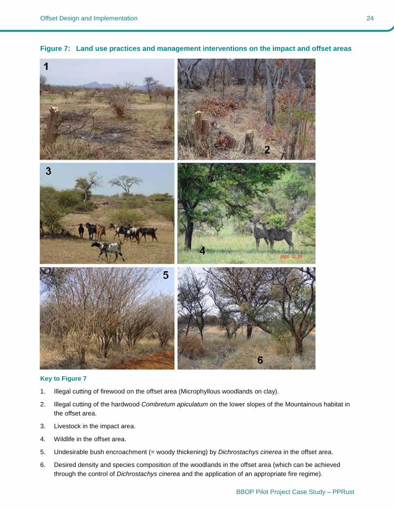
Figure 7: Land use practices and management interventions on the impact and offset areas
Key to Figure 7
1. Illegal cutting of firewood on the offset area (Microphyllous woodlands on clay).
2. Illegal cutting of the hardwood Combretum apiculatum on the lower slopes of the Mountainous habitat in
the offset area.
3. Livestock in the impact area.
4. Wildlife in the offset area.
5. Undesirable bush encroachment (= woody thickening) by Dichrostachys cinerea in the offset area.
6. Desired density and species composition of the woodlands in the offset area (which can be achieved
through the control of Dichrostachys cinerea and the application of an appropriate fire regime).
Offset Design and Implementation 25
BBOP Pilot Project Case Study – PPRust
5.2 Stakeholder engagement
Broad STAKEHOLDER engagement was undertaken during the mine’s Environmental Impact Assessment and
authorisation process. This did not include discussions relating to biodiversity offsets as this process pre-
dated the project’s involvement with BBOP as a pilot project. However, biodiversity protection was high on the
mine’s agenda and in 2005 the mine’s management began to seriously consider biodiversity offsetting as a
means of addressing RESIDUAL IMPACTS and supporting sustainable development within the communities in
which the company operates.
With the decision being taken to set aside the Mooihoek and Groenfontein farms as potential offsets
stakeholder interaction began to increase. uch of this interaction was on an informal and selective basis. This
was necessary to avoid building up expectations (for example with regard to the development of a lodge and
the creation of employment) before sufficient funding had been secured by the company.
At a scientific level the Anglo Platinum team has worked with the BBOP secretariat and a number of
ecologists from southern Africa. At a local level, the Mogalakwena District Municipality, Entabeni Private
Nature Reserve (Waterberg Biosphere Reserve) and adjoining landowners have been notified and involved.
From a community perspective the interaction has up until this stage been very low key and restricted to
certain community leaders. The reason for this low key approach is that the community leaders need to first
agree to what is being planned and in some cases implemented. They then use their own local structures to
take these matters to the affected communities. he interaction with the Kgoshigadi (queen) and her son, the
future tribal leader, on the current status and what is planned for the Mooihoek and Groenfontein farms has
been very positive.
As far as community access to the offset area is concerned, Anglo Platinum has for a number of years
allowed access for the sustainable collection of firewood. At present a group of 30 – 40 local women from
surrounding villages cut and collect firewood from the offset area on an ongoing basis. his practice is strictly
controlled and managed by the mine personnel on the site.
The future use of botanical resources, (e.g. harvesting of medicinal plants) is still to be investigated, but the
collection of firewood and selective hunting of game to improve the integrity of the area will continue as per
the existing management plan.
The mine has recently also identified and trained 10 young people from the surrounding community in aspects
related to horsemanship, horse management and tracking techniques. They have been trained by
professionals in the different fields and are now ready for duty as game guards in the offset area. The seven
week training course was very comprehensive and will add much value to the offset project.
5.3 Financial and institutional arrangements for long-term sustainability of the offset
All of the costs for the management of the offset, including the building of a lodge have originally been
budgeted under the mine’s environmental and sustainable development budget. However, the current
financial turmoil is resulting in uncertainty regarding this funding. Money has been budgeted for the capital
projects, such as fencing, the lodge and associated infrastructure. A budget for operational costs is provided
based on requirements set out in the management plan. Sufficient financial provision has been made to
effectively manage the area. However, as yet no model has been developed for the sustained financial
support of the offset once mining comes to an end in 80 years’ time.
Offset Design and Implementation 26
BBOP Pilot Project Case Study – PPRust
Monitoring programmes for the offset areas are still being developed. Monitoring at this stage is focused on
achieving the existing management requirements as stipulated in the management plan, e.g. preventing
wildlife populations exceeding carrying capacity, control of invasive alien plant species etc. Monitoring
programmes that can assess whether the anticipated biodiversity gains are actually being realised still need to
be designed and implemented.
The Mooihoek / Groenfontein offset area was not developed using the BBOP tools but was developed based
on mine management and community needs. Any planning and monitoring is thus based on the mine’s
requirements in relation to its reputational risk and in relation to its desire to establish a sustainable project for
communities. Although this means that certain BBOP guidelines might not have been used, in general the
BBOP principles were followed.
At present it is difficult to estimate whether any cost savings have occurred directly or indirectly as a result of
the offset. The mine does not have a model in place to monitor this. Moreover, the reason for pursuing a
biodiversity offsets is linked to social rather than financial motives. Developing a sustainable project for the
benefit of communities has far greater social responsibility benefits than financial benefits for the company.
While the offset project costs the mine a substantial amount of money on a yearly basis, the social benefits of
a project of this nature, in an area of high poverty, are very important to Anglo Platinum.
27
BBOP Pilot Project Case Study – PPRust
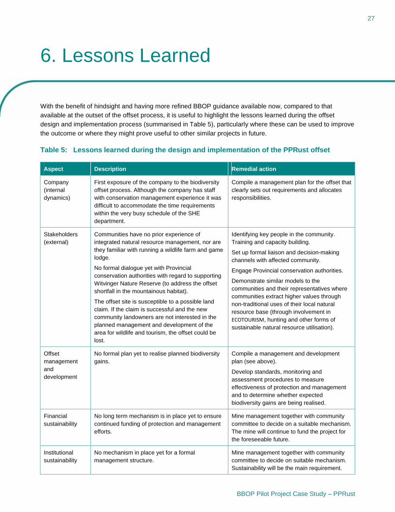
6. Lessons Learned
With the benefit of hindsight and having more refined BBOP guidance available now, compared to that
available at the outset of the offset process, it is useful to highlight the lessons learned during the offset
design and implementation process (summarised in Table 5), particularly where these can be used to improve
the outcome or where they might prove useful to other similar projects in future.
Table 5: Lessons learned during the design and implementation of the PPRust offset
Aspect Description Remedial action
Company (internal dynamics)
First exposure of the company to the biodiversity offset process. Although the company has staff with conservation management experience it was difficult to accommodate the time requirements within the very busy schedule of the SHE department.
Compile a management plan for the offset that clearly sets out requirements and allocates responsibilities.
Stakeholders (external)
Communities have no prior experience of integrated natural resource management, nor are they familiar with running a wildlife farm and game lodge.
No formal dialogue yet with Provincial conservation authorities with regard to supporting Witvinger Nature Reserve (to address the offset shortfall in the mountainous habitat).
The offset site is susceptible to a possible land claim. If the claim is successful and the new community landowners are not interested in the planned management and development of the area for wildlife and tourism, the offset could be lost.
Identifying key people in the community. Training and capacity building.
Set up formal liaison and decision-making channels with affected community.
Engage Provincial conservation authorities.
Demonstrate similar models to the communities and their representatives where communities extract higher values through non-traditional uses of their local natural resource base (through involvement in ECOTOURISM, hunting and other forms of sustainable natural resource utilisation).
Offset management and development
No formal plan yet to realise planned biodiversity gains.
Compile a management and development plan (see above).
Develop standards, monitoring and assessment procedures to measure effectiveness of protection and management and to determine whether expected biodiversity gains are being realised.
Financial sustainability
No long term mechanism is in place yet to ensure continued funding of protection and management efforts.
Mine management together with community committee to decide on a suitable mechanism. The mine will continue to fund the project for the foreseeable future.
Institutional sustainability
No mechanism in place yet for a formal management structure.
Mine management together with community committee to decide on suitable mechanism. Sustainability will be the main requirement.

28
BBOP Pilot Project Case Study – PPRust
7. Final Comments
This pilot project, as the name implies, was started in the early stages of the development of BBOP guidance.
Consequently, the PPRust pilot does not lay any claim to ‘perfectly’ following the guidance. The pilot project
provides a good example of the usefulness of the BBOP guidance particularly with regard to the calculation of
biodiversity losses and potential gains at offset sites. In this particular case, much of the decision-making in
terms of offset location and addressing social issues was dictated by pre-existing conditions and local realities
in the context of land availability and land ownership.
The value of the offset areas does not only lie in their size, but in the overall amount of biodiversity gained
(improved quality and CONDITION, as well as area). The offset will result in a gain of 1,101 HABITAT HECTARES,
compared to the project’s loss of 798 habitat hectares: a net gain of 303 habitat hectares. Thus, rather than
surface area, the value of the offset area is seen to lie in:
1. The anticipated net gain in habitat hectares;
2. The fact that the offset areas contains representative examples of the once extensive Microphyllous
woodlands on clay;
3. The opportunity that the offset provides for generating income for the local community through community
owned projects. It is hoped that these will begin to reduce the reliance of the communities on the remaining
natural resources, which could in turn open the way for Savannah Biome REHABILITATION projects within
the surrounding area; and
4. The opportunity that the areas provide for educating the local communities on the benefits of ECOSYSTEMmaintenance and management.

29
BBOP Pilot Project Case Study – PPRust
8. References
Driver, A., Maze, K., Rouget, M., Lombard, A.T., Nel, J., Turpie J.K., Cowling, R.M., Desmet, P., Goodman,
P., Harris, P., Jonas, Z., Reyers, B., Sink, K. and Strauss, T. 2005. National Spatial Biodiversity Assessment
2004: Priorities for biodiversity conservation in South Africa. Strelitzia 17. South African National Biodiversity
Institute.
Ekofocus. 2004. Anglo Platinum Mokopane Game Reserve. Ecological evaluation 2004. Unpublished report
by Efokocus to PPRust.
Mucina, L. and Rutherford, M.C. (Eds.). 2006. The Vegetation Map of South Africa, Lesotho and Swaziland.
Strelitzia 19. South African National Biodiversity Institute, Pretoria.
SRK. 2002. Proposed mine development for Anglo Platinum – PPRust North project. Ecological specialist
report. Compiled by School of Molecular and Life Sciences, University of the North for Steffen, Robertson and
Kirsten (Pty.) Ltd. SRK Project no. 305804.
SRK. 2003. Proposed mine development for Anglo Platinum – PPRust North project. Ecological summer
survey specialist report. Compiled by School of Molecular and Life Sciences, University of the North for
Steffen, Robertson and Kirsten (Pty.) Ltd. SRK Project no. 305804 (addendum).
Stalmans, M. 2006. PPRust – towards defining a ‘benchmark’ for offset purposes. Unpublished report by
International Conservation Services CC to PPRust (Angloplat).
Stalmans, M. 2007. Potgietersrust Platinum Limited (PPRust North – Overysel / Zwartfontein project)
Benchmarking & Offset calculation. Unpublished report by International Conservation Services CC to PPRust
(Angloplat).

To learn more about the BBOP principles, guidelines and optional methodologies, go to:
www.forest-trends.org/biodiversityoffsetprogram/guidelines