burlington township, nj - dvrpc.org · pdf fileacknowledgments this report was developed for...
TRANSCRIPT
December 2017
BURLINGTON TOWNSHIP, NJ
Prepared for Burlington Township by the Delaware Valley Regional Planning Commission; funded by the National Oceanic and Atmospheric Administration for the New Jersey Resilient Coastal Communities Initiative, managed by the New Jersey Department of Environmental Protection Office of Coastal and Land Use Planning


Acknowledgments
This report was developed for Burlington Township and the New Jersey Department of Environmental Protection, Coastal Management Program, Office of Coastal and Land Use Planning. Financial assistance was provided by the Coastal Zone Management Act of 1972, as amended, administered by
the Office for Coastal Management, National Oceanic and Atmospheric Administration (NOAA) Program through the New Jersey Department of Environmental Protection, Coastal Management Program, Office of Coastal and Land Use Planning. These environmental data and related items of
information have not been formally disseminated by NOAA and do not represent and should not be construed to represent any agency determination, view, or policy.
The following people helped make this report possible:
Stephen Fazekas, Director of Public Works, Burlington Township Scott Hatfield, PE, CME, Director of Engineering, Burlington Township Jeff Taylor, Assistant Engineer, PE, Burlington Township
Michael Wright, Construction Official, Building Inspector, Electrical Subcode/Inspector, Fire Subcode/ Inspector, Licenses & Inspections, Burlington Township
.


B U R L I N G T O N T O W N S H I P C O A S T A L V U L N E R A B I L I T Y A S S E S S M E N T i
Table of Contents
Executive Summary ........................................................................................................................................... 1
Burlington Coastal Vulnerability Assessment ................................................................................................ 3
Introduction .................................................................................................................................................. 3
Burlington Township’s Coastal Vulnerability ........................................................................................... 4
Current Preparedness for Flooding ........................................................................................................... 6
Scenarios ...................................................................................................................................................... 8
Assessing Vulnerabilities ......................................................................................................................... 11
Analysis and Findings .............................................................................................................................. 12
Recommendations for Burlington Township’s Assets ................................................................................ 16
General Recommendations............................................................................................................................. 17
Resources and Funding Opportunities ......................................................................................................... 22
Figures
• Figure 1: Sea Level Rise Projections for New Jersey in 2030, 2050, and 2100.................................... 5
• Figure 2: Western Side of Burlington Township and 1-Percent Floodplain ......................................... 10
• Figure 3: Assiscunk Creek Bridge at Neck Road ................................................................................. 13
• Figure 4: Burlington Township’s Wastewater Treatment Plant ............................................................ 14
• Figure 5: Davis Honda. ........................................................................................................................ 15
Tables
• Table 1: Breakdown by Type for All Analyzed Assets ............................................................................ 1
• Table 2: List of Asset Types Identified as High-Concern ....................................................................... 2
• Table 3: Overview of Assets Identified as High-Concern ..................................................................... 12
• Table 4: Breakdown of Remaining Assets by Degree of Risk .............................................................. 16
Appendices
Appendix A: Coastal Vulnerability Assessment Matrix ............................................................................. A-1
Appendix B: Vulnerability and Consequences Rating Keys ..................................................................... B-1
Appendix C: Burlington Township Flood Scenario Maps ......................................................................... C-1


B U R L I N G T O N T O W N S H I P C O A S T A L V U L N E R A B I L I T Y A S S E S S M E N T 1
Executive Summary
Located along the Delaware River and bisected by many tidal tributaries, Burlington Township is susceptible to the effects of coastal flooding (i.e., flooding along the tidal portions of the Delaware River shoreline and other tidal waterways). The combination of rising tidal waters and increasing frequency of extreme weather
events along these water bodies will gradually increase the risk of coastal flooding events in the township over time.
In this project, Burlington Township staff worked with the Delaware Valley Regional Planning Commission (DVRPC) to conduct a coastal vulnerability assessment (CVA), in which participants reviewed and prioritized future risks to the township from the combined effects of storm surge and sea level rise. The CVA used 2100
sea level rise projections (3.3 feet) in combination with a model that shows the depth and extent of storm surge from a Category 2 storm if it were to strike at high tide and at an angle and direction that maximized the amount of surge.
The CVA project team reviewed the impact of this “CVA scenario” on 15 assets in Burlington Township. Assets include properties, infrastructure, or natural resources that are of high value to the community and/or
facilities and populations that might be particularly vulnerable to extreme events (see Table 1). The project team determined whether each asset would get flooded using the previously described flooding scenario, what would happen to the asset if it were to be flooded, and the consequences to the township if the asset
were damaged or unable to function during a flood.
Table 1: Breakdown by Type for All Analyzed Assets
Asset Category Count
Housing Facility 4
Institutional/Cultural/Government 3
Transportation 3
Emergency Facility 1
Emergency Facility & Institutional/Cultural/Government 1
Hazardous Site 1
Open Space 1
Utility & Institutional/Cultural/Government 1
Total Number of Assets 15
Burlington Township has a low overall vulnerability to the flooding scenario described, though the analysis revealed three assets that Burlington should consider as being of high concern (Table 2).

2 B U R L I N G T O N T O W N S H I P C O A S T A L V U L N E R A B I L I T Y A S S E S S M E N T
Table 2: List of Asset Types Identified as High-Concern
Asset Category Count
Transportation 1
Hazardous Site 1
Utility & Institutional/Cultural/Government 1
The three assets of high concern include a county bridge in the township (transportation asset), the
wastewater treatment/public works building (utility and institutional/cultural/government building), and the Davis Honda property, a contaminated site (hazardous site).

B U R L I N G T O N T O W N S H I P C O A S T A L V U L N E R A B I L I T Y A S S E S S M E N T 3
Burlington Coastal Vulnerability Assessment
Introduction The municipal coastal vulnerability assessment (CVA) is a tool to help communities plan for flooding along
their coastlines and tidal waterways and prioritize flood mitigation strategies, enabling them to better manage and recover from these floods. Every level of government—federal, state, and local—has a role in planning for stressors and threats likely to afflict its citizens. However, municipalities that have the tools to understand,
predict, and prepare for the natural disasters that occur within their borders are arguably best poised to assist their constituents in reducing potential harms associated with climate hazards and extreme weather events.
The CVA assesses the degree to which a community’s “assets” (its properties, infrastructure, natural resources, and populations) will be affected by flooding from projected sea level rise and storm events. For those assets that are affected, the CVA analyzes the consequences that their temporary or long-term loss
poses to the community. With this assessment, communities will be better informed to make decisions about land use planning, flood mitigation, sea level rise adaptation, infrastructure maintenance, capital improvements, and post-disaster recovery. On September 9, 2015, Burlington Township met with DVRPC, the region’s Metropolitan Planning
Organization, to begin the CVA process. The project team used a CVA methodology created by Sustainable Jersey within the New Jersey Resilient Coastal Communities Initiative (RCCI), a program run by the Office of Coastal and Land Use Planning in the New Jersey Department of Environmental Protection (NJDEP).
NJDEP and Sustainable Jersey developed the methodology to help municipalities prepare for sea level rise and likely increases in the frequency of extreme storm events. Burlington’s Location
Burlington Township is a suburban municipality that encompasses 13.9 square miles in Burlington County, New Jersey. Located along the tidal Delaware River, and bisected by tidal portions of Marters Ditch, Tanners Run, Assiscunk Creek, Riggs Mill Creek, Bustleton Creek, and other smaller tributaries, Burlington Township
will feel the effects of sea level rise. At the same time, it will be affected by the stronger storms anticipated in the Northeastern United States. The combination of rising tidal waters, increasingly severe coastal storms, and more extreme precipitation events will increase the risk of flooding in the township over time.
Historical Flooding in Burlington Township Like other communities in New Jersey, Burlington Township is susceptible to extreme precipitation events and potential flooding, but to the knowledge of the participants in the CVA, the township has not had a highly
damaging coastal flood event in recorded history. Communities north of the head-of-tide at Trenton along the Delaware River have experienced numerous devastating riverine floods along the Delaware River since the beginning of the 20th century, with eight major floods having occurred since 1996. However, the impacts of
these floods were experienced from Trenton northward, where the river is not tidal and the water is confined to a narrower channel.
In Burlington Township, the CVA participants did offer recollections of several storms, all of which produced minimal or minor flooding. During the 1962 storm, water came across South Linden Road and affected the single-family homes that back up to the river. According to CVA participants, Superstorm Sandy, Hurricane

4 B U R L I N G T O N T O W N S H I P C O A S T A L V U L N E R A B I L I T Y A S S E S S M E N T
Irene, and Tropical Storm Lee did not cause significant impacts to the township. The Federal Emergency Management Agency (FEMA) reports show that only two properties in the township have submitted repetitive
loss claims on flood insurance. Instead, CVA participants emphasized stormwater runoff issues that the township faces from relatively minor
storms, mentioning such problematic sites as Linden Street along the Delaware River, Devlin Avenue between Tanners Run and Marters Ditch, and the Meadow Oaks and Santa Fe neighborhoods along the Assiscunk Creek.
Burlington Township’s Coastal Vulnerability Why a Coastal Vulnerability Assessment is Relevant to Burlington Despite the lack of catastrophic coastal floods in Burlington Township’s past, the combination of sea level rise and increases in the intensity and frequency of coastal storms caused by climate change will introduce new vulnerabilities in Burlington that the township will need to address.
Since 1900, the sea level has risen approximately one foot in the tidal Delaware River.1 Climate change will continue to cause an accelerating rate of sea level rise and increases in the intensity of severe storm events
in the coming decades. The following is a summary of the expected coastal and riverine flooding changes in New Jersey, assuming global greenhouse gas emissions trends continue as they are today.
Sea Level Rise
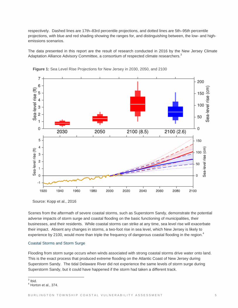
In New Jersey, the most recent sea level rise central estimate (meaning that the estimate has a 50 percent probability of being met or exceeded) is 1.4 feet from current sea level by 2050, and 3.4 feet from current levels by 2100, assuming current rates of emissions continue.2 Figure 1 shows sea level rise projections for New Jersey at Atlantic City in 2030, 2050, and 2100. In the top chart, the box-and-whisker plots indicate sea level rise projections. In 2030 and 2050, the projections are the same for the low- and high-emissions scenarios (Representative Concentration Pathways [RCP] 2.6 and 8.5, respectively). In 2100, the red box-and-whisker plot indicates the sea level rise projection for the high-emissions scenario (RCP 8.5), and the blue box-and-whisker plot indicates sea level rise projections for a low-emissions scenario (RCP 2.6). The white line across the middle of each box-and-whisker plot denotes the 50th percentile value (the value that has a 50 percent probability of occurring). For example, in 2050, the white line is located at 1.4 feet. Looking above the white line, again for 2050 as an example, there is a 33 percent chance that sea level rise will be between 1.4 and 1.8 feet, a 12 percent chance that sea level rise will be between 1.8 and 2.0 feet, and a 4 percent chance that sea level rise will be above 2.0 feet. The same probabilities exist for three sets of sea level rise values below the white line of the box-and-whisker plot. In the bottom chart, the gold-colored line indicates observed tide-gauge heights. Solid red and blue lines are the 50th percentile projection for the high emissions (RCP 8.5) and low-emissions (RCP 2.6) scenarios,
1 Radley Horton et al., “Ch. 16: Northeast,” in Climate Change Impacts in the United States: The Third National Climate Assessment, ed. J. M. Melillo, T. C. Richmond, and G. W. Yohe (U.S. Global Change Research Program, 2014), 373, accessed January 9, 2017, pubs.giss.nasa.gov/docs/2014/2014_Horton_ho06500e.pdf. 2 R. E. Kopp et al., Assessing New Jersey’s Exposure to Sea-Level Rise and Coastal Storms: Report of the New Jersey Climate Adaptation Alliance Science and Technical Advisory Panel, prepared for the New Jersey Climate Adaptation Alliance (New Brunswick, NJ: Rutgers University, October 2016), 2.
B U R L I N G T O N T O W N S H I P C O A S T A L V U L N E R A B I L I T Y A S S E S S M E N T 5
respectively. Dashed lines are 17th–83rd percentile projections, and dotted lines are 5th–95th percentile projections, with blue and red shading showing the ranges for, and distinguishing between, the low- and high-emissions scenarios. The data presented in this report are the result of research conducted in 2016 by the New Jersey Climate Adaptation Alliance Advisory Committee, a consortium of respected climate researchers.3
Scenes from the aftermath of severe coastal storms, such as Superstorm Sandy, demonstrate the potential adverse impacts of storm surge and coastal flooding on the basic functioning of municipalities, their
businesses, and their residents. While coastal storms can strike at any time, sea level rise will exacerbate their impact. Absent any changes in storms, a two-foot rise in sea level, which New Jersey is likely to experience by 2100, would more than triple the frequency of dangerous coastal flooding in the region.4
Coastal Storms and Storm Surge
Flooding from storm surge occurs when winds associated with strong coastal storms drive water onto land. This is the exact process that produced extreme flooding on the Atlantic Coast of New Jersey during Superstorm Sandy. The tidal Delaware River did not experience the same levels of storm surge during
Superstorm Sandy, but it could have happened if the storm had taken a different track.
3 Ibid. 4 Horton et al., 374.
Source: Kopp et al., 2016
Figure 1: Sea Level Rise Projections for New Jersey in 2030, 2050, and 2100

6 B U R L I N G T O N T O W N S H I P C O A S T A L V U L N E R A B I L I T Y A S S E S S M E N T
Unlike sea level rise, storm surge is a temporary condition. However, storm surge can happen at any time,
and the potential height of water pushed onto land in the Delaware River region from a strong storm is much greater than the projected amount of sea level rise. For example, storm surge heights during Superstorm Sandy exceeded 10 feet in some parts of Northern New Jersey and New York, three times the median
amount of projected sea level rise by 2100. While the future frequency and intensity of coastal storms cannot be predicted with certainty, the warming in
the atmosphere and oceans associated with climate change is likely to increase the intensity of coastal storms, particularly in the latter part of the 21st century.5
Riverine Flooding
While this report focuses primarily on coastal flooding, riverine flooding cannot be ignored and likely poses an even greater threat in some neighborhoods in Burlington. CVA participants reported non-tidal riverine
flooding in areas around Route 130, Jennifer Lane, Fountain Avenue, and Spring Hill Lane. CVA participants also noted “upstream-downstream” concerns regarding their position in the watershed relative to other neighboring municipalities, which causes them to receive stormwater runoff from upstream municipalities.
Burlington currently uses FEMA’s 100-year floodplain map (or “Flood Insurance Rate Map” [FIRM]) to evaluate the threat of riverine flooding. The township should continue to use this map for that purpose but at
the same time should recognize that the frequency of storms with heavy downpours is projected to increase as a result of climate change.6 As products and models become available to project the spatial extent of this evolving threat, they should be evaluated by township officials.
Current Preparedness for Flooding Land Use and Conservation
Fortunately for Burlington, the majority of assets in the township are located inland, away from its coastal waterways and at a sufficiently high elevation to avoid widespread damage. Furthermore, much of the land
that is predicted to flood in future decades along the Delaware River and Assiscunk Creek is open space. Figure C4 in Appendix C demonstrates how the presence of open space prevents residents and businesses from being exposed to some of the flooding predicted along the Delaware River and Tanners Run. As of
2011, approximately 302 acres of land along tidal portions of Burlington’s waterways were protected open space. Much of this land is part of the township’s greenway/open space network, which the township continues to work to expand.
Plans
Burlington Township’s 2008 Comprehensive Master Plan includes strategies that can be used to mitigate
some of the potential future impacts of coastal flooding. The plan promotes the goal of protecting such natural resources as wetlands, floodplains, forests, and stream corridors, all of which can absorb floodwaters
5 NOAA, “Geophysical Fluid Dynamics Laboratory,” in Global Warming and Hurricanes: An Overview of Current Research Results, accessed March 17, 2017, www.gfdl.noaa.gov/global-warming-and-hurricanes/. 6 Horton et al., 374.

B U R L I N G T O N T O W N S H I P C O A S T A L V U L N E R A B I L I T Y A S S E S S M E N T 7
and thereby reduce damages to other assets.7 Objectives to meet that goal, as listed in the Master Plan and the Natural Resources Conservation Plan element, include “promote stormwater management practices that
positively affect aquifer recharge areas, floodplains, wetlands, waterways, and properties abutting waterways,”8 and “maximize the ability of natural systems to control runoff and flooding.” 9
The township’s 2006 stormwater management plan,10 which is an addendum to the Public Utilities Service
Plan element of its master plan, also addresses flood issues for the township’s major waterways. It inventories significant stormwater issues in tidal and inland areas and lists a variety of strategies for reducing stormwater and stormwater impacts, including green stormwater infrastructure in the form of detention basin
naturalization, riparian buffer protection, stream bank restoration, and wetland protection.
Emergency Operations Procedures
Although Burlington Township has not been substantially affected by flooding along its waterways, township officials and staff have outreach for flood emergencies. For emergencies, they have a registry, which is kept by the police. Seniors or people with disabilities can register to participate in this voluntary program. The
township also uses Code Red, which sends messages to any mobile device that has opted in; Nixle, which is a public alert texting system; and Constant Contact, a mass email program. All of these are voluntary programs. The township is home to Endeavor Emergency Squad, which uses Facebook as a means of
disseminating disaster information.11 Vulnerable Populations Burlington Township has a population of approximately 22,653 residents (2015 5-Year American Community
Survey [ACS]), and a density of 1,630 residents per square mile. There are several populations that may need additional assistance in the event of a storm, but as indicated in the “Current Preparedness for Flooding” section beginning on page 6, the township continues to demonstrate its desire to ensure that all citizens are
given the assistance they need before, during, and after storms.
Households in Poverty
In 2015, 8.0 percent of households in Burlington reported an income below the poverty level, which was below the state average of 10.5 percent but higher than the county average of 6.25 percent within the same
time period.12
Carless Households Approximately 1.5 percent of households in Burlington Township did not own cars in 2015, which is about the
same as the county’s reported value (1.5 percent) and lower than the state’s value (2.4 percent).13 Carless households face additional challenges in evacuating before a storm by relying on alternative modes of
7 Burlington Township Planning. Comprehensive Master Plan. Township of Burlington, NJ. 2008. www.twp.burlington.nj.us/filestorage/279/714/765/7.10.08_Burl_Twp_MP.pdf. 8 Burlington Township Planning. Comprehensive Master Plan, III F page 7 of 15. 9 Burlington Township Planning. Comprehensive Master Plan, III G page 2 of 9. 10 Burlington Township, Stormwater Management Plan, 2006, PDF pages 154-218. 11 Burlington Township, Burlington Township (NJ) Office of Emergency Management, accessed November 1, 2017, www.facebook.com/Burlington-Twp-NJ-Office-of-Emergency-Management-231238540255356/. 12 U.S. Census Bureau, “DP03: Selected Economic Characteristics,” 2011–2015 ACS 5-Year Estimates. 13 U.S. Census Bureau, “B25044: Tenure by Vehicles Available,” 2011–2015 ACS 5-Year Estimates.
8 B U R L I N G T O N T O W N S H I P C O A S T A L V U L N E R A B I L I T Y A S S E S S M E N T
transportation to leave the township. However, the majority of residents (98.6 percent) have cars, and thus more options to evacuate before an emergency.
Homeowners and Renters 76.2 percent of Burlington Township residents reported owning their homes in 2015, which is about equivalent
with Burlington County (76.5 percent) but higher than in New Jersey (64.5 percent).14 Renters have less ability to repair their homes following a disaster, so while the majority of the township’s residents, as homeowners, are more secure in this regard, there are still a substantial portion of households that, as
renters, are more at risk of displacement following a severe storm.
Residents with a Disability
9.3 percent of residents reported having a disability in 2015, which is lower than the state and county percentages of 10.3 percent and 11.0 percent.15 These residents may have particular mobility and medical
care needs in an evacuation.
Seniors
16.6 percent of Burlington Township residents were elderly in 2015, which is lower than the state and county percentages of 20.2 and 21.0 percent.16 In 2015, two of Burlington Township’s census tracts, 7011.5 and
7011.2, exceeded the nine-county DVRPC region’s average representation of that age group. Together, these two tracts are bordered by Burlington City to the north, the Assiscunk Creek and Springfield Township to the east, Westhampton Township to the south, and Salem Road to the west. The elderly residents living in
these tracts may be particularly affected by flooding from the Assiscunk Creek. As with residents with a disability, seniors may also have particular mobility and medical care needs in an evacuation.
Limited English Speakers
In 2015, 0.85 percent of Burlington Township residents reported that they spoke English “not well” or “not at
all,” which is much lower than that reported for Burlington County (1.7 percent) or New Jersey (6.3 percent).17 Though relatively small, this population may need additional outreach to enable them to understand threats associated with incoming flooding, what is required for them to prepare, what resources are available to avoid
harm, and what assistance can help with recovery from these events.
Scenarios The flood scenario used in this CVA shows the result of storm surge generated by a Category 2 storm plus a sea level rise projection of 3.3 feet by 2100.18 Storm surge was modeled using NOAA’s SLOSH (Sea, Lake, and Overland Surge from Hurricanes) model and shows what would happen if a Category 2 storm were to
strike the Delaware Bay at an angle that would maximize storm surge at high tide. In other words, this is a
14 U.S. Census Bureau, “B25044: Tenure by Vehicles Available,” 2011–2015 ACS 5-Year Estimates. 15 U.S. Census Bureau, “B18101: Sex by Age by Disability Status,” 2011–2015 ACS 5-Year Estimates. 16 U.S. Census Bureau, “B01001: Sex by Age,” 2011–2015 ACS 5-Year Estimates. 17 U.S. Census Bureau, “B16004: Age by Language Spoken at Home by Ability to Speak English for the Population 5 Years and Over,” 2011–2015 ACS 5-Year Estimates. 18 The 3.3-foot figure was from a report produced by the New Jersey Climate Adaptation Alliance Science and Technical Advisory Panel that predates the current report. The 3.3-foot figure was already built into the maps and models by the time the report with the 3.4-foot median estimate was produced.

B U R L I N G T O N T O W N S H I P C O A S T A L V U L N E R A B I L I T Y A S S E S S M E N T 9
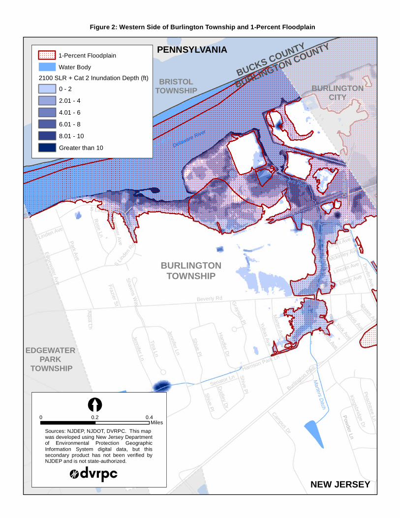
“worst case scenario” for a Category 2 storm in the tidal Delaware River. This flooding scenario will be described in this report as the “CVA scenario.” Notably, the inundation resulting from the combined sea level rise and storm surge depicted in the CVA
scenario closely resembles the 1-percent/100-year flooding extent. Figure 2 demonstrates this similarity along the Delaware River in the western side of the township. FEMA uses the 1-percent scenario in its FIRMs, and Burlington Township uses these maps for planning purposes. Because the extent of flooding
from sea level rise in 2100 during a Category 2 storm is similar to the extent of the township’s FEMA floodplain, the authors determined that the “CVA scenario” was not overly pessimistic or of such a low probability as to not warrant modeling. Furthermore, the storm surge heights expected in a modeled
Category 2 storm are certainly possible, as was experienced in Northern New Jersey during Superstorm Sandy.19 Since storm surge heights associated with a Category 3 or Category 4 storm are less likely, the authors of this report determined that these are not scenarios for which municipalities should focus their
planning efforts. Flood depths were determined using a baseline elevation derived from Light Detection and Ranging (LiDAR)
data.20 The storm surge modeling and the baseline elevation layers were developed state-wide by NJDEP and layered on maps developed by DVRPC. The maps for this study are in Figure 2 and Appendix C.
19 The storm surge experienced in Sandy Hook in Northern New Jersey during Superstorm Sandy was approximately 8.5 feet above mean higher high water. This height is commensurate with what the SLOSH model would predict for a Category 2 hurricane striking the area. Sandy was not technically a hurricane when it made landfall in New Jersey, but the storm’s large wind field and low pressure generated a storm surge that would normally be associated with a Category 2 hurricane according to predictive modeling. 20 Note that the projected flood events used in this assessment were generated by several models prepared by state and national agencies and professionals, and are suitable for planning purposes. However, due to the uncertainty of projections and accuracy of certain types of data, the maps should not be the sole resource for conducting site-specific analyses.
Tanners Run
Delaware River
Sum
mer A
ve
Yubas A
ve
Shive P
l
Marter A
veShive P
l
Park A
ve
Beverly Rd
Shive P
l
S Lin
den
Rd
Dev
lin A
ve
Jennifer Ln
Devlin A
ve
Shaw
ns Way
Mckinley Ave
Lincoln Ave
Edgew
ater Ave
Burlin
gton P
ikeHarrison Park Ln
Elmer Ave
States Ave
Grant Ave
Penn AveNew York Ave
Illinois Ave
Senator Ln
Aqu
a Ln
Kingsbridge D
r
Linden Ave
Frazier S
t
Grayson P
l
Dudley D
r
Campus Dr
Peachtree Ln
Harvest Ln
Handler D
r
Rose Ln
Tina Ln
Jennifer Ln
BRISTOLTOWNSHIP
BURLINGTONTOWNSHIP
EDGEWATER PARK
TOWNSHIP
S Linden Rd
Tanners Run
Marters Ditch
BURLINGTONCITY
BUCKS COUNTY
BURLINGTON COUNTY
Delaware River
PENNSYLVANIA
NEW JERSEY
Pow
der Ln
Figure 2: Western Side of Burlington Township and 1-Percent Floodplain
Sources: NJDEP, NJDOT, DVRPC. This mapwas developed using New Jersey Departmentof Environmental Protection GeographicInformation System digital data, but thissecondary product has not been verified byNJDEP and is not state-authorized.
[0 0.40.2
Miles
2100 SLR + Cat 2 Inundation Depth (ft)
0 - 2
Greater than 10
8.01 - 10
6.01 - 8
4.01 - 6
2.01 - 4
Water Body
1-Percent Floodplain

B U R L I N G T O N T O W N S H I P C O A S T A L V U L N E R A B I L I T Y A S S E S S M E N T 1 1
Assessing Vulnerabilities Methodology On March 8, 2016, DVRPC staff met with Burlington Township staff (listed in the Acknowledgments section) to conduct the CVA. This team examined the vulnerability of 15 “assets,” which are properties, infrastructure, or natural resources that are owned by the township or have high value to the community, as well as
vulnerable populations located within the township. The assets are evaluated using a three-step process:
1. Community assets are identified, mapped, and compared with maps of flooding for selected flood scenarios to determine if they will be exposed to flooding or not.
2. The sensitivity of individual assets is determined. Sensitivity is shorthand for the impact of flooding on an asset. For example, a flooded basketball court will be relatively unimpacted after floodwaters recede, while paper documents in a repository will likely be permanently destroyed if exposed to flooding. While this is a clear-cut example, the sensitivity of many types of assets, such as a downtown building or shopping center, is challenging to determine with much specificity.
3. The consequence is determined by the potential effects on the community from temporary, long-term,
or permanent damage to each individual asset.
Identifying and Mapping Community Assets
The CVA relies on Geographical Information Systems (GIS) maps to locate and analyze community assets and flood hazards. Community assets are identified among three categories—Built Environment, Natural Environment, and Vulnerable Populations—and are plotted using GIS. DVRPC mapped assets and plotted
them against the CVA scenario to determine whether they would be exposed to flooding.
Evaluating Asset Sensitivity and Vulnerability Sensitivity is the degree to which an asset may become affected by predicted floodwaters. Vulnerability is the
product of exposure and sensitivity. If an asset is exposed to flooding and it is sensitive to flooding, then it is vulnerable. The level of vulnerability is thus a function of the level of sensitivity of an asset. In other words, an asset that is exposed to flooding and is highly sensitive to flooding would be highly vulnerable, while an
asset that is exposed and moderately sensitive would be moderately vulnerable. Assets that are not exposed are not vulnerable, regardless of their sensitivity.
For each asset, vulnerability was categorized as insignificant, low, moderate, or high. A description of the categories can be found in Appendix B. When there was insufficient information to determine the exact vulnerability ranking for an asset, a range was used.
Evaluating the Consequences of Asset Damage Consequence is the effect on the community if an asset is temporarily or permanently damaged or impaired by flooding. Consequence is ranked as insignificant, minor, moderate, or high for each asset. A description of the meaning of each ranking can be found in Appendix B.
1 2 B U R L I N G T O N T O W N S H I P C O A S T A L V U L N E R A B I L I T Y A S S E S S M E N T
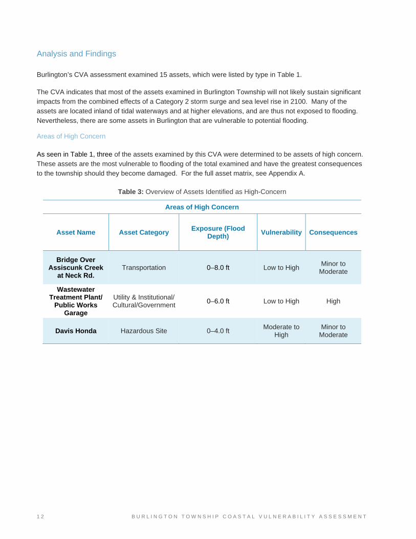
Analysis and Findings Burlington’s CVA assessment examined 15 assets, which were listed by type in Table 1.
The CVA indicates that most of the assets examined in Burlington Township will not likely sustain significant impacts from the combined effects of a Category 2 storm surge and sea level rise in 2100. Many of the assets are located inland of tidal waterways and at higher elevations, and are thus not exposed to flooding.
Nevertheless, there are some assets in Burlington that are vulnerable to potential flooding.
Areas of High Concern
As seen in Table 1, three of the assets examined by this CVA were determined to be assets of high concern. These assets are the most vulnerable to flooding of the total examined and have the greatest consequences to the township should they become damaged. For the full asset matrix, see Appendix A.
Table 3: Overview of Assets Identified as High-Concern
Areas of High Concern
Asset Name Asset Category Exposure (Flood Depth) Vulnerability Consequences
Bridge Over Assiscunk Creek
at Neck Rd. Transportation 0–8.0 ft Low to High
Minor to Moderate
Wastewater Treatment Plant/
Public Works Garage
Utility & Institutional/ Cultural/Government
0–6.0 ft Low to High High
Davis Honda Hazardous Site 0–4.0 ft Moderate to
High Minor to
Moderate

B U R L I N G T O N T O W N S H I P C O A S T A L V U L N E R A B I L I T Y A S S E S S M E N T 1 3
Bridge Over Assiscunk Creek at Neck Road A county bridge crossing the Assiscunk Creek at Neck Road (Figure 3) will be faced with flood depths of up to
eight feet in the CVA scenario. This height represents flooding above the water surface, not the bridge deck. The distance from the water to the bridge deck would need to be accurately calculated to determine whether or not the bridge would be overtopped. The vulnerability of this crossing ranges from low to high, depending
on whether overtopping occurs. In addition, the velocities of water associated with the flooding of the Assiscunk Creek may cause scouring of the bed of the waterway on which the bridge is anchored, potentially destabilizing it. If the deck of the bridge is overtopped, flood waters may also cause substantial pressure on
the bridge, potentially leading to its destruction.
The bridge was assigned a consequences rating of minor to moderate. If the bridge was damaged in a flood, drivers would have to seek alternative routes, substantially altering their commute and causing disruptions of traffic flows. If the bridge were destroyed, it would likely require more than a year to be replaced.
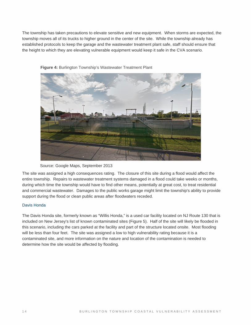
Wastewater Treatment Plant/Public Works Garage
The township's wastewater treatment plant and public works garage (Figure 4) are located on the same site along Devlin Avenue and adjacent to Tanners Run. Flood waters currently collect behind the wastewater plant during storms, but in the CVA scenario, most of the site is predicted to be flooded. While the majority of
the site will be faced with two feet of flooding or less, the northwest corner of the site may see up to six feet. The site was assigned a low to high vulnerability rating. The wastewater treatment plant is designed to flood, but more information is needed about whether its design flood matches the depths predicted in the CVA
scenario.
Source: Google Maps, September 2013
Figure 3: Assiscunk Creek Bridge at Neck Road
1 4 B U R L I N G T O N T O W N S H I P C O A S T A L V U L N E R A B I L I T Y A S S E S S M E N T
The township has taken precautions to elevate sensitive and new equipment. When storms are expected, the township moves all of its trucks to higher ground in the center of the site. While the township already has
established protocols to keep the garage and the wastewater treatment plant safe, staff should ensure that the height to which they are elevating vulnerable equipment would keep it safe in the CVA scenario.
The site was assigned a high consequences rating. The closure of this site during a flood would affect the entire township. Repairs to wastewater treatment systems damaged in a flood could take weeks or months, during which time the township would have to find other means, potentially at great cost, to treat residential
and commercial wastewater. Damages to the public works garage might limit the township's ability to provide support during the flood or clean public areas after floodwaters receded.
Davis Honda The Davis Honda site, formerly known as “Willis Honda,” is a used car facility located on NJ Route 130 that is
included on New Jersey's list of known contaminated sites (Figure 5). Half of the site will likely be flooded in this scenario, including the cars parked at the facility and part of the structure located onsite. Most flooding will be less than four feet. The site was assigned a low to high vulnerability rating because it is a
contaminated site, and more information on the nature and location of the contamination is needed to determine how the site would be affected by flooding.
Figure 4: Burlington Township’s Wastewater Treatment Plant
Source: Google Maps, September 2013

B U R L I N G T O N T O W N S H I P C O A S T A L V U L N E R A B I L I T Y A S S E S S M E N T 1 5
The site was assigned a minor to moderate consequences rating. A “CVA scenario” flood could be detrimental to the property owner’s business, and could also cause some harm to the township, because the
flood could spread contaminants from this site onto other properties after a storm. The site may lean more
towards a minor consequences rating, as NJDEP has determined that there is a single source of contamination affecting only soils, not groundwater (remedial level B).21 However, the true consequences to
the township depend on information that the township has yet to collect, including the location of the contamination, the type of contaminants onsite, and how contamination could potentially be spread by a storm. A full table showing the exposure, sensitivity, and consequences of all assets can be found in Appendix A of
this report. Appendix C shows a map of all listed assets superimposed with the CVA scenario, as well as inset maps showing vulnerable assets along the Delaware River on the west “arm” of the township at a larger scale. Municipal Assets of Lower Risk The remaining (lower-risk) assets are institutional/cultural/governmental facilities, including the township
middle and high schools, preschools, and the police department/town hall building, which is also an emergency facility, and housing facilities for vulnerable populations, including Acacia Hospice, Burlington Woods, Marcella Center, and the Masonic Home of New Jersey. The township’s fire stations and riparian
open space and habitat were also evaluated. Table 4 combines the vulnerability and consequences rating to show the overall risk rating for assets not
considered to be of high concern. Nine assets are considered to be “out of harm’s way” because they are not predicted to be exposed to flooding in the CVA scenario. The remaining asset, riparian open space and habitat, was assigned to the minor risk category.
21 NJDEP, SRP Case Oversight Report: Willis Volkswagen, DEP Dataminer, accessed August 28, 2017, https://www13.state.nj.us/DataMiner.
Figure 5: Davis Honda.
Source: Google Maps, September 2013

1 6 B U R L I N G T O N T O W N S H I P C O A S T A L V U L N E R A B I L I T Y A S S E S S M E N T
Table 4: Breakdown of Remaining Assets by Degree of Risk
Rating Number of Assets
Out of Harm’s Way 9
Minor Risk 1
Total 10
Recommendations for Burlington Township’s Assets
Because not many of its assets are vulnerable in the CVA scenario, Burlington Township does not need to
implement many adaptation measures immediately. However, action is particularly important for the assets considered to be of high concern. The asset-specific recommendations below are derived from DVRPC’s introductory meeting and CVA session with Burlington Township. Recommendations are organized by
degree of importance.
Revisit Flood Impacts at Wastewater Treatment Plant and Public Works Garage
The township should ensure that the height to which it is currently elevating vulnerable equipment at the
wastewater treatment plant will keep the equipment safe in the CVA scenario. Also, flooding on Devlin Avenue and Central Avenue may block access to and from the wastewater treatment plant, which could slow the township’s recovery process. The township should develop a protocol for gaining access to the building in
a flood.
Coordination with NJDEP and Davis Honda Regarding Onsite Contaminants
In the CVA scenario, half of the Davis Honda site is likely to be flooded, including part of the structure.
Because the site contains hazardous materials, a flood could spread contaminants onto other properties, but more information is needed before the township can reduce the likelihood of this occurrence. The township should meet with the site owners and NJDEP to discuss where the contaminants are located onsite, how they
may have percolated into the soil, where floodwaters might carry them in the future, what the effect of further contamination or the spread of contamination could be, the costs of cleanup, and which entities will cover those costs.
Coordination with Burlington City
Burlington Township surrounds Burlington City, a municipality that is much more vulnerable to coastal flooding. As the first municipality outside Burlington City that is out of harm’s way, Burlington Township will
likely increasingly need to coordinate emergency operations with Burlington City during major flood events. The two municipalities should coordinate their disaster planning efforts and long-term land use strategies.
Open Space and Habitat
Rather than opening it to development, the township should continue to preserve remaining unprotected open space along the Delaware River, Marters Ditch, Tanners Run, the Assiscunk Creek, and Bustleton Creek that
B U R L I N G T O N T O W N S H I P C O A S T A L V U L N E R A B I L I T Y A S S E S S M E N T 1 7
is predicted to flood in the CVA scenario. Green Acres, Blue Acres, the Nature Conservancy, the Trust for Public Land, and the New Jersey Conservation Foundation are potential sources of funding for acquisition or
easements.
Research and Communication Regarding County Bridges
Two bridges in the township are at risk of flooding, but since they are on roads controlled by Burlington
County, they are outside the township’s control. If the township creates evacuation routes, it should ensure that none would be affected by the bridges predicted to flood in the CVA scenario. Using the CVA data, the township may need to plan alternative routes to these corridors and provide residents and businesses with
that information.
Outreach and Assistance for Residents on Streets with Limited Access in a Flood
There are four streets in Burlington Township that are predicted to flood in the CVA scenario in a way that
reduces residents’ ability to enter or exit during a flood: New Jersey Avenue, Central Avenue, Devlin Avenue, and River Road. The township should prioritize outreach for flood preparedness and disaster assistance to the residents living along those streets. The township could also work with residents of these streets to
ensure that the residents have well-developed emergency plans so that they can evacuate the area as necessary. The township could assign “block captains” as liaisons to educate their neighbors on risks, help them evacuate before storms, and reach out to new residents in the neighborhoods at risk.
General Recommendations
The general recommendations below are organized by degree of importance within each subcategory. They are derived from the Getting to Resilience reports written by the Jacques Cousteau National Estuarine Research Reserve (JCNERR).22 JCNERR wrote these reports for municipalities that completed the Getting to
Resilience questionnaire, which is a set of questions posed to municipalities about their past and ongoing work to plan for and respond to coastal flood hazards. The reports offer recommendations based on the municipality’s responses to the questionnaire.
Planning
Incorporating Coastal Hazards in Plans and Regulations
Burlington should include information discussed in the CVA, particularly the flood projections and depths caused by sea level rise and storm surge, in municipal plans and ordinances. These documents may include (but are not limited to) the municipal master plan, all-hazards mitigation plan, emergency response plan,
zoning ordinance, subdivision and land development ordinance, and stormwater management ordinance. For example, Worcester County, Maryland, created a comprehensive plan that incorporates coastal hazards throughout the entire document.23
22 New Jersey Resilient Coastal Communities Initiative, Case Studies, accessed November 1, 2017, www.prepareyourcommunitynj.org/case-studies/. 23 Worcester County, Maryland, The Comprehensive Development Plan, March 14, 2006, planning.maryland.gov/PDF/OurWork/CompPlans/Worcester/06_CMP_Worcester.pdf.

1 8 B U R L I N G T O N T O W N S H I P C O A S T A L V U L N E R A B I L I T Y A S S E S S M E N T
Long-Range Planning for Coastal Flooding
Burlington should begin a community-wide planning process to prepare for the long-term effects of storm surge and sea level rise at time scales that extend beyond the standard 20- or 25-year planning horizon. This process will help the community prepare for the gradual, but steadily increasing, rates of sea level rise
expected in the ensuing decades. Actions may include decisions to avoid long-term capital investments in areas that may be affected by sea level rise in 30 or 50 years. Cost-Benefit Analysis for Specific Projects
Burlington Township should use a cost-benefit analysis to guide long-term decision making with regard to the
placement of critical municipal assets, especially shoreline protection structures, along or immediately inland of the waterfront. A cost‐benefit analysis will ensure that the cost of each project over its lifespan (including internal and external costs) has been properly weighed against benefits such as avoided flood damages and
improvement in a community’s quality of life (e.g., by the creation of parks and greenspaces in flood-prone areas). Capital Improvements Plan or Hazard Mitigation Plan
Burlington Township should incorporate flood mitigation projects into a municipal capital improvements plan
or hazard mitigation plan. In doing so, the township can add these projects to an existing “funding pipeline” and make it easier for these projects to be funded and implemented.
Regulations
Zoning Strategies
Zoning ordinances can be used in a variety of ways to protect community assets against flooding. For
example, zoning ordinances can be used to regulate setbacks from rivers and streams, increase base flood elevations for buildings, and set requirements for stormwater management. In particular, the township should create a zoning overlay in floodplain areas, or update the existing zoning code in general, to require new
construction, renovations, and/or flood-sensitive building systems to be elevated above the flood heights predicted in the CVA scenario. Building Codes
By updating the building codes that regulate building design, construction, and landscaping, Burlington
Township can improve the ability of structures in flood‐prone areas to withstand future floods.
Programs and Projects
Stormwater Management
Burlington Township’s drainage systems may not be equipped to handle the effects of sea level rise in combination with coastal storm surge and inland flooding from the more intense storms that are expected
later this century. Low-lying coastal neighborhoods will be particularly at risk. Burlington Township should maximize the capture, storage, and infiltration of stormwater in locations outside of the flood zone to alleviate localized flooding and ponding. Green stormwater infrastructure, and other infrastructure that uses living

B U R L I N G T O N T O W N S H I P C O A S T A L V U L N E R A B I L I T Y A S S E S S M E N T 1 9
plants to treat stormwater onsite, is an excellent approach to improving stormwater management and limiting minor flooding during less severe rainfall events.
Buying Out Floodplain Properties
The most effective way to reduce losses from flooding is to acquire improved flood‐prone properties, both land and structures, demolish or relocate the structures, and restrict future development on the land with a conservation easement. Repetitive loss properties that are also threatened by future sea level rise should be
a priority for potential buy-outs. In cases of properties where unimproved portions of the parcel are expected to be flooded, an easement rather than a fee simple acquisition may be more appropriate. Restoring Floodplain Parcels to Natural Conditions
Burlington Township should return any properties within flood-prone areas that were acquired through Blue
Acres or other land conservation programs to natural floodplain conditions. As a municipality nears buildout, there are increasingly limited areas of land left that still perform natural floodplain functions. Returning lands to natural floodplain functions can be accomplished by restoring wetlands, planting natural vegetation,
reducing sediment compaction, and creating a more natural elevation profile. Funding for this type of project is often available through FEMA grant programs. Community Rating System
Because several residential neighborhoods in Burlington Township are located in the FEMA floodplain and
may experience significant and potentially damaging floods in the CVA scenario, the township should consider participating in FEMA’s Community Rating System program to help reduce these property owners’ flood insurance premiums. By participating in this voluntary program, Burlington will also have the opportunity
to improve its floodplain management practices and make its floodplains safer. Living Shorelines
The township should consider living shorelines as an alternative to hard shore protection structures in efforts to restore, protect, and enhance the shoreline and its environment. Living shorelines use natural stabilization
techniques that rely on vegetative plantings, organic materials, and sand fill, or a hybrid approach combining vegetative plantings with low rock sills or living breakwaters to keep sediment in place and reduce the erosive impact of wave energy.
Disaster Preparedness
Regional Emergency Management Coordination
Burlington Township should develop formalized emergency management practices with Burlington County and neighboring municipalities. Some examples could include coordinating evacuation and re-entry routes, creating large-scale outreach initiatives, or expanding available sheltering options and amenities. Continuity of Operations Plan
A continuity of operations plan is separate from an emergency operations plan and ensures that essential municipal functions continue to be performed before, during, and after a wide range of emergencies. The

2 0 B U R L I N G T O N T O W N S H I P C O A S T A L V U L N E R A B I L I T Y A S S E S S M E N T
continuity of operations plan can help Burlington Township prioritize essential facilities, equipment, vital records, and other assets for protection. It can also help reduce or mitigate disruptions to operations and
facilitate decisionmaking during an emergency. The Borough of Avalon has a sample continuity of operations plan.24 Evacuation Plan
Burlington Township should create an evacuation plan that documents its evacuation protocol before and
during disasters. Information that could be determined and added to the plan includes evacuation routes that could be flooded, the necessary time frame to evacuate residential neighborhoods, and conditions (if any) that would spur a lane reversal in order to evacuate a greater volume of residents from the municipality.
Action Plan for Riverine Floods
Several neighborhoods in Burlington Township receive non-coastal flooding during storms. By drawing upon its knowledge of past storms and topographical information, the township should create an action plan that identifies (1) the type of storms that create flooding at vulnerable locations, (2) steps for staff and community
members to take to prepare for and respond to similar storms in the future, and (3) resources available for addressing the anticipated problems. Community Emergency Response Team (CERT)
The township should consider creating a local CERT program. CERT programs can provide volunteer
support to first responders, provide assistance to victims, help to organize volunteers at disaster sites, and collect disaster information to support first responder efforts. For small municipalities with limited staff, CERT teams are particularly useful and can help cut costs. See https://www.fema.gov/community-emergency-
response-team for more information.
Municipal Organization
Historic Recordkeeping
Burlington should collect and maintain an easily accessible record of historic storms. Residents’ and municipal staff members’ photographs and accounts of these events, especially ones that were not
documented by state and federal agencies, are useful tools that can be used to plan for future storms. These records may identify past surge extents, conditions that caused amplification of storm damages, and vulnerable areas not shown by mapping.
Outreach
Program for Public Information (PPI)
A PPI can help organize Burlington Township’s outreach practices on flood hazards. A PPI is a researched, organized, and implemented program for public outreach that includes assessing the community’s information needs; formulating messages; identifying means of conveying the messages; and implementing, monitoring,
24 The Borough of Avalon, Continuity of Operations/Continuity of Government (COOP/COG) Plan, April 15, 2009, www.prepareyourcommunitynj.org/media/27952/Avalon_COOP_COG.pdf.

B U R L I N G T O N T O W N S H I P C O A S T A L V U L N E R A B I L I T Y A S S E S S M E N T 2 1
and evaluating the program. The National Flood Insurance Program’s Community Rating System provides guidance on establishing a PPI, as well as information on outreach projects.25
This is a significant project, and the township may want to partner with other organizations or entities that have experience in educating residents on flood hazards, particularly those that can offer translation services
from English to other major languages spoken in the township. Public Presentations
Burlington should hold annual presentations for residents, business owners, and other groups to discuss flood hazards. By continuing to emphasize the importance of planning for flooding, the township can set an
example that disaster readiness should be maintained, even in relatively “quiet” times. A PPI can ensure that these presentations are effective. Publicized and recorded presentations can reduce the need for numerous one-on-one meetings with constituents.
Topics can include but are not limited to discussing the science behind different types of flooding; defining base flood elevations, flood zones, and flooding risk; providing updates on changes to FEMA’s flood maps;
sharing information on evacuation routes; providing recommendations for renovating a structure in the floodplain to better withstand floods; and discussing actions that can be taken to reduce flood insurance rates. Presentations could be accompanied by information on the municipality’s special needs database and/or flood
warning systems to get more residents registered. Information on Floodplains
Burlington Township should conduct regular outreach to residents about the natural and beneficial functions of floodplains. Preserving floodplain areas as open space or for only recreational uses is an effective strategy
for reducing—if not eliminating—risks of damage or injury from floods. A continued outreach effort focused on the positive aspects of floodplains is part of a long-term strategy for getting residents to understand and support converting more of the township’s floodplain areas into open space. A white paper written by the
National Association of Floodplain Managers has more information on the topic.26 Coastal Hazard Disclosure Policy
Burlington should create a consistent coastal hazard disclosure policy that is used by all lenders and real estate agents when speaking with potential buyers about buildings located in flood-prone areas. Disclosure
of known flood, erosion, or other related hazard risks at the time of property transfer is an important educational effort consistent with the “No Adverse Impact”27 concept. Some states, such as Florida and California, have disclosure requirements. If a disclosure is required for property in a flood or coastal hazard
area, the seller is required to notify potential buyers of the risks, and the risks can be factored into the purchase decision. If there is a berm, sea wall, or other protective structure on coastal property for sale, a disclosure policy could also require that prospective buyers be made aware of the issues surrounding such 25 National Flood Insurance Program, Developing a Program for Public Information for Credit under the Community Rating System of the National Flood Insurance Program, 2014, crsresources.org/files/300/developing_a_ppi_for_credit_under_the_crs_2014.pdf. 26 Association of State Floodplain Managers, Natural and Beneficial Floodplain Functions: Floodplain Management— More than Flood Loss Reduction, September 16, 2008, www.floods.org/PDF/WhitePaper/ASFPM_NBF%20White_Paper_%200908.pdf. 27 Association of State Floodplain Managers, No Inverse Impact (NAI), accessed November 1, 2017, http://www.floods.org/index.asp?menuID=460.
2 2 B U R L I N G T O N T O W N S H I P C O A S T A L V U L N E R A B I L I T Y A S S E S S M E N T
structures, particularly the need for monitoring and maintaining them. This type of policy can help sellers avoid transferring known adverse impacts that become unpleasant surprises to buyers.
Webpage with Municipal Flooding Resources
Burlington should create a dedicated and easily accessible (from the homepage) “Flood Information” page on its website. The process for creating and maintaining this webpage can be included in the PPI discussed previously. The webpage can contain a link to the FEMA Region II website,28 FIRMs, the CVA maps,
evacuation routes, the municipality’s base flood elevation, basic outreach brochures, and other information that further educates the community on coastal hazard preparation, response, and recovery. The Monmouth County Planning Department has some sample resources on its website.29
Packaged Flood Preparedness Outreach Materials
By packaging flood-preparedness materials to residents in anticipation of future floods, Burlington Township could save time and energy leading up to, during, and after a flooding event as outreach will already have been prepared for dispersal. The outreach should cover evacuation routes, safety procedures, shelter
locations, recovery operations, procedures for entering a flooded building, steps for getting a permit for repairs, substantial damage rules, flood protection opportunities during repairs, and information on grants.
Resources and Funding Opportunities
Federal Programs: Flood Hazards FEMA: Flood Mitigation Assistance Grants The Flood Mitigation Assistance Grants Program provides funding to states, municipalities, and other groups
for projects or plans that reduce or eliminate the long-term risk of flood damage to structures insured under the National Flood Insurance Program. The funds for this grant program are disbursed through states. Burlington should contact the New Jersey State Hazard Mitigation Officer (www.state.nj.us/njoem/) if it is
interested in applying. More information is available at www.fema.gov/flood-mitigation-assistance-grant-
program. FEMA: Hazard Mitigation Grants
The Hazard Mitigation Grant Program helps communities implement hazard mitigation measures following a presidential major disaster declaration. The funds for this grant program are disbursed through states. Burlington should contact the New Jersey State Hazard Mitigation Officer (www.state.nj.us/njoem/) if it is
interested in applying and has an eligible project. More information is available at www.fema.gov/hazard-
mitigation-grant-program.
28 U.S. Federal Emergency Management Agency, Region II Coastal Analysis and Mapping, May 4, 2015, www.region2coastal.com/. 29 Monmouth County Division of Planning, Supporting Documents for CRS Activities, February 7, 2017, co.monmouth.nj.us/page.aspx?Id=4382.

B U R L I N G T O N T O W N S H I P C O A S T A L V U L N E R A B I L I T Y A S S E S S M E N T 2 3
FEMA: Pre-Disaster Mitigation Grants
The Pre-Disaster Mitigation Grant Program assists states, municipalities, and other groups in implementing a sustained pre-disaster natural hazard mitigation program to reduce overall risk from future hazards while
reducing reliance on federal funding in future disasters. This program awards planning and project grants and provides opportunities for raising public awareness about reducing future losses before disaster strikes. The funds for this grant program are disbursed through states. Burlington should contact the New Jersey State
Hazard Mitigation Officer (www.state.nj.us/njoem/) if it is interested in applying. More information is available
at www.fema.gov/pre-disaster-mitigation-grant-program.
Federal Programs: Community Support Partnership for Sustainable Communities
This partnership between the U.S. Department of Housing and Urban Development (HUD), the U.S. Department of Transportation, and the Environmental Protection Agency provides grants to help communities
create vibrant, healthy neighborhoods that provide more housing options, economic opportunities, and efficient transportation while reinforcing existing investments. The program website includes grant offerings from each of these agencies. More information is available at www.sustainablecommunities.gov/partnership-
resources. Information about the grants available in this program is also posted on www.grants.gov. HUD: Community Development Block Grant Program Burlington County receives funding from the federal Community Development Block Grant Program for
developing viable urban communities with an emphasis on assisting low-income persons. Funding may be used to meet urgent needs where conditions pose a threat to the health or welfare of the community. Examples of projects funded include reconstruction of affordable housing after a flood, or the redevelopment
of public access along waterways to include Americans with Disabilities Act (ADA) access. More information is available at www.co.burlington.nj.us/258/Block-Grant-Program. U.S. Economic Development Administration: Economic Adjustment Assistance Program
This program provides financial assistance to communities experiencing gradual or sudden adverse economic changes, including but not limited to those caused by federally declared disasters. More information is available at www.eda.gov/funding-opportunities/.
Federal Programs: Infrastructure U.S. Army Corps of Engineers: Emergency Streambank and Shoreline Protection This program funds the construction of streambank and shoreline protection projects to reduce erosion risks
for structures, including highways, municipal water supply systems and sewage disposal plants, churches, hospitals, schools, nonprofit public services, and known cultural sites. More information is available at www.mvr.usace.army.mil/Business-With-Us/Outreach-Customer-Service/Flood-Risk-Management/Section-
14/.

2 4 B U R L I N G T O N T O W N S H I P C O A S T A L V U L N E R A B I L I T Y A S S E S S M E N T
U.S. Army Corps of Engineers: Small Flood Risk Management Projects
This program funds construction or improvement of flood control works, levees, floodwalls, impoundments, or pumping stations; flood proofing; relocation of structures; or flood warning and preparedness systems. The
Corps of Engineers oversees planning, design, and construction of flood risk management projects in coordination with the project sponsor. More information on this funding resource is available at www.mvr.usace.army.mil/Business-With-Us/Outreach-Customer-Service/Flood-Risk-Management/Section-
205/.
Federal Programs: Open Space and Natural Resources U.S. Army Corps of Engineers: Aquatic Ecosystem Management and Restoration
This program provides financial and technical assistance to restore degraded aquatic ecosystems to a more
natural condition. More information is available at www.mvr.usace.army.mil/Business-With-Us/Outreach-
Customer-Service/Ecosystem-Restoration/Section-206/. U.S. Army Corps of Engineers: Project Modification for Improvement of the Environment
This program offers financial and technical assistance for the planning, engineering, design, and construction of projects to restore ecosystems that have been degraded by a previously constructed Corps of Engineers
project. Projects typically involve environmental restoration of aquatic, floodplain, and upland areas. More information on this program is available at www.mvr.usace.army.mil/Business-With-Us/Outreach-Customer-
Service/Ecosystem-Restoration/Section-1135/. U.S. Army Corps of Engineers: Snagging and Clearing for Flood Control
This program provides financial and technical assistance to reduce flood damages by clearing and excavating channels, as well as constructing embankments in some instances, using materials from the clearing
operation. More information on this program is available at www.mvr.usace.army.mil/Business-With-
Us/Outreach-Customer-Service/Flood-Risk-Management/Section-208/.
State Programs: General Assistance NJDEP Bureau of Flood Control
The Community Assistance Program Unit in NJDEP’s Bureau of Flood Control offers a range of floodplain assistance to municipalities. This unit offers assistance with floodplain issues (in person or on the phone), floodplain ordinance and floodplain map creation and adoption, solving problems on development within
Special Flood Hazard Areas, Community Rating System applications and compliance, flood mapping, and disaster response. The unit also offers regular workshops on floodplain-related topics. More information on this program is available at www.nj.gov/dep/floodcontrol/about.htm#management. NJDEP Coastal Management Program
The New Jersey Coastal Management Program is part of the National Coastal Zone Management Program and provides resources for sustainable and resilient coastal community planning, and climate change
planning. Their technical assistance offerings include contractor assistance, direct municipal grant programs, and funding for the implementation of living shorelines or other nature-based mitigation projects. The

B U R L I N G T O N T O W N S H I P C O A S T A L V U L N E R A B I L I T Y A S S E S S M E N T 2 5
available resources are updated regularly. For more information, contact the Coastal Management Office (www.state.nj.us/dep/cmp/czm_contact.html).
State Programs: Flood Relief and Control NJDEP Shore Protection Program This cost-share program provides grants to protect property and infrastructure from coastal storm damage,
erosion and shoreline migration, and sea level rise. Funds can be used for the protection, stabilization, restoration, or maintenance of the shore, including monitoring studies and land acquisition. Projects must be consistent with the New Jersey Shore Protection Master Plan and Coastal Zone Management Program.
Project areas must be affected by normal tidal cycles and be located on public or private property that has legal, perpetual easements assigned to the state for public access and use. More information is available at www.nj.gov/dep/shoreprotection/funding.htm. NJ Office of Emergency Management Public Assistance Program This program was developed to assist public entities in New Jersey with getting federal funding for repairs,
restorations, reconstruction, or replacement of public facilities or infrastructure damaged by a disaster. The program coordinates damage and needs assessments in response to expected or actual emergency situations as part of the Federal Disaster Assistance Program. The funds available differ for each community
in each declared disaster area. More information is available at ready.nj.gov/programs/public-assistance-
program.shtml.
State Programs: Open Space Preservation and Management NJDEP Blue Acres Program
In 2009, New Jersey passed an act to authorize bonds for the acquisition of lands in the state’s floodways for recreation and natural resources protection. Twenty-four million dollars are available for acquiring properties that have been damaged by storms, may be prone to incurring damage from storms or storm-related flooding,
or protect other lands from such damage. All Blue Acres acquisitions must be from willing sellers. More information is available at www.nj.gov/dep/greenacres/blue_flood_ac.html. NJDEP Community Stewardship Incentive Program (CSIP) Grant
This program provides grants to local governments and shade tree commissions to help implement a comprehensive community forestry management plan. Grant categories include resiliency planning, hazard
mitigation, and reforestation and tree planting. More information on the program is available at www.state.nj.us/dep/parksandforests/forest/community/grants-csip.html. NJDEP Green Acres Program
The Green Acres Program provides low-interest loans and grants to municipal and county governments to acquire open space and develop outdoor recreation facilities. Green Acres works with local governments
from grant application through project completion. All land funded under this program must be open to the public. More information is available at www.nj.gov/dep/greenacres/local.html.

2 6 B U R L I N G T O N T O W N S H I P C O A S T A L V U L N E R A B I L I T Y A S S E S S M E N T
NJDEP Green Communities Grant (Community Forest Program)
This program assists local governments in developing Community Forestry Management Plans that guide communities in establishing and maintaining urban and community forests. Funding is provided through the
U.S. Department of Agriculture Forest Service Urban and Community Forestry Program. More information is available at www.nj.gov/dep/grantandloanprograms/nhr_gccg.htm.
State Programs: Contaminant Mitigation NJDEP Hazardous Discharge Site Remediation Fund
This program provides grants to municipalities, counties, and redevelopment entities for investigating and remediating contaminated sites identified as areas in need of redevelopment, and for remediating
contaminated sites located in a designated Brownfield Development Area. Applications are available online or may be obtained by request from NJDEP. More information on the program is available at www.nj.gov/dep/srp/finance/hdsrf/. NJDEP Technical Assistance Grants Technical Assistance Grants provide funding to nonprofit community groups to improve the community’s
understanding of the environmental conditions at a contaminated site and remediation processes. The bulk of the funding must be used to hire an independent Licensed Site Remediation Professional as a technical advisor to help interpret and comment on site documents. The grant funds are available to community groups
during the Remedial Investigation phase and the Remedial Action phase of remediating a contaminated site. Local governments have to partner with an eligible nonprofit organization to make use of these funds. More information is available at www.nj.gov/dep/grantandloanprograms/sr_techassist.htm.
State Programs: Water Quality Protection NJDEP and New Jersey Environmental Infrastructure Trust (NJEIT) Environmental Infrastructure Financing Program
This program, funded through both NJDEP and NJEIT, provides low-interest loans for constructing water quality protection facilities, including for wastewater treatment and stormwater and nonpoint source pollution management. The Financing Program also provides loans for such activities as open space land purchase
and conservation, contamination remediation, and well sealing. More information is available at www.nj.gov/dep/grantandloanprograms/sr_techassist.htm and www.njeit.org/. NJDEP Nonpoint Source Pollution Control Grants (319 Grant Program)
The Nonpoint Source Pollution Control Grants Program provides grants to reduce water quality impairment through nonpoint source pollution control projects. More information on the program is available at
www.nj.gov/dep/grantandloanprograms/eps_nspc.htm. Rutgers University Cooperative Extension Water Resources Program The Water Resources Program is a specialized program at Rutgers Cooperative Extension that identifies and addresses community water resources issues. Their projects and programs currently include agricultural watershed planning and implementation, green infrastructure education and construction, impervious cover
reduction, municipal stormwater management, community training on water quality issues, rain garden and
B U R L I N G T O N T O W N S H I P C O A S T A L V U L N E R A B I L I T Y A S S E S S M E N T 2 7
rain barrel workshops, and watershed planning and implementation. More information is available at water.rutgers.edu/.
Water Quality Restoration Grants Program
The money from this grant program is available for watershed restoration projects that address stormwater runoff from nonpoint sources. Eligible projects include green infrastructure that reduces stormwater runoff in communities with aging combined wastewater-stormwater infrastructure; and projects that improve suburban
stormwater management systems, help agricultural operations reduce nonpoint source pollution, implement water quality improvements in the Raritan River and Delaware River and Bay watersheds, construct living shorelines, improve water quality in coastal lakes, and promote environmental education. More information is
available at www.state.nj.us/dep/wms/bears/npsrestgrants.html.


B U R L I N G T O N T O W N S H I P C O A S T A L V U L N E R A B I L I T Y A S S E S S M E N T 1
Appendix A


YEAR SLR FROM PRESENT
Present ‐
2050 + 1.4 ft
2100 + 3.3 ft
TOP AREAS OF CONCERN
Asset Name Asset Type Asset Description Exposure SensitivityVulnerability
RatingConsequences
Consequences Rating
Bridge Over Assiscunk Creek at Neck Road
Transportation A county‐owned bridge.The bridge will be faced with flood depths of up
to 8 ft.
The vulnerability of the bridge depends on whether overtopping occurs. The velocities of water
associated with flooding of the Assiscunk Creek may also cause scouring of the bed of the waterway on
which the bridge is anchored, potentially destabilizing it. If the deck of the bridge is
overtopped, flood waters may also cause substantial pressure on the bridge, potentially leading to its
destruction.
Low to High
If the bridge were damaged in a flood, drivers would have to seek alternate routes, substantially altering their commute and causing disruptions of
traffic flows. If the bridge were destroyed, it would likely require more than a year to be
replaced.
Minor to Moderate
Wastewater Treatment Plant and Public Works Garage
Utility and Institutional/Cultural/
Government
The township's wastewater treatment plant and public works garage, located along Devlin Ave. and adjacent to Tanners Run.
Flood waters currently collect behind the wastewater plant at Devlin Ave. and Central Ave. With 2100 sea level rise in a Category 2 storm,
most of the site is predicted to be flooded. While the majority of the site will see up to 2 ft of
inundation, the northwest corner of the site may see up to 6 ft.
The wastewater treatment plant is designed to flood. The township has already taken precautions to elevate sensitive and new equipment. When
storms are expected, the township moves all of its trucks to higher ground in the center of the site. While the township already has established
protocols to keep these structures safe, staff should ensure that the height to which they are elevating vulnerable equipment will continue to keep the
equipment safe in the CVA scenario.
Low to High
The closure of this site during a flood would affect the entire township. Repairs to wastewater
treatment systems damaged in a flood could take weeks or months, during which time the township would have to find other means, potentially at great cost, to treat residential and commercial
wastewater. Damages to the public works garage might limit the township's ability to provide support during the flood or clean public areas
after floodwaters receded.
High
Davis Honda Hazardous Site
A used car facility, formerly known as "Willis Honda," that is included on New Jersey's list of known
contaminated sites. Located at 40 NJ Route 130.
Half of the site will likely be inundated in this scenario, including part of the structure. Most
flooding will be less than 4 ft.
More information on the location of the contamination is needed to determine the site's
degree of vulnerability to flooding.Low to High
A flood could spread contaminants from this site onto other properties after a storm, but the consequences depend on the location of the
contamination, the type of contaminants onsite, and their current rate and volume of migration through the soil. More information is needed on how the hazardous materials stored onsite and
the precautions that the owner has put in place to protect against flooding and further soil
contamination.
Minor to Moderate
Coastal Vulnerability Assessment MatrixVulnerability of Structures, Properties, and Populations in a Category 2 Storm in 2100
Sea Level Rise (SLR) Projections

NATURAL ENVIRONMENT
Asset Name Asset Type Asset Description Exposure SensitivityVulnerability
RatingConsequences
Consequences Rating
Riparian Open Space and Habitat
Open Space and Habitat
Wetlands, shrubland, and forested areas located along the Delaware
River and tidal portions of Assiscunk Creek, Marters Ditch,
and Bustleton Creek.
Many of the habitat areas along both waterways will become flooded in this scenario. Typical depths of between 4 and 8 ft are possible.
Much of the open space that will face coastal flooding is in the form of wetlands. These wetlands will continue to be flooded with increased depths,
likely through 2100.
Low to Moderate
Most of the open space that may be affected by sea level rise and storm surge is already in the 100‐year/1‐percent floodplain, and wetland plant and animal species already in that floodplain should be somewhat adapted to flooding conditions, though not as much as species immediately on
the waterfront.
Insignificant to Moderate
BUILT ENVIRONMENT
Bridge over Riggs Mill Creek at Old York
RoadTransportation A county‐owned bridge.
The bridge is predicted to be faced with flood depths of up to 7 ft.
The vulnerability of the bridge depends on whether overtopping occurs. The velocities of water
associated with flooding of the Riggs Mill Creek may also cause some scouring of the bed of the waterway
on which the bridge is anchored, potentially destabilizing it. If the deck of the bridge is
overtopped, flood waters may also cause substantial pressure on the bridge, potentially leading to
damage or destruction.
Low to Moderate
If the bridge were damaged in a flood, drivers would have to seek alternate routes, substantially altering their commute and causing disruptions of
traffic flows. If the bridge were destroyed, it would likely require more than a year to be
replaced.
Minor to Moderate
Burlington Township Middle School at
Springside
Institutional/Cultural/ Government
A public middle school located at 1600 Burlington Bypass.
This asset is out of harm's way. ‐ Insignificant N/A N/A
Burlington Township High School
Institutional/Cultural/ Government
A public high school located at 610 Fountain Ave.
This asset is out of harm's way. ‐ Insignificant N/A N/A
Fire Stations Emergency Facility
Fire Stations 301, 302, and 303 are located in the center, west, and east quadrants of Burlington
Township, respectively. They are also emergency operations sites.
These assets are out of harm's way. ‐ Insignificant N/A N/A
Police Dept and Town Hall
Emergency Facility, Institutional/Cultural/
Government
The town hall and township police department, located at 525 High
St.This asset is out of harm's way. ‐ Insignificant N/A N/A
PreschoolsInstitutional/Cultural/
Government
Burlington Township contains three preschools. Two of them, B.
Bernice Young and Fountain Woods, are public, and one, Dor Lyn, is private. The schools are dispersed through the township.
These assets are out of harm's way. ‐ Insignificant N/A N/A
Streets Transportation
New Jersey Ave., Central Ave., Devlin Ave., and River Rd. are all local streets where access may be
hindered by flooding.
New Jersey Ave., Central Ave., and Devlin Ave. could be flooded by between up to 3 ft of water from Tanners Run and Marters Ditch. River Rd. could be flooded with up to 2 ft of water from the
Delaware River.
Extended periods of flooding, high‐velocityfloods, or flooding that parallels a road can
cause erosion of roadway infrastructure. Most roads, however, are not substantially affected by
being temporarily overtopped by water.
Low
The flooding of these streets would slow or prevent egress from multiple households,
businesses, and community facilities during a storm.
Minor

VULNERABLE POPULATIONS AND HOUSING FACILITIES
Asset Name Asset Type Asset Description Exposure SensitivityVulnerability
RatingConsequences
Consequences Rating
Acacia Hospice Housing FacilityAcacia Hospice is a hospice facility located inland of the Assiscunk
Creek.This asset is out of harm's way. ‐ Insignificant N/A N/A
Burlington Woods Housing FacilityBurlington Woods is a nursing
home located inland of Assiscunk and Tanners Run tributaries.
This asset is out of harm's way. ‐ Insignificant N/A N/A
Marcella Center Housing FacilityMarcella Center is a nursing home located close to a tributary of Mill
Creek.This asset is out of harm's way. ‐ Insignificant N/A N/A
Masonic Home of New Jersey
Housing FacilityMasonic Home is an assisted living
facility located inland of the Assiscunk Creek.
This asset is out of harm's way. ‐ Insignificant N/A N/A

sdfsd

B U R L I N G T O N T O W N S H I P C O A S T A L V U L N E R A B I L I T Y A S S E S S M E N T 1
Appendix B


B U R L I N G T O N T O W N S H I P C O A S T A L V U L N E R A B I L I T Y A S S E S S M E N T B - 1
Appendix B: Vulnerability and Consequences Rating Keys
Vulnerability Rating Key Level Vulnerability Rating Given Hazard Exposure and Sensitivity
Insignificant
Exposure to Flooding: This community asset is located out of harm’s way. Physical/Structural Damage: No physical or structural damages expected. Disruption/Impairment: No disruption in function, accessibility, or development and delivery of basic services and supplies. No apparent impacts to services, typical operations, routine, or daily life. Accessibility: Key staff members are able to access facilities or locations without interruption.
Low
Exposure to Flooding: Majority of this community asset is located out of harm’s way. Physical/Structural Damage: Minor physical or structural damages expected. Disruption/Impairment: Limited disruption in function, accessibility, or development and delivery of basic services and supplies. Limited impacts to typical operations, routine, or daily life, if any. Accessibility: Key staff members are able to access facilities or locations with minimal interruption.
Moderate
Exposure to Flooding: Significant portion of this community asset is located in harm’s way. Physical/Structural Damage: Moderate physical or structural damages are sustained. Disruption/Impairment: Moderate level of disruption to accessibility or mobility of asset, amenity, or population. Moderate level of interruptions to development and delivery of basic services and supplies. Typical operations, routine, or daily life are moderately affected by flood hazard scenario. Accessibility: Secondary evacuation and access routes available for use if or when primary systems fail.
High
Exposure to Flooding: Majority of this community asset is located in harm’s way. Physical/Structural Damage: Severe level of harms (destruction of property, degradation of function, and/or injury) expected, resulting in high degree of loss. Asset, amenity or population is unable to withstand flood impacts. Disruption/Impairment: Severe, potentially irreparable challenges faced, requiring significant changes to asset functioning and community’s daily life, yielding a "new normal." Production, provision of services, or daily routine expected to sustain high degree of disruption. Significantly reduced operational capacity of community assets and amenities; long-term or permanent relocation of asset, amenity, or population. Accessibility: Severe disruptions to accessibility of asset, amenity, or population, or the disruption of this asset, cause accessibility issues to other community assets. Key individuals, material supplies, core operating systems, and functioning interrupted or unavailable.

B - 2 B U R L I N G T O N T O W N S H I P C O A S T A L V U L N E R A B I L I T Y A S S E S S M E N T
Consequences Rating Key
Level Given Vulnerability of Assets, Rate the Magnitude or Severity of Consequences
1 Insignificant
Injuries & Fatalities: Only minor injuries, if any. Property Damages: Only minor property damage. Population Displacement: No population displacement. Public Health: Human health impacts are negligible or not measurable. Economy: Little to no impacts to major and local businesses. No loss of services. Typical Operations/Daily Life: No impacts or disruptions to typical operations, routine, or daily life. Environment: No lasting environmental degradation. Emergency Response: No adverse effects to emergency response. Hazardous Materials: No increase or change in community or ecosystem exposure to toxins or hazardous materials. Municipal Budget: Negligible operational costs.
2 Minor
Injuries & Fatalities: Minor injuries, limited in geographic scope and/or affected population(s). Property Damages: Limited property in narrow affected area damaged or destroyed. Population Displacement: Temporary displacement of a small portion of the population. Public Health: Measurable but minor adverse human health effects and increase of disease. Economy: Minor impacts to major and local businesses. Minor interruption of supply and services. Typical Operations/Daily Life: Limited disruption to typical operations, routine, or daily life. Environment: Minor damage or loss to habitat and species or functioning of the systems as a component of “green” infrastructure of the community. Small loss of natural resource base. Increased, but tolerable, stress on ecosystem. Emergency Response: Slight decrease in emergency response times and effectiveness. Hazardous Materials: Limited hazardous materials spill, manageable cleanup and remediation. Municipal Budget: Additional but tolerable operational costs.
3 Moderate
Injuries & Fatalities: Multiple deaths or injuries possible over a broad population. Property Damages: Substantial property in affected area damaged or destroyed. Population Displacement: Long-term population displacement over a broader segment of the population. Public Health: Human health impacts are widespread, including increased risk of the spread of communicable diseases. Extended interruption of supply and services. Economy: Disruptions to major and local businesses. Typical Operations/Daily Life: Operations, routine, or daily life affected such that only redundant or alternative systems can be used for an extended duration. Highly vulnerable services, businesses, and populations suffer heavy adverse impacts while less sensitive systems seek alternative arrangements. Environment: Major damage or loss of habitat or functioning of the systems as a component of “green” infrastructure of the community that may be permanent with adverse impacts. Large loss of natural resource base. Emergency Response: Emergency response is strained and may result in significant degradation of response effectiveness and times. Hazardous Materials: Large hazardous material spill with significant risk to humans and ecosystems. Municipal Budget: High operational costs straining local budgets.
4 High
Injuries & Fatalities: High number of deaths or injuries possible across a wide population. Property Damages: Majority of property in affected area damaged or destroyed. Population Displacement: Permanent and widespread population displacement. Public Health: Widespread adverse and significant health impacts, possibly including spread of communicable disease. Economy: Major loss of local businesses. Delivery of Services: Long-term interruption of supply and services. Typical Operations/Daily Life: Majority of community operations, routines, or daily life patterns intensely impacted for an extended period. Highly vulnerable services, businesses, and populations unlikely to bounce back from shock. Environment: Permanent degradation of habitat and species or functioning of the systems as a component of “green” infrastructure of the community. Majority destruction of critical natural resources base. Emergency Response: Need for emergency services exceeds full capacity, and/or services are degraded and not functioning. Hazardous Materials: Hazardous material spill that requires multi-year cleanup and poses significant health or ecosystem risk. Municipal Budget: Operational costs exceed funding and place local government into adverse long-term financial conditions.

B U R L I N G T O N T O W N S H I P C O A S T A L V U L N E R A B I L I T Y A S S E S S M E N T 3
Appendix C


BRISTOL TOWNSHIPBRISTOL
BOROUGHBENSALEMTOWNSHIP
BURLINGTON CO.
BUCKS CO. MartersDitch
Sylvan LakeDrainage Outfall Upper SylvanLake
LowerSylvan Lake
RiggsMill
Creek
Anark
in Cree
k
LINDEN STNEIGHBORHOOD
JENNIFER LNNEIGHBORHOOD
WASTEWATERTREATMENT PLANT& PUBLIC WORKSGARAGE
FIRE DEPTSTATION 302
INSET 1
DOR LYNPRESCHOOL
MARCELLACENTER
BURLINGTONWOODS
BURLINGTON TWPMIDDLE SCHOOL
AT SPRINGSIDE
FIRE DEPT STATION 301& ENDEAVOREMERGENCY SQUAD
ACACIA HOSPICE& MASONIC HOMEOF NJ
FOUNTAIN WOODSELEMENTARY
SCHOOL
BURLINGTON TWPHIGH SCHOOL
POLICE DEPT& TOWN HALL
MEADOW OAKSNEIGHBORHOOD
SANTA FETRACT
B. BERNICE YOUNGELEM SCHOOL
FIRE DEPT STATION 303RELIEF FIRE CO 3
DAVIS HONDA
NEW JERSEY
PENNSYLVANIA
BURLINGTON TOWNSHIP
FLORENCE TOWNSHIP
SPRINGFIELD TOWNSHIP
BURLINGTON CITY
WILLINGBORO TOWNSHIPWESTAMPTON TOWNSHIP
EDGEWATER PARKTOWNSHIP
BEVERLY CITY
DELRAN TOWNSHIP
MANSFIELDTOWNSHIP
DELANCOTOWNSHIP
Bustleton Creek
Barkers
Brook tr
ibutary
Assiscunk Creek
Mill Creek
Barkers Brook
Delaware River
Tanners Run
Barke
rs Br
ook Barkers Brook
Figure C1: Burlington Township with Flooding from Sea Level Rise in 2100 and a Category 2 Storm
2100 SLR + Cat 2 Storm Flood Depth (ft)
0 - 2
Parcel Asset
Water Body
Passenger Rail
School
County Bridge
Law Enforcement Site
Health Facility
Fire Station
EMS Site
Industrial Site
Greater than 10
8.01 - 10
6.01 - 8
4.01 - 6
2.01 - 4
0 0.5 10.25Miles
[
Sources: NJDEP, NJDOT, DVRPC. This map wasdeveloped using New Jersey Department ofEnvironmental Protection Geographic InformationSystem digital data, but this secondary product hasnot been verified by NJDEP and is not state-authorized.

sdfsd

S Linden Rd
FIRE DEPTSTATION 302
Tanners Run
Marters Ditch tributary
Marters Ditch
BURLINGTON COUNTYBUCKS COUNTY
Delaware RiverPENNSYLVANIA
NEW JERSEY
Tanners Run
Tanners Run tributary
Jennifer Ln
Tina Ln
Rose Ln
Handler D
r
Harvest Ln
Peachtree Ln
Campus Dr
Pow
der Ln
Dudley D
rG
rayson Pl
Frazier S
t
Kingsbridge D
r
Aqu
a Ln
Senator Ln
Illinois Ave
New York Ave
Penn Ave
Grant Ave
States Ave
Elmer Ave
Harrison Park Ln
Burlin
gton P
ike
Lincoln AveMckinley Ave
Shaw
ns Way
Devlin A
ve
Jennifer Ln
Dev
lin A
ve
S Lin
den
Rd
Shive P
l
Beverly Rd
Park A
ve
Shive P
l
Marter A
ve
Shive P
l
Yubas A
ve
Sum
mer A
ve
BURLINGTON TOWNSHIP
BURLINGTON CITY
BRISTOLTOWNSHIP
JENNIFER LN. NEIGHBORHOOD
LINDEN ST. NEIGHBORHOOD
WASTEWATERTREATMENT PLANT
& PUBLIC WORKSGARAGE
Figure C2: Inset 1 with Flooding from Sea Level Rise in 2100 and a Category 2 Storm
Passenger Rail
2100 SLR + Cat 2 Storm Flood Depth (ft)
0 - 2
Fire Station
Water Body
Parcel Asset
Greater than 10
8.01 - 10
6.01 - 8
4.01 - 6
2.01 - 4
Sources: NJDEP, NJDOT, DVRPC. Thismap was developed using New JerseyDepartment of Environmental ProtectionGeographic Information System digital data,but this secondary product has not beenverified by NJDEP and is not state-authorized.
0 0.2 0.40.1Miles
[

S Linden Rd
FIRE DEPTSTATION 302
Marters Ditch
BURLINGTON COUNTYBUCKS COUNTYPENNSYLVANIA
NEW JERSEY
Delaware River
Tanners Run
Marters Ditchtributary
Tanners Run
Tanners Run tributary
Jennifer Ln
Tina Ln
Rose Ln
Handler D
r
Harvest Ln
Peachtree LnCam
pus Dr
Pow
der Ln
Dudley D
rG
rayson Pl
Frazier S
t
Kingsbridge D
r
Aqu
a Ln
Senator Ln
Illinois Ave
New York Ave
Penn Ave
Grant Ave
States Ave
Elmer Ave
Harrison Park Ln
Burlin
gton P
ike
Edgew
ater Ave
Lincoln AveMckinley Ave
Shaw
ns Way
Devlin A
ve
Jennifer Ln
Dev
lin A
ve
Shive P
l
Beverly Rd
Park A
ve
Shive P
l
Marter A
ve
Shive P
l
Yubas A
ve
Sum
mer A
ve
BURLINGTON TOWNSHIP
BURLINGTON CITY
EDGEWATER PARK
TOWNSHIP
BRISTOLTOWNSHIP
JENNIFER LN. NEIGHBORHOOD
LINDEN ST. NEIGHBORHOOD
WASTEWATERTREATMENT PLANT
& PUBLIC WORKSGARAGE
Figure C3: Inset 1 with Aerials
Fire Station
Passenger Rail
Water Body
Flooding from Category 2 Storm Surge & 2100 Sea Level Rise
Parcel Asset
Sources: NJDEP, NJDOT, DVRPC. Thismap was developed using New JerseyDepartment of Environmental ProtectionGeographic Information System digital data,but this secondary product has not beenverified by NJDEP and is not state-authorized.
0 0.2 0.40.1Miles
[

S Linden Rd
FIRE DEPTSTATION 302
Tanners Run
Marters Ditch tributary
Marters Ditch
Delaware River
BUCKS CO.
BURLINGTON CO.
EDGEWATERPARK
TOWNSHIP
PENNSYLVANIA
NEW JERSEY
Delaware River
Tanners Run
Tanners Run tributary
Jennifer Ln
Tina Ln
Rose Ln
Handler D
r
Peachtree Ln
Campus Dr
Pow
der Ln
Dudley D
rG
rayson Pl
Frazier S
t
Kingsbridge D
r
Aqu
a Ln
Senator Ln
Illinois Ave
New York Ave
Penn Ave
Grant Ave
States Ave
Elmer Ave
Harrison Park Ln
Burlin
gton P
ike
Lincoln AveMckinley Ave
Shaw
ns Way
Devlin A
ve
Jennifer Ln
Dev
lin A
ve
S Lin
den
Rd
Shive P
l
Beverly Rd
Park A
ve
Shive P
l
Marter A
ve
Shive P
l
Yubas A
ve
Sum
mer A
ve
BURLINGTON TOWNSHIP
BURLINGTON CITY
BRISTOLTOWNSHIP
JENNIFER LN. NEIGHBORHOOD
LINDEN ST. NEIGHBORHOOD
WASTEWATERTREATMENT PLANT
& PUBLIC WORKSGARAGE
Figure C4: Inset 1 with Open Space
Fire Station
Passenger Rail
Water Body
Open Space, IncludingWetland and Upland Habitat
Flooding from Category 2 Storm Surge & 2100 Sea Level Rise
Parcel Asset
Sources: NJDEP, NJDOT, DVRPC. Thismap was developed using New JerseyDepartment of Environmental ProtectionGeographic Information System digital data,but this secondary product has not beenverified by NJDEP and is not state-authorized.
0 0.2 0.40.1Miles
[

C - 6 B U R L I N G T O N T O W N S H I P C O A S T A L V U L N E R A B I L I T Y A S S E S S M E N T

B U R L I N G T O N T O W N S H I P C O A S T A L V U L N E R A B I L I T Y A S S E S S M E N T
Burlington Township Coastal Vulnerability Assessment Report
Publication Number: 17034
Date Published: December 2017
Geographic Area Covered: Burlington Township, Burlington County, New Jersey
Key Words: Assiscunk Creek, Burlington County, Burlington Township, Climate Change, Coastal Vulnerability Assessment, Delaware River, Environment, Flooding, Hazard Mitigation, Municipal Planning, Natural Resources, New Jersey, Sea Level Rise, Waterfront Abstract: This report documents the coastal vulnerability assessment that the Delaware Valley Regional Planning Commission conducted with municipal staff and residents from Burlington Township in 2015 and 2016. The
narrative outlines projected effects of climate change in New Jersey, records Burlington’s historic flooding issues and the actions taken to increase its resilience to floods, and discusses the coastal vulnerability assessment’s methods, findings, and recommendations.
Staff Contact: Melissa Andrews Environmental Planner (215) 238-2930
190 N. Independence Mall West, 8th Floor
Philadelphia, PA 19106-1520
Phone: (215) 592-1800
Fax: (215) 592-9125
www.dvrpc.org

190 N Independence Mall West8th FloorPhiladelphia, PA 19106-1520215-592-1800www.dvrpc.org