bulatov, 18th c. russian charts of the straits (bosphorus and dardanelles)
TRANSCRIPT

Eighteenth-Century Russian Charts of the Straits (Bosporus and Dardanelles)Author(s): Vladimir E. BulatovSource: Imago Mundi, Vol. 52 (2000), pp. 96-111Published by: Imago Mundi, Ltd.Stable URL: http://www.jstor.org/stable/1151480Accessed: 03/12/2008 15:04
Your use of the JSTOR archive indicates your acceptance of JSTOR's Terms and Conditions of Use, available athttp://www.jstor.org/page/info/about/policies/terms.jsp. JSTOR's Terms and Conditions of Use provides, in part, that unlessyou have obtained prior permission, you may not download an entire issue of a journal or multiple copies of articles, and youmay use content in the JSTOR archive only for your personal, non-commercial use.
Please contact the publisher regarding any further use of this work. Publisher contact information may be obtained athttp://www.jstor.org/action/showPublisher?publisherCode=iml.
Each copy of any part of a JSTOR transmission must contain the same copyright notice that appears on the screen or printedpage of such transmission.
JSTOR is a not-for-profit organization founded in 1995 to build trusted digital archives for scholarship. We work with thescholarly community to preserve their work and the materials they rely upon, and to build a common research platform thatpromotes the discovery and use of these resources. For more information about JSTOR, please contact [email protected].
Imago Mundi, Ltd. is collaborating with JSTOR to digitize, preserve and extend access to Imago Mundi.
http://www.jstor.org
/
/,
3 ! 3?
2$
C- $4
-S :i.
-
S:
--: * ^
/: t: S ::-' X .
:. : ff *"S
"
!
0 ,
' =^ ft*^ ^ pMc fma ttYcma swftti Ajmc o e tAtnGtCi ena
-ti o2;: cemp a tMe aU4,M,r w
diCinwg f
am -
e e ba $we8 pca, aM c e |y '
^chpX3:wam00 nz8ee t Cp^:; tASmpt noC,CSIS ?tt m at
t;^j 1
0 .dn .^ .c aM' x^ . ' u !/
> 8ct^6 ftw f/wep2# si.t
AS f4/4/c Cd a kac>twweev Aspancin4a.\
s UtIZ, kaaomcpca 4 ?t96/ wopa6'e (Ctmocis . ^? 1 5 jfce7?wn/fU . .1
ESowt~~z Amp CN"t' CZ MO42 gAv1 //g vg 4mra
V I RG m
:fi 6,^ I
4:
6r
61
9
I
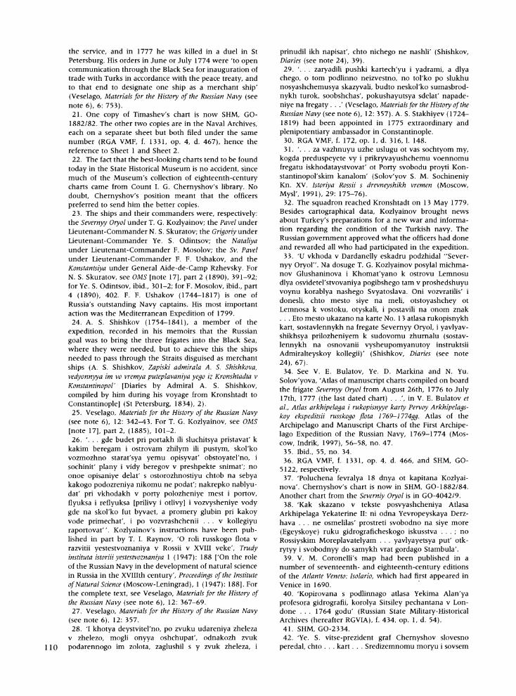
Plate 7. Chart of the northeastern Aegean Sea, made on the frigate Severnyy Oryol in 1777. 37X46, indian ink, watercolour. The place of shipwreck is marked with the letter F. Note the English letters standing for the cardinal directions; this was common, although Dutch (N, 0, Z, W) was normal practice; Russian was rarely used. GO-
4042/13. (Reproduced with permission from the State Historical Museum, Moscow.) (Page 96.)
__
. .---
,..___
9 _'
1
:: t
:* :
-i t_z
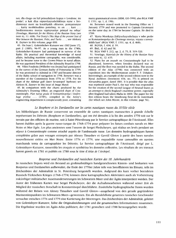
Plate 8. Chart of the Sea of Marmara and the Straits complied by Captain Ye. S. Odintsov of the frigate Grigoriy (1776), with inset showing the city of Constantinople. Indian ink and ink, colour washed. 50X 140 cm. GO-1882/86. (Reproduced with permission from the State Historical Museum, Moscow.) (Page 104.)
' :
I
X 77i <f ; ,f ' Q ?
, ? ''=''''''e)
Eighteenth-Century Russian Charts of the Straits
(Bosporus and Dardanelles)
VLADIMIR E. BULATOV
ABSTRACT: Russian depositories contain a corpus of large-scale Russian manuscript coastal and navigational charts of the Straits (the Bosporus and the Dardanelles) compiled in the late 1770s either by naval officers in the field or by the Drawing Office of the Admiralty Board, St Petersburg. This mapping was undertaken after the Russo-Turkish war of 1768-1774 in anticipation of further naval warfare in the Black and Aegean seas. The author of the earliest charts was Sergey Pleshcheyev, who conducted his surveys while a member of the Russian embassy in Constantinople. Additional hydrographical information was obtained during the voyages of Aleksey I. Timashev and Gavriil Glotov from the newly founded naval bases in the Black Sea. Between 1776 and 1779, a Russian squadron disguised as merchant ships attempted to chart the Straits. The
Admiralty's Drawing Office, supervised by Ivan L. Golenishchev-Kutuzov, then assembled the original drafts and summarized the collected data. The results are found in the Atlas of the Archipelago, engraved in 1781 and
published in 1788.
KEYWORDS: Eighteenth century, Russia, Russo-Turkish War, manuscript charts, hydrographical charts, Russian Navy, Dardanelles Straits, Bosporus Straits, Constantinople, Black Sea, Aegean Sea, Ivan M.
Bersenev, Gavriil Glotov, Sergey I. Pleshcheyev, Aleksey Ivanovich Timashev, Atlas of the Archipelago (1788).
The State Historical Museum, Moscow, possesses fourteen manuscript charts of the Bosporus and the Dardanelles dating from the late eighteenth cen-
tury. At that time, the Bosporus and the Darda- nelles were known in Russia simply as 'the Straits', the term used in this paper. The charts were
compiled mainly between 1774 and 1780 from
surveys carried out by Russian naval officers. In
addition, seven charts of the same area are in the Naval Archives, St Petersburg, two more are in the
Library of the Academy of Sciences, also in St
Petersburg, and four are in manuscript atlases in the Archives of Military History in Moscow, making a total of twenty-seven charts. Few Russian territories were mapped so intensively or so
systematically at the time, and the number of
surviving charts reflects the crucial strategic impor- tance of the Straits to Russia. The aim in this paper is to draw attention to these charts and to illuminate the circumstances under which they were produced.
The charts under discussion are typical large-
scale coastal and harbour navigational charts in various stages of preparation and include original field drafts, manuscript copies, and the coloured
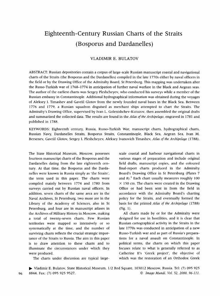
final-report charts produced in the Admiralty Board's Drawing Office in St Petersburg (Plates 7 and 8).1 Each chart usually measures roughly 100 x 150 cm. The charts were created in the Drawing Office or had been sent in from the field in accordance with the Admiralty Board's charting policy for the Straits, and eventually formed the basis for the printed Atlas of the Archipelago (1788) (Fig. 1).
All charts made by or for the Admiralty were
designed for use in hostilities, and it is clear that Russian cartographical activity in the Straits in the late 1770s was conducted in anticipation of a new Russo-Turkish war and as part of Russia's prepara- tions for a naval assault on Constantinople. In
political terms, the charts on which this paper focuses relate to what is generally referred to as Catherine II's 'Greek project', the objective of which was the restoration of an Orthodox Greek
Vladimir E. Bulatov, State Historical Museum, 1/2 Red Square, 103012 Moscow, Russia. Tel: (7) 095 925
96 8844. Fax: (7) 095 925 9527. ?C) Imago Mundi. Vol. 52, 2000, 96-111.

YKk1
',
c I
Fig. 1. Chart of the northern Aegean ( 1788). Map 5 from the printed version of the Atlas of the Archipelago. Compiled by Ivan L. Golenishchev-Kutuzov, Vilim Fondezin and Ivan Bersenev in the Office of the Admiralty Board, St Petersburg, and printed in the printing-house of the Naval Cadet Corps for the Gentry. SHM, GO-3679. Engraving. 58 X 93 cm. (Reproduced with permission
Department of Cartography, State Historical Museum, Moscow.)
Drawing from the
I.
r . ;I
If,
l/\
(Byzantine) Empire under the rule of Catherine's
grandson, Constantine. The link between Imperial policy and the Navy's operations is reflected in the dedication in Matvey G. Kokovtsev's book, Opisa- niye Arkhipelaga i Vavariyskogo Berega [Description of the Archipelago and the Barbarian Shore], pub- lished in 1786, which is addressed to Crown-Prince Pavel Petrovich (President of the Admiralty Board) and runs to the effect that
Constantine has erected his Throne in Constantinople and enlightened the Eastern Empire . . . Constantine has lost the City and the Power. In the book of fate, it is foretold that Constantine will restore this Realm. As I present this book to Your Imperial Highness, I delight in spirit, expressing the presentiments of the Greek peoples, who expect their deliverance [to come] from the banks of the Neva.2
The Russian Navy first appeared in the Medi- terranean in the course of the First Archipelago [Aegean] Expedition (1769-1774).3 The expedition showed that the Russian Navy's superiority would
permit a successful naval assault against Constan-
tinople, but at the same time it demonstrated Russia's need for detailed large-scale hydrographi- cal charts of the future seat of war. A striking fact was that during the expedition, more Russian ships were lost in maritime accidents than in battle.4 As
against one ship of the line blown up under enemy fire, three were lost through running aground or
were sunk after striking reefs. M. G. Kokovtsev, a member of the Expedition, wrote afterwards that
there is a shoal to the east from Lemnos, which is very dangerous for ships moving through the strait between the islands of Lemnos and Tenedos [Bozcaada], especially in summer, because of the swift current coming from the Hellespont [Dardanelles] directly towards this shoal. Seamen . .. get into serious trouble because in some foreign charts, the position of this shoal is wrongly shown, and the Dutch and English charts do not mark it at all; and that is why the Russian 80-cannon ship [Svyatoslav] . . . was wrecked.5
Warfare in a narrow strait with a swift current, as in the Dardanelles and the Bosporus, requires a
greater degree of cartographical preparation than does action in a relatively open sea like the Aegean. As soon as a peace treaty was signed between Russia and Turkey (the Kyuchuk-Kaynardzhiy [Kaynardzha] Treaty of 1774, which neither side
expected to last), the Russian Admiralty Board was ordered to chart the Straits. An already difficult task was made worse by the need for absolute secrecy, especially critical since the newly signed treaty forbade Russian warships any right of passage through the Straits, although merchant ships were
98 permitted to pass through. Under the circum-
stances, the compilation of charts from new surveys and the making of up-to-date manuscript copies from printed European maps, comprises an atypical episode in the history of Russian cartography.
S. I. Pleshcheyev's Charts
The Russian cartographers' first opportunity came in 1775 when a mission headed by N. V. Repnin was dispatched to Constantinople to work out the
interpretation of some of the general clauses in the
Kyuchuk-Kaynardzhiy Treaty. Certain members of the mission were given secret instructions to make land maps, others to make navigational charts.
According to a note in the register of the Admiralty, dated 14 January 1775,
The Board heard a pro memoria by the Foreign Office, which declares: according to the royal decree by Her Imperial Majesty given to that office ... General Nikolai Vasil'yevich Repnin is sent from here in the quality of an Extraordinary and Plenipotentiary Ambassador and according to the approved by H.I.M. list [the mission] includes 12 cavaliers, and among them Lieutenant-Commanders Vasiliy and Sergey Pleshcheyev.6
Hydrographical charting required special skills and a naval officer had to be included in Repnin's mission. Lieutenant-Commander Sergey Ivanovich
Pleshcheyev (1752-1802) was detached from his
regular duties to join the Repnin mission in
Constantinople. His task was to record clandestinely details about the Turkish naval forces and to survey the Straits and coastal towns. The choice of the talented and highly educated Pleshcheyev was a
good one. He had already spent four months in
Syria, where he had been sent in 1772 to establish contacts with Ali-Bey in Egypt, who had taken up arms against the Porte.7 At the same time,
Pleshcheyev was collecting valuable military and
geographical information. His measurements of
depths in the Bay of Acre, for instance, were later used in the compilation of one of the charts (No. 57) in the Atlas arkhipelaga (Atlas of the Archipelago).8 In 1776, after completing his work for Repnin's mission, Pleshcheyev presented his report to the
Admiralty, submitting his charts of the Strait of
Constantinople (Bosporus) and the Dardanelles and
plans of the roadsteads of Trabzon and Synop.9 Once deposited in the Admiralty's Drawing Office, all these charts were widely copied, with the result that there are at least three copies of the Bosporus and the Dardanelles charts.l? Pleshcheyev contin- ued working on his charts in St Petersburg, which
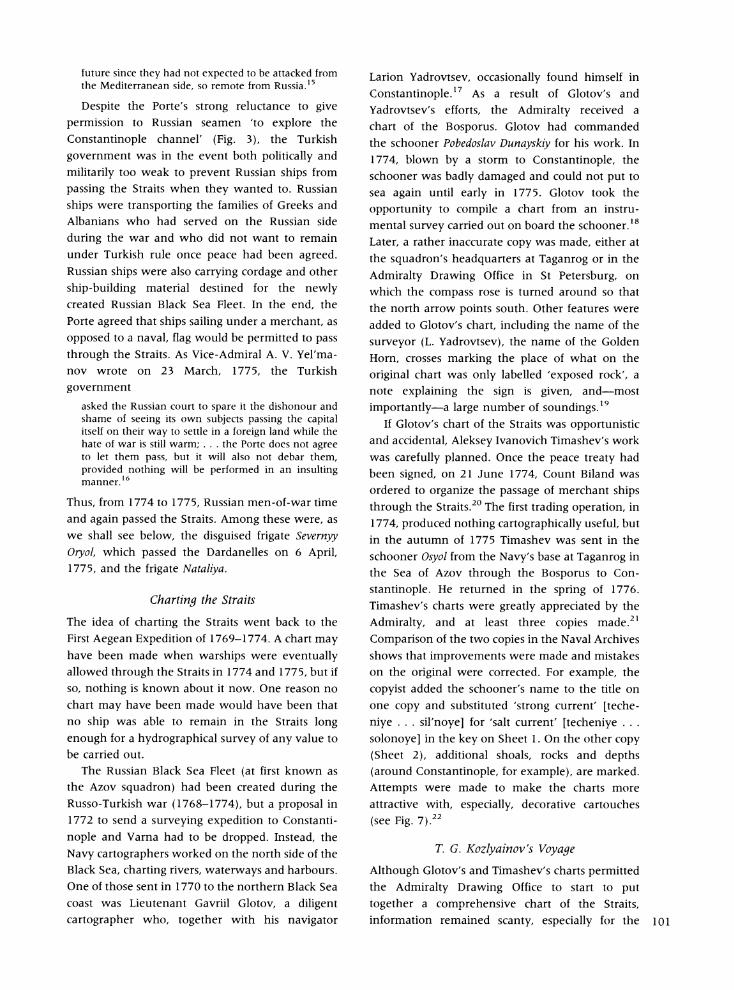
Fig. 2. Chart of the Bosporus. Copy of a map by Sergey I. Pleshcheyev, made in the Drawing Office of the Admiralty Board, 1776. SHM, GO-1882/83. Ink and water-colour. 52.5 X 96.5 cm. (Reproduced with permission from the Department of
Cartography, State Historical Museum, Moscow.)
explains why some, including final-report charts, are dated 1775 and others are dated 1776 (Fig. 2).l
Land mapping by the War Office had virtually ceased in 1772, which accounts for the importance of the maps and plans produced by Repnin's mission, such as a chart of the Straits produced in March 1776 showing the Turkish fortresses.12
There are some interesting differences between the cartography produced by the land surveyors in
Repnin's mission and that of the naval officers.
Maps compiled by land officers include navigational dangers (shoals and reefs), are orientated with south at the top and carry a scale in hours. Naval officers, in contrast, observed the conventions for marine charts. The result was the Admiralty received two quite different images of the same stretch of coast.
Right of Passage through the Straits
Russian access to the Straits had long been a
problem. Charting the Straits would be greatly facilitiated were Russian men-of-war to have the
right of passage. The Russian Cabinet in Saint
Petersburg repeatedly raised the matter during the
negotiations with Turkey in 1774-1775, trying to create a precedent, but the Turkish Porte continued to refuse.
The idea had come from Catherine II, in a note written in her own hand as a postscript to an order dated March 22, 1771, drafted by Count Aleksey G. Orlov (1737-1808) concerning the clauses of a
peace treaty with Turkey:
It would be good if you could help our Mediterranean squadron to pass by Constantinople into the Black Sea to ease its way home or, at least, if some vessels could pass that way. It is only an idea; but I would like it if
you could carry it out.13
Insistence on right of passage was given more clear- cut expression in an 'Addition to the Instruction
given to our extraordinary and plenipentiary ambassadors appointed to the peace congress with the Ottoman Porte ... Count Grigoriy Orlov and
Privy Councillor Aleksey Obreskov', dated 21 April, 1772.14 Acording to this document, the ambassa- dors were to
try to obtain permission for some of the ships of our fleet to return home directly through the Constanti- nople channel and the Black Sea under the pretext that certain of the ships are ramshackle and could not survive the journey around the whole of Europe, or the quickest and closest return from the fleet of the land forces, which are only a burden to it. We are aware of all the painfulness for and delicacy of this request: painfulness for the Turks, as we are demand- ing freedom of navigation in the Black Sea for our seamen to explore the Constantinople channel, which [the Turks] may fear will be dangerous for them in the 99
X, 7~~~~~~~~~~~~~~
'10~~~~~~~~~~~~~~~~~~~~~~~~~~
4~~~~~~~~~~~~~~~4
0 H 1. /.
5 . . ...
`1", K.i' g: : t .;52 j ' ; , , .. +. ' ' . ' ' ,' 5 0 '' ''.-4' ' - 03 ;; 0;. ' .: .. . .: '' ;
tt~~~~~~ 2 ? tj flZU s S . E I t~~~~~~~~~~~~~~~~~~~~~~~~~~~~~~~~~~~~W L erC
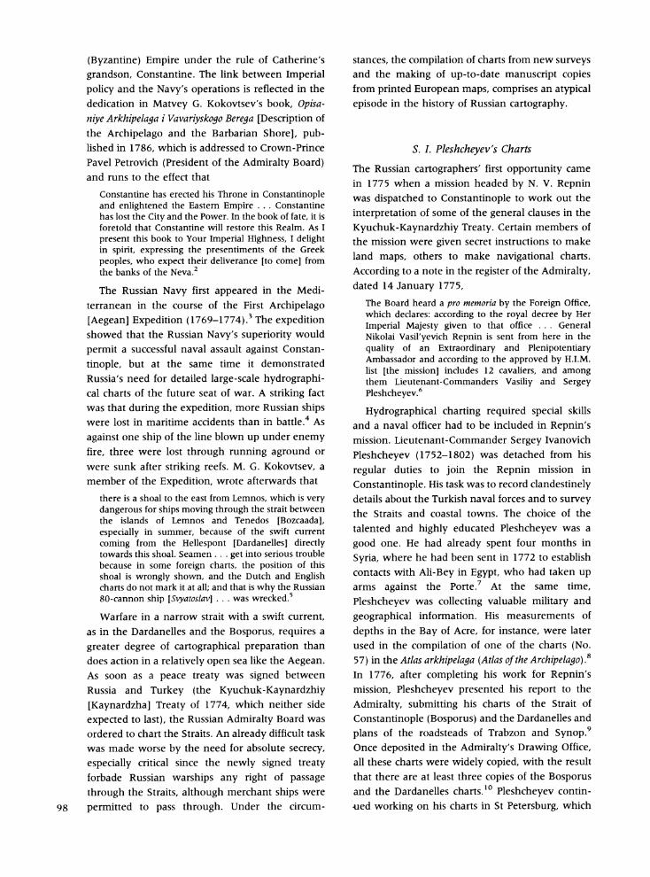
Fig. 3. Detail from Ivan Petryayev's chart of the Straits (see Fig. 5). Inset showing the Constantinople Channel (Bosporus). South is at the top. (Reproduced with permission from the Departmen
Cartography, State Historical Museum , Moscow.)
?i; ':'i{ : "''';,'y ...'' '' f '.?i 'i f . .'./ i"'... i 0. 0' ,i ' ' i'.'" 'D S0" 'D ' E 0; S. ,' .' ~. ' , ' ' ' ' : ' ' ' ' " ', ' ' .'
:E'':., X s:, ' ' "'X''',, f j;'00;9;g<4'X'"'" '...'~"','.'....',.'~ :''.1 '"-."t~. .'" ,..'
Fig. 3. Detail from Ivan Petrayev's chart of the Straits (see Fig. 5). Inset showing the Constantinople Channel (Bosporus). South is at the top. (Reproduced with pem-nission from the Departmen
,Cartography, State Historical Museum, Moscow.)
^::
* j'
{i
/' f; ' '^e
m^
i^
'.;"*f
't 'Of
future since they had not expected to be attacked from the Mediterranean side, so remote from Russia.'5
Despite the Porte's strong reluctance to give permission to Russian seamen 'to explore the
Constantinople channel' (Fig. 3), the Turkish
government was in the event both politically and
militarily too weak to prevent Russian ships from
passing the Straits when they wanted to. Russian
ships were transporting the families of Greeks and Albanians who had served on the Russian side
during the war and who did not want to remain under Turkish rule once peace had been agreed. Russian ships were also carrying cordage and other
ship-building material destined for the newly created Russian Black Sea Fleet. In the end, the Porte agreed that ships sailing under a merchant, as
opposed to a naval, flag would be permitted to pass through the Straits. As Vice-Admiral A. V. Yel'ma- nov wrote on 23 March, 1775, the Turkish
government
asked the Russian court to spare it the dishonour and shame of seeing its own subjects passing the capital itself on their way to settle in a foreign land while the hate of war is still warm; . . . the Porte does not agree to let them pass, but it will also not debar them, provided nothing will be performed in an insulting manner. 1 6
Thus, from 1774 to 1775, Russian men-of-war time and again passed the Straits. Among these were, as we shall see below, the disguised frigate Severnyy Oryol, which passed the Dardanelles on 6 April, 1775, and the frigate Nataliya.
Charting the Straits
The idea of charting the Straits went back to the First Aegean Expedition of 1769-1774. A chart may have been made when warships were eventually allowed through the Straits in 1774 and 1775, but if so, nothing is known about it now. One reason no chart may have been made would have been that no ship was able to remain in the Straits long enough for a hydrographical survey of any value to be carried out.
The Russian Black Sea Fleet (at first known as the Azov squadron) had been created during the Russo-Turkish war (1768-1774), but a proposal in 1772 to send a surveying expedition to Constanti-
nople and Varna had to be dropped. Instead, the
Navy cartographers worked on the north side of the Black Sea, charting rivers, waterways and harbours. One of those sent in 1770 to the northern Black Sea coast was Lieutenant Gavriil Glotov, a diligent cartographer who, together with his navigator
Larion Yadrovtsev, occasionally found himself in
Constantinople.17 As a result of Glotov's and Yadrovtsev's efforts, the Admiralty received a chart of the Bosporus. Glotov had commanded the schooner Pobedoslav Dunayskiy for his work. In 1774, blown by a storm to Constantinople, the schooner was badly damaged and could not put to sea again until early in 1775. Glotov took the opportunity to compile a chart from an instru- mental survey carried out on board the schooner.18
Later, a rather inaccurate copy was made, either at the squadron's headquarters at Taganrog or in the
Admiralty Drawing Office in St Petersburg, on which the compass rose is turned around so that the north arrow points south. Other features were added to Glotov's chart, including the name of the
surveyor (L. Yadrovtsev), the name of the Golden Horn, crosses marking the place of what on the
original chart was only labelled 'exposed rock', a note explaining the sign is given, and-most
importantly-a large number of soundings.19 If Glotov's chart of the Straits was opportunistic
and accidental, Aleksey Ivanovich Timashev's work was carefully planned. Once the peace treaty had been signed, on 21 June 1774, Count Biland was ordered to organize the passage of merchant ships
through the Straits.20 The first trading operation, in 1774, produced nothing cartographically useful, but in the autumn of 1775 Timashev was sent in the schooner Osyol from the Navy's base at Taganrog in the Sea of Azov through the Bosporus to Con-
stantinople. He returned in the spring of 1776. Timashev's charts were greatly appreciated by the
Admiralty, and at least three copies made.21
Comparison of the two copies in the Naval Archives shows that improvements were made and mistakes on the original were corrected. For example, the
copyist added the schooner's name to the title on one copy and substituted 'strong current' [teche- niye . . . sil'noye] for 'salt current' [techeniye ...
solonoye] in the key on Sheet 1. On the other copy (Sheet 2), additional shoals, rocks and depths (around Constantinople, for example), are marked. Attempts were made to make the charts more attractive with, especially, decorative cartouches (see Fig. 7).
T. G. Kozlyainov's Voyage
Although Glotov's and Timashev's charts permitted the Admiralty Drawing Office to start to put together a comprehensive chart of the Straits, information remained scanty, especially for the 101

5l: ( J o fi e P e r4.
.1
.r'!
7. 0I
(U
SC 5 w
V.
1d
T3 z
'I ?....
Y" 112
i^ _|iC 'L ^
fl.1 .
I.7J
. 4 1
I .../
: t
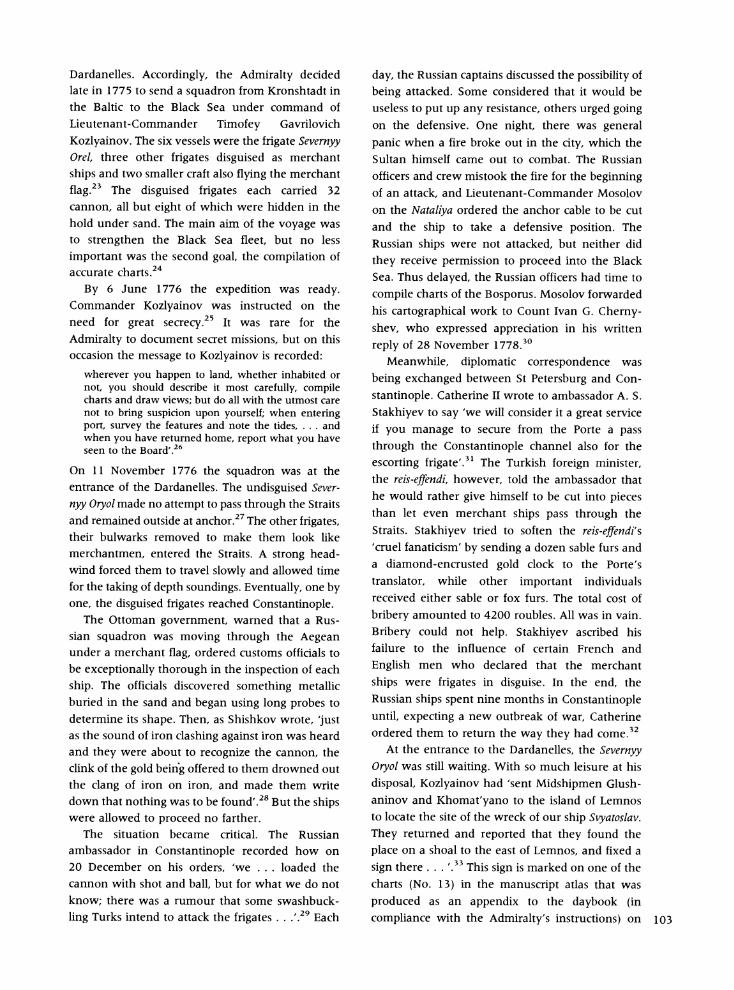
Dardanelles. Accordingly, the Admiralty decided late in 1775 to send a squadron from Kronshtadt in the Baltic to the Black Sea under command of Lieutenant-Commander Timofey Gavrilovich
Kozlyainov. The six vessels were the frigate Severnyy Orel, three other frigates disguised as merchant ships and two smaller craft also flying the merchant
flag.23 The disguised frigates each carried 32 cannon, all but eight of which were hidden in the hold under sand. The main aim of the voyage was to strengthen the Black Sea fleet, but no less important was the second goal, the compilation of accurate charts.24
By 6 June 1776 the expedition was ready. Commander Kozlyainov was instructed on the need for great secrecy.25 It was rare for the Admiralty to document secret missions, but on this occasion the message to Kozlyainov is recorded:
wherever you happen to land, whether inhabited or not, you should describe it most carefully, compile charts and draw views; but do all with the utmost care not to bring suspicion upon yourself; when entering port, survey the features and note the tides, . . . and when you have returned home, report what you have seen to the Board'.26
On 11 November 1776 the squadron was at the entrance of the Dardanelles. The undisguised Sever-
nyy Oryol made no attempt to pass through the Straits and remained outside at anchor.27 The other frigates, their bulwarks removed to make them look like merchantmen, entered the Straits. A strong head- wind forced them to travel slowly and allowed time for the taking of depth soundings. Eventually, one by one, the disguised frigates reached Constantinople.
The Ottoman government, warned that a Rus- sian squadron was moving through the Aegean under a merchant flag, ordered customs officials to be exceptionally thorough in the inspection of each ship. The officials discovered something metallic buried in the sand and began using long probes to determine its shape. Then, as Shishkov wrote, 'just as the sound of iron clashing against iron was heard and they were about to recognize the cannon, the clink of the gold being offered to them drowned out the clang of iron on iron, and made them write down that nothing was to be found'.28 But the ships were allowed to proceed no farther.
The situation became critical. The Russian ambassador in Constantinople recorded how on 20 December on his orders, 'we ... loaded the
cannon with shot and ball, but for what we do not know; there was a rumour that some swashbuck- ling Turks intend to attack the frigates . . .,29 Each
day, the Russian captains discussed the possibility of
being attacked. Some considered that it would be useless to put up any resistance, others urged going on the defensive. One night, there was general panic when a fire broke out in the city, which the Sultan himself came out to combat. The Russian officers and crew mistook the fire for the beginning of an attack, and Lieutenant-Commander Mosolov on the Nataliya ordered the anchor cable to be cut and the ship to take a defensive position. The Russian ships were not attacked, but neither did
they receive permission to proceed into the Black Sea. Thus delayed, the Russian officers had time to
compile charts of the Bosporus. Mosolov forwarded his cartographical work to Count Ivan G. Cherny- shev, who expressed appreciation in his written
reply of 28 November 1778.30
Meanwhile, diplomatic correspondence was
being exchanged between St Petersburg and Con-
stantinople. Catherine II wrote to ambassador A. S.
Stakhiyev to say 'we will consider it a great service if you manage to secure from the Porte a pass through the Constantinople channel also for the escorting frigate'.3' The Turkish foreign minister, the reis-effendi, however, told the ambassador that he would rather give himself to be cut into pieces than let even merchant ships pass through the Straits. Stakhiyev tried to soften the reis-effendi's 'cruel fanaticism' by sending a dozen sable furs and a diamond-encrusted gold clock to the Porte's translator, while other important individuals received either sable or fox furs. The total cost of
bribery amounted to 4200 roubles. All was in vain.
Bribery could not help. Stakhiyev ascribed his failure to the influence of certain French and
English men who declared that the merchant
ships were frigates in disguise. In the end, the Russian ships spent nine months in Constantinople until, expecting a new outbreak of war, Catherine ordered them to return the way they had come.32
At the entrance to the Dardanelles, the Severnyy Oryol was still waiting. With so much leisure at his
disposal, Kozlyainov had 'sent Midshipmen Glush- aninov and Khomat'yano to the island of Lemnos to locate the site of the wreck of our ship Svyatoslav. They returned and reported that they found the place on a shoal to the east of Lemnos, and fixed a
sign there . . . .33 This sign is marked on one of the charts (No. 13) in the manuscript atlas that was
produced as an appendix to the daybook (in compliance with the Admiralty's instructions) on 103
board the Severnyy Oryol as she lay at the entrance of the Dardanelles (Fig. 4).34
Charts of the Straits compiled on board the
Grigoriy and the Nataliya and the summary charts from the Severnyy Oryol have survived. A splendid coloured final-report chart made by Ye. S. Odintsov on the Grigoriy, frequently exhibited, has already been described in print (Plate 8).35 A chart
compiled by Navigator Savva Mokeyev on the
Nataliya survives in two versions: one in the Naval Archives and one in the State Historical Museum.36 The first version, dated 1776-1777, that is, from the time of survey, is interesting for the reference in the
key to the navigations of 'some Venetian pilots' used in compiling the chart. The second version is another beautifully coloured final-report chart, dated March 1777 and signed not by the author-
Navigator Mokeyev, who conducted the survey and drafted the chart-but by the ship's captain, F. Mosolov. The scales on the two versions are in different units: the first chart has a scale in Italian miles; the second has scales in Russian versts and in
something described as 'double steps, each of five
English feet' [dvoynym shagam po pyati fut
aglinskikh]. Among other charts from the Severnyy Orel is a highly polished final report chart which
belonged to Count Ivan G. Chernyshev, on the back of which a note records that the chart was 'received on February 18 from Captain Kozlyainov'.37
Printed Sources
Russian seamen made extensive use of European printed charts of the Mediterranean and, especially, of the Straits. This is made clear in the dedication in the collection of printed charts which was even-
tually produced by the Admiralty as the Atlas of the
Archipelago. The dedication, addressed to Catherine II, contains the exaggerated claim that while 'not one European power . . . has dared to extend the hand of hydrographical art over this sea [Aegean] ... Russian seamen have open and free access to the very gates of proud Constantinople'.38 The introduction to the same atlas reiterates the point, stating that Russian chartmakers 'took the best
existing maps and amalgamated them with new Russian material'.The question is, which foreign printed maps were used by the Admiralty, and to what degree do the Russian manuscript charts reflect purely Russian sources?
Russian manuscript charts of the Straits make few allusions to European sources, except in the
104 case of those made during Kozlyainov's voyage,
the charts made by Mokeyev and Odintsov on the
Nataliya and the Grigoriy respectively. Mokeyev's original chart has the reference cited above to Venetian pilots, which is repeated on the copy, where the scale is in Italian miles as well as Russian versts but the title of Odintsov's chart notes that part of the chart was compiled from an Italian atlas which was on board the frigate. The reason for scales in Italian miles on Russian naval charts is now clear: the officers were drawing information from printed Italian sources, Odintsov for that part of his chart which shows the Sea of Marmara near Constantinople. Their source, we
suggest, is likely to have been the Bosforo tracio,
hoggidi Canale di Constantinopoli descritto dal P.
Cosmografo Coronelli.39 Other evidence for the use of European printed
sources is less direct. We know, for example, that the map of the Aegean made by Kokovtsev and later used to illustrate his book, Description of the
Archipelago and the Barbarian Shore, was based on Francois Grognard's Carte de l'Archipel (1745). Grognard's chart was included by Jacques Nicolas Bellin in the 1753-1754 edition of Le Neptune Francois. Another example, a manuscript chart of the southern Aegean, has a note in the bottom
margin saying that the chart was 'copied from an
original atlas of Ekim Alanya professor of hydro- graphy to the king of the Two Sicilies printed in London ... 1764'.40 This atlas by J. Giacomo
Alagna, called A Compleat Set of New Charts on
Thirty-Eight Large Plates, Containing an accurate Survey of the Coast of Portugal and the Mediterranean Sea, was first published in London in 1764 by John Mount and Thomas Page, with a second edition in 1767.
Another chart in Alagna's atlas, 'The coast of the Mediterranean Sea from Cape Doro and I. de Scio to Constantinople', almost certainly would have been noticed by the Admiralty Board.
Finally,there was Andrew Dury's A map of the
Propontis or Sea of Marmora with its two Streights, Viz
Bosphorus and Hellespont, wherein the Capes, Gulfs, Harbours, Towns, Villages, Cottages, Fountains and Ruins upon these Coasts are exactly described. Done
from a Draught made upon the Spot by P. D. Bohn
(London, 1770). The State Historical Museum's
example of Dury's map is of particular interest for its poor condition and other indications of con- siderable use, notably a number of manuscript notes describing the distances between certain
places.4' Like another of Dury's maps, the Museum's example had once belonged to Count
iFt4
C i 4 A g
: W :'
/~ 4;
^3f-S3A:
4 1-K ;' * " -' : I'
'-N
^1 't : KI? *N - - i...;.
Fig. 5. Chart of the Straits. Copy made in the Admiralty Board's Drawing Office by navigator Ivan Petryayev under supervision of Captain Vilim Fondezin, 1778. SHM, GO-5114. South is at tl chart in the centre shows the Sea of Marmara with the Dardanelles bottom left and the Bosporus top right. Indian ink. 82 x 183 cm. See also Figs. 3 and 6. (Reproduced with permissioi
Department of Cartography, State Historical Museum, Moscow.)
Ie top. The n from the
CV VI
:
- :: '
: i: * . . " r " .. I
.
i
-
5-kS~~~
,4,X Wo fff ,> >-i>- i:'4 ; -, gi?iX t iX 0
?-l9 di X, 3e X
$X<sj>;--: tEt :"X-'';
,< Z a ;. tz j j X ffl s
' 8e 54 SrgtE'ls\ M
jx?x, ; ;9j j i si.; >
s: *X:$ 5 , n t .&-.bet . S ............. .,'f:
X Kj j f; *S-5C,9s diS vO,
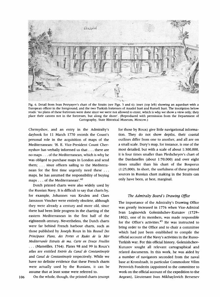
Fig. 6. Detail from Ivan Petryayev's chart of the Straits (see Figs. 3 and 6): inset (top left) showing an aqueduct with a European officer in the foreground, and the two Turkish fortresses of Anadol Isari and Rumeli Isari. The inscription below reads: 'no plans of these fortresses were done since we were not allowed to enter, which is why we show a view only; they place their canons not in the fortresses, but along the shore'. (Reproduced with permission from the Department of
Cartography, State Historical Museum, Moscow.)
Chernyshov, and an entry in the Admiralty's daybook for 11 March 1770 records the Count's
personal role in the acquisition of maps of the Mediterranean: 'H. E. Vice-President Count Cher-
nyshov has verbally informed us that . .. there are no maps ... of the Mediterranean, which is why he was obliged to purchase maps in London and send
them; ... since officers sailing to the Mediterra- nean for the first time urgently need these ...
maps, he has assumed the responsibility of buying maps ... of the Mediterranean'.42
Dutch printed charts were also widely used by the Russian Navy. It is difficult to say that charts by, for example, Johannes van Keulen and Claes Janszoon Visscher were entirely obsolete, although they were already a century and more old, since there had been little progress in the charting of the eastern Mediterranean in the first half of the
eighteenth century. Nevertheless, the Dutch charts were far behind French harbour charts, such as those published by Joseph Roux in his Receuil Des
Principaux Plans, des Portes et Rades de la Mer Mediterranee Estraits de ma. Carte en Douze Feuilles . .. (Marseilles, 1764). Plates 98 and 99 in Roux's atlas are entitled Entree du Canal de Constantinople and Canal de Constantinople respectively. While we have no definite evidence that these French charts were actually used by the Russians, it can be assume that at least some were referred to.
106 On the whole, though, the printed charts (except
for those by Roux) give little navigational informa- tion. They do not show depths, their coastal outlines differ from one to another, and all are on a small scale. Dury's map, for instance, is one of the most detailed, but with a scale of about 1:300,000, it is four times smaller than Pleshcheyev's chart of the Dardanelles (about 1:70,000) and over eight times smaller than his chart of the Bosporus
(1:25,000). In short, the usefulness of these printed sources in Russian chart making in the Straits can
only have been, at best, marginal.
The Admiralty Board's Drawing Office
The importance of the Admiralty's Drawing Office was greatly increased in 1776 when Vice-Admiral Ivan Loginovich Golenishchev-Kutuzov (1729- 1802), one of its members, was made responsible for the Office's activities.43 He was instructed to
bring order to the Office and to chair a committee which had just been established to compile the official account of the Navy's activities in the Russo- Turkish war. For this official history, Golenishchev- Kutuzov sought all relevant cartographical and related documents. In this work, he was aided by a number of navigators seconded from the naval base at Kronshtadt, in particular Commodore Vilim Petrovich Fondezin (appointed to the committee to work on the official account of the expedition to the
Aegean), Lieutenant Ivan Mikhaylovich Bersenev
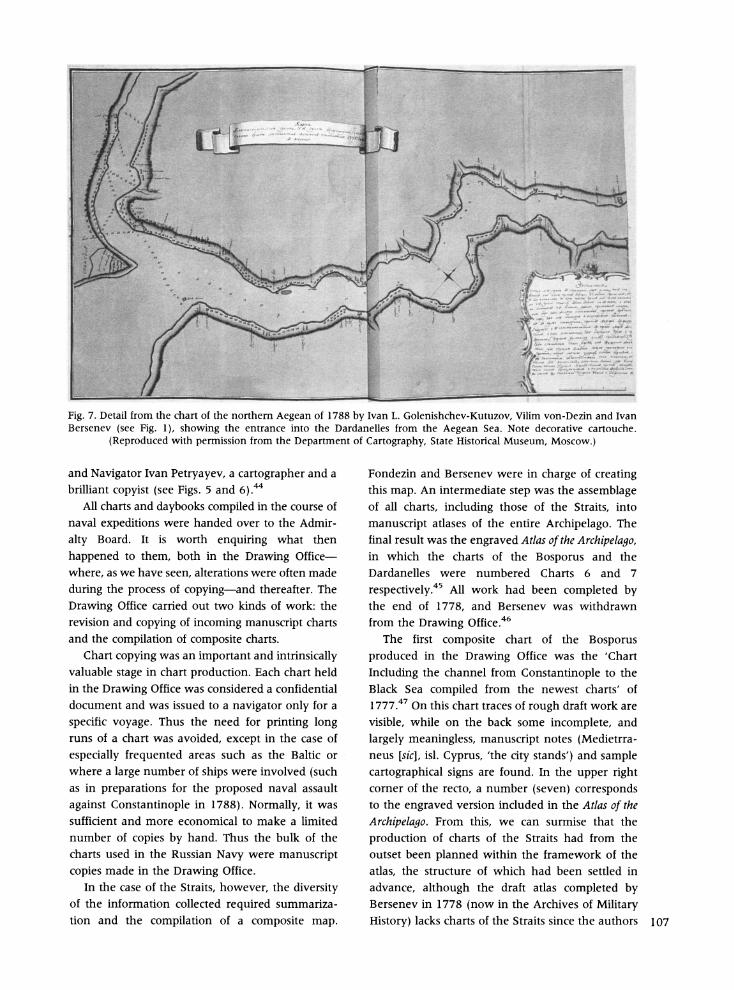
Fig. 7. Detail from the chart of the northern Aegean of 1788 by Ivan L. Golenishchev-Kutuzov, Vilim von-Dezin and Ivan Bersenev (see Fig. 1), showing the entrance into the Dardanelles from the Aegean Sea. Note decorative cartouche.
(Reproduced with permission from the Department of Cartography, State Historical Museum, Moscow.)
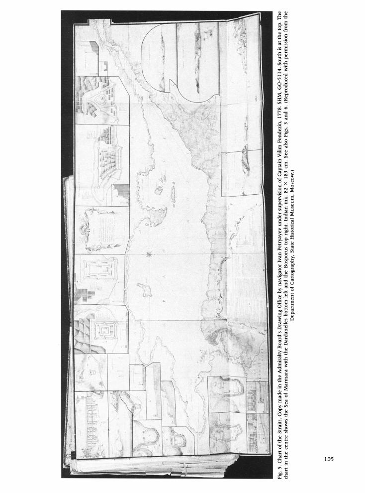
and Navigator Ivan Petryayev, a cartographer and a brilliant copyist (see Figs. 5 and 6).44
All charts and daybooks compiled in the course of naval expeditions were handed over to the Admir-
alty Board. It is worth enquiring what then
happened to them, both in the Drawing Office- where, as we have seen, alterations were often made
during the process of copying-and thereafter. The
Drawing Office carried out two kinds of work: the revision and copying of incoming manuscript charts and the compilation of composite charts.
Chart copying was an important and intrinsically valuable stage in chart production. Each chart held in the Drawing Office was considered a confidential document and was issued to a navigator only for a
specific voyage. Thus the need for printing long runs of a chart was avoided, except in the case of
especially frequented areas such as the Baltic or where a large number of ships were involved (such as in preparations for the proposed naval assault
against Constantinople in 1788). Normally, it was sufficient and more economical to make a limited number of copies by hand. Thus the bulk of the charts used in the Russian Navy were manuscript copies made in the Drawing Office.
In the case of the Straits, however, the diversity of the information collected required summariza- tion and the compilation of a composite map.
Fondezin and Bersenev were in charge of creating this map. An intermediate step was the assemblage of all charts, including those of the Straits, into
manuscript atlases of the entire Archipelago. The final result was the engraved Atlas of the Archipelago, in which the charts of the Bosporus and the Dardanelles were numbered Charts 6 and 7
respectively.45 All work had been completed by the end of 1778, and Bersenev was withdrawn from the Drawing Office.46
The first composite chart of the Bosporus produced in the Drawing Office was the 'Chart
Including the channel from Constantinople to the Black Sea compiled from the newest charts' of 1777.47 On this chart traces of rough draft work are
visible, while on the back some incomplete, and
largely meaningless, manuscript notes (Medietrra- neus [sic], isl. Cyprus, 'the city stands') and sample cartographical signs are found. In the upper right corner of the recto, a number (seven) corresponds to the engraved version included in the Atlas of the
Archipelago. From this, we can surmise that the
production of charts of the Straits had from the outset been planned within the framework of the atlas, the structure of which had been settled in advance, although the draft atlas completed by Bersenev in 1778 (now in the Archives of Military
History) lacks charts of the Straits since the authors 107
were awaiting further information from the Aegean squadron.48 Two other manuscript atlases in the
Archives, however, do have charts of the Straits
(Fig. 7). These are composed of final-report copies, which include information from Pleshcheyev and
Kozlyainov in the Aegean.49 Except for a few details, the content of the
manuscript and the printed versions of the Atlas match each other closely. What is different is the
style of the cartouche decoration, which raises the
question of the date of printing. On 20 April 1781, Golenishchev-Kutuzov at last reported to the
Admiralty Board that the compilation of the Atlas
of the Archipelago had been completed. He presented manuscript copies of the atlas to the Empress and Crown-Prince. The Board then issued instructions for a third manuscript copy to be kept in the
Drawing Office-and for the charts to be engraved and 300 copies printed 'for the first time'.50 Even then, it took until 1788 for the atlas to be published.
It would seem that once the charts for the Atlas of the Archipelago had been completed, no further
surveys of the Straits took place, although the Russians had plenty of opportunities. For example, the opening of a postal service between Constanti-
nople and Taganrog in 1781 made use of packet- boats under the command of Russian naval officers
sporting civilian tail-coats at the Treasury's expense.5' If charts of the Straits were compiled by mariners after 1778, we do not know about them, and the implication is that the Admiralty Board was satisfied with the charts it had already compiled. Although the Board continued to receive maps of
Constantinople, these were not hydrographical charts but plans of Turkish fortifications. By the
time the atlas was published in 1788, another Russo-
Turkish war was breaking out, and a major offensive
against Constantinople was being contemplated.52
The officers who had worked on the charts of the Straits described in this paper had a number of
personal characteristics in common. All were well educated and cultured in the western European tradition. Many had served in the English and other
European navies and had taken part in voyages in the Atlantic, Indian and Pacific oceans, for which
they gained considerable respect in Russia. Many had been decorated for their war service. One way or another, their charts proved so reliable that, a
generation later, in the early nineteenth century, they were still being reprinted.
108 Secrecy-the curse of hydrographical charting-
however, prevented these late eighteenth-century manuscript charts of the Bosporus and the Darda- nelles from taking their rightful place in the history of the mapping of the Mediterranean. They remained unknown abroad, both then and subse-
quently, and they were ignored in later, pre- triangulation, Russian maritime surveying. Thus
they have failed to attract the attention of historians and cartographers alike. Indeed, the very existence of many of these charts is still largely unknown even to those with specialist interests. This paper is an
attempt to draw attention not only to their existence but also to the particular, and sometimes peculiar, circumstances of their compilation in the 1770s.
Acknowledgements: I am most grateful to the American Friends of the J. B. Harley Research Fellowships for a grant assisting me to attend the Eighteenth International Conference on the History of Cartography, Athens, 1999.
A version of this paper was presented to the Eighteenth International Conference on the History of Cartography, Athens, July 1999. Revised text received October 1999.
NOTES AND REFERENCES
1. A 'final-report' chart is one compiled by a surveyor or naval officer and was designed to be presented to his chiefs; in the 1770s, these were the Empress Catherine II, the President of the Admiralty (Crown-Prince Pavel Petrovich), the Vice-President of the Admiralty (Count Ivan G. Chernyshov), and the Admiralty Board as a whole. The chart was usually carefully drawn and coloured and may or may not have been accompanied by a written text.
2. 'Konstantin osnoval Prestol v Tsar'grade i prosvetil Voztochnuyu Imperiyu. Konstantin poteryal grad i vla- dychestvo. Konstantinu prednapisano v knige sudeb vozstanovit' siye tsarstvo. Podnosya siyu knigu Vashemu Imperatorskomu Vysochestvu, vozkhishchayus' dukhom, iz'yavlyaya predchustvovaniya Grecheskikh narodov, ozhidayushchikh svoyeya svobody ot beregov Nevy' (Matvey G. Kokovtsev, Opisaniye Arkhipelaga i Vavariyskogo Berega [Description of the Archipelago and the Barbarian Shore] (St Petersburg, 1786), 7). Kokovtsev was one of the first Russian naval officers to have carried out field surveying in Africa.
3. Modern historians in Russia continue to use the old names in their publications. In the interests of inter- nationality, however, Imago Mundi prefers to use modem names where these are widely known. Thus for Archipe- lago, we have substituted Aegean Sea (or simply, the Aegean). We have left the Russian 'Straits' as the general terms for the Dardanelles and the Bosporus.
4. The wreck of the Svyatoslav on 5 September 1770 caused the assault on the island of Lemnos to fail and led to the mustering-out (expulsion) of Rear-Admiral John Elphinstone, an Englishman, in the service of the Russian state (Anthony Cross, 'The Elphinstone in Catherine the Great's Navy', The Mariner's Mirror, 84 (1998): 268-77). The St Yevstafiy Plakida was destroyed by enemy action. The Aziya was destroyed during the night of 10-11 August 1770 on the Koluer reef between the islands of Khios and Euboea with all hands lost, and on 2 February 1771 the
Rodos ran aground on the coast of the Peloponnese. Not only ships of the line were lost in this manner. On 5 November 1771, the frigates Arkhipelag and Santorino went aground. Although the Arkhipelag was later re- floated, the Santorino had to be abandoned, and the Turks set fire to it.
5. 'K Voztochnoy Lemnosa storone yest' desyat' mil' v more vydavshayasya mel', dlya prokhodyashchikh mezhdu ostrovov Lemnosa i Tenedosa sudov ves'ma opasnaya, a osoblivo v letneye vremya po prichine stremitel'nogo techeniya vody iz Gellespontskago proliva pryamo na siyu mel'. Morekhodtsy ... preterpevayut neschastiya po tomu, chto na nekotorykh inostrannykh chertezhakh polozheniye seya meli oznacheno nepra- vil'no, a na Gollandskikh i Anglinskikh vovse onoy ne pokazano; siye samoe bylo prichinoyu, chto i Rossiyskiy os'midesyatipushechnyy korabl', ... preterpel razbitiye' (Kokovtsev, Description of the Archipelago (see note 2), 18).
6. 'Slushali promemoriyu kollegii inostrannykh del, koeyu ob'yavlyayetm: po vysochayshemu Yeya I. V. imennomu ukazu, dannomu toy kollegii ... otpravlyayet- sya otsyuda chrezvychaynym i polnomochnym poslom general-anshef knyaz' Nikolay Vasil'yevich Repnin i po aprobovannomu Yeya I. V. rospisaniyu poveleno byt' pri tom posol'stve 12 kavaleram postol'stva a v chislo onykh naznacheny flota kapitan-leytenanty Vasiliy i Sergey Pleshcheyevy' (F. Veselago, Materialy dlya istorii russkogo flota [Materials for the History of the Russian Navy] (St Petersburg, 1888), 12: 317). Vasiliy Pleshcheyev died during the mission.
7. The Porte (High Porte or Divan) was the council of ministers in the Turkish government. Ali-Bey, governor of Egypt, rebelled against the Porte from 1771 to 1773. He occupied most of Syria and eventually declared indepen- dence, appointing himself Sultan. In the 1780s, Sergey Pleshcheyev taught geography at the Russian Court and wrote his highly successful book, Obozreniye Rossiyskiya imperii [Description of the Russian Empire] of which four editions were published between 1786 and 1793. For Pleshcheyev's own account of the mission, see 'Dnevnyya zapiski puteshestviya, iz Arkhipelagskago, Rossii prinadle- zhashchego ostrova Parosa v Siriyu i k dostopamyatnym mestam v predelakh Ierusalima nakhodyashchimsya. S kratkoyu istorieyu AliBeyevykh zavoyevaniy. Rossiskogo Flota Leytenata Sergeya Plescheyeva v iskhode 1772 leta. V Sankpeterburge 1773 goda' (manuscript, State Historical Museum, GIM, f. 445. d. 114).
8. Atlas Arkhipelaga soderzhashchiy v sebe karty: odnu general'nuyu, shest' chastnykh, pyat'desyat odnu raznyy zalivov, gavaney, prolivov i drugikh mest vygodnykh dlya lezhaniya na yakore; s prisovokupleniyem tryokh kart Sirskikh beregov. Sochinyon po ukazu Gosudarstvennoy Admiralteyskoy Kollegii, pri yeya chertyozhnoy, pod smotreniyem i rukovodstvom vitse-admirala i Kavalera Ivana Golenishcheva Kutuzova, flota kapitanom Vilimon Fondezinom i leytenantom Ivanom Bersenevym. Pecha- tan v Tipografii Morskogo Shlyakhetnago Kadetskago Korpusa, 1788 goda.
9. Russian State Naval Archives, St Petersburg (here- after RGA VMF), f. 212, Kantselyarii II otdela, dd. 417- 419 (obshchaya numeratsiya), 11. 99-110. The separate plans of Synop and Trabzon bays, kept in the Cartography Department of the State Historical Museum (hereafter SHM), have been mounted on a single sheet of paper (SHM, GO-5119), which has a note 'signed by Lieutenant- Captain and Knight Sergey Pleshcheyev, copied in the Drawing Office by the Admiralty in 1776', with a
manuscript text containing detailed geographical informa- tion about these two towns.
10. The Bosporus charts are SHM, GO-5118 and GO- 1882/83, and RGA VMF, f. 1331, op. 4, d. 464. The Dardanelles charts are SHM, GO-1882/85, and RGA VMF, f. 1331, op. 4, d. 465, 11. 1 and 2.
11. For example, final-report charts RGA VMF, f. 1331, op. 4, d. 464 and d. 465 1. 1 are dated 1775, whereas chart RGA VMF, f. 1331, op. 4, d. 465, 1. 2 and the archetype of chart SHM, GO-1882/83 are dated 1776. The State Historical Museum has the less finished copies GO-1882/ 883 and GO-1882/85.
12. SHM, GO-890/26. A note on the verso of a copy made in 1778 in the Drawing Office at St Petersburg indicates it was made by 'Navigator Ivan Petryayev under the command of Captain Fondezin' (SHM, GO-5114).
13. 'Khorosho by bylo yesli b vam udalos' vygovorit' prokhod nashey v Sredizemnom more eskadre mimo Tsarya-grada v Chornoye more dlya ukrasheniya yey vozvratnogo puti, ili po krayney mere, yesli-b tem putyom vozvratit'sya mogli neskol'ko sudov. Siye vam skazano ydinstvenno tol'ko kak ideya, koya zhelatel'no bylo, chtob vy vozmozhnosti nashli delom dovesti do deystviya' (SB. RIO. t. 97, p. 256).
14. 'Pribavleniye k instruktsii nashim [Yekateriny II], na mirnyy kongress s Porto Otomanskoyu naznachennym, chrezvychaynym i polnomochnym poslam, general- fel'tsekhmeysteru grafu Grigoriyu Orlovu i taynomu sovetniku Alekseyu Obreskovu' ot 21 aprelya 1772 goda (SB. RIO. t. 118, SPV. 1904, pp. 108-110).
15. '. . . pokusit'sya na oderzhaniye ot nikh soglasheniya na svobodu, dlya neskol'kikh sudov iz flota nashego, vozvratit'sya v Rossiyu pryamo cherez Tsaregradskiy kanal i Chornoe more. V predlog takomu postanovleniyu mozhet pred'yavlena byt' obvetshalost' i nenadyozhnost' k dal'neyshemu, vokrug vsey Yevropy, plavaniyu neko- torykh sudov, ili zhe skoreysheye i blizhaysheye vozv- rashcheniye s flota sukhoputnykh, onomu tol'ko v tyaygost' sluzhashchikh, voysk. My chuvstvuem sami vsyu kolkost' i delikatnost' sego trebovaniya: kolkost' dlya turkov potomu, chto oni pri domogatel'stve i nastoyanii nashem o svobodnom plavanii po Chornomu moryu, tem bol'she mogut pochest'dlya sebya na budush- cheye vremya predosuditel'nym i opasnym praktiches- koye poznaniye nashimi moreplavatelyami Tsaregradskago kanala, chem men'she pri nachatii voyny ozhidali byt' atakovannymi so storony tak udalon- nogo ot Rossii Sredizemnago morya'.
16. '. . . prosilo Dvor rossiyskiy izbavit' yego ot ponoshe- niya i styda videt' poddannykh svoikh vo vremya, kak yeshcho nenavist' voyny ne prostyla, proyezzhayushchikh chrez samuyu stolitsu, dlya poseleniya v chuzboy zemle; ... Porta khotya i ne soglasna o tak ovomnronskye poddannykh yeya, no ne bydet shcho so ctoron' yeya i vospeshchenuya mokm. By to ne ponositel' dlya neye obrazom ispolneno'.
17. For Glotov, see Obschchiy morskoy spisok [General Naval Papers, hereafter OMS], part 3 (St Petersburg, 1890), 381-82.
18. A note on the back of the chart, which is titled 'Constantinople Channel from Senyavin', records that it was sent to the Admiralty 'from the Azov squadron' (SHM, GO- 1124). Admiral Aleksey Naumovich Senyavin (1716-1797) commanded the Black Sea fleet at this time.
19. The copy is in SHM, GO-1882/81. 20. Count Biland, a Dutchman who entered the Russian
Navy in 1774 as a commander (Captain of the First Rank), was appointed to head the Danube flotilla. In 1776 he left 109

the service, and in 1777 he was killed in a duel in St Petersburg. His orders in June or July 1774 were 'to open communication through the Black Sea for inauguration of trade with Turks in accordance with the peace treaty, and to that end to designate one ship as a merchant ship' (Veselago, Materials for the History of the Russian Navy (see note 6), 6: 753). 21. One copy of Timashev's chart is now SHM, GO-
1882/82. The other two copies are in the Naval Archives, each on a separate sheet but both filed under the same number (RGA VMF, f. 1331, op. 4, d. 467), hence the reference to Sheet 1 and Sheet 2. 22. The fact that the best-looking charts tend to be found
today in the State Historical Museum is no accident, since much of the Museum's collection of eighteenth-century charts came from Count I. G. Chernyshov's library. No doubt, Chernyshov's position meant that the officers preferred to send him the better copies.
23. The ships and their commanders were, respectively: the Severnyy Oryol under T. G. Kozlyainov; the Pavel under Lieutenant-Commander N. S. Skuratov; the Grigoriy under Lieutenant-Commander Ye. S. Odintsov; the Nataliya under Lieutenant-Commander F. Mosolov; the Sv. Pavel under Lieutenant-Commander F. F. Ushakov, and the Konstantsiya under General Aide-de-Camp Rzhevsky. For N. S. Skuratov, see OMS [note 17], part 2 (1890), 391-92; for Ye. S. Odintsov, ibid., 301-2; for F. Mosolov, ibid., part 4 (1890), 402. F. F. Ushakov (1744-1817) is one of Russia's outstanding Navy captains. His most important action was the Mediterranean Expedition of 1799. 24. A. S. Shishkov (1754-1841), a member of the
expedition, recorded in his memoirs that the Russian goal was to bring the three frigates into the Black Sea, where they were needed, but to achieve this the ships needed to pass through the Straits disguised as merchant ships (A. S. Shishkov, Zapiski admirala A. S. Shishkova, vedyonnyya im vo vremya puteplavaniya yego iz Kronshtadta v Konstantinopol' [Diaries by Admiral A. S. Shishkov, compiled by him during his voyage from Kronshtadt to Constantinople] (St Petersburg, 1834), 2). 25. Veselago, Materials for the History of the Russian Navy
(see note 6), 12: 342-43. For T. G. Kozlyainov, see OMS [note 17], part 2, (1885), 101-2. 26. '. . . gde budet pri portakh ili sluchitsya pristavat' k
kakim beregam i ostrovam zhilym ili pustym, skol'ko vozmozhno starat'sya yemu opisyvat' obstoyatel'no, i sochinit' plany i vidy beregov v preshpekte snimat'; no onoe opisaniye delat' s ostorozhnostiyu chtob na sebya kakogo podozreniya nikomu ne podat'; nakrepko nablyu- dat' pri vkhodakh v porty polozheniye mest i portov, flyuksa i reflyuksa [prilivy i otlivy] i vozvysheniye vody gde na skol'ko fut byvaet, a promery glubin pri kakoy vode primechat', i po vozvrashchenii . .. v kollegiyu raportovat". Kozlyainov's instructions have been pub- lished in part by T. I. Raynov, 'O roli russkogo flota v razvitii yestestvoznaniya v Rossii v XVIII veke', Trudy instituta istoriii yestestvoznaniya 1 (1947): 188 ['On the role of the Russian Navy in the development of natural science in Russia in the XVIIIth century', Proceedings of the Institute of Natural Science (Moscow-Leningrad), 1 (1947): 188]. For the complete text, see Veselago, Materials for the History of the Russian Navy (see note 6), 12: 367-69. 27. Veselago, Materials for the History of the Russian Navy
(see note 6), 12: 357. 28. 'I khotya deystvitel'no, po zvuku udareniya zheleza
v zhelezo, mogli onyya oshchupat', odnakozh zvuk 110 podarennogo im zolota, zaglushil s y zvuk zheleza, i
prinudil ikh napisat', chto nichego ne nashli' (Shishkov, Diaries (see note 24), 39).
29. '.. . zaryadili pushki kartech'yu i yadrami, a dlya chego, o tom podlinno neizvestno, no tol'ko po slukhu nosyashchemusya skazyvali, budto neskol'ko sumasbrod- nykh turok, soobshchas', pokushayutsya sdelat' napade- niye na fregaty . ..' (Veselago, Materials for the History of the Russian Navy (see note 6), 12: 357). A. S. Stakhiyev (1724- 1819) had been appointed in 1775 extraordinary and plenipotentiary ambassador in Constantinople.
30. RGA VMF, f. 172, op. 1, d. 316, 1. 148. 31. '. . .za vazhnuyu uzhe uslugu ot vas sochtyom my,
kogda preduspeyete vy i prikryvayushchemu voennomu fregatu iskhodataystvovat' ot Porty svobodu proyti Kon- stantinopol'skim kanalom' (Solov'yov S. M. Sochineniy Kn. XV. Istoriya Rossii s drevneyshikh vremen (Moscow, Mysl', 1991), 29: 175-76).
32. The squadron reached Kronshtadt on 13 May 1779. Besides cartographical data, Kozlyainov brought news about Turkey's preparations for a new war and informa- tion regarding the condition of the Turkish navy. The Russian government approved what the officers had done and rewarded all who had participated in the expedition.
33. 'U vkhoda v Dardanelly eskadru podzhidal "Sever- nyy Oryol". Na dosuge T. G. Kozlyainov posylal michma- nov Glushaninova i Khomat'yano k ostrovu Lemnosu dlya osvidetel'stvovaniya pogibshego tam v proshedshuyu voynu korablya nashego Svyatoslava. Oni vozvratilis' i donesli, chto mesto siye na meli, otstoyashchey ot Lemnosa k vostoku, otyskali, i postavili na onom znak . . . Eto mesto ukazano na karte No. 13 atlasa rukopisnykh kart, sostavlennykh na fregate Sevemyy Oryol, i yavlyav- shikhsya prilozheniyem k sudovomu zhurnalu (sostav- lennykh na osnovanii vysheupomyanutoy instruktsii Admiralteyskoy kollegii)' (Shishkov, Diaries (see note 24), 67).
34. See V. E. Bulatov, Ye. D. Markina and N. Yu. Solov'yova, 'Atlas of manuscript charts compiled on board the frigate Severnyy Oryol from August 26th, 1776 to July 17th, 1777 (the last dated chart) . . .', in V. E. Bulatov et al., Atlas arkhipelaga i rukopisnyye karty Pervoy Arkhipelags- koy ekspeditsii russkogo flota 1769-I774gg. Atlas of the Archipelago and Manuscript Charts of the First Archipe- lago Expedition of the Russian Navy, 1769-1774 (Mos- cow, Indrik, 1997), 56-58, no. 47.
35. Ibid., 55, no. 34. 36. RGA VMF, f. 1331, op. 4, d. 466, and SHM, GO-
5122, respectively. 37. 'Poluchena fevralya 18 dnya ot kapitana Kozlyai-
nova'. Chernyshov's chart is now in SHM, GO-1882/84. Another chart from the Severniy Oryol is in GO-4042/9.
38. 'Kak skazano v tekste posvyashcheniya Atlasa Arkhipelaga Yekaterine II: ni odna Yevropeyskaya Derz- hava ... ne osmelilas' prostreti svobodno na siye more (Egeyskoye) ruku gidrograficheskogo iskusstva ...; no Rossiyskim Moreplavatelyam ... yavlyayetsya put' otk- rytyy i svobodnyy do samykh vrat gordago Stambula'.
39. V. M. Coronelli's map had been published in a number of seventeenth- and eighteenth-century editions of the Atlante Veneto: Isolario, which had first appeared in Venice in 1690. 40. 'Kopirovana s podlinnago atlasa Yekima Alan'ya
profesora gidrografii, korolya Sitsiley pechantana v Lon- done ... 1764 godu' (Russian State Military-Historical Archives (hereafter RGVIA), f. 434, op. 1, d. 54). 41. SHM, GO-2334. 42. 'Ye. S. vitse-prezident graf Chernyshov slovesno
peredal, chto ... kart ... Sredizemnomu moryu i sovsem
net, dla chego on byl prinuzhdyon kupya v Londone, im poslat'; a kak dlya otpravlyayushchikhsya nyne s Sre- dizmnoye more na korablyakh ofitserov, pomyanutyye ... karty neobkhodimo potrebny, to on ... kart ... Sredizemnomu moryu vypisyvaniye prinyal na sebya' (Veselago, Materials for the History of the Russian Navy (see note 6), 11: 608). For Dury's This Map of the present Seat of War between the Russians, Poles, and Turks . . , see Aleksey K. Zaytsev in this volume, page 000. 43. On Ivan L. Golenishchev-Kutuzov see: OMS [note 17],
part 2 (1885), 96-97. As a young man in the 1740s, Golenishchev-Kutuzov had participated in surveys of the Baltic. His practical and theoretical knowledge of naval affairs, including maritime cartography, was considerable, and he became tutor to the Crown-Prince in naval affairs. He was appointed President of the Admiralty Board in 1798. 44. Vilim Fondezin [Wilhelm von Dezin] had participated
in the survey of the German duchy of Pomerania in 1759; he was promoted to Admiral in 1787 and became director of the Baltic school of navigation in 1798. Bersenev was a member of the Commission from 1776 to 1778. For his chart of the Akhtiar gulf (later Sevastopol' harbour) see Aleksey K. Zaytsev in this issue of Imago Mundi. 45. In comparison with the charts produced by the
Admiralty's Drawing Office, an engraved chart of Con- stantinople, Plan tsarya grada ili konstantinopolya i bosfors- kago proliva ... (1785), compiled in the Army's engineering department is conspicuously poor, containing
many grammatical errors (SHM, GO-3990, also RGA VMF f. 1331, op. 1, d. 190). 46. Bersenev ceased work in the Drawing Office on 1
January 1779 and was promoted to Captain-Lieutenant on the same day; in 1784 he became Captain. He died in 1789. 47. 'Karta Morskaya Zaklyuchayushchaya v sebe proliv
ot Konstaninopolya do Chomogo morya, vzyata s novey- shikh kart' (RGA VMF, f. 1331, op. 4, d. 468). 48. RGVIA, f. 434, d. 59. 49. Ibid., d. 62 and 58. 50. RGA VMF f. 212, op. 2, d. 73, 11. 319-320. 51. Veselago, Materials for the History of the Russian Navy
(see note 6), 12: 633. 52. Plans for an assault on Constantinople had to be
abandoned, however, when Sweden declared war on Russia, and the fleet was needed in the Baltic. The second edition of the Atlas (1798) was connected with an expedition into the Mediterranean under F. F. Ushakov. Interestingly, an example of the second edition now in the Naval Archives (Inventory 434, no. 77) is printed on Alexandria paper, dated 1801. It is possible that the atlas was reprinted under Paul I, the tsar who was responsible for the creation of the second League of Neutral States as an attempt to check England's maritime power, especially after England had taken Malta in 1800. The paper for the first edition bears the Strasbourg fleur-de-lis watermark (for which see John Moore, in this volume, page 56).
Le Bosphore et les Dardanelles sur les cartes nautiques russes du XVIIIe siecle Les bibliotheques de Russie conservent un ensemble de cartes nautiques manuscrites a grande echelle
representant les Detroits (Bosphore et Dardanelles), qui ont ete dressees a la fin des annees 1770 soit sur le terrain par des officiers de marine, soit a Saint-Petersbourg par le Service cartographique de l'Amiraute. Elles furent etablies apres la guerre russo-turque de 1768-1774 pour preparer les futurs combats navals en Mer Noire et Mer Egee. Les plus anciennes sont l'ceuvre de Sergei Pleshcheyev, qui realisa ses leves pendant un
sejour a Constantinople comme attache aupres de l'ambassade russe. Les donnees hydrographiques furent
completees grace aux voyages entrepris par Alexey Timashev et Gavriil Glotov a partir des bases navales nouvellement creees en Mer Noire. Entre 1776 et 1779, une esquadrille russe camouflee en navires marchands tenta de cartographier les Detroits. Le Service cartographique de l'Amiraute, dirige par L. Golenishyev-Kutuzov, rassembla les croquis et synthetisa les donnees collectees. Les resultats de ces travaux furent graves en 1781 et publies en 1788 sous le titre d'Atlas de l'Archipel.
Bosporus und Dardanellen auf russischen Karten des 18. Jahrhunderts In russischen Depots wird ein Bestand an groBmaBstabigen handgezeichneten Kusten- und Seekarten von Bosporus und Dardanellen aufbewahrt, die Ende der 1770er Jahre teils von Seeoffizieren im Einsatz, teils im
Zeichenbuiiro der Admiralitat in St. Petersburg hergestellt wurden. Aufgrund des kurz vorher beendeten Russisch-Tuiirkischen Krieges (1768-1774) konnen diese kartographischen Aktivitaten auch als Vorbereitung zukunftiger militarischer Auseinandersetzungen im Schwarzen Meer und der Agais interpretiert werden. Der Autor der fruhesten Karten war Sergei Pleshcheyev, der die Aufnahmearbeiten wahrend seiner Zeit als Mitglied der russischen Botschaft in Konstantinopel durchfuhrte. Zusatzliche hydrographische Daten wurden wahrend der Reisen von Alexey Timashev und Gavriil Glotov-ausgehend von den gerade gegrundeten Marinestutzpunkten im Schwarzen Meer-gewonnen. Ein als Handelsflotte getarntes russisches Geschwader versuchte zwischen 1776 und 1779 eine Kartierung der Meerengen. Das Zeichenbuiiro der Admiralitat, geleitet von Golenishyev-Kutuzov, faflte die Originalzeichnungen und die gesammelten Informationen zusammen. Die Ergebnisse wurden im Agais-Atlas publiziert, der 1781 gestochen und 1788 herausgegeben wurde.
111