building the capacity of brunei darussalam on disaster ... · kejadian bencana alam yang kerap dan...
TRANSCRIPT
Master in Public Policy and Management Student Research Project
INSTITUTE OF POLICY STUDIES
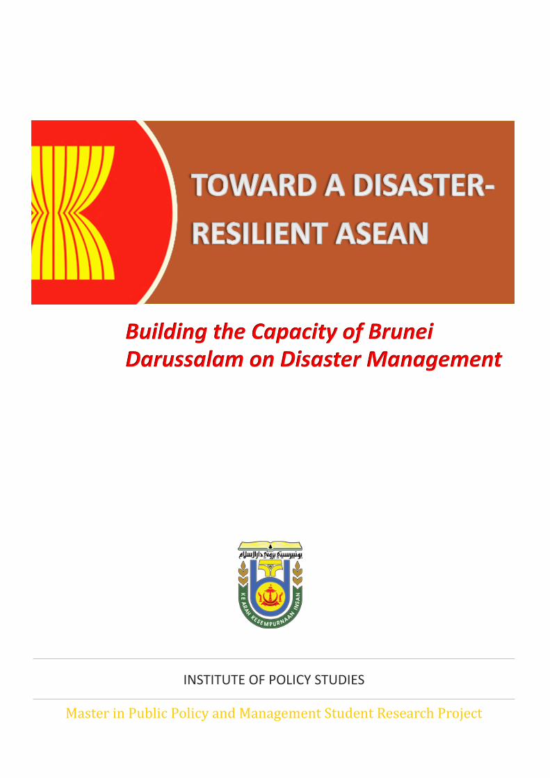
Building the Capacity of Brunei Darussalam on Disaster Management
2
PROJECT MEMBERS
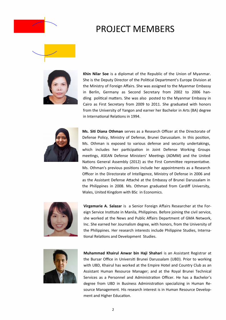
Khin Nilar Soe is a diplomat of the Republic of the Union of Myanmar.
She is the Deputy Director of the Political Department’s Europe Division at
the Ministry of Foreign Affairs. She was assigned to the Myanmar Embassy
in Berlin, Germany as Second Secretary from 2002 to 2006 han-
dling political matters. She was also posted to the Myanmar Embassy in
Cairo as First Secretary from 2009 to 2011. She graduated with honors
from the University of Yangon and earner her Bachelor in Arts (BA) degree
in International Relations in 1994.
Ms. Siti Diana Othman serves as a Research Officer at the Directorate of
Defense Policy, Ministry of Defense, Brunei Darussalam. In this position,
Ms. Othman is exposed to various defense and security undertakings,
which includes her participation in Joint Defense Working Groups
meetings, ASEAN Defense Ministers’ Meetings (ADMM) and the United
Nations General Assembly (2012) as the First Committee representative.
Ms. Othman's previous positions include her appointments as a Research
Officer in the Directorate of Intelligence, Ministry of Defense in 2006 and
as the Assistant Defense Attaché at the Embassy of Brunei Darussalam in
the Philippines in 2008. Ms. Othman graduated from Cardiff University,
Wales, United Kingdom with BSc in Economics.
Virgemarie A. Salazar is a Senior Foreign Affairs Researcher at the For-
eign Service Institute in Manila, Philippines. Before joining the civil service,
she worked at the News and Public Affairs Department of GMA Network,
Inc. She earned her Journalism degree, with honors, from the University of
the Philippines. Her research interests include Philippine Studies, Interna-
tional Relations and Development Studies.
Muhammad Khairul Anwar bin Haji Shahari is an Assistant Registrar at
the Bursar Office in Universiti Brunei Darussalam (UBD). Prior to working
with UBD, Khairul has worked at the Empire Hotel and Country Club as an
Assistant Human Resource Manager; and at the Royal Brunei Technical
Services as a Personnel and Administration Officer. He has a Bachelor’s
degree from UBD in Business Administration specializing in Human Re-
source Management. His research interest is in Human Resource Develop-
ment and Higher Education.
3
ABOUT THE PROJECT
The Master in Public Policy and Management Student Research Project (MSRP) is a
core requirement of the degree programme. Students are tasked to examine relevant
policy issues to gain insights into real-life policymaking processes and develop efficient
teamwork. Each group consists of four students supervised by a faculty member serving
as the Project Academic Advisor (PAA).
The objective of this project is to identify and evaluate the economic, socio-cultural
and political contributions of Brunei Darussalam to developments in the Association of
Southeast Asian Nations (ASEAN). To this end, the research project shall seek to:
1. Explain the legal, economic, political and other related parameters that define
the relations between Brunei Darussalam and ASEAN, as an intergovernmental
regional organization, and the other Member States as well;
2. Identify the strategic objectives of each stakeholder in terms of their economic,
socio-cultural and political viabilities;
3. Explain and assess the existent synergies between each stakeholder’s strategic
objectives and their policy formulation and/or implementation processes; and
4. Recommend to the Brunei Government a hypothetical strategic plan or policy
that will define the country’s relations with other ASEAN Member States related
to the three pillars of ASEAN, namely Economic, Politico-Security and Socio-
Cultural, for the short, medium and long terms.
After determining their research topic, the team decided to work with a client for
their project. By interacting with a client organization, the group was able to understand
the steps and decisions needed in conducting a systematic and research-based policy
analysis. The team worked closely with the National Disaster Management Centre
(NDMC), Brunei's focal point for disaster management in ASEAN. The project also ena-
bled the team members to develop subject matter expertise on disaster management
and benefit from the many learning opportunities, through engagement with the client
and other stakeholders, and collaboration by sharing knowledge and experiences.
4
ACKNOWLEDGEMENT
The members wish to express their sincerest gratitude to all those who have helped
and supported them in doing the research project.
Kolonel (B) Pg Dato Paduka Haji Rosli bin Pg Haji Chuchu
Director
National Disaster Management Centre (NDMC)
Mohamad Adib bin Matali
Special Duties Officer
National Disaster Management Centre (NDMC)
Rozman Junaidi
Deputy General Manager
CAE Brunei Multi-Purpose Training Centre Sdn Bhd.
Senior Superintendent Muhammad Shahreeni bin Haji Yussof
Commanding Officer ‘B’ Division Belait District
Brunei Fire and Rescue Department
Jolkipli Hidop
Senior Research Officer and Lecturer
Brunei Defence Academy
Professor Hj Suhaimi Ali
Project Academic Adviser
Professor Amin Abdul Aziz
Overall MSRP Coordinator
They have been so generous with their time and have willingly guided the group
every step of the way. Their advice and assistance are greatly valued and have contrib-
uted in achieving a viable, accurate, balanced and informative policy research paper.
5
TABLE OF CONTENTS
Title Page 1
Project Members 2
About the Project 3
Acknowledgement 4
Executive Summary 7
Introduction 8
Significance of the Study 8
Objectives 10
Rationale 10
Policy Review 11
Disaster Management in ASEAN 11
Brunei ‘s Initiatives on Disaster Management 16
Methodology 22
Research Design 22
Study Framework 22
Policy Analysis 24
Geohazard Map 24
Incident Command System 27
Think Tank 31
6
TABLE OF CONTENTS
Criteria-Alternatives Matrix 34
Conclusion and Recommendations 36
Conclusion 36
Recommendations 37
Plan of Action 38
Bibliography 40
List of Boxes/Tables/Figures
Box 1. Hyogo Framework of Action: Priorities 12
Box 2. AADMER ‘s General Objectives (Article 4) 14
Box 3. Brunei Darussalam’s Disaster Management Strategy 20
Box 4. Uses of GIS in Disaster Management 25
Figure 1. Data on the Impacts of Disasters in Southeast Asia 11
Figure 2. Disaster Management Process 13
Figure 3. Facade of NDMC Building 17
Figure 4. SNAP Objectives and Targets 18
Figure 5. Logic Model 23
Figure 6. Incident Command Structure 28
Figure 7. Natural Hazards Center Logo 32
Figure 8. Reported Landslides in January 2014 36
Table 1. Criteria-Alternatives Matrix 35
7
EXECUTIVE SUMMARY
Disaster management is gaining momentum as one of
the pressing issues the world is facing today for it is
closely linked to climate change and the environment.
Natural disasters have affected millions of the world’s
population and have serious repercussion on econo-
mies and governments. Notably, the effects of disasters
tend to transcend national boundaries; thus, the impact
of disasters cannot be effectively resolved by a country
acting alone.
Brunei Darussalam, as a member of ASEAN, has been
aspiring to play a more active role in the region, partic-
ularly as the country marked 30 years of joining the or-
ganization in 2014. Disaster management is an area
wherein the country could significantly strengthen its
participation in ASEAN. Disaster management is an im-
portant security issue; albeit a non-controversial one in
keeping with ASEAN’s non-interference policy. This top-
ic has been particularly relevant to Brunei Darussalam
as of late given the frequent occurrence of flooding and
landslides around the country.
Indeed, ASEAN countries are greatly exposed to nat-
ural disasters. Philippines and Indonesia sit right on the
Pacific Ring of Fire; with the region having hundreds of
active volcanoes. Moreover, typhoon passes through
the region bringing on average 30 typhoons per year,
according to the Joint Typhoon Warning Center. Mean-
while, heavy monsoon rains cause flooding and land-
slides, especially in the region’s low-lying areas such as
the Mekong Delta and other densely-populated towns
and villages. The region is also subjected to an intense
hot and dry season, leading to drought and forest fires,
destroying agriculture, and exposing some countries to
serious haze problems in the dry months.
Hence, this project aimed to recommend policies that
Brunei Darussalam can initiate to strengthen its nation-
al capacity on disaster management, as well as to con-
tribute to regional efforts toward achieving the ASEAN
Vision 2020 of having a disaster-resilient region and
safer communities.
Findings from research and evaluation, in addition
to consultations with the various stakeholders, led
the group to recommend producing a geohazard map
for Brunei Darussalam. Geohazard mapping allows
the country to identify areas susceptible to geohaz-
ards and can be integrated into the early warning sys-
tem to build the country’s ability to manage disasters
by enhancing disaster preparedness and response.
The group also developed a Plan of Action, which was
divided into five phases, to ensure the successful im-
plementation of geohazard mapping, and enable Bru-
nei Darussalam to share the benefits of an improved
disaster management system to the ASEAN region as
a whole.
8
“...menekankan pentingnya untuk mengkukuhkan kemampuan di dalam pengurusan bencana.
Kejadian bencana alam yang kerap dan bertambah teruk di tahun-tahun kebelakangan ini
menyebabkan kemusnahan besar dan keperitan kepada ramai masyarakat di serata dunia.”
HM Sultan Haji Hassanal Bolkiah Mu'izzaddin Waddaulah
69th United Nations General Assembly, New York
1 World Bank, “Advancing Disaster Risk Financing and Insurance in ASEAN Member States: Framework and Options for Implementation”, Volume 1, 2012, World Bank website
2 UNISDR, “Terminology”, August 30, 2007, UNISDR website,
Significance of the Study
Southeast Asia is a region vulnerable to both
natural and manmade disasters such as storm,
flood, drought, earthquake, landslide, volcanic
eruption, wildfire, haze and epidemic. Disasters
disrupt the functioning of a community or a society
by causing widespread human, economic and envi-
ronmental losses. The Indian Ocean tsunami in De-
cember 2004, which affected Indonesia and Thai-
land, Cyclone Nargis, which struck Myanmar in
May 2008, and Typhoon Haiyan, which hit the Phil-
ippines in November 2013, left thousands dead
and destroyed homes and livelihoods. Losses relat-
ed to natural disasters cost the ASEAN region, on
average, more than USD 4.4 billion annually.1 Since
a disaster is usually an unforeseen and often sud-
den event that causes great damage, destruction
and human suffering, assistance from the national
or international level is necessary.
A disaster is typically seen as a function of the
risk process for it results from the combination of
hazards, vulnerabilities and insufficient capacity to
decrease the negative consequences of risk.2 Disas-
ters are inevitable, but their worst effects can be
prevented by preparation, early warning and swift
decisive responses. Disaster management aims to
reduce the attendant risks and to mitigate the im-
pact of events that cannot be avoided. ASEAN
9
member states recognize the importance of coop-
eration in addressing natural and manmade disas-
ters. The ASEAN Political-Security Blueprint has
identified disaster management and emergency
response as one of the region’s main non-
traditional security challenges along with transna-
tional crime and counterterrorism. Natural disas-
ters can be classified as a non-traditional security
issue for they arise out of non-military causes and
are transnational in scope. These kinds of security
threats require multilateral cooperation because
national efforts are often inadequate and the
effects are not confined to one state.3 Disasters
pose threats to development in the region by dis-
rupting production and flows of goods and ser-
vices, worsening the balance of payments and gov-
ernment budgets, derailing economic growth, in-
come distribution, and poverty reduction, as well
as causing adverse effects to political stability, so-
cial structures and the environment.4 With the on-
set of climate change, the frequency and intensity
of severe weather-related hazards are expected to
increase over the next decades.
Hence, governments and communities have to
prepare for such events. Disaster management is
considered a proactive approach to avoid or re-
duce human and material loss. Government agen-
cies play a critical role during times of disaster for
they have the resources and manpower needed in
disaster relief operations and mitigation. The na-
tional government has the responsibility to reduce
risk, mitigate effects of, prepare for, respond to
and recover from disasters. Therefore, disaster
management is a public policy issue.
The government of Brunei Darussalam has ini-
tiated efforts to enhance the nation’s capacity for
disaster preparedness and response. In recent
years, the country has been hit by floods and land-
slides. To address this problem, the National Disas-
ter Management Centre (NDMC) was established
to develop strategies on building disaster-resilient
communities. ASEAN, being a cornerstone of Bru-
nei’s foreign policy, is an important partner in pro-
moting dialogue, consultation and cooperation on
disaster management and emergency response.
Moreover, cooperation with ASEAN exemplifies
Brunei’s commitment to uphold efforts on building
ASEAN’s capacity to deal with disasters on a re-
gional level.
This research project aims to arrive at useful,
evidence-based and effective policy recommenda-
tions on strengthening the capacity of Brunei Da-
russalam and ASEAN on disaster management. Ca-
pacity building can be defined as “the process by
which people, organizations and society systemati-
cally stimulate and develop their capacities over
time to achieve social and economic goals, includ-
ing through improvement of knowledge, skills, sys-
tems, and institutions.”5 Although the primary re-
3 Mely Caballero-Anthony, "Non-traditional security challenges, regional governance and the ASEAN Political-Security Community (APSC)", Asia Security Initiative Policy Series,
Working Paper, September 2010 4 Yusuki Sawasa and Fauziah Zen, Disaster Management in ASEAN, ERIA Discussion Paper Series, January 2014, p. 3
5 UNISDR website
10
sponsibility to respond to disasters and implement
programs to reduce disaster risk rests on individual
Member States, addressing natural and manmade
disasters requires a regional approach for such
events affect the ASEAN Community as a whole. In
2006, ASEAN Member States signed the Agreement
on Disaster Management and Emergency Response
(AADMER), a legally binding framework, which
seeks to increase both national and regional capac-
ities on disaster management. The Strategic Na-
tional Action Plan (SNAP) 2012-2025 of the Brunei
Government on Disaster Management also identi-
fied capacity building as one its priorities. Thus,
building the capacity of Brunei and ASEAN is an im-
portant policy area that has to be examined. It is
hoped that through this research the Brunei Gov-
ernment can implement concrete and actionable
policies and programmes which can contribute to
the realization of ASEAN’s goal of having a disaster-
resilient region and safer communities.
Objectives
The objectives of the research project are the
following:
To review current policies and programmes
of the Brunei Government and ASEAN on
disaster management ;
To recommend policies that will strengthen
the capacity of Brunei Darussalam and
ASEAN on disaster management; and
To propose a Plan of Action for the policy
recommendation to the NDMC
Rationale
The AADMER is a regional framework for coop-
eration, coordination, technical assistance and re-
source mobilization in all aspects of disaster man-
agement. It embodies ASEAN’s commitment to
attain the vision of disaster-resilient nations and
safe communities.
The AADMER Work Programme was developed
to achieve concrete actions and initiatives from
2010-2015. It was designed to support the national
agenda and complement the capacities of ASEAN
Member States in the different aspects of disaster
management. The ASEAN Committee on Disaster
Management (ACDM), the body responsible for
policy oversight and supervision of the implemen-
tation process, approved the Work Programme in
2010.
This research study intends to identify policy
options that Brunei can implement as a national
initiative in line with the country’s goals and priori-
ties and ASEAN’s as well. In designing the policies,
the study takes into consideration ASEAN’s vision,
AADMER’s respective components and related
building blocks, the challenges in AADMER imple-
mentation, and Brunei’s own plans and priorities in
terms of disaster management.
11
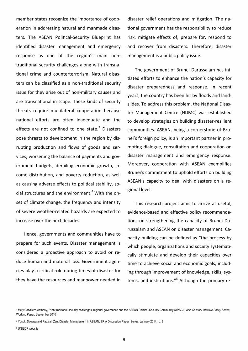
Figure 1. Data on the Impacts of Disasters in Southeast Asia
Data Sources: UNESCAP and World Bank websites
Disaster Management in ASEAN
Since 2000, close to 200 million people in the
region have been adversely affected by natural dis-
asters, and over 300,000 of them died as a result
of these catastrophic events. In terms of economic
cost, ASEAN countries have incurred losses of a
staggering USD 92 billion, between 2000 and 2014,
due to natural disasters.6 To put things into per-
spective, a person living in Southeast Asia is 11
times more likely to be affected by natural disaster
than a person living in North America, and almost
18 times more likely to be affected than a person
living in Europe.7
Not only is Southeast Asia prone to disasters,
6 Natural Disasters Indicators in Southeast Asia region (2000 – 2014), ESCAP Online Statistical Database , UNESCAP website
7 Ibid.
there are other aggravating factors that further
weaken the region's ability to cope with the nega-
tive impacts of disasters. With the onset of cli-
mate change, the intensity and frequency of natu-
ral disasters in the region are expected to in-
crease. The region is home to more than 633 mil-
lion people, many of which are living in vulnerable
areas. Majority of ASEAN Member States are still
considered as developing countries, and because
of resource constraints disaster management
ranks low in the priorities of Member Govern-
ments. Moreover, rapid urbanization brought
about the growth of slums in cities which are al-
ready densely populated. These poor people are
the ones most seriously affected when a disaster
12
strikes. Member States are also dealing with gov-
ernance issues, which result in weak planning and
implementation challenges.
The United Nations International Strategy for
Disaster Reduction (UNISDR) defines disaster risk
management as "the systematic process of using
administrative directives, organizations, and opera-
tional skills and capacities to implement strategies,
policies and improved coping capacities in order to
lessen the adverse impacts of hazards and the pos-
sibility of disaster."8 This process aims to avoid or
reduce the negative effects of hazards through pre-
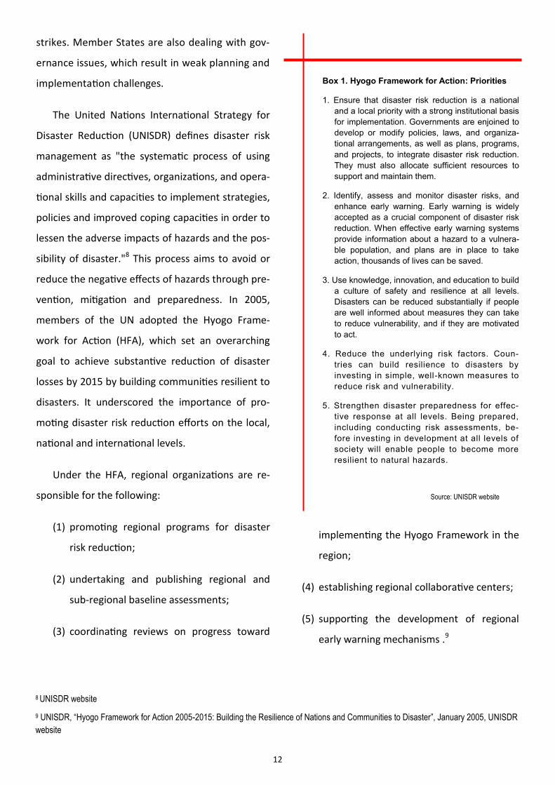
vention, mitigation and preparedness. In 2005,
members of the UN adopted the Hyogo Frame-
work for Action (HFA), which set an overarching
goal to achieve substantive reduction of disaster
losses by 2015 by building communities resilient to
disasters. It underscored the importance of pro-
moting disaster risk reduction efforts on the local,
national and international levels.
Under the HFA, regional organizations are re-
sponsible for the following:
(1) promoting regional programs for disaster
risk reduction;
(2) undertaking and publishing regional and
sub-regional baseline assessments;
(3) coordinating reviews on progress toward
implementing the Hyogo Framework in the
region;
(4) establishing regional collaborative centers;
(5) supporting the development of regional
early warning mechanisms .9
8 UNISDR website
9 UNISDR, “Hyogo Framework for Action 2005-2015: Building the Resilience of Nations and Communities to Disaster”, January 2005, UNISDR
website
Box 1. Hyogo Framework for Action: Priorities
1. Ensure that disaster risk reduction is a national
and a local priority with a strong institutional basis
for implementation. Governments are enjoined to
develop or modify policies, laws, and organiza-
tional arrangements, as well as plans, programs,
and projects, to integrate disaster risk reduction.
They must also allocate sufficient resources to
support and maintain them.
2. Identify, assess and monitor disaster risks, and
enhance early warning. Early warning is widely
accepted as a crucial component of disaster risk
reduction. When effective early warning systems
provide information about a hazard to a vulnera-
ble population, and plans are in place to take
action, thousands of lives can be saved.
3. Use knowledge, innovation, and education to build
a culture of safety and resilience at all levels.
Disasters can be reduced substantially if people
are well informed about measures they can take
to reduce vulnerability, and if they are motivated
to act.
4. Reduce the underlying risk factors. Coun-
tries can build resilience to disasters by
investing in simple, well-known measures to
reduce risk and vulnerability.
5. Strengthen disaster preparedness for effec-
tive response at all levels. Being prepared,
including conducting risk assessments, be-
fore investing in development at all levels of
society will enable people to become more
resilient to natural hazards.
Source: UNISDR website
13
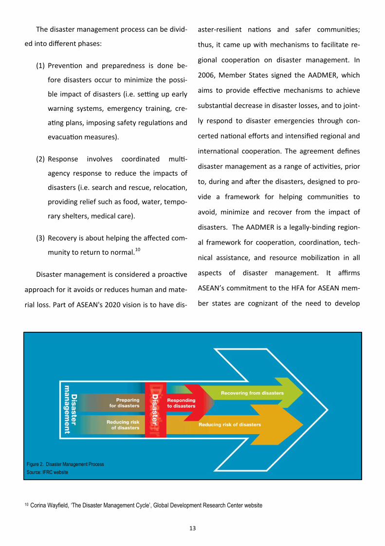
The disaster management process can be divid-
ed into different phases:
(1) Prevention and preparedness is done be-
fore disasters occur to minimize the possi-
ble impact of disasters (i.e. setting up early
warning systems, emergency training, cre-
ating plans, imposing safety regulations and
evacuation measures).
(2) Response involves coordinated multi-
agency response to reduce the impacts of
disasters (i.e. search and rescue, relocation,
providing relief such as food, water, tempo-
rary shelters, medical care).
(3) Recovery is about helping the affected com-
munity to return to normal.10
Disaster management is considered a proactive
approach for it avoids or reduces human and mate-
rial loss. Part of ASEAN's 2020 vision is to have dis-
Figure 2. Disaster Management Process
Source: IFRC website
10 Corina Wayfield, ‘The Disaster Management Cycle’, Global Development Research Center website
aster-resilient nations and safer communities;
thus, it came up with mechanisms to facilitate re-
gional cooperation on disaster management. In
2006, Member States signed the AADMER, which
aims to provide effective mechanisms to achieve
substantial decrease in disaster losses, and to joint-
ly respond to disaster emergencies through con-
certed national efforts and intensified regional and
international cooperation. The agreement defines
disaster management as a range of activities, prior
to, during and after the disasters, designed to pro-
vide a framework for helping communities to
avoid, minimize and recover from the impact of
disasters. The AADMER is a legally-binding region-
al framework for cooperation, coordination, tech-
nical assistance, and resource mobilization in all
aspects of disaster management. It affirms
ASEAN’s commitment to the HFA for ASEAN mem-
ber states are cognizant of the need to develop
14
coordinated regional approaches to prepare for
disasters and ensure swift response in situations
that require international assistance. The AADMER
requires members to cooperate in developing and
implementing measures to reduce disaster losses;
immediately respond to disasters occurring within
their territory; promptly respond to a request for
assistance from an affected country; and take legis-
lative, administrative and other measures to imple-
ment provisions under the agreement.
The AADMER has two different levels of com-
mitment: one, to build regional capacity focused
on supporting Member States in preparedness and
response capacities, coupled with a regional sys-
tem of rules to expedite collaboration during dis-
asters; and two, to assist governments in improv-
ing their disaster risk management systems
through all stages of the disaster management
process.11 Moreover, the agreement intends to
accomplish concrete actions in the strategic com-
ponents of (1) risk assessment, early warning and
monitoring; (2) prevention and mitigation; (3) pre-
paredness and response; and (4) recovery.12
Member states came up with the AADMER Work
Programme for 2010-2015 to serve as a roadmap
in effectively translating the goals of AADMER into
flagship projects based on the four components of
disaster management.
Several bodies are involved in implementing,
monitoring and evaluating the AADMER Work Pro-
gramme. The representatives of the national disas-
ter management agencies of Member States com-
prise the ACDM. Established in 2003, its function is
to provide a link between national and regional
institutions, and manage and implement regional
activities. It also does policy oversight and supervi-
sion of the Work Programme. The ACDM has four
Working Groups which correspond to the strategic
components of the AADMER. Member States
agree to be lead shepherds of projects and are
tasked to coordinate the activities of the members
of the Working Group. The Chair of the ACDM pro-
vides leadership and guidance to fulfill the goals of
11 Daniel Petz, “Strengthening Regional and National Capacity for Disaster Risk Management: The Case of ASEAN”, Brookings-LSE Project
on Internal Displacement, November 2014, p. 14
12 AHA Centre, “AADMER Work Programme 2010-2015”, AHA Centre website
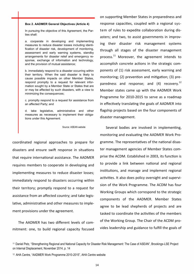
Box 2. AADMER General Objectives (Article 4)
In pursuing the objective of this Agreement, the Par-
ties shall:
a. cooperate in developing and implementing
measures to reduce disaster losses including identi-
fication of disaster risk, development of monitoring,
assessment and early warning systems, standby
arrangements for disaster relief and emergency re-
sponse, exchange of information and technology,
and the provision of mutual assistance;
b. immediately respond to a disaster occurring within
their territory. When the said disaster is likely to
cause possible impacts on other Member States,
respond promptly to a request for relevant infor-
mation sought by a Member State or States that are
or may be affected by such disasters, with a view to
minimizing the consequences;
c. promptly respond to a request for assistance from
an affected Party; and
d. take legislative, administrative and other
measures as necessary to implement their obliga-
tions under this Agreement.
Source: ASEAN website
15
the AADMER. The Chair is primarily tasked to initi-
ate and direct the execution of activities in the
Work Programme. It is also the task of the ACDM
to collaborate with Dialogue Partners, internation-
al and multilateral agencies, non-government or-
ganizations and the private sector to advance the
objectives of the AADMER.
The ASEAN Coordinating Centre for Humanitar-
ian Assistance on Disaster Management (AHA Cen-
tre) was established to facilitate cooperation and
coordination among ASEAN Member States and
with relevant United Nations agencies and other
international organizations. The AHA Centre per-
forms operational coordination and technical
functions under the AADMER, and it operates on
a 24/7 basis.
The ASEAN Secretariat provides policy coor-
dination support, conducts monitoring and eval-
uation of the AADMER, and serves as the custo-
dian of the AADMER Fund. In addition, the
ASEAN Secretariat assists the ASEAN Secretary-
General in fulfilling his duties as the ASEAN Hu-
manitarian Assistance Coordinator in times of a
major disaster or emergency. The ASEAN Disas-
ter Monitoring and Response System (DMRS),
which provides the emergency operations center
using streams of hazard data from all over
ASEAN, is located in the AHA Centre. In its 2013
13 Daniel Petz, “Strengthening Regional and National Capacity for Disaster Risk Management: The Case of ASEAN”
14 Australia, Canada, China, European Union, India, Japan, New Zealand, Republic of Korea, Russia and United States
15 Led by Oxfam Great Britain as the current chair, it includes the following members: ChildFund International, HelpAge International, Mercy
Malaysia, Plan International, Save the Children, and World Vision.
Annual Report, the AHA Centre reported a budg-
et of almost USD 5.8 million, most of which
came from Dialogue Partners. Each ASEAN Mem-
ber State has to contribute USD 30,000 annually
for operational expenses. Members can also give
voluntary contributions to the AADMER fund. 13
In implementing AADMER, ASEAN collaborates
with its Dialogue Partners14 and formed the
AADMER Partnership Group15, a consortium of
seven civil society organizations, for it acknowl-
edges the significance of establishing a wide net-
work of cooperation in addressing the issue.
A comprehensive systems approach is applied
in studying disaster risk management. A systems
perspective entails developing and implementing
efforts that complement the varying aspects of the
cycle. It is also important to note that to achieve a
comprehensive and integrated approach all stake-
holders have to be involved. In the case of ASEAN,
cooperation covers from the community level to
the inter-governmental level and promotes multi-
sectoral coordination. Disasters pose enormous
challenges especially for developing nations. Thus,
regional organizations like ASEAN are working to
increase the capacity of Member States to cope
with disasters in the short run and invest in
measures on disaster prevention and mitigation in
the long run. However, the challenges in effectively
16
translating policies into strategies and activities
remain.
Brunei’s Initiatives on Disaster Management
Although Brunei is one of the least hazard-
prone countries in Southeast Asia, it had its share
of disasters over the years. Based on the records
of emergency calls received by the Fire and Res-
cue Department since 2006, NDMC acknowledges
that the occurrence of hazards have been in-
creasing. In addition to floods and landslides,
other hazardous events such as strong winds,
haze, fire and outbreak of diseases have been re-
ported as of late. NDMC has also recognizes the
possibility that natural disasters such as drought,
beach erosion, tsunamis and earthquake, and in-
dustrial hazards like explosions, pollution and oil
spills are likely to happen.
At the beginning of 2015, many areas suffered
from severe flooding after days of torrential
rains. Floods were reported in 13 sub-districts of
Brunei-Muara, Tutong and Temburong. The ab-
normal amount of rainfall recorded and high tide
of 2.4 meters from 2:00 to 4:00 am caused the
flooding in the three districts.17
In 2014, some 44 cases of landslides have
been recorded by the Brunei-Muara District Dis-
aster Management Committee. The worst-
affected areas in the district were Kg Telanai, Kg
Lambak Kiri, Kg Perpindahan Lambak Kanan, Sg
Tilong, Kg Kapok Kanan and Kg Mentiri. In Tutong
District, landslides were reported in a number of
villages: Kg Piasan Lamunin, Kg Kebia, Kg Pengka-
lan Mau, Kg Luagan Timbaran, Kg Pengkalan
Tangsi, Kg Birau, Kg Sinaut and Kg Bukit Panggal.
Flooding was also reported in several areas
around the country. Radio Televisyen Brunei
gathered reports that Mukim Lamunin, Mukim
Rambai, Mukim Tanjong Maya and Mukim Ukong
were among the areas worst hit by floods in
Tutong District; as well as Kg Sungai Mau, Jalan
Bukit Puan, Kg Singap and Kg Laid Lakang, Jalan
Setia Diraja, Jalan Jaya Negara, Jalan Puteri Bru-
nei, Jalan Panglima, Jalan Singa Menteri and Jalan
Sungai Pandai in Belait District and Mukim Bokok
in Temburong District.16
As a signatory to AADMER, Brunei is expected
to comply with the objectives of the agreement.
One way for the Brunei Government to operation-
alize the AADMER objectives is by strengthening
the capacity of NDMC for it is the country’s focal
point for disaster management in ASEAN. NDMC is
part of the country's National Disaster Council.
The Disaster Management Order of 2006
mandated the establishment of a National Dis-
aster Council. The Council was assigned the
following functions:
16 Rafidah Hamit, “Floods and 44 Landslides”, 23 January 2014, Brunei Times website
17 Ak Mohd Khairuddin Pg Harun and Izzati , “Floods Reported in 13 Sub-districts Across Brunei”, 26 January 2015, Brunei Times website
17
(1) to develop a strategic policy framework for
disaster management for Brunei Darus-
salam;
(2) to ensure that an effective disaster man-
agement system is developed and imple-
mented;
(3) to ensure that regional and international
arrangement concerning matters relating to
effective disaster management are estab-
lished and maintained;
(4) to identify resources that may be used for
disaster operations;
(5) to provide reports and make recommenda-
tions to His Majesty the Sultan and Yang Di-
Pertuan about matters relating to disaster
management and disaster operations;
(6) to prepare the National Disaster Manage-
ment Plan;
(7) to exercise or perform any other function
conferred or imposed to the Council under
this Order or under any other written law;
(8) to decide on the assistance to be provided
to any country or territory relating to disas-
ter operations; and
(9) to decide on the assistance offered by
any country or territory, organisational
or individual.
The Order also provided legal basis for the
establishment of NDMC in August 2006. NDMC
reports to the National Disaster Council, and is
under the administrative purview of the Ministry
of Home Affairs. Under the Order, NDMC was
given the following functions:
(1) to help the Council exercise or perform
its functions;
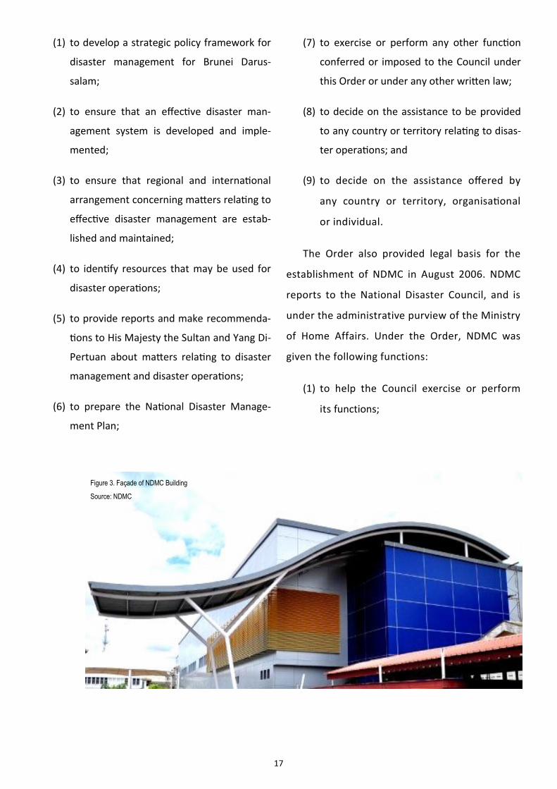
Figure 3. Façade of NDMC Building
Source: NDMC
18
(2) to advise and make recommendations to
the Council about matters relating to disas-
ter management referred by the Council to
the Centre; and
(3) to exercise or perform such other functions
as the Council may determine.
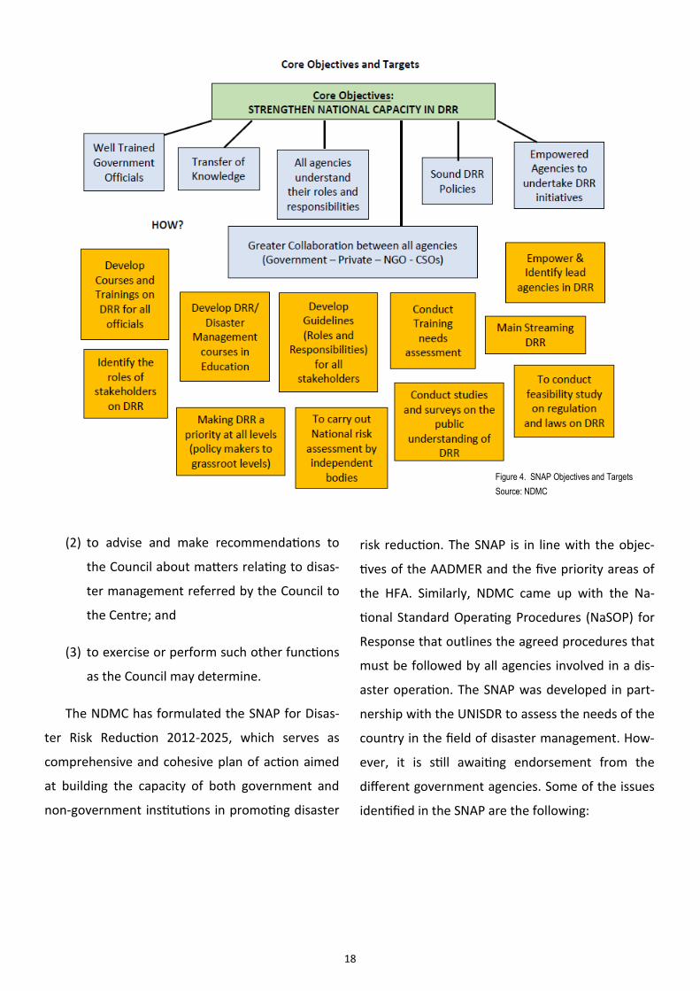
The NDMC has formulated the SNAP for Disas-
ter Risk Reduction 2012-2025, which serves as
comprehensive and cohesive plan of action aimed
at building the capacity of both government and
non‐government institutions in promoting disaster
risk reduction. The SNAP is in line with the objec-
tives of the AADMER and the five priority areas of
the HFA. Similarly, NDMC came up with the Na-
tional Standard Operating Procedures (NaSOP) for
Response that outlines the agreed procedures that
must be followed by all agencies involved in a dis-
aster operation. The SNAP was developed in part-
nership with the UNISDR to assess the needs of the
country in the field of disaster management. How-
ever, it is still awaiting endorsement from the
different government agencies. Some of the issues
identified in the SNAP are the following:
Figure 4. SNAP Objectives and Targets
Source: NDMC
19
(1) Inadequacies in hazard data and vulnerabil-
ity information;
(2) Multi-stakeholder coordination;
(3) Level of emergency preparedness of the
population;
(4) Weak early warning system; and
(5) Integration of disaster risk reduction con-
cerns in social, environmental, physical and
land use planning.
Given these issues, NDMC planned to direct its
resources to meet four priorities, which are:
(1) to enhance disaster risk reduction mecha-
nisms by ensuring that policies are imple-
mented in accordance with the objectives
of AADMER and HFA;
(2) to build multi-sectoral disaster manage-
ment capacity through strong cooperation
and coordination among different stake-
holders;
(3) to increase community awareness and pre-
paredness by promoting an understanding
of the disaster management concept at the
community level; and
(4) to upgrade the competencies of NDMC
staff.
NDMC has initiated a few programs to opera-
tionalize the SNAP. One of which is the Communi-
ty-Based Disaster Risk Management programme
which was launched in March 2010. It is part of
NDMC’s efforts to increase the readiness and pre-
paredness of the communities for disasters by
identifying hazards and reducing risks associated
with them. The objective is to create disaster-
resilient communities in Brunei since it is at the
district level where disaster impacts are felt the
most. Under this programme, NDMC conducts
public awareness exercises, early warning and risk
assessment, and safety checks of houses and
buildings. NDMC has also put together modules
used in the National Service programme and train-
ing for trainors programme primarily focused on
teachers. Moreover, it conducts training activities
for the different government agencies on radio
communications technology, emergency rapid as-
sistance team training in cooperation with Singa-
pore, table-top workshops, and simulation exercis-
es pursuant to the NaSOP. It also made efforts to
introduce the US-based Incident Command Sys-
tem (ICS) into the country’s disaster response sys-
tem. This two-year training was carried out by US
Forest Service as part of the ASEAN-ICS Pilot Coun-
try Project since 2010.
In 2014, NDMC partnered with the CAE-Brunei
Multi-Purpose Training Centre (CAE-Brunei MPTC),
20
a joint venture between a Canadian firm and the
Brunei Government to launch a word-class training
centre by delivering a range of training solutions to
different sectors such as defence, aviation, emer-
gency and crisis management, healthcare and en-
ergy, among others. CAE-Brunei MPTC has estab-
lished an Emergency and Crisis Management Cen-
tre of Excellence that will provide relevant local
authorities such as the Ministry of Home Affairs
and NDMC with comprehensive training activities
to enable the Government to better plan and pre-
pare for emergencies. Using simulation-based
training, the Centre is offering emergency and cri-
sis management training programs to improve the
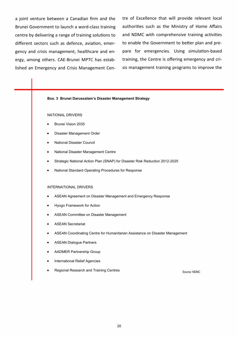
Box. 3 Brunei Darussalam’s Disaster Management Strategy
NATIONAL DRIVERS
Brunei Vision 2035
Disaster Management Order
National Disaster Council
National Disaster Management Centre
Strategic National Action Plan (SNAP) for Disaster Risk Reduction 2012-2025
National Standard Operating Procedures for Response
INTERNATIONAL DRIVERS
ASEAN Agreement on Disaster Management and Emergency Response
Hyogo Framework for Action
ASEAN Committee on Disaster Management
ASEAN Secretariat
ASEAN Coordinating Centre for Humanitarian Assistance on Disaster Management
ASEAN Dialogue Partners
AADMER Partnership Group
International Relief Agencies
Regional Research and Training Centres Source: NDMC
21
Government's coordination, response and opera-
tional decision making given a range of emergency
scenarios. It also plans to offer emergency and cri-
sis management training to ASEAN.
On the international level, NDMC is working
closely with the AHA Centre in Jakarta. NDMC's
own Disaster Command Centre is linked with the
AHA Centre to facilitate cooperation and coordi-
nation among ASEAN Member States, and rele-
vant UN agencies and international organiza-
tions engaged in disaster response and giving
early warning. NDMC is also engaged with other
regional research and training centres such as
the Asian Disaster Reduction Centre, the Asian
Disaster Preparedness Reduction Centre, the
Pacific Tsunami Warning Center and Pacific Dis-
aster Centre. To improve interoperability,
NDMC attends the ASEAN Regional Disaster Re-
sponse Exercises (ARDEX), a biennial event, fo-
cused on increasing the region’s capacity in re-
sponding to disasters; as well as the Disaster Re-
sponse Exercises (DIREX) under the ASEAN Re-
gional Forum. It also participates in the Human
Assistance and Disaster Response (HADR) Exer-
cises as part of the ASEAN Defence Minister's
Meeting Plus Eight (ADMM+8) initiative.
Through all these efforts, NDMC hopes to
build the country’s disaster management capaci-
ty in the short, medium and long term.
22
Research Design
The study was conceived mainly as a qualita-
tive research that employed case studies, contex-
tual analysis and interviews as the research meth-
ods. Case studies were done to benchmark the
proposed policy options with the initiatives of
other countries. For the policy review, conducting
a contextual analysis of relevant policies and pro-
grammes helped in linking the concepts and ob-
jectives with the realities of policy implementa-
tion. Semi-structured interviews with experts and
stakeholders were helpful in determining the fea-
sibility of policy options and the challenges relat-
ed to implementation. This research project has
also examined ways to expand or modify current
policies for it was deemed important to take note
of the projects that key political actors are active-
ly proposing or seriously considering.
In evaluating the three policy options, a Crite-
ria-Alternatives Matrix (CAM) was used. The out-
comes of the each policy option were assessed
using a set of criteria and were presented in the
matrix. The CAM was useful in evaluating and
priortizing a list of options. Set of evaluative crite-
ria was developed, and a relative weight was as-
signed to each criterion. All the options were
ranked according to how well each met the crite-
rion. Each option was multiplied by the weight,
and the option with the highest ranking was se-
lected for further examination.
The main institutional partner of this project
is the NDMC. Understanding the mandate, organi-
zational framework, strategies and priorities of
NDMC is important for it functions as Brunei’s na-
tional focal point for Disaster Management in
ASEAN. The NDMC is the lead coordinating agen-
cy of the Disaster Management Council, which
includes other government agencies.
Study Framework
The purpose of the policy review is to analyze
current policies and programmes that deal with
disaster management and emergency response at
the national and regional levels. From the policy
review and consultation with stakeholders and
experts, the study was able to find out the chal-
lenges and priorities in building ASEAN and Bru-
nei's capacity on disaster management. These
factors were carefully considered in coming up
with policy options that will meet the immediate
23
and long term outcomes. The outcomes must ful-
fill two objectives: (1) to build Brunei's capacity
on disaster management; and (2) to contribute to
regional collaboration on disaster preparedness,
response, recovery and mitigation.
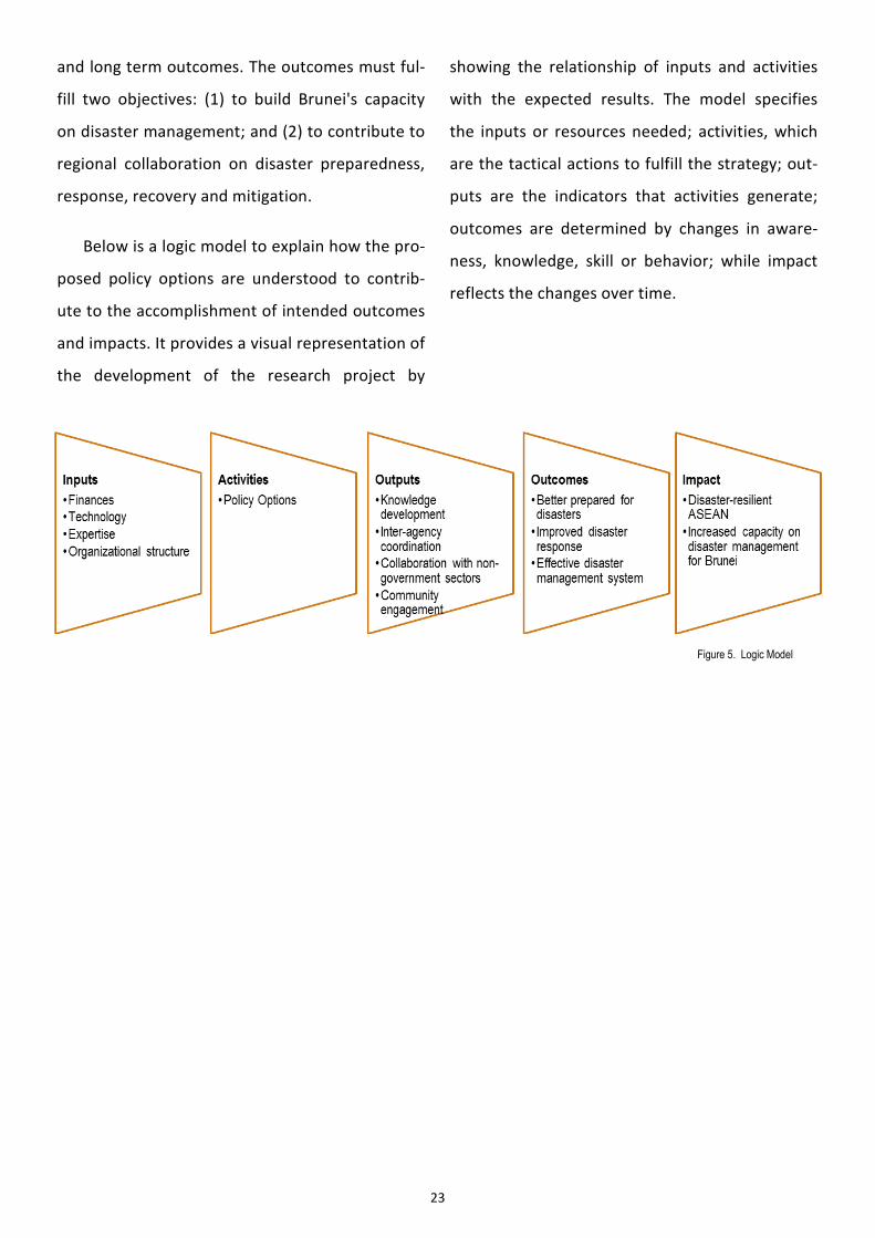
Below is a logic model to explain how the pro-
posed policy options are understood to contrib-
ute to the accomplishment of intended outcomes
and impacts. It provides a visual representation of
the development of the research project by
showing the relationship of inputs and activities
with the expected results. The model specifies
the inputs or resources needed; activities, which
are the tactical actions to fulfill the strategy; out-
puts are the indicators that activities generate;
outcomes are determined by changes in aware-
ness, knowledge, skill or behavior; while impact
reflects the changes over time.
Figure 5. Logic Model
24
From the policy review and consultations with
various stakeholders at the nation and regional
levels on the disaster management process, three
policy options have been identified: (1) producing
a geohazard map for Brunei Darussalam, (2) put-
ting in place an Incident Command System, and
(3) establishing an ASEAN Think Tank on disaster
management.
Geohazard Map
Through geohazard mapping, areas which are
susceptible or vulnerable to various geohazards
are determined. Information gathered from sur-
veying and assessing certain areas can increase
awareness on the types of hazards present in the
community. Geographic Information System (GIS)
helps in identifying disaster points; GIS combines
geospatial input, hardware and software that can
analyze data to produce information. The use of
satellite data and GIS enabled large-scale map-
ping, 3D analysis, updating of existing maps and
project planning. In recent years, GIS has been
applied in disaster management to forecast and
reduce the risks of geohazards.18 These maps can
also be integrated into a country's early warning
system to provide stakeholders with valuable in-
formation in implementing programs and activi-
ties to reduce risk and mitigate the impacts of
18 Elmira Shamshiry et.al. 2001. "Disaster Management Base on Geoinformatics." Institute of Electrical and Electronics Engineers. p. 30
25
natural or manmade disasters. Moreover, maps
can be utilized for development and land use
planning in terms of large-scale infrastructure in-
vestments.
CASE STUDY: THE PHILIPPINES
The Department of Environment and Natural
Resources (DENR) of the Philippine government
started its program on geohazard mapping and as-
sessment in 2004. It is an on-going priority of the
DENR, which is being implemented by the Mines
and Geosciences Bureau (MGB). The components
of the program are the following: (1) rapid assess-
ment survey to generate geohazard maps that will
indicate which areas are prone to natural hazards;
(2) printing and reproduction of maps, manuals
and information materials for public dissemination;
and (3) conduct of seminars and workshops for lo-
cal government officials and public school teachers
to increase their awareness and preparedness on
various natural hazards, as well as teach them on
the proper use of the geohazard maps.
Direct beneficiaries of the project are segments
of the population living in vulnerable areas, the
local government units, various government agen-
cies, non-government organizations and institu-
tions engaged in land use planning and classifica-
tion, environmental regulation and protection, and
disaster management and mitigation. Also to ben-
efit are public and private schools, businesses en-
gaged in infrastructure and resources develop-
ment, general utility companies such as water dis-
tricts, construction companies engaged in public
works and energy producers.
The DENR allocated some PhP 354 million for
the creation of a detailed geohazard mapping in
various disaster prone areas in the country as part
of the agency's efforts to enhance the prepared-
ness of local government units and the implemen-
tation of various mitigation measures against natu-
ral disasters.19 The Philippine government has al-
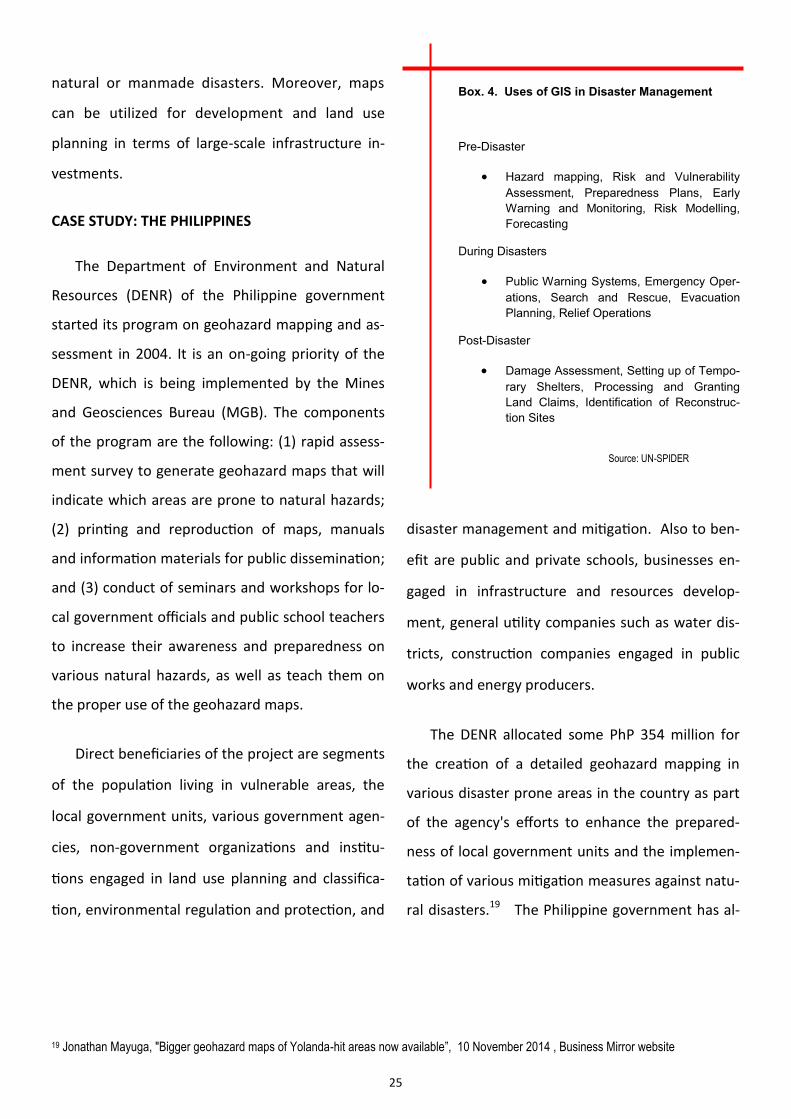
Box. 4. Uses of GIS in Disaster Management
Pre-Disaster
Hazard mapping, Risk and Vulnerability
Assessment, Preparedness Plans, Early
Warning and Monitoring, Risk Modelling,
Forecasting
During Disasters
Public Warning Systems, Emergency Oper-
ations, Search and Rescue, Evacuation
Planning, Relief Operations
Post-Disaster
Damage Assessment, Setting up of Tempo-
rary Shelters, Processing and Granting
Land Claims, Identification of Reconstruc-
tion Sites
Source: UN-SPIDER
19 Jonathan Mayuga, "Bigger geohazard maps of Yolanda-hit areas now available”, 10 November 2014 , Business Mirror website
26
20 Beverly Natividad, "JICA donates P4 million worth of geohazard mapping tools", 5 April 2006 , BusinessWorld website
21 BusinessWorld, "UNDP funds mapping project," 25 March 2005, BusinessWorld website.
so received foreign assistance for this program.
The Japan International Cooperation Agency (JICA)
gave PhP 4 million worth of new geohazard map-
ping materials to the Philippines which included 20
units of Global Positioning System (GPS) equip-
ment, 30 digital cameras, 20 binoculars, a large for-
mat plotter 42-inch printer capable of printing
large-size maps, a 4x4 vehicle, about 12,000 infor-
mation and educational posters on geohazards,
1,500 frames of aerial photographs, scanners, lap-
tops and projectors.20 In addition, the United Na-
tions Development Program (UNDP) extended a
PhP 2.24 million grant for geohazard mapping for it
recognized the program’s substantial impact on
the country's disaster management goals by reduc-
ing, if not eliminating, the possible loss of lives and
properties caused by the interplay of natural ca-
lamities and existing geohazards.21
The program has accomplished a number of
noteworthy outputs. It has identified the top 10
provinces which are highly susceptible to land-
slides, and another list of top 10 provinces highly
susceptible to flooding. Some 1,634 municipalities
and cities have undergone geohazard assessment
and mapping that led to the creation of maps in
1:50,000 scale. A total of 75,000 map sheets were
distributed to all local government units with cor-
responding training and capacity building in inter-
preting the maps. In 2011, the DENR decided to
update the maps of 218 municipalities by making
them more detailed using a scale of 1:10,000. The
interactive maps are also accessible and down-
loadable from three government websites.
BENEFITS TO BRUNEI
Those who will benefit from having geohazard
maps are the general population, especially those
living and working in vulnerable areas. Geohazard
maps can accurately pinpoint these areas and pro-
vide salient information needed in planning and
improving measures on disaster preparedness, re-
sponse and recovery. It can assist government in
infrastructure and development planning.
Geohazard maps of Brunei are barely available.
A national mapping system using GIS can be useful
for land administration, and risk and vulnerability
mapping for disaster mitigation and preparedness.
There is a need to integrate risk and vulnerability
mapping with the national base maps to produce
multi-hazard risk maps complete with compre-
hensive risk assessment. Geohazard maps are an
integral part of a country's early warning system
for these will strengthen Brunei’s commitment
toward implementing the HFA. The NDMC, in its
SNAP, identified inadequacies in hazard data and
vulnerability information and integration of disas-
ter risk reduction concerns in social, environmen-
27
tal, physical and land-use planning as issues that
have to be addressed. Thus, conducting geohaz-
ard mapping and assessment will enable NDMC
and the Brunei Government to build capacity on
disaster management.
CHALLENGES
The geohazard maps are expected to be costly;
for example Philippine government had to spend
around PhP300 million or almost BND10 million.
However, taking into account of the country total
land area compared to the Philippines the costs is
expected to be lower for Brunei. After identifying
geohazard areas, some people living in areas vul-
nerable to flooding and landslides may be com-
pelled to leave and find safer places to reside. This
can be a difficult and costly process, and some peo-
ple may resist from moving from their homes be-
cause of traditional and sentimental values. The
geohazard mapping project is an inter-agency
effort. The agency responsible for producing and
maintaining maps, which is the Survey Department
under the Ministry of Development, would need to
work with agencies such as the Meteorological
Section of the Department of Civil Aviation, Public
Works Department and Town and Country Plan-
ning, etc. The project may be slowed down be-
cause of bureaucratic and coordination problems.
BENEFITS TO ASEAN
As for ASEAN, the geohazard maps will allow
Brunei to feed accurate data and information to
AHA Centre which can be used in conducting re-
gional-level analysis. With Brunei’s know how it
can support other ASEAN Member States consid-
ering to implement geohazard mapping in terms
of knowledge sharing and technology transfer. Of
the 10 ASEAN Members, only the Philippines,
Thailand and Indonesia have geohazard maps.
Brunei can also hold trainings and workshops on
geohazard mapping in cooperation with other
ASEAN members.
Incident Command System
An ICS is a management framework designed
to integrate personnel, equipment, procedures,
facilities and communications during complex
events such as in a catastrophic disaster, enabling
various agencies to come together for a more ef-
fective response operations within a common or-
ganizational structure. Using this structure, first-
responders and other trained personnel can be
assigned to positions with clear responsibilities
regardless of their agency or jurisdiction on a
standard planning process to broadly communi-
cate incident objectives and ensure that respond-
ers’ collective actions meet those objectives
through a unified response. ICS also enables inte-
28
gration not only across institutions or domestic
agencies, but also across state, region, and/or na-
tional boundaries.
CASE STUDY: UNITED STATES
The concept of ICS was developed in the Unit-
ed States more than thirty years ago, in the after-
math of a devastating wildfire in California. Alt-
hough all of the responding agencies cooperated
to the best of their ability, numerous problems
with communication and coordination hampered
their effectiveness. As a result, the Congress man-
dated that the U.S. Forest Service design a system
that would "make a quantum jump in the capabil-
ities of Southern California wild land fire protec-
tion agencies to effectively coordinate inter-
agency action and to allocate suppression re-
sources in dynamic, multiple-fire situations."22
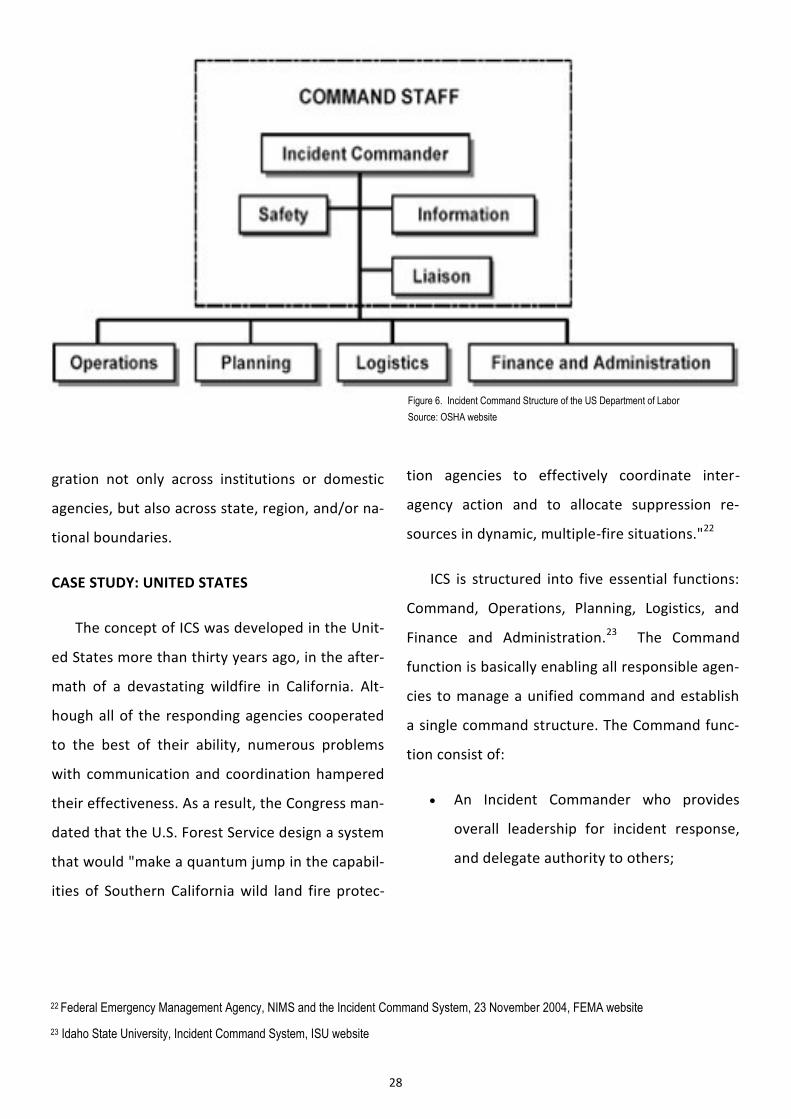
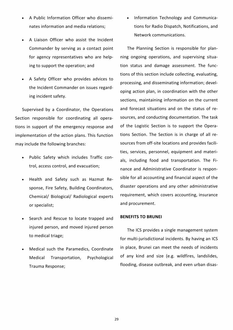
ICS is structured into five essential functions:
Command, Operations, Planning, Logistics, and
Finance and Administration.23 The Command
function is basically enabling all responsible agen-
cies to manage a unified command and establish
a single command structure. The Command func-
tion consist of:
An Incident Commander who provides
overall leadership for incident response,
and delegate authority to others;
Figure 6. Incident Command Structure of the US Department of Labor
Source: OSHA website
22 Federal Emergency Management Agency, NIMS and the Incident Command System, 23 November 2004, FEMA website
23 Idaho State University, Incident Command System, ISU website
29
A Public Information Officer who dissemi-
nates information and media relations;
A Liaison Officer who assist the Incident
Commander by serving as a contact point
for agency representatives who are help-
ing to support the operation; and
A Safety Officer who provides advices to
the Incident Commander on issues regard-
ing incident safety.
Supervised by a Coordinator, the Operations
Section responsible for coordinating all opera-
tions in support of the emergency response and
implementation of the action plans. This function
may include the following branches:
Public Safety which includes Traffic con-
trol, access control, and evacuation;
Health and Safety such as Hazmat Re-
sponse, Fire Safety, Building Coordinators,
Chemical/ Biological/ Radiological experts
or specialist;
Search and Rescue to locate trapped and
injured person, and moved injured person
to medical triage;
Medical such the Paramedics, Coordinate
Medical Transportation, Psychological
Trauma Response;
Information Technology and Communica-
tions for Radio Dispatch, Notifications, and
Network communications.
The Planning Section is responsible for plan-
ning ongoing operations, and supervising situa-
tion status and damage assessment. The func-
tions of this section include collecting, evaluating,
processing, and disseminating information; devel-
oping action plan, in coordination with the other
sections, maintaining information on the current
and forecast situations and on the status of re-
sources, and conducting documentation. The task
of the Logistic Section is to support the Opera-
tions Section. The Section is in charge of all re-
sources from off-site locations and provides facili-
ties, services, personnel, equipment and materi-
als, including food and transportation. The Fi-
nance and Administrative Coordinator is respon-
sible for all accounting and financial aspect of the
disaster operations and any other administrative
requirement, which covers accounting, insurance
and procurement.
BENEFITS TO BRUNEI
The ICS provides a single management system
for multi-jurisdictional incidents. By having an ICS
in place, Brunei can meet the needs of incidents
of any kind and size (e.g. wildfires, landslides,
flooding, disease outbreak, and even urban disas-
30
ters). It allows personnel from various agency to
meld rapidly together into a common manage-
ment structure, and enables Incident Command-
ers to make decisions by establishing a single
command structure. ICS ensures that sufficient
logistical and administrative support are available
given that multiple logistics are usually required
in response to an incident. It is designed to be in-
terdisciplinary and most importantly organization-
ally flexible, which means that ICS is not a perma-
nent organizational structure and is only activated
in times of emergency. Moreover, the ICS is also
cost-effective for it avoids duplication of efforts.
Before ICS, the following weaknesses in inci-
dent management were identified:
Multiple Incident Commanders, too many
‘heads’ leading the operations causing
confusion and clashes of operating proce-
dures;
Different emergency response organiza-
tional structure;
Lack of reliable incident information;
Inadequate and incompatible communica-
tions;
No mechanism for coordinated planning
among agencies;
Unclear lines of authority;
Agencies using different terminologies;
and
Unclear or unspecified incident objectives.
In an effort to address the weaknesses in inci-
dent management, NDMC conducted research
and workshops in collaboration with the US For-
estry Department in 2009. At present, the major
framework of the NaSOP in Brunei Darussalam is
based on the ICS -- from the collaboration, format of
reporting, to the terminologies used in disaster man-
agement. All four districts use and implement termi-
nologies such as District Disaster Management Com-
mittee (DDMC), District Emergency Operation Centre
(DEOC) and Incident Command Post (ICP). The initia-
tive to implement ICS went hand-in-hand with the
NaSOP. Starting in 2011, NDMC conducted seminars,
roadshow, workshop, tabletop exercise and simula-
tion exercises in all four districts to promote the use
of ICS. However, this initiative has not been fully im-
plemented to cover all kinds of incidents, and it does
not involve non-governmental organizations.
CHALLENGES
The main challenges of ICS is integration in terms
of forming effective and efficient teamwork among
various governmental and non-governmental enti-
ties, especially in times of large-scale disaster.
31
Silo mentality of the different government agen-
cies hinders cooperation. In times of disasters, all
agencies involved have to work together and
should be able to take orders from the incident
commander. Those in command of respective
agencies prefer to use old, more familiar meth-
ods, rather than ICS.
For ICS to stick, periodic drills are necessary.
Thus, sustainability is a challenge. Since emer-
gencies do not happen every day, it is difficult to
instill ICS as a standard operating procedure.
More importantly, ICS is a complex system. Be-
fore Brunei can implement this system, it needs
to amass experience in disaster management to
develop a system that can effectively address
disasters. The country needs to clearly define the
command and control system, lines of coordina-
tion and supporting roles of actors involved in
disaster management. Since ICS is an evolving
system, there are no quick solutions available.
Evaluation is required to ensure that operations
reach the desired level of efficiency and effec-
tiveness. It requires hard work, compromise and
commitment to go beyond one’s jurisdiction to
make ICS work. There should be regular inter-
agency trainings, simulation exercises and drills.
Thus, a combination of strong political will and
administrative machinery are critical.
BENEFITS TO ASEAN
If Brunei can successfully put in place ICS, it
can take the lead in conducting joint simulation
exercises with countries in the region that also
uses ICS. Currently, only Thailand and the Philip-
pines have been training their respective re-
spond team to follow the ICS structure. The AHA
center in Jakarta also tries to implement ICS as
part of its disaster response operations in the
region. In the future, Brunei can be a ‘model’
country for ICS, and may contribute to ICS devel-
opment in ASEAN through trainings, knowledge
sharing and technology transfer. Because of the
Brunei’s size and population, the scale of disas-
ters in the country are more manageable. Brunei
can be the prototype for ICS that can be eventu-
ally implemented in all ASEAN countries.
Think Tank
The term ‘think-tank’ refers to any organization
undertaking technical and scientific research to sup-
port policy-related analysis.24 These institutions of-
ten act as a bridge between the academic and poli-
cymaking communities and between states and civil
society, serving in the public interest as independent
voices that translate applied and basic research into
a language that is understandable, reliable, and ac-
cessible for policymakers and the public.25
24 “What is a think-tank?”, TPP Map Website
32
25 Think Tanks and Policy Advice in the US, Routledge 2007 and in The Fifth Estate: The Role of Think Tanks in Domestic and Foreign Policy
in the US, University of Pennsylvania Press
26 International Federation of Red Cross and Red Crescent Societies (IFRC) definition
27 Corina Wayfield, The Disaster Management Cycle
28 Natural Hazards Center website
Think tanks in disaster management can bridge
the gap between scientific researches in natural
disaster and translate it to policy recommenda-
tions that can be applied in improving disaster
management capacities. Disaster Management can
be defined as the organization and management of
resources and responsibilities for dealing with all
humanitarian aspects of emergencies, in particular
preparedness, response and recovery in order to
lessen the impact of disasters;26 hence, it includes
activities before, during and after disasters occur.27
Think tanks in disaster management provides holis-
tic approach to the disaster management process
and can institutionalize capacity building efforts.
CASE STUDY: NATURAL HAZARDS CENTER
Natural Hazards Center, based in University of
Colorado, has served as a national and interna-
tional clearinghouse of knowledge concerning the
social science and policy aspects of disasters. The
Center collects and shares research and experi-
ence related to preparedness for, response to, re-
covery from, and mitigation of disasters, empha-
sizing the link between hazards mitigation and
sustainability to both producers and users of re-
search and knowledge on extreme events. The
Center publishes bi-monthly newsletter, the Natu-
ral Hazards Observer, and an electronic bi-weekly
newsletter, Disaster Research. It maintains a web
site containing updated information on upcoming
conferences and links to publications, organiza-
tions, and other internet resources for hazards
research and practice. It also hosts annual invita-
tion-only Hazards Research and Applications
Workshop, among its tasks. The Center is funded
by a consortium of US federal agencies (Federal
Emergency Management Agency, National Science
Foundation, US Geological Survey, National Oce-
anic and Atmospheric Administration, National
Aeronautics and Space Administration, US Army
Corps of Engineers, the Centers for Disease Con-
trol and Prevention, and the US Forest Service)
and the Public Entity Risk Institute.28
Figure 7. Natural Hazards Center Logo
Source: www.colorado.edu
33
There are several ASEAN-based think tanks
such as ASEAN Studies Centre and Institute of
Southeast Asian Studies in Singapore. Under the
AADMER, Singapore is working on the ASEAN Net-
work of Disaster Management Training Institute
(DMTI) initiative. Among its functions are to serve
as a recognized center for excellence in disaster
management training, education, and information
in the ASEAN region; facilitate capacity building
and sharing of knowledge and resources; and de-
velop the pool of subject matter experts. Moreo-
ver, there are also various think tanks in other
ASEAN countries, among them: Institute of Policy
Studies (IPS) – Singapore, Institute of Strategic and
Development Studies (ISDS) – Philippines, Centre
for Strategic and International Studies (CSIS) – In-
donesia and Institute of Strategic and Internation-
al Studies (ISIS) – Malaysia. However, none of
these think tanks focused specifically on natural
disaster management.
BENEFITS TO BRUNEI
This think tank can assist NDMC in developing
plans, guidelines and SOPs related to the country’s
disaster management efforts. It can also advise
the Government on policymaking by translating
evidence-based research into policy recommenda-
tions. In addition, the think tank can help develop
local expertise on disaster management, and open
opportunities for collaboration between the gov-
ernment and the non-government sector, particu-
larly the academe.
CHALLENGES
Should Brunei take on this initiative, it will re-
quire strong commitment on the part of the Gov-
ernment for it will involve huge funding and vari-
ous logistical issues. The country has to determine
whether the Government is willing to fund the
whole operations of the think-tank, which is like
providing a public good for the region, or just the
initial investments of setting it up and let the oth-
er Member States share the costs. Other logistical
considerations include human resources, tech-
nical capabilities, infrastructure, etc. As the pro-
ject is for the benefit of ASEAN, Brunei needs to
consider the perspective of other Member States,
be it in terms of support, as well as sharing of sen-
sitive information. Moreover, Brunei has to ad-
dress the issue of credibility for the country lacks
experience in disaster management.
BENEFITS TO ASEAN
The think tank will be greatly beneficial to-
ward the region’s disaster management efforts.
By having this think tank, ASEAN can use research
to improve its disaster management capacity.
This task becomes easier when there is a data
and information hub, which can be housed in a
think tank. At the same time, the think tank will
34
also institutionalize the role of research in policy-
making on disaster management efforts in the re-
gion. It can also contribute to ASEAN initiatives on
knowledge and skills development, and provide
support to the functions of the ASEAN Secretariat
and AHA Centre.
Criteria-Alternatives Matrix
The CAM was used in evaluating the policy
options. The outcome of the each policy option
was examined using a set of criteria and present-
ed in a matrix. A typical CAM organizes policy op-
tions across the columns and the evaluative crite-
ria down the rows. A scale was applied to meas-
ure how well the outcomes meet a certain criteri-
on. Each cell represents the projected outcome of
a particular policy option as assessed with refer-
ence to the evaluative criterion.
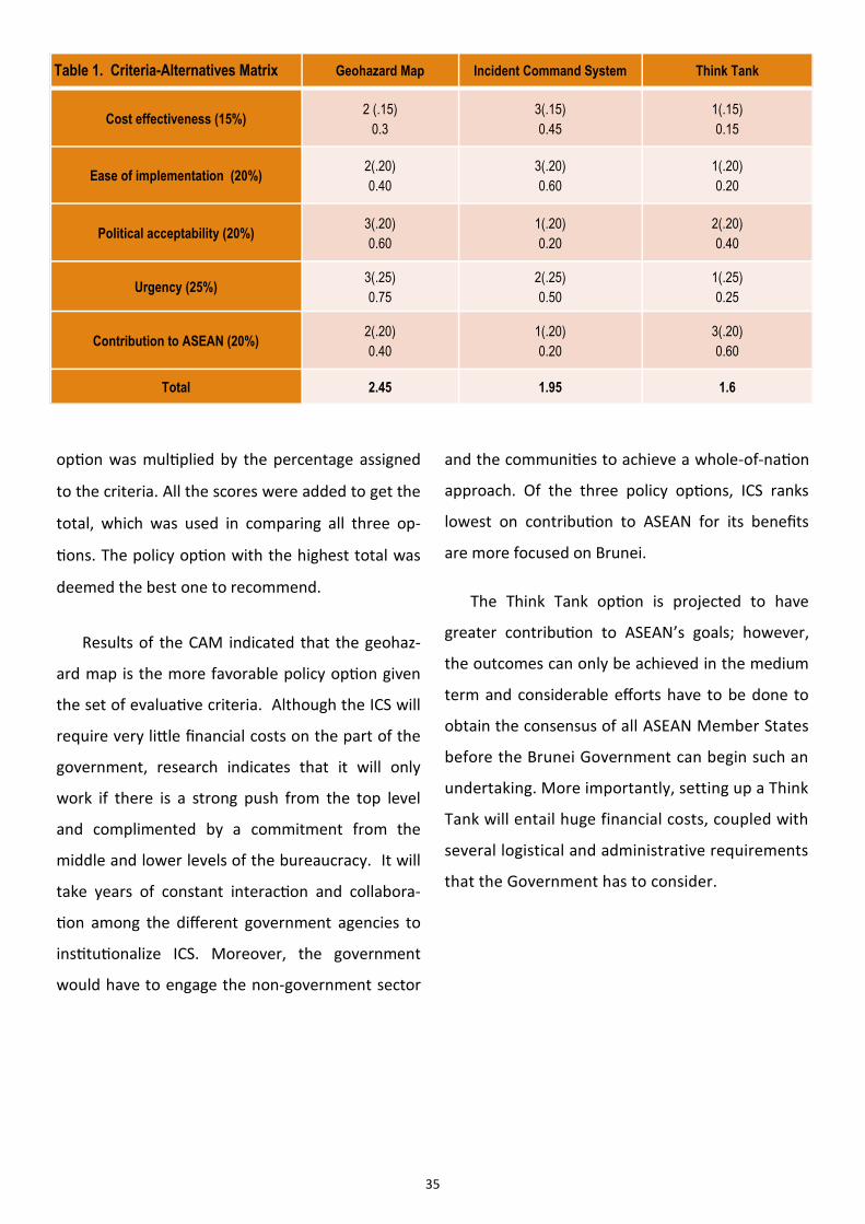
Five criteria were developed to determine
which policy to recommend. The following are
the criteria for evaluation:
Cost-effectiveness: This criterion looks at
the cost of initiating each policy option,
which includes initial investment in setting
up the policy, infrastructure development
needed and funding for other logistical
needs such as technical and human re-
sources.
Ease of implementation: This refers to the
capacity of the Government to implement
the policy options, in terms of organiza-
tional structure, experiences, technology
capacity, expertise and skills needed.
Political acceptability: It pertains to public
support and credibility of the Government
to carry out the policy options. In some
instances, ASEAN’s acquiescence for Bru-
nei to carry out the policy option is also
considered.
Urgency: This criteria refers to how im-
portant the policy option at the short to
medium term and whether it meets the
immediate concerns of the country on dis-
aster management.
Contribution to ASEAN: In line with the pro-
ject’s objectives, the policy option recom-
mended must contribute to ASEAN’s goals.
Different weights were assigned to each criteri-
on to prioritize some over the others. The study
identified ‘urgency’ as the most important criteri-
on, assigning it 25 percent, while ‘ease of imple-
mentation’, ‘political acceptability’ and
‘contribution to ASEAN’ were given 20 percent
each, and ‘cost-effectiveness’ received 15 percent.
Projected outcomes are scored using a scale of 1
to 3, with 3 being the highest. The score for each
35
Geohazard Map Incident Command System Think Tank
Cost effectiveness (15%) 2 (.15)
0.3
3(.15)
0.45
1(.15)
0.15
Ease of implementation (20%) 2(.20)
0.40
3(.20)
0.60
1(.20)
0.20
Political acceptability (20%) 3(.20)
0.60
1(.20)
0.20
2(.20)
0.40
Urgency (25%) 3(.25)
0.75
2(.25)
0.50
1(.25)
0.25
Contribution to ASEAN (20%) 2(.20)
0.40
1(.20)
0.20
3(.20)
0.60
Total 2.45 1.95 1.6
Table 1. Criteria-Alternatives Matrix
option was multiplied by the percentage assigned
to the criteria. All the scores were added to get the
total, which was used in comparing all three op-
tions. The policy option with the highest total was
deemed the best one to recommend.
Results of the CAM indicated that the geohaz-
ard map is the more favorable policy option given
the set of evaluative criteria. Although the ICS will
require very little financial costs on the part of the
government, research indicates that it will only
work if there is a strong push from the top level
and complimented by a commitment from the
middle and lower levels of the bureaucracy. It will
take years of constant interaction and collabora-
tion among the different government agencies to
institutionalize ICS. Moreover, the government
would have to engage the non-government sector
and the communities to achieve a whole-of-nation
approach. Of the three policy options, ICS ranks
lowest on contribution to ASEAN for its benefits
are more focused on Brunei.
The Think Tank option is projected to have
greater contribution to ASEAN’s goals; however,
the outcomes can only be achieved in the medium
term and considerable efforts have to be done to
obtain the consensus of all ASEAN Member States
before the Brunei Government can begin such an
undertaking. More importantly, setting up a Think
Tank will entail huge financial costs, coupled with
several logistical and administrative requirements
that the Government has to consider.
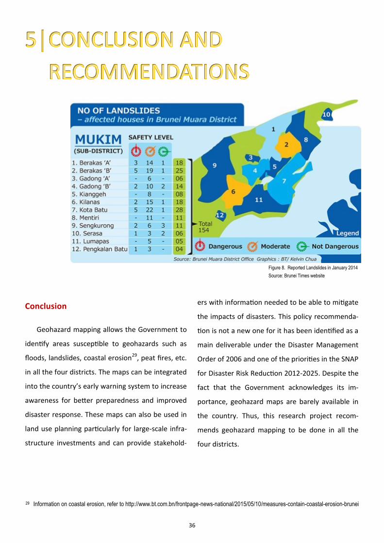
36
Figure 8. Reported Landslides in January 2014
Source: Brunei Times website
Conclusion
Geohazard mapping allows the Government to
identify areas susceptible to geohazards such as
floods, landslides, coastal erosion29, peat fires, etc.
in all the four districts. The maps can be integrated
into the country’s early warning system to increase
awareness for better preparedness and improved
disaster response. These maps can also be used in
land use planning particularly for large-scale infra-
structure investments and can provide stakehold-
ers with information needed to be able to mitigate
the impacts of disasters. This policy recommenda-
tion is not a new one for it has been identified as a
main deliverable under the Disaster Management
Order of 2006 and one of the priorities in the SNAP
for Disaster Risk Reduction 2012-2025. Despite the
fact that the Government acknowledges its im-
portance, geohazard maps are barely available in
the country. Thus, this research project recom-
mends geohazard mapping to be done in all the
four districts.
29 Information on coastal erosion, refer to http://www.bt.com.bn/frontpage-news-national/2015/05/10/measures-contain-coastal-erosion-brunei
37
The recommendation is also based on the anal-
ysis of the Government’s capacity to implement
the chosen policy by looking into initiatives done in
the past, ongoing efforts and the available exper-
tise, technology and human resources. It was nec-
essary to know the Government’s priorities and
constraints in order to think of ways to address
these issues. From the policy recommendation, a
Plan of Action was developed.
Recommendations
Since 2008, more than 900 incidents of land-
slides have been recorded nationwide. Landslides
not only cause damage to properties and areas
where they occur, but also harbor an untold num-
ber of deaths and injuries. Given the severity of
the problem, the Public Works Department con-
ducted a pilot study in 2014 toward developing a
national landslide hazard zoning map. A slope sta-
bility study has been carried out around residen-
tial development areas in Jalan Kota Batu and
Jalan Tutong, which are known to be prone to
landslides. The immediate outcomes of the study
include mapping of landslide conditioning factors
for the areas under review, as well as identifying
landslide risks and hazards. The threshold for
rainfall was also measured for it is a contributing
factor to the occurrence of landslides.30 The na-
tional landslide hazard zoning map will allow
planners to gain a working knowledge of con-
cepts and considerations for incorporating land-
slide hazard assessment into the planning pro-
cess, while civil engineers will be able to evaluate
the appropriate mitigation measures in a timely
manner.31 This project highlights the importance
of being proactive rather than reactive in dealing
with disasters. Reports indicate that the govern-
ment spends an average of BND 5 million annual-
ly for slope rectification works.
The pilot study and the landslide zoning map
can serve as fundamental building blocks in com-
ing up with a national geohazard map. The govern-
ment can utilize the data, findings and processes
from the pilot study in doing the geohazard map.
The only difference is that the geohazard map
looks at various natural and manmade hazards in-
stead of focusing on landslides only. Another initia-
tive that can strengthen the geohazard map pro-
gramme is to link it with the Climate Modeling and
Weather Forecasting Project developed by the Uni-
versiti Brunei Darussalam in partnership with IBM.
This project investigates the impact of climate
change on flood forecasting using the "Blue Gene
Supercomputer," which is the first in the ASEAN
region. The joint efforts between researchers from
UBD and IBM led to the creation of climate models
using regional climate data, which were then incor-
porated into the weather models to enable flood
forecasting and prediction of the impacts of cli-
mate-related events.32
30 Syazwa Souyono, “Pilot study to serve as 'first step' for landslide map”, 16 January 2014, Brunei Times website
31 Rabiatul Kamit, “Landslide hazard map for Brunei”, 16 January 2014, Brunei Times website
32 UBD-IBM Centre, Climate Modelling and Weather Forecasting, UBD-IBM Centre website
38
Having geohazard maps will benefit the general
population, especially those living, schooling and
working in vulnerable areas, and the Government,
particularly the Ministry of Development, for it can
make better informed decisions when investing in
big infrastructure projects. Businesses also stand to
benefit from this project such as the oil and gas
sector, which has pipes running across peat lands
and shorelines, construction companies, real es-
tate developers, and the like. Furthermore, con-
ducting geohazard mapping and assessment will
enable NDMC and the Brunei Government to build
national capacity on disaster management. Inter-
agency coordination is crucial to successfully im-
plement this policy. To produce geohazard maps
with comprehensive risk assessments, agencies
such as the Department of Meteorology of the
Ministry of Information, Marine Department, Sur-
vey Department and Land Survey Department of
the Ministry of Development, along with the
NDMC, have to work together. The Government
should also engage the private sector, academe
and communities.
Capacity-building through geohazard mapping
and assessment is also enshrined in the objectives
of the AADMER. One of the strategic components
of the AADMER Work Programme 2010-2015 is on
risk assessment, early warning and monitoring. The
Work Programme also supports activities that build
on national priorities and agenda by turning ex-
pected benefits and outcomes as leverage to pro-
duce a multiplier effect on a regional scale. Multi-
hazard mapping and vulnerability assessment
based on national data inputs are considered as
part of an ASEAN-wide disaster risk assessment for
these efforts allow for data consolidation and re-
gional-level analysis. With geohazard maps, NDMC
can feed accurate data and information to the AHA
Centre. Part of the functions of AHA Centre is to
receive and consolidate data pertaining to risk lev-
els from the national focal points. On the basis of
such information AHA Centre is able to conduct
analyses on possible implications of disasters on a
regional level. Thus, having a geohazard pro-
gramme enables NDMC to contribute to the devel-
opment of a disaster preparedness platform and
disaster response planning on a regional level.
Plan of Action
The Plan of Action is divided into five phases,
and each phase has a list of tasks to ensure the
successful implementation of geohazard mapping
in Brunei.
PHASE 1
Identify lead agency
Convene relevant implementing agencies
Obtain support from key Government offices
Ensure availability of funds and other inputs
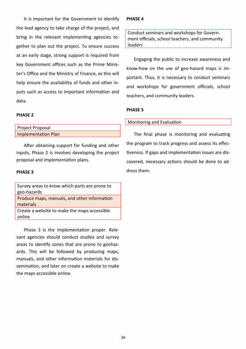
39
It is important for the Government to identify
the lead agency to take charge of the project, and
bring in the relevant implementing agencies to-
gether to plan out the project. To ensure success
at an early stage, strong support is required from
key Government offices such as the Prime Minis-
ter’s Office and the Ministry of Finance, as this will
help ensure the availability of funds and other in-
puts such as access to important information and
data.
PHASE 2
After obtaining support for funding and other
inputs, Phase 2 is involves developing the project
proposal and implementation plans.
PHASE 3
Phase 3 is the implementation proper. Rele-
vant agencies should conduct studies and survey
areas to identify zones that are prone to geohaz-
ards. This will be followed by producing maps,
manuals, and other information materials for dis-
semination, and later on create a website to make
the maps accessible online.
Project Proposal
Implementation Plan
Survey areas to know which parts are prone to geo-hazards
Produce maps, manuals, and other information materials
Create a website to make the maps accessible online
Conduct seminars and workshops for Govern-ment officials, school teachers, and community leaders
PHASE 4
Engaging the public to increase awareness and
know-how on the use of geo-hazard maps is im-
portant. Thus, it is necessary to conduct seminars
and workshops for government officials, school
teachers, and community leaders.
PHASE 5
The final phase is monitoring and evaluating
the program to track progress and assess its effec-
tiveness. If gaps and implementation issues are dis-
covered, necessary actions should be done to ad-
dress them.
Monitoring and Evaluation
40
BIBLIOGRAPHY
AADMER Work Programme Phase 1: Accomplishment Report
AHA Centre, “ASEAN Agreement on Disaster Management and Emergency Response (AADMER) Work Programme
2010-2015”, from http://www.ahacentre.org/aadmer-workplan
ASEAN Political-Security Community Blueprint. Jakarta: ASEAN Secretariat, June 2009.
ASEAN Regional Forum. Annual Security Outlook 2009, Thailand. Accessed on June 22 2014 from http://
aseanregionalforum.asean.org/files/ARF-Publication/ARF-Annual-Security-Outlook/ARF%20Annual%20Security%
20Outlook%202009.pdf
ASEAN Regional Forum. Annual Security Outlook 2010, Vietnam. Accessed on June 22 2014 from http://
aseanregionalforum.asean.org/files/ARF-Publication/ARF-Annual-Security-Outlook/ARF%20Annual%20Security%
20Outlook%202010.pdf
ASEAN Regional Forum. Annual Security Outlook 2011, Indonesia. Accessed on June 23 2014 from http://
www.operationspaix.net/DATA/DOCUMENT/6770~v~ASEAN_Regional_Forum_-
_Annual_Security_Outlook_2011.pdf
ASEAN Regional Forum. Annual Security Outlook 2013, Bandar Seri Begawan, Brunei Darussalam 2013. Accessed on
June 22 2014 from http://aseanregionalforum.asean.org/files/ARF-Publication/ARF-Annual-Security-Outlook/
ARF%20Annual%20Security%20Outlook%202013.pdf
ASEAN Regional Forum. Annual Security Outlook 2014, Myanmar. Accessed on February 6, 2015 from http://
aseanregionalforum.asean.org/files/ARF-Publication/ARF-Annual-Security-Outlook/ARF%20Annual%20Security%
20Outlook%202014.pdf
“Brunei Darussalam Country Report on the Disaster Management” ASEAN Inter-Parliamentary Assembly. The 4th
AIPA Caucus. Bangkok Thailand 2012. Accessed on June 22 2014 from http://www.aipasecretariat.org/wp-
content/uploads/2013/07/Brunei-Country-Report-Disaster-Management.pdf
Brunei Darussalam Strategic National Action Plan (SNAP) for Disaster Risk Reduction 2012-2015. National Disaster Centre
Brunei’s National Vision 2035 . Link: http://www.bedb.com.bn/why wawasan2035.html
BusinessWorld. (March 25, 2005). "UNDP funds mapping project." BusinessWorld. Accessed March 19, 2015 from
https://globalfactivacom.proxy.library.georgetown.edu/ga/default.aspx.
Caballero-Anthony, M., (September 2010). "Non-traditional security challenges, regional governance and the ASEAN
Political-Security Community (APSC)", Asia Security Initiative Policy Series Working Paper.
Case study – Natural Hazards Center based on University of Colorado Link: http://www.colorado.edu/hazards/
The Charter of ASEAN. Jakarta: ASEAN Secretariat, January 2008. Link: http://www.asean.org/asean/asean-charter/
asean-charter
“Climate Modeling and Weather Forecasting” Accessed on June 10, 2015 from UBD|IBM Centre website http://
ubdibm.ubd.edu.bn/past-projects.html
41
Cole, D. (Feb 2000). “The Incident Command System: A 25 year evaluation by California Practitioners” Accessed from
http://www.usfa.fema.gov/pdf/efop/efo31023.pdf
Disasters in Asia and the pacific: 2014 year in review – ESCAP. Link: www.unescap.org
Disaster Management Process. Link: www.ifrc.org
EM-DAT: The International Disaster Database. Centre for Research on the Epidemiology of Disaster – CRED. Link:
http://www.emdat.be/
Engineering Conferences International. n.d. "Geohazards." ECI Digital Archives. Accessed on March 18, 2015 from
http://dc.engconfintl.org/geohazards/
Ferris, E. & Petz, D., (February 2013) “In the Neighborhood: The Growing Role of Regional Organizations in Disaster
Management”, Brookings Institution.
Global Facility for Disaster Reduction and Recovery (GFDRR). Link: https://www.gfdrr.org/
Global Issues on Natural Disasters. Link: http://www.globalissues.org/
United Nations Global Issues. Link http://www.un.org/en/globalissues/
Guha-Sapir, Debarati, Hoyois, Philippe and Below, Regina. (2013) Annual Disaster Statistical Review 2012: The Num-
bers and Trends. Brussels: CRED.
Hamit, R. ( January 23, 2014). “Floods and 44 Landslides”. Brunei Times. Accessed on June 7,2015 from http://
www.bt.com.bn/frontpage-news-national/2014/01/23/floods-and44-landslides
Harun, A. M. K. and Jalil, I. (January 26, 2015). “Floods Reported in 13 Sub-district Across Brunei”. Brunei Times Ac-
cessed June 7 from http://www.bt.com.bn/frontpage-news-national/2015/01/26/highest-rainfall-1966-causes-
floods-13-sub-districts
“Hyogo Framework for Action 2005-2015: Building the Resilience of Nations and Communities to Disaster”, UNISDR,
(January 2005). Accessed from http://www.unisdr.org/2005/wcdr/intergover/official-doc/L-docs/Hyogo-
framework-for-action-english.pdf
Incident Command System Resources, Federal Emergency Management Agency (FEMA). https://www.fema.gov/
incident-command-system-resources
“Incident Command System (ICS)”, Idaho State University. Accessed on April 7, 2015 from www.isu.edu/pubsafe/errp/
ICS/pps
“Incident Command System (ICS)”. FEMA training. Accessed on April 7, 2015 from http://training.fema.gov/EMIWeb/
Kamit, R. (January 16, 2014). “Landslide Hazard Map of Brunei”. Brunei Times Accessed on June 7, 2015 from http://
m.bt.com.bn/news-national/2014/01/16/landslide-hazard-map-brunei
Laporan Tahunan 2013 Pusat Pengurusah Bencana Kebangsaan Kementerian Hal Ehwal Dalam Negeri. Negara Brunei
Darussalam
Mayuga, J. (2014). "Bigger geo-hazard maps of Yolanda-hit areas now available." Business Mirror. November 10. Ac-
cessed on March 19, 2015 from http://proxy.library.georgetown.edu/login?url=http://search.proquest.com/
docview/1622597990?accountid=11091.
McGann, J. G. (2015) “2014 Global Go to Think Tank Index Report”. Think Tanks and Civil Societies Program, the
Lauder Institute, University of Pennsylvania http://repository.upenn.edu/cgi/viewcontent.cgi?
article=1008&context=think_tanks
Natividad, B. (2006). "JICA donates P4 million worth of geohazard mapping tools." Business World. Accessed on March

42
19, 2015 from https://globalfactivacom.proxy.library.georgetown.edu/ga/default.aspx.
Pete, D. (2014) “Strengthening Regional and National Capacity for Disaster Risk Management: The case for ASEAN”.
Brookings-LSE Project on Internal Displacement. P.14
“Priority Areas under the AEAN Political Security Community (APSC) Blueprint”. ASEAN Secretariat’s Information Pa-
per, 9TH APSC Council Meeting, (April 2013), Bandar Seri Begawan
Report of the First Meeting of the Governing Board of the ASEAN Coordinating Centre for Humanitarian Assistance on
Disaster Management. (Oct 2014). Bandar Seri Begawan. Brunei
Sawada, Y & Zen, F. (January 2014), “Disaster Management in ASEAN”, Economic Research Institute for ASEAN and
East Asia Discussion Paper Series link http://www.eria.org/ERIA-DP-2014-03.pdf
Shamshiry, E. et.al. (2001). "Disaster Management Base on Geo-informatics." Institute of Electrical and Electronics
Engineers. p. 30
Singh, U. B. (January 2012). “Disaster Management in South East Asia”. Journal of Defense Studies (Volume 6. No. 1.)
Souyono, S. (January 16, 2014). “Pilot Study to Serve as ‘First Step’ for Landslides Map”. Brunei Times. Accessed on
June 7 2015 from http://bt.com.bn/news-national/2014/01/16/pilot-study-serve-%E2%80%98first-step%E2%80%
99-landslide-map
Statistical Yearbook for Asia and the Pacific 2014. Link: http://www.unescap.org/resources/statistical-yearbook-asia-
and-pacific-2014
Synthesis report on ten ASEAN countries Disaster Risks Assessment - ASEAN Disaster Risk Management Initiative (Dec
2010). Accessed from http://www.unisdr.org/files/18872_asean.pdf
United Nations International Strategy for Disaster Reduction (UNISDR), “Terminology”, (August 30, 2007). Accessed
from http://www.unisdr.org/we/inform/terminology
“What is an Incident Command System?” Occupational Safety and Health Administration, United States Department
of Labor. Accessed on June 3 2015 from https://www.osha.gov/SLTC/etools/ics/what_is_ics.html
World Bank (2012) “Advancing Disaster Risk Financing and Insurance in ASEAN Member States: Framework and Op-
tions for Implementation”, Volume 1. Accessed from https://openknowledge.worldbank.org/
handle/10986/12627