buckeye lake preliminary investigation … · background ... reservoir feeder creek is the primary...
TRANSCRIPT

Engineers Surveyors Planners Scientists
5500 New Albany Road East Columbus, Ohio 43054 Phone: 614-775-4500 Fax: 614-775-4802 Toll Free: 1-888-775-EMHT emht.com
2016-1310
BUCKEYE LAKE PRELIMINARY INVESTIGATION
Draft Deliberative Document – For Discussion Purposes Only
Buckeye Lake Region Corporation
December 16, 2016
Rev. November 2017

Draft Deliberative Document – For Discussion Purposes Only
Buckeye Lake Preliminary Investigation emht.com | i
TABLE OF CONTENTS
INTRODUCTION ...................................................................................................................... 1
BACKGROUND ........................................................................................................................ 1
History of Buckeye Lake ................................................................................................................... 1
Buckeye Lake Watershed ................................................................................................................. 2
EXISTING EFFORTS AND DATA............................................................................................... 2
Ohio Environmental Protection Agency ......................................................................................... 2
Ohio Department of Natural Resources ......................................................................................... 3
Buckeye Lake for Tomorrow ............................................................................................................ 3
Fairfield Soil and Water Conservation District ............................................................................ 3
DATA GAPS / FUTURE STUDIES .............................................................................................. 4
Updated / Refined Phosphorus Mass Balance Model .................................................................. 4
Sediment Sampling ........................................................................................................................... 5
Dredged Material Management Plan ............................................................................................ 5
MAJOR FINDINGS ................................................................................................................... 5
Buckeye Lake Water Quality ......................................................................................................... 5
Tributary Water Quality .................................................................................................................. 6
Recreational Pool Levels................................................................................................................... 7
POTENTIAL ACTION ITEMS ..................................................................................................... 7
In-Lake Projects / Internal Load Reduction ................................................................................... 7
Nonpoint Source Projects / External Load Reduction .................................................................. 9
Supplemental Water Supply ......................................................................................................... 12
CONCLUSIONS ...................................................................................................................... 12
Priority Measures For Phosphorous Load Reduction .................................................................. 12
Other Load Reduction Measures ................................................................................................... 13
REFERENCES .......................................................................................................................... 13
FIGURES Figure 1: Buckeye Lake Watershed ........................................................................................................ 2 ATTACHMENTS Attachment A Buckeye Lake Map Attachment B Buckeye Lake Project Summary

Draft Deliberative Document – For Discussion Purposes Only
Buckeye Lake Preliminary Investigation emht.com | 1
INTRODUCTION EMH&T was engaged by the Urban Community Building Foundation of Ohio to complete a preliminary investigation and data review concerning Buckeye Lake. Buckeye Lake is a 3,200-acre reservoir located approximately 30 miles east of Columbus, Ohio at the intersection of Licking, Perry, and Fairfield Counties, Ohio. The focus of this investigation was to identify, obtain and summarize existing data resources, and compile information on potential lake management strategies pertaining to the following issues:
Maintaining recreational pool levels throughout the summer months;
Sediment removal to improve water quality and aquatic habitat; and
Pollutant load reduction from the surrounding watershed area. As part of this effort, EMH&T endeavored to engage key agencies, including the Ohio EPA, Fairfield Soil and Water Conservation District (SWCD), and the Ohio Department of Natural Resources (ODNR), which have significant data resources and historical knowledge of Buckeye Lake. The information provided by these agencies is summarized herein, along with a listing of potential action items that may warrant further consideration by interested parties. BACKGROUND HISTORY OF BUCKEYE LAKE The reservoir currently known as Buckeye Lake was constructed in the 1820s as part of the Ohio and Erie Canal Project. The reservoir served as part of a system of feeder lakes necessary to maintain the canal water levels. The reservoir was created via construction of a four-mile long earthen dike that blocked drainage into the South Fork Licking River. The reservoir was completed in 1830 and was known at that time as the “Licking Summit Reservoir.” The initial reservoir did not supply sufficient water to operate the canal system, so it was enlarged and a feeder was constructed to divert water from the South Fork Licking River into the reservoir. The impoundment flooded the area formerly known as “The Big Swamp.” Before impoundment, the existing forest and swampland were not cleared, leaving large tracts of timber, brush and peat within the newly formed lake. A large 50-acre mat of sphagnum moss broke loose from the bottom and became the floating island now known as Cranberry Bog. Most of the standing trees soon died and fell into the lake, where they remained through the early 1900s. Following the advent of the railroad and the closing of the canal system in the late 1800s, the reservoir was dedicated by the State of Ohio in 1894 as a public park to be known as “Buckeye Lake.” In the early 1900s, recreational use increased and residential developments sprang up around the lake. In 1908, nearly 80 years after the reservoir was originally impounded, many of the remaining fallen trees and stumps were removed by the state at the behest of the newly formed Buckeye Lake Yacht Club. In 1949, Buckeye Lake was named a state park, and today much of the actual lake and the dam is state-owned property managed by ODNR. ODNR began emergency repairs of the 200-year old dam in 2015, and intends to complete dam repairs by 2019.

Draft Deliberative Document – For Discussion Purposes Only
Buckeye Lake Preliminary Investigation emht.com | 2
BUCKEYE LAKE WATERSHED Buckeye Lake has a surface area of approximately 3,200 acres and a mean depth of approximately five feet. The lake provides aquatic habitat and supports a wide variety of recreational opportunities, including swimming, boating and fishing. The lake drains two 12-digit hydrologic unit codes (HUCs) – Buckeye Lake (05040006 04 03) and Buckeye Lake Reservoir Feeder (05040006 04 04), as shown in Figure 1. These watersheds, totaling approximately 41 square miles, primarily consist of row crop agriculture (53.5%), with remaining land use of grass/pasture (12.8%), forest (15.9%) and developed land (16.6%). The watersheds include several population centers including Buckeye Lake, Harbor Hills, Thornville, Fairfield Beach and Millersport. The significant point sources in these watersheds include the Millersport Sewage Treatment Plant and the Thornville Wastewater Treatment Plant. Both of these point sources have National Pollutant Discharge Elimination System (NPDES) permits with total phosphorus limits of 1.0 mg/L.
Figure 1. Buckeye Lake Watershed Reservoir Feeder Creek is the primary tributary feeding Buckeye Lake, with a total drainage area of between 11.9 and 16.9 square miles (as further discussed in the Data Gaps section below). The other two major tributaries are Honey Creek (6.9 square miles) and Zartman Creek (1.74 square miles). Minor tributaries and nearshore drainage comprise the balance of the total watershed (14.3 square miles). The lake outlet flows into the South Fork Licking River to the north. EXISTING EFFORTS AND DATA OHIO ENVIRONMENTAL PROTECTION AGENCY Ohio EPA has had a fixed monitoring station in Buckeye Lake since 2008 as part of its Inland Lakes Program. In 2011-2012, this monitoring was significantly expanded by virtue of the U.S. EPA-funded Buckeye Lake Nutrient Reduction Project. The U.S. EPA grant allowed Ohio EPA to conduct two years of comprehensive monitoring of the lake and its tributaries, and allowed Ohio EPA to make sub-grants to Buckeye Lake for Tomorrow (BLT) and the Fairfield SWCD for related monitoring and planning efforts (discussed below).

Draft Deliberative Document – For Discussion Purposes Only
Buckeye Lake Preliminary Investigation emht.com | 3
As part of this effort, Ohio EPA monitored three tributaries (Reservoir Feeder Creek, Honey Creek and Zartman Creek), as well as three in-lake locations (L-1, L-2 and L-3), shown on Attachment A. The Ohio EPA surface water data includes standard water quality parameters (temperature, conductivity, pH, turbidity and dissolved oxygen), as well as chemical parameters (i.e., total organic carbon, phosphorus, nitrogen, metals). Sediment cores were also collected at the in-lake monitoring locations in 2012 and were analyzed for various forms of phosphorus. This data was utilized in the Buckeye Lake Nutrient Assessment and Management Recommendations (2014) completed by Tetra Tech Inc. on behalf of U.S. EPA and Ohio EPA. Ohio EPA resumed monitoring at the three in-lake locations in 2014, and have continued to collect the in-lake data annually through the present. The 2011-2012 and 2015 (most recent available) monitoring data was provided by Ohio EPA to EMH&T. This data, as well as the report completed by Tetra Tech, were reviewed as part of this preliminary investigation. OHIO DEPARTMENT OF NATURAL RESOURCES As owner of much of Buckeye Lake, ODNR is responsible for a multitude of lake management and monitoring activities, many relating to the dam. Of interest to this investigation is the Buckeye Lake Depth Survey and Dredge Planning. EMH&T contacted John Kessler, ODNR Office of Real Estate to discuss ODNR’s efforts pertaining to dredging of Buckeye Lake. Mr. Kessler was unable to share detailed information pending coordination with the agencies Public Information Office. To date, we have been unable to obtain information directly from ODNR related to their dredging program. However, EMH&T was able to review the Buckeye Lake State Park 2016 Dredge Planning document, which was provided by Ohio EPA, and the 2014 Depth Survey of Buckeye Lake, which was located online. Any future efforts to engage ODNR should focus on obtaining additional information regarding bathymetry (lake-bottom elevations), dredging operations and dredge material disposal/management, including program costs. BUCKEYE LAKE FOR TOMORROW BLT received a sub-grant from Ohio EPA as part of the Buckeye Lake Nutrient Reduction Project, which allowed the watershed group to complete water quality sampling at 17 sites across the lake and its tributaries. The data was analyzed by Heidelberg University. As part of their sub-grant, BLT also developed the Buckeye Lake Nutrient Reduction Plan (2013), which identified various lake management and nutrient reduction strategies to improve Buckeye Lake. This plan was reviewed as part of EMH&T’s preliminary investigation. FAIRFIELD SOIL AND WATER CONSERVATION DISTRICT As part of a sub-grant under the Buckeye Lake Nutrient Reduction Project described above, the Fairfield SWCD completed a comprehensive review of all streams in the surrounding watersheds to compliment the in-lake sampling conducted by the Ohio EPA and BLT. This effort was spearheaded by Jonathan Ferbrache, Resource Specialist. The purpose of this watershed inventory and analysis was to: (1) understand the watershed boundary; (2) identify sources of nutrients; and (3) visualize realistic locations where improvements could be implemented. The watershed inventory and analysis was conducted in June-October 2012 and April-June 2013 and covered over 90 miles of waterways. The effort included an inventory of existing farm tiles/pipes, septic systems, log/debris jams, erosion, crop and livestock management practices and

Draft Deliberative Document – For Discussion Purposes Only
Buckeye Lake Preliminary Investigation emht.com | 4
riparian conditions. This information was compiled into ArcGIS format and was provided by Fairfield SWCD to EMH&T as part of this preliminary investigation. DATA GAPS / FUTURE STUDIES Based on the review of available information, several significant data gaps were identified, which warrant further investigation and analysis. These include: (1) an accurate watershed delineation for Reservoir Feeder Creek; (2) inflow and outflow data necessary to understand the lake’s water budget; (3) targeted monitoring of drain tiles and the tributaries, particularly during high flow events; (4) additional sampling of sediment cores within the lake; and (5) a dredged material management plan. The first three of these items would serve to update and refine the phosphorus mass balance model for the lake, which was previously prepared by Ohio EPA in conjunction with Tetra Tech. The latter two items would inform any future dredging operations. UPDATED / REFINED PHOSPHORUS MASS BALANCE MODEL Ohio EPA created a phosphorus mass balance model for Buckeye Lake as part of Tetra Tech’s 2014 study in order to better understand the magnitude and timing of phosphorus loading into the lake. This model considered both external loading (i.e., runoff from the surrounding watershed) and internal loading (i.e., release of phosphorus from the lake sediment). The mass balance model relied upon actual tributary and lake water quality data, and utilized modeled tributary inflows, lake outflows and lake levels. The mass balance model could be improved by addressing the following data gaps.
Delineation of Reservoir Feeder Creek Subwatershed
Reservoir Feeder Creek is the primary tributary channel feeding Buckeye Lake. It has a subwatershed area estimated to be between 11.9 and 16.9 square miles, comprising approximately 40% of the total drainage to the lake. The inexact determination of the subwatershed area is attributed to the fact there are many diversions and stream impoundments which could affect whether the surrounding watershed area either goes to Buckeye Lake or to the South Fork Licking River. Depending on how flow is managed through the Pigeon Swamp Petition Ditch, a diversion ditch located near the Kirkersville Cemetery (Attachment A), more or less of the Feeder Creek watershed may actually drain to Buckeye Lake. According to recent conversations with Ohio EPA, flow within this ditch is likely entirely diverted to the South Fork Licking River under low flow conditions. Moreover, the extensive tile drainage system along the Feeder Creek further complicates the understanding of flow patterns in this subwatershed. A better understanding of the contribution of this subwatershed is needed to support the overall water budget for the lake.
Water Budget
A water budget is an accounting of all the water that flows into and out of a particular point of interest. The lack of an accurate overall water budget for Buckeye Lake is particularly problematic as the previous mass balance nutrient modeling has been based upon modeled flows which may not accurately represent real world conditions. Understanding how much water enters Buckeye Lake via the various tributaries, particularly the Reservoir Feeder Creek, would help in determining ways to manage lake levels in response to seasonal changes in rainfall, and refining the external nutrient loading from the surrounding watershed. To resolve this data gap,

Draft Deliberative Document – For Discussion Purposes Only
Buckeye Lake Preliminary Investigation emht.com | 5
continuous flow monitoring equipment should be installed on each of the primary tributaries, and level loggers should be installed at the lake outlet structures.
Enhanced Water Quality Monitoring
Water quality sampling of the tributaries entering Buckeye Lake has not been conducted by Ohio EPA since 2011-2012. Renewal of this effort would be necessary, in conjunction with the recommended flow monitoring, in order to update and refine the phosphorus mass balance model. In particular, sampling is needed during high flow (storm) events, as there is a lack of understanding of both how much flow enters Buckeye Lake during such events (partially due to the Pigeon Swamp Petition Ditch), and the magnitude of nutrient runoff during these event. In general, monitoring within the tributaries has shown that phosphorus levels are minimal or non-detectable in the inflowing tributaries under normal flows. However, nutrient runoff during high flow events may be a significant contributor.
SEDIMENT SAMPLING The current existing understanding of the phosphorus concentrations in the sediment of Buckeye Lake is based upon an extremely limited data set of one core collected at each of the three in-lake monitoring locations. This data was collected by Ohio EPA in 2012 in order to confirm the phosphorus mass balance model completed as part of the Tetra Tech study. Expanding this data set would provide information as to the distribution of phosphorus in the sediments across the lake, as well as important information regarding the sediment profile. In addition to supporting any future refinement of the mass balance model, collection of additional sediment sampling data is crucial to inform any future dredging efforts. The sampling would help determine if there are any “hot spots” that should be prioritized for dredging, the depth to which dredging should occur, and how to best manage the dredge spoils. DREDGED MATERIAL MANAGEMENT PLAN To support any additional dredging of Buckeye Lake, as further discussed under the Potential Action Items, a long-term management plan must be developed to identify the methods, schedules and costs associated with dredging. This plan would serve to prioritize dredging operations, determine a dredging schedule based on long-term goals, identify potential options and disposal sites for the placement of dredge spoils (upland, in-water, beneficial reuse), establish maintenance and regulatory considerations, and provide program costs. MAJOR FINDINGS BUCKEYE LAKE WATER QUALITY All prior studies have determined that the shallow Buckeye Lake impoundment is hypereutrophic, i.e., over productive due to excessive nutrient concentrations captured within the lake. Excess nutrients, primarily phosphorus, have been identified as the source of nuisance algal blooms in the lake. Generally, these nutrients may come from a wide range of sources, including those external to the lake (e.g., agricultural runoff, urban stormwater, failing septic systems, etc.), as well as internal loading. However, all of the data and studies reviewed conclude that internal loading is the primary contributor to the phosphorus concentration within the lake, particularly during the summer months.

Draft Deliberative Document – For Discussion Purposes Only
Buckeye Lake Preliminary Investigation emht.com | 6
According to Tetra Tech (2014), internal loading accounted for 90 percent of the total summer total phosphorus load in 2011, and 78 percent of the total summer total phosphorus load in 2012. The primary source of the internal phosphorus loading is the nutrient-rich sediment and organic matter within Buckeye Lake, which is present by virtue of the reservoir’s original impoundment and prior wetland condition, as well as receipt of nearly two centuries of agricultural runoff. Analysis of the sediment cores collected by Ohio EPA in 2011-2012 indicated that the high total phosphorus concentrations in the sediment were mostly due to high concentrations of organic and biogenic (i.e., derived from biological activity) phosphorus. Under the right conditions, this type of phosphorus can mobilize out of the lake sediments into the water column where it becomes available for algal and/or plant uptake. As much of Buckeye Lake is bereft of aquatic macrophytes (i.e. emergent, submergent and floating vegetation), the excess phosphorus primarily fuels nuisance algal blooms. A secondary source of internal loading in the lake, as noted by the previous studies, is the relatively high numbers of waterfowl, specifically Canada geese. It has been estimated by Fairfield SWCD that the annual contribution of their feces to the total phosphorus loading in Buckeye Lake may be in excess of 4,000 pounds. Other water contaminants associated with goose feces are E. coli and other pathogens known to have a direct impact on human health. The goose population in the Buckeye Lake area consists of a growing population of non-migratory, as well as migratory, species. TRIBUTARY WATER QUALITY Sampling conducted by Fairfield SWCD and Ohio EPA in the major tributary channels of Buckeye Lake indicates that total phosphorus concentrations in these channels are lower than the total phosphorus concentrations within the lake. In general, the tributaries are already meeting target
goals established for total phosphorus (50 g/L), except for during extreme high flow events. Tetra Tech (2014) compared mean total phosphorus concentrations in 2011-2012 for Feeder Creek and Honey Creek to historical mean total phosphorus concentrations from samples collected in 1973-1974, and found that the 2011-2012 tributary mean total phosphorus concentrations were significantly lower, with those in Honey Creek being an order of magnitude smaller. Based on the sampling locations, Tetra Tech attributed the dramatic reduction in total phosphorus to both point source (wastewater treatment plant) improvements and best management practices (BMPs) employed on surrounding agricultural lands. Due to the difficulty in addressing the internal nutrient loading, efforts to prevent additional nutrient input to Buckeye Lake have continued to be strongly encouraged by U.S. EPA, Ohio EPA, and BLT. The Soil and Water Conservation Districts of Perry, Fairfield and Licking Counties have also been actively involved in promoting efforts to reduce external nutrient loading to Buckeye Lake from the surrounding watershed. Based on mass balance modeling described by Tetra Tech (2014), Reservoir Feeder Creek contributes 23 percent of the total (external and internal) annual phosphorus load to Buckeye Lake, while minor tributaries and nearshore drainage contributes 20 percent. Honey Creek and Zartman Creek contribute only 4.5 percent and 1.1 percent of the annual total phosphorus load, respectively. As identified in the Data Gaps section above, there may be some limitations associated with these modeled results, but they provide a general guide for prioritizing non-point source nutrient control efforts.

Draft Deliberative Document – For Discussion Purposes Only
Buckeye Lake Preliminary Investigation emht.com | 7
RECREATIONAL POOL LEVELS As noted previously, little data is available in regard to inflows, outflows and water level in Buckeye Lake. The three primary tributaries to Buckeye Lake are Reservoir Feeder Creek, Honey Creek and Zartman Creek, with minor tributaries and nearshore drainage comprising the balance of the watershed. In addition, Fairfield SWCD has anecdotally noted that there are strong groundwater contributions to the lake from the south and northeast. As noted previously, there is a lack of consensus regarding the drainage area for the Feeder Creek watershed, and thus the total watershed, due to the presence of diversions in the upper watershed. Water levels in the lake are regulated by two structures, the primary outlet at Sellers Point and the old “Waste Weir” near Watkins Island. In 2015, water levels were lowered in order to facilitate construction of the temporary stability berm and seepage barrier along the length of the current dam, which was the first phase of the dam’s replacement. The lake at “normal pool” averages approximately five feet deep, with water levels at the western end being deeper and those at the eastern end being shallower. Based on anecdotal observations, water levels tend to recede during the summer months as evapotranspiration peaks and rainfall declines. It is generally accepted that deeper water levels would significantly improve recreational boating at Buckeye Lake. Increasing the water depth may also have important water quality benefits, as the current shallow nature of Buckeye Lake contributes to its hypereutrophic condition. Inland shallow lakes are typically short-lived ecological units that, through natural processes, eventually become filled with inorganic and organic material until they revert to wetland habitats. Thus, Buckeye Lake will have a tendency to return to its previous wetland state without intervention. It is not sustainable as a lake without ongoing management to maintain desired conditions. POTENTIAL ACTION ITEMS The Buckeye Lake Nutrient Reduction Plan (2013) completed by BLT outlines numerous nutrient control strategies that could be implemented at Buckeye Lake. These strategies were reviewed and supplemented by Tetra Tech in the Buckeye Lake Nutrient Assessment and Management Recommendations (2014). Both of these documents were reviewed as part of this preliminary study. The list of action items presented below is based upon the strategies recommended in these documents, as well as additional potential project concepts suggested by the Fairfield SWCD and Ohio EPA. The strategies fall into three primary categories: (1) in-lake strategies focused on internal load reduction; (2) nonpoint source strategies focused on external load reductions; and (3) supplemental water supply to help maintain/enhance normal pool elevations. The action items are summarized and prioritized in the Buckeye Lake Project Summary (Attachment B). Locations of specific projects are shown on the Buckeye Lake Map (Attachment A). IN-LAKE PROJECTS / INTERNAL LOAD REDUCTION It is evident that Buckeye Lake is dominated by internal loading of phosphorus from its nutrient-rich sediments, and the internal recycling of phosphorus will continue to support algal growth without intervention. The following projects have been identified as potential strategies to control the internal loading of phosphorus. Each of these strategies were recommended by BLT (2013) and TetraTech (2014). It is EMH&T’s opinion that these in-lake projects, particularly dredging, should be prioritized for future action.

Draft Deliberative Document – For Discussion Purposes Only
Buckeye Lake Preliminary Investigation emht.com | 8
Lake Dredging
Removal of the sediments through dredging is generally agreed to be the most permanent solution to reducing internal phosphorus loading. As described in ODNR’s Buckeye Lake State Park 2016 Dredge Planning document, dredging of the lake occurs for navigation purposes in a limited area. As such, its overall effectiveness as a nutrient management tool is minimal. Expansion of dredging operations is strongly recommended, particularly in shallower areas where alum application (see below) is infeasible. Dredging to remove as much as two (2) feet of sediment over the entire lake has been recommended by BLT (2013). However, that would generate a significant amount of dredge material (upwards of 10 million cubic yards) that must be managed. The existing upland Dredge Material Relocation Areas (DMRA) located around the lake would be insufficient to handle this volume.
As noted by Tetra Tech (2014), any dredge spoil should ideally be removed from the lake and the watershed, or the nutrients are likely to eventually return to the lake. However, removal from the watershed may likely be cost prohibitive. If not removed, the dredge spoils should be capped or contained to inhibit leaching of phosphorus back to the lake. Moreover, there may be a potential for phosphorus release from the newly exposed sediments following dredging. As such, the underlying sediments should be sampled prior to dredging to understand the potential for the inadvertent release of phosphorous into the water column due to dredging. Using alum within the lake to arrest the release of phosphorous from sediment is not recommended by BLT due to the proven ineffectiveness in shallow lakes exposed to high wind and wave conditions.
Dredge Management Relocation Areas
While it will not specifically control internal phosphorus loading, the establishment of new Dredge Management Relocation Areas (DMRAs) must occur hand in hand with lake dredging in order to provide for management and disposal of the dredge spoils. BLT recommends that a portion of the DMRAs could be used for the drying of dredge materials, which would then be hauled away for use by others. If increased dredging operations were implemented, the use of that dredge material to create littoral wetlands within the lake should be investigated, both to reduce material management costs and to provide water quality benefits to the lake (i.e., through nutrient uptake by wetland vegetation). Re-using dredge materials within the lake introduces the risk of phosphorus leaching back into the lake; therefore, additional measures will be required to treat or cap this material with inert material.
Canada Geese Population Control and Habitat Manipulations
As the annual contribution of waterfowl feces to the total phosphorus loading in the lake is estimated to exceed 4,000 pounds, aggressive management and control of the resident geese population is needed. As noted by Tetra Tech (2014), waterfowl population management has been very successful in reducing nutrients in some Washington lakes. Efforts may include feeding restrictions, direct harassment of the geese (e.g., with dogs) and addling of eggs. In addition, Fairfield SWCD indicated that more emergent and woody vegetation is needed along the lakeshore to help deter the resident goose population. Geese prefer water bodies where the visual line of sight between the water and adjacent mown grass is broken. A wide vegetation

Draft Deliberative Document – For Discussion Purposes Only
Buckeye Lake Preliminary Investigation emht.com | 9
buffer, at least 10 feet wide and 2 feet tall, may be effective at deterring geese. At a minimum, people living along the lake and visitors must not encourage geese by feeding them.
Island Septic Systems
According to Fairfield SWCD, there are approximately 25 island residences that have no septic permits. BLT has noted a single island with multiple homes and no known septic system (Orchard Island). To mitigate the impacts of wastewater from these residences to the lake, current state requirements for the design and maintenance of home sewage treatment systems (HSTS) should be enforced.
Cranberry Bog Breakwater
Cranberry Bog is a semi-floating island in the lake comprised of peat that broke loose from the bottom of the lake when the area was originally impounded. It is located in a no-wake zone, but it has been documented that the bog is deteriorating due to wave action on the lake. Ohio EPA has found from their monitoring that the bog serves to lower pH values in the surrounding portion of the lake, which in turn combats algae growth. Thus, Ohio EPA has suggested that protection of the bog with a breakwater structure would provide water quality benefits, as well as preservation of the unique bog habitat.
The breakwater would need to be designed such that boating along the north shore is not impeded. In addition, the material used in the breakwater would need to be sensitive to the pH issue, e.g., not comprised of quarried limestone, which is alkaline. This project would likely have limited water quality benefits on the overall Buckeye Lake system, but would allow Cranberry Bog to continue to serve as an amenity and attraction for lake visitors to enjoy.
NONPOINT SOURCE PROJECTS / EXTERNAL LOAD REDUCTION While Buckeye Lake is dominated by internal phosphorus loading, continued implementation of various nonpoint source projects and BMPs is generally encouraged to minimize additional external phosphorus loading. The following projects have been identified as potential strategies to control the external loading of phosphorus. Several of these strategies were recommended by BLT (2013) and TetraTech (2014), while others were suggested by Fairfield SWCD. The projects described below are exclusive of agricultural BMPs, such as cover crops, fertilizer stewardship, no-till practices, and buffer strips. The SWCDs within the counties surrounding the lake will continue to work with the local agricultural community to promote these BMPs, regardless of any other initiatives to improve the watershed and the lake.
Reservoir Feeder Channel
Based on the previously completed modeling, the Reservoir Feeder appears to be the primary source for external loading of nutrients. The Feeder was hand dug to route water from the South Fork Licking River watershed into Buckeye Lake during the canal era. However, this diversion was discontinued following the closing of the canal system. Thus, the primary purpose of the Reservoir Feeder today is to accept drainage from adjoining lands and convey this water toward Buckeye Lake. The Feeder also intercepts many smaller channels and ditches and diverts their flows toward the lake. The Feeder is maintained primarily by an ad hoc alliance of local property owners that depend on the Reservoir Feeder for local agricultural drainage.

Draft Deliberative Document – For Discussion Purposes Only
Buckeye Lake Preliminary Investigation emht.com | 10
As it is no longer used to convey water from the South Fork Licking River, the Feeder has ample channel capacity and is generally oversized. In places it functions like a linear wetland because of the shallow gradient and size. Some reaches are flanked by mature trees and the channel has been allowed to recover naturally. Other reaches are more channelized with little or no riparian buffer. The most downstream part of the Reservoir Feeder is impounded by backwater from Buckeye Lake. Several potential project concepts have been proposed for the Reservoir Feeder, as listed below. These projects would require coordination with local landowners as well as consideration of the potential impacts on field tile drainage.
1. Streambank Stabilization. Bank stabilization techniques are recommended by BLT and
Fairfield SWCD along the steep embankments of the Feeder to reduce the sediment entering the lake that is being eroded from the tributary itself. These stabilization efforts may utilize the two-stage ditch design approach, which incorporates an excavated floodplain bench. The bench reduces shear stress on the channel banks, thereby reducing the potential for bank erosion; it also serves to capture nutrient-laden sediments during larger flood events. Removing logjams will also serve to improve channel bank stability. Planting native tree species on the constructed floodplain bench will provide shade and reduce the temperature of water entering the lake.
2. Feeder Channel Dredging. BLT has recommended implementing a dredging program to
remove sediment accumulated within the feeder channel, particularly where sediment deposit have occurred at the confluence of tributary channels with the feeder channel. These sediments would mostly likely be enriched with nutrients from the surrounding land uses.
3. Wetland Treatment Chain. Fairfield SWCD has suggested that a large wetland treatment
system be constructed along the downstream end of the Feeder. These wetlands would serve to remove sediment and nutrients prior to discharge to the lake, as well as slow down high flows. This idea was supported by Tetra Tech (2014). Per SWCD’s concept, a wetland system would potentially be located at the existing Depalmo Dredge Management Relocation Area (DMRA). However, this concept could be implemented at any number of locations within the agricultural land along the most downstream reach of the Feeder.
4. Turbidity Curtain. Fairfield SWCD suggested deployment of a turbidity curtain at the
downstream end of the Reservoir Feeder. This curtain would serve to settle out and contain sediment, which would then be periodically removed.
Wetland Treatment
In addition to the wetland treatment chain recommended along the Reservoir Feeder, several other locations for constructed wetlands have been identified by BLT and Fairfield SWCD, as listed below. The intent of these constructed wetlands is to filter nutrients, settle out sediment and slow high flows prior to discharge to the lake. The establishment of more vegetated wetland zones around the lakeshore will also help to deter geese.
1. Pigeon Swamp Petition Ditch. Ohio EPA noted that an existing, large wetland system is
present adjacent to the Pigeon Swamp Petition Ditch diversion, located southeast of the Kirkersville Cemetery. Ohio EPA suggested improvements be made to the ditch to ensure flows in this channel are being diverted to Buckeye Lake, along with

Draft Deliberative Document – For Discussion Purposes Only
Buckeye Lake Preliminary Investigation emht.com | 11
restoration/enhancement of the wetland to provide nutrient load reduction from that subwatershed area.
2. Brooks Park. BLT and Fairfield SWCD have noted that there are excess nutrients entering
the lake from the unnamed tributary at Brooks Park. Fairfield SWCD has recommended realignment of the stream channel and creation of a wetland at this location. Fairfield SWCD also recommended conversion of a portion of the existing Brooks DRMA to a littoral (nearshore/lake zone) wetland system.
3. Interstate 70 Rest Area. BLT recommended that a constructed wetland be implemented at
this location, which is north of Maple Bay. This wetland would serve to control nutrient loading coming into the lake and attenuate higher water temperatures in the runoff from the nearby interstate and rest area. The Ohio EPA has reportedly denied a permit for this project in the past and the circumstances need to be investigated to determine if there is a permissible approach to this project.
4. Deep Cut Canal. The Deep Cut Canal, located south of Millersport, is a relic of the Ohio
and Erie Canal. Fairfield SWCD suggested that the Deep Cut could potentially be converted to a large wetland system, to which lake water could be pumped and recirculated to provide nutrient filtration. However, Fairfield SWCD acknowledged there would likely be significant landowner resistance to this concept.
Alternatively, BLT has noted the propensity for algae blooms in the deep cut channel attributed to nutrient-laden sediment and shallow, heated water. Rainfall events wash these algae blooms directly into the lake. Removing the accumulated sediments and increasing water depth would partially address this issue.
Tributary Sediment Reduction
A variety of in-stream sediment reduction initiatives were identified and recommended by Fairfield SWCD as a result of its extensive watershed inventory effort. These projects may individually have a small impact on the water quality of Buckeye Lake, but collectively would serve to reduce erosion, and associated nutrient loading, to the lake.
1. Clary In-Stream Sediment Collectors. The Clary In-Stream Sediment Collector consists of a
shallow concrete well with steel grating over the top that is installed across the stream and recessed below the surface of the streambed. As water flows over the collector, the heavier particles within the water column are settled out within the collector. One side of the collector is slanted such that a front-end loader can periodically be used to remove the collected sediment. The sediment can then be dried and reapplied to the land, or otherwise reused.
As part of the watershed inventory, Fairfield SWCD identified 10 locations where the Clary Collectors could be installed in tributaries to the Reservoir Feeder. These locations coincide with existing stream crossing locations to minimize the disturbance to natural stream habitat.
2. Turbidity Curtains. As described for the Feeder, additional turbidity curtains could be
installed at select tributaries where deemed appropriate based on monitoring results.

Draft Deliberative Document – For Discussion Purposes Only
Buckeye Lake Preliminary Investigation emht.com | 12
3. Bank Stabilization. Approximately 80 tributary locations exhibiting moderate to severe erosion and/or log jams were noted by Fairfield SWCD as part of the 2012 watershed inventory. As described for the Reservoir Feeder, efforts to stabilize the streambanks in these locations would reduce erosion and sedimentation, while establishment of vegetation would assist in filtering nutrients during normal flow periods.
SUPPLEMENTAL WATER SUPPLY Since its conception, providing sufficient water supply to Buckeye Lake has been problematic. The Feeder Channel was originally constructed to divert water from the South Fork Licking River watershed for this reason. Fairfield SWCD has suggested it may be possible to resurrect a connection between the South Fork Licking River and the lake by means of placing an inflatable dam within the river and creating a means to convey impounded water from behind the dam to the lake. This concept would likely only be cost effective if the water can then be conveyed between the river and the lake via gravity flow, and does not require a pump station to achieve the diversion. The inflatable dam system monitors water flow and is inflated during periods of adequate stream flow to back up and divert water to the reservoir. The dam is anchored to a concrete base and uses rubber bladders that are inflated to raise the dam to impound and pool water. When not in use, the bladders are deflated and the dam is then flush with the stream bed. The inflatable dam would require consultation and permitting through ODNR, Ohio EPA, and the U.S. Army Corps of Engineers. In addition, property acquisition will very likely be necessary to accommodate the diversion of flow away from the river and toward the lake.
Diversion at Sellers Point The location suggested by Fairfield SWCD for the inflatable dam and reservoir is the northeast end of Buckeye Lake, north of Sellers Point. This location would allow the reservoir to also be utilized by the Ohio Division of Wildlife’s Hebron Fish Hatchery, which is located near Canal Road and Interstate 70. The hatchery utilizes millions of gallons of water annually, which is currently supplied by Buckeye Lake.
Diversion at Kirkersville Alternatively, it may be possible to create this diversion further upstream along the river, near Kirkersville, and divert the water to the Feeder Channel, which would then carry the diverted flow to the lake. As noted previously, the Feeder Channel is currently oversized and stagnant. Diverting additional flow via the Feeder may have a dual benefit of addressing some of the water quality issues stemming from this stagnation, as well as providing an additional water source to the lake. CONCLUSIONS PRIORITY MEASURES FOR PHOSPHOROUS LOAD REDUCTION Legacy sediment phosphorus stemming from the original impoundment of Buckeye Lake is the primary driver of internal nutrient loading in the lake. Although steps have been taken to reduce external sources of nutrients, effort must be invested in reducing the internal nutrient loading in order to see significant improvements within a reasonable time frame. It has been widely acknowledged that the number one solution to be employed at Buckeye Lake is dredging. In order

Draft Deliberative Document – For Discussion Purposes Only
Buckeye Lake Preliminary Investigation emht.com | 13
to facilitate lake dredging for phosphorus control, additional sampling and analysis of sediment cores across the lake should be completed. A second priority would be removing nutrient laden sediments from the Feeder Canal and the Deep Cut Canal, followed by supplementing water to the lake by diverting flow from the adjacent South Fork Licking River during periods of adequate flow in the river. OTHER LOAD REDUCTION MEASURES The non-point source projects described herein, aimed at reducing external load reductions, will address only a small portion of the overall phosphorous loading in the lake. Monitoring conducted to date has indicated that total phosphorus concentrations in the tributaries are lower than concentrations within the lake and, in general, the tributaries are meeting target goals established for total phosphorus, with the exception of the Feeder Channal. Furthermore, as internal phosphorous loading accounts for over three-quarters of the summer total phosphorus load in the lake, these projects cannot be considered curative. In-lake actions, such as addressing the remaining septic system issues at island residences, should be addressed as an enforcement measure by local government and state agencies. These projects, along with the on-going watershed management, monitoring and the education activities of the BLT, are certainly beneficial to ensure the external loading of phosphorus to the lake is minimized. REFERENCES Buckeye Lake for Tomorrow, Inc. 2013. Buckeye Lake Nutrient Reduction Plan. Prepared for the
Ohio Environmental Protection Agency. December 31, 2013.
“Buckeye Lake Watershed.” Fairfield Soil & Water Conservation District, www.fairfieldswcd.org/Buckeye%20Lake.htm. Accessed November 2016.
Detmers, F. 1912. A Preliminary Report on a Physiographic Study of Buckeye Lake and Vicinity. The Ohio Naturalist, 12(7), 517-532.
“History.” The Buckeye Lake, thebuckeyelake.com/history.php. Accessed November 2016.
Ohio Department of Natural Resources, Division of Parks and Recreation. 2014. Buckeye Lake Depth Survey. July 2014.
Ohio Department of Natural Resources, Division of Parks and Recreation. 2015. Buckeye Lake State Park 2016 Dredge Planning. December 2015.
Ohio Environmental Protection Agency, Division of Surface Water. 2011. Buckeye Lake Area Nutrient Reduction Plan of Study. July 2011.
Ohio Environmental Protection Agency, Division of Surface Water. 2012. Biological and Water Quality Study of the Licking River and Selected Tributaries 2008. OEPA Technical Report/EAS 2011-1-3. January 20, 2012.
Ohio Environmental Protection Agency, Division of Surface Water. 2013. Buckeye Lake Nutrient Reduction Project Fact Sheet. October 2013.

Draft Deliberative Document – For Discussion Purposes Only
Buckeye Lake Preliminary Investigation emht.com | 14
Tetra Tech, Inc. 2014. Buckeye Lake Nutrient Assessment and Management Recommendations. Prepared for the U.S. Environmental Protection Agency, Region 5 and the Ohio Environmental Protection Agency. December 2014.
Tressler, W.L., Tiffany, L.H. & Spencer, W.P. 1940. Limnological Studies of Buckeye Lake, Ohio. The Ohio Journal of Science, 40(5), 261-290.
U.S. Environmental Protection Agency. 1975. Report on Buckeye Lake Fairfield, Licking and Perry Counties, Ohio. EPA Region V. Working Paper No. 396.

ATTACHMENT A
Buckeye Lake Map

Buckeye Lake Preliminary Investigation BUCKEYE LAKE MAP
Attachment A
N
Honey Creek
Reservoir Feeder Creek
Deep Cut Canal
Cranberry Bog
Sellers Point (outlet)
Brooks Park
South Fork Licking River
Zartman Creek
I‐70 Rest Area
Potential Inflatable Dam Location
To Kirkersville (see inset)
Reservoir Feeder Creek
South Fork Licking River
Pigeon Fork Petition Ditch
L‐2
L‐1
L‐3
Source: USGS Topographic Quad Mapswww.eathpoint.us

ATTACHMENT B
Buckeye Lake Project Summary
Draft Deliberative Document – For Discussion Purposes Only
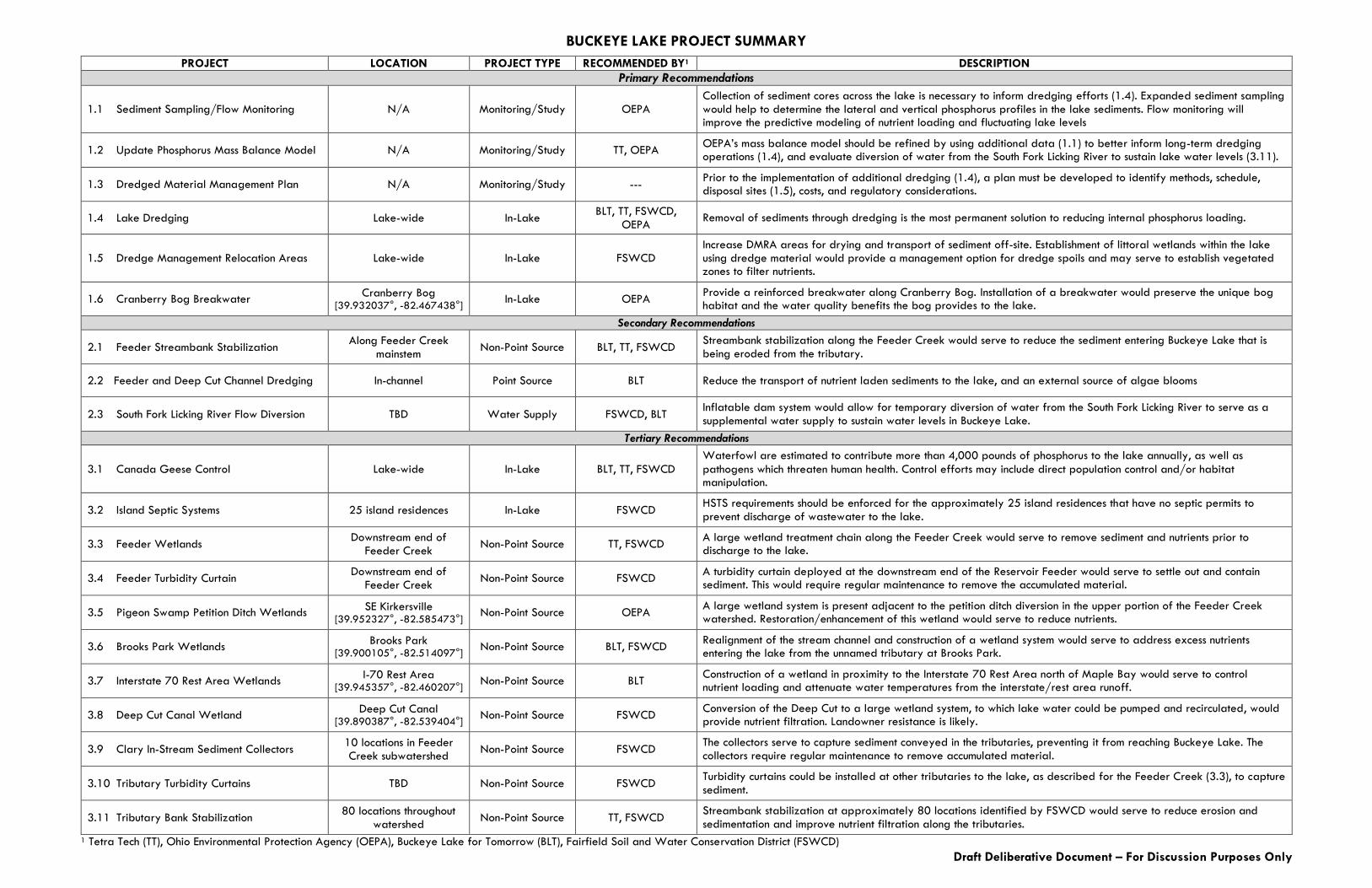
BUCKEYE LAKE PROJECT SUMMARY
PROJECT LOCATION PROJECT TYPE RECOMMENDED BY1 DESCRIPTION
Primary Recommendations
1.1 Sediment Sampling/Flow Monitoring N/A Monitoring/Study OEPA Collection of sediment cores across the lake is necessary to inform dredging efforts (1.4). Expanded sediment sampling would help to determine the lateral and vertical phosphorus profiles in the lake sediments. Flow monitoring will improve the predictive modeling of nutrient loading and fluctuating lake levels
1.2 Update Phosphorus Mass Balance Model N/A Monitoring/Study TT, OEPA OEPA’s mass balance model should be refined by using additional data (1.1) to better inform long-term dredging operations (1.4), and evaluate diversion of water from the South Fork Licking River to sustain lake water levels (3.11).
1.3 Dredged Material Management Plan N/A Monitoring/Study --- Prior to the implementation of additional dredging (1.4), a plan must be developed to identify methods, schedule, disposal sites (1.5), costs, and regulatory considerations.
1.4 Lake Dredging Lake-wide In-Lake BLT, TT, FSWCD,
OEPA Removal of sediments through dredging is the most permanent solution to reducing internal phosphorus loading.
1.5 Dredge Management Relocation Areas Lake-wide In-Lake FSWCD Increase DMRA areas for drying and transport of sediment off-site. Establishment of littoral wetlands within the lake using dredge material would provide a management option for dredge spoils and may serve to establish vegetated zones to filter nutrients.
1.6 Cranberry Bog Breakwater Cranberry Bog
[39.932037°, -82.467438°] In-Lake OEPA
Provide a reinforced breakwater along Cranberry Bog. Installation of a breakwater would preserve the unique bog habitat and the water quality benefits the bog provides to the lake.
Secondary Recommendations
2.1 Feeder Streambank Stabilization Along Feeder Creek
mainstem Non-Point Source BLT, TT, FSWCD
Streambank stabilization along the Feeder Creek would serve to reduce the sediment entering Buckeye Lake that is being eroded from the tributary.
2.2 Feeder and Deep Cut Channel Dredging In-channel Point Source BLT Reduce the transport of nutrient laden sediments to the lake, and an external source of algae blooms
2.3 South Fork Licking River Flow Diversion TBD Water Supply FSWCD, BLT Inflatable dam system would allow for temporary diversion of water from the South Fork Licking River to serve as a supplemental water supply to sustain water levels in Buckeye Lake.
Tertiary Recommendations
3.1 Canada Geese Control Lake-wide In-Lake BLT, TT, FSWCD
Waterfowl are estimated to contribute more than 4,000 pounds of phosphorus to the lake annually, as well as
pathogens which threaten human health. Control efforts may include direct population control and/or habitat manipulation.
3.2 Island Septic Systems 25 island residences In-Lake FSWCD HSTS requirements should be enforced for the approximately 25 island residences that have no septic permits to prevent discharge of wastewater to the lake.
3.3 Feeder Wetlands Downstream end of
Feeder Creek Non-Point Source TT, FSWCD
A large wetland treatment chain along the Feeder Creek would serve to remove sediment and nutrients prior to discharge to the lake.
3.4 Feeder Turbidity Curtain Downstream end of
Feeder Creek Non-Point Source FSWCD
A turbidity curtain deployed at the downstream end of the Reservoir Feeder would serve to settle out and contain sediment. This would require regular maintenance to remove the accumulated material.
3.5 Pigeon Swamp Petition Ditch Wetlands SE Kirkersville
[39.952327°, -82.585473°] Non-Point Source OEPA
A large wetland system is present adjacent to the petition ditch diversion in the upper portion of the Feeder Creek watershed. Restoration/enhancement of this wetland would serve to reduce nutrients.
3.6 Brooks Park Wetlands Brooks Park
[39.900105°, -82.514097°] Non-Point Source BLT, FSWCD
Realignment of the stream channel and construction of a wetland system would serve to address excess nutrients entering the lake from the unnamed tributary at Brooks Park.
3.7 Interstate 70 Rest Area Wetlands I-70 Rest Area
[39.945357°, -82.460207°] Non-Point Source BLT
Construction of a wetland in proximity to the Interstate 70 Rest Area north of Maple Bay would serve to control nutrient loading and attenuate water temperatures from the interstate/rest area runoff.
3.8 Deep Cut Canal Wetland Deep Cut Canal
[39.890387°, -82.539404°] Non-Point Source FSWCD
Conversion of the Deep Cut to a large wetland system, to which lake water could be pumped and recirculated, would provide nutrient filtration. Landowner resistance is likely.
3.9 Clary In-Stream Sediment Collectors 10 locations in Feeder Creek subwatershed
Non-Point Source FSWCD The collectors serve to capture sediment conveyed in the tributaries, preventing it from reaching Buckeye Lake. The collectors require regular maintenance to remove accumulated material.
3.10 Tributary Turbidity Curtains TBD Non-Point Source FSWCD Turbidity curtains could be installed at other tributaries to the lake, as described for the Feeder Creek (3.3), to capture sediment.
3.11 Tributary Bank Stabilization 80 locations throughout
watershed Non-Point Source TT, FSWCD
Streambank stabilization at approximately 80 locations identified by FSWCD would serve to reduce erosion and sedimentation and improve nutrient filtration along the tributaries.
1 Tetra Tech (TT), Ohio Environmental Protection Agency (OEPA), Buckeye Lake for Tomorrow (BLT), Fairfield Soil and Water Conservation District (FSWCD)