bubble in last name first name back · dicated on the syllabus, the number of extra credit points...
TRANSCRIPT

1
Hunter College-CUNY GEOG 101 – Intro to Geography
Instructions for Extra Credit exercise for Exam 3
The extra credit exercises associated with each third of the course are worth a maximum of 8 points added to your exam score at the end of each third. As indicated on the sylla-bus, the number of extra credit points is based on the percent of correct answers. For Exam 3, the extra credit exercise consists of questions on Location Studies with a focus on Political Geography. Consult Chapter 11 in the textbook and ap-propriate maps from a thematic atlas. All answers are to be placed on the blue Scantron sheets. The scanning machine will mark wrong any omissions and double entries in addition to incorrect answers. Please be very careful to place the answers in the correct number spots on the answer sheet. As in-dicated on the syllabus, the number of extra credit points is based on the percent of cor-rect answers by the formula listed. Maximum points are +8. Be sure to print your name on the front of the sheet and mark it “Extra Credit.”
Bubble in your Last Name then your First Name on the back of the blue answer sheet.
EXTRA CREDIT III IS DUE ON: Thursday, Dec. 12, 2019 by the end of class.
Once the answers are posted, answer sheets or answer lists will NOT be accepted –
no matter how valid your reason for missing the deadline.
++++++++++++++++++++++++++++++++++++++++++++++++++++++++++++++++++++++
*** Exam III - the Final Exam *** is on Thursday, Dec. 19 from 11:30 AM-1:30 PM
in our classroom, Room 415HW.
Please note the later time.

2
GEOG 101 EXTRA CREDIT EXERCISE III
Location Studies Focus on Political Geography Chapter 11 of the textbook
Consult the textbook or an atlas for the answers to this extra credit assignment. Always use the most detailed maps to find your answers. Place all answers on the Scantron sheet using a no. 2 pencil. Cleanly erase all mistakes/changes.
CONSULT THE WORLD POLITICAL MAP ON THE FRONT FLAP OF THE TEXTBOOK or A WORLD POLITICAL MAP FOUND IN ANY ATLAS.
Water bodies and especially fresh water resources take on important political significance. 1. The Panama Canal connects the Caribbean Sea with the
a) Gulf of Mexico b) Red Sea c) Pacific Ocean d) Atlantic Ocean
2. Even though the Black Sea is an international body of water, Turkey controls access to and from ports of all the countries bordering on the Black Sea because shipping has to pass through the
a) Kattegat & Skagerrak c) Caspian Sea b) Suez Canal d) Bosporus & Dardanelles
3. Which countries share the lower part of the Ganges River before it enters the sea? a) India and Nepal c) Bangladesh and Sri Lanka b) India and Bangladesh d) India and Pakistan
4. Name of the body of water that is strategically important to the shipping lanes between the Indian Ocean and the South China Sea.
a) Torres Strait c) Strait of Hormuz b) Strait of Malacca d) Strait of Gibraltar
Large inland bodies of water are sometimes shared by more than one country. 5. Which one does NOT have an international boundary passing through it?
a) Aral Sea b) Lake Victoria c) Lake Baykal d) Lake Chad
6. Which of the Great Lakes of North America is solely in the United States? a) Lake Ontario c) Lake Huron e) Lake Erie b) Lake Michigan d) Lake Ontario
The following three rivers flow through or border upon more than one country. Indicate the number of countries each river encounters and the body of water into which the river emp-ties.
7. The Zambezi River begins in Zambia and then is in contact with (a) three countries (b) five countries (c) seven countries
8. before emptying into the (a) Gulf of Guinea (b) Mediterranean Sea (c) Mozambique Channel
9. The Indus River begins in China and then is in contact with (a) two countries (b) five countries (c) eight countries
10. before emptying into the (a) Arabian Sea (b) Bay of Bengal (c) Andaman Sea.

3
11. The Parana River begins in Brazil and then is in contact with (a) two countries (b) four countries (c) five countries
12. before emptying into the (a) Atlantic Ocean (b) Caribbean Sea (c) Pacific Ocean.
Indicate the number of countries having common boundaries with each of the following. 13. Oman (a) one (b) two (c) three 14. Thailand (a) four (b) five (c) six 15. Chad (a) five (b) six (c) seven 16. Slovakia (a) three (b) four (c) five 17. Tajikistan (a) four (b) five (c) six 18. Brazil (a) eight (b) ten (c) twelve
19. What nation borders on both Kenya and Burundi?
a) Malawi b) Tanzania c) Mali d) South Sudan
20. What nation borders on both Botswana and Mozambique? a) Zimbabwe b) Namibia c) Angola d) Zambia
Consult a United States political map in an any atlas.
21. New York State is the only state to border upon a Great Lake and an ocean. a) TRUE b) FALSE
22. Missouri and Tennessee both share borders with eight other states. Besides bordering on each other, with which states do both of them share borders?
a) Kentucky and Illinois c) Arkansas and Mississippi b) Kentucky and Alabama d) Arkansas and Kentucky
23. In only one case in the United States do four states touch each other at the same point. Which state does NOT touch the others at that point?
a) Utah b) Arizona c) Colorado d) Oklahoma e) New Mexico
24. Which state borders on only one other state? a) Maine b) Alaska c) Florida d) California e) Rhode Island
25. Other than Hawaii, which U.S. state does NOT have a line of latitude or longitude as a portion of its political border?
a) Arkansas b) Wyoming c) Michigan d) New York e) New Jersey
Consult your textbook for definitions and the world political map on the end flap of the textbook or in any atlas.
26. Name a compact country of Africa. a) Somalia b) Morocco c) Mali d) Sierra Leone
27. Name an elongated country of Europe. a) Norway b) Iceland c) Greece d) Belarus
28. Name a fragmented country of Asia. a) Saudi Arabia b) Malaysia c) Vietnam d) Pakistan
29. Name a landlocked country of Asia. a) Japan b) Laos c) Myanmar d) North Korea
30. Name a prorupted country of Africa. a) Namibia b) Gambia c) Morocco d) Sudan

4
Sometimes countries exist under unique physical conditions. 31. Kaliningrad Oblast is a _______ of Russia.
a) enclave b) exclave
32. Lesotho is a _______ of South Africa. a) enclave b) exclave
33. Which ministate is NOT found in Europe? a) Liechtenstein b) Monaco c) Andorra d) Palau e) San Marino
34. Which are the only two Central American countries that lack a "two-ocean" coastline? a) Belize and Mexico c) Honduras and Guatemala b) Panama and El Salvador d) El Salvador and Belize
Over the years, independent island groups that became colonies regained their independ-ence.
35. Which of the following Caribbean islands is an independent country? a) Anguilla b) Saint Croix c) Guadeloupe d) Barbados
36. Which of the following South Pacific islands IS NOT an independent country? a) Samoa b) Vanuatu c) New Caledonia d) Tonga
Some overseas areas have been incorporated into the political base of former colonizers as official territories. Match the political unit with its home base.
37. Curaçao is part of the a) United Kingdom c) Kingdom of the Netherlands b) Republic of France d) United States of America
38. Canary Islands are a part of the a) United Kingdom c) Kingdom of the Netherlands b) Kingdom of Spain d) Republic of Portugal
39. Azores is part of the a) United States of America c) Kingdom of the Netherlands b) Republic of France d) Republic of Portugal
40. Northern Marianna Islands is part of the a) United Kingdom c) Kingdom of the Netherlands b) Republic of France d) United States of America
Match the capital city with the country. 41. Bulgaria’s capital city is
a) Nassau b) Gaborone c) Sofia d) Manama e) Ouagadougou
42. Bahrain’s capital city is a) Nassau b) Gaborone c) Sofia d) Manama e) Ouagadougou
43. Bahama's capital city is a) Nassau b) Gaborone c) Sofia d) Manama e) Ouagadougou
44. Burkina Faso’s capital city is a) Nassau b) Gaborone c) Sofia d) Manama e) Ouagadougou

5
Annexation refers to the action where one country takes away the sovereignty of another. 45. This action is defined as a
a) forcible acquisition. b) formal purchase. c) mutually agreed upon merger. d) secession by the people living there.
46. In 2014 Russia annexed the Crimean Peninsula from a) Turkey b) Crimea c) Ukraine d) Romania e) Poland
47. All of the following countries have annexed territory between 1900 and the present except a) Great Britain b) Bolivia c) Morocco d) Germany e) Israel
48. Which area of the United States was NOT an annexation? a) Texas b) Hawaii c) California d) Alaska e) Guam
Over the years, countries have both split apart and joined together because religious, eth-nic, cultural and/or political reasons.
49. All of the following countries were once unified but are now officially divided into sepa-rate sovereign political units EXCEPT:
a) Sudan b) Korea c) Cyprus d) Yugoslavia e) Thailand
50. All of the following countries now unified were once divided into two or more sovereign units EXCEPT:
a) Yemen b) Germany c) Tanzania d) New Zealand e) Vietnam
Match the political unit with its former overseer: 51. Senegal, Seychelles and Madagascar were all once under the influence of:
a) Portugal b) Spain c) France d) Netherlands e) Soviet Union
52. Mongolia, Albania and Bulgaria were all once under the influence of: a) Portugal b) Spain c) France d) Netherlands e) Soviet Union
53. Goa, Macau and São Tomé were all once under the influence of:
a) Portugal b) Spain c) France d) Netherlands e) Soviet Union
International Organizations 54. International organizations are established to replace the governing legitimacy of member
nations. a. TRUE b. FALSE
55. International organizations are established to make small member nations stronger in rela-tion to larger non-member nations
a) TRUE b) FALSE
56. Which of the following is NOT a member of the EU - European Union? a) Spain b) Poland c) Romania d) Latvia e) Switzerland
57. Which of the following is NOT a member of NATO - North Atlantic Treaty Organization? a) Iceland b) Ireland c) Portugal d) Slovenia e) Estonia
58. Which of the following is NOT a member of the OAS - Organization of American States? a) Belize b) Bermuda c). Barbados d) Bahamas e) Bolivia

6
59. Which of the following is NOT a member of OPEC - Organization of Petroleum Exporting Countries?
a) Iran b) Nigeria c) Egypt d) Venezuela e) Saudi Arabia
Exclusive Economic Zone Agreement (1982) allows a country to claim ocean surface and seabed areas up to 200 nautical miles from its coastline, including islands. Areas of over-lapping claims and narrow water areas containing international shipping lanes could result in geopolitical conflicts. Identify areas of potential conflict.
60. The Florida Strait is a potential conflict zone between a) USA and Bahamas c) Bahamas and Puerto Rico b) Cuba and Haiti d) USA and Cuba
61. The Grand Banks is a potential conflict zone for fish resources between a) USA and Canada c) USA and Iceland b) USA and United Kingdom d) USA and Russia
62. The Strait of Hormuz is a potential conflict zone for countries shipping oil from the a) Red Sea b) Gulf of Guinea c) Black Sea d) Persian Gulf
63. The Sea of Japan is a potential conflict zone for the countries bordering it. How many countries have economic interests in that area?
a) 3 b) 4 c) 5 c) 6 e) 7
64. The Kattegat (a strait) is a potential conflict zone between NATO and Russian forces mov-ing in and out of the
a) Arctic Basin b) Barents Sea c) Baltic Sea d) Black Sea
Territorial claims in ocean areas beyond the 200-mile limit, as well as the estab-lishment of coastal out-posts far from a country’s homeland base, have caused conflicts in the past and have the potential to upset balances of power and spheres of territoriality.

7
Colonialization and empire building by European countries from the 1400s-1800s and the Cold War between the United States and the Soviet Union in the 20th century were examples of this. In the 21st century China’s push to establish its influence in the South China Sea and the Indian Ocean basin have important geopolitical implications. India, which considers the Indian Ocean its sea, has been so concerned as to establish its own outposts away from its shores. Consult the following maps for the next 6 questions. Review sections in textbook Chapters 11 and 12 to gain insight to the following current events issues.
Exclusion Economic Zones (EEZ)
Tangled web in the South China Sea

8
9
65. The conflict zone of the South China Sea (see maps above) has been enhanced by the creation and occupation of artificial islands built over reefs by a) Brunei b) Malaysia c) Vietnam d) China e) Philippines
66. The “tangled web” in the South China Sea (see maps above) refers to a) Overlapping political boundaries b) Too many tankers and freighters in the shipping lanes c) Diverse ethnicity of the nations d) Pollution from rivers emptying into the sea.
China’s “String of Pearls” maritime plan is to create a series of strategically connected geopo-litical focal points in the Indian Ocean and South China Sea where its economic interests may be enhanced by both a strong economic and military presence.
67. China’s interest in the Indian Ocean basin may be in part because the major shipping lanes linking Chinese ports to ports in Europe, Africa, South Asia and Australia pass through the region.
a) TRUE b) FALSE
68. The “choke points” on map page 8 are important because they designate areas a) of poorest air quality b) through which ships must pass to go between the Indian and Pacific oceans. c) that cannot handle the volume of maritime trade d) of shipping canals where tolls are charged for transit.
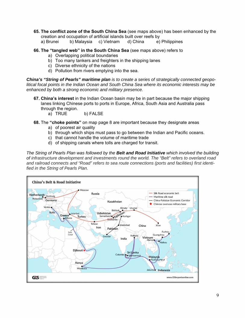
The String of Pearls Plan was followed by the Belt and Road Initiative which involved the building of infrastructure development and investments round the world. The “Belt” refers to overland road and railroad connects and “Road” refers to sea route connections (ports and facilities) first identi-fied in the String of Pearls Plan.

10
69. The combined aspects of the Belt and Road Initiative gives China the flexibility to access world markets (both for selling and purchasing products) by using any one of several routes available in the transportation network that they created.
a) TRUE b) FALSE
70. China’s investment in upgrading the infrastructure of less wealthy countries (port facilities, railroad lines, highways, airports and storage and distribution terminals) is just an attempt to establish “innocent passage” through independent countries for the purpose of world trade and there is no geopolitical strategy involved to gain influence locally.
a) TRUE b) FALSE
©AFG 11/2019