buangor - ararat.vic.gov.au
TRANSCRIPT

BuangorTOWNSHIP PLAN
BUANGOR TOWNSHIP PLANPrepared For Ararat Rural City Council
FINAL REPORT June 2016

Ararat Rural City Council | BUANGOR TOWNSHIP PLANii © 2016
Status VersionChecked PM
Checked PD
Date released
FINAL 2 DF JLR 30/06/2016
© Planisphere 2016.
This Publication is copyright. No part may be reproduced by any process except in accordance with the provisions of the Copyright Act 1968.
PROJECT CONTROL
iiiArarat Rural City Council | BUANGOR TOWNSHIP PLAN© 2016
CONTENTS
1 INTRODUCTION
1.1 Brief
1.2 About Buangor
1.3 Economy and Tourism
1.4 Western Highway Duplication
1.5 Strategic Context
1.6 Planning Controls
2 BUANGOR’S HERITAGE
3 CONSULTATION
3.1 Consultation Results
4 A VISION FOR BUANGOR
5 ECONOMIC & TOURISM DEVELOPMENT
5.1 Tourism
5.2 Township Economic Activity
5.3 Land Use
5.4 Sense of Place
1
1
2
4
6
8
10
14
16
18
19
20
20
22
22
22
24
24
24
26
28
30
32
6 PUBLIC REALM
6.1 Des Brennan Park & Recreation Reserve
6.2 Billy Billy Creek
6.3 Access and Transport
6.4 Public Realm
6.5 Landscape & Urban Design Guidelines
7 IMPLEMENTATION
© 2016Ararat Rural City Council | BUANGOR TOWNSHIP PLANiv
50 km
50 km
10 km
10 km20 km
20
km
100 km
LAKE BOLAC
WILLAURA
ARARAT
BUANGOR
ELMHURST
WARRAK
BEAUFORT
AVOCA
BALLARAT
HALLS GAP
STAWELL
Mount Buangor State
Park
Mount Cole State Forest
Kara Kara State Park
Langi Ghiran State Park
Grampian Ranges National Park
Pyrenees Ranges
Challicum Hills Wind
Farm
Hopkin
s Rive
r
Woa
dy Ya
loak R
iver
Wimmera River
Avoc
a Rive
r
to Adelaide
to Adelaide
to Hamiltonto Hamilton
Pyrenees Wine Region
Bendigo Wine Region
Grampians Wine Region
WESTERN HIGHWAY
WESTERN HIGHWAY
SUNRAYSIA HIGHWAY
PYRENEES HIGHWAY
PYRENEES HIGHWAY
GLENELG HIGHWAY
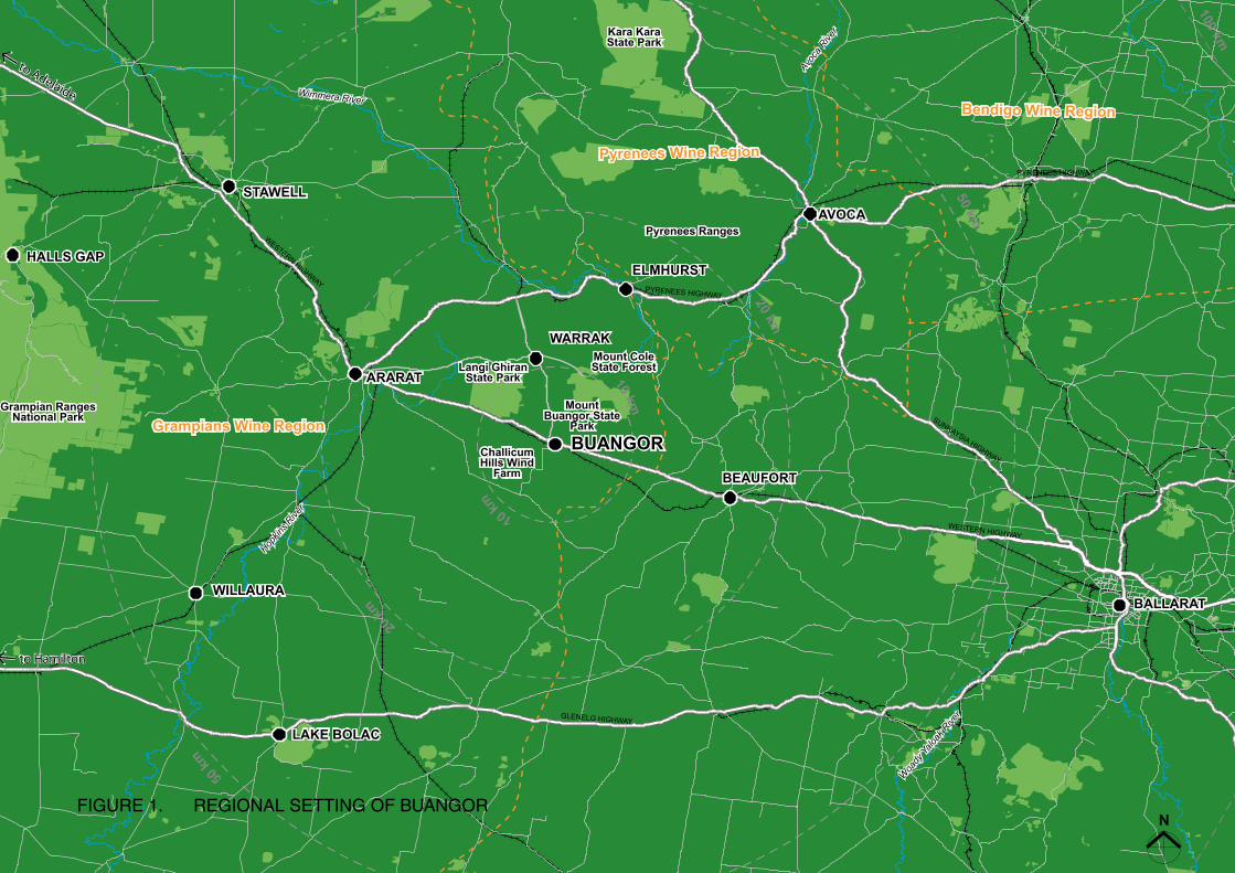
FIGURE 1. REGIONAL SETTING OF BUANGOR

© 2016 1Ararat Rural City Council | BUANGOR TOWNSHIP PLAN
1 INTRODUCTION
Existing signage at the eastern entrance to Buangor
The Western Highway, a major truck route, divides the town with a 90km speed limit.
The Buangor Township Plan has been prepared to respond to the opportunities that will arise following completion of the Western Highway duplication and bypass of Buangor. It has been developed by conjunction Ararat Rural City Council through consultation with the community.
Buangor is a small rural village located on the Western Highway approximately 24km east of Ararat and 75km west of Ballarat.
The township is currently divided by the Western Highway, which is the main interstate transport route between Melbourne and Adelaide. VicRoads is currently in the process of duplicating and upgrading the highway, and part of the duplication project includes the bypass of Buangor.
Removal of this major transport corridor will see the amenity, safety and character of Buangor increase significantly as freight and through traffic is diverted north of town.
1.1 BRIEFThe objectives of the Buangor Township Plan are to:
▪ Provide a future vision for the town
▪ Identify economic and tourism opportunities
▪ Strengthen community facilities
▪ Plan streetscape improvements
▪ Build on Buangor’s landscape and heritage character
▪ Build on the urban design elements outlined in the Ararat Sustainable Growth Future (2014), and on the actions identified in the Community Action Plan (2015-2018)

© 2016Ararat Rural City Council | BUANGOR TOWNSHIP PLAN2
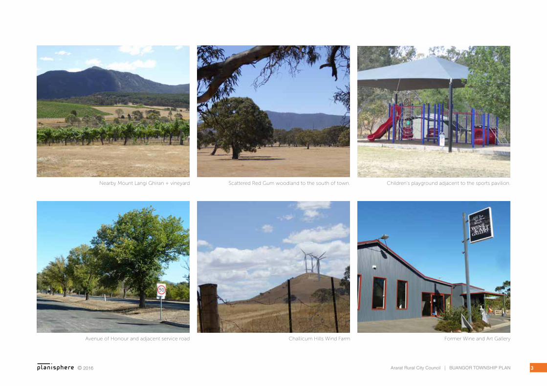
1.2 ABOUT BUANGORBuangor has a high level of visual amenity, with the backdrop of Mount Buangor/Mount Cole and Mount Langi Ghiran rising to the north, a rolling pastoral landscape scattered with remnant river red gums to the south, and a long ridgeline supporting the Challicum Hills wind farm to the east.
The focus of the town is centred around community facilities located within the Des Brennan Park recreation reserve. The most prominent of these is the heritage listed Cobb & Co Changing Station, a bluestone building that is now used for community functions. Beyond that is a sports oval and pavilion that serves as a gathering place for the community, a new BMX track, tennis courts, a children’s playground and adult exercise station.
To the east of Des Brennan Park a winding path crosses the Billy Billy Creek and leads up to the primary school, which has a current enrolment of around 30 students.
On the opposite side of the road the Buangor Hotel and Wine Tasting/Gallery business are no longer in operation. There is currently no commercial activity in the town.
The Avenue of Honour is a key feature of the town’s streetscape. It was planted in 1918 to commemorate those who enlisted and served in the First World War. It is comprised of a mix of English elms, golden elms and silver poplars. Of the original 50 trees that were planted, 30 remain.
Former Cobb & Co Changing Station
Sports Pavilion at the Recreation Reserve
Buildings within Buangor are all single storey, except for the Cobb & Co Changing Station which is a three storey bluestone building that has a commanding presence on the built form character of Buangor. Buildings are modest and many retain a consistent historic character.
The broader community is supported by predominantly farming industries, including wool, cattle, cropping, hay and vineyards. The timber industry has established plantations to the north of the town which are currently in the process of being harvested.
The Challicum Hills wind farm has been operating on a ridgeline that overlooks Buangor to the south-west since 2003.
© 2016 3Ararat Rural City Council | BUANGOR TOWNSHIP PLAN
Former Wine and Art GalleryChallicum Hills Wind FarmAvenue of Honour and adjacent service road
Nearby Mount Langi Ghiran + vineyard Scattered Red Gum woodland to the south of town. Children’s playground adjacent to the sports pavilion.

© 2016Ararat Rural City Council | BUANGOR TOWNSHIP PLAN4
1.3 COMMUNITYBuangor has a strong and active community that is heavily involved in a variety of voluntary activities.
The Buangor Community Sports Committee, Primary School Council, Country Fire Authority and Landcare Group provide focal points for community activity for people living within Buangor and throughout the surrounding agricultural district.
There is a particularly close relationship between Buangor Primary School and the recreation reserve. The school plays an important role in retaining and attracting residents. This is complemented by the Sports Committee, which provides sporting, social and recreational opportunities for both children and adults.
The recreation reserve and primary school precinct has emerged as the central meeting place for the local district, with the pavilion and Cobb and Co Hall catering for a wide range of activities and events. The vision contained in the Buangor Community Action Plan 2015-18, highlights the value placed on this precinct:
Our community will strive to provide:
▪ A central meeting place for functions and town activities
▪ Improvements to existing infrastructure
▪ Opportunities to attract funding from external sources to improve Buangor’s sustainability
▪ Improved services to encourage tourists and residents to the area.
Mt Langi Ghiran
(Image source: www.winebof.com)
Mountainside Wines north of Buangor
(Image source: www.about-australia.com)
There is a close alignment between the goals of the Community Action Plan and this Township Plan. Both will be implemented through a collaboration between community groups, Ararat Rural City Council and relevant State Government agencies and authorities.
1.4 ECONOMY & TOURISMBuangor is nested between Mount Langi Ghiran and Mount Cole State Parks which form part of the lower Pyrenees and have been recognised as part of the South-West Landscape Study (2013).
Mount Cole and Mount Langi are popular nature based attractions and are well-used for camping and recreation.
Challicum Hill to the south west of Bunagor is home to one of Victoria’s first wind farms and provides a scenic route to Ararat.
The district is home to a number of wineries and vineyards, for example Mt Langi Ghiran at the foothills of the mountain and Wineworks at Warrak, which form part of the Grampians Wine region and have access to the Pyrenees to the north.
Agriculture is the largest part of the local economy with cropping, grazing and farming to the south of Buangor. There are also vineyards, horse studs and pastures between Buangor and Warrak.

50 km
50 km
10 km
10 km
20 km
20 km
100 km
ARARAT
BUANGOR
ELMHURST
WARRAK
BEAUFORT
Mount Cole
Mount Cole State Forest
Mount Langi
Pyrenees Ranges
Challicum Hills Wind Farm
Hopkin
s Rive
r
Grampians
Wine Region
To PyreneesTo Pyrenees
Diversification of rural agriculture (vineyards)
WESTERN HIGHWAYPYRENEES HIGHWAY
© 2016 5Ararat Rural City Council | BUANGOR TOWNSHIP PLAN
FIGURE 2. ECONOMY & TOURISM
© 2016Ararat Rural City Council | BUANGOR TOWNSHIP PLAN6
1.5 WESTERN HIGHWAY DUPLICATION
The Western Highway is the main interstate transport route between Melbourne and Adelaide, and is one of Victoria’s busiest rural highways. VicRoads is in the process of duplicating and upgrading the highway as it is expected to see an increase of traffic volumes in the future.
A 6 kilometre bypass is being constructed around Buangor between Andersons Road and Pope Road (see Figure 2 opposite). It is expected to be completed by the middle of 2016. BMD Constructions Pty Ltd has been contracted to construct the bypass.
The bypass will lie to the north of the town, and access will be available via the service road and interchange at a new overpass on Peacocks Road.
Works include:
▪ Realignment and regrading of the existing Western Highway carriageway.
▪ Three new bridges over Billy Billy Creek.
▪ New service roads to maintain local access and road connections to the township of Buangor.
▪ New interchange and highway overpass at Peacocks Road, with ramps connecting to the eastbound lanes.
▪ Two new roundabouts at key access points to
Highway under construction at Buangor - Ben Nevis Road.
Overpass and interchange at Peacocks Road under construction.
the Buangor township.
More detailed information can be found on the VicRoads webpage, including Environmental Effects Statements and Technical Appendices:
https://www.vicroads.vic.gov.au/planning-and-projects/regional-road-projects/western-highway-upgrades/western-highway-duplication-beaufort-to-ararat

© 2016
BUANGORBUANGOR
WESTERN HIGHWAY
FUTURE WESTERN HIGHWAY ALIGNMENT
FUTURE WESTERN HIGHWAY SERVICE ROAD
BUAN
GO
R -
BEN
NEV
IS R
OAD
CH
ALL
UC
IM R
OA
D
CHALLUCIM ROAD
PE
AC
OC
KS
RO
AD
AN
DE
RS
ON
S R
OA
D
MAIN
RO
AD
DIP R
OAD
Buangor Cemetary
Primary SchoolPrimary School
RecreationReserve
RecreationReserve
Railway Station
Billy Billy Creek
10005000
metres
LEGEND
Existing Township Boundary
Future township boundary
Billy Billy Creek
Railway line
Existing Roads
Western Highway Buangor Bypass
Western Highway Buangor Bypass Service Road
New overpass and interchange on Peacocks Road
New roundabouts at town entrances
FIGURE 3. WESTERN HIGHWAY BY-PASS

© 2016Ararat Rural City Council | BUANGOR TOWNSHIP PLAN8
1.6 STRATEGIC CONTEXT
STRATEGIES AND PLANS
ARARAT SUSTAINABLE GROWTH FUTURE STRATEGY (2014)
The Ararat Sustainable Growth Future Strategy (ASGFS) was prepared to provide an integrated land use strategy for managing the future growth of the municipality, and to provide high level strategic direction to inform the update of Council’s Municipal Strategic Statement.
The strategy was incorporated into the Ararat Planning Scheme in March 2015 through Amendment C34.
The changes include a Framework Plan for Buangor (see Figure 3 opposite). The zoning recommendations from the ASGFS, including proposed additional rural residential land, have yet to be included in the Ararat Planning Scheme.
The need for a Township Plan for Buangor was raised in the ASGFS. Included in the Future Growth Recommendations section of the report for Buangor (p. 92) is the action:
Prepare an Urban Design Framework for Buangor to provide direction on potential improvements to the design of the streetscape following construction of the Bypass, including strengthening visual and physical
connections between the north and south sides of the highway.
The plan recommended the following actions for the expansion of residential land:
▪ Rezoning of lots fronting Challicum Road from Farming Zone to Township Zone to reflect their use and subdivision size
▪ Rezoning of lots west of town from Township Zone to Rural Living Zone
▪ Investigating Rural Living Zone opportunities to the north and north east of town following completion of the bypass project
COMMUNITY ACTION PLAN 2015-2018
The Community Action Plan was produced by the broader community of Buangor in conjunction with Ararat Rural City Council. The vision outlined in the Plan is to provide:
▪ A central meeting place for functions and town activities
▪ Improvements to existing infrastructure
▪ Opportunities to attract funding from external sources to improve Buangor’s sustainability
▪ Improved services to encourage tourists and residents to the area.
The actions outlined in the Community Action Plan to achieve the above vision have been incorporated in this township plan.
MUNICIPAL STRATEGIC STATEMENT
SETTLEMENTS (CLAUSE 21.03-1)
The Ararat Municipal Strategic Statement (MSS) identifies Buangor as a Rural Village. Rural Villages support small populations and provide a focal point for the surrounding rural community. Access to services such as education and retail are available and connections to reticulated water vary.
BUANGOR (CLAUSE 21.07-7)
The MSS also includes an objective and strategies that are specific to Buangor:
Objectives:
To encourage Buangor to attract people who enjoy a rural lifestyle.
Strategies:
▪ Support residential uses in close proximity to the town centre and existing community infrastructure and services.
▪ Investigate potential for rural living opportunities to the north and north-east of the township boundary in the longer term, once the bypass is in operation.
▪ Ensure rural residential growth occurs in areas where it will not impact on the viability of productive agricultural land, and minimises potential land use conflict.
▪ Encourage a wider range of businesses, services and activities that take advantage of Buangor’s Heritage assets, nearby wineries and proximity to Mount Buangor and Mount Langi Ghiran.

© 2016
Buangor Primary School
Oval
Cobb & CoHall
Buangor Station
Buangor Cemetery Billy Billy Creek
10005000
metres
LEGEND
Township boundary
Billy Billy Creek
Railway line
Proposed Buangor Bypass
Main Access Road (following construction of the Bypass)
Township Entry Point
Avenue of Honour tree planting
Public open space / recreation
Community Uses
Township Residential
Town centre core
Farming
Area to be rezoned to the Township Zone
Area to be rezoned to the Rural Living Zone
Rural living investigation area
WESTERN HIGHWAY
BUAN
GO
R - B
EN N
EVIS
RO
AD
CH
ALL
UC
IM R
OA
D
CHALLUCIM ROAD
PE
AC
OC
KS
RO
AD
COBBS ROADBUANGOR ROAD
MAIN
STREET
DIP R
OAD
FIGURE 4. BUANGOR FRAMEWORK PLAN
The Buangor Framework Plan
may be found at Clause 21.07
(Local Areas) of the Ararat
Planning Scheme.
© 2016Ararat Rural City Council | BUANGOR TOWNSHIP PLAN10
1.7 PLANNING CONTROLS
ZONES
The Ararat Planning Scheme applies zones that affect the way land in Buangor may be used and developed. The current zoning map from the Ararat Planning Scheme is shown in Figure 4 opposite. Following is a summary of the current zones that apply to the township.
TOWNSHIP ZONE (TZ)
The Township Zone applies to residential land along the Western Highway and within the existing township boundary. The TZ allows for a range of residential, commercial and some industrial uses as well as other educational, religious and community developments. All development within the TZ must respect the existing neighbourhood characteristics of the township. A permit is required for some forms of accommodation, office and commercial uses, industry uses and a place of assembly.
FARMING ZONE (FZ)
The Farming Zone applies to the majority of land outside the existing township boundary. The primary purpose of the FZ is to encourage and retain land for farming and agricultural uses. All non-agricultural uses, including residential developments, must not affect or interfere with the use of the land for farming purposes. For example, only one dwelling is permitted per 40ha lot. Most land uses, particularly those which are not related to agricultural uses, require a planning permit. Additionally, a planning permit is required
to subdivide land and a minimum lot size of 40ha generally applies.
PUBLIC PARK AND RECREATION ZONE (PPRZ)
The PPRZ designates areas for public recreation and open space. Land within this zone should be conserved and protected from development. The PPRZ applies to the recreation reserve and the Cobb & Co Changing Station (which is also subject to the Heritage Overlay). A small number of uses are permitted within the PPRZ including an office, retail premises and a store, subject to a number of conditions.
PUBLIC USE ZONE (PUZ)
The Public Use Zone sets aside land for utilities, services and facilities. In Buangor, the PUZ applies to the Primary School, the cemetery and the railway reserve. Land within the PUZ is not privately owned and any use or development of the land must be referred to the Minister or relevant public land manager.
ROAD ZONE 1 (RDZ1)
The RDZ applies to the Western Highway which runs through the township. The application of the RDZ1 recognises that the road is significant and any development application to built into the road reserve will be referred to VicRoads. Some forms of development are required to be set back a minimum distance (as specified in the schedule to the zone) to the RDZ1.
ARARAT SUSTAINABLE GROWTH FUTURES
Ararat Sustainable Growth Future (2014) recommends changes to the following zones:
▪ Township Zone
▪ Farming Zone
▪ Rural Living Zone
Refer to Figure 2: Framework Plan on the previous page.
These zone changes are yet to be implemented through the planning scheme.
Buangor Primary School
Oval
Cobb & CoHall
Buangor Station
Buangor Cemetery Billy Billy Creek
10005000
metres
LEGEND
Existing township boundary
Future township boundary
Billy Billy Creek
Railway line
Western Highway Buangor Bypass
Farming Zone
Public Park & Recreation Zone
Township Zone
Public Use Zone
Road Zone 1WESTERN HIGHWAY
BUAN
GO
R - B
EN N
EVIS
RO
AD
CH
ALL
UC
IM R
OA
D
CHALLUCIM ROAD
PE
AC
OC
KS
RO
AD

© 2016 11Ararat Rural City Council | BUANGOR TOWNSHIP PLAN
Buangor Primary School
Oval
Cobb & CoHall
Buangor Station
Buangor Cemetery Billy Billy Creek
10005000
metres
LEGEND
Existing township boundary
Future township boundary
Billy Billy Creek
Railway line
Western Highway Buangor Bypass
Farming Zone
Public Park & Recreation Zone
Township Zone
Public Use Zone
Road Zone 1WESTERN HIGHWAY
BUAN
GO
R - B
EN N
EVIS
RO
AD
CH
ALL
UC
IM R
OA
D
CHALLUCIM ROAD
PE
AC
OC
KS
RO
AD
FIGURE 5. ARARAT PLANNING SCHEME ZONE MAP

© 2016Ararat Rural City Council | BUANGOR TOWNSHIP PLAN12
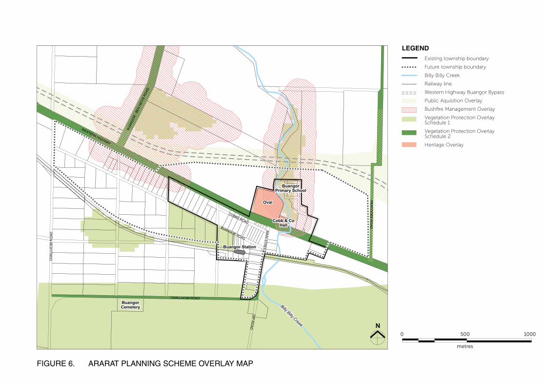
OVERLAYS
The planning scheme applies overlays to address specific environmental, heritage and design issues. Figure 5 (opposite) shows the existing overlays that apply to land in Buangor.
PUBLIC ACQUISITION OVERLAY SCHEDULE 1 (PAO1)
The Public Acquisition Overlay was introduced in 2013 to give VicRoads authority over land to be used for the Western Highway Bypass of Buangor.
BUSHFIRE MANAGEMENT OVERLAY (BMO)
The BMO is applied to areas that have the highest bushfire risk and are likely to be particularly exposed to the impact of bushfire. The suitability of new development in these areas must be fully considered before it proceeds, and appropriate bushfire protection measures will be required.
The current BMO is based on existing tree plantations that currently have an uncertain future as a result of the proposed bypass. Bushfire constraints to the north are likely to reduce once the bypass has been constructed, effectively providing a barrier to any fire front from the north.
VEGETATION PROTECTION OVERLAY SCHEDULE 1 (VPO1)
Areas of vegetation in Buangor have been identified as significant because:
▪ The vegetation comprises important biodiversity links and corridors between larger public land blocks of forest.
▪ The vegetation forms a link between a major block of vegetation and smaller remnant areas.
▪ The areas consolidate remnant corridors along streams.
▪ Areas are considered to be of high conservation significance containing diverse flora and fauna and/or threatened species or communities.
In the Buangor region, the vegetation is significant because of the remnant stands are of high quality and contain depleted and endangered ecological vegetation classes (EVCs). Included are areas of Themeda grassland and Red Gum regeneration. The area provides important habitat for the Powerful Owl and Square-tailed Kite.
A permit is required to remove, destroy or lop any native vegetation in the area covered by the overlay.
VEGETATION PROTECTION OVERLAY SCHEDULE 2 (VPO2)
VPO2 is applied to vegetation contained within roadside reserves throughout the Shire. Many of these contain rare or threatened species or communities and they contribute to the visual quality of the area. Roadsides represent some of
the largest reserves of native vegetation, and play an important role in linking fragmented remnant habitats.
In the Buangor region, VPO2 has been applied along the following roads:
▪ Andersons Road (Grassy Woodland, high degree of naturalness, wildlife corridor)
▪ Challicum Road (Grassy woodland)
▪ Firewood Road (Grassy woodland)
▪ Peacocks Road (Grassy woodland, Stringybark/ Candlebark woodland)
▪ Mile Post Lane (Grassy woodland)
A permit is required to remove, destroy or lop any native vegetation in the area covered by the overlay.
HERITAGE OVERLAY (HO)
The heritage overlay applies to the parcel of land occupied by the Cobb & Co Changing Station which includes to the oval and recreation reserve.
ARARAT SUSTAINABLE GROWTH FUTURES
Ararat Sustainable Growth Future (2014) did not recommend any changes to the current overlays that apply to the township.
Buangor Primary School
Oval
Cobb & CoHall
Buangor Station
Buangor Cemetery Billy Billy Creek
WESTERN HIGHWAY
BUAN
GO
R - B
EN N
EVIS
RO
AD
CH
ALL
UC
IM R
OA
D
CHALLUCIM ROAD
PE
AC
OC
KS
RO
AD
COBBS ROADBUANGOR ROAD
MAIN
STREET
DIP R
OAD
10005000
metres
LEGEND
Existing township boundary
Future township boundary
Billy Billy Creek
Railway line
Western Highway Buangor Bypass
Public Aquisition Overlay
Bushfire Management Overlay
Vegetation Protection Overlay Schedule 1
Vegetation Protection Overlay Schedule 2
Heritage Overlay
© 2016 13Ararat Rural City Council | BUANGOR TOWNSHIP PLAN
Buangor Primary School
Oval
Cobb & CoHall
Buangor Station
Buangor Cemetery Billy Billy Creek
WESTERN HIGHWAY
BUAN
GO
R - B
EN N
EVIS
RO
AD
CH
ALL
UC
IM R
OA
D
CHALLUCIM ROAD
PE
AC
OC
KS
RO
AD
COBBS ROADBUANGOR ROAD
MAIN
STREET
DIP R
OAD
10005000
metres
LEGEND
Existing township boundary
Future township boundary
Billy Billy Creek
Railway line
Western Highway Buangor Bypass
Public Aquisition Overlay
Bushfire Management Overlay
Vegetation Protection Overlay Schedule 1
Vegetation Protection Overlay Schedule 2
Heritage Overlay
FIGURE 6. ARARAT PLANNING SCHEME OVERLAY MAP
© 2016Ararat Rural City Council | BUANGOR TOWNSHIP PLAN14
ABORIGINAL CULTURAL HERITAGE
Buangor is located on the traditional lands of the Tjapwurong Aboriginal peoples.
The Billy Billy Creek corridor is identified as having potential cultural heritage sensitivity. VicRoads undertook a detailed cultural heritage study as part of the Environmental Effects Statement for the Western Highway duplication. The study area included all land within 200m of the alignment options.
Two scarred trees of moderate significance were identified within the Buangor Township area. One (Ch. 17455) lies to the east of town near the intersection of Peacocks Road, and Western Highway 4. The other (Ch.18400) is located to the north in an area of remnant vegetation on Billy Billy Creek.
Construction will extend to within 2m of one of the trees, however if the proposed design is adhered to it is not expected to have any impact on the tree.
Source: VicRoads Environmental Effects Statement (EES) 14: Cultural Heritage.
EUROPEAN HERITAGE
Buangor contains numerous sites that have been identified as having heritage value. Scattered
buildings in various states of repair contribute to the built form character of the town.
The most prominent of these is the Cobb & Co changing station which is a landmark bluestone building fronting onto the Western Highway. It has been attributed a state significance rating by the National Trust. The building, surrounding property and adjacent sports oval are covered by the Heritage Overlay.
Other identified heritage places are:
▪ Buangor Park Farm Complex
▪ Peacocks Road House Ruins
▪ Buangor Primary School
▪ Former Buangor Public Hall
▪ Buangor Railway Station & Railway House
▪ Buangor Post Office & General Store
▪ Buangor Cemetery - Resting place of General Sir Cyril Bingham Brudenell White (1876 – 1940), a celebrated figure in Australian military history.
▪ Former Hotel
▪ Avenue of Honour
The history of Buangor has been compiled into a book titled ‘Coaches Called Here – A History of Buangor and Surrounding Districts’ (1996), authored by Tim Allender and Des Brennan.
2 BUANGOR’S HERITAGE
Church at the corner of Dip Road and Challicum Road, now in private ownership.
Former Buangor Public Hall

© 2016 15Ararat Rural City Council | BUANGOR TOWNSHIP PLAN
Buangor Cemetery
Former Public Hall
Church
Church
Old Gaol
Buangor Park Farm Complex
Buangor Primary School
Cobb & Co Changing Station
Peacocks Road House Ruins
Buangor Station
Railway House
Avenue of Honour
Former Post Office & General Store
Former Hotel
Billy Billy Creek10005000
metres
LEGEND
Existing township boundary
Future township boundary
Billy Billy Creek
Railway line
Western Highway Buangor Bypass
Heritage Overlay
Heritage site
Area of aboriginal cultural sensitivity
Scarred tree (approximate location)WESTERN HIGHWAY
BUAN
GO
R - B
EN N
EVIS
RO
AD
CH
ALL
UC
IM R
OA
D
CHALLUCIM ROAD
PE
AC
OC
KS
RO
AD
FIGURE 7. HISTORICAL FEATURES MAP
© 2016Ararat Rural City Council | BUANGOR TOWNSHIP PLAN16
3 CONSULTATION
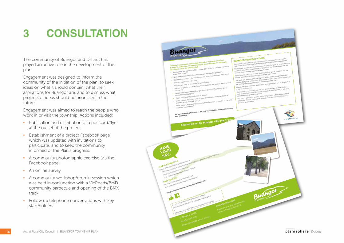
The community of Buangor and District has played an active role in the development of this plan.
Engagement was designed to inform the community of the initiation of the plan, to seek ideas on what it should contain, what their aspirations for Buangor are, and to discuss what projects or ideas should be prioritised in the future.
Engagement was aimed to reach the people who work in or visit the township. Actions included:
▪ Publication and distribution of a postcard/flyer at the outset of the project.
▪ Establishment of a project Facebook page which was updated with invitations to participate, and to keep the community informed of the Plan’s progress.
▪ A community photographic exercise (via the Facebook page)
▪ An online survey
▪ A community workshop/drop in session which was held in conjunction with a VicRoads/BMD community barbecue and opening of the BMX track.
▪ Follow up telephone conversations with key stakeholders.
BuangorTOWNSHIP PLAN
BuangorTOWNSHIP PLAN
BuangorTOWNSHIP PLAN
BuangorTOWNSHIP PLAN
Following the community consultation undertaken in December the Draft
Buangor Township Plan has been developed. Some of things you told us you
would like to see in the plan included:
▪ ‘Improvement and expansion of the Cobb and Co facility for functions in order to
attract more to use it.’
▪ ‘Great idea to do more with beautiful Buangor! Keep up the good work.’
▪ ‘Safe crossing over or under the road needed to connect two sides of the road.’
▪ ‘Need drinkable water in the town.’
▪ ‘Re-zoning to allow for expansion of rural living zones.’
▪ ‘It would be great to see the Railway Station restored and used by the community
in some way.’
▪ ‘Greater emphasis on Mount Buangor, Mount Cole and Mount Langi Ghiran
connection would be good.’
▪ ‘Retain the trees along the Avenue of Honour.’
▪ ‘Install toilets at the pavilion and consider a coffee shop and other forms of
entertainment at the Cobb and Co.’
▪ ‘More festivals, markets and community based activities to promote tourism and
economic opportunities.’
A future vision for Buangor after the Bypass
We are now seeking feedback on the Draft Township Plan and would welcome
your comments.
BUANGOR TOWNSHIP VISION
Buangor will continue to provide a strong community focus for the broader
rural area and maintain excellent connections to its wider landscape context.
The town will become an attractive option for ‘tree changers’ or people wanting
a rural lifestyle within easy commuting distance of Ararat or Ballarat, with the
opening up of new rural residential opportunities.
Young families will continue to be attracted to Buangor for it’s active primary
school, recreation facilities and safe, walkable town centre.
The north and south sides of the highway will be united through improved
visual and physical connections. Improvements to the town centre will build on
the existing landscape and historical character of the town.
Opportunities for economic and tourism development will see local activity in
the town strengthened.
Buangor will become a convenient and attractive place to break up the
long drive between from Melbourne to Adelaide, with facilities for rest and
refreshment being readily available.
The history of Buangor and the surrounding district will be preserved and
celebrated through preservation, restoration and promotion of historical
buildings and features.
CONTACT COUNCIL
Ph: (03) 5355 0222
Email: [email protected]
SUBMISSIONS CLOSE
Please provide your thoughts and
ideas by Friday15 April 2016
BuangorTOWNSHIP PLAN
BuangorTOWNSHIP PLAN
BuangorTOWNSHIP PLAN
BuangorTOWNSHIP PLAN
HAVE
YOUR
SAY...
If you would like more information please contact:
Joel Hastings on 53550222 or [email protected]
or
Robyn Hemley on 5355 0257 or [email protected]
HOW TO BE INVOLVED
Copies of the report will be available online at
http://council-services.ararat.vic.gov.au/planning-building/reformed-residential-zones
www.facebook/BuangorTownshipPlan
or at the Buangor Recreation Reserve Pavilion
HAVE YOUR SAY
Fill out an Online Survey or Feedback Form:
www.surveymonkey.com/r/BuangorTownshipPlan
The plans will be available for comment until April 15th
© 2016 17Ararat Rural City Council | BUANGOR TOWNSHIP PLAN
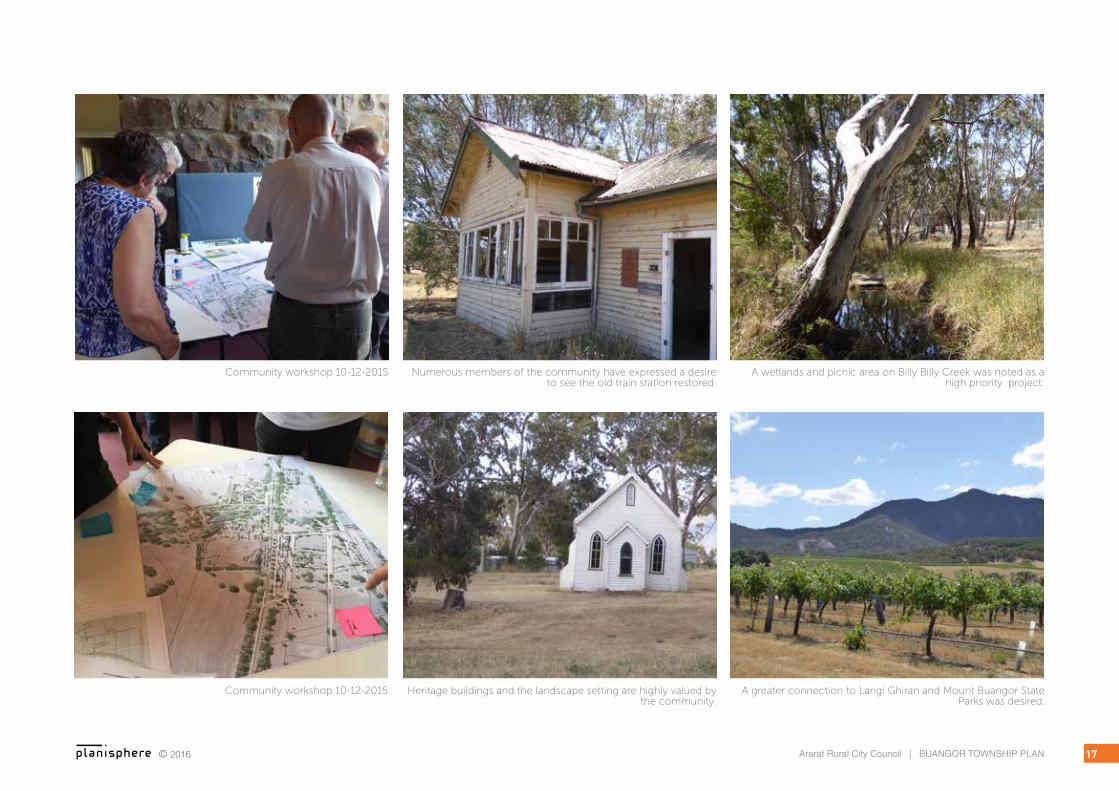
Community workshop 10-12-2015 Numerous members of the community have expressed a desire to see the old train station restored.
Heritage buildings and the landscape setting are highly valued by the community.
A greater connection to Langi Ghiran and Mount Buangor State Parks was desired.
A wetlands and picnic area on Billy Billy Creek was noted as a high priority project.
Community workshop 10-12-2015

© 2016Ararat Rural City Council | BUANGOR TOWNSHIP PLAN18
3.1 ONLINE SURVEY RESULTSThirteen responses to the online survey were collected. The questions asked and a summary of responses are provided below:
What do you like most about Buangor and the surrounding region?
▪ Community spirit and gatherings.
▪ Beautiful landscape, heritage buildings, great tight-knight community.
▪ Community spirit, fantastic serenity and historic buildings.
▪ The people and the beautiful buildings
▪ The trees, access to the Mt Buangor and Mt Cole parks, proximity to Beaufort.
▪ Rural living in close proximity to Ballarat and Ararat. Central to most things Victoria has to offer. Strong community presence.
Participants were asked to prioritise the issues that should be dealt with through the Township Plan. The following responses were received:
▪ Increased town amenity and safety ranked as a medium to high priority
▪ Opportunities to build on the identity of Buangor ranked as a medium priority
▪ Streetscape improvements ranked as a medium to high priority
▪ Opportunities for residential expansion ranked as a medium to low priority
▪ Tourism and economic expansion ranked as a medium to high priority
▪ Improvements to town entry and exit points ranked as a medium priority
▪ Increase in protection from bush fires to the north ranked as a medium to high priority
Projects outlined in the Community Action Plan that residents would like to see prioritised include are summarised in the graph below.
When asked if they have any other contributions to add to the plan, respondents replied:
▪ Improvement and expansion of the Cobb and Co facility for functions in order to attract more to use it
▪ Great idea to do more with beautiful Buangor! Keep up the good work.
▪ Safe crossing over or under the road needed to connect two sides of road. Need drinkable water in the town.
▪ Re-zoning to allow for expansion of rural living zones
▪ It would be great to see the Railway Station restored and used by the community in some way.
▪ Greater emphasis on Mount Buangor, Mount Cole and Mount Langi Ghiran connection would be good.
▪ Retain the trees along the Avenue of Honour
▪ Install toilets at the pavilion and consider a coffee shop and other forms of entertainment at the Cobb and Co.
▪ More festivals, markets and community based activities to promote tourism and economic opportunities.
0% 20% 40% 60% 80% 100%
Landscaping of Des Brennan Park (61.5%)
Township historical museum display (53.8%)
Car park installation west of Cobb & Co Changing Station (30.8%)
Wetlands and picnic area adjacent to Billy Billy Creek (76.9%)
Better public transport connections (61.5%)
Bike and walking paths (30.8%)
Improved street furniture (15.4%)
Landscaping of Des Brennan Park (61.5%)
Township historical museum display (53.8%)
Car park installation west of Cobb & Co
Changing Station (30.8%)
Wetlands and picnic area adjacent to Billy
Billy Creek (76.9%)
Better public transport connections (61.5%)
Bike and walking paths (30.8%)
Improved street furniture (15.4%)

19Ararat Rural City Council | BUANGOR TOWNSHIP PLAN© 2016
4 A VISION FOR BUANGOR
Buangor will continue to provide a strong community focus for the broader rural area and maintain excellent connections to its wider landscape context.
The town will become an attractive option for ‘tree changers’ or people wanting a rural lifestyle within easy commuting distance of Ararat or Ballarat, with the opening up of new rural residential opportunities.
Young families will continue to be attracted to Buangor for it’s active primary school, recreation facilities and safe, walkable town centre.
The north and south sides of the highway will be united through improved visual and physical connections. Improvements to the town centre will build on the existing landscape and historical character of the town.
Opportunities for economic and tourism development will see local activity in the town strengthened.
Buangor will become a convenient and attractive place to break up the long drive between from Melbourne to Adelaide, with facilities for rest and refreshment being readily available.
The history of Buangor and the surrounding district will be preserved and celebrated through preservation, restoration and promotion of historical buildings and features.
Source: Ararat Sustainable Growth Future (2014)

© 2016Ararat Rural City Council | BUANGOR TOWNSHIP PLAN20
5 ECONOMIC & TOURISM DEVELOPMENT
5.1 TOURISM
ISSUES & OPPORTUNITIES
Buangor is located on the Great Southern Touring Route which is a widely promoted road journey. It loops from Melbourne to Ararat via Ballarat, then through the Grampians, down to the coast and along the Great Ocean Road past the Twelve Apostles and Otway Ranges.
To the south, the Glenelg Highway is a major highway that links Melbourne to Mount Gambier and the limestone coast region of South Australia. This is popular route for caravans.
Buangor’s location at the foothills of the Mount Buangor/Mount Cole and Mount Langi Ghiran positions it as a gateway to these significant landscape and recreational assets, and to the Pyrenees and Grampians Wine Regions. A diverse range of agriculture also exists around Buangor including cropping, timber production and vineyards.
The local community support the Challicum Hills Wind Farm, and have indicated that nobody opposed its development or has issues with its ongoing operation.
The wide service lane to the south of the Western Highway provides ample space to develop a RV/caravan stop.
There is currently no accommodation in Buangor, though it is well positioned to attract visitors to
the region. Buangor has many heritage buildings and features that are at risk of decline without management action.
Buangor lacks public toilets. Consultation has revealed that many people stop in town seeking these facilities and have to travel on. The configuration of the Bypass limits the impetus for traffic from Adelaide to stop in Buangor.
ACTIONS
▪ Generate a marketing and branding plan for Buangor that promotes existing and potential future tourism attractions. Include the generation of a strong web presence.
▪ Advocate to VicRoads to include signage advertising attractions in the Buangor region and rest facilities to encourage travellers in from the highway.
▪ Promote Buangor as a coffee break and rest stop between Melbourne/Ballarat and the Grampians, or South Australia and Adelaide (pending local business growth).
▪ Develop a ‘wind farm tour’ that highlights the production of renewable energy in Victoria. Maximise the Challicum Hills position as one of the first wind farms in the area. Tie this into the existing tourist drive around the wind farm, and other wind farms in the region. On a broader scale, this may be linked into promotion of south west Victoria for its contribution to renewable energy.
▪ Investigate scenic tour around Mt Langi Ghiran and State parks and connection to Warrak and Ararat via Pyrenees Highway.
▪ Identify locations for a Buangor Heritage Museum. Possibilities include the Cobb & Co Building or the Railway Station (if restored).
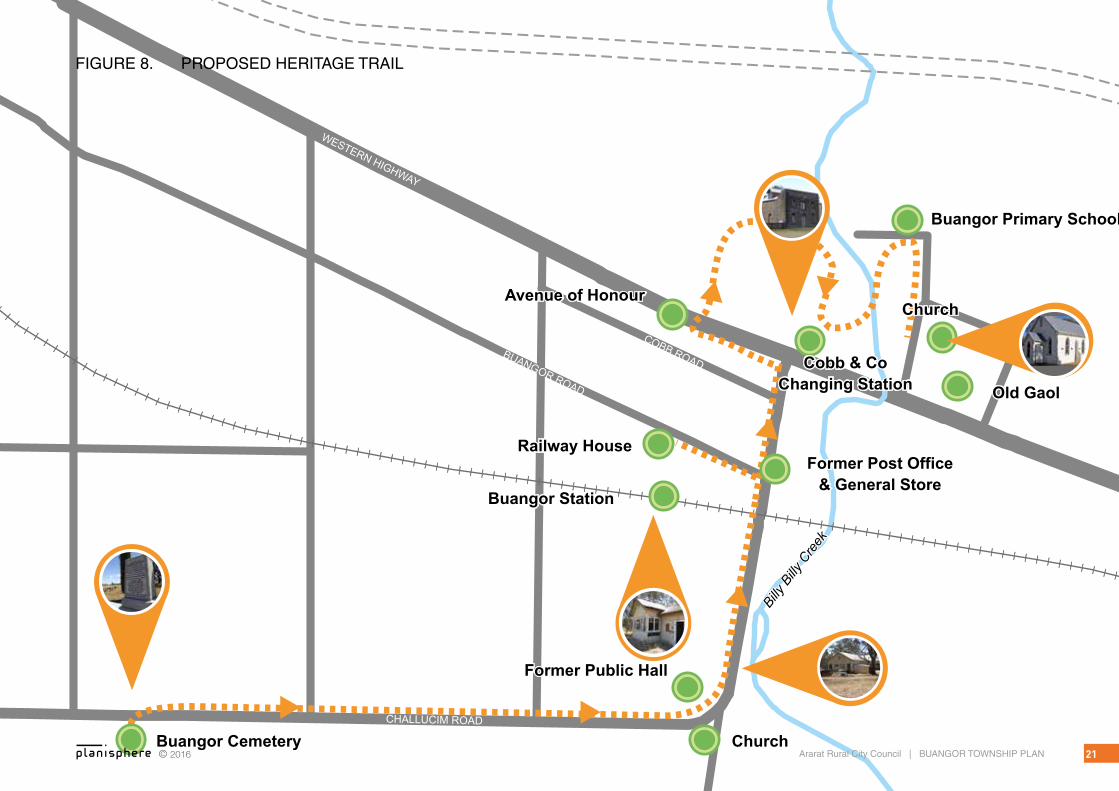
▪ Develop a self-guided Heritage Tour that explores various buildings and places. Provide interpretive signage at key locations and pamphlet style guidebook.
▪ Investigate sites for provision of public toilets. These may potentially be linked into existing facilities such as the sports pavilion at the recreation reserve or the Cobb & Co building.
▪ Develop a wetland / picnic area on Billy Billy Creek to link into existing recreation facilities and potential public toilets.
▪ Investigate options for an RV parking area to encourage travellers to stay overnight. Candidate locations include on the western side of the oval, within the service lane on Western Highway, or to the east of the Cobb and Co.
▪ Provide a regional wayfinding or tourism map close to any rest or picnic facilities that highlights key points of interest such as Mt Langi Ghiran, Mt Cole, the heritage trail and local wineries.
▪ Consider Rural Activity Zone around Mt Cole and Mt Langi.
CHALLUCIM ROAD
WESTERN HIGHWAY
BUANGOR ROAD
COBB ROAD
Buangor Cemetery
Former Public Hall
Church
Church
Old Gaol
Buangor Primary School
Cobb & Co Changing Station
Buangor Station
Railway House
Avenue of Honour
Former Post Office & General Store
Billy
Billy
Cre
ek
© 2016 21Ararat Rural City Council | BUANGOR TOWNSHIP PLAN
FIGURE 8. PROPOSED HERITAGE TRAIL

© 2016Ararat Rural City Council | BUANGOR TOWNSHIP PLAN22
5.2 TOWNSHIP ECONOMIC ACTIVITY
ISSUES & OPPORTUNITIES
Currently there is no commercial activity in town. The owner of the hotel closed the business and is using the building as a dwelling.
There is no general store or convenience store, and residents have to travel to Beaufort (20km east) or Ararat (24km west) for basic supplies.
Recently, the “Off The Beaten Track” wine tasting and gallery business closed, however the buildings and facilities remain in good condition.
A community committee manages the The Cobb & Co building, and it is available for local functions. This may be positioned for more commercial activity, including events such as conferences or weddings.
The broad service road on the southern side of the Western Highway is an ideal space to host a weekend market.
There are a limited number of public transport services through Buangor. A V/Line coach service runs from Stawell to Ballarat from Tuesday to Friday once daily. A coach service also operates daily between Melbourne and Ararat via Buangor.
ACTIONS
▪ Support initiatives to establish service business in Buangor.
▪ Develop a business plan to promote the Cobb & Co building as an events space. This may include marketing and management
goals which in the long term may generate employment opportunities.
▪ Promote business opportunities in Buangor such as a weekend market, gourmet food production or events such as music festivals or conferences.
▪ Support development of accommodation options within the region such as bed and breakfasts, a school camp or a caravan park facilities.
▪ Advocate for public transport options and the potential of the old rail way station.
5.3 LAND USE
ISSUES & OPPORTUNITIES
Opportunities for rural residential expansion have been identified in the ASGFS.
Future rural residential allotments may provide space for hobby farming or boutique food production.
Consolidation of the town centre is constrained by the absence of reticulated de
ACTIONS
▪ Promote Buangor for the development of lifestyle properties within commuting distance of Ararat and Ballarat.
▪ Support small scale agricultural ventures on future rural living allotments, including allowing farm gate sales.
▪ Further investigate the merits of rezoning land for rural lifestyle purposes.
5.4 SENSE OF PLACE
5.5 ISSUES & OPPORTUNITIES
The former Railway Station has not been maintained since its closure in the 1980s, and is now in a state of disrepair. Despite this there is a strong desire within the community to see the building restored.
The Western Highway will be diverted to the north of town which will create an opportunity to rename the main road to something that reflects the local character of the area.
ACTIONS
▪ Support restoration of the former Railway Station by the local community. Suggestions for the project include formation of a local committee or inclusion of a “Men’s Shed” type of group, sourced either locally or from Ararat.
▪ Involve local residents in renaming the section of the Western Highway that runs through Buangor when the bypass is complete.
▪ Continue to support and enhance existing community facilities and various community groups, clubs and associations as a key asset of the township.
▪ Work closely with Government and other service providers (e.g. Bush Nursing Centres) to promote and develop opportunities for improvement e.g. provision of a community bus service, shared partnership development around home and community care (HACC) services, and nursing infrastructure.

© 2016 23Ararat Rural City Council | BUANGOR TOWNSHIP PLAN
Public toilet facilities and a picnic area on the Billy Billy Creek corridor will create better amenities for people needing a break
on the Highway..
The “Off The Beaten Track” facilities are still in excellent condition.
The Old General Store and Post Office.
Owners of the nearby Ampitheatre Hotel have turned it into a B& B and gourmet ice creamery.
Talbot Farmers Market attracts thousands of visitors. Image: www.visitvictoria.com
The music festival at Meredith raises funds that are invested back into the local community.

© 2016Ararat Rural City Council | BUANGOR TOWNSHIP PLAN24
6 PUBLIC REALM
6.1 DES BRENNAN PARK & RECREATION RESERVE
The park, recreation reserve and creek environs are an important focus for the town centre and community activity.
A number of the potential improvements to this area are illustrated Buangor Public Realm Concept Plan, see Figure 25.
ISSUES & OPPORTUNITIES
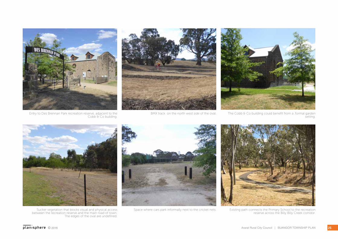
Vegetation on the southern boundary of Des Brennan Park is weedy growth from suckers that have sprouted from the Avenue of Honour. This growth and an old post and wire fence currently create a visual and physical barrier between the town centre and the recreation reserve.
Access to the new BMX track is undefined. Concerns have been raised that users will drive across the oval rather than access it from the sides.
The sports oval is exposed to strong winds from the south east.
The Cobb & Co Changing Station is an excellent feature building that would benefit from a formalised garden setting.
ACTIONS
▪ Prepare a landscape masterplan for the recreation reserve and Western Highway.
▪ Remove weedy tree growth and old post and wire fence from the southern boundary of Des Brennan Park.
▪ Formalise car parking west of the Cobb & Co building. Use surface treatments and low, native planting to define spaces. Where possible, accommodate the planting of shade trees.
▪ Support the proposed extension of the pavilion kitchen to improve flexibility of use.
▪ Install lighting to the west of the Cobb and Co. building to improve pedestrian safety.
▪ Provide access to the BMX track via formalised path around the oval.
▪ Incorporate an informal native landscape theme around the perimeter of the oval that assists to define spaces. For example, the area adjacent to the cricket nets that is used for car parking, or for bounding new path networks. Provide additional seating and shade trees around the oval.
▪ Design a formal garden such a rose garden with clipped box hedges to improve the setting of the Cobb & Co building.
▪ Assist in removal of rubbish dumped behind the sports pavilion.
▪ Install bands of vegetation or earth mounding to provide a wind break at the south western corner of the oval.
6.2 BILLY BILLY CREEK
ISSUES & OPPORTUNITIES
The Billy Billy Creek retains a naturalistic character and the importance of the vegetation is recognised through the application of the VPO. The creek environs is currently managed by the Department of Environment, Land, Water and Planning (DELWP).
Access to the creek is provided via a scenic path that connects the Sports Pavilion up to the school.
The community has indicated that the creek corridor needs more maintenance as it is often overgrown and inaccessible.
ACTIONS
▪ Develop a picnic and wetlands area along Billy Billy Creek that connects to the existing sport and recreation facilities, potential future toilet facilities and the Cobb & Co building.
▪ Retain the ecological focus of the creek corridor.
▪ Advocate to DELWP for more regular maintenance of the creek corridor, and/or support the reinstatement of a local Land Care group to assist with ongoing maintenance.
© 2016 25Ararat Rural City Council | BUANGOR TOWNSHIP PLAN
Existing path connects the Primary School to the recreation reserve across the Billy Billy Creek corridor.
Space where cars park informally next to the cricket nets.Sucker vegetation that blocks visual and physical access between the recreation reserve and the main road of town.
The edges of the oval are undefined.
Entry to Des Brennan Park recreation reserve, adjacent to the Cobb & Co building.
BMX track on the north west side of the oval. The Cobb & Co building could benefit from a .formal garden setting.

© 2016Ararat Rural City Council | BUANGOR TOWNSHIP PLAN26
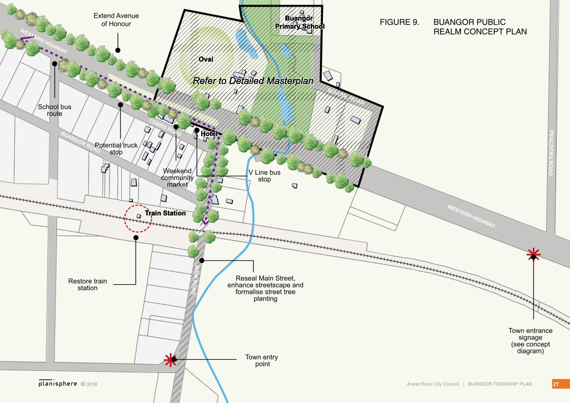
6.3 ACCESS AND TRANSPORT
ISSUES & OPPORTUNITIES
Reduction in heavy freight traffic through the centre of town will result in a much safer and more pleasant environment to walk and cycle.
Currently there is no footpath along the Western Highway and concerns about safety and amenity have been raised, particularly for children walking to school or to the bus stop.
The school bus stop on the corner of the Western Highway and Main Road lacks definition, shelter and connections to other parts of the town.
A Vline Bus service connects Buangor to Melbourne, Ballarat, Ararat, Ouyen, Stawell and Nhill.
ACTIONS
▪ Encourage overflow parking from events at Des Brennan Park to locate within the service road on the south side of the Western Highway.
▪ Provide a footpath along the north side of the Western Highway to encourage and facilitate walking to school.
▪ Install a pedestrian crossing across the Western Highway at the intersection of Main Road to connect the school bus stop on the south side to the primary school and recreation reserve to the north.
▪ Provide shelter at the school bus stop.
▪ The pathway that connects Des Brennan Park, Billy Billy Creek and the Primary School could be improved through an expanded network. This may include a southern loop from the Cobb & Co building, across the Creek to the Primary School, and a northern path across to the BMX track that returns to the Western Highway down the western side of the oval.
▪ Advocate for improved frequency of accessible transport services to Ararat, Ballarat and Melbourne, particularly for the elderly and youth of the community.
▪ Explore reopening of train station in the long term.
Existing train station and railway line
Extend Avenue of Honour
HotelHotel
Train StationTrain Station
OvalOval
Refer to Detailed MasterplanRefer to Detailed Masterplan
Buangor Primary School
Buangor Primary School
HotelHotelHotel
Train StationTrain StationTrain Station
OvalOvalOval
Refer to Detailed MasterplanRefer to Detailed MasterplanRefer to Detailed Masterplan
Buangor Primary School
Buangor Primary School
Buangor Primary School
Town entry point
Town entrance signage
(see concept diagram)
Reseal Main Street,enhance streetscape and
formalise street tree planting
Restore train station
Potential truck stop
Weekend community
market
V Line bus stop
School bus route
WESTERN HIGHWAY
WESTERN HIGHWAY
PEAC
OC
KS R
OA
D
COBBS ROADBUANGOR ROAD
MA
IN R
OA
D
SCHOOL ROAD
© 2016 27Ararat Rural City Council | BUANGOR TOWNSHIP PLAN
FIGURE 9. BUANGOR PUBLIC REALM CONCEPT PLAN
Existing path
Buangor Primary School
Oval
Playground
Exercise station
Sports Pavilion
BMX Track
Oval Dam
School Dam
Cricket nets
Billy B
illy Creek
Buangor Primary SchoolBuangor Primary School
OvalOval
PlaygroundPlayground
Exercise stationExercise station
Sports PavilionSports Pavilion
BMX TrackBMX Track
Oval DamOval Dam
School DamSchool Dam
Cricket netsCricket nets
Billy B
illy Creek
Billy B
illy Creek
Billy B
illy Creek
Remove weed growth and fencing from
boundary of park. Open up space to road reserve as a “village green.” Use
low scale native plating to assist in defining spaces
Potential wetlands and picnic area on Billy Billy
Creek
Extend Kitchen
Formal gardens
Lighting
Light Redgum
TreeInformation
board
Plant shade trees around the perimeter of the oval
Timber seating around oval
New path along Western Highway
Formalise car park area & improve
drainage
Detailed landscape masterplan
Potential RV Site
Pote
ntia
l new
pat
h
Remove fence, weeds and trees
Potential new path network to maximise access around Des
Brennan Park, Billy Billy Creek & Primary School.
WESTERN HIGHWAY
COBBS ROAD© 2016Ararat Rural City Council | BUANGOR TOWNSHIP PLAN28
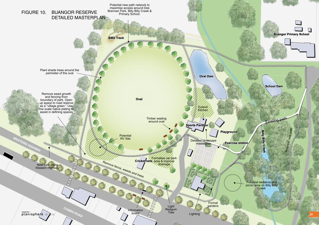
6.4 PUBLIC REALM
ISSUES & OPPORTUNITIES
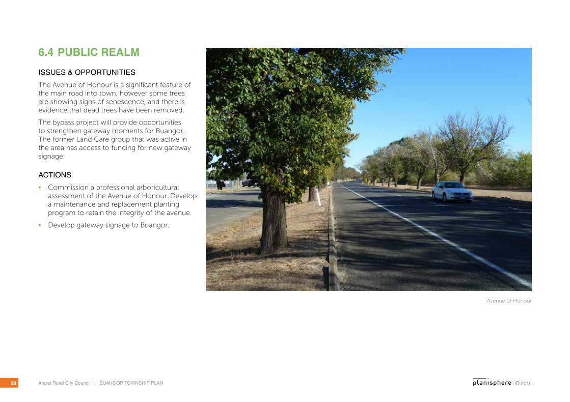
The Avenue of Honour is a significant feature of the main road into town, however some trees are showing signs of senescence, and there is evidence that dead trees have been removed.
The bypass project will provide opportunities to strengthen gateway moments for Buangor. The former Land Care group that was active in the area has access to funding for new gateway signage.
ACTIONS
▪ Commission a professional arboricultural assessment of the Avenue of Honour. Develop a maintenance and replacement planting program to retain the integrity of the avenue.
▪ Develop gateway signage to Buangor.
Avenue of Honour
Existing path
Buangor Primary School
Oval
Playground
Exercise station
Sports Pavilion
BMX Track
Oval Dam
School Dam
Cricket nets
Billy B
illy Creek
Buangor Primary SchoolBuangor Primary School
OvalOval
PlaygroundPlayground
Exercise stationExercise station
Sports PavilionSports Pavilion
BMX TrackBMX Track
Oval DamOval Dam
School DamSchool Dam
Cricket netsCricket nets
Billy B
illy Creek
Billy B
illy Creek
Billy B
illy Creek
Remove weed growth and fencing from
boundary of park. Open up space to road reserve as a “village green.” Use
low scale native plating to assist in defining spaces
Potential wetlands and picnic area on Billy Billy
Creek
Extend Kitchen
Formal gardens
Lighting
Light Redgum
TreeInformation
board
Plant shade trees around the perimeter of the oval
Timber seating around oval
New path along Western Highway
Formalise car park area & improve
drainage
Detailed landscape masterplan
Potential RV Site
Pote
ntia
l new
pat
h
Remove fence, weeds and trees
Potential new path network to maximise access around Des
Brennan Park, Billy Billy Creek & Primary School.
WESTERN HIGHWAY
COBBS ROAD© 2016 29
FIGURE 10. BUANGOR RESERVE DETAILED MASTERPLAN
© 2016Ararat Rural City Council | BUANGOR TOWNSHIP PLAN30
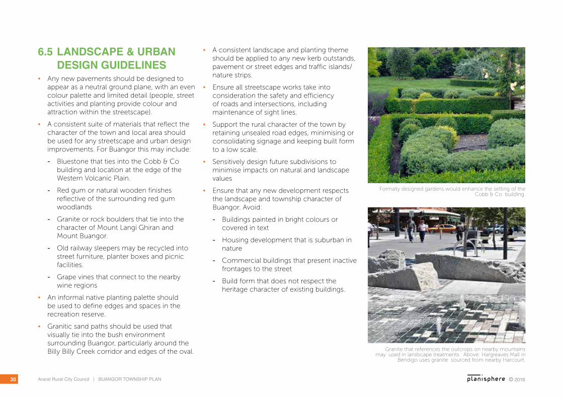
Granite that references the outcrops on nearby mountains may used in landscape treatments. Above: Hargreaves Mall in
Bendigo uses granite sourced from nearby Harcourt.
Formally designed gardens would enhance the setting of the Cobb & Co building.
6.5 LANDSCAPE & URBAN DESIGN GUIDELINES
▪ Any new pavements should be designed to appear as a neutral ground plane, with an even colour palette and limited detail (people, street activities and planting provide colour and attraction within the streetscape).
▪ A consistent suite of materials that reflect the character of the town and local area should be used for any streetscape and urban design improvements. For Buangor this may include:
- Bluestone that ties into the Cobb & Co building and location at the edge of the Western Volcanic Plain.
- Red gum or natural wooden finishes reflective of the surrounding red gum woodlands
- Granite or rock boulders that tie into the character of Mount Langi Ghiran and Mount Buangor.
- Old railway sleepers may be recycled into street furniture, planter boxes and picnic facilities.
- Grape vines that connect to the nearby wine regions
▪ An informal native planting palette should be used to define edges and spaces in the recreation reserve.
▪ Granitic sand paths should be used that visually tie into the bush environment surrounding Buangor, particularly around the Billy Billy Creek corridor and edges of the oval.
▪ A consistent landscape and planting theme should be applied to any new kerb outstands, pavement or street edges and traffic islands/nature strips.
▪ Ensure all streetscape works take into consideration the safety and efficiency of roads and intersections, including maintenance of sight lines.
▪ Support the rural character of the town by retaining unsealed road edges, minimising or consolidating signage and keeping built form to a low scale.
▪ Sensitively design future subdivisions to minimise impacts on natural and landscape values
▪ Ensure that any new development respects the landscape and township character of Buangor. Avoid:
- Buildings painted in bright colours or covered in text
- Housing development that is suburban in nature
- Commercial buildings that present inactive frontages to the street
- Build form that does not respect the heritage character of existing buildings.

© 2016 31Ararat Rural City Council | BUANGOR TOWNSHIP PLAN
Example of furniture made from recycled railway sleepers.Discarded railway sleepers near Buangor Station building may be recycled for furniture for the street, recreation reserve and
picnic facilities or for landscape elements such as planter boxes or garden edges.
Grape vines line shop awnings in Ararat, creating a connection between the town and nearby wine regions.
Example of low scale, informal native vegetation used to define paths and spaces (Woodend Children’s Park).
Township gateway signage concept. Bluestone is iconic material of western Victoria.
© 2016Ararat Rural City Council | BUANGOR TOWNSHIP PLAN32
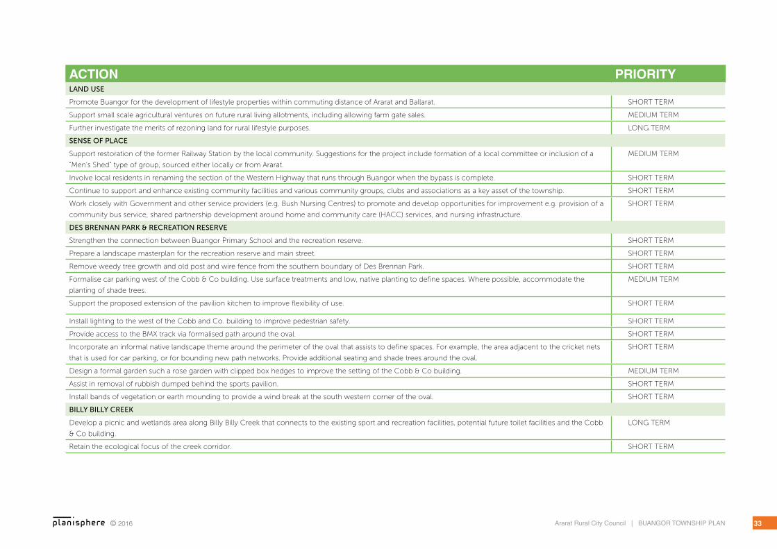
7 IMPLEMENTATIONACTION PRIORITYTOURISM
Generate a marketing and branding plan for Buangor that promotes existing and potential future tourism attractions. Include the generation of a strong web
presence.
SHORT TERM
Advocate to VicRoads to include signage advertising attractions in the Buangor region and rest facilities to encourage travellers in from the highway. SHORT TERM
Promote Buangor as a coffee break and rest stop between Melbourne/Ballarat and the Grampians, or South Australia and Adelaide (pending local business
growth).
MEDIUM TERM
Develop a ‘wind farm tour’ that highlights the production of renewable energy in Victoria. Maximise the Challicum Hills position as one of the first wind farms in
the area. Tie this into the existing tourist drive around the wind farm, and other wind farms in the region. On a broader scale, this may be linked into promotion of
south west Victoria for its contribution to renewable energy.
MEDIUM TERM
Identify locations for a Buangor Heritage Museum. Possibilities include the Cobb & Co Building or the Railway Station (if restored). MEDIUM TERM
Develop a self-guided Heritage Tour that explores various buildings and places. Provide interpretive signage at key locations and pamphlet style guidebook. SHORT TERM
Investigate scenic tour around Mt Langi, Warrak and through to Pyrenees Highway. SHORT TERM
Investigate sites for provision of public toilets. These may potentially be linked into existing facilities such as the sports pavilion at the recreation reserve or the
Cobb & Co building.
MEDIUM TERM
Develop a wetland / picnic area on Billy Billy Creek to link into existing recreation facilities and potential public toilets. LONG TERM
Investigate options for an RV parking area to encourage travellers to stay overnight. Candidate locations include on the western side of the oval, within the service
lane on Western Highway, or to the east of the Cobb and Co.
MEDIUM TERM
Provide a regional wayfinding or tourism map close to any rest or picnic facilities that highlights key points of interest such as Mt Langi Gherang, Mt Cole, the
heritage trail and local wineries.
SHORT TERM
TOWNSHIP ECONOMIC ACTIVITY
Support initiatives to establish service businesses in Buangor. MEDIUM TERM
Develop a business plan to promote the Cobb & Co building as an events space. This may include marketing and management goals which in the long term may
generate employment opportunities.
SHORT TERM
Promote business opportunities in Buangor such as a weekend market, gourmet food production or events such as music festivals or conferences. MEDIUM TERM
Support development of accommodation options within the region such as bed and breakfasts, a school camp or a caravan park facilities. MEDIUM TERM
Advocate for connection of Buangor to the wireless National Broadband Network SHORT TERM - ONGOING
SHORT TERM = 1 TO 3 YEARS | MEDIUM TERM = 3-5 YEARS | LONG TERM = 5-10 YEARS
© 2016 33Ararat Rural City Council | BUANGOR TOWNSHIP PLAN
ACTION PRIORITYLAND USE
Promote Buangor for the development of lifestyle properties within commuting distance of Ararat and Ballarat. SHORT TERM
Support small scale agricultural ventures on future rural living allotments, including allowing farm gate sales. MEDIUM TERM
Further investigate the merits of rezoning land for rural lifestyle purposes. LONG TERM
SENSE OF PLACE
Support restoration of the former Railway Station by the local community. Suggestions for the project include formation of a local committee or inclusion of a
“Men’s Shed” type of group, sourced either locally or from Ararat.
MEDIUM TERM
Involve local residents in renaming the section of the Western Highway that runs through Buangor when the bypass is complete. SHORT TERM
Continue to support and enhance existing community facilities and various community groups, clubs and associations as a key asset of the township. SHORT TERM
Work closely with Government and other service providers (e.g. Bush Nursing Centres) to promote and develop opportunities for improvement e.g. provision of a
community bus service, shared partnership development around home and community care (HACC) services, and nursing infrastructure.
SHORT TERM
DES BRENNAN PARK & RECREATION RESERVE
Strengthen the connection between Buangor Primary School and the recreation reserve. SHORT TERM
Prepare a landscape masterplan for the recreation reserve and main street. SHORT TERM
Remove weedy tree growth and old post and wire fence from the southern boundary of Des Brennan Park. SHORT TERM
Formalise car parking west of the Cobb & Co building. Use surface treatments and low, native planting to define spaces. Where possible, accommodate the
planting of shade trees.
MEDIUM TERM
Support the proposed extension of the pavilion kitchen to improve flexibility of use. SHORT TERM
Install lighting to the west of the Cobb and Co. building to improve pedestrian safety. SHORT TERM
Provide access to the BMX track via formalised path around the oval. SHORT TERM
Incorporate an informal native landscape theme around the perimeter of the oval that assists to define spaces. For example, the area adjacent to the cricket nets
that is used for car parking, or for bounding new path networks. Provide additional seating and shade trees around the oval.
SHORT TERM
Design a formal garden such a rose garden with clipped box hedges to improve the setting of the Cobb & Co building. MEDIUM TERM
Assist in removal of rubbish dumped behind the sports pavilion. SHORT TERM
Install bands of vegetation or earth mounding to provide a wind break at the south western corner of the oval. SHORT TERM
BILLY BILLY CREEK
Develop a picnic and wetlands area along Billy Billy Creek that connects to the existing sport and recreation facilities, potential future toilet facilities and the Cobb
& Co building.
LONG TERM
Retain the ecological focus of the creek corridor. SHORT TERM

© 2016Ararat Rural City Council | BUANGOR TOWNSHIP PLAN34
ACTION PRIORITYAdvocate to DELWP for more regular maintenance of the creek corridor, and/or support the reinstatement of a local Land Care group to assist with ongoing
maintenance.
SHORT TERM
ACCESS & TRANSPORT
Encourage overflow parking from events at Des Brennan Park to locate within the service road on the south side of the Western Highway. SHORT TERM
Provide a footpath along the north side of the Western Highway to encourage and facilitate walking to school. MEDIUM TERM
Install a pedestrian crossing across the Western Highway at the intersection of Main Road to connect the school bus stop on the south side to the primary school
and recreation reserve to the north.
MEDIUM TERM
Review location of the school bus stop. SHORT TERM
The pathway that connects Des Brennan Park, Billy Billy Creek and the Primary School could be improved through an expanded network. This may include a
southern loop from the Cobb & Co building, across the Creek to the Primary School, and a northern path across to the BMX track that returns to the Western
Highway down the western side of the oval.
MEDIUM TERM
Advocate for improved frequency of accessible transport services to Ararat, Ballarat and Melbourne, particularly for the elderly and youth of the community. MEDIUM TERM
PUBLIC REALM
Commission a professional arboricultural assessment of the Avenue of Honour. Develop a maintenance and replacement planting program to retain the integrity
of the Avenue.
MEDIUM TERM
Develop gateway signage to Buangor. SHORT TERM