brr leg 1 (4 - blue ridge...
TRANSCRIPT

BRR Leg 1 (3.9 miles, Easy)
Elevation (feet): Min 3901 Max 4919 Ascent +21 Descent -1031
Leg Legend: 0.0 Start (Grayson Highlands State Park Visitor Center) 3.9 Grayson Highlands State Park Office & Gate, on R
(EZ 1)
Leg Notes: Minimal traffic. Entire leg in
Grayson Highlands State Park.
Leg Description: Steady, but controlled downhill. Great
views of the Grayson Highlands’ balds and mountains. Watch for wild ponies. Run on Left, EZ is on Right.

BRR Leg 2 (7.5 miles, Hard)
Elevation (feet): Min 2774 Max 3933 Ascent +406 Descent -1539
Leg Legend:
0.0 S EZ 1 (Grayson Highlands State Park Office) 0.8 R Highlands Parkway #58 (Park Entrance) 0.9 L Spencer Branch Rd. #797 (gravel/dirt) 2.0 R Wolf Knob #746 (gravel/dirt) 2.9 RS Wallen’s Creek #1374 (paved) 0.5 L 194 N (paved) 0.4 Helton United Methodist Church, on L (EZ 2) Leg Notes: Stay alert for traffic on
Highlands Parkway (#58) and Hwy 194. These are more heavily traveled and have tight shoulders.
Leg Description: Steady downhill, steep at
times. Narrow gravel/dirt roads at times. Run on Left, EZ on Left.

BRR Leg 3 (5.2 miles, Moderate)
Elevation (feet): Min 2690 Max 3107 Ascent +400 Descent -479
Leg Legend: 0.0 EZ 2 (Helton United Meth. Church) 0.9 R Silas Creek #1523/Helton Creek #1527 (paved) 0.0 R Silas Creek #1523 (one lane bridge, gravel/dirt) 1.7 R Stop Sign (Silas Creek Rd. Continues, paved) 2.6 Landmark Baptist Church, on L (EZ 3)
Leg Notes: 194 is a more heavily
traveled road. Be alert for traffic. Leg Description: A good climb and descent on
gravel. Mostly flat and rolling before and after the gravel road section. Run on Left, EZ on Left.

BRR Leg 4 (6.9 miles, Hard)
Elevation (feet): Min 2584 Max 3125 Ascent +755 Descent -379
Leg Legend: 0.0 EZ 3 (Landmark Baptist Church) 2.7 L North Fork New River Rd. #1513 (two lane bridge, paved) 0.6 R Old 16 South #1573 (paved) 2.9 R Ashe County Park Rd. #1511 (paved) 0.7 Ashe County Park, on L (EZ 4)
Leg Notes: Be very alert for traffic as
you enter Old 16, which is a heavily traveled, winding road with narrow shoulders.
Leg Description: Great running along the New River. A good
climb on Old 16. The distance and climb make this a Hard leg. Run on Left, EZ on Left.

BRR Leg 5 (4.8 miles, Moderate)
Elevation (feet): Min 2912 Max 3162 Ascent +404 Descent -325
Leg Legend:
0.0 EZ 4 (Ashe County Park) 0.4 R Old 16 South 1573 (paved, run on right) 0.9 S Through traffic light, South Main St. (run on right) 1.7 L North 6
th Ave. (Ashe County Ford Dealership on Right,
Wilco Hess gas station on Left) 0.2 R East Main Street (Right at blinking red Traffic Light) 0.1 L South Third Ave. (1
st Left, just before movie theatre)
0.1 R East Ashe St. (2 blocks, no choice but to turn Right) 0.05 S West Ashe St. (cross Jefferson Ave at Traffic Light) 0.05 L South Second Ave. (1
st Left after Traffic Light)
0.1 R Long Street (1st Right)
0.0 L Graybeal Ave. (1st Left)
0.1 R Buck Mountain Rd. #1134 (at stop sign) 1.1 Friendly Grove Baptist Church, on R (EZ 5)
Leg Notes: Run on the right and use
the shoulder and sidewalk, when available along Old 16 and South Main St. until you turn left on North 6
th Ave.
Once on North 6th
Ave run on Left. Be alert for traffic lights, stop signs, pedestrians, etc… Streets will be business as usual. Blind curve on Buck Mtn. Rd. Leg Description: Mostly rolling, with one good climb on Buck
Mountain Rd. Run through busy downtown West Jefferson. Run on Right until North 6
th Ave, then run on Left. EZ on Right.

BRR Leg 6 (6.7 miles, Hard)
Elevation (feet): Min 2987 Max 3563 Ascent +968 Descent -989
Leg Legend: 0.0 EZ 5 (Friendly Grove Baptist Church) 1.5 S (pavement ends, gravel/dirt begins) 0.8 L Bald Mountain Rd. #1138 (gravel/dirt) 1.7 L Bald Mountain Rd. (paved) 0.9 L Golf Course Rd. 1.5 R Beaver Creek School Rd. 0.3 R Frosty’s Choose & Cut, on R (EZ 6) Leg Notes: Minimal traffic. Be alert
for more traffic on Beaver Creek School Rd. Run on Left, EZ on Right. Leg Description: A good climb and a steep gravel/dirt descent
early on, followed by a long gradual climb through the valley. A steep paved climb and 1-mile descent finish this run. Enjoy the view of Bluff Mountain and its waterfall as you begin your first big descent.

BRR Leg 7 (2.3 miles, Easy)
Elevation (feet): Min 3095 Max 3226 Ascent +186 Descent -151
Leg Legend: 0.0 EZ 6 (Frosty’s Choose & Cut) 0.0 R Beaver Creek School Rd (as you exit parking lot) 2.0 R 194 South 0.3 Bethany Methodist Church, on L (EZ 7)
Leg Notes: Beaver Creek School Rd
& 194 are heavily traveled, winding roads with tight shoulders. Be alert for traffic.
Leg Description: Mostly rolling and downhill. Small climb in
the final 0.3 on 194. Run on Left, EZ on Left.

BRR Leg 8 (3.1 miles, Easy)
Elevation (feet): Min 3061 Max 3343 Ascent +327 Descent -378
Leg Legend: 0.0 EZ 7 (Bethany Methodist Church) 0.6 L Grant Houck Rd. #1114 to East Mill Creek #1112 2.5 Zion Methodist Church, on L (EZ 8)
Leg Notes: 194 is a heavily traveled,
winding road with tight shoulders. Be alert for traffic.
Leg Description: Mostly rolling and downhill. One monster
climb about 1.0 mile before EZ 7. Run on Left, EZ on Left.

BRR Leg 9 (4.6 miles, Easy)
Elevation (feet): Min 2904 Max 3134 Ascent +186 Descent -401
Leg Legend: 0.0 EZ 8 (Zion Methodist Church) 2.5 R Railroad Grade Rd. #1106 2.1 Riverside Restaurant, on L (EZ 9)
Leg Notes: Enjoy the views of the
New River.
Leg Description: Mostly downhill and flat with one good climb
and decent about the middle of the leg. Run on Left, EZ on Left.

BRR Leg 10 (5.3 miles, Easy)
Elevation (feet): Min 2918 Max 3085 Ascent +315 Descent -166
Leg Legend: 0.0 EZ 9 (Riverside Restaurant) 3.7 L Big Hill Rd. (Community of Todd) 1.6 Green Valley Community Park, on L (EZ 10)
Leg Notes: Great run along the New
River.
Leg Description: Flat run with a bit of a climb on Big Hill Road
(go figure). Run on Left, EZ on Left.

BRR Leg 11 (8.4 miles, Very Hard)
Elevation (feet): Min 2959 Max 3411 Ascent +680 Descent -551
Leg Legend: 0.0 EZ 10 (Green Valley Community Park) 0.5 L River Rd. 2.0 L South Castleford Rd. 0.6 R Hardin Rd. (gravel/dirt) 2.1 S (gravel ends/paved begins) 2.4 S Brown’s Farm Rd. (Cross 421 4-lane highway) 0.6 ReGeneration Church, on L (EZ 11)
Leg Notes: Enjoy the views of the
New River while you can. All rural roads. Be alert for blind curves on Castleford. Be very alert as you cross Highway
421.
Leg Description: The distance, along with a good climb on
Castleford and Hardin Rds. makes this a tough leg. Run on Left, EZ on Left.

BRR Leg 12 (6.1 miles, Hard)
Elevation (feet): Min 3139 Max 3506 Ascent +661 Descent -547
Leg Legend: 0.0 EZ 11 (ReGeneration Church) 0.05 R Old 421 0.5 L Blue Ridge Parkway Entrance 0.1 R Blue Ridge Parkway 4.6 R Exit Blue Ridge Parkway at Bamboo Gap (just over bridge) 0.1 L Little Laurel 0.1 R Bamboo 0.6 L Mount Vernon Baptist Church, on L (EZ 12)
Leg Notes: Support vehicles are not
permitted on the Blue Ridge Parkway. Runners must wear a reflective vest while running on the Parkway. Bamboo is narrow with minimal shoulder. Must run on Left.
Leg Description: A very honest 10K+, but with awesome views
from the Blue Ridge Parkway. Run on Left, EZ on Left.
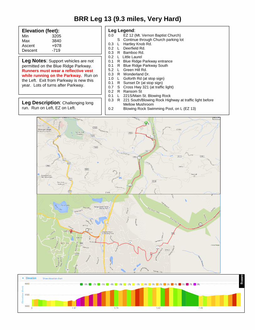
BRR Leg 13 (9.3 miles, Very Hard)
Elevation (feet): Min 3205 Max 3840 Ascent +978 Descent -719
Leg Legend: 0.0 EZ 12 (Mt. Vernon Baptist Church) S Continue through Church parking lot 0.3 L Hartley Knob Rd. 0.2 L Deerfield Rd. 0.3 R Bamboo Rd. 0.2 L Little Laurel 0.1 R Blue Ridge Parkway entrance 0.1 R Blue Ridge Parkway South 5.2 L Green Hill Rd. 0.3 R Wonderland Dr. 1.0 L Goforth Rd (at stop sign) 0.1 R Sunset Dr (at stop sign) 0.7 S Cross Hwy 321 (at traffic light) 0.2 R Ransom St 0.1 L 221S/Main St. Blowing Rock 0.3 R 221 South/Blowing Rock Highway at traffic light before Mellow Mushroom 0.2 Blowing Rock Swimming Pool, on L (EZ 13)
Leg Notes: Support vehicles are not
permitted on the Blue Ridge Parkway. Runners must wear a reflective vest while running on the Parkway. Run on the Left. Exit from Parkway is new this year. Lots of turns after Parkway.
Leg Description: Challenging long
run. Run on Left, EZ on Left.

BRR Leg 14 (6.2 miles, Hard)
Elevation (feet): Min 3451 Max 3874 Ascent +532 Descent -539
Leg Legend: 0.0 EZ 13 (Blowing Rock Swimming Pool) 0.0 R Clark St 0.0 L 221 South 6.2 Grandfather Country Store, on L (EZ 14)
Leg Notes: Stay alert for traffic on
221. Tight shoulders. Caution Runner signs will posted frequently to warn on-coming traffic.
Leg Description: Rolling on 221 South. Stay alert for
traffic. No turns. Run on Left, EZ on Left.

BRR Leg 15 (10.5 miles, Very Hard)
Elevation (feet): Min 3560 Max 4311 Ascent +1222 Descent -493
Leg Legend: 0.0 EZ 14 (Grandfather Country Store) 221 South 10.5 Grandfather Mountain, on L (EZ 15)
Leg Notes: Mostly desolate stretches of
road along the base of Grandfather Mountain. 221 is winding, stay alert.
Leg Description: Tough leg because of the distance and
because most of it is a climb. Run on Left, EZ on Left.

BRR Leg 16 (3.2 miles, Easy)
Elevation (feet): Min 3618 Max 4286 Ascent +15 Descent -675
Leg Legend: 0.0 EZ 15 (Grandfather Mountain, Old Yonahloosee Rd.) 1.6 R Remain on Old Yonahloosee Rd (DO NOT turn Left through gate.) 0.6 L 221 South 0.2 S Through traffic light 0.7 S Through traffic light 0.1 First National Bank shopping complex, on L (EZ 16)
Leg Notes: 221 and 181 are heavily
traveled. Be alert for traffic. Run on L. Vans are NOT permitted on Old
Yonahloosee Rd, must use 221 South.
Leg Description: Be alert for traffic on 221/181. Run on
Left, EZ on Left.

BRR Leg 17 (2.9 miles, Easy)
Elevation (feet): Min 3618 Max 3871 Ascent +247 Descent -225
Leg Legend: 0.0 EZ 16 (First National Bank Shopping Complex) 0.0 L Turn Left out of shopping complex on 181 South 2.9 Newland Elementary School, on L (EZ 17)
Leg Notes: 221 and 181 are heavily
traveled. Be alert for traffic. Run on L.
Leg Description: Be alert for traffic on 181. Run on Left,
EZ on Left.

BRR Leg 18 (5.0 miles, Moderate)
Elevation (feet): Min 3562 Max 4071 Ascent +570 Descent -379
Leg Legend: 0.0 EZ 16 (Newland Elementary School) 0.0 L Turn Left out of parking lot 0.4 R 194 North (at Traffic Light) 0.2 L Old Toe River Rd. (at Traffic Light) 0.8 L Cow Camp 3.2 R Spanish Oak 0.3 L Mt Pleasant Rd 0.1 Christmas Tree Lot, on L (EZ 18)
Leg Notes: Running through
downtown Newland, traffic lights, etc…, but quickly turns rural. Leg Description: Mostly rolling with a big climb on Cow Camp.
Be extra alert for traffic on Spanish Oak. Run on Left, EZ on Left.

BRR Leg 19 (5.8 miles, Hard)
Elevation (feet): Min 2869 Max 3837 Ascent +343 Descent -1306
Leg Legend: 0.0 EZ 18 (Mt. Pleasant Rd/Spanish Oak Rd) 3.3 L Lick Log 2.4 L 19E 0.1 Plumtree Presbyterian Church, on L (EZ 19)
Leg Notes: Rural route, but remain
alert for traffic on narrow roads. Leg Description: Big downhills and one good climb make this a
tough leg. Spanish Oak turns into Squirrel Creek. Run on Left, EZ on Right.

BRR Leg 20 (3.8 miles, Easy)
Elevation (feet): Min 2763 Max 2895 Ascent +148 Descent -184
Leg Legend: 0.0 EZ 19 (Plumtree Presbyterian Church) 3.8 Riverside Elementary School, on R (EZ 20)
Leg Notes: 19E is a heavily traveled
road. Be alert for traffic.
Leg Description: Flat and gentle downhill. Entire leg is on 19E.
No turns. Run on Left, EZ on Right.

BRR Leg 21 (8.0 miles, Very Hard)
Elevation (feet): Min 2710 Max 3209 Ascent +1019 Descent -985
Leg Legend: 0.0 EZ 20 (Riverside Elementary School) 1.4 R Hanging Rock Rd. 6.6 Mt. Carmel Baptist Church, on L (EZ 21)
Leg Notes: 19E is a heavily traveled
road. Be alert for traffic.
Leg Description: Long leg with some tough climbs. One turn
onto Hanging Rock Rd. Hanging Rock Rd. turns into Gouges Creek Rd. at the County Line, but is the same road. Run on Left, EZ on Left.

BRR Leg 22 (2.6 miles, Easy)
Elevation (feet): Min 2494 Max 2867 Ascent +24 Descent -363
Leg Legend: 0.0 EZ 21 (Mount Carmel Baptist Church) 0.1 R Cabin Road (No Vans on Cabin Rd) 0.9 L Beaver Creek Rd. at stop sign 0.1 R 19E (Run on Right on 19E) 0.1 R Oak Ave. to Spruce Pine 0.0 L Oak Avenue (in front of Bantom Chef) 1.1 L Highland Avenue 0.2 R Greenwood Road 0.1 Ingles Grocery Store, on L (EZ 22)
Leg Notes: Vans take 19E to Oak Ave
(do not drive on Cabin Rd). Runners are on 19E for less than 0.1 mile, run on the Right for this short segment. Otherwise, run on Left.
Leg Description: Easy leg. Run on Left, EZ on Left.
Run on Right for short segment of 19E only.

BRR Leg 23 (4.8 miles, Moderate)
Elevation (feet): Min 2504 Max 2727 Ascent +513 Descent -328
Leg Legend: 0.0 EZ 22 (Ingles Grocery) 0.2 R Stroup Rd (Vans not permitted on Stroup Rd) 0.3 LS Creed Pittman Rd 0.3 R Broadwater Way 0.1 L Meadow Lane 0.1 R 226 North 3.8 Ledger Ace Hardware on R (EZ 23)
Leg Notes: Run on the left on 226.
226 is heavily traveled. Be alert to traffic when running and when crossing to EZ.
Vans not permitted on Stroup Rd. Leg Description: Lots of turns early on. Long run on
226, remain alert for traffic. Run on Left, EZ on Right.

BRR Leg 24 (5.8 miles, Moderate)
Elevation (feet): Min 2436 Max 2917 Ascent +338 Descent -598
Leg Notes: 226 is heavily traveled.
Remain alert for traffic.
Leg Legend: 0.0 EZ 23 (Ledger Ace Hardware)
Remain on 226 North 5.1 L South Mitchell Ave. 0.4 L Baker Lane (street sign on Left) 0.2 R Remain on Baker Lane at Friendship Baptist Ch. 0.1 Bakersville Fire Dept., on R (EZ 24)
Leg Description: Long run on 226 to Bakersville. Run
on Left, EZ on Right.

BRR Leg 25 (4.3 miles, Moderate)
Elevation (feet): Min 2290 Max 2492 Ascent +287 Descent -244
Leg Legend: 0.0 EZ 24 (Bakersville Fire Dept.) 0.0 Cross bridge 0.0 L Route 226 4.3 Red Hill Baptist Church, on L (EZ 25)
Leg Notes: 226 is more heavily
traveled, although the traffic will be lighter during night hours, stay alert for traffic.
Leg Description: The distance, but mostly the rolling
hills and big finishing hill make this moderate. Run on Left, EZ on Left.

BRR Leg 26 (4.4 miles, Moderate)
Elevation (feet): Min 2187 Max 2570 Ascent +503 Descent -572
Leg Legend: 0.0 EZ 25 (Red Hill Baptist Church) 1.0 S Remain on 226 N, 197 N joins 0.1 L 197 North 1.9 L Remain on 197 N at Harrell Hill Rd. (after bridge) 1.4 Tipton Hill Elementary School, on R (EZ 26)
Leg Notes: 226 N often carries more
traffic than 197 N. Both roads have many curves, stay alert for traffic.
Leg Description: Some difficult hills, but the distance
makes this moderate. Run on Left, EZ on Right.

BRR Leg 27 (9.1 miles, Hard)
Elevation (feet): Min 2071 Max 2513 Ascent +371 Descent -474
Leg Legend: 0.0 EZ 26 (Tipton Hill Elementary School) 2.0 L Whitson Branch Rd. / Green Mt. Rd. (turn left before going under the bridge) 0.3 R cross RR tracks (do NOT race the train) 0.1 L after bridge, Green Mountain Rd. 3.1 R Jacks Creek Rd. 3.6 Clearmont School Road, on L (EZ 27)
Leg Notes: The RR tracks are active,
even at night. Stay alert for trains and do not attempt to race the train. Leg Description: The distance makes this a hard leg.
Run on Left, EZ on Left.

BRR Leg 28 (8.0 miles, Hard)
Elevation (feet): Min 2332 Max 2721 Ascent +627 Descent -255
Leg Legend: 0.0 EZ 27 (Clearmont Elementary School) 6.5 L 19 E 1.5 L Charlie Brown Rd 0.0 State Employees Credit Union, on R (EZ 28)
Leg Notes: Jacks Creek is a winding
road. Run alert. Construction on 19E.
Leg Description: The distance and a steady climb make
this a “Hard’ leg. Remain on Jacks Creek until intersection with 19E. Construction on 19E. Run on Left, EZ on Left.
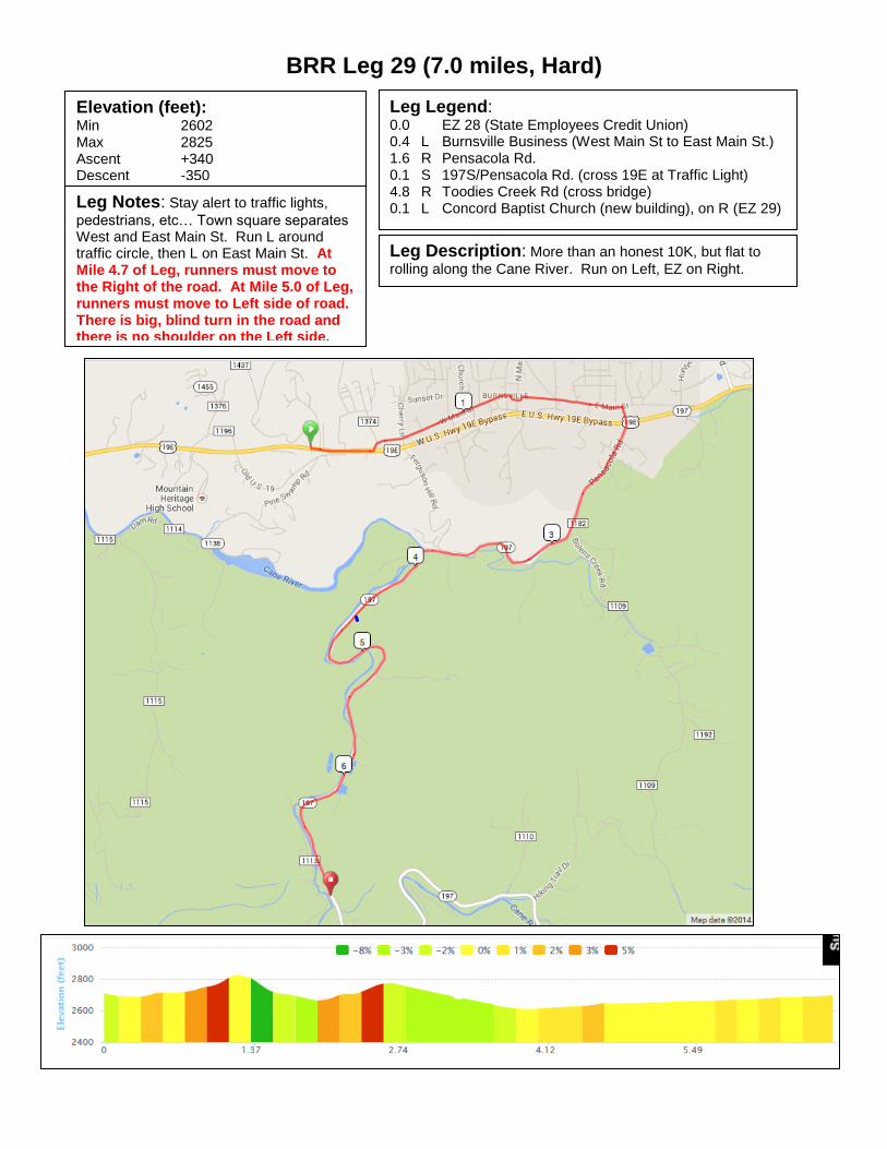
BRR Leg 29 (7.0 miles, Hard)
Elevation (feet): Min 2602 Max 2825 Ascent +340 Descent -350
Leg Legend: 0.0 EZ 28 (State Employees Credit Union) 0.4 L Burnsville Business (West Main St to East Main St.) 1.6 R Pensacola Rd. 0.1 S 197S/Pensacola Rd. (cross 19E at Traffic Light) 4.8 R Toodies Creek Rd (cross bridge) 0.1 L Concord Baptist Church (new building), on R (EZ 29) Leg Notes: Stay alert to traffic lights,
pedestrians, etc… Town square separates West and East Main St. Run L around traffic circle, then L on East Main St. At Mile 4.7 of Leg, runners must move to the Right of the road. At Mile 5.0 of Leg, runners must move to Left side of road. There is big, blind turn in the road and there is no shoulder on the Left side.
Leg Description: More than an honest 10K, but flat to
rolling along the Cane River. Run on Left, EZ on Right.

BRR Leg 30 (4.4 miles, Easy)
Elevation (feet): Min 2680 Max 2861 Ascent +205 Descent -43
Leg Legend: 0.0 EZ 29 (Concord Baptist Church) 0.1 R 197 South 4.3 Laurel Branch Baptist Church, on R (EZ 30)
Leg Notes: No turns. Leg Description: Flat along the Cane River. Run on
Left, EZ on Right.

BRR Leg 31 (6.5 miles, Mountain Goat Hard)
Elevation (feet): Min 2861 Max 4263 Ascent +1398 Descent -1
Leg Legend: 0.0 EZ 30 (Laurel Branch Baptist Church) 1.4 R 197 South Continues 5.1 The top, on L (EZ 31)
Leg Notes: After 1.4 miles take the
hard right at Murchison (stay on 197 South). The EZ is at the top!
Leg Description: The topo says it all. Run on the Left,
EZ on Left.

BRR Leg 32 (9.4 miles, Very Hard)
Elevation (feet): Min 2185 Max 4264 Ascent +1 Descent -2073
Leg Legend: 0.0 EZ 31 (gravel begins) 4.4 S gravel ends, paved begins 4.9 L Paint Fork 0.1 Barnardsville Elemen. School, on R (EZ 32)
Leg Notes: Gravel most of the way.
Don’t be fooled…you’ll cross a bridge that is paved about 0.5 before the gravel truly ends. Only one turn on Paint Fork.
Leg Notes: The distance, the gravel road, and all downhill
on tired legs make this very hard. Run on Left, EZ on Right.

BRR Leg 33 (5.3 miles, Mountain Goat Hard)
Elevation (feet): Min 2188 Max 3097 Ascent +895 Descent -664
Leg Legend: 0.0 EZ 32 (Barnardsville Elementary School) 3.1 S Maney Branch Rd. 2.1 S Reems Creek Rd. 0.1 Beech Community Center baseball field, on
R (EZ 33)
Leg Notes: Paint Fork and Maney Branch
are winding. Stay alert for traffic. Paint Fork changes to Maney Branch at the top of the climb. Same road. NO turns.
Leg Notes: Steepest climb and steepest descent
of the Relay. History requires a Mountain Goat rating. No turns. Run on Left, EZ on Right after stop sign.

BRR Leg 34 (4.5 miles, Moderate)
Elevation (feet): Min 2182 Max 2431 Ascent +282 Descent -271
Leg Legend: 0.0 EZ 33 (Beech Community Center Baseball Field) 0.1 R Reems Creek Rd. 2.4 L Ox Creek Rd. 2.0 South Fork Ind. Methodist Church, on L (EZ 34)
Leg Notes: Reems Creek is heavily
traveled. Ox Creek is winding. Stay alert for traffic.
Leg Description: Easiest of the last 6 legs, but a difficult
third leg. Moderate because of the distance and elevation. Run on Left, EZ on Left.

BRR Leg 35 (4.2 miles, Hard)
Elevation (feet): Min 2427 Max 3363 Ascent +920 Descent -244
Leg Legend: 0.0 EZ 34 (South Fork Ind. Methodist Church) 2.2 L Blue Ridge Parkway entrance 0.3 R Blue Ridge Parkway 1.7 R Craven Gap Exit 0.1 Gravel Shoulder, on R (EZ 35)
Leg Notes: Ox Creek is winding. Stay
alert for traffic. At the top of the climb, stay left to the Parkway. Reflective vests are required on the Parkway.
Leg Description: Winding and big climb on Ox Creek.
But leg finishes with a gradual descent and big views from the Parkway. The climb makes this hard. Run on Left, EZ on Right.

BRR Leg 36 (6.5 miles, Very Hard)
Elevation (feet): Min 2182 Max 3432 Ascent +354 Descent -1268
Leg Legend: 0.0 EZ 35 (Craven Gap Exit) 6.3 R College St. (Run on Right sidewalk) 0.2 R At traffic circle onto Oak St 0.05 R One Oak Plaza parking lot (Finish)
Leg Notes: Stay alert for traffic on
Town Mt. Rd. (694). Early morning fog may require reflective vest.
Leg Description: The Glory Leg! Run on Left on Town
Mountain Rd. Run on Right sidewalk on College St to the Finish.