british permian-trassic stratigraphyjncc.defra.gov.uk/pdf/v24chap1.pdf · allowed animals to...
TRANSCRIPT

Chapter 1
General introduction
From:Benton, M., Cook, E. & Turner, P., (2002), Permian and Triassic Red Beds and the Penarth Group of Great Britain, Geological Conservation Review Series, No. 24, Joint Nature Conservation Committee, Peterborough, 337 pages, illustrations, A4 hardback, ISBN 1 86107 493 XFor more information see: http://www.jncc.gov.uk/page-2967


The Permo–Triassic world
3
SCOPE OF THE VOLUME
The present volume describes sites selected forthe Geological Conservation Review that exem-plify the Permian and Triassic red-bed sedimentsof Britain. Although the main focus of the bookis the Permian and Triassic continental sedi-ments, 13 sites that represent the British marinePenarth Group (formerly called the ‘Rhaetic’) arealso described (marine Permian GCR sites aredescribed in another volume of the GCR Series(Smith, 1995)). The Penarth Group sites areincluded here because the deposits were laiddown during a relatively short span of time atthe end of the Triassic Period (perhaps only oneor two million years in duration) that provide atransition from the Triassic red beds into themarine Lower Jurassic Series (the ‘Lias’).
THE PERMO–TRIASSIC WORLD
The Permian and Triassic periods, ranging fromabout 291 to 199 million years (Ma) ago, weretimes of major change on the Earth. During thistime, through plate tectonics, the continentsmoved together to form the supercontinentPangaea (‘all Earth’), a single landmass thatextended virtually from pole to pole, and whichallowed animals to migrate unimpeded fromwhat is now ‘Australia’ to what is now ‘Canada’(Figure 1.1a). Later, towards the end of theTriassic Period, break-up of Pangaea began, andthe incipient North Atlantic Ocean began toopen up between what we now know as‘Europe’ and ‘North Africa’ on the one side, and‘North America’ on the other (Figure 1.1b).
There were also immense changes in climatesas well as in palaeogeography. The PermianPeriod began with a major glaciation inGondwana (a southern hemisphere super-continent that had fused with Laurasia to formPangaea). The glaciation began in theCarboniferous Period and came to an endduring the Early Permian Epoch. Elsewhere,climates throughout the Permian and Triassicperiods were generally hot, and conditions com-monly arid. Indeed, much of the classicPermo–Triassic succession in Great Britain, andelsewhere, consists of ‘red beds’, sediments laiddown in generally hot conditions either indeserts or in rivers and lakes, their predominantred-iron coloration attesting to the highly oxi-dizing environments in which they accumulated.
Mass extinctions
There were vast planet-wide upheavals twiceduring this time interval, one at the end of thePermian Period, 251 Ma ago, and the other at theend of the Triassic Period, about 199 Ma ago.These were two of the ‘big five’ mass extinctionswhen many diverse groups of plants, animals,and microbes suffered unusually high levels ofextinction (Figure 1.2), for which various causes,varying from bolide impacts to volcanic events,have been hypothesized. Many biologistsbelieve we are living through the sixth massextinction now, judging by the rate at whichspecies are being wiped out by human activity.
The end-Permian mass extinction was by farthe largest ever on Earth. Perhaps as many as96% of all marine species became extinct, whileon land more than three-quarters of all verte-brate families were lost; only 4% of knownspecies survived through the event into theTriassic Period. This is the nearest that life onEarth has yet come to total annihilation.
Although there is little fossil material in thered beds at the Permian–Triassic boundary inBritain that exemplify the impact on the faunaand flora, comparisons of the fossil record frommarine Permian rocks and marine Triassic rocksreveal the extent of faunal changes (Figure 1.2).
Life had flourished essentially unchallengedduring the Carboniferous and Permian periods:crinoids, corals, nautiloids, ammonoids and fish-es diversified in the seas, and amphibians andmammal-like reptiles continued their invasion ofthe land. However, after more than 100 millionyears of relative stability, the end of the PermianPeriod was marked by huge changes to the life ofthe time; these were far more devastating thanthe much more famous end-Cretaceous massextinction when the dinosaurs died out.
In the sea, reefs were destroyed, and withthem disappeared the last of the rugose and tab-ulate corals, as well as major groups of bry-ozoans, echinoderms, foraminifera, ostracods,brachiopods, gastropods, bivalves, ammonoids,nautiloids, and fishes. This huge ‘clear-out’ ofclassic Palaeozoic animals opened the way fornew groups of corals to arise later in the TriassicPeriod, and for previously minor groups of bryo-zoans, bivalves, echinoderms, and ammonoidsto come to the fore.
On land too, the end-Permian mass extinctiondestroyed the complex ecosystems of amphib-ians and mammal-like reptiles, and left only

General introduction
4
remnants behind in the earliest Triassic times,from which arose the dinosaurs, pterosaurs,marine reptiles, and mammals. Some of theseterrestrial forms appear sporadically in the fossilrecord, either as skeletal remains or as footprintsin the British Permo–Triassic red beds, but therecord is sparse.
The magnitude of the crisis is indicated by the
recovery phase in the Triassic Period. Wholehabitats had gone and took millions of years toreturn. For example, it took 20 million yearsbefore new kinds of reefs became re-established,being built, of course, by organisms differentfrom those that built the Permian reefs. After theend-Permian event there is a famous ‘coal gap’,when no coal is found at all: the forests had been
Figure 1.1 Palaeogeography (palaeocoastline) of (a) the Early Triassic (Induan–Olenekian) world c. 250 Ma,showing Pangaea, which had been assembled from Laurasia and Gondwanaland, and (b) the Late Triassic(Rhaetian) world c. 200 Ma. At the end of the Triassic Period Pangaea began to rift apart. The maps show themain areas of land and mountains, with ‘modern’ coastlines superimposed for reference (after Smith et al.,1994).

The Permo–Triassic world
5
devastated, and burial of plant material in signif-icant quantites came to a complete halt for 20million years. The diverse and complex ecosys-tems of mammal-like reptiles, including massive,rhinoceros-sized plant-eaters, and sabre-toothedgorgonopsians that preyed on them, were gone,and only some small to medium-sized amphib-ians and reptiles inhabited the Early Triassicworld. However, 30 Ma later, ecosystems hadbegun to diversify on land again, and this co-incided with the radiation of the dinosaurs.
Many causes have been proposed for the end-Permian mass extinction, including changes insea level or salinity. At one time, a key cause wasthought to have been the coming together of thecontinents to form the supercontinent Pangaea(Figure 1.1), a process that reduced the numbersand area of shallow seas, and which allowedland animals to move all over the globe. Thissupposedly wiped out all local floras and faunasand reduced overall global diversity. Since theyear 2000, however, it has become clear that theevent was rapid, not drawn out over some 10–20Ma, as had been thought, but occupying 500 000years or less. This has moved the focus of atten-tion to more rapid processes. Some geologists,for example, have suggested that the extinctionwas produced by a major asteroid impact on theEarth. However, evidence for such an impact isweak, despite some recent excitement about thediscovery of fullerenes in boundary sediments(Becker et al., 2001), supposed indicators of anextraterrestrial source of material. Most likely,the huge end-Permian event was caused by vastbasaltic eruptions in Siberia, which producedenormous quantities of gases, notably sulphurdioxide, that caused a massive decrease in airand sea temperatures, and created a major an-oxic episode (Erwin, 1993; Hallam and Wignall,1997).
Further minor extinction events in the TriassicPeriod, at the end of the Olenekian Age, c. 245Ma ago, and at the end of the Carnian Age, c. 220Ma ago, were responsible for killing off someanimal groups, but they did not affect all of life.The end-Carnian event in particular was associ-ated with a major turnover of vertebrates onland: dominant herbivorous mammal-like rep-tiles disappeared, and the dinosaurs radiatedexplosively into the abandoned environmentalniches. However, the end-Triassic event –another of the ‘big five’ mass extinctions – wassmaller than the end-Permian event, witnessingthe loss of perhaps 50% of species, particularly
Figure 1.2 The fates of many animal groups in thesea were determined dramatically by the end-Permianmass extinction event, some suffering major restric-tions in diversity, others being entirely wiped out.(Based on the work of J.J. Sepkoski, Jr.) The width ofthe bands is proportional to the number of con-temporary families present.

General introduction
6
those in the sea. This was again perhaps associ-ated with anoxia and major sea-level change(Hallam and Wignall, 1997). There is someslightly stronger evidence for asteroid impact atthe Triassic–Jurassic boundary (there are ind-icators such as some weakly ‘shocked’ quartz,and some iridium – Hallam and Wignall, 1997),but that evidence is not wholly convincing.
STRATIGRAPHY OF THE PERMIANAND TRIASSIC SUCCESSIONS
The Permian: international standards
The Permian System was named and defined byMurchison (1841), and was based on thesequence of marine and continental rocks hehad seen around the town of Perm, on the westside of the Ural Mountains, and in the moun-tains and plains to the west and south. It wasclear, before he went to Russia in the companyof E. de Verneuil and A. von Keyserling, thatthere was a distinct stratigraphical unit betweenthe Carboniferous and the Triassic rocks ofGermany and Great Britain, which was thencalled, rather inadequately, the ‘early’ or ‘lower
New Red Sandstone’. However, in westernEurope, it had been hard to define where thisunit began and ended. In Russia, Murchisonfound floras and distinctive faunas of inverte-brates, fishes, and land tetrapods, which provid-ed a basis for the separation and recognition of‘Permian’ strata, which could then be recognizedin western Europe by comparison of faunas.
Murchison’s ‘Permian System’ comprisedrocks later assigned to the Kungurian, Kazanian,and Tatarian stages, essentially the Middle andUpper Permian (Figure 1.3). Older rocks heassigned to the ‘Carboniferous’, or ‘Permo–Carboniferous’, and this confusion continuedwell into the 20th century. Russian workers sub-sequently extended the Permian System down-wards by erecting the Artinskian, Sakmarian, andAsselian stages, and introduced the UfimianStage between the Kungurian and Kazanianstages (Smith et al., 1974; Warrington, 1996).
The Russian sections are not entirely satisfac-tory as a global standard succession, since partsof the sequence are missing, and the upper partsare continental. Although fossils are present inthese upper units in the Ural Mountains, theyare mainly plants and continental invertebratesand vertebrates, including amphibians and
Figure 1.3 Permian stratigraphy, showing the international scale (Jin Yugan et al., 1997), and main equivalentdivisions from successions in Germany and central Europe, Russia, and North America. The Illawarra magnet-ic reversal event (IR) is documented in the top Wordian Stage, and high in the Rotliegendes, so the ‘Zechstein’lithostratigraphical unit falls in the Capitanian Stage or higher. (Based on Jin Yugan et al., 1997 and Wardlaw,2000.)

Permian and Triassic stratigraphy
7
reptiles, and are of limited use in global correla-tion because of their comparative rarity. Debatehas continued since the 1970s about the relativemerits of more complete and fully marine sec-tions in China and North America in particular,and a new stage nomenclature (Figure 1.3),based upon marine successions in Russia, for theLower Permian (Cisuralian Series), in the USAfor the Middle Permian (Guadalupian Series),and China, for the Upper Permian (LopingianSeries) was ratified in 1996 (Jin Yugan et al.,1997).
The British Permian succession
Permian rocks occur widely in the British Isles,in a number of separate ancient depositionalbasins, from the Hebrides and west of Scotland,through the English Midlands, to Devon. Inplaces, the successions are entirely continental,but in others there is a change from earlier,broadly continental, sedimentation, to later,broadly marine, deposition. There are alsovolcanic rocks of Permian age at some localities.
The stratigraphy of the British Permian redbeds has long been problematic. At first, in theearly 19th century, all red beds between thereadily identifiable marine and coal-bearingCarboniferous and the marine Lower Jurassicstrata were termed collectively the ‘New RedSandstone’. After the introduction of the term‘Triassic’ in Germany in 1834, the lower ‘NewRed Sandstone’ had a variable definition, equat-ing with what in Germany were termed the‘Rotliegendes’ (red beds) and the ‘Zechstein’(marine limestones and evaporites), and oftenalso the overlying ‘Unter Buntsandstein’.
The earlier Permian succession in GreatBritain, dominated by continental deposits, isparticularly hard to subdivide and correlate,since the styles of sedimentation are almostcertainly specific to each basin. However, Smithet al. (1974, pp. 6–7) argued that there weresome broader-scale changes in climate and land-scape through the Early and early-Mid Permiantimes that would probably be reflected in thesediment types, and which might provide arough guide to correlation. Hence, they notedthat, in each basin, there is a general tendencyfor water-laid sands and breccias to be succeed-ed by aeolian sands, reflecting a decrease in rain-fall and relief through time. These are followedby water-laid sediments deposited following anincrease in rainfall, perhaps associated with the
Zechstein transgressions. These broad changesin the physical environment have been used toprovide very rough correlations when other evi-dence is lacking.
Dating of the Permian red beds is difficult.Plant fossils and reptile bones and footprintshave been reported from a few scattered locali-ties, and these provide very rough indications ofage, but at best only to stage level, by compari-son between basins in the British Isles, and bycomparison with Permian red bed successions inFrance, the Netherlands, Germany, Poland, andRussia. Interbedded volcanic rocks in some ofthe British Permian red-bed sequences have pro-vided radiometric dates that are invaluable inproviding evidence of age in palaeontologicallybarren successions.
The Zechstein transgression provides animportant time datum, if the assumptions aboutthat transgression (see below) are correct.Dating within the marine Zechstein facies is rel-atively straightforward, based on the range ofmarine fossils, even though the eastern(Zechstein) and western (Bakevellia) basins inthe north of England were separated by thePennine Ridge. These marine units have beendescribed in a separate Geological ConservationReview (GCR) volume, Marine Permian ofEngland (Smith, 1995).
The base and top of the Permian System inGreat Britain are hard to define (Smith et al.,1974, pp. 8–10). It is believed that, in mostbasins, there was a hiatus in sediment dep-osition around the end of the Carboniferous andthe beginning of the Permian periods, but theduration of the gap is hard to define because ofthe general absence of fossils. So, in somebasins, the lowest continental red beds may beStephanian (latest Carboniferous) in age. In theMauchline Basin in south-west Scotland, plantfossils suggest that the lowest red beds are prob-ably of earliest Permian age, and this is acceptedbroadly for other basins that contain similar redbeds.
In the English Midlands, red-bed sedimenta-tion began in the Late Carboniferous Epoch, andthe onset of such continental conditions is datedas Westphalian D. In particular, the Keele Bedsand the Enville Beds have shuttled between theCarboniferous and the Permian. The currentview (Smith et al., 1974; Glover and Powell,1996; Bridge et al., 1998; Powell et al., 2000) isthat the Keele Beds are Stephanian in age, andthe Enville Beds are also latest Carboniferous,

General introduction
8
even though definitive fossil evidence is lacking.The base of the Permian succession in theMidlands is tentatively placed at the base of theClent Formation and equivalent breccia unitsfound throughout the Midlands. Fossil amphib-ians and reptiles in the overlying KenilworthSandstone Formation in Warwickshire constrainthe age of the Clent Formation. In Devon, radio-metric dates with means of 282, 287, and 291 Mahave been recorded from lavas interbedded withbreccias and sandstones in the lower part of theExeter Group, a Carboniferous (?) to Permianred-bed succession (Edwards et al., 1997); theage of the base of the Permian Period is about291 Ma (Wardlaw, 2000).
The definition of the top of the BritishPermian succession is highly subjective sincethere is no fossil or radiometric age evidence toconstrain closely the Permo–Triassic boundaryanywhere in the British Isles (Pattison et al.,1973; Smith et al., 1974, pp. 7–8; Warrington etal., 1980, pp. 9–10). The only hint of dating evi-dence comes from palynomorphs in the isolatedKingscourt Outlier in Ireland (Gardiner andVisscher, 1971; Visscher, 1971), which constrainthe boundary within a 30–60 m section. This isdiscussed further below (in the section entitled‘The revised scheme for the British Triassic suc-cession’) and in the introduction to Chapter 3 ofthe present volume.
The classic Germanic divisions ofthe Triassic Succession
The Triassic succession of Great Britain is divid-ed into a number of stratigraphical units that aregenerally hard to assign confidently to theLower, Middle, and Upper Triassic divisions. Forthis reason, the Triassic red-bed units through-out the country are all treated together inChapter 3. The uppermost Triassic sites thatinclude the marine-influenced Penarth Group(‘Rhaetic’) are distinctive, and are treated sepa-rately in Chapter 4.
In Europe, the Triassic System is representedin the north by the ‘Germanic’ sequence, whichis largely continental in origin, and in the southby the essentially marine Tethyan ‘Alpine’sequence. The standard global stratigraphicalschemes for the Triassic strata were based firston the Alpine successions that containammonoids and other biostratigraphically usefulfossils. More recently, attention has switched tomarine successions in North America (Tozer,
1967, 1979, 1984; Silberling and Tozer, 1968).Macrofossils are rare, or absent, in many units ofthe Germanic Triassic succession, and correla-tion of that largely red-bed continental succes-sion with the marine successions was difficult,prior to the development of palynological stud-ies since 1960.
The name ‘Trias’ was proposed by Alberti(1834) to unite the then three divisions,‘Bunter’, ‘Muschelkalk’, and ‘Keuper’, of the suc-cession in Germany. These lithostratigraphicaldivisions have often been equated loosely withthe Lower, Middle, and Upper Triassic series.However, the Bunter and Keuper are partly ofMid Triassic age, and the Muschelkalk representsonly part of Mid Triassic time. The Bunter–Muschelkalk and Muschelkalk–Keuper bound-aries are apparently diachronous across theGermanic basin. Classically, the British Triassicred beds were equated, as far as possible, withthe Germanic Triassic strata. However, therehave always been problems in using this scheme,not least because the marine Muschelkalk is notdeveloped in Great Britain. Hence, an inde-pendent stratigraphical system was proposed byWarrington et al. (1980). The development ofTriassic stratigraphy in Britain is summarizedbelow.
From the beginning of the 19th century,British geologists recognized a unit of generallyred sandstones and mudstones lying betweenthe Carboniferous and Jurassic strata. This evi-dently continental intercalation between twoclearly marine systems was called the ‘New RedSandstone’, to distinguish it from the other thickunit of red sandstones that lay below theCarboniferous rocks, the ‘Old Red Sandstone’.It proved hard to subdivide the New RedSandstone, largely because fossils were rare orabsent. For example, Sedgwick and Murchison(1829a), in describing the New Red Sandstone ofnorthern England, identified seven lithologicaldivisions, the upper two of which, the ‘Upperred sandstone’ and ‘Upper red marl and gyp-sum’ were equated with the German Bunter andKeuper respectively. Geologists continued touse the term ‘New Red Sandstone’ well into themiddle of the 19th century, especially for the redand yellow sandstones that might have beeneither Permian or Triassic in age, but Alberti’sterm ‘Trias’ was introduced to England throughthe 1830s and 1840s.
This rather unsatisfactory situation continueduntil the results of the British Geological
Permian and Triassic stratigraphy
9
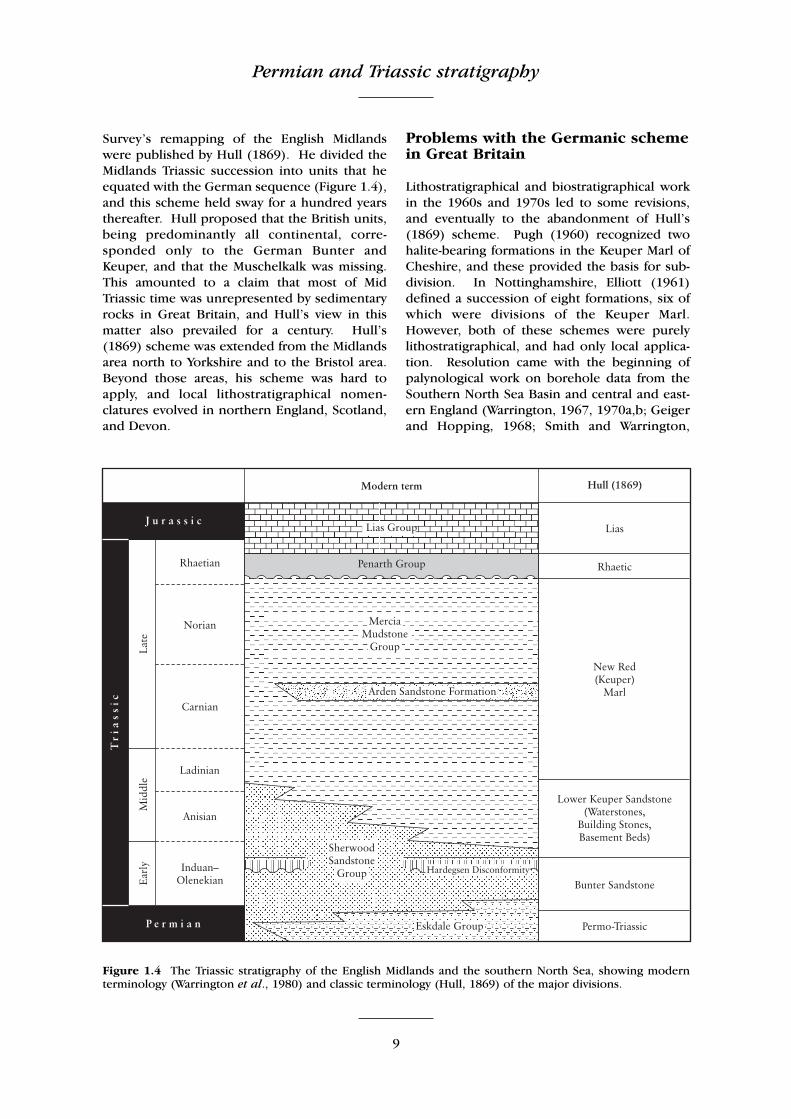
Survey’s remapping of the English Midlandswere published by Hull (1869). He divided theMidlands Triassic succession into units that heequated with the German sequence (Figure 1.4),and this scheme held sway for a hundred yearsthereafter. Hull proposed that the British units,being predominantly all continental, corre-sponded only to the German Bunter andKeuper, and that the Muschelkalk was missing.This amounted to a claim that most of MidTriassic time was unrepresented by sedimentaryrocks in Great Britain, and Hull’s view in thismatter also prevailed for a century. Hull’s(1869) scheme was extended from the Midlandsarea north to Yorkshire and to the Bristol area.Beyond those areas, his scheme was hard toapply, and local lithostratigraphical nomen-clatures evolved in northern England, Scotland,and Devon.
Problems with the Germanic schemein Great Britain
Lithostratigraphical and biostratigraphical workin the 1960s and 1970s led to some revisions,and eventually to the abandonment of Hull’s(1869) scheme. Pugh (1960) recognized twohalite-bearing formations in the Keuper Marl ofCheshire, and these provided the basis for sub-division. In Nottinghamshire, Elliott (1961)defined a succession of eight formations, six ofwhich were divisions of the Keuper Marl.However, both of these schemes were purelylithostratigraphical, and had only local applica-tion. Resolution came with the beginning ofpalynological work on borehole data from theSouthern North Sea Basin and central and east-ern England (Warrington, 1967, 1970a,b; Geigerand Hopping, 1968; Smith and Warrington,
Figure 1.4 The Triassic stratigraphy of the English Midlands and the southern North Sea, showing modernterminology (Warrington et al., 1980) and classic terminology (Hull, 1869) of the major divisions.

General introduction
10
1971). This enabled correlation between theBritish and German successions, and resolved anumber of outstanding stratigraphical problems.Warrington et al. (1980) summarized the threekey findings that came from the palynologicalstudies.
1. There are sedimentary successions of MidTriassic age in Great Britain. The Muschelkalkfacies itself may not be developed in theBritish Isles, but deposits of the same ageoccur in red-bed sequences. The ‘LowerKeuper Sandstone’ of Hull (1869) comprisesrocks equivalent in age to part of the GermanUpper Bunter and Muschelkalk; thus, his useof the terms ‘Bunter’ and ‘Keuper’ is notmeaningful, and they are best abandonedwhen referring to the British Triassic succes-sion.
2. Many of the Triassic facies in Great Britain arediachronous. For example, the base of theKeuper Marl is older in west Lancashire thanin the Midlands.
3. Hull’s (1869) stratigraphical scheme for theTriassic red beds of the Midlands cannot beapplied readily in all other areas. It had beenassumed that the particular sandstone andmudstone units that he recognized had a widegeographical distribution. This is not neces-sarily the case. Most of the units that he iden-tified in the Midlands are of local extent only,and the Triassic succession in other basins isoften quite different.
The revised scheme for the BritishTriassic succession
In making their radical proposals for a majoroverhaul of the British Triassic stratigraphicalscheme, Warrington et al. (1980, pp. 9–11)noted the difficulties in establishing objectivechronostratigraphical correlations. The base ofthe Triassic System cannot be identified withconfidence anywhere in the British Isles, despitethe fact that many successions apparently spanthe Permo–Triassic boundary (Pattison et al.,1973). These boundary sequences are virtuallyall unfossiliferous, and the only hint of datingevidence comes from palynomorphs in theisolated Kingscourt Outlier in County Cavan,Ireland (Gardiner and Visscher, 1971; Visscher,1971; see Figure 1.7). In the absence of a firmbiostratigraphical definition, Warrington et al.(1980) chose an arbitrary horizon to mark the
base of the Triassic System in the British Isles,the lateral lithostratigraphical correlative of thebase of the Bröckelschiefer. This is the acceptedbase of the Triassic System in Germany, a unitthat lies on top of the classic Zechstein (pre-sumed latest Permian in age) and below anargillaceous unit, the ‘Bunter Shale’. The base ofthe Bröckelschiefer has been traced throughboreholes in the North Sea to the Durham andYorkshire coasts (Rhys, 1974; Cameron, 1993;Johnson et al., 1994).
The upper boundary of the Triassic System isdefined by the base of the Jurassic System, whichis internationally recognized as being at the baseof the planorbis subzone of the planorbisAmmonite Zone of the Hettangian Stage(George et al., 1969; Cope et al., 1980;Warrington et al., 1980). The lowest few metresof the Lias, the ‘Pre-planorbis Beds’, are regard-ed as Triassic in age; this is discussed in moredetail in Chapter 4.
It has not been possible to place internationalchronostratigraphical stage boundaries withinBritish Triassic successions with any confidence(Warrington et al., 1980, pp. 10–11), but itseems probable that all stages, the Induan,Olenekian, Anisian, Ladinian, Carnian, Norian,and Rhaetian, are present; locally palynologyand magnetostratigraphy have provided moreprecise correlations with the marine standard.In other cases, fossil macroplant remains, fishes,and even tetrapods have been used to establishgeneral ages, usually no more precisely than tostage level. However, in some British Triassicsedimentary basins, there are no fossils of anykind, and in the absence of radiometric dates ormagnetostratigraphical evidence, there is virtual-ly no constraint on age.
Warrington et al. (1980) proposed a lithos-tratigraphical scheme for the British Triassic suc-cession. The classic terms ‘Bunter’ and ‘Keuper’were abandoned, as were a number of otherpoorly defined terms (e.g. ‘Waterstones’).Formations recognized in Triassic sequences inBritain constituted three major lithostratigraphi-cal units, the Sherwood Sandstone Group, theMercia Mudstone Group, and the Penarth Groupthat are applicable throughout most of theBritish Isles. The first two groups comprise theBritish Triassic red-bed sequences and aredescribed mostly in Chapter 3; some are, withthe Penarth Group, the subject of Chapter 4.
The Sherwood Sandstone Group is a thicksequence of sandstones largely in the lower part
Structural setting
11
of the Triassic System throughout Great Britain;it is broadly equivalent to units previously called‘Bunter’ and the arenaceous (lower) part of the‘Keuper’. The base is strongly diachronous,probably ranging in age from latest Permian toearly Triassic. The Sherwood Sandstone Groupcomprises formations in the arenaceous succes-sion between the Saliferous Marls (wherepresent) and the base of the Mercia MudstoneGroup. The top is also diachronous, andbecomes younger from the Irish Sea and NorthSea areas into the Midlands and southernEngland. The Sherwood Sandstone Group maybe up to 1500 m thick, but thins substantially inthe south.
The Mercia Mudstone Group comprises pre-dominantly argillaceous formations and evapor-ites that lie between the Sherwood Sandstoneand Penarth groups. It is largely equivalent tothe old ‘Keuper Marl’. The lower boundary isusually sharp, but may be gradational, in whichcase it is placed where mudstone and siltstonebecome dominant over sandstone. The base isdiachronous, as noted above, but the contactwith the Penarth Group is usually slightly dis-conformable. The Mercia Mudstone Groupvaries greatly in thickness, from over 1350 m inthe centre of basinal areas, to as little as 200 mover structural highs, and to 0 m at localitieswhere depositional margins are preserved.
The Penarth Group
This volume includes coverage of the PenarthGroup, formerly called the ‘Rhaetic’, somethingof an unusual addition to a volume concernedmainly with ‘red-bed’ sediments. However, thePenarth Group represents the deposits laiddown during a relatively short span of time atthe end of the Triassic Period – estimated vari-ously at only one or two million years in dura-tion – that was a prelude to the marine LowerJurassic (= Lias Group). The Penarth Group isof Rhaetian age and there is no question what-ever that it is part of the Triassic succession. Thechange in sedimentary style, from red bed todark-coloured marine sediments, is dramaticenough, but it is local to central and westernEurope, and not a worldwide phenomenon, andit is not associated with major faunal and floralchanges. Such changes occur higher in the suc-cession, around the Triassic–Jurassic boundary,as formally defined.
The Penarth Group is noted for its sharp,
unconformable boundary with the underlyingBlue Anchor Formation of the Mercia MudstoneGroup. In general accounts, writers describethis horizon as marking the level at which theRhaetian sea waters flooded across the playasand brackish sabkhas. Penarth Group sedimentsare marine, as indicated by their fossil content,including, for example, dinoflagellate cysts,corals, brachiopods, bivalves, echinoderm debrisand ichthyosaur bones. The sediments consistpredominantly of blue, grey, and black shalesand limestones, arranged in laterally extensive,but generally thin, units. Bone beds, units con-taining abundant transported bones, teeth,coprolites, and phosphatic debris of mixedmarine and continental derivation, occur inplaces. A basal bone bed occurs at some loca-tions, but there are in fact ‘Rhaetic’ bone beds atseveral horizons.
STRUCTURAL SETTING
Introduction
The Permo–Triassic basins of the western UK fol-low a roughly north–south linear rift system, theClyde Belt (McLean, 1978; Coward, 1995),which was strongly influenced by the underlyingstructural grain. A number of different riftsystems can be identified (Ziegler, 1990) thatcontain a large number of individual basins,typically with a basin fill of 1–4 km of mostlycontinental red beds and evaporites. Isopachmaps constructed for the Triassic strata of north-western Europe (Ziegler, 1990) suggest that theline of maximum Triassic subsidence locatedalong the axis of the Clyde Belt (McLean, 1978;Coward, 1995) can be connected southwardsthrough the Stafford Basin and the WorcesterGraben to depocentres associated with the Paysde Bray fault and the Paris Basin. While thebasins of the Clyde Belt constitute half-grabens,they display a pronounced degree of internalcomplexity, allowing a number of discrete struc-tural styles to be identified (Jackson andMulholland, 1993).
Major earth movements continued from LateCarboniferous into Early Permian times, particu-larly in the south of England. These earth move-ments, part of the Variscan or Hercynian phaseof mountain building, resulted from Gondwanamoving northwards against Laurasia. Suturingtook place along a line within the currentMediterranean Sea, but the resultant north–
General introduction
12
south compression propagated northwards intosouthern England, Wales, and Ireland.
The onshore outcrop of Permo–Triassic redbeds represents the surface expression of muchmore extensive and thicker successions that arepresent at depth on the UK Continental Shelf(UKCS) area. The correlation between surfaceand subsurface sections is relatively well knownas a result of seismic reflection surveys (e.g.Chadwick and Evans, 1995) and correlation withdeep onshore boreholes (Whittaker et al.,1985).
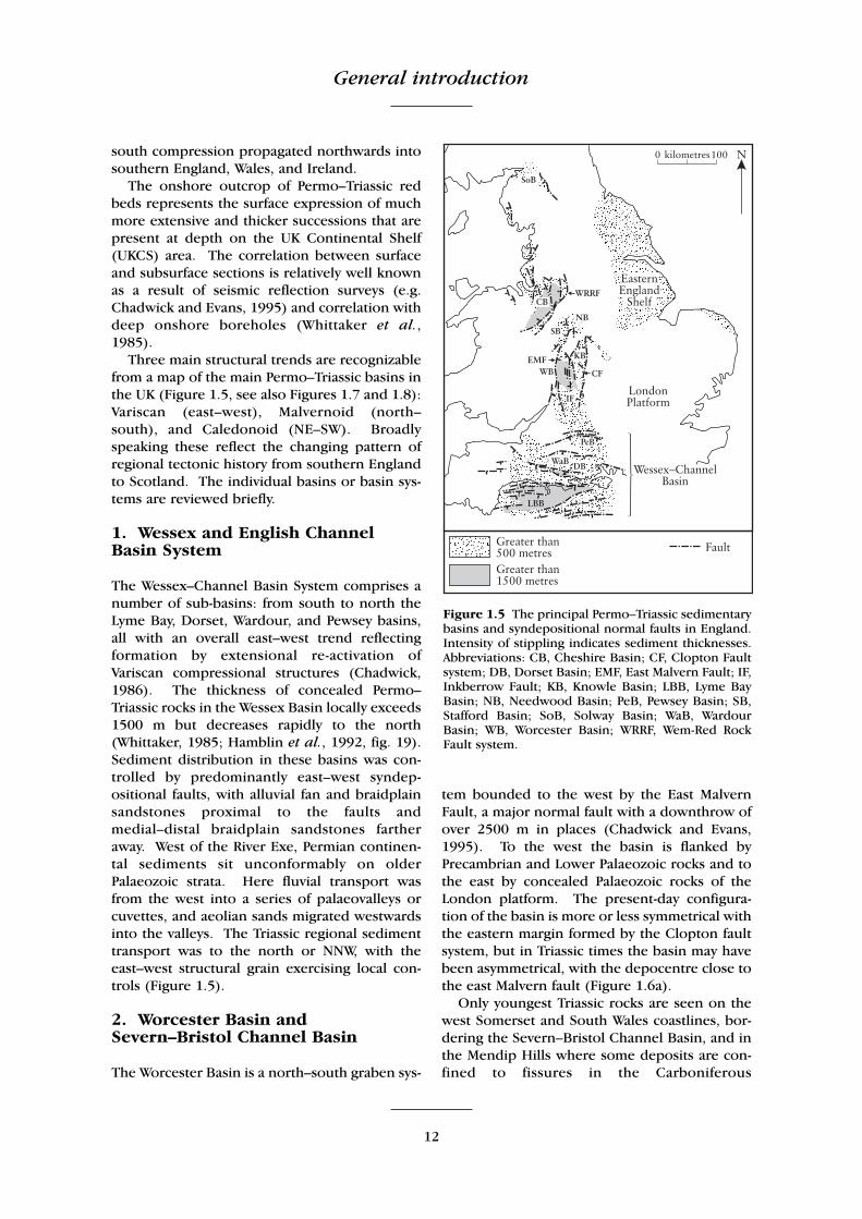
Three main structural trends are recognizablefrom a map of the main Permo–Triassic basins inthe UK (Figure 1.5, see also Figures 1.7 and 1.8):Variscan (east–west), Malvernoid (north–south), and Caledonoid (NE–SW). Broadlyspeaking these reflect the changing pattern ofregional tectonic history from southern Englandto Scotland. The individual basins or basin sys-tems are reviewed briefly.
1. Wessex and English ChannelBasin System
The Wessex–Channel Basin System comprises anumber of sub-basins: from south to north theLyme Bay, Dorset, Wardour, and Pewsey basins,all with an overall east–west trend reflectingformation by extensional re-activation ofVariscan compressional structures (Chadwick,1986). The thickness of concealed Permo–Triassic rocks in the Wessex Basin locally exceeds1500 m but decreases rapidly to the north(Whittaker, 1985; Hamblin et al., 1992, fig. 19).Sediment distribution in these basins was con-trolled by predominantly east–west syndep-ositional faults, with alluvial fan and braidplainsandstones proximal to the faults andmedial–distal braidplain sandstones fartheraway. West of the River Exe, Permian continen-tal sediments sit unconformably on olderPalaeozoic strata. Here fluvial transport wasfrom the west into a series of palaeovalleys orcuvettes, and aeolian sands migrated westwardsinto the valleys. The Triassic regional sedimenttransport was to the north or NNW, with theeast–west structural grain exercising local con-trols (Figure 1.5).
2. Worcester Basin andSevern–Bristol Channel Basin
The Worcester Basin is a north–south graben sys-
tem bounded to the west by the East MalvernFault, a major normal fault with a downthrow ofover 2500 m in places (Chadwick and Evans,1995). To the west the basin is flanked byPrecambrian and Lower Palaeozoic rocks and tothe east by concealed Palaeozoic rocks of theLondon platform. The present-day configura-tion of the basin is more or less symmetrical withthe eastern margin formed by the Clopton faultsystem, but in Triassic times the basin may havebeen asymmetrical, with the depocentre close tothe east Malvern fault (Figure 1.6a).
Only youngest Triassic rocks are seen on thewest Somerset and South Wales coastlines, bor-dering the Severn–Bristol Channel Basin, and inthe Mendip Hills where some deposits are con-fined to fissures in the Carboniferous
Figure 1.5 The principal Permo–Triassic sedimentarybasins and syndepositional normal faults in England.Intensity of stippling indicates sediment thicknesses.Abbreviations: CB, Cheshire Basin; CF, Clopton Faultsystem; DB, Dorset Basin; EMF, East Malvern Fault; IF,Inkberrow Fault; KB, Knowle Basin; LBB, Lyme BayBasin; NB, Needwood Basin; PeB, Pewsey Basin; SB,Stafford Basin; SoB, Solway Basin; WaB, WardourBasin; WB, Worcester Basin; WRRF, Wem-Red RockFault system.

Structural setting
13
Limestones. In Glamorgan, marginal alluvialfans were sourced from ridges of CarboniferousLimestone and prograded southwards towardsthe Bristol Channel.
The infill of the Worcester Basin includes bothPermian and Triassic red beds with a maximumthickness of just over 3 km. The Permian suc-cession comprises the Haffield Breccia and theBridgnorth Sandstone Formation; the Triassiccomprises the Kidderminster, WildmoorSandstone, Bridgnorth Sandstone, andBromsgrove Sandstone formations and theMercia Mudstone Group. Fluvial transport wasnorthwards, parallel to the Malvern axis, and inpart of a fluvial system extending from southDevon through the central Midlands, termed the‘Budleighensis River’ by Wills (1970a).
3. East Midlands–Southern NorthSea (SNS) Basin
The East Midlands shows little structure com-pared with the more westerly basins and the
only syndepositional faults lie offshore (e.g.Dowsing Fault Zone in the SNS Basin). ThePermo–Triassic dips gently into the SNS Basin,and extends northwards into the main CentralGraben and Viking Graben, which reflect theeast–west palaeostress pattern initiated later inthe opening of the North Atlantic. Palaeo-currents in the Sherwood Sandstone Group indi-cate flow towards the north-east into the NorthSea Basin.
4. Cheshire Basin–East Irish SeaBasin
The Cheshire and East Irish Sea basins constitutepart of the Clyde Belt (McLean, 1978), a NW–SE-trending chain of deep Triassic troughs stretch-ing from the Highland Boundary Fault to theCheshire Basin. The formation of these basinshas been linked with an episode of extensionassociated with an early phase of Atlantic open-ing (Ziegler, 1982, 1990). Structural styles inthis area are extremely diverse, with the location
Figure 1.6 Structural cross-sections through the Worcester Basin (a), and Cheshire Basin (b). Vertical exag-geration is × 2.5. (After Chadwick and Evans, 1995.)
General introduction
14
of basin bounding-faults being strongly influ-enced by the position of buoyant Ordovician–early Devonian granites and earlier Palaeozoicbasement structures (Jackson and Mulholland1993). The Cheshire Basin is a half-grabenbounded on the east by the Wem-Red Rock faultsystem, which has a throw of about 3500 m atthe base of the Permo–Triassic succession(Chadwick and Evans, 1995) (Figure 1.6b). Onthe western margin the Triassic succession thinsout by depositional onlap (Colter and Barr,1975).
The basins of the Irish Sea and adjacent areashave been infilled with up to 5.7 km ofPermian–Lower Jurassic sediments includingwhat is probably the thickest (4375 m) Triassicsuccession encountered on the UKCS (Jacksonand Mulholland, 1993). In the East Irish SeaBasin the Sherwood Sandstone Group is over-lain by the Mercia Mudstone Group and isunderlain by the Late Permian St. Bees Shales.Much less is known about the stratigraphy of thePeel or Central Irish Sea basins (Jackson et al.,1995; Jackson and Johnson, 1996; Meadows etal., 1997; Newman, 1999). The northern por-tion of the Irish Sea is bisected by theAnglesey–Isle of Man–Rhins of Galloway Uplift, aN–S-trending, post-Early Jurassic axis of uplift.Evidence for the continuity of Triassic sedimen-tation across this axis can be found by compar-ing Triassic thicknesses along the erosional east-ern margins of the Kish Bank, Peel, and NorthChannel basins with those along the erosionalwestern margins of the East Irish Sea and SolwayFirth basins (Jackson and Mulholland, 1993).Indeed, the lithostratigraphy encountered in theKish Bank Basin closely resembles that of theEast Irish Sea and Cheshire basins.
5. Vale of Eden Basin
The Vale of Eden is a north–south-trending fault-bounded basin flanked to the east byCarboniferous and Lower Palaeozoic rocks ofthe Askrigg and Alston blocks. As in a number ofthe other basins, the structural trend reflects thestructural grain of the basement. However, thehistory of the Dent-Pennine Fault System thatforms the eastern boundary of the basin is com-plex. The faults were initiated as an extensionalsystem in Dinantian times and then re-activatedduring oblique strike-slip compression in thelate Carboniferous Variscan orogeny (Underhillet al., 1988). Subsequent extension occurred
during deposition of the Permo–Triassic infillsequence.
The Permian sediments rest unconformablyon Carboniferous rocks on the western marginof the basin, where they are thickest (see Figure2.22). The main fluvial dispersal was through anaxial system flowing to the north with lateralcontributions from marginal alluvial fans fring-ing the Dent and Pennine faults. Aeolian unitswere deposited from easterly winds with con-comitant sand transport westwards across thebasin.
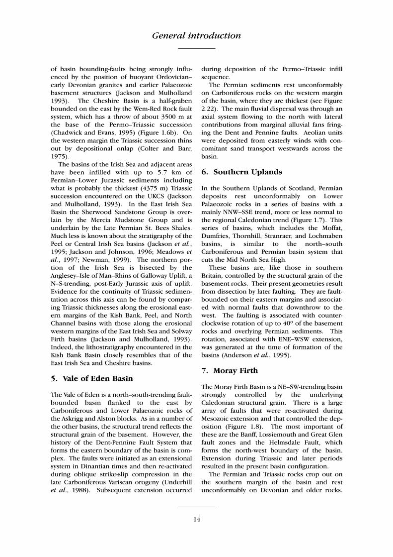
6. Southern Uplands
In the Southern Uplands of Scotland, Permiandeposits rest unconformably on LowerPalaeozoic rocks in a series of basins with amainly NNW–SSE trend, more or less normal tothe regional Caledonian trend (Figure 1.7). Thisseries of basins, which includes the Moffat,Dumfries, Thornhill, Stranraer, and Lochmabenbasins, is similar to the north–southCarboniferous and Permian basin system thatcuts the Mid North Sea High.
These basins are, like those in southernBritain, controlled by the structural grain of thebasement rocks. Their present geometries resultfrom dissection by later faulting. They are fault-bounded on their eastern margins and associat-ed with normal faults that downthrow to thewest. The faulting is associated with counter-clockwise rotation of up to 40º of the basementrocks and overlying Permian sediments. Thisrotation, associated with ENE–WSW extension,was generated at the time of formation of thebasins (Anderson et al., 1995).
7. Moray Firth
The Moray Firth Basin is a NE–SW-trending basinstrongly controlled by the underlyingCaledonian structural grain. There is a largearray of faults that were re-activated duringMesozoic extension and that controlled the dep-osition (Figure 1.8). The most important ofthese are the Banff, Lossiemouth and Great Glenfault zones and the Helmsdale Fault, whichforms the north-west boundary of the basin.Extension during Triassic and later periodsresulted in the present basin configuration.
The Permian and Triassic rocks crop out onthe southern margin of the basin and restunconformably on Devonian and older rocks.

Structural setting
15
Figure 1.7 The Permo–Triassic basins in the Southern Uplands of Scotland and the Longford–Down region ofIreland. The Permian outcrop north-west of the Southern Uplands Fault and south-east of the Iapetus Sutureare not shown – see Figure 2.1. (After Anderson et al., 1995.)
Figure 1.8 The major tectonic elements of the Inner Moray Firth Basin. (After Andrews et al., 1990.)

General introduction
16
Palaeocurrents from the Burghead SandstoneFormation show sediment movement north-east-wards along the basin axis; palaeowinds blewfrom the east and north-east.
8. Minches Basin
In north-west Scotland are a number of Triassicbasins that are mainly known from offshorewells and seismic exploration. These form theHebrides–Sea of Hebrides–North Minch Basin, aNNE–SSW-trending complex controlled bymajor Caledonian faults. Outcrops of theStornoway Formation on the islands of Mull,Skye, Raasay and Lewis occur within the basin.
SEDIMENTOLOGY
British Permian sediments
The uplands created by the Variscan Orogenywere extensively eroded during Early Permiantimes, levelling the rugged scenery to a rollingpeneplain, and generating thick accumulationsof alluvial red-bed sediments. These sedimentswere deposited unconformably on top of erod-ed marine Carboniferous sediments in mostparts of the country, except in parts of theWarwickshire coalfield, where sedimentationmay have been continuous from Carboniferousinto Permian time, and in Devon, where conti-nental red bed deposition may have started inthe Late Carboniferous Epoch (see above). Inplaces, weathered profiles occur in the rocksimmediately underlying the red beds.
The Permian red beds accumulated as alluvialfans around the mountainous areas, and filledsubsiding basins between the mountains (Figure1.9a). The originally rugged landscape isexpressed in the nature of the unconformitybetween Carboniferous and Permian rocks inAnnandale, southern Scotland, and in the Vale ofEden and parts of the Midlands. In most areas,these earliest fluvial sediments consisted ofcoarse breccias dominated by locally derivedclasts. Sometimes these gravelly beds occur inmappable valley systems that might representwadis (deep incised valleys produced duringmonsoonal flash floods). In south-westScotland, and in parts of south-west England,volcanic activity continued from Carboniferousinto Permian times; lavas are in places interbed-ded with the clastic sediments, and in other
places contributed reworked debris. The coarsesediments assigned to the earliest Permian suc-cession are known largely in the west of GreatBritain, where valleys were deepest, and wheresubsidence was rapid. Their absence in the eastmay reflect ongoing and later erosion and pene-planation.
After the initial phase of rapid erosion of theuplands, rates of deposition slowed and thegrain size diminished. The dominant sedimen-tary process was the movement of material byprevailing winds from the east or ENE. Typicalsediments include screes around the margins ofthe basins, overlapping alluvial fanglomeratesand sandstones interdigitating with similar sedi-ments coming from the opposite sides of narrowvalleys, and with aeolian sandstones in the widervalleys and basins. The largest basins showplaya-like mudstones in the centres, with halitedeposits in some parts of the North Sea Basin.In Northern Ireland and northern and centralEngland, thin breccias accumulated on uplandslopes. These contain exotic clasts, indicatinglong-distance transport, but their origin isunclear.
The Early and early Mid Permian sedimentsare largely red and buff in colour, indicating aridclimatic conditions. Fossils are rare, but thelandscape was clearly not devoid of life: fossilplants have been found in association with vol-canic rocks in the Mauchline Basin of south-westScotland (Wagner, 1983) and in the AshowGroup of the English Midlands. Sporadic verte-brate foorprints in early Mid Permian strata alsogive a hint of the life of the time.
Studies in the North Sea Basin (Glennie,1972; Rhys, 1974; Marie, 1975; Smith and Taylor,1992; George and Berry, 1993) have helped toelucidate the palaeogeography and climatic con-ditions of Early and early Mid Permian times.These authors have recognized fluvial, aeolian,lake-sabkha, and desert-lake environments inwhat was a low-lying continental area extendingfrom northern England across the North Sea andthe Netherlands into Germany, termed the‘Rotliegendes Basin’, which includes theSouthern North Sea Basin (Figure 1.9b,c).Glennie (1972) identified two broad facies asso-ciations:
1. In the southern part of the basin, abuttingagainst the London-Brabant Massif (Figure1.9a,b), is an assemblage of sandstones withsome conglomerates and breccias, sourced

Sedimentology
17
mainly from the neighbouring upland area.The conglomerates contain clasts ofWestphalian coal measures and were deposit-ed on alluvial fans and in river channels dur-ing flash floods. Some sands are well sortedand were probably reworked by subsequentaeolian processes. Finer-grained sediments
contain mudcracks. This facies is seen alsoonshore in Arran and in south Devon.
2. The second major facies association, in thenorthern and central parts of the‘Rotliegendes Basin’ (Figure 1.9a,b), consistsof siltstones and claystones with evaporites.The monotonous red mudstones with occa-
∧ ∧ ∧ ∧ ∧ ∧ ∧ ∧ ∧ ∧ ∧ ∧ ∧ ∧ ∧ ∧ ∧ ∧ ∧ ∧ ∧ ∧ ∧ ∧ ∧ ∧ ∧ ∧∧ ∧ ∧ ∧ ∧ ∧ ∧ ∧ ∧ ∧ ∧ ∧ ∧ ∧ ∧ ∧ ∧ ∧ ∧ ∧ ∧ ∧ ∧ ∧ ∧ ∧ ∧ ∧∧ ∧ ∧ ∧ ∧ ∧ ∧ ∧ ∧ ∧ ∧ ∧ ∧ ∧ ∧ ∧ ∧ ∧ ∧ ∧ ∧ ∧ ∧ ∧ ∧ ∧ ∧ ∧∧ ∧ ∧ ∧ ∧ ∧ ∧ ∧ ∧ ∧ ∧ ∧ ∧ ∧ ∧ ∧ ∧ ∧ ∧ ∧ ∧ ∧ ∧ ∧ ∧ ∧ ∧ ∧∧ ∧ ∧ ∧ ∧ ∧ ∧ ∧ ∧ ∧ ∧ ∧ ∧ ∧ ∧ ∧ ∧ ∧ ∧ ∧ ∧ ∧ ∧ ∧ ∧ ∧ ∧ ∧∧ ∧ ∧ ∧ ∧ ∧ ∧ ∧ ∧ ∧ ∧ ∧ ∧ ∧ ∧ ∧ ∧ ∧ ∧ ∧ ∧ ∧ ∧ ∧ ∧ ∧ ∧ ∧
∧ ∧ ∧ ∧ ∧ ∧ ∧ ∧ ∧ ∧ ∧ ∧ ∧ ∧∧ ∧ ∧ ∧ ∧ ∧ ∧ ∧ ∧ ∧ ∧ ∧ ∧ ∧∧ ∧ ∧ ∧ ∧ ∧ ∧ ∧ ∧ ∧ ∧ ∧ ∧ ∧∧ ∧ ∧ ∧ ∧ ∧ ∧ ∧ ∧ ∧ ∧ ∧ ∧ ∧
∧ ∧ ∧ ∧ ∧∧ ∧ ∧ ∧ ∧ ∧ ∧ ∧ ∧∧ ∧ ∧ ∧ ∧ ∧ ∧ ∧ ∧
Figure 1.9 Palaeogeography of Britain and the North Sea in the Permian Period. (a) Palaeogeography of Britainand adjacent areas during the Early and Mid Permian epochs. (b, c) Lithofacies and environments in theSouthern North Sea Basin, during the Mid Permian epoch (Upper Rotliegendes), map (b) and north–southcross-section (c). The Southern North Sea Basin and North German basin together make up the ‘RotliegendesBasin’. Based on Glennie (1972), Marie (1975), and Anderton et al. (1979).
General introduction
18
sional evaporites probably represent deposi-tion in and around a sabkha lake. Theabsence of marine fossils suggests that thiswas a continental sabkha. These beds gradeinto halite-rich deposits that may indicate theformer presence of a major desert lake in themiddle of the basin (Figure 1.9b,c).
This work has provided unique evidence forthe desert lake, now seen only in offshore bore-holes, and helps to clarify the conditions of dep-osition seen onshore.
George and Berry (1993) recognized up tofive major drying-out cycles in the Rotliegendesof the southern North Sea and argued that thesehave stratigraphical potential for basin-wide cor-relation, as they represent major long-termclimatic cycles. The Southern North Sea Basinexpanded through the period of time represent-ed by the Rotliegendes, from being confined tothe offshore area during deposition of Cycle 1and Cycle 2, then extending progressively overthe north-east margin of Norfolk during Cycle 3deposition, then Lincolnshire and Yorkshire dur-ing Cycle 4 deposition, and finally Durham dur-ing Cycle 5 deposition. Each cycle began withsheet floods feeding sediment into marginalareas of the basin, at the centre of which was adesert lake. Through the cycle, alluvial fans builtout into the basin, sands were reworked intoaeolian dunes, the lake evaporated and halitedeposits formed at the centre. Anderton et al.,(1979, p. 184) visualized the end of Rotliegendestime in Great Britain as ‘a shimmering desert’comparable with modern land-locked desertbasins such as the Caspian Basin of Central Asia.
The incoming of the Zechstein facies marks adramatic change to marine environments fol-lowing a transgression from the Boreal regionsin the north; this entered the North Sea Basinand extended over eastern England, and alsoformed the Bakevellia Sea in the Irish Sea Basinand areas on the north-west side of the BritishIsles. This transgression is thought to havespread rapidly across much of Europe (Smith etal., 1974, p. 5) because the first Permian marinefaunas in Great Britain and central Europe(Germany, Poland, western Russia) are very sim-ilar, plant remains in the lowest deposits of theZechstein and Bakevellia seas are similar, andbecause it has been linked to the final melting ofthe Gondwana ice sheet, implying a rapid andsynchronous effect.
The Zechstein and Bakevellia sea sediments
contrast with the earlier Permian red beds andconsist largely of bedded dolomitic limestones,anhydrites, calcareous shales, and beddedhalites, with unequivocal marine fossils. Hereand there they are interbedded with minor land-derived clastic deposits. Everywhere, the marinesediments pass upwards into continental redbeds.
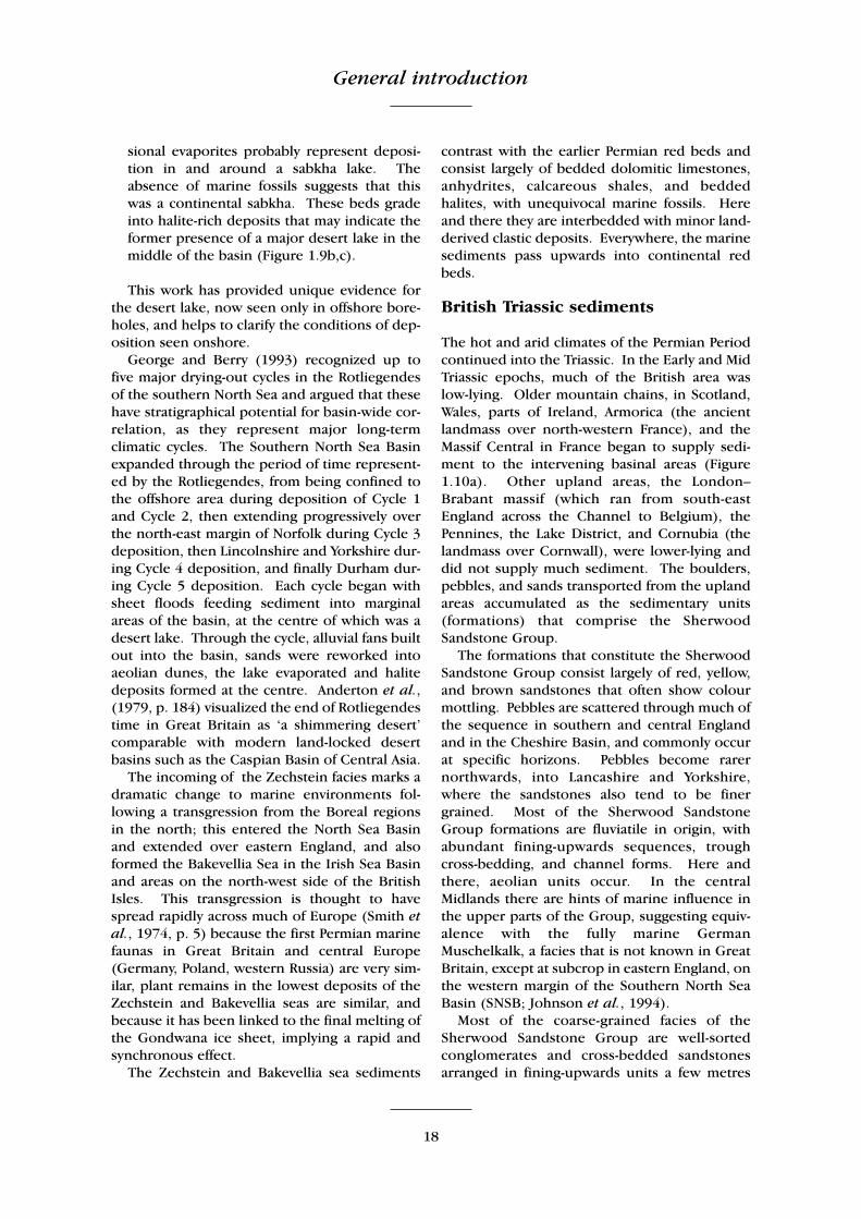
British Triassic sediments
The hot and arid climates of the Permian Periodcontinued into the Triassic. In the Early and MidTriassic epochs, much of the British area waslow-lying. Older mountain chains, in Scotland,Wales, parts of Ireland, Armorica (the ancientlandmass over north-western France), and theMassif Central in France began to supply sedi-ment to the intervening basinal areas (Figure1.10a). Other upland areas, the London–Brabant massif (which ran from south-eastEngland across the Channel to Belgium), thePennines, the Lake District, and Cornubia (thelandmass over Cornwall), were lower-lying anddid not supply much sediment. The boulders,pebbles, and sands transported from the uplandareas accumulated as the sedimentary units(formations) that comprise the SherwoodSandstone Group.
The formations that constitute the SherwoodSandstone Group consist largely of red, yellow,and brown sandstones that often show colourmottling. Pebbles are scattered through much ofthe sequence in southern and central Englandand in the Cheshire Basin, and commonly occurat specific horizons. Pebbles become rarernorthwards, into Lancashire and Yorkshire,where the sandstones also tend to be finergrained. Most of the Sherwood SandstoneGroup formations are fluviatile in origin, withabundant fining-upwards sequences, troughcross-bedding, and channel forms. Here andthere, aeolian units occur. In the centralMidlands there are hints of marine influence inthe upper parts of the Group, suggesting equiv-alence with the fully marine GermanMuschelkalk, a facies that is not known in GreatBritain, except at subcrop in eastern England, onthe western margin of the Southern North SeaBasin (SNSB; Johnson et al., 1994).
Most of the coarse-grained facies of theSherwood Sandstone Group are well-sortedconglomerates and cross-bedded sandstonesarranged in fining-upwards units a few metres

Sedimentology
19
thick. These facies are attributed to streamfloodand braided stream settings. The pebbles with-in these coarse, fluviatile units often indicatetheir provenance. Most of the conglomeratefacies of the Sherwood Sandstone Group areinterpreted as deposits that formed on alluvialfans around the margins of upland areas.Indeed, in some areas, it has been possible tomap out the shapes of the Triassic fans and toidentify their supply canyons. Some of the con-glomerates, for example the KidderminsterFormation and correlatives in the Midlands, andthe Budleigh Salterton Pebble Beds in Devon,contain more exotic clasts that have travelled agreater distance, seemingly from Armorica.
The conglomerate facies generally gradeupwards into red sandstones and siltstones.These siltstones are mostly structureless, butripple marks and desiccation cracks occur.Bands of nodular carbonate are common andshow features characteristic of calcrete horizonsor palaeosols (Steel, 1974b). Red siltstonesoccur throughout these facies. In some places,the silts are associated with evaporites or withevidence of former evaporitic minerals, such asgypsum and anhydrite. The silt sediments prob-ably accumulated as overbank deposits of estab-lished fluvial systems or in playa lakes (Steel,1974a). The calcareous palaeosols and evapor-ites indicate arid conditions.
The Mercia Mudstone Group is broadly equiv-alent to the old ‘Keuper Marl’. It is dominatedby argillaceous formations; sandstones occuronly sporadically. The mudstones and sub-ordinate siltstones are typically red, more rarelygreen and grey in colour, mainly in the former‘Tea Green Marl’ and ‘Grey Marl’ units, now theBlue Anchor Formation, at the top of the group.In basinal areas, thick halite-bearing units aredeveloped, and thin beds of gypsum and an-hydrite commonly occur in certain parts of thesuccession. Deposition was mainly in water,probably in playas or inland sabkhas, with inter-mittent connections to the sea. Sediment wastransported into these environments both inwater and by wind. Locally, a thin basal brecciaor sandstone is present, especially at sites at ornear to the depositional margin.
In some areas of England, the lower part ofthe Mercia Mudstone Group contains evidenceof the presence there of marine conditions,during Mid Triassic times. During the EarlyTriassic Epoch, the nearest seas were the Tethysfar to the south and part of the great circum-
Pangaea ocean (‘Panthalassa’) to the north, nearGreenland. During the Mid Triassic Epoch,however, the Tethys spread northwards acrossGermany, Poland, and the southern North Seaarea. This transgression produced the rhythmicmudstone–limestone couplets, massive marinelimestones, shell beds, and evaporites of theMuschelkalk. A tongue of Tethys extendednorthwards into the North Sea area (Figure1.10a), and its influence penetrated into theEnglish Midlands and Cheshire. Evidence ofmarine conditions includes acritarchs from thehighest Bromsgrove Sandstone Formation andfrom the Tarporley Siltstone Formation, at thebase of the Mercia Mudstone Group(Warrington, 1967, 1970a). Other marinefossils, such as the inarticulate brachiopodLingula (Rose and Kent, 1955), have beenreported from equivalent formations(Warrington et al., 1980). A rich assemblage oftrace fossils in sediments of marine intertidalaspect has been reported from the TarporleySiltstone Formation of North Cheshire (Irelandet al., 1978). These indications do not implyfully marine environments, like those represent-ed by the German Muschelkalk, but they provethat water of marine origin reached centralEngland in Anisian times. The encroaching seamay have raised humidities over England.Whatever the cause, there are a number of richfaunas and floras from rocks of this age in local-ities from Cheshire to Devon (Walker, 1969;Benton et al., 1994; see below).
The bulk of the Mercia Mudstone Group con-sists of rather featureless unfossiliferous redmudstones, the old ‘Keuper Marl’. The apparentmonotony of these units is relieved here andthere by greenish beds, desiccation cracks, lam-inae with rainprints, and horizons of gypsumand anhydrite nodules. The group was deposit-ed in vast inland basins (Figure 1.10b) and overbroader areas between the uplands than thedeposits formed earlier in the Triassic Period (cf.Figure 1.10a). The sedimentary basins hadaccommodated hundreds of metres of thecoarse-grained Sherwood Sandstone Group sed-iments, and the topography during the dep-osition of the Mercia Mudstone Group was lessmarked. Rates of runoff from the uplands hadevidently reduced considerably compared withearlier times, as indicated by analyses of the clayminerals (Jeans, 1978; Ruffell, 1991): illite andchlorite dominate, and kaolinite is virtuallyabsent. In marginal zones, calcretes probably
General introduction
20
Figure 1.10 Palaeogeography of Britain in (a) the Anisian Age (Mid Triassic; c. 245 Ma). (After Warrington andIvimey-Cook, 1992)

Sedimentology
21
Figure 1.10 – contd. Palaeogeography of Britain in (b) Norian–Rhaetian times (Late Triassic; c. 205 Ma).

General introduction
22
took many thousands of years to develop, indi-cating stable conditions in those basins, and arainfall of less than 300 mm per year. This isconfirmed by occasional finds of exfoliated peb-bles and sheeted bedrock, so-called ‘onion skinweathering’, which today occurs only in deserts(Tucker, 1974).
The scarcity of fossils and apparent rarity ofsedimentary structures has made it hard to inter-pret these Mercia Mudstone Group facies. Twohypotheses for their formation have been pre-sented:
1. The sediments represent subaqueous dep-osition in an inland hypersaline lake or inlandsea, or in bodies of water of marine origin.
2. The sediments were deposited in giant playasor desert plains.
The first suggestion seems to represent the bestexplanation for the bulk of the succession(Warrington, 1974d, Arthurton, 1980; Ruffell,1991). In some places, for example in theWorcester Graben and Cheshire Basin, thickaccumulations of evaporitic halite with associat-ed sulphate salts, were precipitated from watersof marine origin (the sediments containacritarchs, microfossils found only in the sea). Acommonly-suggested modern analogue is theRanns of Kutch, India, an evaporitic coastal plainthat is periodically flooded by both the IndusRiver and by monsoon-driven marine watersfrom the Indian Ocean.
The second suggestion is true only for theupper part of the sequence seen, for example, insouthern Wales (Tucker, 1977, 1978). Tucker(1978) described ‘fossil shorelines’ around themargins of the South Wales Basin, where MerciaMudstone Group sediments were deposited onand against islands of Carboniferous Limestone.Tucker (1978) suggested that this low-lyingbasinal plain was periodically subjected to tor-rential rain. This produced an extensive shallowlake, which dried up slowly under an intenseequatorial sun, producing evaporite mineralsand desiccation features on the muddy plain.The absence of varve-like lamination in the redmudstones is somewhat puzzling: this would beexpected in a large lake in which fine-grainedsediments in tranquil conditions were accumu-lating. The absence of clear lamination may bethe result of continuous churning and homo-genization of the muds by soil-forming process-es, or because the bulk of the red muds com-
prise wind-borne desert dusts or loess.
RED BEDS OF THE BRITISHPERMO–TRIASSIC SUCCESSION
Introduction
British Permian and Triassic red beds comprise awide variety of deposits of continental environ-ments ranging from alluvial fans, river channelsand floodplains to aeolian dune fields, desertlakes, and coastal mud flats (Figure 1.11). Theyare distinctively red (between 5R and 10R of theRock Colour Chart; Rock-Color Chart Com-mittee, 1991), but contain varying proportionsof drab and polychrome strata. The colour isdue to finely disseminated iron oxides (mainlya-Fe2O3), which indicates that they were deposit-ed and buried under oxidizing conditions(Walker, 1967; Turner, 1980). Deposition of thePermian and Triassic sediments was in desertbasins, and the British Lower Permian sedimentsinclude world-class representatives of thedeposits of a palaeo trade-wind desert (Glennie,1970).
Studies of the British Permo–Triassic red bedshave been central to the development of ideas ofcontinental drift and palaeomagnetism. This islargely because they have relatively strong andstable Natural Remanent Magnetization (NRM)carried by haematite. Runcorn (1965) producedpolar-wander paths for Europe and NorthAmerica and compared palaeomagnetic resultsfrom the Triassic strata of the Colorado Plateauand Europe that clearly indicated the opening ofthe North Atlantic Ocean.
The British Permo–Triassic red beds display arange of facies indicative of both aeolian andfluvial depositional environments.
Aeolian environments
Aeolian deposits in the British Permo–Triassiccomprise the following:
(1) aeolian dunes and draa characterized bytexturally mature sandstones with large-scalecross stratification with sweeping, asymptoticforesets. Maximum foreset inclinations are oftenup to 30º (approaching the maximum angle ofrepose of dry sand in air of 34º). Individual setsare separated by sharp, generally planar, bound-ing surfaces.(2) Aeolian sandsheets that typically comprise

Red beds of the British Permo–Triassic succession
23
bi-modally laminated sandstones on a millime-tre-scale with well-rounded coarser laminations.Scours, granule lags, and thin cross-laminatedunits may be present. (3) Damp interdune deposits comprising vari-ably silty sandstones with irregular wavy orlenticular lamination and soft-sediment con-tortions. The dominant structures are adhesionripples formed by the sticking of windblownsand to damp surfaces.
Glennie (1970) and other authors have attrib-
uted the high angle of dune foresets to com-pactional effects during burial, but removal byerosion of dune crests could also be a significantfactor. A key element in identifying aeoliandunes is the recognition of grainflow and grain-fall laminations (Hunter, 1977). In addition,horizontal or sub-horizontal aeolianites, particu-larly translatent strata and wind-ripple lamina-tion, are important.
Early work by Shotton (1956) on the PermianBridgnorth Sandstone demonstrated the linkbetween the geometry of cross strata and dune
Figure 1.11 Deserts today provide excellent analogues for understanding the ancient desert sedimentary sys-tems of the British Permo–Triassic red beds. (a) Deserts derive sediment from mountain chains, first as coarse-grained alluvial fans (intermittent, braided streams build up ‘cones’ of material (breccias and conglomerates) atthe point where they discharge onto a plain). Farther from source, the sediment is broken down into finer-grained sands and muds mainly through aeolian processes (abrasion through wind transport, weathering etc.).Perennial lakes develop during the wet season, and may produce evaporites as they dry out. (b) Dune fieldsdevelop by the accumulation of sand carried by prevailing wind and small ephemeral streams; the materialtends to accumulate as sand dunes. (c) The principal forms of dune.
General introduction
24
planform morphology. Clemmensen (1987) andThompson (1969) used analysis of boundingsurface geometry to infer, respectively, thepresence of star and dome-shaped dunes in theBritish Permo–Triassic succession. More recent-ly emphasis has been placed on the nature of thebounding surfaces between individual sets.Brookfield (1977) demonstrated the significanceof 1st, 2nd and 3rd order bounding surfaces andhow these relate to the migration of dunes anddraa in modern aeolian systems. The highest-order surfaces, super bounding surfaces(Kocurek, 1988), record major climate changeand the transition from fluvial to aeoliansequences (or vice versa).
Interdune deposits are preserved in areas ofrelatively high sedimentation rate and are thusassociated with dunes showing a climbing bed-form geometry. More complete preservation ofinterdune deposits occurs in areas of net tecton-ic subsidence that act as sediment ‘sinks’. Thus,in Permo–Triassic sequences thick interdunedeposits are restricted to the Permian successionin the centre of the Southern North Sea Basinand in the Cheshire and Irish Sea basins.
Fluvial and associated environments
Six major fluvial and associated sedimentaryenvironments are represented in the BritishPermo–Triassic succession.
1. Playa lake and sabkha sediments are red siltymudstones and claystones with thin sand-stones. Sedimentary structures include ripplemarks, desiccation cracks and footprint trails,with associated nodular anhydrites and algallaminites.
2. Alluvial fanglomerates are poorly sorted grav-els. Those deposited from ephemeral sheetfloods show poorly stratified or imbricategravels with upwards-fining profiles. Debrisflows are matrix supported and show little orno internal organization.
3. Coarse-grained braided rivers are indicated bytexturally mature gravels with variable inter-nal organization. Crude stratification, large-scale foresets, and interbedded cross-strati-fied sandstones are characteristic.
4. Sandy braided rivers are represented by sand-stones with upper-phase plane beds, planar-tabular and trough cross-stratification andsubordinate siltstones. Planar-tabular setsmay show re-activation surfaces. Interbedded
siltstones and shales are generally laterallydiscontinuous. Units are arranged inupwards-fining packages.
5. Meandering rivers produce sandstones with ahigh proportion (30–60%) of interbedded silt-stones in upwards-fining sequences. Thechannel sandstones may show lateral accre-tion (epsilon) cross-stratification and a varietyof smaller scale cross-stratified, rippled andplane bedded sandstones. The siltstones(floodplain) may have palaeosols (calcretesand other types are abundant in the Triassicsuccession) and thin sandstones depositedfrom overbank floods.
6. Marine intertidal and brackish mudflats areindicated by thin heterolithic sandstones andrippled siltstones, often with mud drapes,desiccation cracks and pseudomorphs afterhalite. Trace fossils, including Lingulichnus,indicate marine conditions.
In general, fluvial sediments are more poorlysorted and less texturally mature than aeoliansediments. This is reflected by a higher detritalclay content, more angular grains and irregularfabrics. The presence of intraformational mudclasts or curled clay flakes has often been used asevidence of waterlain deposition, but Glennie(1970) has described conditions under whichcurled clay flakes may be preserved in aeoliansediments.
Alluvial fans frequently show thick, apparent-ly monotonous, sequences of gravels and con-glomerates with variable degrees of organiza-tion. Excellent examples occur in south Devon(Laming, 1966). Comparison with modern fans(Blair and McPherson, 1994) shows that bothsheetflood- and debris-flow-dominated fansdeveloped in Permian times, with sheetflooddeposits predominating.
Much of the emphasis in fluvial sedimento-logical research has been on the relationshipbetween channel pattern and the resultinggeometry of the deposits (Miall, 1996). In thesimplest case, the distinction between braidedand meandering systems is made on the basis ofthe relative proportions of channel and flood-plain deposits, and the vertical sedimentary pro-file. Meandering river deposits show upwards-fining profiles and, ideally, the preservation oflateral accretion (point-bar) cross-stratificationand a relatively high proportion of flood plainfines. These deposits are relatively scarce in theTriassic succession, except in the Bromsgrove

Palaeontology of the Permo–Triassic succession
25
Sandstone Formation and parts of the HelsbySandstone Formation (Wills, 1970a; Thompson,1970a; Old et al., 1991). Braided rivers, on theother hand, are dominated by coarser-graineddeposits and show abundant internal erosion(channel surfaces) and stacked sequences ofplanar tabular, or trough, cross-stratified sand-stones. The Triassic strata of the UK includesome world-class examples of braided fluvialsequences (e.g. the Budleigh Salterton PebbleBeds and the Nottingham Castle, St BeesSandstone and Otter Sandstone formations).
Recent research indicates that fluvial archi-tecture is complex and sensitive to tectonicevents and climatic changes. Channel patternsare complex; anastomosed channels are abun-dant in some arid-climate regimes and verticalchanges may be the result of tectonic or climaticinfluence rather than fluvial processes andhydraulics. Some units have remained enigmat-ic and require resolution in terms of facies inter-pretation. These include the Wildmoor Sand-stone and parts of the Wilmslow Sandstoneformations.
PALAEONTOLOGY OF THE BRITISHPERMO–TRIASSIC SUCCESSION
Permian palaeontology
Fossils are rare in the British Permian red beds,and entirely absent in some basins. The amphib-ian Dasyceps and the pelycosaur reptilesSphenacodon and Haptodus are known fromthe Kenilworth area of Warwickshire (Paton,1974, 1975), as is the conifer Lebachia (=Walchia). A limited flora from the MauchlineBasin in south-west Scotland indicates a LateCarboniferous to probably earliest Permian age(Wagner, 1983).
Footprints of amphibians and reptiles havelong been known from the LocharbriggsSandstone Formation of Dumfriesshire, thePenrith Sandstone of the Vale of Eden, and theYellow Sands of Mansfield, all probably of MidPermian age (Hickling, 1909; McKeever, 1991,1994; Benton and Spencer, 1995, pp. 20–1;McKeever and Haubold, 1996). In the Vale ofEden, and in parts of Nottinghamshire, fossilplants and palynomorphs are known from greymudstones, dated as latest Permian; these indi-cate the existence of a uniform, pan-Europeanflora at the beginning of the Zechstein (Stoneley,1958; Clarke, 1965b; Schweitzer, 1986).
The extensive red beds of Devon and neigh-bouring parts of Somerset and Dorset are almostdevoid of fossils. Mid to Late Permian paly-nomorphs from the Whipton Formation at thebase of the upper part of the Exeter Group inDevon (Warrington and Scrivener, 1988, 1990)provided the first biostratigraphical evidence ofa Permian age in that area. Vertebrate footprintshave been reported from higher beds, theBroadclyst Sandstone Member of the DawlishSandstone Formation, in the same area(Warrington and Scrivener, 1988, 1990).
The latest Permian Hopeman Sandstone is,compared to other British Permian red beds,remarkably rich in fossils, having yielded sometwenty specimens of the dicynodonts Gordoniaand Geikia and the pareiasaur Elginia, all ofwhich can be compared with close relatives inLate Permian strata of Russia and South Africa.Footprints of these, and other, reptiles have alsobeen found to be abundant in the coeval sand-stones of the Morayshire coast (Benton andWalker, 1985).
Triassic palaeontology
The Sherwood Sandstone Group is only locallyfossiliferous and some major units are entirelydevoid of fossils. Trace fossils are known fromthe Wilmslow Sandstone Formation in north-east Cheshire (Sarjeant, 1974). The HelsbySandstone Formation in Cheshire has yieldedtrace fossils, including the famous vertebratefootprints Chirotherium and Rhynchosauroides(Sarjeant, 1974; Tresise and Sarjeant, 1998), aswell as indeterminate plant remains and thecrustacean Euestheria. None of these fossils canbe used biostratigraphically. In addition,Warrington (1970a,b) reported a miosporeassemblage from the basal bed of the HelsbySandstone Formation in north-east Cheshire thatwas regarded as late Early Triassic in age, but isnow interpreted as Anisian (early Mid Triassic).
Fossils are relatively abundant in the upperunits of the Sherwood Sandstone Group and thebasal units of the Mercia Mudstone Group, asso-ciated perhaps with the partially marine incur-sions of Anisian Age. The BromsgroveSandstone Formation in the Midlands has yield-ed fossil plants (conifers and horsetails),annelids, inarticulate brachiopods, bivalves,crustaceans (Euestheria and ostracods), scorpi-ons, fishes such as Gyrolepis and Dipteronotusand the lungfish Ceratodus, large fish-eating

General introduction
26
amphibians such as Mastodonsaurus, smallplant-eating procolophonid reptiles such asKapes, hefty plant-eaters such as Rhyncho-saurus, and large flesh-eating rauisuchianarchosaurs (Walker, 1969; Poole, 1978; Old etal., 1991; Benton et al., 1994). The aquaticforms are found generally in argillaceous sedi-ments, often finely laminated, and associatedwith disseminated plant debris. The amphibiansand reptiles are usually found as disarticulatedelements in lag deposits within cross-beddedsandstone channel fills. The plants, inverte-brates, and vertebrates all appear to have cos-mopolitan distributions, sharing close relativesas far afield as Russia, Africa, and the Americas.Comparable faunas are known also from theOtter Sandstone Formation in Devon (Milner etal., 1990; Benton et al., 1994), a likely age-equivalent.
The Tarporley Siltstone Formation and itsequivalents have yielded plant remains, inarticu-late brachiopods (Rose and Kent, 1955) and, inthe southern part of the Cheshire Basin, reptiles(Rhynchosaurus; Benton et al., 1994).
These plants, invertebrates, and vertebratesindicate only a generalized Mid Triassic age.Palynological assemblages, of miospores in par-ticular, have been more helpful in correlation tothe North Sea and German successions, and tothe marine Alpine successions (Warrington etal., 1980). Such assemblages have been report-ed from Lancashire, Cheshire, Staffordshire,Nottinghamshire, Worcestershire, Warwickshire,and Oxfordshire, and have allowed the ages ofindividual horizons to be determined to thelevel of subdivisions of the standard stages insome cases.
Younger formations have produced someexcellent macrofossils that give general evidenceof age. Miospores are rare in the continentalparts of the Upper Triassic succession, that is,below the marine Penarth Group. One of themost famous macrofossil-bearing units is theLossiemouth Sandstone Formation of the Elginarea in north-east Scotland. This has produceda rich reptilian fauna, including plant-eatingrhynchosaurs, flesh-eating archosaurs, and sev-eral smaller forms (Benton and Walker, 1985).The Lossiemouth Sandstone Formation wasdated formerly as largely Norian in age, by com-parison of the fauna with those from Germanyand elsewhere in the world (Warrington et al.,1980). It is now generally accepted to be of lateCarnian age, by comparison with similar faunas
from South America that are securely datedradiometrically (Benton, 1994; Lucas, 1998).
In England, the Upper Triassic portions of theMercia Mudstone Group are almost devoid offossils. An exception is the Arden SandstoneFormation, and its lateral equivalents in theMidlands. This thin, partly arenaceous, unit hasyielded plant remains, crustaceans, fish, andamphibian and reptilian remains, as well asmiospores (Clarke, 1965a; Warrington, 1970a,1974a; Fisher, 1972; Barclay et al., 1997), whichare indicative of a late Carnian age. Similarly, theButcombe Sandstone Member in the MendipHills, south of Bristol, the North CurrySandstone Member of Somerset, and the WestonMouth Sandstone Member of Devon have yield-ed Carnian, or late Carnian, miospores, andappear to be equivalents of the Arden SandstoneFormation (Warrington, 1971; Warrington et al.,1980).
Other fossils in the Mercia Mudstone Groupare sporadic and not biostratigraphically useful,but they are dramatic. These include abundantdinosaur footprints from shore-face sandstonesof Late Triassic age at Barry Island in South Wales(Tucker and Burchette, 1977; Lockley et al.,1996), and bones of the dinosaur Theco-dontosaurus from the ‘Dolomitic Conglom-erate’ of Bristol (Riley and Stutchbury, 1840;Etheridge, 1870; Benton et al., 2000). By com-parison with dinosaurs from elsewhere, bothmay be assigned a possible Norian age.
Similarly hard to date, but perhaps even moresignificant palaeontologically, are the famousfissure faunas from the Mendips, Gloucester-shire, and South Wales (Robinson, 1957; Fraser,1994; Benton and Spencer, 1995). Infilled cav-erns and solution features, formed on upliftedCarboniferous Limestone in these areas, occa-sionally contain rich assemblages of reptile andmammal bones and teeth. During the LateTriassic Epoch, the tops of limestone islandsaround the Severn–Mendip area were erodedinto a karst surface, and red-bed soils formed inplaces. The islands were evidently vegetatedand supported rich faunas of sphenodontidlizards, dinosaurs, gliding reptiles, and mam-mals that occasionally fell, or were washed, intodeep solution-cavities. Dating of the fissure fillsis very difficult. Some contain palynomorphsindicating Rhaetian or Hettangian–Sinemurianages, and these tend to contain different verte-brate faunas from those that lack palynomorphs.The latter are probably older and have verte-

The selection of red-bed and Penarth Group GCR sites
27
brate faunas that include reptiles, such as thecrocodilomorph Terrestrisuchus and the pro-colophonid Leptopleuron, that are apparentlyidentical with taxa from mid Norian strata ofGermany and late Carnian deposits of Scotlandrespectively. Perhaps the fissures range in agefrom late Carnian to Sinemurian, spanning theLate Triassic and Early Jurassic epochs.
The Blue Anchor Formation, the highest for-mation in the Mercia Mudstone Group in theBritish Isles, has yielded scattered plant and fishremains in central and northern parts of thisregion. In south-west England and South Wales,the ‘Grey Marls’ facies in this formation hasyielded richer faunas, including bivalves, andpalynomorph assemblages that include marinedinoflagellate cysts (Orbell, 1973; Ivimey-Cook,1974; Warrington, 1974b; Warrington andIvimey-Cook, 1995).
The palaeontology of the British PenarthGroup is discussed in Chapter 4, pp. 225–6.
THE SELECTION OF PERMIAN ANDTRIASSIC RED-BED AND PENARTHGROUP GCR SITES
N.V. Ellis
This volume of the Geological ConservationReview (GCR) describes sites that were selectedfor the GCR because of their special significancein the study and understanding of BritishPermian and Triassic red-bed and Penarth Groupstratigraphy, sedimentology, palaeogeographyand palaeontology. Sites of scientific interest formarine Permian rocks were afforded their ownsite-selection category (‘Block’) in the GCR andare described in a separate volume of the GCRSeries, Marine Permian of England (Smith,1995). Sites of Permian and Triassic age impor-tant for fossils of fishes, amphibians, reptiles,mammals and arthropods were also selectedindependently for their own ‘Blocks’ in the GCR,owing to the relative rarity of fossils of this type.They are described elsewhere in the GCR Series(see, for example, Benton and Spencer, 1995,Dineley and Metcalfe, 1999, Benton et al., inpress). Nonetheless, some of these palaeonto-logical sites are critically important from anEarth history or stratigraphical perspective andsuch sites are thus described in the present vol-ume as well.
The general principles guiding GCR site selec-tion are described in an introductory volume of
the GCR (Ellis et al., 1996), but can be encapsu-lated in three broad components:
1. International geological importance (e.g.stratigraphical ‘type’ sites and other sites thathave achieved informal, but widely held,international recognition).
2. Presence of ‘classic’ or exceptional featuresthat are scientifically important (e.g. ‘text-book’ examples of particular sedimentologi-cal features or exceptionally rare occur-rences).
3. Presence of representative geological features(e.g. characteristic or typical features ofBritish Permian and Triassic rocks) that areessential in comprehensively portraying thegeological history of Britain.
However, in order to ensure true nationalimportance in the selected representative sites,site selection was underpinned by the premisethat the particular GCR Block should be repre-sented by the minimum number of sites. Onlythose sites absolutely necessary to represent themost important aspects of Britain’s stratigraphywere therefore selected. (Two GCR Blocks arerelevant here – they were called ‘Permian–Triassic Stratigraphy’ and ‘Rhaetian Stratigraphy’during the principal GCR site selection phase inthe 1980s).
On an entirely practical level, all selected sitesmust be conservable, meaning in essence: (a)that development planning consents do notexist or else amendments can be negotiated; and(b) that sites are physically viable, for example,in terms of the long-term stability of exposures.
In order to compile the ultimate site list forthe ‘Permian–Triassic stratigraphy’ and ‘RhaetianStratigraphy’ GCR Blocks, extensive consulta-tions were carried out with appropriate geolo-gists by the GCR Unit of the former NatureConservancy Council in the 1980s, and a largenumber of sites were assessed before the finallisting was produced. There are many problemsinherent in producing a truly representative listof nationally important sites that merit conserva-tion. In order to help provide a framework forselecting sites within a GCR Block, the conceptof GCR Networks is applied.
GCR Networks
GCR Networks are the themes for site selectionthat link clusters of representative sites within a
General introduction
28
GCR Block, and these have influenced the struc-ture of the present volume. Of course differentthemes could have been adopted here – types ofsedimentary structures, sedimentological com-position, diagenetical history, sequence of envi-ronmental change and so on – and these can betraced in the sites described in this book, but theprincipal theme for site selection and thereforethe organization of the sites in this book is therepresentation of British depositional basinsduring Permian and Triassic times. Details of thegeological scenarios that the networks representcan be found in the chapter introductions, butcan be summarized as follows:
British Permian red-bed palaeogeograph-
ical, sedimentological and stratigraphical
GCR networks (Chapter 2)
Because each sedimentary basin has distinctcharacteritsics, the GCR localities are assigned toregional site networks, representing broadly themajor ‘British’ basins of sedimentation duringthe Permian Period. The broad stratigraphicaland sedimentary conditions of each basin areoutlined in Chapter 2. A total of 23 GCR siteshave been selected to illustrate the key featuresof the British Permian red beds networks (seeFigure 2.1).
• Moray Firth Basin• south-west Scotland• north-east England• west Cumbria• Vale of Eden• English Midlands• Devon
British Triassic red-bed palaeogeograph-
ical, sedimentological and stratigraphical
GCR networks (Chapter 3)
In the same way that the Permian red-bed GCR
networks were devised, the GCR localities (32 inall) are assigned to regional site networks, listedbelow. The rationale for establishing such net-works is to reflect the different characteristics ofdistinct sedimentary basins (see Figure 3.1) – itis impossible to document a typical successionof the British Triassic red beds in any single partof the country (Warrington et al., 1980).
• Moray Firth Basin• Western Highlands and Islands and Arran• west Cumbria and the East Irish Sea
Basin• Cheshire Basin• western margin of the North Sea Basin• Central Midlands• South Wales• Devon
Penarth Group GCR networks
(Chapter 4)
The Penarth Group, formerly the ‘Rhaetic’,represents a dramatic change from earlierTriassic sedimentation styles throughout theBritish Isles and much of western and centralEurope. This change has long been interpretedas reflecting a major marine transgression thatspread across much of north-west and centralEurope a few million years before the end of theTriassic Period. Thirteen GCR sites, on the northand south shores of the Severn Estuary, in Avon,Gloucestershire, Somerset and on the Devoncoast, have been selected for the GCR to repre-sent the sedimentary, stratigraphical andpalaeontological features of the Penarth Grouptogether with contiguous Mercia MudstoneGroup deposits, including ‘red beds’ (see Figure4.5), according to four regional networks:
• South Wales• Gloucestershire, Avon and north Somerset• west Somerset• Devon.