british columbia prospectors assistance program...
TRANSCRIPT

BRITISH COLUMBIA
PROSPECTORS ASSISTANCE PROGRAM
MINISTRY OF ENERGY AND MINES
GEOLOGICAL SURVEY BRANCH
PROGRAM YEAR: 2001/2002
REPORT #: PAP 01-20
NAME: DREW ANDREWS

Findlsy CreekProject
The wildlife on the Thunderpaws claims is diverse and thriving.
~~~’ ‘y :;,rq’ ,I;; I
Dr&ic Exploration has -. - recorded all wildlife sightings since 1997 and other than the tourists do not s&m threatenedby mining activities. A herd of Elk numbering one hundred, White Tail:deer in groups ofthree to.~~ i
;: .,,.. pb ,:\i:.:$?,yj five, Mule deer also range in the area, sow and cub Grizzlys, two to three pair a qFp~,wk
i
Bears and cubs are also plentiful, Eagles and Hawks are abundant, se 1
ridge as well. Wolf dominate the ridge area and are frequently seen on kill sites discovered. 3ats, pika, rabbits, varmints, osprey, lesser species of birds, many species of insects and Bull Trout reside too. Cows (free range) have trails in entire area due to ranching.
Vegetation is semi-arid and comprised mainly by grasses, sedges, alders, dogwood, wild rose bushes, hawthome bushes, many low cover flowers and herbs. Intense growth along Findlay Creek and drainages. Vegetation is relatively sparse above canyons and walking is very easy through groves or meadows.
Trees dominate the moist areas of Thunderpaws claims, though widespread forest tires in 19895 (Thunderhill) have eliminated large tracts of forest on surrounding mountains and valleys, regeneration is thriving and will stive. The main species of trees in the Thunderpaws area are Douglas Fir, Yellow Pine, Ponderosa Pine, larch, Birch, Cedar and Poplar. Large and very old junipers dot the ridges due to minerals on hand. Alders and maples also are present.
Drevic Exploration is environmentally sensitive to all vegetation and wildlife and will continue to live with the environment with no impact or compromise.
Vicki Mine and Findlay Creek Prospecting Report
The Vi&i Mine on the Thunderpaws #l claim (Tenure # 3734 10) is located 30 metres north of Findlay Creek, southwest of the baseline OE line south boundary (580099 E, 555495 N, elevation 971 metres). The mine is the hanging wall of quartz ledge and veins in dolomite I argillite canyon wall bedrock on a fault trending 43’023”. The fault and quartz ledge is within the Mount Nelson Formation (west) contacting the Toby Formation (east) which is f&wall. Quaternary cover from above canyon (north) almost completely conceals dolomite/argillite below (south) in canyonledges to Vi&i Mine. Multi ledge lead toward Thunderhill Ridge located at 8 kilometre of Findlay Creek Road, most of them nearly level; 4” to 8” inclination. The surface rock is grey-blue dolomite in thin layers from 4 to 12 inches, next lower layer is green argillite I quartz&e with quartz veins to a depth of 5 metres. The next lower layer is quartz ledge (96% silica), massive quartz veins traveling upward at 40” inclination in direction of 20”. Five veins go north from quartz beds from Findlay Creek 20” to 45”, 0.5 to I metre in width. The Vicki Mine bedrock contacts the Toby Formation (east side), which has a surface layer of black argllites/black shales, quart&e to a depth f 12 me&es. This layer has massive quartz vein intrusions originating from south demonstrating igneous intrusion below in fault trench. The

c. larger veins head north from Vicki Mine and can be seen in several places on surface, their length so far determined is 50 metres. Dutch Creek Formation contacts Mount Nelson Formation (west side of mine) at a distance of 200 metres from Vi&i mine. The surface rock of Dutch Creek Formation has rusty weathering quartzite/argiIlites with light clays to depth of 50 metres from surface.
The quartz ledge is faulted north-south across Findlay Creek continuing south, exhibited with some Mount Nelson Formation and stratigraphy. From this years measurements, the Vicki Mine stratigraphy is from top: Quatematy cover of 1 metre, 0.1 metre of dolomite, 2 metres of green argillite/quartzite, 1 metre quark vein with a lower layer of solid quartz ledge undetermined in thickness. Drilling will be necessary. The Mine has a strike and dip of 330”/10” SW, trend of 43” and plunge 10” SW. The quartz veins beginning at this point have been exposed by trenching and assaying, removal of material done in 1999/‘2000. More trenching to follow in 2002. Assays done in 1999/2000 as well as 2001. The assays have indicated gold/silver, which varies from 0.02 g/ton to 25.6 g/ton for gold, 2 oz/ton to 15 oz/ton for silver, small percentage of platinates, copper, lead, silver, iron, pyrite, magnetite, galena, tetrahedrite, garnet, quartz crystal, malachite, azurite, quartz. and ICP elements of lesser percents. ICPs were also done to measure and track arsenopyrites and other metal leaching that could occur and readings in 2001 were minimal and unchanged. Our mining engineer proposes to extract ores from underground drifts originating from north Thunderhill Ridge (Thunderpaws and Ivy claims) so no adits or portals will be constructed on or near Findlay Creek and its drainages.
For 0.5 kilometres from Vicki Mine west along north side of Findlay creek, assays/lCPs have been done on 5 vents N/S 220”-225” including 2001. Tests indicates homogeneous gold as well as metallic gold.. An igneous intrusion through a disseminated metal/silver deposit characterized by iron staining, quarts structure with galena, chalcopyrite. All of our gold/silver ore was processed in mills with concentrates and tables in conjunction with assays in 2001. The deposits in pod type structure with extent of content to be determined by drilling in 2002/2003.
The Vicki Mine has ongoing trench work to ap all veins with N/S trend, 4 trenches have been done to date. Completion of trench 4 done in 2001, geological mapping and assays/milling. 2, 2metre by 1 metre trenches mechanically dug after access trails were pushed by Kubota 4WD backhoe/front-end loader in 2000,4WD pickups and crew required for bulk samples. 2,2 metre by 3 metre trenches hand dug by crew. All stratigraphy was constant and similar to descriptions from above. 50 ton of ore samples removed for milling, processing and assays in gold/silver analysis in 2000/200 1. Vein #2 100 metres west, 10 metres from north side of Findlay Creek, a 2 metre by 1 metre trench S/N was hand dug by crew due to access restrictions, removing 3 ton of rock samples. Due to waterways extreme care is practiced in extracting ore materials, becoming very labour intensive tripling our worktime. Trenchwork at Vicki Mine north uninterrupted. Trenches above canyon are required to determine vein system north of Findlay Creek. Access trails have provided some mechanical access for exploration but most terrain will be drilled because of extreme conditions.
.- Drevic Exploration working with Dynamic Exploration ltd., have mapped the stratigraphy of Findlay Creek and Vi&i mine on Thunderpaws claims and compilation of this data is ongoing.

c Going south of Findlay Creek for three kilometres by I kilometre is slated for exploration and drilling program for 2002 to 2007 to be conducted by Rick Walker, Willi Ferstl and Drew Andrews.
Prospects in this area appear to be favourable with similar stratigraphy as north side of Findlay Creek. Road access is good so work I exploration will proceed much faster with all primary access roads/trails for mechanical equipment mapped and submitted to Ministry of Water, Lnad and Air Protection and Ministry of Forests, all of which are approved Access trails and mine roads submitted as well. A crew of three men and a separate crew of 2 have been involved with Drevic for all aspects of prospecting and mining. Rick Walker has been the geologist for 200012001 exploration year. Willi Ferstl of Narrow Vein Mining Consutling Ltd / AIimak Mining specialist is outmining engineer. Wildlife and forest growth is abundant and no impact has occurred with all environmental issues being addressed. A baseline soil sample program is in place to monitor mining activities as well as metal leaching if it occurs. Intensive studies in the Vicki Mine area continue for exploration of gold/silver and deposit sizes. To date 2001/2002 all programs are in place including personnel concerning the Thunderpaws claims, Thunderbill properties project and as finances allow geological mapping, geological services, compilation and mining exploration in detail will continue with new data forthcoming. Much assaying is needed in all areas of Thunderpaws claims too. Stratigraphy and drilling top priority as well.
Ivy Mine Prospecting Report 2001
The Ivy Mine on the Ivy claim (Tenure # 38 13 17) is the northern end OS a quartz ledge running pa&e1 with a major fault zone. UTM 580350 E, 5555450 N is the location of the mine and direction of 26”/206” for the fault line north of Findlay Creek I Thunderpaws claims. The Thunderpaws Project is exploring for veins north of Findlay Creek and is considered the south boundary for 2001. The quartz ledge continues from Vi&i Mine to the top of the canyon and north to Thunderbill Ridge / Thunderpaws, Rook and Ivy claims and is located within the Mount Nelson Formation north/south with transitional bedrock in the contact zones bordering the west/east flanks of Vi&i and Mine Ridge and outcrops for 4 kilometres. Our fmdings indicate a huge igneous intrusion in sulphide deposits within a fill trench or trenches of fault zones. I have found minor and major quartz veins emanating from massive quartz ledge of Ivy Mine which extends outward and upward much like a centipede upside down on its back, legs up. These veins continue into al1 contact zones and are of two types, galena, silver/goId in quartz and chalcopyrites/goltisilver in quartz. The iron staining is significant with the quartz green-white with good crystal content being of high grade silica, Several major veins are present similarly within the south boundary of the Thunderhill properties all in dolomite/argillites also green in nature as the Vi&i Mine.
The quartz ledge at north end of ridge (Ivy Mine) is undetermined in depth, 10 metres below the surface still continues as massive quartz ledge with a total thickness so far of 5 metres. The
,‘-‘- 1 overburden is dolomite with minor layering of geen argillites with 0.2 metre of Quaternary \
f ‘\
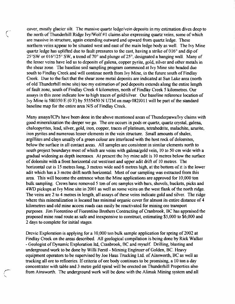
cover, mostly glacier silt. The massive quartz ledge/vein deposits in my estimation dives deep ta the north of Thunderhill Ridge Ivy/Wolf # 1 claims also expressing quartz veins, some of which are massive in structure, again extending outward and upward from quartz ledge. These northern veins appear to be situated west and east of the main ledge body as well. The 1~ Mine quartz ledge has uplifted due to fault pressures to the east, having a strike of 016O and dip of 25”SW or 016”/25” SW, a trend of 70” and plunge of 2Y, desibmted a hanging wall. Many of the lesser veins have led us to deposits of galena, copper pyrite, gold, silver and other metals in the shear zone. The baseline soil sampling program commnced at Ivy Mine site headed due south to Findlay Creek and will continue north from Ivy Mine, in the future south of Findlay Creek. Due to the fact that the shear zone metal deposits are indicated at Sun Lake area (north of old Thunderbill mine site) too my estimation of pod deposits extends along the entire length of fault zone, south of Findlay Creek 4 kilometres, north of Findlay Creek 5 kilometres. Our assays in this zone indicate low to high traces of gold/silver. Our baseline reference location of Ivy Mine is 580350 E (0 E) by 5555450 N UTM on map 0825011 will be part of the standard baseline map for the entire area N/S of Findlay Creek.
Many assays/ICPs have been done in the above mentioned areas of Thunderpawsilvy claims with good mineralization the deeper we go. The ore occurs in pods or quartz, quartz crystat, galena, chalcopyrites, lead, silver, gold, iron, copper, traces of platinum, tetrahedrite, malachite, azurite, iron pyrites and numerous lesser elements in the vein structure. Small amounts of shales, argillites and clays usually of a green colour are interlaced with the host rock of dolomites, below the surface in all contact areas. All samples are consistent in similar elements north to south project boundarys most of which are veins with galenaigold vein, 10 to 50 cm wide with a gradual widening as depth increases. At present the Ivy mine adit is 10 metres below the surface of dolomite with a front horizontal cut west/east and upper adit drift of IO metres. The horizontal cut is 15 metres long, 3 metres wide and 6 metis high at the bottom of it is tbe lower adit which has a 3 metre drift north horizontal. Most of our sampling was extracted from this area. This will become the entrance when the Mine applications are approved for 10,000 ton bulk sampling. Crews have removed 5 ton of ore samples with bars, shovels, buckets, picks and 4WD pickups at Ivy Mine site in 200 I as well as some veins on the west flank of the north ridge. The veins are 2 to 4 metres in length, all assays of these veins indicate gold and silver. The ridge where this mineralization is located has minimal organic cover for almost its entire distance of 4 kilometres and old mine access roads can easily be reactivated for mining ore transport purposes. Jim Fiorentino of Fiorentino Brothers Contracting of Cranbrook, BC bas appraised the proposed mine road route as safe and inexpensive to construct, estimating $5,000 to $6,000 and 2 days to complete for initial stages.
Drevic Exploration is applying for a 10,000 ton bulk sample application for spring of 2002 at Findlay Creek on the areas described. All geological compilation is being done by Rick Walker -Geologist of Dynamic Exploration Itd, Cranbrook, l3C and myself. Drilling, blasting and underground work to be done by Willi Ferstl - Mininig Engineer of Golden, BC. Heavy equipment operators to be supervised by Joe Haus Trucking Ltd. of Ainsworth, BC as well as trucking all ore to refineries. If criteria of ore body continues to be promising, a 10 ton a day concentrator with table and 3 metre gold spiral will be erected on Thunderhill Properties also from Ainsworth. The underground work will be done with the Alimak Mining system and all

personnel and equipment required for the Thunderpaws program are in place and available when miing permits are approved. A drilling plan has been arranged for ore potential for 2002/2003 by Rick Walker, Willi Ferstl and myself
Proposed test trenches cannot be explored due to unsafe access for heavy equipment on Ivy Mine area. A mine access road will create safe approaches for test trenches and heavy trucks. Handdug test pits have been dug by crew along toe ofwest flank of ridge from Vicki Mine to ivy Mine with some sampling done north of Ivy Mine as well. Surface rock is grey dolomite which covers Iayers of green argillite/quartzite that contact east side of ridge of red quart&e with intrusions of black argillites and shales. Iron pyrites are dominant in all stratigraphy. Glacier silt and elastic constituents comprise cover on west and east flanks of Thunderhill ridge!Thunderpaws claims at the base. 4 to 6 cm of organic matter on the surface, 16 to 20 cm of glacier silt and gravel, next lower layer is reddish-grey dolomite varying in thickness from 3 metres to 20 metres which has argillite, quartzite decomposing broken rock on its surface, 1 to 5 cm in size. Below the dolomite is layering of quart&es and argillites 1 to 4 metres in thickness. Beneath these layers is a massive quartz ledge containing numerous and old working in area indicate similar features. High grade quartz is consistent for entire 6 kilometres of current exploration. The white green quartz with iron staining has a silica content of 96% which is very good flux material in smelting. Metallic fire assays have demonstrated the best approach in tracking gold concentrate near and in veins of test pits with sampling program. All old roads and accesses have deep waterbats, completely deactivated and previous road reclamation prohibits backhoes and equipment any access beyond 4x4 pickups and a four man crew manually removing test ores from site. Drilling is very important to prove stratigraphy and ore
deposits and will bc working in conjunction with the test trench program. Ail assay samples which are favourable are milled and processed for supplemental testing too at Nelson and Golden.

SUMMARY
On August 24’h, 2001, a Statement of Work totaling approximately $20,000 of work was submitted by Drew Andrews, owner of the Findlay Creek claims (summarized in Claim Status). Of this total, approximately $6,000 of limited geological and preparatory work was completed on the claims, predominantly along Findlay Creek (Thunderpaws and Vicki claims).
A total of 42 rock samples were taken from the Findlay Creek claims, predominantly on the Thunderpaws claims, along Findlay Creek west of camp and at the Vicki Mine (immediately east of camp). Of the 42 samples recovered, 21 were representative grab samples (up to 2 kg) and 1.5 were larger samples ranging between 80 and 100 Ibs. The representative samples were sent for analyses while the larger samples were crushed and processed for recovery of a concentrate. Four of the larger samples (#35 to #38) were subdivided into smaller tractions and sent to different labs for comparison of results.
In addition, work was completed on preparation of a 1:20,000 scale base map for the Findlay Creek claims. The portion of the I :20,000 scale TRIM map (082 JO1 1) covering the claim area was digitized to produce a topographic map for the property and surrounding area. Similarly, the pertinent portion of the 163,360 scale geology map (Leech 1958) was digitized and placed onto the topographic base map as an overlay.
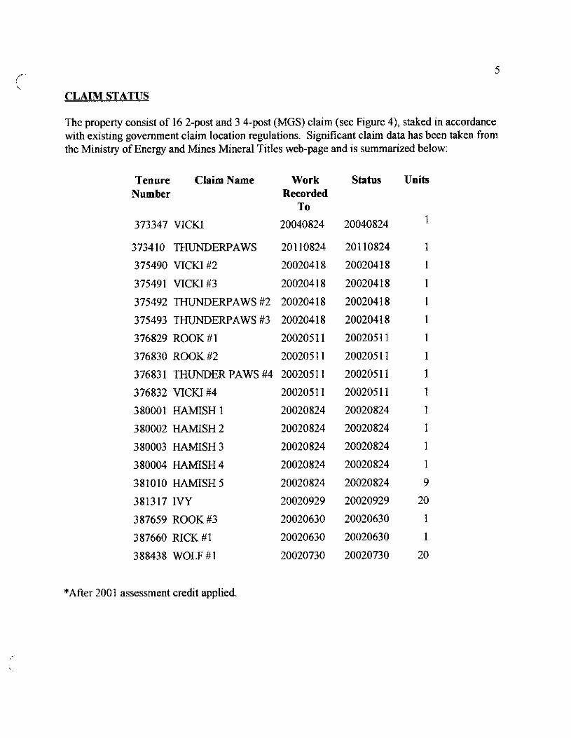
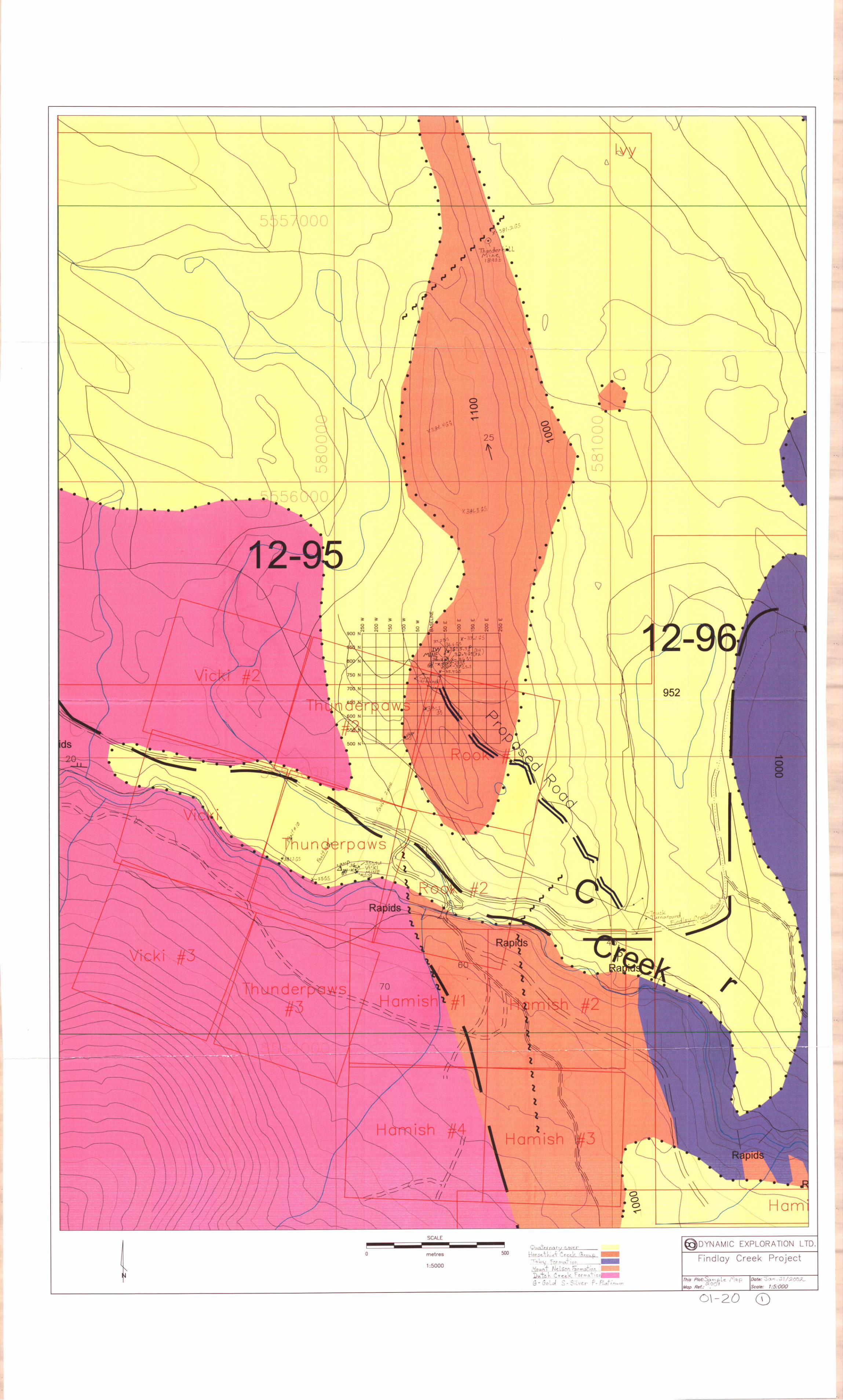
CLAIM STATUS
The propertyconsistofl6 2-post and 3 4-post (MGS)claim(see Figure 4), stakedinaccordance with existing government claim location regulations. Significant claim data has been taken from the Ministry of Energy and Mines Mineral Titles web-page and is summarized below:
Tenure Claim Name Work Number Recorded
To
373347 VICKI 20040824
373410 THUNDERPAWS 20110824
375490 VICKr#2 20020418
375491 vICKl#3 20020418
375492 THUNDERPAWS #2 20020418
375493 THUNDERPAWS #3 20020418
376829 ROOK #l 20020511
376830 ROOK #2 20020511
37683 1 THUNDER PAWS #4 200205 11
376832 VICKI#4 20020511
380001 HAMISH 1 20020824
380002 HAMISH 2 20020824
380003 HAMISH 3 20020824
380004 HAMISH 4 20020824
381010 HAMISH 5 20020824
381317 IVY 20020929
3 87659 ROOK #3 20020630
387660 RICK #1 20020630
388438 WOLF #I 20020730
Status
20040824
20110824
20020418
20020418
20020418
20020418
200205 11
20020511
20020511
200205 11
20020824
20020824
20020824
20020824
20020824
20020929
20020630
20020630
20020730
Units
1
1
1
1
1
1
1
1
1
1
1
1
1
1
9
20
1
1
20
*After 2001 assessment credit applied.

,- 7
WORK HISTORY
There are no Assessment reports which directly apply to the project area. Brief reports of the project area and/or surrounding areas available in the Minister of Mines Reports have been compiled in Appendix B.
The claims were staked between 1999 and 2000. Most of the work to date has been undertaken on the Thunderpaws (Tenure # 373410) and Vicki (Tenure # 373347) claims, comprised of surface sampling and limited trenching. A minor amount of work has been undertaken evaluating a short adit located along the southern boundary of the Ivy claim (Tenure # 38 I3 17).
A number of bulk samples have been taken to determine whether gold is present and, if so, possible controls on gold mineralization. A series of surface samples have been taken, together with material from trenching on the Thunderpaws claim (the Vicki mine). These samples are currently under evaluation at the applicants refinery at Golden.
A number of localities along Findlay Creek and several of its tributaries have had limited documented placer gold production (see Appendix B). In addition, historical work on “Thunder Hill”, as well as the short adit discovered on the southern margin of the Ivy claim, suggests mineral gold potential.
Processing of samples taken to date by the applicant have confirmed the presence of low grade gold, believed to be present as inclusions within sulfides (i.e. pyrite), along (controlled by) fault and fracture planes and as disseminations throughout host rocks adjacent to veins, fault and/or fractures. In addition, it is suspected that placer gold is present in fluvial deposits along, and poorly consolidated sediments on either side of, Findlay Creek.
For example, the following has been taken from Holland (1950):
Placer Cold production of British Columbia
From Tuble XVI - Golden Mining Division: Gold Fineness and Conversion Factors Used in Table XVIf
Number of Weight of Range of Average Fineness Conversion Total Fineness Gold Fineness: Fineness Used for Factor Production
Determinations Represented Gold : Gold Conversion Used Recorded
Ounces Value
/-’ Findlay Ounces $ Creek 1 11 923 923 923 19.05 242 4,690

Sample I.D.
=#20
%?I #22 #23 #24 #25
#3ZSample l-l Sample l-2 Sample l-3 Sample l-4 #35 - Cont. I,1 #35 - Cow. 1.2 #35 - cont. 1.3 #35 - cont. 1.4
Lab ChemMet Consultants Inc Chem-Met Consultants Inc Chem-Met Consultants Inc Chem-Met Consultants tnc Chem-Met Consultants tnc Chem-Met Consultants Inc International Metallurgical* lntemational Metallurgical’ International Metallurgical* International Metallurgical” International Metallurgical’ International Metallurgical* International Metallurgical’ International Metallurgical*
#35-Table tails 1.5 lntemational Metallurgical’ es- 1.1 Eagle River Gold Mines Ltd #36- 1.2 Eagle River Gold Mines Ltd #%I.3 Ivy Mine Em-Tech Laboratories Ltd #S-l.5 Vicki Mine Ew-Tech Laboratories Ltd #36 - 1.6 Ivy Mine Eco-Tech Laboratories Ltd #37-1.1 international Metallurgical’ #37-1.2 International Metallurgical’ Sample 37 - 1.4 G-fern-Met Consultants Inc 1.4 Ivy - Crushed orelntemational Metallurgical’ 1.5 Table tails International Metallurgical* #37-1.5 Eco-Tech Laboratories Ltd #38-1.3 Chem-Met Consultants Inc #38 - 1.4 Eco-Tech Laboratories Ltd
22
Jan. 29, 2001 Feb. 7, 2001
Date
June 12,200l June 12,2GUl June 12.2001 June 12,200l July 16. 2001 July 16, 2001 July 16, 2001 July 16, 2001 July 16, 2001
Aug. 15, 2001 Aug. 15,200l
July 6, 2001 July 6, 2001 July 6, 2KJl
July 23, 2001 July 23, 2001 July 13, 2001 July 23, 2001 July 23, 2001 July 20. 2001 July 18,2001
t.t!L’:$ $2 NQU.IS,XQl sJ-Y16,=JI
24.9 0.03
g/t,& g/up:
0.17 0.07 12.8 0.03
<O..lO 0.22 0.13
co.10 0.02
26.67 2.42 3.52 1.11 0.25
1.5 0.69
co.03 0.34
0.5 0.58 0.34 0.35 0.11 0.36 1.03 0.76 0.55 i.33
7 91.4 103 1.7 c.1
38.5 39 45
39.5 2
147.5 97.5 145 46
trace 4.21 96.8
0.4 98.6 118 136
664 145
46 78.9 158 140
z5
On tbe basis of results rctumed thus far, Drevic Exploration is preparing an Application for a Notice of Work and Reclamation inn order to obtain a 2,000 (to 10,000) tonne bulk sample for processing.
Therefore, to provide a suitable base map for recording data and to have a map specific to the project for reporting purposes, the author initiated a program to prepare a 1:20,000 scale base map with an overlay of the geology (Leech 1958, Hijy 1995). The base map will provide a suitable base on which to plot all subsequent sample locations, locations of past and present physical work sites (i.e. trenching, roads and trails) and geological information. The resulting base map, was completed in the spring of 2001, a portion of which is included in this report, and represented preparatory work for the 2001 field program.
One day was spent by the author on the property (property examination) in the company of Drew Andrews to visit the site of active work along Findlay Creek (relatively small 80 to 100 lb
f-

Mining Division Locality Windermere Thunder Hill Gold quartz and galena
1898
Findlay Creek flows into the Kootenay River near ‘Canal Flats”, its watershed forming the southern boundary of the Windermere Division, A good flow of water character&es it, said to amount to 7,500 miner’s inches, the fall of the stream being from 75 to 100 feet tot he mile.
In the immediate neighbourhood, situated within two miles from the upper end of Upper Columbia Lake, quite a number of locations have been made, all on a series of quartz ledges, which run about north and south, and which are all of the same general character.
Starting with the most northerly, we have in succession the following groups: - The Sun Lake, Thunder HilI, Jupiter, and Soudan, and on the south side of Findlay Creek the Gold Hill Group.
This group, owned by Jas Brady et al., consists of four claims in one block, Sun Lake Group. all locations; situated about 1% miles west of Sun landing, on the Upper
Columbia Lake, and one mile from the main stage mad running from Golden to Fort Steele. Elevation, 3,100 feet, or about 400 feet above the lake. Country rock, slates, and schists, running in a general N.E. and SW. direction and dipping N.W., with occasional igneous dykes occurring in a general N. and S. direction.
There appears to be three distinct quartz ledges running through the properties - running with the bedding of the schists - which outcrop and have been stripped in several places, proving their continuity. They are somewhat irregular and poekety, jumping from one layer of schist to another. These ledges, which are each from 15 to 50 feet wide, are made up partly from white quartz and partly from a grayish quartz, which gives the impression that it may be a very highly altered quartzite. Interhedded here and there are quartz and talcose schists.
The gray quartz and the schists near the lead are spotted here and there with small cubes of iron pyrites carrying gold, and with occasional particles of galena The proportion of these sulphides in the quartz 1 estimated at about from % to 1 per cent. Numerous assays were shown me from material taken from the open cuts, which ran from $1.05 to $1.85 in silver and about $4.00 in gold. These assays were from near the surface and on material which was much weathered, and serve merely as indications as to what may he expected with depth
Considerable work has been done on these properties, but confined as yet to open cuts and other surface developments.
Of good water and timber there is an ample supply, sufficient for all mining needs. A good log cabin, divided into two rooms, has been erected, and the property can be easily reached by waggon, the surface thereabouts being comparatively clear and the slopes gradual.

PLACER-MINING, FINDLAY CREEK.*
R. A. Ballentine and associates, of Portland, have taken up thirty-two bench and creek leases on the upper reaches of Findlay creek with a view to testing out their placer-gold possibiiities. The ground is situated about 16 miles back from Canal Flats, 10 miles by old logging-road and 6 miles by trail.
This summer some preliminary testing of the gravels was done, the results of which are said to have been encouraging, and some drilling may be undertaken next year. Other work done in connection with this undertaking includes extensive repairs to the old trail and the building of a large and substantial cabin. Several parties of prospectors were active in the upper Findlay Creek area looking for silver-lead-zinc deposits in the northern extension of the Aldridge formation.
1965 CANAL FLATS*
FINDLAY CREEK (50” 115’ S. W.)
Office address, 1222-18th Street Northwest, Calgary, Alta. Hobbs & Haliverson These two partners moved equipment onto their four placer leases at
the confluence of Deer and Findlay Creeks, 12 miles west of Canal Flats, but did not start operating. The equipment includes one cubic- yard dragline, portable concentrator, 5 by 10 double-deck vibrating screen, one 100&a. gene&or, and a D-6 cat.
McKellor P.M.L. 262. - Roy McKellor, of Calgary, Alta., worked alone for a period of three months during the summer of 1965 and hydraulicked and sluiced approximately 200 yards of gravel from his lease on the bank of Findlay Creek, 12 miles west of Canal Flats.
1966 GOLDEN MINING DIVISION
FINDLAY CREEK (SO0 115” SW.)
(By D. R. Morgan)
Three placer-mining leases at and upstream from the confluence of Deer and Findlay Creeks, 12 miles west of Canal Flats, were held by A. E. Hobbs and A. C. Halvorson. The two partners made an attempt to operate equipment that was brought in at the latter part of 1965. The equipment was found to be unsuitable and was removed.
Roy McKellor, of Calgw, Alta., working alone for a few weeks during the summer of 1966, hydraulicked and sluiced approximately 150 yards of gravel from his P.M.L. 26 1 on the south side of Findtay Creek downstream from the confluence of Deer Creek, 12 miles west of Canal Flats.

D. TECHNICAL REPORT
. One technical report to be completed for each project area. MIhbyofEnwgy~nlm Energy ad Uimnls Diviiian
. Refer to Program Regulations 15 to 17, page 6.
SUMMARY OF RESULTS ~ Information on this kmr~ la contidential for v This summary section must be filled out by all grantees, one for each project area : one year .nll is mbjea to tile provisions of
_ thr Freedom o,hfmmion Act
NaIlI. T> red Andra$J -5
LOCATIONlCOMMODITIES
Project Area (as listed in Part A
Location of Pro’ect Area NTS
Reference Number am t/2001 f34
ILE No. if applicable
Known Mineral Occurences in Project Area ui.& fl ; n#. i luu J”r; rr e
WORK PERFORMED
I. Conventional Prospecting (area) b60 h a. .2Y wr,% aoDrbX/'*fc 2. Geological IMapping (hectares/scale) 2 50 /ta / 10 u ; fs r ’ c+MlUk
~-oLy xtr
4 1
3. Geochemical (type and no. of samples) 71 .&; 1. 4. Geophysical (type and line km)
5. Physical Work (me and amount) lsmm3j s+d. /zz .+ 1 g 2 pfd I
6. Drilling (no. holes, size, depth in m, total m)
7. Other (specify)
pector Assistance Pro
Prospectors Assistance Program Guidebook 2001 1s

D. TECHNICAL REPORT (continued)
REPORT ON RESULTS (continued)
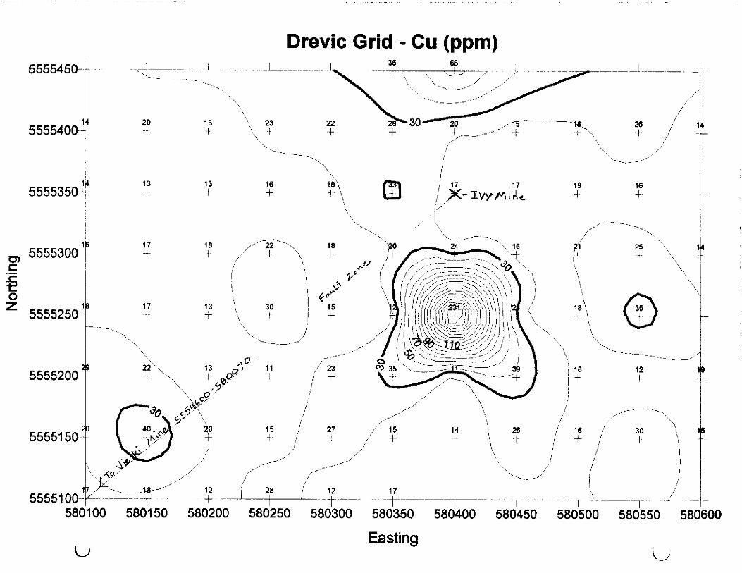
4. GEOCHEMICAL RESULTS [Describe all survey types done (rock, soil, silt) and their objective. Show clearly on accompanying map(s) of appropriate scale all sample sites along with all significant values. Any anomalous area should be indicated on maps by the use of contouring, variable symbol sizes, or some other suitable technique. Include a discussion/interpretation ofresults. A copy of analysis/assay certificates must be included with sample numbers from map.

D. TECHNICAL REPORT (continued)
REPORT ON RESULTS (continued)
4 Geo&am;c&i Res,l_ts
Prospecrors Assistance Bogram - Guidebook 2001 17

D. TECHNICAL REPORT (continued)
REPORT ON RESULTS (continued)
5. GEOPHYSICAL RESULTS [Specify the objective of the swwy, the method used and the work done. Discuss the results and show the data on an accompanying map of appropriate scale. Any anomalous areas must be indicated on maps by the use of contouring, or some other suitable technique.]
5. OTHER RESULTS [Drilling - describe objective, type and amount of drilling done. Discuss results, including any si@icant intersections obtained. Indicate on a map of appropriate scale the drill-hole collar location, the angle of inclination and azimuth. Drill logs correlated with assay results must be included. Physical Work - describe the type and amount of physical work done and the reasons for doing it (where not self-evident). This includes Lnes&C%, Uails,
Signature of Grantee &,$&&urn Date
Signahre of person tilling out Final Prospecting Report if other than grantee
Prospectors Assistance Program - Guidebook 2001 19

Assessment Report for the
Findlay Creek Area Claims
Fort Steele Mining Division B.C.G.S. 082 JO1 1
Latitude 50” 07 30”, Longitude 115” 52’ 00”
for
Drevic Exploration 814 Almberg Road
Golden, BC VOA IH2
Submitted by:
Richard T. Walker, P.Geo.
of
Dynamic Exploration Ltd. 656 Brookview Crescent
Cranbrook, BC VlC 4R5
Submitted: December 24&, 2001

c ii
Table of Contents
Summary ............................................................................................................................... Introduction ...........................................................................................................................
Location and Access ............................................................................................................. Physiography and Climate .................................................................................................... Claim Status .......................................................................................................................... Work History ......................................................................................................................... Regional Geology ................................ ___ ... ____ ................................................................ ____ ... 2001 Program ....................................................................................................................... Conclusions ........................................................................................................................... References .............................................................................................................................
Paw
I 2 2 5 7 9 21 24 24
c

.,. II1
List of Figures
Figure 1 - Regional Location Map.. ............................................................................. 3 Figure 2 - Location Map .............................................................................................. 4 Figure3-ClaimMap.. ................................................................................................. 6 Figure 4 - General Geology and Claim Map (1:20,000 scale) ..................................... 23
List of Appendices
Appendix A - Statement of Qualifications Appendix B - Excerpts from the Minister of Mines Reports Appendix C - Statement of Expenditures Appendix D - Prograrh - Related Documents

r- 1 L
LNTRODUCTION
The Findlay Creek claims are located southwest of Columbia lake and west of Canal Flats, on the western margin of the Rocky Mountain Trench. The claims are located on B.C.G.S. map 08250 11, straddling Findlay Creek. The current claims include previous workings associated with the former Thunderhills mine, located on a prominent ridge oriented north-south along the eastern edge of the property.
The claims can be accessed from Highway 95 by turning off at the Blue Lake access road (Findlay Creek Forest Service Road) and driving 8 kilometres. The property is roughly centred on the junction of the Findlay Creek Forest Service Road and the Skookumchuk Forest Service Road.
On August 241h, 2001, a Statement of Work totaling approximately $20,000 of work was submitted by Drew Andrews, owner of the Findlay Creek claims (summarized in Claim Status). Of this total, approximately $6,000 of limited geologicat and preparatory work was completed on the claims, predominantly along Findlay Creek (Thunderpaws and Vi&i claims).
A total of 42 rock samples were taken from the Findlay Creek claims, predominantly on the Thunderpaws claims, along Findlay Creek west of camp and at the Vi&i Mine (immediately east of camp). Of the 42 samples recovered, 2 1 were representative grab samples (up to 2 kg) and 15 were larger samples ranging between 80 and 100 Ibs. The representative samples were sent for analyses while the larger samples were crushed and processed for recovery of a concentrate. Two of the larger samples (#35 to #38) were sub-divided into smaller fractions and sent to different labs for comparison of results.
In addition, work was completed on preparation of a 1:20,000 scale base map for the Findlay Creek claims. The portion of the 1:20,000 scale TRIM map (082 JO1 1) covering the claim area was digitized to produce a topographic map for the property and surrounding area. Similarly, the pertinent portion of the I :63,360 scale geology map (Leech 1958) was digitized and placed onto the topographic base map as an overlay.

r 2
LOCATION AND ACCESS
The study area is located BCGS mapsheet 082JOl I, approximately 8 km west of Highway 95, southwest of Columbia Lake and west-northwest of the community of Canal Flats. The claims are centred at approximate coordinates:
Latitude 50’ 07 30”, Longitude 115” 52’ 00” UTM 58OOOOE. 5554500 N
The claims can be easily accessed from Highway 95 by turning west of the highway at the Blue
Lake exit. Follow the well maintained logging road approximately 7 kilometres to the core of the two post claims. A camp has been established along Findlay Creek and can be accessed by proceeding south along the Skookumchuk Forest Service Road for approximately 150 metres. A trail is evident on the west side of the logging road immediately before the bridge. The camp is located approximately 250 metros along the trail, beyond a chain gate.
Deactivated logging and skid trails provide possible ATV access throughout much of the claims. In addition, the claims north of Findlay Creek are largely open, sparsely treed whereas the southern claims are located in old logging cuts and have moderate to dense second growth
PHYSTOGRAPHY AND CLIMATE
Tbe following observations have been made by Drew Andrews on the Findlay Creek claims
Vegetation is semi-arid and comprised mainly by grasses, sedges, alders, dogwood, wild rose bushes, bawthome bushes, many low cover flowers and herbs. Intense growth along Findlay Creek and drainages. Vegetation is relatively sparse above canyons and walking is very easy though groves or meadows
.* - ‘i.
Trees dominate the moist areas of Thunderpaws claims, though widespread forest fires in I985 (Thunderhill) have eliminated large tracts of forest on surrounding mountains and valleys, regeneration is thriving and will survive. The main species of trees in the Thunderpaws area are Douglas Fir, Yellow Pine, Ponderosa Pine, Larch, Birch, Cedar and Poplar. Large and very old junipers dot the ridges due to minerals on band. Alders and maples also are present.
Due to the open nature of the area subsequent to the tire, snow cover is generally minimal, with deeper levels present in sheltered draws. As such, the claims are available to work throughout much of the year. To date, the claims have been worked from March to early November.


22
Sample I.D.
#21 K!2 K!3 #24 #25 Sample l-1 Sample l-2 Sample 1-3 Sample I-4 #35-conc.1.1 #35 - cont. 1.2 #35 - corlc. 1.3 #35 - Cont. 1.4
Lab Chem-Met Consultants Inc Chem-Mat Consultants lnc Chem-Met Consultants Inc Chem-Met Consultants Inc Chem-Met Consultants Inc Chem-Met Consultants Inc International Metallurgical’ International Metallurgical* International Metallurgical* international Metallurgical’ International Metallurgical’ International Metallurgical* International Metallurgical* International Metallurgical’
#I35 -Table tails 1.5 International Metallurgical’ #36 - 1.1 Eagle River Gold Mines Ltd #36-1.2 Eagle River Gold Mines Ltd KS-l.3 Ivy Mine Em-Tech Laboratofies Ltd #X-IS Vicki Mine Eco-Tech Laboratories Ltd #36 - 1.6 Ivy Mine Ew-Tech Laboratories Ltd #37-1.1 International Metallurgical’ #37 - 1.2 International Metallurgical” Sample 37 - 1.4 Chem-klet Consultants Inc 1.4 Ivy - Crushed orelntemational Metallurgical’ 1.5 Table tails International Metallurgical’ #37 - 1.5 Eco-Tech Laboratories Ltd #36-1.3 Chem-Met Consultants Inc #38 - 1.4 Eco-Tech Laboratories Ltd
* International Metallurgical and Environmental lnc
Date Jan. 29,2001
Feb. 7,200l
June 12,200l June 12,2001 June 12,200l June 12.2001 July 16, 2001 July 16, 2001 July 16, 2001 July 16, 2001 July 16.2001
Aug. 15,200l Aug. 15,2001
July 6. 2001 July 6, 2GUl July 6. 2001
July 23, 2001 July 23, 2001 July 13, 2001 July 23, 2001 July 23,200l July 20, 2001 July 18, 2001 July 24,200l
7 91.4 103 1.7 x.1
38.5 39 45
39.5 2
147.5 97.5 145
46 trace 4.21 96.8
0.4 98.6 118 136
66.4 145 46
78.9 158 140
24.9 0.03 0.17 0.07 12.8 0.03
a.10 0.22 0.13
co.10 0.02
26.87 2.42 3.52 1.11 0.25
1.5 0.69
co.03 0.34
0.5 0.58 0.34 0.35 0.11 0.36 1.03 0.76
On the basis of results returned thus far, Drevic Exploration is preparing an Application for a Notice of Work and Reclamation inn order to obtain a 2,000 (to 10,000) tonne bulk sample for processing.
Therefore, to provide a suitable base map for recording data and to have a map specific to the project for reporting purposes, the author initiated a program to prepare a 1:20,000 scale base map with an overlay of the geology (Leech 1958, Hisy 1995). The base map will provide a suitable base on which to plot all subsequent sample locations, locations of past and present physical work sites (i.e. trenching, roads and trails) and geological information. The resulting base map, was completed in the spring of 2001, a portion of which is included in this report, and represented preparatory work for the 200 1 field program.
One day was spent by the author on the property (property examination) in the company ofDrew Andrews to visit the site of active work along Findlay Creek (relatively small 80 to 100 lb


7 c WORK HISTORY
There are no Assessment reports which directly apply to the project area. Brief reports of the project area and/or surrounding areas available in the Minister of Mines Reports have been compiled in Appendix B.
The claims were staked between 1999 and 2000. Most of the work to date has been undertaken on the Thunderpaws (Tenure # 373410) and Vicki (Tenure # 373347) claims, comprised of surface sampling and limited trenching. A minor amount of work has been undertaken evaluating a short adit located along the southern boundary of the Ivy claim (Tenure # 381317).
A number of bulk samples have been taken to determine whether gold is present and, if so, possible controls on gold mineralization. A series of surface samples have been taken, together with material from trenching on the Thunderpaws claim (the Vicki mine). These samples are currently under evaluation at the applicants refinery at Golden.
A number of localities along Findlay Creek and several of its tributaries have had limited documented placer gold production (see Appendix B). In addition, historical work on “Thunder Hill”, as well as the short adit discovered on the southern margin of the Ivy claim, suggests mineral gold potential.
Processing of samples taken to date by the applicant have confirmed the presence of low grade gold, believed to be present as inclusions within sulfides (i.e. pyrite), along (controlled by) fault and fracture planes and as disseminations throughout host rocks adjacent to veins, fault and/or fractures. In addition, it is suspected that placer gold is present in fluvial deposits along, and poorly consolidated sediments on either side of, Findlay Creek.
For example, the following has been taken from Holland (1950):
Placer Gold production of British Columbia
From Table XVI - Golden Mihing Division: Gold Fineness and Conversion Factors Used in Table XVII
Number of Weight of Range of Average Fineness Conversion Total Fineness Gold Fineness: Fineness Used for Factor Production
Determinations Represented Gold : Gold Conversion Used Recorded
Ounces Value
Findlay Ounces % Creek 1 11 923 923 923 19.05 242 4,690

a r- I,
From Table XVII - Phcer Gold Production from Golden Mining Division
Year
1881 - 85
Findlay Creek
Ounces Value ($)
231 4,400
1931 - 35 II 290 ............................................................... I I
Totals ..................... 242 4,690
Finally, the discovery of a short adit driven to evaluate vein-type galena, chalcopyrite and pyrite mineralization (lead, copper * silver i gold f zinc), as well as the reference to “... distinct quartz ledges running through the properties - running with the bedding of the schists ..“in the Minister of Mines Reports for “Thunder Hill” (see Appendix 1) suggests quartz veins having Polymetallic vein potential

r 9 i
REGIONAL GEOLOGY
The project area is located immediately north of the Skookumchuk map sheet and south of the area mapped by Pope (I 990). From the mapping reported by these two authors, it would appear the project area may be characterized by one or more facies changes from the Skookumchuk map sheet to strata mapped in the Toby-Horsethief Creek area. As there has been no geologicai mapping of the project area or immediate vicinity, the stratigraphic descriptions for both the Skookumchuk map sheet (Hiiy 1993) and the Toby-Horsethief Creek area (Pope 1990) have been provided below.
The following has been taken from Hdy (1993):
SHEPPARD CREEK FORMATION (LOWER DUTCH CREEK FORMATION)
The Sheppard Formation includes up to several hundred metres of stromatolitic dolomite, quartz arenite, siltstone and argiliite lying above the Nicol Creek Formation. In the Skookurnchuk area, it increases dramatically in thickness, from approximately 500 metres near Echoes lake to 1500 metres in the Larchwood Lake area, 10 kilometres farther north. This increase in thickness is accompanied by prominent facies changes in the Sheppard Formation and in the overlying Gateway and Phillips formations.
The Sheppard Formation is characterized by an assemblage of green siltite, sandy dolomite, quartz wacke, distinctive stromatolitic dolomite and oolitic dolomite layers.
Northwest of Skookumchuk, the formation is marked by pronounced changes in thickness and litbology. At Echoes Lake, it is approximately 500 metres thick. The basal part comprises mainly green, laminated siltstone, crossbedded and rippled sandstone and quartsite, with dolomitic siltstone layers throughout. Stromatolitic dolomite interbedded with quart&e, purple siltstone, massive dolomite and oolitic dolomite forms a distinctive package more than 100 metres thick near the top of the formation.
At Larchwood Lake, 10 kilometres farther north, the Sheppard Formation is estimated to be 1500 metres thick. This dramatic increase in thickness is largely accommodated by a thick succession of dominantly green siltstone, commonly in the form of graded siltstone-argillite couplets, that lies between the Nicol Creek lavas and the stromatolite-bearing sequence at the top of the Sheppard Formation. Farther west, near Bradford Creek, the formation is still recognizable but is referred to as the lower Dutch Creek Formation. It comprises green siltstone and argillite with minor dolomitic siltstone and, near the top, stromatolitic dolomite. This stromatolitic sequence can be traced north of Bradford Creek and marks the contact between the lower and upper Dutch Creek, It comprises cycles of rounded and gritty quartz wackestone, overlain by oolitic, stromatolitic or massive dolomite. These cycles may contain a few thin, purple argillite beds
f- with mud cracks and locally, ripup clasts. They are overlain by and interbedded with light
!L..~~ green siltstone-argiltite couplets, usually lenticular, laminated and graded.

r IO
GATEWAY FORMATION (UPPER DUTCH CREEK FORMATION)
The Gateway Formation is defined to include siltite, argillite, arenite and dolomite between the Sheppard Formation and red and maroon siltstone and argillite of the overlying Phillips Formation. It correlates with the lower part of the upper Dutch Creek Formation northwest of Skookumchuk.
The Gateway Formation comprises dominantly pale green siltstone and minor dolomitic or argillaceous siltstone.
In the Skookumchuk area , the gateway Formation is also predominantly a pale green siltstone succession with some intervals of mauve or purple silty argillite. Some dolomite and dolomitic siltstone, oolitic dolomite and cryptal algal dolomite also occur in the upper Gateway. A thin unit of dark grey and black, finely laminated siltstone and argillite is present just below the Phillips Formation.
Salt casts and symmetrical ripples throughout the Gateway Formation suggest deposition in shallow water; dessication cracks, mud-chip breccias and oxidized facies indicate periods of subaerial exposure. ._. The formation thickens rapidly to the north in the Skwkumchuk area primarily as the result of an increase in the pale green siltstone component. Tbe absence of the overlying Phillips Formation, sparse outcrop and the similarity between lithologies in the upper Gateway and lower Roosville formations make it difficult to determine the thickness and extent of the Gateway Formation to the north and west.
PHILLIPS FORMATION
The Phillips Formation is one of the most conspicuous regional marker units in the Purcell Supergroup It is a distinctive red to purple quartzite and siltstone sequence that averages between 150 and 200 metres in thickness. It pinches out near tarchwood Lake in the Skookumchuk area, supplanted by green siltstone and quartzite of the Dutch Creek Formation. The Phillips Formation is characterized by thin-bedded, red, maroon and purple quartzite, siltstone and argillite. It has gradational contacts with both the underlying Gateway Formation and overlying Roosville Formation, with interbeds of green siltstone near the base and top. Ripple marks, cross laminations, de&cation cracks and mud-chip breccias are common sedimenq structures, and micaceous siltstone and argillite beds are diagnostic. The disappearance of the Phillips Formation in the Skookumchuk area is rather abrupt. In the last recognized exposures at Larchwood Lake, however, the maroon colouring is not as conspicuous as in exposures farther south and is restricted to specific beds.
c

c II
ROOSVILLE FORMATION
The Roosville Formation correlates with the upper Dutch Creek Formation in the Lardeau area. Its thickness varies considerably, due to beveling by unconformably overlying Late Proterozoic, Middle Cambrian or Devonian rocks.
The Roosville Formation comprises argillite, siltstone, quartzite and dolomite. Dark grey argillite and silty argillite interbedded with green siltstone predominate in the lower part of the formation in the Gold Creek area Higher in the succession, pale green argillaceous siltstone predominates, interbedded with mauve siltstone, some thin intraformational conglomerate layers and minor dolomitic siltstone and red argiI1ite layers. Stromatolitic and oolitic dolomite are prominent locally. Syneresis cracks occur in the argillite beds, and mud cracks, ripup clasts, mud-chip breccias and graded and lenticular beds are common throughout the succession. Subtle facies changes in the Roosvilie Formation occur between Echoes and Larchwood lakes in the Skookumchuck area. Layers with ripup clasts are abundant at Echoes Lake, less common and with more rounded clasts at Larchwood Lake, and rare north of Larchwood Lake.
DUTCH CREEK FORMATION
The Dutch Creek Formation is defined as a group of rocks between the Purcell Iavas (Nicol Creek Formation) and the Mount Nelson Formation. The Iavas are no? exposed in the Lardeau and Nelson east- half map areas and hence it is difficult to determine the exact thickness and extent of the Dutch Creek Formation there. It is estimated to be between 1200 and 1500 metres thick in the Windermere area and a 1300-metre section has been measured east of Kootenay Lake at Rose Pass.
In the Femie west-half map area, the Dutch Creek Formation is only exposed northwest of Skookumchuck The lower part of the formation is described in the section on the Sheppard Formation. The upper part includes the Gateway Formation, the Roosville Formation and overlying rocks beneath the Mount Nelson Formation. The maximum thickness of the Dutch Creek Formation in the Bradford Creek area is estimated to be 4800 metres, including approximately 3300 metres of upper Dutch Creek.
The upper Dutch Creek is discontinuously exposed north of Skookumchuck. A carbonate marker bed approximateiy 200 metres thick occurs within the formation some 3000 metres above the Nicol Creek Iavas. It is a massive, cream to tan-weathering, thick to medium-bedded dolomite and limestone unit. Crypto-algal features are present locally. The top and the base of the unit consist mainly of argiliaceous silty dolomite. It is included within the Dutch Creek rather than the Mount Nelson Formation as the basal quart&e typical of the Mount Nelson is not exposed below it. Furthermore, green siltstone, black argillite and thin oolitic dolomite
c
interbeds higher in the section probably correlate with similar facies in the Roosville Formation at Larchwood Lake.

f 12
\. MOUNT NELSON FORMATION
The Mount Nelson Formation comprises a thick sequence of quartzite, dolomitic argillite and siltstone that conformably overlies the Dutch Creek Formation. It was restricted to include onIy the lower part of the formation. The upper part, informally named the Frances Creek Formation, is separated from the Mount Nelson Formation (new) by a disconformity.
The lower Mount Nelson Formation is divisible into three members in the Mount Forster map: a basal white orthoquartzite 100 to 200 metres thick, 100 to 300 metres of buff and grey dolomites and an upper unit, to 370 metres thick, ofpurple and red shale with buff dolomite interbeds. The overlying Frances Creek Formation comprises thick-bedded orthoquartzite, grey dolomite and interbedded sandstone and shale.
The total thickness of the Mount Nelson Formation (new) in the Mount Forster area varies from 500 metres to 1950 metres, due partly to erosion prior to deposition of the Frances Creek Formation or Windermere Supergroup and partly to syndepositional tectonics. The Frances Creek Formation varies in thickness from 750 metres to 1020 metres. At Rose Pass east of Kootenay Lake, the entire Mount Nelson Formation is approximately 750 metres thick.
In Femie west-half map area, the Mount Nelson Formation is only exposed at Lookout Mountain along the northern edge of the map area. It has a gradational contact with the underlying Dutch Creek Formation; phyllitic black argillite-siltstone rocks become increasingly more quartzitic and the interbeds of quartz wacke become cleaner up-section. The basal quart&e of the Mount Nelson is a clean, well-rounded and well-sorted, medium-bedded orthoquartzite containing a few thin beds of sandy dolomite. The basal quartzite is overlain by a mixture of white, green and purple quartz arenite and dolomitic sandstone, locally gritty, as well as some purplish dolomite and argillite. Locally, the diagenetic character of these maroan beds is clearly demonstrated as the colouring crosscuts bedding planes and leaves spotty remnants of light green argillite. A buff-weathering sequence of dolomite overlies these quartz wacke, siltstone and argillaceous dolomite beds. This package is overlain by more green siltstone and minor purple siltstone and argillite. The total exposed thickness of the Mount Nelson Formation is approximately 400 metres.

c The following has been taken from Pope (1990):
13
Van CREEK FORMATION
The Van Creek Formation is best exposed at the south end of Stark Creek. It consists of coarse to medium-grained, light-grey or green to dark-green quartrites, siltstones and silty argillites. The beds have consistent thicknesses of between 20 to 50 centimetres with slightly undulose bases and truncated tops, together with internal cross and planar lamination and grading. Van Creek quartzites grade upward into thinly bedded, pale green quart&es and then into thinly interbedded 2 to 20 centimetre pale green quartzites, silts and buff weathering dolomitic silts of the Lower Gateway Formation, Hg 1 member.
LOWER GATEWAY FORMATION
The Lower Gateway Formation is subdivided into two members Hgl and Hg2 (Figure 5).
Hg 1: The contact between the Van Creek and Lower Gateway formations is gradational and in the absence of the Nicol Creek Formation can only be roughly estimated. The lowermost units of the Lower Gateway Formation are identified as where carbonate first occurs in the succession. The thin bedded quartzites in this transitional sequence are characterized by weathered pyrite, which imparts a distinctive red spotted appearance.
The Hgl member is estimated from cross sections and distribution to be well in excess of 1000 metres thick. It consists of interbedded packages of quartzite, green siltstone and buff dolomitic siltstone and dolomite. Sedimentary structures such as cross lamination, grad@, charmeping and dewatering structures, are well preserved and compositional differences frequently enhance exposures. Siltstones in the dolomitic packages usually show an upwards gradation from dolomite free, finely cross-laminated silt and sand to dolomitic cross-laminated siltstone and cryptalgal to stromatolitic-laminated micritic dolomite. Bed thicknesses vary from generally 2 to 10 centimetres in the time grained quartzite dominated lower part, to 10 to 50 centimetres in the upper dolomite dominated part of the Hg 1 member.
Hg2: The dolomite dominated upper part of the Hgl member passes into a 90-metres thick, cream to buff weathering dolomite unit. The dolomite displays cryptalgal and stromatolitic laminations, cream chert intercalations, rare halite casts and silty and sandy crosslamination. Bed thickness varies between 50 centimetres to 2 metres, and grain size varies from micrite, which is typically blue-grey, to coarse sucrose-textured, light coloured recrystallized dolomite. This unit hosts the Mineral King lead-tine-silver mine.

c 14
DUTCH CREEK FORMATION
The boundary between the Lower Gateway Formation and the Dutch Creek Formation is clearly exposed in Coppercrown, McDonald and Far&m creeks. In all cases a sharp contact is observed, characterized by a narrow zone of rusty weathering. The contact is interpreted as a parallel unconformity and the rusty weathering zone marking a hiatus
Within the Dutch Creek Formation there is not a clearly defined stratigraphy, but four basic lithofacies (A to D) have been distinguished. Beds are usually between 2 to 20 centimetres thick and consist of tine grained quarizite and argillite in graded couplets. Sedimentary structures include fine herringbone, ripple and channel cross-laminations. The Dutch Creek Formation has a marked lack of carbonate.
There is a great variation in thickness of the Dutch Creek Formation from an estimated 1000 metres to less than 300 metres over a lateral distance of 5 kilometres. The maximum measured thickness of the formation is 700 metres in the Coppercrown-Mineral Creek area. Although the observed contact with the overlying Mount Nelson Formation is always paraconformable, the contact is very sharp and represents a major change in facies, hydrodynamic energy and sedimentary processes, and is therefore interpreted as an unconformity
MOUNT NELSON FORMATION
The Mount Nelson Formation is the uppermost unit of the Purcell Supergroup below the Windermere unconformity. It is 1320 metres thick and consists of very distinctive thick, well-bedded sequences of white orthoquartzites, buff weathering dolomites and purple dolomites and argillites. A very precise lithostratigraphy comprising seven members, mappable at a scale of 150 000, has been established The formation is preserved largely intact, except for the Upper Dolomite, on the north side of Law Creek
LOWER QUARTZITE
The lower Mount Nelson quartzite varies in thickness from 50 to 150 metres and is a useful marker horizon. It is characteristically white and consists of well sorted, fine to medium grained (0.5 to 1 millimetre) pure quartz arenites, with thin bedding (2 to 20 centimetres) and well developed planar and ripple lamination. These sedimentological features distinguish it from the upper Mount Nelson quartzite which is also white.
LOWER MAIN DOLOMITE
The lower main dolomite is approximately 400 metres thick and lies conformably upon the lower quartzite, with which it has a gradational contact over of 40 metres. It is easily accessible and very well exposed in the upper part of Law Creek. The dolomites are characterized by a

;F- 15
i pale-grey weathered and blue-grey fresh colour, a very consistent bedding thickness of 20 to 50 centimetres and cryptalgal to stromatolitic lamination. Individual beds usually consist of a lower cross-kdded silty (5 to 20 per cent quartz) dolomite containing soft-sediment dewatering structures, which pass upwards into cryptalgal laminated dolmicrites and hemispherical laterally-linked stromatolites. Large disseminated dolomitized halite casts, up to 3 centimetres in diameter, are common in the upper parts of beds and rare ooiite laminations have &en identified. Black carbonaceous argillites, 1 to 2 centimetres thick, are frequently interbedded with the dolomites.
The upper parts of the lower Main dolomite are more thickly bedded (20 to 50 centimetres), whereas the lower parts are thinner bedded and contain more terrigenous argillitic material. The sequence is capped by a distinctive cream coloured stromatolitic, crystalline chertydolomite unit about 20 metres thick.
MIDDLE QUARZITE (lower part)
The middle quartz&e lies with sharp contact on the lower main dolomite upper-cream marker unit. This is the “apple green” quartzite mapped by Atkinson (1975) as the lower Mount Nelson quartzite in the Paradise map area, and is best exposed on the north side of Clearwater Creek. The middle Mount Nelson quart& forms the summits of Mount Nelson and Mount Catherine, but exposures are more easily accessible in the Law Creek section.
It is apple green in colour and consists of grade4 channel cross-bedded and massive, fine to coarse-mined quartz arenites, impure sandstones and argillites. The beds commonly have undulose bases, argillite rip-up clasts, truncated tops, and are usually 10 to 20 centimetres thick but may be up to 50 centimetres. The grading, channelling and erosion surf&es in the quartzites indicate rapid deposition in the form of turbidites. Thick bedded sections display truncated A-B and A-C Bouma sequences whereas thinner bedded sections commonly display A-D and A-E sequences.
The middle quartzite grades into a section of varicoloured buff weathering doiomitic siltstones, argillites and impure sandstones at the base of the distinctive orange dolomite sequence.
ORANGE DOLOMITE (middle part)
The orange dolomite sequence, which is approximately 180 metres thick, is composed of well- bedded bright orange-buff weathering, silty and sandy crystalline dolomites with abundant stromatolites, crypt&al lamination and chert intercalations. Solution collapse breccias, halite casts and mud cracks are common. The dolomites are typically blue-grey when fresh, although recrystallized zones within the dolomite are lighter coloured and have a sucrosic texture. Fine to medium-grained quartz-rich (5 to 20 per cent quartz) laminae define ubiquitous tine scale
/- cross-laminations, grading and dewatering structures.
c.

c 16
WHITE MARKERS (upper part)
Conformably above the orange dolomite is the white marker sequence, which has a maximum thickness of about 70 metres. It consists of cream, buff and silver-grey dolomites, locally developed pure-white magnesite beds up to 1 metre thick, and purple, green and buff dolomitic mudstones. Dolomites have stromatolitic laminations and cream chert intercalations which preferentially replace the algal structures. The dolomitic mudstones contain abundant halite casts. At the Kootenay Queen mine, hosted by the white marker sequence, beds up to 1 metre thick consist entirely of dolomitized halite casts.
PURPLE SEQUENCE
The conformably overlying purple sequence is in gradational contact with the white marker sequence. Purple tipple-drift cross-laminated dolomitic sandstones and siltstones, with abundant halite casts dominate the lower part of the unit which grades up into a sequence of purple argillites. The composition of the dolomitic silts is approximately 20 per cent quartz, 70 per cent fine-grained anhedral dolmicrite, and 10 per cent hematite which imparts the very distinctive purple colour. Interbedded with the silts and argillites are a number of mudcbip breccias and monomict pebble conglomerates. The purple argillites in the top half of the sequence often contain green reduction spots and isolated green reduction laminae.
At the top of the sequence a conglomerate overlies and is in sharp contact with the purple shales. It consists of angular to rounded dolomite and quartzite boulders, cobbles and pebbles in a purple sandy-argillite matrix. It is interpreted as an intraformational unconformity, and attains a thickness of about 10 metres in the northern part of the Toby-Horsethief Creek area, but is less than 2 m&es thick in the Paradise mine area.
UPPER MIDDLE DOLOMlTE
The upper middledolomite member is approximately 80 metres thick and is well exposed at the Paradise mine adjacent to the dam site. It is similar to the lower main dolomite and the upper dolomite but can be distinguished by the proliferation of algal allochems, in particular oncolites and oolitic, pisolitic and peloidal laminations. The allochems are typically replaced by black chert, which is very distinctive on weathered surfaces.
UPPER QUARTZITE
The upper quartz&e is a distinctive cliff-forming unit of white orthoqtites in excess of 260 metres thick. This member was mapped as upper Mount Nelson quartzite by Atkinson (1975) and described as such by Reesor (1973). It is best exposed in the upper parts of Springs Creek where it forms cliffs south of the Paradise mine and forms the foundation for the mine buildings. It can also be seen along Law Creek where the road negotiates a series of switchbacks adjacent to a waterfall over the quartzite.

The quartzites consist of well sorted medium to coarse-pined and generally pure arenites with a quartz overgrowth cement. Bedding varies in thickness between 20 centimetres to I .5 metres and usually occurs as sequences of thick or thinly bedded strata. The typically lichen covered outcrop coupled with the indurated nature of the quartzites usually obscures the sedimentary structures, particularly in the thick-bedded pure quartz arenite sections. Massive bedding and poorly preserved sedimentary features distinguish the upper quartzite from the lower quart&e. Massive tabular cross beds, cross beds and rare bertingbone cross lamination can occasionally be discerned from subtle colour-banding caused by differential cementation and hematite staining. Thin bedded sections of quart&e are poorly sorted, impure and exhibit grading, channelhng, unimodal and bimodal ripples.
UPPER WLOMITE
This is the uppermost unit of Belt-Purcell stratigraphy exposed in the Purcell anticlinorium below the Windermere unconformity. It is well exposed in the upper parts of Springs Creek where it hosts the Paradise PbZn-Ag mine. The upper dolomite has a conformable gradational contact with the underlying quartzite, comprising a characteristic IO-metre thick interbedded purple argiliite, quartzite and dolomite transitional sequence, which is exposed at the head of Springs Creek. This transitional unit is a useful marker horizon in the Paradise map.
The upper dolomite is well-bedded (10 to 50 centimetres) pale to dark grey, interbedded with quartz and dolomite pebble conglomerates and dolomite-supported cross-laminated quartz sands. The dolomite is distinguished by abundant black chert layers which preferentially replace cryptalgal structures and thin carbonaceous black shale interbeds. The most characteristic feature is a very well developed fine scale (0.5 to I millimetre) lamination in micritic blue-grey dolomite, which is strongly contorted into microfolds and localized pockets of breccia
WINDERMERE SUPERGROUP
The Windermere Supergroup consists of a basal conglomeratic unit, the Toby Formation, and an upper argillite and pebbIe conglomerate unit, the Horsethief Creek. It lies with very considerable and irregular unconformity on the underlying Belt-Purcell Supergroup and also shows a variation in thickness from 80 metres to greater than 3 kilometres in the Toby-Horsethief map area. This thickness variation reflects the presence of a paleo high referred to as the “Windermere High”. This supports the facies analysis based that the Toby Formation is a syn-rift deposit.
The Toby Formation overiies different levels of the Belt-Purcell stratigraphy within adjacent fault panels indicating that the faults were active during sedimentation. l%e ‘Windermere
r- High” is interpreted in this context as a high standing block on the terraced passive margin.
L

18 f -., .~ TOBY FORMATION
Four lithofacies have been identified. These lithofacies cannot be correlated across the area due to rapid lateral facies changes and they are not differentiated into mappable members at 150 000 scale. It would be possible to distinguish members at I:10 000 scale.
BOULDER BRECCIA LJTHOFACKES
The breccia lithofacies is locally developed at the base of the Toby Formation and comprises monomict clast-supported boulder breccias. The breccias show very local provenance and occur as lenticular bodies, suggesting that they were deposited within irregularities in the Toby unconformity surface. The unconformity surface may be mapped locally in three dimensions and provenance can be traced to within a few tens of metres. The best example is documented in Toby Creek (GR 375,853) where the basal bouIder breccia lies in troughs in the Hmn 3 dolomite.
DIAMICTITE LITHOFACIES
The diamictite lithofacies has considerable variation. The most common diamictite type seen in the Toby- Horsethief creek area consists of rounded quart&e and subangular dolomite boulders supported in a sandy argillite matrix. This is the dominant diamictite facies exposed along the Toby Creek road (type locality of the Toby Formation), and is also we11 exposed on the road up to the Paradise mine in Springs Creek. A finer-grained variety comprises well-rounded quart&e pebbles and cobbles and angular dolomite pebbles and cobbles supported in an argilhtic matrix. The claats in the diamictite facies appear to be derived exclusively from the underlying Mount Nelson Formation.
SPARSE CLAST DIAMICTITE LITHOFACIES
This facies consists of graded, coarse to tine, poorly sorted are&es and argillites with rare rounded quartzite pebbles or cobbles. The are&es have poorly sorted massive basal units of quartz, lithic claats and carbonate, overlain by graded and cross-laminated sand and silt and an upper argillite unit. Cobbles are best exposed in argilhte beds where the weathering contrast is most marked.
SILTSTONE-ABGHLITE LITHOFACIES
The siltstone-argillite facies comprises the bulk of the Toby Formation and is most dominant in the upper parts of the formation. It consists of well-sorted and graded fine quartz are&es and argillites which occur in graded couplets and typically exhibit complete tine-scale Bouma sequences.

r \. HORSETHIEF CREEK FORMATION
19
Typically the boundary between the Toby Formation and the Horsethief Creek Formation is gradational. A rudimentary stratigraphy of lithofacies, rather than of discrete lithological units, is recognized in the Horsethief Creek Formation. Individual units show rapid lateral thickness and facies variations, requiring detailed mapping to establish direct correlations. Five lithofacies have been recognized. The siltstone-argillite lithofacies occurs throughout but is dominant in the lower half of the Formation. The other four lithofacies, which are separated by the siltstone-argillite facies, may define a rough stratigraphy, although they may occupy more than one stratigraphic position.
BLACK CARBONATE
This is an easily traced marker used to define the base of the Horsethief Creek Formation in the Toby Horsethief Creek area It is best exposed on a small unnamed peak northeast of Watch Peak (GR 485,910) and also at a switchback on the Springs Creek road (GR 515,919). It consists of thin bedded (5 to 20 centimetre) dark-grey to black limestone, with varying amounts of quartz sand and silt supported by a calcite matrix, and thin calcareous quartz-arenite interbeds. The sandy limestones contain coarse unlaminated to cross-laminated quartz sand
f- which grade upward into sparse quartz sand and sib in a tine- grained calcareous matrix. Upper
t. parts of beds commonly contain evidence of recrystaIliz.ation to coarse-crystalline calcite which shows a very characteristic “beef texture.
Packages of dark grey carbonates occur at higher levels in the stratigraphy in the more thickly developed sequences as found on Mount Bruce and the ridge between Mount Bruce and the Paradise mine. The two small peaks north and northwest of the Paradise mine (GR 4 14,9 17 and 485,915 respectively) are composed of this black carbonate facies which forms positive weathering features.
SILTSTONE-ARGlLLlTE LITHOFACIFS
The siltstone-argillite tithofacies comprises thick sequences of thin bedded (1 to 10 centimetres) graded siltstone and argillite and finely laminated (1 to 5 millimetres) black, dark to light green and grey argiliite (without sit&tone). This lithofacies comprises the bulk of the Horsethief Creek Formation and is also interbedded within the other main lithofacies. The graded siltstone-argillite couplets are interpreted as distal turbidites, and the laminated argillites as pelagic deposition of tine clays.
DOLOMITE
A buffdolomite, up to 30 metres thick, occurs in the lower part of the sequence. This is best
c observed on the ridge north of the Paradise mine (GR 498,922) where it forms crags and a cliff which extend into Bruce Creek. It is developed in all sections of the Horsethief Creek
i/- 20 \~
Formation, including Red Line Creek where the entire Horsethief Creek Formation attains a thickness of only 80 metres. Dolomite supported quartzite and dolomite pebble-conglomerate beds, in which the dolomite matrix has recrystallized to a sparry cement, occur in Springs Creek (GR 514,920).
QUARTZ FELDSPAR AREKITES AND PEBBLE CONGLO,MJXRATES (Grit)
Thick sequences of Horsethief Creek grit give rise to the flat easternmost summits of the Purcell mountains in the Invermere area, but they are most easily accessible on the Horsethief Creek road where they outcrop on both sides of the bridge spanning Horsethief Creek (GR 495,027).
The pebble conglomerates consist of grain-supported, moderately-sorted crystalline quartz and quartz-feldspar clasts with varying amounts of characteristically red jasper, together with green to grey argillite, quartzite and dolomite lithoclasts. A matrix, comprising less than 20 per cent of the conglomerates, is composed of quartz, feldspar, lithic clasts, carbonate, sericite and chlorite. Quartz and jasper grams are usually about 1 to 2 centimetres but may exceed 10 centimetres in length. In general feldspar grains do not exceed I centimetre, and are commonly about half the size of the surrounding quartz grains. Sedimentary structures include normal grading, basal inverse grading, channels and flame structures. They commonly contain isolated boulder size lithoclasts of dolomite and quartzite, and sheet-like argillite rip-up clasts in excess of 1 metre in length
Sections, 50 to 100 metres thick, contain pebble conglomerate beds between1 to 3 metres thick and interbedded coarse are&es and argillites. Individual beds have a lenticular geometry at the outcrop scale but pinch out over distances of 20 to 100 metres.
Coarse arenite beds are compositionally equivalent to the pebble conglomerates but are generally poorly sorted and have a greater proportion of matrix. In thin section, quartz grains characteristically display abundant inclusion trails and strain extinction and the matrix consists of quartz are&e, argillite lithoclasts, sericite, chlorite, muscovite and dolomite rhombs. Chlorite, muscovite and dolomite grains are euhedral and exhibit overgrowth relationships. The feldspar is always strongly altered, although albite twinning ghost-textures are present.
RED AND VARICOLOURED ARGKLLITES
Red and varicoloured argillites occur at the top of the Horsethief Creek Formation They outcrop along the Horsethief Creek road just east of the bridge (GR 497,026) but are best exposed at the eastern ends of the ridges on either side of Law Creek. The sequence comprises red, green, pink, purple and buff argillites with interbedded packages of pink carbonate, and varicoloured impure arenites.

c 21
STRUCTURE
With reference to Hay et al (1995), the project area is characterized by a series of predominantly northeast trending faults which repeat the Mount Nelson, Toby Creek and lower Horsethief Creek formations on the west side of the Rocky Mountain Trench. Numerous small faults have been identified along Findlay Creek by the applicant, however, none have been mapped to date.
Further work is proposed as part of this funding application to evaluate these faults and associated fracture planes, particularly as they control mineralization.
2001 PROGRAM
There have &en no Assessment reports tiled for the area currently covered by the Findlay Creek claims or the immediate vicinity, however, there are historical records documenting work along Findlay Creek for placer purposes and the former Thunderbill mine. Work by the owner, Drew Andrews, has confrmed the presence of lode gold in the Findlay Creek area. Limited geological
\ work has been undertaken by the author to make a preliminary attempt to understand the geology (stratigraphy and structure) of the gold-bearing strata. This work was completed as a complement to physical work claimed separately on August 24,200l (see Appendix D).
There is placer goid in and along, as well as in the gl t b;i&hes on either side of, Findlay Creek In an attempt to quantify the amount and na
& f the~placer gold an application for a
Change in Placer Designation was submitted in Jan , 1 but was denied. -3-
Concentratesoduced by the owner revealed the consistent presence of &
~stiiS&@ently &dslow, see also Appendix D) I%%& both h&t strata (argillites, 1999-2000
program) and cross-cutting quartz veins A total of 42 samples were analyzed at three different labs using both multi-element ICP and assay procedures. Of the 42 samples taken, 2 1 were representative grab samples of mineralization and 4 samples (#35 to #38) were crushed, concentrated, split into separate fractions and analyzed.
The assay results for the 2001 samples are tabulated below.
The intent of the program was two-fold, 1) to confirm the analytical presence of gold (which to date has represented a difficult issue) and 2) attempt to identify the predominant lithology and/or structure hosting the gold (and subsequently, a potentially economic deposit).


24
samples for preparation of concentrates), the Vicki Mine (locus of last years trenching and sampling program) and a brief tour of the southern end of “Thunder Ridge”.
A total of two days were spent preparing and plotting the base map (which was digitized by a consultant in Saskatoon).
CONCLUSIONS
The limited geological work described here was completed as part of a larger program dominated by physical work (submitted by Drew Andrews on August 24”‘, 2001). The intent is to provide a suitable base map on which to plot and record all subsequent work pertaining to the evaluation of precious and base metal potential in the Findlay Creek area along the western edge of the Rocky Mountain Trench.
There are gold-bearing strata within the uppermost Purcell (and possibly lower Windermere) Supergroup strata, tentatively correlated to the Dutch Creek and/or Mount Nelson formations, possibly including the Toby Creek Formation and/or the basal Windermere unconformity, In order to begin to identify and understand the gold-bearing strata and/or structures, a base map was required specific to the project, containing the pertinent and available information, on which subsequent data, work and observations could be recorded. This was the purpose of this limited preparatory work.
REFERENCES
Holland, S.S. 1950. British Columbia Department of Mines Bulletin No. 28, 89 p
Hay, T. 1993. Geology of the Purcell Supergroup in the Femie west-haif map area, southeastern British Columbia, British Columbia Ministry of Energy, Mines and Petroleum Resources Bulletin 84,157 p.
----, Price, R.A., Legun, A., Grant, B. and Brown, D. 1995. Purcell Supergroup, Southeastern British Columbia, British Columbia Ministry of Energy, Mines and Petroleum Resources Geoscience Map 1995-1, 1:250,000.
Leech, G.B. 1958. Canal Flats, British Columbia - Sheet 82J/4, Geological Survey of Canada Map 24-1958, 163,360.
Pope, A. 1990. The Geology and Mineral Deposits of the Toby-Horsethief Creek map area, northern Purcell Mountains, southeast British Columbia (82K), British Columbia Ministry of Energy, Mines and Petroleum Resources Open File 1990-26
Appendix A
Statement of Qualifications

r STATEMENT OF QUALIFICATIONS \
I, Richard T. Walker, of 656 Brookview Crescent, Cranbrook, BC, hereby certify that:
1)
2)
3)
4)
5)
1 am a graduate of the University of Calgary of Calgary, Alberta, having obtained a Bachelors of Science in 1986.
I obtained a Masters of Geology at the University of Calgary of Calgary, Alberta in 1989.
I am a member of good standing with the Association of Professional Engineers and Geoscientists of the Province of British Columbia.
I am a consulting geologist and Principal of the firm of Dynamic Exploration Ltd. with offices at 656 Brookview Crescent, Cranbrook, British Columbia.
I am the author of this report which is based on information provided by Drew Andrews (Drevic Exploration), a one day property visit during the 2001 field season, research pertaining to an application for a Change in Placer Designation and work associated with production of a 1:20,000 scale base map and geological overlay.
Dated at Cranbrook, British Columbia this 24’ day of December, 2001.
Richard T. Walker, P.Gec.
./-

Appendix B
Excerpts - Minister of Mines Reports
Excerpts from the Minister of Mines Reports
1885
Owing to the excitement arising last spring a great many of the Chinese, hitherto engaged in mining on Wild Horse Creek, decamped to Findlay Creek. That departure lessened the output from Wild Horse Creek, and unfavourably affected the general returns, owing to the utter failure of Findlay Creek, as regards shallow diggings.
Those Chinamen who went to the latter creek found promising prospects upon the rim- rock in several places, and during high water, which lasted nearly all through the season, erected substantial buildings, intended for permanent occupation, and busied themselves in sawing lumber and getting out timbers for wing-dams and machinery, etc., at a considerable amount of expense and labour. Several wing-dams were subsequently washed away by fall freshets, which followed immediately upon the cessation of those of spring and summer, and when the miners, late in the fall, were enabled to thoroughly test the creek they found that the bed-rock was hard and smooth, sure indications of the absence of gold, which proved too generally to be the case. Among other unfavourable results, the Chinamen who placed their faith in FindIay Creek wore reduced to beggary, in many cases being without the barest necessaries of existence, or the means of paying for the supplies they had procured during the season.
There is, however, a prospect of the upper portion of the creek, which is some 30 miles in length, proving of importance as a field for extensive mining operations. The benches have been found to contain gold in small quantities, and it is believed that with hydraulic power they can be worked to advantage and profitabty. A large amount of capital will first have to be expended, which is at present ready if the company wishing to carry on that enterprise can obtain sufficient ground to justify the necessary outlay. The ground in question is of no value to the individual ‘Free Miner’, and cannot, I consider, be better disposed of than by granting a portion of it to some such company as the above.
1886
On Findlay Creek Cochrane & Brady have had a number of men employed in making roads, building houses, and in the construction of an extensive ditch in connection with their hydraulic works.
Hydraulic pipes, giant, etc., and a saw-mill have been placed on the ground and it is expected that the works will be in full operation next summer.
1887
Findhy Creek Mning Co. (Hydrrulicj Messrs. Cochrane & Brady have conveyed their rights, under the mining lease granted to
them on Findlay Creek in 1886, to a company formed in London, England, called the Findlay Creek Mining Company, Limited. Cochrane & Brady have constructed a ditch of 1,000 miner’s inches capacity, and a saw-mill of sufficient power to turn out about 5,000 feet, board measure,

of lumber per day, and have also completed hydraulic works capable of wasbing 1,000 cubic yards of gravel per day of 24 hours.
They bad got fairly started in opening up their first ground near the mouth of White Tail Creek, when the heavy frosts of October 23” and following days obliged them to shut down for the winter.
During the season the company’s engineer has thoroughly prospected a considerable portion of their ground, and the results have been so satisfactory that the present works will be increased by another pipe and giant, and another set put in about two and a half miles further down Findlay Creek, early next summer.
1888
Fin&y Creek Mining Company (HydraulicQ This Company has a titst-class ditch and flume about 5% miles long, and of a capacity of
about 700 inches of water. The head at lower end is about 200 feet. The hydraulic plant consists of a 1%inch water pipe, No. 2 giant, and 400 feet of 30-inch sluice, and has a capacity of about 1,000 cubic yards per day, of 24 hours, in ordinary gravel.
The dead work, through clay and cement, is about finished, and a gravel bank of about 100 feet deep, which prospects well, has been all but reached.
It is thought that the bedrock of one of the old channels coming in from the north will be struck in June or July next, and that good pay will be the result.
The company has erected good houses, a blacksmith’s shop, storehouses, etc., and has all the necessary tools and appliances to carry on the work, also a circular saw-mill of average capacity.
A prosperous season is expected next season. Below the Findlay Creek Mining Co.‘s ground the ‘Adela’ Mining Co. has completed a
ditch and flume, nearly 3 miles long - capacity, 300 inches - and has put up hydraulic works. The hydraulic was only run for a few days this past fall, but the prospects were satisfactory.
Some good free gold quartz ledges have been discovered in the vicinity.
1889
Fin&y Creek Nothing has been done upon this creek during the past season Tbe property of the
Findlay Creek Gold Mining Company is still considered valuable, and work will be commenced at their hydraulic mine at an early date next spring.
From a claim on this creek, the ‘Thunderer’, $45 to $80 in silver, with traces of gold have been obtained from different assays.
1891 \
Thunder Hill Mine Thunder Hill is a large butte situated in the foot-hills of the Selkirk Range, near Findlay
Creek, and within about one and a half miles of the Upper Columbia Lake, on which a number of claims have been located.
This discovery was made by Mr. James Brady, M.E., in 1884. Until this winter, but little development work was done on any of the claims. The work done from year to year was confined mainly to cutting trenches across the butte at various places, in order to locate the lead, which was, to a great extent, covered with soil.
During the latter part of last summer, Mr. Brady formed a company, registered as the Thunder Hill Mining Compny, Limited, of Victoria, to test and operate his claims. Work has been prosecuted in a most energetic manner this winter. The lead is of exceedingly large dimensions, running in a northerly and southerly direction. The country rock of the locality appears to be generally Cambrian slate.
1892
As stated above, work has been active this summer on and in connection with the Thunder Hill Mine. Two Ingersoll steam drills have been in use, which have worked to great advantage. Large quantities of concentrating ore have been taken out and stored in the bins, ready to be transported to the concentrating works on the shore of the Columbia Lake, a distance of about one and three quarter miles, as soon as the erecting of the machinery is completed and the tramway leading from the mine to the works in running order. The concentrating plant, manufactured by the Chicago Iron Works Company, is of a capacity of tit@ tons a day.
The ore passes from the crushers to the rolls, then to the screens, and descending to the jigs. The concentrates resulting from this treatment are here withdrawn, whilst the slimes undergo fine concentration on double revolving huddles or slime tables of approved type. The buildings are roomy and substantial, everything being laid out in a most convenient yet compact manner. I understand that the works will be in running order about June next. The tramway is on a descending grade from the mine, and will be worked by gravity in bringing down the ore; whilst for the present the trucks will be returned to the mine by horse power. The immense bodies of quartz which are exposed by the workings at the mine, are of increasing size as greater depth is attained, and would appear to be more heavily mineralized.. Several careN samplings of the ore body thus far exposed have been made during the past summer, as the work progressed, which are stated to have furnished favourable results.
It is understood that the Company contemplates working the mine on a much larger scale, with a 250-ton plant, when the present plant shall have proved itself an established success in dealing with the ores from the mine.
A force of about forty-five men has been engaged in connection with this mine during the past season.
It is hardly necessary to point out the vast importance of this undertaking, and tbe results which would follow its success, when it is stated that the lead extends for several miles and is
I- covered by claims owned by this Company and others, and that there are many outcrops on it, which are stated to be similar on the surface to those on the Thunder Hill claim.

c This group is owned by Jas. Brady el al., and consists of four locations in one Jupiter Group. block, 1% miles from Upper Columbia Lake and the stage road, and is at
an elevation of 3,500 feet or 800 feet above the lake. The general occurrence of the ledge is here the same as in the Srrn Lake group, two or three parallel quartz ledges on a ridge 250 to 300 feet above the surrounding country. The out-crops vary from 20 to 60 feet in width and maintain a general N. and S. direction, showing on three of the claims,
West Ledge On the Jupiter c~laim an open cut, 150 feet long, has been run and the ledge cross-cut some 25 feet. From this open cut an inclined shaft has been sunk for 30 feet, near the hanging wall.
East Ledge The east ledge is large and has been exposed on the Jupiter and North Jupiter in a series of open cuts.
On the west ledge the quartz contains a certain amount of galena in places, together with iron pyrites, but neither as yet exposed in very appreciable quantities. The mineralization, however, is stronger than on Sun L&e or Tkunder Hill. Should subsequent development reveal ore in sufllcient quantities to be worked, the properties are so situated as to be cheaply operated and the ore could be readily transported to the Thunder Hill Concentrator, which, however, would have to be remodelled to suit the ore,
Thunder Hill This group, owned by Jas. Brady et aL, consists of four claims, one of which Group is Crown-granted, the others being locations. A large amount of work has
been done on these properties, said to aggregate $12,000, inclusive of the mine buildings, and this not taking into account a tramway of almost two miles in length connecting the mine with the millsite on the lake, to be noticed later.
In a general way the conditions are the same as prevail in the two groups already described. At the point where the main workings are, there is a quartz ledge about 100 feet wide which has been faulted and thrown to the west about 50 feet and nearly at right angles to the ledge. For about 50 feet on the line of this fault, where the two ends of the ledge come together, there appears to have been a rather considerable deposit of galena, which might be described as a chimney of ore. This has now been taken out to a depth of about 50 feet, and was the deposit on which the property was started, and to treat which the concentrator was erected on the lake shore.
r- ‘r,
Small quantities of galena are to be found elsewhere in the ledge, but in no place do they give promise of such ore in quantity. Iron pyrites carrying gold occur scattered through the ledge, but, so far as was visible, only to a small percentage, seemingly less than in the Sun Lake.
A tunnel has been driven through 75 feet of the solid ledge, the rock from which lay on the dump. This rock I sampled as being representative of the general ledge, Mr. Brady, who was present, agreeing with me as to its representative character. The sample I turned over to the Provincial Assayer, who reports to me that it does not carry more than a trace of gold.
As regards the property generally, the existence of the immense quartz ledge is proven beyond doubt, yet such galena as has been found does not continue in quantities to warrant working. The expectation of the owners is that the property will turn out to be sufficiently high in gold to be profitably worked. I am satisfied that the gold does not e,xist as free gold and that
such gold as there is occurs in the iron pyrites, which in working would have to be concentrated. Fine grinding would have to be resorted to and the concentration effected with suitable appliances. The future of the properties, it may be said, therefore, depends on the percentage of iron pyrites in the rock, as the grade of the concentrates will remain fairly constant, and from my observations values will not exceed $100 to the ton of concentrates. As far as was pointed out to me, or as 1 could see at any point on the property, the percentage of iron pyrites in the ledge, as it would have to be mined, did not exceed one or, at the outside, two per cent.
There are several log buildings at the mine, office, bunk-houses, blacksmith shop, stable, etc., now somewhat out of repair, yet serviceable if ever required.
1903 NORTH-EAST KOOTENAY DISTRICT.
WINDERMERE MINING DIVISION.
REPORT OF PROVINCLQL MlNERALOGIST.
The stage route from Cranbrook passes FindIay creek, the scene of the operations of the “Thunder Hill Co.” On this Company’s property no further work has been done, and it is reported that the machinery in the concentrator has been sold for removal to near Fort Steele. On Findlay creek there has, this past year, been a revival of placer gold mining, and a syndicate of Rossland men was at work a few miles up the stream testing certain gravel deposits, in. which gold had been found. Considerable work had been done in prospecting, and at that time a large canvas hose was being brought in to fully test the bank by hydraulic methods, for which an adequate water supply is assured. No practical results had then been obtained, and no authentic information has since been received as to the outcome of the season’s work.
1913
Findlay Creek also drew the attention of prospectors this year, with the result that many new claims were staked on this creek.
1915 Findhy Creek
Findlay creek rises in the main range of the Purcell mountains, and flowing easterly enters the Kootenay river just south of Canal Flats. A small amount of placer-mining bas been carried on along this creek at different times in past years. It was reported tbat some work had been done on the creek during the summer of 19 15, so the writer went to Canal Flats and then up the creek to see what had been done. It was found that the total amount of gold taken out was limited to a couple of hundred dollars taken out by one or two old-timers with rockers, and tbat a few others bad spent a short time on the creek panning gravel more as prospecting than anything else. It is doubtful if there is much grave1 on the creek that would pay to work in a modern way, as it has been tested many times and always later abandoned.

Appendix C
Statement of Expenditures

Appeudix D
Pmgram-Related Documents

CERTIFICATE OF ASSAY
f- “\ B.C. GOVEWMENT CERTIFIED ASSAYER

CHEM MET CONSULTANTS INC. “ANc0uvE.R B.C. c*?.I.4D.4 WP6a9 PHONE : (60-i) 321-2765
/- F*cslivxE : (604)321-2165
x. CERTIFICATE OF ASSAY
Client: Drevic Explorations File no: Proj #99R 8 14 Almberg Road Date: February 7, 200 1 Golden, B.C. P.O. no: VOA III2 Attention: Drew Andrews
We hereby certify that thejokwing are the results of assays on: 5 solids
SAMPLE lDENTIFICATION
v21 .03
Y22 -17
Y23 .07
Y24 12.8
925 .03
m/t
Ag
o/t
7.0
91.4
103.
1.7
<.l
r3
B.C. G6$‘ERNMENT CERTIFlED ASSAYER
International Metallurgical and Environmental Inc. Certificate of Analysis
Project: Drevic Exploration Date: June 12, 2001 P.O. #: 3280
Sample
Sample l-1 Sample l-2 Sample l-3 Sample l-4
Au Ag g/t g/t
co.10 38.5 0.22 39.0 0.13 45.0
410 39.5
,- !j

ASSAYING GEOCHEMISTRY
ANALYTICAL CHEMISTRY ENVIRONMENTAL TESTING
10041 Dallas Drive Kamloops, B.C. VZC 6T4 Phone (250) 573-5700 Fax (250) 573-4557
email: [email protected]
CERTIFICATE OF ASSAY AK 2001-145
DREVIC EXPLORATION 814 ALMBERG ROAD
GOLDEN, SC
VOA 1 H2
6-Jul-01
ATTENTION: DREW ANDREWS
No. of samples received: 3 Sample type: Rock Project #: 99R Shipment #: None Given Samples submitted by: Drevic Exploration
Au
ET #. Tag # k-lw 1 #25-l .3lUY Mine Gabna Ore SW 0.69 0.020 96.8 2.82 16.3 2 #36-1.5 Vicki Mine Con. 3009 x0.03 ~0.001 0.4 0.01 3 #36-1.6 WY Mine Crushed Ore 6009 0.34 0.010 98.6 2.88 1.04 10.5
QC DATA:
Reaplit: 1 #36-l .3lUY Mine Galena Ore 6009
Standard: MED-STD
,‘~
FPlkk \
XLSMll
Fax Drwic @ 250-3446366
CC Dynamic Expbrathn @ 2504268755
0.63 0.018
1.81 0.053
B.C. Certified Assayer
Page 1


CHEM MET CONSULTANTS INC, . . VANCOUVER B.C. CANADA V6P 6R9 PHONE : (604) 321-276s FACSmnLE : (6434) 321-1765
CERTIFICATE OF ASSAY
File no: Date: July 13, 2001
f- i
Client: Drevic Explorations 8 14 Almberg Road Golden, B.C. P.O. no: VOA 1H2 Attention: Drew Andrews
We hereby certify that the following ore the resulis of assays on: 1 sample crushed ore.
LAMPLE DENTIFICATION
iample 37 1.4
AU
oh
-34
&
86.4
-L < B.C. C
r T
UZRNMENT CERTIFIED ASSAYER

W~ERNATIONAL METALLL’RGICAL AND EWIRONMENTAL INC. 13 - 2550 AclardRna~. K:lowna. B.C., Caixda. VIX 7M. Tclqhm~:~z50~)491-1Iu. Fabmilt<50)49~.1723
Fax Cover Sheet
DATE: July 16. 2001
to: DAEW ANDREWS DREVIC EXPLORATION
PHONE: (250) 344-E66 FAX: (250) 344.20413
FROM: Keu McVey PHONE: (250).191-1722 FAX: (250).491-1723
Pages:2
Elnal Results - Sam& f&j
Hsre are the gold and silver resuits (!x~ious!y reportad July 95 together with t?e PGE’s avd ICP results on sampies ti33 1.7, 1.2 and 1.3. (complete!~ The Pbaf samples 1.2 and 1.3 and the Cu Of sample 1.2 was over range fcr the ICP test. If you require Pb cx Cu specifiiliy we can do fi as a separaie anaklsis.
07,16;01 13:oo e
International METALLURGICAL AND ENVIROSMENTAL INC. 13 - 255C Ahnd Road, Kelorwna. B.C..Cam.da VlX 7L4. Tclephmc(250)49L-1722, Fxaimile<Z50)491-17n
‘mplr ID v Sn I w La Al ppmi R
Mg Cd Na K tl35 % I % % j B
1 ppm rni m I.1 46 -2q -2 37 1.14 0.75
I.? 19 -20 -20 c.1 0.02
0.3 i4 0.03; 0.21 1
a -O.@l/ 0.01 1.3 5 -20 -2 -1 o.tTz -0.01 O.Oit -O.Oli -0.01,
Regards

I
international Metallurgical and Environmental Inc. Certificate of Analysis
Project: Drevic Explorations Date: January 14, 2002 Project No.: 3807
Sample
Ki91.1 c391.2
Au &I gfi g/t
0.55 1.56 26.5
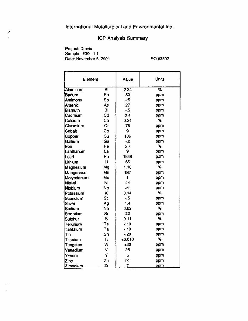
,- International Metallurgical and Environmental Inc.
ICP Analysis Summary
Projsct: Dravic Sample: #39 1 .l Date: November 5.2001
Barium Antimony ArseniC Bismuth Cadmium Calcium Chmmium Cobalt Copper Gallium Iron Lanthanum Lead Liihium Magnesium Manganese
N&l Niobium POtassium Scandium Silver Sodium
Sulphur Tellurium Tantalum Tin Titanium TUngstWl Vanadium Yitrium Zinc
Ba
Sb As Bi Cd Ca Cr co CU
Ga Fe La Pb Li
M9 Mn MO Ni Nb K
SC Ag Na Sr S
Te Ta Sn Ti w V Y
Zn LZirccdum Zr
PO #3Bo7
Lii--p-
2.34 % 50 wm -5 wm 27 wm C5 wm 0.4 wm
0.24 % 78 wm 9 wm
106 wm c2 wm 6.7 % 9
1548 $1 66 wm
1.10 % 107 wm 1 wm
44 wm <l wm
0.14 % -3 1.4 gt
0.02 % 22 wm
0.11 % cl0 wm cl0 Wm c20 wm
<0.010 % -20 wm 25 wm 5 wm
9i wm 7 ppm

CHEM MET CONSULTANTS INC
i CERTIFICATE OF ASSAY
Client: Dynamic Exploration Ltd. File no: 656 Brookview Crescent Date: July 18, 2001 Cranbrook, B.C. P.O. no: VlC 4R5 Attention: Rick Walker
We hereby certrfi that the foUowing are the results of assays on: I sample crushed rock
SAMPLE [DENTIFICATION
bt38 1.3
AU
oh
1.03
Ag
olt
158.
/ B.C. G
T T
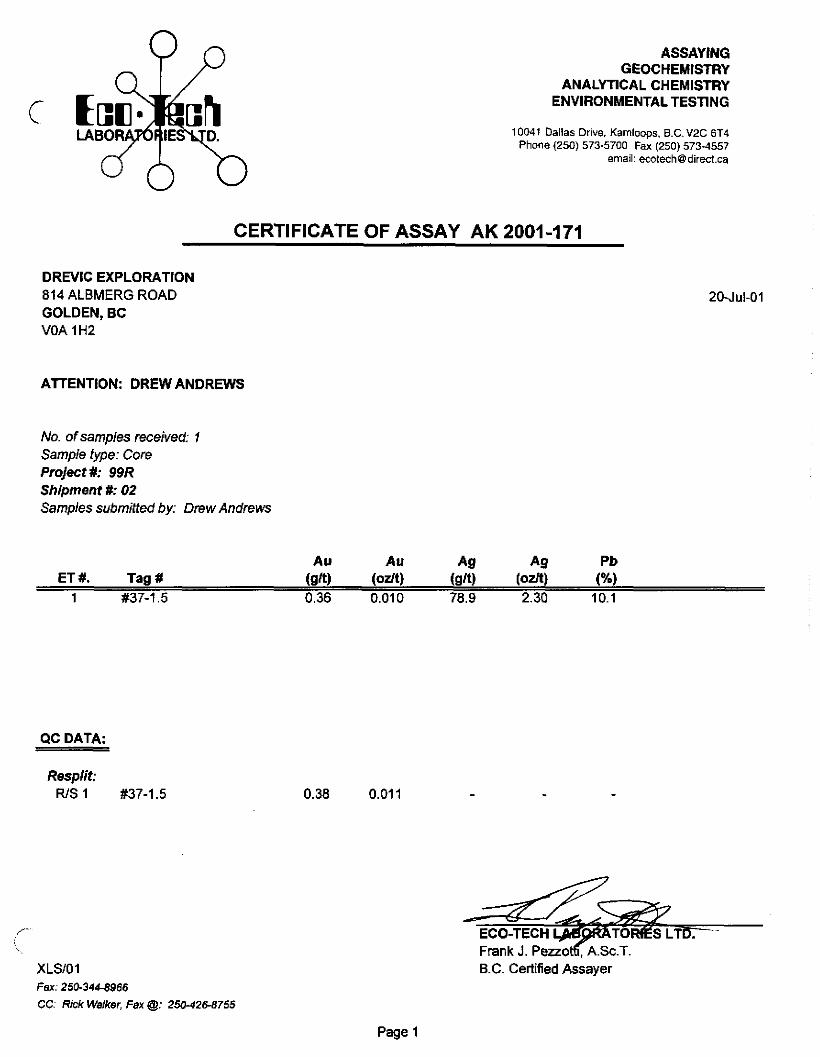
ASSAYING GEOCHEMISTRY
ANALYTICAL CHEMISTRY ENVIRONMENTALTESTING
10041 Dallas Drive, Kamloops. B.C. WC ET4 Phone (250) 573-5700 Fax (250) 573.4557
email: [email protected]
DREVIC EXPLORATION
814 ALBMERG ROAD
GOLDEN, BC VOA 1 H2
CERTIFICATE OF ASSAY AK 2001-171
2OJuL01
ATTENTION: DREW ANDREWS
No. of samples received: 1 Sample type: Core Project #: 99R Shipment #: 02 Samples submitted by: Drew Andnws
ET #. Tag #
1 #37-1.5 0.36 0.010 78.9 2.30 10.1
QC DATA:
Resplit: R/S1 #37-1.5
!\. Frank J. P&oKA.Sc.T.
XLSlOl B.C. Certified Assayer
Fax 250-344-8966
CC: Rick Walker. Fax @: 250-42~8755
0.38 0.011
Page 1

DREW EXPLORATION 814 ALBMERG ROAD ODLDEH, BC “OA I”2
BI CaYo Cd co Cr MO NsX P Pb Sb S” sr T,% ” ” w Y zn
220 0.04 190 10 4 0.02 <5 vo 0 4.01 20 Cl 40 4

lntematlonal Metallurgical and Environmental Inc. ICP Analysis Summary
Project: Drcvic Project No.: 3444 Ilattc July 23. 200 I
Sample 1.n Li Mg Mn MO Na Nb ppm % p+lpln ppm “/,
1137 1.0 34 0.6 83 3 0.0, <1 k*3 --
PPrn f f o;:a
Sample I.D. Ta Te Ti V w Y 2n Zr PPl” ppn % pQm pp”l ppm ppm pp
#37 1 .o Cl0 t-3 <lo co.01 37 =-20 1 81 5 ._

International Metallurgical and Environmental Inc. ICP Analysis Summary
Project: Drevic Project No.: 3444
Date: July 23, 2001
Sample I.D.
#37 1 .o
Ag Al As Ba Bi Ca Cd CO Cr CU FeTot Ga K La ppm % ppm ppm ppm % ppm ppm ppm ppm % ppm % ppm
C.2 1.58 80 44 c5 0.11 0.3 3 51 149 10 11 0.22 14
Sample I.D.
#37 1 .o
Li Mg Mn MO Na Nb Ni Pb S Sb SC Sn Sr ppm % ppm ppm % ppm ppm ppm % ppm ppm ppm ppm
34 0.6 63 2 0.01 <I 8 74 0.16 c5 4 <20 16
Sample I.D.
#37 1 .o
Ta Te Ti V w Y Zn Zr ppm ppm % ppm ppm ppm ppm ppm
Cl0 <IO co.01 37 c20 1 81 5

International Metallurgical and Environmental Inc. Certificate of Analysis
Project: Drevic Explorations Date: July 23, 2001 Project No.: 3444
Sample Sample
$37 1.1 $37 1.1 #371.2 #371.2
AU AU As As sn sn gJt gJt
0.50 0.50 118 118 0.58 0.58 136 136

International Metallurgical and Environmental Inc. ICP Analysis Summary
Project: Drevic Exploration Project No.: 3395 Date: July 23, 2001
Sample I.D. Ag Al As Ba Bi Ca Cd CC Cr CU Fe Tot Ga K La ppm % ppm ppm ppm % ppm ppm ppm ppm % ppm % ppm
1, IVicki mine cone 0.4 1.14 12 113 c5 0.39 0.3 21 112 121 4.4 <2 0.21 37
1.2 Ivy mine cone 128.4 0.11 1720 14 135 0.04 38 15 146 z-1 0000 >lO <2 0.01 2 1.3 Ivy mine cone 88.7 0.02 468 14 138 0.01 19.9 9 191 9369 3.53 c2 <O.Oi cl
Sample I.D. Li Mg Mn MO Na Nb Ni Pb s Sb SC Sn Sr ppm # ppm ppm % ppm ppm ppm % ppm ppm ppm ppm
1 .lVicki mine cone 25 H5 417 3 0.03 2 23 774 0.52 <5 <5 <20 14 1.2 Ivy mine cone ~1 0.02 610 6 co.01 Cl 59 >10000 6.36 802 <5 <20 23 1.3 Ivy mine cone ~1 <O.Ol 48 7 <O.Oi Cl 21 >10000 3.99 202 <5 <20 9
Sample I.D. Ta Te Ti V W Y Zn Zr Au Pi Pd Rh ppm ppm % ppm ppm ppm ppm ppm ppm wb ppb Ppb
1 1Vicki mine cone cl0 <lO 0.064 46 <20 5 54 4 0.022 7 Cl <5 1.2 Ivy mine cOnc cl0 23 co.01 19 <20 1 632 3 26.87 49 244 c5 1.3 Ivy mine cone do Cl0 Go.01 5 <20 cl 123 <I 0.24 17 cl <5

International Metallurgical and Environmental Inc. Certificate of Analysis
Project: Drevic Explorations Date: July 23, 2001 Project No.: 3395
Sample Au Ag s/t s/t
1.4 Ivy - crushed ore 0.35 145 1.5 Table tails 0.11 46
/- .

ASSAYING GEOCHEMISTRY
ANALYTICAL CHEMISTRY ENVIRONMENTAL TESTING
10041 Dallas Drive Kamloops, B.C. VZC 6T4 Phone (250) 573-5700 Fax (250) 5734557
email: ecot&@direct.ca
DREVIC EXPLORATION 814 ALMBERG ROAD
GOLDEN, BC
VOA 1 HZ
CERTIFICATE OF ASSAY AK 2001-198
24-J&01
ATTENTION: DREW ANDREWS
No. of samples received: 1 Sample type: Ore Project #: 99R shipment #: 3 Samples submitted by: Drew Andrews
QC DATA:
ResPlit: I #381.4
Standard: Mpla
Fax: 250-344-8966
CC: Rick Walker @ 25042&8755
0.72 0.021 143.0 4.17 15.1
4.33
Frank J. Pezzotti, A.Sc.T.
B.C. Certified Assayer
Page 1

23.JUl-01
ECO-TECH LAsONATORIEs LTD. 10041 DSllPO Drive UAMLOOPS. B.C. WC OT4
ICP CERTIFkxTE OF ANP.LYS,S AK 2001.148 DREVIC eXPLORATloN 814 ALMSERG ROAD GOLDEN, SC WA Ii-n
Phone:250-573-5700 Fax :250.57?-%%7
E1K rag” A,, *IX A. 8. 81 can Cd ca Cr C”F.X LawJx Mil Ho NC,% NI P Pb Sb Sn sr TIY. ” ” w Y Z”
% 1 aa1.4 =30 0.05 275 20 225 0.01 23 s a01 42 40 >,ocoo 190 00 IQ a07 Cl0 <I Cl0 4 82

. . _.-
c CLIENT IVY MN6
Daily Assay Report

09/06~0 I 11:19 f2
INTERNATIOSAL MET.ALLURGICAL ANI) ENVIROFMENTAL INC. 13 -350 Arh,d Road. Kelcwna B.C.. Canda. VIX 7L4. Te’ephane:(ZSO!A91-1712, F~aimilc:(Z50:49l-11?3
Fax Cover Sheet
DATE:
TO:
September 6. 2901
DREW ANDREW5 DREVIC EXPLORATION
PHONE: (250) 3448966 FAX: VW 34MOS0
FROM: Kel? McVey PHONE: (250)-491- 1722 FAX: @SO)-491 -1723
pases:l
Drew,
Samle ++3I
Here ar* the &I and silver results for samples 1137 - 1.3 (we incorrectly reported as 1.0).
AU 0.18 won A0 cl @ton
Regards
Ken McVey

btemdmnal fhtallurgical and Environmental Inc. WRcate of Analysis
- W la 1\1 MQ Ca Na K 57 Y Oa Li Nb SC Te TI 2, S ICP lwppn%%~4r.%Fwppnmmwppmppn%fm%
x38 1.1 cm 4 0.06 co.01 0.M co.01 0.01 15 ‘1 Q <I <I 4 <IO <o.o, 3 .‘lOJ30 138 12 Qu Cl 0.08 0.01 0.04 *.0, 0.02 5 rl Q cl cl c5 Cl0 Co.01 Cl 0.04
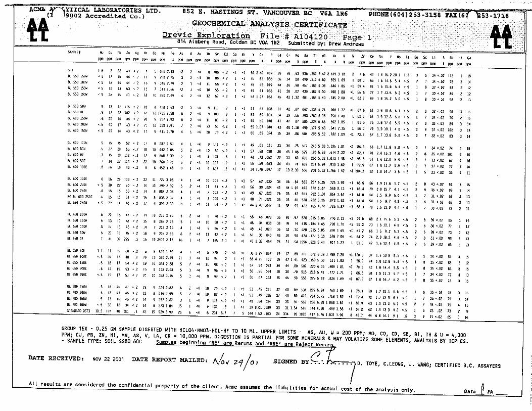


Drew Andrew 8 I4 AImberg Road Golden, B.C. VOA I H2
Wayne T. Choquette Archaeoiqist
Pi). BOX 25. Yahk, B.C~ VOB 2PO PhoneSas: X1)114-5361
April 17,33Xl
Dear Drew:
.Re: &&s ~fXrchaeciog~,&‘al Rrconnaissance. Thundsroaws Claim trenchin
The trenching locality was inspected via foot traverse on April 12, X00. It con&s of a small intermediate terrace on the left bank of Findlay Creek upriver ofthe Skookumchuck Forest Rotid bridge. Almost the entire terrace has been previously escavated into the undrrl~in; cobble grawls during earlier mining operations. This disturbance provided abundant subsurface exposure but left only two small remnants of the natural landform. one near the margin roughly midway along the terrace and the other a: the rear of the terrace near its eastern (downstream! end. Both revealed about haIf a mrtre cf unstrati!ied flurial sand overlying gravels, indicating a flood bar in a back eddy as the probable mechanism for deposlt!on of fine sechment atop !he gravel terrace fill. No soil development was apparent in the capping sand near the terrace margin while only a ver), *eak oxidized iron horizon MS revealed near the top of the sand at 0~ eastern kterior of the terrace. These data suggest a limited age (not more than a few hundred yearsi for the fine sediment cap on the terrace and the probabilie that earlier Holocene tine sediments would hzve been deflated by floodwaters.
Considering the nature of the capping fine sediments (i.e. deposited in water as opposed to overbank alluvial floodplain sedments), buried precontact cultural deposits would be unlikely and no buried soiIs or weathering surfaces were observed. Coupled xviiith the apparently recent (Little Ice Age’!) of the fine sediment cap and especially the almost complete disturbance ofthe terrace by previous mining activities. it is concluded that the small intermediate terrace where the trenching is proposed has no potential for containing intact precontact archaeological deposits or features. Therefore, from an archaeological prtrspective, there are no objections to the proposed project proceeding.
I trust the above is satisfacto? for your needs - if Fou haw an:d ques:ions or if you require additional information, please do not hesitate to contact me.
Yours sincere!y,
-9 .b r-1”
b yne Choquette
c.c. Thomas Munson, Ic;tunaxaXinhaskeI Tribal Council