british columbia depari'rent of ?rl · british columbia depari'rent of ?rl.ines €ion....
TRANSCRIPT
BRITISH COLUMBIA DEPARI'RENT OF ?rl.INES €Ion. IT. A. ~ \ ICREXZIO, blinister.
ROBT. D n s ~ , Deputy Uinistcr. J. D. GALLOWAY, Pmrineial Xincralogist. J. Ijrcmos, Chief Inspector of Xines.
BULJ,EYIN NO. 2, 1930


T o the Hon. TV. A . Mclienzie, ,lfi?lister of dfi~zes, Victoria, B.0.
heconling to r o w instructions, special inrestigations were made during tire fie111 season of 1929 of certairl placer areas of tile Province. This bulletin hils been issued in order that this
in addition to the special reports, SL gt!ner;~l sun~lnary regardiug lilacer-mining in British infonnntion sbould be given to tile public at as early a date as gossiblc. ‘The bulletin contains,
Columbia by inyself, :md condensed historical, geological, and stntistieal information regarriing all the important placer arens of the Province. A bibliography of reports on British Columbia placers is also, included, which it is believed mill bc useful to those interested in this branch of tile mineral imlustry.
I have the honollr to be,
SIR-I beg to submit heren’ith a special bulletill 011 Placer-mining in British Columbia..
Your obediel~t servant, Sir,
JOIIX D. GAILOYI’AY, Provincial diineralogist.
~ I I I W L ? G of Jfiacs, T’iCtoriu, n.c., Peb,.um.2/ Itth, 1980.
PLACER-MINING IN BRITISH COLUMBIA.
IS04 .......... J4OS.516 IS05 .......... 481.683 lSD0 .......... s44,o?G
..........
l m l .......... 42(3.ooo
Total ..................................
production in 1S63, with an output valued at nearly four million dollars. li'rom IS75 to 1803 n It will he noted that the most important period n.ns from 1S58 to 1,377, with the maximum
Steady decline ensued and then thc industry rcvivecl until 1904, when all ollt~lut of $1,115,300 was
for 1920. recorded. Since that time the output has dwindled stendily until now it is ~ O W I I to $100,599
Altllough production has become almost negligible, it should not be conclnded that thcre is 110 interest in the industry. Actually in the last tiire Fcars~nluch placer-mining 1x1s bcen carried
consistea of testing placer-ground, and in m m y instances the testing is i:.ot conclusive or c o m on, but unfortunntcly without as yet very tangible yrorluction results. I\l:uch of this yvor1~ has
pletcd. In a number of placer-fields of the Province plants for hy~llmulicliing arc being con- structed, and smnc of thcse may be expected to be productive in the fnt.nre. >Iuch dcsultorr small-scale work has becn carried on, 11:lrtly tn recorer "old t m d partly to prove np (lcposits of 111acer-gravels.
the qncstion naturally arises whether there is not still a good possibility of reviving placer- As tlie known placci-fields of thc Prorincc contain nlany areas which llnve not llccn tested,
mining to something like its forlner l~osition in tire niinernl industry of I3ritisll Columbia. With this objcctive in view, the Honourable l:he hlinister of Mines dccidcd to have some special
rnlchael, a former Assistnnt Mineralogist ant1 nm- n practisillg conslllting miniug engineer, mas investigations of IJlacer areas made during the field senson of 1929. Accordingly, Herbcrt Car-
secured to make a seport on certain placer areas in the Queen (Xarlotte and Atlin >lining Divisions. Also C. \V. Xoore, nn experienced placcr ol>er&tor, \\.as rllgngctl to make a careful stlxly of the plaeer-fields of Cariboo, Qnesnel, and 0minn.a JIiniIlg Divisions. Ile was lmable to fully cover this laxgc fleld in the time available, but did examine many sections of these Divisions.
p b l i c a t as carly a date as possible; and these reports have heen Snpplcrr.cnted with condenscrl This bulletin has bccn issocd in order that these relIorts Inas be brade available to the
general, statistical, historical, and geo1ogi~:nl information nbont tlie placer-fields of the Province.

6 BUREAU OR MINES.
Nr, Noore’s report on the Cariboo, Quesnel, and Omineca Mining Divisions is esselltially a report from the view-point of an operator and is intended to definitely state favourable possi- bilities. It is a record of his conclusions relative to various pronerties, with .brief details regarding the occurrences.
~~
In the menaration of this bulletin Mr. Carmichael kindly ofceered to write historical sum- maries regarding certain placer areas of the Province; these are giVen nnder the headings of the various Mining Dirisions. In the compilation of this bulletin the writer has taken informa- tion from nll available sourccs, but only direct references are aclnlomledged.
placer operations, but have becn used to illustrate the various phases of the industry since its Nost of the maps and plwtos included in this bulletin do not neceSSarily represent present
commencement. It is not intended that this bulletin on placer-mining will be reprinted in the Annual Report
for 1029, which is now being prepared; it should, therefore, be preserved by those who desire a permanent lile of the publications of the British Columbia Department of Mines.
. .
GEIUERAI; HISTORICAL REVIEW.
Charlotte Islands, the first real metal-mining in tlle Province \ w s the recovery of gold from Altllongh Small amounts of gold mere reported to have been obtained froin veins on Queen
placer-gmvels.
Dnilflas was Governor of Vancouver’s Island and Lieutenant-Covenlor of Queen Charlotte At the time of the discovery of gold in quarto veins on Queen Charlotte Islands James
which was the first mining regulation in the Pacific Knrtll-west. This set forth the terms and Islands. Accordingly, ns Lientennnt-Governor, he issued a pmcliirnntion on March 20th, 1853,
Islands. licence under which thc digging or mining of gold could be carried on in the Queen Charlotte
At this tilne the mainland of the Province mas an almost nnlinorvn area, commonly known as New Caledonia, and mainly administered by the Hudson’s Bay Company. The discovery of gold was reported on the Columbia river, near the confluence of the Pen6 d’Oreille, in 1865, but this was of little importance. With the discovery of gold on thc Thompson river in 1857 and the rapid influx of thollsan~ls, Governor Douglas assumed authority to gol’ern the area and issued the follorving proclamation to regulate the mining of gold :-
‘‘ PlloCLAXAnoS. “ 28th December, 185i.
“ T h e r e a s by Ian~ all mines of gold and all gold in its llaturnl state of deposit within tlre Districts of Fraser River and of Thomimn’s River, commonly known as the Quaatlam, Contean,
belonging to the Crown : and Shamswap countries, whether in the lands of the Queen or of any of Ifer Xajesty’s suhjects
the soil of tlle,said districts, and that certain persons hnve colnmenced or are about to c o n - “And whereas information has heen received by the Governour that gold esists npon and in
menee searching and digging for the same, for their own use, !r’itllout leave or other authority from IIer Majesty:
“Wow, I, James Douglas, the Governour aforesaid, on behalf of Her Majesty, do hereby publicly notify nnd declare that all persons who Shall take from any lallds within the said dis- tricts :tuy gold metal or ore containing gold, or mho sllnll dif for and disturb the soil in search of gold metal or ore, mithout having been duly authorized in that behalf by Her Xajesty’s Colonial Government, will be psosecuted both criminally and cirilly as the law allows.
“And further notify and duclare that Such reglll~t,iolls as may be found eqedient will he prepared ana publislrecl, setting forth the terms on which licences will he issued for this purwse on the payment of a reasonable fee.
1887, and 21st year of Her Majesty’s reign. “ Given under m y hand and seal a t Government IIouse, Victoria, this 28th day of December,
“(sgd.) JAXES DOUGLAS,
“By His Excellency’s Command. “ (Sgd.) RICIIAED GOLLIDGE, See.
O0z;emotLr.
“ God Save tlle Queen.”

PLACERXINIKG IN RRITISE COLUXBIA. 7
Shortly after this proclamation regulations were issued provkling for 11 licence of 21 shillings
On August Znd, 1868, “British Colunlbia” was formally brought into existence by “An Act
mainland of the Province and Queen Charlotte Islands were included in tlle new colony of to pro~ide for the Government of British Colmnbia,” passed by the British Government. The
Uritish Columbia, but Vancouver’s lslaurl remained a scp:rrate Crown Colony. James Douglas v a s Governor of bath colonies.
in the Provincc, and in this Act the fce for a free miner’s certificate was sct a t Sl, Sllbstantially I n lsj9 me “ Gold Field Act” was passed; this was the first statutow recognition of mining
the same as the @j fee to-day. Under this Act Goid Commissioners lvere apyointed mho had cstensirc administrative and quasi-judicial powers.
a month and a commission appnintcd to deal with the sizc of claims, cnllcct fees, etc.
the f;nnons Cariboo rush from 1858 onmards. The Prorincinl ArchiVes have numerous documents Xany accounts hare bcen written of the discovei7; of placer gold in British Columbia and
relating to this early history of the Province and mans bonks and brochures have been written
For the puqmse of this bulletin it i s hclieved tha t the fallowing comprehensive und informa-
“ It is nom difiicult to ascertain under what precise circumstances the first discovery of gold phtcers on the mainland of I3ritish Culumbia occurred. Little attention was at first given to acco11nts of the finding of Small quantities of gold, and at a latcr datc, when gold-mining spmng into importance, numerous stories resnecting i ts discovery were invented or exhumed. One statcment is to tllc effect that the Iludson’s Bay agent at Kamloops hat1 bought gold from the Indians as e;lrly as 1%2, but, if correct, the amount purchased must hare been very small.
of the Intcvnationnl honndary, and moderately rich diggings began to be worked in that vicinity. In 1835 a scr’i’ant of the same company dilrcovcrcd goid ncar Fort Colr7ille, n Short distance South
It Seems ccrtain that the epoch-making discorerg of gold in British Columbia was the direct result of the ColYille excitement. Sndians from Thompson river, visiting n woman of their tribe I\-110 was nmrried to a I”rcnclr-Cnnarli;m a t \Valla TValln, spread the report that gold, like that found a t Colrille, occulrrerl also ill their country, :MI in the Snmmw or autumn of 3857 four or fire Cana(1ians and half-breeds crossed over to Thoml)son river, :lud succeeded in finding n’orl~abk plttcers at Sicoamen, on that river, 9 miles above its mouth. On tlle return of these prospectors the news of the discorcry nl’ gold spread mDidly. It is also probable that their nrriral on the !l‘homi,son Caused the 1mli:ms to take an interest in gold-mining, for we read in a disyatcll of Gorernor Sir James Douglas that from October Gth, 1857, to the end of thnt ~ m r 300 w6. of gold had passed through the hands of thc Hudson’s IIay Company, this amount being all, so far as known to Ilouglns, which had been obtained. Douglas :sWaks of the region, including the lo~r.cr Thompson, from which the gold came, ns the ‘ Coutei~n country.’
“Smrlg tcrr S P R ~ S previously, in 1549, m k l hnil becn diseovcred in California, and that country was swmning wit11 a eosmopolitm ~ ~ p u l : ~ t i o n of goI&scekcrs; thus mhcn the discovery of gold in the north bLmme knomn and nuthenticnted, by the cxhi1,ition of the gnld itself, an extra- ordinary nligrntinll followed. Betmeen Xnrch and June, 1858, from 20,000 to 23,000 persons nrrivcd by sen from S m l Francisco in Victorin, and courerted that place (first fonndcd by the Ilurlson’s nily Company in 7813) from a quiet ri1l;Lge of two or three hllndree(1 inhabitants into n city of tents. At the same time, man? nlincrs (eslinmted by same at 8,000 in number) reached British Columhiil by orerland rolltes from tllc south. A lilrgc proportion of those who arrived a t Vict,oria never got as far as the nmuttl of Fr;lscr riucr, thcir objectivc point, and so great mere the natural diflicultics and the resulting disapmintment esperienced that all except about 3,000 of this promiscnous migration retllrnetl to CaliEornia before the following ,January. The inland country wan cntimly without roules of communication, tj? nature x singularly aimclllt one, and unprwided with means for the support of a Iawe population. M4?anwhilc, by the more fortunatr nnrl cncrgetic the derelopment of i ts menlth had been fairly inaugurate& The nllrifcI‘olls river-lrnrs in tlle vicinity of 11opc and Yalc on the lover Eraser, being the most :Icccssihle, \VCI‘P the first to be morked, nnd the retnrn of gold began to assume immrtant dimensions.
. based on the historical documents mhicll hal’e been carefully preserved.
live sun~mxry by G. A i . DIIwson* is most suitable:--

8 BUREAU O F MINES.
overland from the south had pushed onward in face of extraordinary difficulties-resuiting s o t "Before the close of the working season in 1858, some of the adventurers who had come
alone from the roughness of the country itself, but combined with the Nant of supplies and occasional overt hostility of the Indians-as f a r as Fountain, a short distance above Lillooet on the Fraser, and by tlle line of the Tllompsop to Tranquillo river on ICamloops lake. In tlle following year a renevved advmce brought a number of miners to Quesuel river, and in 18GO rich diggings were found at the forks of the river and over GOO wllites mere at work on its length, while Antler creel; was discovcred and Some work done upon it by a few score men-thus fairly entered on the estremely rich central region of Cariboo.
" The theory formed by the miners who first worked the fine ' fiour ' gold o f the Fraser belox Yale was that this gold had its origin in richer deposits torard the Sources of the great rirer, and though this theory was only partly correct as the origin of these particular deposits, i t none the less served as tllc impelling force which led to the opening up of Cariboa district.
" I n 18G1 Williams and Liglltning creeks, Cariboo, the two most celebrated in the annals of British Columbia placermining, mere discovered, and in this and the following Year most of the other rich creeks in Cariboo became known. Thc first gleanings from the old Carilloo stream-courses were notable. It is estimated that gold to the value of $2,000,000 had been got out by a population not excceding 1,500 before the end of,l801. In consequence of those finds 21
second important migrqtion of miners and othcm towards the Province commenced before the close of 1861, which continued in greater or less rolume until about 18%. A series of lcttexs from a correspondent of the Times contribute11 largely to this result, and extended the area of interest to very Fide limits, bringing advcnturers from England, Canada, Australia, and New Zealand. A party of mcn Cven set out for Cnrihoo from enstcrn Canada overland in 1862. Of this party several members lost their lives in the mountains, but some eventually rencheil their destination."
The history of the placers of the Cariboo and Qucsnel Divisions from 1664 to the present time is well known; it constitutes practically the history of t,he country for Some years. The sudden outburst of mealth in the short space of a few years did much to lny the foundation of the material prosperity of British Columbia, and the influx of thousands changed the country from a milderness inhabited by Indians and trappers into an area in which many forms of industrial activity eon~inenced.
It is interesting to note that in the early years of mining the authorities were very careful not to give a v a y too much ground. ConsideXing the vast area administered, it seems stmngc that such small areas were allowed to each individual, and it is quite evident that the n e v placer-fields were consideved to be extremely rich. The first placer claim were only 12 feet syuar-144 square feet--hardly worth while starting on. The pcrmittcd size of claims NDS
gradually inereascd until now they are 250 feet along the stream and 1,000 feet wide. By the " Placer Act," passed in 1801, provision was also made for taking up plarer leases half a mile in length and also, 5-mile dredging lenses along the beds of rivers. These present regulations contrast shnrply with the carly ideas tllat prevailed.
The Same CalltiouSneSS is Seen in the first regulations for lode-minerals, by which mineral claims only 100 feet square wcre granted, Nllich compares Nith the present size of 1,500 feet square.
and from 1865 a progressive decline in t.he yearly output cnsucd. As the rich diggings ere Thc easily wxlced bonanzn deposits of the Caviboo quickly yielded their golden treasure
worlied out, many extensive hydraulic plants werc put in to handle 1on-grade ground in large quantities: also nllmerolls expensire enterprises mere commenced to carry on deep drifting in ground that, owing to adrerse physical conditions, rras left by the old-timers. It is unfortunate that most of these projects xcre financially nnsnccessful, and it is cvidcnt that lack of adequate knowledge of the placer deposits and the problems to be contended with mere the primary causes of failure.
Since the Carihoo nlsh swcessiye new placer-fields haye heen discovered in the proy.incc, and each one has been marker1 by a greater or lesser "stxmgede" to the new diggings. While other important fields llare lleen discovered. the Cnrihoo has been mithout doubt the richest and most prnductire placer-ficld discovered in tlre Province up to the present time.
In 1863 rich placer deposits were found on Wild Horse creek, in East Kootenay, which caused solne'excitcment at the time and were worked somewhat extensively in the following year.

$i. i
!

PLACER-bIIS'ING IN BRITISH COLUXBIA. 9
10 BUREAU O F MINES. ~
“Commissioner Cox’s reports were full of interesting matter, and some notes therefmm will he sufficient to indicnte the Yalues of gold recovered in that area. EIe says, on July Uth, 1861,
per day per man of $1G; vages to hired men, $16 peer day. Rufus Henry mrote that hispest that there mere on, the creek ninety-three Inen, four ditches, nnd two Sluices ; averaging a yield
~ e e k , July 10th to lGth, 1861, gave him profit, four hands working, of $349. *‘ Con relates how the ‘ Southern Boundary Act’ stopped active huildlng operations at Rock
Creek, as it forced the c~llcetion of customs upon the traders from the south. ‘‘ Gold v a s discovered then, 1801, on a creek cnllcd Riviere de L’iinse dn Sable, which is
now Nission creek, a t IZelolr-na, and Mr. Cox regretted this, as it made more trails to gnard. “ I n l R G l Rock Creek hegan to lose i ts miners, as the Ne% Perct Indian Reserve was opened
to prospectors, and they rushed over there. Some, however, came back, and he tmen June and
Baume.” November, 1881, $S3,000 n%s taken out of Rock creek. The discoverer of the creek NBS one
GENERAL GEOLOGY OF BRITISH COLUDIBIA PLACER-FIELDS.
features of placer-fields vhich arc many hundreds of miles a W t , still there are certain condi- TVhile i t may seem to he rather out of the question to generalize regarding the geological
tions which pestain to all the placer areas of the Province; and a realization of these may be decidedly useful.
are not @,en for the conclusions reached or ideas adranccd. In the aggregate there is an In the following geologic discussion, onl!.‘ a brief summary is given and in general reasons
extensive literature on British CO1umhia placer deposits, which contains much of the evidence on which this summary is bnscd.
stretching north-westerly from the International boundin’y-line up to Atlin and extending into It is lloticeable tlvat the important placer-fields of the Province lie along a broad zone
Yukon Territory. This fact ga7-e rise to an early theory of an immense “ Aow ” of gold-bearing grarels or “ mas11 ” traversing the Province along this line; the theory, of collsse, was quite untenable and erroneous.
This grouping of t l x main placer areas along one zonc was noticed h~ Dan’son, mho said :-- “While it may now be safely affirmed that gold is yery generally distributed over the entire
importance in which at least ‘ colou1s ‘ of gold nray not be found, the enumeration of the prin- area of the Province of British Columbia, so nluch so that there is scarcely a stream of any
cipal discoreries of important mining districts show ~ e r y clearly that most of these are situated along the system of momltnins and high plateaus which comprises the Purcell, Sellrirk, Columbi:r, and Cariboo ranges and their north-n.estern continuations, lging to the sont11-west of the Rocky Jlonntain range prowerly so ealled, and parallel ill direction n-ith it. Of a11 the gold-psoducing districts that of Cariboo has proved the richest and the most continuouslg productive.”
Physiograpl~ically the pvacer-ficlds nre situated ill the Central Belt of the Cordilleras of
vhich systems in turn include the Selkirk, Monashee, and Carihoo mountains aud the Fmser, Canada. This Central ltclt is comprised of the Colmnhia, Interior, Cassiar, and Yukon systems,
Nechako, and Yukon plateaus. Generally speaking, the placer-fields of British Colombia o~cl l r in plateau areas where alpine
mountains arc ahsent. As a rule the topogmphic relief is not great, althongh in places the deep valleys of the Frtrscr plateau gire an allpeamnce of trne mountainous topography. E ~ c n in the Selkirk xnd Cariboo monntnins the placer-fields are found in topagyaplric areas transitional between plateans and typical mountain ranges.
in the various placer-fields. In many of these areas a noticeable feature of the rock formation Rocks of many rariet,ies and formed orer a considerxhlc range in geologic age are found
is the large number of quartz reins that are esposed. For the purpose of this discussion it is
is important to bear in mind that quartz veins a r e almost always present, mrying in size from unnecessary to enumerate thc fgpes of roclr formations occurring in the placer camps, but it
mere stringers up to Icdges 100 feet in nidth. In some areas auriferous slates are JM?ntioned by some writers, bnt these generally consist of slates containing small irregular qnartz stringers, and i t is in these that the gold occurs.
fOllONing the intrusion, or series of intrusions, of batholithic rocks expressed in the Coast The great period of mineralieation in British ColumDla v a s in Jura-Cretaceons times
PLACEItl\lISING I N BRITISH COLUXBIB. 11

12 BUREAU OF MINES.
(3.) Post-Glacial gravel deposits. The Pleistocene or Glacial epoch scattered enormous masses of .gravels across the country and particularly in the main stream-channels. In the zones~of original Tesitary placer tle~losits tliese glacial gpil~els contained more or less gold, but almost always the original placer-gravels vere so diluted with extraneous material that the final depositions of glacial gravels were of no eeonomic value as placer deposits. In this connection
have been concentrated by Post-Pleistocene strcnm-action, but as a rule these deposits are loxv it should be remembered that ice-erosion did not concentrate. In places these glacial gravels
grade, mith the esception of bar deposits, which Sometilnes have rich shallov ground. Variations of these three 1.ypcs occur, hut in a broad general way this classification includes
all placer deposits in the Province. In some cases ancient cllanlx?ls have been left stranded through diversion of the waters by glaciation, covered by glacial gra~el8, anrl later these ancient channels mere robbed by recent stremu-action gisiving rise to rich placers in the rjresent Stpennls. This mas well esemplified by Iieithley creek, Qnesnel Division, and in part on Lightning creek.
ont by glaciation and deposited almost intact away from the original source nnd entirely sur- Masses of Tertiary gmrels with a rich gold content have appnrcntly in places been plnclietl
rounded by glacial gravels. This has bcen suggested as the cxplanntion of the rich patch at Cedar creek, Cariboo Dirisiou.
geology is glaciation and that much cautioasness must be used in assuming continuity of any Enough has beell said to shorn that the dominant feature of British Colunrbin ~ l a c e r
placer deposit. Much futile WOL'IK has been clone on the assumption that a rich pay-streak i n an ancient channel should contillr~e for miles. The channels often do continue, but in nmly instances are barren of pay-gravels.
TIE Graham Island deposits are probably of type 3, but have been mainly concentsatcd in the present deposits by wave-action.
NETIIODS OF WORICINC.
The early miners in each calnp started with pans and rockers; and this was followecl by deep- Practically every method of vorliing has been nsed in the pllncer-fields of British Columbia.
drifting Illethods, the pay-gravels being washed in sluice-bases. The old-timers of the Cariboo
handle the water and ground heavy with slkim and water-pressure mas successfully handled. did wonderful work in deepdrifting operations; Cornish pumps and water-n-heels were used to
I n the Cariboo after 1864 rnnny ciaborate deep-drifting enterprises were coorn~enced to mine cam tinuations of channels ~ ~ o r l t e d by the old-timers. I t \vas assurned that with more modern machinery areas Unprofitable to the old-timer wolild pay i o operate, but practicillly none of these projects have been successful.
Later, hydraulic vpcrations were commenced and in recent years the bull; of the placer production of the. I'rovincc has come from hyilraulic ogerations. Variations of ordinary hJ-drallliC practice have been used, including hydva~ilic clevators and the so-called "pun~p- hydraulic." This Initcr system i s used where mater is scarce and the water is caught in dams
and generally inemcient system, only suitable for rich shallow ground. Some exeellent hydraulic below the operation and plllnln?d back to he used again under a 1lressure-hcnd; it is 8 costly
systems have been instxllctl in the Prorince, particularly in the Cariboo, Quesnel, Liard, and Atlin Disisinns.
design or n new unpro re~ invention that prored unsuitable for the work. Probably the only Dredging has been tried in several places, but nearly all the dredges hare bcen of poor
really modem dredge installed in the Province w a s the one at Antler creek, Cariboa Division,
ful, but the operation unfortullntely was not a financial s~~ccess. This dredge has now been onerated by the IZafue Copper Dcvelop~nent Company. nlechanicnlly this dredge was success-
scrapped and the machinery shipped out of the country.
been used to dig placer-gravels. Generally, every tirailable device has been u6ed in attempting Variations of &redging, such as steam-showls, g.ns-shovels, nnd drag-line scrnpcrs, have also
to exploit the latent xealth of the placer deposits of the Province.
ANCIENT CHANNELS.
channels, and mans channels are theorized running in all directions. While sucll theories are The history of every placer camp in British Colombia i s filled ~ i t h stories of ancieut
PLACER-AIISIXG IS BRITISIi COLUhIUIA. 13

$10.50 17.00 17.00
16.00 16.50 17.00 17.00 17.25 17.2-5 17.26 17.25 16.00 15.87 15g0 1g.50 16.00'
16.00 17.00
17.28 17.25 157G 17.25 17.50 18.33 18.50
16.30 16.80
16.90 17.40 10.50 18.00
16.00 18.00 16.00
18.00 18.00
18.00 18.00
18.00 10.00
16.25 16.25 10.2; 16.25 16.25 16.25 18.00 18.00 18.00
17.89
10.50 17.89
18.00 16.00 17.27
16.00 18.00 18.00

tiary drainage) which have not been recognized. alany of these channels may be barren of (2.) The major possibility for the future is probably the finding of ancient channels (Ter-
pay-gravels through ice-erosion, but some of them may contain worl<-i(xble ~ l a c e r deposits. (3.) Low-grade Post-Glacial deposits occl~r in many places which have been formed by
concentration of Glacial gravels by Post-Pieistocenc streamaction. TVhile many of these are too lolv in gold content to be profitably worked, i t is probable that adequate testing mill show m.my deposits that. could be Iryllranliclzc0, providcxl there is an adcquate supply of water and physical conditions are suitable. Some of these deposits, as wcll, may provide suitable ground for dredging.
of the black-sand concentrates from placer operations to recover the gold and glntinum contellt (4.) I n some areas, particularly in the Tulnrneen and Quesnel sections, the efficient handling
may make possible the movking of present known deposits which cannot be profitably handled by present methods.
Central Belt, it seems probible that many interesting llossibilities will be brought to light and If further detail geologic work is done i n the various placer areas, particnlarlp in the
capital will be encouraged to test out various gravel deuosits now unitnomu.
CIIROXOLOGY 01.' RRITISII COLULIBIA PLACERS.
There have been reports and stories of thc Spaniards nxshing for gold in the early days of their occupation of the west coast of Vaneourer island, especially at Zebnllos or Cold rirer,
having clone so. The same mar be mi0 for Sombrio xiver. flowing into Esperanza inlet, but no evidence has dcfinilcly been found 011 that r i rer of their
1860. J. W. XcIZag reported gold between Victoria and Xanaimo, but not e11ough to pay. 1552. Chief Trader BlcLean nul-chased gold-dust from Indians at ICawloops. 1853. Geo. I%. McClelliln found gold on the Simillrameen river.
1867. Gold discovered at month of the Tllompson river. 1S55. Gold discovered on the Columbia at the confluence of the fend d'otreille river.
155% Gold first discovered in Oliantitg on thc Ion-er Fraser river. 1560. Rock creek i n Bo~ndary centvc of much excitement. 3860. Cariboo and Quesnel areas opened. 1860. Placers regularly worl~?d on Simillzamcen river. 1861. Gokl discorered on Pence rirer. 18G2. l'lacer gold discorered at Redwell (Bear) river, Clnyoquot, Vancouver island. 3863. Rich placers foonrl on Wild Home creel; an11 Pn.ry crccli, East Iiootenap. 186% This \\.as the year of greatest developmeNt and outplit of tire 1)lncer-diggings of
1864. Leech River placers XTel'e discovered at the southern end of Vancouver islnnd. 1864. O~nineca gold first Oiscowrecl. 1865, Placer gold found in the creeks at the K g Bend of the Colinnbia rirer. These creeks
JSG7. Omineca place13 regularly warlce(1. 18FR to 1874. Gorennnent maintained an assay office at Bnrlierr.ille. 18i1. Placer gold found at China cpeck, Alberni, Vancouver island.
1579. 1.Iydraulic lnininx on large scale eonnnenced in Cariboo. 18i2 I n Cassiar djstriet placer gold 11x9 found a t Thibert and Dense creelrs.
1881. Placers wxe discovered on Jmxe creekl Skeena river. 1586. Rich placer found at Granite creek, Similknmeen 1)ivision. ISPS. Atlin placer-fields disco~ereed. 1890, man, 1901. Black sands ,rorlx?d at nrveck bay, v e s t const of ~ a , , c o u , ~ island. 1901-12. Rex-ival of interest in Curiboo and Qoesnel with hydraaulie mining, 1921. Cedar Creek are:\, Quesnel. 1924. Gold Pan creek, Liard. 1927. Squam creek, Atlin.
c nuboo. .. 31arlmnm ofliciill recordrrl prodnetion oP placer gold in history of Prorince.
are about 40 lnilcs north of the town of Remlstolie.


"After this second run came a period of general subsidence, followed by another general lomering of the water-level or rtlising of the land and accompanied with the wearing-down of
ceutrated the gold in the prescnt channels. A t this period the rocky barriers across both Pille the present channels of the creeks, vhich in places cut througll the previous gold runs and con-
aud Spruce creeks were broken and the streams were enabled to cut out their present cha~lnel~."
Tagish lakes. TVitb the exceutian of the fi;'ngineo. grou11, most of these%laims have 1Cpsed. The I n 1900 lode-mining is first mentioned and a number of claims m v e staked round Atlin and
year 1001 shows the beginning of the abandonment o f the individual placer claims; this is in
tion from the placer ckinl of 100 feet to 811 association of a group of clnilns to proride a bed-rock accord with the history of crery placer-lield on the Sorthem Pacific slope. There is the transi-
tlunle to su~mly the gronp wit11 water, dump, and a .generally chen1)er hamlling of the ground: for the reason that the individual placer &aims had become too Io\v graac to give reasonablc returns for the method in vhich the labour as applied.
field and limited capital. At the Same time there are the snlall comgnnies vho drift to bed-rock Then there Colnes the d a y of the small hydraulic mining con~pany, usnally with a limited
or drift to old channels; both colnpanies often worlc under Yery Aisadrantageous circumstances with varying success.
the stage is set for the final large hydraulic mining company. Atiin seem to have now reached When these companies begin to realize that they hax'e no longer n paying proposition, then
a large hydraulic mining company, which might be stated as follows:- Lhis period. Experience has amply Shomn that there are numePous xcquisites for the success of
The control of an entire creclc or n long section of a river iree from adverse claims by individual miucrs.
t o make sure thnt it does carry the values it is Supposed to havc, before nny large sums of money Sufficient ground to poy a profit on the undertaking. Efficient prospecting of such ground,
have been spent. This is thc raclc on which many companies hare conle to grief. Sufficient mater to wash the ground during the period of the enterprise. Sufficient head to
bring the mater effectively to the highest point of rorking. Sufficient grade in the creek so that the n'orlc is not retarded by the fiume becoming choketl. Sufficient capital for the unilertxking. Efficient management. To offset the ahore, a sales organization for the product is not required. Progress from the,indiridual placer claim to the large hydraulic mining company is slow,
any effective work for themselves can hold up n camp and retard the progress of a district usually 'covering a period of many years. 'A few individuals who are not in a position to do
for years.
close information :- As to the actual Quantities of gold shipped out of Atlin, the following figures will give very
1899 (discovery of the camp) 3,750 $75,000 191: .......................................... 18.~50 $377,000 Is99 .......................................... m,ooo .......................................... m o o 22,500
soo,onn 3916 1s.023 .......................................... 4~5n.000 1917 .......................................... 13,600
360,300
1901 .......................................... 15,onn 3nn.000 .......................................... 312.000
1902 20,000 101s 11,025
.......................................... 400,ooo 1919 .......................................... 8,860 220,500
100s .......................................... Lxz.000 440.000 1920 .......................................... 6,930 i~38.600 177,000
1904 .......................................... 26:500 FC30,OOO 1021 .......................................... 7,210 144,200 1903 .......................................... 2 3 , m .......................................... 1906 22,750
4~-z,onn m5,noo
1822 7,450 14s,onn
1907 20,400 1923 7S70
408,ono '150,600
.......................................... 1924 .......................................... 8,647 147,000 1908 .......................................... 10,150 2o3.000 1925 .......................................... 2.896 1900 .......................................... 1n.ooo ..........................................
49,220
m o 13,750 200,000 1926 2,607 w3,onn
44,318 .......................................... 1827 .......................................... 2,428 41,276
oz. 0 5 .
.......................................... ..........................................
.......................................... .......................................... 1 9 m 11,500 1911 11,2.50 223.000
.......................................... '2~0,noo 1929 .......................................... 2,082 1328 3J74 63,955
35,394 ..........................................
1914 16,000 .......................................... 322,000 $8,569,4% IS13 1'5,750 a183,noo
DESCRIPTIOX O F PLACER PROPERTIES.
a number of the properties give promise of hecoming prodncers of Some size. During the Season of 1929 there was considerable activity amongst the placer-miners and
Surprise lake on the north side; work was started this year by building a flume and hydraulick-. Luke Surprise Mining Go., JAd.-This company is working on Ruby creek, which flows into

PLBCERdIIXING I N BRITISH COLUI\IBIA. 19
along thc hillside 011 the solltll side and from If5 to I mile hack from Surp:rise lake. This will
same to a dam high up on Otter creek-a total distance of nearly SIT/, miles. take in tlre waters of Tright, Idaho, Casino, Union, and erentually Quarta creeks, delivering the
A semicirculnr galvnnioed flume is at prrsent being built from TJnion creek to Wright creek, the intitkc a t Union creek being 650 feet a b o ~ e Surprise lalie. This work is being well done and shows very colnmcndable enterprise on the part of the eompans. There is, tlley estimate, ground on Otter creek which it will take fifty sears to work out, but wliich could not 1111ve been tackled without the mater-supply now being installcd. Thc ground has been prospceted by drilling and by old pl,lilcer-lvorkings.
Here the bed-rock is covered with a rather fine drift carrying only low vah~cs In gold; this in An intcresting situation has been diseloscd by rccent piping. near the mouth of Otter creek.
turn has been orerlain by a much Coarser dcmsit of zravel, the line of demarcation being distinct. This ugper layer contains mUCll heavier and higher gold values than the deposit below. This
might be accounted for by tlle expiration of a considerable period of geologicnl time between the first deposit and the secolld one, designated the Interglacial period. At the end of this period the

20 BIJREAU OF JIlNES.


M' Kee C r e e k

HISTORICAL.
TIIIBERT CREEK.
First, the period from 1873 to the ere of the Yukon rusll. Those were the days of shallow The story of Cassiar is :argely thc story of 'I'hibert creel;. Two distinct periods are noted.
diggings and the individual nliner who needed no otller capital t h m his pan and grub-sta%e.
witnessed the passing of tbc rocker and the wing-dam, the coming of machinerr and the Second, that period following the Yukon rush and extending to the present-a ceriod that
hydraulic miner, and the advent of c:rpitnl and bnsiness metllo(1s. This latter is more truly the period of the Thibert Crcek hydraulic workings.
TIIE DAYS or s m r m w DIGGIKGS.
TAIBEXT'S Drsc!oa~nu. Prospectors hnti been taking gold from the sands and bars o f the Etilcine for more than a
deeade before the strikc on Thibert creek in 1873. liut these takings ,!-ere smnll and the Cossiar goldfields still awaited t.lreir discoyerel.--a stranger coming from the f:u JIacl<enzir!. In IS09 Henry Thibert left Llinncsota with one companion, intending to hunt and trap along the JIaclmmie rir'er for i l fcw Seasons, then cross tlre llocl~ics inld trnrerse British Columbia to the coast. His journey was o m of hardship nnrl priration. In the spring of 1872, having crossed the Rockies during t l x nntumn of the :-car before and vintered at a Ilndson'k Bay post on the Dcloire, 11e m:ls in Ibe compang of ~IcCllllogll, anolher intrepid explol'er, maliing his wag down t.hnt strcnm to the I.ixr(i. Together thrp followcd the Linrd to the northern boundary of British Columbia and tllcn StI'uck ou t for the Stikinc by way of tlre Dease river and Derrse lake. They sprnt that winter at Buck's bar on the Stikinc, and hem Thibert garted with hlcCullog11 in Rehruary (1STX) to retrace his Steps and do a bit of prosllecting.
fonnd coarse gold on the be&rocB, running 2 or 3 0%. to the pan a t n clepth of little more than Mnnlly, at the mouth of t.hc creek Vrhich hears his name, his efforts mere rewarded and he
1s inches. Another party, in 1S72, left Victoria, deciding to try thcir lurk in that little-lcnomn Cassiar
country : they mere Wll iam JIoore and his tmo sons, John and TVilliam. The elder Moore mas later linown as Captain Bill Nonre, and I believe the White pass to the Yukon was discovered by him.
Moore and his parts met. Thibert and McCullogh nt the liead of Dense lake and went clown the lake together. 3loorc and his sons stopwd at t,he mouth of the first large creek t.hcy came to flowing into the lalre from. the west. Thibert and 3lcCtillogh rient on to what is nom Tllibert creelc.
T m STAMPEDE.
lienrd tile n e w nnd left their dingings. Xg 1474 the 'population of the district had increased By August of that year twenty miners lmd arri7,cd. In Carihoo ilnd in Onlineen the miners
to 1.000: pcrllnps 2.000 persons in ill1 Tisited the country tha t year. Other streams, now called after their discorcrcrs. mew prospected and proved as rich as Thihert creek. Claims on Dense creek areraged $20 a (It137 to the mnrr. One company took out 200 oz. in a weelc; another, $2,700 in fire days. A single pan vent $49, rrhilr t\w men to&her mashed 50 we. in a day. Laketon, a t the montll of Dease cverk (or " T ~ l i e t o ~ ~ n , " ns i t ~ 8 s called in the screnties), spmng into heina orernigllt and bccnme a t onre tlle centre of the district 's nctkities. During the s~~mmer, ~llmoum spread that Tlli1,ei.t creek was "spotted." This led to further erplolorations and resulterl in the discomrs of gold on Xcnamr creek. some $0 miles nortlr of LaBcton and a tributary of the Ilcase. Of all thc minws nrrivinr: in thxt RCasOn, scarcely B hundred remained to face an Arctic Tinter: am1 these suffered great hardship from disease aud lnclc of food.
sUI3SSQWXT &ZXTS.
The first Gold Co~nlniseioncr. J. P. Sullivan, was appointed in 1874, the year of the creation of the Prorincini Deg;utmcnt of Xines. Ire issued S25 licences that season and on the difficulties of tile trail and the excessive cost of transportation. The charge from mrangell to Telegmpll Crcck mas $110 a ton, and i t cost 45 cents a pound to move stuff from tilere to Laketon. Labour received generally qbout $9 a day, but in some cases as high as $16 mas pain where the diggings mere remote from the mining camp.
838"
- I10-30'
- - I
-
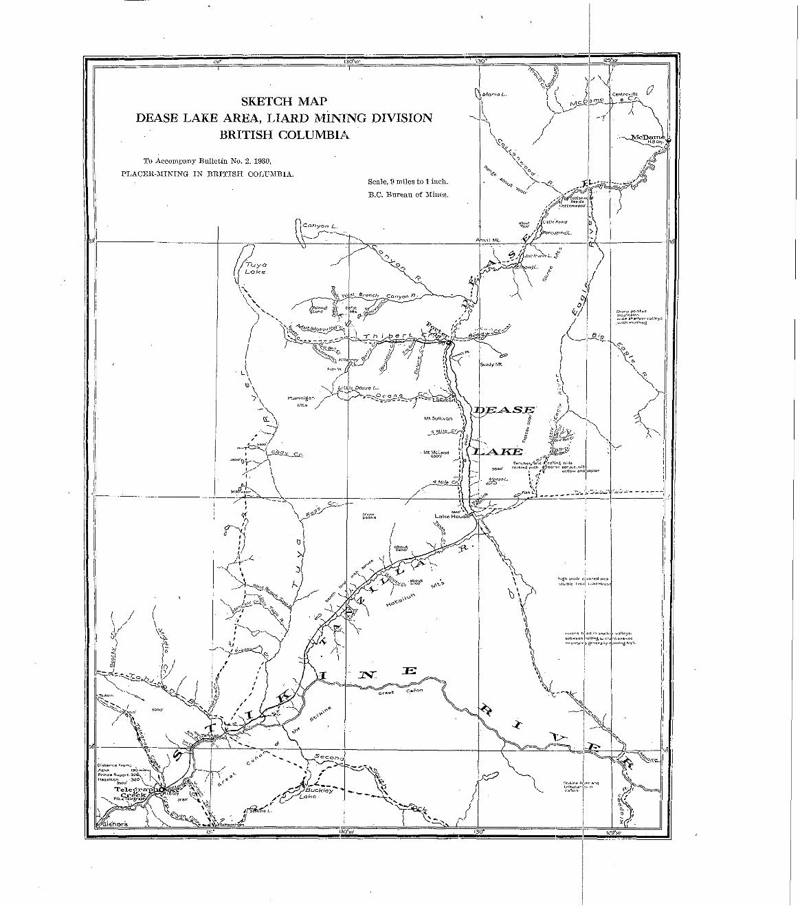
SKETCH MAP DEASE LAKE AREA, LIARD MINING DIVISION -.
BRITISH COLUMBIA
l j !I
To Accompnny Bulletin No. 2, 1930,
PLBC&R-UIKING I N BRITISH COT,UhIBIb Scale, 9 miles to 1 inch.
B.C. Bureau of Xincs.

! 1974 ................................... 1873 ....................................
IS77 I876
1878 .................................... 3979 .................................... IS SO..^^.. ....................... ISSI ............................... 1852 ................................... IS83 ................................... 188 ..................................... 1 8 S j ~ .............................. 1586 .................................. 1SSi.. .............................. 18SS .................................... ~
1 8 9 0 . ~ ~ ~ ~ ~ 1SS8.L
1sBY 1sn1
1Y!13 .................................... 1894 .................................. 190 ~ .....................................
..................................
...................................
1
i .............................. ............................
...................................
.................................
I
s100,000
xo,mo 5'50,000
81.300 62800 '66,000 60,900 37!S00 28,ooo 14,noo 10,000 12,400 '21,500 1S.IW n m o
12.000 11,200
Tllibert.
$100,000 150,000
173.700 130,700
05.600
57,000 71,000
'29,9UO 30.GOO 20,000 30,000 1'2,600 14,zno 10,000 6, ion
10,800 1o.ooo 10,000
'0:GOo 4,.100 4,000
$i:2i8.600 4,000
s200,oon 300,000 163,700 l41,SOO 101,300
s m o o n 11'3200
0'5,000 70,;oo
4%loO 03,000
20.600 16,aOO
22,SOO 1n.000
'm,ooo ZS.lO0
15,000 8.'300
0,700 s.900
9.600
............. s:1n,ooo
Total.
s1,ooo.nno mo,ono 403,700 S08,SOO
406,200 ?J18,i00
a8S.800
182,SOO 198,900
101,600 '60,700 63,700
43,300 65,200
5.mon 41,000
28,000 40,oon
?2,non za,7no
110,noo
~~
84,09S.jOO 22,000

".

26 BUREAU O F MINES.
leases and put in a small plant on Berry creek, a tributary of Tbibcrt. In l9oG this Company worked fifty days and took out $17,000 in gold. In 1907 the same companY W I s working Thibert creek, v h e n slides occurred, breaking the fiurne and burying the pipe-line and machinery. The same year the manager and principal owner of the Rosclla Ilydraulic Mining and Development Company, Limited, died anii morlz on that creek w a s snspcnded. Since that date no hydraulic work of any extent has been done in the district, moil< being largely confined to individual placers am1 some drifting to old channels.
Wm. Fleet Robcrtson, Provincial Mineralogist. visited tilc Cassiar field in 1912, and his trill is described in the An~run l Report of that year. €le states that hydraulicl~ing on Thibert creek could not be carried on profitably witllont a larger \I.atel”sllpply which collld be obtained by a longer flume up Thibert creek.
reports on the district by IT. 9. Johnston ani1 I?. A. ICcrr. Tliese contain the latest official In the Geological Survcy of Canada Summary Report, 1026, P a r t A, there are very goo6
information available and from which tllc following amtations are made:- ‘I The general possibilities for placer-mining in the region include hydmnlic1;ing on Dease,
l’hibert, Dcloire, and Mosquito creeks, dredging on 1,iLtlc Etlgle I’iVQr, and individual mining on
similar clewsits in the Xagle River country, altlmngh they are not known to contain pay-streaks Goldpan creel? and a t ot,lm: places. The lava-hlrieil placers of thc Stikine and somewhat
of any great value. o p l ~ a r to he vort,hy of further lxospcct,ing. There is a vast region north- east and cast of Dease lalrc, dminell by Turnagain and IZecliilta rirers, in mhicll a great deal of prospecting has been clone with no very imwortant results, hut it is v e l ~ improbable tha t all the strcams in this region hare been prospected, and the discovery of Goldpan creek shomd that. nltllougil somc prospccting lrad been done 011 tllc Creek, the sag-streak had been missed.
of the old channels of the creeks mere preserved in the form of drift-corered rock benches along ‘ j Dcase and Thibert creeks Irere thc main zo:d-proililcing creeks of the region, because parts
the sides of the present stream-valleys. “T‘alle?s that llnve the rounded U-sllapc of glacinlly eroded vnlless Should be aYoidcd.
I n narrom, yOutllfnl-appearing valleys, such as Goldpan creek, placer gold, if it OCCII~S, is liltely to be most abundant in the hcd of tllc stream in places where the surface grarels estend down to I m - r o ~ k . If lmuldcr-dag occurs beneath the Surface sravels in the bottom of the rallcy there
hmcath the clay. Narrow and deep V-shancd r~allcs~a, d t h moderate grmlients, even if they may be some concentrat,imi of gold on the mrfwe of the clay, hut there is lil<cly to be little
do not have rich benches o f the nld cllanncl along thc Sidcs, are more favourable than wide mlleys. If boulder-clay orcu11’8 in the hottoln of thew, there is a possihilit? that a pay-streak lies bencatll the day . Tlrc recent rock CanI-ons, which arc llsunll? easily recognized by their nearly rcrtiral sides and wuthful nppenmnce. are nnfaroin.nble for the occurrence of placer gold. unless they happen to lmve heen cnt ciomn ilivectly heion, the old channel of the stream. Xany of tlmn indiratc tlrrlt a hliried chilnnel. in wl:i?lr 11lnct.r go10 is more likely to bc found, occurs alonssidc the new channel.
possil,!e that placer deposits occur in thc rrrrlr-hotton). proridlns other conditions are faronmble. Li If the bcd-rock in tllc r.icinitp of n creel<-l,asin is mincrnlised P T ~ R to a slight extent, it is
If t,he bra-rock. a s in par ts a t least of the prallitic nrcas and in other areas, shows no signs of minernlimtion i t is improhnble that p l a c ~ r dPpo6it.s O C C I I ~ . ”
crcclrs and l~ydraulic mininx llns not yet been b ~ g n n Iry any of tile bixner and efficiently m;mnp.rd This I l~ inps 11s to tile srrsent date: the Dlacrrs have nearly :,I1 heen nm3wl out on the older
compnnirs. It is. homvcr . n laree district nncl there is ample field for the discovery of some new gold-
llc~ring creeks which will give a fresh impetus to prospecting.
SKEEXA MIXIKG DIT’ISIOS.
After the Carilmo cscitemcnt was over. tninrrs foliowed 171) the rirers and creeks north of
creel^. nilout 100 milcs from the month of the Slieena. the Fraser river, prOSpPCting them as they Tent. Ascending the SBcena they came to L~~~~
The first return from I.orne creek was in IS%, when thirtyfire miners R7el’e ,,.orlring prodnccil $li.O00 : in 1S8.5 there v.ere nbout I08 men and the yield mas $18,000. ln the follorning year the Xininr: Rccorrlcr snys the niiners hnd CoI1Side~ablc (limcultr on nccollnt of water; the yield for the i’enr was $13,400. During 1887 only twenty-onc men mere a t n q p ~ ~ , hnt those getting do\Tn to bcd-rock made fair lwges, the sir ld being $.i,ZSO: this is the last year in ,,,hiCll

PtACER-hfIi\TING IN BRITISA COLUMBIA. 27

28 BUREAU O F MINES
QUEEN CHARLOTTE MINING DIVISION.
BIACKSAXD 'DEPOSITS O F GRAHAM ISLASD. REPORT RY €IEREEET CARXICIIA~, .
The Queen Charlotte group of islands lies in the Pacific ocean, the southern point being 140
Rupert. Grallarrr is the lmgest northerly island U ~ K I Moresby, the southern. The east and north miles north-west of Valrcollver islnntl and the north-eastem point is 60 miles west of Prince
shore of Graham island is lorn-lying and has beaches which extend for miles. The western shore is bold, with few beaches, and the southern islands are practically deroid of the low-level shores seen on Graham ishlnd.
Numerous reports liare'been received by the 1)epartment of >fines of gold- and platinum- bearing black sands on Queen Charlotte islands, and recent+y a alachine was Inestioned as having been marc successful in the reenvery of the precious lnetals than Some of the former appliances. I started m y examination of thesc deposits with :I considerable amount of scepticism as to a favourable report, as I had previously been over the black sands of Vancouver island and had invcsf,igatcd a number of blacl<-silnd gdd-sa:nrittg Inuchincs. The machines lTWc often in the han& of persons v h o had only a vague Imowledge of what the machines were supposed to do and \vere occasionally mere toys; in other cases t,heg \yere 110 donbt designed to extract gold from an unsophisticated public.
When I investimted the Gralmmn Isliu~l dcImsits I was foreud to change my views both as to the deposits and the lllaelline used for saring the gold. The black-sand deposits are mnch more extensive than any I have seen on Vancouver islimd. It is probable that they cover all that part of Graham island on which glacial drift has heen deposited to any extent: this approximates an area of 800 square miles.
I t i s mllil<ciy that a11 t,llis arra will cnrltain blark snnds thilt will pay to n.mB, bot there mQy be places \vh~re the 8atids might be so collccntrated that thrS \Till ~ a y , Clependini: 011 the size of the undertaking and the area of sands tha t will be remunerative for such undert:Llrinx. There a rc plwes lx-herc the sands h n x been so concmtratt'd hy present-day streams that the? hare paid fairly good m g c s wit11 a line of sluice-boxes mcl the most primitire method of lilovilig the sand r i t h sho~els . Such areas arc of limited extent and number. Tlirre nre othrr less concentrated areas, hut of much greater extent, which would probably support a larger undertaliilig in vhich the gravel \vonld be entirely handled by ~llechanical power; this mill be referred to Inter. The black sands carry both xold and the platinum grollp of metals. This has been proved by many assays nr ;~ le on samples fronl widlely separated districts.
The origin of this gold am1 plntinlnn is still a matter for spceidrltion; it has been suggested that it came from quartz reins that existed on Grnham island and that had been eroded. It seems, ho\vever, ~ l ~ u c l ~ more likely that the precious metals were carried by glaciers from fnrther north and deposited with nlacinl drift which forms the maior portion of the eastern side of Graham island. South-castem Alaska is k n o l ~ n to contain many quartz reins carrying yalt~es in bath glntinmn and gold, nnd it is more than li1:clv that these \wre eroderl by glacial nction ann millions of tons carried down xnrl deposited on Graham island xnd the surrounding coast.
It is prol~able that these lllaci~ smtls have Oecorile con?eotratcd by three different methods. First, by the actio31 of glacial rirers mhen thc sands were first laic1 down; the tendency of these r i r ~ r s wonk1 be for a nrorleratr concentxation over a considerable nrex. Secondly, hy ~ ~ a v e -
shore-line, probably by the elevation of the shore abore the present high-mater level. This is action; there is eviclence that this has estellded for a consi~lerable distance beyond the present
evidenced in tpst-pits xyhirlr hare bem slillB 100 fPCt or mose Irark from the beach a t illasset inlet. The lex1 of the ground where these pits have been d11n is 15 to 20 feet allore present
black sands f r o m I to 12 inches thick ana have every appeara11ce of vave concentsation; there are layers of black sand with siliceous sand in between. There are large trees on this c round which must be 800 or 600 years old. Thirdly, there is the concentmtion of present-day streams ,,.hich cut throuxlr these sands; none of these strenms are rallid and the arca concentrated is therefore not great.
high-wntcr level; they have been Snl>k t o X depth of 8 Or If feet and clearly shorn bands of

PLACER-XISING I S BRITISH COIAIJAIIRIA. 29
30 BUREAU OF MINES
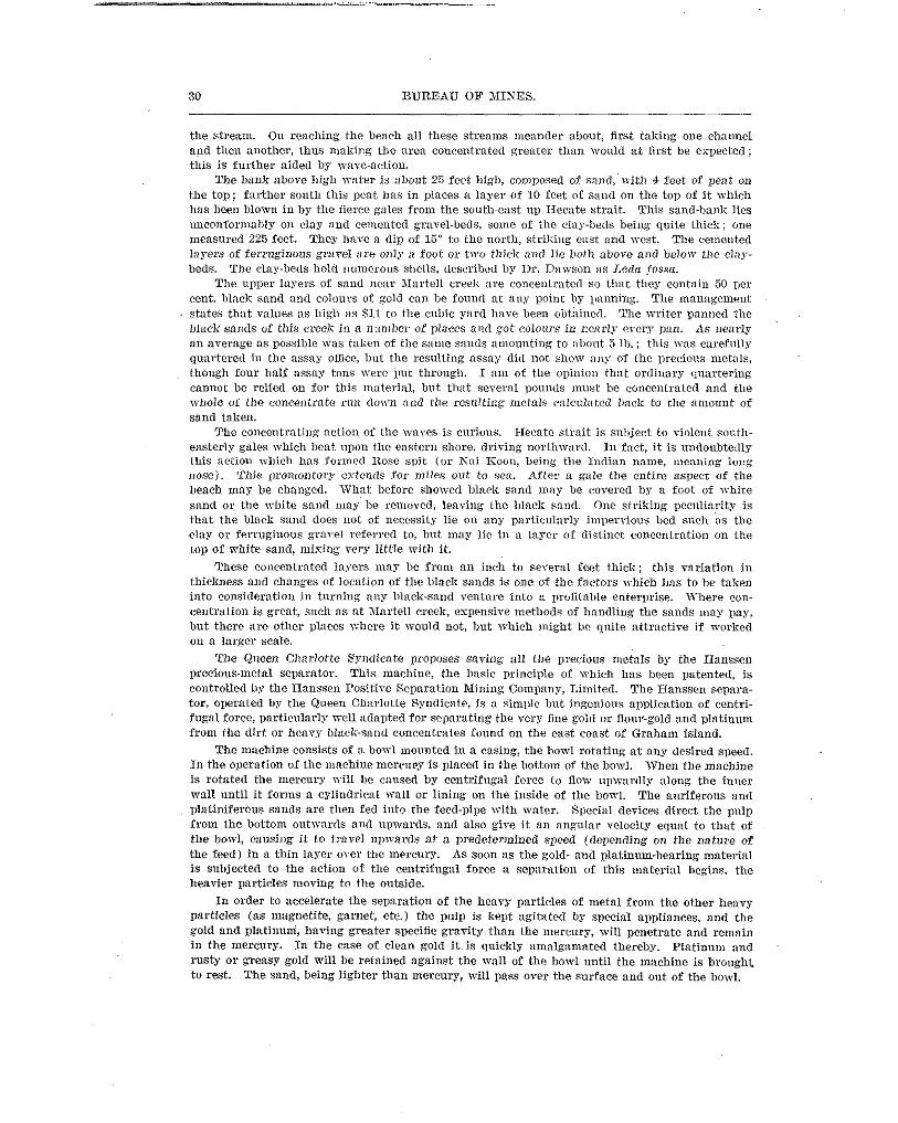
the stream. On reaching the bench a11 these s t ream meander about, first taking one chatinel and then another, thus making Ibe area concentrated greater than would a t first be expected; this is further aided by wave-action.
The bal~li abore liigb va te r i s about 2s fect 11igl1, composed of snnd,'n-itl> 4 feet of peat on the top; farther south this pcat has in places a layer of 10 feet of sand on the top of it which has beeu blown in by tile fierce gales from the soutl~~east ug IIecate strait. This sand-bank lies u~~conformabiy 011 clay and cemented gmrel-beds, some of the day-beds being quite thick; one measnred 225 feet. They llnve a dip of 13- to the north, striking east nnd west. 'The cemented 1. a . ~ e ~ s . . of ferruginous gra,-el are onlp a foot or two thick and lie bot11 :>bore and below the clw- beds. The clay-beds hold nolnwous shcils, ticsCYibcd by Ilr. IIa\~son a s I'eda fossa.
The alrper lnyers of sand ncas Xartell creek are concentratcrl YO tlrat they contain 50 per cent. blaclz sand and colours of gold can be found at ang point by Imming. The mnnrrgement states that valt~es as high as S I 1 to the cubic yard lmve lieen obtiincrl. The \n i te r panued the black snrids of this creek in a number of places ruld ,got colours in ncarly every an. As nearlp an averaxe a s possible \vas taliun of the s m l e sands nrnountinx to aliont 5 lb.: this was carefully quartere6 in the assay ofme, but the resulting assay did nnt sllow any of the precious nietals, though four half assay tons verc put through. I an1 of the o1)inion thnt ordinar>' rljoarteriug cannot be relied on for this ~ni~terinl, but tlxlt several pounds inuse be concentrated and the
sand taken. rrhole of the conceentmte run down ;rnd the resulting r n e l n l ~ caictzlirtctl back to tlte m m m t of
The concentrating nction of the I ~ V P S is cnrionn. I-lecate strait is suhjeet to riolent 8011th- easterly gales which beat upon thc eastcnl shore, driring nortbwar(1. I11 fnct, it is undoubtedly this nctioll which has formed ROSS w i t (or h-ai Iioon, heirrg tlre Intlinu nane, tneaning locq nose). This promontory estcn<7s fo r miles ou t to sex. After n gale the cntirc aspect of the beach may be changed. What hefore showed hlnck sand nlay lie covered by a foot of \Thite sand or the white sand may be removcd, IeaTing the lllaek sand. One striking pccnliarity is tha t the black s w ~ d does not of necessity lie on any particularly impervious lxd sliel~ as the clay or feccuginons grarel referred to, but lnay lie in a lagcr of distinct conccntration on the top of white sand, mising rery little mith it.
These co11centxnted layers lllns be from an inch to sereral feet thick; this rariation in thickness ana chnnqes o f location of tlle black sands is one of the factors ,?-hidl has to be taken into consideratioll in tnrnillg any hlack-sand venture Into x profitQhle enterprise. T h e r e cwl- centration is great, such as at Xartell creek, expensive methods of handling the sands may pay, but there are otller places where it would not, but Which might be quite attractive if worked 011 a larger scale.
The Queen Cllnrlottc Ss'lldicate proposes saving ail the plecious metals by the Hanssen precious-metal separator. This machine, the basic principle of >rhich lms been patented, is
tor, operated by the Queen Clnwlutte Syndicate, is a simille hut ingenious application of centri- controlled by the Hanssen I'ositire Separation Nining Cornpans, Lilnited. The Hanssen separa-
from tlle dirt or hears hltlcli-and concentrates fonnd on the cast coast of Graham island. fuga1 force, particnlarly mcll adapted for separating the very fine gold or floul'-gold and platinum
The machine consists of a bowl mounted in a cusing, the bowl rotating a t a n y desired speed. I n t h e operation of tlle mnchim? mercuPy is placed in the bottom of the borvl. When the machine is rotated the mercury I d 1 be caused by centrifugal force to flow upwardly along the inner mall until it forms a cylindrical \Val1 or lining on tlle inside of tlle boTl. The auriferous nnd platiniferous sands are then fed into the fecd-pipe with mater. Special devices direct the pulp from the bottom outmards and upwards, and also xire it an angular x-elocity equal to that of the borvl, Causing it to travel llp~~arrls at a PTedeterInined speed (depending on tlle nature of the feed) in a thin layer over the mercusy, As soon as the gold- and platinum-bearing material
heavier particles moving to the outside. i s subjected to the action of tlle centrifugal force a Separation of this material begins, the
In order to accelerate the separation of the heavy particles of metal from the other heavy particles (as magnetite, garnet, ete.) the pulp is kept agitated by special aljpiiances, and the gold and platinum, having greater specific gravity than the mercury, will penetrate and remain in the mercurr In the case of clean gold i t is quickly amalgamated thereby. platimnn and rusty or greasy gold Fill be retained against the wall of tlle bowl until the machine is brought to rest. The sand, being lighter than mercury, Will pass over the snrface and out of the ~ O \ ~ I .


leaving the old valley or running across the modern drainage system, as is so often the case in the deep placers of California and Australia.’
“This very confining of the channels effected that concentration of the values which made the rich placers of the early days, and to-day renders \,‘orltable and profitable a number of small hydraulic ,propositions, operating on compnratively limited deposits of, gravel containing unUsu311y high gold rnlues and occurring as old, high channels, or benches, or as ancient and
gravel-baring streams, after lealsing the confined mountain valleys, issued into the wider, n~ore buried outlets of creeks, \There the modern creek has cut a new channcl for itself. The ancient
level valleys or plains, sgreading out more, their cuurses being less sharply limited, their flow slower, and their channels larger. These latter rcprcsent the grcat gravel-deposits of the, Qucsnel and its tributaries, of Willow river, Cottonwood, etc., which are, on the whole, larger and lower grade, while their course is more obscure, haring in many cases been covered with subsewcnt f l o m or lake deposits.”
J. 1). Gallomay, while Assistant Mineralogist in 1014, eane through Carihoo district by way
hydPaulic properties a t worl<--nmnely, Lowhee, Stoizts Gulch, and Mosquito Creek claims. of Prince George; he states in the Annual Report for that year that there were three large
Prospecting by drilling V:IS under way on TTillimns creek and Willow river, a?ld Mr. Gallowag stated then that ’I It cannot he said that a Sufficient quantity of ground has as yet been proren up on Williams to warrant the esllenditure necessary for a complete dredge installn- tion, but in the erent of a similar area being proven up an TT‘illow rirer, then the two together might form an attractive dredging propodtion.”
yield round $200,000 per annum ; the Resident Engineer for the district reports a very satisf;lc- From 1934 to 1924 a considerable nrnourlt of hydraulic mining mas carried on, showing a
tory year in.1324 and the insidllation of a dredge on .4ntler creeli, mhich mas morliing the following year with good results, the recorery for the year being $06.066, and in 1026 the gold returns for the sear were $170,093, mostly contributed by the Antler Creel; dredge.
An operation for dredging the bars 01 the Fraser river at Lillooet wns started in 1926. A company acquired 6 miles of dredging-ground and installed n drag-line Scraper as me11 as a natent device for s w i m gold. This method, howeYes, did not work out in practice and v a s
~~
abandoned. In 1027 and 1925 there WLS considerable activity amongst tile Smaller hydraulics an11 a
large amount of Keystone-drilling done in prospecting new ground.
given to Bancroft‘s “ IIistorg of British Columbia,” the Reports of the Geological Survey of The writer wishes to acknowledge his indebtedness for the historical information herein
Canada, and the hnnurrl Iteports of the Xinister of 3Iincs fos Buitish Columbia.
CARIBOO, QUESNEL, AND OMINECA MINING DIVISIONS. REPORT DY C. TV. MOORE:.
INTRODUCTION.
During the Season of 1920 considerable activity was Shown in placer-mining in this district. particularly in the Carihoo Division. The production for the year is estimated at $38,845 and the total for the Nosth~eastern District a t $63,342.
in operation were Jmvhee Mining Companny, Limited (formerly John Hopp Nines), on Lowhee Water conditions mcrc in general favourable for the hydraulic mines. The major hydraulics
creek, which continued in virgin grollnd; Carinelle Placers, IAnited, operating the nullion; and B. Boe, operating the l’lott and Lfllle leases on Cedar creek. The activities of the many smaller hydraulics in and about flaI’ken~iIle, whose annual total contribution to the output is considerable, lvere much the same as usnnl.
and in the Horsefly section by R. X . Camlibell. Interesting new discarel5es were made on Spanish creek by A. Sutherland and A. Anderson,
Company of Canada, Jhnited. on Swamp river, and by Central R.C. &fines Development, Limited, Keystone-clrilling operations were carried on hy t,he Consolidated ICiniug and Smelting
in Braver vallep, in the IIorsefly section. The dredge~formerls owned by the Iiafue Copper De\.elopment Company, Limited, has been
sold to interests in the United States and has been dismantled and shipped to Oregon.


PLACER-XlNING I N BRITISH COLUllIRIb. 3s
36 EUREAU OF MINES.
as mould have been desirable. During the season of 1929 a start WQS madc on a road from Fort
of building roads and trails in this scetion. St. ~ a m e s to Nanson ~reelr, and generally the Department of &lines is fully alive to the necessity
Upon completion of the roul now under constsuctiou from Fort St. Jalncs to i!ianson Creek, it will be possible to get hcavy drills into thc country, and thus encourage capital to drill the larger areas. I t will also iu'oride thc individual prospector with an opportunity to c a m a grub- stake vi thout haTing t,a t P a x l hundscds of miles to do so. I rvould Suggest that this road be completed ~ i t 1 1 a l l possible dispatch.
There are scveral Small creeks in this section which are well worth prospecting and solne larger areas which are sufficiently attractiw to warl'ilnt mnminntion with :L view to dredging.
a drill of this type cannot bc tnlwn in, cscept a t an almost prohihitire cost. The fen. light drillr- It requires a ICeystone drill to pravc the ground, and until there i s a good road into the COUntL'Y
which htve bccn tnlicn in h a ~ c dcmonstratcd that their usefulness is confined to a very limited amount of scout drilling.
In the Cariboo. Qnesnel, nnrl Omineca 'llining Dir.isions thcre are without doubt lllallY excellent opportnnitics, other than those mentioned in this report. It mill, howver, require considerable time 2nd inrcstigrtion to secure sufiicicnt data to present a cornprchensive (lescrii>- tion of the mnny poillts of intercst to the mining industry.
that adwntage will be tnkcn of thc m:ms opporluuities which, upon inrestigntion, should offer Owing to the interest heink taken in pliaccr-mining ;rt the prcscnt time, it is more than I i lW'
wcrr prospcct of sntisfaciory rclnuneratiou for hotlr thc Dmspector and operator, and mill in all probability enable the Cnrilioo to regain its fonl,cr plnec :is n llirgc placer~gold prodncing district.
As an instance of the possibilities, there is x hi:h chnnuel paralleling the Elorsefly river on
Little Svift river to an outlet on Lizlrtning creek, ahout 2% milcs below TVinmlam, whiclr is cut the north which prohtrbly has ne\-er had a pick in it. Thcre is rinothcr channel running from
by numerous creelis and is quitc likely to prore the source of the gold, found ahova the clay, on Peters creek nnd Ligllining crcelz.
There arc milcs of old channels in thc Cariboo in which there has nei'er been a hole drilled to Ocd-rock. As 5 matter of fact., dctaii Bnowledgc of the Carihoo and Omincca is limited to certain arcus.
Cnnadn) corers but a very small area in the viciniiy of BarBerdllc. It is, homever, a valuable The escellcnt report of TT. A. Johnston and X'. L. Uglom (Jlemoir 149, Geological Surrey of
report 21s it is a iccy to t,hc placer geology of a much lal.der area. As a result of m 3 7 esnn~inntions I hare reacheii the following conclusions:-
and hydmulicking. (1.) That there are large arcas in Cariboo and Onlineca n.hicl1 can be Worked by dredging
some returns on money invested. (2.) The indications are that them are sufficient mlues, if progerly managed, to pay hand-
(3.) That every consideration should be gireen capital, during the next few years, in order
a firm and permanent fonndntio21. that the greatest possible actiyity mill take place, to the end that the industry mill be placed on
(4.) That the buihllng of roads and trnils for mining purposes shonld be continued and in a systematic may,
(5.) That the " Plnccr Act " should bc rerisecl, and particularly that the provisions dealing with free mineqs' ccrtificates should be made much lcss drastic than at the present time.
(6.) That n good topographical nlap of the Carilloo district should be made as soon as possible.
\ CARIROO NINING DIVISION.
PRINCE GEOEGG SECCTIOI". oovenlmclzt Creeli.
The Gorermnent Creek HyAraulic Gold >lining Company has had a geologist in the field
This company has also washed a considerable quantity of surface gravels, but as no report all summer making an investigation, and I belieye some 7'ery valuable work has been donc.
was made to the Resident Engineer, I am unable to make any definite statement as to wllat success was obtained.
PLACERXISING IN BRITISH COLUXBIA. 37

38 BUREAU OF MIKES,
extcnd down-stream before it is cut by the present channel of the creek. It is quite possible that i t vi11 extend down-stream approxinmteLs 2 miles.
hours a day for three months, and to work tmelre hours a day for the remaining three months There is sutticient water available in Cnnninglram creek to worlc this property twenty-four
of the season. The present ditch is so srnall tha t during the very hot veather, Which causes
nozzle with a 150-foot head. heavy engoration, it is impvssible to get sufficient water to thc penstock to supply a 3-incll
Eight-ndle Lake.
tha t automobiles and truclrs can easily be driren to the lake. The road from Barkerville to this lake has been so greatly improved during the su1Iin1cr
Lake property, lowcring the flume to enable them to get out some v i tire rich gravels still left M. IlcComish and Morris Anderson hare been working all summer on the old Eight-mile
in these leases. This propertr was one of the most spectilcular finds in the latter days of the Cariboo. The papdirt mas found on the top of hard bouidel.-clay. Due to the lack of sufficient grade and a limited supply of water this became a very erpcnsive operation. When the ground was n~orlced hack from the lake, mhicb mas used for dumping purposes. tlle grade of the flume gradually rose above the clay. vhich nmde it impossible to 8ecurc the values, and conseauently
the PreVious operations ended, and it is this ground vhich the present VWners are trying to the work was discontinned for a time. There is knorrn to bc rich pay-dirt under the bank, where
recover. Other Creeks.
Pine creek. John Chouse is working a lease on the riSllt limit of Summit creelr. E. D. Rccs is \vorl;ing his leases on Shepherd creck. John Roddick is working a lease on
Willow River. This river drains the largest area of rich placcr-gsouml in thc Cariboo. Williams creeli is
the ileadvatcrs of the East fork of this riirer, ~~vhile Pack of Clubs crcck and Slougll creek form ‘.he T e s t forlc. The t v o forks conrerge at the nort.1, side of Island mountain, about 10 miles north-\vest of Barlcerrille. l’ractically all of the creeks draining into the river hare been worlred.
The TVillpw Rircr >lining Company endenroured to work the river ibelf j u s t below the junction with ~fosgllito cseek, bu t r i th l i t t l e or no success, due, principally, t o t,hc depth and cost Of pumping water. It did. Iromcvcr, provc that thcre vere good ralues on tlle bottom, as Some of tlle gronnd went as high 11s $7 to the sQuare foot of heA-rock. Apparently the deep ground docs not extend ~ I I S very great distance do\vn-drean~, a s tile rivcr flows over bed-rack 6 miles bclom the mining company’s wol’1;s. The rim-rock ehovs at serrral points above Valley
is some of the most promis i~~g grouna for dredging operatinns in the Cnriboo. (Big Valley) creek. Betwecn Dragon crcck and T7alle~ creek, a distance of about 16 milcs, there
the valley is very wide and is pralxrhly an old lake-bottom. From this point for about 45 miles From mhere Valley creek empties into the T\yillow rircr to a point about 5 miles north,
days of the Cnriboo thcre ~ 1 s considerable rocking done on the hars of this section. (as the rirer flows) there arc excellent possibilitics of finding dredging-ground. In the curly
Dragon creck about half n mile from the mouth. It rms nhnost prirallel with Villom river, There i s an old channel, the Source of wllicll is ver), prohlem~tical, but which crosses
although in a slirhtly more westerly direction, for some miles, turns easterlr. and joins Willow rirw about 18 miles from Drngon creelt. Xr. Ford, of 1)r:lmon Creck, believes that this is the old chilnnel of I m t creeii, which is rery 1il;elg correct. The channel is so decply corered with glacial drift that it is impossihlc to determine its source.
that i t crosses Trenillus rreck ahout 4% miles from its mouth and is quite likely to he the source From l ~ n o ~ ~ l e d g e gained at the Dragon Creek esposurc and from other evidence, I believe
of thc xolh founA in l<n.~lmn and I3aldlimd creeks, as vel1 as the rich spots found on the right limit of Tregillua crcelr. F’iom this point to abo1lt 10 miles north. vhcre it empties into the TTiIlmv river. a s a hanxina v:lllcy. the old channel is vel1 ~lcDne,l. Dendwoocl creek, nlhicll empties into the Willon. r i w r rrhnut 2 miles north of Trexillns creek, cuts the old channel nnd was n-o~ked from this mint to its mouth. CanSon creck. n.Irich p p t i r s into the Willow river from the same S i d r . aborit, 2 milcs farthcr north, (lid not cnt the channel ana carriec1 no n lues . Archer creek, north of Canyon creek, cut the channel, and from this point to its moutll

40 BUREAU O F XIINES.
large area under similar conditions, vhich would probably carry values about the Same as tllese area to have sufficient values to make modern dredging profitable, there vould be available a
two leases. On Io~ver Swift river anrl on 1,ightning creek, as well as on t.lle flats around Coldspring
Rauch and Cottonwood House, there is a laxer of gol(l-bearing graVelS at a deptll of from 8 to 20 feet on top of the clay. ID tile early days of the Cariimo, Chinamen worked Iarge areas on the surface. In many inslances t,lie grarel was rich, :is is proven hy the records of the late John Uoyd. The drillillg on Swift river is the only worl< in this Section which has testecl the ground.
QUESSICL XIXIKG DIVISIOS.
I%VRSEFLY SECTIVS.
On October 7th, in camnany with Douglas Lay, Resident Engineer for the North-eastern
creek and found the gmrels to be orcrlaiu with volcnnic rock. V'e also visited Triplet lake and District, I visited this section. We esainined tile anciext cl~nilnel n-here i t is cut bg XoXat
inspected the morl; done last winter just east of t,he lake by J. It. JVilliams and Xiklcelsen Bros. They had made two attempts In reach bed-rock by sinking sl~afts, hut due to the great amount
surface to tile point nt which they \vert compelled to stop they found AIiocene gravels, with the of water encountered were Imsuccessful, altllougl-il they did get l)elo\v tile Inlre-levcl. From the
that the chanuel runs tow;ml Star lalre. To the south-east of Star lake they claim that the old exception of one strntum of lignite coal. This morlc is of valile for the reason that it proves
channel can be traced. Since there appears 110 good reason for rloubtiag this claim, then some- where near Star lake the 01~1 channel lnny he found intact, and if so \mxlld be the 1)soper place to $tart drilling.
that this old channel runs through Bearer valley to the Quesncl rirer. It then folloved the I believe that the r ich gravels found a t TYarrIs Ilomeffy originated from an old ci1nnnel and
course of the present Quesnel river for Some distance and probnbly fiowed west in the ricinity of Dragon mountain in to the Fmser river, 7 miles bclow the tovn of Quesnel. l t is believed this old chanuel was the source of the gold found at the \\-ell-known rich bar on the Briiser river
cIm21nel in thc vicinity of Star lalre. Should such drilling p o ~ e the direction, then it could be at this mint. It i s to be ho1)ed that some compnny will be Sllflieicntly interested to test this
folloved and, if m t too much disturhcd with ice, would offer xvonderful mssiBilities. Should
great assistance in helping to prove direction of this old channel. the Central U.C. hiims Development, Limited, get to bed-rock at Beaver valley, it will be of very
New m a AI?niw Co.-About the first of December this company started drilling north of IIorsefly, witll the eS1)ectation of locating the estensiall of the rich '' Ddy " foond a t Wards IIorsefly hydraulic. l t aDpears tllat they have succeeded. To dnte tell holes h a r e been drilled. B. F. I,unliy, the 1nauagcr, reports the average result froin drilliilg is ahout $1 a cubic yard. The average deptll is 36 feet, vhicb is ideal fa r drcdging. There is an area of about 50 acres at least, or about 3,000,000 cubic yards. The area morke8 at Vards €lorsefly mas less than 5 acres, with a reported production of ahout 13300,000. Mr. Luncly rellorts that the values are on aud above hard blue clay, mhicll mt.s as a false bed-rock.
Tlliinterestiilg featuse of the riiscorery is that the gold founil must have come from a higher iercl than tile bed-rock under the dar. The gravels carrying t.hc gold therefore must hare been resorted froin a higher level. The ancieut channeI near the month of Xoffat creek sho\vs signs of erosion and is quite 1il;ely the s0111'ce of tile gold. If this is the case the old channel at Triplet and Star lakes should offer good iuducements for rl?illing.
Xof fa t Creelc.
For further description see Anuual Reports for 1027, Page S O , anrl 1928, gage 203. At the. time of each of m y two visits t o this section the owners of the leases mere a~vay. The only portion of the creek examiuetl \vas that below the falls. 'the following information on nloffnt creek is from the report of Ilouglas Lay, Resident Engineer, in the Annual Report for 1928:-
mention is made of the fact that Noffat creek ,a1)parently cuts through an ancient river-course. "Bnoient Ri~e?=cha?mel C N t &!u Haflat Creek.--In the Aununl Xegort for 19227, page 180,
This was further investigated during the year. A short distance below the falls on Moffat creek thcre is erposed on both banks what nppem's to be a n aueient river-channel. The gravel

S K E T C H MAP
OFTHESOUTH FORK O F
Q U E S N E L R I V E R

PLACERNINING IN BRITISH COLUXBIA. 41 ~

42 BUREAU OF MINES.
is residual and is composed allnost entirely of well-worn quartz, closely resembling that from the deposit a t S t a r and Triplet lakes, on which are the leases of J. Williams and C . ICuchan, and also that of the old 39iocc?m proIlertJ- a t IIorseay.
level of the bed of Xoffat creek at this paint is 235 feet vertically above Ilorsefly Post-ofice. "Where intelsected hy Xoffat creek the direction of this channel is X. 65' W. (mag.). The
is not certain whether the latter is in place. It is understood that some years ago a Keystone On the left bank of >loPat creek a t t h i s paint the gravel is overlain by volcanic lava-flow, but it
drill-hole was put down in this gravel at a point somewhat dorvn-strx?am from this exposure, hut bed-rock was not reached. This is obviously a point a t whicl~ drilling Sho"1d be carried out, because of the hydrilulic pxsilrilities Which may exist, and which can only be prored by ascer- taining the depth of the channel a t this point as \vel1 as the ralues. IloffLt creek would fnrnisb a good supply of matcr for llydmulicking if the presence of the other conditions essential to suc~ess can be estniJlished by I(eystone-dlrilling."
Antoine Creek. TlJis creek flows out of the eastern end of Beaver Palley into the Horsefly river. It has
never been properly tested and his beeu oTer1ooked for years by prospectors. In 1028 It. X. and John Campbell staked ground on the creek and when doing their annual deoelopment-wollt,,orl~ last July fouud good ''pap." E. X. Calnpbell reports good mlues in ail their pits. In places the grayel went a6 high as 33 a cubic yard.
On October Stll, while on the creek, the ground mas panned at several different places over about 1% miles of the creek, and while I did not get values as high as reported by 311'. Campbell, the gravels did sho\v high values o ~ e r a lnrpe area. Although the pits put down by Campbell Bros. were from F to 7 feet deep, there is nothing Bnoml about the actual deptll to bed-1'OcB; consequently it is not possible to make any accurate estimate of yardage. If the grollild Is 20 feet deep, with the values holding to that depth, it will make a good hydraulic property. Physical conditions are ideal for hydmulicldng. There is unlimited roan, for tailings in Itoberts lake (Anderson). There are no big racks in sigbt, no? is ihere likely to be in the ~ ~ O U I J ~ . The mater-supilly was not investigated. R. N. Campbell states that they will hnoe snflicient water to supplv a Xo. F hydraulic plant for a senson of six 2Jlonths. Campbell Bros. \ \we inore fortunate thaJ1 tlie average prospector with regard to iinancin,g. This was quick@ arranged with B. P. Lnndiy, \~,ho in cOnsidePBtion of B one-llalf interest agreed t o furnish m a t e r i a l m ~ d complete certnin stiyulntcd rorlz. They have their storage-dam completed and it is their intention to s tar t mork on the ditch as soon as the frost is out of the ground. The ditch will be Short a l ~ d , 3s the? lla~-e a road to the mouth of the creel; w e r W ~ i c h to trans~lort plant and nrnterial, the cost of equiming the property will, be small. Vi th any kilid of luck they should be piping in July.
Beaver Valleg.
valley, with the result tllat >I?, Lundy formed the Central B.C. >fines Development, Limited, R. 3. Campbell, of Ilorsefly, was successfnl in intercstingr I?. I?. Lundy ill his leases in the
vhich started drilling in Ju ly . 311'. tundy reports that the results to date have been rery satis- factol,y, but sufficient drilling has not yet been done to develop any extensive area. The corn- pany intends to start drilling again in the early sllring.
Black Cveek. lllaclc creek empties into the Horsefly river about 20 miles east of TIorsefly Post-ofice, from
mbich point there is a good motor-road to the luouth of the creel;. The >lacJCeracher leases \IWC taken over about a year ago by the Rountree alines, Limited,
of Vanconver. hhout 1% miles from the month of the creek there is n drop of abont 200 feet.
located just ahore this canyon. There is no sign vhatever of bed-rock, or rim.rock, for 1,000 Above the falls the creek flo\vs through il narrolv rock canyon 2So feet long and the leases are
feet. The rompany claims to hare good prospects in the gravel in this portion of the creek. Since taking o ~ e r the property this conlp8ny has installed IL good Xo. 4 hydraulic giant rind built a St"ragedi8nl. I t h a s also lo\veretl the roclc c:lnyon to $1 depth of 20 feet at the u p ~ e r end, putting in a flume on grade, all of vhich has entailed a considerable expenditure of tilue and money. In the roclt-cuts, or canyon, a 2-comp:rrtmcnt finme has been installed, each compnrt. ment 3 feet wide.


44 BURICAU O F XINES
an old clrannei of Spanish creek, the discovery is of interest in view of the fact tha t on this While further work requires to be done before it can be determined wllether or not this is
creek no material amount of gold was found above the mouth of Dlack Bear creek. A good cabin hod been built by the ovners of this property on the right hank of Spanish creek, a short distance from the vorkings.
Kort7~ Pork of Q s e n ~ e l River.
owners stntc that a t the t ime of examination (October la th , 1D26) sloughing at the face of the X~ltl~Caas GoZU Xining Co.*-Witll reference to tlle 1.928 Annual Rcport on this property, tlle
pit rendered i t impossible to discern lvhat was observed by them a t tile time of piping-namely, the fact that at the face of the pit bed-rock dipped into the hili, also that solile zold was founfi at this point, and that the indications m!re that tlle f;Ice of the pit bad jfcsS reacllcd the SoutA
ohlnem furtiler state that GI] opening 1l:ls bccn made on Wolrcrine crcek, some 3,000 feet u p rim of a buried ancient clmnnel running parallel to the Xorth fork of thc Quesncl river. The
stream from the above-mcntioncd point, mliich aiso indicates the existence of such buried ancient channel.
furthcr examined during ID30. It should, howex-er, De borne in mind that, even assuming that This exposure on Wolverine creek lms not yet been inspcctetl and this property mill be
there does exist a buried ancient channel on this property, the question of profitable gold values
example. Until such has been done no intelligent ancl reliable opinion can be espressed a s to therein remains to De determined by camful and acleqoilte testinz-by Keystonexlrilling, for
possibilities. Forthcr, i t seem evident that such t:estiug sl~oulcl precede any capital outlay in conncetion with any sclielne of actual mining qxral ions.
South Fol-7~ of Quan~eZ I?iver
Nelson a%d Bzrlnr Leaaes.-Tliese leases xere not m r k e d dnrin: the SeasoLi. The owners, J. P. Nelson and E. E. Defue. arc contempixting sonle impravcmcnts to their pnmpiug piant for nest spring.
Bsllion.-This property is n o v being vorked by Cnrineile Placers, Limited. During the sgring and summer ogerntions were carried on, but were discontinued early in the fall. I an,
Engineer. unable to state vith what s~~cccss, for the reason tllnt no rcllort has been made to tlle Resident
IiPlTllI.EX SECTION.
011 Srramp river in August. It is understood tllat results vcre unsatisfactory. Chester and The Gonsoli~atecl Mining and Snlelting Company of Cxuadu, Limited, discontinued drilling
Tbomas were prospcctinn on Reitllley creek. H. DeLoilg bad a slnali hydraulic plant on Vcavrr creek, a tributary of Iieillk?y creek.
able deveiol,ment-n.orli, b n t with ,That results I do not kno\v as there was no report available. The Quesnel Gold 3Iining Company, Limited, operated during tlle Sunllner and did consider-
OAIINECA AIINIXG DIVISIOX.
IIousTos SECTIOS.
nw7i m d Rob Creelcs.
These two creeks are xbont 10 miles sovlth of tile tomli of IIouston, on the Cmadian Xational Raiimay. They can be reached by a fairly good auto-road from IIouston. The leases are owned by TTT. A . Johnston, of Prince George.
coarse gold has been taken out. The property csten[ls over Some 20 miles of creel<-bottom and, There are small prospects on the surPace and In the c a n ~ o l l just below the property. Some
xhile there has not been enongh dereloii,ncnt-work (lone to prove ralnes, i t warrants at least three sections of drill-holes. The physical conditions are ideal for dredging.
Xmsort SECTIOX.
The term “3r;inson geetion” is used to desi,qnate that portion of the Omineea Xining Division rrhich in former ears had some i~nllartance as a placcr camp and mllich centred about
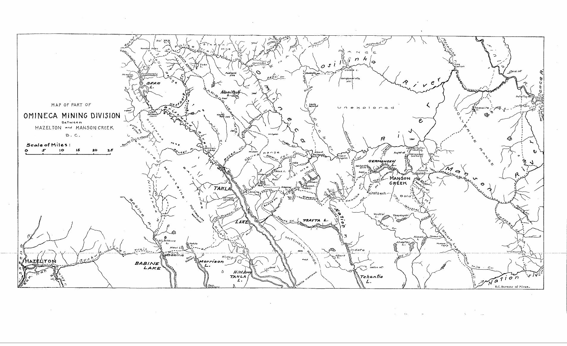
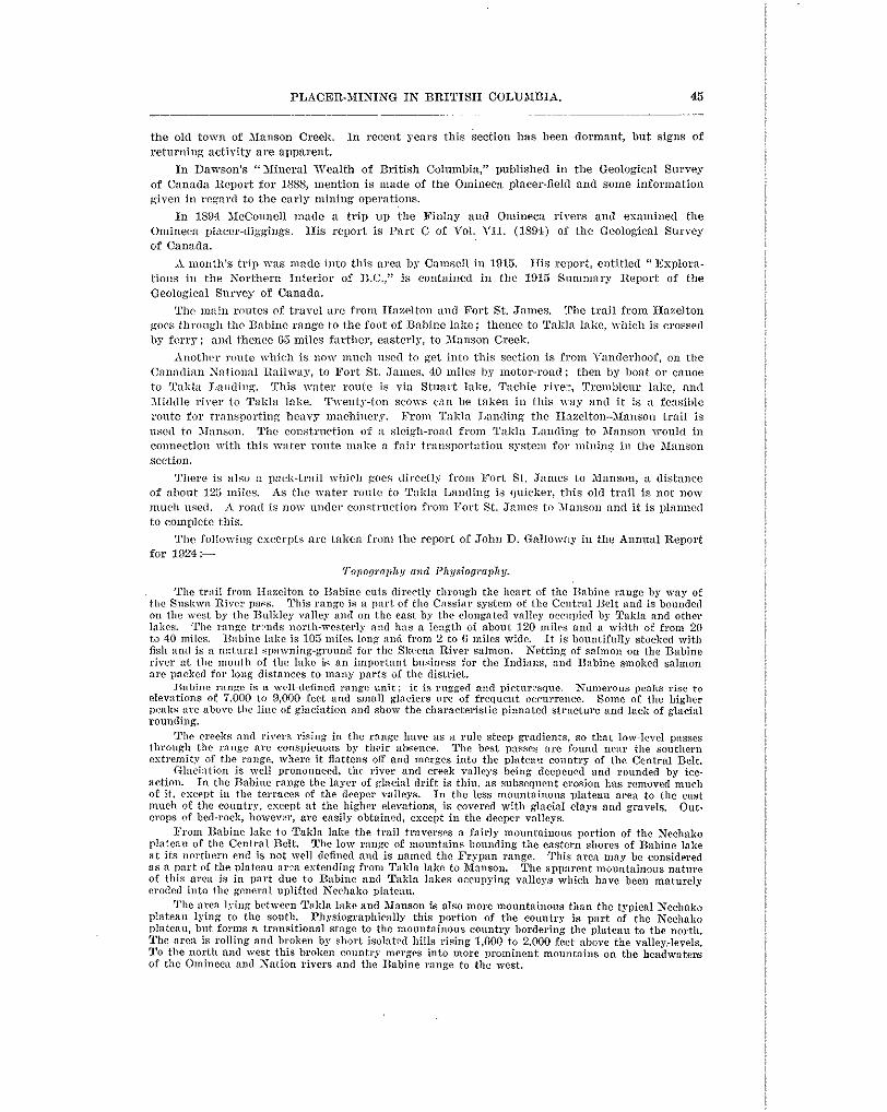
45 .. .

46 BUREAU O F XINES.
Pacific ocean. The maters of Takla lake flow soutllward and evcntunlly reach the Pacific ocean bs the Drainage from the Bnbine range and Rabine lake is all to the Skeena river and thence to the
Ncehako and Fraser rivers. The area between Takln lake and 31\1nnson Creek is on the Pacific-Arctic divide, ns the waters of
the Omineca, Xanson, and XTntion rivers flow into the Finlay and Parsnip rivers, and by means of the Peace and XIaclien~ie rivers flow northerly into the Arctic, while thc Tnliln Lake waters and tributaries flow southcrly to join the F’rascr systcm going into thc Pacific. For B mountain region the gradients of the streams are not stecg, except in the Babine rnnge and on Babine river, which flows out of Babine lake.
R very, slight fall to the southeast, whieh permits of easy navigation by boats and scows from Fort The great wntcrmny formed by Stuart, Tremblcur, 2nd Tal& lnkes and connecting streams h m
St. James to the Driftwood rivcr. The streams draining to the -4retie have steeper slopes and navigation by canoe from the Pence river up the Xation, Omiaccn, and Manson rivers, although attimnted. is somewhat hnonrdous.
Good timbcr, consisting mainly of eedilr, hemlorli, and spruce, occurs on tho Bnbine range on both the slopes to the Bulkley valley and to Babine lake. East of Babinc Inlie for R few miles there is also a cood stand of timber. ICnsterlv from this mint the country llns been lnreelv burned over
rocks. which are as a rule closely interbedded and intercalatcd. Wherever the range has l~een closely The Babine range consists dominnntly of considerably metamorphosed volrnnie and sedimentary
eanminrd thcse roclw are found to be members of the JJeselton formation of Jura-Cretaceous ace. mid it is believed tlrc whole range is lnrgcly made up of roclrs of this formation
Intrusive into these older rocks arc small bodies-dukes, sills, and small batboliths-of granitic roclis; basic, Inmprophyric, dykes also occur. Igneow intrusions in thc range have not been on nen~ly
those of the Bukley mountains dircctly to the west. as large a scale as in the Coast range and its subsidiary mountainsl but are more comparnble with
The gcologric conditions nre excellent for the occurrcncc of mineral, and in many parts of the range mineralized areas lrave bcen discovered. Descriptions of the character of the Hnrelton formation and intrusive granitic rocks as exposed dong the Bulkley, Skeeua, and tributary vnlleys can be found in several reports of the Geological Survey of Canada and in previous Aunnal Reports of the British Columbia Department o€ Nines.
probable that-the Iln%lton formation continues easterly for some dkt,ance. On Talcla lake there is n Between Bebinine lake and Talila lake the rock formations have not been studied in detail. It is
seriss of sedimentary rocks, consisting of conglomerate, sandstone, slrale, and some coal, which has
formation, which ovcrlies the llaoelton formntiou in the Hazelton-Tellwn sections. So far as is been classified by Camsell as being of Cretaceous age. Thse rocks are very similar to the Skeena
known, Ilaselton formation rocks are continuous from Rabine lake until within n few miles of Takla lake, where the Cretaceous sedim?nts come in. Associated with these 6ediments arc some beds of volcanic roclis.
East of Tnkla lake the Cretaceous sediments continue for’about 5 miles. At this point the schistose series of rocks, wlrielr lnve a widmpread distribution in the Manson section, commence. These rocks, which are tentatively closscd by Camsell as being of Carboniferous age, consist of n schistose complex,
into this series are small bodies of granite. One of these crops out on the trail ,beyond Silver creek and including limestone, argillite, chert, slate, quarkite, and some highly dtercd volcanic rocks. Intrusive
another n short distance sonth of Xanson Creek.
veins is the source of the placer gold in the different ereelis in the area. Qnnrta veins are of common occurrence in this formation and it is believed that gold from these
Economic Ceulogv.
Tire important minernlkleposits of thc Mnnson section so far known are the gravel-deposits in whielr plncer gold 0cc111.s. Prospectiug for gold in “l!ire Ornineea,” as the section was known in the early d a m commenced in 186.1, but very little production was made until 186% The area within which the greater part of the mining has tsben place is scarcely more than 60 miles in its greatest diameter, and iurludos the uppel‘ portions of the Gcrmnnsen, Omiueca, and hlnnson Fivers and their tributaries.
the Cassiar district. 111 IS79 the Omineca agnin attracted attention, but in 1887 was once more After a few years of mining the a r ? ~ was practically abaudoned owing to the placer discoveries in
nearly abandoned, and since that time has only been worked more or lcss intermittently for pia-r.

PLACER-AIINISG IN BRITISH COLUXIBIS. 47
48 BUREAU O F MINES.
and low-grade ground has been left. This ground is too low grade to be worked a t 5 profit by small- scale individual mining, but will make good " l n y '' for drcdginp. Resides the stream-beds, the benches in plnces are believed Lo carry law values. Streams that were not mx'lird by the oid-timers carry more or less values and are mortll investigation with n view to outlining dredging areas.
small lake cxpnnsions, mllielr have never beeu tested for placer gold. In many places there is undoubt- Strrams euch as Kenny, Silver, Upger ilanson, and others lravc wide Dat vallegs, with, in places,
edly n very considerable thickness of gla~inl clays and gravels, which arc pmctically barren of ~alues. But where stream-action h s to some extent conccntrated these glacial gravels low-grade auriferous gravel ha6 been formed.
The mwnge depth of ~ I ' B Y C I S along tlrc creeks are in many i&aoces not great and well within the dredging limit. The gravels gmeraiiy do not contain large boulders and the Scllistose bed-rock is very suitable for dredging. Altlrough nt some distance from the railway, good enough transportation
Slate Creek. Since 19% the only real dcreloprnent-work done is the drilling of Slate creek by TV. 11.
Ogilvie for the Consolidated Xining and Smelting Company of Canada. While in conversation with Mr. Ogilvie, although no ~ e r y definite statenirllts were made regarding yardage and values, I was given to understand that thc ralnes l(-crc high, but that there vas not sufficient ywdage to justify the expense o f bniiding a llitch and equipping the ground with an hydraulic plant.
Above the point wlreve tlre present c11;mncl of Slate cuceI< empties into Manson creek there are three distinct cllannels. Tiiese cut tllc divide bctwcen the two creeks and undoubtedly a t different periods Slatc creek fio!vxl throllch these channels. This \vould prohnbiy account for the rich sp ts on blnnson crf& just below wlmrc these channels \\.ere cut by thc creel:, and it is quite possibie. should tlw c w ~ p a n y prospect or drill these thrce channels, that it ~ o u l d increase the yardage to a point xhere it would justify them in installing a ditch and plant.
dlallson Creek. R. 1% Fleming and partners harc taken in a slnall pump to be operated by an IWinrude
engine and had just started to prospect vrllen I Tisited the creek.
Oermnnson Creel&.
h a r e acquired several lcases on the upper ell6 of the creek, above the point at which it v a s AI1 Lock had rxtlier n poor rem' 011 account of the unusually dry Season. &lcCorkell Bros.
worked in the early Anys. About 1% milcs of this grriund sllould be good. The old-timers made
did not mcct r i t h any I % ~ J - great results, 1xincipalJp on accorlnt of thc henYy nnd sudden mins several efforts to work tllc ground by wing-damming and shmeiling hlto bores, but their efforts
which would ~ m s h out their rning~riams and sluices. NcCorl-ell 13ros. intend t o install a drag- line scraper wlrich ~ o r l r s 011 n boom. Should i t be possible to work the ground dry by this method, and I.f thcy hare a proper vashing-machine and Some device for getting rid of the tailings, their operations may grove quite successful.
vita1 creel&
by ground-sluicing and a small hydraulic plant. Owing to the height of the clay-bank and the Lee Tong and iissocitltes arc the only operators on this creeic. IIeretofore they have worlcecl
small amount of vater available, their operntions mere not successful during the last year and they have devoted the sumlner of 1929 to getting ready to work the ground by drifting methods. They have talccn ns n partner Sing Cow, of Iiarlierville, mho is a first-class underground mon. Practically all summer m1s spent in doing dead-work in order to get the property in shape for drift-mining. No production was made during 1929.
On Tom creek TV. XcConniek is still looking for the outlct of the old channel. There was one other prospector prnsnecting for phlcer in the Omineca. As I failed to locate him, I cann?t State vhether he has met with any success.
NATION RIVER SECTION This section was not visited during the year. George Snell rellorts that he and his partners
hare half a mile on Philip creek and 3% miles on Nation river which Show exceptionally good values and claim that i t could be dredged with every ,prospect of success. The transmrtati.on

PLACERMINING I N BRITISEI COLUMBIA. 40 .- ___
facilities in this sectiotl are rery inadequate at present. TIE Fort St. James-Manson Creek road, nom under construction, will cross the Kation river abore thcsc lei~scs nnd will provide some rclicf for this section and will help in sowing the difficulties of h e l l and partners.
noted that there mas n very consirlerable area in this section that would lend itself t o dredging, In the Annual Report for 1024, John D. Gallomay (thcn Resident Engineer, No. 2 District)
providing tlmt tlrcrc wcrc adew:lte ~ n ~ a n s of tmnsportation, in ordcu thnt drills may be taken in for tcstng pnrpooscs. At the present lime there is undur construction 5 road from Fort St. Jsnnes to Manson Creek, ;mrl until this ronrl is com1,leted there is very little prospcct of sccusing capitill for dereloymcat-r~’or8 in this district.
COMMENTS ON REPORT OF C. W. MOORE. I3y DOUGT,AS LAY, R e s m ~ n AIlsIsc EXGI3Irex.
or some consiaerabk time past tire view bas been erpl’essed in tlie Annual Reports of t l x iuinister of ;\lines, in the face of a declining placer-oulput, tllnt field-study indicates n more
output. S1,ch a ricw is cry considerably st.rcngthened by tllc investi;:ations carried ant by llopeful ontlook than thnt I V I I ~ ~ I I might BC inferred by mere scrutiny of statistics concerning the
c. Tv. Aloore in 1929, appointed for thc Inn’pom. 17is reyort is nf great .irnport:mce and sllould be closcly studied by all interested. The purport nf thcsc rcmnrks is to slimmarize tllc most important featnvcs of that rcport and to direct attention t u certain facts which hare a n important bearing on placer occurrence in this district.
In S O ~ W cascs the report directs attention t u specific propertics or dr’xlging areas, such, for csample, as D r ~ ~ m n o n ~ l flat (iwarnulic) and Saw Nil1 flnt (wssiblc dredging area), which offer very clear-cut and definite ohjectivc!i to the initktion of mining enterprise. In other cases tlw report menlions ce.r(ain old nnd possibly ~ol&he~I~ing channels xmny miles in lengtlr vrliich dfcr n fickl f o r much dctailcd inrestig;$tion; such, for esmnple, as the Pre-Glacial IIorsefly’ river am1 Lhc ancient bnricd channel par:lllcl to the TVillorv riyer, cut by Dragon creek and othcr crcehs north of this.
Among 1~ydir:rulic possibilities of major immrtance, C. TV. Xoore places Drummond flnt, nnd he is also imprrssrtl with the Trehonsc llsdrnulic on Cunningham Creek. The property of
of natev can be 1mcurcd. I k o n crcck, in tlie Fort Gcorgc section, also merits close study. ~ I o r ~ h c a d Dfiniug Syndicate also posscsses the carmarks of mngnitnde if an adequate supply
As to a promising field for prospecting, C. 5‘. AIoore stl’essrs the importance of the region betmxn willow river itnd Eraser river, pointed out in the 1928 Annual R.cport.
It is WCL‘IIIIJ~F gci-mane to remarl< thal:, if SIICCESS is to be met with in prospecting for placer in a gllacinte0 country. Irao!vledge of elementary glacial geology is essential, whether such has been acquired through long practical espcrience and has become instinctive, or through study.
n~eilsurc to the lack of interest shown in this brnnch of the mining inr1u:Stry by capital. and it T l ~ r c is every reason to mypose t hn t t l x decline of the plaecr-oltpnt is due in large
is hoped that thr imcstigat.ion during 19:U by the 1)cpnrtment vill lend t o a reviral. Signs of
with its remnrlmble potpourri of mineral occurrences, has probably been less studied than other an nwnlmhg of intcrcst was mnnifcstcd in the IIorsefly sect.ion during the year. This section,
sections of the Carihoo, but fives pyomisc of graving in importance.
of the loeiltion of the Pre-Glacial and Fold-bearing drainage S ~ ~ C I I I S . From the commercinl The broad basis upon which all placer-gold field-study rests in a glaciated country is that
point of ciew this is of the utmost imporlance. and as a preliminary it is desirable to establish the approsimntc position, a t any rate. of any Pre-Glncial rnastet=drainage systems. Pre-Glacial chnunels mil? or may not be mnrliedly dliffcrent from those occupied hy t h i present drainage, and their ilnpnrYnnce lies not only by reason of their wssible gold content in situ, but because, by move rnodern stream-piracy. they may be the source of gold on more modern creeks which
While careful Study by the expcriencril observer may indicate with great exactitude the cross t.heir collrse and whicll have rol~bed and reeoncentratcA n portion of their gold contents.
probable course of a gold-bearing challnel, valucs and yardage are Iargel!~ unknown quantities, 4
50 RUREAU OW MINES.
and the final apwal must be to the Keystone drill before heavy expenditure on plant for the recorery of the gold is justified.
As tlie result of inrestigation in tlie Cariboo and Quesnel >lining Divisions to date, the existencc of three l’re-Glacial master-drainage systems have been established at one or more points in their respectire COII~SCS. These are:-
(2 . ) The Ere-Glacial South fork of tllc Quesnel river. (1.) The Frc-Glacial Frascv river.
(3.) The I’re-Gincinl ilursefly river. Of thcse, the Prc-GIxial South fork of the Qnesnel rircr is of outstanding importilnce and
has Originated the impovlmlt placer deposits exemplified in t.he IIullio?L mine, tho property of Xorehend Xiuing Syndicate, and Drummond flat. The importnrrce of the other t w o Pre-Glacial rivers has not.yet been fully gauged, but they both merit lnlich further investigation.
ffrascr rivers-one floming north-west in the Rocky Xountilin trench, coinciding with tlle (1.) Fre-Glacial I*r:tsar rirer. In I’re-Glacial times it seems likely that there mere tmo
present upper reaches of the Fraser, but continuing north-westmanis in the Rocky Jfountain trench in the channels no^ occu~ieA by the Crooked, Pack, and Parsnip rivers, and the other having its sousce somemhcve north of Prince George, and flowing npgroximately due south, as has hcen indicated 11s nuthoritics. It i s now apparent thnt this southerly flowing and gold- bearing Prc-Glacial Frasev river is cut by thc present Il‘raser river in the Cottonwood canyon
channel has apparently been traced nortllnm~ls by D. n. Fraser, mho iliis year has been sinldng above Quesnel, where is situated the Tcrtiorg mine, (refer to 1.927 Annual Report). This
a shaft and drilling on Canyon creek close to the main high\my, at. n point ahout 20 miles north of the Tert inru mine. Ile is endeavouring to trace this channel northwards, in the hope that
ment creeks. i t may he piclied up in thc vicinity of the Icnovn gold-bearing terrain cut by IIixon and Govern-
(2.) Pre-Glacial South fork of the Quesnel river. This offers more aDparcntly obvious commercial possibilities than the other two mentioned. Therc are several different channels.
nor i s this point of any apparent importance. One channel, the shortest, is that of the BuZZCon Whether these mere occupied Simllltaneously or successively hy the ancient Stream is not clear,
inine. Another followed the depression nom occupied by Long and Little lakes and Morehead creeks. On this is the property of the Aforehead Mining Syndicate (see 1927 Annual Report, vith map), largely a virgin property possessing an apwarance of some size. Still a third phase of this ancient river branched from that just described near the upper reaches of Norehead creek, which cut through it, exposing tlle property of S. Prior (see 1927 Annual Report) and apparently joining the Quesnel river at Drummond flat, there constituting one of the major hydraulic posslDilities. In fact, it is considered by C. TV. Xoore as being of outstanding importance.
(3.) The Pre-Glacial IIorsrfly rirer. Of this there is not a great deal of positive evidence. I t s gravels. where exposed a t the dfiocone mine, Horsefly, and mar by a t Star and Triplet lakes, and on Aloffnt creek, indicate a Stream o f great age and proportions. It affords the only knomn instancc, probably, of a residual gravel (that is, a gravel composed almost wholly of one resistant constitnent, in this case snarta) in tlle Cnriboo district, and its course is extremely difficult to fOllON oming to the fact that it is prohahly olaer than the surroonnding rolcanic
hut evidence indicates tha t the Pre-Glacial Horsefly river had two branches, one folloming rocks and is probably cnpped by them in places. I t s coursc i s largely a matter of conjccture,
perhaps mnre or less the cnwse of the present Horseflr rirer as f a r as the settlement of Horsefly, and the other a tributary nortlr of this draining in part the area now drained by Xoffat creek. These two streams 11nitell at or ahont Ilorscfly to flom through the Bearer ralley into the Quesncl river n t ~ e a r e r l n o n t l i : from tha t point i t followed more or less the course of the prcsent Quesnel rirer, thrn flnwed westcrlr id thc vicinity of Dragon lake, and originated the rich bar on the Fraser rivcr about 7 miles below the town of QucsneI.
an important bearing on gold distribution in the Horsefly section, nnd quit,e possibly the deposits The tracing of t.llin nncicnt river in the vicinity of the settlement of Horsefly has quite likely
of Ward’s Horsefly and IIobs011’s IIOrsefly originated from stream-piracy of this ancient river. Iieystnne-drilling in the vicinity of Star and Triplet lalces and on illoffat creek mould doubtless
Annual Reports for 1927, 1928, 1902, and 1920. throw much light on this matter. Further information on this subject mill be found in the
52 BUREAU O F MINES.
Quantity is found are typical bar concentrations; in somc cases thcse bars a r e the present ones in the streams, n.hilc in others thcy arc old bars farming flats and lorn terraces along the valleys. The gold has been transported by glacial action and also by normal fillviatile action in both Pleistocene and Recolt time. In the wolrl;ing-orer of the clays. sands, and graTels in the stream-wllcys the gold becomes concentrated a t snltnblc ~IIIICPS nnd a dcposit is fonned mhich is relatively lnueh riclicr in gold than thc bulk of the material. This action is going on continuallg, so that new aimifernus bars are being fortrred in the rivers. I n deposits of this nature only the upper parts are enriched and as a rule there is little or no concentratioll of gold on bed-rock.
(‘ Small-scale mining of bars and flats along these rivers has been carried on for years. In this work roc%cls are used and in some places a small creek supplies mater for ground-sluicing and mashing. I n a Eew instnnces power-pumps hal,e been lised to supply water from the rirer for the sluice and thc g r a ~ c l mined by h;md. As the gold is fine all0 flakyl care has to be taken in saving it , for much of i t has a tmclcucy to f loa t grid is thcrcDy lost. The yearly production of gold from this han&mining is, however, small, and ns a rule no record of i t is obtninable.
“It has been considered by many that some of the grnrel flats along the Peace rirer n.ould pay to work hy large-scale methods, such as dredging of some tmc. Two sue11 attempts have been made and thesc mill n o v hc dcscribcd.”
Company, using a drag-line scmper and access or^ equipment a t I3mnhnm flat on t,he Peace river, The two large-scale mining enternrises refcrred to were the Peace River Gold Dredging
ann the operation of x single-bucket type drcdge a t Fo r t St. John. Both these operations were failures and nothing furthcr 11ns hem donc.
The most important (lopnsit vorlierl in this area w t s Pf tc Toy bar (this i s in OmineCa Division, not f a r froin f h e boundary-line of Pence I?irer DiTision), which siclded fair returns to indiridnal efforts for some time. ‘Lhc followinx note is from R. G. 3IcConnell’s report on the Pinlag and Ominecn rircrs in thc Annilal Report for 1804, Gw,logical Surres of Canada:-
“ The first discorery of gold in the Peace Itiver coimtry wns made on the Parsnip, about 20 m k s above its mouth, by I5ilI C w t in 1861. In the following year Pete Tag bar on the
productive, the Field amounting to about $50 per iixy to the man.” Finlay, a fern miles below the Omineca, was found, and for some time proved wonderfully
testing has been carried out on bars and flats n*ith the ohjectire of proving sufficient pay-gravels I n recent years small-scale indi<.idual’mork has heen carried on at rarions places and some
for dredging.
CENTRAL MINERAL SURVEY DlSTRICT (No. 3). NOTES BY Jorrn D. Gz\l.l.o\VAY, PROVISCIILL >~IICITERALOGIST.
Ashcroft, Vernon, Nirola, and Pale. The district covel‘s an area of approximately 44,000 square The Central District incluOes the seven Mining Divisions of Kamloops, Clinton, I,illooet,
miles, or, roughly, one-third of the territory of the mainland of southern British Columbia, lying between the 53x1 and 40th parnllels of norlh latitude.
on the Thompson rirer in I&%, lrnd shortly after many cxeeks and rivers were being 1)rospeeted Active phwcr-mining in thc Province commenced in this district with the discorcry of gold
and mined. Placer operations have been carried on erer since in the district, but the various calnm were not as spectacular xs the Cariboo, Cassiar, and Atlin diggings. In the aggregate, it is estimated that $6,000,000 worth of placer gold has been pmauecd by the whole district. It is impossible to arrive at exact figusees, through lack of official records, but it is believed this estimate is approximately correct.
The district is in the heart of the Central Belt, hut the most important deposits Imrked have not been original plxrers formed close to the source of the gold. Xany rich bar deposits have, however, been rrorlrrd; these represent reconcentrations of gravels containing s n ~ x l l amounts of fine gold that have been t ranswrted long distances by glaciation and stream-action.
Numerous rich bars were worked on the Fraser and Thompson rivers, such as Cornish,
Yale carried no ‘’ scale ” gold at all. These deposits are as a rule shallom and by the nature Emorg, Hill, Bnxter, Foster, French, and Normon, the lat ter heing above Lillooet. Those below
of their origin do not estend to bed-rock. It has been thought by many that rich values should occur on bed-rock in the immerliate vicinity of these bar deposits, and various unsuccessful cnter-

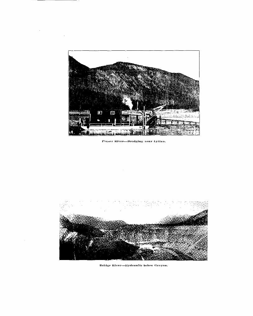

PLACER-JIINISG IN BRITISH COLU3IIRIA. 63

54 BUIlEAU O F MINES,
In the sulmner of 1909 T. Drummond went in mitll a few men and hnilt a dam and put tbe creek through a flume about 400 feet long in order to dry the creeclt-bed, which he did success-
boulder, some of the pieces being valued at $:. Apptlrently this \vas all the work that mas done, fully. He then began to slnice, getting some coarse gold from below and under a very big
but irom a financial standpoint it mls llot a success, so he discontinued marl<.
run under the hank on the east side of the creek ahout 300 feet belom Drummond’s dam, and a Fro111 a11 accounts, nothing further was done until thirtcen years ago, when a tunnel was
few fcct above the rock where Drummond mas supposed to l iaw found the gold. Xorris Davis
long. Mr. Davi;, whom I sam in Likely, says the gravel from the tunnel vent 6 5 cents a Cubic was not a t the property while I w a s there, hut his son infornled mc that the tunnel was 118 feet
. yard, and that a blind shaft. was sunk 9 feet d e w at the end that m n t $0 a cubic yard. I could not make an estimate of tlle average values as they could not give tlx? size of the tunnel or shaft. N y meroid rentling showed 200 feet of ghleial drift oyer the tonnel. This hank of drift has fallen domn over the mouth of the tunnel, malting it impossible to form an opinion as to a possibility of B channel being there.
I n conversation with Xs. Davis before I left Likely for the prowcrty, he considcred this was sufficient prospzcting to justif, the espense of bnilding the road and putting on the hydraulic
for h~draulickiug during the dry season. It is claimed that 300 feet of Dressure can he obtained plant and other equipment. IIohson crcelr is fed by numerous small glaciers, making ,it ideal
with 3 miles of ditch. At the time a survey party \vas locating a ditch-line. It is apparent that the Ilobson Creek deposit is glacial and the concentration will likely be
washed *own to the delta at the nmnth of the creek, leaving only the coarse gola 01‘ nuggets. in sgots. TT’ith the heavy gri~clc and large flow of water, the fine gold, if any, mill hare been
It is difficult t o say anything about the dump for the tailings until there is mom information to be had on the depth of the supposed cllannel under the hill.
in spots, also that there has not been Suflicient pros1Xcting done to justify the expenditure o f Aly opinion is that the IIohson Creek deposits are glacial and the concentration is local and
$6,000 in building B road to rcach the Property. Aluch further testing should be carried aut before i t can be assumed that the deposit will pay to work as an hydraulic.,
SIMILKAMEEN MINING DIVISION. I~lSTORlCdL SUXhrAilY EY IiERnEILT CAl3XICrlAEl..
SIASIIXAXEBS IUVER.
i t mas not until lSGO that regular’ placer-mining n.ns cavried on, tile ,>liners coming from the George X. McClellxn first fonnd gold in this riYer in 1533, bnt only in snlall amounts, and
dmeric:in side. The excitement of tile rich diggings in Cnriboo seems to have attracted most, if
until placer gold vas discovered 011 Granite creek, a tributary of the Simillwneen, by John not all, of the miners and to have left this river desertecl, a8 tilere is 110 mention of the district
Chance in 1885.
district and reported to tlrk Xinister OF ASines in Xornnber, 1885. EIe says in his report: In October of that >-car T. Elmyn, Depnty Provincial Secretary, made a special trig into the
.thnt river on its right lxnil~, la miles above its junction n’ith thc Soutll Sin~ilkamren at Prince- “Granite creek is :( t r i lmtup of the Tuiameen or Sort11 fork of ( h e Simii i~~meen, and falls into
ton, pevlwx better I a ~ o w n a s Vermilion Forks. l~ronr near the mouth of the creek to n point something over half a mile beion‘ the forlts, a distance of 4 miles, no claim which has been tested 011 bot.h sides of the bed o f the stream lms failed to yield good returns, and it may snfely be said tllat the gromd for that distance will aver:lge over a n ounce a day to the Band.
creel; claims, areraging probahly 300 feet to the company who r e ? e ~Tovkinq. The gold adlnitted “ O n October Xlst, 1SS5, on lower Granite crecic, there vere sistp-two companies orning
to have been taken ont by the several white and Cllincse companies from July 5th to October 31st anmlnts to tlle large sum of $90.000, which, considering the great loss of time c a ~ ~ s e d by the freshet and the dificulty of oljtnining lumber for sluicc-lmses, is creditable showing.
’‘ Chinese hax? for y e a s bcen mining on tlle hanks of the Tulalneen many miles above the mouth of Granite creek.


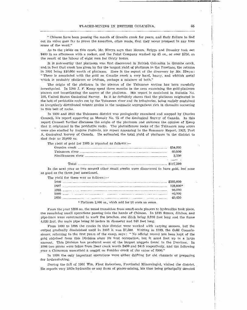

50 BUREAU OF IIINES
to the lode mines. In 1911 there mas a revival of iuterest in plricer-mining. Platinum Gold- fields, Linlited, prospected ground on the Tulameen river and another company prospected Slate creek, vhich produced a collsiderahle alnount of platinum in the early days. J. D. Gallo!vay, Assistant hlineralogist, Tisited the district in 1913, devoting most of his time to lode-mining. He states that only n few Cllinamen were working 011 the Tnlanwen, an$ on Granite a placer lease was being prosgectcd by r h n b e r t ;u. Stewart . In 1015 wm. 11. nrclver nlarle a rcport for the Department of Mines, in which he describes Lamhert & Stemxt's hydraulic mine as being :nccessful that year in malring a clean-up of $2,000.
number of boulders. There vas u revival in both hydraulic and deep placer-mining in 1024, due A drag-line ScrapL'r 71'3s tried on Some grrountl in 19223, hot nvls not successful owing to the
largely to the higher price of platinum, vhiclr had risen to $118 a n ounce; the output was $2,100. Nest year ground mas being tested for dredging and not so much prodlxctive work was .done, as the yicld of platinum fell to $1,000.
I n 1020 a specttculas find wns made by Garnet Sootheran on his placer lease about half a mile below Eagle creek, on the \rest 'side of the Tnlnlnecn river. l i c discovered a pay-streak
onnee of crude plntiullm to the cubic yard. Several other operators started to try out some of along the side of and under the boulder-(lnmps of some old plnccr-disgings; this ran about an
in the outlook for placer-mining, though high water prevented Sootlierall from working his lease; the old deep diggings. The nest year the Resident Engineer reported a continued improvement
other oDerators produced ovcr 15,000 oz. of crude platinum and gold.
that testing of grounb by sinking Shafts and Dumping w a s not s ~ ~ ~ c e s s f n l 011 account of the Prospecting occupied the attention of most of the companies during 1028, and i t vas found
water which had to be handled, so churn-drilling has been used instend. A gas electric shovel was tried on the Similkalneen river, but the returns were not high enough to wnrmnt the opera-
in Several directions. tiou of this type of machine. The results from deep prospectins in 1029 have beell encouraging
PLACER CONDITIONS, I N 1029.
REPOI~T 118 1'. R. FIL~GAFD, Rasrnsm J1rsmh-a ESGISEER.
Several efforts have been and a r e being made from time to time to mine the hencli-gravels on the Tularneen river. In the past every operation !vas commnenced with the insurmmntable handicap of uot knowing the depth to bed-roc% or the vahles to the enbic yard of the estimated yardage. It is well known that the old'channels are sinuous and their location must be fallowed if success is to result. Xost of these old channels are buried deep beneath glacial gravels which contain " spotty " values in gold and platinum. Along the edge of these moraines, next to the stream o r water action, il gradon1 concentration of values takes place, which is apt to lead the unwary into the belief that the whole mass is similarly valuable. It is vitally necessary to
has followed. Close to Princeton some years ago a drilling campaign was financed by English churn-drill hefore installing machinery, and this has not been done, with the result that failure
capital with the idea of dredging the river-flats. Some values were found in channels, too narrow for this type of machine, but as a whole the grax-els ITere too low grade to be profitable. This drilling was done about 22 miles from mhat is consinered as the source of the gold and
glacial moraines rather than from direct stream-action. In any case the location appeared to be platinum, and it seelm very lilcels that the valoes found were the result of reconcentration from
too far away from the solirce of the precious metals. John GtiMt Leases.-These leases are situated about 2 miles below Coallnont, on the Tnla-
meen river. The lease being worked lies on the south side of the river along the Kettle Valley
boom, mas installed. A grimly and stationary 24- by 18-inch sluice-hoses have also been built. Railway. A P. 4 model, 1%-cubic-yard bucliet shovel, with dras-line equipment, on n 50-foot
through a 12-inch main. A Grant 4-inch nozzle is used f o r hydrauliclring xhen the shovel is not Water-supply is provided by a Pnirbanl;s-Norse 75-80, heavy-duty, j,000-gallons-a-n~iIlllte pump
working. !?he sluice-hoses trve equipped with 4-inch poles, inrerted rails set % inch apart, angle-iron 2 inches apart, followed by perfornted screens and a t rap for black sands. The gmdc used is an 11-inch drop in 10 feet. The tailings are being dumped ilcross the Tufameen river. Kumerous pits and two shafts, 36 feet and 20 feet deep respectively, have been sunk. The former struck riwroclc. Pay-gravel found in these workings prior to the installation of machinery averaged 44 cents a cubic yard in free gold alxl platinum.


The total sm'cbge llroved vas 52,528, but values recoverell have not been received a t present. A sample of black sand taken from the sluice-boles after the first ' / clean-up " and after panning out all visiblc metal nss:ryed : Gold, O S 0 0%. to the ton ; platinum, 0.60 oa. to the ton. No large-scale att.emgt has been made to sa\,e these sands by concentration, The residue from the boxes is being piicd I.emporarily. Operations have been hindered to some extent by isolated nlasses of boulders m1'ying in siae up to 2 cubic yards. The sho~el can handle most of these boulders ollce they arc loosened. Until a larger arcn of bed-rock is uncovered, so tha t i t can he properly clemecl and room csclrrated for the boulders, resy little can be said regarding the possibilities of this endeavour. A good Ileal of time mas lost when boulders piled up against the grimly aud the s h o ~ e l had to remain inactive.
Grmite Creelc X i n i n g n,zd Developnmbt Co'.-This company installed a steam-driven shovel and sluice-boxes 011 a small bnrge in the Tnlai~~een rives a t the mnit,h of Granite creek. A short operation proved that this type of sluice-bos \vas too congested to handle the Sands and \ ~ o r B was stopped for the time being.
Slate Gmek Comolidlrted l'lnccn, litd..-This conwmy continned driving the tunnel up nlld under Slate creck rinring the sear. 111 October a totnl of 1,200 feet had been driven without finding bed-rock. Advice from the manager, Norman NcConniclt, on Kovember 20th stated that the work was eolltinuing and ,that some trouble had been encountered Nherl on old prospect-
corered river-gravel 7 feet below the floor. The management estimates that during December shaft was struck, which necessitated malting a detour. A 12-inch tube sunk in the drift dis-
cstmt, De ascertained. this gravel should be reached xith the tunnel, when the Sllrcess of this project mill, to some
I i ig Bcml Plalir~am a ~ d Cord 3 1 h h g Go., %td-Under the nlanilgement of John Marks, these leases, situated about GI,$ miles up the Tultnneen river from Tnlarneen villaEe, were operated only a short time owing to Vater-shortage. A small Bmount of golB and plntinuln mas
'bare been nlade. recovered. This is au old high chnnuel being vorlre(1 to bed-rock and some good recoveries
and several other leases along the Tnlameen rirer and Granite creek. Small alnouuts of gold and platinurn vere recovxecl from the Saothernn, Andrcvv Gordon,
1029, ILIIS not, it is l~nderstood, commenced any'lnrge-scale operations ny to the present time. The British Colmnbia Platinum ,\fining Company, Limited, reported upon in KO. 1 Bulletin,
FORT STEELE MINING DIVISION. IX1sronrc.u. SUIIXAXY UY HEIII~ERT CARUICIIXEI..
been mined to some est.ent Irefore the I1:ast Kootenay nlld Big Rend excitements attracted The bars of the Columbia ri\-er above Colville, in what is llom the State of 1Cashington, had
nlultitudcs from a distance. Some gold colours had been found on the bank of the Columbin at Colville in 1855, and Angus Mcl)onald's prospecting espeditioll found moderately renluncratire diggings at the mouth of the Pend d'Oreille nenr the bounclary-line. Miners having gradually worlied their way up the ICootenay rkcr from Idaho, rich diggirrgs mcre a t last discovered not far f rom the boundary-line, which gave rise in 1563-64 to the Kootenay gold-mining escitement. A trail from walls I\"nlla was built in to this point.
mild Eorse creek hecmne the centre of the district mhen gold was discovered therc in 1R63,
horses there. By A I a y , lS(i4, some 400 miners had distributed themel~~es along the creek. and in 1SG4 i t became 1111 important camp. The crcek got its nnlne from the number of n'ild
PTosDects \yere obtained of $1 to the pan and ordinary clxilns n-cre paying $20 to $30 a dny to the man; nuggets rtnmixrg from $2.60 to $is were found. Fisherville was the name of the town, but in 18% i t x a s pulled c1on.n far the purpose of woiliing the g o u n d on xhich it stood, and the operation is said to hare bcen high17 remunerative.
without going south of the International boundary. In 1865 the Dewdney trail mas built to the ICootenay river to give an outlet to Victoria
b r d hecn found, the most important being Perry creek, n branch of the St. Mary river. On this Prom 1862 to lSF9 hydlmuiie mining WWcarried on and a number of i c w gold-bearing creeks
creek three men took out, $22.5 in Are days, while the wound generally gave an ounce a day to thc man. Good prospects vere found on Mopie riser in 1869, but in 1672 A. TV. Vowell, the


60 BUREAU OF IIINES.
About 200 men ascended the Columbia, prospecting all the creeks Aowing into that river
McCulloch creeks, branches of Gold creek. The pioneers were four Frencllmen, x-ho bad settl& . until the Big Bend country v a s reached. The first rich placers mere found on French and
along the Columbia as far as the Big Bend were found to yield well in coarse gold not unlike on French creek as early as IRO;, and had obtained $16 from eleren pans of dirt. All the bars
that found in D s t Itnotenay. Iiorth of this no gold \vas fonnd. R. T. Smith, who acted as Gold Commissioner for the Dig Bend district in 1865, left there
in November and reported to tlre Goven~ment that the Icnown yield of Wrench creek for the season mas $32,000; of XeCulloch creek, $2,700; and Carnes creel:, $3,000; but on account of the gold-esport tax then in force he did not belieye more than half the real amoullt had been declared.
In the spring of 1866 miners mere beginning to fluelt in and Portland mas doing a large business with the upper Columbia. Finding the trail would be inadequate to compete mith the roads from the south, the British Columbia Gorernment impmscd tlie Shuswap route car19 in the year and the IIudson's B l y Company built a steamer, the '' Xartin," which on Xny 27th began to malre sem-weeklp trips on Shusvap lake to Seymour, on the lalre. In April, 1S66. this town contained twenty builclings. The route, homver, got :L set-Baclr, as boats and steamers b e a n to ply on the upper Colnmbia from Colville, in Washington, to Death Rapids (or Dnlles des Morts), in British Columbia.
five passengers and arrived a t thc latter place on April 2Gth, 186G, being ten days in mnlcing The steamer " Forty-Sine " made her first trip from CoIvilIc to Death Rapids wi1.h eightF-
the trip up through the ice, taking passengers for $25 and freight at $200 a tan ; she paid for herself during the first season. From Death Rapids freight was carried in boats. being dragged through the rapids to Wilson's Imxiing, 25 miles farther ill) the river. On May 19th one of
and carelessly handled, olpsized, nnd all but five were drowned. The Forty-Kine " continued these boats containing twentr-three persons came d o \ ~ n oyer the rapids and, being overloaded
to makc regular trips from Colville to Death Rapids.
creeks yielded eacll $lOO,OOO. I n 1867 there were 100 miners wintering on French creek alone, The yield for the season of 18(i(i was estimated a t SZS0,000, of which Erench and BlcCullocl~
but by 1869 the prestige of the district had departed, the shallow (liggings were becoming vor1;ed out, and the deep ground had to wait for the more favourtlble condilions of a new ern. Some of the deeper ground was worlred for a year or two, but by 1874 :Ill interest in the district as a placer camp seems to imve died, as no mention is made of ally gold returns in the Annnal Report for that year or for sonle time.
creek; three tunnel claims vere taken up above the falls. French creek attracted some little About 1885 interest hecame renewed, principally in the deel~ placer-ground of XcCulloch
attention and a bed-rock Anme chnrter mas applied for on that creek. In 1886 good progrcss \\-ns made with deep placer-mining, the miners malting fair to good
wages by sluicing and shovelling into boxes. V o r k of a similar nature \vas started on Carnes creek and ~ o r l ; continued on French creek and McCulloch creek.
end of 1887: he mentions n dozen large creeks being ~vorlied and paying $3 to $3 a day to the A decided improvement in the placer sitnation is reportcll by the Gold Commissioner a t t he
man. The Ophir Red Roc11 Wlume Company put in a flulnc on a l'h-mile lease on McCulloch creek and tool; out $1,500 in coarse gold befoore the end of the season, but a flood prevented a final clean-up.
Sereral hed-rock flumes vere put in on other creelis; on Carnes Creclc four niell sluicing got out $127 in one day; the Ppsult of this \Toric is shown in the returns for 1887, which Were $8,550. From 1887 to 1800 placer-mining as steadily carried on and sevcral long tunnels vere run to tap old channels; the ret111.n~ on the n'lmie >sere fairly successful. Both w x k and prospecting fell off considerahlr betmeen 18SO nnd 1806, due to lode-mining excitement farther
the Consolet io~ mine on French creek paid $0,000 by wing-damming and bcnch diggings on south, hut a nnnther of claims and leases were Steadil3' worked l~hicll paid good wages. In 1896
Gold Drop creek gave a rctllrn of $2,000 to tTVo men. A Illmlber of small ogerations were carried on, but the returns are not stated.
In the Annual Report for 1898 J. D. Sibhaid, Gold Commissioner, gives a Comprehensive account of the allnvial mining in the Big Bend district; most of the creelcs mere being xmrBed t o some extent, but the Iirincipal nlention is of an hydraulic operation on French creek, where


64 BUREAU O F NINES.
Dawsox, G. X . General Ko;c on the %lines and Minerals of Economic Value of B.C. Can. G.S.
__ On the Superficirrl Geology of British Columbia. Geol. Soc., London, Quar. Jour. 34;
__ Report on the Area of the IZamloolm Sllcct. Can. G.S. Bun. Rep. 7 ; B427 pp., maps
__ Prelinlinars Ilcport on the I'hgsical and Gcological Veatures of the Southern Portion of
__ The Slineral \VfaIth of British Cdunlbia. Can. G.S. Ann. Xep. 3; 1L 163 pp. (1889). __ Notes on Ilydraulic Mining in British Columbia. General hlining Association of the
__ Cassinr. Can. G.S. Sum, Rep., 1888.
DOLMAQE, V. Wreck Bay Beach Placers. Can. G.S. Sum. Ilep., 1918; B 38. I_ Sirnillameen. Can. G.S., 1Si7 and S and 1887, 8.
ELLS, R. W . Rcpoort 011 Graham Island, British Columbia. Can. G.S. An. Rep., Vol. XVI., 1906;
ELIYENS, Nmvrox \\;. Some Sotes on Sivash Creek Section. B.C. Xining \Varld, 34; 937-939.
EVAXS, X . F. The Sonrce of Frascr Rirer Gold (B.C.). &lining and Engimering World,
__ The Similkmneen and its Reds (B.C.). $lining T\'orlcl. 25; 399 (190a). Chicago. __ British Columbin I'lacers, Pnst and Present. >lining World, 20; 563, 657, 770 (1907). FREELAXD, P. B. Rcports in Ministcr of >lines' Annual Reports. GALLOWAY, JOHN D. ReDoris as Resident Engineer and I'rmincial Jlineralogist in Ann. Reps. I_ Sinlillinmeen Alining Di~ision. 1933 Ann. Rep. - Cariboo Mining Division. 1914 Ann. Rep. __ Horsefly Section. 1920 Ann. Rep. __ Cedar Creek Camp. 1922, 1923 Ann. Rep. __ Lightning Creclr. 1023 Ann. Ren. __ Peaec Rirer Ilining Division. 1923 Ann. Rep. __ Spanish Creek. 1924 Ann. Rep. __ Carihoo and Quesnel Divisions. 1924 Ann. Rep.
- Sotes on the Cnriboo District. Trans. Can. Inst. X . & %I., 19213. G r n l u n ~ , J. C. Report on Field Worli in the 2\tliu District, 13.C. Can. G.S. Slim. Rep., 1899
(An. Rep, Xo. 12) ; A 52-75 (1900). Can. G.S. An. Rep, S o . 13, 1000 ; A 52-02 and map
__ Xotcs on Atlin Gold I?ields (B.C.). Can. N. Inst. Journal, 3 (1900) ; 97-101. Can.
&p. Progress, 187677; 103-140 (1878).
89-123, map (1878).
(1893).
the Interior of Isritish Columbia, 1Si7.
Prov. of Quebec, Journnl, Oti:an% Ont., J 2 ; 173-176 (1896).
la E.
Chicago, 1911.
Chicago, 23 ; 268-259 (100.5).
Alanson Section, Omineca Division. 1924 Ann. Reg.
(1000).
Alining Rev. 19 ; 09-70 (1,000). __ Report on the Atlin ;\lining District, B.C. .Can. G.S. An. Reg. 1 2 ; ~ B 48 pp., mal, (1901).
Can. Mining Rev. 21; 13-10 (1902). __ Characteristics of the Atlin Gold Fields (H.C.). Can. AI. Inst. J. 5 ; 21-32 (1003).
__ Glaciation jn the Atlin Mstriict (B.C.). Journal Geology, Chicago, 10; 182-185 (1902).
II,WOEX, E. A. Cariboo District of British Calulnbin. ;\lining 2nd Rng. Record. Vol. XXVIII.. __ The North Thompson Talky (B.C.). Can. M.J. 31: 1 . i (1910).
HEPBVIW-, ART. E. Gold nred8ing in Dritisll Columbin. Aline, Quarry, and Derrick, 1; 157-189
Ilonsox.. J. B. TPllc Auriferous Grnrels of Britisll Columbia. Can. Mining Rev. 14; 1G20
HowAY. F. Ti'.. and Sr!~io~m~~tr,n, E. 0. S. Rritisb Columbia from the Earliest Days to the
No. 1 (1924).
(191.5,.
(1496). Gen. X . Ass. Quel)ec, S 2 ; 177-189 (18M).
Present. 1914. JAMES, 8. T. Reports as Resident ;\lining Engineer, KO. 1 District, B.C. In Ann. Reps. JOHKSTOR, W. A. Placer and Vein Gqld Deposits of Rarkerville, B.C.. Can. G.S. Axern. 149. - Gold-dredging Pos~ihilities in t h e B a r k e ~ ~ i l l e Area, British Columbia. T r a n s Can. Inst.
Min. ana >let., pp. 16j-182 (1922). __ Placer Jfining in 13nrlcerville Area, B.C. Can. Geo. Sur. Sum. Rep. 1921, pt. A ; 59-71.


TRINBIX, 13'. J. 'She Xining Advance into the Inland Empire. Bull. Univ. TTisconsin, No. G38
TYEBELL, J. B. K'otes on the Placer Mines of Cxriboo, B.C. Econ. Geol., Vol. 14, pp. 33&3+6. I_ W a s there a Cordilleran Glacier in British Columbia? Jour. Geol., Vol. 27; EGG0 (1919). Uorow, N. L. Quartz Veins of Barkerville Area, Cnriboo Dist., B.C. Bull.%an. Inst. Xin. and
I_ Bedrocks and Quartz Vcius of Barkerville Xaparca, Cariboo Dist., B.C. Can. G.S. Sum.
UOLOW, N. L., and Jonxs~on, N. A. Placer ana Vein Gold Deposits of Barkerville, B.C. Can.
__ The Origin of the Placer Cold of the Barkerrille Area, Cxriboo Dist., E.C. Can. Economic
T'ALLFAU, F. W. B.C. Minister of Mines' Report., 1001. W A D D I K G T O N . A t r x m PEIIDERII.L. Fraser Mines Vindicated, or a History of Four Months.
YOUKG, 1losnr.1~~. hfining in Atlin, B.C. Jour. Can. A h . Inst., 1909; 477494.
(1914).
Alet., Nay., 1922; 1165.
Rei]., 1922, pt. A ; 8%67.
G.S . %&m. 149. m e . Geol., Val. XVIII., Xo. 0 ; 541 (1023).
de Garro, Victoria, 1858.