brief assessment of cagayan de oro river basin
TRANSCRIPT

BRIEF ASSESSMENT OF CAGAYAN DE ORO
RIVER BASIN
Presentation Outline
• Basic Information of Cagayan de Oro River Basin
Thematic maps
Rainfall Information
• Major Flooding
2009 (Action taken)
2011 (Action taken)
• Recommendations/Action Plan
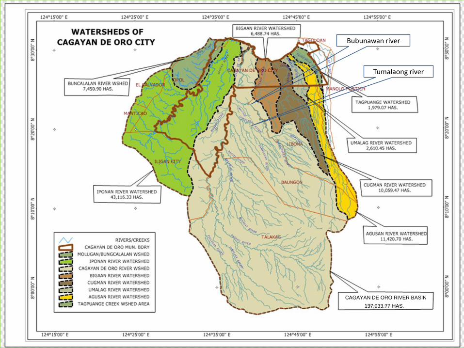
Tumalaong river
Bubunawan river
137,933.77 HAS.
CAGAYAN DE ORO RIVER BASIN
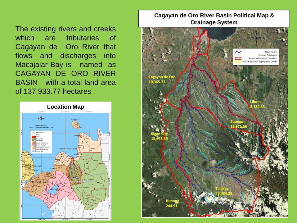
The existing rivers and creeks
which are tributaries of
Cagayan de Oro River that
flows and discharges into
Macajalar Bay is named as
CAGAYAN DE ORO RIVER
BASIN with a total land area
of 137,933.77 hectares
Cagayan de Oro River Basin Political Map &
Drainage System
Location Map
Baungon23,971.56
Libona8,130.33
Cagayan de Oro10,365.73
Iligan City15,678.39
Talakag79,484.28
Bubong244.91 Pangantucan
58.82

The entire Basin has 8 major rivers,
within the 7 municipalities : Talakag,
Baungon, Libona, and Pangantucan of
Bukidnon; Iligan City of Lanao del
Norte; Municipality of Bubong of Lanao
del Sur,ARMM; and Cagayan de Oro
City, which are composed with 122
barangays
Bubunawan, Cagayan de Oro Rivers (26,875.89 has.)
Tumalaong, Samalawan Rivers (13,352.12 has.)
Tagiti River (9,255.24 has.)
Kalawaig, Tutoban, Minontay Rivers (19,382.66 has. )
Batang, Banongcol, Baylanan, Sangaya, Sagayan Rivers
(31,598.07 has.)
Tikalaan, Picalin Rivers (7,527.20 has.)
Pigcotin, Bulaong Rivers (24,438.30 has.)
Munigui River (5,504.29 has.)
Rivers, Creeks, Road & Barangay Map
8 SUBWATERSHEDS OF CDO RIVER BASIN

Sub-Watersheds LocationSub -Watershed
Area
Length of Rivers &
Tributaries (Km)
Timberland Area
within Sub-
watershed
1. Bubunawan,
Cagayan Rivers
Cagayan de oro ,
MisOr, Libona &
Baungon, Bukidnon 26,875.89 71.93 / 194.27 12,217.93
2. Tumalaong,
Samalawan Rivers
Baungon, Bukidnon
13,352.12 45.71 / 112.48 6,283.89
3. Tagiti River Baungon, Bukidnon 9,255.24 38.06 / 61.365 5,799.81
4. Kalawaig, Tutoban,
Minontay Rivers
Baungon & Talakag,
Bukidnon 19,382.66 84.78 / 109.30 11,483.87
5. Batang, Banongcol,
Baylanan, Sangaya,
Sagayan Rivers
Talakag, Pangantucan
Bukidnon31,598.07 109.86 / 152.91 17,606.67
6. Tikalaan, Picalin
Rivers
Talakag, Bukidnon
7,527.20 60.57 / 16.98 3,094.07
7. Pigcotin, Bulaong
Rivers
Talakag Buk; CDO;
Bubong,LDS; Iligan,
LDN 24,438.30 69.62 / 92.28 20,334.99
8. Munigi River Cagayan de Oro City5,504.29 32.13 / 14.27 2,165.96
CAGAYAN DE ORO
RIVER BASIN TOTAL 137,933.77 512.67 / 753.84 78,987.19
Sub -Watershed Areas of Cagayan de Oro River Basin

The river basin has great social physical
economic and environmental significance and
potentials as it is a source of water for
domestic industrial, irrigation and for hydro
electric power generation. It likewise is
endowed with important biodiversity as it still
has a closed forest of about 18,812.40
hectares
CLASS SYMBOL AREA
Closed forest, broadleaved NF4F 18,812.40
Forest plantation, broadleaved FPB 80.58
Inland water IW 242.62
Mangrove forest NFM 68.37
Open forest, broadleaved NF2B 19,218.28
Other land, built-up area BUA 2,260.36
Other land, cultivated, annual crop AC 23,783.39
Other land, cultivated, perennial crop PC 7,155.00
Other land, natural, grassland GL 16,756.83
Other wooded land, shrubs Sh 33,965.39
Other wooded land, wooded grassland WGL 15,590.55
TOTAL AREA in Has. 137,933.77
Vegetative/Land Cover
Map
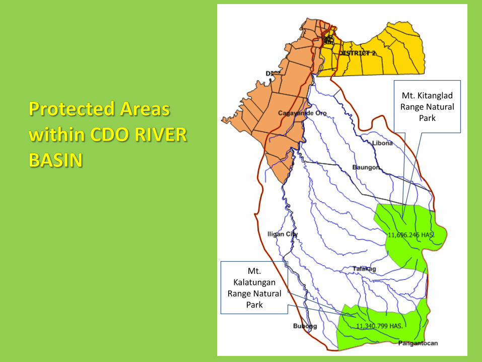
Mt. KitangladRange Natural
Park
Mt. Kalatungan
Range Natural Park


as of 8.am., Dec. 17, 2011

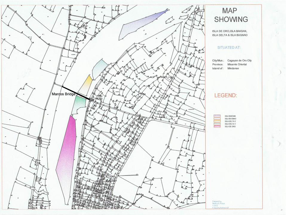

Isla de Oro
Isla Baksan
Isla Delta 1
Isla Delta 2
Isla Bugnao
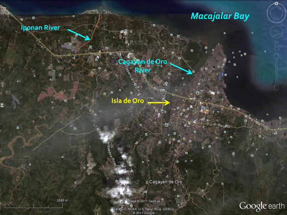
Isla de Oro
Macajalar Bay
Cagayan de Oro River
Iponan River

Rainfall:
180.9 mm in Cagayan de Oro City for 24-hr readingfrom Dec. 16, 8AM to Dec. 17, 8AM, 2011 per PAG-ASA station.
470 mm per DMPI Capihan Rain Gauge station(Libona, Bukidnon) on same period.
Previous flooding occurred on January 11, 2009:
Lumbia Airport Station registered 88.8mm onJanuary 10, 2009 and 73.5mm on January 11, 2009.Rain Gauge Station located at the City propermeasured 89.4mm and 132.8mm respectively forthe same period.

Reported Flood-Affected Areasin Cagayan de Oro City December 17, 2011
• Brgys. Lapasan, Cugman, Carmen, Tablon,Kauswagan, Macasandig, Balulang, Agusan,Baikingon, Brgy. 10 (Isla de Oro), Pagatpat,Iponan, Bulua, Canitoan, Puntod, Macabalan,Consolacion, Bugo, Brgys. 13 and 14 (IslaBugnaw), Brgy. 15, Brgy. 6 and 7, Brgy. 11,Balubal, Patag and San Simon

REPORT ON RAPID FLOOD-HAZARD ASSESSMENT OFTHE AFFECTED AREAS IN CAGAYAN DE ORO CITYAND OTHER PARTS OF MISAMIS ORIENTAL RE:JANUARY 11, 2009 FLOOD EVENT
Lumbia Airport Station registered 88.8mm on January 10, 2009 and 73.5mm on January 11, 2009. Rain Gauge Station located at the City proper measured 89.4mm and 132.8mm respectively for the same period.
Affected Barangays are Balulang, Bulua, Bugo,Camaman-an, Canitoan, Carmen, Consolacion, Gusa,Iponan, Kauswagan, Lapasan, Macabalan, Macanhan,Macasandig, Pagatpat, Patag, Puntod, San Simon,Brgys., 13, 17, 18, 22, 23, 24, 26, 27, 34, 35 and 36.
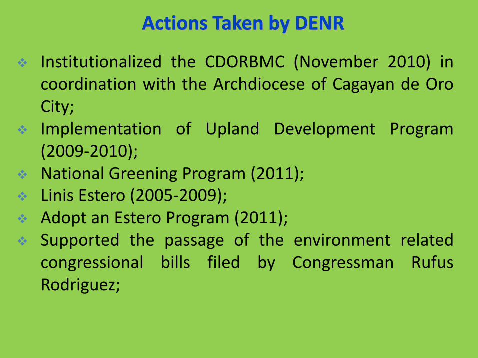
Institutionalized the CDORBMC (November 2010) incoordination with the Archdiocese of Cagayan de OroCity;
Implementation of Upland Development Program(2009-2010);
National Greening Program (2011); Linis Estero (2005-2009); Adopt an Estero Program (2011); Supported the passage of the environment related
congressional bills filed by Congressman RufusRodriguez;

Characterized and assessed the BubunawanWatershed to flooding and landslide;
Provision of Geo-hazard Assessment Reports andmaps to all LGUs (2010); and
Development of Integrated Coastal ManagementPlan (ICMP) of Cagayan de Oro City (2011)

August 2010
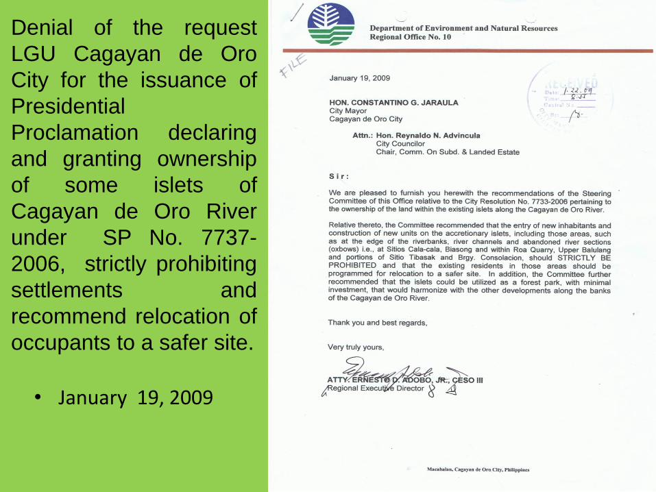
• January 19, 2009
Denial of the request
LGU Cagayan de Oro
City for the issuance of
Presidential
Proclamation declaring
and granting ownership
of some islets of
Cagayan de Oro River
under SP No. 7737-
2006, strictly prohibiting
settlements and
recommend relocation of
occupants to a safer site.

Created the Operation/Relief Assistance Center Distributed assistance financial and relief goods Donated fabricated 150 coffins to LGU CDO & IC Donated confiscated forest products (567.33 cu.m) to
DSWD-10 and 17,000 bd.ft. to DepEd-10 Attendance to meetings called by DSWD, OCD,
Cluster and Archbishop Rapid re-assessment of the identified relocation sites
at Canitoan (Sitio Calaanan), Lumbia and UpperGusa, Cagayan de Oro City
Created a “probe” team to conduct investigation
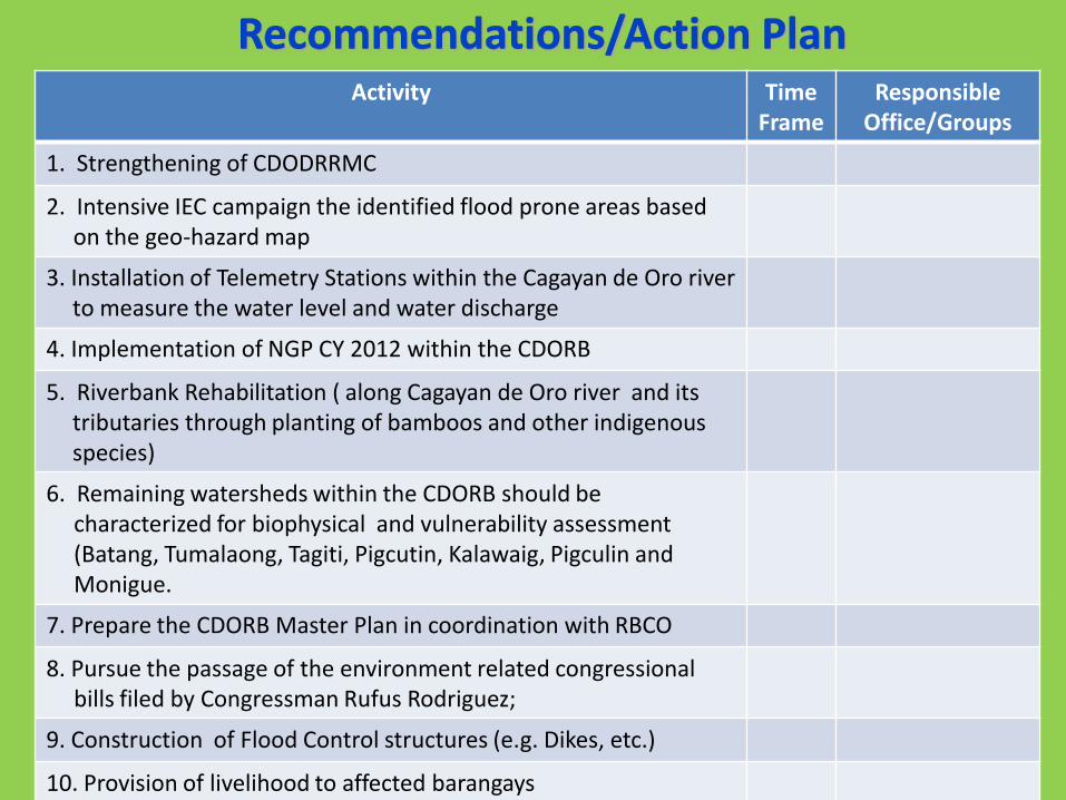
Activity Time Frame
Responsible Office/Groups
1. Strengthening of CDODRRMC
2. Intensive IEC campaign the identified flood prone areas based on the geo-hazard map
3. Installation of Telemetry Stations within the Cagayan de Oro river to measure the water level and water discharge
4. Implementation of NGP CY 2012 within the CDORB
5. Riverbank Rehabilitation ( along Cagayan de Oro river and its tributaries through planting of bamboos and other indigenous species)
6. Remaining watersheds within the CDORB should be characterized for biophysical and vulnerability assessment (Batang, Tumalaong, Tagiti, Pigcutin, Kalawaig, Pigculin and Monigue.
7. Prepare the CDORB Master Plan in coordination with RBCO
8. Pursue the passage of the environment related congressional bills filed by Congressman Rufus Rodriguez;
9. Construction of Flood Control structures (e.g. Dikes, etc.)
10. Provision of livelihood to affected barangays

Activity Time Frame
Responsible Office/Groups
11. Review of land uses upstream and downstream of Iponan River, including other major drainages in the region
12. Relocate communities located within the highly vulnerable areas, such as island bars, former channels and creeks and other critical areas near riverbank
13. Exert efforts to stop illegal hydraulic mining in the watershed of Iponan
14. Local engineering offices and DPWH-10 should check, verify all structures, such as dams, bridges, spillways, lateral drainages along major thoroughfares and establishment affected by flood in terms of foundation stability
15. Declog certain sections of the river channel and tributaries that were choked by debris brought by the floodwaters
16. Install warning systems downstream and strengthen/capacitate the Barangay Disaster Coordinating Councils.

Activity Time Frame
Responsible Office/Groups
17. Install rain gauges and flood level gauges (telemetry/ indigenous system) in the upstream in coordination with the PDCC’s of the nearby provinces of Bukidnon and Lanao del Sur
18. Encourage private companies with rain gauges stations to furnish PAGASA-10 their records/data gathered. A resolution to this effect has to be issued by the concerned RDCC/PDCC/MDCC where such weather monitoring equipment/tools have been established
19. Reactivate City Mining Regulatory Board (CMRB) to set forth the policies in the management of small-scale mining operations in Cagayan de Oro City viz-a-viz their social, environmental and economic obligations

Agency Contact Address
• Email address = [email protected]
• Tel. # = (088) 856-9066
• Fax # = (08822) 726280

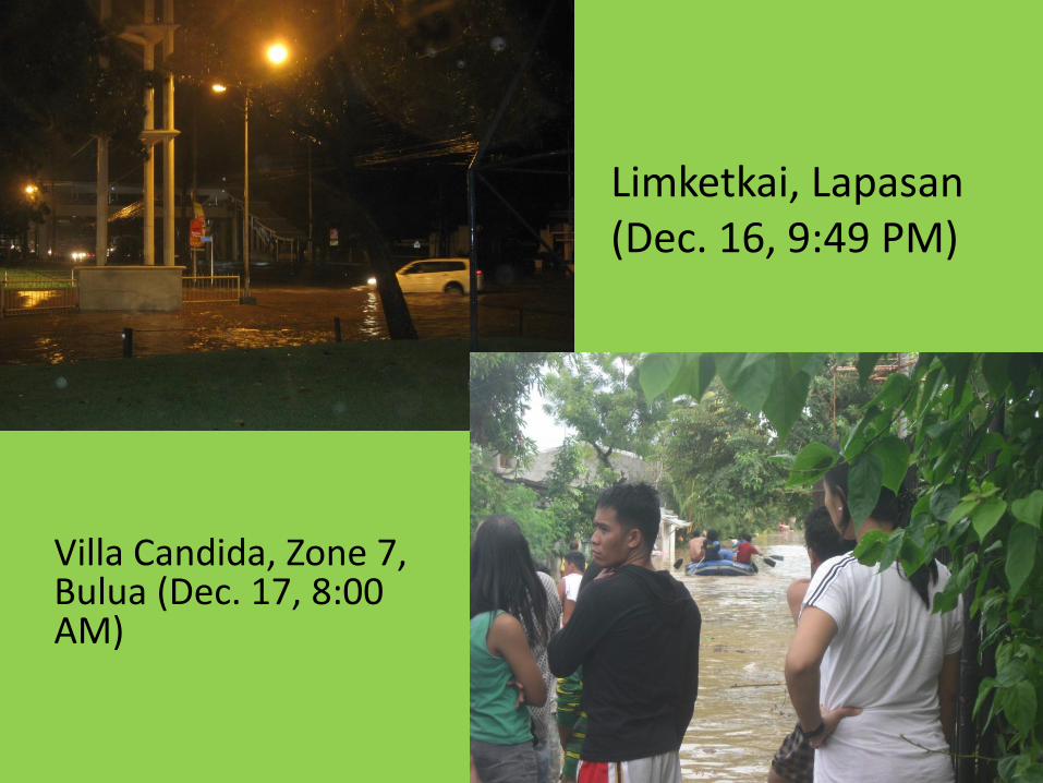
Limketkai, Lapasan (Dec. 16, 9:49 PM)
Villa Candida, Zone 7, Bulua (Dec. 17, 8:00 AM)
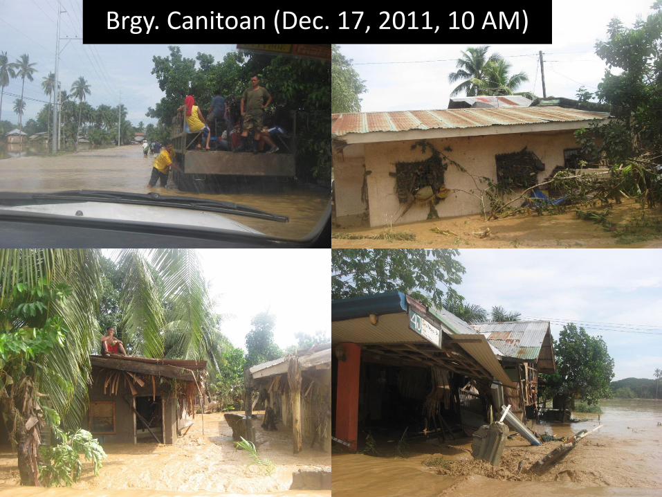
Brgy. Canitoan (Dec. 17, 2011, 10 AM)
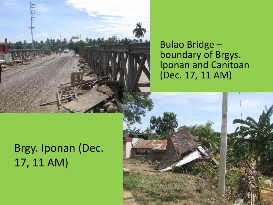
Bulao Bridge –boundary of Brgys. Iponan and Canitoan(Dec. 17, 11 AM)
Brgy. Iponan (Dec. 17, 11 AM)

Villa Candida Subd. Zone 7, Brgy. Bulua(Dec. 17, 12 PM)
Macasandig Rotunda (Dec. 17, 1 PM)

IECs CONDUCTED
• By the MGB-DENR Central Office IEC team to brgy. captains of Cagayan de Oro City on March 12, 2011

IECs CONDUCTED
• By the MGB-DENR 10 to brgy. captains of Cagayande Oro City at the Cagayan de Oro CouncilEnvironment Committee on Sept 27, 2011
ISLETS ALONG CAGAYAN DE ORO RIVER
•There are Five (5) unsurveyed Islets along Cagayan de Oro River namely: Isla de Oro (8.6 ha),Isla Delta 1 (1.3 ha), Isla Delta 2 (1.2 ha), Isla Bugnaw (1.4 ha), and Isla Bacsan (3.2 ha); with anapproximate total area of 15.7 hectares.•The City Council of Cagayan de Oro passed Resolution No. 7733-2006 dated January 30, 2006requesting a proclamation declaring and granting ownership of the islets in favor of the City tobe used for eco-tourism project and other public purpose with parallel requests of Isla DeltaLandless Association, Inc. (IDLAI).•On June 4, 2008, Regional Executive Director Maximo O. Dichoso, in a letter to Hon. ConstatinoJaraula, then Mayor of Cagayan de Oro City, denied the request on the ground that the Islets donot qualify for eco-tourism purposes.•On October 2, 2008, Regional Executive Director Maximo O. Dichoso in a letter toHon.Reynaldo Advincula, City Councilor and Chairman of the Committee on Subdivision andLanded Estate,again denied the request due to the nature of accretionary islets and its inherentinstability. Further, prior geo-scientific studies confirmed the active and dynamic nature of thisfluvial system and it would be prudent to avoid construction of houses near the river to avertpotential catastrophic events.•DENR Region 10 created a committee composed of representatives from all sectors of DENR toconduct a comprehensive assessment of the area per Regional Special Order No. 2008-486.•On January 19, 2009, the Committee submitted its report recommending to the CityGovernment of Cagayan de Oro entry of new inhabitants and construction of new units beSTRICTLY PROHIBITED and that existing residents be programmed for relocation to a safer site.The islets were recommended to be used as forest park.

• January 19, 2009
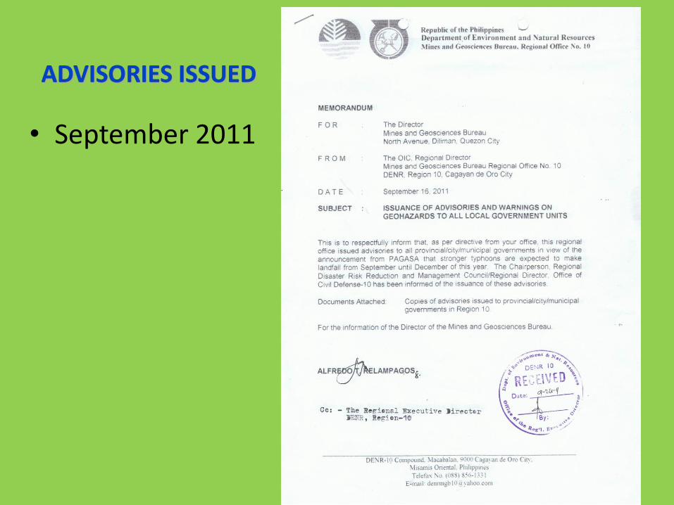
• September 2011