bridgewater vis report - · pdf filebridgewater 4 42 and 89 wewaka brook road bridgewater, ct...
TRANSCRIPT

Visual Resource Evaluation Report
Proposed Wireless Telecommunications Facility
Bridgewater 4
42 and 89 Wewaka Brook Road Bridgewater, CT
Prepared for
Prepared by VHB/Vanasse Hangen Brustlin, Inc. 54 Tuttle Place
Middletown, CT 06457
July 2010

VHB Vanasse Hangen Brustlin, Inc.
J:\40999.33\reports\bridgewater_vis_report.doc 1
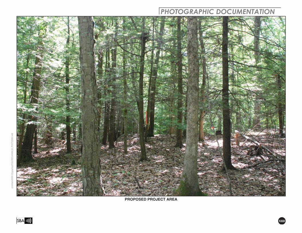
Visual Resource Evaluation SBA Towers II LLC seeks approval from the Connecticut Siting Council for a Certificate of Environmental Compatibility and Public Need to construct a wireless telecommunications facility (“Facility”) to be located on property at 42 and 89 Wewaka Brook Road (“Host Property”) in the town of Bridgewater, Connecticut. This Visual Resource Evaluation was conducted to approximate the visibility of the proposed Facility within a two-mile radius of the Site (“Study Area”). Attachment A contains a map that depicts the location of the proposed Facility and the limits of the Study Area. Also contained in Attachment A is a photograph of the proposed Facility location.
Project Introduction
The proposed Facility includes the construction of a 170-foot tall monopole designed to support up to four antenna platforms with associated ground equipment to be located within a fenced enclosure at the base of the tower. Based on information provided by the project engineer, Clough Harbor Associates, LLP, the proposed Facility is located at approximately 582 feet above mean sea level (AMSL). Access to the proposed Facility would initially utilize an existing residential driveway off Wewaka Brook Road, but would then follow portions of an existing dirt drive and woods road currently located on the Host Property (to be improved to accommodate service vehicles) that extend to the project area in a westerly direction.
Site Description and Setting
The Host Property is comprised of two adjoining parcels that are identified in the Town of Bridgewater land records as Map ID 15-1 (51.2 Acres) and Map ID 15-2 (4.0 Acres). The proposed compound area and a significant portion of the proposed 12-foot wide gravel access drive would be located on parcel 15-1 which is mostly wooded and undeveloped. Parcel 15-2 is currently occupied by a single-family residence and several associated outbuildings and includes frontage along Wewaka Brook Road. Land use within the general vicinity of the proposed Facility and Host Property is mainly comprised of low-density residential development; undeveloped, forested land; and agricultural fields. In total, the Study Area contains roughly 45 linear miles of roadways. The topography within the two-mile radius surrounding the proposed Facility is characterized by both the Housatonic River/Lake Lillinonah and the Shepaug River, which flow north to south through the western and eastern portions of the Study Area, respectively and the rolling hills that generally parallel these water bodies. Ground elevations within the Study Area range from approximately 194 feet AMSL along the Housatonic River/Lake Lillinonah to approximately 860 feet AMSL on top of Botsford Hill located to the northeast of the proposed Facility. The tree cover within the Study Area consists mainly of mixed deciduous hardwood species interspersed with stands of mature evergreen species. The tree canopy occupies approximately 5,932 acres of the 8,042-acre study area (74%). During the in-

VHB Vanasse Hangen Brustlin, Inc.
J:\40999.33\reports\bridgewater_vis_report.doc 2
field activities associated with this analysis, an infra-red laser range finder was used to accurately determine the average tree canopy height throughout the Study Area. Numerous trees were selected for measurement and the average tree canopy established, in this case 65 feet. Lastly, the Study Area features approximately 551 acres of surface water that includes portions of the Housatonic River/Lake Lillinonah, the Shepaug River and several small ponds located to the north/northeast of the proposed Facility.
METHODOLOGY
In order to better represent the visibility associated with the Facility, VHB has developed a two-fold approach utilizing both a predictive computer model and in-field analysis. The predictive model is employed to assess potential visibility throughout the entire Study Area, including private property and/or otherwise inaccessible areas for field verification. A balloon float and Study Area drive-through reconnaissance are also conducted to provide a height and locational representation, back checking of the computer model and photographic documentation from publicly accessible areas. Results of the balloon float are analyzed and incorporated into the final viewshed map. A description of the methodologies used in the analysis is provided below.
Visibility Analysis
Using ESRI’s ArcView® Spatial Analyst, a computer modeling tool, the areas from where the top of the Facility is expected to be visible are calculated. This is based on information entered into the computer model, including Facility height, its ground elevation, the surrounding topography and existing vegetation. Data incorporated into the predictive model includes a digital elevation model (DEM) and a digital forest layer for the Study Area. The DEM was derived from the Connecticut LiDAR-based digital elevation data. The LiDAR data was produced by the University Of Connecticut Center for Land Use Education and Research (CLEAR) in 2007 and has a horizontal resolution of 10 feet. In order to create the forest layer, digital aerial photographs of the Study Area are incorporated into the computer model. The mature trees and woodland areas depicted on the aerial photos are manually traced in ArcView® GIS and then converted into a geographic data layer. The aerial photographs were produced in 2006 and have a pixel resolution of one foot.
Once the data are entered, a series of constraints are applied to the computer model to achieve an estimate of where the Facility will be visible. Initially, only topography is used as a visual constraint; the tree canopy is omitted to evaluate all areas of potential visibility without any vegetative screening. Although this is an overly conservative prediction, the initial omission of this layer provides a reference for comparison once the tree canopy is established and also assists in the evaluation of potential seasonal visibility of the proposed Facility. An estimated tree canopy height of 50 feet is initially utilized to prepare a

VHB Vanasse Hangen Brustlin, Inc.
J:\40999.33\reports\bridgewater_vis_report.doc 3
preliminary viewshed map for use during the Study Area reconnaissance. The average height of the tree canopy, in this case 65 feet, is determined in the field using a hand-held infra-red laser range finder. The forested areas within the Study Area were then overlaid on the DEM with a height of 65 feet added and the visibility calculated. The forested areas are then extracted from the areas of visibility, with the assumption that a person standing among the trees will not be able to view the Facility beyond a distance of approximately 500 feet. Depending on the density of the vegetation in these areas, it is assumed that some locations within this range will provide visibility of at least portions of the Facility based on where one is standing. Also included on the map is a data layer, obtained from the Connecticut State Department of Environmental Protection (CTDEP), which depicts various land and water resources such as state parks and forests, recreational facilities, dedicated open space and CTDEP boat launches and other categories. This layer is useful in identifying potential visual impacts to any sensitive receptors that may be located within the Study Area. Lastly, based on a review of available data published by the Connecticut Department of Transportation and Housatonic Valley Council of Elected Officials (HVCEO), it was determined that there are currently no state- or locally-designated scenic roadways within the Study Area.
The preliminary viewshed map (using topography and an initial tree canopy height of 50 feet) is used during the in-field activity to assist in determining if significant land use changes have occurred since the aerial photographs used in this analysis were produced and to compare the results of the computer model with observations of the balloon float. Information obtained during the reconnaissance is then incorporated into the final visibility map.
Balloon Float and Study Area Reconnaissance
On June 15, 2010 Vanasse Hangen Brustlin Inc., (VHB) conducted a balloon float at the proposed Facility location to further evaluate the potential viewshed within the Study Area. The balloon float consisted of raising and maintaining an approximate four-foot diameter, helium-filled weather balloon at the proposed site location at a height of 170 feet. Once the balloon was secured, VHB staff conducted a drive-by reconnaissance along the roads located within the Study Area with an emphasis on nearby residential areas and other potential sensitive receptors in order to evaluate the results of the preliminary viewshed map and to document where the balloon was, and was not, visible above and/or through the tree canopy. During the balloon float, the temperature was approximately 80 degrees Fahrenheit with calm wind conditions and sunny skies.

VHB Vanasse Hangen Brustlin, Inc.
J:\40999.33\reports\bridgewater_vis_report.doc 4
Photographic Documentation
During the balloon float, VHB personnel drove the public road system to inventory those areas where the balloon was and was not visible. The balloon was photographed from several vantage points to document the actual view towards the proposed Facility. Several locations where the balloon was not visible are also included in order to provide documentation from select areas. The locations of the photos are described below:
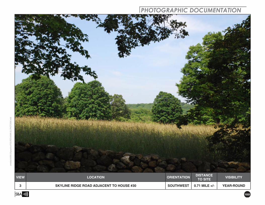
1. View from Skyline Ridge Road. 2. View from Skyline Ridge Road adjacent to house #66. 3. View from Skyline Ridge Road adjacent to house #30. 4. View from Northrop Street adjacent to house #211. 5. View from Northrop Street. 6. View from Northrop Street adjacent to house #160. 7. View from Northrop Street adjacent to house #147. 8. View from Northrop Street adjacent to house #119. 9. View from Northrop Street adjacent to house #70. 10. View from Stuart Road adjacent to house #129. 11. View from Hut Hill Road north of Sarah Sanford Road. 12. View from Stuart Road. 13. View from Route 133. 14. View from Route 133 at Stuart Road. 15. View from Wewaka Brook Road east of Route 133. 16. View from Wewaka Brook Road at Host Property. 17. View from Wewaka Brook Road at Stuart Road.
Photographs of the balloon from the view points listed above were taken with a Nikon D-80 digital camera body and Nikon 18 to 135 mm zoom lens. For the purposes of this report, the lens was set to 50mm. “The lens that most closely approximates the view of the unaided human eye is known as the normal focal-length lens. For the 35 mm camera format, which gives a 24x36 mm image, the normal focal length is about 50 mm.1"
The locations of the photographic points are recorded in the field using a hand-held GPS receiver and are subsequently plotted on the maps contained in the attachments to this document.
1 Warren, Bruce. Photography, West Publishing Company, Eagan, MN, c. 1993, (page 70).
VHB Vanasse Hangen Brustlin, Inc.
J:\40999.33\reports\bridgewater_vis_report.doc 5
Photographic Simulation
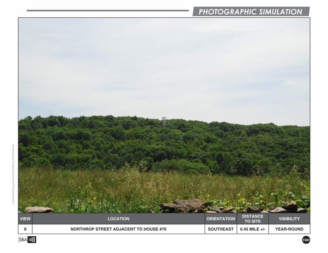
Photographic Simulations were generated for the ten locations identified above where the balloon was visible (Views 1-10). The Photographic Simulations represent a scaled depiction of the proposed monopole from these locations. The height of the Facility is determined based on the location of the balloon in the photographs and a scaled, three dimensional model of the proposed monopole is simulated into the photographs. The aspect and rotation of the three dimensional model is adjusted in the simulations in order to reflect the visual perspective and specific sector(s) of the monopole that would be viewed from each photographic location. Both the photographic simulations and non-visible shots (Views 11-17) included in this evaluation are contained in Attachment A.
CONCLUSIONS
Based on this analysis, areas from where the proposed 170-foot monopole would be visible above the tree canopy comprise approximately 62 acres within the 8,042- acre Study Area. As depicted on the attached viewshed map (included as Attachment B), the majority of year-round visibility associated with the proposed Facility occurs over portions of Northrop Street, located to west of the proposed Facility, and portions of Skyline Ridge Road located to the east. These areas also extend to the open fields that parallel both roadways. The viewshed map also depicts areas of potential year-round visibility along select portions of Stuart Road (View 10) located approximately 0.36-mile to the northeast of the proposed Facility; portions of the Host Property located to the east of the proposed Facility; and on several private properties located to the northeast, northwest and southwest of the proposed Facility that are mainly comprised of open, undeveloped fields. VHB estimates that at least partial year-round views of the proposed Facility may be achieved from portions of approximately 16 residential properties located within the Study Area. This includes two residences located along Skyline Ridge Road; eight residential properties located along an approximate 0.85-mile segment of Northrop Road; two residential properties located along Wewaka Brook Road; two residential properties along Stuart Road; and two residences located along Hut Hill Road. Overall however, the intervening topography and/or existing vegetation serve to significantly minimize the potential for year-round views of the proposed Facility from other locations within the Study Area. Several additional areas where seasonal (i.e. during “leaf off” conditions) views are anticipated were also identified as part of this evaluation. These areas are depicted on the attached viewshed map and comprise approximately 60 additional acres. Overall, areas of anticipated seasonal visibility are limited to the general vicinity of the Host Property as well as select portions of Wewaka Brook Road where seasonal views of the proposed Facility may be achieved from approximately four residential properties; Northrop Street where seasonal views may extend to approximately five residential properties; Skyline Ridge Road where

VHB Vanasse Hangen Brustlin, Inc.
J:\40999.33\reports\bridgewater_vis_report.doc 6
approximately six residences may have leaf-off views of the proposed Facility and Stuart Road where seasonal views may be achieved from approximately two residential properties.
VHB Vanasse Hangen Brustlin, Inc.
J:\40999.33\reports\bridgewater_vis_report.doc 7
Attachment A
Photolog Documentation Map, Project Area Photograph, Balloon Float Photographs and Photographic
Simulations
PHOTOGRAPHIC DOCUMENTATIONctmiddat\40999.33\graphics\FIGUR
ES\40999.33_PH
OTO
SIM.indd
PROPOSED PROJECT AREA

PHOTOLOG MAPctmiddat\40999.33\graphics\FIGUR
ES\40999.33_PH
OTO
SIM.indd
!.
!(!(
!(
!(
!(!(
!(
!(
!(
!(
!(
!(
!(!(
!(
!(
!(
!(
1
23
45
6
78
9
11
101213
14
15
16
17
E0.5 0 0.50.25
Miles
Study Area
Proposed Facility

VIEW LOCATION ORIENTATION DISTANCE TO SITE VISIBILITY
1 SKYLINE RIDGE ROAD NORTHWEST 0.81 MILE +/- YEAR-ROUND
PHOTOGRAPHIC DOCUMENTATIONctmiddat\40999.33\graphics\FIGUR
ES\40999.33_PH
OTO
SIM.indd

PHOTOGRAPHIC SIMULATIONctmiddat\40999.33\graphics\FIGUR
ES\40999.33_PH
OTO
SIM.indd
VIEW LOCATION ORIENTATION DISTANCE TO SITE VISIBILITY
1 SKYLINE RIDGE ROAD NORTHWEST 0.81 MILE +/- YEAR-ROUND

PHOTOGRAPHIC DOCUMENTATIONctmiddat\40999.33\graphics\FIGUR
ES\40999.33_PH
OTO
SIM.indd
VIEW LOCATION ORIENTATION DISTANCE TO SITE VISIBILITY
2 SKYLINE RIDGE ROAD ADJACENT TO HOUSE #66 SOUTHWEST 0.70 MILE +/- YEAR-ROUND

PHOTOGRAPHIC SIMULATIONctmiddat\40999.33\graphics\FIGUR
ES\40999.33_PH
OTO
SIM.indd
VIEW LOCATION ORIENTATION DISTANCE TO SITE VISIBILITY
2 SKYLINE RIDGE ROAD ADJACENT TO HOUSE #66 SOUTHWEST 0.70 MILE +/- YEAR-ROUND
PHOTOGRAPHIC DOCUMENTATIONctmiddat\40999.33\graphics\FIGUR
ES\40999.33_PH
OTO
SIM.indd
VIEW LOCATION ORIENTATION DISTANCE TO SITE VISIBILITY
3 SKYLINE RIDGE ROAD ADJACENT TO HOUSE #30 SOUTHWEST 0.71 MILE +/- YEAR-ROUND

PHOTOGRAPHIC SIMULATIONctmiddat\40999.33\graphics\FIGUR
ES\40999.33_PH
OTO
SIM.indd
VIEW LOCATION ORIENTATION DISTANCE TO SITE VISIBILITY
3 SKYLINE RIDGE ROAD ADJACENT TO HOUSE #30 SOUTHWEST 0.71 MILE +/- YEAR-ROUND
PHOTOGRAPHIC DOCUMENTATIONctmiddat\40999.33\graphics\FIGUR
ES\40999.33_PH
OTO
SIM.indd
VIEW LOCATION ORIENTATION DISTANCE TO SITE VISIBILITY
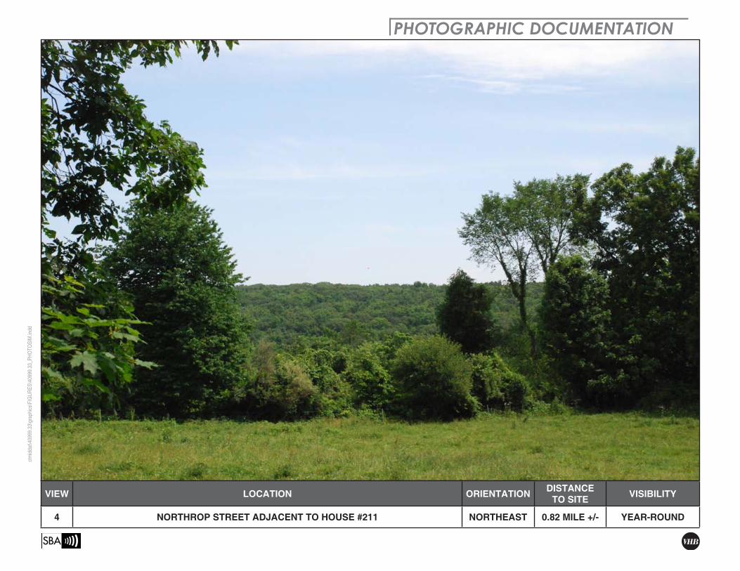
4 NORTHROP STREET ADJACENT TO HOUSE #211 NORTHEAST 0.82 MILE +/- YEAR-ROUND

PHOTOGRAPHIC SIMULATIONctmiddat\40999.33\graphics\FIGUR
ES\40999.33_PH
OTO
SIM.indd
VIEW LOCATION ORIENTATION DISTANCE TO SITE VISIBILITY
4 NORTHROP STREET ADJACENT TO HOUSE #211 NORTHEAST 0.82 MILE +/- YEAR-ROUND

PHOTOGRAPHIC DOCUMENTATIONctmiddat\40999.33\graphics\FIGUR
ES\40999.33_PH
OTO
SIM.indd
VIEW LOCATION ORIENTATION DISTANCE TO SITE VISIBILITY
5 NORTHROP STREET NORTHEAST 0.78 MILE +/- YEAR-ROUND

PHOTOGRAPHIC SIMULATIONctmiddat\40999.33\graphics\FIGUR
ES\40999.33_PH
OTO
SIM.indd
VIEW LOCATION ORIENTATION DISTANCE TO SITE VISIBILITY
5 NORTHROP STREET NORTHEAST 0.78 MILE +/- YEAR-ROUND

PHOTOGRAPHIC DOCUMENTATIONctmiddat\40999.33\graphics\FIGUR
ES\40999.33_PH
OTO
SIM.indd
VIEW LOCATION ORIENTATION DISTANCE TO SITE VISIBILITY
6 NORTHROP STREET ADJACENT TO HOUSE #160 NORTHEAST 0.59 MILE +/- YEAR-ROUND

PHOTOGRAPHIC SIMULATIONctmiddat\40999.33\graphics\FIGUR
ES\40999.33_PH
OTO
SIM.indd
VIEW LOCATION ORIENTATION DISTANCE TO SITE VISIBILITY
6 NORTHROP STREET ADJACENT TO HOUSE #160 NORTHEAST 0.59 MILE +/- YEAR-ROUND

PHOTOGRAPHIC DOCUMENTATIONctmiddat\40999.33\graphics\FIGUR
ES\40999.33_PH
OTO
SIM.indd
VIEW LOCATION ORIENTATION DISTANCE TO SITE VISIBILITY
7 NORTHROP STREET ADJACENT TO HOUSE #147 NORTHEAST 0.50 MILE +/- YEAR-ROUND

PHOTOGRAPHIC SIMULATIONctmiddat\40999.33\graphics\FIGUR
ES\40999.33_PH
OTO
SIM.indd
VIEW LOCATION ORIENTATION DISTANCE TO SITE VISIBILITY
7 NORTHROP STREET ADJACENT TO HOUSE #147 NORTHEAST 0.50 MILE +/- YEAR-ROUND

PHOTOGRAPHIC DOCUMENTATIONctmiddat\40999.33\graphics\FIGUR
ES\40999.33_PH
OTO
SIM.indd
VIEW LOCATION ORIENTATION DISTANCE TO SITE VISIBILITY
8 NORTHROP STREET ADJACENT TO HOUSE #119 NORTHEAST 0.47 MILE +/- YEAR-ROUND

PHOTOGRAPHIC SIMULATIONctmiddat\40999.33\graphics\FIGUR
ES\40999.33_PH
OTO
SIM.indd
VIEW LOCATION ORIENTATION DISTANCE TO SITE VISIBILITY
8 NORTHROP STREET ADJACENT TO HOUSE #119 NORTHEAST 0.47 MILE +/- YEAR-ROUND
PHOTOGRAPHIC DOCUMENTATIONctmiddat\40999.33\graphics\FIGUR
ES\40999.33_PH
OTO
SIM.indd
VIEW LOCATION ORIENTATION DISTANCE TO SITE VISIBILITY
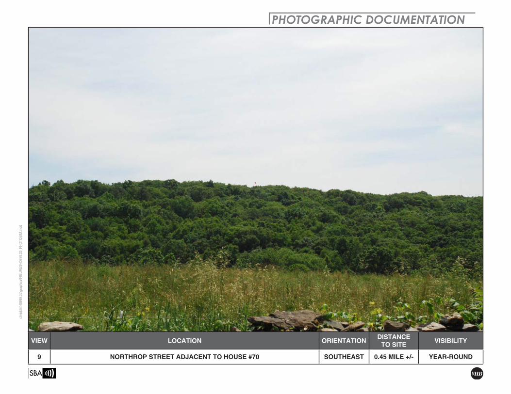
9 NORTHROP STREET ADJACENT TO HOUSE #70 SOUTHEAST 0.45 MILE +/- YEAR-ROUND
PHOTOGRAPHIC SIMULATIONctmiddat\40999.33\graphics\FIGUR
ES\40999.33_PH
OTO
SIM.indd
VIEW LOCATION ORIENTATION DISTANCE TO SITE VISIBILITY
9 NORTHROP STREET ADJACENT TO HOUSE #70 SOUTHEAST 0.45 MILE +/- YEAR-ROUND

PHOTOGRAPHIC DOCUMENTATIONctmiddat\40999.33\graphics\FIGUR
ES\40999.33_PH
OTO
SIM.indd
VIEW LOCATION ORIENTATION DISTANCE TO SITE VISIBILITY
10 STUART ROAD ADJACENT TO HOUSE #129 SOUTHWEST 0.35 MILE +/- YEAR-ROUND

PHOTOGRAPHIC SIMULATIONctmiddat\40999.33\graphics\FIGUR
ES\40999.33_PH
OTO
SIM.indd
VIEW LOCATION ORIENTATION DISTANCE TO SITE VISIBILITY
10 STUART ROAD ADJACENT TO HOUSE #129 SOUTHWEST 0.35 MILE +/- YEAR-ROUND

VIEW LOCATION ORIENTATION DISTANCE TO SITE VISIBILITY
11 HUT HILL ROAD NORTH OF SARAH SANFORD ROAD SOUTHEAST 1.29 MILES +/- NOT VISIBLE
PHOTOGRAPHIC DOCUMENTATIONctmiddat\40999.33\graphics\FIGUR
ES\40999.33_PH
OTO
SIM.indd

PHOTOGRAPHIC DOCUMENTATIONctmiddat\40999.33\graphics\FIGUR
ES\40999.33_PH
OTO
SIM.indd
VIEW LOCATION ORIENTATION DISTANCE TO SITE VISIBILITY
12 STUART ROAD SOUTHWEST 0.42 MILE +/- NOT VISIBLE

PHOTOGRAPHIC DOCUMENTATIONctmiddat\40999.33\graphics\FIGUR
ES\40999.33_PH
OTO
SIM.indd
VIEW LOCATION ORIENTATION DISTANCE TO SITE VISIBILITY
13 ROUTE 133 SOUTHEAST 0.58 MILE +/- NOT VISIBLE

PHOTOGRAPHIC DOCUMENTATIONctmiddat\40999.33\graphics\FIGUR
ES\40999.33_PH
OTO
SIM.indd
VIEW LOCATION ORIENTATION DISTANCE TO SITE VISIBILITY
14 ROUTE 133 AT STUART ROAD SOUTHEAST 0.41 MILE +/- NOT VISIBLE

PHOTOGRAPHIC DOCUMENTATIONctmiddat\40999.33\graphics\FIGUR
ES\40999.33_PH
OTO
SIM.indd
VIEW LOCATION ORIENTATION DISTANCE TO SITE VISIBILITY
15 WEWAKA BROOK ROAD EAST OF ROUTE 133 NORTH 0.94 MILE +/- NOT VISIBLE

PHOTOGRAPHIC DOCUMENTATIONctmiddat\40999.33\graphics\FIGUR
ES\40999.33_PH
OTO
SIM.indd
VIEW LOCATION ORIENTATION DISTANCE TO SITE VISIBILITY
16 WEWAKA BROOK ROAD AT HOST PROPERTY WEST 0.39 MILE +/- NOT VISIBLE

PHOTOGRAPHIC DOCUMENTATIONctmiddat\40999.33\graphics\FIGUR
ES\40999.33_PH
OTO
SIM.indd
VIEW LOCATION ORIENTATION DISTANCE TO SITE VISIBILITY
17 WEWAKA BROOK ROAD AT STUART ROAD SOUTHWEST 0.54 MILE +/- NOT VISIBLE

VHB Vanasse Hangen Brustlin, Inc.
Attachment B
Viewshed Map

!(
B r i d g e w a t e rB r i d g e w a t e r
_̂
!.
!(
!(
!(
!(!(
!(
!(
!(
!(
!(
!(
!(!(
!(
!(
!(
!(
¬«133
B r i d g e w a t e rB r i d g e w a t e r
R o x b u r yR o x b u r y
N e wN e wM i l f o r dM i l f o r d
S o u t h b u r yS o u t h b u r yB r o o k f i e l dB r o o k f i e l d
LakeLillinonah
Water Access
Town OpenSpace
SouthCemetery
BridgewaterRecreation
Area
Sunny ValleyFoundation,
inc.
BridgewaterFire Dept.-white Tract
Sunny ValleyFoundation,inc.-Cemetery Tract
Undefined
Sunny ValleyFoundation,inc.-Wolfpit Mt. Tract
Sunny ValleyFoundation,inc.- Lake
Lillinonah Tract
PrivateOpenSpace
SunnyValley Foundation,inc.-
Fost Tract
SouthburyLandTrust
PrivateOpenSpacePrivate
Open Space
Cemetery(route133)
Roxbury LandTrust, Inc.
(River Road)
ChasePark
BrookfieldHighSchool
BridgewarerFire Dept.-
fairgrounds
HopBrook
Sanctuary
DriftwoodMarineBase
Town Of NewMilford
(Clatter Valley)
Sunny ValleyFoundation,inc.-
Dow Tract
Sherman Park
SchoolPark
Town OpenSpace
PrivateOpenSpace
Sunny ValleyFoundation,inc.- Isbill,
carlson Tracts
Old BridgePark
Gurski FarmOpenSpace
Town OpenSpace (MinorBridge Road)
BurnhamSchool
Undefined
Town Of Bridgewater-Lake Lillinonah
Tract
Town Open Space (LongMeadow
Hill Road)
BridgewaterTownPark
LakeLillinonah
Boat Launch
Ivers NaturePreserve
StibbeParcel Hillandale Skating Pond
Hop BrookSanctuary
SchroedersParcel
Barkwood Falls
WinwoodLyndenwood
PuritanValley
Boat Launch
Paradise HillPreserve
23
45
78
9
11
1013
14
15
16
1712
61
Study Area
Proposed Facility
//ctm
iddat/
projec
ts/40
999.3
3/grap
hics/f
igures
/Bridg
ewate
r_prel
imina
ry_vie
wshe
d_ma
p.pdf
VHB
E
Viewshed AnalysisProposed SBA Towers II LLCTelecommunications Facility
Bridgewater42 and 89 Wewaka Brook Road
Bridgewater, Connecticut
Year-Round Visibility (+/- 62 acres)
Legend!H Proposed Tower Location
0.5 0 0.50.25Miles
Photographs - June 15, 2010
Inset MapTown of Bridgewater
Proposed FacilityStudy Area
Federal Open Space (CT DEP, 2004)Boat Launches (CT DEP, Dec 2009)Scenic Road (State and Local)Town Line
_̂
!( Balloon is not visible
Seasonal Visibility (+/- 60 acres)
NOTE:- Viewshed analysis conducted using ESRI's Spatial Analyst.- Proposed Facility height is 170 feet.- Existing tree canopy height estimated at 50 feet.- Study Area is comprised of a two-mile radius surrounding the proposed facility and includes 8,042 acres of land.- Results not field verified by balloon float.DATA SOURCES:- Digital elevation model (DEM) derived from Connecticut LiDAR-based Digital Elevation Data (collected in 2000) with a 10-foot spatial resolution produced by the University of Connecticut and the Center for Land Use Education and Research (CLEAR); 2007- Forest areas derived from 2008 digital orthophotos with 1-meter pixel resolution; digitized by VHB, 2010- Base map comprised of Danbury (1984), Newtown (1984), New Milford (1984) and Roxbury (1984) USGS Quadrangle Maps- Municipal and Private Open Space data layer provided by CT DEP, 1997- Federal Open Space data layer provided by CT DEP, 2004- CT DEP Property data layer provided by CT DEP, April 2010- CT DEP Protected Open Space Mapping (POSM) data layer provided by CT DEP, Dec 2009- CT DEP boat launches data layer provided by CT DEP, Dec 2009- Scenic Roads layer derived from available State and Local listingsMap Compiled July, 2010
!( Balloon visible above trees
Protected Municipal and Private Open Space (CT DEP, 1997)CemeteryPreservationConservationExisting Preserved Open SpaceRecreationGeneral RecreationSchoolUncategorized
CT DEP Property (CT DEP, May 2010)State ForestState ParkDEP Owned WaterbodyState Park Scenic ReserveHistoric PreserveNatural Area PreserveFish HatcheryFlood ControlOtherState Park TrailWater AccessWildlife AreaWildlife SanctuaryProtected Open Space Mapping (POSM) Area (CTDEP, Dec 2009)