bridge # lake shady ave over s br mid fk zumbro r · 7190 sq. ft. traffic sidewalk width 50a. lt...
TRANSCRIPT

2016 UNDERWATER
BRIDGE INSPECTION REPORT
BRIDGE #
DISTRICT: COUNTY: CITY/TOWNSHIP:
Date of Inspection:
Equipment Used:
Inspected By:
Report Written By:
Report Reviewed By:
Final Report Date:
55031
LAKE SHADY AVE over S BR MID FK ZUMBRO R
District 6 Olmsted Oronoco
06/14/2016
Forsyth, Roy
Roy Forsyth
City or Municipal Highway AgencyOwner:
MinnesotaSTATE:

UNDERWATER SUMMARY 3
UNDERWATER INSPECTION 4
UNDERWATER INSPECTION PROCEDURES 6
STRUCTURE INVENTORY 7
ELEMENTS 8
PICTURES 12
DRAWINGS 14
TABLE OF CONTENTS
PAGE NUMBER
Contractor:
(A) Monitor accumulations of timber debris during future inspections and consider removal operations in order to reduce channel obstruction, additional lateral loads on the substructure, as well as scour susceptibility at the bridge site.
(B) Reinspect the submerged substructure units at the normal maximum recommended (NBIS) interval of sixty (60) months.
Collins Engineers, Inc.
9687Contractor Job Number:
RECOMMENDATIONS
REPORT SUMMARY
UNDERWATER INSPECTION
The substructure units inspected at Bridge No. 55031, Piers 1 and 2, were found to be generally in satisfactory condition with no defects of structural significance observed. All of the steel shells of the cast-in-place concrete piles typically exhibited loss of protective coating and minor surface corrosion from channel bottom to 10 feet above the waterline. Heavy accumulations of timber debris were observed at both piers extending a maximum of 8 feet above waterline. The channel bottom material consisted of silty sand allowing 1 foot of maximum probe rod penetration.
(A) Steel piles exhibited coating failure with light surface corrosion over 100 percent of the surface area from channel bottom to 10 feet above waterline.
(B) A heavy accumulation of timber debris, consisting of 1.5 foot diameter and smaller logs and branches, was observed around the perimeter of Pier 2 extending from the channel bottom up 8 feet.
(C) A heavy accumulation of timber debris, consisting of 2 feet diameter and smaller logs and branches, was observed at the north side of Pier 1 extending from the channel bottom to 8 feet above the waterline.
(D) The channel bottom material consisted of silty sand allowing 1 foot of maximum probe rod penetration.
INSPECTION FINDINGS
Page 3 of 15

Top of pier cap of the downstream end of Pier 2.Water Level Reference:
WATERLINE DATUM
Waterline Elevation (feet):
The waterline was approximately 16.1 feet below the reference. Description:
944.0
4.
Piers 1 and 2Substructure(s) Inspected:
SUBSTRUCTURE INSPECTION DATA
General Shape:
6.7Maximum Water Depth at Substructure(s) Inspected (feet):
Each pier consists of concrete pier cap supported by a single row of eight cast-in-place (CIP) concrete piles.
Code:Item 62: Culvert:
6
Y 48 06/2016Code:Item 92B: Underwater Inspection:
Code:
(Minnesota specific codes are used for 92B and 113)
NBIS CODING INFORMATION5.
Item 60: Substructure:
Item 61: Channel and Channel Protection:
6Code:
District 6District:
LAKE SHADY AVE
County:
The superstructure consists of a concrete deck resting on three prestressed concrete multi-girder spans supported by two reinforced concrete abutments and two cast-in-place pile piers. The substructure units are designated as North Abutment, Piers 1 and 2, and South Abutment.
Bridge Description:
055 - Olmsted
Facility Carried:
BRIDGE DATA1.
UNDERWATER INSPECTION
Bridge #:
S BR MID FK ZUMBRO RFeature Intersected:
55031
Underwater Visibility (feet):
Sunny, 70°FWeather Conditions:
0.5 ft.
3.
1 ft/sWaterway Velocity (ft/sec):
06/14/2016
Professional Engineer/Team Leader:
INSPECTION DATA2.
Roy A. Forsyth
Date of Underwater Inspection:
Roy A. ForsythInspection Diver:
Page 4 of 15
885 Scour 1 EA 1
STRUCTURAL ELEMENT CONDITION RATING
Conditions
6.
R
Bridge is scour critical because abutment or pier foundation is rated as unstable due to observed scour at bridge site.
Item 113: Scour Critical Bridge: Code:
X No (Mark your selection with an X)Yes
225
CS3 CS4
Steel Piling 1616 EA
CS2ELEM # Unit CS1Element Description Quantity
Page 5 of 15

The routine underwater inspection of Bridge 55031 (Lake Shady Avenue over the Zumbro River) was completed on June, 14, 2016. The underwater inspection was conducted from shore. The inspection was conducted by a team consisting of a PE-Diver with a valid MnDOT Team leader certification, a backup diver and a dive tender. Due to waterway conditions at the time of inspection, the inspection could be accomplished by wading in accordance with OSHA regulations. Profiles were taken along the upstream and downstream faces of the bridge and around the periphery of substructure units to determine the presence, location and area of scour.
The bridge elements inspected consisted of 2 piers with 8 CIP concrete piles each. According to the bridge inventory or design drawings, Piers 1 and 2 were founded on CIP concrete pilings. Inspection procedures followed FHWA guidance and the MnDOT Bridge and Structure Inspection Program Manual with channel bottom probing to search for bottom of foundations. The routine underwater inspection frequency is recommended to remain at a maximum of 60 months based on those findings and risk factors. Also, inspection procedures should continue to follow the above approach and standard guidance with 100% Level I and 10% Level II intensity efforts.
INSPECTION PROCEDURES
UNDERWATER INSPECTION
Page 6 of 15

Spec. Feat.Pier Foundation (Material/Type)
8 - CIPCantilever ID
+ W A T E R W A Y +Number of Spans Historic Status
4 - PILE BENT
Underwater 60Culvert Type 3 - FTG PILE
Pinned Asbly.
06/14/2016
Barrel Length
176.3 ft. Navigation Control
Waterway Opening (sf.) 2100Structure Length
ft. Year Painted
0 - No nav. control on waterwayDeck Width (Out-to-Out) 44.2
+ P A I N T +
APPR: 0 TOTAL:5 - Not eligible
MAIN: 3
Main Span Length 57.6 ft.Drainage Area (sq. mi.) 218.0
B R I D G E D A T A +Main Span Detail
1 - MEETS STANDARDS+ M I S C.
Appr. Span Type Structure Flared
GR Termini 1 - MEETS STANDARDS
Appr. Guardrail
Main Span Type 5 - Prestress or Precast Median Width On Bridge
ft. Bridge Railing 1 - MEETS STANDARDS
1 - MEETS STANDARDS
Main Span Design 01 - Beam Span
ft. GR Transition
Skew 0
Y/N Freq Date
Abutment Foundation (Material/Type)
1 - CONC Frac. Critical
D E P T H I N S P. +Appr. Span Design
0 - No flare+ I N
Appr. Span Detail Field Conn. ID
Parallel Structure N - No parallel structure
Pier Protection
0 - Not Required
Rating Date 05/06/20167190 sq. ft. Traffic
ft. 50B. Rt 0.00Sidewalk Width 50A. Lt 0.00
Roadway Area (Curb-to-Curb)
Posted Load 0 - Not Required
PostingStructure Area (Out-to-Out) 7792 sq. ft.
DBL:VEH: SEMI:
Rt 22 ARail Type Lt 22 C 1 - No Restriction
1 - No Restriction
B 1 - No Restriction
N - Not Applicable Overweight Permit CodesCurb Height Lt
ft. Horizontal 1 - Object Markers
0.00 ft. Vertical0.00 ft. Rt
Wear Surf Install Year
sq. ft. Nav. Vert. Lift Bridge Clear. (ft.)
R - CRIT - MONITOR
Year 1994Primer Type MN Scour Code
Painted Area
Unsound Paint % Nav. Clr. (ft.)Deck Material 1 - Concrete Cast-in-Place 0.0Wear Surf Type 1 - Monolithic Concrete
(concurrently placed with stru
Vert. 0.0 Horiz.
S I G N S +Operating Rating 2 - HS TRUCK
1 - Epoxy Coated Reinforcing + B R I D G E
Inventory Rating 2 - HS TRUCK 25.60
51.80Deck Rebars Install Year 1985
Deck Rebars
Finish TypeWear Course/Fill Depth 0.00 ft.
0 - None
Design Load 5 - HS 20
+ C A P A C I T Y R A T I N G S +Deck Membrane
44 ° 9
Inspector Name Forsyth, Roy
Latitude Control Section (TH Only) Status' 37.24 ''
2 - 2-way traffic
Routine Inspection Frequency 24
Sect., Twp., Range
0.5 MI S OF 5TH ST Level of Service 1 - MAINLINE
- 14W Roadway Type18 - 108N
Detour Length 2.0 mi.R A T I N G S +
Custodian 04 - City or Municipal Highway Agency
Owner 04 - City or Municipal Highway Agency
Deck 7 Unsound Deck %
C O N D I T I O N° 32 '
A - Open
Longitude 92 000+00.660 + N B I 26.29 '' Reference Point
Crew
+ I N S P E C T I O N +
Agency Br. No. 95
District 06
Bridge Match ID (TIS) 0 Userkey
LAKE SHADY AVE over S BR MID FK ZUMBRO R
Minnesota Structure Inventory Report
Bridge ID: 55031
+ G E N E R A L + + R O A D W A Y +
Date: 07/14/2016
Sufficiency Rating 99.9Roadway Name or Description
87
City Oronoco
Routine Inspection Date 11/10/2014
Desc. Loc.
Township LAKE SHADY AVE
Number
NRoadway O/U Key Route On StructureMaint. Area 6A Structurally Deficient
NRoute Sys 10 - MUNCounty 055 - Olmsted Functionally Obsolete
Lanes
Waterway Adequacy 8Max. Vert. Clear.
ft.Legislative District 29Aft.Potential ABC 2 - N/A ft.
ft.On - Off System Roadway Width 40.8 ft.
Vertical Clearance ft.0 - OFF
Underclearances N
Service On 1 - Highway Appr. Surface Width+ S A F E T Y F E A T U R E S +
5 - Waterway Bridge Roadway Width 40.8
38.0 ft.
Service Under
ft.
40.7 ft. Approach Alignment 8Horizontal Clear.
ft.
ft.+ S T R U C T U R E + Lateral Clearance
HCADT ADTT6
Year Built 1985
MN Year Reconstructed Functional Class
%Channel 6
Substructure
0Superstructure 8
ON 2 UNDER
780 YEAR 2013BMU Agreement ADT
Structure Evaluation 7If Divided
D I M E N S I O N S +Bridge Plan Location 1 - CENTRAL
12/1/1985Deck Geometry 9
NB-EB SB-WBDate Opened to Traffic
+ R D W Y
FHWA Year Reconstructed
MN Temporary Status
09 - Rural - LocalCulvert N
A P P R A I S A L R A T I N G S ++ N B I
Page 7 of 15

County:
City:
Township:
Township:Section: Range:
Span Type:
NBI Deck: Super: Sub: Chan: Culv:
Appraisal Ratings - Approach: Waterway:
Required Bridge Signs - Load Posting:
Horizntal:
Traffic:
Vertical:
MN Scour Code:
Open, Posted, Closed:
Location:
Route:
Control Section:
Local Agency Bridge Nbr.:
Ref. Pt.:
Maint. Area:
Length:
Deck Width:
Rdwy. Area/ Pct. Unsnd:
Paint Area/ Pct. Unsnd:
Culvert:
Olmsted
Oronoco
108N18 14W
5 - Prestressed Concrete 2 -Stringer/Multi-beam or Girder
7 8 6 6 N
8 8
0 - Not Required
1 - Object Markers
0 - Not Required
N - Not Applicable
R - CRIT - MONITOR
0.5 MI S OF 5TH ST
10 - MUN 87 000+00.660
6A
176.3
44.2
7190 sq. ft. / %
sq. ft. / %
N/A
A - Open
ft.
ft.
Postings:List:
MINNESOTA BRIDGE INSPECTION REPORT
09/12/2016
Inspector: CO Bridge
BRIDGE 55031 LAKE SHADY AVE OVER S BR MID FK ZUMBRO R
Unofficial Structurally Deficient N
NUnofficial Functionally Obsolete
Unofficial Sufficiency Rating 99.9
ELEMNBR ELEMENT NAME INSP. DATE QUANTITY
QTYCS 1
QTYCS 2
QTYCS 3
QTYCS 4REPORT TYPE
Reinforced Concrete Deck 07/14/2016 7792 SF 7636 0 156 012 Underwater
7792 SF 7636 0 156 0Migrated Values
Notes: [2012-14] There are scattered transverse cracks beneath the deck near both piers and in both overhangs with efflorescence.
510 - Wearing Surfaces 7190 SF 7190 0 0 0
Notes: Top of Concrete Deck with Epoxy Reinforcement Notes: [2012-14] There are no spalls, delaminations, or patches noted in the surface ofthe deck.
Underwater 07/14/2016
7190 SF 7190 0 0 0Migrated Values
Prestressed Concrete OpenGirder/Beam
07/14/2016 700 LF 700 0 0 0109 Underwater
700 LF 700 0 0 0Migrated Values
Notes: [2012-14] No deterioration noted at the time of this inspection.
Reinforced Concrete Abutment 07/14/2016 128 LF 114 14 0 0215 Underwater
128 LF 114 14 0 0Migrated Values
Notes: [2016] Migrator added 40 LF to abutment quantity to account for wingwalls (CS1:40 CS2:0 CS3:0 CS4:0).South Abutment - [2012-14] has 6 vertical 0.010" cracks scattered along the front face. There is some leaching noted at the end blockconstruction joint at each end next to the wingwalls.
North Abutment - [2012-14] has 8 vertical 0.010" cracks scattered along the front face with some leaching noted at the end block constructionjoint at each end next to the wingwalls.
Wingwall notes: [2012-14] Southwest Wingwall - has areas of superficial map cracking with some staining.[2012-14] Northwest Wingwall - has areas of superficial map cracking with some staining.[2012-14] Northeast Wingwall - has areas of superficial map cracking with some staining.
Steel Pile 07/14/2016 16 EA 0 16 0 0225 Underwater
16 EA 0 16 0 0Migrated Values
Notes: [2012-14] All 16 piling have failed paint with active corrosion. Repaint all piling.
515 - Steel Protective Coating 180 SF 40 140 0 0
Notes: [2016] Underwater Inspection - Painted coating failure with light surface corrosion over 100 percent of the surface area from channelbottom to 10 feet above waterline.
Underwater 07/14/2016
999 SF 999 0 0 0Migrated Values
Reinforced Concrete Pier Cap 07/14/2016 88 LF 82 6 0 0234 Underwater
88 LF 82 6 0 0Migrated Values
Notes: Pier # 1- [2012-14] has 9 vertical 0.010" cracks scattered along both sides.
Pier # 2 - [2012-14] has 5 vertical 0.010" cracks scattered along both sides.
Page 8 of 15

Strip Seal Expansion Joint 07/14/2016 82 LF 82 0 0 0300 Underwater
82 LF 82 0 0 0Migrated Values
Notes: South End - [2012-14] during 2008 inspection the joint opening measured 7/8 of an inch wide at the west end and 5/8 of an inch wide atthe east end. The strip seal joint was clean and in good condition at the time of this inspection. During inspection in 2006 the expansion jointopening measured 1 inch wide at the west end and 7/8 of an inch wide at the east end.
North End - [2012-14] during 2008 inspection the joint opening measured 3/4 of an inch wide at the west end and 1 1/8 inches wide at the eastend. The strip seal joint was clean and in good condition at the time of this inspection. During the 2006 inspection the joint opening measured 1inch wide at the west end and 1 1/4 inches wide at the east end.
Pourable Joint Seal 07/14/2016 178 LF 149 29 0 0301 Underwater
178 LF 149 29 0 0Migrated Values
Notes: [2012] Six feet of joint over piers, 10' of the south and 13' of the north joints ,at the end of deck approach slab joint, have lost adhesion.
Elastomeric Bearing 07/14/2016 20 EA 20 0 0 0310 Underwater
20 EA 20 0 0 0Migrated Values
Notes: The elastomeric bearing pads are located along both abutments, along both sides of pier 2 and along the north side of pier 1.
South Abutment Bearings - [2012-14] OK, the elastomeric bearings show little or no deterioration. All 4 bearings are set ahead 1 inch overcenter.
Pier # 1 Bearings - [2012-14] OK, the elastomeric bearings show little or no deterioration.
Pier # 2 Bearings - [2012-14]OK, the elastomeric bearings show little or no deterioration.
North Abutment Bearings - [2012-14] OK, the elastomeric bearings show little or no deterioration. All 4 bearings are set ahead 1 inch overcenter.
Fixed Bearing 07/14/2016 8 EA 8 0 0 0313 Underwater
8 EA 8 0 0 0Migrated Values
Notes: The fixed bearings are located along the south side of the pier.
[2012-14]Pier # 1 Bearings - OK, the fixed bearings show little or no deterioration.
Reinforced Concrete Approach Slab 07/14/2016 1520 SF 760 760 0 0321 Underwater
1520 SF 760 760 0 0Migrated Values
Notes: [2016] Migrator assumed an approach slab length of 20FT and used the inventory quantity of 38FT for the width.[2012-14] South Approach Slab - has sealed longitudinal cracks, a small 6" X 8" spalled area at the south end along the center line and themainline slab adjacent tot eh approach has heaved upwards slightly from 1/2 to 3/4 of an inch.
[2012-14] North Approach Slab - OK, has sealed longitudinal cracks and the mainline slab adjacent to the approach has heaved upwardsslightly from 3/4 to 1 inch.
Reinforced Concrete Bridge Railing 07/14/2016 352 LF 349 3 0 0331 Underwater
352 LF 349 3 0 0Migrated Values
Notes: [2012-14] There are 1 or 2 vertical 0.010" cracks per rail section with some staining or leaching. There are rebar spalls along the tops ofthe northwest and northeast corner end posts and a small spalled area at the top of the southwest corner end post.West Railing - has scattered railing section with light scaling and horizontal cracks along the bottom.
Critical Deficiencies or Safety Hazards 07/14/2016 1 EA 1 0 0 0800 Underwater
1 EA 1 0 0 0Migrated Values
Notes: [2012-14] No critical findings were observed at the time of inspection.
Concrete Decks - Cracking & Sealing 07/14/2016 0 LF 0 0 0 0810 Underwater
0 LF 0 0 0 0Migrated Values
Notes: [2012-14] Approximately 1700 linear feet of deck cracks were sealed in 2008.
ELEMNBR ELEMENT NAME INSP. DATE QUANTITY
QTYCS 1
QTYCS 2
QTYCS 3
QTYCS 4
BRIDGE 55031 LAKE SHADY AVE OVER S BR MID FK ZUMBRO R
REPORT TYPE
Page 9 of 15

Approach Relief Joint 07/14/2016 54 LF 24 30 0 0816 Underwater
54 LF 24 30 0 0Migrated Values
Notes: These are the E-eight joints that are located at the roadway ends of both approach slabs.[2014] All joints have lost adhesion and on the North side the NBL foam is missing and on the South side the SBL foam is missing.
South End E-eight Joint - during 2008 inspection the joint opening measured 1 1/8 inches wide at the west end, 2 inches wide at the east endand the entire length of the joint was sealed. During 2006 inspection the joint opening measured 1 1/2 inches wide at the west end to 2 incheswide at the east end and the enter length of the joint was sealed. During 2004 inspection the joint opening measured 2 1/2 inches wide at thewest end to 3 inches wide at the east end. During 2002 inspection the joint opening measured 3 inches wide along the entire length of the joint.
North End E-eight Joint - during 2008 inspection the joint opening measured 1 inch wide at both end and the entire length of the joint wassealed. During 2006 inspection the joint opening measured 1 1/2 inches wide at both ends and the enter length of the joint was sealed. During2004 inspection the joint opening measured 2 1/2 inches wide across the entire length of the joint. During 2002 inspection the joint openingmeasured 3 inches wide across the entire length of the joint.
Concrete Shear Cracking 07/14/2016 1 EA 1 0 0 0883 Underwater
1 EA 1 0 0 0Migrated Values
Notes: [2012-14] No shear cracking observed.
Scour 07/14/2016 1 EA 1 0 0 0885 Underwater
1 EA 1 0 0 0Migrated Values
Notes: [2014] South pier some scour developing behind the timber debris.[2012] R - Scour critical. Monitoring required. Scour monitoring sign is mounted to the south side of pier 1 near the west end. Bridge wassonar sounded 9-25-10 during high water and findings were ok. An underwater inspection and cross section were completed on 9/12/12.Results are in bridge file.
Other Bridge Signing 07/14/2016 1 EA 0 0 1 0891 Underwater
1 EA 0 0 1 0Migrated Values
Notes: [2012-14] Signs Required: Horizontal Clearance The signs are located at the southeast and northwest corners only. Signs are neededon NE & SW corners.
Slopes & Slope Protection 07/14/2016 1 EA 1 0 0 0892 Underwater
1 EA 1 0 0 0Migrated Values
Notes: [2014] The toe of the South bank is eroding from water pushing around the South pier timber debris.[2012] The slopes at the abutments and wingwall's are in stable condition at the time of inspection.
Guardrail 07/14/2016 1 EA 1 0 0 0893 Underwater
1 EA 1 0 0 0Migrated Values
Notes: [2012-14]There is minor impact damage to 2 section of plate beam guardrail at the northwest corner. All guard railing section were intactat the time of inspection.
Deck & Approach Drainage 07/14/2016 1 EA 1 0 0 0894 Underwater
1 EA 1 0 0 0Migrated Values
Notes: [2012-14] The catch basins are located along both sides of the south approach slab, both were in good condition at the time of thisinspection.
Miscellaneous Items 07/14/2016 1 EA 1 0 0 0899 Underwater
1 EA 1 0 0 0Migrated Values
Notes: [2012-14] There are two 4" diameter utility pipe penetrating through both abutments behind the wet fascia girders, both were firmlyattached at the time of this inspection. One pipe has a broken anchor between piers.
Protected Species 07/14/2016 1 EA 0 1 0 0900 Underwater
1 EA 0 1 0 0Migrated Values
Notes: [2016] Migrator determined the presence of swallows on this structure based on data in the inventory or comments in thegeneral/miscellaneous notes.
General Notes: This structure has a scour code rating of "R" CRITICAL MONITOR.All girders, bearings and CIP pilings are numbered from the west and all spans and piers are numbered from the south.There is a scour monitoring sign mounted along the south side of pier 1 near the west end.Bridge was inspected using under deck snooper truck in 2004.An Underwater Inspection and cross sections were completed on 9/12/12.[2012] DNR water level monitoring system was installed at the SW corner.[2012] Yes swallow nests.[2012-14] REPAIRS NEEDED: Remove timber debris from Piers. Remove flammable debris from unside of deck atabutments. Repaint all piling.
ELEMNBR ELEMENT NAME INSP. DATE QUANTITY
QTYCS 1
QTYCS 2
QTYCS 3
QTYCS 4
BRIDGE 55031 LAKE SHADY AVE OVER S BR MID FK ZUMBRO R
REPORT TYPE
Page 10 of 15

ELEMNBR ELEMENT NAME INSP. DATE QUANTITY
QTYCS 1
QTYCS 2
QTYCS 3
QTYCS 4
BRIDGE 55031 LAKE SHADY AVE OVER S BR MID FK ZUMBRO R
REPORT TYPE
Inspector's Signature Reviewer's Signature
Inventory Notes: Consider removing from the Underwater inspection list due to a change in water level, because the dam downstream hasbeen opened permently.
[2012] DNR water level monitoring system was installed at the SW corner.[2012] Yes swallow nests.[2012-14] REPAIRS NEEDED: Remove timber debris from Piers. Remove flammable debris from unside of deck atabutments. Repaint all piling.
58. Deck NBI:
36A. Brdg Railings NBI:
36B. Transitions NBI:
36C. Appr Guardrail NBI:
36D. Appr GuardrailTerminal NBI:
59. Superstructure NBI:
60. Substructure NBI:
61. Channel NBI:
62. Culvert NBI:
71. Waterway Adeq NBI:
72. Appr RoadwayAlignment NBI:
[2016] Underwater Inspection - Reduced to 6 due to painted coating failure with light surface corrosion over 100 percent of thesurface area from channel bottom to 10 feet above waterline.
Remove large timber debris from both piers.
Page 11 of 15
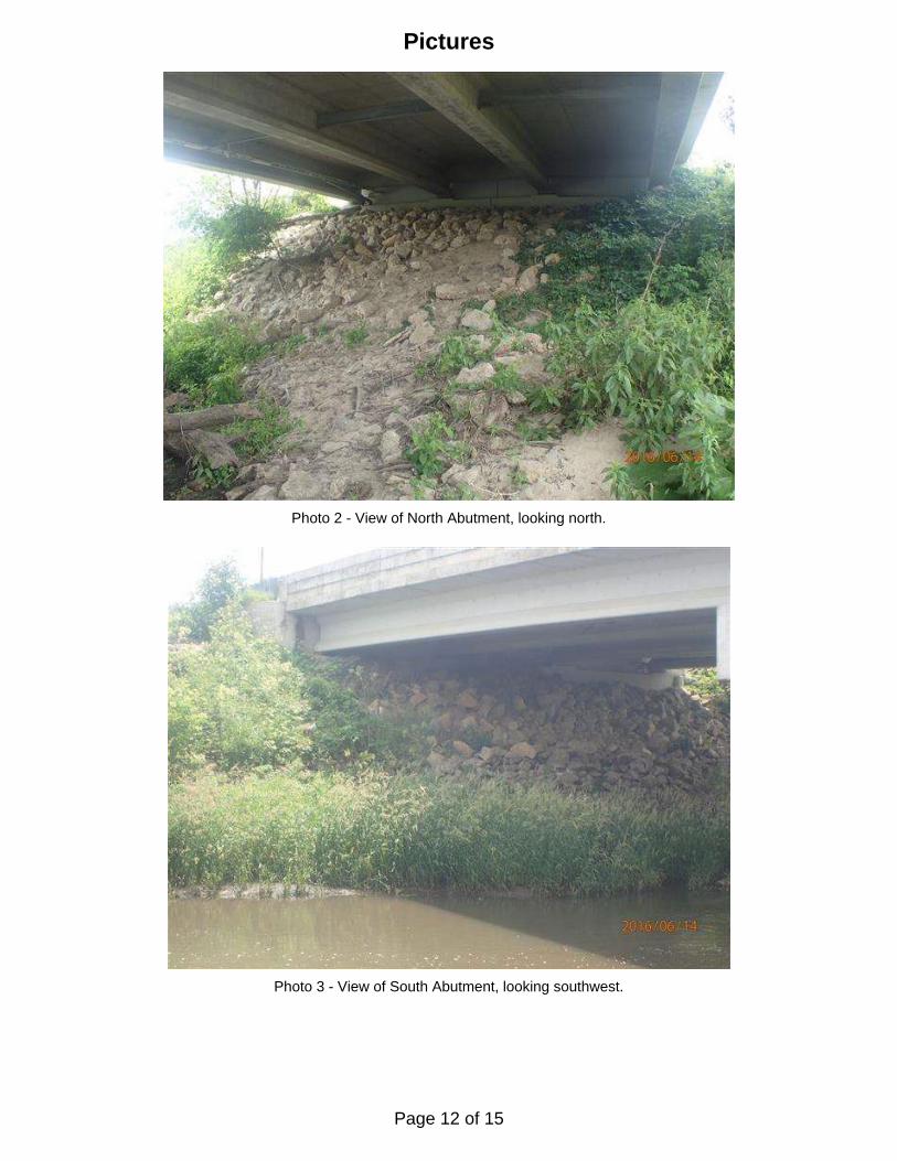
Photo 2 - View of North Abutment, looking north.
Photo 3 - View of South Abutment, looking southwest.
Pictures
Page 12 of 15

Pictures
Photo 4 - View of Pier 1, looking south.
Photo 5 - View of Pier 2, looking south.
Page 13 of 15

Page 14 of 15

Page 15 of 15