brave old world: modernist public space design in london ... · bo bardi wanted a design that would...
TRANSCRIPT

Brave Old World: Modernist Public Space Design in London and São Paulo
7 June – 2 July 2017 RIBA Practice Space66 Portland PlaceLondon W1B 1AD
University of Westminster Faculty of Architecture and the Built Environment
Public Spaces and the Role of the Designer:
A Symposium for Practitioners (and others)
June 20, 2017 Wren Room, RIBA
SYMPOSIUM
BOOK TICKETS ON THE PROJECT WEBSITE psarchitect.org/events

London County Council Architect’s Department, South Bank Arts Centre, 1960 – 1968, looking toward the Hayward Gallery

This exhibition helps redress the balance of attention paid to public spaces from the point of view of the user – a great deal – and from the point of view of the designer – considerably less. Consequently, we concentrate here on the role of design and the designer in the production of spaces that are designed to be public spaces, ensembles of buildings and spaces, and not open green areas, or streets intermittently taken over for celebrations or political protest. In this way, the ‘co-creation’ of a public space through the designer at one end of the process, and the user at the other, can be better understood.
The mid-20th century is a powerful lens through which to view both the debates around our public spaces today, and public spaces themselves. For the first and perhaps the last time in this country, state and architect in the mid 20th century were engaged in a radical partnership: to build something new on a national scale, or at least to radically reconsider the old. As a result, architects had the opportunity to intervene on a heady scale, and had no hesitation in doing so, designing for rather than with their users.
Architects in Brazil also had the support of the state, though only a fraction of them were its direct employees. Nor was Brazil reconstructing itself after a World War. Instead it was constructing itself as a modern state, pursuing ‘developmentalism’ under both President Juscelino Kubitschek’s democratic government (1956 – 1961), and under the military dictatorship (1964 – 1985). São Paulo during this period grew exponentially. Although new housing, schools and hospitals for all were important elements of this modernity, at least as important were public spaces, where the state could project its image. There are quite a number of these spaces – Praça da Sé, Anhangabaú, Praça Roosevelt etc. – all contributing to an impression of a modern, forward-looking state.
The exhibition uses four themes, Continuity, Innovation, Memory and Legibility, to explore both the design of public spaces and the understanding of those designs – why they are the way they are – a question that could and should be asked about everything in our built environment.
Introduction
London and São Paulo
Space cut from a solid
A solid standing in space

We tend to think of hard-paved public spaces in terms of squares, or at least open spaces formed by the buildings around them. This creates the traditional urban pattern of solid and void, with the voids cut out of a continuous urban fabric. This is the ‘DNA’ of public spaces, passed down over centuries in European cities, and reproduced in Europe’s colonies.
In contrast, the dominant model of spatial organisation for Modernists in the 1920s and 30s was that of universal space, rather than particular places; an abstract and infinitely extendable grid on which sat buildings-as-objects. In the worst cases, this led to ‘leftover space’, of little use to anyone. In the best cases, it led to exciting new combinations of building and public space.
Designed between 1962 and 1990, and shifting sites from Bloomsbury to the Euston Road, the British Library clearly demonstrates the ‘other tradition’ of Modernism which Colin St John Wilson championed, a Modernism enriched by references to architecture’s past. Not exclusively, however: the design was also generated by the client’s requirements, that is, from ‘a rigorous factual appreciation of the required conditions and not, as so often the case, the imposition of preconceived forms and ideas upon the real desires and necessities at issue’ (M.J. Long). Leslie Martin and Colin St John Wilson produced the initial feasibility study (1962 – 1964) for the Library on a site in Bloomsbury opposite the British Museum. After prolonged local opposition to the size of the project, the site was moved to St. Pancras in 1976, and Martin left the project.
Museo de Arte São Paulo
The British Library
The British Library 1962 – 1990
Colin St John Wilson and Partners

St. John Wilson continued with six partners, in particular his wife, M.J. Long, who shared client liaison and overall design work with him. From its earliest iterations onwards, the scheme for the new library always included provision for public space in the form of a ‘piazza’, which when intended for Bloomsbury, echoed the forecourt in front of the British Museum, and then remained as an organizational idea when the site was moved.
Car
Traditional
Modernist
Pedestrian
The 1950s were a period of great expansion for the city of São Paulo, accelerating a process begun in the late 19th century. Born and trained in Italy, Lina Bo Bardi was one of a number of European architects escaping the devastation in Europe after World War II, and bringing with them ideas about architectural Modernism that chimed with views and work of many Brazilian architects. Bo Bardi’s discussions with the Director of MASP, Francisco de Assis Chateaubriand, about a museum of art ‘for the people’, started in the 1950s, and finished in 1968 with the opening of MASP. Bo Bardi wanted a design that would promote the public’s relationship with art, a public unfamiliar with museums, a rarity in the city at that time. ‘I sought a simple architecture able to quickly communicate what was once called monumental. That is the sense of a collective, of civic dignity’ (Lina Bo Bardi). The life of this collective
Museo de Arte São Paulo (MASP), 1957 – 1968
Lina Bo Bardi
was to be acted out in the dramatic public space: ‘With MASP… I would like people to be there, to see outdoor exhibitions, and talk, listen to music and watch movies. I would like children to be there and play under the morning and the late afternoon sun, and even music bands and everyday bad taste’ (Lina Bo Bardi).

In 1933, influenced by Le Corbusier’s ideas for the ‘functional city’, the Congrés International d’Architecture Moderne (CIAM) produced the Athens Charter. This proposed new cities that were efficient, healthy, and zoned according to activity (residential, commercial etc.). The pedestrian and the car were to move at their own speeds, unimpeded by the other, and each would have its own spatial realm.
In the UK, from Abercrombie and Forshaw’s ‘County of London Plan’ (1943) onwards, centralised control of roadway development, and the decision to divide pedestrians and cars grew firmer, both among architects and planners. In São Paulo, as traffic grew through the 1950s and 60s, similar spatial solutions were explored. In 1971, the city government created EMURB – Empresa Municipal de Urbanização – a department to deal with São Paulo’s rapid growth. Among EMURB’s studies was the 1974 proposal by the leader of the Paulista School of Brutalist architecture: João Batista Vilanova Artigas. Much as Modernists did in London at the time, he suggested a vertical separation between pedestrians and traffic.
Like so many of São Paulo’s 20th century public spaces, the CCSP (1976 – 1982) began as an infrastructural intervention: the addition of a new metro stop, Vergueiro Station, a kilometre from the centre of the city. From the brief of the São Paulo Culture Secretary, Mario Chamie, and the competition-winning design by architects Prado Lopes and Telles, came one of the most complex and interesting public spaces in São Paulo. Graduates in 1966 of the School of Architecture, Mackenzie University, Prado Lopes and Telles were two generations below João Batista Vilanova Artigas (1915 – 1985), leader of the Paulista School of Brutalist Modernism. However, although they were identified with it, they had their own ideas about what and how to build, and for whom.
The 1970s were a particularly repressive period during the Brazilian dictatorship (1964 – 1985), and a non-
Centro Cultural De São Paulo
South Bank Arts Centre
Centro Cultural de São Paulo (CCSP),
1976 – 1982 Eurico Prado Lopes and
Luiz Benedito de Castro Telles

Existing
hierarchical, easily accessible space was therefore a political as well as spatial statement: ‘It is possible to censor theatre, music and literature. But [the dictatorship] was unable to censor architecture because it is difficult to understand the intentions contained within a design. We made a space to bring people together, a democratic building developed under a military dictatorship!’ (Prado Lopes).
The South Bank Arts Centre (1960 – 1968) was built after the Royal Festival Hall (1951) and before the National Theatre (1976). It is a leading example of British Brutalism, and consists of the Queen Elizabeth Hall, the Purcell Room, and the Hayward Gallery. The clients were public: the London County Council (LCC) and the Arts Council, and so were the architects. In fact the LCC was both client and architect.
Norman Engleback (1927 – 2015) was the lead architect on the design of the Centre, with a large team behind him, including three members of Archigram: Ron Herron, Warren Chalk, and Dennis Crompton. Almost half of all English architects were directly employed by the state at this time, and Engleback had been brought into the LCC Architect’s Department in the 1950s by Leslie Martin, then chief architect
to the LCC. The Centre was constructed to a very high material standard: ‘The idea at the time was that people deserved the best, and after the war and austerity, they jolly well did’ (Engleback).
When asked in 1966 why the Southbank Centre looked the way it did, Warren Chalk, who was in charge of designing the walkways, said: ‘The original basic concept was to produce an anonymous pile, subservient to a series of pedestrian walkways, a sort of Mappin Terrace for people instead of goats’ (Mappin Terrace, London Zoo, a reinforced concrete landscape for animals).
Infill Tabula rasa
South Bank Arts Centre (SBAC), 1960 – 1968
London County Council Architect’s Department

Public spaces are repositories of memory, physical evidence of a city’s evolution, and sites of people’s pasts, as citizens and private individuals: the square we marched to in a demonstration; the plaza we met our friends in after school.
Public spaces change as cities grow and priorities shift. The memories attached to one version of a public space can be bulldozed away, their previous incarnations accessible only in our recollections or in archives.
Add to this the desire in Brazil in the 1950s to build a modern state, and the desire in Britain to build a new world after the devastation of World War II, and conditions were perfect for a large scale erasure of the urban past, and its replacement with Modernist development.
This tabula rasa or ‘clean slate’ approach deliberately ignored traditional ways of organising space in cities, and traditional building types. This often meant large amounts of urban fabric – and their social networks – were lost instead of renewed. But it also meant that unhealthy, poor quality urban fabric was cleared for new housing, schools, and public realms. The erasure of Modernist work by contemporary regeneration can therefore be as regrettable as the loss of older architecture and urban design to Modernist interventions. Something we are now learning.
Vale do Anhangabaú is a linear public space on a heroic scale, the result of a 1981 competition held by the city of São Paulo. It is also a palimpsest of the development of São Paolo since the early 20th century, from ‘capital of coffee’ in the 19th and early 20th centuries to industrialised metropolis in the mid 20th. Anhangabaú is also a memorial to the struggle between public interest and private profit, public space and road. In 1908, the valley belonged to the Barão tea plantation. By the 1960s, it was a multi-lane highway and barrier between the Old Centre and the expanding city on the other side of the valley.
Early 20th centuryBetween 1907 and 1917, there
were several projects for Anhangabaú. The first, in 1907, by the engineer and city councillor Augusto Telles, sought to establish the valley as a public park. Another in 1911 by the architect Samuel Neves, proposed to exploit increased land values with a Parisian style boulevard through the valley. Finally in 1917, the French planner Joseph Bouvard succeeded with a compromise of public park below and privately developed Beaux-Arts buildings above.
Mid 20th centuryAs the 20th century progressed
and São Paulo continued to expand, new projects were proposed, all reflecting the desire for a modern metropolis that
Elephant and Castle Shopping Centre
Vale do Anhangabaú
Vale do Anhangabaú 1907 – 1992
1981 to present, Rosa Klias and Jorge Wilheim
would accommodate a modern transport infrastructure. Gradually, Anhangabaú ceased to be a park, and by the 1960s, had become a major and problematic highway instead. By the 1970s, pedestrians and cars were directly confronting one another.
Late 20th centuryIn 1981, the then mayor of São
Paulo, Reynaldo de Barros, held a national competition to solve the problem of Anhangabaú. Like many of the entries, the winning project by landscape Rosa Kliass and architect and urbanist Jorge Wilheim prioritised the return of a public space to the city, running the highway underneath a gigantic concrete lid. On January 25, 1992, the new space was officially opened, and the Modernist vision of a gleaming high speed metropolis gave way to a return to a park.
of post-war reconstruction, clearing bomb damage and slums. The Ministry of Transport, inadvisedly leading the redevelopment, delivered a double roundabout system not much liked by the architects and planners involved, and the LCC was left to distribute parcels of land around them, to be developed both by the state and by private developers.
The Elephant and Castle Shopping Centre is a repository of urban memory both of post-war Modernist urbanism, and of the local community. Designed by the husband and wife team Paul Boissevain and Barbara Osmond, they were inexperienced in shopping centre design, but were selected for their bold use of a new typology – the covered American shopping mall. It was the third of its kind in Europe, and pointed the way to contemporary shopping centres like Westfield London, providing a generous landscaped plaza outside as well as a large light-filled atrium inside with what was intended to be a retractable roof. When the developers had to trim their budget, the architects’ urbane intentions suffered.
Neither the developers, Willets, nor the LCC had researched sufficiently to deliver what they claimed would be ‘the Piccadilly of the south’, intended to attract shoppers from the West End as well as locally. The community’s memories of the decline of the Shopping Centre and rise of the outdoor market in the 1990s begin here, with a mismatch between the region-wide shoppers Willets expected, and the local residents who actually shopped at the Centre and successfully made it their own.
Private
Semi-publicPublic
Semi-private
Member of public
The Elephant and Castle Shopping Centre was a centrepiece in the radical post-war redevelopment of south London, sweeping away the 19th century district that preceded it. In its turn, it will be swept away by the current regeneration of the entire Modernist Elephant and Castle area, which includes the Shopping Centre and the Heygate Estate.
Elephant and Castle was one of the Comprehensive Development Areas masterplanned by the London County Council (LCC) as part of the wider project
Elephant and Castle Shopping Centre, 1959 – 1965
Boissevain and Osmond

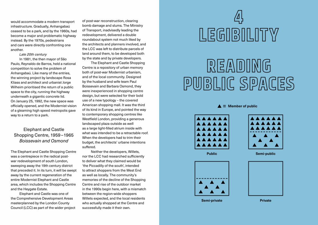
Public space needs to be readable as public in order to succeed. People need to see evidence that they are welcome there. The first and simplest visual cue is the sight of other members of the public passing through or occupying a space. Many other visual cues are provided by design, and can sometimes be accidentally – or deliberately – ambiguous.
This ambiguity can lead to a richer experience for the user – public space can become semi-public space, and private space, semi-private. This RIBA gallery is a good example of semi-public space. Or is it semi-private? Whatever the visual and programmatic cues given to visitors to allow them to read a space accurately, they can, and often do, subvert design intentions, or interpret them in unexpected ways.
Ambiguity can also lead to uncertainty for the user – am I allowed in there or not? This uncertainty can result in an empty public space. Is this a sign of failure or simply a different, more reflective kind of space? ‘For a cognitive society, one that would be in control of its direction, spaces need to be calm, urbane, even a little empty’ (Alison and Peter Smithson, The Charged Void: Urbanism). A provocative thought.
London’s Economist Plaza (1959 – 1964) and São Paulo’s Centro Empresarial Itaú Conceição (1975 – 2005) are examples of public space designs that take advantage of ambiguity, with semi-public and semi-private areas adding complexity to public and private ones. They were both commissioned by private clients – The Economist Newspaper Ltd. and Itaú Unibanco respectively – and designed by private architects – Alison and Peter Smithson with Maurice Bebbin London, and Jaime Marcondes Cupertino, José Gennaro, and Francisco Javier Manubens in São Paulo forPhase 1 of the development, which delivered the distinctive landscaping.
The ensemble of Economist Buildings and Plaza were designed by Peter and Alison Smithson with the more experienced architect, Maurice Bebb, acting as advisor. The Smithsons were founding members of Team X, a dissident group within CIAM (Congrés International d’Architecture Moderne), who, like many others in CIAM post-war, questioned the Functional City of pre-war Modernist urbanism – efficient, rational, its functions zoned, its civic dimension largely missing.
The client was keen to set their project apart from the more usual 1960s podium and slab office development, and the Smithsons produced an asymmetrical arrangement of three buildings around a raised public space – the ‘Plaza’. In keeping with their urban
The Economist Plaza
Centro Empresarial Itaú Conceição
The Economist Plaza 1959 – 1964
Alison and Peter Smithson

ideas, the Smithsons produced a design that both responded to, and transcended place, was part of St James and part of a new urban typology; one that turned the traditional urban block inside out, and opened it up to light, air – and more adventurous members of the public. In the Smithsons’ words: ‘The group looks forward to other groups’, ‘towards the collectivity of the yet unbuilt’ (The Charged Void: Urbanism). This hints at what would come to dominate their famous 1957 Berlin Haupstadt competition entry, which proposed ‘a more general system of pedestrian ways at various levels’, ensuring ‘a minimum of conflict between pedestrian and vehicular needs’. (See INNOVATION, the Smithsons on film.)
Centro Empresarial Itaú Conceição is the headquarters of the Brazilian bank Itaú Unibanco, and was built in three phases: 1982 – 1985, 1985 – 1990 and 2000 – 2005. Jaime Cupertino was the only architect to work on all three phases, and Phase 1, with José Gennaro and Francisco Javier Manubens produced the elaborate multi-level landscape that characterises the design.
Centro Empresarial Itaú Conceição, 1982 – 2005
Phase 1: Jaime Marcondes
Cupertino, José Gennaro, Francisco
Javier Manubens
Credits
We have made all reasonable efforts to clear copyright with the correct owners of all supporting media shown. Should you have a proprietary or other interest in any of these, please contact us at [email protected]
Images on leaflet
London County Council Architect’s Department, South Bank Arts Centre, 1960 – 1968, looking toward the Hayward Gallery: John Donat / RIBA Collections
British Library: Arup Museo de Arte São Paulo: Junior Braz, Shutterstock Centro Cultural de São Paulo: Susannah Hagan South Bank Arts Centre: John Donat, RIBA Collections Vale do Anhangabaú: Edicard Elephant and Castle Shopping Centre:
London Illustrated News The Economist Plaza: Jane Hall Centro Empresarial Itaú Conceição: Jaime Cupertino
Theme 1: Continuity
1 The medieval Piazza del Campo, Siena. ominojarre / iStock2 Oscar Niemeyer, Palácio do Congresso Nacional,
Brazilia, 1960. Paulo Fridman/Corbis, Getty Images3 Colin St John Wilson and Partners, British Library
and forecourt as construction nears an end. Arup4 Painting of Covent Garden Market by Balthazar
Nebot, 1737. Tate, London 20175 Model of the British Library on the proposed
Bloomsbury site (1970s), directly opposite the British Museum, and flanking an existing church. Their public spaces mirror each other. Architectural Press Archive / RIBA Collections
6 Sir John Wolfenden (left), Director of the British Museum, and Colin St John Wilson, 1970. Douglas Miller /Keystone / Getty Images
7 Colin St John Wilson and M.J. Long in front of an earlier portrait of them. Anne Purkiss
8 Lina Bo Bardi, Museo de Arte São Paulo (MASP) today. Junior Braz / Shutterstock
9 São Paulo in the 1960s, with Niemeyer’s Edificio Copan (1966) in the foreground. Rick Gerharter / Lonely Planet Images / Getty Images
10 Lina Bo Bardi, 1982. Bo Bardi Institute11 MASP, retrospective installation recreating Bo Bardi’s
original display designs. Eduardo Ortega / MASP12 Lina Bo Bardi, MASP – Photomontage and concept
development, 1957 – 1968. Bo Bardi Institute13 A crowd gathered under MASP. Luiz Hossaka / Museu
de Arte de São Paulo14 Sectional model of the British Library, earlier version
of the design. Clare Hamman15 Lower and Upper ground floor plan of British Library
with public space highlighted. Jane Hall16 MASP from the busy Avenida Paulista, pedestrianised
on a Sunday. Eduardo Ortega / MASP17 The quieter, emptier belvedere side. Andrew Higgott
Theme 2: Innovation
18 The Barbican pedestrian realm, 1974. Jane Hall19 João Batista Vilanova Artigas. Parque Anhangabaú with
vertical car / pedestrian separation. São Paulo: PMSP, 197420 Smithsons on Haupstadt: Extracts from a lecture given
by Alison and Peter Smithson at the Architectural Association on April 4, 1976. In it, they discuss the urbanism that governed their entry for the 1957 Berlin Haupstadt competition. Architectural Association
21 A Separate Realm: Animation of the walkway system, South Bank Arts Centre. Mike O’Hanlon. Soundtrack: Let’s Stay by Hector Plimmer, Albert’s Favourites
22 Eurico Prado Lopes and Luiz Benedito Castro Telles, Centro Cultural São Paulo. Jane Hall
23 Eurico Prado Lopes, 1970s. Institute of Architects of Brazil – Department of São Paulo
24 CCSP, view of site today, with green roofs either end of the main body of the building. Shutterstock
25 São Paulo: street protest against the military dictatorship. EVARISTO SA / AFP / Getty Images
26 CCSP today. José Lefèvre27 London County Council Architect’s Department, South
Bank Arts Centre, 1960 – 1968, looking toward the Hayward Gallery. John Donat / RIBA Collections
28 Norman Engleback with proposals for Crystal Palace, 1955. Studio Engleback Archive
29 The topography of the South Bank Arts Centre, looking towards the Hayward Gallery, 1968. John Donat / RIBA Collections
30 Isometric of South Bank Centre (1968), LCC, architects, Ove Arup and Partners, engineers, showing the Queen Elizabeth Hall (CH), the Purcell Room (R), the Hayward Gallery (AG) and walkways (e.g. W). Arup
31 The same site during the Festival of Britain, 1951, with the Royal Festival Hall between the two bridges. The National Archives / SSPL / Getty Images
32 Alison and Peter Smithson, Berlin Haupstadt Masterplan, 1957. Left: Sketch showing the generosity of the pedestrian network that makes it a public space to go to as well as go through. Above: Sketch showing the dominant organisational idea of post-war planning and urban design: the vertical separation of car and pedestrian. Harvard
33 Purcell Room undercroft. Arup
Theme 3: Memory
34 Minoru Yamasaki architect, the Modernist Pruitt Igoe housing estate, Chicago in 1955: the past erased by Modernism. Bettmann / Getty Images
35 Pruitt Igoe demolished between 1972 – 1976, after unmanageable social failure. Bettmann / Getty Images
36 Rosa Kliass and Jorge Wilheim architects, Vale do Anhangabaú today. alffoto / iStock
37 The Valley as plantation in 1908, showing the Viaduto do Chá (Tea Viaduct), the first raised walkway to the Old Centre of São Paulo. Gaensly and Lindemann Archive
38 Joseph Bouvard’s compromise: the park as built, 1927. Alinari Archives / Getty Images
39 Anhangabaú 1907 project for a park similar to that of Augusto Telles. Public domain
40 Samuel Neves, 1911 project for Haussmann-like avenue. Engenharia Municipal
41 Anhangabaú in the 1960s, the park a major highway. Edicard42 Rosa Kliass. Conselho de Arquitetura e Urbanismo do Brasil43 Jorge Wilheim. Marcelo Donatelli44 Competition drawing by Wilhelm and Kliass,
‘Squarefor rallies and public events’, 1981. EMURB45 Vale do Anhangabaú today. Andrew Higgott46 Boissevain and Osmond architects, Elephant and Castle
Shopping Centre, 1965. COLLAGE – The London Picture Archive
Itaú sits on the avenue where São Paulo’s first metro line was built in the 1970s. To recover some of the cost, the city government acquired the land above the line for development, in this case in an unusual public-private partnership, the city kept public access to the Conceição metro and bus stations, and the Bank acquired land for their HQ, undertaking to maintain publicly accessible space on their privately owned site (Cupertino 2009).
The site slopes down from the bus station on the main avenue to one of the entrances to the metro, creating a series of levels from which to access the bank’s buildings. A public route runs from top to bottom, and the truly private, the bank’s buildings, sit behind pools of water. Better moats than walls, which began to characterise the class divisions of space in São Paulo in the 1980s, and have continued ever since. Better that all classes continued to use the Itaú space during the economic crises of the 1980s and 90s than abandon it as they abandonned so many other public spaces out of anxiety.
In spite of these two examples, it would be simplistic to assume that private ownership of public space always leads to spatial ambiguity. Mies van der Rohe’s Seagram Building (1958) in New York is a private office building with a famously public, entirely readable, public space. (See William H. Whyte’s film adjacent, The Social Life of Small Urban Spaces.)

47 Elephant and Castle, 1949. Bert Hardy / Picture Post / Getty Images
48 Allies and Morrison architects, design for the redevelopment of the Shopping Centre and London College of Communication sites in Southwark. Allies and Morrison
49 Paul Boissevain pointing to a model of the Shopping Centre. George Hales / Getty Images
50 Model of the Elephant and Castle redevelopment scheme as built, showing Shopping Centre upper left. COLLAGE – The London Picture Archive
51 Paul Boissevain and Barbara Osborn. Joanna and Rosalind Boissevain
52 Cover of the developers Willetts brochure of the Shopping Centre, showing the atrium as intended, with a sliding glass roof. Southwark Local History Library and Archive
53 Plan and aerial photo of Lovejoy Plaza, Portland, Oregon, by Lawrence Halprin, 1966. Architectural Archives, University of Pennsylvania
54 Kliass and Wilheim, Vale do Anhangabaú today. Andrew Higgott
55 The park as lid over transport infrastructure, often a source of major public spaces in São Paulo in the mid-20th century. Andrew Higgott
56 The opening of the Shopping Centre, 1965, showing the ramp that connects the upper level of the atrium with street level and with the sunken plaza. Illustrated London News Ltd. / Mary Evans
57 The sunken plaza giving onto shops lining the lower level of the atrium inside, 1965. RIBA Collections
58 Shopping Centre atrium, showing the two levels, 1965. RIBA Collections
59 A ramped entrance to the subway system today. Jane Hall60 Entrance to subway system from the Shopping Centre
Plaza, 1969. Architectural Press Archive / RIBA Collections61 Intention: the developer’s brochure showing
the landscaped plaza of the Shopping Centre as a place to go to as well as go through. Southwark Local History Library and Archive
62 As built: the Shopping Centre plaza as built, without most of its landscaping, and nowhere to sit. Architectural Press Archive / RIBA Collections
Theme 4: Legibility
63 Granary Square, public and semi-public spaces. Central St Martin’s, semi-private and private spaces. Clare Hamman
64 Alison and Peter Smithson, the Economist Plaza, 1964. Architectural Press Archive / RIBA collections
65 Alison and Peter Smithson, 1950s. EmmaDavies / Evening Standard / Getty Images
66 The Economist Plaza today, showing a return to the original intention of displaying public art. Jane Hall
67 Drawings of the Economist Plaza by Gordon Cullen, emphasising the contextual ‘Townscape’ aspect of the design. RIBA Collections
68 Top: aerial view of the Economist Buildings Economist Buildings in their St. James context. Bottom: A witty photomontage of the open block typology proliferating across St. James by George Kasabov, an architect then working in the Smithsons’ office. George Kasabov
69 Ludwig Karl Hilberseimer, Highrise City (Hochhausstadt): Perspective View: North-South Street, 1924. The Art Institute of Chicago / Art Resource, NY / Scala, Florence
70 Aerial view of Centro Empresarial Itaú Conceição. Jaime Cupertino
71 Jaime Marcondes Cupertino (left) and Javier Manubens. Jaime Cupertino
72 São Paulo today, a wall dividing favela from private development. Oxfam / Tuca Vieira
73 Section through the Economist site from St. James to Bury St. showing raised podium. Jane Hall
74 The ramp up to the podium from St. James. Jane Hall75 Plan of the Economist Buildings and Plaza. Jane Hall76 A public route to the bus station through the privately
maintained park. Jane Hall77 The circular public space outside the Conçeicão metro
station, a favourite gathering place, and clearly public. Jane Hall
78 Mies van der Rohe, the Seagram Building and plaza, New York, 1958. Ezra Stoller / Esto
79 Close up of the Seagram Building plaza, New York, 1958. Ezra Stoller / Esto
80 The Social Life of Small Urban Spaces, William H. Whyte (1980): In providing so many places to sit, walk and meet in Centro Empresarial Itaú Conceição, Jaime Cupertino acknowledged the influence of the urbanist William H. Whyte, who studied the effect of design on the use of public space. Whyte’s film analyses why he Seagram Building plaza is a popular success. Direct Cinema / Alexandra Whyte
81 Model of the Economist Buildings and Plaza as built, opening up the traditional perimeter block to the public. Lee 3D Ltd.
We are indebted to Pablo Herenú of Hereñú+Ferroni Architects for his research into the design and political history of Vale do Anhangabaú. His thesis is available at www.hf.arq.br/pesquisa/sentidos-do-anhangabau
University of São Paulo:Prof. José LefèvreMonica Camargo
Project funders: AHRCUKFAPESP
This exhibition is part of a research project at the Department of Architecture, University of Westminster, and the Department of Architectural History, University of São Paulo, and was made possible by the Arts and Humanities Research Council UK, and the generosity of our project partner, the RIBA. www.psarchitect.org
University of Westminster:Prof. Susannah HaganDann Jessen (East Architecture Landscape and Urban Design)Dr. Neal Shasore
UK project partners:Royal Institute of British ArchitectsRoyal Town Planning InstituteBritish Council20th Century Society
Exhibition and graphic design:Polimekanos
The University of Westminster team would like to thank: Arup AssociatesRosalind and Jo BoissevainEmma Brown (Emma Brown Pictures Ltd.)Jaime CupertinoDavid Dernie, Zahra Saleh, John Zhang (University of Westminster)East Architecture Landscape and Urban DesignEstoMark Garside (VXV Ltd.)GettyJane HallClare Hamman (Chasing Shadows)Pablo HereñuAndrew HiggottGeorge KasabovMeneesha Kellay, Eira Szadurski, Jonathan Makepeace (RIBA)George Lee (Lee 3D Ltd.)Peter Murray (New London Architecture)Mike O’HanlonOMNI ColourOxfamHector PlimmerRoyal College of Art Fernando SerrapiãoTamsie Thomson, Rosa Rogina (London Festival of Architecture)Alexandra Whyte