bradley g. hill
TRANSCRIPT
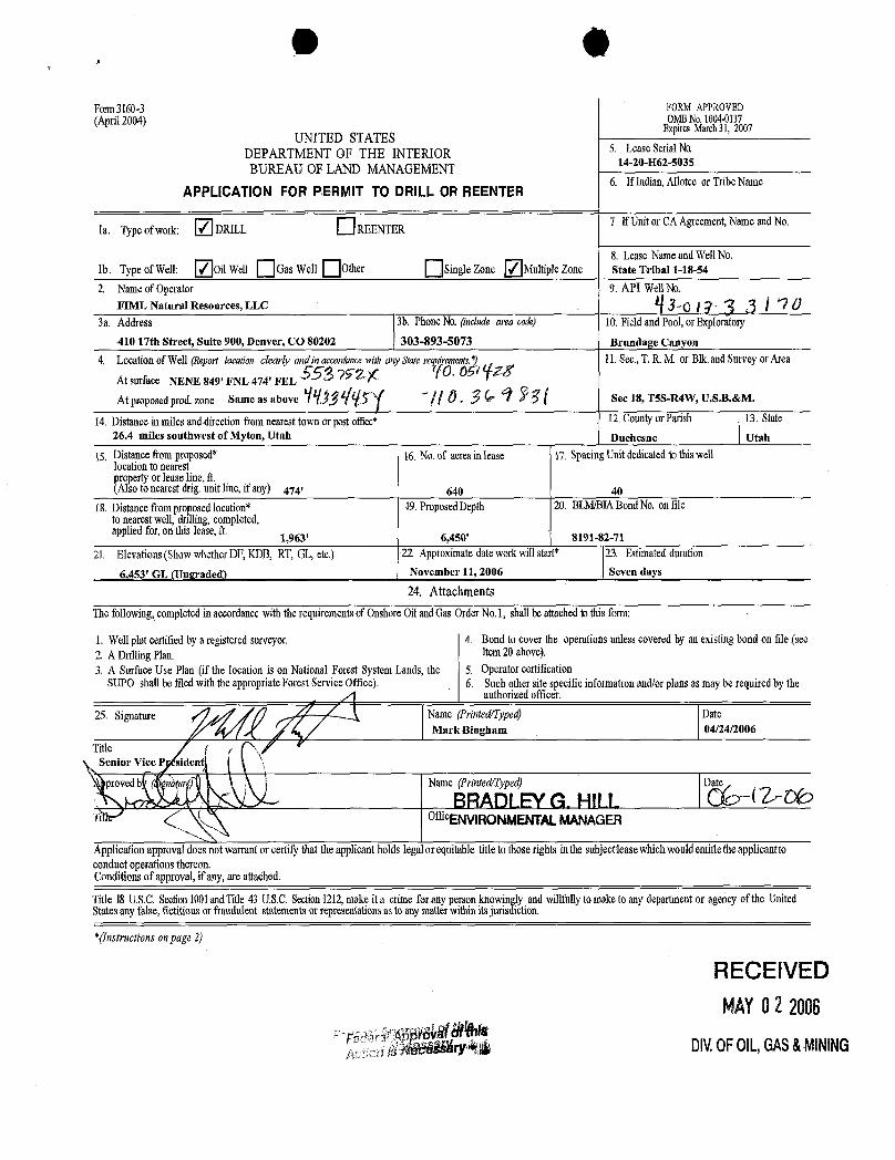
0Form3160-3 FORMAPPROVED(April2004) OMBNo.1004-0137
ExpiresMarch31,2007UNITED STATES
DEPARTMENT OF THE INTERIOR 5. LeaseSerialNo.BUREAU OF LAND MANAGEMENT
14-20-H62-5035
APPLICATIONFOR PERMIT TO DRILLOR REENTER6. IfIndian,AlloteeorTribeName
la. Typeof work: DRILL REENTER 2 IfUnitor CAAgreement,NameandNo.
8. LeaseNameand WellNo.lb. Typeof Well: OilWell GasWell Other SingleZone MultipleZone State Tribal 1-18-54
2. Nameof Operator 9. API WellNo.FIML Natural Resources, LLC Og 2 Û
3a. Address 3b. PhoneNO. (include area cok) 10.Fieldand Pool,orExploratory
410 17th Street, Suite 900, Denver, CO 80202 303-893-5073 Brundage Canyon
4. Locationof Well(Report location clearly and in acconiancewith anyMateaqwrements.*) 11.Sec.,T.R.M. or Blk.andSurveyorArea
At surface NENE 849' FNL 474' FELÛÑ Ë
At proposed prod.zone sameas above | Ô. Ñ Sec 18, T5S-R4W, U.S.B.&M.
14. Distanceinmiles anddirectionfromnearest townorpost office* 12. CountyorParish 13. State26.4 miles southwest of Myton, Utah Duchesne Utah
15. Distancefromproposed* 16. No.of acres inlease 17. SpacingUnitdedicatedto thiswelllocationtonearestproperty or leaseline,ft(Alsotonearest drig.unit line,if any) 474' 640 40
18. Distancefromproposedlocation* 19.ProposedDepth 20. BLM/BIABond No.on fileto nearest well, drilling,completed,appliedfor,on this lease,ft
1,963' 6,450' 8191-82-71
21. Elevations(Showwhether DF,KDB,RT, GL,etc.) 21 Approximatedateworkwill start* 23. Estimatedduration
6,453' GL (Ungraded) November 11, 2006 Seven days
24. AttachmentsThefollowing,completedinaccordancewiththerequirements of OnshoreOilandGasOrderNo.I, shallbeattachedtothisform:
1. Wellplatcertified bya registered surveyor. 4. Bondtocover the operationsunlesscovered by an existing bondon file (see2 A DrillingPlan. Item20 above).3. A SurfaceUse Plan(if the locationis on NationalForestSystemLands,the 5. Operatorcertification
SUPO shallbefiledwith theappropriate ForestServiceOffice). 6. Suchother site specific informationand/orplansas may be required bytheauthorized officer.
25. Signature Name(Printed/Typed) DateMark Bingham 04/24/2006
TitleSenior Vice P sident
proved Name(Printed/Typed) Date
BRADLEYG. HILLofficENVIRONMENTALMANAGER
Applicationapprovaldoesnotwarrantor certifythattheapplicantholdslegalorequitabletitletothoserightsinthe subjectieasewhichwouldentitletheapplicanttoconductoperationsthereon.Conditionsof approval,if any,areattached.
Title 18U.S.C.Section1001andTitle43 U.S.C.Section1212,makeit a crime foranypersonknowinglyandwillfully tomake to anydepartmentor agency of the UnitedStatesanyfalse,fictitiousor fraudulentstatements or representations as to anymatterwithin itsjurisdiction.
*(Instructionsonpage 2)
RECEIVEDMAYO2 2006
ry DIV.0FOIL,GAS&

UTE/FNR, LLC.
T5S, R4W, U.S.B.&M. Well location, STATE TRIBAL //1-18-54, locatedas shown in the NE 1/4 NE 1/4 of Section 18,T5S, R4W, U.S.B.&M. Duchesne County, Utah.
SB954'JO"W - 5124.01' (Meas.) set Marked stone BASIS OF ELEVATIONset stone
BENCH MARK (M67) LOCATEDIN THE SW 1/4 OF SECTIONo> 9, T5S, R4W, U.S.8,&M. TAKEN FROM THE DUCHESNE SEo QUADRANGLE,UTAH, DUCHESNE COUNTY, 7.5 MINUTE QUAD.
RR Lot 7 (TOPOGRAPHIC MAP) PUBLISHED BY THE UNITED STATESI 474· DEPARTMENTOF THE INTERIOR, GEOLOGICALSURVEY. SAID5 4 S72 7E 1R/BAL /1-18-54 ELEVATIONIS MARKED ON CAP AS BEING 6097 FEET.
WWElev. Unsraded Ground = 6457 BAsis OF BEARINGS
BASIS OF BEARINGS IS A G.P.S. OBSERVATION.
Lot 2N
18o
^o
oo o - o
Lot JSCALE
CERTIFICATETHIS IS TO CERTIFYTHAT THE ABOVE PLAT WAS PREPARED FROMFlELD NOTES OF ACTUALSURVEYS MADE BY YSUPERVISIONAND THAT THE SAME ARE EBEST OF MY KNOWLEDGEAND BEL .
Lot 4REGl!!IEREGI ATI .
STATE AHSet Marked Stone Pile of Stones Set Marked Stone
NB9°58'23"W- 2482.73' (Aleas.) NB9°J8'46"W
- 2642.44' (Meas.) 2' UINTAH ENGINEERING &BS SOUTH 200 EAST - VERNAL, H 84078
LEGEND: (NAD 83) (435) 789-1017LATITUDE =
40°03'05.02" (40.051394) SCALE DATESURVEYED: DATEDRAWN:=90° SYMBOL LONGlTUDE=
110°22'13.74" (110.370483) 1" = 1000' 02-10-06 04-10-06= PROPOSED WELL HEAD. (NAD 27) PARTY REFERENCES
LATITUDE =40°03'05.16" (40.051433) B.H. J.T. C.G. G.L.O. PLATA = SECTION CORNERS LOCATED.
LONGITUDE=110°22'11.19" (110.369775)
WEATHERCOOL
FILE
UTE/FNR,

O O
SELF CERTIFICATION STATEMENT
The following self-certification statement is provided per federal requirements dated June15, 1988.
Please be advised that FIML Natural Resources, LLC is considered to be the operator ofthe following well.
State Tribal 1-18-54NE/4 NE/4 849' FNL 474' FEL, Section 18 T-5S, R-4 W U.S.B. & M.Lease BIA: 14-20-H62-5035Duchesne County, Utah
FIML Natural Resources, LLC is responsible under the terms of this lease for theoperations conducted upon lease lands.
Rick L. ParksOperations ManagerFIML Natural Resources, LLC410 17th S reeSuite 900Denver, Colorado 80202(303)
O O
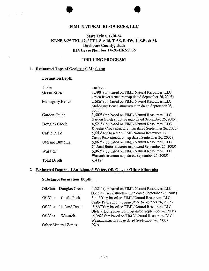
FIML NATURAL RESOURCES, LLC
State Tribal 1-18-54NENE 849' FNL 474' FEL Sec 18, T-5S, R-4W, U.S.B. & M.
Duchesne County, UtahBIA Lease Number 14-20-H62-5035
DRILLING PROGRAM
1. Estimated Tops of Geological Markers:
Formation Depth
Uinta surfaceGreen River 1,398' (top based on FIML Natural Resources, LLC
Green River structure map dated September 26, 2005)Mahogany Bench 2,686' (top based on FIML Natural Resources, LLC
Mahogany Bench structure map dated September 26,2005)
Garden Gulch 3,602' (top based on FIML Natural Resources, LLCGarden Gulch structure map dated September 26, 2005)
Douglas Creek 4,521' (top based on FIML Natural Resources, LLCDouglas Creek structure map dated September 26, 2005)
Castle Peak 5,443' top based on FIML Natural Resources, LLCCastle Peak structure map dated September 26, 2005)
Uteland Butte Ls. 5,867' (top based on FIML Natural Resources, LLCUteland Butte structure map dated September 26, 2005)
Wasatch 6,062' (top based on FIML Natural Resources, LLCWasatch structure map dated September 26, 2005)
Total Depth 6,412'
2. Estimated Depths of Anticipated Water, Oil, Gas, or Other Minerals:
SubstanceFormation Depth
Oil/Gas Douglas Creek 4,521' (top based on FIML Natural Resources, LLCDouglas Creek structure map dated September 26, 2005)
Oil/Gas Castle Peak 5,443'(top based on FIML Natural Resources, LLCCastle Peak structure map dated September 26, 2005)
Oil/Gas Uteland Butte 5,867'(top based on FIML Natural Resources, LLCUteland Butte structure map dated September 26, 2005)
Oil/Gas Wasatch 6,062' (top based on FIML Natural Resources, LLCWasatch structure map dated September 26, 2005)
Other Mineral Zones N/A
- 1

O O
3. Pressure Control Equipment:
Please refer to FIML Natural Resources, LLC Standard Operating Procedure(SOP Version: Revised October 6, 2005).
4. Proposed Casing and Cementing Program:
Please refer to FIML Natural Resources, LLC Standard Operating Procedure(SOP Version: Revised October 6, 2005).
5. Drilling Fluids Program:
Please refer to FIML Natural Resources, LLC Standard Operating Procedure(SOP Version: Revised October 6, 2005).
6. Evaluation Program:
Please refer to FIML Natural Resources, LLC Standard Operating Procedure(SOP Version: Revised October 6, 2005).
7. Abnormal Conditions:
Please refer to FIML Natural Resources, LLC Standard Operating Procedure(SOP Version: Revised October 6, 2005).
8. Anticipated Starting Dates and Notification of Operations:
Please refer to FIML Natural Resources, LLC Standard Operating Procedure(SOP Version: Revised October 6, 2005).
9. Other Information:
Please refer to FIML Natural Resources, LLC Standard Operating Procedure(SOP Version: Revised October 6, 2005).
- 2

2M SYSTEMBLO\NOUT PREVENTER FOR HIGH PRESSURE WELLS
900 SERIES MINIMUM2000# psi W.P.
BOP 6" X 3000 PS1 or 10" X 3000 PSI
DRILIJNG RTPPL£
PE RAMS
8 NOAA
CS¾iUNEKILLUNE
ADJUSTABLECHOKETOPlTAND/OAMUD/ GASSEPARATOA
BLEED UNE TO PIT
2 * 2" NOMINAL
TO PlT
ADJUSTABLECHOKE

O O
FIML NATURAL RESOURCES, LLC
State Tribal 1-18-54NENE 849' FNL 474' FEL, Sec 18, T-5S, R-4W, U.S.B. &M. Duchesne County, Utah
Lease Number 14-20-H62-5035
Onshore Order No. 1
MULTI-POINT SURFACE USE & OPERATIONS PLAN
1. Existing Roads
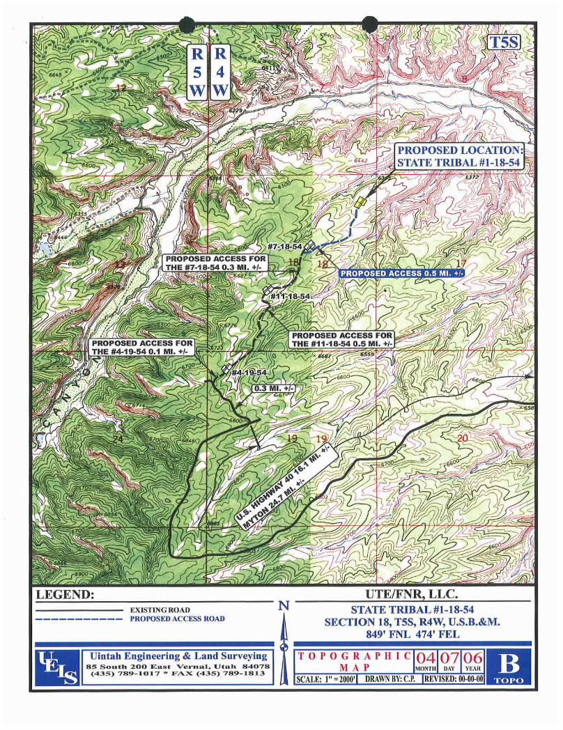
A. Start in Myton, Utah. Proceed west on US Highway 40, 8.8 miles to theAntelope Creek/Sowers Canyon Road at the Bridgeland turnoff. Turn southand proceed 10.1 miles on the Sowers Canyon Road. Turn southwest on theBrundage Canyon Road and proceed approximately 5.0 miles. Turn north andproceed approximately 0.3 miles to the Berry proposed Ute Tribal 4-19-54location. Continue on the access road for approximately 0.1 miles. The roadthen becomes the access road for the Ute Tribal 11-18-54. Continue forapproximately 0.5 miles and the road becomes the access road for the UteTribal 7-18-54. Continue 0.3 miles to the proposed access road for the UteTribal 1-18-54. Continue 0.5 miles to the Ste Tribal 1-18-54 proposedlocation.
B. The proposed well site is located approximately 26.4 miles southwest ofMyton, Utah - See attached Topographic Map "A".
C. Refer to attached Topographic Map "A".D. Existing roads will be maintained and repaired as necessary. No off lease
Right-of-Way will be required.
2. Planned Access Roads
See Topographic Map "B" for the location of the proposed access road.
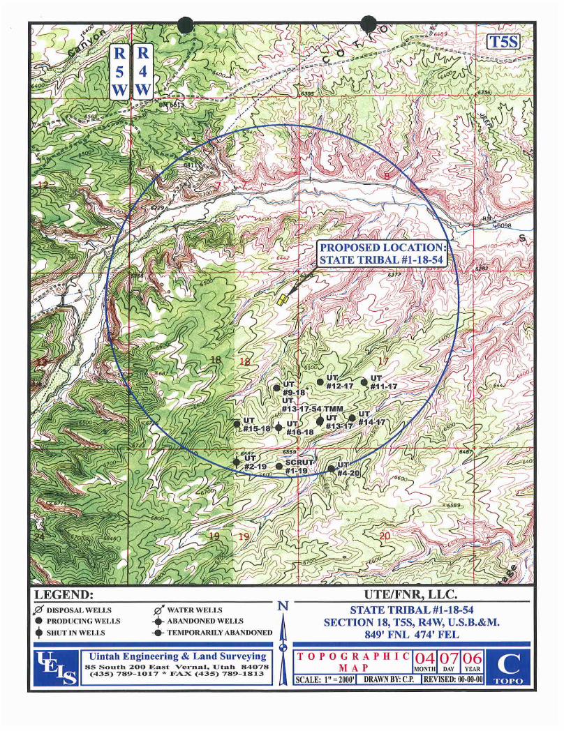
3. Location of existing wells within a one mile radius of proposed well location
See Topographic Map "C" for the location of existing wells within a one-mile radius.
4. Location of Existing and lor Proposed Facilities
Please refer to FIML Natural Resources, LLC Standard Operating Procedure (SOPVersion: October 6, 2005).
- 1

O O
5. Location and Type of Water Supply
A. Water supply will be from East Duchesne Water District, Arcadia, Utah.Section 28, T-3S, R-3W, Duchesne County, Utah. The water right number is43-10152.
B. Water will be hauled by Ute Tribal Water Service.C. No water well will be drilled on the lease.
6. Source of Construction Materials
Please refer to FIML Natural Resources, LLC Standard Operating Procedure (SOPVersion: October 6, 2005).
7. Method of Handling Waste Materials
Please refer to FIML Natural Resources, LLC Standard Operating Procedure (SOPVersion: October 6, 2005).
8. Ancillary Facilities
Please refer to FIML Natural Resources, LLC Standard Operating Procedure (SOPVersion: October 6, 2005).
9. Well Site Layout
The attached Location Layout diagram describes drill pad cross-sections, cuts andfills, and locations of the mud tanks, reserve pit, pipe racks, trailer parking, spoil dirtstockpile(s) and top soil stockpile(s).
10. Plans for Restoration of the Surface
Please refer to FIML Natural Resources, LLC Standard Operating Procedure (SOPVersion: October 6, 2005).
11. Surface Ownership
Access Road: Utah Division of Wildlife ResourcesLocation: Utah Division of Wildlife Resources
12. Other Information
Please refer to FIML Natural Resources, LLC Standard Operating Procedure (SOPVersion: October 6, 2005).
- 2

O O
13. Operator's Representative and Certification
Name: Rick L. Parks
Address: 410 17*Street
Suite 900Denver, Colorado 80202
PhoneNo. 303-893-5081Cellular No. 303-229-7689
All lease and/or unit operations will be conducted in such a manner that fullcompliance is made with all applicable laws, regulations and Onshore Oil and GasOrders. FIML Natural Resources, LLC is fully responsible for the actions of itssubcontractors. A copy of these conditions will be furnished to the fieldrepresentative to ensure compliance.
Certification:
I hereby certify that I, or persons under my direct supervision, have inspected theproposed drill site and access route; that I am familiar with the conditions thatpresently exist; that the statements made in this plan are, to the best of my knowledgeand belief, true and correct; and that the work associated with operations proposedherein will be performed by FIML Natural Resources, LLC and its contractors andsubcontractors in conformity with this plan and the terms and conditions under whichit was approved. This statement is subject to the provisions of 18 U.S. C. 1001 forthe filing of a false statement.
Date Rick L. ParksOperations ManagerFIML Natural Resources, LLC
- 3
O O
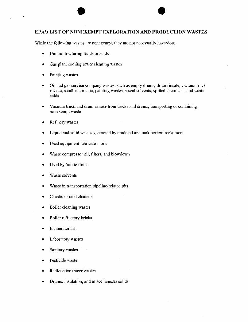
EPA's LIST OF NONEXEMPT EXPLORATION AND PRODUCTION WASTES
While the following wastes are nonexempt, they are not necessarily hazardous.
• Unused fracturing fluids or acids
• Gas plant cooling tower cleaning wastes
• Painting wastes
• Oil and gas service company wastes, such as empty drums, drum rinsate, vacuum truckrinsate, sandblast media, painting wastes, spend solvents, spilled chemicals, and wasteacids
• Vacuum truck and drum rinsate from trucks and drums, transporting or containingnonexempt waste
• Refinery wastes
• Liquid and solid wastes generated by crude oil and tank bottom reclaimers
• Used equipment lubrication oils
• Waste compressor oil, filters, and blowdown
• Used hydraulic fluids
• Waste solvents
• Waste in transportation pipeline-related pits
• Caustic or acid cleaners
• Boiler cleaning wastes
• Boiler refractory bricks
• Incinerator ash
• Laboratory wastes
• Sanitary wastes
• Pesticide waste
• Radioactive tracer wastes
• Drums, insulation, and miscellaneous

O OUTE/FNR, LLC.
STATE TRIBAL #1-18-54LOCATED IN DUCHESNE COUNTY, UTAH
SECTION 18, T5S, R4W, U.S.B.&M.
PHOTO: VIEW FROM CORNER #5 TO LOCATION STAKE CAMERA ANGLE: NORTHWESTERLY
I
PHOTO: VIEW FROM BEGINNING OF PROPOSED ACCESS FOR THE #11-18-54 CAMERA ANGLE: SOUTHEASTERLY
I Uintah Engineering & Land Surveying I-OCATIONPHOTos O 07 06 PHOTO85 South 200 East Vernal, Utah 84078 "0" "I TR*
¿4_ 435-789-1017 [email protected] TAKENBY:B.H. DRAWNBY:C.P.

O OUTE/FNR LLC.LOCATION LAYOUT FOR
STATE TRIBAL #1-18-54SECTION 18, T5S, R4W, U.S.8.&M.
849' FNL 474' FELProposed Access ,
C- 10. 4 ' "°°"
8. 60. '
6Sta. J+ JO
"°" C- 12. 1' MSCALE: 1" = 50' Cut Slope S. 625'DATE: 04-10-06DRAWN BY: C.G Round Corners NO
NOmà ¾
os Needed
be /ocated a rnin.of 100' frorn theWell Head. I I I I
lore Pit 'g- g Approx.B. 56.7 , PIPE RACKS Toe of
Fill Slope
(Ðtm.Pit) --- DOG HOUSE125' Sta. 1+60
-- lgdì•9 Existing.
Eksen PUMP Drainage
MUD SHED TOILET
HOPPER
POWER
TOOLS
FUEL
TRASH STORAGETANK
F-6.0'E/. 44.4' Sta. 0+00
A
4.B. 44.5' E/. 46.7(Btm. Pit)
Dev. Ungraded Ground at Location Stoke = 6453. J', UINTAH ENGINEERING & LAND SURVEYING
Bev. Graded Ground at Location Stake = 6450.4 86 So. ß00 East * Vernal, Utah 84078 * (435)

UTE/FNR LLC.tilTYPICALCROSS SECTIONSFOR
o STATE TRIBAL//1-18-54x--section SECTION 18, T5S, R4W, U.S.B.&M. p.
Scale849' FNL 474' FEL
1" = 50'
40' 125'DA E 04 0-0
Preconstruction SM. J+JOGrade
10 70' 40' 125'
LOCAT/0H STAKE S/ope = 1 1/2: 1
- CUT
F SM. 1 60
10' 70' 40' 125'
inished Grade
120' 125'
No SM. 0+00Topsoil should not beStripped Below FinishedGrade on Substructure Areo.
* NOTE:E/LL QUANT/TY/NCLUDESSX FOR COh/PAC710N
APPROXlMATEYARDAGES
CUTEXCESS MATERIAL = 5,1]O Cu. Yds.
(12") Topsoil Stripping =JJJO Cu. Yds. Topsoil & Pit Backfill = 5,1]O Cu. Yds.(1/2 Pit Vol.)
Remaining Location = 10,500 Cu. Yds.EXCESS UNBALANCE = 0 Cu. Yds.
TOTAL CUT = 13,830 CU.YDS. (After Interim Rehabilitation)
FILL = 8, 700 CU.YDS· UINTAH ENGINEERING & LAND SURVEYING86 So. ß00 Easi * Vernal, Utah 84078 * (436)

LEGEND: UTE/FNR, LLC.O PROPOSED LOCATION N STATE TRIBAL #148-54
SECTION 18, TSS, R4W, U.S.B.&M.849' FNL 474' FEL
Uintah Engineering & Land Surveying TOPOGR A PH I e 04 07 0685 South 200 East Vernat, Utah 84078 M A P MONTH DAY YEAR
(435) 789-1917 * FAX (435) 789-1813SCALF;1"= 2000 DRAWNBY:C.P. REVISED
5 4WW
PROPOSED ACCESS FOR# 8-54 +
PROPOSED ACCESS FOR Jr
LEGEND: UTE/FNR, LLC.EXISTING ROAD N STATE TRIBAL #1-18-54
----------- PROPOSED ACCESS ROAo SECTION 18, TSS, R4W, U.S.B.&M.849' FNL 474' FEL-, Uintah Engineering & Land Surveying TOPOGR A BI I c 04 07 06
4ÊÎ s - o ir fig isoi SCALE:1"= 2 00 DRAWNBY:C.R S
N:STATE TRIBAL #1-18-54
LEGEND: UTE/FNR, LLC.y MSPOSAI, WERS g( WATER WELLS N STATE TRIBAL #1-18-54e PRODUCING WELLS ABANDONED WELLS SECTION 18, T5S, R4W, U.S.B.&M.
$HUT IN WELLS & TEMPORARILY ABANDONED 849' FNL 474' FEL
- Uintah Engineering & Land Surveying TOPOGR A PH I c 04 0 085 South 200 East Vernal, Utuh 84078 ÑÎ À Ÿ MONT DAY YEAR
(435) 789-1011 * FAX (435) 789-1813SCALE:1"= 20001 DRAWNRY:C.P. REVISED:

'Ï'5S1
PROPOSED LOCATION:
APPROXIMATE TOTAL PIPELINE DISTANCE = 2,439' +/-
LEGEND: UTE/FNR, LLC.PROPOSED ACCESS ROAD N STATE TRIBAL #1-18-54
¯¯¯¯¯"¯¯¯ ¯¯ SECTION 18, T5S, R4W, U.S.B.&M.
-(SERVICING OTHER WELLS) 849' FNL 474' FEL
Uintah Engineering & Land Surveying TOPOGR A PH I e 04 07 06 |85 South 200 East Vernal, Utah 84078 M A P NTH DAY YEAR(435) 789-1017 * FAX (435) 789-1813
SCALE:1"= 1000' DRAWNBY:CÆ REVISED:
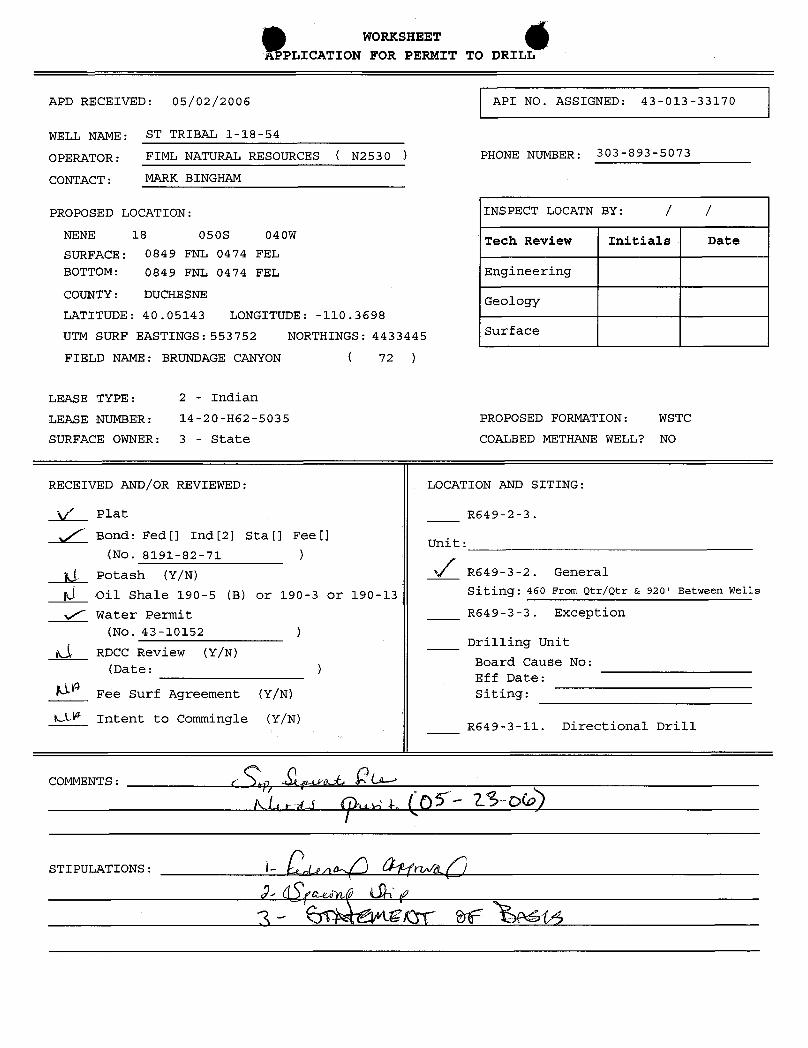
WORKSHEETAPPLICATION FOR PERMIT TO DRILL
APD RECEIVED: 05/02/2006 API NO. ASSIGNED: 43-013-33170
WELL NAME: ST TRIBAL 1-18-54
OPERATOR: FIML NATURAL RESOURCES ( N2530 ) PHONE NUMBER: 303-893-5073
CONTACT: MARK BINGHAM
PROPOSED LOCATION: INSPECT LOCATN BY: / /NENE 18 050S 040W .Tech Review Initials DateSURFACE: 0849 FNL 0474 FEL
BOTTOM: 0849 FNL 0474 FEL Engineering
COUNTY: DUCHESNEGeology
LATITUDE: 40.05143 LONGITUDE: -110.3698
UTM SURF EASTINGS:553752 NORTHINGS:4433445 Surface
FIELD NAME: BRUNDAGE CANYON ( 72 )
LEASE TYPE: 2 - Indian
LEASE NUMBER: 14-20-H62-5035 PROPOSED FORMATION: WSTC
SURFACE OWNER: 3 - State COALBED METHANE WELL? NO
RECEIVED AND/OR REVIEWED: LOCATION AND SITING:
\f' Plat R649-2-3.
y/' Bond:Fedf] Ind[2] Sta[] Fee[]Unit:
(No. 8191-82-71 )
(1 Potash (Y/N) % R649-3-2. General
6 Oil Shale 190-5 (B) or 190-3 or 190-13 Siting: 460 From Qtr/Qtr & 920' Between Wells
v/' Water Permit R649-3-3. Exception
(No. 43-10152 )Drilling UnitLÁ RDCC Review (Y/N)
Board Cause No:(Date: )Eff Date:
Fee Surf Agreement (Y/N) Siting:
LLW Intent to Commingle (Y/N) ,R649-3-11. Directional Drill
COMMENTS: r
STIPULATIONS: L cg¿n
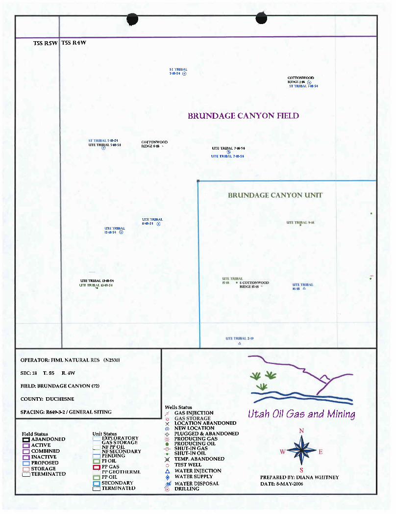
0TSS R5W T5S R4W
ST TRIBAL3 18 54 @
CGITONWOODRIDGEMB Q5T TRIBAL MS-54
BRUNDAGE CANYON FIELD
si IRititt $18-54 CUETONWOODLETETR AL 5-18-54
RIDGE 618 N
UTE TRIBAL 7-18 54
i lìRUNDAGE CANYON UNIT
UTE TRIBALIMS-54 @ LIII TRilii IN
urnuna12-18-54 @
UTE TR I18 SC O YOOD
I DIL LMIBAL 2 1
OPERATOR: FIML NATURAL RES (N2530)
SEC:18 T.5S R.4W
FIELD: BRUNDAGE CANYON (72)
COUNTY: DUCHESNE
Wells StatusSPACING:R649-3-2/GENERALSITING / GASINJECTION Utah 08 Gas and MMM
g GAS STORAGE× LOCATION ABANDONED
NEW LOCATIONField Status Unit Status PLUGGED &cABANDONEDQ ABANDONED EXPLORATORY PRODUCING GASO AcrIVE GAS STORAGE e PRODUCING OIL
COMBINEDCOOWARY
W EINACTIVE P ING
p( TEMP. ABANDONED
M TED G THERML A N ECTION SPP OIL g WATER SUPPLY PREPAREDBY:DIANA WHITNEYSECONDARY g WATER DISPOSAL DATE: 8-MAY-2006TERMINATED f i
O
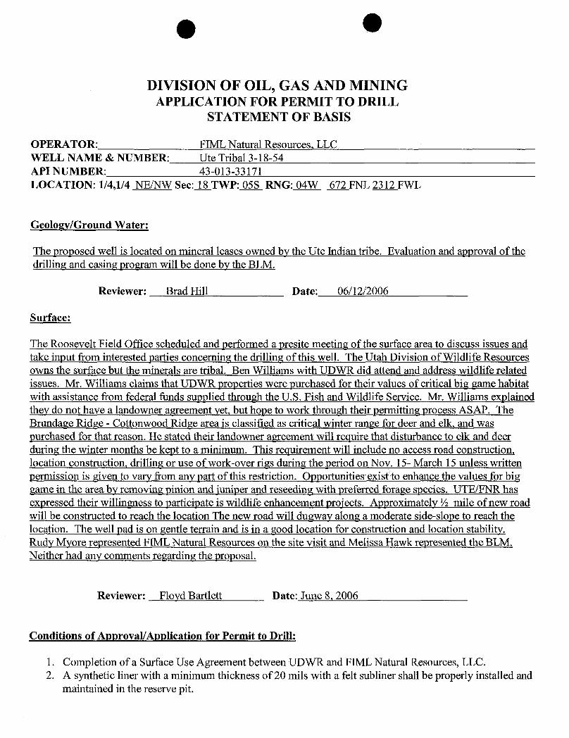
DIVISION OF OIL, GAS AND MININGAPPLICATION FOR PERMIT TO DRILL
STATEMENT OF BASIS
OPERATOR: FIML Natural Resources, LLCWELL NAME & NUMBER: Ute Tribal 3-18-54API NUMBER: 43-013-33171LOCATION: 1/4,1/4 NE/NW Sec:XTWP: 05S RNG: 04W 672 FNL 2312 FWL
Geology/Ground Water:
The proposed well is located on mineral leases owned by the Ute Indian tribe. Evaluation and approval of thedrilling and casing program will be done by the BLM.
Reviewer: Brad Hill Date: 06/12/2006
Surface:
The Roosevelt Field Office scheduled and performed a presite meeting of the surface area to discuss issues andtake input from interested parties concerning the drilline of this well. The Utah Division of Wildlife Resourcesowns the surface but the minerals are tribal. Ben Williams with UDWR did attend and address wildlife relatedissues. Mr. Williams claims that UDWR properties were purchased for their values of critical big game habitatwith assistance from federal funds supplied through the U.S. Fish and Wildlife Service. Mr. Williams explainedthey do not have a landowner agreement yet, but hope to work through their permitting process ASAP. TheBrundage Ridge - Cottonwood Ridge area is classified as critical winter range for deer and elk, and waspurchased for that reason. He stated their landowner agreement will require that disturbance to elk and deerduring the winter months be kept to a minimum. This requirement will include no access road construction,location construction, drilling or use of work-over rigs during the period on Nov. 15- March 15 unless writtenpermission is given to vary from any part of this restriction. Opportunities exist to enhance the values for biggame in the area by removing pinion and juniperand reseeding with preferred forage species. UTE/FNR hasexpressed their willineness to participate is wildlife enhancement projects. Approximately ½ mile of new roadwill be constructed to reach the location The new road will duaway along a moderate side-slope to reach thelocation. The well pad is on gentle terrain and is in a good location for construction and location stability.Rudy Myore represented FIML Natural Resources on the site visit and Melissa Hawk represented the BLM.Neither had any comments regarding the proposal.
Reviewer: Floyd Bartlett Date: June 8, 2006
Conditions of Approval/Application for Permit to Drill:
1. Completion of a Surface Use Agreement between UDWR and FIML Natural Resources, LLC.2. A synthetic liner with a minimum thickness of 20 mils with a felt subliner shall be properly installed and
maintained in the reserve

g (Iþ-SITE PREDRILL EVALUATION
Division of Oil, Gas and Mining
OPERATOR: FIML Natural Resources, LLCWELL NAME & NUMBER: Ute Tribal 3-18-54
API NUNBER: 43-013-33171LEASE: State/Tribal(14-20-H62-5035) FIELD/UNIT: Brundage Canyon FieldLOCATION: 1/4,1/4 NE/NW Sec: 18 TWP: 05S RNG: 04W 672 FNL 2312 FWLLEGAL WELL SITING: 460 F SEC. LINE; 460 F 1/4,1/4 LINE; 920 F ANOTHER WELL.GPS COORD (UTM): X =553052 E; Y =4433493 N SURFACE OWNER: Utah Division ofWildlife Resources
PARTICIPANTSFloyd Bartlett (DOGM),Rudy Myore (UTE/FNR),Ben Williams (Utah__Divisionof Wildlife Resources), Melissa Hawk (BLM), Dan Rasmussen and JordonMonsen (UELS).
REGIONAL/LOCAL SETTING & TOPOGRAPHY
Well site is proposed approximately 26.4miles +/- southwest o_f Myton,Utah along Sowers Canyon Road to a Brundage Ridge oil well developmentroad on Tribal lands. Following this road to the existing Ute Tribal11-18-54 well then following a road to be constructed to the 5-18-54well approximately 0.2 miles then along approximately 0.5 miles of roadto be constructed to the proposed location.
The location is on a flat-topped ridge with a slight slope to the northtoward Sowers Canyon. Topography in the area becomes very steep to thenorth as the drainages drop into Sowers Canyon however all the proposedlocation is nearly flat with no intersecting drainages. The areaconsists of a Pinion-Juniper habitat type. Sowers Canyon, approximately½ mile to the north, contains a perennial stream, which ioins AntelopeCreek. Antelope Creek flows northerly into the Duchesne River nearBridgeland, Utah.
SURFACE USE PLAN
CURRENT SURFACE USE: Winter range for elk and mule deer.
PROPOSED SURFACE DISTURBANCE: Proposed construction 0.5 miles of accessroad and a well location 330'x 165' plus a 190' x 70' x10'reserve pitand soil stockpile storage outside the described area.
LOCATION OF EXISTING WELLS WITHIN A 1-MILE RADIUS: See 'TOPO C'
LOCATION OF PRODUCTION FACILITIES AND PIPELINES: Production equipmentshall remain on location unless otherwise authorized by the Division,gas pipelines run along access road to existing tie in points. A lineowned by Berry Petroleum will be used under an agreement.
SOURCE OF CONSTRUCTION MATERIAL: Native cut and fill using borrowedmaterial
ANCILLARY FACILITIES: None

OWILL DRILLING AT THIS LOCATION GENERATE PUBLIC INTEREST OR CONCERNS?(EXPLAIN): Probably not as there are several other wells in the
Brundage, Cottonwood and Tabby Canyon area. However, some sportsmenhave expressed concern with well development on UWR lands diminishingtheir value as big game habitat.
WASTE MANAGEMENT PLAN:
As detailed in UTE/FNR Standard Operating Procedure
ENVIRONMENTAL PARAMETERS
AFFECTED FLOODPLAINS AND/OR WETLANDS: None.
FLORA/FAUNA: Mixed grass lands frequently dominated with dense stands ofpinion-juniper. Site is on a ridge dominated by pinion and iuniper.Other species are infrequent but include black sagebrush and squirreltail, needle and thread grass, Indian ricegrass and shadscale. Area isclassified as critical elk and deer winter range by the UDWR. Otherspecies common include mountain lion, bobcat, rabbit, coyote and smallerbirds and mammals.
SOIL TYPE AND CHARACTERISTICS: Moderately deep medium brown sandy loam.Frequent brown surface rock erosion pavement.
SURFACE FORMATION & CHARACTERISTICS: Broad gentle north sloping ridgewith a few draws or swales. Planned access road and well site are ingood locations relative to the topography.
EROSION/SEDIMENTATION/STABILITY: Current erosion is light. No stabilityproblems are expected with pad construction and access to the location.
PALEONTOLOGICAL POTENTIAL: None observed during onsite
RESERVE PIT
CHARACTERISTICS: Proposed in cut on southwest side of location,measuring 70'x 190'x 10' deep.
LINER REQUIREMENTS (Site Ranking Form attached): 22 points. A liner isrequired for the reserve pit.
SURFACE RESTORATION/RECLAMATION PLAN
According to Landowner Agreement and seed mixture provided by UDWR
SURFACE AGREEMENT: No
CULTURAL RESOURCES/ARCHAEOLOGY: A survey was completed by James A. Truesdaleand submitted to DOGM and UDWR according to requirements. On Tribal Landsnorth of the Ute Tribal 11-18-54 well an old fence and possible corral hasbeen constructed from pinion and juniper. The proposed road in this area wasre-routed at the request of the Ute Indian
OOTHER OBSERVATIONS/COMMENTS
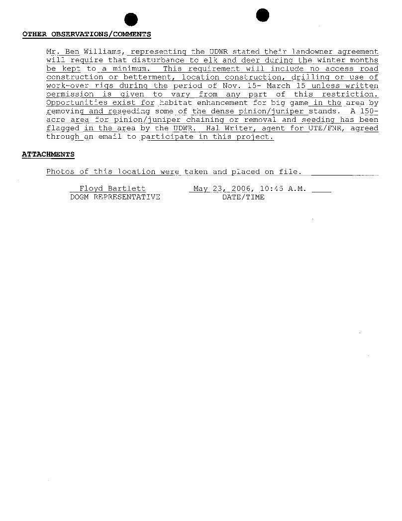
Mr. Ben Williams, representing the UDWR stated their landowner agreementwill require that disturbance to elk and deer during the winter monthsbe kept to a minimum. This requirement will include no access roadconstruction or betterment, location construction, drilling or use ofwork-over_ rigs during the period of Nov. 15- March 15 unless writtenpermission is given to vary from any part of this restriction.Opportunities exist for habitat enhancement for big game in the area byremoving and reseeding some of the dense pinion/iuniper stands. A 150-acre area for pinion/iuniper chaining or removal and seedinq has beenflaqqed in the area by the UDWR. Hal Writer, agent for UTE/FNR, agreedthrough an email to participate in this project.
ATTACHMENTS
Photos of this location were taken and placed on file.
Floyd Bartlett May 23, 2006, 10:45 A.M.DOGM REPRESENTATIVE

g Ouation Ranking Criteria and Ranking Score
For Reserve and Onsite Pit Liner Requirements
Site-Specific Factors Ranking Site Ranking
Distance to Groundwater (feet)>200 0100 to 200 575 to 100 1025 to 75 15<25 or recharge area 20 __0
Distance to Surf. Water (feet)>1000 0300 to 1000 2200 to 300 10100 to 200 15< 100 20 2
Distance to Nearest MunicipalWell (feet)
>5280 01320 to 5280 5500 to 1320 10<500 20 0
Distance to Other Wells (feet)>1320 0300 to 1320 10<300 20 0
Native Soil TypeLow permeability 0Mod. permeability 10High permeability 20
Fluid TypeAir/mist 0Fresh Water 5TDS >5000 and <10000 10TDS >10000 or Oil Base Mud Fluid 15
containing significant levels ofhazardous constituents 20 5
Drill CuttingsNormal Rock OSalt or detrimental 10 0
Annual Precipitation (inches)<10 010 to 20 5>20 10 5
Affected Populations<10 010 to 30 630 to 50 8>50 10 0
Presence of Nearby UtilityConduits
Not Present 0Unknown 10Present 15 0
Final Score 22 (Level II Sensitivity)
SensitivityLevel I = 20 or more: total containment is required, consider criteria for excluding pit use.SensitivityLevel H = 15-19:lining is discretionary.SensitivityLevel HI = below 15: no specific lining is

.y_.
64
? 5.
I
5

.

©JON M. HUNTSMAN, JR.
Governor
GARY R. HERBERTLieutenant Governor
State of Utah June 12, 2006
Department ofNatural Resources
MICHAEL R. STYLERExecutiveDirector FIML Natural Resources, LLC
410 17th St., Ste. 900Division of Denver, CO 80202
Oil, Gas & Mining
JOHN R BAZADivisionoirec'°' Re: State Tribal 1-18-54 Well, 849' FNL, 474'FEL, NE NE, Sec. 18, T. 5 South,
R. 4 West, Duchesne County, Utah
Gentlemen:
Pursuant to the provisions and requirements of Utah Code Ann.§ 40-6-1 etseq., Utah Administrative Code R649-3-1 et seq., and the attached Conditions ofApproval, approval to drill the referenced well is granted.
This approval shall expire one year from the above date unless substantial andcontinuous operation is underway, or a request for extension is made prior to theexpiration date, The API identification number assigned to this well is 43-013-33170.
Sincerely,
Gil HuntAssociate Director
pabEnclosures
cc: Duchesne County AssessorBureau of Land Management, Vernal District Office
1594 West North Temple, Suite 1210, PO Box 145801, Salt Lake City, UT 84114-5801telephone (801) 538-5340 • facsimile{801) 359-3940 • TTY (801) 538-7458 •

O
Operator: FIML Natural Resources, LLCWell Name & Number State Tribal 1-18-54
API Number: 43-013-33170Lease: 14-20-H62-5035
Location: NE NE Sec.__1_8_ T. 5 South R. 4 West
Conditions of Approval
1. GeneralCompliance with the requirements of Utah Admin. R. 649-1 et seq., the Oil and GasConservation General Rules, and the applicable terms and provisions of the approvedApplication for permit to drill.
2. Notification RequirementsNotify the Division within 24 hours of spudding the well.• Contact Carol Daniels at (801) 538-5284.
Notify the Division prior to commencing operations to plug and abandon the well.• Contact Dan Jarvis at (801) 538-5338
3. Reporting RequirementsAll required reports, forms and submittals will be promptly filed with the Division,including but not limited to the Entity Action Form (Form 6), Report of Water -
Encountered During Drilling (Form 7), Weekly Progress Reports for drilling andcompletion operations, and Sundry Notices and Reports on Wells requesting approval ofchange of plans or other operational actions.
4. State approval of this well does not supersede the required federal approval, which must beobtained prior to drilling.
5. This proposed well is located in an area for which drilling units (well spacing patterns) havenot been established through an order of the Board of Oil, Gas and Mining (the "Board").In order to avoid the possibility of waste or injury to correlative rights, the operator isrequested, once the well has been drilled, completed, and has produced, to analyzegeological and engineering data generated therefrom, as well as any similar data fromsurrounding areas if available. As soon as is practicable after completion of its analysis,and if the analysis suggests an area larger than the quarter-quarter section upon which thewell is located is being drained, the operator is requested to seek an appropriate orderfrom the Board establishing drilling and spacing units in conformance with such analysisby filing a Request for Agency Action with the Board.
6. Compliance with the Conditions of Approval/Application for Permit to Drill outlined in theStatement of Basis. (Copy

Form 3160-5 UNITED STATES(April2004) DEPARTMENTOF THE INTERIOR E ires 007BIJREAU OF LAND MANAGEMENT 5. LeaseSerialNo.
SUNDRY NOTICES AND REPORTS ON WELLS 14-20-H62-5035
Do not use this form for proposals to drill or to re-enteran 6. IfIndian,AllotteeorTribeNameabandoned well. Use Form 3160 - 3 (APD) for such proposals. Ute Tribe
SUBMIT IN TRIPLICATE- Otherinstructions on reverse side. 7. IfUnitorCA/Agreement,Nameand/orNo.
1. Type oilWell GasWeg Other 8. WellNameand No.
State Tribal 1-18-542. NameofOperatorFIML Natural Resources, LLC 9. API WellNo.3a Address 3b. PhoneNo. (include area code) 43-013-33170
410 17th Street, Suite 900 Denver, CO 80202 303-893-5090 10.FieldandPool,or ExploratoryArea4. LocationofWell (Footage,Sec.,T, R.,M, or SurveyDescnption) Brundage Canyon
NENE 849' FNL 474' FEL Sec 18 T-5S, R-4W 11. Countyor Parish, State
Duchesne
12. CHECK APPROPRIATEBOX(ES)TO INDICATE NATURE OF NGIICF, REPORT, OR OTHER DATA
TYPE OF SUBMISSION TYPEOF ACTION
Acidize Deepen Production (Start/Resume) WaterShut-OffNoticeof Intent AlterCasing Fracture Treat Reclamation WellIntegrity
SubsequentReport Casing Repair NewConstruction Recomplete Other Location Change
ChangePlans Plug andAbandon Temporarily AbandonFinal AbandonmentNotice Convertto Injection PlugBack WaterDisposal
13. Describe Proposed or CompletedOperation(clearly stateallpertinentdetails,includingestimated starting dateof any proposedwork and approximate durationthereofIf theproposalisto deependirectionallyor recomplete horizontally,givesubsurface locationsand measured and truevertical depthsof all pertinentmarkers andzones.Attach theBond under which thework will beperformedorprovidetheBond No. on filewith BLM/BIA.Requiredsubsequent reports shall befiledwithin 30daysfollowingcompletion of the involvedoperations. Iftheoperation results ina multiple completion or recompletion ina new interval,a Form 3160-4shallbefiledoncetestinghasbeencompleted.FinalAbandonmentNoticesshall be filedonly after allrequirements, includingreclamation, havebeencompleted, andtheoperator hasdeterminedthatthesite isready forfmalinspection.)
Attached are new survey plats for the State Tribal 1-18-54. It was requested by the DWR that the location be changed after the on-site. TheAPD for this well was approved by the State of Utah on June 12, 2006. The APD has not yet been approved by the BLM.
The new location is 1,068' FNL & 586' FEL.
àh DivisionofBIA Nationwide Oil & Gas Lease Bond No. 8191-82-71. Ôll,OSS andMiningState of Utah , Division of Oil, Gas & Mining Surety Bond No. 8193-15-93
14. I hereby certify that the foregoing is true and correctName (Printed/Typed)
Signature
a Title Operations nt
THIS SPACE FOR FEDERAL OR STATE OFFICE USE
Approvedby Title DateConditionsof approval, if any,are attached. Approvalof thisnotice doesnot warrantorcertify thatthe applicant holdslegalor equitable titleto thoserights in thesubject lease Officewhich would entitlethe applicant to conduct operations thereon.Title 18U.S.C.Section1001and Title43U.S.C.Section1212,make it a crime forany personknowinglyand willfully tomake to anydepartmentor agency of the UnitedStatesany false,fictitiousor fraudulentstatementsomrepresentationsasto anymatterwithin its jurisdiction.(Instructions on page flECEIVED
coPygNITOOPERATORFEB2 02007

e eFIML NATURAL RESOURCES,
February 16, 2007
Utah Division of Oil, Gas and Mining1594 West North Temple, Suite 1210P. O. Box 145801Salt Lake City, UT 84114-5801
Attn.: Ms. Diana Mason
RE: State Tribal 1-18-54NENE Sec 18 T-5S R-4WDuchesne County, Utah
Dear Ms. Mason:
Enclosed is the following information concerning the referenced well.
Sundry Notice - Well Location ChangeLocation Exception Letter
If any questions arise or additional information is required, please contact me at 303-893-5090.
Sincerely,
Cassandra ParksOperations Assistant
/cpEnclosures: RECEIVED
FEB2 8 2007DNOFOIL,GAS&MINING
410 17* Street, Suite 900 * Denver, CO 80202 * (303)893-5073 * Facsimile (303)
FIML ATURAL RESOURC S, LLC
February 16, 2007
Utah Division of Oil, Gas and Mining1594 West North Temple, Suite 1210P. O. Box 145801Salt Lake City, UT 84114-5801
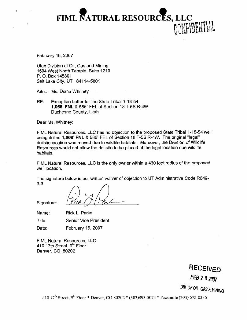
Attn.: Ms. Diana Whitney
RE: Exception Letter for the State Tribal 1-18-541,068' FNL & 586' FEL of Section 18 T-5S R-4WDuchesne County, Utah
Dear 19Is.Whitney:
FIMLNatural Resources, LLC has no objection to the proposed State Tribal 1-18-54 wellbeing drilled 1,068' FNL & 586' FEL of Section 18 T-5S R-4W. The original "legal"drillsite location was moved due to wildlife habitats. Moreover, the Division of WildlifeResources would not allow the drillsite to be placed at the legal location due wildlifehabitats.
FlML Natural Resources, LLC is the only owner within a 460 foot radius of the proposedwell location.
The signature below is our written waiver of objection to UT Administrative Code R649-3-3.
Signature:
Name: Rick L. Parks
Title: Senior Vice President
Date: February 16, 2007
FIML Natural Resources, LLC410 17th Street, 96 FloorDenver, CO 80202
RECEIVEDFEB2 02007
DNOFOIL,GAS&MINING410 17* Street, 9° Floor * Denver, CO 80202 * (303)893-5073 * Facsimile (303)

O OUTE/FNR, LLC.
STATE TRIBAL #1-18-54LOCATED IN DUCHESNE COUNTY, UTAH
SECTION 18, T5S, R4W, U.S.B.&M.
PHOTO: VIEW FROM CORNER #5 TO LOCATION STAKE CAMERA ANGLE: SOUTHWESTERLY
PHOTO: VIEW FROM BEGINNING OF PROPOSED ACCESSFOR THE #11-18-54 CAMERA ANGLE: SOUTHEASTERLY
Uintah Engineering & Land Surveying i OCATIONPHOTos 04 07 06 PHOTO85 South 200 East Vernal, Utah 84078 UNT1 "AY TE^*
-since1964 _ 435-789-1017 [email protected] TAKENBY:D.R. DRAWNBY:C.P. ISED:

UTE/FNR LLC.LOCATION LAYOUT FOR
STATE TRIBAL #1-18-54SECTION 18, T5S, R4W, U.S.B.&M.
1068' FNL 586' FEL
E-1.8' E--5.8SCALE: 1" =
50, E/. 57. E/. 5J.J'
DATE: 6-8-06DRAWNBY: K.G
Topsoil Stockp//e
NOTE
E 5 8 Rou d Corner
F/are Pit is to Approx.
be located a rnin. IPP Of --
of 100' frorn the Cut SlopeWell Head TEOf
illitt
oIlllll
¿¯ 6 .8
i l I
PIPE RACKS
C- 12. 7' ¯ E- 161.O'(Ðtm.Pit) -- RIG DOG HOUSE
125' Sta. 1+60
C-5.EI. 64.4
Approx.Toe of
PUMP- Fill Slope
MUD SHED TOILET
9 ---- HOPPER
o -- POWER
TOOLs Sta. 0+50
--- FUEL--- STORAGETR SH
o C-6.O' TANK
B. 65.7'
Sta. 0+00
A
C-25.9' C- ZJ s. es 7,
E 75 O - E/. 66. 4'
{Ðtm.Pit) Proposed AccessRoad
Elev. Ungraded Ground at Location Stake = 6460.7's IIINTAH ENCINEERING LAND SURV EYING
Bev. Graded Ground at Location Stoke = 6459.1 86 So. 200 East * Verreal, Utah 84078 * (435)

UTE/FNR LLC.TYPlCALCROSS SECTIONS FOR
No.161 9o STATE TRIBAL#1-18-54. -
×-sectionSECTION 18, T5S, R4W, U.S.B.&M. "a '
Scale se- 1068' FNL 586' FEL
1" = 50' gyDATE: 6-8-06 40' 125'DRAWN BY: K.G.
Finished GradeF/LL CUT
Preconstruction 'E/LGrade -
"SM. J+JO
10' 70' 40' 125'
Slope = 1 1/2: 1l.0CA T/0N STAKE
Il'
10' 70 40' 125°
cur S M. 0+50I
120' 125'
CUT CUT / 's
NOTE: T WAT&TamfamfaTaiTopsoil should not beStripped Below Finished SM. 0+00 * NOTE·Grade on Substructure Area. F/LL QUANT/TY/NCLUDES
SX FOR COMPACT/ONAPPROXIMATE YARDAGES
CUT EXCESS MATERIAL = 7,060 Cu. Yds.
(12") Topsoil Stripping = J,210 Cu. Yds. Topsoil & Pit Backfill = 5,010 Cu. Yds.(1/2 Pit VoL)
Rernaining Location = 10,420 Cu. Yds.EXCESS UNBALANCE = 2,050 Cu. Yds.
TOTAL CUT = 1J, 630 CU.YDS. (After Interirn Rehabilitation)
FlLL = 6, 570 CU.YDS. UINTAH ENGINEERING & LAND SURVEYING86 So. 200 East * Vernal. UtoA 84078 * (436)
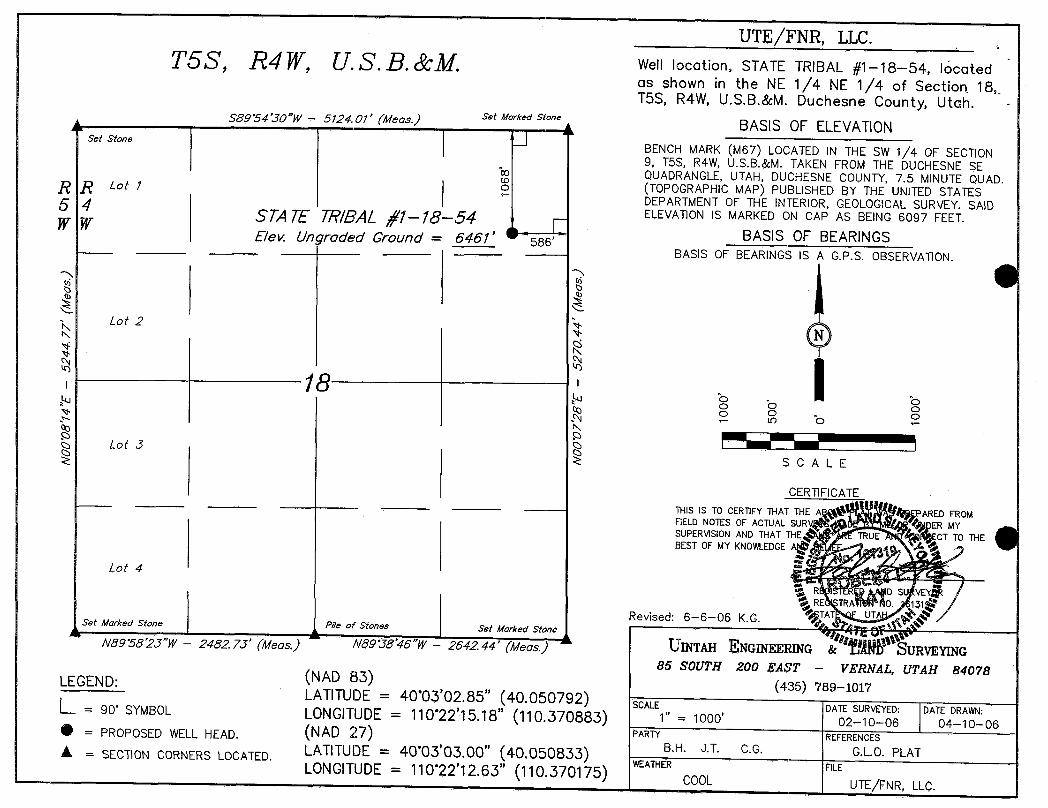
UTE/FNR, LLC.T5S, R4W, U.S.B.&M. Well location, STATE TRIBAL //1-18-54, located
as shown in the NE 1/4 NE 1/4 of Sectiort 18,T5S, R4W, U.S.B.&M. Duchesne County, Utah. -
SB9°54'30"W- 5124.01' (Meas.) '''"°'"""°"" BASIS OF ELEVATION
set stoneBENCH MARK (M67) LOCATED IN THE SW 1/4 OF ŠECTION9, T5S, R4W, U.S.B.&M. TAKEN FROM THE DUCHESNE SEQUADRANGLE,UTAH, DUCHESNE COUNTY, 7.5 MINUTE QUAD.R Lot 1 1 o (TOPOGRAPHIC MAP) PUBLISHED BY THE UNITED STATESRDEPARTMENTOF THE INTERIOR, GEOLOGICALSURVEY. SAID5 4 S7A 7E TR/BALý'1-18-54 ELEVATIONIS MARKED ON CAP AS BEING 6097 FEET.WW
Elev. Unyroded Ground = 6461' 586, BASIS OF BEARINGS--- BASIS OF BEARINGS IS A G.P.S. OBSERVATION.
Lot 2N
18
o Lot 3SCALE
CERTlFICATETHIS IS TO CERTIFYTHAT THE A PARED FROMFIELD NOTES OF ACTUAL SUR ER MYSUPERVISIONAND THAT THE TRUE CT TO THEBEST OF MY KNOWLEDGEA
Lot 4
R D SU VERE TRA 0. 13
Revised: 6-6-06 K.G. TAT UTSet Marked Stone Pile of Stones Set Marked Stone n$Û
NB9°58'2J"W- 2482.73' (Meas.) NB9°JS'46"W
- 2642.44' (Meas.)2' UINTAH ENGINEERING & URVEYING
86 SOUTH 200 EAST - VERNAL, UTAH 84078LEGEND (NAD 83)
(435) 789-1017LATITUDE=
40°03'02.85" (40.050792) SCALE DATE SURVEYED: DATE DRAWN:= 90 SYMBOL LONGITUDE=110°22'15.18" (110.370883) 1" = 1000' 02-10--06 o4-1o-o6
= PROPOSEDWELL HEAD. (NAD 27) PARTY REFERENCESLATITUDE = 40°03'03.00" (40.050833) 8.H. J.T. c.G. G.L.O. PLATA = SECTION CORNERS LOCATED.
WEATHER FILELONGITUDE= 110°22'12.63" (110.370175) COOL UTE/FNR,

6
TI
LEGEND: UTE/FNR, LLC.PROPOSED LOCATION N STATE TRIBAL #1-18-54
SECTION 18, TSS, R4W, U.S.B.&M.1068' FNL 586' FEL
Uintah Engineering & Land Surveying T Ö POG˯Ä
PH I c 04 07 0685 South 200 East Vernal, IJtah 84O78 M A P ONTH DAY YEAR
(435) 789-1017 * FAX (435) 789-1813scAu "-2000' ww¾ _18Ao

PROPOSED LOCATION:
PROPOSED ACCESS FOR
PROPOSED ACCESS FORPR POSED ACCESS FOR THE #11-18-54 0.5 M .
+/- -
LEGEND: UTE/FNR, LLC.EXIS11NG ROAD N STATE TRIBAL #1-18-54
----------- PROPOSED ACCESS ROAD SECTION 18, T5S, R4W, U.S.B.& M.1068' FNL 586' FEL
Uintah Engineering & Land Surveying TOPOGR A PH I c 04 0 06 m85 South 200 East Vernal, LJtah 84078 Î 11 Ÿ MONTI DAY YEAR i $
(435) 789-1017 * FAX (435) 789-1813SCALE:1" =2000' DRAWNBY:C.P. REVISED:06-12-06

PROPOSED LOCATION:
LEGEND: UTE/FNR, LLC.y DISPOSAL WELLS WATER WELLS N STATE TRIBAL #1-18-54e PRODUCING WELLS ABANDONED WELLS SECTION 18, TSS, R4W, U.S.B.&M.g SilUT IN WELLS & TEMPORARILY ABANDONED 1068' FNL 586' FEL
- Uintah Engineering & Land Surveying TOPOGR A PH I c 04 07 0685 South 200 East Vernal, Utah 84078 M A P mosTu »Av vtan(435) 789-1011 * FAX (438) 189-1813
SCALE:1" = 2000· DRAWNBY:C.R
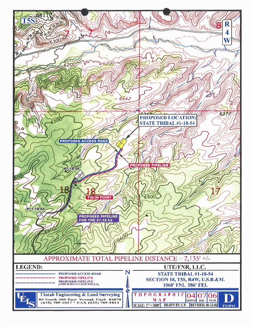
APPROXIMATE TOTAL PIPELINE DISTANCE = 2,135' +/-
LEGEND: UTE/FNR, LLC.PROPOSED ACCESS ROAD N STATE TRIBAL #1-18-54
----------- PROPOSED PIPELINEPROPOSED PIPELINE SECTION 18, T5S, R4W, U.S.B.&M.
------ ---- (SERVICINGOTHERWELLS) 1068' FNL 586' FEL
Uintah Engineering & Land Surveying TOPOGR A PH I e 04 07 0685 South 200 East Vernal, Utah 84078 M A P MONTH DAY YEAR
(435) 789-1017 * FAX (435) 789-1813SCALE:I" = 1080' DRAWNBY:C.P. REVISED:

,
' e eSTATE OF UTAH FORM 9
DEPARTMENT OF NATURALRESOURCESDIVISIONOF OIL, GAS AND MINING LEASEDESIGNATIONANDSERIALNUMBER:
14-20-H62-5035
SUNDRY NOTICES AND REPORTS ON WELLS 6. I NDIAN,ALLOTTEEORTRIBENAME:
7. UNITor CA AGREEMENT NAME:Do not use thisform for proposals todrillnew wells, significantly deepen existing wells below current bottom-hole depth, reenter plugged wells, or to
drill horizontal laterals. Use APPLICATION FOR PERMIT TO DRILLform forsuch proposals.
1. TYPEOFWELLOIL WELL GAS WELL Q OTHER S
aE Ar baanI1 - 4
2. NAMEOF OPERATOR: 9. API NUMBER:
FIMLNatural Resources, LLC 43013331703. ADDRESS OF OPERATOR: PHONE NUMBER: 10. FIELDAND POOL, OR WILDCAT:
410 17th St. Ste 900 Denver STATE CO ZIP 80202 (303) 893-5090 Brundage Canyon4. LOCATION OF WELL
FOOTAGES AT SURFACE: ,Û ... & 586 FEi.. COUNTY: ÛU0ÑOS
QTR/QTR, SECTION, TOWNSHIP, RANGE, MERIDIAN: NENE 18 5S 4W STATE:UTAH
ii. CHECK APPROPRIATE BOXES TO INDICATENATUREOF NOT1CE,REPORT, OR OTHER DATATYPE OF SUBMISSION TYPE OF ACTION
O ACIDIZE DEEPEN REPERFORATE CURRENT FORMATIONNOTICE OF INTENT
(Submit in Duplicato) ALTER CASING FRACTURE TREAT SIDETRACK TO REPAIR WELL
Approximate date work willstart: CASING REPAIR NEW CONSTRUCTION TEMPORARILYABANDON
CHANGE TO PREVIOUS PLANS OPERATOR CHANGE TUBING REPAIR
CHANGE TUBING PLUG AND ABANDON VENT OR FLARE
O SUBSEQUENT REPORT CHANGE WELL NAME PLUG BACK WATER DISPOSAL(Submît Original Form Only)
CHANGE WELL STATUS PRODUCTION (START/RESUME) WATER SHUT-OFFDate of work completion:
COMMINGLEPRODUCING FORMATIONS RECLAMATIONOF WELLSITE OTHER: Request for permit
O CONVERT WELL TYPE RECOMPLETE - DIFFERENT FORMATION OXÍGOSiOn
12. DESCRIBE PROPOSED OR COMPLETED OPERATIONS. Clearly show all pertinent details including dates, depths, volumes, etc.
FIML Natural Resources, LLC is requesting the State Tribal 1-18-54 permit be extended, due to the delay in getting theapproval from the BLM. FIMLhas not yet received an approved permit from the BLM.
Approvedby theUtah Divisionof
Oil,Gas and Mining
Date:y es -o.
_ RECEIVED
DIV.0FOIL,GAS&MINING
NAME (PLEASE PRINT) Cassandra Parks TITLE Operations Assistant
SIGNATURE DATE /
(This space for State use only)
(5/2000) (See Instructions on Reverse

Application for Permit to DriHRequest for Permit Extension
Validation(this form should accompany the Sundry Notice requesting permit extension)
API: 4301333170 iWell Name: State Tribal 1-18-54
Location: NENE 1,068' FNL & 586' FEL Sec 18 T-5S R-4W
Company Permit issued to: FIML Natural Resources, LLCDate Original Permit Issued: 6/12/2006
The undersigned as ownerwithlegal rights to drill on the property as permittedabove, hereby verifles that the information as submitted in the previouslyapproved application to drill, remains valid and does not require revision.
Following is a checklist of some items related to the application,which should beverified.
if located on private land, has the ownership changed, if so, has the surfaceagreement been updated? Yes O NoO
Have any wells been drilled in the vicinityof the proposed well which would affectthe spacing or siting requirements for this location? YesO Nom
Has there been any unit or other agreements put in place that could affect thepermitting or operation of thisproposed well? YesEl Nom
Have there been any changes to the access route including ownership, or right-of-way, which could affect the proposed location? YesONo12l
Has the approved source of water for drilling changed? YesO NoO
Have there been any physical changes to the surface location or access routewhîchwillrequire a change in plans from what was discussed at the onsiteevaluation? Yes O NoO
Is bonding still in place, which covers this proposed well?Yesl21NoO
Sigkifûre Date
Title: Cassandra Parks
Representing: FIML Natural Resources,

FIML NATURAL RESOURCES, LLC
June 4, 2007
Utah Division of Oil, Gas and Mining1594 West North Temple, Suite 1210P. O. Box 145801Salt Lake City, UT 84114-5801
Attn.: Ms. Diana Mason
RE: State Tribal 1-18-54NENE Sec 18 T-5S R-4WDuchesne County, Utah
Dear Ms. Mason:
Enclosed is the following information concerning the referenced well.
Sundry Notice - Requesting a Permit Extension (corrected footages)
If any questions arise or additional information is required, please contact me at 303-893-5090.
Sincerely,
Cassandra ParOperations Assistant
/cp RECEIVEDEnclosures:
JUNO52007DIV.0F01L,GAS&MINING
410 17* Street, Suite 900 * Denver, CO 80202 * (303)893-5073 * Facsimile (303)

FIML NATURAL RESOURCES, LLC
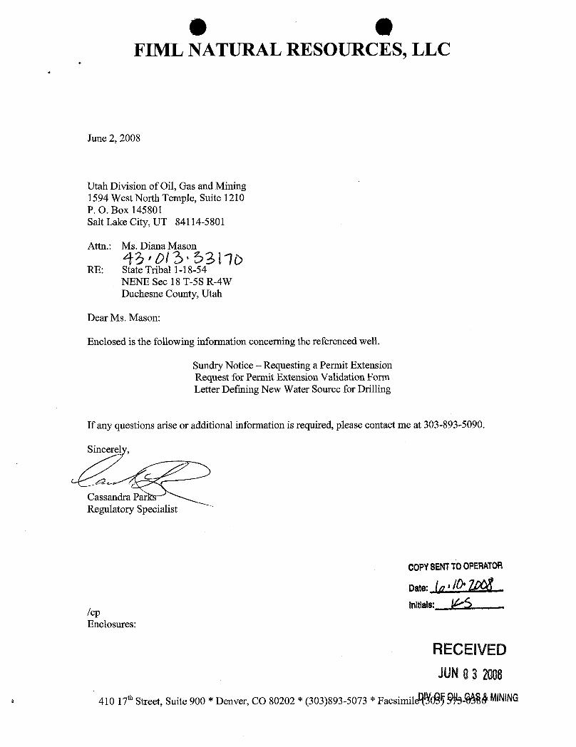
June 2, 2008
Utah Division of Oil, Gas and Mining1594 West North Temple, Suite 1210P. O. Box 145801Salt Lake City, UT 84114-5801
Attn.: Ms. Diana Mason
RE: Source of Drilling Water
Dear Ms. Mason:
FIML Natural Resources, LLC water for drilling operations will now be hauled by BettsTrucking. It will come from Duchesne City, Utah. The water right number is 43-3651.
If any questions arise or need additional information is required, please contact the undersigned at303-893-5090.
Cassandra ParksRegulatory Specialist
/cp
RECEIVEDJUNO3 2008
DIV,OFOIL,GAS&MINING
410 17 Street, Suite 900 * Denver, CO 80202 * (303)893-5073 * Facsimile (303)

O OSTATE OF UTAH FORM 9
DEPARTMENTOF NATURALRESOURCES' DIVISlONOF OIL, GAS AND MINING 5. LEASEDESIGNATIONANDSERIALNUMBER:14-20-H62-5035
6. IF INDIAN,ALLOTTEEOR TRIBE NAME:SUNDRY NOTICES AND REPORTS ON WELLS Ute
7. UNITor CA AGREEMENT NAME:Do not use thisform for proposals to drill new wells, significantly deepen existing wells below current bottom-hole depth, reenter plugged wells, or to
drill horizontal laterals. Use APPLICATIONFOR PERMIT TO DRILLform for such proposals.
1. TYPE OF WELL 8. WELL NAMEand NUMBER:OIL WELL GAS WELL OTHER State Tribal 1-18-54
2. NAMEOF OPERATOR 9. API NUMBER:
FIML Natural Resources, LLC 43013331703. ADDRESS OF OPERATOR: PHONE NUMBER: 10. FIELDAND POOL, OR WILDCAT:
410 17th St. Ste 900 y Denver STATE CO zi,80202 (303) 893-5090 Brundage Canyon4. LOCATIONOF WELL
FOOTAGESATSURFACE: 1,068' FNL & 586' FEL coUNTY: ÛUÛÍTOS O
QTR/QTR, SECTION, TOWNSHIP, RANGE, MERIDIAN: NENE 18 5S 4W STATE:UTAH
11. CHECK APPROPRIATE BOXES TO INDICATENATURE OF NOTICE, REPORT, OR OTHER DATATYPE OF SUBMISSION TYPE OF ACTION
ACIDIZE DEEPEN REPERFORATE CURRENT FORMATIONNOTICE OF INTENT
(Submit in Duplicate) ALTER CASING FRACTURE TREAT SIDETRACKTO REPAIR WELL
Approximate date work will start: CASING REPAIR NEW CONSTRUCTION TEMPORARILYABANDON
CHANGE TO PREVIOUS PLANS OPERATOR CHANGE TUBINGREPAIR
CHANGE TUBING PLUG ANDABANDON VENT OR FLARE
O SUBSEQUENT REPORT CHANGE WELL NAME PLUG BACK WATER DISPOSAL(Submit Original Form Only)
CHANGE WELLSTATUS PRODUCTION (START/RESUME) WATER SHUT-OFFDate ofwork completion:
COMMINGLEPRODUCING FORMATIONS RECLAMATIONOF WELL SITE OTHER: Request for permitCONVERT WELLTYPE RECOMPLETE - DIFFERENT FORMATION OXÍODSIOD
12. DESCRIBE PROPOSED OR COMPLETED OPERATIONS. Clearly show all pertinent details including dates, depths, volumes, etc.
FIML Natural Resources, LLC is requesting the State Tribal 1-18-54 permit be extended, due to the delay in getting theapproval from the BLM. FIMLhas not yet received an approved permit from the BLM.
Approvedby theUtah Divisionof
Oil,Gas and Mining
By:
NAME(PLEASE PRINT) Cassandra Parks TITLE Regulatory Specialist
SIGNATURE a DATE 6/2/2008
(This space for State use only) RECEIVEDJUNO3 2008
(5/2000) (See instructions on Reverse

O O
Application for Permit to DrillRequest for Permit Extension
Validation(thisform should accompany the Sundry Notice requesting permit extension)
API: .4301333170
Well Name: State Tribal 1-18-54
Location: NENE 1,068' FNL & 586' FEL Sec 18 T-5S R-4W
Company Permit Issued to: FIML Natural Resources, LLCDate Original Permit Issued: 6/12/2006
The undersigned as owner with legal rights to drillon the property as permittedabove, hereby verifies that the information as submitted in the previouslyapproved application to drill, remains valid and does not require revision.
Following is a checklist of some items related to the application, which should beverified.
If located on private land, has the ownership changed, if so, has the surfaceagreement been updated? YesONolZI
Have any wells been drilled in the vicinityof the proposed well which would affectthe spacing or siting requirements for this location? YesO Nom
Has there been any unit or other agreements put in place thatcould affect thepermitting or operation of this proposed well? YesONolZl
Have there been any changes to the access route including ownership, or right-of-way, which could affect the proposed location? YesONo12l
Has the approved source of water for drillingchanged? YeslZINoO
Have there been any physical changes to the surface location or access routewhich willrequire a change in plans from what was discussed at the onsiteevaluation? YesO NoO
Is bonding still in place, which covers thisproposed well? YeslZINoO
6/2/2008
Signature Date
Title: Regulatory SpecialistRECENED
Representing: FIML Natural Resources, LLC

STATE OF UTAH FORM 9
O DEPARTMENT OF NATURALRESOURCESDIVISIONOF OIL, GAS AND MININ 5. LEASEDESIGNATIONANDSERIALNUMBER:
14-20-H62-5035
SUNDRY NOTICES AND REPORTS ON WELLS 6 N AdNALLOTTEbEeORTRIBENAME:
7. UNITor CA AGREEMENT NAME:Do not use this form for proposals todrill new wells, significantly deepen existing wells below current bottom-hole depth, reenter plugged wells, or to
drill horizontal laterais. Use APPLICATION FOR PERMIT TO DRILLform forsuch proposals.
1. TYPE OF WELL 8. WELL NAMEand NUMBER:OIL WELL Ü GAS WELL OTHER State Tribal 1-18-54
2.NAMEOFOPERATOR: 9.APINUMBER:
FIML Natural Resources, LLC 43013331703. ADDRESS OF OPERATOR: PHONE NUMBER: 10. FIELDAND POOL, OR WILDCAT:
410 17th St. Ste 900 CITY STATE CO ZIP 80202 (303) 899-5603 Brundage Canyon4. LOCATIONOF WELL
FOOTAGESATSURFACE: 1,068' FNL & 586' FEL COUNTY: Duchesne
QTR/QTR, SECTION, TOWNSHIP, RANGE, MERIDIAN: NENE 18 SS 4W STATE:UTAH
u. CHECK APPROPRIATE BOXES TO INDICATENATUREOF NOTICE, REPORT, OR OTHER DATATYPE OF SUBMISSION TYPE OF ACTION
O ACIDIZE DEEPEN REPERFORATE CURRENT FORMATIONNOTICE OF INTENT
(Submit in Duplicate) ALTER CASING FRACTURE TREAT SIDETRACKTO REPAIR WELL
Approximate date work willstart: CASING REPAIR NEW CONSTRUCTION TEMPORARILYABANDON
O CHANGE TO PREVlOUS PLANS OPERATOR CHANGE TUBING REPAIR
O CHANGE TUBING PLUG ANDABANDON VENT OR FLARE
SUBSEQUENT REPORT CHANGE WELL NAME PLUG BACK WATER DISPOSAL(Submit Original Form Only}
O CHANGE WELL STATUS PRODUCTION (START/RESUME) WATER SHUT-OFFDate of work completion:
COMMINGLE PRODUCING FORMATIONS RECLAMATIONOF WELL SITE OTHER: Request for permitCONVERT WELL TYPE RECOMPLETE -DIFFERENT FORMATION OXÍ80SiOD
12 DESCRIBE PROPOSED OR COMPLETED OPERATIONS. Clearly show all pertinent details including dates, depths, volumes, etc.
FIMLNatural Resources, LLC is requesting the State Tribal 1-18-54 permit be extended, due to the delay in getting theapproval from the BLM. FIMLhas not yet received an approved permit from the BLM. Request for Permit Extension validationis attached.
Approvedby theUtah Divisionof
Oil,Gas and Mining
COPYSENTTOOPERATOR '
NAME(PLEASE PRINT) Elaine Winick TITLE Regulatory Specialist
SIGNATURE DATE 6/1/2009
(This space for State use only)
RECEIVEDJUNO3 2009
(5/2000) (See Instructions on Reverse Side)OlV.0FOlt,GAS&

Application for Permit to DrillRequest for Permit Extension
Validation(thisform should accompany the Sundry Notice requesting permit extension)
API: 4301333170Well Name: State Tribal 1-18-54
Location: NENE 1,068' FNL & 586' FEL Sec 18 T-5S R-4W
Company Permit Issued tO: FIML Natural Resources, LLCDate Original Permit Issued: 6/12/2666
The undersigned as owner with legal rights to drill on the property as permittedabove, hereby verifies that the information as submitted in the previouslyapproved application to drill, remains valid and does not require revision.
Following is a checklist of some items related to the application, which should beverified.
If located on private land, has the ownership changed, if so, has the surfaceagreement been updated? Yes O No O
Have any wells been drilled in the vicinityof the proposed well which would affectthe spacing or siting requirements for this location? YesO Nom
Has there been any unit or other agreements put in place that could affect thepermitting or operation of this proposed well? YesO No2
Have there been any changes to the access route including ownership, or right-of-way, which could affect the proposed location? YesO No IZI
Has the approved source of water for drilling changed? YesO NoO
Have there been any physical changes to the surface location or access routewhich willrequire a change in plans from what was discussed at the onsiteevaluation? YesO NoO
Is bonding still in place, which covers this proposed well? YesŒNoO
6/1/2009
Signature Date
Title: Regulatory Specialist
Representing: FIML Natural Resources, LLC
RECEIVEDJUNO3 2009
DIV.0FOlL,GAS&

API Well No: 43013331700000
STATE OF UTAHDEPARTMENT OF NATURAL RESOURCES
DIVISION OF OIL, GAS, AND MINING
FORM 9
5.LEASE DESIGNATION AND SERIAL NUMBER: 14-20-H62-5035
SUNDRY NOTICES AND REPORTS ON WELLSDo not use this form for proposals to drill new wells, significantly deepen existing wells below currentbottom-hole depth, reenter plugged wells, or to drill horizontal laterals. Use APPLICATION FOR PERMIT TODRILL form for such proposals.
6. IF INDIAN, ALLOTTEE OR TRIBE NAME:
7.UNIT or CA AGREEMENT NAME:
1. TYPE OF WELL Oil Well
8. WELL NAME and NUMBER: ST TRIBAL 1-18-54
2. NAME OF OPERATOR: FIML NATURAL RESOURCES, LLC (FNR)
9. API NUMBER: 43013331700000
3. ADDRESS OF OPERATOR: PHONE NUMBER: 410 17th Street Ste 900 , Denver, CO, 80202 303 893-5077 Ext
9. FIELD and POOL or WILDCAT: BRUNDAGE CANYON
4. LOCATION OF WELL FOOTAGES AT SURFACE: 1068 FNL 0586 FEL QTR/QTR, SECTION, TOWNSHIP, RANGE, MERIDIAN: Qtr/Qtr: NENE Section: 18 Township: 05.0S Range: 04.0W Meridian: U
COUNTY: DUCHESNE
STATE: UTAH
11.
CHECK APPROPRIATE BOXES TO INDICATE NATURE OF NOTICE, REPORT, OR OTHER DATA
TYPE OF SUBMISSION TYPE OF ACTION
NOTICE OF INTENTApproximate date work will start:
12/31/2010
SUBSEQUENT REPORTDate of Work Completion:
SPUD REPORTDate of Spud:
DRILLING REPORTReport Date:
ACIDIZE ALTER CASING CASING REPAIR
CHANGE TO PREVIOUS PLANS CHANGE TUBING CHANGE WELL NAME
CHANGE WELL STATUS COMMINGLE PRODUCING FORMATIONS CONVERT WELL TYPE
DEEPEN FRACTURE TREAT NEW CONSTRUCTION
OPERATOR CHANGE PLUG AND ABANDON PLUG BACK
PRODUCTION START OR RESUME RECLAMATION OF WELL SITE RECOMPLETE DIFFERENT FORMATION
REPERFORATE CURRENT FORMATION SIDETRACK TO REPAIR WELL TEMPORARY ABANDON
TUBING REPAIR VENT OR FLARE WATER DISPOSAL
WATER SHUTOFF SI TA STATUS EXTENSION APD EXTENSION
WILDCAT WELL DETERMINATION OTHER OTHER:
12. DESCRIBE PROPOSED OR COMPLETED OPERATIONS. Clearly show all pertinent details including dates, depths, volumes, etc.
FIML Natural Resources, LLC is requesting the State Tribal 1-18-54 permit beextended, due to the delay in getting the approval from the BLM. FIML has not
yet received an approved permit from the BLM.
NAME (PLEASE PRINT) PHONE NUMBER Karin Kuhn 303 899-5603
TITLE Sr. Drilling Technician
SIGNATURE N/A
DATE 7/30/2010
August 09, 2010
iPI Well No: 43013331700000
FORM 9
STATE OF UTAHDEPARTMENT OF NATURAL RESOURCES
DIVISION OF OIL, GAS, AND MINING 4E DE2sI50NA5TION AND SERIAL NUMBER:
SUNDRY NOTICES AND REPORTS ON WELLS 6. IF INDIAN, ALLOTTEE OR TRIBE NAME:
Do not use this form for proposals to drill new wells, significantly deepen e×isting wells below currentbottom-hole depth, reenter plugged wells, or to drill horizontal laterals. Use APPLICATION FOR PERMIT TO 7.UNIT or CA AGREEMENT NAME:
DRILL form for such proposals.
1. TYPE OF WELL 8. WELL NAME and NUMBER:Oil Well ST TRIBAL 1-18-54
2. NAME OF OPERATOR: 9. API NUMBER:FIML NATURAL RESOURCES, LLC (FNR) 43013331700000
3. ADDRESS OF OPERATOR: PHONE NUMBER: 9. FIELD and POOL or WILDCAT:410 17th Street Ste 900 , Denver, CO, 80202 303 893-5077 Ext BRUNDAGE CANYON
4.LOCATIONOFWELL COUNTY:FOOTAGES AT SURFACE: DUCHESNE
1068 FNL 0586 FELQTR/QTR, SECTION, TOWNSHIP, RANGE, MERIDIAN: STATE:
Qtr/Qtr: NENE Section: 18 Township: 05.05 Range: 04.0W Meridian: U UTAH
11.CHECK APPROPRIATE BOXES TO INDICATE NATURE OF NOTICE, REPORT, OR OTHER DATA
TYPE OF SUBMISSION TYPE OF ACTION
ACIDIZE ALTER CASING CASING REPAIR
NOTICE OF INTENTApproximate date work will start: CHANGE TO PREVIOUS PLANS CHANGE TUBING CHANGE WELL NAME
12/31/2010CHANGE WELL STATUS COMMINGLE PRODUCING FORMATIONS CONVERT WELL TYPE
SUBSEQUENT REPORT DEEPEN FRACTURE TREAT NEW CONSTRUCTIONDate of Work Completion:
OPERATOR CHANGE PLUG AND ABANDON PLUG BACK
PRODUCTION START OR RESUME RECLAMATION OF WELL SITE RECOMPLETE DIFFERENT FORMATION
O SPUD REPORTDate of Spud: REPERFORATE CURRENT FORMATION SIDETRACK TO REPAIR WELL TEMPORARY ABANDON
TUBING REPAIR VENT OR FLARE WATER DISPOSAL
DRILLING REPORT WATER SHUTOFF SI TA STATUS EXTENSION APD EXTENSIONReport Date:
WILDCAT WELL DETERMINATION OTHER OTHER:
12. DESCRIBE PROPOSED OR CC MPLETED OPERATIONS. Clearly show all pertinent details including dates, depths, volumes, etc.
FIML Natural Resources, LLC is requesting the State Tribal 1-18-54 permit beextended, due to the delay in getting the approval from the BLM. FIML has not Approved by the
yet received an approved permit from the BLM. Utah Division ofOil, Gas and Mining
Date: Au st 09, 2010
By:
NAME (PLEASE PRINT) PHONE NUMBER TITLEKarin Kuhn 303 899-5603 Sr. Drilling Technician
SIGNATURE DATEN/A

The Utah Division of Oil, Gas, and Mining
- State of Utah- Department of Natural Resources
Electronic Permitting System - Sundry Notices
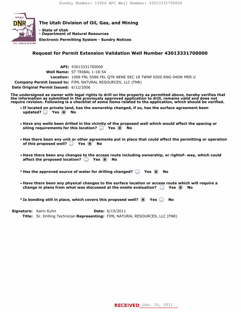
Request for Permit Extension Validation Well Number 43013331700000
API: 43013331700000Well Name: ST TRIBAL 1-18-54
Location: 1068 FNL 0586 FEL QTR NENE SEC 18 TWNP 050S RNG 040W MER UCompany Permit Issued to: FIML NATURAL RESOURCES, LLC (FNR)
Date Original Permit Issued: 6/12/2006
The undersigned as owner with legal rights to drill on the property as permitted above, hereby verifies thatthe information as submitted in the previously approved application to drill, remains valid and does notrequire revision. Following is a checklist of some items related to the application, which should be verified.
If located on private land, has the ownership changed, if so, has the surface agreement beenupdated? Yes No
Have any wells been drilled in the vicinity of the proposed well which would affect the spacing orsiting requirements for this location? Yes No
Has there been any unit or other agreements put in place that could affect the permitting or operationof this proposed well? Yes No
Have there been any changes to the access route including ownership, or rightof- way, which couldaffect the proposed location? Yes No
Has the approved source of water for drilling changed? Yes No
Have there been any physical changes to the surface location or access route which will require achange in plans from what was discussed at the onsite evaluation? Yes No
Is bonding still in place, which covers this proposed well? Yes No
Signature: Karin Kuhn Date: 7/30/2010
Title: Sr. Drilling Technician Representing: FIML NATURAL RESOURCES, LLC (FNR)
July 30, 2010July 30, 2010
August 09, 2010
UTAH
DNR The Utah Division of Oil, Gas, and Mining'
- State of Utah- Department of Natural ResourcesElectronic Permitting System - Sundry Notices
OTI BAS Br MlNTNG
Request for Permit Extension Validation Well Number 43013331700000
API: 43013331700000Well Name: ST TRIBAL 1-18-54
Location: 1068 FNL 0586 FEL QTR NENE SEC 18 TWNP 0505 RNG 040W MER UCompany Permit Issued to: FIML NATURAL RESOURCES, LLC (FNR)
Date Original Permit Issued: 6/12/2006
The undersigned as owner with legal rights to drill on the property as permitted above, hereby verifies thatthe information as submitted in the previously approved application to drill, remains valid and does notrequire revision. Following is a checklist of some items related to the application, which should be verified.
•If located on private_land, has the ownership changed, if so, has the surface agreement beenupdated? I___|I Yes I_Ð_I No
• Have any wells been drilled in the vicinity of the_proposed well which would affect the spacing orsiting requirements for this location? I:___) Yes _®_) No
• Has there been any unit or other agreements put in place that could affect the permitting or operationof this proposed well? I i Yes i i No
• Have there been any changes to the access route including ownership, or rightof- way, which couldaffect the proposed location? I___) Yes I _I No
• Has the approved source of water for drilling changed? I __I Yes i i No
• Have there been any physical changes to the surface location or access route which will require achange in plans from what was discussed at the onsite evaluation? I___I Yes I®I No
Approved by the•Is bonding still in place, which covers this proposed well? I§|I Yes i i No Utah Division of
Oil, Gas and MiningSignature: Karin Kuhn Date: 7/30/2010
Title: Sr. Drilling Technician Representing: FIML NATURAL RESOURCES, LLѾ¾R) August 09, 2010
By:
RECEIVED July 30,

STATE OF UTAHDEPARTMENT OF NATURAL RESOURCES
DIVISION OF OIL, GAS, AND MINING
FORM 9
5.LEASE DESIGNATION AND SERIAL NUMBER: 14-20-H62-5035
SUNDRY NOTICES AND REPORTS ON WELLSDo not use this form for proposals to drill new wells, significantly deepen existing wells below currentbottom-hole depth, reenter plugged wells, or to drill horizontal laterals. Use APPLICATION FOR PERMIT TODRILL form for such proposals.
6. IF INDIAN, ALLOTTEE OR TRIBE NAME:
7.UNIT or CA AGREEMENT NAME:
1. TYPE OF WELL Oil Well
8. WELL NAME and NUMBER: ST TRIBAL 1-18-54
2. NAME OF OPERATOR: FIML NATURAL RESOURCES, LLC (FNR)
9. API NUMBER: 43013331700000
3. ADDRESS OF OPERATOR: PHONE NUMBER: 410 17th Street Ste 900 , Denver, CO, 80202 303 893-5077 Ext
9. FIELD and POOL or WILDCAT: BRUNDAGE CANYON
4. LOCATION OF WELL FOOTAGES AT SURFACE: 1068 FNL 0586 FEL QTR/QTR, SECTION, TOWNSHIP, RANGE, MERIDIAN: Qtr/Qtr: NENE Section: 18 Township: 05.0S Range: 04.0W Meridian: U
COUNTY: DUCHESNE
STATE: UTAH
11.
CHECK APPROPRIATE BOXES TO INDICATE NATURE OF NOTICE, REPORT, OR OTHER DATA
TYPE OF SUBMISSION TYPE OF ACTION
NOTICE OF INTENTApproximate date work will start:
12/31/2011
SUBSEQUENT REPORTDate of Work Completion:
SPUD REPORTDate of Spud:
DRILLING REPORTReport Date:
ACIDIZE ALTER CASING CASING REPAIR
CHANGE TO PREVIOUS PLANS CHANGE TUBING CHANGE WELL NAME
CHANGE WELL STATUS COMMINGLE PRODUCING FORMATIONS CONVERT WELL TYPE
DEEPEN FRACTURE TREAT NEW CONSTRUCTION
OPERATOR CHANGE PLUG AND ABANDON PLUG BACK
PRODUCTION START OR RESUME RECLAMATION OF WELL SITE RECOMPLETE DIFFERENT FORMATION
REPERFORATE CURRENT FORMATION SIDETRACK TO REPAIR WELL TEMPORARY ABANDON
TUBING REPAIR VENT OR FLARE WATER DISPOSAL
WATER SHUTOFF SI TA STATUS EXTENSION APD EXTENSION
WILDCAT WELL DETERMINATION OTHER OTHER:
12. DESCRIBE PROPOSED OR COMPLETED OPERATIONS. Clearly show all pertinent details including dates, depths, volumes, etc.
FIML Natural Resources, LLC is requesting the State Tribal 1-18-54 permit beextended, due to the delay in getting the approval from the BLM. FIML has notyet received an approved permit from the BLM. Request for Permit Extension
validation is attached.
NAME (PLEASE PRINT) PHONE NUMBER Karin Kuhn 303 899-5603
TITLE Sr. Drilling Technician
SIGNATURE N/A
DATE 6/15/2011
06/20/2011
Jun. 15, 2011
Sundry Number: 15956 API Well Number: 43013331700000Sundry Number: 15956 API Well Number: 43013331700000
FORM 9STATE OF UTAH
DEPARTMENT OF NATURAL RESOURCESDIVISION OF OIL, GAS, AND MINING 4
HD6E2-50NA5TIONAND SERIAL NUMBER:
SUNDRY NOTICES AND REPORTS ON WELLS 6. IF INDIAN, ALLOTTEE OR TRIBE NAME:
Do not use this form for proposals to drill new wells, significantly deepen existing wells below currentbottom-hole depth, reenter plugged wells, or to drill horizontal laterals. Use APPLICATION FOR PERMIT TO 7.UNIT or CA AGREEMENT NAME:
DRILL form for such proposals.
1. TYPE OF WELL 8. WELL NAME and NUMBER:Oil Well ST TRIBAL 1-18-54
2. NAME OF OPERATOR: 9. API NUMBER:FIML NATURAL RESOURCES, LLC (FNR) 43013331700000
3. ADDRESS OF OPERATOR: PHONE NUMBER: 9. FIELD and POOL or WILDCAT:410 17th Street Ste 900 , Denver, CO, 80202 303 893-5077 E×t BRUNDAGE CANYON
4.LOCATIONOFVVELL COUNTY:FOOTAGES AT SURFACE: DUCHESNE
1068 FNL 0586 FELQTR/QTR, SECTION, TOWNSHIP, RANGE, MERIDIAN: STATE:
Qtr/Qtr: NENE Section: 18 Township: 05.05 Range: 04.0W Meridian: U UTAH
11.CHECK APPROPRIATE BOXES TO INDICATE NATURE OF NOTICE, REPORT, OR OTHER DATA
TYPE OF SUBMISSION TYPE OF ACTION
ACIDIZE ALTER CASING CASING REPAIR
NOTICE OF INTENTApproximate date work will start: CHANGE TO PREVIOUS PLANS CHANGE TUBING CHANGE WELL NAME
12/31/2011CHANGE WELL STATUS COMMINGLE PRODUCING FORMATIONS CONVERT WELL TYPE
SUBSEQUENT REPORT DEEPEN FRACTURE TREAT NEW CONSTRUCTIONDate of Work Completion:
OPERATOR CHANGE PLUG AND ABANDON PLUG BACK
PRODUCTION START OR RESUME RECLAMATION OF WELL SITE RECOMPLETE DIFFERENT FORMATION
SPUD REPORTDate of Spud: REPERFORATE CURRENT FORMATION SIDETRACK TO REPAIR WELL TEMPORARY ABANDON
TUBING REPAIR VENT OR FLARE WATER DISPOSAL
DRILLING REPORT WATER SHUTOFF SI TA STATUS EXTENSION APD EXTENSIONReport Date:
WILDCAT WELL DETERMINATION OTHER OTHER:
12. DESCRIBE PROPOSED OR C( MPLETED OPERATIONS. Clearly show all pertinent details including dates, depths, volumes, etc.
FIML Natural Resources, LLC is requesting the State Tribal 1-18-54 permit beextended, due to the delay in getting the approval from the BLM. FIML has notyet received an approved permit from the BLM. Request for Permit Extension Approved by the
validation is attached. Utah Division ofOil, Gas and Mining
Date: 06/20/2011
By:
NAME (PLEASE PRINT) PHONE NUMBER TITLEKarin Kuhn 303 899-5603 Sr. Drilling Technician
SIGNATURE DATEN/A 6/15/2011
RECEIVED Jun. 15,
The Utah Division of Oil, Gas, and Mining
- State of Utah- Department of Natural Resources
Electronic Permitting System - Sundry Notices
Request for Permit Extension Validation Well Number 43013331700000
API: 43013331700000Well Name: ST TRIBAL 1-18-54
Location: 1068 FNL 0586 FEL QTR NENE SEC 18 TWNP 050S RNG 040W MER UCompany Permit Issued to: FIML NATURAL RESOURCES, LLC (FNR)
Date Original Permit Issued: 6/12/2006
The undersigned as owner with legal rights to drill on the property as permitted above, hereby verifies thatthe information as submitted in the previously approved application to drill, remains valid and does notrequire revision. Following is a checklist of some items related to the application, which should be verified.
If located on private land, has the ownership changed, if so, has the surface agreement beenupdated? Yes No
Have any wells been drilled in the vicinity of the proposed well which would affect the spacing orsiting requirements for this location? Yes No
Has there been any unit or other agreements put in place that could affect the permitting or operationof this proposed well? Yes No
Have there been any changes to the access route including ownership, or rightof- way, which couldaffect the proposed location? Yes No
Has the approved source of water for drilling changed? Yes No
Have there been any physical changes to the surface location or access route which will require achange in plans from what was discussed at the onsite evaluation? Yes No
Is bonding still in place, which covers this proposed well? Yes No
Signature: Karin Kuhn Date: 6/15/2011
Title: Sr. Drilling Technician Representing: FIML NATURAL RESOURCES, LLC (FNR)
Jun. 15, 2011
Sundry Number: 15956 API Well Number: 43013331700000Sundry Number: 15956 API Well Number: 43013331700000
UTAH
DNR The Utah Division of Oil, Gas, and Mining'
- State of Utah- Department of Natural ResourcesElectronic Permitting System - Sundry Notices
OTI GAS Rr MlNTNG
Request for Permit Extension Validation Well Number 43013331700000
API: 43013331700000Well Name: ST TRIBAL 1-18-54
Location: 1068 FNL 0586 FEL QTR NENE SEC 18 TWNP 0505 RNG 040W MER UCompany Permit Issued to: FIML NATURAL RESOURCES, LLC (FNR)
Date Original Permit Issued: 6/12/2006
The undersigned as owner with legal rights to drill on the property as permitted above, hereby verifies thatthe information as submitted in the previously approved application to drill, remains valid and does notrequire revision. Following is a checklist of some items related to the application, which should be verified.
•If located o_nprivate_land, has the ownership changed, if so, has the surface agreement beenupdated? I
_
i Yes igi No
• Have any wells been drilled in the vicinity of the_proposed well which would affect the spacing orsiting requirements for this location? :___:I Yes g:I No
• Has there been any unit or other agreements put in place that could affect the permitting or operationof this proposed well? I:_:I Yes IÏiÏ:I No
• Have there been any changes to the acce_ss route including ownership, or rightof- way, which couldaffect the proposed location? I___I Yes igi No
• Has the approved source of water for drilling changed? I_
I Yes IÎiÏI No
• Have there been any physical changes to the surface location or access route which will require achange in plans from what was discussed at the onsite evaluation? __:I Yes ig:I No
• Is bonding still in place, which covers this proposed well? liiil Yes i i No
Signature: Karin Kuhn Date: 6/15/2011Title: Sr. Drilling Technician Representing: FIML NATURAL RESOURCES, LLC (FNR)
RECEIVED Jun. 15,

RECEIVED: Apr. 17, 2012
STATE OF UTAHDEPARTMENT OF NATURAL RESOURCES
DIVISION OF OIL, GAS, AND MINING
FORM 9
5.LEASE DESIGNATION AND SERIAL NUMBER: 14-20-H62-5035
SUNDRY NOTICES AND REPORTS ON WELLS
Do not use this form for proposals to drill new wells, significantly deepen existing wells belowcurrent bottom-hole depth, reenter plugged wells, or to drill horizontal laterals. Use APPLICATIONFOR PERMIT TO DRILL form for such proposals.
6. IF INDIAN, ALLOTTEE OR TRIBE NAME:
7.UNIT or CA AGREEMENT NAME:
1. TYPE OF WELL Oil Well
8. WELL NAME and NUMBER: ST TRIBAL 1-18-54
2. NAME OF OPERATOR: FIML NATURAL RESOURCES, LLC (FNR)
9. API NUMBER: 43013331700000
3. ADDRESS OF OPERATOR: PHONE NUMBER: 410 17th Street Ste 900 , Denver, CO, 80202 303 893-5077 Ext
9. FIELD and POOL or WILDCAT: BRUNDAGE CANYON
4. LOCATION OF WELL FOOTAGES AT SURFACE: 1068 FNL 0586 FEL QTR/QTR, SECTION, TOWNSHIP, RANGE, MERIDIAN: Qtr/Qtr: NENE Section: 18 Township: 05.0S Range: 04.0W Meridian: U
COUNTY: DUCHESNE
STATE: UTAH
11.
CHECK APPROPRIATE BOXES TO INDICATE NATURE OF NOTICE, REPORT, OR OTHER DATA
TYPE OF SUBMISSION TYPE OF ACTION
NOTICE OF INTENTApproximate date work will start:
12/31 /2012
SUBSEQUENT REPORTDate of Work Completion:
SPUD REPORTDate of Spud:
DRILLING REPORTReport Date:
ACIDIZE ALTER CASING CASING REPAIR
CHANGE TO PREVIOUS PLANS CHANGE TUBING CHANGE WELL NAME
CHANGE WELL STATUS COMMINGLE PRODUCING FORMATIONS CONVERT WELL TYPE
DEEPEN FRACTURE TREAT NEW CONSTRUCTION
OPERATOR CHANGE PLUG AND ABANDON PLUG BACK
PRODUCTION START OR RESUME RECLAMATION OF WELL SITE RECOMPLETE DIFFERENT FORMATION
REPERFORATE CURRENT FORMATION SIDETRACK TO REPAIR WELL TEMPORARY ABANDON
TUBING REPAIR VENT OR FLARE WATER DISPOSAL
WATER SHUTOFF SI TA STATUS EXTENSION APD EXTENSION
WILDCAT WELL DETERMINATION OTHER OTHER:
12. DESCRIBE PROPOSED OR COMPLETED OPERATIONS. Clearly show all pertinent details including dates, depths, volumes, etc.
FIML Natural Resources, LLC is requesting the State Tribal 1-18-54permit be extended due to the delay in getting the approval from the
BLM. FIML has not yet received an approved permit from the BLM.Request for Permit Extension validation is attached.
NAME (PLEASE PRINT) PHONE NUMBER Kristi Stover 303 893-5084
TITLE Sr Drilling Technicain
SIGNATURE N/A
DATE 4 /17 /2012
April 18, 2012
Sundry Number: 24880 API Well Number: 43013331700000Sundry Number: 24880 API Well Number: 43013331700000
FORM 9STATE OF UTAH
DEPARTMENTOF NATURALRESOURCES5.LEASE DESIGNATION AND SERIAL NUMBER:DIVISION OF OIL, GAS, AND MINING 14-20-H62-5035
SUNDRY NOTICES AND REPORTS ON WELLS 6. IF INDIAN, ALLOTTEE OR TRIBE NAME:
Do not use this form for proposals to drill new wells, significantly deepen existing wells belowcurrent bottom-hole depth, reenter plugged wells, or to drill horizontal laterals. Use APPLICATION 7.UNITor CA AGREEMENT NAME:
FOR PERMIT TO DRILL form for such proposals.
1. TYPE OF WELL 8. WELL NAME and NUMBER:Oil Well ST TRIBAL 1-18-54
2. NAME OF OPERATOR: 9. API NUMBER:FIMLNATURALRESOURCES, LLC(FNR) 43013331700000
3. ADDRESS OF OPERATOR: PHONE NUMBER: 9. FIELD and POOL or WILDCAT:410 17th Street Ste 900 , Denver, CO, 80202 303 893-5077 Ext BRUNDAGE CANYON
4. LOCATION OF WELL COUNTY:FOOTAGES AT SURFACE: DUCHESNE
1068 FNL 0586 FELQTRIQTR, SECTION, TOWNSHIP, RANGE, MERIDIAN: STATE:
QtrlQtr: NENE Section: 18 Township: 05.0S Range: 04.0W Meridian: U UTAH
CHECK APPROPRIATE BOXES TO INDICATENATURE OF NOTICE, REPORT, OR OTHER DATA
TYPE OF SUBMISSION TYPE OF ACTION
ACI DIZE ALTER CASING CASING REPAIRNOTICE OF INTENT
Approximate date work will start: CHANGE TO PREVIOUS PLANS CHANGE TUBING CHANGE WELL NAME
12/31/2012CHANGE WELL STATUS COMMINGLE PRODUCING FORMATIONS CONVERT WELL TYPE
SUBSEQUENT REPORT DEEPEN FRACTURE TREAT NEW CONSTRUCTIONDate of Work Completion:
OPERATOR CHANGE PLUG AND ABANDON PLUG BACK
PRODUCTION START OR RESUME RECLAMATION OF WELL SITE RECOMPLETE DIFFERENT FORMATIONSPUD REPORT
Date of Spud: REPERFORATE CURRENT FORMATION SIDETRACK TO REPAIR WELL TEMPORARY ABANDON
TUBING REPAIR VENT OR FLARE WATER DISPOSAL
DRILLING REPORT WATER SHUTOFF SI TA STATUS EXTENSION APD EXTENSIONReport Date:
WILDCATWELLDETERMINATION OTHER OTHER:
12. DESCRIBE PROPOSED OR COMPLETED OPERATIONS. Clearly show all pertinent details including dates, depths, volumes, etc.
FIML Natural Resources, LLC is requesting the State Tribal 1-18-54 Approved by thepermit be extended due to the delay in getting the approval from the utah Division of
BLM. FIML has not yet received an approved permit from the BLM. Oil, Gas and Mining
Request for Permit Extension validation is attached. Date: April 18, 2012
By:
NAME (PLEASE PRINT) PHONE NUMBER TITLEKristi Stover 303 893-5084 Sr Drilling Technicain
SIGNATURE DATEN/A 4/17/2012
RECEIVED: Apr. 17,

RECEIVED: Apr. 17, 2012
The Utah Division of Oil, Gas, and Mining
- State of Utah- Department of Natural Resources
Electronic Permitting System - Sundry Notices
Request for Permit Extension Validation Well Number 43013331700000
API: 43013331700000Well Name: ST TRIBAL 1-18-54
Location: 1068 FNL 0586 FEL QTR NENE SEC 18 TWNP 050S RNG 040W MER UCompany Permit Issued to: FIML NATURAL RESOURCES, LLC (FNR)
Date Original Permit Issued: 6 /12 /2006
The undersigned as owner with legal rights to drill on the property as permitted above, hereby verifies that theinformation as submitted in the previously approved application to drill, remains valid and does not require revision.Following is a checklist of some items related to the application, which should be verified.
If located on private land, has the ownership changed, if so, has the surface agreement been updated? Yes No
Have any wells been drilled in the vicinity of the proposed well which would affect the spacing or sitingrequirements for this location? Yes No
Has there been any unit or other agreements put in place that could affect the permitting or operation of thisproposed well? Yes No
Have there been any changes to the access route including ownership, or rightof- way, which could affect theproposed location? Yes No
Has the approved source of water for drilling changed? Yes No
Have there been any physical changes to the surface location or access route which will require a change inplans from what was discussed at the onsite evaluation? Yes No
Is bonding still in place, which covers this proposed well? Yes No
Signature: Kristi Stover Date: 4 /17 /2012
Title: Sr Drilling Technicain Representing: FIML NATURAL RESOURCES, LLC (FNR)
Sundry Number: 24880 API Well Number: 43013331700000Sundry Number: 24880 API Well Number: 43013331700000
UTAH
DNR The Utah Division of Oil, Gas, and Mining'
- State of Utah- Department of Natural ResourcesElectronic Permitting System - Sundry Notices
OTI. EMI Pr N1NTrie
Request for Permit Extension Validation Well Number 43013331700000
API: 43013331700000Well Name: ST TRIBAL 1-18-54
Location: 1068 FNL 0586 FEL QTR NENE SEC 18 TWNP 050S RNG 040W MER UCompany Permit Issued to: FIMLNATURALRESOURCES, LLC(FNR)
Date Original Permit Issued: 6/12/2006
The undersigned as owner with legal rights to drill on the property as permitted above, hereby verifies that theinformation as submitted in the previously approved application to drill, remains valid and does not require revision.Following is a checklist of some items related to the application, which should be verified.
* If located on private land, has the ownership changed, if so, has the surface agreement been updated? OYes No
• Have any wells been drilled in the vicinity of the proposed well which would affect the spacing or sitingrequirements for this location? O Yes No
• Has there been any unit or other agreements put in place that could affect the permitting or operation of thisproposed well? (_) Yes No
• Have there been any changes to the access route including ownership, or rightof- way, which could affect theproposed location? O Yes i No
· Has the approved source of water for drilling changed? O Yes No
• Have there been any physical changes to the surface location or access route which will require a change inplans from what was discussed at the onsite evaluation? Yes No
' Is bonding still in place, which covers this proposed well? Yes No
Signature: Kristi Stover Date: 4/17/2012Title: Sr Drilling Technicain Representing: FIMLNATURALRESOURCES, LLC(FNR)
RECEIVED: Apr. 17,

State of UtahDEPARTMENT OF NATURAL RESOURCES
MICHAEL R. STYLER
GAR . BERT ExecutiveDirector
Governor Division of Oil, Gas and MiningGREG BELL JOHN R. BAZA
Lieutenant Governor Division Director
December 7, 2012
Kristi StoverFIML Natural Resources, LLC410 17TH Street, Suite 900Denver, CO 80202
Re: APDs Rescinded for FIML Natural Resources, LLCDuchesne County
Dear Ms. Stover:
Enclosed find the list of APDs that you requested to be rescinded. No drillingactivity at these locations has been reported to the division. Therefore,approval to drill these wells is hereby rescinded, effective November 29, 2012.
A new APD must be filed with this office for approval prior to thecommencement of any future work on the subject location.
If any previously unreported operations have been performed on this welllocation, it is imperative that you notify the Division immediately.
Sincerely,
Diana MasonEnvironmental Scientist
cc: Well FileBureau of Land Management, VernalSITLA, Ed Bonner
UTAH
DNR
1594 West North Temple, Suite 1210, PO Box 145801, Salt Lake City, UT 84114-5801telephone (801) 538-5340 • facsimile (801) 359-3940 . TTY (801) 538-7458 • www.ogm.utah gov
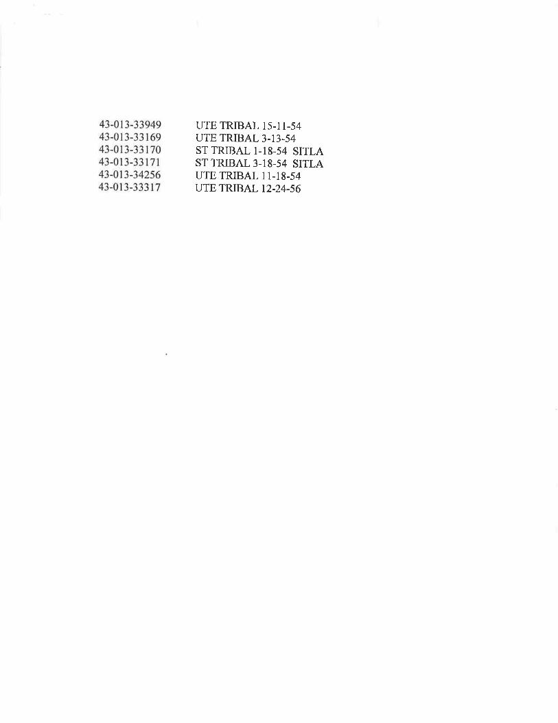
43-013-33949 UTE TRIBAL 15-11-5443-013-33169 UTE TRIBAL 3-13-5443-013-33170 ST TRIBAL 1-18-54 SITLA43-013-33171 ST TRIBAL 3-18-54 SITLA43-013-34256 UTE TRIBAL 11-18-5443-013-33317 UTE TRIBAL

United States Department of the InteriorBUREAU OF LAND MANAGEMENT
Green River DistrictVernal Field Office
H a 170 South 500 EastVernal, UT 84078
http://www.blm.gov/ut/st/en/fo/vernal.html
April 1, 2013
IN REPLY REFER TO:3160 (UTGO11)
Krista MechamBerry Petroleum Company4000 South 4028 WestRoosevelt, UT 84066
Re: Request to Return APDWell No. State Tribal 1-18-54NENE, Sec. 18, T5S, R4WDuchesne County, UtahLease No. 14-20-H62-5035
Dear Ms. Mecham:
The Application for Permit to Drill (APD) for the above referenced well received in this office onAugust 6, 2006 is being returned unapproved per your request to this office in an emailmessage to Land Law Examiner Robin R. Hansen received on March 6, 2013. This was a FIMLAPD that was acquired by Berry. Ifyou intend to drill at this location at a future date, a new APDmust be submitted.
Ifyou have any questions regarding APD processing, please contact Robin R. Hansen at (435)781-3428.
Sincerely,
Is/ Jerry Kenczka
Jerry KenczkaAssistant Field ManagerLands & Mineral Resources
Enclosures
cc: UDOGMBIA
bcc: Well File APR16 2013