bpdb – bangladesh power development board bangladesh · · 2014-08-20bpdb – bangladesh power...
TRANSCRIPT

4724A16/FICHT-13290568-v2
Report July 2014
BPDB – Bangladesh Power Development Board Bangladesh
Hatiya Hybrid PV Power Plant
Fuel Management and Fuel Transportation Notes
HATIYA ISLAND
4724A16/FICHT-13290568-v2
Rev No. Rev-‐date Contents /amendments Prepared/revised Checked/released
0 03.07.2014 Report S. Chowdhury, D. Meyerhoff, K. Ahnemann
S. Sancho
Sarweystrasse 3 70191 Stuttgart ● Germany Phone: +49 711 8995-0 Fax: +49 711 8995-459
www.fichtner.de Please contact: Fabian Kuhn Extension: 782 E-mail: [email protected]
4724A16/FICHT-13290568-v2 I
Table of Contents
1. Preface 1
1.1 Brief Introduction of Hatiya Island 1
2. Quay (Ghats) in Hatiya Island 2
3. Present Fuel Supply System 3
4. Means of Fuel Supply System 3
5. Feature of the Oil Tanker Ships 3
6. Selection of Site for Installation of Fuel Evacuation Jetty 4
7. Feature of the Selected Area for Storage Tank near the Jetty 5
8. Calculation of Maximum Monthly Fuel Requirement 5
9. Fuel Storage Tanks near the Jetty 5
10. Recommendation for the Fuel Storage Tank Site 6
11. Security Wall 7
12. Condition of Roads from Selected Fuel Storage Area to the Plant Area in Horandra Market 7
13. Responsibility of Fuel Transport 7
14. National Requirement for Oil Tank Ships to Stop at an Island 7
15. Availability of Electric Power at Fuel Storage Site after the Completion of Grid Network 8
16. Social and Environmental Clearance and other Certification 8
17. Annex 1 - Layout Drawing 1
18. Annex 2 - Photographs 1
18.1 Tamaruddin Ghat 1
18.2 Nalchira Ghat (During High Tide) 2 18.3 Proposed Jetty Site (Near Tamaruddin Ghat) 3
18.4 Proposed Fuel Storage Site near to the Jetty Site 7 18.5 Road from the Storage Tank to the Power Plant Area 8
18.6 Hybrid Plant Area 10
4724A16/FICHT-13290568-v2 II
List of Figures Figure 2-1: Overview Map of Hatiya Island and the Ghats [Courtesy: Google] 2 Figure 6-1: Google earth image of the proposed fuel storage area and also the
proposed jetty area for fuel tanker anchorage. 4 Figure 18-1: Tamaruddin Ghat during low tide 1 Figure 18-2: Tamaruddin Ghat during high tide 1 Figure 18-3: Nalchira ghat during high tide 2 Figure 18-4: Nalchira ghat during high tide 2 Figure 18-5: Proposed site for oil evacuation jetty 3 Figure 18-6: Photo from proposed jetty site (Photo from S to N) 3 Figure 18-7: Photo from proposed jetty site (From N to S) 4 Figure 18-8: Photo towards the proposed jetty site (From E to W) 4 Figure 18-9: Road from fuel storage site to jetty site (FromE to W) 5 Figure 18-10: Road from the proposed fuel storage site to jetty site (From E to W) 5 Figure 18-11: Road towards the fuel storage site from the river bank (From W to E) 6 Figure 18-12: Road from fuel storage site towards Tamaruddin market (From S to
N) 6 Figure 18-13: Proposed area for fuel storage tank 7 Figure 18-14: Proposed area for fuel storage tank (photo from W to E) 7 Figure 18-15: A sharp bend of the road connecting fuel storage tank area to the
hybrid plant area 8 Figure 18-16: Asphalt main road from Tamaruddin Ghat to Hybrid plant site 8 Figure 18-17: A culvert on the main road 9 Figure 18-18: Main road from Tamaruddin Ghat to hybrid power plant site 9 Figure 18-19: Hybrid plant area near Horandra market (during dry season) 10 Figure 18-20: Hybrid plant area near Horandra market (during rainy season) 10
4724A16/FICHT-13290568-v2 1
1. Preface The objective of this study is to support the Bidders for getting an idea of the envisaged fuel transportation concept to Hatiya Island and the existing site. The following document is for information only, all information given shall be validated by own surveys and studies carried out by the contractor as required for best plant operation. Hatiya Island is located in the estuary of the Bay of Bengal. There is no direct road connection to the main land. The only possibility to transport large amount of fuel to the island is by river. The island has no temporary or permanent jetty for ship anchorage, loading and unloading. The nearest bulk fuel supply facility to Hatiya is the Chittagong sea port area, which is approximately 70 km away (aerial distance) from the island. To go from Chittagong to Hatiya Island by ships one needs to cross the Bay of Bengal. There is a minimum size and design of ships to cross the bay. Consequently, very small ships or oil tanker cannot be used for fuel transport to Hatiya from Chittagong port. Monthly maximum requirement of fuel oil will be 300 tons and in future with increasing demand it can go up to approximately 500 tons. Photos of the Island are attached at the end of this report for better impression.
1.1 Brief Introduction of Hatiya Island
Hatiya is located between latitude 22° 4'47.79"N to 22°23'48.00"N and longitude 91° 0'19.90"E to 91°11'31.27"E. Total area is approximately 1,500 km². Hatiya has a population of 452,463 [population census 2011]. Hatiya has 10 unions: viz. Boyar char, Carrying char, Char king, Char Ishwar, Tamaruddi, Burir char, Sonadia, Jahajmara, Nijhum dwip (recently established). There are 53 Mauzas/Mahallas and 69 villages in this upazilla. Traditional transport to go to Hatiya Island from the mainland of Noakhali is by sea-trucks and from Chittagong to Hatiya by ships. Hatiya Island can be reached directly from the capital city of Dhaka by launch. Within Hatiya, road transport service is provided by passenger jeeps (on the main roads), baby taxis, trucks and rickshaws. Total number of haats and bazars (village markets) are 52, most noted of which are Oskhali, Afazia, Tamruddi, Chowmuhani, Sagaria, Jahajmara, Sonadia chowrasta, Char Chenga and Nalchira Bazar, Horandra market. Most people work in agriculture and fishing. A few people are working in the service sectors, either in governmental or non-governmental jobs. All banks are run by the government, such as Krishi Bank, Sonali Bank and Jonota Bank. There is one Upazila Health Complex and 10 family planning centres. Notable NGOs operating in this area are Grameeen bank, Dwip unnoyan songstha, Brac, Proshika, CARE, and Caritas. There is only one governmental college: Hatiya Dwip Government College. There are three other colleges not affiliated with the government.

4724A16/FICHT-13290568-v2 2
The location for the proposed hybrid power station is near to Horandra market (22°14'15.13"N, 91° 8'29.40"E) which is beside the main road of Hatiya Island, The main road of Hatiya Island runs from north to south. Tidal range of Hatiya Island during dry season (winter) is 3-4 meters and during monsoon seasons 4-5 meters.
2. Quay (Ghats) in Hatiya Island There is no permanent jetty on Hatiya Island for anchorage of ships or launches to load and unload cargo or passengers. The ships’ and launches’ or the sea track carries’ ladders are made of wood. These ladders are placed between ships and the shore line to carry, load and unload of cargo and passengers, as can be seen in the photos at the end of the report. There are four (4) main quays (Ghats) in Hatiya Island. 1. Nalchira Ghat: This temporary landing station is on the north eastern side
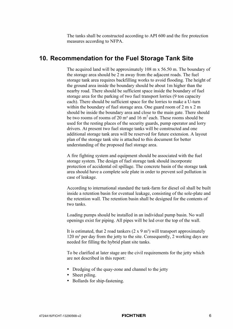
of the Hatiya Island (22°22'57.87"N, 91° 7'11.70"E). This area is under river erosion. Generally the sea track from Chairman Ghat of Noakhali district (ca. 25 km in the North on the mainland) comes to this jetty and also the ships from Chittagong (70 km to the East) use this jetty for load and unload cargo and passengers.
2. Tamaruddin Ghat: This landing station is on the west side of Hatiya Island (22°17'37.09"N, 91° 4'24.43"E). Sea truck from ChairmanGhat of Noakhali disctrict and launches from Dhaka use this Ghat.
3. Jahajmara Ghat: Some local boats and also the fishing boats use this quay (22° 7'9.27"N, 91° 1'15.94"E).
4. Kazir bazaar: This is a small jetty on the east coast of the island (22°17'46.73"N, 91°10'31.83"E) for local boat transportation. Generally, the fuel supplier of the present Hatiya power plant uses this Ghat to unload the fuel drums. The fuel is transported from Chittagong by trawler.
Figure 2-1: Overview Map of Hatiya Island and the Ghats [Courtesy: Google]

4724A16/FICHT-13290568-v2 3
Out of these main Ghats only two are navigable for oil tankers: Nalchira and Tamaruddin Ghat. Nalchira Ghat is under river erosion. Erosion protection work is going on at the Tamaruddin Ghat and surrounding area by placing concrete blocks and sand filled geo-textile bags. It is the intention of BPDB to select a location for the new jetty for fuel evacuation from the oil tanker a site near the Tamaruddin Ghat.
3. Present Fuel Supply System The supply of electricity at Hatiya is realized by three old diesel generators. The installed capacity of each generator is 400 kVA, but at present they can supply in total a maximum power of 500 kW only. At present diesel is carried in drums from Chittagong port by trawler to the Kazir bazaar. From there the drums are carried by trucks to the present plant area in Ozkhali bazaar (22°17'26.63"N, 91° 8'24.59"E). There are two metal storage tanks (see photos below) with a capacity of 50,000 and 30,000 liters inside the present diesel power station. The daily consumption of the plant is 1,400 liters. Currently, the plant is running for 12 hours per day. The capacity of the storage system is for approximately 2 months. The supplier transports 40 to 100 drums of diesel fuel at a time (each drum contains 200 liters of diesel oil). The new proposed hybrid power station is 5 km south to the present power station. Neither the old diesel generators nor the metal storage tanks will be used in future for the new hybrid plant. The new hybrid plant will have to get its own tanks.
4. Means of Fuel Supply System In future, fuel should be transported to the island by oil tanker of suitable sizes. The available oil tanker sizes in Bangladesh for inland water transport are from 250 tons to 2,000 tons. It is the intention of BPDB to bring fuel from Chittagong port city (closest area from Hatiya for bulk fuel purchase). A fuel tanker of at least 800 tons is necessary for safety reasons. To go to Hatiya from Chittagong one needs to cross the bay. Fuel tankers with a size less than 800 tons are not allowed to cross the bay. Considering the depth of the river beside Tamaruddin Ghat it is recommended to use the minimum accepted 800 tons oil tankers for fuel transport to the island.
5. Feature of the Oil Tanker Ships The 800 tons oil tankers have loaded draughts of 2 - 3 meters. The oil tankers have their own pumps for pumping of diesel fuels. Generally onboard 300 to 500 HP pumps are available in these oil tankers. These pumps can be connected to 4˝ (10.16 cm) or 6˝ (15.24 cm) oil evacuation pipes. The fuel tanks have their own rubber piping system for

4724A16/FICHT-13290568-v2 4
interconnection (it is recommended to provide both piping sizes for interface in the jetty – but the pipes from shore to the fuel tank should be 6˝ or 15.24 cm). By these pumps the fuel tankers can evacuate a fully loaded tank within 6-8 hours (depending upon the size of pumps in oil tankers). The flow rate is approximately 100 tons /hour. These pumps can pump oil up to a maximum of 350 meters horizontal distance with a vertical head of 25 meters. A permanent jetty near the storage tank is needed. There are available suppliers or constructors of jetties in Bangladesh.
6. Selection of Site for Installation of Fuel Evacuation Jetty
Considering the access to the island BPDB prefers to have the jetty for oil evacuation near the Tamaruddin Ghat. The place selected for jetty by BPDB is at a location with the co-ordinates: 22°17'2.74"N and 91° 4'23.14"E. Recently, erosion protection initiatives are taken for this side of the island as can be seen on the photos.. So, it can be reasonably expected that this shore line is protected now. The proposed hybrid plant in Horandra market is approximately 14 km from this proposed jetty area. The water level of this side of the river is high enough even during the winter for oil tankers navigation. Three (3m) meters depth of water body can be achieved within 5-7 meters from the shore line during low tide. A jetty is needed for anchorage and other infrastructure of the fuel tanker for diesel evacuation. The co-ordinates of the selected fuel storage area are 22°17'2.27"N and 91° 4'34.55"E.
Figure 6-1: Google earth image of the proposed fuel storage area and also the
proposed jetty area for fuel tanker anchorage.

4724A16/FICHT-13290568-v2 5
7. Feature of the Selected Area for Storage Tank near the Jetty
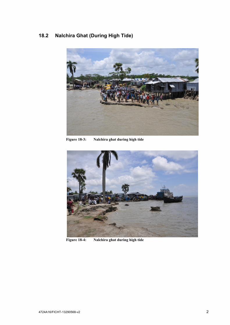
The area selected by BPDB for fuel storage tank near the proposed jetty is privately owned. BPDB will be responsible for acquiring the area. At present the area is used for some seasonal crop cultivation like lentil. There is an earth road (approximately 3 meters wide) from the jetty to the proposed fuel storage area. A brick soling road goes to the nearby Tamaruddin market from the selected fuel storage site. From Tamaruddin market an asphalt road goes to the hybrid plant area. The fuel storage tank area looks flat and is approximately 1 meter lower than the adjacent road. The area needs to be filled up and the sand / earth fill should be one 1 meter higher than adjacent road. At present the connecting road from Tamaruddin market to selected fuel storage site is a brick soling road. The width of the road is approximately 3.5 meters. No resettlement of houses or bush clearance is needed for building the storage tanks. The selected site for fuel storage is 108 m x 56.50 m.
8. Calculation of Maximum Monthly Fuel Requirement Daily consumption of the fuel for 2.0 MW 24h/day operation will be of 10 tons [12m3]. Maximum monthly requirement is 300 tons (30 days x10 tons).
9. Fuel Storage Tanks near the Jetty Fuel storage capacity of the storage tank near the jetty should be sufficient to store fuel that is carried by an oil tanker that can cross the bay. There should be fuel storage tanks at two different locations: One should be near to the jetty that should be sufficient enough to store diesel of one full oil tanker. The minimum size of the oil tanker that can pass the bay is 800 ton. So the storage tank capacity near to the jetty should be bigger than 800 ton, with some buffer capacity the storage tanks near the jetty should be 1,000 ton capacity, which is approximately 1300 m³. Considering the geographical location of Hatiya it will be wise to build two 500 ton interconnected cylindrical shaped fuel storage tanks near the jetty, for instance each storage tank could be 5 meters in diameter and height 8 meters. The tanks material shall be of steel or alternative concrete tank with liner inside. The tanks itself shall be placed inside a big retention basin able to retain the total fuel capacity in case of tank lack or accident safe and without environmental pollution. Two tanks should be connected with two stop valves. Fuel unloading (to road tank lorries) facilities should be considered at both storage tanks, so that two fuel tank lorries can be loaded at the same time from each tank. The storage tanks should be equipped with small pumps to load the road tank lorries. Loading from the jetty should be such that both the storage tanks can be loaded simultaneously and also separately.
4724A16/FICHT-13290568-v2 6
The tanks shall be constructed according to API 600 and the fire protection measures according to NFPA.
10. Recommendation for the Fuel Storage Tank Site The acquired land will be approximately 108 m x 56.50 m. The boundary of the storage area should be 2 m away from the adjacent roads. The fuel storage tank area requires backfilling works to avoid flooding. The height of the ground area inside the boundary should be about 1m higher than the nearby road. There should be sufficient space inside the boundary of fuel storage area for the parking of two fuel transport lorries (9 ton capacity each). There should be sufficient space for the lorries to make a U-turn within the boundary of fuel storage area. One guard room of 2 m x 2 m should be inside the boundary area and close to the main gate. There should be two rooms of rooms of 20 m² and 16 m2 each. These rooms should be used for the resting places of the security guards, pump operator and lorry drivers. At present two fuel storage tanks will be constructed and one additional storage tank area will be reserved for future extension. A layout plan of the storage tank site is attached to this document for better understanding of the proposed fuel storage area. A fire fighting system and equipment should be associated with the fuel storage system. The design of fuel storage tank should incorporate protection of accidental oil spillage. The concrete basin of the storage tank area should have a complete sole plate in order to prevent soil pollution in case of leakage. According to international standard the tank-farm for diesel oil shall be built inside a retention basin for eventual leakage, consisting of the sole-plate and the retention wall. The retention basin shall be designed for the contents of two tanks. Loading pumps should be installed in an individual pump basin. No wall openings exist for piping. All pipes will be led over the top of the wall. It is estimated, that 2 road tankers (2 x 9 m³) will transport approximately 120 m³ per day from the jetty to the site. Consequently, 2 working days are needed for filling the hybrid plant site tanks. To be clarified at later stage are the civil requirements for the jetty which are not described in this report: • Dredging of the quay-zone and channel to the jetty • Sheet piling. • Bollards for ship-fastening.

4724A16/FICHT-13290568-v2 7
11. Security Wall The boundary / security wall of the fuel storage site should be similar of the hybrid power plant near to Horandra market. The security wall should be 2.5 meters in height after land filling (the storage tank area should be backfilled at least one meter higher than the nearby road. Barbed wire of 0.6 meters should be placed over the security wall. The dimension of the security wall and the main gate is indicated in the drawings prepared for the main Tender Document.
12. Condition of Roads from Selected Fuel Storage Area to the Plant Area in Horandra Market
The selected fuel storage site is approximately 600 meters to the south of Tamaruddin market. The road connecting Tamaruddin market and selected fuel storage site is brick soling road. The road connecting Tamaruddin market and proposed hybrid plant near Horandra market is an asphalt road. The width of the asphalt road is 3.5m with a clearance of 0.5m on both sides. There are several culverts on the way. A study to be performed by the bidder to confirm that they can carry the loads of the tank lorries without any risk or damage or if not, which strengthening or reparation works are required. One culvert was seen to have a width of 3.2m. There are some sharp bends in the connecting road but those are not assumed to hinder the transportation of the 9 tons fuel tank lorries. The Bidder has to conform also this by an own study.
13. Responsibility of Fuel Transport BPDB will pay for the diesel cost and transportation cost of oil tankers from Chittagong BPC depot to the unloading jetty at Hatiya. Pipe line construction (buried pipes from jetty to storage tank), supply of reserve tank near the unloading jetty and other infrastructure construction or improvement is an inevitable part of Bidder’s scope of work; the Bidder will have to take the responsibility and ensure the pumping/unloading fuel from floating main vessel to the nearby storage tank within the period of its contractual obligation of 2 years. Likewise, within the contractual obligation period Bidder has to perform fuel transportation from the storage tank at the jetty to the hybrid plant.
14. National Requirement for Oil Tank Ships to Stop at an Island
At present there is no route for oil tank ships to go to Hatiya. So, the selected Bidder needs to acquire the permission from BPC (Bangladesh petroleum Corporation) for oil tank ships to go to Hatiya with the assistance of BPDB. For the construction of the new jetty at Hatiya Island permission

4724A16/FICHT-13290568-v2 8
from BIWTA (Bangladesh Inland Water Transport Authority) is required, BPDB will assists in getting this permission.
15. Availability of Electric Power at Fuel Storage Site after the Completion of Grid Network
BPDB will ensure the grid extension (electric power line) up to the fuel storage site.
16. Social and Environmental Clearance and other Certification
Clearance of DoE (Department of Environment) and also clearance from Bangladesh Fire Service and Civil Defense may be needed for the fuel transport system development in Hatiya Island. In both the cases BPDB will take care of getting the clearance certificates. If any other clearance or certificates is needed BPDB will also assist the bidder in getting those.

4724A16/FICHT-13290568-v2 1
17. Annex 1 - Layout Drawing A tentative layout drawing is attached in Section 6 - Chapter 3 - Attachment C-07 Storage Tank Site Layout.

4724A16/FICHT-13290568-v2 1
18. Annex 2 - Photographs
18.1 Tamaruddin Ghat
Figure 18-1: Tamaruddin Ghat during low tide
Figure 18-2: Tamaruddin Ghat during high tide
4724A16/FICHT-13290568-v2 2
18.2 Nalchira Ghat (During High Tide)
Figure 18-3: Nalchira ghat during high tide
Figure 18-4: Nalchira ghat during high tide

4724A16/FICHT-13290568-v2 3
18.3 Proposed Jetty Site (Near Tamaruddin Ghat)
Figure 18-5: Proposed site for oil evacuation jetty
Figure 18-6: Photo from proposed jetty site (Photo from S to N)

4724A16/FICHT-13290568-v2 4
Figure 18-7: Photo from proposed jetty site (From N to S)
Figure 18-8: Photo towards the proposed jetty site (From E to W)
4724A16/FICHT-13290568-v2 5
Figure 18-9: Road from fuel storage site to jetty site (FromE to W)
Figure 18-10: Road from the proposed fuel storage site to jetty site (From E to W)

4724A16/FICHT-13290568-v2 6
Figure 18-11: Road towards the fuel storage site from the river bank (From W to E)
Figure 18-12: Road from fuel storage site towards Tamaruddin market (From S to N)

4724A16/FICHT-13290568-v2 7
18.4 Proposed Fuel Storage Site near to the Jetty Site
Figure 18-13: Proposed area for fuel storage tank
Figure 18-14: Proposed area for fuel storage tank (photo from W to E)

4724A16/FICHT-13290568-v2 8
18.5 Road from the Storage Tank to the Power Plant Area
Figure 18-15: A sharp bend of the road connecting fuel storage tank area to the
hybrid plant area
Figure 18-16: Asphalt main road from Tamaruddin Ghat to Hybrid plant site

4724A16/FICHT-13290568-v2 9
Figure 18-17: A culvert on the main road
Figure 18-18: Main road from Tamaruddin Ghat to hybrid power plant site

4724A16/FICHT-13290568-v2 10
18.6 Hybrid Plant Area
Figure 18-19: Hybrid plant area near Horandra market (during dry season)
Figure 18-20: Hybrid plant area near Horandra market (during rainy season)