borough of bridgewater beaver county,...
TRANSCRIPT
Borough of Bridgewater Beaver County, Pennsylvania

Comprehensive Plan for the Borough Bridgewater Beaver County, PA
I TABLE OF CONTENTS I
I Section I:
0 0 0 0
Section 11:
I I 0 I 0 I
1 t.
Section 111:
0 0 0 0 0
Section IV:
Section V:
Section VI:
INTRODUCTION
A Comprehensive Plan: What is It? Statutory Authority for the Plan The Consulting Finn Methodology Applied in Preparing the Comprehensive Plan
THE BOROUGH OF BRIDGEWATER, BEAVER COUNTY PA
Regional Setting Historical Background
DEMOGRAPHIC ANALYSIS
Population Population by Age Cohort Racial Composition Income and Employment Commutation Patterns
TRANSPORTATION AND INFRASTRUCTURE
LAND USE ANALYSIS
RECREATION
Section VII: (
HOUSING

Section VIII: ECONOMIC DEVELOPMENT
Section IX: COMMUNITY DEVELOPMENT PLAN
Section X: IMPLEMENTATION
LIST OF MAPS
EXISTING LAND USE COMMUNITY FACILITIES PROPOSED LAND USE

SECTION I:
INTRODUCTION

INTRODUCTION
A Comprehensive Plan: What is It?
In Pennsylvania, comprehensive planning documents are developed and guided by the Pennsylvania Municipal Planning Code, or Act 170. This code identifies a set of specific elements that are recommended for every comprehensive planning document, but does not limit the plan to this specific set of criteria. Instead, municipalities are encouraged to research and analyze data that may be unique to an individual area.
The preparation of a comprehensive plan involves the collection of a set of interrelated ideas and data. A comprehensive plan is not intended to be a specific blueprint for community development, but rather a flexible document that guides growth, development or redevelopment by recommending municipal policy actions in regard to land use. The broader planning goal of the document is to promote the health, safety, and general welfare of the community.
In accordance with Act 170, the completed Bridgewater Comprehensive Plan incorporates the following planning issues into the various components of the plan.
H A statement of objectives of the municipality concerning its future development within the context of its location, character, and timing of any future development.
A plan for land use.
A plan to meet the housing needs of the community.
H A plan for the movement of people and goods.
H Interrelationships among planning components.
H Short and long range goals.
H Interrelationships of policy among contiguous municipalities and the County.
Statutory Authority and Intent of the Comprehensive Plan
A comprehensive plan can be viewed as a tool which municipalities or Planning Commissions u t i e when faced with making planning related decisions. As stated above, the Pennsylvania Municipalities Code (Act 170 of 1988) guides the development of the comprehensive plan. Act 170 also provides the statutory authority for the preparation of the plan. Act 170 allows for "The planning agency shall at the request of the governing body have the power and shall be required to:
Section I Page 1

0
0
1. Prepme the comprehensive plan for development of the municipality, and present it for the consideration of the governing body.
The governing b 4 shall have the power to adopt and amend the comprehensive plan as a whole or in parts."
A valuable comprehensive plan does not deal with one specific issue or one form of development, but rather is drafted with the intent to integrate a wide range of issues and topics. The comprehensive approach provides a balance of issues necessary to formulate valuable strategies for community revitalization as well as potential growth.
The comprehensive plan identifies and addresses a broad range of social, economic and environmental issues while incorporating the elements required by the Pennsylvania Municipalities Code. The overall intent of this plan is to provide a framework from which policy makers and stakeholders can act to manage, enhance and preserve the natural and man made environments within the Borough of Bridgewater and Beaver County well into the Twenty-first Century.
The Consulting Firm and its Approach
The Borough of Bridgewater selected the firm of Mullin & Lonergan Associates, Inc. to prepare the Comprehensive Plan in the spring of 1997. Mullin & Lonergan is a community and economic development consulting firm with offices in Pittsburgh and Philadelphia. The firm has a broad background in comprehensive planning, redevelopment, urban planning, community development, demographic analysis and development financing. Mullin and Lonergan Associates, Inc. participated in a 1986 study of the Borough of Bridgewater's riveri?ont and downtown resources. Since that time, Mullin & Lonergan has become involved in a site specific land use plan for the former Benton's Landing marina property. M u h & Lonergan's approach to the comprehensive plan incorporates previously completed planning initiatives along with an updated analysis of land use and other planning issues on a Borough-wide basis to create a current and unified statement of planning policies for the community.
Methodology Applied in Preparing the Comprehensive Plan
In carrying out this project the consulting team used various methods to reach its conclusions. This comprehensive plan was developed using the following methods.
Census Data
The demographic data used in the preparation of this document was obtained from the 1980 Census of the Population as well as 1990 Census of the Population and Housing, Summary Tape 3A. In addition to the 1980 and 1990 Census data, the most recent State of Pennsylvania's income and poverty data were utilized. This includes data on employment and
Section I Page 2 I

unemployment as well as housing were applicable. Each source which was used in documented in the text of the report.
Windhield Survey and Site Analysis
In obtaining data such as land use, recreation areas, economic development opportunities and the transportation network, the consultants performed a detailed windshield survey and site analysis. For example, in obtaining data for land use in the Borough, a block by block survey was conducted during the springlsummer of 1997. This information provided the basis for many of the policy recommendations contained in this report.
Meetings
Recommendations and information contained in this report were also based on interviews conducted by the consulting firm. The information obtained in the report grew out of meetings with local officials and other locally based groups who have presence in the Borough of Bridgewater.
Other Information
During the course of the preparation of this document many additional sources of information, too many to mention here, were utilized. All statistics and outside information contained in this report is cited within the body of the text. Please refer to each individual footnote for reference sources.
Section I Page 3

I
SECTION 11:
THE BOROUGH OF BRIDGEWATER, BEAVER COUNTY, PA

THE BOROUGH OF BRIDGEWATER, BEAVER COUNTY, PA
0 Regional Setting
Bridgewater is located in the center of Beaver County at the confluence of the Beaver and Ohio Rivers. Bridgewater is approximately 35 miles northwest of downtown Pittsburgh.
Bridgewater lies at the intersection of two major transportation arteries. Route 5 1 is a major north / south four lane corridor which provides direct access to the town at Bridge Street, Riverside Drive and the signalized intersection at Leopard Lane. The other major artery is Route 68. Route 68 is the major east / west corridor which provides direct access to Beaver. The Beaver Valley Expressway is located approximately two miles west of Bridgewater via Route 68 through the Borough of Beaver. The expressway also provides direct access to the Greater Pittsburgh International Airport, the Parkway West, Downtown Pittsburgh and all points east.
Bridgewater is linked to New Brighton and Beaver Falls via Route 18. Exit 2 of the Pennsylvania Turnpike is located approximately ten miles north of Bridgewater on Route 18. Route 65 provides access to Pittsburgh via Ambridge and Sewickley.
Within a 30 mile radius of Bridgewater are numerous attractions and urban centers including the City of Pittsburgh, the western portion of Allegheny County , the Greater Pittsburgh International Airport, the northern portion of West Virginia panhandle including the City of Weirton and parts of eastern Ohio such as the City of S t eu benville.
The central part of Beaver County offers such amenities and attractions as the seat of County government in Beaver, the Beaver County Medical Center, the famous four star Wooden Angel restaurant, Brady's Run Park, the Beaver Valley Mall, Penn State's Beaver Campus and various recreational attractions of the Beaver River.
Section II Page 1

0 Historical Background
Bridgewater is situated on the northwestern shore at the confluence of the Beaver and Ohio Rwers. By 1800, Bridgewater was an active port and boat building center. In the early 18OO's, the Bridgewater waterfront was typically full of canal boats extending fiom the bridge up river to Sharon.
Significant events in Bridgewater history include:
H In 1803 the Harmony Society purchased and developed the west bank of the Beaver River fiom the bridge to the Ohio River. This space was used for storing goods shipped and received by river.
H In 1814, the Pennsylvania Assembly adopted an Act to authorize the construction of a toll bridge over the Beaver River at "Wolf Lane". Wolf Lane was an early reference to what is now the Bridgewater side of the Beaver Valley. The WolfLane Bridge was the second bridge to transverse the Beaver River, the first having been built two miles upriver at Fallston.
H In 182 1, the Wolf Lane Bridge was destroyed by a wind storm and rebuilt in 1824 at a cost of $20,000.
H In 18 18, a prominent local man named Joseph Hemphill began to lay out a large portion of Bridgewater, he being one of the largest land owners in the area. He erected an inn and a storeroom at the end of Wolf Lane Bridge and for many years did a thriving business.
H The construction of the canal system fiom Bridgewater to New Castle in 183 1 brought prosperity to Bridgewater. In the 1830's Bridgewater became a completely urban center containing 1 10 dwellings, 4 taverns, and one church. Bridgewater's industries included a sawmill, salt works, iron foundry, brewery, a windmill factory and numerous boatyards.
H In 1834, Bridgewater gained independence and was incorporated as a Borough.
Curiously, Bridgewater benefitted fiom the development of the railroads (circa 1850) on the opposite side of the River. Given the relatively small land area of the Borough, a railroad right of way on the western bank of the Beaver River would have severely restricted access to the water and would have become the dominant land use of the community.
The economic interests of Bridgewater have been better served fiom the location of the locks and railroads on the opposite side of the river. The Borough now enjoys one
Section II Page 2

of the few riverfront areas in Western Pennsylvania that is unencumbered with railroad and industrial land uses.
While primarily a working waterfiont community, Bridgewater also became something of a tourist attraction. Stephen Stone constructed a hotel and steamboat landing at the mouth of the Beaver River near the present location of the Crah Brothers barge repair facility. "Stones Point" became the a stopping place for river traffic, and soon took on the characteristics of a resort and local assembly point where news of the day was shared.
At this time, Bridge Street extended from the River to Beaver and was lined with commercial establishments including grocery stores, a bakery, doctors offices and tailor shops. The Keystone Bakery was or igd ly located on Bridge Street (1 884) but moved to Market Street in 1902. The Peirsol Academy, a private school was established in Bridgewater in 1875. The first Post Office was opened in 1879. It bore the name of "West Bridgewater" because there was another town by the name of Bridgewater in the eastern portion of Pennsylvania.
Section II Page 3

SECTION 111:
Demographic Analysis

I
Place
DEMOGRAPHIC ANALYSIS
Total Number of Persons 1980 1990
This section of the Comprehensive Plan will analyze the historic changes that have occurred in the Borough of Bridgewater and Beaver County. The infomation and corresponding trends that are presented, ultimately provide the basis for the recommendations set forth at the end of this plan. The data source utilized for this analysis is the 1980 and 1990 U.S. Census Population and Housing. Generally, the information will show the changes in population, income, employment, housing and commutation patterns in the Borough and the County.
Beaver County
0 Population
204,441 180,805 I
As can be seen by the following table, the Borough of Bridgewater has lost approximately 15% of its total population between 1980 and 1990. In 1980, the total population of the Borough was 879 persons. By 1990, the total number of Borough residents dropped to 746 according to the most recent Census Bureau statistics. Similarly, the County lost 12 % of its population over the same time period.
Population Borough of Bridgewater
1980 - 1990
0
I Bridgewater Borough I 879 I 746 I
Not only has Borough of Bridgewater lost population since 1980, but the remaining persons have aged. In 1980, 223 persons were over the age of 55. This represents a full quarter of the total population. By 1990, those persons over the age of 55 totaled 209, or 28% of the population. This represents a 3% increase compared with 1980.
Another characteristic of the Borough’s population is that since 1980 those persons ages 9 and under have decreased substantially. In 1980, there were a total of 124 persons ages 9 or under. This represented over 14% of the total population. In 1990, those persons ages 9 and under totaled 79 or 10.5% of all persons. This is almost a 5% loss of population for this age cohort in a ten year period. The following chart shows a breakdown for all age cohorts in the Borough of Bridgewater between 1980 and 1990.
Section III Page 1

Population by Age Borough of Bridgewater, PA
1980-1990
Age Cohort
under 5 years
5-9 years
Total Persons 1980 1990
61 34
63 45 ~~
10-14 years
15- 19 years
I 20-24 years I 75 I 57
52 49
83 51
25-34 years
35-44 years
45-54 years
114 121
98 120
109 60
55-64 years
65-74 years
75 + years
0 Race
109 98
86 65
30 46
Since 1980, the racial breakdown of the Borough of Bridgewater has remained relatively stable. In 1980 there were 748 whites, or 85% of the population, 128 blacks, or 14% of the population, and the balance a mix of American IndiansEskimos, and Asians. By 1990, the percent of each of these races stayed about the same despite a small drop in overall population of the Borough. 1990 Census data showed there were 645 whites (86%), 94 blacks (12%) and 7 (2%) persons who are classified as "other" race. The following table shows a comparative breakdown of race in the Borough of Bridgewater between 1980 and 1990.
Total
Section III Page 2
879 746

Racial Breakdown Borough of Bridgewater, PA
1980-1990
Race
White
Black
1980 1990
748 645
128 94
American Indian, Eskimo, Aleut
Asian
I Other I 0 . I 7 I
2 0
1 0
I Total I 879 I 746 I
Income Range
Less than $5,000
5 , 000-9,999
10,000-14,999
0 Income
1980 1990
52 25
39 30
42 53
In terms of income, households in the Borough of Bridgewater has generally improved since 1980. Households in the upper income bracket ($50,000 and above) has jumped fiom 2 households in 1980 to 38 in 1990. Also, households in the $35,000 to $49,999 range have also increased between 1980 and 1990. Those households earning between $35,000 and $49,999 in 1980 number 25 by 1990 that number had grown to 39. Also, Median Household Income increased to $22,609 in 1990 fiom $17,500 in 1980 . This represents nearly a 33% increase over the ten year period.
However, despite the growth in the number of households at the upper end of the income range, the vast majority of households in Bridgewater still earn less than $25,000 a year. In fact, 1990 Census data revealed that nearly 57% (175) of the households in Bridgewater e m less than $25,000 a year. The following table provides a breakdown of income for the Borough of Bridgewater.
Household Income Borough of Bridgewater, PA
1980-1990

15,000-24,999
25,000-34,999
107 67
45 54
Poverty
35,00049,999
50,000 and above
Total Households
Median Household Income
Median Family Income
Another key aspect to examine when looking at income is the extent of poverty in the community. This reflects the general health of an areas economy. As may be seen by the table below, the poverty rate in Bridgewater has almost doubled since 1980 despite the fact that the population has remained relatively constant. In 1980, there were only 18 families which were considered below the poverty line. This represents nearly 8% of the total population of Bridgewater in 1980. By 1990, poverty figures revealed that 15% (1 14 families) of the population in Bridgewater was below the poverty line.
25 39
2 38
3 12 3 06
$17,500 $22,609
$19,279 $24,779
Low and Moderate Income Data
Like the poverty statistics above, low and moderate income data provides insights into a municipalities economic health and well being. Based on 1990 Census data, the Commonwealth of Pennsylvania compiled the percent of the persons which earns less than 5 1% of the median income for the area. In Bridgewater, there was a total of 3 17 persons which were considered low and moderate income. This translates into an overall low and moderate income percentage of 43.66%. This is a relatively low percentage compared to other surrounding Beaver County communities such as Aliquippa and Beaver Falls.
Employment
When comparing occupations in Bridgewater Borough, it is easy to see that the economy is service based in nature. Nearly 71% of all occupations located in the Borough were service related in 1990. Another observation along this line is that the Bridgewater economy has been changing fiom a manufacturing base to a more service based economy since 1980. The Borough of Bridgewater is no different, in this regard, than the nation as a whole.
Section III Page 4

This trend of chan@ng from a service based economy has been occurring on a national level since the late 1970's.
~~~~ ~
Farming, Forestry, and Fishing
Precision Production, Craft and Repair
Operators, Fabricators, and Labors
Evidence of this trend may be observed in the table below. As can be seen, in 1980 more than half of all occupations were based in manufacturing related industries while the other half of the work force was employed in the service type industries. By 1990, a large gap developed between those employed by the service based industries and those employed by manufacturing industries. Nearly 7 1% of the work force was employed in service related industries while only 29% of the work force was employed by manufacturing based industries.
0 3
51 28
126 70
Occupational Breakdown Borough of Bridgewater, PA
1980-1 990
OccuDation 1 1980 I 1990
Managerial and Professional Speciality
Technical, Sales, and Administrative Support
Service OccuDations I 66 I 68
Totals I 345 I 339
Another positive aspect of the Bridgewater economy is the drastic improvement in the unemployment statistics between 1980 and 1990. As can be seen by the followhg chart, unemployment was cut nearly in half over the last ten years. In 1980, there were 688 persons in the work force of which 345 were employed and 53 were unemployed. This represented an unemployment rate of 13.3%. By 1990, 612 persons were in the work force with 339 persons employed and only 29 person unemployed. This translated into an unemployment rate of only 7.9%.
Section III Page 5

Employment Figures Borough of Bridgewater, PA
1980-1990
Labor Force Status
Persons 16 years and older in Labor Force
Percent in Labor Force
1980 1990
688 612
57.8% 60.9%
Employed
Unemployed
I Percent Unemployed I 13.3% I 7.9% 1
345 339
53 29
Commutation
Commuting to Work
Workers 16 and over
Percent that Drive
Percent that Carpool
Percent using Public Transportation
The final demographic characteristic that was researched was commutation, or the means by which residents of the Borough of Bridgewater get to their place of employment. As can be seen by the chart below, nearly three quarters of all residents get to work by driving.
1980 1990
345 339
73.6 73.6
12.0 13.8
0.0 I .2
Somewhat surprising, is the fact that a large percentage of workers carpool to work in Bridgewater. In 1980, 12% of persons employed carpool. By 1990, that number increase by nearly two percentage points to 13.8%. Another somewhat surprising figure is the fact that in 1980 and 1990 a large percent of persons walk to their place of employment. In 1980 and 1990, about 12% of working persons walked to work.
With a mean travel time to work of 16 minutes, it is apparent that Bridgewater is largely a bedroom community whose residents travel to surrounding areas for employment purposes.
Commutation Patterns Borough of Bridgewater, PA
1980-1990

I Percent using other means I 2.4 I 0.0 ~~~~ ~
Percent Walking
Mean Travel Time to Work
12.0 11.4
16.6 minutes 17.6 minutes
Section m Page 7

SECTION IV:
TRANSPORTATION AND INFRASTRUCTURE IN BRIDGEWATER, PA

TRANSPORTATION AND INFRASTRUCTURE IN BRIDGEWATER
0
0
Introduction
Transportation access in terms of availability and adequacy is of vital importance to the social and economic vitality of a Borough as transportation and intiastructure is a major determinant of economic and residential growth. This comprehensive Plan identifies and analyzes the differing modes of transportation available to the Borough to determine how Bridgewater can better position itself for economic and residential development/revitdition. .
Transportation is considered a valued commodity. It is essential requirement for the development of the economy and the efficient movement of traffic. Access has always played a significant role in determining growth patterns, economic progress and centers of activity.
In addition, our society has become much more concerned with traffic safety, the environment, and the quality of life as it relates to transportation issues. Therefore, transportation problems are more complex today then ever before. This section of the plan examines the Borough’s existing modes of transportation on a local level and how the regional traffic network impacts the Borough’s transportation system. This section attempts to identify hture actions that will provide a more effective and efficient transportation system.
Regional Transportation Access
Bridgewater is located in the center of Beaver County at the confluence of the Beaver and Ohio Rivers. Bridgewater is approximately 35 miles northwest of downtown Pittsburgh.
Bridgewater lies at the intersection of two major transportation arteries. Route 5 1 is a major north / south four lane corridor which provides direct access to the town at Bridge Street, Riverside Drive and the signalized intersection at Leopard Lane. The other major artery is Route 68. Route 68 is the major east / west corridor which provides direct access to Beaver. The Beaver Valley Expressway is located approximately two miles west of Bridgewater via Route 68 through the Borough of Beaver. The expressway also provides direct access to the Greater Pittsburgh International Airport, the Parkway West, Downtown Pittsburgh and all points east.
Bridgewater is linked to New Brighton and Beaver Falls via Route 18. Exit 2 of the Pennsylvania Turnpike is located approximately ten miles north of Bridgewater on Route 18. Route 65 provides access to Pittsburgh via Ambridge and Sewickley.
Section IV Page 1

Within a 30 mile radius of Bridgewater are numerous attractions and urban centers including the City of Pittsburgh, the western portion of Allegheny County , the Greater Pittsburgh International Airport, the northern portion of West Virginia panhandle including the City of Weirton and parts of eastern Ohio such as the City of Steubenville.
The central part of Beaver County offers such amenities and attractions as the seat of County government in Beaver, the Beaver County Medical Center, the famous four star Wooden Angel restaurant, Brady's Run Park, the Beaver Valley Mall, Penn State's Beaver Campus and various recreational attractions of the Beaver River.
0 Circulation Patterns
Vehicular traf€ic from points north enters the Borough at the intersection of Route 5 1 and Riverside Drive. Traffic from points east and south, i.e., Rochester and Monaca enters the focus area either via the Bridgewater/Rochester Bridge or the Bridge Street exit of Route 5 1. Traffic from Beaver and points west enter the focus area by way of Route 68, Wolf Lane, and Market Street.
Bridgewater has not been treated kindly by the Route 51 highway planners. This major four lane artery bisects the Borough longitudinally and forms an abrupt end to the Bridge Street commercial district. To the uninitiated, the relative absence of directional signage identifjmg the Bridge Street exit and the severe radius of the highway and the exit ramp render this blind interchange nearly unusable. Without advance warning, northbound vehicles traveling at expressway speeds simply cannot decelerate in time to initiate the hard right turn onto Bridge Street. Northbound access onto Route 5 1 from Bridge Street is prohibited due to limited sight distances of oncoming traffic. Poor planning of the Bridge Street exit from Route 51 has resulted in public safety problems and has detracted from the commercial viability of the Bridge Street shopping district. Efforts are needed to ease the transition from expressway to the traditional. downtown commercial district.
There exists a general lack of directional signage to Bridgewater fiom all points, but this is especially true for motorists approaching Bridgewater from the east via Route 65. Small signs provide direction to Beaver and to Ohio via Route 5 1 , but the casual visitor to Bridgewater must translate these signs while negotiating a twisting high speed limited access highway in order to reach his destination. There is no substitute for large, well lighted overhead signage at the Route 65/5 1/68 malaise.
The internal street system within the Bridgewater focus area employs a grid pattern with the primary north-south streets being Riverside Drive and Market Streets. The major east-west streets are Bridge Street and Leopard Lane.
Section IV Page 2

Pedestrian circulation within the Borough is similar to vehicular traffic patterns. Pedestrian access to the riverfiont is impeded by the guardrail along Riverside Drive. A footpath has been worn along the river side of the guardrail, which demonstrates the demand for some form of pedestrian walkway running parallel to the River.
The Borough has recognized the need for pedestrian access to the riverfront area as evidenced by the Riverside Park improvements including the shelter, amphitheater, bank stabilization efforts and the boardwalk. Access to these facilities is provided by means of a rampway at the north end of the existing boardwalk. There exists an obvious need to expand on the public improvements within the park, and the Borough is presently seeking additional recreation grants fiom State government to continue this project.
The linkage between Riverside Park and public parking areas is highly underdeveloped. The transition fiom motorist to pedestrian must be both convenient and environmentally inviting in order to reinforce the public's use of the park. Presently there are no public parking lots to service the park, and parking on Riverside Drive is quite dangerous given the width of the berm. Most visitors park their automobiles along the cross streets that run perpendicular to the kver. The absence of designated parking areas and a formalized pedestrian crossing area on Riverside Drive impedes public access to the park. During peak demand pe,riods such as the Beaver County Riverfest, parking and pedestrian movements become rather chaotic. This is not particularly surprising given the size of the community and the scale of the event.
Another important aspect of circulation involves access to the community by watercraft. Vessels approaching Bridgewater via the Ohio River enter the Beaver River by passing under a series of three bridges including a rather unattractive but functional railroad bridge, the expressway bridge and the Bridge Street bridge. The 22 foot vertical clearance at the Railroad Bridge precludes all but the smallest of pleasure craft fiom gaining access to the Beaver River. Once inside the bridges, there are seven marinas and the Borough of Rochester's leased boat club areas which collectively offer more than 500 seasonal dockage spaces to boaters. There is a relative absence of a public dock or transient dockage facilities along the Beaver River to meet the needs of visiting yachtsmen. In recent years, each marina has been filled to capacity with seasonal dockers and extensive waiting lists now exist for dockspace. A Pennsylvania Fish Commission launch ramp has been constructed along the River in New Brighton, and this facility is highly utilized during weekends.
Section IV Page 3

I 0 Infrastructure
The Borough of Bridgewater is well serviced by utility inhstructure, and the location of underground lines is readily available from engineering survey data. Sanitary sewer service was extended to the Borough in the late 1960's. Certain gas lines within the Borough are privately owned and maintained. Caution must be exercised whenever excavation is planned in these areas. There are also a small number of active oil and gas wells in the Borough that are capped.
The Borough of Bridgewater is serviced by Bell Telephone, Duquesne Light for electricity, Columbia Gas for natural gas, Adelphia for cable television and the Beaver Falls Municipal Authority for drinking water and sewage. M ,
The conditions of local streets is generally acceptable. Sidewalk development is sporadic, especially in the Riverfront Park area where emphasis must be placed on pedestrian circulation.
Section IV Page 4

~
I ~
I
SECTION V:
LAND USE ANALYSIS OF BRIDGEWATER, PA

LAND USE ANALYSIS OF BRJDGEWATER, PA
0 BACKGROUND
In the early 1980’s, Bridgewater began a gradual transformation in land use. I Much of this transformation can be attributed to the proximity of the Borough to the County Seat and the riverfiont location of the community. Bridgewater is one of the few communities whose riverfront land was not dominated by railroad and heavy industrial uses. People are attracted to Bridgewater because of the ability to access the amenities of the Beaver River.
Bridgewater has been a destination for pleasure boaters as well as visitors arrivhg by automobile for many years. Marinas and water related uses have been located along the Borough’s rive&ont throughout history. Jerry‘s Curb Service has attracted restaurant customers for generations. However until 1980, the amenities of the Beaver River did not stimulate large scale real estate development within the Borough of Bridgewater.
The Borough’s transformation in land use began, circa 1982, with the closure of the Keystone Bakery and the reuse of the property for Stone Point Landing, an office and restaurant facility. The positive market response to the Stone Point project attracted the attention of other developers and entrepreneurs. Residential condominiums in the $100,000 price range have since been developed on Riverside Drive and on Bridge Street. New residential construction is presently underway o
The Borough’s downtown has been revitalized through the introduction of streetscape improvements and commercial rehabilitation projects. The number of retail establishments in the downtown has increased dramatically. A new three story mixed use (ground floor commerciaVupper floor residential) structure has recently been introduced on Bridge Street near its intersection with Riverside Drive. Commercial development continues to occur along the portion of Riverside Drive near its intersection with Route 5 1. Recently, a one acre parcel of land on Riverside Drive was optioned for $200,000 in conjunction with plans to develop apartments for the elderly. This transformation is likely to continue until the supply of commercial land within the Borough becomes exhausted. The relatively limited supply of commercial land taken together with the increasing interest of developers in the Bridgewater market will cause further increases in land and building values. There will also be increased pressure on Borough officials to actively manage land use and development issues.
mrt*
Section V Page 1

NEIGHBORHOOD ANALYSIS
This section of the Comprehensive Plan will provide a brief overview of existing conditions within Bridgewater's neighborhoods and implications for h a r e growth and development. Many of the ideas and suggestions in this section of the Comprehensive Plan were originally conceived as part of previous planning studies in Bridgewater, including:
w a Riverfront Development Study for the Borough of Bridgewater dated December, 1987 a Riverfiont Development Plan prepared by the Beaver County Corporation for Economic Development dated March, 1993 a site development analysis for the area bounded by Route 51, the Beaver River, Bridge Street and Market Street prepared for the Borough of Bridgewater in January, 1995
The following sections describe the various neighborhoods of the Borough of Bridgewater and provide an overview of the neighborhood conditions. In addition, the map that follows this page provides a general overview of the existing land uses within the Borough.
Section V Page 2


0 Riverfront Areas
In many areas of the Borough, pedestrians can walk to the water's edge. It is this amenity that attracts people and investment to Bridgewater. As such, this attribute should be preserved to the maximum extent feasible.
The Borough's waterfront should remain accessible to the public. This will help to preserve the natural qualities of the riverfront. It is suggested that the first layer of land immediately adjacent to the river's edge be designated as a public access waterfront area. The foundation for the public access waterfront area was established in Bridgewateis Riverfront Development Study dated December, 1987. The objective of this land use classification is to maximize pedestrian access and circulation around the waterfront. This land area could constitute a thin ribbon of land to accommodate a pedestrian walkway. Buildings should never be built to the water's edge. Public ownership or an access easement of the first layer of land immediately adjacent to the river's edge will serve the Borough's long term interests.
The design guidelines for these riverfront areas include:
H Buildings
Buildings are generally discouraged in this district, as its purpose is to preserve habitat and protect the natural environment. Much of the land area encompassed within this district is located in the 100 year floodplain where local regulations prohibit most types of activity.
The types of buildings that would be appropriate for this zone would be limited public restroom facilities and service/storage buildings in support of public parks and dockage areas. These buildings must comply with local floodplain regulations and be unobtrusive and designed to blend harmoniously with the natural environment.
Roadways and Walkways
Design and layout of walkways should be sensitive to the natural qualities of the riverfront, and should emphasis pedestrian movements as the primary means of circulation along the water's edge. Grade separation should be utilized wherever possible as a means of separating pedestrian movements, vehicular movements and private use activities. Paving materials should be consistent throughout this district in order to achieve a degree of integration with adjacent development.
Section V Page 4

1 Lighting
The appearance of the waterfiont at night should be a major planning consideration, and a lighting plan should be developed for the district as a whole. Lighting should be low level and low intensity. Light poles &d fixtures should be uniform throughout the district. Lighting should be used to dramatize the bridges and landmarks to the riverfiont district.
1 Dockage Areas
Non commercial marinas (i.e., those without retail space, restaurant space, boat sales, service, storage, or showroom facilities) may be introduced to this district. Design of the dockage areas should provide public access to the riverfront while providing privacy of dockers. No outdoor storage of materials, supplies, and equipment in unenclosed areas should be permitted, nor should boat owners be permitted to use parking areas for repair or maintenance purposes. Provisions should be made for vehicular unloading areas in proximity to dockage area. One transient dock space should be provided for every 20 seasonal dock spaces.
1 Parking
Public parking should be provided at trailhead areas or in areas where more intense activity (dockage areas, launch ramp areas, amphitheater areas, etc.) is anticipated. Parking areas that contain more than 10 spaces should incorporate landscaped islands, dividers and screening. Wherever possible, large unbroken expanses of hard surfaces should be avoided.
1 Service areas
Service access for dumpsters and trash removal facilities should be adequately screened.
1 Signage
Signs that provide directional information will be permitted, as will signs that describe historic sites and/or events. Signage should be simple and unobtrusive. High quality graphics of uniform design are essential to the visual appearance of the district. An overall signage system should be designed for the study area. Advertising signs and billboards should be prohibited.
Section V Page 5

0 Wolf Lane Area
The Wolf Lane area includes all of the land located between Route 5 1 and the Beaver and Ohio hvers. Land uses within the Wolf Lane area include a service station, the Munroe auto body shop, the Matthe Oil Company, the Roberts Oil Company, Thursdays Restaurant and the Crane Brothers barge rebuilding facility. A railroad right of way traverses this neighborhood which limits access to the riverfront. Presently, a pedestrian trail is being developed in this area to link the amenities of the Bridgewater riverfront area with the Riverside Drive area of Beaver.
Land within this neighborhood will have increasing value for commercial development, especially land that fronts on the Beaver and Ohio Rivers. This site offers a spectacular view of the Beaver and Ohio Rivers. The railroad constraint to access must be overcome in order for this neighborhood to achieve its development potential. Thursday's Restaurant and the Captain's Quarters marina at the foot of Wolf Lane are appropriate uses within the neighborhood. The Borough should strive for higher quality commercial land uses in this area. Eventually, this area should become de-industrialized. This transformation will occur gradually over time as land values continue to increase.
In terms of future land use, a single integrated use that is oriented to the rivers would be appropriate. An important planning objective for this neighborhood is to provide a pedestrian link between the Riverside Drive area of the Borough of Beaver with the riverf?ont attractions and commercial amenities of Bridgewater's commercial core. It is suggested that this portion of the Borough be designated as a riverfront mixed use area. The Borough should encourage hotel, retail, restaurant, office and marina uses in this area. Public access to the riverfiont should be encouraged. The riverfront mixed use development concept for this neighborhood was originally envisioned in the Borough's Riverfront Development Study dated December, 1987. The ,following paragraphs outline the design guidelines for this mixed-use area.
The hverfront Mixed Use area represents a more upscale form of planned development that maintains a distinct orientation to the river. Since development will be in the form of new construction, this area offers an opportunity to achieve several waterfront and community development objectives.
The main objective embodied within the Riverfront Mixed Use area is to create a major new form of development and to link it to other attractions in the community via a network of pedestrian walkways and boardwalks. Public access and circulation are fundamental to the urban design objectives of the district.
Uses within this area might include a conference hotel, office, marina, and residential. Residential apartments or condominiums would preferably be developed at second floor locations above ground floor commercial uses, especially along the riverfront.
Section V Page 6
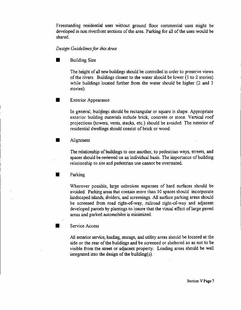
Freestanding residential uses without ground floor commercial uses might be developed in non riverfkont sections of the area. Parlung for all of the uses would be shared.
Design Guidelines for this Area
rn
rn
Building Size
The height of all new buildings should be controlled in order to preserve views of the rivers. Buildings closest to the water should be lower (1 to 2 stories) while buildings located hrther from the water should be higher (2 and 3 stories).
Exterior Appearance
In general, buildings should be rectangular or square in shape. Appropriate exterior building materials include brick, concrete or stone. Vertical roof projections (towers, vents, stacks, etc.) should be avoided. The exterior of residential dwellings should consist of brick or wood.
Alignment
The relationship of buildings to one another, to pedestrian ways, streets, and spaces should be reviewed on an individual basis. The importance of building relationship to site and pedestrian use cannot be overstated.
Parking
Wherever possible, large unbroken expanses of hard surfaces should be avoided. Parking areas that contain more than 10 spaces should incorporate landscaped islands, dividers, and screenings. All surface parking areas should be screened from road right-of-way, railroad right-of-way and adjacent developed parcels by plantings to insure that the visual effect of large paved areas and parked automobiles is minimized.
Service Access
All exterior service, loading, storage, and utility areas should be located at the side or the rear of the buildings and be screened or sheltered so as not to be visible from the street or adjacent property. Loading areas should be well integrated into the design of the building(s).
Section V Page 7

I Marina
Due to the potential for wake damage from commercial shipping along the Ohio River, the provision of dockage would best be accomplished through a dredged basin with a breakwater and seawalls. Controlling depths should be at least five feet. Building space should be provided for marina related services such as shower/restroom facility, laundry, boat supplies, and dockmaster's office. Provisions should be made for a vehicular unloading area or temporary parking area in proximity to slipspace.
I Roads and Walkways
Pedestrian pathways should be segregated from street comdors wherever possible. Design and layout of these paths should emphasize pedestrian movements as the primary means of circulation through the site. Areas of pedestrian use should be paved. Paving materials and patterns should be consistent for walkways, drives, and parking areas in order to achieve a degree of integration with the adjacent development.
I Lighting
Lighting should be organized in simple patterns which reinforce the basic structure of open spaces and sidewalks. Where lights follow a street or sidewalk, they should be placed in straight rows on one or both sides. Light poles and fixtures should be consistent throughout the district.
I Sculptures and Fountains
A sculpture or fountain should be encouraged along the waterfront. This sculptural element would function as an effect landmark for the site.
I Signage
Signs should be simple and unobtrusive. High quality graphics are essential to the overall visual experience of the site. The following type of signs should be permitted:
1. Building Identifications - one sign permitted at the main entrance to each building.
2. Directional Signs - As required to facilitate and regulate movement (vehicles and persons) through the site.
Section V Page 8

I 0 Village Commercial Area
Bridgewater’s village commercial area is bounded generally by Route 5 1, the Beaver River and Otter Lane. Land uses within this neighborhood include ground floor retail establishments fkonting on Bridge Street, the Beglin Ford dealership, the EMS garage and office on Bridge Street, churches, professional offices, a new retaiVresidentia1 condominium building, Stone Point Landing, banks and single family homes. This area is part of the Borough’s historic district. As such, a village setting should be preserved wherein new construction is sympathetic to the character of existing buildings.
Highway commercial uses such as the Ford dealership, the fuel pumping facility and the EMS garage are inappropriate for this area. The Borough should strive for a pleasing pedestrian environment within its central commercial core. Vehicular circulation in this area should be secondary to pedestrian movements.
The continued revitalization of the Borough’s commercial core area should be encouraged. The tree plantings , light fixtures and benches give a pedestrian scale to the business district. Additional green areas, parklets and walkways would further reinforce the historic preservation objectives of the neighborhood. It is especially important to preserve older commercial buildings that front on Bridge Street and to encourage ground floor retail and service uses within the Bridge Street environment. Again, it is important to preserve pedestrian access to the riverfront. The Stone Point Landing facility is an example of how commercial development can be made more dynamic by preserving public access to the Beaver River.
Parking in village commercial areas is traditionally provided by on-street metered spaces and off street metered lots. Parking meters are designed to discourage all-day parking. The proliferation of commercial establishments in Bridgewater has created demand for off street lots. As highway commercial uses continue to become transformed to village commercial uses, the Borough should proactively reserve space in the reconfiguration of land use for off street parking lots. The preferred location for off street lots is one half to one full block off of Bridge Street. The Bridge Street facade line should be preserved with commercial or mixed used structures that are sympathetic in design to the original architecture of the downtown. Off street parking lots should be located behind Bridge Street commercial structures with well lighted pedestrian walkways that link the parking lots to Bridge Street. Signage should direct pedestrians from the lots to Bridge Street and vice versa. During the preparation of the Comprehensive Plan, two potential sites were identified for the use of parking lots that serve this commercial area. These two sites are:
Section V Page 9

1. Parking Lot Site A: This site is generally bounded by South Alley, Boundary Lane, Clarion Street and Route 5 1.
2. Parking Lot Site B: This site is generally bounded by Locus Alley, Route 5 1, Beaver Alley, and Cherry Alley.
The Borough may wish to consider the creation of a Parking Authority to finance the acquisition and operation of off street parking lots. Because the appearance of the lots are important, the Borough should engage a registered landscape architect to design the improvements to the proposed parking lots.
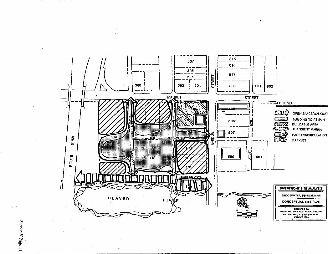
Waterfront Commercial District
The waterfront commercial section of the Borough is another important area in Bridgewater that is bounded by Route 5 1, the Beaver River, Bridge Street and Market Street. This is the site of a former marina that suffered bankruptcy in the late 1980's. Additionally, the Beglin Ford used car lot on the Beaver River side of Market Street is also located in this area. Borough and County officials commissioned a site analysis of this area in January of 1995 when the land became controlled by a local developer. The site analysis reinforces the importance of this site as a common denominator between the Beaver River and Bridgewater's downtown area. The land use objective for this site is waterfront commercial (marina, ofice, retail and service uses) with an ample supply of open space and pedestrian access that encourages interaction between the downtown and the riverfront. A public access walkway along the riverbank would serve to link the Stone Point Landing public access area with the Riverside Drive area of Beaver through the eventual completion of the pedestrian trail network. On site parking would be required for the marina facility. The development objective for this area is depicted on the site plan which has been extracted from the site analysis study and follows this page.
Parking is also an important issue within the waterfront commercial district. Increased demand for parking has been created as commercial development has intensified within the commercial core area of the Borough. Metered curb parking spaces are insufficient to meet the current demand for parking space. Within the waterfront commercial district, off street parking lots are required to service commercial establishments. Off street metered lots should not front on Bridge Street as this land should be reserved for commercial development. Ideally, off street lots should be located within one half block of Bridge Street. Well lighted pedestrian walkways should extend from Bridge Street to the off street lots. Signage should direct motorists to the location of the off street lots.
Design Guidelines for this area are as follows:
Section V Page 10
I-- I I I
_. --- I I t ir" u)
- -LEGEND
moo OPEN SPACEMIALKWAY
BUILDING TO REMAIN BUILDABLE AREA
TRANSIENT MAfllNA
PARKlNGlClRCULATlON PARKL-
v1
U. 0 0
8

w E U
' /.. .... ; ' . .? . ./f; . : i . .
Proposed Rlver Walk 1 LTran6tent Marlna L Merlns OMce
L Pedestrlen Overlook
Outdoor Dlnlng Area
f
11 RIVERFRONT SITE ANALYSIS
c

Land Use
Building sites that abut the riverfront shall be preserved for water dependent uses, Le. those that relay on direct access to the water in order to function. Typical water dependant uses include boat launch ramps, marina, barge transfer operations, ship or barge repair, etc. non water dependant uses (i.e. warehouse, distribution, office, commercial, etc.) should be introduced to inland building sites. Commercial uses should also remain incidental to other uses within this area.
W Lot Area
Minimum lot area should be 30,000 square feet.
Exterior Appearance
Building facades fronting on internal streets should be of masonry construction.
Parking
Finished grades of parking areas should be not less that one percent nor more than five percent. Landscaping should be introduced to parking areas to eliminate unbroken expanses of hard surfaces.
W Loading and Unloading
Loading and unloading areas and service areas for refuse collection should be located so as not to be visible from the street. Architectural and/or landscaped screening of loading and service areas should be encouraged.
W Storage
Any material stored outside of enclosed buildings shall be screened by ornamental fencing or planting. Water dependant uses shall be exempt from this requirement provided that outdoor storage is not visible fiom the streets.
Landscaping
Any part of the site which is not used for buildings, loading spaces, parking spaces, aisles, sidewalks, and storage areas shall be planted and maintained with an all season cover. Trees and shrubs should be provided in accordance with an approved landscape plan.
Section V Page 13

Residential Area
One of Bridgewater’s larger residential areas is bounded by Route 5 1 , Fulton Street, the Beaver River, and Elm Street. Land uses within this neighborhood include single family residential homes that fiont Market Street, churches, garages, medical offices and an apartment complex at the comer of Canal and Market Streets. This area also includes the Borough’s Municipal complex that house the Borough’s offices, a fire station, Borough Council hall and public works facility.
Recently, this area also experienced the introduction of two story condominiums along River Side Drive between Lion Street and Poplar Street. The condominiums are upscale in nature and offer excellent views of the Beaver River. The price for these units range from $90,000 to $1 10,000.
Also, this area has also encountered the new construction of smaller scale two bedroom, single family homes along Canal Street. These homes are situated on a single lot and construction should be completed by early 1998. Price ranges for these newly constructed homes are in the range of $65,000 to $70,000. These dwellings are yet another example of the desirability of Bridgewater as a place to live.
Outside of the newly constructed condominiums and single family detached housing, the condition of homes in this part of the Borough could be considered fair. Many of the older single family homes in this neighborhood have fallen into disrepair and are need of rehabilitation. The Borough should encourage residents in this area to invest in the needed repairs to the homes in poor condition. If the owners of these homes qualify, they should seek rehabilitation assistance from the Beaver County Housing Rehabilitation Program.
In the future, this neighborhood should continue to remain residential in nature. Borough officials should strive for larger lot sizes for any newly constructed homes. Design Guidelines for this type of residential development would include the following:
H Lot Area
Minimum lot area should be 5,000 square feet.
W Exterior Appearance
Building facades fronting onto streets should be of masonry construction, wood or aluminum.
Section V Page 14

0 Leopard Lane Area
0
0
This area is bounded by Leopard Lane, Route 51, Market Street, and Otter Lane. Land uses within t h ~ s neighborhood are mainly single family residential homes that front Mulberry Street. Other uses within this area include an A M E Church, offices on the comer of Market and Leopard Lane and several vacant parcels of land.
The condition of homes in this part of'ihe Borough could be compared to those in the residential section described above. Many of the older single family homes in this neighborhood have fallen into disrepair and are need of rehabilitation. The Borough should encourage residents in this area to invest in the needed repairs to the homes in poor condition. If the owners of these homes qualify, they could seek rehabilitation assistance fiom the Beaver County Housing Rehabilitation Program.
This area of the Borough also possess an undeveloped parcel of land across Mulberry Street from the Union Savings and Loan building. The primary use of this site should be for multi-family residential development. The Borough should encourage such uses as medium density residential developments either condominiums or garden style rental units on this site.
As a second alternative, the Borough may also consider encouraging development on this site that would be of a convenience commercial nature. Examples of these uses would include small scale grocery stores or small newsstands which would serve the surrounding residential neighborhoods.
Riverside Drivemoute 51 area
This area is bounded by Elm Street, the Beaver River and Route 51. Land uses within this neighborhood are dominated by highway commercial type uses including the River Harbor Marina, the Medical Office Building, Boot's Restaurant, the Saloon, a vacant car wash, batting cages, Scobie's Truck and Auto Service, Brewster's Ice Cream, Jerry's Curb Service, and the Masonic Temple Building.
Any future development in this area should be geared towards highway commercial types of land uses with employee and customer parking provided on site.
Route 51 Industrial area
This area of the Borough is located at the northern most end of Bridgewater. Access to this section of the Borough is limited, in that one must travel on Route 5 1 through the Borough of Fallston to reach it. There are no other roads which service this section of the Borough. This effectively separates this neighborhood fiom the rest of Bridgewater.
Section V Page 15

Land uses within this neighborhood are dominated by industrial uses. Businesses which are located here include Litell Steel, Marecic Truck Repair, and Amen Gas Also located within this section of the Borough are seven residential, single family detached homes. Eventually, this area should become industrialized. This transformation will occur gradually over time with the continued introduction of industrial type land uses and the prohibition of any new/additional residential land uses.
This area of the Borough should continue to remain industrial in nature. Permitted uses should include, construction materials and supplies, distribution facilities, research laboratories, trade shops (such as carpenter, plumber, and electrical), warehousing, electrical and gas operations, manufacturing, assembling, processing, and packaging of a wide variety of products.
0 Sharon Road Area
This area is bounded by Route 51, Fair Avenue, Leopard Lane and frontage properties on Sharon Road. This area consists of a mixture of highway commercial uses and single family residential housing. Currently, this neighborhood is undergoing a transition from residential to commercial.
Specifically, existing uses in this area include the Beaver County Times, the Wooden Angel restaurant, the Magnolia Street residential area, Robert's Tavern, Greenridge Office Building, Advanced Cardiology, Agway and single family homes located on both sides of Sharon Road.
-
The condition of the housing in this section of the Borough could be considered fair. The majority of the homes are older detached housing. Some of the housing in this neighborhood could benefit from various repairs. This is especially true for the homes fronting Sharon Road.
The Borough should accept the trend that the neighborhood in transition and encourage the emerging commercialization of this area in the future.
0 Reservoir Area
This area is accessed from the Borough of Beaver via Spring Lane. The land use in this area is predominately single family homes on very large lots. The homes are located on a promontory which provides excellent views of the river valley below. This area also includes a reservoir that provides water service to residents in the Borough.
Section V Page 16

The homes in this area are generally in excellent condition and resemble those found in a suburban residential development. The Borough of Bridgewater should continue to maintain this area as low density single family.
The Borough of Bridgewater Historic District
During the past ten to fifteen years, historic preservation has become increasingly important to society. This is evidenced by the National Historic Preservation Act of 1966. In addition, Federal regulations known as "protection of historic properties", govern the historic review by the State Historic Preservation Office when federal hnds are being used to undertake physical improvements to land or buildings. The purpose of this act is to protect historic properties.
By definition, historic properties refer to any prehistoric or historic district, site, building, structure, or object included in, or eligible for inclusion in, the National Register. This term includes artifacts, records, and remains that are related to and located within such properties.
Within the Borough of Bridgewater, there is a recognized Historic District which is included on the National Register. Generally, this district is located in the western section of the Borough and is bounded by Bridge Street, Mulberry Street, Fulton Street, Cheny Alley, Elm Street and the Beaver River. A location map which outlines this district may be found following page V- 18.
General characteristics of this Historic District in Bridgewater include:
W There are a total of 136 buildings and structures;
g Among the contributing resources of this district are 97 buildings, mostly two and one-half stories houses as well as commercial buildings located along Bridge Street, an early twentieth century industrial complex, two former school buildings, and four churches;
W One of the buildings had been previously listed on the National Register.
W The majority of the building and structures in this district were built prior to 1900.
W The Bridgewater Bridge, which connects Bridgewater to Rochester, was built in 1933 and is historic.
Section V Page 17

Should new developments or conversions occur in this historic district, special design guidelines should be implemented to maintain and preserve the character of this area of the Borough. Normally, a special review committee is established to examine plans for new development and exterior rehabilitation within the historic district. Improvements are inconsistent with existing architecture in the historic district are discouraged.
It is recommended that Bridgewater's historic district be treated as an overlay zoning district. This means that in addition to meeting the requirements of the underlying zoning district, a second layer of historic preservation requirements must be met.
Section V Page 18


I Environmental Analysis for the Borough of Bridgewater
An understanding of the natural physical environment is important in devising planning policies for the Borough of Bridgewater's Comprehensive Plan. The following sections provide a review of the environmental features identified in Bridgewater and provide a basis in formulating planning policy for the Borough by distinguishing those areas where development is least likely to degrade the environment. The information regarding natural features, when coupled with other social and economic data, provide a sound basis for land use decisions in the Borough of Bridgewater.
Slopes
Slope gradients in the Borough of Bridgewater have been calculated and are presented on the Topographic Slope map which follows this page. Slope is defined as the radical change in elevation over a horizontal distance, and is usually expressed as a percentage. It is an important determinate for land use. For example, slopes less than ten percent are suitable for most uses, though drainage problems may exist where the slope is less than two percent. Slope values between ten and fifteen percent impose some limitations on development. Sites may require grading or special design of septic systems, and architecture is not also feasible. Where slopes exceed 15 percent, significant constraints on development exist. Extensive grading and filling is required for most residential and industrial development occurring on steep sloped land. Clearing of steep sites can cause erosion and sedimentation problems if runoff is not strictly controlled. Use of septic systems is difficult, though steep slopes can accommodate large single family developments if construction is sensitively planned.
Steep slopes are found in Bridgewater particularly, in the eastern industrial section of the Borough.
Section V Page 20

H Floodplains
Floodplains are another environmental feature considered. Floodplains are usually flat areas of land bordering streams, which are periodically inundated by flood waters. Generally, only rare rain storms of severe intensity cause an entire area to flood. The 100 year flood boundary has been delineated on the Floodplain map which follows this page. The boundary was developed from a map prepared by the Federal Emergency Management Agency (FEMA) as part of the National Flood Insurance Program for the Borough.
The narrow floodway is a zone of high flood intensity, where the water flows fastest and deepest. The flood hazard area, which is subject to slower flows and shallow inundation, delineates the extent of flood waters that could be expected to occur once every 100 years. FEMA uses the theoretical extent of a flood occurring once every 100 years to determine eligibility for Federal Flood Insurance. The probability of a flood inundating the flood hazard area once every 100 years is based on a statistical evaluation of rainfall and stream flow records. The occurrence of a 100 year flood does not preclude another flood of similar magnitude occurring again the next year, or even the same year.
Only over a lengthy period would one expect that a 100 year flood would, on the average, occur once every 100 years. Also, the 100 year hazard area delineation may expand in the hture due to increased runoff caused by impervious surfaces such as streets, roads, and parking lots associated with future development.
Although floodplains are attractive sites for development due to their flat terrain and proximity to the water, building in floodplains will inevitably result in significant flood-related damages and even danger to life. Any structures or paved surfaces in the floodplain prevent absorption and obstruct flood flows, thereby eliminating valuable groundwater recharge sites and increased flood peaks.
Proper floodplain planning reduces damages associated with their development and ensures the perpetuation of the important ecological functions of floodplains. Uses that are not significantly harmed by periodic flooding, such as agricultural, recreation, and nature study, should be encouraged.
The 100 year floodplain occupies the majority of the Borough and includes all of the area from Market Street to the river.
Section V Page 22

urce.
Rk.4 FLOOD WXJRSANCE MAP, U.S. Deparment of HUD d USGS QUAD Map )rough ofBridgewater, PA ~mmunity Pmd Number 4201C1S 0001-B
---
MARCH, 1998 NQRTH
Section V Page 23

PROPOSED LAND USE
The plan for future land use in Bridgewater Borough is derived from several factors which include the community goals and objectives as described in Section IX, the existing land use patterns, natural limitations imposed on the use of the land, existing and proposed transportation plans, and community facilities.
The following narrative describes the Borough's physical land use plan. Although it is a reflection of social and economic values, this plan is hndamentally a guide to the physical development of the Borough. It is intended to translate values into a scheme that describes how, why, when, and where to build, rebuild, or preserve the Borough.
This proposed land use plan is a statement of policy, covering the community desires of quality, character, and location. These land use objectives will be achieved through the use of the zoning ordinance. Proposed land uses for the Borough of Bridgewater have been depicted on the Proposed Land Use Map which may be found on page V-29. Proposed land uses have been divided into eleven classifications, as follows:
Public Access Waterfront
As its name implies, the purpose of this district is to create a passive public park area along the waters edge. The Public Access Waterfront District is essentially a preservation zone wherein only limited development would occur. The types of uses envisioned within this district include pedestrian trails and walkways, bike trails, public parks, non commercial marinas, water taxi dockage areas and boat launches. Park related accoutrements that could be introduced to this district would include handicapped fishing piers, overlook decks, park equipment, and objects of art and culture.
It is anticipated that private land owners within this district would grant a public access easement to the waterfiont that would permit pedestrian circulation along the rivers edge. In most cases, development of riverfiont property will involve local zoning approvals, and the public access easement will be negotiated as part of the overall approval process. Most developers attracted to riverfront property will understand that a public access riverwalk will add considerably to the attractiveness of the site and enhance property value.
For existing owners of riverfront property where no development is planned, the acquisition of a riverfront public access easement will invariably involve the issues of security and privacy. Property owners will be fearful that pedestrian activity along the waterfi-ont may result in damage to their property or constitute an invasion of privacy. Grade separation and other design measures can usually minimize' these concerns.
Section V Page 24

Rwerfront Mixed Use District i
The Waterfiont Mxed Use District represents a more upscale from of planned developnient that maintains a distinct orientation to the rivers. Since development will be in the form of new construction, the district offers an opportunity to achieve several waterfront and community development objectives.
The main objective embodied within the Riverfront Mixed Use District is to create a major new form of development and to link it to other attractions in the community via a network of pedestrian walkways and boardwalks. Public access and circulation are fhndamental to the urban objective of this district.
Uses within this district might include a conference hotel, office, marina and residential complexes. Residential apartments and/or condominiums would be preferably developed on the second floor locations above ground floor commercial uses, especially along the river front. Free standing residential uses without ground floor commercial uses might be developed in non waterfront sections of this district. Parking for all of the uses would be shared.
Single Family Residential
The Single Family Residential District represents the majority of the Borough of Bridgewater. This district would generally remain the same as it is currently. The boundary of this district in the Borough would roughly include the area between Otter Lane, Rwerside Drive, Elm Street and Route 5 1. Additionally, the Reservoir area of the Borough should be classified as part of this district since it is also residential in nature.
Uses within this district would be limited to single family detached residential units, parks, playgrounds and other non commercial recreational uses, education and religious uses.
Multi-Family Residential
The Multi-Family Residential District is very similar to the Single Family Residential District, in that it permits all of the same kinds of uses. The main difference is that the Multi-Family Residential District also allows for more dense living environments such uses as ,oarden style apartments, condominiums, and townhomes. In addition, other permitted uses within this district would be assisted living facilities and nursing homes.
This type of land use is currently emerging in several residential sections of Bridgewater. Therefore, this district should be created to meet this land use. Presently, three residential areas of the Borough are encountering multi-family development.
Section V Page 25

The areas include: the new condominium development along Riverside Drive, the fo.mer school which was converted to apartments at the comer of Market Street and Canal, and the comer lot on Mulberry and Leopard Streets which would be ideal for a higher density residential land use. These uses should be permitted to continue in these outlined areas of the Borough.
Downtown Commercial
The Downtown Commercial District is an area where commercial uses are generally found. Specific uses in this district would include ground floor retail establishments such, churches, professional offices, and retaivresidential condominiums, restaurants, banks. Generally, this area would be bounded by Route 5 1, Bridge Street, Otter Lane and Riverside Drive.
The character of this district could be described as a low to medium density commercial neighborhood with a district orientation to and flavor of Bridgewater's growing downtown. Conversions of existing structures would be encouraged in order to maintain the existing architectural of the setting. In addition, any new development should also be sympathetic to the surrounding older buildings. This would be accomplished by the use of similar architectural styles and building materials as the surrounding buildings.
Village Central Commercial
The Village Commercial District is an area where quaint commercial uses are blended with the historic character of this neighborhood. Such uses in this district should include ground floor retail establishments such as flower stores and antique stores, churches, professional offices, and retdresidential condominiums. This District would be generally bounded by Bridge Street, Market Street, and Route 5 1.
The character of this district could be described as a low to medium density commercial neighborhood with a district orientation to and flavor of Bridgewater's's historic nature. Conversions of existing structures would be encouraged in order to maintain the existing architectural and village scale of the setting. In addition, any new development should also be sympathetic to the surrounding historical buildings. This would be accomplished by the use of similar architectural styles and building materials. Building setbacks on Bridge Street should be discouraged. New development should maintain the existing facade line.
Section V Page 26

8 Highway Commercial
The Highway Commercial District is an area where commercial business, which are ill fitted for the downtown commercial district, are located. Typically, such use are found along highways routes or on the perimeter of urban areas and have generous amounts of parking to accommodate commercial activity. Within Bridgewater, there would be two highway commercial areas. The first highway commercial area would be located in the Wolf Lane area between Route 51 and the railroad right-of-way. The second district would be located north of the railroad to Sharon Lane.
Permitted uses in this area would include automobile dealerships, automobile service centers, furniture and appliance stores, strip shopping centers, larger scale restaurants, and other related facilities. Generally, on-site off street parking should be provided in highway commercial areas.
w Riverfront Commercial
The Riverfront Commercial District is an area where water dependent uses such as commercial marinas, boat sales, and boat service facilities can be blended with water related uses such as nautical museums, specialty retailing with nautical themes and restaurants. Other uses that could be introduced to this area on a smaller scale and limited basis would include professional offices and inn style lodging of the bed and breakfast variety.
The character of this district could be described as a low to medium density commercial neighborhood with a district orientation to and flavor of the River. Conversions of existing structures would be encouraged in order to maintain the existing architectural and village scale of the setting. New development would incorporate a high degree of public access and circulation into the site plan, including the preservation of the public views of the Rivers. Building set backs would generally follow that of existing architecture along public streets, but would be more pronounced along the Rivers. Ample open space requirements would limit the intensity if development in this district.
Generally, there would be two River Commercial Districts in Bridgewater. The first one would be bounded by the river front, Poplar Street, the Borough limits and Route 5 1. The other Riverfront Commercial District would be bounded by the river, the railroad tracts, Wolf Lane, Market Street and Bridge Street.
Section V Page 27

rn Industrial
Land uses that are found in this district would include heavy and/or light industrial businesses, warehousing activities, shipping facilities, heavy machine/truck repair facilities and other such uses.
The industrial area of Bridgewater is limited to the extreme eastern edge of the Borough. This area has been used for heavy industrial uses such as the Late1 Steel and other related businesses. The industrial designation of this area is keeping with the existing use of land. Primarily access to the regional transportation network (Route 5 1) is a major consideration for this area to remain industrial.
rn Open Space Open spaces have been identified and classified as a separate land use category. By identifying open spaces the Borough has recognized that these areas exist. These areas should be preserved by the Borough for future use. Potential uses for these open spaces could include such uses as parks, parklets, and other recreational type uses. Within Bridgewater, this area would buffer the industrial area of the Borough and the highway commercial district located along Route 5 1.
Public
Public uses have been identified and a separate land use category has been established. By identifying public land uses, the Borough has recognized the importance of public landhuildings and is thus helping to preserve existing public land uses. Examples of public land uses in Bridgewater would include railroad sidings, the municipal complex, and the reservoir.
rn Environmentally Sensitive Areas
Development should be limited in steep slope areas, floodplains, wetlands and other sensitive areas. These areas have been identified on the maps that appear after pages V-20 and V-22 of this section. It is recommended that environmentally sensitive areas be treated as an overlay zoning district. This means that in addition to meeting the requirements of the underlying zoning district, a second layer of protective measures must be met.
In natural resource protection regulations, standards are set for limiting the intrusion of development into specific types of areas. For example, the municipal ordinances can specify that, on a given tract or group of tracts under one ownership, no more than the stated percent of the following types may be altered, regraded, cleared, or built on:
Section V Page 28

Floodplains - 0 percent
Streams, watercourses, wetlands, lakes or ponds - 0 percent
Lake or pond shorelines - no more than 20 percent
Wetlands margin - no more than 20 percent
Steep slopes of 25 percent or more - no more than 20 percent
Steep slopes of 15 to 25 percent - no more than 30 percent
Prime agricultural soils - no more than 20 percent
Woodlands - no more than 40 percent
Minimum lot size and setback requirements are set by the underlying zoning district, and in addition, a minimum building envelope other than traditional lot setbacks is specified to provide sufficient area for the general location of the building, driveway, parking areas, patios, other improvements and site alterations. The minimum required lot may consist partly of the protected environmentally sensitive areas, but the minimum building envelopes are not allowed to intrude into them in excess of amounts specified above. For single-family detached residences, the minimum building envelope typically ranges between 8,500 and 3,500 square feet, depending on the zoning district.
The use of building envelopes rather than traditional lot setbacks provide a flexible alternative and is particularly more useful than open space development or lot averaging in single-lot or small lot developments as is more typical of development in Bridgewater. The building envelope is defined as that portion of a lot located within the minimum prescribed front, rear and side yard setback distances. In examining traditional setback requirements, the building envelope for a one acre lot represents nearly 40 percent of its total area. As lot sizes increase, the percentage of a lot within the building envelope increases. For instance, on a typical three acre lot, the building envelope defines roughly 60 percent of the lot's total area. While it is necessary, particularly in a rural setting, to provide for ample flexibility in the siting of a structure on a lot, there is no reason to permit development which would theoretically allow for disturbance to take place within an area constituting 60 percent of a three acre lot. The use of traditional setbacks creates excessive discretion in the siting of structures and their accompanying site disturbance.
In the design process, the building envelopes should be more narrowly defined and the most suitable areas for development should be shown. Areas beyond the reduced building envelope should be restricted against development. Building envelope lines should not be drawn into wetlands or steep slope areas which need not be disturbed.
Section V Page 29
Building envelopes ultimately selected should not include the top of ridge lines, should avoid open fields and should be located on the edges of fields and in wooded areas to minimize the visual impact of development; building envelopes should not include wetlands, wetlands transition areas and floodplains. Minimum setbacks for building envelopes from lot lines, building envelopes on adjacent lots and street lines can also be established.
A similar approach to natural resource protection regulation called "net-out" is also used to preserve natural and scenic resources. In the net-out method, land areas such as floodplain, wetland, and steep slope areas that cannot support development without significant negative environmental impacts are deducted from the total parcel area before determining the maximum number of dwellings that are permitted. All tracts of land and all design options such as open space design and lot averaging must be subject to the net-out provision. Therefore, the maximum achievable number of units must be the same for a given tract no matter what design option is proposed.
The Beaver River forms the Borough's eastern boundary. The river is a high-quality river requiring special consideration for protection. The Land Use Plan designates the lands adjoining the Beaver River as Low Density Residential minimizing intense and extensive development of the stream's shoreline. Protection of the stream corridor is a land use objective that can be achieved by the Borough's development regulations by requiring wooded or vegetated buffer zones along the Beaver River corridor.
Buffers or buffer zones are the areas surrounding the core areas of a natural feature and provide insulation between significant ecological qualities and the existing or potential, negative disturbances nearby. The size of the buffer depends upon physical factors including slope, topography, and hydrology and ecological factors such as species present and disturbance as well as the buffer itself, such as uniformity, species composition and age.
While some states have legislation to protect particular resource areas, Pennsylvania has no statewide requirement for buffer zones or stream corridor protection. Authority for creating a buffer zone along stream corridors can be found in the MPC provisions authorizing municipalities to zone for the "protection and preservation of natural resources" Section 603(b)(5). In the zoning purpose section, zoning ordinances "shall be designed" to promote "preservation of the natural, scenic and historic values in the environment and preservation of forests, wetlands, aquifers and floodplains" among out purposes Section 604( 1).
Section V Page 30

The Beaver River is a rural river corridor as it passes through Bridgewater. Rural stream corridors are characterized by cultivated land and natural vegetation with little to no hard paving. Farming and recreation are the prevalent uses, and mining, logging or other resource extraction activity also occur. The primary emphasis for management in rural stream corridors should be preservation of open space values and protection of water quality from agricultural runoff or runoff associated with resource development Buffers in rural stream Corridors should be fi-om 65 feet to 300 feet.
The following is a list of guidelines for use in further defining appropriate buffer widths.
Area of Flooding
Steep Slopes
Sediment Control
Nutrient Removal
Habitat (Aquatic)
Habitat (Terrestrial)
Buffers should be sufficiently wide to include the 1 00-year floodplain.
On reaches of a stream with slopes greater than 10 percent, consider extending the buffer beyond the top of the slope.
Where disturbance is occurring near the stream, a buffer of at least 65 feet and up to 150 feet should be considered.
Where major sources of nutrients are proposed (fertilizers), a distance of at least 65 to 150 feet should be considered.
A setback of wooded vegetation should be at least 50 to 80 feet.
For deer wintering areas and wildlife corridors, a setback of wooded vegetation of 100 to 300 feet should be considered.
The storage of equipment from off-site businesses and the general storage of old autos and trucks has been identified as a problem in Bridgewater Borough. To eliminate this problem of visual blighting, Bridgewater can play a significant role in maintaining and even improving the community through the establishment and enforcement of appropriate codes.
Section V Page 3 1

Any area will become unattractive ifjunk and litter are permitted to accumulate in and around the yards of existing houses and accessory structures. To correct this problem, or to avoid its occurrence, Bridgewater can establish minimum permitted conditions for the maintenance of all premises throughout the municipality through the enactment of appropriate code standards. For example, the BOCA National Existing Structures Code (1 991) contains updated provisions for property maintenance as well as technical guidelines for the rehabibtion and reuse of existing structures.
The following standards are examples of the BOCA Existing Structures Code requirements which can be used to ensure that property owners maintain their properties in accordance with minimum standards:
Sanitation: All exterior property areas and premises shall be maintained in a clean, safe and sanitary condition free from any accumulation of rubbish or garbage (section ES-301.1);
Storage areas: All open salvage yards and open storage areas shall be completely obscured fiom surrounding property by a solid screen not less than six feet in height. Storage of debris, junk, or construction materials, which are not associated with an approved use or permitted construction at that site, shall be prohibited (section ES- 301.7);
Motor vehicles: Not more than one currently unregistered andor uninspected motor vehicle shall be parked on any property in a residential district, and said vehicle shall not at any time be in a state of major disassembly, disrepair or shall it be in the process of being stripped or dismantled. A vehicle of an type shall not at any time undergo major overhaul, including body work in a residential district unless such work is performed inside a structure or similarly enclosed area designed and approved for such purposes (section ES 30 1.10.1); and
- Weeds: All lots shall be maintained fiee fiom weeds or plant growth in excess of ten inches. All noxious weeds shall be prohibited. Weeds shall be defined as all grasses, annual plants and vegetation other than trees or shrubs provided, however, this term shall not include cultivated flowers and gardens (section ES 301 .b).
Uses such as junk yards and storage areas can also be controlled through a zoning ordinance. For example, a property which contains two or more cars without valid inspections stickers is defined as a junk yard. Such a property would then be subject to the zoning regulations for a junk yard.
Section V Page 32

1 Active enforcement of codes such as those listed above, can prevent blighting problems from occurring. Moreover, knowing that all adjacent or nearby properties would have to at least meet minimum maintenance standards would encourage property owners to maintain the appearance of their properties.
Appropriate care and maintenance of public areas and facilities within villages not only assures their continued use, but also enhances their appearance and increases individual property values. In many municipalities, it is the responsibility of the property owner to maintain the sidewalks, curbs, driveways, parking spaces and similar paved areas that are within the street right-of-way adjacent to the property owner's land. Therefore, Bridgewater could include language in the codes that stipulates the property owners' responsibilities for the proper maintenance of these facilities. Model language for the maintenance of public areas is contained in the BOCA National Existing Structures Code.
Section V Page 33


SECTION VI:
RECREATION IN BRIDGEWATER, PA.

ANALYSIS OF RECREATION IN BRIDGEWATER, PA
0 Introduction
This section of the Comprehensive Plan evaluates the Borough of Bridgewater's recreation facilities. The park and open space analysis inventories the Boroughs existing public, semi-public, and private resources and provides recommendations and guidelines for future adequacy.
The function of recreation areas and open space is a valued community asset. The common functions of recreational amenitiedopen space areas follow:
Preserves ecologically important natural environments;
Provides attractive views and visual relief from developed areas;
Provides sunlight and air;
Buffers other land uses;
Separates areas and controls densities;
Provides areas for water reservoirs;
Provides opportunities for recreational activities;
Is an important factor in creating quality communities;
0 Existing Recreational Facilities
Outside of water related recreational facilities associated with the rivers (such as marinas), and the passive recreational amenities (walkways, etc.) along the Beaver River, the Borough of Bridgewater is relatively lacking in recreational amenities. A review of the existing land uses within the Borough shows there to be only one small park within the Borough located at the comer of Porter and Clarion Streets. This park consists of the following amenities:
Swings;
Sliding Board;
Basketball Court;
Section VI Page 1

Benches; .. Picnic Tables;
All of this play equipment at this park is in fair condition and functional.
Another recreational activity available to residents of the Borough is a privately owned and commercially operated batting cage facility located near the intersection of Riverside Drive and Sharon Road.
a Recreational Needs
The recreational needs of the Borough of Bridgewater include the following:
W Updating existing park facilities;
Need for funding to purchase and install new equipment for the park;
1 Plan for future recreational uses that take advantage of Bridgewater's access to the river such as a river walk way, a riverfront trail network that links Bridgewater with Beaver Borough, boat launches, and marina facilities for boats.
It is recommended that the Borough pursue a Keystone Grant through the Pennsylvania Department of Conservation and Natural Resources to undertake a comprehensive recreational facilities plan for the community.
Section VI Page 2
i
SECTION VII:
ANALYSIS OF HOUSING IN BRIDGEWATER, PA
ANALYSIS OF HOUSING IN BRIDGEWATER, PA
0 Introduction
This section of the Comprehensive Plan evaluates the Borough of Bridgewater's housing characteristics. The following sections will provide an inventory of the Boroughs existing housing stock as well as provide a historical overview of housing trends in the Borough.
The evaluation that follows will provide the Borough of Bridgewater with an understanding of the opportunities and constraints to development that guide housing growth, which in turn, leads to a responsible housing policy.
0 Housing Demographics
In terms of housing, the Borough of Bridgewater has experienced many positive changes between 1980 and 1990. Generally speaking, the value of owner occupied housing units increased, the vacancy rate decreased, and there has been an increase in the number of rental units.
Other observations obtained from the 1990 Census data include:
55% of the 35 1 housing units in the Borough were owner-occupied.
35% of the housing units in 1990 were renter occupied.
W Only 10% of the housing units in 1990 were vacant. This was down 5% from 1980.
W Median housing value was $4 1 , 100 which was nearly 20% higher than in 1980.
H Median contract rent rose to $401 a month which nearly 45% higher than in 1980.
H The number of houses built prior to 1940 was 56.4%. This was a decrease from 1980 when nearly 70% of the houses were built prior to 1940.
The following charts shows the comparative statistics between 1980 and 1990 for housing in the Borough of Bridgewater. They also show a breakdown by housing units as to when the housing structures were built. This data provides insights as to the general age of the housing units.
Section VI1 Page 1

Housing Data Borough of Bridgewater, PA
1980-1990
Housing Category 1980
I
1990
Median Housing Value
Median Contract Rent
I Total Housing Units
$32,300
$180.00
Total Housing Units 369 (100%) 351 (100%)
369 351 I 214 (58%) 1 194(55%) I Owner-Occupied Housing
Units
I Renter-Occupied Housing Units I 102 (27%) 121 (35%) I I Vacant Housing Units 53 (15%) I 36(10%) I
$41,100
$40 1 .OO
Rental Housing Stock
Year Structure was Built Borough of Bridgewater, PA
1980-1990
Year Structure was Built 1980 I 1990
1989 to March 1990 -- I 0
1985 to 1988 -- I 5 . 1980 to 1984
1970 to 1979
1960 to 1969 39 24
1950 to 1959
a&?&-
253 (68.5%) I98 (56.4%)
1940 to 1949
193 9 and earlier
Section VI1 Page 2

Windshield Survey of Housing Conditions in Bridgewater I
In November of 1997, a windshield survey of the Borough of Bridgewater was performed to document the conditions of the housing stock. The survey documented the number and conditions of housing units by area in the Borough. This information should be used to assist the Borough in implementing a Borough wide housing plan.
The following chart documents the results of the windshield survey.
Housing Conditions Windshield Survey
Borough of Bridgewater, PA November, 1997
Location
Market Street
Boundary Lane to Elm St. Elm St. to Poplar St. Poplar St. to Lion St. Lion St. to Washington St. Washington St. to Canal St.
Canal St. to Leopard St. Leopard St. to Fulton St.
Fulton St. to Otto Alley
Type of Housing
Units
Single Family Single Family Single Family Single Family Sing. Family/
Rental Single Family Sing. Family/
Rental Sing. Family/
Rental
Number of Housing Units
4 12 8 6
10 houses 1 rental blg.
9 20 houses
1 rental blg. 3 houses 1 Multi- fam.unit
Number of Vacant
Parcels/Units
3
1 (unit)
Condition of Housing
Very Good Very Good
Fair to Good Fair to Good Fair to Good
Fair Fair to Poor
Fair
Section VI1 Page 3

~~
Riverside Drive
9 2 houses 2 Condos 2 houses
2 new condos 4 houses 6 Condos
~~
Fair to Good Fair to Good
Houses poor Condo Good Fair to Poor
Good
Fulton St. to Leopard St. Leopard St. to Canal St.
Canal St. to Washington St.
Washington St. to Lion St. Lion St. to Poplar St.
Single Family Single Fam. and Condos Single Fam. and Condos
Single Family Multi-Family
Mulberry Street
Leopard St. to Fulton St. Fulton St. to Otter Lane Otter Lane to Bridge Clarion Street to Rt. 51 Leopard to Canal St. Canal St. to Washington St. Washington St. to Lion St.
Single Family Single Family Single Family Single Family Single Family Single Family Single Family
10 houses 8 houses 3 houses 4 houses 7 houses 4 houses 5 houses
Poor Poor Poor Poor
Fair to Poor Fair Poor
Poplar Street
Route 5 1 to River Drive Single Family 5 houses 0 Fair to Poor
Lion Street
Route 5 1 to River Drive Single Family 6 houses '0 Poor
Washington Street
Route 5 1 to River Drive Single Family Multi-Fam.
9 houses 2 Condos
0 Fair to Good
Canal Street
Route 51 to River Drive Single Family 10 Houses (5 new )
0 Fair to Good
Leopard Street
Route 51 to River Drive Single Family 5 houses Fair 0
Section VI1 Page 4

In summary, the housing market in the Borough of Bridgewater reflects considerable public appeal. Prospective residents are attracted to the locational convenience of the Borough, its riverfront amenities, and its village character. As such, it is important for the Borough to effectuate policies that preserve these inherent assets.
As the popularity of Bridgewater as a commercial destination and as a place to live continues to increase, it is reasonable to expect property values and the quality of housing to improve. The gentrification of the Borough’s housing stock, however, is not hl ly underway. The Borough’s goal should be to encourage a wide range of housing types to households in all income ranges. Diversity in housing and resident income will contribute to the attractiveness of Bridgewater as a place to live, shop and recreate.
Section VI1 Page 5

SECTION VIII:
ECONOMIC DEVELOPMENT IN BIUDGEWATER, PA

ANALYSIS OF ECONOMIC DEVELOPMENT IN BRIDGEWATER, PA
0 Introduction
This section of the Comprehensive Plan evaluates the Borough of Bridgewater's economy.
0 Existing Conditions
Over the last decade, the Borough of Bridgewater has experienced a surge in commercial and residential development. This trend can be observed through a comparative study of recent trends in the real estate tax millage, assessed valuation and building permit data in the Borough. The following section provides an overview of these recent trends.
Recent Development Trends
The following chart shows the recent increases in the Boroughs real estate tax millage. As can be seen by the chart below, between 1989 and 1996 the tax millage has rose from 10.5 to 18.5.
TREND IN BRIDGEWATER BOROUGH'S REAL ESTATE TAX MILLAGES
I 1989 I 10.5 I I 1990 I 13 I
SOURCE: BEAVER COUNTY DEPARTMENT OF ASSESSMENT
Section VI11 Page 1

I The following chart shows the recent trends in assessed valuation fiom 1990 to 1995 in the Borough of Bridgewater.
BRIDGEWATER, PENNSYLVANIA TREND IN ASSESSED VALUATION: 1990 TO 1995
1990 9,329,665 485 +2 18 , 100
1991 9,625,715 486 +296,050
1992 9,746,965 487 +12 1,250
1993 10,055,640 486 +308,675
1994 10,490,090 488 +434,450
1995 10,994,340 494 +504,250
1996 10,971,390 494 -22,950 SOURCE: BEAVER COUNTY DEPARTMENT OF ASSESSMENT
The following chart summarizes the building permit data in the Borough of Bridgewater between 1991 and 1995. As can be seen by the chart, there has been a modest increase in the number of building permits granted for renovations and new construction over the last five years especially in 1995 and 1996.
BRIDGEWATER, PENNSYLVANIA BUILDING PERMIT DATA
I1991 I 3 I 15 I 18 I I 1992 I 1
11993 I 0 I 9 1 9 1
Section VI11 Page 2

1995 I 7 I 30 I 37 I 1996 5 24 29
I Total I 19 107 I 126 I
It is anticipated that the above outlined development trends will continue into the foreseeable future. Therefore, the Borough should plan to manage this continued development. The Borough should pay particular attention to undeveloped and underdeveloped parcels of land in the Borough since fiuther development pressure is likely to occur in these areas.
0 Bridgewater: A Vision of the Future
Based on the recent development trends, the Borough should begin to plan for the future by looking closely at areas which are now developing commercially. This can be accomplished by preparing a plan for what the future vision of these developing areas may eventually look like. The following narrative presents a vision of various neighborhoods, within the Borough, that are likely to encounter high demand for commercial land and additional development or redevelopment. This vision can also assist Borough officials in the development of future policies that govern growth and development in these areas.
The Downtown Area
The continued revitalization of the Borough’s village commercial downtown should be encouraged by Borough officials. The tree plantings, light fixtures, and benches give a pedestrian scale to the business district and should continue in the current manner. Additional green areas, parklets, and walkways would further reinforce the historic preservation objectives of this area of the Borough. It is especially important to preserve older commercial buildings that front onto Bridge Street and to encourage ground floor retail and services uses within this neighborhood. Again, it is important to preserve pedestrian access to the riverfront. The Stone Point Landing facility is an example of how commercial development can be made more dynamic by preserving public access to the Beaver River.
Parking in village commercial areas is traditionally provided by on-street metered spaces and off street metered lots. Parking meters are designed to discourage all-day parking. The proliferation of commercial establishments in Bridgewater has created
Section VI11 Page 3

demand for off street lots. As highway commercial uses continue to become transformed to village commercial uses, the Borough should proactively reserve space in the reconfiguration of land use for off street parking lots. The preferred location for off street lots is one half to one full block off of Bridge Street. The Bridge Street facade line should be preserved with commercial or mixed used structures that are sympathetic in design to the original architecture of the downtown. Off street parking lots should be located behind Bridge Street commercial structures with well lighted pedestrian walkways that link the parking lots to Bridge Street. Signage should direct pedestrians from the lots to Bridge Street and vice versa. During the preparation of the Comprehensive Plan, two potential sites were identified for the use of parking lots that serve this commercial area. These two sites are:
1. Parking Lot Site A: This site is generally bounded by South Alley, Boundary Lane, Clarion Street and Route 5 1.
2. Parking Lot Site B: Th~s site is generally bounded by Locus Alley, Route 5 1, Beaver Alley, and Cherry Alley.
The Borough may wish to consider the creation of a Parking Authority to finance the acquisition and operation of off street parking lots.
The Crane Brothers Development Site and Surrounding Area
The Crane Brothers barge repair facility and other land in this area has increasing value for commercial development, especially land that fronts on the Beaver and Ohio Rivers. This site offers a spectacular view of the Beaver and Ohio Rivers. The railroad constraint to access must be overcome in order for this neighborhood to achieve its development potential. The Borough should strive for higher quality commercial land uses in the vicinity of the Crane Brothers site. Eventually, this area should become de-industrialized. This transformation will occur gradually over time as land values continue to increase.
In terms of future land use, a single integrated use that is oriented to the rivers would be appropriate. An important planning objective for this site, and neighborhood as a whole, is to provide a pedestrian link between the Riverside Drive area of the Borough of Beaver with the riverfront attractions and commercial amenities of Bridgewater's commercial core. It is suggested that this portion of the Borough be designated as a riverfront mixed use area. The Borough should encourage hotel, retail, restaurant, office and marina uses in this area. Public access to the riverfront should be encouraged.
Section VI11 Page 4
The Riverfront Mixed Use area represents a more upscale form of planned development that maintains a distinct orientation to the river. Since development will be in the form of new construction, this area offers an opportunity to achieve several waterfront and community development objectives.
The main objective embodied within the Riverfront Mixed Use area is to create a major new form of development and to link it to other attractions in the community via a network of pedestrian walkways and boardwalks. Public access and circulation are fundamental to the urban design objectives of the district.
Uses on this site and within this area might include a conference hotel, office, marina, and residential. Residential apartments or condominiums would preferably be developed at second floor locations above ground floor commercial uses, especially along the riverfront. Freestanding residential uses without ground floor commercial uses might be developed in non riverfront sections of the area. Parking for all of the uses would be shared.
The Rivers and their Importance for Economic Development
The Beaver and Ohio Rivers play an important role in the economic development of the Borough of Bridgewater. Not only are the rivers a valuable natural resource, they also provide recreational outlets and other amenities for residents and visitors to the Borough of Bridgewater. Bridgewater has been a destination for pleasure boaters as well as visitors arriving by automobile for many years. Marinas and water related uses have been located along the Boroughs riverfront throughout history.
Bridgewater should consider itself blessed by the fact that the Borough is one of only a few communities whose riverfront land is not dominated by railroads and heavy industrial uses. People and developers are now attracted to Bridgewater because of its access to the river and its relatively pristine river front land. Borough officials must recognize this fact and use the river to the Boroughs economic advantage.
In the future, Borough officials should encourage additional river front access for recreational uses as well as controlled commercial land uses which are consistent with and the riverfront.
Section VI11 Page 5

Code Enforcement
In older communities such as the Borough of Bridgewater, code enforcement is one of the most critical responsibilities of municipal government. During the preparation of the Comprehensive Plan, a windshield survey of all the structures in the Borough was completed.
The results of this windshield survey revealed that many of the homes and buildings in the Borough were code deficient and in need of rehabilitation. The Borough must aggressively enforce codes and zoning ordinances to achieve quality development that is in scale with the community.
Section VI11 Page 6
SECTION IX:
COMNlUNITY DEVELOPMENT POLICY RECOMMENDATIONS

COMMUNITY DEVELOPMENT POLICY RECOMMENDATIONS
0
I I ,
Introduction
The purpose for the formulation of the community development policy recommendations is to provide the Borough with guidance and coordination of the land use decision making process. These stated policies allow the community to evolve in a desired fashion that is cognizant of growth determining factors such as commerce, population, housing, transportation, public facilities and services, and infrastructure.
By undertaking the comprehensive planning process, the community can begin to understand and recognize how the economy, housing, community development are integral parts of the whole and how these elements are closely linked to existing conditions such as new emerging river fiont land uses, different types of housing districts and various commercial districts. For this reason there is a need for planning to provide a common framework fiom which community decision makers can begin to evaluate all interests.
Planning Policy Recommendations: Goals and Objectives
Based on the expression of community values and a review of existing conditions as outlined in the preceding sections, the following list of planning goals set forth the policy statement of the Borough of Bridgewater.
W Continue to improve the transportation system to provide a safe and efficient means of travel in the Borough especially along Route 5 1 and Bridge Street;
W Encourage the stabilization of the existing housing stock;
Preserve the existing character of the emerging Village Commercial District and the downtown;
W Encourage the rehabilitation and preservation of the structures and buildings in the Borough’s Historic District;
W Continue to use the attraction of the Rivers to promote diverse economic opportunities;
W Encourage the expansion of existing businesses and industries;
W Encourage additional recreational opportunities such as parks and parklets in the Borough;
Section M Page 1

w
w
Protect environmentally sensitive areas;
Develop a new zoning process to effectively regulate the development of land within the Borough of Bridgewater;
Reorganize the land use administrative process to provide sufficient staff and resources to administer the regulatory process;
Maintain the provision of adequate public services/utilities to all Borough residents;
Continue to utilize the recreational benefits of being located on the river; and link these attractions to neighboring communities via pedestrian trails and walkways.
0 Housing Policy Recommendations: Goals and Objectives
The following section provides the housing goals and objectives for the Borough of B ridgewater.
Housing Goals:
w
Stabilization of the existing housing stock;
Provide for diversification of new housing types, including higher density opportunities in areas of the Borough where surrounding land use is compatible with this type of housing;
Provide affordable housing opportunities for existing and fbture residents of the Borough of Bridgewater;
Encourage the deveioprnent of regulations which promote the safety of new houses and the renovation of existing housing;
Encourage larger lot sizes for any new single family housing development in the Borough;
Section M Page 2

Housing Objectives:
1. Encourage the use of available hnding to implement rehabilitation programs that can improve poor single family homes.
The majority of housing units in the Borough are in fair condition. However, there are sections of some neighborhoods that contained housing which could benefit from a targeted housing rehabilitation program. The Borough, via Beaver County, could assist families in obtaining funds for necessary housing repairs, provide the families meet the low and moderate income guidelines. This could be completed through various housing rehabilitation programs offered by Beaver County.
2. Support the implementation and enforcement of building code requirements for new housing construction and building maintenance to ensure quality construction in the Borough of Bridgewater.
The Borough of Bridgewater could implement a Borough-wide Code Enforcement Program which would serve to identify code violations and promote safety standards for new housing. To implement this type of Program the Borough would have to higher a qualified Code Inspector on a part-time basis.
3. Incorporate provisions in the land use ordinance that allow for single family and multi-family housing units on individual lots.
4. Enact standards which govern the development of new housing which advance the interests of the Borough as well as protect the interests of the residents concerning high-cost regulations.
5. Develop zoning and subdivision standards that do not erect barriers to the use of affordable housing.
6. Ensure that various types of housing choices area available to all Bridgewater residents.
Section IX Page 3

0 Transportation Policy Recommendations: Goals and Objectives
The following section will provide the policy recommendation for transportation issues in the Borough of Bridgewater.
Transportation Goals
I Continue to provide a safe and efficient ground transportation network in the Borough;
I Continue to improve the vehicular circulation within the Borough;
Transportation Objectives
I Improve directional signage along Route 51 near Bridge Street into the Borough of Bridgewater especially for vehicles traveling into the Borough from the West.
I Determine the possibility of constructing a deceleration lane from Route 5 1 onto Bridge Street.
Install identification signage for Riverside Drive and Bridgewater for northbound and southbound motorist on Route 5 1.
I Undertake efforts to improve linkages between the Bridge Street/Market Street Intersections and other activity nodes within the community.
I Improve Leopard Lane to provide better access to the Wooden Angel and the community of Beaver
Section IX Page 4

0 Community Facilities Policy Recommendations: Goals and Objectives
Community Facilities Goals
Maintain existing recreation activities which are associated with the rivers for the Borough;
H Provide additional recreational facilities such as a park or playground for the Borough;
Continue to provide resources for adequate fire protection for Borough residents;
Continue to provide adequate police services to the residents and businesses in the Borough of Bridgewater;
Continue to provide adequate public facilities to all Borough residents;
Community Facilities Objectives
1. Employ available resources to hrther develop parks and parklets within the Borough of Bridgewater.
2. Continue to fund and support adequate police, fire, and emergency protection services for the Borough.
3. Develop Borough wide strategy for improving and expanding recreational facilities in the Borough.
4. Continue to promote and protect the Borough’s historic district.
0 Administrative Policy Recommendations: Goals and Objectives
Administrative Policy Goals:
W To insure that the Comprehensive Plan, and the concepts which are implemented, reflect the current conditions in the Borough.
To insure the consistency between the Comprehensive Plan and the implementation legislation of the Borough.
Section IX Page 5

Administrative Policy Objectives:
1. Review and revise the Comprehensive Plan on a short term basis such as every three to five years.
2. Review and revise the Comprehensive Plan if any major impacts, either locally or regionally, affect the Borough of Bridgewater.
c1 3 . Revise the Borough's Zoning Ordinance to reflect the revisions in the
Comprehensive Plan and the Municipalities Planning Code.
4. Revise the Borough's Subdivision Ordinance and Land Development Ordinance to reflect the revisions in the Comprehensive Plan and the Municipalities Planning Code.
Section IX Page 6

SECTION X.
IMPLEMENTATION

Introduction
The purpose of this section is to provide a guide to local officials in implementing the policy recommendations of the Bridgewater Borough Comprehensive Plan. Provided is a review of the regulatory tools available to the Borough and the funding resources available to effectuate the Bridgewater Borough Comprehensive Plan.
0 Regulatory Tools
Zoning
A comprehensive plan provides a framework for the development of a community. Zoning is one of the most important tools for the implementation of the Bridgewater Borough Comprehensive Plan. Zoning consists of a text describing the different land use zones and a map delineating the different zones.
In accordance with the Pennsylvania Municipalities Planning Code, zoning ordinances should reflect the policy goals and objectives as provided in the community's comprehensive plan and give consideration to the character of the municipality, the needs of the citizens, and the suitabilities and special nature of particular parts of the municipality. The provisions of zoning ordinances shall be designed to promote, protect, and facilitate the public health, safety, morals and the general welfare; to prevent overcrowding of land, blight, danger and congestion; to provide for the use of land for residential housing of various dwelling types; and to accommodate reasonable overall community growth, including population and employment growth.
Zoning is meant to be a flexible tool. Amendments to the zoning ordinance and map may be made based upon changing conditions and assumptions. Amendments are meant to reflect the desires of the community and should occur based upon amendments to the comprehensive plan to assure that all zoning decisions have a factual base which avoids the potential for piecemeal zomng.
The zoning process should be open to the public. In any zoning decision, the facts should be well documented, and there should be good reasons for what is recommended or rules in agreement with the policies established by the Bridgewater Borough Comprehensive Plan.
Section X Page 1
Official Map
Article IV of the Municipalities Planning Code authorizes counties and municipalities to develop and adopt official maps that show the surveyed exact locations of existing and proposed public streets, watercourses and public grounds, including widening extensions, openings or closings.
The official map is an important tool for notifLing all land owners of existing and proposed public lands and rights-of-way. The effect of such notification is that landowners do not have to be compensated for buildings put on such lands after adoption of the official map. This tool has been used infrequently primarily because of cost, but may be used more since Act 170 now allows mapping of all or "only a portion" of the municipality.
w Subdivision and Land Development Ordinance
The subdivision and land development ordinance regulates the development and redevelopment of lands in a community based upon prevailing community policies as described in the comprehensive plan. The subdivision and land development ordinance works with the zoning ordinance to assure that development and redevelopment occur in an orderly fashion. In agreement with Act 170, a community's subdivision and land development ordinance may include provisions for ensuring that land development and redevelopment shall conform to the comprehensive plan and to any regulations or maps adopted in fbrtherance thereof and provisions for encouraging and promoting ingenuity in the layout and design of land development and redevelopment.
The subdivision and land development ordinance seeks to ensure orderly development and redevelopment which will be physically attractive and not a heavy burden on municipal finances. Subdivision and land development regulations should be administered in keeping with the goals and objectives of the comprehensive plan. Like zoning, the subdivision and land development ordinance has some flexibility through either the variance or the amendment process.
Capital Improvement Program (CIP)
A CIP schedules the hture provision of capital improvements based on the need for various projects, and on a municipality's financial ability to pay for them. Capital improvements are defined as major, one-time expenditures by a local government to provide or improve physical facilities, acquisition of land, or exterior improvements to buildings.
Section X Page 2
0
Formulation of a CIP is based upon a municipality's overall goals and objectives for developing capital projects, some of which are articulated in the municipality's comprehensive plan. At the same time, a municipality must also project its future revenue raising capability, taking into account current debt service obligations, statutory debt limits, types of revenue sources available, growth in future revenue sources such as the real property tax base, and fbture financing costs. The result of combining the needs and the analysis of financial capability is a prioritized list of capital improvement projects for each year covered by the C P , which normally covers a five to ten year period.
Funding Resources
Funds available to Bridgewater Borough for implementing the policies recommended by the Bridgewater Comprehensive Plan are available from three sources: revenues; borrowing through municipal bonds, and intergovernmental grants and loans. Additionally, included are hnding sources for enhancing economic development.
rn Property Taxes
Property tax revenue is a common method of funding for the day-to-day operation of local government operations. Tax revenue can also be utilized for long-term expenses. A prioritized list of desired capital improvements beyond those recurring expenses can be maintained with the Borough instituting a Capital Improvement Program as noted above, to project needs and avoid "crisis financing".
rn Municipal Bonds
Under the Pennsylvania Local Government Unit Debt Act (Act 52 of 1978), a municipality can insure nonelectoral debt equal to two and one-half times the average of its last three year's total revenues (minus Revenue Sharing and Community Development Funds, etc.). In the case of these general revenue bonds, the loan is then repaid without interest over a period of years from revenues earmarked for this purpose and deposited in a special sinking fund account. Among the projects that these borrowed funds could help finance are: road improvements, sewer and water improvements; curb and sidewalk repairs; acquisition and demolition of deteriorated properties; and purchase of police and fire equipment.
rn Intergovernmental Grants and Loans
Community Development Block Grant Program. CDBG funds can be used for a wide variety of activities that benefit low- and moderate-income households or aid in the prevention or elimination of slums and blight. Eligible activities include housing rehabilitation, public improvements, demolition, public services, acquisition of property and historic preservation.
Section X Page 3

HUD has extended CDBG entitlement assistance to Beaver County since 1974. In FY 1997, HUD's CDBG entitlement grant for Beaver County was in the amount of $4,785,000.
It will be important for the Borough to request CDBG funding for activities that meet the eligibility requirements for the CDBG Program. The Borough would be well advised to request CDBG funding for site specific projects or unique initiatives that are required to carry out the Bridgewater Comprehensive Plan.
Keystone Parks & Recreation Application
The objective of the Keystone Parks and Recreation program as administered by the DCNR is to improve the quality of life of Pennsylvania's citizens by providing local governments with grant funding to: address public outdoor recreation and park deficiencies at the neighborhood and community level; meet the public outdoor recreation and park needs of special population groups such as minorities, lower income, disabled and senior citizens; and support community conservation and community revitalization efforts.
Penn-Vest
Penn-Vest is an infrastructure assistance program offered by the Pennsylvania Infrastructure Investments Authority. Eligible activities.include a variety of public water and sewer improvements projects. The emphasis of the program is on activities that will result in new jobs and an improved local economy. Both grants and loans are offered under this program depending upon the type of project and severity of the funding need.
W Pennsylvania Department of Transportation Enhancement Program
The program provides a means of stimulating additional activities that go beyond the normal or historic elements of a transportation improvement project. Transportation enhancement activities must have a direct relationship to the intermodal transportation system. The intent is to more creatively integrate transportation facilities into their surrounding communities and the natural environment. The ten categories which are defined as eligible for transportation enhancement fimding are: provision of facilities for pedestrians and bicycles, acquisition of scenic easements and scenic or historic sites, scenic or historic highway programs, landscaping or other scenic beautification, historic preservation, rehabilitation and operation of historic transportation buildings, structures or facilities (including historic railroad facilities and canals), preservation of abandoned railway corridors (including the conversion and use thereof for pedestrian or bicycle trails), control and removal of outdoor advertising, archaeological planning and research, and mitigation of water pollution due to highway runoff.
Section X Page 4

Funding can be provided to cover up to 80 percent of the proposed project cost. Applicants must provide a commitment of at least 20 percent of the proposed project cost. However, there is some flexibility in providing the 20 percent matching finds. The match may also be provided through in-kind services. Funds from other federal funding programs can be used as the matching finds only if specifically stated by the federal funding law. State finding sources can be used if eligible under the state funding law. In many cases, state highway finds cannot legally be used for the types of projects which will qualiQ for this new program.
Department of Environmental Resources Pennsylvania Recreational Trails Program
These funds may be used by a municipality for trail maintenance, development, acquisition, trailhead facilities or to improve access and use of trails by persons with disabilities.
The program is administered using an 80/20 finding ratio with a maximum grant of $15,000. Therefore, in order to be eligible for $15,000 in grant funds, the total project cost must be at least $18,750.
Certified Local Government Historic Preservation Grant Program
Grants to municipalities for planning activities, such as surveys, preservation plans, ordinances, training and education projects, and the preparation of National Register nominations. All grants require a match of between 30 and 50 percent.
Tax Incentives for Rehabilitating Historic Buildings
Since the Borough of Bridgewater has a qualified Historic District, it is important to realize that there are certain benefits and tax incentives available for housing rehabilitation within historic districts.
Various tax incentives for the preservation and rehabilitation of historic structures were established by the Tax Reform Act of 1986. This law amended the Federal Income Tax Code with provisions to:
1. Stimulate preservation of historic commercial and income-producing structures or buildings by allowing favorable tax treatments for rehabilitation. This would include the allowance for an owner of a certified historic structure to amortize the costs of a certified rehabilitation over a period of five years. If the property qualifies as a substantial rehabilitation of a historic property, the owner may instead take accelerated depreciation that he would otherwise not be able to take.
Section X Page 5