book of - vliz.be · berg, gunther van rykegem, alexander van braeckel, wim mertens and bart vande...
TRANSCRIPT


BOOK OF ABSTRACTS ECSA LOCAL MEETING 2016
ESTUARINE RESTORATION: FROM THEORY TO PRACTICE AND BACK
UNIVERSITY OF ANTWERP ANTWERP, BELGIUM
5-9 JULY 2016

This publication should be quoted as follows:
Patrick Meire (Ed.). 2016. Book of abstracts: ECSA Local Meeting 2016. Estuarine Restoration: from theory to practice and back. Antwerp, Belgium, 5-9 July 2016. VLIZ Special Publication 77. University of Antwerp (UA), Antwerp / Flanders Marine Institute (VLIZ), Oostende, Belgium. 98 pp. Vlaams Instituut voor de Zee (VLIZ) University of Antwerp InnovOcean site Ecosystem Management Research Group Wandelaarkaai 7 Universiteitsplein 1 BE – 8400 Oostende BE – 2610 Wilrijk
T: +32 (0)59 34 21 30 T: +32 (0)3 265 41 11 E: [email protected] E: [email protected]
www.vliz.be www.uantwerpen.be
Photo cover:
Verdronken Land van Saeftinghe © Misjel Decleer
The abstracts in this book are published on the basis of the information submitted by the respective authors. Reproduction is authorized, provided that appropriate mention is made of the source.
ISSN 1377-0950

Table of Contents
PART I – CONFERENCE INFORMATION Sponsors .................................................................................................................................................... 9
Scientific Committee ............................................................................................................................... 10
Program ................................................................................................................................................... 10
Mid conference excursion ....................................................................................................................... 15
PART II – ABSTRACTS - ORAL PRESENTATIONS
The Schelde from past to future: an integrated approach for restoration - Patrick Meire, Tom Maris, Stefan Van Damme, Tom Cox, Lotte Oosterlee, Stijn Temmerman, Erika Van den Berg, Gunther Van Rykegem, Alexander Van Braeckel, Wim Mertens and Bart Vande Voorde ..... 21
Recovery of water quality in European estuaries - Tom Maris, Tom Cox, Stefan Van Damme and Patrick Meire .............................................................................................................................. 22
Stable isotopic composition of inorganic nitrogen substrates represent an efficient tool to investigate long term evolution of the Scheldt health condition - Florian Deman, Natacha Brion, François Fripiat, David Verstraeten and Frank Dehairs .......................................... 23
Restauration of the Gironde estuary through reduction of urban impact: outputs of the ETIAGE program - Thierry Polard, Mélodie Chambolle, Alexandre Ventura, Henri Etcheber, Hélène Buzinski, Gérard Blanc, Benoit Sautour, Magali Baudrimont, Aurelie Lanoux, Victoria N. Deycard, Yann Aminot, François Dindinnaud, Mario Lepage, Elodie Bouchon and Mélina Lamouroux ........................................................................................................................................ 24
Ecological regulation in the Elbe estuary - changes of the riverine load restores the oxygen budget and the planktonic food web - Birte Hein, Jörg Scholle and Andreas Schöl ..... 25
Recipes for restoring natural turbidity in estuaries - Thijs van Kessel, Bas van Maren and Han Winterwerp ................................................................................................................................. 26
Using an idealised process-based model to analyse sediment dynamics in the Scheldt estuary - R.L. Brouwer, Y.M. Dijkstra, H.M. Schuttelaars and George Schramkowski.................. 27
Phytoplankton response to environmental changes in the Scheldt estuary - Reinhoud de Blok, Michele Tackx, Tom Maris, Patrick Meire and Wim Vyverman .............................................. 28
Zooplankton resting stages in the Scheldt estuary: is the CRC Lippenbroek a zooplankton refuge? - F. Azémar, S. Mehraz, T. Maris, D. Van Pelt and O. Glippa ........................................... 29
Zooplankton grazing pressure on phytoplankton along the Scheldt continuum: importance in a restoration context - M. Le Coz, S. Chambord, S. Net, J. Prygiel and M. Tackx ................... 30
Ontogenetic habitats of Eurytemora affinis in the Seine estuary - Dur Gael and Souissi Sami .... 31
The recovery of fish communities in the Zeeschelde (1995-2015) - Jan Breine and Erika Van den Bergh .......................................................................................................................................... 32
Restoration can do strange things to zooplankton - M. Tackx, S. Chambord, M. Le Coz, T. Maris and P. Meire ............................................................................................................................ 33
Ecological restoration in estuaries: overview of the published literature and main lessons - Cécile Capderrey, Valérie Foussard, Stéphanie Moussard, Nicolas Bacq and Jean-Michel Olivier ................................................................................................................................................ 34
Managed realignment projects on land owned by the Conservatoire du littoral: two examples in Normandy - Lucie Thiebot ......................................................................................... 35
Abiotic environment and plant community development in Spartina maritima restored salt marshes 9 years after restoration - Guillermo Curado, Blanca Gallego-Tévar, Enrique Figueroa and Jesús M. Castillo ......................................................................................................... 36
Interactive effects of vegetation and grain size on erosion rates in salt marshes of the Northern Adriatic Sea - Veronica Lo, Tjeerd Bouma, Carl Van Colen and Laura Airoldi .............. 37

Habitat value of tidally restored marshes for fish and macrocrustaceans: feedback from two study cases in the Gironde estuary - Alain Lechêne, Philippe Boët, Pascal Laffaille and Jérémy Lobry ..................................................................................................................................... 38
Biological top-down control of tidal marshes can regulate time-scales for establishment and recovery - Jim van Belzen, Christian Schwarz, Stijn Temmerman, Oliver Gorge, Tjeerd Bouma and Johan van de Koppel ..................................................................................................... 39
Blue Carbon: opportunities for restoring wetlands and estuaries in Europe - M. van der Snoek, M. Teunis, Tom van der Have and K. Didderen ................................................................... 40
The impact of pre-restoration land-use and disturbance on sediment structure, hydrology and the sediment geochemical environment in restored saltmarshes - K.L. Spencer, S.J. Carr, G.L. Harvey and J.A. Tempest .................................................................................................. 41
Lessons learned in managed realignment design along the Scheldt estuary (Belgium) - Alexander Van Braeckel, Wim Mertens and Erika Van den Bergh ................................................... 42
Comparison of sedimentation in controlled reduced tidal and simple culvert tidal restored sites along the Scheldt-estuary - Lotte Oosterlee, Tom Cox, Tom Maris, Stijn Temmerman and Patrick Meire .............................................................................................................................. 43
Rates of deposition on intertidal mudflats: an initial synthesis - Steve Mitchell and Heidi Burgess .............................................................................................................................................. 44
Assessing the influence of saltmarsh restoration on sediment dynamics - Benjamin Taylor and David Paterson ........................................................................................................................... 45
Forecasting the biogeomorphic development of intertidal wetland restoration: A novel modelling approach - Christian Schwarz, Jim van Belzen, Olivier Gourgue, Tjeerd Bouma, Johan van de Koppel, Patrick Meire and Stijn Temmerman ............................................................ 46
The evolution of creek networks in saltmarsh restoration schemes – Implications for planning and site construction - Jonathan Dale, Heidi Burgess and Andrew Cundy ..................... 47
Groundwater flow in freshwater tidal marshes: a comparison of a natural and a restored marsh - Niels Van Putte, Goedele Verreydt, Stijn Temmerman and Patrick Meire ........................ 48
The role of differences in the former land use on the 3D structure of restored saltmarsh sediments - Jonathan Dale, Andrew Cundy, Heidi Burgess, Kate Spencer and Lucy Diggens...... 49
Modeling morphodynamic response of estuaries to closure of secondary tidal basins - Abdel Nnafie, Tomas Van Oyen and Bart De Maerschalck .............................................................. 50
Morphological changes in the Zwin and Westerschelde estuaries - De Nul Pieter Jan .................. 51
Building with Nature: using natural infrastructure for coastal adaptation - Tom Ysebaert ......... 52
Translating the windows of opportunity theory into techniques to establish ecosystem-engineering species: linking theory to application - Tjeerd J. Bouma, Wouter Lengkeek, Karin Didderen, Ralph J.M. Temmink and Greg Fivash ................................................................... 53
Using pacific oyster Crassostrea gigas for sediment stabilization: how their effectiveness depends on biological and environmental setting - João Salvador de Paiva, Brenda Walles, Tom Ysebaert and Tjeerd Bouma ........................................................................................ 54
Controlled reduced tidal areas: an evaluation of 10 years Lippenbroek - Tom Maris, Lotte Oosterlee, Stijn Temmerman and Patrick Meire .............................................................................. 55
International law as a driver for estuarine restoration - An Cliquet ............................................... 56
Restoration and sustainability: key concepts for the integration of human activities in the conservation objectives of the Natura 2000 Network - José A. Juanes, Cristina Galván, María Recio, Bárbara Ondiviela and Beatriz Echavarri ..................................................................... 57
Multiple implications of the restoration of coastal wetland ecosystem and the establishment of a strategic restoration framework - Bong-Oh Kwon, Jungho Nam, Kyu-Hee Son and Jong Seong Khim ......................................................................................................... 58
How ecological restoration may contribute to mitigate hydrodynamic changes in estuaries - Stijn Temmerman, Jeroen Stark, Sven Smolders and Patrick Meire .............................................. 59
Modelling of the historical and current hydrodynamics of the Scheldt estuary - Dieter Meire, Yves Plancke and Joris Vanlede ............................................................................................. 60

How the tides changed in the Schelde-estuary under influence of natural changes and human interference - Y.M.G. Plancke, W. Vandenbruwaene and D. Meire ................................... 61
Importance of a marsh and marsh characteristics for storm surge attenuation along an estuary - Sven Smolders, Stijn Temmerman and Patrick Meire ..................................................... 62
Tidal wetlands as ecosystem-based adaptation to coastal flood risks - Rebecca Van Coppenolle, Christian Schwarz and Stijn Temmerman ................................................................... 63
A comparison of responses of a new and established managed realignment site to storm events - Heidi Burgess, Jonathan Dale and Paul Kilkie ................................................................... 64
EMOVER: an estuary management game as a tool to enhance communication and learning - A.W. van Kleef, N.L. Houtekamer, L.A. Adriaanse, M. Taal and Yvonne Andersson-Skold .......... 65
Optimizing ecosystem functions of estuarine restoration: reinstituting resilience at the landscape scale - Charles A. SImenstad ......................................................................................... 66
Inter-estuarine comparison as a tool to derive holistic management priorities - Stefan Van Damme and Patrick Meire ................................................................................................................ 67
Tidal marsh restoration: necessary but also desirable - Annelies Boerema and Patrick Meire ..... 68
Managed realignment and ecosystem services: results from two UK sites - Michael MacDonald, Chris de Ruyck and Richard Bradbury ......................................................................... 69
Morphological management, a concept for an holistic management of estuaries - Y.M.G. Plancke and S.J. Ides ......................................................................................................................... 70
Not too brittle and not too stagnant might be the guidance for any ecosystem restoration - Victor N. de Jonge, Ulrike Schückel and Dan Baird ....................................................................... 71
Integrated plan of the upper sea Scheldt: towards a sustainable future - R. Adams, D. Depreiter, G. Van Holland, M. De Beuckelaer-Dossche and G. Van Rijckegem .............................. 72
Optimalisation of the design of the Hedwige-Prosperpolder depoldering: a multi-model approach - Joris Vanlede, Wouter Vandenbruwaene, Tatiana Maximova and Arnold Van Rooijen .............................................................................................................................................. 73
A spatial planning instrument for restoring estuarine low marshes - Maike Heuner, Arnd Weber and Uwe Schröder .................................................................................................................. 74
Using tidal landform scaling for habitat restoration planning, design, and monitoring - W. Gregory Hood ............................................................................................................................... 75
“To restore or not to restore, that is the question, whether ‘tis nobler…” - Mike Elliott .............. 76
PART III – ABSTRACTS - POSTER PRESENTATIONS
Tidal marsh vegetation die-off: spatial developments and feedback mechanisms - Lennert Schepers and Stijn Temmerman....................................................................................................... 79
Biodiversity on artificial oyster reefs - Anneke van den Brink .......................................................... 80
Chemical quality assessment of sediments of the scheldt Estuary using sediment quality guidelines - Kristine De Schamphelaere, Johnny Teuchies, Lieven Bervoets, Ronny Blust and Patrick Meire ..................................................................................................................................... 81
Complete invasion of Impatiens glandulifera in the Scheldt basin - prospects for 'hydrological control' - Bart Vandevoorde, Ralf Gyselings, Alexander Van Braeckel, Bram Dhondt and Erika Van den Bergh ..................................................................................................... 82
Creating new, non-tidal brackish marshland: results of a large-scale field experiment - Frank Van de Meutter, Ralf Gyselings and Erika Van den Bergh .................................................... 83
Development of a triad assessment method for brackish sediments in Flanders - Kristine De Schamphelaere, Johnny Teuchies, Tom Ysebaert, Ronny Blust and Patrick Meire ................... 84
Do marshes attenuate storm surges? Modelling the effects of marsh geometry and marsh size on storm surge reduction rates - Jeroen Stark, Patrick Meire and Stijn Temmerman ........ 85
Estuarine restoration : from theory to practice - Peter De Lee and Willy Claes ............................... 86

From legislation to implementation: the Hamburg strategy for improving the conservation status of habitat types and species under the EU Habitats Directive in the Elbe estuary - Christian Michalczyk and Heike Markus-Michalczyk ..................................................................... 87
Halophilic spiders and Carabid beetles as indicator for salt gradients in the Slufter on Texel - Jeroen Evertsen, Tim Jak and Arjen M. Strijkstra ................................................................ 88
Impact of wave action on the morphological evolution of the tidal flats and marshes in the proximity of the port of Antwerp - Jean-Philippe Belliard, Alexandra Silinski, Dieter Meire, Gerasimos Kolokythas and Stijn Temmerman ..................................................................... 89
Mercury cycling in restored coastal wetlands - K.L. Spencer, M. A. Morris and L. Belyea .............. 90
Modelling the effect of intertidal area changes on tidal hydrodynamics in estuary channels - Jeroen Stark, Yves Plancke, Stefaan Ides, Patrick Meire and Stijn Temmerman .......... 91
Morphological development of the Perkpolder tidal basin - Matthijs Boersema, Jebbe van der Werf, Tjeerd Bouma and Joost Stronkhorst ............................................................................... 92
Oxygen deficiencies in the Schelde and Elbe estuary: same difficulties, different causes - Lindsay Geerts, Soetaert Karline, Maris Tom, Kirsten Wolfstein and Patrick Meire ....................... 93
Restoring estuarine functions in combination with safety management: ten years of data from the first CRT - Lotte Oosterlee, Tom Maris, Olivier Beauchard, Stijn Temmerman and Patrick Meire ..................................................................................................................................... 94
The evolution of creek networks in saltmarsh restoration schemes – Implications for planning and site construction - Jonathan Dale, Heidi Burgess and Andrew Cundy .................. 95
The return of the twaite shad in the Zeeschelde - Jan Breine, Erika Van den Bergh, Ine Pauwels, Pieterjan Verhelst and Johan Coeck .................................................................................. 96
The use of lead slags in river embankments: an environmental impact study - Johnny Teuchies, Stefan Van Damme, Patrick Meire, Ronny Blust and Lieven Bervoets ............................ 97

PART I
CONFERENCE INFORMATION


ECSA Local Meeting 2016 9
Sponsors
We would like to thank all of our generous sponsors, whose sponsorship helps support the ECSA Local Meeting 2016, Estuarine Restoration: from theory to practice and back.

10 ECSA Local Meeting 2016
Scientific Committee
Conference Chairman
Prof. Dr Patrick Meire, Ecosystem Management Research Group, University of Antwerp, Belgium
Scientific Committee
- Prof. Dr Mike Elliott, Editor-in-Chief Estuarine, Coastal and Shelf Science, Institute of Estuarine and Coastal Studies, University of Hull, United Kingdom
- Dr Sally Little, ECSA Conference Coordinator, Lecturer/Senior Lecturer in Geography, Nottingham Trent University, United Kingdom
- Dr Kate Spencer, ECSA President, School of Geography, Queen Mary, University of London, United Kingdom
- Prof. Dr Jean-Michel Olivier, CNRS, Laboratoire d'Ecologie des Hydrosystèmes Naturels et Anthropisés, Université Lyon, France
- Prof. Dr Tjeerd J. Bouma, Senior scientist, Royal Netherlands Institute of Sea Research (NIOZ), Netherlands
- Mario Lepage, ingénieur en Ecologie aquatique, Unité Ecosystèmes Estuariens et Poissons Migrateurs Amphihalins, Irstea Direction de Bordeaux, France
- Dr Andrea D'Alpaos, Associate Professor,Department of Geosciences,University of Padova, Italy
- Dr Angus Garbutt, Coastal Ecology, Centre for Hydrology & Ecology, Environment Centre Wales, United Kingdom
- Prof. Dr Frank Mostaert, Division Flanders Hydraulics Research (Hydrological Laboratory), Flemish government, Antwerp, Belgium
- Prof. Dr Kai Jensen, Professur Angewandte Pflanzenökologie, Fakultät für Mathematik, Informatik und Naturwissenschaften, Universität Hamburg, Germany
- Prof. Dr Stijn Temmerman, Ecosystem Management Research Group, University of Antwerp, Belgium
- Prof. Dr C.A. Simenstad, Coordinator, Wetland Ecosystem Team, School of Aquatic and Fishery Sciences, University of Washington Seattle, United States of America
- Prof Dr M. Tackx, Ecolab - Laboratoire Ecologie Fonctionnelle et Environnement, Université Paul Sabatier, Toulouse, France
- Dr Tom Ysebaert, Royal Netherlands Institute for Sea Research (NIOZ) · Spatial Ecology, Yerseke, Netherlands
- Ir. Tom Maris, Ecosystem Management Research Group, University of Antwerp, Belgium
- Luca van Duren, Ecosystems and Sediment Dynamics, Deltares, Netherlands
- Erica Van den Bergh, Institute for nature and forest research, Belgium
- Gunther Van Ryckegem, Institute for nature and forest research, Belgium
- Dr Jean-Paul Ducrotoy, Reading professor Emeritus in Coastal Sciences and Management, France
- Dr Jan Seys, Head of Communications, Flemish Institute of the Sea (VLIZ), Belgium
- Dr Angel Borja, Chief Editor of the new Frontiers in Marine Science journal, Researcher at AZTI-Tecnalia, Spain
- Andreas Schöl, Bundesanstalt für Gewässerkunde, Koblenz, Germany

ECSA Local Meeting 2016 11
Program
Tuesday 5 July
17:00 Registration desk open
19:00 Welcome reception (until 21:00)
Wednesday 6 July
09:00 Welcome word
General introduction
09:15 P. Meire et al. The Schelde from past to future: an integrated approach for restoration
A recovering pelagic system
09:45 T. Maris et al. Recovery of water quality in European estuaries, the basis for restoration
10:15 F. Deman et al. Stable isotopic composition of inorganic nitrogen substrates represent an efficient tool to investigate long term evolution of the Scheldt health condition
10:30 T. Polard et al. Restauration of the Gironde estuary through reduction of urban impact: outputs of the ETIAGE program
10:45 Coffee break
11:15 B. Hein et al. Ecological regulation in the Elbe estuary - changes of the riverine load restores the oxygen budget and the planktonic food web
11:30 T. van Kessel et al. Recipes for restoring natural turbidity in estuaries
11:45 R.L. Brouwer et al. Using an idealised process-based model to analyse sediment dynamics in the Scheldt Estuary
12:00 R. de Blok et al. Phytoplankton response to environmental changes in the Scheldt estuary
12:15 F. Azémar et al. Zooplankton resting stages in the Scheldt estuary: is the CRT Lippenbroek a zooplankton refuge?
12:30 Lunch
13:30 M. Le Coz et al. Zooplankton grazing pressure on phytoplankton along the Scheldt continuum: importance in a restoration context
13:45 D. Gael et al. Ontogenetic habitats of Eurytemora affinis in the Seine estuary
14:00 E. Van den Bergh et al. The recovery of fish communities in the Zeeschelde (1995-2015)
14:15 M. Tackx Restoration and the pelagic food web: theory, observations and questions
14:45 Coffee break

12 ECSA Local Meeting 2016
Restoring tidal wetlands
15:15 C. Capderrey et al. Ecological restoration in estuaries: overview of the published literature and main lessons
15:45 L. Thiebot Managed realignment projects on land owned by the Conservatoire du littoral: two examples in Normandy
16:00 G. Curado et al. Abiotic environment and plant community development in Spartina maritima restored salt marshes 9 years after restoration.
16:15 V. Lo et al. Interactive effects of vegetation and grain size on erosion rates in salt marshes of the Northern Adriatic Sea
16:30 A. Lechêne et al. Habitat value of tidally restored marshes for fish and macrocrustaceans: feedback from two study cases in the Gironde estuary
16:45 J. Van Belzen et al. Biological top-down control of tidal marshes can regulate time-scales for establishment and recovery
17:00 M. van der Snoek et al. Blue Carbon: opportunities for restoring wetlands and estuaries in Europe
17:15 General discussion
17:30 Poster session
Thursday 7 July
Restoration and morphodynamics
09:00 K.L. Spencer et al. The impact of pre-restoration land-use and disturbance on sediment structure, hydrology and the sediment geochemical environment in restored saltmarshes
09:30 A. Van Braeckel et al. Lessons learned in managed realignment design along the Scheldt estuary (Belgium)
09:45 L. Oosterlee et al. Sedimentation in Lippenbroek and Burchtse Weel : how design determines sedimentation
10:00 S. Mitchell et al. Rates of deposition on intertidal mudflats: an initial synthesis
10:15 B. Taylor et al. Assessing the influence of saltmarsh restoration on sediment dynamics
10:30 C. Schwartz et al. Forecasting the long-term biogeomorphologic development of large-scale intertidal wetlands: Submesh approach for vegetation modelling
10:45 Coffee break
11:15 J. Dale et al. The evolution of creek networks in saltmarsh restoration schemes – Implications for planning and site construction
11:30 N. Van Putte et al. Groundwater flow in freshwater tidal marshes: a comparison of a natural and a restored marsh
11:45 J. Dale et al. The role of differences in the former land use on the 3D structure of restored saltmarsh sediments

ECSA Local Meeting 2016 13
12:00 A. Nnafie et al. Modeling morphodynamic response of estuaries to closure of secondary tidal basins
12:15 P.J. De Nul et al. Morphological changes in the Zwin and Westerschelde estuaries
12:30 Lunch
Restoration: future developments
13:30 T. Ysebaert et al. Building with nature
14:00 T.J. Bouma et al. Translating the Windows of Opportunity theory into techniques to establish ecosystem- engineering species: linking theory to application
14:15 J. Salvador de Paiva et al. Using pacific oyster Crassostrea gigas for sediment stabilization: how their effectiveness depends on biological and environmental setting
14:30 T. Maris et al. Controlled reduced tidal areas: an evaluation of 10 years Lippenbroek
14:45 Discussion
15:00 Departure for Kruibeke Excursion to the Polders van Kruibeke and BBQ (return to Antwerp approximately 23:00)
Friday 8 July
Restoration: policy and legislation
09:00 A. Cliquet International law as a driver for estuarine restoration
09:30 J.A. Juanes et al. Restoration and sustainability: key concepts for the integration of human activities in the conservation objectives of the Natura 2000 Network
09:45 B. Kwon et al. Multiple Implications of the Restoration of Coastal Wetland Ecosystem and the Establishment of a Strategic Restoration Framework
Restoration and hydrodynamics
10:00 S. Temmerman et al. Restoring hydrodynamic functioning of estuaries
10:30 D. Meire et al. Modelling of the historical and current hydrodynamics of the Scheldt estuary
10:45 Coffee break
11:15 Y. Plancke et al. How the tides changed in the Schelde-estuary under influence of natural changes and human interference
11:30 S. Smolders et al. Importance of a marsh and marsh characteristics for storm surge attenuation along an estuary
11:45 R. Van Coppenolle et al. Tidal wetlands as Ecosystem-based adaptation to coastal flood risks
12:00 H. Burgess et al. A Comparison of Responses of a New and Established Managed Realignment Site to Storm Events

14 ECSA Local Meeting 2016
12:15 O. van Kleef et al. Introduction to the "estuary game"
12:30 Lunch
Restoration: towards more integrated approaches
13:30 C.A. Slmenstad Optimizing ecosystem functions of estuarine restoration: reinstituting resilience at the landscape scale
14:00 S. Van Damme et al. Inter-estuarine comparison as a tool to derive holistic management priorities.
14:15 A. Boerema et al. Tidal marsh restoration: necessary but also desirable
14:30 M. MacDonald et al. Managed realignment and ecosystem services: results from two UK sites
14:45 Y. Plancke et al. Morphological management, a concept for an holistic management of estuaries
15:00 Coffee break
15:30 V. De Jonge et al. Not too brittle and not too stagnant might be the most important guidance for any restoration
15:45 R. Adams et al. Integrated Plan of the Upper Sea Scheldt: towards a sustainable future
Restoration: planning of design of projects
16:00 J. Vanlede et al. Optimalisation of the design of the Hedwige-Prosperpolder depoldering: a multi-model approach
16:15 M. Heuner et al. A spatial planning instrument for restoring estuarine low marshes
16:30 W.G. Hood Using tidal landform scaling for habitat restoration planning, design, and monitoring
Closure
16:45 M. Elliot "To restore or not to restore, that is the question, whether 'tis nobler in the mind to suffer..." - Recovering UK estuaries
17:15 Final discussion
18:30 Symposium dinner
Saturday 9 July
08:30 Excursions (until approximately 15:00)

ECSA Local Meeting 2016 15
Mid conference excursion
Polders van Kruibeke
To protect the Schelde basin from flooding, Flanders decided in 1977 to build the Sigmaplan. This ambitious plan had three pillars: raising dikes, building flood control areas (FCA) and finally a huge storm surge barrier. At the start of the new millennium, dike works were nearly finished and 12 of the 13 flood control areas were operational. The last and largest flood control area in Kruibeke however was not build yet, neither was the extremely expensive storm surge barrier.
In the meantime, ideas on water management evolved. Creating more FCAs with both a safety and a nature function appears to provide more benefits than building a storm surge barrier. Also the plans for Kruibeke changed from an FCA with only a safety goal towards a project with focus on safety and nature restoration. For this, compensation requirements for the expansion of the Antwerp harbor were an important driver.
Kruibeke: a Flood control area
The Schelde makes two capricious bends at Kruibeke, first north then eastward. At this strategically chosen location, Waterwegen & Zeekanaal (W&Z; administration for waterways and seacanal) has built the flood control area Kruibeke-Bazel-Rupelmonde. The largest of the thirteen flood control areas in the Scheldt basin became operational in 2015, providing a fivefold increase in the protection of Flanders against floods from the Scheldt and its tributaries.
How does it work?
An FCA only floods in the case of a storm tide. This combination of spring tide and an extreme north-westerly storm happens approximately once or twice per year. In the case of high water levels, the water flows over the overflow dike into the flood control area. This causes the tidal wave to lose strength. The overflow dike is the original dike, which has been lowered and reinforced to withstand the river water flowing over it. The water flows back via special discharge constructions once the water level of the river has gone down. To prevent residential areas, roads and other infrastructure from coming under water, the hinterland of a flood control area is always protected with a ring dike. The new ring dike was built first, and only then the old Schelde dike was lowered.
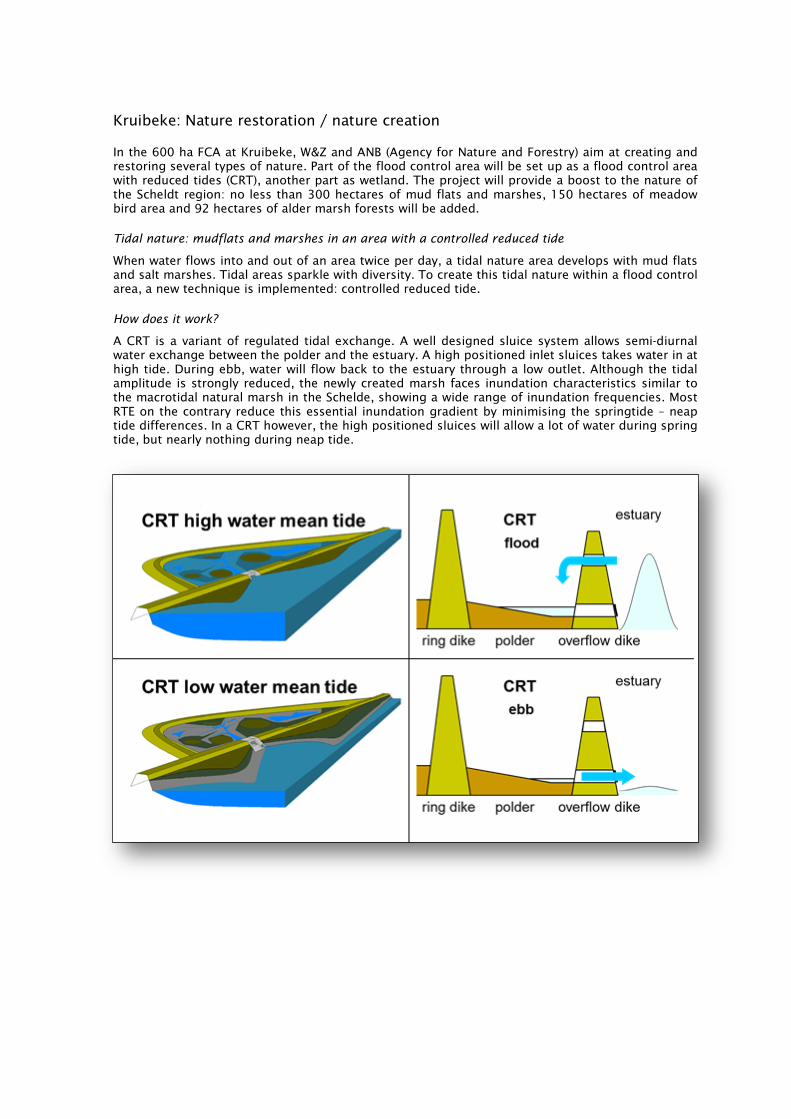
Kruibeke: Nature restoration / nature creation
In the 600 ha FCA at Kruibeke, W&Z and ANB (Agency for Nature and Forestry) aim at creating and restoring several types of nature. Part of the flood control area will be set up as a flood control area with reduced tides (CRT), another part as wetland. The project will provide a boost to the nature of the Scheldt region: no less than 300 hectares of mud flats and marshes, 150 hectares of meadow bird area and 92 hectares of alder marsh forests will be added.
Tidal nature: mudflats and marshes in an area with a controlled reduced tide
When water flows into and out of an area twice per day, a tidal nature area develops with mud flats and salt marshes. Tidal areas sparkle with diversity. To create this tidal nature within a flood control area, a new technique is implemented: controlled reduced tide.
How does it work?
A CRT is a variant of regulated tidal exchange. A well designed sluice system allows semi-diurnal water exchange between the polder and the estuary. A high positioned inlet sluices takes water in at high tide. During ebb, water will flow back to the estuary through a low outlet. Although the tidal amplitude is strongly reduced, the newly created marsh faces inundation characteristics similar to the macrotidal natural marsh in the Schelde, showing a wide range of inundation frequencies. Most RTE on the contrary reduce this essential inundation gradient by minimising the springtide – neap tide differences. In a CRT however, the high positioned sluices will allow a lot of water during spring tide, but nearly nothing during neap tide.

ECSA Local Meeting 2016 17
This new technique was implemented for the first time in the pilot project Lippenbroek. This site can be visited during the Post conference excursion. For more information about Polders van Kruibeke you can visit these websites:
- www.sigmaplan.be/nl/projectgebieden/polders-van-kruibeke - www.natuurenbos.be/polders-van-kruibeke - www.scalluvia.eu - www.facebook.com/depoldersvankruibeke
The area is also intended to serve as an example of sustainable tourism. To this end, we met with neighbouring countries via the international STEP Project (Sustainable Tourism in Estuary Parks). More information on this project can be found on www.step-projects.eu.
Planning for the excursion
At 15:00 we will drive by bus to the ferry at Hoboken. By ferry we will cross the Schelde to Kruibeke and start our visit to this FCA. We will walk through the area and meet many different aspects of this huge project. We arrive at the village of Bazel, just outside the FCA, where we will have a BBQ. After dinner, a bus will drive us back to Antwerpen.
In Kruibeke, we will divide the group in three. You can choose one of the following thematic walks through the area: (1) fauna & flora; (2) water quality and ecological functioning or (3) safety and engineering. All thematic groups will get an overview of the entire project, but with a focus on the chosen subject.


PART II
ABSTRACTS ORAL PRESENTATIONS

ECSA Local Meeting 2016 21
The Schelde from past to future: an integrated approach for restoration
Patrick Meire1, Tom Maris1, Stefan Van Damme1, Tom Cox1, Lotte Oosterlee1, Stijn Temmerman1, Erika Van den Berg2, Gunther Van Rykegem2, Alexander Van Braeckel2, Wim Mertens2 and Bart Vande Voorde2
1 Universiteit Antwerpen, Faculteit Wetenschappen, Departement Biologie, Onderzoeksgroep Ecosysteembeheer (ECOBE), Campus Drie Eiken, Gebouw C, Universiteitsplein 1, 2610 Antwerpen, Belgium
E-mail: [email protected]
2 Instituut voor Natuur- en Bosonderzoek (INBO)
As many estuaries, the Schelde estuary was heavily degraded due to habitat loss, pollution and disturbance. Already in the sixties initiatives were taken to protect some of the remaining estuarine habitats and ecologically valuable habitats in the former floodplain. These initiatives could however not stop further degradation. More stringent environmental legislation resulted in a better water quality, especially in the fresh and brackish part of the estuary, as from the nineties. This, and the emerging concept of nature development triggered the elaboration of a nature restoration plan, mainly oriented towards habitat restoration as a key for restoring the biodiversity of the system. The economic importance of the estuary as the entrance to the port of Antwerp, associated dredging activities and the necessary flood protection stimulated a lot of research. This resulted in a growing insight into the complex interactions between hydrodynamics, geomorphology and ecological functioning on the one hand and some fundamental problems of the estuary on the other hand. Tidal dynamics are increasing, leading to a bigger tidal range and higher high water levels leading to flood risks. Inherently this impacts the geomorphology, which in turn impacts ecological functioning. Water quality was improving, but nutrient loads remain high as the Scheldt drains a very densely populated catchment. It became clear that an integrated restoration plan was necessary and that objectives of the restoration should not only be formulated in terms of restoration of biodiversity but also in terms of how the restoration reduces the overall negative trends in the hydro- and morphodynamics and can enhance the ecological functioning of the estuary. The concept of ecosystem services is a very useful concept in linking all the different aspects of the system. In this presentation an overview of the restoration of the Schelde estuary and the present management will be given.

22 ECSA Local Meeting 2016
Recovery of water quality in European estuaries
Tom Maris, Tom Cox, Stefan Van Damme and Patrick Meire
Universiteit Antwerpen, Science/Biology, Universiteitsplein 1, 2610 Antwerpen (Wilrijk), Belgium E-mail: [email protected]
Estuaries have always attracted many human activities, and hence pollution. The Scheldt estuary was one of the most impacted estuaries in the world, both in terms of organic and chemical pollution as in terms of morphologic alterations. Especially in the oligohaline and freshwater part of the Schelde, most of the year anoxic conditions prevailed. Gradually, waste water treatment plants were build. Despite these investments in water purification, water quality improvements were limited in the Schelde and a clear oxygen sag remained every summer. At the change of the millennium however, a rapid increase in water quality was observed. Driver of this positive and rapid evolution was a change from a heterotrophic to an autotrophic system. Although nutrient input has decreased, algal blooms have dramatically increased. Oxygenation of the water enhances auto purification and enables restoration of the estuarine ecosystem. Still receiving high nutrient loads, the Zeeschelde estuary is however far from healthy. A new concern for the pelagic ecosystem might be an increase in turbidity.
ECSA Local Meeting 2016 23
Stable isotopic composition of inorganic nitrogen substrates represent an efficient tool to investigate long term evolution of the Scheldt health condition
Florian Deman, Natacha Brion, François Fripiat, David Verstraeten and Frank Dehairs
Vrije Universiteit Brussel, Departement AMGC, Pleinlaan 2 F8.61, 1050 Brussel, Belgium E-mail: [email protected]
The biogeochemical cycle of nitrogen in marine and freshwater environments is complex since subject to different within-system processes (uptake, mineralization, ammonification, nitrification), as well as varying input – output functions (discharge, N2 fixation, denitrification). The past decade the concentrations of the different inorganic nitrogen species in the river Scheldt have changed significantly, as a result mainly of extended waste water treatment efforts. Main features are a drastic decrease of the ammonium load, as a result mainly of increased oxygen saturation levels and with a more efficient nitrification as a result. The use of stable isotope tools, next to information about substrate concentrations and reservoir strengths, greatly helps to achieve a detailed understanding of the processes acting on the aquatic N-cycle. We have implemented a series of methodologies for the isotopic analysis (δ15N) of the different oxidised and reduced forms of N (nitrite, nitrate, ammonium total dissolved nitrogen, dinitrogen) as well as O (δ18O) in nitrate, nitrite. These methodologies rely on both bacterial and chemical methods transforming the substrates to be analysed in nitrous oxide, the gaseous compound analysed per isotope ratio mass spectrometer. These methods will be briefly introduced and results obtained for the February, March, April 2016 OMES Schelde cruises (Ghent-Antwerp) and for the Westerschelde (March 2016) will be presented. A strong seasonal change in the relative contribution of NO
2- and NH
4+ and the δ15N composition is
observed, with a strong impact of an increased nitrification activity during the onset of spring (April). We see the long term follow-up of the isotopic composition of these inorganic N-species as a powerful tool to monitor the evolving health status of the Scheldt.

24 ECSA Local Meeting 2016
Restauration of the Gironde estuary through reduction of urban impact: outputs of the ETIAGE program
Thierry Polard1, Mélodie Chambolle1, Alexandre Ventura1, Henri Etcheber2, Hélène Buzinski2, Gérard Blanc2, Benoit Sautour2, Magali Baudrimont2, Aurelie Lanoux2, Victoria N. Deycard2, Yann Aminot2, François Dindinnaud2, Mario Lepage3, Elodie Bouchon4 and Mélina Lamouroux5
1 LyRE, R&D Center of SUEZ Eau France, France E-mail: [email protected]
2 UMR EPOC 5805 CNRS, University of Bordeaux
3 IRSTEA, Bordeaux
4 Centre Assainissement, Direction de l’Eau, Bordeaux Métropole
5 Agence de l'Eau Adour Garonne
While the Gironde estuary had long been considered as preserved, it is now subject to several alarming reports (water, sediment and biota contamination, hypoxia, degraded ecological state, etc.). Considering that both global and local pressures (namely climate change and population growth) tend to increase, it became necessary to set up actions for its restoration. To do so, a consortium was set up between 2010 and 2014 around a program about an “Integrated study of the effects of upstream and local inputs on the functioning of the estuarine Garonne” called ETIAGE. The goal was to characterize the contributions of the pressures originating from the upstream or from the metropolitan area of Bordeaux in order to trigger the most relevant actions. To be able to address together scientific issues and operational recommendations, the consortium was composed of research laboratories and managers. The inputs of macro- and micropollutants emitted by the city through wastewater treatment plant and combined sewer overflows were characterized. These local inputs were compared to the upstream inputs in terms of quantity and quality. Accumulation and synergistic toxic impact of the micropollutants was demonstrated. Moreover, the drivers of hypoxic episodes and their potential impacts during downstream migration of anadromous fish (Alosa alosa) were identified. As a result, Bordeaux Metropole and SUEZ initiated numerous measures to contribute to the restoration of the estuary by reducing the urban footprint. Based on the already innovative real-time management system which aims at minimizing the volume of effluent discharged from the sanitation network through a dynamic optimization of its storage capacity, new steps have been engaged. Real time quality monitoring and modeling of the network and the aquatic ecosystem are in progress in order to drive the sanitation system based on sewage and receiving environment qualities. Moreover, micropollutants are addressed through a source reduction strategy.

ECSA Local Meeting 2016 25
Ecological regulation in the Elbe estuary - changes of the riverine load restores the oxygen budget and the planktonic food web
Birte Hein1, Jörg Scholle2 and Andreas Schöl1
1 Federal Institute of Hydrology, Ecological Interactions, Am Mainzer Tor 1, 56068 Koblenz, Germany
E-mail: [email protected]
2 Bioconsult GbR
Estuarine ecosystems are controlled by a multitude of factors, each influencing the other. Abiotic factors like temperature, light, nutrients, and salinity play a large part in the control of growth, distribution, and abundance of estuarine populations at the base of the food chain, such as microbes and phytoplankton. Every part of the complex web of biotic and abiotic factors fits together to make a system that is resilient to external changes. In the Elbe Estuary, the water quality of the extended freshwater region is mainly driven by the input from the river. As a consequence of changes of the political situation in central Europe at the end of the last century, the loading of the estuary had dramatically altered. Before 1990, the river water quality was dominated by organic carbon from municipal and industrial wastewater inputs while nowadays organic carbon derived from riverine primary production is dominating. In parallel, nutrient and heavy metal loads have been clearly diminished. We show and analyse the changes of the oxygen content in the Elbe Estuary during the last four decades and relate them to the altered riverine load. The results of a Mann-Kendall Trendtest prove a positive trend in the oxygen concentrations during the last decades with a breakpoint during the years 1991-1993. Beside, we also use the Kendall rang correlation coefficient to investigate the influence of the variability of the river discharge on the oxygen content of the estuary. The changes have led to an improvement of the abiotic habitat quality and thus to high chlorophyll and zooplankton densities in the upper section of the estuary. Thereby the spawning habitat of the twait shad (Alosa fallax) located at the lower end of the freshwater region has been partly restored and the food basis of the fish larvae and juveniles has been widened.

26 ECSA Local Meeting 2016
Recipes for restoring natural turbidity in estuaries
Thijs van Kessel, Bas van Maren and Han Winterwerp
Deltares, Sea and Coastal Systems, Postbox 177, 2600 MH Delft, The Netherlands E-mail: [email protected]
Estuaries around the world experience an increase in turbidity levels due to human interference such as channel deepening, land reclamation, port extension, maintenance dredging etc. Sometimes these effects are minor, but sometimes these effects are major. In some estuaries (e.g. Ems, Loire) a shift to hyper turbid conditions is observed and fluid mud layers are formed which did not occur prior to interventions. This contribution first discusses the steering factors for turbidity such as (residual) transport, sinks and sources and the influence of physical, chemical and biological processes hereon. These factors result in a wide range of turbidity levels in natural estuaries as demonstrated from observations and numerical modelling. On top of this human interference also plays a role, which is hard to identify from observations only as - typical for estuaries in populated areas - there may be a long history of different types of interventions, all with their own response time scale. Numerical models help to identify cause and effect with regard to these interventions in addition to the large natural variability of turbidity in estuaries. Subsequently, these insights are used: - to propose criteria to evaluate how much turbidity levels do deviate from natural (pre-
anthropogenic) conditions and - if turbidity levels do significantly deviate from natural conditions, to identify what are the main
contributing factors. Based on these insights applied to the Scheldt and Ems estuaries as examples, potentially effective measures to bring turbidity levels back to normal are proposed. The challenge is to propose effective measures that both fit within the natural estuarine dynamics and are economically feasible, which will greatly enhance their acceptance and likelihood of implementation.

ECSA Local Meeting 2016 27
Using an idealised process-based model to analyse sediment dynamics in the Scheldt estuary
R.L. Brouwer1, Y.M. Dijkstra2, H.M. Schuttelaars2 and George Schramkowski1
1 Flanders Hydraulics Research, Berchemlei 115, 2140 Antwerp, Belgium E-mail: [email protected]
2 TU Delft
Idealised process-based models are a complementary tool to numerical modeling. Their advantages are that they are computationally efficient and are particularly suited to identify the importance of individual physical mechanisms. Currently, an idealised modeling suite for estuarine hydrodynamics and sediment transport is developed by Flanders Hydraulics Research and TU Delft. This activity is part of the hyperturbidity project within the framework of the "Agenda for the future" research program. The aim of the project is to study the risk of the Scheldt Estuary becoming a hyperturbid system and to identify mitigating measures. The idealised model has been used to understand the mechanisms that underly the qualitative relation between sediment distribution and river discharge in the Ems and Scheldt estuaries (Schramkowski et al. 2015). The results show explicitly that the sediment balance in both systems is totally different due to the differences in tidal hydrodynamics. Moreover these findings indicate that the Ems is more efficient at trapping sediment because gravitational circulation is a more important transport agent. In this contribution the model is applied to assess the changes in tidal wave propagation and turbidity dynamics of the Scheldt as a result of measures including channel widening, channel deepening and changes in the location of the weir at Merelbeke. Primary parameters to be studied are enhancement of the tide, changes in tidal asymmetry, location of turbidity maxima and the ability to flush sediment at higher discharges. Reference Schramkowski G.P., Brouwer R.L., Verwaest T., Mostaert F. 2015. "Geïdealiseerde processtudie van systeemovergangen naar hypertroebelheid: WP 2.2 Gevoeligheidsonderzoek en vergelijking tussen Zeeschelde en Eems", Flanders Hydraulics Research, WL2015R13_103_3
28 ECSA Local Meeting 2016
Phytoplankton response to environmental changes in the Scheldt estuary
Reinhoud de Blok1, Michele Tackx2, Tom Maris3, Patrick Meire3 and Wim Vyverman1
1 Ghent University, Department of Biology, Laboratory of Protistology & Aquatic Ecology, Krijgslaan 281, 9000 Gent, Belgium
E-mail: [email protected]
2 Laboratoire Ecologie Fonctionnelle et Environnement, Université de Toulouse
3 University of Antwerp, Department of Biology, Ecosystem Management Research Group
Because of their short generation times, phytoplankton is among the first to respond to environmental stress as well as restoration measures. Although these responses have been intensely studied in lakes, much less information is available for highly complex and dynamic estuarine ecosystems. Here we present a synthesis of phytoplankton dynamics in the freshwater tidal Scheldt estuary based on monitoring data since 1996. Throughout the study period, diatoms have been the dominant group of algae in the estuary, followed by green algae. Phytoplankton mean summer biomass has increased since 2003 and shows a gradual upstream shift in population maxima in more recent years. However, changes in species composition have been more dramatic than the changes in productivity, in particular among diatoms. Based on statistical analyses of field data and laboratory experiments, we attempt to identify the main drivers of these floristic changes. Interspecific differences in ammonium tolerance, susceptibility to parasites and zooplankton grazers emerged as important processes influencing species turnover among phytoplankton in the Scheldt estuary, next to physical forcing by hydrological conditions and underwater light regime.

ECSA Local Meeting 2016 29
Zooplankton resting stages in the Scheldt estuary: is the CRC Lippenbroek a zooplankton refuge?
F. Azémar1, S. Mehraz1, T. Maris2, D. Van Pelt2 and O. Glippa3
1 EcoLab, Université de Toulouse CNRS INPT UPS, 118 Route de Narbonne, 31062 Toulouse cedex 9, France
E-mail: [email protected]
2 University of Antwerp, Ecobe (Ecosystem Management Research Group)
3 Université Lille 1, CNRS, Université du littoral Côte d’Opale, UMR 8187 LOG
Restoration of estuarine intertidal areas is mainly aimed at reducing flooding risk and favoring biogeochemical exchange between the watercourse and the marches. The recently developed concept of controlled reduced tidal systems (CRCs) such as the Lippenbroek in the Scheldt, provide environmental conditions close to natural circumstances, but somewhat more sheltered. While pools on tidal marches are known as nursing areas for many pelagic organisms, little is known about the potential of CRCs to harbor zooplankton organisms or their resting stages. In this study, we have investigated the abundance of zooplankton in the water of the CRC Lippenbroek, as well as the abundance of resting stages in the sediments and compared these with abundances found in the main channel of the Scheldt and the outer dike marches. For the pelagic sampling, 50 L of water were filtered through a 50 µm plankton net and the collected zooplankton preserved n 4 % final concentration formalin. 7 cm cores were taken at several elevation levels within the CRC and in muddy and coarse outer dike sediments. Cores covered 90 ml with filtered Scheldt water were incubated in the laboratory at 18 °C, a 14 h photoperiod and the overlaying water sampled daily during 30 days for resting stages. The results show a spatial heterogeneity of both zooplankton abundance and resting stages within the Lippenbroek. Resting stages are more abundant at low elevation in the CRC than in the outer dike sediments. These results highlight yet another function of CRC’s: they represent sanctuaries for zooplankton.

30 ECSA Local Meeting 2016
Zooplankton grazing pressure on phytoplankton along the Scheldt continuum: importance in a restoration context
M. Le Coz1,2, S. Chambord1, S. Net3, J. Prygiel4 and M. Tackx1
1 ECOLAB, Université de Toulouse CNRS INPT UPS, 118 Route de Narbonne, 31062 Toulouse cedex 9, France
E-mail: [email protected]
2 Université Lille 1 CNRS, Université du littoral Côte d’Opale UMR 8187 LOG
3 Université Lille 1, Sciences et Technologies, LASIR (Laboratoire de Spectrochimie Infrarouge et Raman) UMR 8516
4 Agence de l’Eau Artois, Picardie
In the pelagic, zooplankton is important as a resource for higher trophic levels, but also as a controller of phytoplankton blooms in systems. The Scheldt river springs in the North of France and reaches the North Sea at Vlissingen (The Netherlands) after crossing Belgium. The river- estuary continuum runs though landscapes covering a diversity of land-uses, ranging from agriculture to intensive urbanization and industry. This creates various situations in the environmental conditions (residence time, nutrient concentrations and pollutant concentrations) which are more or less favorable to the development of various zooplankton communities. In this study, we present the composition of the zooplankton communities along this gradient. Its feeding impact on the natural phytoplankton communities was measured at a number of riverine and estuarine sites and at different seasons. Natural water fractions filtered on 250 µm, containing the microzooplancton and most of the mesozooplankton community, were incubated together with water filtered on 50 µm, containing only natural suspended particulate matter. Concentrations of algal marker pigments were quantified by HPLC. It is shown that, according to the site and the season zooplankton, community grazing pressure on the phytoplankton community varies from 6 to 50 % / day. This highlights the importance of considering conditions for zooplankton development for a number of restoration issues such as using phytoplankton and zooplankton as a water quality indicator, evaluating eutrophication risk and promoting conditions for higher trophic level development.

ECSA Local Meeting 2016 31
Ontogenetic habitats of Eurytemora affinis in the Seine estuary
Dur Gael1 and Souissi Sami2
1 Shizuoka University, Shizuoka University, Faculty of Science, Surugaku Ooya 836, 422-8017 Shizuoka, Japan
E-mail: [email protected]
2 Université Lille 1, Sciences et Technologies
Estuarine ecosystems are under numerous environmental, anthropogenic and climatic pressures. Estuarine copepods, such as Eurytemora affinis have been affected by those changes including facing competition with invaders or the need to migrate upstream associated with changes in their habitats. Consequently, efforts to define and monitor potential habitats have been enhanced. Therefore, the present study aims: (i) to determine the main environmental variables shaping the habitat of E. affinis within the Seine estuary; (ii) to model the habitat of three groups of E. affinis developmental stages (larval, juvenile, and adult groups). For this purpose, data from intensive field studies of zooplankton sampling during 2002-2010 were used. The fine scale data on density and abiotic conditions (salinity, temperature, river outflow) provide inputs for the habitat computation. The main environmental factors relating to the species abundance are salinity, and temperature. We established regions in salinity-temperature space where the three groups of developmental stages exhibit higher densities. The computed habitats differ between developmental groups. In general, the preferendum of salinity and salinity tolerance range respectively increase and decrease with the developmental stages. The maximum tolerance range to temperature occurred at lower salinities for nauplii and copepodite. These results are in agreement with the physiological specificity of each group of developmental stage. Our model can be used to determine E. affinis functional habitat (i.e. the spatial relation with structuring factors), carry out analysis of retrospective and prospective evolutions, and investigate the effect of restoration on this copepod habitat.

32 ECSA Local Meeting 2016
The recovery of fish communities in the Zeeschelde (1995-2015)
Jan Breine and Erika Van den Bergh
Research Institute for Nature and Forest INBO, Kliniekstraat 25, 1070 Brussels, Belgium E-mail: [email protected]
The fish monitoring program in the Zeeschelde started in the early 1990’s, when anoxic conditions in the pelagic system where still very common along the freshwater reaches. The monitoring program since then was intensified and diversified as the fish populations recolonized the estuary. In the mesohaline zone water quality was always good enough to allow a diverse fish community. However, in the early 1990s, nearly no fish was caught in the oligohaline and freshwater part of the estuary. In the past two decades we observed a recovery of the habitat functions along the estuarine gradient for the different functional ecological guilds of the fish fauna: Marine stragglers, marine juveniles, estuarine residents, freshwater fish, and last but not least the diadromous fish species. The effect of water quality and the function of restored tidal wetlands in this recovery process will be discussed as well as the distance to the conservation goals (N2000) and the good ecological status (WFD).

ECSA Local Meeting 2016 33
Restoration can do strange things to zooplankton
M. Tackx1, S. Chambord1, M. Le Coz1, T. Maris2 and P. Meire2
1 EcoLab, Université de Toulouse CNRS INPT UPS, 118 Route de Narbonne, 31062 Toulouse cedex 9, France
E-mail: [email protected]
2 University of Antwerp, Ecobe (Ecosystem Management Research Group)
While zooplankton is an important link between primary estuarine pelagic resources (phytoplankton, detritus) and higher trophic levels, it is little studied in long-term monitoring of estuarine systems. In this talk, we explain the difficulties in studying estuarine zooplankton which may explain this lack of data. The long term OMES monitoring of the Sea- Scheldt (1996-present) has fortunately included monthly analysis of zooplankton at 6 stations along the brackish - freshwater gradient. The obtained 20 year dataset has showed that the zooplankton community has changed substantially in parallel to water quality improvement, especially in the freshwater reach of the Scheldt. Essentially, E. affinis, a typical brackish water spring species, has become dominant in the freshwater reach, and the originally abundant cyclopoid copepods have practically disappeared. We consider a number of questions arising from this quite spectacular change in the zooplankton composition – and give (some) answers. What permitted E. affinis to develop in the freshwater reach? Why does it do better there than in the brackish water reach? Is it a returning fugitive rather than an invader? Why did the cyclopoid copepods decline in abundance? Does improving water quality decrease zooplankton biodiversity? At what taxonomic level should we consider zooplankton biodiversity in restoration context? We have also quantified the grazing impact of E. affinis on different types of microalgae within the natural phytoplankton community, and show that its impact is mainly on diatoms, and rarely on other phytoplankton taxa. The trophic role of zooplankton grazing in the upstream reach of the Scheldt is considered from a management and restoration viewpoint. Which zooplankton community is needed to control algal blooms? To allow higher trophic level development? What are the environmental conditions necessary for which zooplankton community?

34 ECSA Local Meeting 2016
Ecological restoration in estuaries: overview of the published literature and main lessons
Cécile Capderrey1, Valérie Foussard1, Stéphanie Moussard2, Nicolas Bacq2 and Jean-Michel Olivier3
1 Université de Rouen, Onema, GIP Seine Aval, 115 Boulevard de l'Europe, Pôle Régional des Savoirs, 76100 Rouen, France
E-mail: [email protected]
2 GIP Seine Aval
3 Université de Lyon
Estuaries are both naturally complex and human-impacted environments where restoration activities and ecological knowledge acquisition are challenging. Ecological restoration initiatives in estuaries may suffer from a global lack of information and/or knowledge going from the objectives-setting step to the whole evaluation of the restoration project. Despite a growing number of published feedbacks, it still remains difficult to establish a clear link between measured effects and restoration efforts. Moreover, lessons learned from former feedbacks may be not easily transferable to build a global reflexion given the strong heterogeneity in projects. Ideally, ecological restoration actions seek to re-establish damaged or lost ecological functions by acting on habitat structure and underlying processes but little is known concerning the required conditions to achieve good ecological functioning, i.e concerning the correct development of underlying physical, chemical, biological and ecological processes. In this context, an analysis based on 200 scientific papers was conducted to provide a first and non-exhaustive state of art to rely on in future restoration projects. This analysis sought to identify in the literature the main restoration objectives and estuarine habitats associated, the different approaches used in setting restoration objectives, the restoration techniques employed, and the methodology developed to assess the achievement of restoration objectives. This analysis enabled to identify the different amount of knowledge detected and associated to the steps described above. It also pointed out the existence of predictive tools that could be used in future projects, and some key elements that must be assessed to clarify the links between habitat restoration and recovery of damaged or lost functions targeted by restoration actions.

ECSA Local Meeting 2016 35
Managed realignment projects on land owned by the Conservatoire du littoral: two examples in Normandy
Lucie Thiebot
Artelia Eau & Environnement, Maritime Business Unit, 8 Avenue des Thébaudières, BP 232, 44815 Saint-Herblain, France E-mail: [email protected]
Against today’s backdrop of rising sea levels and climate change, the Conservatoire du littoral, the French public agency in charge of coastal protection and France’s largest owner of polders, is considering managed realignment as a strategy for adapting and managing its land. It is hence anticipating future changes to habitats located in areas likely to be flooded and taking steps to accompany them. Artelia has conducted managed realignment studies on two polders located at estuary mouths on behalf of the Normandy shoreline division of the Conservatoire du littoral. Several key stages of the study and evaluation approach that was proposed and tested deserve special mention: - A significant amount of time was devoted to project representation and social acceptance aspects; - The objectives were reformulated and ranked in collaboration with the stakeholders involved in
the approach; - The criteria for evaluating the restoration scenarios were defined and weighted by a technical
committee; - The stakeholders interviewed at the beginning of the study were consulted again at the end,
enabling them to express their opinions regarding the approach. The managed realignment of the terrains François (20 ha) on the Orne estuary has three main objectives: restore the salt marshes in the framework of adapting coastline management strategies to address the impacts of climate change; maintaining the existing habitats with heritage interest across the estuary, which is classified as a Special Protection Area under the EU Birds Directive; restoring the estuarine character of the landscape and the associated uses. Among the various methods for reconnecting land and sea that are proposed, evaluated and compared, the project to be implemented includes opening a 30 metres wide breach. This ambitious measure will benefit birds within the SPA and bring functional improvements for fish in the downstream section of the river Orne.

36 ECSA Local Meeting 2016
Abiotic environment and plant community development in Spartina maritima restored salt marshes 9 years after restoration
Guillermo Curado, Blanca Gallego-Tévar, Enrique Figueroa and Jesús M. Castillo
Universidad de Sevilla, Departamento de Biología Vegetal y Ecología, Reina Mercedes s/n (Facultad de Biología), 41013 Sevilla, Spain E-mail: [email protected]
Restoration efforts are needed to recover salt marsh areas which have been degraded or destroyed. Cordgrasses plantations are an excellent way to accelerate the recovery of intertidal areas increasing accretion rates, facilitating ecological succession and increasing biodiversity and ecosystem services. The small cordgrass, Spartina maritima, is the only native cordgrass in many European estuaries. It is known that planting S. maritima recreates typical plant zonation patterns in the short term. However, little is known about the maturation process both in plant community and in the abiotic environment in the medium-long term due to the lack of extensive restoration projects carried out following this successful method. In this sense, our study is carried out in the most extensive documented S. maritima plantation so far, located in Odiel Salt Marshes (Southwest Iberian Peninsula). We hypothesized that S. maritima cover would decrease at the same time that topographic level increases due to its replacement by other halophytes colonizing higher elevation such as Sarcocornia perennis ssp. perennis. In addition, the accumulation of S. maritima below-ground biomass would be slower than its above-ground biomass. Therefore, abiotic factors such as oxygenation level of sediments would change respect to previous years modifying conditions that allow other plant species to colonize these marshes. Increasing the knowledge about environmental conditions development after Spartina plantation (ecosystem engineer species) offers key information for managing programs such as native species introductions or new habitat recreations to increase heterogeneity and biodiversity in new conservation efforts during the maturation of the restored ecosystem.

ECSA Local Meeting 2016 37
Interactive effects of vegetation and grain size on erosion rates in salt marshes of the Northern Adriatic Sea
Veronica Lo1, Tjeerd Bouma2, Carl Van Colen3 and Laura Airoldi4
1 Universiteit Gent, Faculteit Wetenschappen, Vakgroep Biologie, Onderzoeksgroep Mariene Biologie (MARBIOL), Campus De Sterre S8, Krijgslaan 281, 9000 Gent, Belgium
E-mail: [email protected]
2 Royal Netherlands Institute for Sea Research (NIOZ)
3 Ghent University
4 University of Bologna
Salt marsh ecosystems provide multiple ecosystem services, including protecting coastlines from erosion via sediment stabilization. The functions provided by salt marsh vegetation are increasingly negatively affected by human pressures such as land reclamation, climate change and eutrophication. We sampled salt marshes across 230 km of the Italian Northern Adriatic coastline and quantified resistance to lateral erosion by exposing the samples to simulated waves in a flume experiment. We analyzed the relationships between erosion and the presence of Spartina vegetation, the local sediment characteristics, and leaf C:N ratios. Erosion was significantly lower when Spartina vegetation was present across all samples, and in the absence of vegetation, erosion depended on silt content. Our study highlights the interactive effects of vegetation and grain size on erosion rates across the sampling sites, raising important considerations for management of salt marshes for the purpose of coastal protection.

38 ECSA Local Meeting 2016
Habitat value of tidally restored marshes for fish and macro-crustaceans: feedback from two study cases in the Gironde estuary
Alain Lechêne1, Philippe Boët1, Pascal Laffaille2 and Jérémy Lobry1
1 Irstea, Irstea, 183 Route de Pessac, Apt F154, 33170 Gradignan, France E-mail: [email protected]
2 INP-ENSAT
Estuarine intertidal flats and marshes act as refuge, feeding and nursery grounds for fish and macrocrustaceans. Because of land claim, those habitats have greatly declined in Europe. However, an increasing number of former polders have been tidally restored since 1990. Tidal restoration raises concern about the ecological trajectories of restored sites and their functional equivalence with natural intertidal habitats. In the Gironde estuary, two sites have been tidally restored since 1999 and 2010 respectively: the Mortagne marsh, a former polder of the mesohaline zone, and the northern part of the île Nouvelle, an island in the oligohaline zone. Both sites were monitored during 2011-2013. Fish assemblages of the restored sites showed striking structural similarities with natural marshes and mudflats. Both sites were numerically dominated by Pomatoschistus microps whereas Liza ramada was the main contributor to biomass. The restored habitats seemed to act as feeding grounds for juveniles and adults or subadults of P. microps, L. ramada, Anguilla anguilla and Platichthys flesus. Juveniles of estuary-dependent marine species were seldom caught on the île Nouvelle but seasonally abundant in Mortagne marsh suggesting nursery function. In summer, 0-group Dicentrarchus labrax and Sparus aurata and 1-group L. ramada were shown to reside and grow in artificial ponds dug in the vincinity of Mortagne marsh. Tidal restoration had a strong extinction effect on the exotic species which thrive in the ditches of the southern part of the île Nouvelle. Tidal restoration promoted species with recreational or commercial fishing interest. Nevertheless, no clear positive effect was observed for species threatened with extinction or protected by european regulation. Mid-term feedback from the restoration of Mortagne marsh also reveals that its habitat value for aquatic organisms may have started to decline as a result of the natural filling dynamics and the development of extensive reed and cordgrass stands

ECSA Local Meeting 2016 39
Biological top-down control of tidal marshes can regulate time-scales for establishment and recovery
Jim van Belzen1,2, Christian Schwarz1,2,3, Stijn Temmerman1,2,3, Oliver Gorge1,2,3, Tjeerd Bouma1,2 and Johan van de Koppel1,2
1 Royal Netherlands Institute for Sea Research (NIOZ), Department of Estuarine and Delta Systems, PO Box 59, 1790 AB Den Burg, Texel, The Netherlands
E-mail: [email protected]
2 Utrecht University, PO Box 140, 4400 CA Yerseke, The Netherlands
3 University of Antwerp, Ecosystem Management Research Group, Wilrijk, Belgium
A major knowledge gap in restoration of tidal marshes (e.g. by managed re-alignment) consists in the high variance in time-scales needed for their re-establishment after which restoration can be regarded successful. Often only physical factors (e.g. intertidal elevation and wave action) are considered to provide the conditions for re-establishment of tidal vegetation, however there are strong indications that biotic interactions can also play a pivotal role explaining variance in rates of establishment success. In this study, we tested the potential of top-down control by animals (i.e. benthic macrofauna and birds) to explain the slow colonization of a de-embanked area (i.e. ‘Paardenschor’) along the Scheldt estuary (Belgium) by a combination of field and laboratory experiments. This site is sheltered from waves and has a relatively high elevation (1-5% of time inundated) at which old established marshes are growing, yet revegetation is slow. Results from a seedling survival experiment in the field reveal that macrofauna benthos, and more specifically the ragworm Hediste diversicolor, had a significant effect on the survival of transplanted Aster tripolium seedlings in the field, while the influence of birds was less obvious. Additional laboratory experiments show that seedlings are able to escape from grazing when they are growing within patches of the macroalgae Vaucheria sp. Furthermore, although birds did not affect the survival of seedlings in our field experiment we present additional observations and results that suggest that birds are possibly still important affecting the tidal flat development and vegetation establishment early in the growing season due to bioturbation. Although further research into the role of birds and benthos is needed, our results underline that biological interactions (i.e. consumption and habitat modification) can be an important top-down control delaying establishment of tidal marsh vegetation and should therefore be accounted for when predicting the success of tidal-marsh restoration.

40 ECSA Local Meeting 2016
Blue Carbon: opportunities for restoring wetlands and estuaries in Europe
M. van der Snoek1, M. Teunis2, Tom van der Have2 and K. Didderen2
1 University of Groningen, Helper Oostsingel 37B, 9722 AR Groningen, The Netherlands E-mail: [email protected]
2 Bureau Waardenburg
The need to mitigate climate change as well as to protect and restore threatened wetland ecosystems has prompted interest in a new way of funding conservation: Blue Carbon. Blue Carbon ecosystems are distinguished by their ability to sequester large amounts of CO
2 from the
atmosphere mainly by sedimentation and to store it in the soil for centuries. Anthropogenic pressures such as encroaching development and sea level rise threaten Blue Carbon habitats, such as salt marshes, seagrass beds, mangroves and peatlands. Wetland degradation causes them to emit stored carbon from the soil back into the atmosphere. However, restoring these ecosystems is difficult and usually restricted by lack of funding. Blue Carbon programs can provide a new business model to attract investors, and connect them with conservation organisations to facilitate wetlands restoration. First, Blue Carbon project areas are investigated and monitored to estimate their carbon sequestration rate. Then, the amount of carbon stored annually in the project area is converted to carbon credits. These carbon credits are registered on the voluntary carbon market and purchased by parties interested in mitigating their emissions, thereby generating funding for the restoration of the Blue Carbon project area. Blue Carbon projects are underway in the United States but potential opportunities in Europe are still unused. In the present study, we investigate the feasibility of restoring an estuarine habitat as Blue Carbon project in The Netherlands to identify the success factors. The main technical challenge is developing a methodology for calculating the carbon sequestration rate; identifying and connecting stakeholders and investors is also crucial for success.

ECSA Local Meeting 2016 41
The impact of pre-restoration land-use and disturbance on sediment structure, hydrology and the sediment geochemical environment in restored saltmarshes
K.L. Spencer1, S.J. Carr1, G.L. Harvey1 and J.A. Tempest2
1 Queen Mary University of London, United Kingdom E-mail: [email protected]
2 Cambridge University
Saltmarshes are being lost or degraded as a result of human activity resulting in potential loss of critical ecosystem services including the provision of wild species diversity and water quality regulation. To compensate for this saltmarshes are being restored or recreated, usually driven by legislative requirements for increased habitat diversity, flood regulation and sustainable coastal defence. Yet, there is increasing evidence that restoration may not deliver the ecosystem services anticipated and this is frequently attributed to poor drainage and sediment anoxia. However, physical sediment characteristics, hydrology and the sediment geochemical environment are rarely examined in restoration schemes, despite such abiotic factors being critical for plant succession. This study combines a broad-scale investigation of physical sediment characteristics in nine de-embanked saltmarshes across SE England, with an intensive study at one site examining water levels, sediment structure and the sediment geochemical environment. Three-dimensional sediment structure and porosity was quantified using the novel application of X-ray microtomography. The aim was to examine the impact of pre-restoration disturbance on physical sediment characteristics, specifically 1) to measure physical sediment characteristics and sediment structure, 2) to examine sub-surface water levels and connectivity between the sub-surface environment and tidal floodwaters and 3) to examine the potential influence of pre-restoration land-use and disturbance on sediment and pore water geochemistry.

42 ECSA Local Meeting 2016
Lessons learned in managed realignment design along the Scheldt estuary (Belgium)
Alexander Van Braeckel, Wim Mertens and Erika Van den Bergh
Research Institute for Nature and Forest INBO, Kliniekstraat 25, 1070 Brussels, Belgium E-mail: [email protected]
With the updated Sigmaplan the Flemish government aims to harmonise flood control and ecological rehabilitation in the Scheldt Estuary. Tidal wetland restoration is essential to success. Three different types of managed realignment have yet been applied: - Removal of defences: Ketenisse, Lillo west, - Breach of defences: Paardeschor, Lillo east, Heusden - Realignments of defences: Paddebeek, Noordkasteel In these managed realignment projects crucial design issues includes initial ground level, creek precursors, breech dimensions, whether or not to remove dikes and width of the area. In 2003 Ketenisse has been levelled below mean high water resulting in a brackish tidal area of 60ha. Similarly at Paardenschor (2004) and Lillo west (2012) 12ha and 5ha are restored. Defences have been breached at Heusden (2006) and at Lillo East (2011) resulting in 11ha freshwater and 3ha brackish tidal area. By realigning the dikes near Paddebeek (2004) 1.6ha and 2.4ha near Noordkasteel (2010) was restored. Initial ground levels varied between the sites from mean high water to 1 meter below MHW. The lowest levels are obtained at dike removal sites (1-0.5m-MHW) compared to breached sites (0.5-0.1m–MHW) and defence realignment sites (0.3m-MHW). Creek precursors have been dug out in Paardeschor and Lillo. One aim in managed realignment design is to optimise creek formation. In these sites creek formation occurred exclusively in zones with net sedimentation. Creek density increased with a decreasing slope and an increasing width. At Lillo breaching is compared with an adjacent dike removal area and sedimentation rate did not differ. These measures together with creek precursors led to a dendritic creek system in the deposited sediment. In managed realignment projects along the Scheldt wide areas, levelled well (1-0.5m) below mean high water with deep creek precursors appear to have the highest potential for tidal marsh restoration.

ECSA Local Meeting 2016 43
Comparison of sedimentation in controlled reduced tidal and simple culvert tidal restored sites along the Scheldt-estuary
Lotte Oosterlee1, Tom Cox2, Tom Maris1, Stijn Temmerman1 and Patrick Meire1
1 University of Antwerp, Department of Biology, Universiteitsplein 1 C0.30, 2610 Wilrijk, Belgium E-mail: [email protected]
2 Royal Netherlands Institute for Sea Research NIOZ
Along the Scheldt estuary tidal marshes and mutdflats are being restored on formerly embanked land. For this purpose several techniques can be used, among them two different forms of regulated tidal exchange: controlled reduced tide (CRT) and simple culvert system (SCS). In a CRT high inlet culverts and low outlet valves in the dike allow a limited amount of water to enter and leave the low elevated polder area. The created tidal regime in the CRT has almost the same characteristics as the tidal regime on higher-elevated natural marshes in the estuary. In contrast, the SCS consists of a low single passage through the dike so that the full estuarine tidal range (on average 5.35 m) enters and leaves the low lying area without change of the tidal curve. It may be expected that in CRT-marshes or SCS-marshes the interaction between elevation change and consequent changes in tidal characteristics and soil properties deviate from each other and from natural tidal marshes. In this study we compare results on these variables between the systems and discuss possible underlying causes of the observed differences. The low CRT sites are initially characterized by a strong increase in surface elevation (max. 0.1 m year-1) gradually decreasing over nine years, which coincided with a reduction of flooding frequencies. At high sites elevation change rates and flooding frequencies started to increase after several years. In the SCS-area, extremely high sedimentation rates (3.8 m year-1 at low sites, 0.7 m year-1 at high sites) were observed within the first months. Very quickly, liquid mud covered the whole SCS-area. Due to an unexpected event, the area was cut off from tidal influence for 1.5 years, in which the area drained. Soon after re-opening the culverts, the evolved creek system maintained and a well-drained, ecologically well-functioning mudflat system formed.
44 ECSA Local Meeting 2016
Rates of deposition on intertidal mudflats: an initial synthesis
Steve Mitchell1 and Heidi Burgess2
1 University of Portsmouth, School of Civil Engineering and Surveying, Portland Building, PO1 3AH Portsmouth, United Kingdom
E-mail: [email protected]
2 University of Brighton, United Kingdom
In considering restoration of estuaries for re-establishment of salt marsh areas it is important to be able to predict the rate of increase of deposition of inter-tidal sediment in a range of different environments. This is especially challenging in high tidal range environments, and particularly so when these are subject to pressures from a range of different stakeholders and interest groups. The effects of climate change, especially sea level rise and increased storminess, may also moderate the tendency of intertidal muddy sediments to settle in some areas. At sheltered sites such as Pagham Harbour on the heavily populated South Coast of the UK, increased sediment deposition over time has led to the establishment of salt marsh, and although this seems to have been a result of luck rather than planning, numerical models of geomorphological change must take into account the processes of erosion, transport and deposition as influenced by a complex set of hydrodynamic factors. We present a reinterpretation of some previously published results of long term increase of sediment levels and show how these compare with measurements made in other systems (Seine, Scheldt, Humber) in anthropogenically moderated high tidal range environments. This enables us to build our understanding of the importance of a range of factors, including tidal range, the availability of sediment supply, and the sheltering effect from winds and storm waves. Using this approach enables us to start to build up a profile of the (environmental) factors most likely to favour the growth of salt marsh plants such as Salicornia. This can then inform attempts to promote the growth of salt marsh plants as part of a wider estuarine restoration strategy, and can inform management practices in systems of this kind in a range of settings.

ECSA Local Meeting 2016 45
Assessing the influence of saltmarsh restoration on sediment dynamics
Benjamin Taylor and David Paterson
University of Saint Andrews, Sediment Ecology Research Group, Gatty Marine Lab, KY16 8LB Saint Andrews, United Kingdom E-mail: [email protected]
Coastal wetland ecosystems can act as large-capacity, long-lived carbon sinks and could play a role in providing climate change mitigation services. This societal benefit can be taken as an additional benefit to promote restoration efforts of these globally threatened ecosystems. The Eden Estuary, Scotland has been the focus of saltmarsh conservation efforts using the transplantation of Bolboschoenus maritimus from donor stands to un-vegetated mudflat. Efforts were focussed on the expansion of the existing marsh and to provide protection to exposed high marsh cliffs. The additional carbon storage within the estuary resulting from these efforts is being assessed to better understand the holistic value of such conservation initiatives Sediment deposition and settlement measures were taken seasonally across spring to neap tidal ranges. Study areas were classified as ‘natural’ (B.maritimus marsh or high marsh dominated by Puccinellia maritima), ‘old planted’ (being >10 years old), ‘young planted’ (being <5 years old) and bare mudflat. Samples provided measures of total sediment, organic content and carbon content being deposited or settling. Image analysis was also employed to quantify the vegetative cover and density at each sampling point in each season. These data were used to assess the different sediment dynamics within each study area and how vegetation structures might influence sediment behaviour. Initial data suggests differences in sediment dynamics between the areas, with ‘natural’ marsh and ‘old planted’ areas experiencing the least absolute total sediment deposition. Further, there is a difference in organic and carbon content between these samples. Factors influencing these differences could be attributed to type and density of vegetation present and elevation of each area, used as a proxy for immersion period. Early results indicate the importance of vegetation stand age in terms of the mediation of sediment dynamics and carbon storage.

46 ECSA Local Meeting 2016
Forecasting the biogeomorphic development of intertidal wetland restoration: a novel modelling approach
Christian Schwarz1, Jim van Belzen2, Olivier Gourgue1, Tjeerd Bouma2, Johan van de Koppel2, Patrick Meire1 and Stijn Temmerman1
1 University of Antwerpen, Ecosystem Management Research Group, Wilrijk, Belgium E-mail: [email protected]
2 NIOZ Royal Netherlands Institute for Sea Research, Department of Estuarine and Delta Systems, and Utrecht University, The Netherlands
Managed realignments - i.e. the landward displacement of seawalls in order to create new intertidal habitats on formerly embanked land - are becoming an important engineering option enabling the reduction of the costs of coastal defenses, providing a sustainable approach in dealing with sea level rise and simultaneously delivering environmental benefits through the creation of intertidal habitats. A major challenge in managing, planning and executing managed realignments lies in optimizing their design in respect to abiotic factors (e.g. dimensions of dike breaches or of channel networks) and biotic factors (e.g. revegetation or natural establishment of plants) in order to guarantee success within the desired time frame. Due to the novelty of this approach and the lack of long-term data available, numerical models are applied to breach this gap. We use a coupled finite element hydrodynamic- (TELEMAC2D), morphodynamic- (SISYPHE) and an in-house developed vegetation growth model, in combination with field experiments and measurements, to forecast the development of a future managed realignment site over a period of several decades (465 ha, Hedwige-Prosperpolder, Scheldt estuary, Belgium & The Netherlands). The novelty of our approach resides in the subgrid/mesh approach which is used in modelling spatio-temporal vegetation development. This approach allows us to take small scale (e.g. 0.25m) interactions between vegetation, flow and sediment transport into account although the hydro-geomorphic model is run on a coarser gird (e.g. 5m). It not only reduces computational time, opens possibilities for sensitivity testing, but potentially conserves the importance of small scale vegetation dynamics on shaping landscape patterns such as the erosion of channels. This study summarizes the vegetation and sedimentation parameterization, and discusses preliminary results in the context of large-scale (100s of ha) biogeomorphologic development for long-term (decades) forecasting and its management implications.

ECSA Local Meeting 2016 47
The evolution of creek networks in saltmarsh restoration schemes – Implications for planning and site construction
Jonathan Dale, Heidi Burgess and Andrew Cundy
University of Brighton, School of Environment and Technology, Cockcroft Building, Lewes Road, BN2 4GJ Brighton, United Kingdom E-mail: [email protected]
Creek networks and drainage features in restored saltmarshes and mudflats have been identified to locally enhance sediment supply (Reed et al., 1999), increase sediment stability and increase drainage as they develop (Watts et al., 2003). However, many restored sites remain poorly drained which can have implications for the ecosystem services provided by these sites. Measurements of changes in the position and elevation of the creek networks will be presented from the Medmerry Managed Realignment site, UK, the largest open coast realignment site in Europe. The measurements will be supported by visual observations of drainage through pre-existing channels, areas excavated during site construction, the remains of terrestrial pipes and former land-use features and evidence of soil pipes which have collapsed to form embryonic creek networks. These findings highlight the need for increased awareness of the pre-existing drainage features when planning estuarine restoration schemes and the importance of site design in the development of drainage networks. Areas needing further consideration will be evaluated, with this work providing an insight into the drainage of restored saltmarshes with implications for the design and construction of future restoration projects.
References - Reed, D. J., Spencer, T., Murray, A. L., French, J. R. & Leonard, L. 1999. Marsh surface sediment
deposition and the role of tidal creeks: Implications for created and managed coastal marshes. Journal of Coastal Conservation, 5, 81-90.
- Watts, C. W., Tolhurst, T. J., Black, K. S. & Whitmore, A. P. 2003. In situ measurements of erosion shear stress and geotechnical shear strength of the intertidal sediments of the experimental managed realignment scheme at Tollesbury, Essex, UK. Estuarine Coastal and Shelf Science, 58, 611-620.

48 ECSA Local Meeting 2016
Groundwater flow in freshwater tidal marshes: a comparison of a natural and a restored marsh
Niels Van Putte, Goedele Verreydt, Stijn Temmerman and Patrick Meire
University of Antwerp, Department of Biology, Pijlkruidstraat 26, 2990 Wuustwezel, Belgium E-mail: [email protected]
Numerous tidal marsh areas are being restored for flood protection and ecological development along the Scheldt estuary. Recently however, questions arise about the extent to which restored marshes deliver ecosystem services. Due to the historical land use of the restored marshes and the compacted polder soil, underlying the freshly accreted sediment, subsurface water flow might be altered, hereby affecting important ecosystem functions such as nutrient cycling, the source-sink function and the vegetation development in the marsh. In this research, a combination of a newly developed method for in situ subsurface water flux measurements is used in combination with measurements of soil characteristics and groundwater head time series along a transect in both a natural and a restored marsh. Special attention is paid to the presence of organic matter and macro pores in the soil, and their effect on subsurface water flow. The goal of this study is to map for the first time the physical movement of water in freshwater tidal marsh soils and to see if these movements differ in natural and restored marshes, with a focus on hydrologic factors affecting these movements. Ultimately, this research serves as a pilot study to evaluate different methods to assess subsurface hydrology in freshwater tidal marshes, with the prospect of conducting a larger study which could form the foundations for new approaches to design restored freshwater tidal marshes.

ECSA Local Meeting 2016 49
The role of differences in the former land use on the 3D structure of restored saltmarsh sediments
Jonathan Dale1, Andrew Cundy1, Heidi Burgess1, Kate Spencer2 and Lucy Diggens2
1 University of Brighton, School of Environment and Technology, Cockcroft Building, Lewes Road, BN2 4GJ Brighton, United Kingdom
E-mail: [email protected]
2 Queen Mary University of London
Evidence suggests that saltmarshes in managed realignment sites differ in structure and function to adjacent natural sites. Previous studies have associated these differences with the sub-surface sediment structure influencing the porosity and hydraulic conductivity of the restored sites, possibly due to compaction caused by the former land use (Tempest et al., 2015). However, further evidence is required assess the extent to which the former land use influences the evolution of other saltmarsh restoration schemes. To investigate the role that different former land uses have on the sediment structure we present innovative 3D analysis of sediment cores from the Medmerry Managed Realignment site, UK, the largest open coastal realignment site in Europe. Core samples were taken in July 2015 from a former barley field, farmed intensively up to two weeks before site inundation in September 2013, and a field used irregularly for low-quality arable purposes. Each core was scanned using an x-ray computed microtomography system and comparisons between the two sites have been contextualised by supporting data from the wider on-going monitoring of the Medmerry site. Visual comparisons of the sediment structure demonstrated a lower abundance and tortuosity of macropores and clear laminations in the upper sediment in the field farmed intensively. It is proposed that former land use can have a long-term effect on evolution of the sediment regime, which in turn can have major implications for ecosystem services such as coastal flood defence, immobilisation of pollutants and species diversity provided by the Medmerry site. This poster provides new insight into the influence of the former land use with implications for the success of future restoration projects.
Reference Tempest, J. A., Harvey, G. L. & Spencer, K. L. 2015. Modified sediments and subsurface hydrology in natural and recreated salt marshes and implications for delivery of ecosystem services. Hydrological Processes, 29, 2346-2357.

50 ECSA Local Meeting 2016
Modeling morphodynamic response of estuaries to closure of secondary tidal basins
Abdel Nnafie, Tomas Van Oyen and Bart De Maerschalck
Flanders Hydraulics Research, Berchemlei 115, 2140 Antwerp, Belgium E-mail: [email protected]
Many estuaries are situated in very densely populated areas with high economic activities that often conflict with their ecological values. For centuries, geometry and bathymetry of estuaries have been drastically modified trough engineering works, such as embanking, sand extraction, channel deepening, closure of tidal basin, etc. It is generally recognized that these interventions have resulted in significant hydrodynamic and morphological changes in these estuaries (e.g. increasing tidal range and SPM concentrations, loss of intertidal areas, formation of new shoals and channels, channel migration, increasing tidal range and SPM concentrations, see e.g Winterwerp et al., 2013; Wang et al. 2009). Examples include the Ems estuary, the Loire, the Scheldt, the Elbe and the Yangtze. To successfully manage estuarine systems under the ever increasing pressure of population and economic growth, it is necessary to improve our understanding of potential impacts of engineering works on hydro- and morphodynamics of these systems. The aim of this contribution is to investigate effects of closure of secondary tidal basins on the long-term morphodynamic evolution of estuaries. For this purpose, numerical model Delft3D is used, which has been successfully applied to morphodynamic modeling of estuaries and other coastal systems (cf. Hibma et al., 2003; van der Wegen et al., 2008; Ridderinkhof et al., 2014). The current study considers a realistic geometry, which is based on that of the Scheldt estuary. Mean motivation to consider this estuary is that it used to consist of multiple secondary tidal basins (Sloe, Braakman and Hellegat), which have been gradually closed off between 1800 and 1968 (van der Spek, 1997). Another motivation to select this estuary is that many historical data on its geometry and bathymetry are available since 1800, which enables a comparison between model results and observations.

ECSA Local Meeting 2016 51
Morphological changes in the Zwin and Westerschelde estuaries
De Nul Pieter Jan
Universiteit Antwerpen, Jan De Nul Group, Tragel 60 9308 Aalst, Belgium E-mail: [email protected]
Goal of this research Goal of this research is to investigate what the influence of embankment activities has been on the dimensions of the Zwin and Westerschelde tidal inlet over the course of history. The research will look how from 1561 AD upto 2013 AD the dimensions of both have changed. Furthermore it will be investigated if they are in geomorphological equilibrium. Geomorphological equilibrium would mean that a plot of its surface cross sectional area versus tidal prism fall on a straight line (D’Alpaos, 2009). Material and methods This research makes use of historical maps of both inlets. These were digitalised and processed in GIS. Due to lack of historical topographical and tidal data, proxies have been used to calculate tidal prism and depth of the tidal inlet. The width of the tidal inlet is a proxy for the depth, whereas the surface of the tidal basin area is a proxy for the tidal prism. Results The results show that the width of the Westerschelde inlet decreased slightly between 1795 AD and 2013 AD. The width of the Zwin inlet decreased sharply between 1561 AD and 1900 AD. For both locations the surface of the tidal basin versus the inlet width was plotted. This shows the relative speed with which the inlet narrowed as a result of embankment. Furthermore for both locations a theoretical tidal prism and surface cross sectional area (SCA) was calculated. These data were plotted against the widely used Jarret (1976) dataset. Conclusion Both inlets followed the relation between tidal prism and surface cross sectional area as proposed by D’alpaos et al. (2009). None of both inlets proves to be presently in equilibrium, since a plot of their SCA versus tidal prism doesn’t match with the dataset of Jarret (1976) for tidal inlets in geomorphological equilibrium.

52 ECSA Local Meeting 2016
Building with nature: using natural infrastructure for coastal adaptation
Tom Ysebaert1,2
1 NIOZ Royal Netherlands Institute for Sea Research, Korringaweg 7, 4401 NT Yerseke, The Netherlands
E-mail: [email protected]
2 IMARES Wageningen UR, Haringkade 1, Ijmuiden, The Netherlands
Globally, estuaries and coasts are under pressure as coastal human population growth and urbanization continues, while climate change leads to rising tides and increased storminess. In many locations, conventional coastal engineering solutions with hardened structures such as sea walls, bulkheads and revetments are increasingly challenged by these changes and their maintenance may become unsustainable. Instead, ‘soft’ engineering options using green infrastructure and eco-engineering, are increasingly recognized as more sustainable, adaptive, cost-effective (on a life cycle basis) and ecologically sound alternatives to conventional engineering solutions. The restoration of estuarine ecosystems such as marshes, tidal wetlands, mangroves, biogenic reefs etc. offer increased protection against flooding and erosion, while simultaneously delivering many other essential ecosystem functions and services. Healthy, well-functioning ecosystems will offer risk reduction and enhance natural resilience to the adverse impacts of climate change and reduce the vulnerability of people. Extensive experience with eco-engineering has been achieved in the Dutch Building with Nature program (www.ecoshape.nl), in which existing concepts and ideas have been further developed and tested in a number of full-scale pilot experiments, including sand engines, oyster reefs, mangroves and wave-attenuating forests. A number of these experiments will be shown along with results and lessons learned, as well as other examples of eco-engineering in estuarine and delta environments worldwide. These ecosystem-based examples show promising opportunities, however, large-scale application and implementation in policy and management of our estuaries and deltas will require greater focus on in-situ research and a better mechanistic understanding of the long-term ecosystem dynamics.

ECSA Local Meeting 2016 53
Translating the windows of opportunity theory into techniques to establish ecosystem-engineering species: linking theory to application
Tjeerd J. Bouma1, Wouter Lengkeek2, Karin Didderen2, Ralph J.M. Temmink3 and Greg Fivash1
1 NIOZ Royal Netherlands Institute for Sea Research, Korringaweg 7, 4401 NT Yerseke, The Netherlands
E-mail: [email protected]
2 Bureau Waardenburg
3 Radboud University Nijmegen
Ecosystem engineers (EE) are species that are capable of modifying their physical environment. In estuarine and coastal environments EE are highly abundant, and are typically foundation species that provide habitat to many other species, thereby enhancing diversity. Unfortunately, these estuarine and coastal ecosystems ‘engineered’ by foundation species (seagrass, mangroves, salt marshes, oyster reefs, etc.) have been globally declining. Restoration of these ecosystem engineers has proven to be extremely difficult, with high failure of restoration efforts around the globe. At the same time, the need for restoration is increasing, given the many ecosystems services that EE-ecosystems provide (e.g., enhance coastal defense, reduce coastal erosion, enhance biodiversity, etc). Hence, over the last years a large body of work has focused on how to restore EE-ecosystems. This has led to the Windows of Opportunity concept. Within this talk, I will highlight i) the Window of Opportunity theory and ii) how this theory has led to novel restoration techniques. I will specifically highlight the use of biodegradable elements (BESE) that can be used for coastal restoration.

54 ECSA Local Meeting 2016
Using pacific oyster Crassostrea gigas for sediment stabilization: how their effectiveness depends on biological and environmental setting
João Salvador de Paiva1, Brenda Walles2, Tom Ysebaert2 and Tjeerd Bouma1
1 HZ University of Applied Sciences, Edisonweg 4 4382 NW Vlissingen, The Netherlands E-mail: [email protected]
2 NIOZ Royal Netherlands Institute for Sea Research, Korringaweg 7, 4401 NT Yerseke, The Netherlands
Ecosystem-based coastal defense is a promising way to climate proof estuaries and coastlines. One of the advocated methodologies is creation, restoration or conservation of intertidal ecosystem engineering species that stabilize shorelines and attenuate waves. The Pacific oyster (Crassostrea gigas) is an ecosystem engineer known for its wave attenuating, sediment trapping and stabilization capacity. The aim of this research is 1) to quantify to what extent oysters’ ability to stabilize sediment is conditional, and 2) if this effect can be predicted based on physical forcing, morphological characteristics of the tidal flat, and biological characteristics of the oyster reef. This was investigated by correlating long-term sediment accretion patterns of tidal flats covered by natural intertidal oyster reefs to reef characteristics and abiotic conditions. Results showed that stabilization of sediment by oysters increases under erosional conditions. Furthermore, our results showed that tidal flat shape determine the strength of the engineering , as larger elevation changes were found in convex tidal flats versus concave tidal flats. Additionally, there is a relation between sediment stabilization and reef characteristics, as a lower width to length ratio and higher patch or oyster densities increase the ability to accrete and stabilize sediment within the reef. The ability of C. gigas to shape its environment depends both on biotic and abiotic conditions. Stabilizing effects of oyster reefs on tidal flats stress their importance as ecosystem engineers in erosion dominated estuaries and coastlines. Conservation of oyster reefs, as well as construction of artificial reefs could be an important management tool for tidal flat protection and conservation.

ECSA Local Meeting 2016 55
Controlled reduced tidal areas: an evaluation of 10 years Lippenbroek
Tom Maris, Lotte Oosterlee, Stijn Temmerman and Patrick Meire
Universiteit Antwerpen, Science/Biology, Universiteitsplein 1, 2610 Antwerpen Wilrijk, Belgium E-mail: [email protected]
When considering marsh restoration on embanked sites, managed realignment is not always an option, due to site characteristics or safety considerations. Regulated Tidal Exchange (RTE) can offer an alternative. Here we present results of ten year of monitoring of the pilot project Lippenbroek. Lippenbroek is a flood control area with a controlled reduced tide (CRT), a technique similar to RTE, but with major ecological advantages. A well designed sluice system allows semi-diurnal water exchange between the safety area and the estuary. Although the tidal amplitude is strongly reduced, the newly created marsh faces inundation characteristics similar to our macrotidal reference marsh, showing a wide range of inundation frequencies. Most RTE on the contrary reduce this essential inundation gradient by minimising the springtide – neap tide differences. We present results of ten years intensive monitoring on tidal variation, nutrient processing, species colonization and habitat development in the 10 hectare big pilot CRT. Mass balance studies show that the CRT acted immediately as a sink for e.g. nitrogen. The site evolved from a source of phosphorus to a sink. Rapid colonisation of benthic species is related to input of estuarine sediments. Vegetation patterns and sedimentation rates are linked to flooding frequencies. Long term predictions are however difficult since a CRT has no feedback mechanism that decreases flooding frequencies with increasing elevation of the marsh. For this, adaptive management at the sluices is an option, depending on the kind of habitat that is requested. Our results indicate that the CRT-technique provides strong potential for durable, adaptive restoration of tidal marshes on low sites. Within the Schelde estuary, the technique will be implemented on larger scale: more than 1500 ha of CRT marshes is under construction.

56 ECSA Local Meeting 2016
International law as a driver for estuarine restoration
An Cliquet
Ghent University, Public, European & International Law, Universiteitstraat 4, 9000 Gent, Belgium E-mail: [email protected]
This contribution aims to look at the role that law can play in getting restoration done ‘on the ground’. It will focus on some of the most relevant legal obligations for estuarine restoration at the international and EU level. This includes obligations and targets under the Biodiversity Convention (including restoration under the Aichi targets) and the restoration obligations under the Ramsar Convention. At the EU level, this encompasses the requirement under the Water Framework Directive to obtain a good environmental status and the obligations to restore species and habitats at a favourable conservation status under the Birds and Habitats Directives, as well as the commitments from the EU Biodiversity Strategy and the Green Infrastructure policy. Which approaches can we find in these instruments, are there any (binding) guidelines or standards in the legal instruments and are these obligations and targets effectively and timely implemented? As some estuarine restoration works are conducted under legally obliged compensation schemes for infrastructure works, the specific obligations for ecological compensation under the Habitats Directive will be discussed, as well as a recent judgment from the European Court of Justice (the so-called ‘Briels’ case), in which the Court distinguishes between restoration as ‘mitigation’ and ‘compensation’. The possible implications of this ruling for restoration will be explained.

ECSA Local Meeting 2016 57
Restoration and sustainability: key concepts for the integration of human activities in the conservation objectives of the Natura 2000 Network
José A. Juanes, Cristina Galván, María Recio, Bárbara Ondiviela and Beatriz Echavarri
Universidad de Cantabria, Environmental Hydraulics Institute IHCantabria, Isabel Torres 15, 39011 Santander, Spain E-mail: [email protected]
Estuaries are under the negative influence of several anthropogenic activities, which have lead to an unacceptable level of ecological impairment. In this context, restoration emerges as an important discipline in order to reverse this situation and recover the ecosystem services provided by these environments. Hydrodynamic alterations, invasive species and eutrophication are three remarkable pressures that affect estuaries around the world. In 2009, two restoration actions were carried out in the Oyambre estuary (Northern Spain), in order to recover the natural tidal regime after removing a dike and to remove the extended populations of the invasive shrub B. halimifolia that had colonized many estuarine areas. Since then, an adaptive monitoring program was implemented in order to study the evolution in the physic-chemical and biological conditions of the estuary. Results reveal significant changes in the ecosystem, which has achieved an stable state, and the decisive role of tidal flows restoration on the control of the distribution and coverage of B. halimifolia. Based on this study, a large scale and integrative restoration project supported by the LIFE Programme is been developing in other estuaries along the cost of Cantabria. Design of restoration actions were performed in order to promote the sustainability of productive, educational, cultural and touristic activities within Sites of Community Importance (SCIs). As a result, an improvement of both the connectivity along those estuaries and the conservation status of some protected habitats are expected. In this presentation, a summary of the 8-years monitoring program will be presented as the basis for the design of the new restoration proposals included in the CONVIVE-LIFE project (LIFE14 NAT/ES/001213).

58 ECSA Local Meeting 2016
Multiple implications of the restoration of coastal wetland ecosystem and the establishment of a strategic restoration framework
Bong-Oh Kwon1, Jungho Nam2, Kyu-Hee Son3 and Jong Seong Khim1
1 Seoul National University, Research Institute of Oceanography, 1 Gwan-ak ro, Gwanak-gu 08826 Seoul, South-Korea
E-mail: [email protected]
2 Korea Maritime Institute
3 Korea Marine Environment Management Corporation
Korean society has been recently promoting the restoration of coastal wetlands. These efforts might become the basis of a policy framework that compensates for the limitations of a regulation-oriented policy such as the designation of marine protected areas (MPAs). The shift in government policy could contribute to strengthening the socioeconomic infrastructure of coastal development through the accumulation of ecological capital. Although our scientific efforts and social demands in regard to the ecological restoration of the coastal wetlands have increased during the past years, the bases for restoration in Korea requires that scientific, technological, financial, social and legal aspects be enhanced. The present study re-examined the concept and attitudes behind coastal wetland restoration in the light of changing circumstances in Korea. Herein, we first defined coastal wetland restoration as “An act of recovering the functions of the ecosystem of coastal wetlands to a state that resembles conditions prior to being damaged.” Next, this study discussed the limitations and future directions of such restoration efforts based on the descriptive analyses of recent restoration practices from social, economic, and technological aspects. Finally, we suggest future policy directions regarding coastal wetland restoration on the basis of a PFST (policy-financial- social-technological) analysis; 1) re-arranging legal mechanisms, 2) setting multi- dimensional restoration goals, 3) establishing a multi-discipline- and convergence– based R&D system, 4) linking spatial management and local development to the restoration, 5) building restoration governance at the local level, 6) implementing an ecosystem service payment system, and 7) applying test-bed projects in accordance with proper directions.

ECSA Local Meeting 2016 59
How ecological restoration may contribute to mitigate hydrodynamic changes in estuaries
Stijn Temmerman1, Jeroen Stark1, Sven Smolders2 and Patrick Meire1
1 University of Antwerp, Ecosystem Management research group, Universiteitsplein 1, 2610 Antwerpen, Belgium
E-mail: [email protected]
2 Flanders Hydraulics
The hydrodynamic characteristics of estuaries, such as the tidal range, tidal asymmetry, residence times, waves, storm surge events, and long-term sea level rise, are to a large extent determinant for many estuarine processes and functions, including natural processes such as the fluxes of sediments, nutrients and biota, but also socio-economic functions such as protection against flood risks and water depth for shipping. In many estuaries, especially those where human impacts have modified the estuarine morphology, these hydrodynamic characteristics have changed over various time scales, leading in certain situations to undesired developments such as growing tidal range, increasing tidal asymmetry, further inland propagation of sea level rise and storm surges. In this presentation, we intend to give an overview of how the ecological conservation and restoration of estuarine habitats may contribute to mitigate such undesired hydrodynamic changes, with special reference to examples on intertidal habitat effects on hydrodynamics in the Scheldt estuary (Belgium and The Netherlands). Our overview is based both on field observations on tidal (and storm surge) propagation within a large intertidal marsh (Saeftinghe), as well as on model simulations of within-marsh hydrodynamics and upscaling to hydrodynamic effects on the whole estuary scale. As such we demonstrate that the potential to mitigate undesired hydrodynamic changes, such as the mitigation of tidal range, tidal asymmetry and storm surge levels, largely depends on the geomorphological properties of intertidal habitats, such as their size, elevation and location along the estuary, and on ecological properties, such as vegetation-induced friction. Our overview also shows that effects of intertidal habitat restoration on estuarine hydrodynamics are often complex and not straightforward, highlighting that further research is needed in support of effective restoration plans.

60 ECSA Local Meeting 2016
Modelling of the historical and current hydrodynamics of the Scheldt estuary
Dieter Meire, Yves Plancke and Joris Vanlede
Waterbouwkundig Laboratorium/Flanders Hydraulics Research, Berchemlei 115, 2140 Antwerpen, Belgium E-mail: [email protected]
The Scheldt estuary, the part of the Scheldt river subject to tides, ranges from the mouth up to the city of Ghent, over a length of 180 km. Numerous human interventions have been performed in the Scheldt estuary over the last century, ranging from impolderings, deepenings of the fairway to harbor extensions. This, together with external forcings as sea-level-rise, resulted in a change of the horizontal (velocities, fluxes) and vertical (water levels) tide in the estuary over the last century. The water levels have been measured at several measurement locations since the end of the 19th century. Although long recordings exist of the water levels, almost no historical information is available of the horizontal tide or water velocities. Therefore, it is not clear in what extent the change of water levels has influenced the currents. Both for the year 2009, the current situation including all human modifications to the estuary, and for 1954, a reference year before the main deepening works and harbor extensions, a hydrodynamic model is set up using the SIMONA software. The model grid ranges from the North Sea to the most upstream parts of the Scheldt estuary, including the main side rivers. Both for 1954 and 2009, a bathymetry is interpolated onto the grid based on depth soundings. The model is calibrated in previous work (Vanlede et al., 2015). Roughness calibration was accounted by specifying regions with different values of Manning coefficient across the domain. The model is validated for both situations and compared with water level measurements, to assess the model accuracy. Comparing the results of both models gives more insight in the major changes in the horizontal and vertical tide, the amplitude and phase of the important harmonic components and the residual fluxes due to morphological changes in the estuary.

ECSA Local Meeting 2016 61
How the tides changed in the Schelde-estuary under influence of natural changes and human interference
Y.M.G. Plancke, W. Vandenbruwaene and D. Meire
Flanders Hydraulics Research, Berchemlei 115, 2140 Antwerp, Belgium E-mail: [email protected]
The Schelde-estuary has a length of 160 km and is characterized by a macro-tidal regime, ebb and flood currents, a longitudinal salinity gradient and important sediment transports, leading to important morphological changes. Over the past centuries several human interferences have taken place in and along the estuary: starting with important poldering of areas along the estuary, dike-building, cutting-off of several bends, dredging works to guarantee the port accessibility and sand extraction for commercial reasons. Beside these human activities sea level change occurred and has caused changes in the morphology of the estuary and thus the tidal penetration in the estuary. The tidal range increases from the mouth of the estuary towards up-estuary. At the start of the 20th century, this maximum was located near Antwerp (KM80), while at the end of the 20th century this maximum has increased and is located more up-estuary (Tielrode, KM100). More up-estuary the tidal range decreases, due to the smaller depth resulting in more damping. At Antwerpen, the yearly averaged high water levels increase gradually, while the low water levels show a rather sudden drop in the 1970’s. For the high water level both sea-level-rise and the 18,6-year nodal cycle are found to be important in the changes of the water levels. These factors also influence the low water level, although the drop in the 1970’s is related to the combination of different human interventions. Over the past years, research projects have tried to estimate the individual importance of each activity in the changes of water levels. State-of-the-art numerical models were used to quantify the effect. Until now, it wasn’t feasible to explain the changes in water level by adding the effect of individual activities. It is assumed that the effect of morphological changes (natural or activity-induced), is responsible for changes in tidal penetration.

62 ECSA Local Meeting 2016
Importance of a marsh and marsh characteristics for storm surge attenuation along an estuary.
Sven Smolders1, Stijn Temmerman2 and Patrick Meire2
1 Flanders Hydraulics Research, Berchemlei 115, 2140 Antwerp, Belgium E-mail: [email protected]
2 Antwerp University
Marshes are worldwide appreciated for their ecological value and their capability to reduce wave heigths of storm surges. In our study we show that marshes can also play a very important role in storm surge attenuation inside an estuary. With a 2D hydrodynamic model of the Scheldt estuary (The Netherlands and Belgium) we demonstrate for different storm surges, the effect of the presence and its morpgological characteristics (like platform elevation, width and length) of the largest remaining natural marsh in Western Europe, the Drowned land of Saeftinghe. The presence of this large marsh inside the estuary attenuated the storm surge along and inside the estuary, keeping water levels lower upstream in the estuary.

ECSA Local Meeting 2016 63
Tidal wetlands as ecosystem-based adaptation to coastal flood risks
Rebecca Van Coppenolle, Christian Schwarz and Stijn Temmerman
University of Antwerp, Universiteitsplein 1 C.032, 2610 Wilrijk, Belgium E-mail: [email protected]
Coastal hazards are realities to coastal communities around the world; coastlines and their human settlements face increasing threats due to climate change, such as increasing cyclone intensity or rising sea-level. Traditional coastlines protection structures are mainly engineering structures in need of costly maintenance and adaptations and whose ability to endure will be challenged by climate change induced events. Over the past years and in some regions, the use of preserved or restored coastal habitats, such as tidal wetlands, have been developed, often in complement to more hard engineering structures, to protect populations and economic assets from coastal hazards. This approach, defined as an Ecosystem-based management, relies on the ability of vegetation to attenuate storm surge flood levels, wind waves and shoreline erosion and to adapt by sedimentation to the sea-level rise in addition to other valuable ecosystem services. Our study investigates a specific aspect of the Ecosystem-based management approach, namely the ability of salt marshes and mangroves to reduce storm surges, by comparing the consequences of its presence in the world’s most populated deltas. We investigate these consequences using a GIS model that assesses the potential reduction in surge height due to presence or absence of coastal vegetation and that highlights areas potentially eligible for tidal wetlands restoration. The Ganges-Brahmaputra delta in India and Bangladesh is used as a case study to present initial insights on the implications of Ecosystem-based management on a large spatial scale.

64 ECSA Local Meeting 2016
A comparison of responses of a new and established managed realignment site to storm events
Heidi Burgess, Jonathan Dale and Paul Kilkie
University of Brighton, School of the Environment and Technology, Lewes Road, BN2 4GJ Brighton, United Kingdom E-mail: [email protected]
One of the major aims of managed realignment schemes is to protect the hinterland from flooding caused by tidal surges or storm events. For this to be successful and sustainable the newly created habitat needs not only to adapt to the new inter-tidal environment but also needs to be resilient to larger events. At the end of 2015 and the beginning of 2016 the south coast of the United Kingdom was subject to a number of large storm events. The shingle coast of the Selsey Peninsular, south coast of England, is protected by two realignment schemes. The first Pagham Harbour was storm breached in 1910 and the second, Medmerry Nature Reserve, was deliberately breached in 2013. These two sites are monitored continually for variations in suspended sediment, bed elevation and water levels. This therefore provides a comparative insight into how a two realignment systems, in the same locality, of similar size but different in age by 100 years respond and re-bound from the same storm events. Many realignment sites, if monitored post-breach at all, only receive funding for a very limited period of time, most of which is generally focused on the fauna and flora. The sediment is the fundamental basis of the environmental ecosystem, but is often ignored especially in longer-term studies. To fully understand how these newly created habitats are functioning there needs to be more in depth understanding of the changes sedimentary processes over decadal periods. By providing a direct comparison between a new and an established realignment system, the results of this research provide an insight into how newer systems may develop. Which will help scientists and engineers better understand the complex processes which occur within these anthropogenically restored systems, hence improve planning, construction and monitoring of current and future restoration projects.

ECSA Local Meeting 2016 65
EMOVER: an estuary management game as a tool to enhance communication and learning
A.W. van Kleef1, N.L. Houtekamer1, L.A. Adriaanse2, M. Taal3 and Yvonne Andersson-Skold4
1 Houtekamer & Van Kleef, Bastion 24, 4351 BG Veere, The Netherlands E-mail: [email protected]
2 Rijkswaterstaat Zee & Delta
3 Deltares
4 COWI
Within the Interreg IVB North Sea Region project EMOVE an Estuary Management game has been developed. The project dealt with three different estuaries: the Weser (Germany), the Göta-Älv (Sweden) and the Schelde (Belgium and The Netherlands). The essential outcomes of the project are described in a Governance Vision on adaptive estuarine management (EMOVE partners, 2015). To facilitate the cooperation and communication with stakeholders in the estuaries new innovative tools were explored. Visualisations with different levels of interaction have been made. The first one is a 3D virtual representation of the development of salt marshes. A virtual 3D presentation shows how a tidal flat eventually evolves into a salt marsh. The second one is an interactive 3D virtual model of the Göta-Älv in Sweden, where rising sea-level is expected to cause large areas to face flooding issues in the future. The model was used in dialogues with stakeholders where the potential impacts and different measures were discussed. The third one is a serious game, EMOVER, about the management of estuaries. The main aims of the game are to let stakeholders experience the cohesiveness and complexity of estuaries and to increase the knowledge about dominant physical processes. It concerns a fictive estuary and the underlying calculations are based on known empirical relationships. The game was developed in cooperation with several stakeholders from the Schelde estuary and water management students. The player can select different options of the management of the estuary and the game ends after 200 virtual years of management which takes 10-20 minutes to complete. The player sees an overview of the management decisions and their effect on the estuary for the functions shipping, nature, resistance against flooding and available farmland. When played in a guided meeting, the game can bring the discussion between the stakeholders to a higher level.
66 ECSA Local Meeting 2016
Optimizing ecosystem functions of estuarine restoration: reinstituting resilience at the landscape scale
Charles A. SImenstad
University of Washington, School of Aquatic and Fishery Sciences, 1122 NE Boat Street, 98105 Seattle, United States of America E-mail: [email protected]
Although rehabilitating estuarine structure at the patch scale can enhance local ecosystem functions, it is important to acknowledge that the common ecoengineering approach is piecemeal and often not much more than “feel good” ecological gardening. An increasingly common argument for large-scale restoration planning is sustaining or recovering system resilience, which in the ecological resilience context is contingent on ecosystem variability. Given the connectivity and diverse forcing affecting the functions of estuarine ecosystems, their restoration mandates at least understanding, if not planning for, variability in ecosystem processes and structure at a landscape context. While landscape considerations can be revealed by landscape structure, only by understanding ecosystem processes at landscape scales can restoration promote resilience in recovery. Prerequisite conditions in a landscape approach to restoration would include: (1) extensive if not total removal of stressors inhibiting natural ecosystem dynamics; (2) re-establishment of both ecosystem structure and process landscape connectivity; (3) understanding hydrogeomorphic and other allometric controls on variability in estuarine ecosystem structure; (4) sufficient capacity to accommodate dynamic restoration responses; (5) setting priorities for restoration of mosaics, beyond patches; and, (6) planning to embrace natural scales of disturbance. The ultimate outcome of landscape restoration is sustainability in the knowledge and acknowledgement of natural variability and future change. Several examples from the Pacific Northwest USA of planning and implementing restoration at landscape scales are provided to illustrate the principles and consequences of process-based restoration that promotes resilience.

ECSA Local Meeting 2016 67
Inter-estuarine comparison as a tool to derive holistic management priorities
Stefan Van Damme and Patrick Meire
University of Antwerpen, Faculteit Wetenschappen; Departement Biologie, Onderzoeksgroep Ecosysteembeheer (ECOBE), Campus Drie Eiken, Gebouw C, Universiteitsplein 1, 2610 Antwerpen, Belgium E-mail: [email protected]
Comparing systems can offer more knowledge for each individual system than studies of individual systems. As an example, there is a local debate going on in France whether the food web in the Seine estuary has become impoverished or not. The ecological functioning of the Seine was therefore compared with the Scheldt estuary. Nutrient concentrations, light climate, or morphology were in both estuaries favorable for allowing primary production. Yet, chlorophyll a concentrations in the Seine were critically low and even still showed a decreasing trend, while in the Scheldt, phytoplankton is actually booming. The comparison showed that the residence time was most likely the factor explaining the difference for primary production between the estuaries. In the Seine Bay, depletion of dissolved silica could be related with discharge, indicating that Seine blooms were mainly restricted to dry periods, while the Seine estuary hardly showed depletion at all. Although average discharge has not changed, there is evidence that the minimal summer discharge values have increased over time, reducing further the primary production hence the base of the food web. It is shown why the comparative aspect is determining for the diagnosis, and how the holistic approach offers a variety of possible restauration measures, taking into account factors that could explain the increase of summer discharges.

68 ECSA Local Meeting 2016
Tidal marsh restoration: necessary but also desirable
Annelies Boerema and Patrick Meire
University of Antwerp, Universiteitsplein 1C, 2610 Wilrijk, Belgium E-mail: [email protected]
In the challenge towards developing integrated ecosystem management, it is important to illustrate and measure the ecological and socio-economic importance of ecosystem restoration projects. Restoration projects are often developed for one specific target, but could add many other benefits to the society. With an ecosystem services assessment we could make an evaluation of the different positive and negative effects of the project. In this study biophysical and monetary data were collected to calculate the value of ecosystem services delivered by two different tidal marsh restoration projects in the Schelde estuary (Belgium and The Netherlands). The main target flood protection is compared to the other ecosystem service benefits to illustrate the potential added value of an ecosystem services assessment. The ecosystem services assessment of the presented projects show that the projects are more beneficial for the society then the situation without the project. Remarkable is that this conclusion is the opposite of what would have been decided without including additional ecosystem services benefits (the projects are not clearly beneficial when only comparing the investment cost with the flood protection benefit). Overall, the multiple benefits of tidal marsh restoration projects make it interesting projects to include in an integrated ecosystem management plan. An ecosystem services assessment enables an integrated evaluation of projects for several targets which is essential when looking for opportunities to reduce management costs and to increase benefits to society. This helps the development of an integrated management strategy with respect to both ecological and socio-economic needs in the estuary.

ECSA Local Meeting 2016 69
Managed realignment and ecosystem services: results from two UK sites
Michael MacDonald, Chris de Ruyck and Richard Bradbury
RSPB Centre for Conservation Science E-mail: [email protected]
Managed realignment is proposed as a means of dealing with sea level rise and coastal flooding, and also offers opportunities to restore natural coastal ecosystems. However, the value of managed realignment for biodiversity has been questioned, both in terms of ecological integrity and the value of biodiversity in supporting management decisions. The provision of ecosystem services is increasingly cited as a reason for nature conservation and habitat restoration, including managed realignment. For this reason, quantifying the net changes in ecosystem services arising from realignment is important, although it is not straight forward and has not been done widely. Using a toolkit developed by the Cambridge Conservation Initiative, known as TESSA, we carried out ecosystem service assessments at two managed realignment sites in the United Kingdom: Hesketh Outmarsh East on the Ribble Estuary in north-west England, and the Inner Forth Estuary in Scotland. TESSA recommends the collection dedicated data or use of site-appropriate data, and comparing the provision of services in plausible alternative scenarios (in this case, continued agricultural production behind sea defences). Ecosystem services considered included climate change mitigation (in the form of carbon sequestration and greenhouse gas emission), recreation, agricultural production, and flood protection. The monetary value of farming tends to be outweighed by the value of carbon in accreted sediments, although this is sensitive to both carbon pricing and the rate of accretion. Management decisions are also likely to involve political aspects, rather than simply economic considerations, so the results of these assessments will be useful for decision-makers, but not necessarily definitive.

70 ECSA Local Meeting 2016
Morphological management, a concept for an holistic management of estuaries
Y.M.G. Plancke1,2 and S.J. Ides2
1 Flanders Hydraulics Research, Berchemlei 115, 2140 Antwerp, Belgium E-mail: [email protected]
2 Antwerp Port Authority
Over the past decades, several projects have been executed in estuaries without taking into account the possible effects on other estuarine functions. In recent years, due to the implementation European Bird and Habitat Directives, procedures have forced managers to search for a multi-functional approach. Where estuaries serve different functions, the morphological evolution of the estuary is crucial with regard to the evolution of several estuarine services. The importance of morphology should be recognized by managers, as it can been seen as the foundation for different functions. In 2001, a long term vision (LTV) for the Schelde-estuary was published by the Dutch and Flemish governments. Within this vision, several goals were defined, focussing on safety against flooding, port accessibility and nature. Parallel with this LTV, an independent expert team appointed by the Antwerp Port Authority, investigated the possibility of a navigation channel enlargement. They concluded that it was possible, although a new approach was necessary: they proposed a new strategy for the disposal of dredged sediment where dredged sediment could be “used” to create benefits for other functions. Since 2010, dredged sediments have been disposed along different sandbars in the Westerschelde, changing the flow patterns and creating low dynamic habitats. In finding the optimal management strategy for an estuary, policy makers have to deal with different functions, some having contrasting goals. Morphology should be seen as the key for other functions, and morphological management the concept to realise win-win-situations for different estuarine functions (“holistic approach”). Although this concept may seem to be simple, several challenges remain: understanding of the morphological evolution is one of the more difficult scientific aspects; both numerical and physical scale models result in important uncertainties, and experience is and will stay crucial in understanding the morphological functioning of estuaries.

ECSA Local Meeting 2016 71
Not too brittle and not too stagnant might be the guidance for any ecosystem restoration
Victor N. de Jonge1, Ulrike Schückel2 and Dan Baird3
1 University of Hull, Institute of Estuarine and Coastal Studies/IECS, Cottingham Road, HU6 7RX Hull, United Kingdom
E-mail: [email protected]
2 Senckenberg Institute, Wilhelsmhaven & Landesbetrieb für Küstenschutz, Nationalpark und Meeresschutz Schleswig-Holstein, Tönning, Germany
3 Department of Botany and Zoology, Stellenbosch University, South Africa
Recently a lot of progress has been made in the understanding of how ecosystems are best organised in terms of structure and functioning. This is welcomed knowledge because many of our coastal environments are under pressure due to human activities and human interventions. Based on a large set of biomass and carbon flow analyses via Ecological Network Analysis under R (enaR) and applied to the ecosystem of the Ems estuary we demonstrate that 1) parts of food webs should not be used as surrogate to determine the status of the entire system, 2) natural ecosystems are quite resilient because the efficiency of the carbon flows through the system is not maximized but in balance with the overhead in the system, 3) certain ENA related indicators are promising for application in management and thus also restoration.

72 ECSA Local Meeting 2016
Integrated plan of the upper sea Scheldt: towards a sustainable future
R. Adams1, D. Depreiter1, G. Van Holland1, M. De Beuckelaer-Dossche2 and G. Van Rijckegem3
1 International Marine & Dredging Consultants, IMDC, Van Immerseelstraat 66, 2018 Antwerp, Belgium
E-mail: [email protected]
2 Waterwegen en Zeekanaal NV
3 Instituut voor Natuur- en Bosonderzoek
The Scheldt estuary is the carrier of economic, societal and environmental functions in one of the most developed regions of Western Europe. Development put a lot of pressure on the system functioning, finally leading to the definition of a Long Term Vision for the Scheldt estuary, to which all new projects must be submitted. The functioning of the Upper Sea Scheldt, though part of the estuary, never really was considered to the full extent. Embedded in the Agenda of the Future, the Integrated Plan for the Upper Sea Scheldt aims at improving the understanding of the upper estuary system functioning, as a basis for proposing measures to improve its functioning. The Integrated Plan continues from the safety and habitat objectives agreed in the Sigma Plan and aims at bringing them to the level of restoring estuarine system functioning, and safeguarding the estuary functions within the limits of its autonomous development and taking into account the cumulative effects of human activities. In the study, estuarine planning alternatives are being compared using a state of the art integrated modeling instrument, including 3D-hydrodynamic and sediment transport models, ecosystem and habitat models. Simplified 1D-hydrodynamic and morphological modeling is used to study possible building-blocks. These vary from introducing sills and spurs, to the restoration of intertidal area (depoldering) and flood channels, referring to experience in the Scheldt and other estuaries. Based on promising hydrodynamic and morphological response, alternatives will be composed for analysis with the detailed integrated modeling instrument. This selection of building-blocks is discussed with stakeholders. The presentation will focus on the selection and study of these building-blocks, and first results of the calculations. The authors invite conference participants to come into debate during the poster session and contribute with original ideas and arguments or counter-arguments for the selection of building-blocks and alternative composition.

ECSA Local Meeting 2016 73
Optimalisation of the design of the Hedwige-Prosperpolder depoldering: a multi-model approach
Joris Vanlede1, Wouter Vandenbruwaene1, Tatiana Maximova1 and Arnold Van Rooijen2
1 Vlaamse overheid, Beleidsdomein Mobiliteit en Openbare Werken, Vlaams Ministerie Mobiliteit en Openbare Werken, Departement Mobiliteit en Openbare Werken, Waterbouwkundig Laboratorium, Kust en Maritieme Toegangswegen, Berchemlei 115 2140 Antwerpen, Belgium
E-mail: [email protected]
2 Deltares
The area Hedwige-Prosperpolder was designated for depoldering in the bilateral (Flemish-Dutch) vision for the Scheldt Estuary "Ontwikkelingsschets 2010". The VNSC ("Vlaams Nederlandse Schelde Commissie") commissioned research in 2015 to look into an optimisation of the existing design of the depoldering. Flanders Hydraulics, together with Deltares and Unesco-IHE looked at the question whether it was possible to achieve the goals of the project while minimising initial human intervention. A flow model was set-up in Telemac-2D to estimate flow velocity and bottom shear stress and the efficiency of tidal filling and emptying. An empirical tidal marsh development model was used to estimate the time-scale of expected vegetation development. A wave model was used to predict the impact of wind and ship waves in the area after depoldering. Predicting the evolution of a depoldered area is a difficult question to tackle because of the many processes involved (flow and waves driving erosion and sedimentation, vegetation development influencing morphological development, …) and still a matter of active research. The experience of the Hedwige-Prosperpolder project shows that a smart combination of different model types can provide elements of an answer that can be combined through expert judgement.

74 ECSA Local Meeting 2016
A spatial planning instrument for restoring estuarine low marshes
Maike Heuner, Arnd Weber and Uwe Schröder
Federal Institute of Hydrology, Ecological Interaction, Am Mainzer Tor 1 56068 Koblenz, Germany E-mail: [email protected]
To improve the ecological conditions in the navigable Elbe estuary, the Waterway and Shipping Board Hamburg plans to remove technical bank protection on the island of Lühesand. An area with steep slopes between mean low and mean high water and protected by riprap should be modified to a natural bank with gentle slopes. Using data from natural reference sites, we set up species distribution models for the emergent macrophytes Schoenoplectus tabernaemontani, Bolboschoenus maritimus, and Phragmites australis. Based on the models, we conducted spatial simulations to identify the most appropriate site with the best habitat suitabilities and the lowest work effort. The key predictors for the habitat suitability of these macrophytes species were ‘elevation relative to mean high water’, ‘mean bank slope’, and ‘length of bottom friction’ from shallow water up to the vegetation belt as variable representing hydrodynamic stress. Based on the slope of the reference sites, the modifications of the slope were simulated to create virtual elevation models. Using these and the present elevation model, the species’ habitat suitabilities were calculated. Finally, present and simulated situations were compared by habitat suitability, area of tidal flats, and volume of ground material. The simulations showed a decrease in bank slope and an increase in tidal flats and habitat suitability. We infer that the ecological conditions for emergent macrophytes will improve. They can act as natural bank protection, because plants of low marsh attenuate waves. Thus, natural habitats for other flora and fauna species will be provided. Our developed method can serve as a crucial spatial planning instrument for restoring low marshes along estuarine shorelines

ECSA Local Meeting 2016 75
Using tidal landform scaling for habitat restoration planning, design, and monitoring
W. Gregory Hood
Skagit River System Cooperative, 4907 NE 187th Place, 98155 Lake Forest Park Washington, United States of America E-mail: [email protected]
Tidal channels are structurally and functionally prominent features in tidal marshes, so their restoration is central to tidal marsh restoration. Consequently, a prominent question in tidal marsh restoration is how many tidal channels can a restoration site support, and thus, how many dike breaches should be made to restore tidal inundation and tidal channels. Allometric analysis of reference tidal marshes in Puget Sound river deltas and the lower Columbia River estuary showed channel outlet count scales with marsh area. Further statistical analysis indicated completed and proposed tidal marsh restoration projects were typically deficient in tidal channel count by 4- to 5-fold compared to reference marshes, with likely impacts to fish access to the restoration sites. Additionally, the lengths, surface areas, and drainage basin areas of the largest, 2nd-largest, 3rd-largest, etc., up to 15th-largest tidal channels that drain a marsh island, as well as the lengths of the largest through 5th-largest tributaries to the largest and 2nd-largest channels also scaled with marsh area. Regression of the scaling relationship y-intercepts against channel rank for each river delta examined showed that the rate of channel size decrease from one rank to the next was well fit by a power function, with R2 values approaching 1. These relationships reveal predictable structure in many aspects of tidal channel planforms and allow engineers to design channel excavation in considerable detail. Finally, total channel network length and surface area scale disproportionately with marsh area, indicating disproportionate benefits of restoring one large site versus several smaller sites of equal total area. These results provide general guidance to improve tidal marsh restoration design and planning, and their application is illustrated in a conceptual design that is the basis for a current restoration project.
76 ECSA Local Meeting 2016
“To restore or not to restore, that is the question, whether ‘tis nobler…”
Mike Elliott
University of Hull, Institute of Estuarine & Coastal Studies, Cottingham Road HU6 7RX Hull, United Kingdom E-mail: [email protected]
Using examples from UK and other estuaries both elsewhere in Europe and further afield, this presentation discusses the benefits of using ecoengineering with ecohydrology in restoring the ecology and ecosystem services in estuarine areas and wetlands. It considers whether such restoration improves the ecology in an area for the long term or only in the short term and whether any ecoengineering benefits those carrying out the restoration more than the ecology of the area. This covers the philosophical aspects of whether creating any ecology, even for a short time, is better than doing nothing and also the response of those developers who have to fund such restoration efforts even if the benefits are short lived. Hence it considers examples where an objective may be to restore an area but not maintain it once restored. The examples are taken from the remediation of poor water quality (as in the Thames Estuary), as recovery from temporary habitat loss, and the restoration of ancient wetlands which have been farmland in historical times (e.g. in the Humber). The examples cover the way in which socio-economic benefits may equal, or even outweigh, the ecological benefits (as in flood defence schemes) and thus the way in which economic imperatives can be the justification for ecological restoration and ecoengineering (such as using tunnelling waste to create new bird habitat).

PART III
ABSTRACTS POSTER PRESENTATIONS


ECSA Local Meeting 2016 79
Tidal marsh vegetation die-off: spatial developments and feedback mechanisms
Lennert Schepers and Stijn Temmerman
University of Antwerp, Department of Biology, Schouwvegersstraat 22, 9000 Gent, Belgium E-mail: [email protected]
The Blackwater marshes (Maryland, USA) have experienced large-scale vegetation die-off over the last century, with a spatial gradient of increasing die-off over a relatively short distance. The vegetation die-off has resulted in a complex mosaic of marsh vegetation and open water areas. These spatial patterns of vegetation die-off determine the hydrodynamic forces acting on these marshes: the size and the position of the die-off areas relative to the tidal channel system will influence the current and wave action. This will in turn affect geomorphic processes such as sedimentation and erosion. We hypothesize that along the spatial gradient of increasing vegetation die-off, the die-off occurs initially in the marsh basins furthest away from channels, and then expands towards the higher-elevated natural levees along the channels. The pools coalescence and form bigger areas, and become increasingly connected to the tidal system. As a consequence, the initial effect of vegetation die-off on the hydrodynamic forces will be minimal. However, when the pools reach a certain size, or when they become sufficiently connected to the tidal channel, the hydrodynamic forces will become increasingly important. We test these hypothesized patterns by quantifying the spatial and temporal patterns of vegetation die-off on aerial images from 1938 to 2010 with GIS analyses.

80 ECSA Local Meeting 2016
Biodiversity on artificial oyster reefs
Anneke van den Brink
HZ University of Applied Sciences, Delta Academy, Edisonweg 4, 4382NW Vlissingen, The Netherlands E-mail: [email protected]
Four artificial oyster reefs were placed at the Oesterdam sand nourishment in the Eastern Scheldt of The Netherlands in 2010 to reduce the erosion of the sand nourishment. The reefs consist of a metal cage filled with dead oyster shells and are intended to eventually turn into living oyster reefs and form a food source for birds. Through the construction of the artificial reefs, a heterogeneous, hard substrate was introduced onto the soft substrate which introduced a new habitat type which will likely support a different community composition. The biodiversity on the artificial reefs has been monitored for two years to investigate how the biodiversity is developing. What species have colonized the reefs? Do the reefs differ from each other, or from a natural reef in biodiversity? By placing the artificial reefs in an area with naturally soft substrate, have we created a haven for hard substrate exotic species to exist? Will the reefs turn into living and adapting reefs?

ECSA Local Meeting 2016 81
Chemical quality assessment of sediments of the scheldt Estuary using sediment quality guidelines
Kristine De Schamphelaere, Johnny Teuchies, Lieven Bervoets, Ronny Blust and Patrick Meire
Antwerp University, Department of Biology, Ecobe/Sphere, Universiteitsplein, 2610 Wilrijk, Belgium E-mail: [email protected]
In sediment risk assessment, analysis of the pollutant concentrations is essential in determining the degree and nature of sediment contamination. However, chemical analyses provide no evidence of toxic effects or effects in situ. The Sediment Quality Triad method incorporates measures of various chemical parameters, toxicological effects and benthic community structure in view of conducting an integrated assessment of sediment quality. In view of developing a triad assessment method for brackish sediments in Flanders, for the chemical component of the triad assessment an inventory of existing sediment quality guidelines (SQGs) was made. Numerous sediment quality guidelines have been developed during the past 30 years to contribute to managing contaminated sediments. Originally, sediment contamination was assessed by determining bulk chemical concentrations of individual compounds and comparing them with reference of background concentrations. Since the 1980s biological effects have been more incorporated in the derivation of SQGs. Approaches to derive SQGs include among more the equilibrium partitioning approach, the effects rang approach, effects level approach, apparent effect tresholds and screening level concentration approach. In total 75 SQGs for micropollutants were gathered in a database. For every SQG the derivation method and type was indicated, and a “class” was contributed to each SQG with class 1 indicating no ecotox effect, class 2 indicating an ecotoxeffect, and class 3 indicating a severe/unacceptable ecotox effect. In 2015, 30 sediment samples were taken along the Scheldt estuary (Sea Scheldt (Flanders) and Western Scheldt (The Netherlands)) and other brackish aquatic systems in Flanders. For these samples, chemical parameters (e.g. metals and organic pollutants) were determined and evaluated against the SQSs. Based on the SQG database, a first determination of SQGs will be made for application in the Triad Assessment Method, allowing for grouping of sediments into 4 different quality classes, varying from “no ecotox effect” to “unacceptable ecotoxeffect”.

82 ECSA Local Meeting 2016
Complete invasion of Impatiens glandulifera in the Scheldt basin - prospects for 'hydrological control'
Bart Vandevoorde1, Ralf Gyselings1, Alexander Van Braeckel1, Bram Dhondt2 and Erika Van den Bergh1
1 Research Institute for Nature and Forest (INBO), Kliniekstraat 25, 1070 Brussels, Belgium E-mail: [email protected]
2 Ghent Univerity
Himalayan balsam (Impatiens glandulifera) was introduced from eastern Asia into Europe as a garden ornamental, but has easily escaped cultivation. For Belgium, the first records date back as far as the 19th century, yet the species became widespread only since the mid-20th century. We here report on the occurrence of Himalayan balsam along the Zeescheldt, the main river of Flanders (Belgium). For this, we dispose of an extensive series of vegetation data from permanent plots spanning the past two decades. These data showcase how the species has become ever more ubiquitous, now occurring in over 90% of the plots. It now is the single most reported species. It colonizes reed beds and dominates the herb layer of willow shrubs and woodlands, and the associated Natura2000 habitats are now assessed to be in a bad ecological status. When testing for the importance of hydrological variables, the vegetation composition of plots appeared to be best explained by the frequency of inundation. However, the data suggested that Himalayan balsam in particular performs best in soils that drain relatively rapidly following such inundation. The Zeescheldt is under tidal influence from the river mouth up to 160 km inland, and recently, hundreds of hectares of new inundation areas are created as part of a flood control program (Sigma plan). Some of these are under controlled reduced tidal regime (CRT) as a means to combine flood control with tidal wetland restorion. Himalayan balsam seems not to be locally dominant in these CRT, and this corroborates our observation of the species’ niche; i.e., the reduced tides lead to less extreme drainage conditions. This may provide prospects for landscape-wide suppression of Himalayan balsam in freshwater tidal marshes.

ECSA Local Meeting 2016 83
Creating new, non-tidal brackish marshland: results of a large-scale field experiment
Frank Van de Meutter, Ralf Gyselings and Erika Van den Bergh
Research Institute for Nature and Forest (INBO), Kliniekstraat 25, 1070 Brussels, Belgium E-mail: [email protected]
Land reclamation at the cost of brackish marshland is still ongoing in Belgium as harbors continue to expand. Nowadays, compensations are legally required and new habitat needs to be created. This raises some questions: 1/ can we create a new, non-tidal brackish marshland on the short-term?, 2/what type of translocation of vegetative material gives the best results for brackish marshland vegetation development? and 3/what type of management is best to assist this development? A large-scale field experiment at four sites was established, with a full-cross design of management (cutting, grazing, no management) and transplant method (turves, seeds, hay, no transplant). Vegetation development was monitored for three consecutive years. Translocation greatly accelerates the establishment of the focal vegetation types. Translocation of turves immediately created the focal vegetation, which remained largely unchanged during the experiment. When seeds or dried hay were translocated, the establishment of focal plant species improved, yet after three years, vegetation had not yet closed, differenced largely with the original vegetation. Early successional and ruderal species dominated. Plots without any transfer of material, were colonized by ruderals and some wind-dispersed focal species; many of the focal species did not colonize. Grazing helped to suppress competitive species but did not enhance establishment of focal species.

84 ECSA Local Meeting 2016
Development of a triad assessment method for brackish sediments in Flanders
Kristine De Schamphelaere1, Johnny Teuchies1, Tom Ysebaert2, Ronny Blust1 and Patrick Meire1
1 Antwerp University, Department of Biology, Ecobe/Sphere, Universiteitsplein, 2610 Wilrijk, Belgium
E-mail: [email protected]
2 Imares
In sediment risk assessment, analysis of the pollutant concentrations is essential in determining the degree and nature of sediment contamination. However, chemical analyses provide no evidence of toxic effects or effects in situ. The Sediment Quality Triad method incorporates measures of various chemical parameters, toxicological effects and benthic community structure in view of conducting an integrated assessment of sediment quality. In framework of developing a triad assessment method for the quality evaluation of brackish sediments, in 2015 30 sediment samples were taken along the Scheldt estuary (Sea Scheldt (Flanders) and Western Scheldt (The Netherlands)) and other brackish aquatic systems in Flanders. For these samples, chemical parameters (e.g. metals and organic pollutants), toxicological effects and benthic community structure are being assessed. In this study 3 bioassays are carried out to test their suitability for uptake in a quality triad method for brackish sediments as indicator of ecotoxicological effects. Two sediment contact bioassays with the polychaete worm Hediste diversicolor and the amphipod Corophium volutator, and a pore water test with the rotifer Brachionus plicatilis are performed to test the toxicity of the samples. Based on a literature inventory of existing sediment quality standards for brackish waters and on analysis of the ecotoxicological and biological effects of sediment pollutant concentrations, quality guidelines for chemical parameters for Flemish brackish sediments will be derived. For the biological component of the triad method, comprising an evaluation of the benthic invertebrate community, a separate evaluation method is developed for brackish oligohaline more static water systems, and for brackish sediments in the different ecotopes of the Scheldt estuary. For the latter the M-ABMI (‘Multivariate AMBI’, Bald et al., 2005; Muxika et al., 2007) and the Occurrence Intactness Index are tested for their suitability as biological index in a triad method for the evaluation of Scheldt sediments.

ECSA Local Meeting 2016 85
Do marshes attenuate storm surges? Modelling the effects of marsh geometry and marsh size on storm surge reduction rates
Jeroen Stark, Patrick Meire and Stijn Temmerman
University of Antwerp, Universiteitsplein 1, 2610 Antwerpen, Belgium E-mail: [email protected]
Restoration of tidal wetlands and marshes is starting to be implemented in addition to conventional coastal defense structures to protect coastal and estuarine areas from flood hazards. In this study, the capacity of tidal wetlands to attenuate peak water levels locally is assessed with a hydrodynamic model (TELEMAC-2D) for ‘Het Verdronken Land van Saeftinghe’, a 3000 ha intertidal marsh in The Netherlands. The model is validated against observed water level variations along a 4 km marsh channel. Scenario analyses are performed to study the effect of marsh geometry (platform and channel elevation) and marsh size (the position of the levees surrounding the marsh). Model results indicate that peak water level reduction largely varies between individual flooding events and between different locations in the marsh. The marsh channel depth determines the maximum amount of peak water level reduction, with the highest attenuation rates for shallower marsh channels and lower attenuation rates for deeper channels. The elevation of the marsh platform has little effect on the maximum attenuation, but it determines which tides are attenuated. In particular, only tides that inundate the platform are attenuated, while undermarsh tides are not attenuated or even amplified. Furthermore, model scenarios with variable dike positions show that attenuation rates can be minimized by blockage and set up of water levels against dikes or other structures confining the marsh size. This blockage only affects peak water level attenuation across wetlands if the duration of the flood wave is long compared to the marsh size. Ultimately, a relationship is found between attenuation rates, local marsh geometry and the storm surge height for marshes covered with typical wetland grasses (Spartina, Elymus or Scirpus species). The findings in this study may assist coastal managers in the optimization of the coastal protection function of tidal wetlands in combination with dikes.
86 ECSA Local Meeting 2016
Estuarine restoration : from theory to practice
Peter De Lee1 and Willy Claes2
1 University of Antwerp, Department of Biology, Belgium E-mail: [email protected]
2 University of Hasselt
No abstract was submitted to accompany the poster.
ECSA Local Meeting 2016 87
From legislation to implementation: the Hamburg strategy for improving the conservation status of habitat types and species under the EU Habitats Directive in the Elbe estuary
Christian Michalczyk1 and Heike Markus-Michalczyk2
1 Hamburg Ministry of Environment and Energy, Neuenfelder Strasse 19, 21109 Hamburg, Germany E-mail: [email protected]
2 University of Hamburg
The EU Habitats Directive forms a cornerstone of Europe´s nature conservation policy and aims to conserve natural habitats, and animal and plant species. Together with the Birds Directive, both target on the EU wide Natura 2000 ecological network of protected areas. However, in the third National Report to the EU Habitats Directive (2013), many of the habitat types and species in Germany are assessed as being in an unfavorable conservation status. To improve the status, the Hamburg Ministry of Environment and Energy developed a comprehensive Fauna-Flora-Habitats-Strategy (FFH-Strategy); for habitat types available since 2014 (http://www.hamburg.de/ffh-strategie/). In the Metropolregion Hamburg, the Elbe estuary extends along an approx. 150 km tidal stretch to the North Sea. Except the Hamburg port and some other industrial sites, the entire area is protected under the Natura 2000 network. Here, the conservation objectives include 13 habitat types (annex I HD), 11 species (annex II HD), 26 species of naturally occurring wild birds (annex I BD), and 2 endemic species. The present FFH-Strategy details profiles of habitat types in Hamburg, including data on the situation and specifies conservation measures to reach a favorable status. One example for protected habitats along the Elbe estuary are residual alluvial forests (habitat type 91E0). Today, tidal softwood floodplain forests are fragmented due to urbanization since the last centuries and, more recently, tidal forests are exposed to an increasing tidal amplitude and diverse effects of changes in estuarine hydromorphology. Implementing the FFH-Strategy, measures to restore estuarine tidal floodplain forest is required, planned and currently implemented. The FFH-Strategy and some restoration measures of willow softwood forests in tidal wetlands along the Elbe estuary will be presented and discussed.

88 ECSA Local Meeting 2016
Halophilic spiders and Carabid beetles as indicator for salt gradients in the Slufter on Texel
Jeroen Evertsen, Tim Jak and Arjen M. Strijkstra
Wildlife management, Van Hall Larenstein University of Applied Sciences, The Netherlands E-mail: [email protected]
The Slufter on Texel is a salt marsh area behind dunes with an open contact with the North Sea and daily tidal entrance of sea water. Changed management concerning the connection with the North Sea includes the possibility of increased influences of entering sea water, which may affect N2000 nature values through changes in salt gradients. A spatial Multi Criteria Analysis using salt sensitivity and rarity of N2000 nature values revealed that several important nature values in the Slufter are associated with salt gradients. The present research aimed for finding indicator animal species that can detect potential changes in salt gradients on the microhabitat early. Because of their ecological role as (top)predator and their sensitivity for change in a microhabitat, spiders and Carabid beetles were used. In April-July, animals were caught monthly for 4 days with 55 pitfalls on 11 salt gradients in sensitive areas. Beside soil salinity, also habitat aspects (a.o. salt marsh type, vegetation height) were recorded. In total, 4084 spiders of 71 species were caught, of which 3 halophilic species. In total, 968 Carabid beetles of 38 species were caught, of which 5 halophilic species. Number of halophilic spider species was associated with soil salinity and vegetation height. Number of halophilic Carabid beetle species was associated with soil salinity and salt marsh type. Per ‰ increase in soil salinity, the increase in number of halophilic species was estimated as 8.6% for halophilic spiders and 9.7% for halophilic Carabid beetles. These species groups appear related to soil salinity and thus potentially useful as indicators for changes in salt gradients in the Slufter.

ECSA Local Meeting 2016 89
Impact of wave action on the morphological evolution of the tidal flats and marshes in the proximity of the port of Antwerp
Jean-Philippe Belliard1, Alexandra Silinski1, Dieter Meire2, Gerasimos Kolokythas1 and Stijn Temmerman1
1 University of Antwerp, Heistraat 52, 2610 Wilrijk, Belgium E-mail: [email protected]
2 Flanders Hydraulics Research
The Galgeschoor is a protected nature area of tidal flats and marshes within the port of Antwerp area along the Scheldt estuary (Belgium). In the future, shipping traffic is expected to increase in front of the Galgeschoor due to the construction of a new dock (the Saeftinghedok) and the recent opening of the Kieldrechtsluis, which connects the Deurganckdok to the Waaslandhaven. This economic development may trigger potential environmental impacts. In particular, the tidal flats and marshes of Galgeschoor may experience changes in wave exposure as a result of the expected increase in ship-induced wave climate intensity. In this contribution we present an ongoing study which aims to understand and quantify the relative importance of wind-induced waves versus ship-induced waves on the morphological evolution of the low and high tidal flats of Galgeschoor. Investigations centre on the relationships between wave height characteristics and wind properties (speed and direction), as well as ship properties (length, width, speed). Results notably show a significant positive correlation between wave height and wind speed and that peak wave height occurs for southwest winds. However, although the increase in the amplitude of ship-induced primary waves could be attributed to the increasing ship speed for large vessels, no obvious relationships seem to arise between wave height and ship properties. The analysis is then extended to the comparison between hydrodynamic forcing (waves and tidal currents) and surface elevation changes at the tidal flats. Preliminary results indicate that periods of high erosion seem to be primarily driven by events of significant wave heights at the high tidal flat whereas the more dynamic and stronger elevation changes occurring at the low tidal flat do not seem to be explained by waves solely.

90 ECSA Local Meeting 2016
Mercury cycling in restored coastal wetlands
K.L. Spencer, M. A. Morris and L. Belyea
Queen Mary University of London, United Kingdom E-mail: [email protected]
Saltmarsh restoration, through de-embankment, is being implemented across Europe and North America with implications for physicochemical conditions in the wetlands soils created. Yet, there is little understanding of the effects of de-embankment on biogeochemical cycling and this is of particular pertinence for contaminants such as Hg whose behaviour and toxicity is strongly influenced by the physicochemical environment. The aim of this work was to understand the effects of saltmarsh restoration on Hg cycling and MeHg production. Field observations were used to assess broad-scale Hg dynamics and physico-chemical controls on MeHg production. Recently de-embanked sites have lower MeHg concentrations, probably due to poor drainage and limited vegetation development. Physical sediment properties are less heterogeneous in restored sites, which is reflecting lower habitat and topographic heterogeneity. Previous land-use has a significant impact on physico-chemical sediment characteristics and these characteristics change over time to reflect saltmarsh development. There was evidence to show that it takes decades for restored sites to attain similar physico-chemical characteristics to their natural counterparts. This could have significant implications for wider biogeochemical cycling in restored saltmarshes, and long-term implications for the delivery of biogeochemical ecosystem services. Surface sediments in restored coastal wetlands appear to be areas of significant MeHg production. MeHg concentration was found to be well correlated with indicators of sulphate reducing bacteria, however most importantly, evidence was found for biogeochemical relationships with MeHg concentration, particularly the association of MeHg and indicators of iron reduction. Therefore, where MeHg is normally restricted by sulphide production, high levels of MeHg can be formed through other pathways.

ECSA Local Meeting 2016 91
Modelling the effect of intertidal area changes on tidal hydrodynamics in estuary channels
Jeroen Stark1, Yves Plancke2, Stefaan Ides3, Patrick Meire1 and Stijn Temmerman1
1 University of Antwerp, Universiteitsplein 1, 2610 Antwerpen, Belgium E-mail: [email protected]
2 Flanders Hydraulics
3 Port of Antwerp
Historically, intertidal areas along the Scheldt estuary have been embanked for agricultural and industrial purposes, reducing the intertidal habitat from ~100000 ha around 1000 years ago to ~9000 ha nowadays. Recently, large scale marsh restoration projects are being realized to restore intertidal habitat and reduce flood risks along the Sea Scheldt in Belgium. Along with such intertidal area changes, tidal hydrodynamics are expected to change. This study aims at gaining fundamental insights in the role of intertidal area geometry on tidal hydrodynamics along the Scheldt estuary. The impact on tidal asymmetry is herein of special interest as tidal asymmetry induces residual sediment transport and is therefore of importance for estuarine morphodynamics. A validated TELEMAC-2D model of the Scheldt estuary is used to assess the effect of the size, elevation and location along the estuary of intertidal areas on estuarine tidal hydrodynamics through several geomorphological scenarios. Model results indicate that the location and size of intertidal areas determine the intensity and reach along the estuary over which tidal hydrodynamics are affected. For equally sized intertidal areas, the impact on tidal hydrodynamics increases if they are located further upstream, as the additional storage volume increases relative to the tidal prism. The elevation of intertidal flats affects the magnitude and direction of tidal asymmetry along the estuary channels. Based on the ratio between maximum cross-sectional averaged velocities during flood and ebb, flood dominance prevails if all tidal flats are high (~MSL +2m) or low (~MSL -2m) in the tidal frame. However, if tidal flats are around MSL, flood-dominance decreases significantly and the tidal asymmetry even becomes locally ebb-dominant. Besides, flood-dominance in the estuary channel peaks in the vicinity of the additional intertidal areas and generally reduces upstream and downstream of these areas.

92 ECSA Local Meeting 2016
Morphological development of the Perkpolder tidal basin
Matthijs Boersema1, Jebbe van der Werf2, Tjeerd Bouma3 and Joost Stronkhorst1
1 HZ University of Applied Sciences, Delta Academy, Edisonweg 4, 4382NW Vlissingen, The Netherlands
E-mail: [email protected]
2 Deltares
3 Royal Netherlands Institute for Sea Research (NIOZ)
Introduction Since 2003 the ferry between Kruiningen (Zuid-Beveland) and Perkpolder (Zeeuws-Vlaanderen) is out of service, which was a starting point for regional development initiatives at Perkpolder. These initiatives combine housing, recreation and development of a salt water natural area. For the development of this area, Rijkswaterstaat made an opening in the original dyke of 400 m and constructed a new dyke around this new tidal basin with a surface of 75 ha. After the opening in June of 2015, the area gets flooded twice per day, which results in sediment import from the Western Scheldt. The potential sediment import, and the accumulation rate are important parameters in the development of salt marches, and the possibilities for recreational usage. In this study the morphological development of the Perkpolder basin is investigated and compared with reference basins in the vicinity. Methodology For this study the basin hypsometry of the Perkpolder tidal basin is investigated and compared with other areas (Land van Saeftinghe and Sieperdaschor), to give an estimate of the sediment storage capacity of the newly created basin. To predict sediment accumulation rate at Perkpolder tidal basin, the elevation development of these additional areas are used in combination with field measurements, and model predictions. Findings Perkpolder is a relative low lying basin, this is due to the early (13th century) embankment of the polder. The tidal basin is at this point in time suitable for development of mudflats. To reach the final stage of a sediment filled basin, the average basin elevation should rise approximately 2.8 m (with Saeftinghe as a reference), and import around 1.8 x10⁶ m3 of sediment. If sediment availability is not a limiting factor, the hypsometric curve of Perkpolder will show the most significant changes through time as compared with other basins in the vicinity.

ECSA Local Meeting 2016 93
Oxygen deficiencies in the Schelde and Elbe estuary: same difficulties, different causes
Lindsay Geerts1, Soetaert Karline2, Maris Tom1, Kirsten Wolfstein3 and Patrick Meire1
1 University of Antwerp, Department of Biology, Willaard 17, 2640 Mortsel, Belgium E-mail: [email protected]
2 Royal Netherlands Institute for Sea Research (NIOZ)
3 Hamburg Port Authority
The expansion of oxygen minimum zones (OMZ’s) in estuaries, sometimes also referred to as ‘dead zones’, is catastrophic for ecology and economy (e.g. Diaz, 2001; Conley et al., 2009). At low oxygen levels, benthic invertebrates and fish are physiologically stressed (e.g. Vaquer-Sunyer & Duarte, 2008) while estuarine biogeochemistry is drastically changed (e.g. Middelburg & Levin, 2009). In the Elbe estuary a minimum oxygen zone can be found around 50 km downstream the weir at Geesthacht (Amann et al., 2012), while in the Schelde two minimum oxygen zones can be found, one around 20 km downstream the sluice of Merelbeke, and another one around 70 km downstream the sluice (Soetaert et al., 2006). When studied over a time period of six years (2004 – 2009), oxygen conditions have greatly improved in the Schelde estuary, while in the Elbe estuary, the existence of this oxygen minimum zone seems to persist. This while biochemical oxygen demand measurements are about two times lower in the Elbe than in the Schelde estuary. To understand which processes are causing these different oxygen dynamics, we applied a one-dimensional reactive transport model to both estuaries. In the Schelde we found oxygen problems to be mainly related to organic matter input from the major tributaries, while in the Elbe oxygen dynamics were found to be more influenced by estuarine morphology. This implies that water quality management will be more effective to remediate hypoxia related problems in the Schelde than in the Elbe.

94 ECSA Local Meeting 2016
Restoring estuarine functions in combination with safety management: ten years of data from the first CRT
Lotte Oosterlee1, Tom Maris1, Olivier Beauchard2, Stijn Temmerman1 and Patrick Meire1
1 University of Antwerp, Department of Biology, Universiteitsplein 1 C0.30, 2610 Wilrijk, Belgium E-mail: [email protected]
2 Royal Netherlands Institute for Sea Research
When considering marsh (re)creation or restoration on embanked sites, managed realignment is not always an option, due to site characteristics or safety considerations. For this purpose flood control areas combined with a Controlled Reduced Tide (CRT) (a form of regulated tidal exchange) can offer an alternative. CRT allows the implementation of a restricted tidal regime by the use of high inlet culverts and low outlet valves, as well as storm flood protection. Although the tidal amplitude is strongly reduced, the newly created marsh is subjected to flooding characteristics similar to the natural marshes in macrotidal estuaries. It allows the introduction of a wide range of flooding frequencies in a polder with an elevation far below the estuarine mean high water level. At the same time spring- neap tide variation is maintained, but the the hydroperiod is extended compared to natural marshes. Results of intensive monitoring on the CRT pilot site Lippenbroek demonstrate the potentials of this approach. Here we present these data on tidal variation, nutrient processing, species colonization and habitat development in the CRT pilot. Mass balance studies show that the CRT acts as a sink for e.g. nitrogen. The site evolved from a source to a sink for phosphorus. Rapid colonisation by typical estuarine and wetland species was observed for plants, benthic invertebrates, fish and birds. Vegetation patterns and sedimentation rates are highly linked to site elevation and related flooding characteristics. Yet, long term predictions are difficult since a CRT has no feedback mechanism that decreases flooding frequencies with increasing elevation of the marsh. This is because of the tidal volume entering the CRT being independent of site elevation, but being dependent on culvert dimensions, which can be fully adjusted. In this way, tidal regime, sediment dynamics and ecological evolution can be modified according to the restoration goals.

ECSA Local Meeting 2016 95
The evolution of creek networks in saltmarsh restoration schemes – Implications for planning and site construction
Jonathan Dale, Heidi Burgess and Andrew Cundy
University of Brighton, School of Environment and Technology, Cockcroft Building, Lewes Road, BN2 4GJ Brighton, United Kingdom E-mail: [email protected]
Creek networks and drainage features in restored saltmarshes and mudflats have been identified to locally enhance sediment supply (Reed et al., 1999), increase sediment stability and increase drainage as they develop (Watts et al., 2003). However, many restored sites remain poorly drained which can have implications for the ecosystem services provided by these sites. Measurements of changes in the position and elevation of the creek networks will be presented from the Medmerry Managed Realignment site, UK, the largest open coast realignment site in Europe. The measurements will be supported by visual observations of drainage through pre-existing channels, areas excavated during site construction, the remains of terrestrial pipes and former land-use features and evidence of soil pipes which have collapsed to form embryonic creek networks. These findings highlight the need for increased awareness of the pre-existing drainage features when planning estuarine restoration schemes and the importance of site design in the development of drainage networks. Areas needing further consideration will be evaluated, with this work providing an insight into the drainage of restored saltmarshes with implications for the design and construction of future restoration projects.
References - Reed, D. J., Spencer, T., Murray, A. L., French, J. R. & Leonard, L. 1999. Marsh surface sediment
deposition and the role of tidal creeks: Implications for created and managed coastal marshes. Journal of Coastal Conservation, 5, 81-90.
- Watts, C. W., Tolhurst, T. J., Black, K. S. & Whitmore, A. P. 2003. In situ measurements of erosion shear stress and geotechnical shear strength of the intertidal sediments of the experimental managed realignment scheme at Tollesbury, Essex, UK. Estuarine Coastal and Shelf Science, 58, 611-620.

96 ECSA Local Meeting 2016
The return of the twaite shad in the Zeeschelde
Jan Breine1, Erika Van den Bergh1, Ine Pauwels1, Pieterjan Verhelst2 and Johan Coeck1
1 Research Institute for Nature and Forest (INBO), Dwersbos 28, 1630 Linkebeek, Belgium E-mail: [email protected]
2 Research Group Marine Biology, Gent University, Krijgslaan 281, 9000 Gent, Belgium
Twaid shad (Allosa falax), an Annex species of the Habitats Directive, was reportedly extinct in the Schelde estuary. In March 1995 adult twaite shad was caught for the first time in the cooling water of the nuclear power station in Doel, after decades of complete absence of the species in the Zeeschelde. Regular fykenets sampling between Zandvliet and Kastel, started in 1995 and the first adult shad was landed in the 1996 surveys in Zandvliet. In the fresh water reaches volunteers caught the first adult in 2011. Since then shad catches increased yearly. In 2012 anchornet surveys caught the first juvenile shad, as evidence of reproduction in the estuary, and in 2014 spawning activities of twaid shad were observed between Branst and Briel. In 2015 we tagged 8 shads with V7 or V9 tags. A complex migration pattern between April 22th 2015 and June 28th 2015 was revealed. In the spring of 2016 many adult shads were caught again, some more specimens were tagged and with the help of many volunteers an attempt was made to map spawning activities in space and time.

ECSA Local Meeting 2016 97
The use of lead slags in river embankments: an environmental impact study
Johnny Teuchies, Stefan Van Damme, Patrick Meire, Ronny Blust and Lieven Bervoets
University of Antwerp, Faculteit Wetenschappen, Departement Biologie, Onderzoeksgroep ECOBE Ecosysteembeheer, Campus Drie Eiken Gebouw C, Universiteitsplein 1, 2610 Antwerpen, Belgium E-mail: [email protected]
Metal slags are a waste product from the metallurgical or recycling processing. Slags are used in hydraulic engineering, mainly as armourstones to stabilize riverbanks or coasts. However, leaching from slags may be a source of hazardous metals towards the aquatic environment. In the Scheldt estuary (Belgium) tons of monolithic lead slags are used to protect and strengthen its banks. The environmental impact of the use of lead slags in river embankments is investigated. The lead slags used in the Scheldt estuary were found to contain very high concentrations of lead (20 g kg-1) and zinc (50 g kg-1). Leaching, based on standardized laboratory tests, resulted in high metal concentrations in the water. However, the release rate decreased fast and was about 100 times lower after 30 days, but is still two orders of magnitude larger than natural armourstones. Basic modelling indicated that the total lead concentration in the surface water from the Scheldt estuary will increase temporarily with 2 – 15 µg L-1 when 9000 tons of lead slag (realistic work) will be deposited on the river bank. Bioaccumulation was tested in a mesocosm with benthic and pelagic organisms exposed to (1) unused slags, (2) slags applied in the estuary and (3) natural armourstones. High accumulation of metals in biota occurred in the organisms exposed to the unused slags. No significant differences existed between metal concentrations exposed to applied slags (3 years) or natural armourstones. The release of metals from slags pose an environmental risk when used in hydraulic engineering. The release and impact is clear on the short term. Release rates decrease fast and the long term impact was found to be limited. Since lead is a priority pollutant on the list of the Water Framework Directive any release causing deterioration of the aquatic system should be prevented.

