book 1 chapter 5 site selection, road engineering and
TRANSCRIPT

Site Selection Book 1 Chapter 5 - 65
Book 1 Chapter 5 Site Selection, Road Engineering and Erosion Control Authors: Gary S. Bender, Victor W. Smothers, and Len Francis The success of a grove will depend largely on how well the site was selected. Trees on the correct rootstock can be planted properly, the roads can be engineered correctly, and the irrigation system installed by a qualified irrigation engineer, but if the site is located in a chronically frosty or windy area, the grove will likely be a failure. In this chapter, several important elements to consider are discussed under Section 1 – Site Selection. In Section 2 we discuss Road Engineering and Erosion Control. The irrigation system is thoroughly discussed in Book 2, Chapter 1 – Irrigation under “Components of the Irrigation System”. For more complete information on proper sizing of pipe, friction losses, effect of gravity on water pressure etc., we suggest that you consult with a qualified irrigation engineer. Section 1 - Site Selection Selecting the proper site for the grove is critical for success. The ideal site would have the following characteristics:
• Good soil drainage. Soils that do not drain well due to soil compaction or clay layers may cause roots to die of asphyxiation. Root rot caused by the fungus Phytophthora cinnamomi is much worse in poorly drained soils. As a rule of thumb, if an 18 inch deep hole is dug and filled with water, and water is still in the hole the following day, then this is not a good site for avocados. Sandy loam soils are usually considered to be good for avocados, but only if the subsoil has good drainage. Clay soils are not recommended for avocados. When replanting a grove that had root rot and/or poor drainage, mounding is usually recommended in order to improve drainage. After building the mounds, the entire root ball is planted in the mound with the bottom of the root ball just above the surface of the native soil. A mound is constructed by scraping the surrounding soil into a mound about 6-7 feet in diameter, usually about 20 inches high. If the ground is flat enough, a scraper attached to a tractor pushing the soil to one side can create long, continuous mounds.
• Warm climate. The Hass variety of avocado will freeze at temperatures below 29° – 30° F,
therefore the site must be located in a warm zone with good air drainage at night. During a cold night, warm air rises and cold air flows down the hill, collecting in low areas. Avocados should be planted above the frost line. o Estimate the frost line. The frost line can be difficult to estimate, but effort should be made
to determine this as best as possible. Some tips for determining the frost line: first, laurel sumac is frost tender and only grows where it is warm enough for avocados to grow. It is best to observe the sumac right after a frost, but if this is not possible, and you see older sumac plants on the property, it would be likely that avocados would survive. Second, talk to the neighbors. Since we have damaging freezes about every ten years in California, it is

Site Selection Book 1 Chapter 5 - 66
likely that someone might remember where the frost line was on your property. Third, study the terrain.
o Evaluate the slope and elevation. Cold air flows if the land is sloped, and on the hillsides cold air is not standing long enough to create a cold atmosphere. That is, unless the elevation is high enough that snow is common and would remain for a period of time--long enough to lower the temperature well below freezing. Also, if the elevation is high enough, it will be cold even if the air can flow. This is an elevation influence. For every 1,000 foot rise in elevation, there is a 3° F drop in temperature. Given a similar slope for cold air flow with the same sun exposure and prevailing winds, a location at 4,000 feet elevation would be 9° F colder than one at 1,000 feet.
o Is there a basin? In evaluating the frost hazard of an area, determine if the area forms a basin. This is the case with most valley bottoms. It could be a thousand-acre area, yet if all the slopes come down continuously around the entire area and form a sort of crater with no open sides, the air will flow to an extent, but just as it would be with water, cold air will fill up the basin and create a frost hazard for the trees that are planted there. If there is an opening in the basin, perhaps the cold air can flow out. The frost hazard would be a great deal less for elevations in the basin that are higher than the lip of the opening. If one thinks of the basin as filling with water, where will the water be able to spill out? Those spots where the water would not flow out are those spots that are too cold for avocados.
o Temperature records. Given the sizable investment required for development of an avocado grove, it would be wise to have some specific temperature data, especially if venturing into an area where avocados are not grown in the surrounding area. Digital recording thermometers that can be downloaded into a computer are better than a minimum-recording thermometer because they will give the duration of a frost. This is important because it is generally believed that if a frost below 29° F lasts for over four hours, severe damage to Hass fruit will occur. The minimum recording thermometers will not give the duration of low temperatures, but they will give a good indication of frost potential. A problem with weather data is that it can be misleading if only one year’s data have been collected. One year this area may be warmer, the next year colder. It is for this reason that three years of data are needed to say with some confidence, “Well, I think it’s pretty safe!”
• Not too hot. Avocados will start to drop fruit if the summer temperatures have prolonged
periods over 100° F. Temperatures over 105° F in late May or June have been known to drop almost the entire crop of young fruit that were just set. This is one reason why we don’t grow avocados in the desert.
• Slope. Avocados grow well on slopes, but steeper slopes make harvesting and fruit removal
from the grove more difficult. If avocados are to be planted on the steeper slopes, more effort and expense must be put into grove roads and cutting paths down to the roads from the trees. Flat ground is easier to farm, but there is very little flat ground available for grove development in the Southern California coastal counties. If avocados are to be planted on steep slopes, it would be wise to have a topping/pruning program to keep the tree height under control.
• Wind. Care should be taken to locate the grove in an area that is not facing constant wind.
High winds will cause leaf drop, fruit drop and a dramatic increase in water usage. Some east facing slopes will be subject to Santa Ana winds in the fall, and these winds have been known to

Site Selection Book 1 Chapter 5 - 67
cause almost complete fruit drop. Windbreaks can be constructed with rows of Lombardy poplar or Casurina, but these trees need to be watered and this can be rather expensive. Wind also has an influence on temperature during the bloom period. The daily winds may not be so strong that they affect tree growth, but they still may cause temperatures to be cool enough during spring that pollination of the flowers is affected. This greatly decreases the productive potential of the trees.
• Water supply. District water is piped to most groves in Southern California, but some remote
areas do not have access to district water, or, due to the high cost of water, the grower may prefer to use well water for all or part of the irrigation. (“District water” for most areas implies that the water is sourced from the Colorado River, with some mixture of State Water Project water originating from the Delta region in Northern California and perhaps some local water sources.) It is important that the quantity of water required for the mature grove be calculated so that the production from the well or other sources match the irrigation requirement. Assuming that production of water from the well remains constant, this calculation will indicate as to how many acres can be planted. However, due to drought cycles in California, growers should be aware that water production from wells rarely remains constant (see below for further information).
• Water quality. Since avocados are especially sensitive to salinity in the irrigation water,
knowing the quality of the water supply is crucial. Important mistakes have been made when growers calculated that the water output from a well was sufficient to meet the water requirement of the grove, but the water quality was too saline for avocado production (see below for further information).
• Access. In some cases, groves are established in areas where the only access is through private
property. The grower should make sure there is an understanding (hopefully there is a legal agreement) that there will be access for all farming operations for the life of the grove. “Access” also means that your pickers will be able to get to the trees, pick them safely and get the fruit down the hill to a bin on a grove road. It doesn’t make much sense to plant a tree on such a steep ridge that the pickers can’t get access to the tree for harvesting!
• Location of infrastructure. It is less expensive to operate an avocado grove when the grove is
located reasonably close to the packinghouse and other important components of the operation, including labor supply, farm supply stores, grove managers and trucking. During the harvest season most large groves have a truck coming from the packinghouse every day to pick up fruit; this trucking cost can become expensive for groves in remote locations. Also, if you are relying on a professional grove manager to manage the grove, but you want to plant your grove an hour away from the nearest grove manager, you must be prepared to manage the grove yourself.
• County permits. Last on this list, but quickly becoming one of the most important of the
criteria for choosing a site is the necessity for obtaining a grading permit if working in an area that hasn’t been farmed in the last five years. In addition, approval by the county is required if you want to clear and plant in a zone that might be covered by a multi-species habitat plan. San Diego County is currently (2002) developing a plan that will, in effect, make it very difficult if

Site Selection Book 1 Chapter 5 - 68
not impossible to plant groves in certain areas of the county due to the necessity to preserve habitat for endangered species. Other counties face similar situations. Some counties require permits to drill wells (San Diego does not), and in most counties it is now illegal to cut down an oak tree. Before purchasing a site for grove development, it is very important that you check with the County Dept. of Planning and Land Use for any restrictions that might come with the property.
Determine the Quantity of Water. Most of the smaller groves were planted with the notion that the water would be supplied from the local water district. However, with the cost of water increasing, and the supply susceptible to cutbacks, many land owners are interested in drilling for water to supply part or all of the water needs of the grove. The question is, how much is available? Even with drip irrigation, a mature acre of avocados will require at least 4,500 gallons per day during the summer in most interior areas of Southern California. With extra water for leaching, and extra water to meet the water needs on exceptionally hot, windy days, this figure can be much higher. That is the amount that ultimately must be provided for, not the amount needed in the first, second, and third years after planting. From a conservative standpoint, the well pump should not have to run continuously 24 hours a day, day after day. It should run no more than 50-70% of the time. An ideal situation would be to run the pump 12 hours every day, or 24 hours every other day. On a 50%-use basis, a well will have to produce 6.25 gallons per minute in order to provide 4.5000 gallons per day to the mature acre of avocados. 4,500 gallons = 375 gallons per hour 12 hours 375 gallons per hour = 6.25 gallons per minute 60 minutes In this example, a mature 10 acre grove will require a water flow of 62.5 gallons per minute. Determine the Water Quality. Just as important as the quantity is the quality of the water. It should not be too salty or have a high level of specific toxic ions, such as chloride. The only way to determine the quality of the water is to have it analyzed by a commercial laboratory. Salt is measured in parts per million (ppm), which is reported by the labs as milligrams per liter (mg/L). The constituents in salt are often reported in milliequivalents per liter (meq/L). Total salinity is often measured by the lab in units of electrical conductivity (EC); a measurement of 1.0 is approximately equal to 640 ppm total dissolved solids (TDS). With increasing salinity in the water, there will be a reduction in yield, but the reduction in yield varies according to the ions in the water. For instance, saline water composed of more chloride anions will suppress yield more than water with the same salinity composed predominantly of sulfate anions. According to research by R. S. Ayers with the USDA Salinity Lab (1977), avocados are capable of producing maximum yields if the salinity levels are below EC = 0.9 (576 ppm). Avocados are expected to have a 10% decline in yield if the EC = 1.2 (768 ppm), and they are expected to have a 25% decline in yield if the EC = 1.7 (1088 ppm). Avocados are expected to have an unacceptable 50% decline in yield if the EC of the water = 2.4 (1536 ppm). With drip irrigation, irrigating on a daily basis, it may be possible to use water with 1,200-1,500 ppm

Site Selection Book 1 Chapter 5 - 69
salinity, but there will probably be substantial yield reduction at the higher salinity levels. With sprinkler irrigation, 800-1,000 ppm is the maximum acceptable range. For avocado production, water with an EC below 1.0 (640 ppm) is preferred. As a comparison to well water, district water in Fallbrook (composed of a mixture of Colorado River water and water from the State Water Project, originating from the Feather River in Northern California), had an average TDS of 486 – 515 ppm, or an EC of 0.802 – 0.852 in 2001 (Fallbrook Public Utility District, 2002). Avocados are very sensitive to chloride in the water. Chloride accumulation in leaves at the end of the season is the main reason for leaf tip burn, eventually resulting in leaf drop. Pure Colorado River water has an average of 113 ppm chloride (3.2 meq/L). This is acceptable with conscientious irrigation and regular leaching. If avocados are grown on Mexican type rootstocks, the chloride content in well water should be below 5 meq/L. The sodium content in water can also be a hazard for avocados. If the proportion of sodium in the water is high, sodium attaches to the clay particles will cause the particles to “run together”, causing a slick surface and reduced water penetration. This does not seem to be a problem in the hillside soils with a high content of decomposed granite, but it can be a problem in the soils with high clay content. In addition, sodium can be directly toxic to avocado leaves causing a burning along the edges. Section 2 - Road Engineering and Erosion Control for Avocado Groves Avocados in Southern California have been planted on steep slopes since the 1970’s. The advent of low volume irrigation systems, injection of fertilizers in the irrigation water, and biological control of pests have allowed the successful farming of groves on steep slopes. Good flat land is no longer available due to the pressure to build houses, and because flat ground is usually in valley floors where frost is a problem. We often hear comments from visiting avocado researchers and growers from around the world that it is impossible to plant groves on such steep slopes, but it is done and these groves are successful! Groves on steep slopes are successful in Southern California due to the following factors:
• Growers expend a lot of time and money to build good grove roads. These roads are often built over very rough terrain, but they are (for the most part) constructed well so that they don’t wash out during rains, and they are not too steep so that bins of fruit can be removed readily.
• Rainfall is usually fairly low in Southern California, averaging 11 to 15 inches per year, with some years as low as 3.5 inches. This reduces the amount of erosion and road washouts in the groves.
• Pests are under biological control (usually). The terrain is too steep to pull a spray rig through a grove, therefore a great deal of effort, and money for research, is spent on maintaining biological control. In the case where we may have a new pest causing significant damage (such as avocado thrips), helicopters are used for spraying groves, but only when recommended by a licensed pest control advisor.
• Fertilizers can be applied through the irrigation water (fertigation), and irrigation systems if properly designed can have very good emission uniformity, even on steep slopes.

Site Selection Book 1 Chapter 5 - 70
Road Systems. The purpose of a network of grove roads is to facilitate removal of bins of fruit efficiently. Two types of road networks are used. If there is a hill in the middle of the grove, a continuous primary road is built upward and around the hill with a loop at the top of the hill. Secondary roads are built from the primary road; these roads run on the contour of the hill usually looping completely around the hill and rejoining the primary road. The second type of road network utilizes a primary road climbing up the hill with switchbacks at the end of each grade. Secondary roads are built from the primary road, usually on the contour of the hill. These usually have dead ends, with a wide-spot at the end for turning around. Topographical maps are essential when planning roads with 10 percent grades. The maps do not show outcroppings of rocks and other obstacles, therefore “walking” the grove and marking the roads with flags is necessary to get the final adjustments for the exact road locations. Contour roads are spaced with six rows of trees between them on the gentler slopes, and 4 rows between them on the steeper slopes. Land Preparation. It is best to brush off the hill before building the roads because in thick brush it may be difficult for the tractor operator to see the terrain. There are several options available for brushing the hill. On the gentler slopes the land can be cleared by a dozer, or the brush can be cut with a heavy duty brush mower pulled by a dozer or tractor, or the brush can be crushed by a “sheeps-foot” (without the water) pulled by a dozer. On the steeper slopes the brush will have to be cleared by hand with a crew using machetes, chain saws and brush hoes. Sometimes a chain dragged behind two tractors, with the chain between the tractors, is used to clear brush out of gullies. The more work that can be done by machinery is the most economical method. Brush is either chopped into small pieces and left on the ground (to reduce soil erosion), or stacked into piles and burned on “burn days”. (The grower will need a burn permit from the Fire Dept., and permission to burn on what is deemed a “burn day”. Merely having a burn permit does not imply that a burn can occur on just any day.)
Erosion Control in Grove Development Erosion control practices are a necessary part of avocado grove development. The USDA Natural Resources and Conservation Service has developed several “Best Management Practices” (BMPs) that need to be considered during the development stage. Access Roads Grading roads for any development can be the largest source of water runoff and erosion. This practice is usually one of the first measures to provide access to the property. The key to proper road design and drainage is to frequently divert runoff water from the road before it causes erosion on the road itself or on the slope below. All roads that are properly designed, constructed and maintained will avoid long-term costs of erosion and grading. Initially, the landowner will need to have the necessary permits from the regulatory agencies before commencing work. This will require the submission of an engineering plan for the roads along with specifications and an environmental assessment.
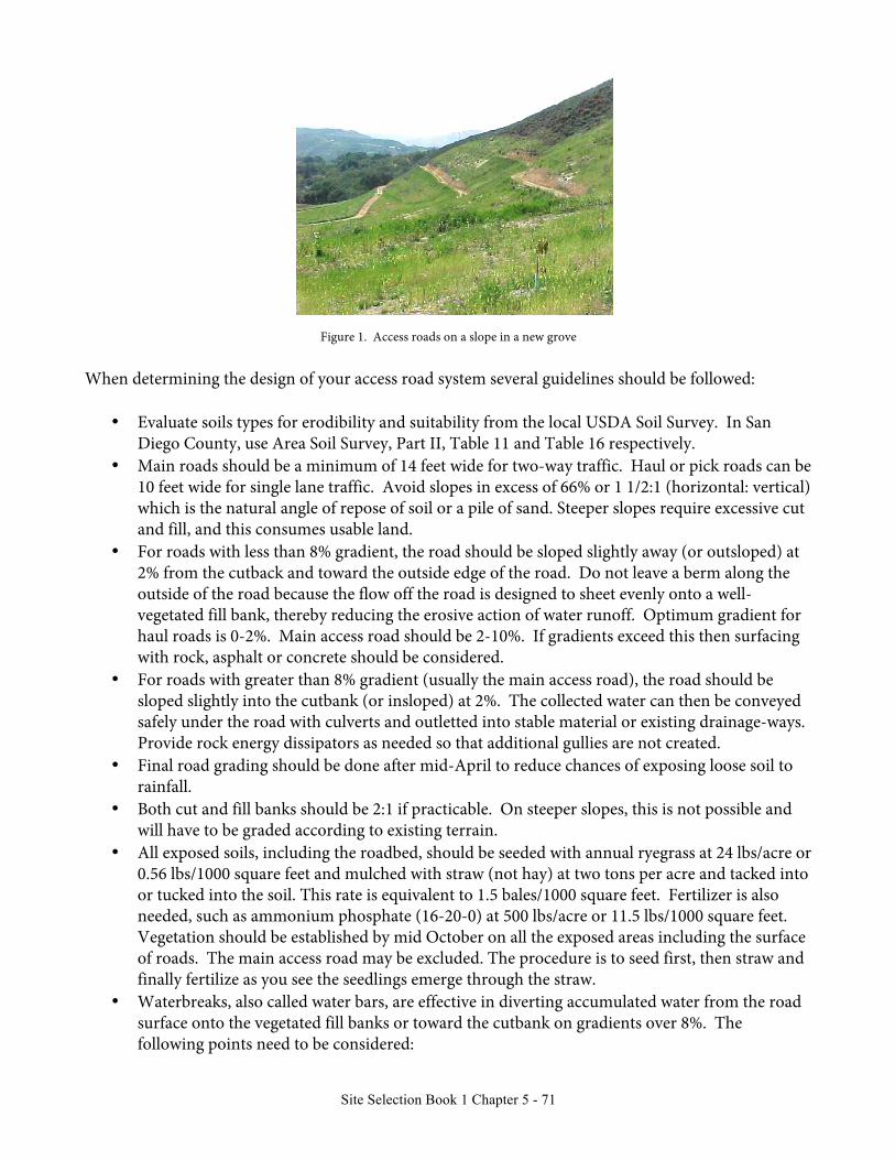
Site Selection Book 1 Chapter 5 - 71
Figure 1. Access roads on a slope in a new grove When determining the design of your access road system several guidelines should be followed:
• Evaluate soils types for erodibility and suitability from the local USDA Soil Survey. In San
Diego County, use Area Soil Survey, Part II, Table 11 and Table 16 respectively. • Main roads should be a minimum of 14 feet wide for two-way traffic. Haul or pick roads can be
10 feet wide for single lane traffic. Avoid slopes in excess of 66% or 1 1/2:1 (horizontal: vertical) which is the natural angle of repose of soil or a pile of sand. Steeper slopes require excessive cut and fill, and this consumes usable land.
• For roads with less than 8% gradient, the road should be sloped slightly away (or outsloped) at 2% from the cutback and toward the outside edge of the road. Do not leave a berm along the outside of the road because the flow off the road is designed to sheet evenly onto a well-vegetated fill bank, thereby reducing the erosive action of water runoff. Optimum gradient for haul roads is 0-2%. Main access road should be 2-10%. If gradients exceed this then surfacing with rock, asphalt or concrete should be considered.
• For roads with greater than 8% gradient (usually the main access road), the road should be sloped slightly into the cutbank (or insloped) at 2%. The collected water can then be conveyed safely under the road with culverts and outletted into stable material or existing drainage-ways. Provide rock energy dissipators as needed so that additional gullies are not created.
• Final road grading should be done after mid-April to reduce chances of exposing loose soil to rainfall.
• Both cut and fill banks should be 2:1 if practicable. On steeper slopes, this is not possible and will have to be graded according to existing terrain.
• All exposed soils, including the roadbed, should be seeded with annual ryegrass at 24 lbs/acre or 0.56 lbs/1000 square feet and mulched with straw (not hay) at two tons per acre and tacked into or tucked into the soil. This rate is equivalent to 1.5 bales/1000 square feet. Fertilizer is also needed, such as ammonium phosphate (16-20-0) at 500 lbs/acre or 11.5 lbs/1000 square feet. Vegetation should be established by mid October on all the exposed areas including the surface of roads. The main access road may be excluded. The procedure is to seed first, then straw and finally fertilize as you see the seedlings emerge through the straw.
• Waterbreaks, also called water bars, are effective in diverting accumulated water from the road surface onto the vegetated fill banks or toward the cutbank on gradients over 8%. The following points need to be considered:

Site Selection Book 1 Chapter 5 - 72
o Install before the middle of November. o The optimal size of an earthen waterbreak is 6 inches above the road surface and 6 inches
below the road surface. If it is smaller, it may be less effective in diverting water, will require increased maintenance, and will probably break down faster.
o Don't allow diverted water to flow directly into unstable areas, septic fields or natural water courses.
o Avoid placing waterbreaks in swales, gullies or low areas where water has no escape. Place waterbreaks above these areas whenever possible.
o Place waterbreaks above changes in grade to minimize water flowing down steeper portions of the road.
o Place waterbreaks above road intersections and curves in the road. o Runoff water from waterbreaks should not be directed onto fill material unless a downspout
or other conveyance measure (i.e. rocks, pipe, chute) is provided and the water is drained away from the fill. This is a case where compacted berms need to be placed along the outside bank to divert the concentrated water to the outlet.
o Each waterbreak should have a continuous, firm berm of soil at least six inches high and six feet wide that is parallel to the waterbreak cut.
o All waterbreaks need to be open at the lower end so the water can run off easily. o Ponding of water behind a waterbreak should be avoided. The ponded area may become
filled with sediment and the waterbreak may fail as continuing runoff flows on the road. o All waterbreaks should be installed at an angle of between 30 and 45 degrees downhill from
the perpendicular to the road; this will catch and direct runoff water to the outlet. o Keep the waterbreak and outlet clear of debris and sediment so that water drains freely. The recommended spacing of waterbreaks for grove roads is as follows:
Road Gradient (%) Interval between bars (feet) 5 125 10 78 15 58 20 47
Culverts will be needed at all natural drainages. Install them at right angles to the road. Determine the size of the culverts based on the hydrology (amount of water produced) from the watershed. Reduce plugging by installing catch basins or debris racks several feet upstream of the culvert entrance. Drop inlets to culverts create proper hydraulics and also reduce siltation.

Site Selection Book 1 Chapter 5 - 73
Figure 2. Culvert draining into a rock dissipater
Figure 3: Profile of Culvert Installation Maintenance is very important. There are several actions that can be incorporated into most road maintenance programs that reduce the long-term cost and need for annual road maintenance.
• Restrict access during wet weather. You only aggravate erosion and drainage problems. Usually roads will dry out within a day or two in coarse-textured soils.
• Make adequate drainage more important than vehicle speed. • Inspect and clean out culverts after first rains creating surface flows. • Avoid excessive road maintenance. Whenever possible, retain stabilizing vegetation in road ditches
by removing small blockages by hand. Avoid undercutting cutbanks and retain bank sloughage when adequate road width remains.
• Only regrade to remove deep ruts or damaged areas during severe storms. This should be done in the spring when soil moisture allows for good compaction of graded material.

Site Selection Book 1 Chapter 5 - 74
• Inspect the road system at regular intervals and immediately apply soil erosion and water control measures necessary to prevent damage.
• For larger operations it behooves the owner to have a night watchman during an expected major rainfall event to insure all drainage systems are functioning properly.
• Abandon or relocate road sections with repeated high maintenance. • Consider mowing roads or "driving out" vegetation across the full width if the primary purpose for
conducting road maintenance is to reduce fire hazard and minimize soil disturbance.
Filter Strips In addition to controlling erosion on slopes below the road, it is important to avoid polluting streams with sediment produced from soil erosion upslope. A filter strip is a vegetated area below the road which can catch sediment before it reaches a stream. Design a drainage system so that each waterbar or culvert releases onto an energy dissipater. Each energy dissipater in turn should release onto a filter strip adequately vegetated to trap sediment. If necessary, seed the filter strip area with suitable grasses to improve its stability and sediment-trapping capability. “Critical Area Planting” This practice is applied to roads and other exposed soils. If the land is cleared by hand the erosion potential is reduced and critical area planting may not be needed. For erosion control in the grove area, native annuals are encouraged but seeding and mulching will be required if the land is cleared with equipment since much of the seed base can be buried during clearing. A good operator can clear just the brush and leave the topsoil and seed base. Sometimes the seed base is annual broadleaf weeds instead of grasses which may require additional herbicide control measures. For insurance, a specific seed mix can be used for the first few years as a vegetative cover until the tree canopy shades the ground. Planting should be avoided in the sprinkler pattern of the tree. The use of erosion control nettings over a straw mulch is an effective alternative but may be more costly. Nettings are tucked in or pinned and rolled down the slopes. Mulching The application of clean organic material such as straw can be done around the tree in the area of the sprinkler pattern for erosion control since this area is not to be planted to a cover crop. Mulching 2-4 inches deep will reduce weed growth, conserve moisture and improve soil tilth. Do not incorporate the mulch into the soil. Underground Outlets This BMP is designed to carry surface runoff to a controlled outlet or natural drainageway. It is an underground pipeline properly sized to carry storm flows down steeper terrain and control gully erosion. The hydrology of the watershed must be evaluated to size the pipe. It is recommended that a design be done prior to construction because each property and situation is different. Cover Crops Planted annual grasses or natural vegetation should be established on the contour between tree rows to control sheet erosion. This will replace the Critical Area Planting in the long term. The types of equipment used and the cultural operations performed should maintain a population of planted and/or

Site Selection Book 1 Chapter 5 - 75
desirable resident species not including any noxious weeds that provides at least 60 percent ground cover during the erosive period. Plant height shall be controlled by mowing. As the trees grow and the canopy shades the cover crop it is slowly eliminated. It should not be allowed to grow around the sprinkler as this will disrupt the spray pattern and result in poor distribution to the root zone.
Figure 4. Cover crops planted between young trees on a slope.
Irrigation Pipeline When larger sub main and main pipelines are backfilled, it is usually necessary to control erosion on the exposed soils with Critical Area Planting. Seeding, mulching and fertilizing are done to the same specifications to control sheet erosion. Cutting the Roads A large dozer is used initially to build the roads. Slope boards are used to create the inner slope. A smaller (less expensive) dozer is then used to clean the dirt berm at the base of the slope. The inner edge of the road needs to be clean or the dirt will flow into the culvert and clog it during the first rain. Drainage across Roads In addition to culverts and drain pipes running underneath roads (as described above), it may be necessary to build small Arizona drains to move small amounts of water across roads where it is difficult to build culverts. Arizona drains are built with rock and concrete across dips in the road, draining water into gullies. The Final Steps The final step is to install the main irrigation lines (described in Book 2 Irrigation). Most large groves will asphalt the main entrance to the primary road. This is done to reduce the dust in the most heavily traveled areas, and it makes it easier for the boom trucks from the packinghouse to gain entrance on rainy days.

Site Selection Book 1 Chapter 5 - 76
Figure 5. A good grove road