bomen axe quarry - wagga.nsw.gov.au
TRANSCRIPT

BOMEN AXE QUARRY
AND MANUFACTURING SITE
ASSESSMENT and STATEMENT OF SIGNIFICANCE
FOR AN ABORIGINAL PLACE DECLARATION
REPORT PREPARED FOR THE
NSW OFFICE OF ENVIRONMENT AND HERITAGE
June 2011
Compiled by:
Go Green Services, Wagga Wagga


BOMEN AXE QUARRY AND
MANUFACTURING SITE
ASSESSMENT AND STATEMENT OF SIGNIFICANCE
FOR AN ABORIGINAL PLACE DECLARATION
REPORT PREPARED FOR THE NSW OFFICE OF ENVIRONMENT AND HERITAGE
Place Nomination by: Waagan Waagan Project Group Project Supervision: Barrina South Country, Culture & Heritage Division OE&H, Southern Region, Queanbeyan Project Manager: Roy Barker Aboriginal Heritage Conservation Officer OE&H, Southern Region, Queanbeyan Report compiled by: Dick Green Go Green Services Wagga Wagga 2650 Phone: 6928 1342 Email: [email protected]
June 2011

Bomen Axe Quarry and Manufacturing Site i
TABLE OF CONTENTS
ACKNOWLEDGEMENTS .................................................................................................................... ii
DEDICATION TO WIRADJURI .......................................................................................................... iii
A. OVERVIEW AND SUMMARY OF FINDINGS ...................................................................1
1. Summary (Recommendations) ........................................................................................1
2. Background to Aboriginal Place Declarations ..............................................................1
3. Statement of Significance of Bomen Axe Quarry and Manufacturing Site ....................3
4. Management Issues ....................................................................................................... 10
B. ADMINISTRATION, OBJECTIVES, METHODOLOGY & CONSULTATION ........... 12
1. Administration .............................................................................................................. 12
2. Assessment Objectives .................................................................................................. 13
3. Assessment Methodology and Framework ................................................................... 13
4. Consultation process, Principles, Protocols & Information Use Agreements ............. 14
C. RESEARCH FINDINGS ........................................................................................................ 16
1. Locality, Land Tenure and Site Maps/Physical & Cultural Information, Description of
Wiradjuri Country ........................................................................................................ 16
2. Historically Recorded/Archival Information ................................................................ 23
3. Knowledge Holders and Oral History Information ...................................................... 26
4. Land Owners and Stakeholder Information ................................................................. 31
5. Archaeology of Bomen Axe Quarry and Manufacturing Site ....................................... 32
6. Use of, and association with, Bomen Axe Quarry and Manufacturing Site in Recent
Times ............................................................................................................................. 35
D. REFERENCES ........................................................................................................................ 36
E. APPENDICIES ........................................................................................................................ 39
1. Aboriginal Place Nomination Form ............................................................................. 39
2. Information Use Agreement .......................................................................................... 41
3. Letters of Support (7) .................................................................................................... 42


ACKNOWLEDGEMENTS The assistance of the many individuals, communities and organisations who contributed to the research and preparation of the Assessment and Statement of Significance for an Aboriginal Place Declaration of the Bomen Axe Quarry and manufacturing site is gratefully acknowledged. Every effort has been made to include all contributors as listed below and obtain permission for copyrighted materials where necessary. Apologies are made for any omissions. The OE&H would welcome these being brought to its attention. Particularly culturally valuable were the contributions of knowledge holders Stan Grant, Senior (Narrandera), James Ingram (Wagga Wagga), Richard Kennedy (Wodonga) and Steve Meredith (Griffith). Gratefully acknowledged is the permission from Kerry Navin and Kerry Officer (Navin-Officer Heritage Consultants) to use information from their archaeological survey report (including maps and photo plates) of the Bomen Axe Quarry site. This information forms a major component of this Aboriginal Place assessment. Staff or members of the following organisations contributed by way of consultation, provision of information and/or guidance: Land and Property Management Authority, Wiradjuri Council of Elders, Wagga Wagga Aboriginal Elders Group, Wagga Wagga City Council, Waagan Waagan Project Group, Wagga Wagga Local Aboriginal Land Council and Charles Sturt University (School of Education and Riverina Archives). Staff from the Office of Environment and Heritage, Queanbeyan, greatly assisted with organisational guidance and provided field assistance. Thanks go to Sharon Bennett, Rural Management Strategies, Wagga Wagga for typing and producing this report. COVER PHOTO Plate 1. Core stone and flake, Bomen axe quarry and manufacturing site, November 2002. COVER ARTWORK Page border artwork depicts Waagan Waagan (Crows or Australian Ravens), gugaa (goannas) and the many linking hands of the people of Wiradjuri Country. These symbols encapsulate the story of Wagga Wagga Wiradjuri Country, its people and culture. Artwork by Alison Wighton.
Bomen Axe Quarry and Manufacturing Site ii

A DEDICATION TO WIRADJURI The pursuit of happiness, knowledge and a long life, lie at the heart of all human activity. At the same time, there is a strong desire for security. What gives security more than material wealth is identity; knowing who we are and what is our relationship to everything at all levels of existence, the physical, the mental emotional and the spiritual. The discovering of this identity and the unfolding of these relationships can, and perhaps should, occupy much of our time. As Indigenous people, for we are all Indigenous to planet Earth, we have the opportunities at the place and in the communities in which we live, even though our ancestral roots may lie elsewhere. So, many of us find ourselves living in the place and surrounds we now call Wagga Wagga within Wiradjuri Country. To come to know and connect with this place, as individuals we can seek merely to be curious or to take an objective or scientific approach in our quest for knowledge or, we can choose to deepen this development of a sense of place, this connectedness, which can then be made useful to the whole community. Despite major physical modification, made especially since European settlement, this place, this land, this Country, retains an identity of its own which is eternal, deep and subtle. The original carers of this Country, Wiradjuri people, evolved a cultural relationship very much in accord with the physical and spiritual qualities of this place. The notion of caring for Country was the basis for much of traditional Wiradjuri existence as indeed it was elsewhere. “People talk about Country, speak and sing to Country, visit and worry about Country, feel sorry for Country, long for Country. People say that Country knows best, hears, smells, takes notice, takes care, is sorry or happy. It has consciousness and a will towards life. Because of this richness, Country is love and peace, nourishment for body, mind and spirit”. (1) So an elder can say; “Everything came up out of the ground – language, people, emus, kangaroos, grass. That’s law” (2) and, “This is me. I am the land. The land owns me.” (3). One of the strongest connections to Wiradjuri Country is the natural musicality of its sounds, where “in spring the bush used to be a constant choir of song; where from twenty directions at once you could hear the mopoke call, from one hundred, the curlew” (4). These sounds are reflected in the Wiradjuri language through the naming of places and living things, the describing, contemplating and understanding of relationships and spiritual matters. Much of Wiradjuri culture, knowledge and tradition was passed on orally through this language, part of which is retained and part of which being restored today. So an elder could say; “It’s all in the lingo (language), boy! It does not matter how it is spelt but how it is sounded – the sound (pronunciation) has to be correct”. (5) Our obligation then, towards the study of Wiradjuri Country, culture and heritage, becomes simple; “to approach it with an open mind and with an attitude of respect; to ensure the range and variety of its expression. To intend from the beginning to preserve the mystery within it as wisdom to be experienced, not questioned. And to be alert for its openings, for those
Bomen Axe Quarry and Manufacturing Site iii

moments when something sacred reveals itself within the simple and the Country and the culture and the community knows that you are there”. (6 Paraphrased) Once connected to Country it becomes a comfort to know that the land under our feet has been nurtured and cared for thousands of years but is now crying out for renewed care. So Wiradjuri elders have requested that: “You (meaning the community collectively) have to bring Wiradjuri knowledge together – what you know from the old times, knowledge from the contact period and new knowledge” (7) and “You do what you can to respect, care for and continue Wiradjuri culture.” (8) Wiradjuri and associated Indigenous peoples’ concepts and ways of doing things need to be increasingly taken into account in planning and use of the land and activities thereon. Active shared custodianship of Wiradjuri and associated Indigenous culture and heritage is a beckoning responsibility. When we realise we need this understanding of Country, of culture, of heritage, of people, we will be contributing to a more sharing, caring, knowing and happy community. This report is dedicated to that end.
Bomen Axe Quarry and Manufacturing Site iv

A. OVERVIEW AND SUMMARY OF FINDINGS
A1. SUMMARY (RECOMMENDATIONS)
i. That this Assessment and Statement of Significance of the Bomen Axe Quarry and manufacturing site be submitted to the Minister for the Office of Environment and Heritage for consideration for the Declaration of the site as an Aboriginal Place.
ii. That a Plan of Management for the Bomen Axe Quarry and manufacturing site
be drafted as soon as possible involving the local Aboriginal Community, relevant organisations and interested parties.
A2. BACKGROUND TO ABORIGINAL PLACE DECLARATIONS What are Aboriginal Places? Put simply, Aboriginal Places are a way of recognising and legally protecting Aboriginal cultural heritage. Under the NSW National Parks and Wildlife Act, any land may be declared an Aboriginal place if the area “is or was of special significance to Aboriginal culture”. Why nominate an area for Aboriginal Place declaration? Aboriginal Places protect a range of cultural values, including former Aboriginal reserves and missions; land containing Aboriginal burials; important meeting places and ceremonial sites; important post-contact historical events, such as massacres and birthplaces of notable Aboriginal people; places with dreaming stories and other spiritual significance; and places with Aboriginal artefacts requiring special recognition and protection. Declaring an area an Aboriginal Place is a way of formally recognising the cultural attachment Aboriginal people have to land, to Country. Throughout NSW many landholders acknowledge and respect Aboriginal peoples’ attachment to particular areas. Aboriginal people and landholders have worked collaboratively to protect many areas that are also important for their educational value for future generations of Aboriginal and non-Aboriginal people. Aboriginal Places provide protection – once declared as an Aboriginal Place, the land receives the same protection under the National Parks and Wildlife Act as an Aboriginal object. That means that any activities that will damage, destroy or deface the Aboriginal Place cannot be carried out unless specific consent is granted by the Director-General of the Department, which can only be granted after consultation with local Aboriginal groups. The status, use or ownership of an area does not change as a result of a declaration but culture and heritage is recognised and protected. Declaration of an area as an Aboriginal Place gives landholders and the whole community benefits by providing:
Bomen Axe Quarry and Manufacturing Site 1

• a way of helping to conserve the unique cultural heritage of NSW for future generations;
• an opportunity to contribute to the process of reconciliation;
• the chance to share knowledge of, and learn more about, their land;
• protection in perpetuity of the Aboriginal Place under Section 90 of the NP&W Act;
• access to specialist advice from the Office of Environment and Heritage on the mangement of the Aboriginal Place;
• access to external funding grants for conservation and protection works;
• potential interpretation signage to help inform the public of the values of the site and;
• social, economic and environmental benefits including employment, tourism and recreation for the whole community;
• educational opportunities on site and through production of educational materials for community, school and tertiary institutions.
Bomen Axe Quarry and Manufacturing Site 2

A3. STATEMENT OF SIGNIFICANCE OF BOMEN AXE QUARRY AND MANUFACTURING SITE
Introduction During an archaeological survey of a proposed power plant site within the Bomen Industrial area in 1998, a surface hard rock quarry and axe manufacturing site was identified. This site is considered to have high scientific and educational significance for the local Aboriginal community (10). Prompted by this knowledge and encouraged by the Department of Environment, Climate Change and Water, the Waagan Waagan Project Group, on behalf of the Aboriginal community made an application to the Department to have the site declared as an Aboriginal Place in January 2011. This site is assessed using the Burra Charter of Australia criteria below (9) as having high cultural significance within a regional context. The site also has significance as one of a relatively small number of similarly classed sites known from NSW and the adjoining eastern seaboard states. This assessment is based on the rarity of this site type both locally and regionally, the significance of the site to the Aboriginal community, the scientific (archaeological) research potential of the site and the educational interpretation potential of the site. Significance to contemporary Wiradjuri and associated Aboriginal people This site has considerable significance to contemporary Wiradjuri and associated Aboriginal people based on the following factors:
• the rarity of this site type and the representative value of this site;
• the evidence it contains of past Wiradjuri resource use and cultural activities previously and now rarely practiced (stone tool making);
• its potential for demonstrating local Wiradjuri and regional trading networks;
• its demonstration of past and intimate Aboriginal knowledge of the local Wagga Wagga area’s natural resources;
• its scientific archaeological research potential;
• the closeness of the site to the large Aboriginal population centre, and therefore relatively easy access;
• its potential for education and interpretation, at all levels (Community, Charles Sturt University, Primary to Tertiary level);
• the potential it represents for a positive management relationship with the land owners, Wagga Wagga City Council and the Aboriginal Community;
• potential tourism site for appreciation and understanding of Wiradjuri culture and heritage.
Bomen Axe Quarry and Manufacturing Site 3

Plate 2. A selection of hammerstones identified at East Bomen 1 site.
Plate 3. An example of a large core (left) and flake from East Bomen 1 site.
Navin & Officer, 1998 (10)
Bomen Axe Quarry and Manufacturing Site 4
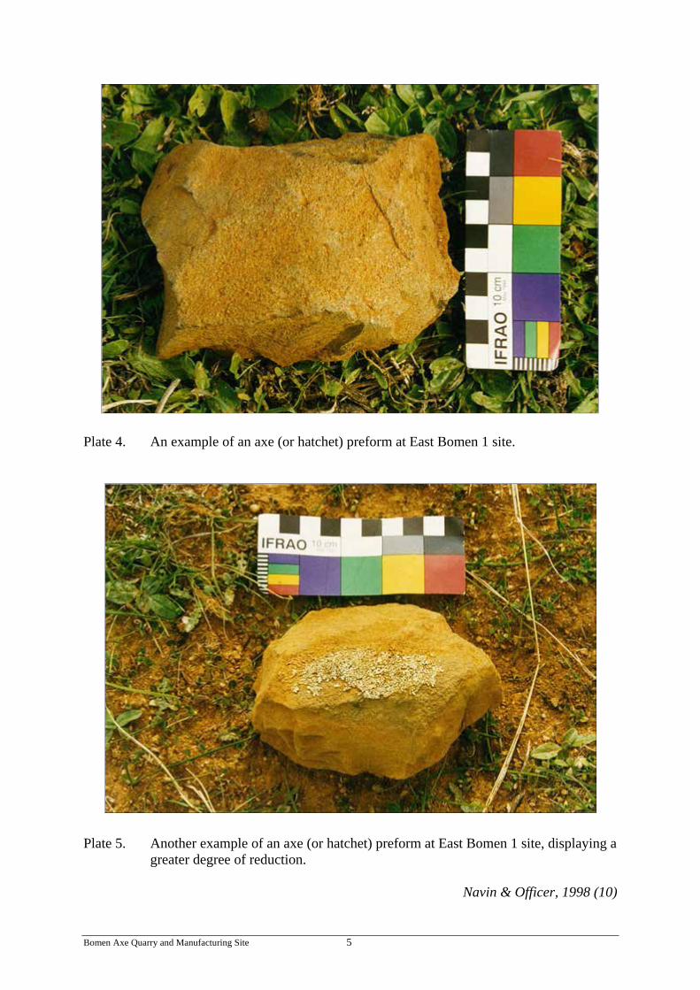
Plate 4. An example of an axe (or hatchet) preform at East Bomen 1 site.
Plate 5. Another example of an axe (or hatchet) preform at East Bomen 1 site, displaying a
greater degree of reduction.
Navin & Officer, 1998 (10)
Bomen Axe Quarry and Manufacturing Site 5

Scientific (archaeological) significance and representativeness This site has high scientific, archaeological value given its rarity, representativeness and research potential (10).
• The Aboriginal Heritage Information Management System (AHIMS) Register contains a classification for ‘quarry’ which includes all Aboriginal hard stone procurement sites recorded to date in New South Wales. Aboriginal ‘quarry sites’ are a relatively rare site type, with only 292 so far recorded (10).
• In a review of stone artefact quarries and reduction sites conducted in 1993 (11), it was noted that at the time there were 144 hardstone quarry sites recorded from NSW. Of the 104 hardstone quarry sites in NSW where the stone type is recorded, basalt comprised only 6.3% of records (27.8% of records contained no rock identification). About 50% of the records consist of silcrete, chert, quartz and quartzite sources. Of the quarries where details were recorded, a majority exploited the use of outcrop boulders, pebbles or cobbles extracted from the ground surface. The Bomen quarry is thus characteristic of the most frequently recorded types of exploited hardrock outcrops and method of extraction.
• The 1993 review also noted that eighteen quarry sites have been recorded in NSW where evidence for axe manufacture is also present. Based on this evidence, Bomen Axe Quarry and manufacturing site is an example of a rare site type, which is representative of a small basalt quarry where axe manufacture was also conducted. These characteristics provide for considerable scientific significance, which is increased by the potential for subsurface material, the number of artefacts available for study, the apparent relatively undisturbed nature of some parts of the site, and the accessibility of the site.
Value as an educational and/or recreational resource The educational value of the site is considerable due to the following factors (10):
• the high Aboriginal and scientific archaeological values of the site;
• the potential to provide relatively easy and controlled authorised access whilst preventing unauthorised access or promoting unauthorised visitation;
• the potential to effectively conserve and manage the site through fencing and controlled visitation and interpretation signage, tours and walks;
• the proximity of the site to the regional population centre of Wagga Wagga and Aboriginal organisations and an education system and institutions capable of providing public and cultural interpretation for visitor groups; and
• the potential value of the site for the education and appreciation of Aboriginal culture, by local Aboriginal custodians, and the broader non-Aboriginal population including students from Charles Sturt University, Riverina TAFE, primary and secondary schools.
Bomen Axe Quarry and Manufacturing Site 6

Aesthetic value This site does not currently have high aesthetic values based on a conventional understanding of landscape and artefact appreciation. The artefacts themselves are not visually intrusive and the basalt outcrop presents a very low-key and visually insignificant landscape element (see plates 6 & 8).
• In terms of its overall landscape context, the site is now situated in a highly modified context when measured against its probable original woodland vegetation context. The immediate site surrounds are devoid of native vegetation and consist of ploughed agricultural fields and a transmission line easement (Plate 6). Further industrial development is likely to the west and north due to land zoning. The eastern slopes are protected from industrial development due to scenic values and visual buffer considerations. Good views to the east, north and west including to Kengal (The Rock) are possible from the site and this aspect of the site’s aesthetics probably contribute to an understanding of the past use and significance of the site.
• Elements of the small scale context of the site, notably its ridge crest context and location adjacent to granite boulder outcrops also serve as important aesthetic and interpretation components.
• In summary, this site has low overall aesthetic values but contains important visual and landscape elements and values which contribute to a visitor’s appreciation and understanding of the site.
The development and implementation of a Plan of Management for the site may address some of the low aesthetic values by re-establishment of local native woodland vegetation in appropriate areas. Significance Assessment Criteria Used The Burra Charter of Australia defines cultural significance as ‘aesthetic, historic, scientific or social value for past, present and future generations’ (9). The assessment of the cultural significance of a place is based on this definition but often varies in the precise criteria used according to the analytical discipline and the nature of the site, object or place. In general, Aboriginal archaeological sites are assessed using five potential categories of significance:
• significance to contemporary Aboriginal people; • scientific or archaeological significance; • aesthetic value; • representativeness; and • value as an educational and/or recreational resource.
Many sites will be significant according to several categories and the exact criteria used will vary according to the nature and purpose of the evaluation. Cultural significance is a relative value based on variable references within social and scientific practice. The cultural significance of a place is therefore not a fixed assessment and may vary with changes in knowledge and social perceptions.
Bomen Axe Quarry and Manufacturing Site 7

Plate 6. View of East Bomen 1 site on eastern side of fenceline showing better preserved
sections of site. Note natural basalt cobbles in foreground. Secondary flaking floors occur in the foreground and around the granite rocks behind and in front of the standing figures, looking northwest.
Navin & Officer, 1998 (10)
Bomen Axe Quarry and Manufacturing Site 8

Aboriginal significance can be defined as the cultural values of a place held by and manifest within the local and wider contemporary Aboriginal community. Places of significance may be landscape features as well as archaeologically definable traces of past human activity. The significance of a place can be the result of several factors including: continuity of tradition, occupation or action; historical association; custodianship or concern for the protection and maintenance of places; and the value of sites as tangible and meaningful links with the lifestyle and values of community ancestors. Aboriginal cultural significance may or may not parallel the archaeological significance of a site. Scientific significance can be defined as the present and future research potential of the artefactual material occuring within a place or site. This is also known as archaeological significance (10). There are two major criteria used in assessing scientific significance:
1. The potential of a place to provide information which is of value in scientific analysis and the resolution of potential research questions. Sites may fall into this category because they: contain undisturbed artefactual material, occur within a context which enables the testing of cretain propositions, are very old or contain significant time depth, contain large artefactual assemblages or material diversity, have unusual characteristics, are of good preservation, or are a constituent of a larger significant structure such as a site complex.
2. The representativeness of a place. Representativeness is a measure of the degree
to which a place is characteristic of other places of its type, content, context or location. Under this criteria a place may be significant because it is very rare or because it provides a characteristic example or reference.
The value of an Aboriginal place as an educational resource is dependent on: the potential for interpretation to a general visitor audience, compatible Aboriginal values, a resistant site fabric, and feasible site access and management resources. The principle aim of cultural resource management is the conservation of a representative sample of site types and variation from differing social and environmental contexts. Sites with inherently unique features, or which are poorly represented elsewhere in similar environment types, are considered to have relatively high cultural significance. The cultural significance of a place can be usefully classified according to a comparative scale which combines a relative value with a geographic context. In this way a site can be of low, moderate or high significance within a local, regional or national context. This system provides a means of comparison, between and across places. However, it does not necessarily imply that a place with a limited sphere of significance is of lesser value than one of greater reference. Within the context of the present investigation, the relevant region is considered to be the NSW southwestern slopes extending westward from the southern tablelands and highlands to, the extensive plains of Western NSW.
Bomen Axe Quarry and Manufacturing Site 9

A4. MANAGEMENT ISSUES The high significance assessment for the Bomen Axe quarry and manufacturing site has the consequence that all site management strategies must be based on three objectives (10):
1. the long term and insitu conservation of the site; 2. the prevention of further significant detrimental impact to the site; 3. the facilitation of appropriate and controlled forms of access to Aboriginal
custodians, researchers and other types of visitors. These objectives appear to be reasonably compatible with the surrounding industrial development. The following management strategies are considered to form a necessary framework for the effective long term conservation of the site within the anticipated context of the proposed industrial development:
1. Inform Wagga Wagga City Council departments as owner and all adjacent land owners, lessees and other parties with easement rights about the presence and significance of the site and the need to prevent further detrimental impact.
2. Prevent further detrimental impact to the site from ploughing, stone removal,
vandalism, other forms of ground disturbance, and treadage and erosion damage from stock and graded firebreaks.
3. Provision of appropriate stable access (pedestrian and vehicular) to the site in
conjunction with future road development at Bomen. 4. The drafting and instigation of a Plan of Management for the site. This document
should define the conservation and management objectives and strategies for the site, and be drafted in consultation with all stakeholders including Aboriginal community and custodians and the Office of Environment and Heritage.
5. The erection of a permanent fence around the five hectare defined and zoned
Special Purpose site which includes an appropriate buffer margin between the site and fence. The boundary location and associated buffer distance between the fence lines and the site boundary has been determined based on:
• an appreciation of the topographic context of the site and the need to
conserve an appropriate proportion of the surrounding ridgecrest topography adjacent to the site;
• the inclusion of a buffer of at least 50 metres between the known extent of surface archaeological evidence and the fence line. This is considered to provide an adequate buffer which would allow for protection of potential subsurface archaeological material which may be present beyond the present surface indications, and allow for vehicular movement around the perimeter, and;
Bomen Axe Quarry and Manufacturing Site 10

• an effective fencing alignment allowing for relatively straight lines,
defined corners and designated road access.
6. As a protected site, it should not be quarried or have materials removed without the permission of the traditional custodians and the OE&H.
7. The prevention and control of activities within the fenced and/or actual site area. Excluded activities should include ploughing; installation of subsurface or above ground services, excavations except for those undertaken under the provisions of a permit issued by the NSW NPWS; and dumping or storage of fill or other materials. Controlled activities could include low level stock grazing (to control grass cover or fire hazard); vermin and weed control; vehicular access on defined tracks; visitor access and various forms of interpretation; scientific research; and revegetation of areas bordering the site. The type, scope and frequency of these activities would be subject to confirmation in a Plan of Management.
8. Establish a set of access protocols which define how, when and who may access
the site and what access restrictions such as party size and permissible activities may apply. This should be drafted in consultation with the local Aboriginal community and the NSW NPWS, and form part of the Plan of Management.
9. The prevention of accidental damage to the site during construction works by fencing the site prior to construction activities and designating the site area as a no-go area.
10. Ensure that scenic views from the site to the north, east and southeast are retained to an appropriate extent in order to maintain the landscape context values of the site.
11. Include the site on the Local Environmental Plan heritage schedule.
12. Visually screen from view the intrusive industrial features of the proposed development by planting local native vegetation around the area of the site. Planting within the fenced site area should only occur in locations where artefactual material was not going to be disturbed and should be consistent with any access and maintenance strategies proposed in the Plan of Management (10).
Bomen Axe Quarry and Manufacturing Site 11

B. ADMINISTRATION, OBJECTIVES & METHODOLOGY
B1. ADMINISTRATION In late 2010, the then Southern (Queanbeyan) office of the Country, Culture and Heritage Division of the NSW Department of Environment, Climate Change and Water engaged Go Green Services, Wagga Wagga to undertake assessments and prepare statements of significance for seven potential Aboriginal Place declarations in the Wagga Wagga and Albury area. NOTE: Following the change in NSW State Government in March 2011, this agency became the Office of Environment and Heritage (OE&H). This followed consultation by DECCW staff with the local Aboriginal community, staff from state agencies, Wagga Wagga City Council and Charles Sturt University in February 2010 and field visits to the places in July, 2010. The locations nominated for assessment were: WAGGA WAGGA • Bomen Axe Quarry • Bomen Lagoon • Flowerdale Lagoon • Wiradjuri Reserve • Wollundry Lagoon HENTY • Doodle Cooma Swamp ALBURY • Mungabareena Reserve The Project/Consultant’s Brief outlines the scope of the project, outcomes, budget, time frame communication, project management and supervision required. The overall project was administered and undertaken by the following: Senior Manager: Paul House Manager, Country, Culture & Heritage Division OE&H, Southern Region, Queanbeyan Project Supervision: Barrina South Country, Culture & Heritage Division OE&H Southern Region, Queanbeyan Project Manager: Roy Barker Aboriginal Heritage Conservation Officer OE&H, Southern Region, Queanbeyan Reports compiled by: Dick Green Go Green Services Wagga Wagga 2650
Bomen Axe Quarry and Manufacturing Site 12
B2. ASSESSMENT OBJECTIVES The objective of this project is to finalise the seven Aboriginal Place nominations in order to assist the Minister for the Environment, Climate Change and Water in making a decision regarding the declaration of these areas as Aboriginal Places. In doing this the project aims to: a. Collate all available information about the places (physical, land tenure,
archaeological, written and oral history).
b. Describe the places sufficiently to ensure that there is no confusion over the location and extent of the areas concerned and that their current conditions are adequately recorded.
c. Assess the available information to determine if it satisfies the definition of an Aboriginal Place under the NPW Act.
d. Make clear recommendations to the DECCW regarding the appropriateness of a declaration being made over the areas.
e. Identify and make recommendations on, any management issues highlighted by the Aboriginal and wider community and the DECCW, especially the Aboriginal Heritage Conservation Officer that may adversely affect the places’ integrity. This is aimed to contribute to future plans of management for the places.
B3. ASSESSMENT METHODOLOGY The methods and procedures outlined in “Aboriginal Places” DECC Guidelines for the Assessment and Gazettal of Aboriginal Places, Culture and Heritage Division, May 2008 (12) were generally followed with some adaptation to the attributes and circumstances of these places after discussion with OE&H staff. The Project Brief was also the basis of the studies. The information collected about the Places and surrounding areas seeks to establish:
• Who are the knowledge holders?
• What is the basis on which the people who have the information have status? Why do they have rights or responsibilities to speak for the place? What Country/s do they affiliate with? Is this affiliation traditional and/or historical and/or contemporary?
• What are the stories of the place according to Aboriginal tradition?
• Are there other stories which are historical and/or contemporary?
• What is the location and the extent of the place?
• What is the connection of the place to other places in the area?
• What are the physical features comprising or constituting the place or site?
• What, if any restrictions, should apply to the information above if this is not already covered in the Information Use Agreements?
Bomen Axe Quarry and Manufacturing Site 13
Bomen Axe Quarry and Manufacturing Site 14
• Are there any restrictions, according to Aboriginal tradition, on activities that may be carried out in the vicinity of the place? What are the locations in which these activities may not take place?
• What is the social significance of the place? The following diagram (Diagram No. 1) outlines the Assessment Methodology Framework that was used in this process. B4. CONSULTATION PROCESS, PRINCIPLES, PROTOCOLS AND
INFORMATION USE AGREEMENTS The principles, protocols and practices as recommended by the Oral History Association of Australia (OHAA) were followed where possible in the assessment and information collection processes. That is, use of pre-interview questionnaire establishing interviewee background and authorisation of use of recorded material, referring draft material back to contributors for clarification and approval prior to publication. Authorisation was by way of an Information Use Agreement (Appendix 2). Conditions of use and access protocols were also sought and received from A.I.A.T.S.I.S. Four main knowledge holders were interviewed – James Ingram, Stan Grant, Richard Kennedy and Steve Meredith. The above process assisted with complying with the principles of research as outlined in the Aboriginal Place Declaration Guidelines (June 2001). That is:
1. The wishes of the people about recording, storage and access to the information were respected and safe-guarded.
2. When reporting traditions and stories it was important to establish by asking in an appropriate way and at an appropriate time:
• Who told the story to the knowledge holder?
• Where were they when they were told the story?
• What were the circumstances under which they were told the information or story?
• Where this was obtained, it is recorded with the knowledge holders’ stories.
3. Where possible, arrangements were made to meet with knowledge holders,
individually or in small groups, in places where they felt comfortable, mainly in their homes or at the site itself. This was supplemented with two consultations/information sessions with the Wagga Wagga Local Aboriginal Land Council and one session with the landholders, the Wagga Wagga City Council.

ABORIGINAL PLACE NOMINATIONS
DIAGRAM 1
Bomen Axe Quarry and Manufacturing Site 15
ASSESSMENT METHODOLOGY FRAMEWORK
INFORMATION COLLECTION
INFORMATION COMPONENT
PURPOSE To compile a Statement of Significance through an assessment of:
Locality and Land Tenure. Physical evidence including archaeological, ecological and cultural landscape features.
Written and/or recorded material including maps, photographs and publications.
Stories and oral traditions.
Identification of, and informing, landholders/stakeholders of Aboriginal Place Nominations
METHODOLOGY Define place boundaries and land tenure. Obtain flora and fauna listings and cultural landscape mapping. Conduct search of sites register. Obtain archaeological evidence.
Research information and documents (books, maps, plans, surveys, reports, newspapers, records held in public institutions and private collections).
Conduct site visits, community meetings and record interviews with knowledge holders.
Liaison and interviews with land owners and stakeholders.
MAIN SOURCES National Parks and Wildlife Service sites AHIMS register. Ecological and Archaeological Surveys. Community knowledge holders.
Riverina Archives, State Records, Wagga Wagga & Charles Sturt University Libraries, Mitchell Library, Wagga Museums & Council Records, AIATSIS (Canberra), Land & Property Management Authority, Internet.
Wiradjuri and associated Aboriginal knowledge holders. Local landholders and community people.
Landowners, stakeholders, Wagga Wagga City Council Land and Property Management Authority.
1. Locality, Land Tenure, Physical & Cultural Information
2. Historically Recorded Archival Information
3. Oral History Information
4. Land holder and Stakeholder Information

Bomen Axe Quarry and Manufacturing Site 16
C. RESEARCH FINDINGS C1. LOCALITY, LAND TENURE AND SITE MAPS Location and Land Tenure
The site is located within the Bomen Industrial Estate owned and managed by the Wagga Wagga City Council approximately seven kilometres north of Wagga Wagga. The physical address is 251 East Bomen Road, Wagga Wagga. An area of approximately five hectares providing a buffer surrounding the axe quarry site was surveyed in about 2004. This area was rezoned by Wagga Wagga City Council from Rural – Industrial to Special Purpose within the Public Recreation (RE1) Zone in 2007 following the recognition of its significance. This area comprises Lot 23 DP1085826 Parish of Eunanoreenya, County of Clarendon (see Locality Map No. 1). The site has been recorded on the Aboriginal Heritage Management System as Site No. 56-1-0043. The actual area of the stone quarry and axe manufacturing site is relatively large. Surface basalt rock, distribution of stone cores, flakes and working areas cover an irregular area of about one hectare (150 x 70m) (see Quarry and Axe Manufacturing Site Map No. 3). The site can be located on the 1:25,000 Wagga Wagga Topographic Sheet 8327-1-N using the grid reference 538500 (Eastings) and 6119000 (Northings). The GPS reading is 35º 07000 South, 147º 42400 East. C1. PHYSICAL & CULTURAL INFORMATION Geology and Topography
The axe quarry, stone reduction and axe manufacturing site is situated on a low range of hills which forms part of the undulating northern margin of the Murrumbidgee River corridor. The River is situated three kilometres to the south and its associated flood plain just 800 metres to the southeast. The hills have formed from mid-Silurian age (approximately 400 million years old) Wantabadgery Granite which discontinuously outcrops along crests in low rounded clusters. The hills are part of a low undulating range situated between the Kurrajong Plain, adjacent to the river and Dukes creek to the northwest (10). The small area of rock outcrop forming the quarry is quite different to the Wantabadgery granite. A sample of the quarried rock (not an artefact) from the site has been analysed by Dr Tim Munson (Curator of Geology, Dept Geology, Australian National University) (13). The rock has been identified as a hydrothermally altered alkali basalt, high in sodium (Na) and potassium (K). The rock is likely to be a hypabyssal basalt, which has formed a small dyke or sill within the surrounding mid-Silurian age Wantabadgery Granite. Similar rock in western Victoria is of Tertiary age (around 30 million years ago). This formation does not appear on the geological mapping for the region. Based on 1:250,000 scale mapping, the closest basalts occur 85 km to the east, in the Honeysuckle Range, east of Brungle, or east of Batlow (14). This potentially indicates the importance of the site in terms of limited availability of stone for maxing axes (hatchets) and for trade of blanks (partially complete axes) in this region (10). The axe quarry site is located on a north-south orientated ridgeline which extends and descends northward from a high knoll of 288m (ASL) located south of the site. The Murrumbidgee River flood plain provides a local base level of 180m (ASL). The ridgeline forms the watershed between the Dukes Creek catchment to the west and an unnamed tributary to the east. Both drain southward onto the Murrumbidgee River flood plain.

MAP 1 Location Plan: Axe Quarry Reserve
Bomen Axe Quarry and Manufacturing Site 17

MAP 2 Location Plan: Axe Quarry Reserve and Aboriginal Place Nomination 2011.
Bomen Axe Quarry and Manufacturing Site 18

MAP 3 Sketch map of site East Bomen. Surficial hardstone quarry and axe manufacturing
site (not to scale, all distances paced).
Navin & Officer, 1998 (10)
Bomen Axe Quarry and Manufacturing Site 19

Bomen Axe Quarry and Manufacturing Site 20
C1. DESCRIPTION OF WIRADJURI COUNTRY – (WIRADJURI NGURAMBANG) AND CULTURAL LANDSCAPES The following description, profile and map relate to the landscape in the period from about 15,000 years ago until about 200 years ago. In the period that followed the last great ice age, (10,000 to 15,000 years ago) the Murrumbidgee River was broad and shallow transporting large amounts of sand and gravel and forming sand dunes and alluvial plains we now see on the flood plain between Oura and Wagga Wagga and beyond (15). Over the past 10,000 years the Murrumbidgee has cut into the old flood plain, with its course changing at times leaving billabongs out from the river. Landscapes features associated with the river and its flood plain were central to the traditional Wiradjuri way of life. These included sand dunes, creeks, billabongs, lakes and swamps. The surrounding sloping country, consisting of hills and ridges originally formed around 400 million years ago, have been shaped by creeks, water and wind erosion and geological processes. These areas appear to have been less frequented by Wiradjuri than areas with more water. The Cultural Landscapes map and Profile (Diagram No. 2) show the landscape features of the near recent prehistoric times near Wagga Wagga (Map No. 4). The term “cultural landscape” has come to be widely used in heritage management and archaeology. The following is a good definition and description of cultural landscapes, (15). “A cultural landscape consists of the fabric of the land and its natural resources, traditional sites and other evidence of material culture together with sites of ceremonial and spiritual significance.” We tend to divide cultural heritage into material and non-material, ancient (archaeological) and recent (historical or contemporary). These distinctions are valid in that we use different methods to investigate and describe that heritage. However, we need to take into account the interrelationships between these different aspects of cultural heritage and relate them to the overall landscape. The land itself is then seen, used and appreciated in a cultural context. Places may then have significance to a group of people even though they may have no physical record of occupation at that place. More often the significance of a site lies in its context within a landscape. At times it may be significant independent of its position, (15). The landscape contains the evidence of actions or stories of Dreaming ancestors, or may bring back memories of more recent ancestors. So a major floodplain, like the Murrumbidgee Flood Plain and associated surrounding hills is a cultural landscape. Although most of the cultural evidence has been destroyed, these areas still remind us of traditional times and therefore can be considered a cultural landscape. The above approach is in line with recent trends to move away from the treatment of sites as “dots on maps” to a recognition of the interrelatedness of many sites, (16). This practice makes sense both from Wiradjuri culture and scientific viewpoints. In the case of the Bomen Axe Quarry site, a dot on a map does not adequately represent the field of physical, spiritual significance which surrounds the place. The local Wagga Wagga community today sees the significance of the site as being integral to the significance of the whole area of Wiradjuri Country around Wagga Wagga. These

MAP 4 Bomen Axe Quarry and Manufacturing Site 21

DIAGRAM 2
470
370
270
170
Country/Landscape Type
Duyul (Hills)
Burba (Sloping Country)
Bilabu galing Ngurang (Creeks & Water Places)
Guwalbu gunigal (Lakes & Plains)
Bilabu gunigal (Creeks & Plains)
Girigiri buiyanha gunigal – (Red sloping Plains)
Bila Guungun gunigal (River Flood Plain)
Garray Duyul (Sandhills)
Bila Murrumbidya (River Murrumbidgee)
Present Day Localities
Gregadoo Hills Malebo Range Kengal (The Rock) Bomen Axe site
BrucedaleBomenOura
Keajura Creek Houlaghans Creek Big Springs
Roping PoleSwampLake AlbertGrubben Swamp
BullenbongTarcutta & Sandy CreeksBurkes Creek
BelfraydenDownsideUranquinty
Billabongs – Parken Pregan, Bomen, Flowerdale, Gobbagumbalin, Wollundry
Berry Jerry, Brick Kiln, Hunters Hill, Pomingalarna, Wabblam Billy Eunonyarheenya
All River
HeightAbove
SeaLevel
(Metres)
Profile 1 Wiradjuri Cultural Landscapes
Kengal (The Rock) to Murrumbidgee River(Refer to Map No 1)
Bomen Axe Quarry and Manufacturing Site 22
Native Vegetation
(Sample of Plants Used)
Iron BarkHill OakStringy BarkCypress PineGrass Tree, Wattles Butter bush Quandong, Mat Rush, Lillies & Orchids
White Box Kurrajong Quandong Hickory & Golden Wattles, Peach HeathChocolate & Bulbine Lily, Flax Lily, Hill Indigo, Misteltoe
River Red GumGrey BoxTea TreeGrassesCommon Reed Sedges,Native Geranium,Cumbungi
River Red Gum Common Reed Cumbungi Tall Spike Rush
Grey Box, Wattles Boree, Native Millet Nardoo Cumbungi
Grey & Yellow BoxBullokeEmu Bush?Umbrella WattleHopbushMistletoeYam DaisyBulbine Lily
River Red GumSilver WattleCumbungi, Yam DaisyNardooOld Man WeedWild Tomato?
White Cypress Pine Silver Banksia
River Red GumRiver She OakRiver BottlebrushCommon Reed
Native Animals Birds, Fish, Insects(Sample Used)
Grey Roo, Wallaby, Echidna, Carpet Snake, Wombat, Circada, Goanna
Brush & Ringtail Possums, Eastern Grey Roo, Echidna Cicadas, Wombat
Black & Wood Duck Bird Eggs & Fledgelings, Black fish & Eels
Ducks & Bird Eggs Red Bellied Black Snake, Mussels, Fish, Yabbie
Emu, Lizards/Snakes, Turtles, Fish, Water Rat
Goanna, Echidna, Emu, Eastern Grey Roo
Brush & Ringtail Possums, Goanna, Snakes, Curlew, Emu, Black Duck, Pelican, Eggs, Turtles, Mussels, Fish, Yabbies, Water Rat
Bilby, Echidna, Goanna
Murray CodMurray Cray, Fish Silver & McQuarie Perch, Trout, Cod, Turtles
Evidence of Traditional Use
Stone Arrangements Ceremonial Places Ochre Sites Lookout Places Stone Quarries
Scar TreesFish Traps
Stone AxesGrinding StonesScar TreesCamp SitesWater wellsFish Traps
BurialsScar Trees (around margins)
Nardoo & grass Grinding Stones Earth Mounds, Fire Hearths, Scar Trees, Fish Traps
Grinding StonesStone AxesFire StonesScar Trees
Fish Traps, Fire Ash, Stone Artefact scatters, Shell Middens Wooden shields, clubs, shovel, spears, Canoe Trees, Earth Mounds
Burials, Camping Places
Canoe Trees (River’s Margin)
Bomen Axe Quarry and Manufacturing Site 22Bomen Axe Quarry and Manufacturing Site 22

cultural landscapes highlight the importance and interrelatedness of all components of Wiradjuri Country to Wiradjuri people. The site of the Bomen Axe Quarry would have served as well as a lookout and men’s meeting place. The panoramic view from here includes that of one of the most sacred and highly significant places for Wiradjuri – that of Kengal (The Rock) some 40 kilometres to the south west. Kengal was declared an Aboriginal Place in 2004 (17). It is close to the Murrumbidgee River, and associated billabongs (Bomen, Kurrajong, Parken Pragen) and Kurrajong Plain, all sources of natural resources. C2. HISTORICALLY RECORDED/ARCHIVAL INFORMATION (a) Bomen – Name Derivation One source (18) gives the meaning of “Bomen”/”Bowmin” as an Aboriginal word of the Wiradjuri Language meaning “Deep”; apparently taking its name from the deep lagoon on the northern side of the Murrumbidgee River. The lagoon referred to is shown on old maps as “Bowmin” Lagoon and has apparently been corrupted to the present spelling. Bomen, now a north-eastern suburban and industrial area, which, for a time (from 1878), was the southern terminus of the Railway from Sydney prior to the construction of the Railway bridge and viaduct across the Murrumbidgee River in 1879 (18). The axe quarry site is situated in the Bomen industrial area and has therefore been identified by this name. Some credibility to the derivation of this name, or a similar Wiradjuri name, (but not its meaning) is given by reference to the expedition of Charles Sturt. Sturt’s second and most relevant expedition to Wiradjuri Country and past the present day site of Wagga Wagga set out from Sydney on 3 November 1829 to trace the course and destination of the Murrumbidgee. Sturt camped at Pondebadgery (Wantabadgery) the Wiradjuri name of the extensive flood plain there. He says that “two natives had attached themselves to the party and had made themselves generally useful” (19). These two Wiradjuri, who the stockmen named Jemmie and Peter, “were of infinite service to us, from their knowledge of all the passes and the general features of the country.” (19) Given this statement it is likely that Jemmie and Peter took Sturt’s party along known routes and to camping places. It appears that Sturt’s party may have travelled west from current day Oura; “the blacks led us on a west by south course to the base of a small range...near which there was a deep lagoon”(19). Could this have been Bomen Lagoon? It was evident they here expected to have found some other natives. A 1938 Daily Advertiser article indicated that the “natives showed signs of restlessness and were disinclined to go any further. Their reason for this was that along the river was the dreaded Bunony, a fearsome
Bomen Axe Quarry and Manufacturing Site 23

bully!! They were a peace loving tribe, they did not want to fight. They set off along the river flats until they came to the Bomen Lagoon. Here they pitched camp”. This same source is at least incorrect in the statement they “rested their horses for several days.” (20) At this spot (Bomen Lagoon?) “the natives were very restless, and showed signs of expecting trouble. They walked as far as Parken Pregan Lagoon and it was evident that they thought to find other natives there, but apparently the dreaded Bunony had “gone bush””. (20) Could this be a variation of “Eunony” or the longer “Eunonyhareenya”, local Wiradjuri words variously given the meanings of, “fighting blacks in ambush”, (21) an “emu sanctuary” (22), “a tribe” (23), and/or “Eunony (a Wiradjuri warrior) lives here”. (24). Eunonyhareenyah is said to have been the spot in remote times, where this Eunong, a warrior of considerable renown, and reputed to be of great statue, lived. (20). Given that the flood plain and sand hills at Eunonyhareenyah were utilized for food collecting and camping, could Bunony/Eunony/Eunong have been the local resident or, group of Wiradjuri who was feared and acted as protector of the various bird and fish sanctuaries in the area including Bomen Lagoon? Would he/they have frequented the Bomen axe quarry site? Some further support to the name “Bomen/Bowmin” being related to “fighting” is given in the recently restored Wiradjuri language (25). The verb or action word; “bumarra” means to “fight, beat or hit”. The stem of the word; “buma” can be used to build many further verbs, nouns and other words. A further reference states that “Bomen is from either “bomi” – a stick or “bumea” – to beat (41)”. Could “Bowmin/Bomen” be derived from these sources? (b) Quarries, reduction sites and Aboriginal Mining Aboriginal quarries are sites where people either took stone from the ground surface or rocky outcrops to make chipped or ground stone tools for many different purposes or dug for ochre (26, 27). Like other groups, Wiradjuri people depended on their stone implements to gather and process their food; quarries, reduction and processing sites were developed to cater for the demand for these products; and transport routes were established to allow for their trade. Sites, like Bomen, where stone tool manufacture occurred are called “reduction” sites. This process always leaves stone debris. The term “stone artefact” includes finished or unfinished products, usually a stone tool, and this debris (28). Stone tools were made by “knaping”, “flaking”, “pressure flaking”, “grinding” and “crumbling” by use of hammer stones, anvils and grinding stones which were often left at the quarry for convenience sake and because they were heavy (see Diagram 3) (31). The stone tools were used for cutting, for carving and crafting wood, for grinding seed and for making new stone implements and other tools (27, 29).
Bomen Axe Quarry and Manufacturing Site 24
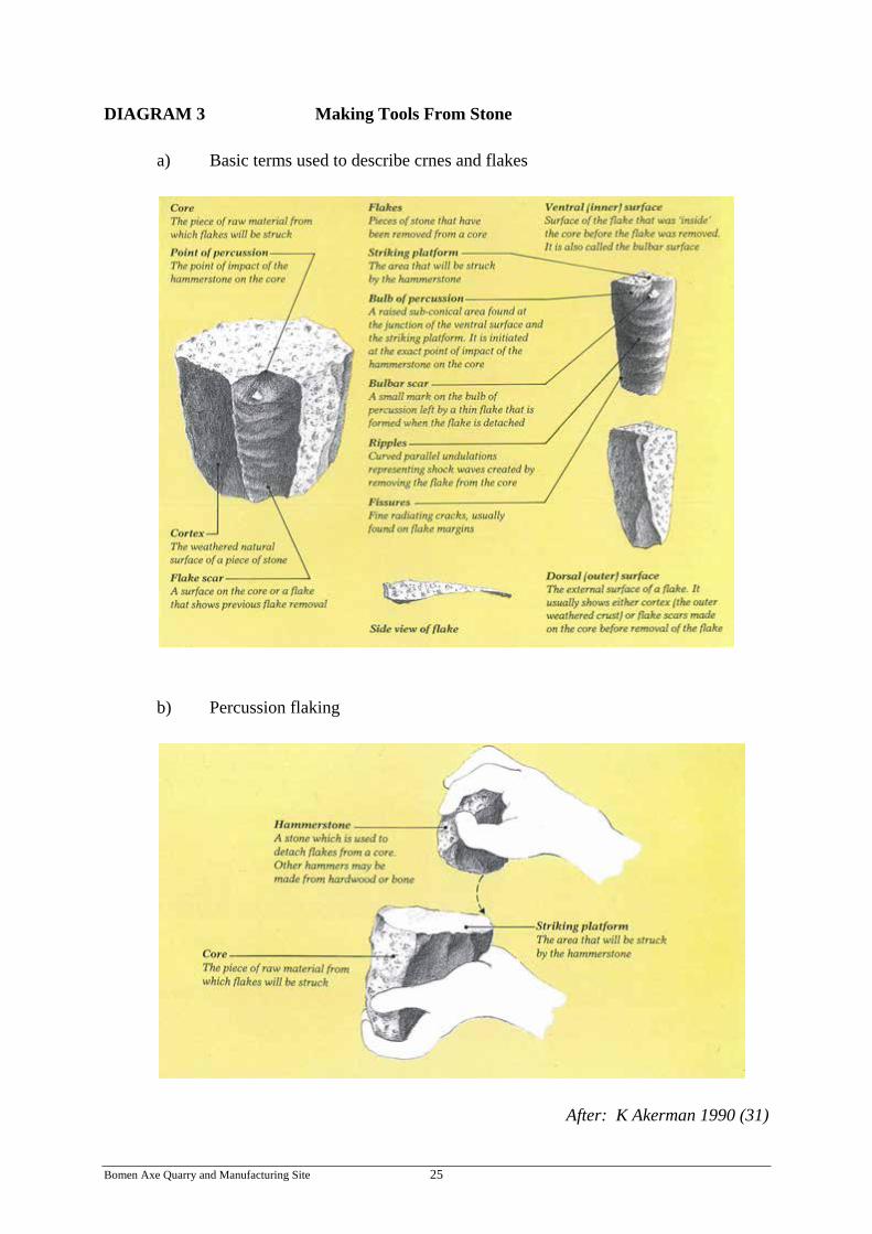
DIAGRAM 3 Making Tools From Stone a) Basic terms used to describe crnes and flakes
b) Percussion flaking
After: K Akerman 1990 (31)
Bomen Axe Quarry and Manufacturing Site 25
Work at an Aboriginal quarry would have consisted of the extraction and rough trimming of “blanks” – pieces of a convenient size and shape for making into axes. Final trimming of the axe and grinding of the blade was often done elsewhere. Sites for reduction or the “finishing” of stone tools were widely scattered and the tools were widely traded. Axes have been shown to have been traded as far as 800 kilometres. Stone tools older than 40,000 years have been found in the north and east of Australia (27). There are 416 recorded Aboriginal mine sites in eastern Australia (Queensland, NSW, Victoria), although new sites are being identified all the time. In NSW there are 183 identified sites (144 stone quarries and 17 ochre mines, with no information, beyond location, being available for the remaining 22 (27). Because stone artefacts do not rot or rust, they are often the main or only physical evidence of past Aboriginal occupation in an area (30). At times many different clans would gather near a quarry site to trade for the stone or ochre and to hold ceremonies, initiations and other important cultural events. Custodianship of quarries rested with the clan on whose land they occurred and access to them was allowed only with the permission of these custodians. Within a clan, the actual mining was often undertaken by a smaller group who had special knowledge of how to correctly extract the resource (27). The process of creating a sharp edged tool from stone requires both skill in execution and suitable rock that, when struck, will fracture to a fine edge. The process is ancient and was practiced in varying degrees by cultures all over the world. C3. KNOWLEDGE HOLDERS AND ORAL HISTORY INFORMATION Oral history is a record of information usually on tape or CD (and/or later written down) as the result of a planned interview. Its purpose is to create a record where none exists or to supplement existing records for future research. Oral history is a method of recording spoken language, eyewitness accounts and insights into society and its changing values and attitudes. It also gives a voice to those previously denied the chance to contribute to the recording of history. (32) Oral history is a history built around people. It thrusts life into history itself and it widens its scope. It allows heroes not just from the leaders, but from the unknown majority of the people. It encourages elders, teachers and students to become fellow-workers. It brings history into, and out of, the community. It helps the less privileged, and especially the old, towards dignity and self-confidence. It makes for contact – and thence understanding – between social classes, races and between generations. To individual historians and others, with shared meanings, it can give a sense of belonging to a place or in time, like the Dreaming. In short, it makes for fuller human beings. Equally, oral history offers a challenge to the accepted myths and stories of history, to the authoritarian judgment inherent in its tradition. It provides a means for an understanding of the social meaning of history (33).
Bomen Axe Quarry and Manufacturing Site 26

To assess the significance of, and to provide knowledge and understanding of the Bomen Axe Quarry for an Aboriginal Place nomination, people were interviewed and voluntarily made major to minor (although significant) contributions. The interviews were held with Wiradjuri Elders, other Wiradjuri and Indigenous knowledge holders and skilled stone tool makers and long-term residents and/or descendants of long-term resident families. Material provided has not been quoted verbatim but rather written so as to convey the knowledge, meaning or intent of the interviewee. All major contributions were referred back to the interviewees for checking accuracy before publication. The basis of the importance of this site is that it is regarded as significant to Wiradjuri and associated Aboriginal people living in the Wagga Wagga area today. Evidence of an unbroken orally transmitted traditional knowledge about the Bomen Axe Quarry has not been found. However, there is knowledge from oral, historically recorded and researched sources of similar sites, stones and the activities in relation to quarries and stone tool making passed on from current and previous generations as the following interviewees confirm. Also, through the process of cultural retention and regeneration, the skills of stone tool making continue in this region and elsewhere (see Plate 7). Part of the meaning of this site is the archaeological and historical evidence of the area having been the site of Wiradjuri habitation and use in traditional times and in the 50 year period immediately after European contact (1830 to 1880) (34). This includes Wiradjuri interaction with the Tompson family, first European settlers and the retention and management of the nearby traditional emu sanctuary at Eunonyhareenyah until the 1870’s. However, since around 1900, the Wiradjuri in the Wagga Wagga area were reduced to a handful in numbers. With this went much of the local traditional Wiradjuri knowledge. However, since the selection of Wagga Wagga in 1974 as an Aboriginal Resettlement location, the Wiradjuri and associated Aboriginal population has greatly increased. With this has come a cultural revival of knowledge, language and traditions. Knowledge Holders Interviews To provide relevant knowledge and understanding of the significance of the Bomen Axe Quarry and the processes and role of traditional stone tool making, a number of people were interviewed and voluntarily made valuable contributions to this process. This included the following contributions from knowledge holders Wiradjuri elder, Stan Grant (Senior), James Ingram (Junior), Richard Kennedy and Steve Meredith.
• Stan Grant, Narrandera, Wiradjuri elder and tireless worker for the regeneration of Wiradjuri language: “Whatever you make, be it a boomerang or an axe, a part of you, your spirit goes into the product. This is important as an extension of you, part of yourself. The axe or boomerang belonged in part to the person who made it. This is the same today if you make a home” (37).
Bomen Axe Quarry and Manufacturing Site 27

• James Ingram, Wagga Wagga, long term resident, knowledge holder and active worker for the care and custodianship of Wiradjuri Country: “Bomen axe quarry is proof of long term occupation of the area by Wiradjuri. It is still there and has high spiritual value. It was and is a gift that was given for use and interaction with other clans for trading. It was and is today held in high esteem. Other clans from the Southern Plains came to meet at the now Wagga Wagga area traditionally. It was a place to speak before travelling onto the mountains and the now Tumut and Canberra areas. People returned from these areas on their way back along the river, Billabong Creek, to Urana, Cummeragunja and other places. The Bomen axe quarry site was close to resource places (food, water, fish, emus) like Bomen, Parken Pragen and Wollundry Lagoon, the river and Kurrajong Plain. It was a lookout point to Kengal (The Rock) and the eastern highlands, an ideal men’s only area for talking while tool making and a place of reflection. It’s educational value today is in the potential to re-introduce men and younger men to activities and connections that reaffirm their identity as Aboriginal people – to re-establish some of the ways before they are lost. I remember my grandfather making cutting tools from blue glass and old beer bottles. The glass was thicker then but is now thinner due to technology. My family also made artefacts, like boomerangs and knives for sale. This was a time to observe skills and talk about cultural knowledge” (36, 38).
• Richard Kennedy, practicing traditional stone tool maker: “We can organise traditional stone tool making workshops where we collect from the bush suitable stone, native timber for handles and grass material for binding and hafting. We can use obsidian and other stone for axes, spear points and knife making. Modern products like glass bottles, ceramic insulators and coffee table glass have all been used. Traditional techniques including knapping and pressure flaking or modern tools such as copper rods are used” (39).
• Steve Meredith, Griffith, who has practiced making traditional stone tools commented on the significance of these practices: “Traditional stone making is important as a way of getting back to Country. It is culturally important to have camps back on Country, to see the natural resources and practice cultural activities. From my experience, the skills need to be kept up by practicing or you lose the feel of the skill and would need to start from scratch again. Today’s lifestyle makes this difficult. I would encourage the Wagga Wagga community to organise some workshops to regenerate and practice cultural activities like this” (40).
Bomen Axe Quarry and Manufacturing Site 28

Plate 7. Stone tool making skills are being regenerated. Spear heads made from chertz,
glass and quartz.
Workshop, Western NSW 2011
Bomen Axe Quarry and Manufacturing Site 29

STORY: from “The Spear and the Stone” (35)
very old man, the last member of his tribe to possess the skill of fracturing
quartz into cutting tools, is teaching some younger Aboriginal men this art.
The small flakes of quartz used for cutters and scrapers are the only
supplements to an otherwise wood-based technology. He takes the younger men
many miles into the bush to a place where he knows the earth “prepares” stones for
this purpose. He points out the features of the land, which has been visited by his
tribal ancestors for generations to collect stone for tools. A soft breeze in the leaves
of the tall gum trees relieves the heat of the midday sun. The old man squats,
traditional sorrow or mourning scars on his chest, one leg drawn underneath him.
With his deep-set eyes shut he passes his weathered black hand, in a sensuously fluid
motion, over boulder after boulder. To each stone he mumbles a phrase: “This one
is pregnant, but she is not ready yet,” “This one will be very good in its time.”
Finally he finds a stone that he picks up and holds in both hands; with a knowing
smile, he says, “The flint lives inside this stone like a dream inside your mind. Its
essence has been prepared inside the stone since the Dreamtime ... now it is ready to
be born!”
A
Quick, sharp blows with another stone shatter the boulder, and the desired
implement appears out of the rock. The young Aboriginal men watch the old man
intently as he removes the
newborn tool from the dark
womb of its parental rock
and holds it up with
noticeable satisfaction. In
most cases there is no need
to chisel or shape these
pieces of stone; they are
“born” perfect and are
almost identical to the
13,000-year-old cutting
tools that archaeologists
have found. (35) Drawing by Ray Rue (35)
Bomen Axe Quarry and Manufacturing Site 30

C4. LAND OWNERS AND STAKEHOLDER INFORMATION The Bomen Axe quarry site is within and surrounded by the Bomen Industrial Area administered by the Wagga Wagga City Council. The quarry was found and surveyed during an archaeological assessment of approximately 155 hectares of industrial land in 1998 (10). This was part of an overall investigation by Pacific Power in partnership with Great Southern Energy for a proposed power plant on the land in question. Advice to Council has been to include the site in the Local Environment Plan heritage schedule (10, 17). In 2004, attention was drawn to the significance of the site to the Aboriginal communities through the Wagga Wagga Community Working Party and Local Aboriginal Land Council. With the assistance of the Aboriginal Sites Officer, Department of Environment and Conservation and Council staff, an area of approximately five hectares was surveyed and pegged following site visits by the community. This area allowed for a buffer area around the site and designated road access. This area was subsequently re-zoned by Council as Special Purpose Recreation Reserve (Special Purpose) within the Public Recreation (RE1) Zone. Council has been supportive since 2004, of the Aboriginal Community’s wishes for designation and management of the site as an Aboriginal Place. Consultation with the Marra Marra Aboriginal Advisory for Council was held in September 2010. The intention to develop a community Plan of Management and fence the site in 2006 has not eventuated to date (June 2011). In February 2011, Council was advised that the site was one of a number of locations nominated for assessment as Aboriginal Places. Further liaison with Council about its involvement and support and to outline the benefits of successful Aboriginal nominations has been ongoing since then.
Bomen Axe Quarry and Manufacturing Site 31

C5. ARCHAEOLOGY INFORMATION The Bomen axe quarry and manufacturing site was identified and reported on in 1998 during an archaeological survey for a proposed power plant at Bomen (10). The information contained in this report is the basis of the following summary and photos. It has been recorded on the Aboriginal Heritage Information System (Site No. 56-1-0043). Site Details This site can be described as an Aboriginal surficial surface hardstone quarry and axe manufacturing site, following the terminology adopted by Hiscock and Mitchell (1993) (11). These classifications are defined in the following way: Surficial (Surface) Hardstone Quarry: “Sources of stone that were exploited by simply collecting fragments of rock shattered on the ground surface, or by breaking up lumps of bedrock that were naturally exposed.” Axe Manufacturing Sites: “Axe manufacturing sites contain debris reflecting the flaking of rock to form disk shapes which were then converted to axes by grinding. ... The size of these sites (and by implication the number of manufactured axes) ranges from very small (square metres) to impressively large (square kilometres).” This site is of medium size when compared with others in Eastern Australia (28). The site provides evidence for the on-site procurement of basalt rock through the flaking of naturally occurring surface cobbles, and subsequent on-site reduction of this flaked material to form axe (or hatchet) performs. The evidence for this site consists of a surface scatter of an estimated 500 artefacts including hammer stones, cores, primary flakes and secondary flakes (see Table 1). All artefacts (with the possible exception of some of the hammer stones) appear to have been made from the naturally occurring basalt around which the site is focused. The maximum dimensions of the artefact scatter are 150 x 70m. Hammer stones, cores, primary and larger flakes occur in a close correlation with the natural incidence of basalt cobbles which mark the surface extent of this bedrock. The cobbles have a naturally rounded brown to red brown cortex with extensive iron oxide staining. The surface cobbles range in size from 50cm to 10cm in maximum dimension and occur over a surface area of 120 x 70m (see Plates 2 & 3). The distribution of smaller flaked material tends to be concentrated along the crestline and apparently correlated with either protruding granite outcrops or the natural incidence of the basalt cobbles. The granite may have formed convenient places to sit whilst working the basalt, or alternatively this correlation simply reflects the incidence of ground surface visibility adjacent to the rocks. The distribution of smaller flakes is suggestive of a number of variously discrete and merged working floors or areas of reduction (see Plate 9). Based on a preliminary inspection of the site, the reduction appears to have been solely directed at the manufacture of axe (or hatchet) preforms, although the construction of other artefact types cannot be ruled out at this stage. Two examples of flaked preforms were
Bomen Axe Quarry and Manufacturing Site 32

Plate 8. View of East Bomen 1 site on eastern side of fenceline, looking west. Note surficial basalt cobbles and slight surface relief which may prove to be indicative of quarry excavation.
Plate 9. Detail of secondary flaking floor at East Bomen 1, evident in an exposure around
the margin of a low granite outcrop.
Navin & Officer, 1998 (10)
Bomen Axe Quarry and Manufacturing Site 33

identified at the site (Plates 4 & 5). The working of the basalt is clearly limited to the immediate areas of the natural outcrop. A rough estimate of the proportion of artefact types exposed on the surface included the following: TABLE 1 Artefact Types – Bomen Axe Quarry
Artefact Estimated %
For Visual Description see Photo No and
Diagrams 1 & 2
1. Large Flakes (Includes decortication and primary
flakes and flakes longer than 15cm) 20% Photo 3
2. Core stones 7% Photo 3
3. Secondary flakes and flakes less than 15cm 57% Photo 9
4. Hammer stones (mainly basalt cobbles)
3% Photo 2
5. Axe (hatchet) preforms 1% Photos 4 & 5
After: Navin & Officer 1998 (10)
Bomen Axe Quarry and Manufacturing Site 34

C6. USE OF, AND ASSOCIATION WITH, THE BOMEN AXE QUARRY
IN RECENT TIMES There has been a major and rapid increase in the Aboriginal population over the last 30 years in the Wagga Wagga area and is currently estimated to be in excess of 3,000. This population has been drawn from a wide range of language/social grouping areas (“tribal areas”), particularly from Western New South Wales, and together with an increasing appreciation and respect and acknowledgment of Aboriginal culture by non-Aboriginal Australians has led to a more diverse and shared cultural heritage in the area (34). With this rapid increase in population, places such as the Bomen Axe quarry become increasingly important as places to maintain and re-establish links to the land and culture for Aboriginal people. They also become places of shared Aboriginal and non-Aboriginal heritage. The following sample listing of visitations and usage with the Bomen Axe quarry site, demonstrate the importance of recent and current day use of, and association with, this place. With a successful Aboriginal Place Nomination and implementation of a Plan of Management of the site, visitations and appropriate usage of the site is expected to increase markedly. TABLE 2 Sample Visitations & Usage of Bomen Axe Quarry Site
YEAR(S) PURPOSE/ORGANISATION
1998 Site survey – Wiradjuri Regional Aboriginal Land Council Site Officer
2000 – 2010 Cultural and heritage tours – (Reconciliation Wagga Wagga, Wagga Wagga Mens Group, Wagga Aboriginal Elders,
Wagga Wagga Local Aboriginal Land Council)
2006 – 08 Education student research and visits (Charles Sturt University)
2002 – 06 State Agency & Wagga Wagga City Council inspections (National Parks & Wildlife Service)
Bomen Axe Quarry and Manufacturing Site 35

D. REFERENCES
1. Rose, DB – Nourishing Terrains – Australian Aboriginal Views of Landscape & Wilderness, Australian Heritage Commission 1996
2. Hobbles Danaiyarri – Northern Territory in Rose op.cit 3. Banjo Clarke – Lore of the Land – CD Rom, ANTAR South West Victoria 2001 4. Gilmore, M – Old Days Old Ways A book of Recollections, Angus & Robertson
Sydney 1934 5. Uncle Lennie de Silva pers.com Newcastle 1992 6. Anon (fax manuscript) – Edited excerpts from NSW National Parks and Wildlife
Service, 1995 7. Ossie Ingram – Wiradjuri Elder pers.com interview at Narrandera, 2008 8. Grant, C (Wongamar) pers.com Wagga Wagga, 2003 9. Australian ICOMOS – The Australia ICOMOS Charter for the Conservation of Places
of Cultural Significance (The Burra Charter), 1987 10. Navin, K and Officer, K – Archaeological Survey for Aboriginal Sites, Proposed
Power Plant at Bomen, North Wagga Wagga – a report to Pacific Power, Deacon 1998
11. Hiscock, P and Mitchell, S – Stone Artefact Quarries and Reduction Sites in
Australia: Towards a type profile. Aust. Heritage Commission Technical Publications Series 4, 1993
12. Department of Environment and Climate Change - Aboriginal Places – Guidelines for
Assessment and Gazettal of Aboriginal Places, May 2008 13. Munson, T – Specimen Report, Department of Geology, Australian National
University, 1998 14. Degeling, PR Wagga Wagga 1:250,000 Metallogenic Map 51/55-15 Geological
Survey NSW, Sydney, First Ed. 1977 15. Pardoe, C and Martin, S – Murrumbidgee Province Aboriginal Cultural Heritage
Study – Report to NSW NP&WS, 2001
Bomen Axe Quarry and Manufacturing Site 36

16. National Parks & Wildlife Service NSW – Aboriginal Cultural Heritage – Standards and Guidelines Kit (Draft) 1997
17. Green, D – The Rock Hill Nature Reserve, Aboriginal Place Nomination Assessment –
Go Green Services, Wagga Wagga, 2004 18. Ellis, WR – The Street Names of Wagga Wagga – Wagga Wagga City Council, 1990 19. Sturt, C – Two Expeditions into the Interior of Southern Australia 1828-31 Vol II.
Smith Elder, London 1833 20. Jinx – Early history of Wagga Wagga. Notes from Sturt’s Diary. Wagga Wagga
Daily Advertiser 10/10/1938 21. Baylis, JJ – Wiradjuri Language Euroa, 1927 22. Gilmore, M – Old Days, Old Ways – A Book of Recollections. Angus & Robertson
Sydney, 1934 23. Withers, H in Brough-Smyth, R The Aborigines of Victoria Vol II. London, 1878 24. Emblem, R – The Aboriginals in Back to Wagga Souvenir Booklet. Daily Express
Office, Wagga Wagga, 1927 25. Grant, S and Rudder, J – A New Wiradjuri Dictionary. Restoration House, Canberra,
2010 26. Anon. Our Precious Heritage – Aboriginal Quarries - Website
sss.ccmairdig.info/heritage/sites artefacts-quarries – 19/1/2011 27. Anon. Prime facts – Mining by Aborigines – Australia’s First Miners. NSW Dept of
Primary Industries, 2007 28. Anon. Quarries and reduction sites Queensland Government – Environmental
Protection Agency. Parks and Wildlife Service 29. Anon. Aboriginal Ground – Edge Axes. Site Identification Mini Poster 8. Aboriginal
Affairs, Victoria, 2003 30. Kempff, J – Aboriginal Objects – Due Diligence Code: For Plantation Officers.
NSW Dept of Industry and Investment, 2010 31. Akerman, K – Tools, Weapons and Utensils. ATSIC, Commonwealth of Australia,
Canberra, 1990
Bomen Axe Quarry and Manufacturing Site 37

32. Anon. Definition of Oral History, NSW info sheet, OHAA – New Zealand Oral History Archive, Sydney, undated
33. Thompson, P. –The Voice of the Past, Oral History. Oxford University Press, 1990 34. Green, D – Wiradjuri Heritage Study – For the Wagga Wagga Local Government
Area of NSW. Go Green Services, Wagga Wagga City Council, 2002 35. Jones, R – The Spear and the Stone – TV Documentary. Aust Inst of Aboriginal
Studies, Canberra, 1983. Illustrated by Ray Rue in ‘Voices of the First Day’ Awakening in the Aboriginal Dreamtime, Lawlor, R, 1991
36. Charles Sturt University – School of Education Students and Wallace, A (Lecturer) –
Bomen Axe Quarry – Assignment & Power Point Presentation (unpublished) CSU Wagga Wagga, May 2007
37. Grant, S – pers.com Phone interview from Narrandera, 6 June 2011 38. Ingram, J – pers.com Interview at Wagga Wagga, 3 June 2011 39. Kennedy, R – pers.com Phone interview from Wodonga, 6 June 2011 40. Meredith, S – pers.com Phone interview from Griffith, 31 May 2011 41. Urban Concepts – Wagga Wagga City Council Wisdom Study – Environment Audit
of the Bomen area, 1995.
Bomen Axe Quarry and Manufacturing Site 38

E. APPENDICIES
E1. ABORIGINAL PLACE NOMINATION FORM
Bomen Axe Quarry and Manufacturing Site 39

Bomen Axe Quarry and Manufacturing Site 40

E2. INFORMATION USE AGREEMENT
Bomen Axe Quarry and Manufacturing Site 41

E3. LETTERS OF SUPPORT Letters of Support were received from:
1. Wagga Wagga Aboriginal Elders Group
2. Wiradjuri Council of Elders
3. Waagan Waagan Project Group
4. Wagga Wagga Local Aboriginal Land Council
5. Wagga Wagga City Council
6. Land & Property Management Authority
7. Charles Sturt University
Bomen Axe Quarry and Manufacturing Site 42

1.
Bomen Axe Quarry and Manufacturing Site 43

2.
Bomen Axe Quarry and Manufacturing Site 44
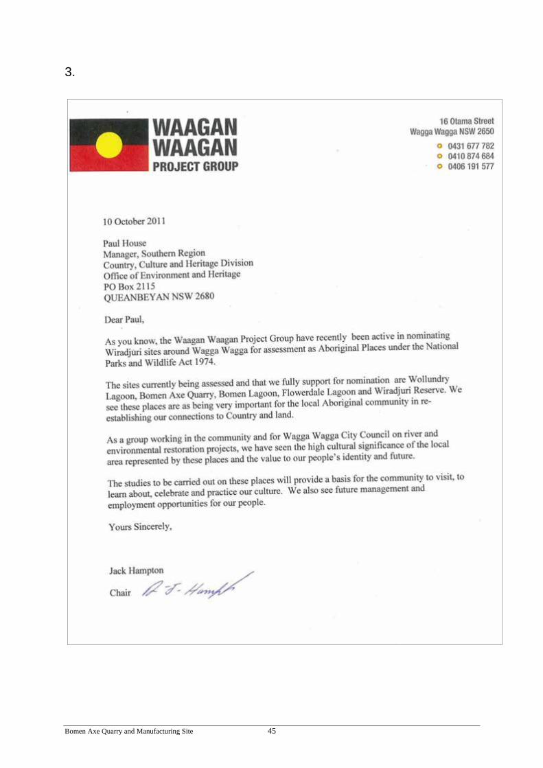
3.
Bomen Axe Quarry and Manufacturing Site 45

4.
Bomen Axe Quarry and Manufacturing Site 46

5.
Bomen Axe Quarry and Manufacturing Site 47

Bomen Axe Quarry and Manufacturing Site 48

6.
Bomen Axe Quarry and Manufacturing Site 49
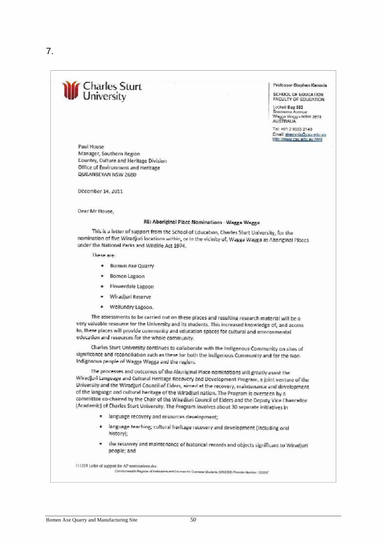
7.
Bomen Axe Quarry and Manufacturing Site 50

Bomen Axe Quarry and Manufacturing Site 51