bolinas gridded mesa plan - marin county, california...61 25 27 28 29 29 . 1.0 introduction 1.1...
TRANSCRIPT

Bolinas Gridded Mesa Plan

A PLAN FOR
THE
BOLINAS
GRIDDED MESA
Adopted by the Marin County Planning Commission
September 24, 1984
Adopted by the Marin County Board of Supervisors
November 27, 1984
Approved by the California Coastal Commission
March 27, 1985


THE PREPARATION OF THIS PLAN
WAS FUNDED BY A GRANT FROM
THE SAN FRANCISCO FOUNDATION
Prepared by
EDAW, INC.
and
THE MESA PLAN RESOURCE GROUP
for
THE BOLINAS PLANNING COUNCIL
and
THE MARIN COUNTY PLANNING DEPARTMENT
Mark Riesenfeld
Neil Sorensen
Planning Director
Principal Planner


1.0
2.0
3.0
4.0
5.0
6.0
TABLE OF CONTENTS
Section Title
INTRODUCTION ••••
I. I
1.2
Background and Issues •..•.••.•••..•..•••....•..•••.
Purpose for the Gridded Mesa Plan
. ........... .
OPPORTUNITIES AND CONSTRAINTS. ••••••••••••••••••••••••• 0 •••••••••
2.1
2.2
2.3
2.4
2.5
2.6 2.7
Physiography
2.1.1 Slope Configuration ••••••••••••••••••
2.1.2 Slope Stability and Bluff Slippage ••
Geology and Soi Is •.•••.• ., ••.•••••.••.•..•.•• e •• " ••••••••••••••••••
Hydrology.
Vegetation
Wildlife ••.
Land Use.
Utilities ••••
AL lERNA T I VES ...................................................... .
BOLINAS GRIDDED MESA PLAN
4.1
4.2
4.3
Gridded Mesa Pian
Policies and Programs •
4.2.1 Land Use ••
Circulation
Utilities ••
Housing •••••
................................
4.2.2
4.2.3
4.2.4
4.2.5 Economic Development ••••••••••
Implementation Strategies •••••••••••••••
4.3.1
4.3.2
4.3.3
County Act ions •••••••••••••••••
Bolinas Community Actions ••
Other Agency Act ions •••••• ••••• 0 •••••• 0 ••• 0 0 ••••••••••••••
GRIDDED MESA PLAN IMPLEMENTATION SUMMARY •••••••••••••••••••••
ACKNOWLEDGEMENTS ............................................... .
4
10
II
II
14
16
18
19
20
21
24
32
50
50
51
51
62
64
65
66
66 66
68
69
70
73


Figure
2-1
2-2 4-1
4-2 4-3
4-4
Table
2-2
2-3
2-4
2-5
2-6
LIST OF FIGURES
Title
Slopes Greater Than 35%
Slope Stability •••••••••
Bluff Erosion Zone •••••
...........................................
Drainogeway Setback Area .••••..••..•.•....•••••..•••...
Area Not Suitable for On-Site Sewage Disposal ••••.•••
Resident ia I Development Zones •.•..••..•••••.•.....•.•• ct e ••••••••••
LIST OF TABLES
Title
Water Consumption Summary ••••••••••••••••••••
Estimated Flow--Arroyo Hondo ••••••••.•••••••••
Present Storage Capacity
Dry Year Water Budget •••••••••••••••
Current Demand and Projected Shortfall
ii
13
IS
54 56
59
61
25 27
28
29
29


1.0 INTRODUCTION
1.1 Background and Issues
The Gridded Mesa Plan represents the most recent step in the planning process for
Bolinas that stems from the Bolinas Community Plan. It focusses on a distinct portion of
Bolinas called the Gridded Mesa.
When the Bolinas Community Plan was adopted in 1975, the problems and issues affecting
the Gridded Mesa were recognized and discussed. Three specific recommendations
regarding the Gridded Mesa were included in the 1975 Plan, including the creation of a
Planning Council and the consideration of a "redevelopment" plan for the Mesa. The
major impetus behind this recommendation was the expression by the community at that
time was that "some method of redoing this mosaic of buildable and unbuildable lots is a
major goal of the Bolinas Plan." The Local Coastal Program (LCP), adopted by the
County in 1979 and certified by the State in 1980, also recognized the problems facing
Bolinas and identified the need to prepare a restoration plan for the Gridded Mesa.
In order to meet the intention of both these plans, the Bolinas Planning Council was
created in 1981 with the purpose of obtaining the funding suggested by the LCP and to
proceed with the planning process for the Gridded Mesa. In 1982, the Bolinas Planning
Council and the County submitted an application for planning funds to the San Francisco
Foundation which was granted. Consultants were then retained and the planning process
was initiated. The formal planning process for the Gridded Mesa Plan began in November
of 1982. This document represents nearly two years of cooperative efforts by both the
Bolinas community and the County of Marin.
This work does not replace the 1975 Bolinas Community Plan. Rather, it is a supplement
to Section I 0 of the 1975 Plan entitled "Redevelopment of the Gridded Mesa," and should
be considered as part of the dynamic planning process which requires all plans to be
continuously changing and improving. The process is not completed yet and will continue
as changes occur on the Gridded Mesa and elsewhere in the Bolinas community.

Background
The Bolinas "Gridded Mesa" is an area of about 300 acres on a bluff overlooking Bolinas
Bay and the Pacific Ocean in unincorporated west Marin County. The area was
subdivided in 1927 into 5,336 20' x I 00' lots. Many of these lots were sold for $69.50 as
part of a subscription promotion by the San Francisco Bulletin. This subdivision consists
of a rigid grid pattern superimposed over a former dairy farm, without regard to drainage
patterns, slope, bluff erosion or other natural features. The streets on the Gridded Mesa
were never accepted by Marin County, and unless maintained by adjoining property
owners, many streets remain often impassable. A few of the streets are paved roods
maintained by the County. Over the years, some roads have eroded into the sea and
others have been abandoned, leaving lots with no public access. Drainage throughout the
area is adversely affected by the roadway pattern. The entire area is served by on-site
sewage disposal systems.
In November 1971, the Bolinas Community Public Utility District instituted a
moratorium on the issuance of water permits, thereby halting new construction on the
Gridded Mesa and other areas of Bolinas. This action was based on a shortage of water,
specifically during summer months and drought years. Unrestrained development of the
Gridded Mesa was also a significant concern due to the limited utilities and the
community desire to maintain the town's rural atmosphere. The moratorium continues to
be supported by residents of the District, who have voted not to increase water resources
beyond that required by the present population.
Marin County officials have agreed that the limited water supply constitutes a
significant constraint on development on the Gridded Mesa. The lack of a community
wide sewage disposal system represents another significant constraint. The size of the
existing parcels is also a problem. Under a "grandfather" clause in the Marin County
Zoning Ordinance, the undersized lots (originally 20' x I 00'), in Bolinas are designated as
legal building sites even though the ordinance requires residential building sites to be
I 0,000 square feet in size. While these smaller lots are considered as legal sites, the
building, health and safety standards established by the County tend to exclude these lots
from development consideration. Where possible, these 20 x I 00' parcels may be
combined into larger sites meeting the development standards.
2

The Local Coastal Program-Unit I (LCP), which was prepared to meet the requirements
of the State Coastal Act of 1976, also included a recommendation for a moritorium,
providing that: "No permits for construction of residential structures on the Gridded
Mesa will be issued after the lifting of the water moratorium until the Restoration
Study o • o is completed."
In May 1981, residents of Bolinas formed a volunteer Planning Council as recommended
by the 1975 plan. After several meetings, the Council voted to prepare a Plan for the
Gridded Mesa. There was a strong consensus among Council members that the Plan
should be prepared with participation by the Community and within the framework of the
goals and objectives of the 1975 Bolinas Community Plan. A Mesa Plan Resource Group
was established from interested community members by the Gridded Mesa Plan consul
tants to assist them in preparing the Plan. Some of the Resource Group had extensive
expertise and knowledge of the physical and cultural characteristics of the area. The
Resource Group compiled and created the data base from which the Gridded Mesa Plan
evolved. Additional consultants were employed to analyze the soil and drainage
conditions on the Gridded Mesa and to recommend realistic sewage disposal techniques.
The results of that analysis dramatically affected the Gridded Mesa Plan. Once the
physical constraints were understood, few land use alternatives appeared to be feasible.
Issues
Today, lot size varies widely over the Mesa, with a large number of the original 20' x 100'
lots sti II remaining. The Mesa accounts for about one-half of the total dwelling units in
Bolinas, but over two-thirds of the residentially zoned portion of the Bolinas Planning
Area.
For the past three years, the citizens of Bolinas and Marin County officials have held
discussions to resolve the problem of "second unit dwellings." These are accessory
residential structures which have been constructed in areas zoned for single family use,
often without building or other permits. The County has identified between 80 and 100
of these structures in Bolinas, representing the primary stock of low to moderate income
rental housing in the community. Most of these units are located on the Gridded Mesa.
A Second Unit Ordinance drafted by the Marin County Planning Department with
assistance from the Bolinas Planning Council was approved by the Marin County Board of
Supervisors, January 12, 1982. Under this Ordinance, community plan amendments may
3

be introducted by communities in unincorporated areas of Marin to legalize second
units. On March 29, 1983, the Board of Supervisors approved a Second Unit Ordinance
for Bolinas, requiring permits for all existing second units. By the end of January 1984,
only 14 permits had been requested. Of these, only one has been approved and two have
been withdrawn.
There are other key issues affecting the Gridded Mesa beyond the water shortage and the
limitations related to the parcel size and configuration. Primarily, they are the physical
characteristics of the Mesa itself, some of which cannot be changed, such as the soils,
and others which are continually changing, such as the eroding bluffs and the unstable
slopes. These characteristics have dramatically affected this phase of planning for
Bolinas. The following sections will serve to describe the opportunities and constraints
inherent in the existing environment and indicate how the current plan was affected by
them.
There is a wide range of sentiment about growth among both Bolinas residents and
property owners. Some people feel that Bolinas should retain its present scale and level
of development; others would welcome residential and commercial growth. This issue of
growth versus no-growth was a lively and influential factor throughout the planning
process.
1.2 Purpose for the Gridded Mesa Plan
The Gridded Mesa Plan represents a joint undertaking of the Marin County Planning
Department, the Bolinas Planning Council and the Mesa Plan Resource Group. It utilized
the services of a Program Planner, Local Facilitator, and a Planning Consultant to
coordinate the preparation of a plan for the Bolinas Gridded Mesa. This plan is intended
to serve as an effective guide to future development and resource preservation in the
area. The Mesa Plan outlines the implications for natural resources, community values,
and public services of land use alternatives. The 1984 Plan was prepared within the
framework of the goals, policies, and objectives of the 1975 Community Plan as well as
additional goals identified by the Bolinas Planning Council and the Marin County Planning
Department. The goals of the Local Coastal Program were also incorporated in the
planning process.
4

The most important purpose of the planning process at this stage of the community's life
is to first identify and accept the existing physical constraints and the existing problems
resulting from unrestrained and incorrectly sited development and then determine the
policies and programs necessary to implement solutions to those problems. The purpose
of this plan is to protect the fragile environment of the Mesa from the documented
negative cumulative impact of improper drainage and development as well as to provide
a plan for the possibility of safe and orderly future development. Resolving the current
problems related to drainage, sewer and water are given the highest priority.
Goals for the Gridded Mesa Planning Process
The Bolinas community has established a set of goals which it feels will help maintain or
improve its welfare. These goals were stated in the 1975 Bolinas Community Plan (BCP).
In addition to the BCP goals, the LCP embodies statements of goals which influence land
use planning in Bolinas. These were derived through specific community participation
and reflect the county and state goals affecting Bolinas. These goals are compatible
with the BCP goals. The stated goals and their origins are listed below:
I. Understand, Protect and Engender Elements of Community (BCP)
2. Achieve a Healthy Coexistence Between Man and Nature (BCP)
3. Foster Economic Development (BCP)
4. Accept and Encourage a Wide Range of Lifestyles (BCP)
5. Participate in Planning and Decision Making Affecting Bolinas and Its Surroundings
(BCP)
6. Protect and Conserve State Coastal Resources (LCP)
7. Maximize Public Use and Enjoyment of State Coastal Resources (LCP)
8. Ensure Health and Safety of Persons Residing In or Visiting the Local Coastal Unit
(LCP)
Marin County also has several jurisdictional obligations which add to the goals and
objectives framework for this project. In particular, the County has the responsibilities
of maintaining law and order, protection of lives and property and maintaining health
standards.
5

Plan Objectives
The 1975 Plan goals are general in nature. From each general goal, more specific
statements, objectives, are derived. Goals are better understood when they are further
defined by objectives. The following summary list shows the relationship of the goals to
the objectives stated in the 1975 Bolinas Community Plan, including the Local Coastal
Program goals:
Goal 1: Understand, Protect and Engender Elements of Community
Objectives:
o Maintain existing land use patterns (this could conflict with 1984 plan)
o Maintain Bolinas as resident, not tourist community
o Minimize/control impact of autos on community
Goal 2: Achieve a Healthy Coexistence Between Man and Nature
Objectives:
o Accept reasonable mix of residential and agricultural uses
o Respect wildlife systems
o Respect vegetative systems
o Preserve unique aesthetic value of landforms
Goal 3: Foster Economic Development
Objectives:
o Prepare capital improvement programs for roads, signs, ponds, drainage
6
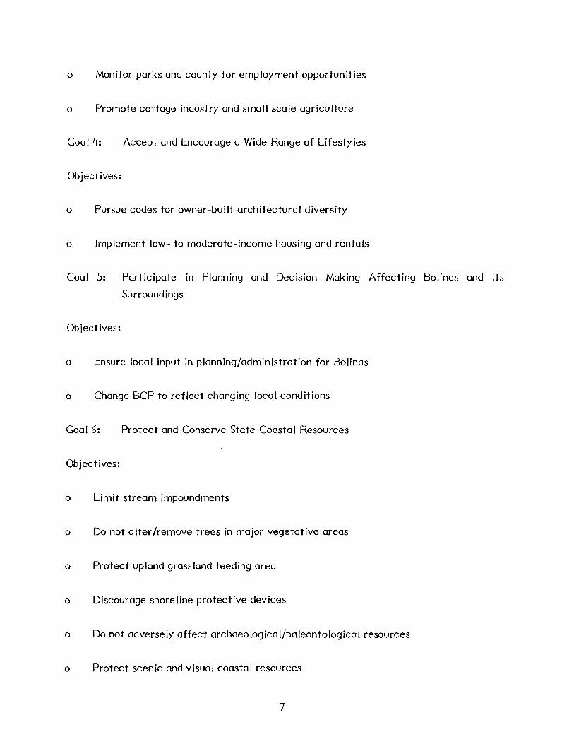
o Monitor parks and county for employment opportunities
o Promote cottage industry and small scale agriculture
Goal 4: Accept and Encourage a Wide Range of Lifestyles
Objectives:
o Pursue codes for owner-built architectural diversity
o Implement low- to moderate-income housing and rentals
Goal 5: Participate in Planning and Decision Making Affecting Bolinas and Its
Surroundings
Objectives:
o Ensure local input in planning/administration for Bolinas
o Change BCP to reflect changing local conditions
Goal 6: Protect and Conserve State Coastal Resources
Objectives:
o Limit stream impoundments
o Do not alter /remove trees in major vegetative areas
o Protect upland grassland feeding area
o Discourage shoreline protective devices
o Do not adversely affect archaeological/paleontological resources
o Protect scenic and visual coastal resources
7

o Avoid large-scale development changing rural village character
Goal 7: Maximize Public Use and Enjoyment of State Coastal Resources
Objectives:
o Continue Bed and Breakfast program
o Encourage social and economic diversity
o Preserve views to scenic resources from roads and trails
Goal 8:
Objectives:
Ensure Health and Safety of Persons Residing In or Visiting the Local Coastal
Unit
o Ensure new buildings are not threatened by cliff erosion
o Ensure development meets Alquist-Priolo standards
o New septic systems shall meet water quality guidelines
o Water quality should be monitored
Conflicting Goals and Objectives
In some instances, the stated objectives (and goals) conflict with each other. While some
objectives, such as "maintain existing land use patterns" and "encourage social and
economic diversity," may both be desirable objectives, Bolinas cannot necessarily
maintain its current land use patterns and provide low cost housing or develop cottage
industries. Similarly, Bolinas may not be able to both limit stream impoundment or
diversions and encourage residential development or road access to all parts of the
Mesa. Where objectives conflict, it is necessary to set priorities. This does not happen
as a singular event during the planning process. Since the process is dynamic, the goals
8
and objectives must be periodically reviewed and adjusted. Throughout this phase of the
planning process the Planning Council emphasized that the goals and objectives included
in the 1975 Community Plan were still valid for the 1984 Gridded Mesa Plan. However,
additional objectives were identified as the process progressed. The 1975 goals and
objectives, supplemented by those developed during the Gridded Mesa Plan process are
used to create specific policies and programs for implementing the preferred plan.
9


2.0 OPPORTUNITIES AND CONSTRAINTS
Opportunities
There are several planning opportunities inherent in the Gridded Mesa. The location of
the Gridded Mesa with its ocean and bay coastal areas and the accompanying views and
vistas provides a unique environment. There is access to the extraordinary Duxbury
Reef, a National Preserve, from the Mesa. Views and vistas of the coastal hills also
contribute to the aesthetic quality of the Mesa.
On the Mesa itself, the many parts of the drainage system, including the creeks and
ponded areas, define the form and quality of the rural environment. The rolling mesa
land, much of which is undeveloped, provides an excellent opportunity for the community
to plan a system of open area elements integrated with development. "Active" areas
could be set aside for neighborhood parks or community gardens, with "passive" areas
reserved for walking, sitting or observing.
Similarly, because land is available, including land well sited to take advantage of the
variety of views and vistas, exceptional residential development opportunities are
possible. Due to the level topographic character of most of the Mesa, as well as ease of
access to the Mesa, opportunities exist to reduce the cost of residential construction.
The size and location of undeveloped parcels provide opportunities for developing housing
units in clusters, reducing impacts on the environment as well as construction costs.
The existing vegetation pattern contributes to the aesthetic quality of the Mesa; it
provides protection and fuel, as in the case of some of the larger stands of trees.
l-lowever, these vegetation elements can also become constraints. These, and other
constraints are discussed below.
Constraints
Prior to the preparation of the Gridded Mesa Plan, a great deal of data had been
compiled on the physical characteristics of the Mesa. Some of this data, such as the
status of the water supply, is much documented and widely discussed and had become an
important factor in the Bolinas Planning Process in the last 13 years. Other important
data, such as the characteristics of the soils on the Mesa, were never confirmed until
now.
10

During the development of the Gridded Mesa Plan, the known data were updated and
supplemented by field work and laboratory analysis. As a result, the community and the
County now have a reliable data base from which to formulate some realistic planning
guidelines.
The environmental characteristics discussed in this section are described individually so
that a better understanding of the existing conditions is possib I e. In rea I ity, none of
these characteristics is isolated. Each is a part of the whole and when one factor
changes or is changed, the others are affected in some way. The soils, the geology, the
slope and slope stability, the existing land use and ownership patterns, and the modified
drainage patterns tend to limit the planning opportunities more than do other factors,
such as the existing vegetation and wildlife characteristics. Where limiting factors
overlap, cumulataive constraints act to further direct the planning process. For
example, soil characteristics, when considered by themselves, may limit on-site sewage
disposal, construction of buildings and roads, and agriculture. When such soil limitations
are combined with the constraints associated with excessive slopes or the existing
surface drainage patterns, cumulative constraints may prohibit development of any kind
in that area. Thus, it is often a combination of factors that constrain the planning
options. The remainder of this section briefly describes the environmental
characteristics having the greatest affect on the Gridded Mesa Plan.
2.1 Physiography
2.1.1 Slope Configuration
The form of the land affects the Gridded Mesa Plan in several ways. Primarily, the slope
of the land can inhibit or prohibit building and road construction and on-site sewage
disposal systems. Most of the Mesa, particularly the eastern portion, is relatively level
(less than two percent slope). The western end of the Mesa, including the major
drainageways, ranges from I 0 percent slope to greater than 40 percent along the bluffs
and creeks. The Slope Map (Figure 2-1) indicates the general slope configuration on the
Mesa.
For this plan, slopes greater than 35 percent are considered excessive and development
of the areas within the slope category is not recommended. The County's Zoning
II

Ordinance and the Local Coastal Program restricts construction of residential units in
areas with greater than 35 percent slope. As can be seen from Figure 2-l, the steepest
slopes occur along the Alder Creek drainage and the bluffs along both the ocean and bay
sides of the Mesa. When considered along with the constraints inherent in the Mesa soils,
this factor can present significant constraints for any type of land use.
12

~
\
\
I
Bolinas Gridded Mesa Plan SLOPES GREATER THAN 35%
Bolinas Planning Council Mesa Plan Resource Group Marin County Planning Department
EDAW inc. 1983
1' N
1000
\. '"
·"
\I ! / ;
i )
/ / f
' j't
I .' i . '
i
~· .. J / '.J
,.___..~
Figure 2-1

2.1.2 Slope Stability and Bluff Slippage
In general, the soils on the Gridded Mesa are relatively stable, with two significant
exceptions being the bluff areas and the steep slopes along the major drainage ways.
(See Slope Stability map, Figure 2-2.) Slope stability can be affected by factors other
than slope such as soil structure, drainage, vegetation, soil disturbance, and seismic
activity. In this case, the soil structure exhibits a condition where the soil layers are not
cohesive and where water moves longitudinally between these layers. Slippage can be a
problem in the areas where this occurs.
The bluff slippage is a readily apparent phenomenon easily visible along the shoreline.
The rate of slippage has been measured frequently and several assessments have been
completed. The available data indicates that the section of the bluff above Bolinas Bay
between Overlook Drive and Duxbury Point is falling away at an average rate of between
12 to 24 inches per year, and the ocean side bluff west of Duxbury Point is eroding at an
average rate of nearly 30 inches per year. In any given location, slippage can be
substantially greater or less than the average suggests.
Although actual annual erosion tends to be episodic in nature--with annual losses of five
feet to ten feet interspersed with more stable periods--the variations appear to be
related to the relative wetness of winters. The failures experienced during the winter of
1982-1983 clearly illustrate the potential for significant erosion along the bluff.
Chaparral, grasses, and other vegetation may contribute to the stabilization of slopes up
to five to ten degrees steeper than similar non-vegetated areas. However, large
shallowrooted trees, such as the eucalyptus and cypress, may contribute to slope
destabilization by drastically altering slope conditions when they are toppled because of
high winds, senescense, or soil failure.
14


;.
Bolinas Gridded Mesa Plan SLOPE STABILITY
Bolinas Planning Council Mesa Plan Resource Group Marin County Planning Department
EDAW inc. 1983
Feet
~ 0 100 200
-........ -
A Most Stable
~ D Least Stable
400 600 1000
Figure 2-2

Differential rates of bluff retreat necessitate differential construction setbacks. Set
backs should be considered on a site specific basis. The Local Coastal Program setback
of 150' and the Bolinas Community Plan figure of 120' discussed during the planning pro
cess were based on the formu Ia: setback = life expectancy of structure (50 yrs., I 00 yrs.,
150 yrs.) x rate of retreat + safety factor (45'). (Rate of retreat figures and the safety
factor are based upon studies done for the California Division of Mines and Geology in
1977 by David L. Wagner, Geology For Planning In Western Marin County, California.)
Since the two Mesa bluff areas are different, separate bluff retreat rates are considered
as follows:
Between Overlook and Duxbury Point:
50 yrs x 2'/yr + 45' (safety factor) = 145'
I 00 yrs x 2'/yr + 45' (safety factor) = 245'
150 yrs x 2'/yr + 45' (safety factor) = 345'
Between Duxbury Point and Poplar Road:
50 yrs x 2.5'/yr + 45' (safety factor)= 170'
100 yrs x 2.5'/yr + 45' (safety factor)= 295'
150 yrs x 2.5'/yr + 45' (safety factor) = 415'
Because cliff erosion is episodic, not constant, it is difficult to estimate the position of
the cliff for any given year in the future. Building life expectancy is highly variable.
The setback formula was used by the Mesa Plan Resource Group to determine the zone
a long both bluffs where no new construct ion should occur.
2.2 Geology and Soils
Since the Bolinas Community Plan was approved by the County in 1975, additional studies
have been completed that have added to the know ledge of the Mesa. Because of these
studies, the Mesa Plan has an advantage that the Bolinas Community Plan did not have.
The most recent geologic analysis by Wagner (1977), and the soils analysis by G!uesta
Engineering and WESCO (1983), provide the most current data on the structure of the
Mesa. These data are critical and much of the Gridded Mesa Plan is based on them.
16
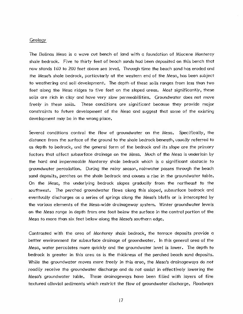
Geology
The Bolinas Mesa is a wave cut bench of land with a foundation of Miocene Monterey
shale bedrock. Five to thirty feet of beach sands had been deposited on this bench that
now stands 160 to 200 feet above sea level. Through time the beach sand has eroded and
the Mesa's shale bedrock, particularly at the western end of the Mesa, has been subject
to weathering and soil development. The depth of these soils ranges from less than two
feet along the Mesa ridges to five feet on the sloped areas. Most significantly, these
soils are rich in clay and have very slow permeabilities. Groundwater does not move
freely in these soils. These conditions are significant because they provide major
constraints to future development of the Mesa and suggest that some of the existing
development may be in the wrong place.
Several conditions control the flow of groundwater on the Mesa. Specifically, the
distance from the surface of the ground to the shale bedrock beneath, usually referred to
as depth to bedrock, and the general form of the bedrock and its slope are the primary
factors that affect subsurface drainage on the Mesa. Much of the Mesa is underlain by
the hard and impermeable Monterey shale bedrock which is a significant obstacle to
groundwater percolation. During the rainy season, rainwater passes through the beach
sand deposits, perches on the shale bedrock and causes a rise in the groundwater table.
On the Mesa, the underlying bedrock slopes gradually from the northeast to the
southwest. The perched groundwater flows along this sloped, subsurface bedrock and
eventually discharges as a series of springs along the Mesa's bluffs or is intercepted by
the various elements of the Mesa-wide drainageway system. Winter groundwater levels
on the Mesa range in depth from one foot below the surface in the central portion of the
Mesa to more than six feet below along the Mesa's southern edge.
Contrasted with the area of Monterey shale bedrock, the terrace deposits provide a
better environment for subsurface drainage of groundwater. In this general area of the
Mesa, water percolates more quickly and the groundwater level is lower. The depth to
bedrock is greater in this area as is the thickness of the perched beach sand deposits.
While the groundwater moves more freely in this area, the Mesa's drainageways do not
readily receive the groundwater discharge and do not assist in effectively lowering the
Mesa's groundwater table. These drainageways have been filled with layers of fine
textured alluvial sediments which restrict the flow of groundwater discharge. Roadways
17

and ill-placed construction have also obstructed the drainageways. Similarly, discharge
to the west side of the Mesa is also blocked by Monterey shale bedrock. In short, the
subsurface groundwater flows from the east side of the Mesa to the west, where it is
blocked by the underlying bedrock formation, and to the south, where it emerges as
springs along the southern bluff face.
In addition, groundwater ponds in localized areas where the subsoil is primarily clay or
the underlying bedrock is Monterey shale. During exceptionally wet years, such as the
winters of 1981 to 1982 and 1982 to 1983, the groundwater perched on the surface may
merge with the groundwater perched on the bedrock to create a saturated zone extending
from the bedrock to the surface of the Mesa. Subsurface sewage disposal systems fail to
operate under these conditions.
Soils
There are three basic soil groups related to the land form on the Mesa: (I) those
occurring on slopes; (2) those occurring in the drainageways; and (3) those found on the
gently sloping terraces.
Individually, these soils exhibit special characteristics. However, only a few
characteristics are significant for the Gridded Mesa Plan at this time. The soils on the
sloped areas generally exhibit slow permeability and a lack of free water movement.
Those in the drainageways are also limited in their permeability and are generally
saturated during the rainy season. The terrace soils vary in depth to the water table
during the winter months, ranging from greater than six feet along the bay side bluff to
between two and three feet near the main drainageways. These characteristics represent
significant constraints for development, particularly residential development, as these
soils severely limit opportunities for on-site sewage disposal on the Mesa
2.3 Hydrology
Just as the Mesa's Soils restrict the development opportunities, the surface drainage
characteristics also contribute to the overall drainage problems. While the western
portion of the Mesa exhibits sursurface drainage constraints, the eastern portion faces
surface drainage problems. The existing land form and topographic conditions combined
with artificial barriers caused by the gridded development pattern with its roadway
system adversely affect the natural drainage pattern.
18

The major drainage, specifically Alder Creek and its tributaries, cuts the Mesa from east
to west. Lesser drainages are located along the Mesa Road and Terrace Avenue. A
complex system of natural channels, roadside ditches, overland flow and groundwater
seepage operates on the Mesa, particularly during the wet season. This system is
inadequate to drain the developed areas of the Mesa and ponding occurs as a result. This
ponding causes localized saturation of the surface soi Is and flooding of the existing septic
system trenches. This results in the surfacing of effluent from the septic systems and
the periodic backing up of residential plumbing. In addition, as the ponding occurs and
the area retains surface water, the groundwater is recharged and the water table rises
and merges with the saturated soils.
The subsurface drainage problems vary across the Mesa, and, in general, the constraints
to development are severe. The most well-drained area is found along the southern bluff
facing Bolinas Bay. The rest of the terrace area experiences groundwater levels which
are two to five feet below the surface. This condition severely constrains the use of
traditional trench-style on-site sewage disposal systems. The drainage swales (i.e., along
Larch Road), exhibit the worst surface drainage conditions. This is partly due to ill
constructed roadways crossing the swale. Pending in these areas tends to saturate the
soils above the existing water table and adds to the development constraints.
2.4 Vegetation
The vegetation found on the Mesa presents less of a constraint to development than the
geology, soils and slope conditions. The existing vegetation does, however, offer some
opportunities for maintaining or enhancing the quality of the environment.· The
opportunities include providing safe habitat conditions for the existing wildlife as well as
being part of the aesthetic character of the area.
While not necessarily a constraint to development, some of the existing tree species can
present problems and might even be dangerous is some situations. Three of the tree
species dominate the taller and most visible stands on the Mesa; tasmanian blue gum,
monterey pine, and monterey cypress. The Mesa Plan Resource Group identifies many of
these species now found on the Mesa to be over mature and in their decline. They are
naturally shallow rooted and have outgrown their own structural support system. The
poor soils and hydrological constraints described above add to the problem by causing
19

these species to be even more shallow rooted. The Mesa Plan Resource Group noted the
following:
"Consequently breakage and windthrow in these stands is becoming a serious
financial and safety problem and will likely worsen with time. Many people find
they have tree problems they cannot afford to remedy. The tall trees often block
sunlight and increase energy consumption. They accelerate the decay of wood
buildings and block views where lower-growing species could yield a net decrease in
energy consumption, preserve views and privacy, and create more comfortable
microclimates. Tall trees on steep slopes and along drainage ways increase
erosion. When they are windthrown they disturb large areas of soil and begin a
domino series of erosion events. They overtop and suppress lower subordinate
vegetation such as brush and grass that are better suited to binding the soil
together. Thus, they accelerate erosion. On the positive side they are visually
pleasing to many, they provide hawk nesting sites and eucalyptus can be used to dry
moist areas and is an excellent source of local money. All three species are
commonly used for fuel. (Gridded Mesa Plan Workbook, p. 1-27, 1-28.)
From a planning point of view, the existence of these dominant tree species should be
incorporated into the open space and circulation system for the Mesa and wood lot
opportunities should be identified where conflicts with existing or potential residential
uses do not exist.
2.5 Wildlife
Like vegetation, wildlife contributes to the quality of life experienced in Bolinas and
should be recognized accordingly. The natural habitats of birds and animals on and
around the Mesa are diverse. Opportunities exist for preserving substantial areas of
relatively undisturbed land around the Mesa as open space which can be linked to a
network of open or undeveloped areas on the Mesa itself. As noted by the Mesa Plan
Resource Group, the existing wildlife will thus be encouraged to remain or be attracted
to the preserved areas. For planning purposes, these opportunities need to be considered
as the open space or Mesa Resource area is defined.
20

2.6 Land Use
The existing lotting pattern and the scattered development provide both a constraint and
an opportunity. As stated above, opportunities for well suited residential units with
relatively low construction costs exist. On the other hand, the rigid grid pattern and the
generally scattered development pattern can constrain future residential or agricultural
uses on the Mesa.
The scattered ownership pattern and the variety of parcel sizes also provide
constraints. Table 2-1 illustrates the parcel size and ownership pattern on the Mesa and
in the Town. The County's zoning regulations call for minimum lot sizes of 10,000 square
feet but allow smaller lots because the subdivision predates the current parcel size
requirements in the zoning ordinance. Consolidation of lots with contiguous ownership is
possible and necessary in most cases as the or ig ina I 20' x I 00' lots are not of sufficient
size to meet the County's current building, health and safety standards.
21

LAND USE DATA
Information
T ota I Number of Gr idded Mesa Parce Is
Total Number of Gridded Mesa 2,000 SF Parcels
Total Number of Gridded Mesa 4,000 SF Parcels
Total Number of Gridded Mesa 6,000 SF Parcels
Total Number of Gridded Mesa 8,000 SF Parce Is
Total Number of Gridded Mesa 10,000 SF Parcels
Total Number of Gridded Mesa 20,000+ SF Parce Is
Number of Gridded Masa Parcels 6,000 SF or Larger
Number of Gridded Mesa Parcels 8,000 SF or Larger
Number of Gridded Mesa Parcels I 0,000 SF or Larger
Total Number of Parcels (Not limited to Gridded Mesa)
Non-Taxable Parce Is
Total Number of Improved and Unimproved Parcels
Total Number of Improved Parcels
Total Number of Unimproved Parcels
Total Number of Residential Parcels
Single Family Improved Parcels
Multi-Family Improved Parcels
Commercial Parcels and Other
Mar in Office of Assessor 12/82 Data*
2,345 (I 00%)
65 (3%)
2,280 (97%)
602 (26%)
I ,678 (71%)
2,261 (96%)
569 (95%)
14 (2%)
19 (1%)
Bolinas Moratorium
Review Lot Survey 1979 Data
I ,281 (57%)
125 (10%)
341 (26%)
208 (16%)
164 (13%)
381 (30%)
65 (5%)
818 (64%)
610 (48%)
446 (35%)
* The Marin County Assessor's office has not consolidated adjacent parcels under commission ownership.
22

BOLINAS PARCEL OWNERSHIP
Ownership--Improved Parcels
Number Percent
Local Marin (except Bolinas) Outside Marin (State) Outside State
385 67
132 18
Total 602
Ownership (All Parce Is)
Local 768 Marin (except Bolinas) Outside Marin (State) Outisde State
Total 2,280
64.0 11.0 22.0 3.0
100.0
23
Ownership--Unimproved Parce Is
Number
Local Marin (except Bolinas) Outside Marin (State) Outside State
Total
Percent
383 23.0 377 23.0 793 47.0 125 7.0
I ,678 I 00.0
Number Percent
33.7 444 19.5 925 40.6 143 6.2
100.0
2.7 Utilities
Water Supply and Storage
The Bolinas Community Public Utilities District includes all of the Bolinas Mesa within
its geographical jurisdiction. The District gets its water supply from Arroyo Hondo
which is situated on National Park lands. The District operates on a yearly cycle with
water being stored during the rainy season in two dams, Woodrat Ill and Woodrat 112.
During the dry season, water from these dams is pumped into the system to keep up with
demand. The flow in Arroyo Hondo is not sufficient during the summer to meet the
community needs.
Flow
There is no accurate measurement of the flow at all times in Arroyo Hondo because the
District can measure it only when all the water in the arroyo is trapped by the catchment
or diversion dams and is going into the system. There is no feasible way for the District
to measure the flows over these dams in the winter.
Table 2-2 shows the increase in water consumption from 1967 to 1983 to be from 25 x
106 gal. to 53.8 x 10⁶ gal. This increase has occurred even though the water moratorium
has been in effect since November I 971.
24

Table 2-2
Water Consumption Summary
1967 25 X I o6 Gallons 1973 43.1 X 10⁶ 1978 46 X 106
1968 28.864 x 10⁶ Gallons 1974 44.5 X 10⁶ 1979 51.23 X I o6
1969 29.8 x 10⁶ Gallons 1975 51.48 x 1 o6 1980 55.43 x 1 o6
1970 32.259 X I o6 Gallons 1976 45.8 X 10⁶ 1981 44.98 X I o6
1972 30.921 x 10⁶ Gallons 1977 33.7 X 10⁶ 1982 51 X 106
1983 53.8 X 10⁶
Reservoir Evaporation:
Evaporation ac. ft. = 40"/yr. x surface in acres/ 12
Percent Consumption/Me.
January 6.8
February 6.7
March 7.0
April 7.4
May 8.6
June 9.4
July 10.2
August 10.8
September 10.0
October 8.6
November 7.4
December 7.0
Source: Wm. J. Osward, Ph.D. PE, "Preliminary Evaluation of the Water Supply
Potential Available to the B.C.P.U.D., August 1973.
The rate of evaporation at the two reservoirs is 40 inches a year x surface in acres.
25

Table 2-2 also shows the rate of monthly consumption to vary between January and
August from 6.8 percent of the yearly consumption to 10.8 percent. Consumption goes
up in the dry season.
The flow in Pine Gulch Creek has been measured by the U.S. Geologic Survey and for
similar periods, i.e., when Arroyo Hondo is susceptible to measurement--the latter's flow
has been determined to be 30 percent that of Pine Gulch Creek. Pine Gulch Creek drains
the San Andreas Fault (proper) and its mouth is located between the school and the
nursery on the Bolinas-Olema Road. Table 2-3 estimates the flow for Arroyo Hondo
based on the corresponding figures for Pine Gulch Creek. This table shows the relative
flow of the arroyo in normal and "dry" years in acre feet. It shows, in "dry" years, a drop
from a high of 378 acre feet in a typical winter month to I acre foot of flow in
September--just before the beginning of the rainy season. In a wet year, the minimum
flow is about 8 acre feet per month.
Table 2-4 contains figures on the District's storage capacity. The figures are in gallons
for each individual storage facility, four tanks and two dams. The total storage capacity
is set out in acre feet after factoring for evaporation, a five acre foot per year legal
obligation to Commonweal, and unusable bottom mud and sludge. Five acre feet goes to
Commonweal under a settlement made in the condemnation use whereby the District
acquired one of the Woodrat sites.
There resu Its a net safe yield for the District's storage capacity of 40.9 acre feet. The
maximum flow exploitable by the District at Arroyo Hondo is 200,000 gallons per day.
26

Table 2-3
Estimated Flow-Arroyo 1-bndo
Average Year I 00 Year Dry
Acre-Feet Acre-Feet
January I ,303 157
February 633 378
March 325 273
April 108 73
May 60 37
June 62 14
July 19 5
August 12 2
September 8 I
October 22 17
November 34 26
December 450 47
Source: Using U.S.G.S. records, Arroyo 1-bndo flow (30 percent of Pine Gulch Creek).
Consumption
The population of Bolinas is assumed to be about 1,700 people with a requirement of 120
gallons per person per day. The 120 gallon figure is not adjusted for the heavy users
downtown, i.e., the bar, restaurants, and laundromat, which exceed the 120/gal. day for
each person. Also excluded in this 120 gal/person/day, is leakage which further reduces
the personal consumption. The recent drought increased attention to water conservation
and consumption was significantly reduced at that time. As these habits erode away, the
demand is expected to go up.
27

Green Tank
Gold Tank
Terrace Tanks
Little Mesa
Woodrat 1t2
Woodrat 111
Table 2-4
Present Storage Capacity
Gallons
420,000
420,000
130,000
20,000
6,500,000 net safe yield
5,850,000 net safe yield, minus Commonweal
13,340,000 gallons = 40.9 acre feet
Maximum flow capacity from Arroyo Hondo 200,000 gallons/day*
* B.C.P.U.D. Daily Logs.
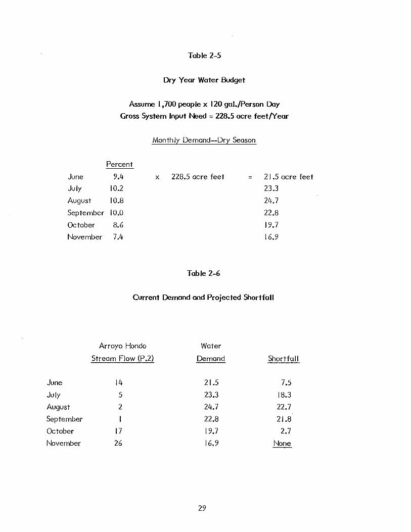
Based on 1,700 population at 120 gal/day, the yearly gross impact need is 228.5 acre
feet. 1 Then, from Oswald's figures (Table 2-5) the need is set out for present demand.
July, August and September are the critical months. The shortfall for those months
approximates the capacity of one of the Woodrat reservoirs, which represents the
additional storage needed just to bring the existing community up to a safe level under
the present conditions, which includes a leakage factor of 38 percent, twice the state
average.
One acre foot equals 325,851 gallons.
28
June
July
August
September
October
November
Table 2-5
Dry Year Water Budget
Assume I ,700 people x 120 gai./Person Day
Gross System Input Need = 228.5 acre feet/Year
Monthly Demand--Dry Season
Percent
9.4 X 228.5 acre feet = 21 .5 acre feet
10.2 23.3
10.8 24.7
10.0 22.8
8.6 19.7
7.4 16.9
Table 2-6
Current Demand and Projected Shortfall
Arroyo Hondo Water
Stream Flow (P .2) Demand Shortfall
June 14 21.5 7.5
July 5 23.3 18.3
August 2 24.7 22.7
September I 22.8 21.8
October 17 19.7 2.7
November 26 16.9 None
29
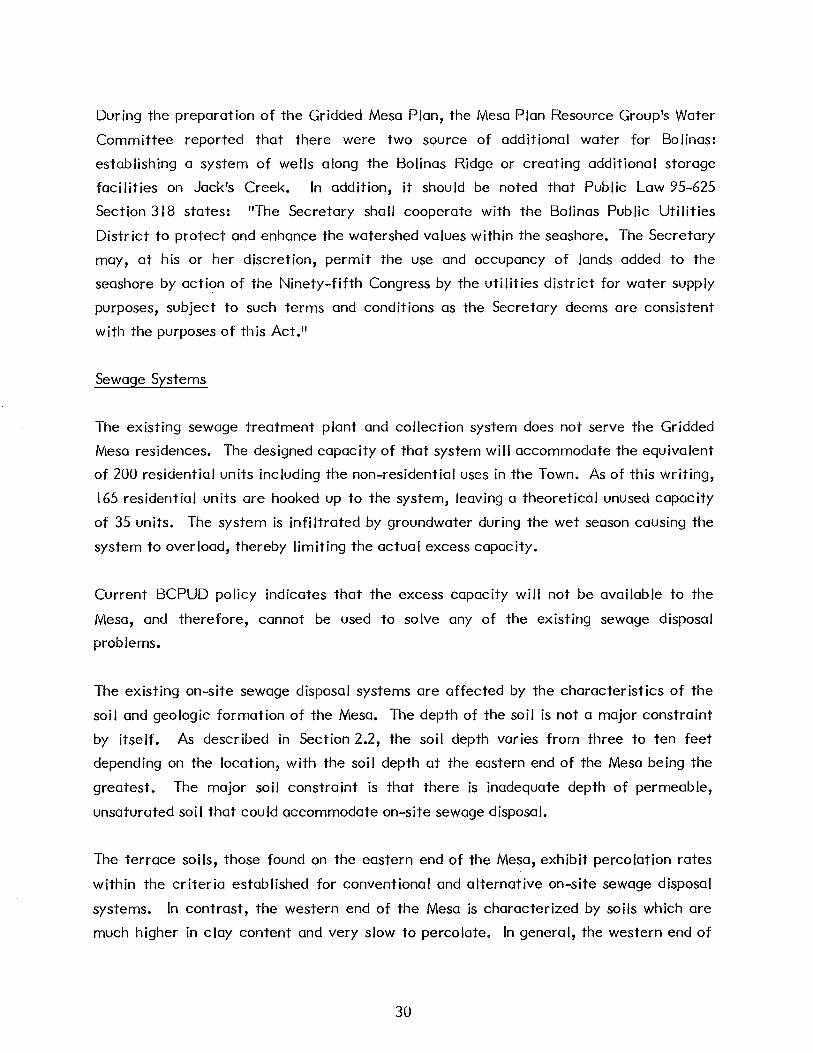
During the preparation of the Gridded Mesa Plan, the Mesa Plan Resource Group's Water
Committee reported that there were two source of additional water for Bolinas:
establishing a system of wells along the Bolinas Ridge or creating additional storage
facilities on Jack's Creek. In addition, it should be noted that Public Law 95-625
Section 318 states: "The Secretary shall cooperate with the Bolinas Public Utilities
District to protect and enhance the watershed values within the seashore. The Secretary
may, at his or her discretion, permit the use and occupancy of lands added to the
seashore by action of the Ninety-fifth Congress by the utilities district for water supply
purposes, subject to such terms and conditions as the Secretary deems are consistent
with the purposes of this Act."
Sewage Systems
The existing sewage treatment plant and collection system does not serve the Gridded
Mesa residences. The designed capacity of that system will accommodate the equivalent
of 200 residential units including the non-residential uses in the Town. As of this writing,
165 residential units are hooked up to the system, leaving a theoretical unused capacity
of 35 units. The system is infiltrated by groundwater during the wet season causing the
system to overload, thereby limiting the actual excess capacity.
Current BCPUD policy indicates that the excess capacity will not be available to the
Mesa, and therefore, cannot be used to solve any of the existing sewage disposal
problems.
The existing on-site sewage disposal systems are affected by the characteristics of the
soil and geologic formation of the Mesa. The depth of the soil is not a major constraint
by itself. As described in Section 2.2, the soil depth varies from three to ten feet
depending on the location, with the soil depth at the eastern end of the Mesa being the
greatest. The major soil constraint is that there is inadequate depth of permeable,
unsaturated soil that could accommodate on-site sewage disposal.
The terrace soils, those found on the eastern end of the Mesa, exhibit percolation rates
within the criteria established for conventional and alternative on-site sewage disposal
systems. In contrast, the western end of the Mesa is characterized by soils which are
much higher in clay content and very slow to percolate. In general, the western end of
30

the Mesa is not suitable for any on-site sewage disposal system that is currently
acceptable by County and State standards.
Another constraint affecting on-site sewage disposal is the shallow depth of the
groundwater in the terrace soils of the Mesa. In these areas during the wet season,
groundwater is found between one to six feet below the surface depending on the location
with the greatest depth found closest to the southern bluffs. Conventional subsurface
leaching trenches can be used in this near bluff area. Inland of the bluffs, the seasonal
groundwater level is found to be high, being highest in areas near the Alder Creek
drainage. Alternative disposal systems are more appropriate in these areas where the
groundwater is closer to the surface.
In the nearly level (less than 2 percent slope) terrace soils at the eastern end of the Mesa
little problem exists for on-site sewage disposal based on slope characteristics alone. In
contrast, the slopes in the western end of the Mesa exceed 30 percent in some areas of
the Alder Creek drainage. Combined with the tight soils and poor percolation
characteristics of the shale area, the steep slopes contribute to make the western end of
the Mesa unsuitable for on-site sewage disposal.
As stated in Section 2.3, the Mesa is drained by a network of drainageways which vary
significantly in size. The main watercourse is Alder Creek which runs along the center
of the Mesa from the east to the west end, emptying into the Ocean across Agate
Beach. A northern tributary of this main channel originates near Poplar and Walnut
Streets. These well-defined channels carry water into the summer season. Beyond these
are deeper parts of the drainage in the terrace soils which can be characterized as
wetland areas. The parcels located in and adjacent to these wetlands are also unsuitable
for on-site sewage disposal.
Another constraint affecting on-site sewage disposal is the parcel size. Many of the
existing parcels are too small to accommodate a residence using traditional on-site
sewage disposal sytems. Because of the poor site conditions, the land requirements for
sewage disposal are so great that many parcels now existing are too small and must
either be joined to other parcels or abandoned as a possible site for residential
development under the current sewage disposal options.
31

3.0 ALTERNATIVES
Throughout the planning process for the Gridded Mesa Plan, a series of alternative plan
proposals were evolved based originally on the expression of the community and the non
resident property owners and then narrowed by the specific findings of the soils
investigation. Eventually, four alternatives, ranging from one that recommended no new
development to one that recommended full development of all parcels greater than
4,000 square feet, were presented during the Gridded Mesa Plan Workshop series. Of the
four, which are described below, three were the subject of an advisory poll of the
community in November of 1983. A clear majority of voters preferred the Baseline
Alternative which called for no additional growth.
The Alternatives
There are four basic alternatives, each suggesting a different intensity of residential
development. These four alternatives have been identified as the Baseline Alternative,
the Moderate Growth Alternative, the Regulated Moderate Growth Alternative, and the
Full Buildout Alternative. Many of the elements included in the Baseline Alternative,
such as the open space concepts, are also included in the others. Each alternative is
governed by a set of basic assumptions.
Baseline Alternative
I. Basic Description--This alternative recognizes the existing development pattern to
community character and the current impacts of the significant constraints. This
alternative includes no new residential development. Based on the constraints
related to the soils, slopes and bluff erosion, some areas of the Mesa can be
identified that could be included in a permanent open space resource element.
2. Assumptions
Assumption l--It is not feasible to expand the supply of water for domestic use at
this time.
Assumption 2--The unused capacity of the existing sewage treatment facility is
committed for future use within the area already served by the sewerage system
and is not available to the current or future residents of the Mesa.
32
Assumption 3--lt is not feasible to expand the existing sewage treatment plant at
this time, nor is a new plant feasible. Correcting the infiltration problem affecting
the existing collector lines will not affect the options available for the Mesa
because it only improves the system available to the downtown area
Assumption 4--The soils and geologic formation of the Mesa severely limit the use
of on-site sewage disposal techniques currently recognized by the County and the
Regional Water Quality Control Board. Portions of the Mesa are unsuitable for any
additional on-site sewage disposal systems.
Assumption 5--Some mechanisms are available, such as the Land Trust, to make
non-developable residential parcels available for other uses, such as open space or
limited agricultural uses.
Assumption 6--New residential development is possible but only if water meters
can be purchased, transferred or on-site water is available and meets County
standrads and the parcel size and soil conditions also meet County standards for
resident ia I development.
Assumption 7--lt is possible that the County may require an evaluation of the
existing on-site sewage disposal systems and may require correction of those
systems failing to meet acceptable standards established by County regulations.
Assumption 8--The existing on-site sewage disposal systems that do not now meet
the required standards can be altered, repaired, relocated or replaced to meet the
county and state requirements. Some of the techniques employed toward that end
include relocating the disposal systems to areas with more suitable soils or by
installing holding tanks which are pumped at regular intervals. Holding tanks will
only be allowed by the County for a short-term solution. The western portion of
the Mesa has the most severe constraints. Fixing the failing systems in this area
may require expansion of the existing sewage treatment facility or constructing a
new facility.
Assumption 9--The existing disposal systems that are failing will probably have to
be fixed before any new development can occur. No predictions can be made on
33
the amount of land available for future development because it is not possible to
predict how much of the currently undeveloped land may be required to fix the
existing systems that now fail.
3. Key Elements of the Baseline Alternatives
A. The existing development on the Mesa remains essentially the same. The
existing roadway network is modified to reestablish the natural surface
drainage pattern of the Mesa as part of the program to improve the overall
on-site sewage disposal system. Some of the existing unpaved or gravel
covered roads will become cui-de-sacs or part of the open space system in the
Resource Area. All existing residential units would have adequate fire and
other emergency access.
B. A 100-year Bluff Erosion Setback line is established. No new construction of
habitable structures is permitted in the area designated between the setback
line and the existing bluff edge.
C. A Mesa Resource Area is established as an overlay zone over the Mesa. The
Resource Area roughly corresponds to the most severely constrained soils and
the areas of steepest slope. This Resource Area includes the elements of a
permanent open space system as well as pedestrian, bicycle and equestrian
trails. Neighborhood park areas could be included as part of the Resource
Area if useful parcels become available for this type of use. This alternative
does not include the taking of any parcel for park use. Limited agricultural
or horticultural projects could also be located in this area. If non-buildable
parcels are made available to the Land Trust or the BCPUD they could be
considered for park development if appropriate. This Resource Area can also
include areas to be planted as wildlife habitat and wind breaks.
D. As an extension of Resource Area, a community recreation center could be
established near the existing Mesa fire station.
34
4. Costs and Tradeoffs
A. Community Goals
This alternative does not accomplish the goal expressed during the
development of the Community Plan and reiterated during the Mesa Plan
process of a residential development program averaging six new units per
year over a twenty year period. Existing units could be lost as the existing
health and safety regulations are enforced by the County. Little possibility
exists for low and moderate income housing. It does, however, support the
goals stating concern for protection of the community's environment and of
state coastal resources.
B. Public Services
(I) The costs of rehabilitating the existing on-site sewage disposal systems
are not known at this time since the level of effort will not be known
until each system can be evaluated.
(2) There would be no increases in costs to the school since the school
population is not increased by this alternative.
(3) There would be no increase in costs to the fire district.
(4) There are no additional costs anticipated for the County's Jaw
enforcement program as a result of this alternative.
(5) There are no additional costs anticipated for other County emergency
services.
C. Land Ownership
(I) This alternative will have a significant impact on the uses that
individual property owners can make of their land. If no new
development is possible because the utilities are limited and the area
has severe physical limitations, then many of the existing parcels are of
limited use.
35

o Parcels located in the area with the greatest constraints for on
site sewage disposal would probably not be suitable for
development even if additional water were available, although a
site-by-site evaluation must be conducted to verify specific
conditions.
o Parcels located along the bluffs, particularly immediately
adjacent to the edge are not suitable for development with this
alternative. Owners of these parcels may wish to consider the
opportunities presented by the Land Trust and other mechanisms
which enable them to recover some value for their land.
o Parcels located between the area back of the bay facing the bluff
and the main drainage ways are not suitable for conventional on
site sewage disposal systems. Rehabilitation of the existing
disposal systems could require the owners of those systems to
increase the size of their lots to accommodate the appropriate
sewage treatment system as required by the County.
If on-site rehabilitation is not feasible in the areas with the most soil
constraints, specifically the western portion of the Mesa, a sewage
treatment plant might be considered as a necessary technical solution.
Owners of undeveloped parcels within the areas with the greatest
constraints may wish to consider the opportunities presented by the
Land Trust or the BCPUD for donation or trade.
Moderate Growth Alternative
I. Basic Description: This alternative assumes that the existing on-site disposal
systems that now fail have been corrected and an accounting of the potentially
developable land has been revised and the decision can be made by the community
and the funds are available from one or more sources, to increase the supply of
water to the community for domestic use. With the increased supply of water,
some of the now undeveloped or underdeveloped parce Is of land on the Mesa can be
36
considered for development. Sewage treatment on the Mesa utilizes on-site
disposal techniques, both conventional systems and those alternatives approved by
the County and the Regional Water Gluality Control Board (absorption beds, sand
trenches and mound systems). The increase in residential units on the Mesa could
range from approximately 40, if only the existing large size parcels (greater than
I 0,000 square feet) are developed, to approximately 120 if all the undeveloped
parcels were consolidated and redistributed (through sale or trade) as parcels
greater than 10,000 square feet (depending on the soil suitability zone). The range
of development could increase the population of the community by 105 to
315 persons. As with the Baseline Alternative, an open space system or Resource
Area, becomes an important element in the physical structure of the community.
2. Assumptions
Assumption !--Additional development on the Mesa does not occur until the
existing systems are determined to be adequate or are repaired, removed,
relocated, replaced or connected to a sewage treatment facility of some kind.
Assumption 2--lt is politically, physically and economically feasible to expand the
supply of domestic water for the entire community, including the Mesa. Expanding
the supply could include new sources of supply, new or expanded storage facilities
and new or rehabilitated distribution systems.
Assumption 3--The unused capacity of the existing sewage treatment facility is
committed for future use within the area already served by the sewerage system
and is not available to the current or future residents of the Mesa.
Assumption 4--The soils and geologic formation of the Mesa severely limit the use
of on-site sewage disposal techniques currently recognized by the County and the
Regional Water Gluality Control Board. Portions of the Mesa are unsuitable for any
acceptable on-site disposal technique.
Assumption 5--lt is not feasible to expand the existing sewage treatment plant at
this time, nor is a new plant feasible. Correcting the infiltration problem affecting
the existing collector lines will not affect the options available for the Mesa
because it only improves the system available to the Town.
37

Assumption 6--Lot consolidation is possible and desirable. Private individuals can
sell to others. Private individuals can trade parcels. Private individuals can sell or
trade to the Land Trust. The Coastal Conservancy may be involved in a lot
consolidation program.
Assumption 7--New residential development is possible because the expanded water
supply allows additional water meters and water service to be allocated. The soil
and slope conditions suggest that some areas of the Mesa are less suitable for
development than others. The County will review each application for development
permit against the environmental constraints and determine whether or not the
subject parce I can be developed.
Assumption 8--Additional development does not necessarily have to occur within
the existing grid pattern established by the original development plan for the
Mesa. The existing pattern can be modified to include residential development
alternatives such as clustering of development adjacent to a shared sewage disposal
system.
Assumption 9--The increased population will result in an increased number of trips
to and from the Mesa. Access will have to be studied and probably improved. This
increased traffic to the Town will have to be accommodated by either on- or off
street parking. Parking areas will be required in or near the center of the Town.
The existing on-street parking areas in Town are not sufficient to accommodate the
increased demand for parking.
Assumption I 0--The new development on the Mesa is subject to the economic
controls exhibited by the market at the time of development. No phasing program
occurs.
3. Key Elements of the Moderate Growth Alternative
A. The undeveloped parcels within the existing grid pattern are developed at a
rate of six units per year over the next twenty years. The parcels most likely
to be developed first are those whose size, soil and slope conditions meet the
County's minimum standards for on-site sewage disposal systems. The extent
38

of the new development is directly related to the availability of water and
the capacity of the Mesa's soils to accept on-site sewage disposal. Each
application for development permits will be considered on its individual
merits. Not every parcel shown by this alternative will be developed. This
alternative represents a maximum level of development if all unbuilt parcels
could be consolidated, reallocated and developed. The opportunity exists for
clustering residential units around or adjacent to common sewage disposal
systems.
B. A I 00-year Bluff Erosion Setback line is established. No new construction of
habitable structures is permitted in the area designated between the setback
line and the existing bluff edge.
C. A Mesa Resource Area is established as an overlay zone over the Mesa. The
Resource Area roughly corresponds to most constrained soi Is and steepest
slopes. This Resource Area includes the elements of a permanent open space
system as well as pedestrian, bicycle and equestrian trails. Neighborhood
park areas could be included as part of the Resource Area if useful parcels
become available for this type of use. This alternative does not include the
taking of any parcel for park use. Limited agricultural or horticultural
projects could also be located in this area. If non-buildable parcels are made
available to the Land Trust or the BCPUD they could be considered for park
development if appropriate. This Resource Area can also include areas to be
planted as wildlife habitat and wind breaks.
D. The existing roadway network is modified to improve access to and from the
Mesa and to reestablish the natural surface drainage pattern of the Mesa as
part of the program to improve the overall on-site sewage disposal system.
Some of the existing unpaved or gravel covered roads will become cui-de-sacs
or part of the open space system in the Resource Area. All existing
residential units would have adequate fire and other emergency access.
E. As an extension of the Resource Area, a community recreation center could be established near the existing Mesa fire station.
39
4. Costs and Tradeoffs
A. Community Goals
(I) This alternative is consistent with the 1975 Community Plan to the
extent that a maximum limit of development can be identified which is
similar to the limit discussed during the development of the Community
Plan. The extent of the potential for development is not clear at this
time and cannot be specifically identified until an evaluation of the
existing disposal systems has been completed and a sewage disposal
system rehabilitation program is implemented. If no undeveloped
parcels were required to complete the rehabilitation program
approximately 75 new residential units could be developed (20-22@
I 0,000 square feet, 8-1 0 @ 20,000 square feet, and 40-43 @ 40,000
square feet). Combined with the development potential in the sewered
area of the Town and other suitable parcels in the Planning Area, this
development potential exceeds the goals commonly expressed by the
community, including a healthy coexistence of man and the
environment.
(2) This alternative does not meet the community's expressed goal of
regulated phased growth. It is however reasonable to assume tho the
allowed growth would occue throughout the planning period.
B. Public Services
(I) The costs of rehabilitating the existing on-site sewage disposal systems
is not known at this time since the level of effort will not be known
until the results of a system by system evaluation.
(2) The costs of expanding the water system could range between
$1 ,600,000 and $2,162,000 depending on the system alternative chosen.
(3) If 75 new units were developed there is a potential to increase the
elementary school age population by approximately 50 elementary
school students. This represents a maximum increase, the actual
40

increase will probably be less if Jess than 75 units are developed. The
existing school currently has unused capacity and will not need to be
expanded. Additional teaching staff will probably be required. High
school age students can be accommodated by the existing Tamalpais
High School in Mill Valley.
(4) If the maximum development occurs, the increased development will
probably require some expansion of the existing fire protection
program.
(5) Increasing the population on the Mesa would result in an increase in the
need for additional law enforcement. The County Sheriff and his staff
would be in Bolinas more frequently than with the Baseline Alternative.
(6) With this alternative, all community services will experience a greater
demand. The costs of providing these services will have to be paid
through increased taxes, bond sales, grants, or assessment districts.
C. Land Ownership
(I) Once the sewage disposal system rehabilitation program has been
implemented, property owners with parcels of adequate size and
acceptable slope configuration as stipulated by existing county
ordinance, as well as exhibiting soils suitable for on-site sewage disposal
can seek development approvals from the County. Property owners
with parcels smaller than the minimum allowed in each zone or who are
unable to consolidate, trade or sell their parcels in the existing market
may want to consider sales, trades or gifts to the Land Trust or the
BCPUD.
Regulated Moderate Growth Alternative
I. Basic Description: This alternative assumes that the existing on-site disposal
systems that now fail have been corrected and an accounting of the potentially
developable land has been revised and the decision can be made by the community
and the funds are available from one or more sources, to increase the supply of
41

water to the community for domestic use. With the increased supply of water,
many of the now undeveloped or underdeveloped parcels of land on the Mesa can be
considered for development. Sewage treatment on the Mesa utilizes on-site
disposal techniques, both conventional systems and those alternatives approved by
the County and the Regional Water Quality Control Board (absorption beds, sand
trenches and mound systems). The increase in residential units on the Mesa could
range from approximately 40, if only the existing large size parcels (greater than
I 0,000 square feet) are developed, to approximately 120 if all the undeveloped
parcels were consolidated and redistributed (through sale or trade) as parcels
greater than I 0,000 square feet (depending on the soi I suitability zone). The range
of development could increase the population of the community by 105 to
315 persons. As with the Base line Alternative, an open space system or Resource
Area, becomes an important element in the physical structure of the community.
2. Assumptions
Assumption !--Additional development on the Mesa does not occur until the
existing systems are determined to be adequate or are repaired, removed,
relocated, replaced or connected to a sewage treatment facility of some kind.
Assumption 2--lt is politically, physically and economically feasible to expand the
supply of domestic water for the entire community, including the Mesa. Expanding
the supply could include new sources of supply, new or expanded storage facilities
and new or rehabilitated distribution systems.
Assumption 3--The unused capacity of the existing sewage treatment facility is
committed for future use within the area already served by the sewerage system
and is not available to the current or future residents of the Mesa.
Assumption 4--The soils and geologic formation of the Mesa severely limit the use
of on-site sewage disposal techniques currently recognized by the County and the
Regional Water Quality Control Board. Portions of the Mesa are unsuitable for any
acceptable on-site disposal technique.
Assumption 5--lt is not feasible to expand the existing sewage treatment plant at
this time, nor is a new plant feasible. Correcting the infiltration problem affecting
42

the existing collector lines will not affect the options available for the Mesa
because it only improves the system available to the Town.
Assumption 6--Lot consolidation is possible and desirable. Private individuals can
sell to others. Private individuals can trade parcels. Private individuals can sell or
trade to the Land Trust. The Coastal Conservancy may be involved in a lot
consolidation program.
Assumption 7--New residential development is possible because the expanded water
supply allows additional water meters and water service to be allocated. The soil
and slope conditions suggest that some areas of the Mesa are less suitable for
development than others. The County will review each application for development
permit against the environmental constraints and determine whether or not the
subject parce I can be developed.
Assumption 8--Additional development does not necessarily have to occur within
the existing grid pattern established by the original development plan for the
Mesa. The existing pattern can be modified to include residential development
alternatives such as clustering of development adjacent to a shared sewage disposal
system.
Assumption 9--The increased population will result in an increased number of trips
to and from the Mesa. Access will have to be studied and probably improved. This
increased traffic to the Town will have to be accommodated by either on- or off
street parking. Parking areas wi II be required in or near the center of the Town.
The existing on-street parking areas in Town are not sufficient to accommodate the
increased demand for parking.
Assumption I 0--A mechanism can be developed by the county and the community
to regulate the growth of the Planning area including the Mesa so that the planned
community services can remain adequate.
3. Key Elements of the Moderate Growth Alternative
A. The undeveloped parcels within the existing grid pattern are developed over
time. The parcels most likely to be developed first are those whose size, soil
43

and slope conditions meet the County's minimum standards for on-site sewage
disposal systems. The extent of the new development is directly related to
the availability of water and the capacity of the Mesa's soils to accept on-site
sewage disposal. Each application for development permits will be considered
on its individual merits. Not every parcel shown by this alternative will be
developed. This alternative represents a maximum level of development if all
unbuilt parcels could be consolidated, reallocated and developed. The
opportunity exists for clustering residential units around or adjacent to
common sewage disposal systems.
B. A I 00-year Bluff Erosion Setback line is established. No new construction of
habitable structures is permitted in the area designated between the setback
line and the existing bluff edge.
C. A Mesa Resource Area is established as an overlay zone over the Mesa. The
Resource Area roughly corresponds to most constrained soils and steepest
slopes. This Resource Area includes the elements of a permanent open space
system as well as pedestrian, bicycle and equestrian trails. Neighborhood
park areas could be included as part of the Resource Area if useful parcels
become available for this type of use. This alternative does not include the
taking of any parcel for park use. Limited agricultural or horticultural
projects could also be located in this area. If non-buildable parcels are made
available to the Land Trust or the BCPUD they could be considered for park
development if appropriate. This Resource Area can also include areas to be
planted as wildlife habitat, wind breaks, and fuel supplies.
D. The existing roadway network is modified to improve access to and from the
Mesa and to reestablish the natural surface drainage pattern of the Mesa as
part of the program to improve the overall on-site sewage disposal system.
Some of the existing unpaved or gravel covered roads will become cui-de-sacs
or part of the open space system in the Resource Area. All existing
residential units would have adequate fire and other emergency access.
E. As an extension of the Resource Area, a community recreation center could
be established near the existing Mesa fire station.
44

4. Costs and T radeoffs
A. Community Goals
(I) This alternative is consistent with the 1974 Community Plan to the
extent that a maximum limit of development can be identified which is
similar to the limit discussed during the development of the Community
Plan. The extent of the potential for development is not clear at this
time and cannot be specifically identified until an evaluation of the
existing disposal systems has been completed and a sewage disposal
system rehabilitation program is implemented. If no undeveloped
parcels were required to complete the rehabilitation program
approximately 75 new residential units could be developed (20-22@
10,000 square feet, 8-10@ 20,000 square feet, and 40-43@ 40,000
square feet). Combined with the development potential in the sewered
area of the Town and other suitable parcels in the Planning Area, this
development potential exceeds the goals commonly expressed by the
community. Once the rehabilitation program is implemented, the
reduction in the development potential will probably bring the total
number of suitable parcels closer to the community goal.
B. Public Services
(I) The costs of rehabilitating the existing on-site sewage disposal systems
is not known at this time since the level of effort will not be known
until the results of a system by system evaluation.
(2) The costs of expanding the water system could range between
$1 ,600,000 and $2,162,000 depending on the alternative chosen.
(3) If 75 new units were developed there is a potential to increase the
elementary school age population by approximately 30 elementary
school students. This represents a maximum increase, the actual
increase will probably be less if less than 75 units are developed. The
existing school currently has unused capacity and will not need to be
expanded. Additional teaching staff will probably be required. High
45

school age students can be accommodated by the existing Tamalpais
High School in Mill Valley.
(4) If the maximum development occurs, the increased development will
probably require some expansion of the existing fire protection
program.
(5) Increasing the population on the Mesa would result in an increase in the
need for additional law enforcement. The County Sheriff and his staff
would be in Bolinas more frequently than with the Baseline Alternative.
(6) With this alternative, all community services will experience a greater
demand. The costs of providing these services wi II increase.
C. Land Ownership
(I) Once the sewage disposal system rehabilitation program has been
implemented, property owners with parcels of adequate size and
acceptable slope configuration as stipulated by existing county
ordinance, as well as exhibiting soils suitable for on-site sewage disposal
can seek development approvals from the County. Property owners
with parcels smaller than the minimum allowed in each zone or who are
unable to consolidate, trade or sell their parcels in the existing market
may want to consider sales, trades or gifts to the Land Trust or the
BCPUD.
Full Buildout Alternative
I. Basic Description: This alternative, based on the construction of a sewage
treatment foe i lity and an adequate supply of water, illustrates how the Mesa might
look if all parcels 4,000 square feet in size or larger, excluding those with slope and
bluff setback constraints, were developed.
46

2. Assumptions
Assumption l--It is politically, physically and economically feasible to expand the
supply of water for domestic use at this time.
Assumption 2--The existing sewage treatment plant can be expanded as the demand
for new residential development occurs, or a new sewage treatment facility can be
constructed with a capacity sufficient to serve the fully developed Mesa.
Assumption 3--The existing on-site sewage disposal systems are subject to a
rehabilitation program prior to the completion of a sewage treatment plant and
collector system. The County will do an evaluation of the existing systems prior to
preparing and implementing a sewage disposal system rehabilitation plan.
Assumption 4--An opportunity exists under full buildout growth to establish a
contractual agreement which regulates growth of the planning area including the
Mesa so that the planned community services can remain adequate.
3. Key Elements of the Full Buildout Alternative
A. The existing grid development pattern remains the same and the unbuilt areas
are fi lied in.
B. An interim zoning pattern is established while the sewage disposal system
rehabilitation program is implemented. This zoning pattern corresponds to
the parcel size recommendations based on sewage disposal requirements
(I 0,000 square feet, 20,000 square feet, 20,000-40,000 square feet).
C. A 100-year Bluff Erosion Setback line is established. No new construction of
habitable structures is permitted in the area designated between the setback
line and the existing bluff edge.
D. A Mesa Resource Area is established as a permanent open space element.
This area corresponds to that portion of the central and western portion of
the Mesa where the slopes are greater than 35 percent, the soils are unstable,
and the major drainageways occur. A pedestrian, bicycle, equestrian
47

circulation system con be developed within this Area. Neighborhood park
spaces, if desirable, can also be established as part of the Resource Area if
land becomes available for such a purpose. Limited agricultural or
horticultural projects could also be located in this area.
E. The existing roadway network will be retained and upgraded to provide access
to and from the projected residential development.
F. As an extension of the Resource Area, a community recreation center could
be established near the existing Mesa fire station.
4. Costs and T radeoffs
A. Community Goals
This alternative does not accomplish the goal expressed during the
development of the Community Plan and reiterated during the Mesa Plan
process of a residential development program averaging six new units per
year over a twenty year period. However, it does support the goals of
fostering economic development.
B. Public Services
(I) The costs of rehabilitating the existing on-site sewage disposal systems
is not known at this time since the level of effort will not be known
until the results of a system by system evaluation are known.
(2) A new sewage treatment facility and collector system could cost
$20 million (1983 dollars).
(3) In order to supply water to the new development, an agreement with a
water agency outside the area would be required. No local supply would
be adequate.
(4) The alternative would result in an increase in the elementary school age
population of approximately 360 students. These students can not be
48

accommodated in the existing facilities. New facilities would be
required.
(5) As the population on the Mesa increases toward full buildout, the fire
district would incur increased costs for equipment and operating
expenses.
(6) As the population on the Mesa increases toward full buildout the County
services would be required on a greater frequency and additional costs
would be incurred.
C. Land Ownership
(I) This alternative provides the current land owners with the greatest
number of options for using their land. With this alternative, the
parcels greater than 4,000 square feet can be developed as single Jots,
sold or otherwise consolidated with other parcels, donated to the Land
Trust or the BCPUD for community purposes or left alone.
49

4.0 BOLINAS GRIDDED MESA PLAN
The Bolinas Gridded Mesa Plan seeks to meet the goals of the community as expressed by
the 1975 Bolinas Community Plan and the Local Coastal Program. The Plan's primary
objective is to improve conditions on the Mesa to benefit the health and welfare of the
residents of the existing community while preserving native species diversity and habitat
and conserving the nature of the environment for residents and visitors as well as to
provide a plan for the possibility of safe and orderly development in the future. The Plan
addresses those problems currently faced by Bolinas, particularly those related to
sewage, water and protection of the coastal environment.
The Gridded Mesa Plan recognizes that the Mesa area is a portion of the Bolinas
community within which are areas where residential infill and relocation opportunities
exist. One of the major premises of the Plan is that this area of Bolinas was subdivided
in 1927 without regard to necessary infrastructure or environmental constraints and that
attention must now be addressed to the resulting problems. Any future development that
occurs must be consistent with the now recognized environmental constraints prevalent
in the area. Relocation may be required to provide safe living conditions and enhance
the environment. The following pages describe the characteristics of the Gridded Mesa
Plan, its policies and recommended implementation strategies.
4.1 Gridded Mesa Plan
The 1984 Gridded Mesa Plan deals with improving the existing conditions and determining
the development capacity of Mesa. No realistic land use or circulation plan can be re
commended until the existing problems ore solved and an accurate inventory of develop
ment or use opportunities can be completed. The Mesa Plan should be implemented in
less than five years. After the Plan is implemented, the 1975 Bolinas Community Plan
should be reevaluated and updated for the entire Bolinas Planning Area. Existing resi
dents and non-resident property owners should be encouraged to acquire additional par
cels to solve their sewage disposal problems or to create adequate parcel size for future
development.
50

4.2 Policies and Programs
The primary objective of the Gridded Mesa Plan is to solve the problems that threaten
the health and welfare of the residents of the existing community. This objective
overrides all the objectives stated in the 1975 Community Plan. Although the implemen
tation recommendations included in that plan called for continuous monitoring of the
performance of the Plan and the identification of "trouble spots," it is clear that the
extent of those possible problems was not completely understood at that time. This Plan
addresses those "trouble spots." Central to this concept is that the highest priority in
addressing
possible.
attempted
applied.
these problems will be given to the least costly and least disruptive means
The least costly and least disruptive means to solve problems shall be
before other measures which may be more costly or more disruptive are
The objectives discussed below are taken directly from the 1975 Bolinas Community Plan
and supplemented with 1984 objectives. The policies and programs are specific to the
Gridded Mesa Plan and do not necessarily relate to the remainder of the community.
4.2.1 Land Use
There is potential for new residential development on the Mesa if the water supply can
be increased. However, this potential is limited by Mesa soils which limit the feasibility
of existing and future use of septic tanks and leachfields for sewage disposal on the
Mesa. Therefore, while there is a substantial amount of undeveloped land on the Mesa,
much of this has no development potential using septic tanks. Development opportunities
ore also limited by existing parcel sizes and configuration.
The potential for residential development represented by the Plan is Jess than was
assumed during the consideration of the Alternatives. The difference is due to an
increased understanding of the constraints inherent on the Mesa.
Given these constraints, the potential exists for 68 to 75 new residential units to be
developed on the Mesa. This range assumes that a parcel consolidation program can be
implemented since most of the available parcels are below the minimum size needed to
allow on-site sewage disposal or do not meet County development standards. The size of
51

the parcels that can be developed for residential use varies depending on its location on
the Mesa.
The range of development potential may change as the effects of the improvement
programs recommended by this Plan are evaluated. As the programs are implemented,
the availability of water and land will be identified and the residential development
potential can be measured as the land needed to repair existing problem septic systems
and effectuate a drainage and circulation plan.
The policies set forth below discuss several observed constraints and opportunities for
development and, in part, focus on difficulties associated with rebuilding structures in
higher risk areas. However, notwithstanding any other provisions of the plan, residential
structures destroyed by fire, earthquake or other natural disasters shall be permitted to
be rebuilt.
Objective: Any new construction proposed for environmentally-sensitive or potentially
dangerous areas, including single-family construction, shall be assessed in relation
to its impacts: Cliff Erosion Zone, Drainage Patterns, slope policy area, Alquist
Priolo Seismic Safety Zone, Coastal Commission Permit Zone, Marin Countywide
Plan Conservation Zone, and suitability of soils for septic systems, and the
cumulative impact of septic systems on groundwater mounding and soil nitrate
accumulation. Countywide Conservation Zone standards should be developed for
this purpose. (1975 Bolinas Community Plan)
Policy LU-I: There shall be no residential development or substantial construction near
the bluffs. (1975 Land Use Policy 6-revised for the Gridded Mesa Plan)
Programs:
LU-1.1--Establish a Bluff Erosion Zone along the Bolinas Bay side of the Mesa. The
extent of this Zone shall be based on a I 00-year life expectancy for a residential
unit. The Zone shall extend from Overlook Drive to Duxbury Point and shall
include all land from the edge of the bluff to a line 245 feet inland. This edge shall
be reexamined and adjusted as necessary every five years. No new construction
and no residential additions amounting to greater than I 0 percent of the existing
total floor area or 120 square feet (whichever is greater) shall be permitted in this
52

zone on a one-time basis. Replacement construction will be permitted provided
that it conforms to current building and environmental health codes and the waiver
provisions of Program LU-1.3 below. (Figure 4-1) Time Frame: Immediately.
LU-1.2--Establish a Bluff Erosion Zone along the Pacific Ocean side of the Mesa. The
extent of this Zone shall be based on a I 00 year life expectancy for a residential
unit. This Zone shall extend from Duxbury Point to Poplar Road and shall include
all land from the edge of the bluff to a line 295 feet inland. This edge shall be
reexamined and adjusted as necessary every five years. No new construction and
no residential additions amounting to greater than I 0 percent of the existing floor
area or 120 square feet (whichever is greater) shall be permitted in this zone on a
one-time basis. Replacement construction will be permitted provided that it
conforms to current building and environmental health codes and the waiver
provisions of Program LU-1.3 below. (Figure 4-1) Time Frame: Immediately.
53

• •
' --~-~ ..
Bolinas Gridded Mesa Plan BLUFF EROSION ZONE
Bolinas Plarllling Cooocll Mesa Plan Rescxrce Group Marin Cot.my Plamlng Department
EDAW Inc. 1983
1' N
1000
llllllllll ~?u~t YE~'::"sion Setback Zone
Figure 4-1

LU-1.3--The restrictions imposed by LU-1.1 and 1.2 can be waived on an individual basis
if a site specific engineering report prepared by a licensed engineer can show that
hazardous conditions do not exist on that site or that the site-related constraints
can be adequately overcome and that construction on that specific site will not
contribute to the cumulative negative effects, specifically groundwater mounding,
nitrate accumulation and bluff erosion on the Mesa. Any construction (new
construction or additions) within either bluff erosion zone will require that permit
issuing agencies (e.g., the County, BCPUD) be held harmless for any Joss due to
erosion. Time Frame: Immediately.
Policy LU-2: Tilere shall be no residential development along the Mesa's major
drainageways. (1975 Land Use Policy 6-revised for the Gridded Mesa Plan)
Programs:
LU-2.1--Establish a setback along Alder Creek including its northern tributary
(originating near Poplar Road and Walnut Road). The extent of the setback varies
with the physiography of the drainage and is shown by Figure 4-2. No new
construction shall occur within this setback area except as allowed by Stream
Protection Policy 4 of the LCP (page 19, LCP Unit 1). Time Frame: Immediately.
LU-2.2--Replacement construction of single family homes located in the drainageway
areas will be permitted provided that it conforms to current building and
environmental health codes and provided that engineering data clearly
demonstrates how the reconstruction will not impair the functioning and
maintenance of the drainageways.
Policy LU-3: An overall surface drainage plan for the Gridded Mesa and adjoining areas
shall be made and implemented as soon as possible to help alleviate septic system
failures. Lot consolidation, access and road plans and improvements all await
this. Piecemeal drainage plans which do not conform to an overall plan are a
damage to other property, the cliffs and houses downslope. Ol-site and surface
drainage and improvement of existing drainage should be a first priority. The road
plan should be made in conjunction with the drainage system. (1984 Gridded Mesa
Plan).
55

I t, • •
I _/.·
// >~ ,J I;, - . ~1:
;i
- - :-- '-
.. ~·---··- .·. -·
Bolinas Gridded Mesa Plan DRAINAGEWAY SETBACK .AREA
Bolinas PlaMing Council Mesa Plan ResOll'ce Group Marin County Plaming Department
EDAW Inc. 1000
Existing Built Parcels, 1983
Figure 4-2

Programs:
LU-3.1--Prepare a Mesa-wide drainage plan. Time Frame: Immediately.
LU-3.2--lmplement a Mesa-wide drainage program based on the recommendations of the
Guesta report (I 983), including:
a. On-site drainage improvements by individual property owners but coordinated
with Master Drainage Plan.
b. Install new, or larger, culverts under the existing roads.
c. Clear and enlarge existing drainage ditches.
d. Establish a system of underdrains along existing road rights-of-way. Install
perforated lateral drains (3 to 4 inches in diameter) along the roads running
north to south. Install main collector lines (8 to I 0 inches in diameter-non
perforated) along the roads running east to west.
Time Frome: Begin immediately.
LU-3.3--Implementation of this program will be the responsibility of the County, the
BCPUD and the Fire Department. An application for outside funding will probably
be necessary. Time Frome: Immediately.
Policy LU-4: lhere shall be no residential development on the Meso in areas with
restrictive soils where on-site sewage disposal systems ore found to foil .. Approval
of new septic tonk installations is dependent upon the recognition of the cumulative
impacts of septic systems, including groundwater mounding and soil nitrate
accumulation. If a determination of the cumulative impacts indicates that
adjacent properties ore excluded from development if a second unit is added to on
existing development, then the primary unit would be given priority. {This policy
applies os long os on-site sewage disposal systems ore used on the Meso.)
(1975 Land Use Policy 6-revised for the Gridded Meso Plan)
57

Programs:
LU-4.1--Establish a restricted area on the Mesa corresponding to Zone V identified by
the Questa Report of September 1983 (Figure 4-3). No new residential construction
which utilizes on-site subsurface sewage disposal systems shall be allowed in this
zone. Replacement residential construction of legally constructed homes which
utilize on-site subsurface sewage disposal systems may be permitted provided that
it conforms to current building and environmental health codes and other policies
of this plan. Further study may reveal some areas within this zone which are
suitable for inclusion in a different zone. Time Frame: Immediately.
LU-4.2-The County shall, prior to the issuance of new septic permits in the R-1 0 area,
study the cumulative impact of ground water mounding on south bluff erosion.
Policy LU-5: 1he minimum parcel sizes for residential development on the Mesa shall be
restricted by location if on-site sewage disposal systems are used. There shall be
three areas for development corresponding to the constraints to on-site sewage,
disposal inherent in the soils. The minimum lot size in these three areas shall be
10,000, 20,000 and 40,000 square feet, respectively. In the area requiring a
minimum parcel size of 10,000 square feet, 20 to 22 new residential units are
possible if a lot consolidation program is implemented. Similarly, in the area
requiring a minimum parcel size of 20,000 square feet, 8 to 10 new residential units
are possible, and in the area requiring a minimum parcel size of 40,000 square feet,
40 to 43 new residential units are possible. Further study may reveal some areas
within this ?:one which are suitable for inclusion in a different zone (see
Program LU-5.5). Assessment of a site for a zoning change must include considera
tion of the cumulative impacts of on-site sewage disposal, including groundwater
mounding and soil nitrate accumulation. (1984 Gridded Mesa Plan Policy)
NB--This range of development potential is based on an aggregation of undeveloped
parcels within each zone with no reflection of the diverse ownership
pattern. During the process of improving or repairing the existing on-site
sewage disposal systems, the development potential may decrease.
58
. I

,. ~ ... ,.' · ...
\,
))/; .. ,, ·,: -·~-:~··:::.~·:s
. . --~~~ ..
•. . -/-~ --~·--~~·-
vc
/"-( (
~
I \
I
._· ...... -
·,
; . ---
·' )
. ~ "';..-.. _,:_--"_:?f"'_~: ·. _/ ~----,-------.-....;
( Bolinas Gridded Mesa Plan if AREA NOT SUITABLE FOR -i ON-SITE SEWAGE DISPOSAL
Bolinas Planning Council Mesa Plan Resource Group Marin County Planning Department
EDAW inc. 1983
~ $>~'0'! ••!"'"" N ~,. x:~i:.,;·: Butlt Parcels, ,..'--,...~-~---· '····, ''*·"·~ 1983 - ~~~:~~~:.~~~~~
400 600 1000
'·.
.. .: -;:)>\-: 1 '
It
Fiaure 4-3

Programs:
LU-5.1--Establish a residential development zone (C-R-A-82) on the Mesa corresponding
to the extent of the T I soils identified by Questa ( 1983). Require the minimum lot
size in this zone to be I 0,000 square feet (Figure 4-4). Time Frome:
Immediately. Development potential: 20 to 22 residential units.
LU-5.2--Establish a residential development zone (C-R-A-83) on the Mesa corresponding
to the extent of the T? soils identified by Questa (1983). Require the minimum lot
size in this zone to be 20,000 square feet. County adjusts zoning regulations to
reflect Mesa R-20 zone. County and community pursues lot merger and
consolidation program on Mesa. Coastal Conservancy funds should be sought to
implement this program (Figure 4-4). Time Frame: Immediately. Development
potential: 8 to 10 residential units.
LU-5.3--Establish a residential development zone (C-R-A-84) on theMesa corresponding
to the extent of the T3 and T4 soils identified by Questa (1983). Require the
minimum lot size in this zone to be 40,000 square feet. County adjusts zoning
regulations to reflect Mesa R-40 zone. County pursues lot merger program on
Mesa. Coastal Conservancy funds should be sought to implement this program
(Figure 4-4). Time Frame: Immediately. Development potential: 40 to
43 residential units.
LU-5.4-Establish a Mesa-wide groundwater mounding monitoring program during the wet
season to determine the areas with the most constraints on development using on
site sewage disposal. Time Frame: Immediately.
LU-5.5-Establish an appeal mechanism for each zone so that individual property owners
may have their site considered according to its own specific physical characteris
tics. No waivers or variances can be granted until the cumulative impacts can be
determined. Time Frame: Immediately.
LU-5.6-Establish a methodology for reviewing individual sites during the wet season
which includes testing the soil for. permeability, percolation, effects on ground
water, nitrate impacts and other cumulative effects. Time Frame: Immediately.
60

....... -
/·' " -·-.. ~-
I
'-I
\ I
\ \ I
1 I
l I
;·· -':~:;~'-'j.:~:-~:-_ . ---..... _ ... '-.
. ~· ·-
- .......... _
/
",\_I,·;_-• ·.,._,~
. '\ .\_.,
:_; { !
'I
'
., I
.' '".
'• ~ ---~;>\":' ,;
' Jv' '_/"
":#~ ... ~· - _ .... · ~: __ . " ;.
~·- . ·----i"'-,
(/ Bolinas Gridded Mesa Plan . RESIDENTIAL DEVELOPMENT
ZONES Bolinas Planning Council Mesa Plan Resource Group Marin County Planning Department
1' N
10,000 Square Feet Minimum
20,000 Square Feet Minimum
40,000 Square Feet Minimum
~~.-'.._~'~ s,>~ Existing \ ·· · '> · · ; Built Parcels, .' ·. :,."{ 1983 ~ . .;. .. " . .; ......... ~. .... '
., I .,
'•'
EDAW inc. 1983 1000 Figure 4~4

Policy LU-6: There shall be a permanent Mesa Resource Area which includes unde
veloped open space, developed recreation, community gardens or agricultural uses,
circulation, wildlife habitats, view and vista preservation areas. (1984 Gridded
Mesa Plan)
Programs:
LU-6.1--Estab I ish Mesa Resource Conservation Areas as an over lay to the future land use
on the Mesa. The Bolinas Planning Council shall undertake a study of uses on the
Mesa and shall recommend appropriate uses and their implementation. These shall
include: (I) identification, enhancement and protection of wildlife habitats,
seeking to preserve a maximum number of species of wildlife and of native
vegetation on the Mesa; (2) an area set aside to establish a community tree nursery;
(3) neighborhood parks; (4) butterfly reserves; (5) community gardens; (6) an
arboretum; (7) bicycle paths; (8) footpaths; (9) play areas; (I 0) nature study areas;
and (I I) observation points. The location of these activities and uses is dependent
on the natural landscape features and the availability of land for protection and/or
acquisition for these uses. Time Frame: After drainage and road plan.
(Insert maps of Pedestrial trails and Mesa Resource Conservation Areas and Uses.)
Programs:
E-1.1--Amend the Local Coastal Program to include cottage industries and small-scale
agriculture in the Coastal Zone. Time Frame: As soon as possible.
4.2.2 Circulation
Objective: Revise the grid pattern of roads on the Mesa to provide access to all
developed parcels, minimize the impact caused by vehicular movement, define
neighborhood areas, and to respect the natural drainage pattern on the Mesa.
( 1984 Gridded Mesa Plan)
Policy C-1: Solutions to the most significant traffic and circulation problems shall be a
high priority of the Gridded Mesa Plan. (1984 Gridded Mesa Plan}
62
Programs:
C-1.1--Prepare a Circulation Policy Plan shall be developed to include (Time Frame:
Begin 1984):
I. Plan for keeping traffic slow, minimizing straight-a-ways and minimizing
arterial intersections.
2. Providing all-weather access to all houses and structures.
3. Facilitating drainage and improving wildlife and scenic resources by avoiding
the crossing of drainage systems except with adequate culverts, and avoiding
steep slopes and those prone to slide.
4. Reducing overall road area to a more compact and efficient system and the
improvement of Terrace Avenue. One method to be considered is the
installation of speed reduction devices in the pavement.
5. Minimizing the extent and costs of improvements while providing access.
Maximum the tasks that may be accomplished by coordination of neighbor
hood efforts with those of the BCPUD.
6. Create safe and well designed bicycle trails and footpaths throughout the
community.
7. Define small neighborhoods by restricting or eliminating through traffic.
C-1.2--Establish a Mesa Assessment District, or other appropriate financing mechanism,
for the purpose of planning and providing access and coordinating circulation with
the Mesa-wide drainage program. Time Frame: As soon as circulation and
drainage plans are completed.
C-1.3--Abandon unneeded roads and return these areas to their natural state. Time
Frame: After circulation and drainage plans are completed.
63

4.2.3 Utilities
Objective: Pursue studies on Redevelopment/resubdivision of the Gridded Mesa to
reduce road, drainage, septic tank, and environmental impact problems of the small
lot /grid plan. ( 1975 Bolinas Community Plan)
Improve the water system ( 1984 Gridded Mesa Plan)
Policy U-1: The existing water system shall continue to be upgraded or repaired where
necessary to eliminate the current loss of water throughout the system. lhe
existing water system may need to be supplemented with additional capacity to
serve additional new residential units consistent with the drainage, roadway, and
septic system maintenance plans. (1984 Gridded Mesa Plan)
Programs:
U-1.1--Conduct a "water audit" to determine the actual amount of water usage in
Bolinas. Time Frame: First year.
U-1.2--Eiiminate the leakage in the collection and distribution system, specifically the
pipeline along Arroyo Hondo and the distribution lines across the Mesa. Time
Frame: By end of fifth year of Plan.
U-1.3--BCPUD prepares a water needs plan pursuant to Policy U-1. Time Frame:
Following preparation of a revised roadway and drainage plan and when a survey of
existing septic systems provides data that would indicate the land suitable and
available for future development.
U-1.4--The BCPUD will submit to its voters a plan and funding program to supplement
the existing water system to accommodate remaining available building sites within
the District. Time Frame: When water plan complete.
U-1.5--AII water conserving devices shall be encouraged.
64

Policy U-2: Develop new strategies to solve existing sewage disposal problems.
Programs:
U-2.1-County and the BCPUD shall develop a program of joint cooperation in the
maintenance of existing septic systems and the review of new systems. The
Department of Environmental Health in cooperation with the State and BPUD will
investigate and consider any feasible proposal that calls for the construction of an
alternative sewerage treatment plant. The nature of this cooperative program will
be developed immediately following the adoption of the Mesa Plan. Time Frame:
Immediately.
U-2.2--The County shall, as part of such a program, in cooperation with BPUD assist in
securing funds for septic tank rehabilitation provided that the developed parcel
meets all other applicable County Codes. Time Frame: After drainage plan is
implemented.
4.2.4 Housing
Objective: Pursue at the State and County levels the development of an owner /resident
building code amendment to reduce the cost of shelter. (1975 Bolinas Community
Plan amended for the 1984 Gridded Mesa Plan.)
Policy H-1: Provide safe and healthy low cost housing opportunities on the Mesa and in
the Town. (1984 Gridded Mesa Plan)
Programs:
H-1.1-Establish a housing organization, as part of the Land Trust or the Ecumenical
Association for Housing, to determine ways to provide low cost housing opportuni
ties on the Mesa. Time Frame: Immediately.
H-1.2--Establish a "Self-Help" housing construction program on the Mesa through the
Land Trust or the Ecumenical Association for Housing. Time Frame: Begin
immediately.
65

Policy H-2: Utilize existing structures for low cost housing. (1984 Gridded Mesa Plan)
Programs:
H-2.1--lnventory the existing structures in the Planning Area to determine the potential
for developing low and moderate income housing. Utilize existing structures for
low-cost housing. Existing structures located in the area already sewered should be
given priority attention. Time Frame: Begin immediately.
4.2.5 Economic Development
Objective: Expand the economic base of the community by providing opportunities for
cottage industries and small-scale agriculture. ( 1984 Gridded Mesa Plan)
Policy E-1: Cottage industries and small-scale agriculture shall be allowed on the Mesa
and the balance of the Planning Area. (1984 Gridded Mesa Plan)
Programs:
E-1 .1--Amend loca I Coast a I Program to inc Jude cottage industries and sma 11-sca le
agriculture. Time Frame: Immediately.
4.3 Implementation Strategies
4.3.1 County Actions
I. The County adopts the Gridded Mesa Plan including the policies and programs
contained therein.
2. The County establishes the Bluff Erosion Zone as an area where residential
development and construction is limited.
3. The County establishes guidelines for reviewing development proposals within the
Bluff Erosion Zone on a case by case basis.
66

4. The County establishes a drainage setback area where residential development is
prohibited.
5. The County cooperates with BCPUD and the Bolinas Fire Department to formulate
a comprehensive plan for improving the Mesa-wide drainage which incorporates
individual on-site drainage programs to avoid adverse cumulative impacts. The
comprehensive plan includes grading and excavation to improve cross-Mesa flow
and eliminate ponding, culverting throughout the roadway network, realigning the
roadway network and the possible installation of a subsurface storm sewer system.
The County implements the drainage plan in conjunction with BCPUD and the
Bolinas Fire Department. Planning and implementation for drainage programs will
be undertakn as funding becomes available.
6. The County assists in the preparation of grant requests for special projects related
to implementing the Initial Phase of the Gridded Mesa Plan.
7. The County establishes a restricted development zone on the Mesa corresponding to
Zone V from the Cluesta Report.
8. The County establishes three residential development zones on the Mesa where the
minimum lot sizes are 10,000 square feet, 20,000 square feet, and 40,000 square
feet, respectively.
9. The County establishes a Mesa-wide groundwater mounding monitoring program.
I 0. The County enforces existing programs for residential site evaluation and permit
approval.
II. The County works with BCPUD to develop a circulation plan.
12. The County assists in establishing a funding mechanism for the circulation plan.
13. The County works with BCPUD to develop a cooperative program for maintaining
existing septic systems and reviewing new systems.
67
14. The County continues to communicate directly with the Bolinas community to
establish a greater mutual understanding of the Gridded Mesa Plan.
4.3.2 Bolinas Community Actions
I. The Bolinas Planning Council adopts the Gridded Mesa Plan including the policies
and programs contained therein.
2. BCPUD recognizes the Bluff Erosion Zone and new residential hookups in that area
consistent with the policies of this plan.
3. BCPUD establishes guidelines for reviewing development proposals within the Bluff
Erosion Zone on a case by case basis.
4. BCPUD recognizes the drainage setback area where new residential development is
limited consistent with plan policies and programs.
5. BCPUD cooperates with the County and the Bolinas Fire Department on the
development and implementation of a Mesa-wide drainage plan.
6. The Bolinas Fire Department cooperates with the County and BCPUD on the
development and implementation of a Mesa-wide drainage plan.
7. BCPUD recognizes a restricted development zone corresponding to Zone V of the
Questa Report.
8. The Bolinas Planning Council prepares a Mesa Resource Conservation Area Plan.
9. BCPUD works with the County to develop a circulation plan.
10. BCPUD continues to upgrade or repair the existing water system.
II. BCPUD will submit to its voters a plan and funding program to supplement the
existing water system.
68

12. BCPUD will work with the County to develop a cooperative program for
maintaining existing septic systems and reviewing new systems.
4.3.3 Other Agency Actions
I. The Coastal Commission approves an amendment to the Local Coastal Program to
include the Gridded Mesa Plan and language relating to I) phased growth based on
utility system capacity, and 2) cottage industries.
2. The Regional Water Quality Control Board approves the alternative sewage disposal
systems proposed for use on the Mesa.
3. The Land Trust becomes the housing action agency in Bolinas.
69
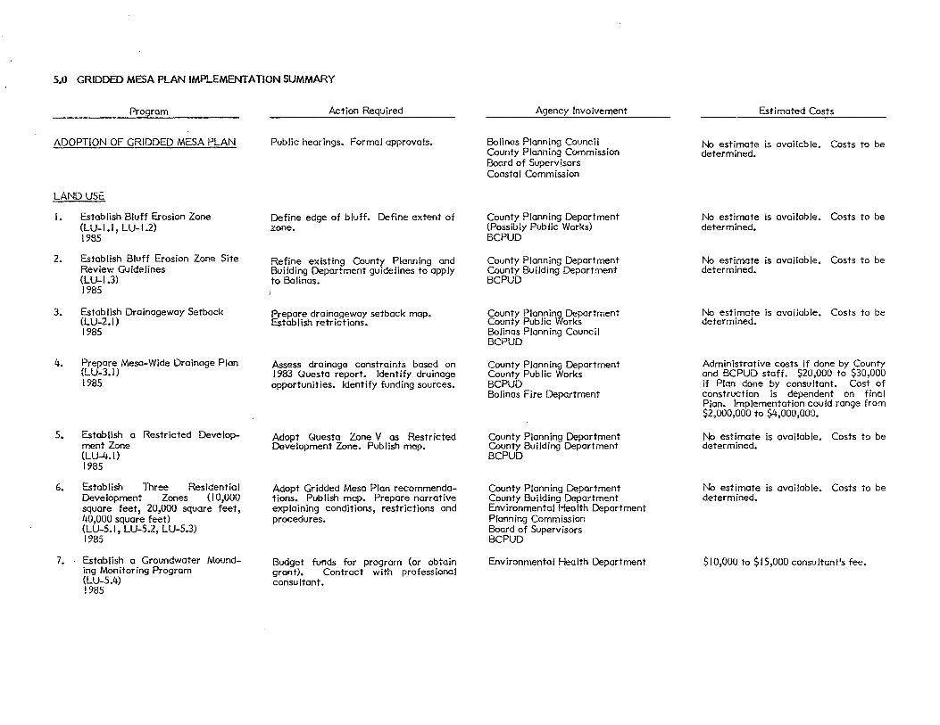
5.0 GRIDDED MESA PLAN IMPLEMENTATION SUMMARY
Program
ADOPTION OF GRIDDED MESA PLAN
LAND USE
I.
2.
3.
4.
5.
6.
7.
Establish Bluff Erosion Zone (LU-1.1, LU-1.2) 1985
Establish Bluff Erosion Zone Site Review Guidelines (LU-1.3) 1985
Establish Drainageway Setback (LU-2.1) 1985
Prepare Mesa-Wide Drainage Plan (LU-3.1) 1985
Establish a Restricted Development Zone (LU-4.1) 1985
Establish Three Residential Development Zones (10,000 square feet, 20,000 square feet, 40,000 square feet) (LU-5.1, LU-5.2, LU-5.3) 1985
Establish a Groundwater Mounding Monitoring Program {LU-5.4) 1985
Action Required
Public hearings. Formal approvals.
Define edge of bluff. Define extent of zone.
Refine existing County Planning and Building Department guidelines to apply to Bolinas.
Prepare drainageway setback map. Establish retrictions.
Assess drainage constraints based on I 983 Uuesta report. Identify drainage opportunities. Identify funding sources.
Adopt Questa Zone V as Restricted Development Zone. Publish map.
Adopt Gridded Mesa Plan recommendations. Publish map. Prepare narrative explaining conditions, restrictions and procedures.
Budget funds for program (or obtain grant). Contract with professional consu It ant.
Agency Involvement
Bolinas Planning Council County Planning Commission Boord of Supervisors Coastal Commission
County Planning Department (Possibly Public Works) BCPUD
County Planning Department County Building Department BCPUD
County Planning Department County Public Works Bolinas Planning Council BCPUD
County Planning Department County Public Works BCPUD Bolinas Fire Department
County Planning Department County Building Department BCPUD
County Planning Department County Building Department Environmental Health Department Planning Commission Boord of Supervisors BCPUD
Environmental Health Department
Estimated Costs
No estimate is available. Costs to be determined.
No estimate is available. Costs to be determined.
No estimate is available. Costs to be determined.
No estimate is available. Costs to be determined.
Administrative costs if done by County and BCPUD staff. $20,000 to $30,000 if Plan done by consultant. Cost of construction is dependent en final Plan. Implementation could range from $2,000,000 to $4,000,000.
No estimate is available. Costs to be determined.
No estimate is available. Costs to be determined.
$10,000 to $15,000 consultant's fee.
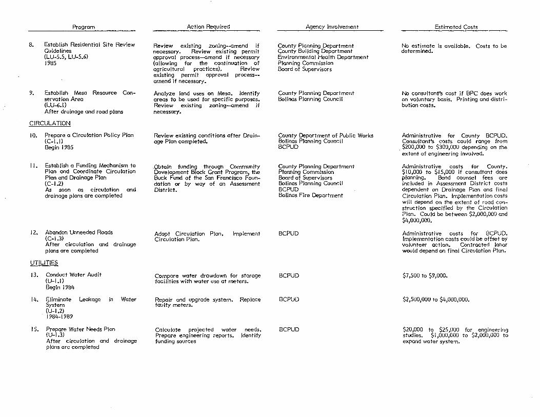
8.
9.
Program
Establish Residential Site Review Guidelines (LU-5.5, LU-5.6) 1985
Establish Mesa Resource Conservation Area (LU-6.1) After drainage and road plans
CIRCULATION
I 0. Prepare a Circulation Policy Plan (C-1.1) Begin 1985
II. Establish a Funding Mechanism to Plan and Coordinate Circulation Plan and Drainage Plan (C-1.2) As soon as circulation and drainage plans are completed
12. Abandon Unneeded Roads (C-1.3) After circulation and drainage plans are completed
UTILITIES
13. Conduct Water Audit (U-1.1) Begin 1984
14. Eliminate Leakage in Water System
15.
(U-1.2) 1984-1989
Prepare Water Needs Plan (U-1.3) After circulation and drainage plans are completed
Action Required
Review existing zoning--amend if necessary. Review existing permit approval process--amend if necessary (allowing for the continuation of agricultural practices). Review existing permit approval processamend if necessary.
Analyze land uses on Mesa. Identify areas to be used for specific purposes. Review existing zoning--amend if necessary.
Review existing conditions after Drainage Plan completed.
,Qbtain funding through Community Development Block Grant Program, the Buck Fund of the San Francisco Foundation or by way of an Assessment District.
Adopt Circulation Plan. Circulation Plan.
Implement
Compare water drawdown for storage facilities with water use at meters.
Repair and upgrade system. Replace faulty meters.
Calculate projected water Prepare engineering reports. funding sources
needs. Identify
Agency Involvement
County Planning Department County Building Department Environmental Health Department Planning Commission Boord of Supervisors
County Planning Department Bolinas Planning Council
County Department of Public Works Bolinas Planning Council BCPUD
County Planning Department Planning Commission Boord of Supervisors Bolinas Planning Council BCPUD Bolinas Fire Department
BCPUD
BCPUD
BCPUD
BCPUD
Estimated Costs
No estimate is available. Costs to be determined.
No consultant's cost if BPC does work on voluntary basis. Printing and distribution costs.
Administrative for County BCPUD. Consultant's costs could range from
. $200,000 to $300,000 depending on the extent of engineering involved.
Administrative costs for County. $10,000 to $15,000 if consultant does planning. Bond counsel fees ore included in Assessment District costs dependent on Drainage Plan and final Circulation Plan. Implementation costs will depend on the extent of road construction specified by the Circulation Plan. Could be between $2,000,000 and $4,000,000.
Administrative costs for BCPUD. Implementation costs could be offset by volunteer action. Contracted labor would depend on final Circulation Plan.
$7,500 to $9,000.
$2,500,000 to $4,000,000.
$20,000 to $25,000 for engineering studies. $! ,000,000 to $2,000,000 to expand water system.

Program
16. Submit Water Plan to Voters (U-1.4) When plan complete
17. Develop Program for Maintenance and Review of On-Site Sewage Disposal Systems (U-2.1) 1985
18. Maintain an Active Enforcement Program Regarding Failing Septic Systems (U-2.2) Begin after drainage plan is implemented
HOUSING
19. Establish a Housing Organization to Determine Ways of Providing Low Cost Housing Opportunities (H-1.1)
20.
21.
1985
Establish Self-Help Construction Program. (H-1.3) 1985
Inventory Structures in Area to Determine Potential {H-2.1) 1985
ECONOMIC DEVELOPMENT
Housing
Planning Housing
22. Amend Local Coastal Program to Include Cottage Industries and Small Scale Agriculture (E-1.1) 1985
8:84052405
Action Required
Prepare project description. Prepare ballot.
Determine condition of existing systems. Establish guidelines. Establish cooperative agreement.
Enforce existing laws pertaining to health standards. Identify alternative systems acceptable to County and State agencies.
Utilize Land Trust. Work with established housing organizations {Ecumenical). Seek funding from available sources.
Create or adapt existing programs to allow owner-builder or occupant-builder activities to occur.
Survey existing buildings in town to determine if potential exists to create low cost housing opportunities. Identify funding sources if remodeling or rehabilitation activities ore required.
Change wording in LCP.
Agency Involvement
BCPUD
Environmental Health Department BCPUD
Environmental Health Department Regional Water Gluality Control Board BCPUD
County Planning Department Bolinas Planning Council Land Trust
County Building Department County Planning Department Bolinas Planning Council Land Trust Ecumenical Association for Housing Marin County Housing Authority
County Planning Deportment Bolinas Planning Council Land Trust
Coastal Commission
Estimated Costs
Printing costs. Election costs.
No estimate is available. Costs to be determined.
No estimate is available. Costs to be determined.
No estimate is available. Costs to be determined.
Depends on program.
Depends on program.
No estimate is available. Costs to be determined.


6.0 ACKNOWLEDGEMENTS
This Gridded Mesa Plan is the result of many hours of work by a large number of dedicated individuals. The Mesa Plan could not have been completed without their efforts. We wish to express our appreciation for their help and guidance.
Bolinas Planning Council
Jon Goodchild Ray Moritz Steve Matson Fred Styles Libby Meyers Jack McClellan Kevin Kelly Jeff Creque Michael Caspers Robert Scarola
Marin County Planning Department
Margie Macr is Mark Riesenfeld Ne i I Sorensen
Marin County Environmental Health
Mark Kostielney and his Staff Edward Stewart
BCPUD
Paul Kayfetz Dottie LeMieux Peter Martin Jack McClellan Vic Amoroso Phi I Buchanan
The ·Mesa Plan Resource Group
Socioeconomics:
Libby Meyers Greg Hew lett Ellen Into Diana Lopez Ned Hoke
Aesthetics and Cultural:
Jenny Ulrich-Ciymer Candace Wyatt Nancy Candy Dotty LeMieux Jan Holloway Susan T acherra
73

Barbara Kayfetz Sara Schrom David Galin
Land Use:
Ted Boutmy Bi II T acherra Jack McClellan Maile Johnson James T acherra Jon Goodchild Steve Matson David KeIter Burr Heneman Loretta Galliani Bob Stewart Bill Lyons
Physical and Biological:
Ray Moritz Jan Holloway Bi II T acherra Jim Friedrich Albert HoI lander Ed Suij Rob Rich Jim Lunsford Wayne Thomas Sara Schrom Susan Doglione Jeff Creque Susan Go ldhaber Susan Eng lebry Melissa Hamilton Marta Wolfe
Utilities/Community Services:
Jack McClellan Scott Coburn Fred Styles Libby Meyers George Davison Patty Bradford Bill Lyons Dotty Lemieux Jack Trainor Bill Gripp Mary Daniel Perluss George Sage
74

The Media
Don Deane--The Coast a I Post Hearsay News Editors Point Reyes Light
Bo I inas Property Owners Association
Matt Lockary Bill Lyons
Questa Engineering
Norm Hantzsche, PE
WESCO
Jeff Peters T. Scott Gibson
EDAW Staff
Larry Kennings Teresa Rea Mike Fotheringham Debbie Tassis Alan Hyden Dan O'Donoghue
8:84012521 75
