blacksburg 2046: administrative manual section b ...tobweb.org/docs/comp plan/individual...
TRANSCRIPT

December 11, 2012 Blacksburg 2046 Administrative Manual Section B
Blacksburg 2046: Administrative Manual
Section B
Supplemental Chapter Information


December 11, 2012 Blacksburg Administrative Manual Section B
Heritage Park
Municipal Park
Hand-in-Hand Playground
Park Classification Standards Regional Park Regional parks typically provide a wide variety of activities for the greater community, and also present opportunities for non-traditional recreation. These parks are often funded, developed, or operated as multi-jurisdictional facilities. Nature and community centers, festival grounds, extensive trail systems, and water activities are features that can typically be found in regional parks. To accommodate their unique amenities, regional parks span a minimum of 100 acres and have a service radius of approximately 25 miles. Additionally, the typical acreage/population ratio for regional parks is four to five acres per 1,000 persons. The Heritage Park & Natural Area (169 acres) is a regional park due to its attraction of specific users from well beyond the town’s boundaries. Features proposed for the Heritage Park & Natural Area include a lake, wetlands enhancement and preservation, a nature center, several miles of paved and unpaved trails, a national forest connection, a small amphitheater, and other family-oriented recreational amenities.
District Park District parks serve a wide variety of community interests and include intensively developed areas for active recreation, as well as supporting infrastructure. Typical active recreational amenities include playgrounds; athletic fields for soccer, baseball/softball, and for multi-use; tennis and volleyball courts; and trails. Typical infrastructure may include restrooms, concession stands, benches, picnic areas, shelters, and parking areas. Access to district parks should be along or near a major road, and access should be multi-modal in nature. District parks are a minimum of 50 acres in size and have a service radius of approximately five miles. Blacksburg does not have a district park but, based on population projections for 2010 and on a typical acreage/population ratio at four acres per 1,000 persons for district parks, needs one with approximately 180 acres. Current park acreage including Kipps Park, Kipps Elementary School and the Blacksburg Middle School totals just over 70 acres.
Community Park Community parks serve several neighborhoods within a community. They typically provide active recreation facilities for neighborhoods, but otherwise they act as oversized neighborhood parks. Typical recreational amenities found in community parks are similar to those provided in district parks; however, differences include varying scales, more traditional neighborhood park amenities like horseshoes, basketball courts, recreation centers, and similar amenities unique to the community. Community parks are usually a minimum of 20 acres in

December 11, 2012 Blacksburg Administrative Manual Section B
Nellie’s Cave Park
size and have a service radius of approximately one-mile. Access should be along, or near, a major road that is multi-modal in nature. A typical acreage/population ratio for community parks is three to four acres per 1,000 persons. For the Town of Blacksburg this ratio translates into 125 – 175 acres of park land, including the Municipal Park. The only community park in Town, the Municipal Park is Blacksburg’s main recreational facility, and serves as an undersized district park. The 35-acre facility includes a lighted ball field, a multi-use field, two playgrounds, five shelters, eight tennis courts, a roller hockey court, a skate park, an aquatic center, a community center and the Parks and Recreation administrative offices.
Neighborhood Park Neighborhood parks are located within walking distance of adjacent neighborhood(s) and serve the area’s specific recreational interests. A neighborhood park usually does not provide parking or restrooms, but depending on service level demand, a park may offer such facilities. Typical neighborhood park amenities include playgrounds, shelters, trails, and multipurpose fields. School parks may also be considered functional neighborhood parks. Neighborhood parks span a minimum of five acres and have a service radius of one-half mile. A typical acreage/population ratio for neighborhood parks is three acres per 1,000 persons. Tom’s Creek and Nellie’s Cave Park are both neighborhood parks that function as community parks and include facilities for athletics.


December 11, 2012 Blacksburg 2046 Administrative Manual Section B
Greenway Priority Construction Chart
Trail Name
Location
Status High Priorities
National Forest Connector Meadowbrook Drive to National Forest Complete Huckleberry Trail Extension Existing Trail west of Rt. 460 Bypass to Hethwood and Heritage
Park Master Planned
North Main St. Connector Patrick Henry Drive to Wyatt Farms Construct Summer 2004 Central Blacksburg Greenway Bicentennial Trail from College Avenue to Community Center Master Planned Corporate Research Center
(CRC) Connector Complete southwest segment of Airport Loop
South Main Greenway Ramble Road to Margaret Beeks Elementary School Margaret Beeks Trail Margaret Beeks School to Hubbard Street and Cedar Run Creek Cedar Run Greenway Ellett Road at Main Street via Cedar Run Creek to Industrial Park
Drive Master Planned
Tom's Creek Greenway Extending the length of the stream North-South Connector Prices Fork Road at Plantation Road, along Rt. 460, north to Brush
Mountain Road
Ellett Loop Trail Cedar Run Greenway by Blacksburg Transit to Ellett Park via Ellett Road, parallel to the RRX in the park to the Smart Road ROW into town
Master Plan Proposed
Medium Priorities Stadium Trail Behind Lane Stadium (on campus) from Washington St. to Southgate
Drive TEA-21 Request VT
Hethwood Trail Extension Plantation Rd. to Duck Pond Dr. north of Stroubles Creek TEA-21 Request VT University Trail System Trails throughout campus per the University Master Plan Patrick Henry Trail High School to North Main Givens Trail, Section A Shenandoah Trail system to Givens Lane, Wyatt Farms, and Bishop
Road
Givens Trail, Section B From the Shenandoah Loop following the abandoned Givens Lane right-of-way
Stroubles Creek Greenway West from the existing Hethwood trail to the corporate limits Wharton Street Connector Huckleberry Trail at library via former BMS and Wharton Street to
Harding Elementary
Hubbard Street Trail Connects the South Main Trail with the Huckleberry Trail; NE segment of airport loop
Shadow Lake Road Trail Parallel to Shadow Lake Rd. from Glade Road to Meadowbrook Dr. Other Priorities
Mary Draper Ingles Trail Duck pond via Glade/Shadow Lake Roads to Tom's Creek Greenway and the National Forest east of Laurel Ridge
Nellie's Cave Road Trail Grissom Lane to Luster's Gate Road Municipal Golf Course Trail Middle School to the Golf Course North Main Trail Wyatt Farms to US 460 Bypass CRC Loop Harding to Main Connector Harding Avenue to North Main Street U.S. Bicentennial Bikeway
Connector Connects the town's trail system to the Bicentennial Bikeway (Rt. 76) with connections to Roanoke County
Old Stagecoach Road Trail Follows un-built Roanoke Street right of way and makes a connection to Apperson Drive
Blacksburg Outer Loop Arterial trail system around the entire Town

December 11, 2012 Blacksburg 2046 Administrative Manual Section B
SIDEWALKS Sidewalk planning consists of the prioritization of projects in the Capital Improvements Program and modifications to the Subdivision Ordinance. There are three methods of financing sidewalks in Town. The first is the inclusion of sidewalks in new developments, where the developer incurs all of the costs. The second is a cost-sharing arrangement for construction of sidewalks along the road frontage of private property at the request of the property owner. Under this arrangement, the Town provides the labor and equipment, and the property owner pays for the cost of materials. The third method of financing sidewalk projects is through Town installation, whereby all of the costs are borne by the Town. Funding for these projects can be from a variety of sources such as the Capital Improvements Program, the VDOT Revenue Sharing programs or grants. Sidewalk projects funded by the Town are prioritized by a ranking system developed by the Greenway/Bikeway/Sidewalk/Corridor Committee that is approved by Town Council. Until such a time that a new ranking system is approved, the Sidewalk Project Ranking System adopted October 12, 2009 is in effect and listed below.
Sidewalk Project Ranking System Criteria Weight
½ mile distance to a school 2 ½ mile distance to a Town park 1 Project along a collector or arterial road 1 ½ mile distance to downtown commercial area 1 ½ mile distance to Virginia Tech academic campus 1 ½ mile distance to a general commercial area 1 Project distance less than ¼ mile in length 1 Project within ¼ mile of a bus stop 1 Project directly adjacent to high density development 1 Maximum Points 10


December 11, 2012 Blacksburg 2046 Administrative Manual Section B
Road From ToSide of Street Quadrant Easement Issues Connect Coherence Potential Funding Source
Giles Road North Main Tee west NEOn-street parking N. Main to Giles General Fund
Harding Ave. Roanoke Patrick Henry north NEUtility poles. Other issues
connect to downtown, Harding Elem.
General Fund / future Safe Routes to School (SRTS)?
Harding Ave. Windsor Hills Patrick Henry NEUtility poles. Other issues
High density housing connect to downtown, Harding Elem., BT
General Fund / Future SRTS?
Main Woodbine Red Maple NEUtility poles. Other issues
connects high density neighborhoods to two bus stops
Under design, funded, 2011 rev sharing funded
Mount Tabor N. Main Bishop south NEUtility poles. Other issues
connects many high density neighborhoods to Main. General Fund
Meadowbrooktrailer park, 3110 Meadowbrook
Brown Farm crosswalk NW
North: yards, South: town
connect trailer park to town, eventually would connect through Obenshain Farm to Kipps and Huck. General Fund
Old Glade Rd Price's Fork Glade NW
VT – Univ. Mall. Space for sidewalk
connects apartments and rental houses to BT stops General Fund
Oriole Cul-de-sacPrices Fork/hotel NW
VT-owned, existing dirt road through some of route.
would connect NW quadrant to Hethwood-VT asphalt trails via hotel's existing path. Connection to schools General Fund
Shadow Lake Lake Wood Dr Glade north NW private yardsConnect Shadowlake Village to Glade General Fund
Clay Willard Prospect SEissues. Street is narrow General Fund
Clay WillardMiddle School Property SE
Issues on SE side General Fund
Nellies Cave Gardenspring Town Limits SE narrow, steep General Fund
Park Palmer Grissom north SEhouses near road, steep.
Critical connector for most of highland Park to South Main area. General Fund
Prospect Clay Washington SE
utility poles. Steep side grade. Connector. General Fund
Hubbard Kennedy Airport south SWnone. Along the airport fence. completes to S. Main. Pending Grants
Research Center Drive Industrial Dr.
Tech Center Drive SW
East: private, West: VT/CRC
Asphalt segment on west at RRC. General Fund
Top Sidewalk Priorities as Submitted by Corridor Committee MembersUpdated November 2011


December 11, 2012 Blacksburg 2046 Administrative Manual Section B
Bicycle Route Priorities
Name Location Status High Priorities
Bishop Road Route 460 Bypass to Mount Tabor Road and North Main Street Signed Broce Drive University City Boulevard to Main Street Signed Clay Street Main Street to Clay Street Terminus Signed; lanes designed Country Club Drive Extend from Main Street to Palmer Drive and along Palmer to
the golf course via Graves Avenue Signed
Ellett Road Main Street to Town Limits Signed Giles Road Main Street to Main Street Signed Glade Road Boxwood Drive to Meadowbrook Dr Signed Industrial Park Rd. Main Street to Town Limits Signed Mount Tabor Road Main Street to Town Limits Signed Patrick Henry Drive High School to Harding Avenue Signed; some lanes Professional Park Drive
South Main Street to Prosperity Drive Signed with lanes
Roanoke Street Harding Avenue to Main Street Signed Tom's Creek Road Route 460 to Meadowbrook Drive Signed with lanes University City Blvd Prices Fork Road to Tom's Creek Road Signed; lanes planned Washington Street Duck Pond Drive to Kent Street 12’ shared pathway West Campus Drive Entire length Signed with lanes
All high priorities are signed as bike routes with lanes to follow, as feasible, when roads are repaved or improved in the future.
Other Priorities Drill Field Drive Entire length Duck Pond Drive Entire length Farmview Drive Entire length Happy Hollow Road Mount Tabor Road to Harding Ave. Harding Avenue From Corporate limits to Happy Hollow Road High Top Road End of S. Main Street at Yellow Sulphur Rd to Merrimac Rd Main Street Entire length where possible and where there is no parking Meadowbrook Dr. Glade Road to Tom's Creek Road Merrimac Road Prices Fork Road to High Top Road Progress Street Prices Fork Road. via Webb, Kabrich, Watson streets along
Progress to North Main Street via Givens Lane
Ramble Road Tech Center Drive to Yellow Sulphur Road

December 11, 2012 Blacksburg 2046 Administrative Manual Section B
VDOT Street Classifications1
Arterial Streets
Street From To Miles
1993 Traffic (vpd)
1995 Traffic (vpd)
2001 Traffic (vpd)
2005 Traffic (vpd)
Clay Street South Main Street Allegany Street 1.36 N/A N/A N/A 1,900 Harding Avenue East Town Limit Owens St. 0.84 6,217 6,292 7,108 5,100 North Main Street* College Ave. Rt. 460 Bypass 3.27 21,587 23,444 21,701 18,000 Owens Street Roanoke St. Harding Ave. 0.10 N/A 5,119 6,143 4,500 Patrick Henry Drive Harding Ave. Toms Creek Rd. 1.46 N/A N/A NYA 5,900 Prices Fork Road* West Town Limit North Main St. 3.03 29,689 40,516 30,543 27,000 Roanoke Street South Main St. Owens St. 0.42 5,716 6,945 7,468 5,700 South Main Street Hightop Rd. College Ave. 3.10 17,761 19,063 19,801 19,000 Toms Creek Road Rt. 460 Bypass Prices Fork Rd. 0.95 10,994 11,580 14,808 11,000 University City Blvd.* Prices Fork Rd. Toms Creek Rd. 1.11 11,615 12,852 9,159 7,900
Collector Streets
Street From To Miles 1993 Traffic (vpd)
1995 Traffic (vpd)
2001 Traffic (vpd)
2005 Traffic (vpd)
Airport Rd. Country Club Dr. South Main St. 0.88 1,830 2,001 2,159 2,289 (2002 Count)
Country Club Dr. Airport Rd. Palmer Dr. 0.43 3,327 3,315 4,831 3,800 Ellett Rd. South Main St. East Town Limit 0.84 5,128 5,726 4,438 2,100 Glade Rd. West Town Limit Prices Fork Rd. 2.42 3,858 5,171 5,642 4,700 Southgate Dr. Rt. 460 Bypass Spring Rd. 0.71 7,816 10,893 12,328 8,010
(2004 Count) Mt. Tabor Rd. East Town Limit North Main St. 0.97 3,704 4,097 NA 3,100
Figure T-7, VDOT Street Classification Listing *counts may be taken at different locations
1 The above chart of VDOT Street Classifications is established in accordance with VDOT standards based upon existing road conditions and existing traffic counts. The map below of Town Street Classifications is the Town’s desire of how the road network within the Town of Blacksburg will operate in 2046. Therefore, there may be some discrepancies between the chart and map.

December 11, 2012 Blacksburg 2046 Administrative Manual C
Alley and Right-of-Way Vacation Process 1) When requests for a vacation of an alley or unbuilt right-of-way are received by the Town,
• ensure requirements for application contained in Town Code § 21-114 have been complied with.
• make an assessment of the monetary value of the alley or unbuilt rights-of-way according to the general guidelines:
o residential property value may be estimated according to current assessed values of adjacent property and square footage to be vacated; or
o when the vacation allows for an additional buildable lot or when the property is non-residential, property value may be established by a formal appraisal; or
o a formal appraisal may be required by Town Council; and • the applicant shall provide a statement of title concerning the alley or right-of-way (before
and after the vacation), satisfactory to the Town Attorney; and • provide notification to all neighborhood representatives about the vacation request and
associated public meetings; and • provide all adjacent property owners an opportunity to apply for an equal right-of-way; and • The cost of any formal appraisal or title research, as may be required, shall be the burden of
the applicant.
2) Vacate alleys and unbuilt rights-of-way only when the following three conditions are met: • The alley or unbuilt right-of-way is judged as not important to the Town's neighborhoods in
terms of providing rear access for residents, space for utilities, and a means to provide Town services; and
• The alley or unbuilt right-of-way is not important to the Town's present or future transportation network in terms of automobile, bicycle, or pedestrian traffic; and
• The alley or unbuilt right-of-way does not serve as the primary access to parcels.
3) Vacate built right-of-way only when all three conditions of Paragraph 2 are met, with the presumption that the built right-of-way is important to the Town’s neighborhoods and the Town’s present and future transportation network.
4) Assess whether or not the alley or right-of-way could be used for another public function such
as park land or public open space
5) If there is no other public function to which the property could be used, and the Town is able to claim an interest in the alley or right-of-way, and the applicant is willing to remit to the Town the value of the alley as computed in 1) above, consider disposition of the alley or right-of way.
6) The disposition of an alley or right-of-way shall not be acted upon without public hearings
before the Planning Commission and the Town Council, duly advertised, in accordance with the Virginia Code.
7) The disposition of an alley or right-of-way shall not be acted upon without public hearings
before the Planning Commission and the Town Council, duly advertised, in accordance with the Virginia Code.

December 11, 2012 Blacksburg 2046 Administrative Manual Section B
Alley and Unbuilt Rights-of-Way Retention Recommendation Right of Way
Recommendation
Reason
Airport Road in Airport Acres Retain May be needed for Hubbard/Country Club extension Cedar Hill Drive Retain Necessary for future subdivision Country Club Drive, by campus Retain Future access should be retained for extension of Country
Club and path Craig Drive Retain Craig Drive extension anticipated with future subdivision
plans Dehart Street Retain Area needed for future Hubbard Street extension Eastview Terrace Retain Possible extension for residential development Eheart Street Retain Possible Eheart Street extension Emerald Street Extension Retain Possible future alternative route through this neighborhood End of Eakin Street Retain Access to bike path First Street Retain May be needed for Hubbard/Country Club extension Grayland Street Retain (up to residential) Access to commercial buildings Grove Avenue Retain Possible extension of Grove Avenue or bike path Lincoln Lane Retain Possible extension for residential development Lindale Drive Retain Access to Shadow Lake Road Mabry Lane Retain Possible future VDOT project (Roanoke Connector) Montgomery Street Extension Retain Access to undeveloped site; aligned with existing street Near Ramble Road 0.6 miles from Industrial Park
Retain Access to undeveloped site
Old Roanoke Road-Piedmont to New Roanoke Street, Eastern Link, & Harding to Eastern Link
Retain Possible street extension or bikeway
Oriole Drive Retain Possible extension of Oriole Drive Pineridge Drive Retain Access to Pineridge Drive in Laurel Ridge Subdivision from
Tom's Creek Second Street Retain May be needed for Hubbard/Country Club extension Sunrise Drive Middle Link Retain Possible extension or bike path Valleyview Drive Retain Possible extension for future development Virginia Street in Airport Acres Retain May be needed for Hubbard/Country Club extension Washington Street Middle Link Retain Possible future connection of Washington Street segments Yellow Sulphur & Ramble Rds. Retain Part of VDOT ROW for Route 460
***Note: The above list is not an inclusive list of all rights-of-way within town. Other rights-of-way exist and may not have a specific future use as set forth in the Comprehensive Plan. These unlisted rights-of-way should be evaluated under the established Comprehensive Plan Policies and Objectives


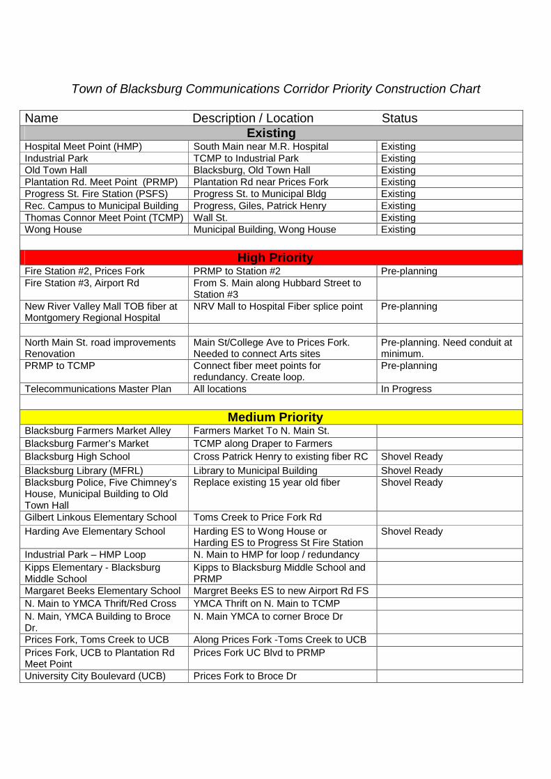
Town of Blacksburg Communications Corridor Priority Construction Chart
Name Description / Location StatusExisting
Hospital Meet Point (HMP) South Main near M.R. Hospital ExistingIndustrial Park TCMP to Industrial Park ExistingOld Town Hall Blacksburg, Old Town Hall ExistingPlantation Rd. Meet Point (PRMP) Plantation Rd near Prices Fork ExistingProgress St. Fire Station (PSFS) Progress St. to Municipal Bldg ExistingRec. Campus to Municipal Building Progress, Giles, Patrick Henry ExistingThomas Connor Meet Point (TCMP) Wall St. ExistingWong House Municipal Building, Wong House Existing
High PriorityFire Station #2, Prices Fork PRMP to Station #2 Pre-planningFire Station #3, Airport Rd From S. Main along Hubbard Street to
Station #3New River Valley Mall TOB fiber atMontgomery Regional Hospital
NRV Mall to Hospital Fiber splice point Pre-planning
North Main St. road improvementsRenovation
Main St/College Ave to Prices Fork.Needed to connect Arts sites
Pre-planning. Need conduit atminimum.
PRMP to TCMP Connect fiber meet points forredundancy. Create loop.
Pre-planning
Telecommunications Master Plan All locations In Progress
Medium PriorityBlacksburg Farmers Market Alley Farmers Market To N. Main St.
Blacksburg Farmer’s Market TCMP along Draper to Farmers
Blacksburg High School Cross Patrick Henry to existing fiber RC Shovel Ready
Blacksburg Library (MFRL) Library to Municipal Building Shovel ReadyBlacksburg Police, Five Chimney’sHouse, Municipal Building to OldTown Hall
Replace existing 15 year old fiber Shovel Ready
Gilbert Linkous Elementary School Toms Creek to Price Fork Rd
Harding Ave Elementary School Harding ES to Wong House orHarding ES to Progress St Fire Station
Shovel Ready
Industrial Park – HMP Loop N. Main to HMP for loop / redundancy
Kipps Elementary - BlacksburgMiddle School
Kipps to Blacksburg Middle School andPRMP
Margaret Beeks Elementary School Margret Beeks ES to new Airport Rd FS
N. Main to YMCA Thrift/Red Cross YMCA Thrift on N. Main to TCMP
N. Main, YMCA Building to BroceDr.
N. Main YMCA to corner Broce Dr
Prices Fork, Toms Creek to UCB Along Prices Fork -Toms Creek to UCB
Prices Fork, UCB to Plantation RdMeet Point
Prices Fork UC Blvd to PRMP
University City Boulevard (UCB) Prices Fork to Broce Dr

Virginia Tech Art Gallery/Dept. Farmers Market to Old Armory
Other PrioritiesBusinesses Various As conduit passes by/open ditchJackson St as sidewalk repaired Draper to N. Main conduit Town maintenance scheduleNew sidewalk planning/install Various New subdivision & Town
maintenance schedulesSewage Pumping for monitoring Various As conduit passes by/open ditchShopping centers Various As conduit passes by/open ditchTown owned buildings Various As conduit passes by/open ditchTown parks Various
Traffic lights Data backbone As conduit passes by/open ditchWarm Hearth and Heritage Hall Warm Hearth Drive As conduit passes by/open ditchWater facilities for monitoring andcell site data feed
Network backbone for water tankmounted wireless equip, and telemetry.
As conduit passes by/open ditch
Water, Sewer pipe installation Connect existing conduit installation As conduit passes by/open ditch
Notes:1. Chart provided January 2009, by Town of Blacksburg Information Technology
Department in cooperation with BTAC.


Rd.veaCesiNell
Park
Dr.
Merrimac Rd.
Plantation Rd.
Old M
ill Rd
.
Heath
er D
r.
Oaks Dr.
Tall
Fork Rd.Prices
Prices Fork Rd.
Lark
Ln.
Glade Rd.
Rd.
Lake
Shadow
Toms Creek Rd.
D
r.Meadowbrook
US 4
60 B
ypas
s
St.Maywood
Rd.Happy Hollow
Rd.Bishop
Mt. Tabor R
d.
Whipple Dr.Givens Ln.
Dr.McBryde
Grove Ave.
Dr.
Broce
Blvd.
University City
Prog
ress
St.
Turner St.
North
Main
St.
Dr.HenryPatrick
Eheart St.
Alleghany St.
Lee St.
Harding Ave.
Washington St.
Highland Cir.
Dr.
Palmer
Dr.
Country Club
Dr.view
Farm
Rd.Industrial Park
US 460 Bypass
Rd.Ellett
Ramble Rd.
South Main St.
Airport Rd.
Southgate Dr.
South
Main
St.
Jennelle Rd.
Harding Ave.
Luste
rs Ga
te Rd
.
Cedar
Run
Rd.Bishop Rd.
Nellie
s Cave
Rd.
³Town of BlacksburgTown-Owned
Properties
Town of Blacksburg, E&G Dept., 2/22/12
Approximate Town OwnedAcreage: 702.1
35 - Cedar Run Greenway (1.07 acres)36 - Cork Street Lot 1 (.5 acres)37 - Cork Street Lot 2 (.72 acres)38 - Ellett Spring Lots (44.6 acres)39 - Interchange Park (34.36 acres)40 - Northside Park (16.1 acres)
Recreational Undeveloped Properties (97.35 acres)
45 - Fire Station 1 (.67 acres)46 - Fire Station 2 (1.62 acres)47 - Police Department (1.1 acres)
Emergency Services Properties (3.39 acres)
1 - Brookfield Village (10.06 acres) 2 - Cedar Hill Park (1.25 acres) 3 - Crestview Tot Lot ("Rocket Park") (.23 acres) 4 - Deerfield Bike Trail (24.12 acres) 5 - Dehart Street Tot Lot Park (.39 acres) 6 - Ellett Valley Recreational Area (109 acres) 7 - Gateway Park (15.33 acres) 8 - Graves Park (.87 acres) 9 - Heritage Community Park & Natural Area (168.58 acres)10 - Huckleberry Trail11 - Lark Lane Park (3.7 acres)12 - Lucas Drive Lot (.39 acres)13 - Marcia's Park (.3 acres)14 - McBryde Tot Lot Park (.44 acres)15 - Municipal Golf Course (51.21 acres)16 - Municipal Park Complex (34.40 acres)17 - Nellie's Cave Park and Arboretum (11.08 acres)18 - Owens Street Park (2 acres)19 - Page Park (.14 acres)20 - Price House Nature Center & Garden Park (.68 acres)21 - Primrose Lane Park (5.77 acres)22 - Seneca Drive Park (7.74 acres)23 - Shenandoah Bike Trail & Park (18.27 acres)24 - Spring Lot (.98 acres)25 - Sunrise Park (1.06 acres)26 - Toms Creek Park (9.33 acres)27 - Town Green (.24 acres)28 - Westover Park (4.84 acres)29 - Winfrey Fields (11.07 acres)30 - Wong Park (9.24 acres)
Recreational Developed Properties (502.71 acres)
50 - Alleghany Water Tank (.7 acres)51 - Cedar Orchard I Pump Station (.53 acres)52 - Cedar Orchard II Pump Station (.7 acres)53 - Cedar Run Pump Station (4.88 acres)54 - Coal Bank Ridge Water Tank (1.23 acres)55 - CRC Pump Station (.13 acres)56 - Highland Park Pump Station (3 acres)57 - Highland Park Water Tanks (1.94 acres)58 - Karr Heights Pump Station (.6 acres)59 - Murphy Pump Station (.41 acres)60 - Neil Street Water Tank (.99 acres)61 - North Main Street Water Tank (1.35 acres)62 - Shenandoah I Pump Station (.29 acres)63 - Shenandoah II Pump Station (.09 acres)64 - Storm Drain Lot (.12 acres)65 - Toms Creek Village I Pump Station (.07 acres)66 - Toms Creek Village II Pump Station (.05 acres)67 - Water System Pump House (.07 acres)
Utility Properties (17.15 acres)85 - Alexander Black House (.67 acres)86 - Armory (.61 acres)87 - Blacksburg Motor Company (.99 acres)88 - Blacksburg Transit (11.12 acres)89 - Clay Street Parking Lot (.31 acres)90 - Five Chimneys (WTOB) (1.06 acres)91 - Odd Fellows Hall (.03 acres)92 - Old Town Hall (.53 acres)93 - Public Works (9.82 acres)94 - Thomas-Connor House (.93 acres)95 - Town Hall (1.55 acres)
Administrative Properties (27.62 acres)
0 3,600 '(128(30
(18
(24(20(45
(91
(36
(37
(12
(125 (68
(19
(16
(50
(51
(52
(70
(123
(15
(57
(58(3 (102
(65 (72
(25
(17
(35
(2
(53
(100
(92 (88
(116(38
(6(74
(39
(75
(55
(5
(8
(10
(118
(119
(103
(29
(78
(46
(9
(28
(59
(11
(7
(122
(67
(79
(77(66
(105
(14
(93
(121
(108
(109
(115
(80
(120
(26
(4
(1
(76
(64
(63
(23
(22
(106
(117
(73
(41 (21
(107
(61
(62
(60
(81
(71
(54
(101(104
(110
(111
(112(113(114
(86(94
(85
(27(87
(95
(90(13
(89(48
100 - Blacksburg Industrial Park Phase I (25.51 acres)101 - Church Street Parking Lot (.19 acres)102 - Highland Park (.35 acres)103 - Old PSA Wellhouse Lot (.22 acres)104 - Parking Lot & Farmers Market (.42 acres)105 - Property, Easement Rt. 723 (.28 acres)106 - Right-Of-Way (1.42 acres)107 - Right-Of-Way (.12 acres)108 - Right-Of-Way (.04 acres)109 - Right-Of-Way (.68 acres)110 - Right-Of-Way (.01 acres)111 - Right-Of-Way (.04 acres)112 - Right-Of-Way (.05 acres)113 - Right-Of-Way (.03 acres)114 - Right-Of-Way (.05 acres)115 - Right-Of-Way (.14 acres)116 - Right-Of-Way (.81 acres)117 - Right-Of-Way (.5 acres)118 - Right-Of-Way (4.6 acres)119 - Right-Of-Way (.36 acres)120 - Right-Of-Way (.13 acres)121 - Right-Of-Way (.01 acres)122 - Right-Of-Way (.21 acres)123 - Right-Of-Way (.13 acres)124 - Westview Cemetery (16.74 acres)125 - 401 Wilson Avenue (.34 acres)
Miscellaneous Properties (53.88 acres)
70 - Alleghany Heights Water Pump Station71 - Coal Bank Ridge Water Pump Station72 - Forest Hills Sewer Pump Station73 - Givens Sewer Pump Station74 - Hall Property Sewer Pump Station75 - Hospital Sewer Pump Station76 - Laurel Ridge Water Pump Station77 - Shawnee Sewer Pump Station78 - Stroubles Creek Sewer Pump Station79 - Sturbridge Square Sewer Pump Station80 - Windsor Hills Sewer Pump Station81 - Wyatt Farm Sewer Pump Station
Pump Stations Only, Not Parcels
(40
(47
(56
(126
(124
(127
September 2012


December 11, 2012 Blacksburg 2046 Administrative Manual-C
Extraterritorial Areas As part of Montgomery County, the Town of Blacksburg’s Planning Commission provides comments on development projects located in the County within one mile of the Town limits and on significant development projects in the County near the Town that will impact Town residents. Impacts include those factors identified in Government Relations Objective and Policy #16 such as density, transportation, watershed, wastewater, stormwater and viewsheds. Comments are forwarded to the Montgomery County Planning Commission and Board of Supervisors for their consideration during the review and approval process of a development project. The following list of Extraterritorial Area Identifying Characteristics was first established in the 1996 update of Blacksburg 2046. These characteristics have been updated in subsequent reviews of the Town’s Comprehensive Plan and moved to the Administrative Manual during the 2012 review. These characteristics identify and detail concerns of the Town regarding future development projects in the County as the two jurisdictions grow. The impacts are not listed in priority order and may not be applicable to all proposed projects:
1. Extraterritorial Areas watersheds include the Roanoke River, James River, New River, and groundwater aquifers. A distinguishing feature of the area is the Eastern Continental Divide, which separates watersheds that drain into the Atlantic Ocean from those that drain to the Gulf of Mexico. The Roanoke River is the main Atlantic drainage waterway in this area, and the New River is the large Gulf drainage. Craig Creek, a small tributary of the James River (Chesapeake Bay-Atlantic drainage) lies north of Blacksburg in Montgomery County. The continental divide was an important feature to settlers headed west, and access across the divide is reflected in historic trails. The groundwater resources of Blacksburg are influenced by land uses outside the Town boundary, and vice versa. Areas within and around Blacksburg contain karst terrain with uncharacterized flow regimes, having interconnections between ground and surface waters distinguished by easily impacted elements such as caves, sinkholes, and springs. Bottom Creek in Montgomery and Roanoke Counties and Little Stony Creek in Giles County are protected by the state as exceptional state waters.
2. The George Washington - Jefferson National Forest borders the Town to the north and
provides recreational facilities primarily geared to hiking, trail riding, mountain biking, and fishing. The national forest runs primarily between the ridgelines of Brush Mountain and Gap/Sinking Creek Mountain. It is wooded and provides a mountain habitat for plants and wildlife. Pandapas Pond Recreational Area is located within this area on the west side of U.S. Route 460. The Town should carefully monitor the potential sale of any National Forest lands and the associated impact on the Town’s viewshed. The Town supports maintaining the integrity of the National Forest lands.
3. The Town is nestled between largely undeveloped, wooded mountains, which provide scenic views from areas in Town. Brush Mountain is located to the north and west, Paris Mountain to the east, and Price Mountain to the south. These mountains provide a visual boundary and a community identity to Blacksburg. Suburbanization of mountain slopes

December 11, 2012 Blacksburg 2046 Administrative Manual-C
and ridgelines threatens these natural and scenic resources that are widely valued in the region as contributing significantly to the quality of life in the area. Most of the mountain slopes facing Blacksburg are in private ownership and not protected with conservation easements. Further, the spectacular views afforded from points on these slopes make them attractive for housing development. In many cases the lack of well and septic sites, and the unavailability of public utilities, have limited development. In addition, poor road access has constrained development. The designation of much of the County (including the western half of Price Mountain, the undeveloped portions of Brush Mountain, the North Fork Valley, Paris Mountain, and other features in the Blacksburg area) as Resource Stewardship has curtailed future development of large-scale subdivisions on mountain slopes; the eastern portion of Price Mountain is the exception and will likely have the greatest visual impact on Blacksburg. The Town should work with the County and other organizations to protect the viewshed, which is currently zoned R-2 and is designated as “Residential Transition” in the County’s comprehensive plan. Development on mountain slopes, if any, should be in a conservation pattern where either very large lots retain natural forest cover and the subsequent clearing of individual properties is severely limited, or in a planned development where building sites are carefully chosen to minimize clearing and grading and large portions of the property are permanently preserved in their natural state, with greenway and trail connections.
4. Montgomery County’s Heritage Trail System is an opportunity to link the Town’s
greenway trail system to a regional network in Christiansburg, Radford, and Prices Fork, providing an alternative transportation system. The Huckleberry Trail provides a greenway connection from Blacksburg through the mid-County area, past the Coal Miner’s Heritage Park, to the New River Mall in Christiansburg. In addition, the TransAmerica Bikeway (Route 76) runs through North Fork Valley, following Ellett Road from Christiansburg to Lusters Gate Road and Catawba Road to the Roanoke County boundary. The Town-owned nature park, site of a former spring along Ellett Road, provides the potential for a greenway link between jurisdictions. The Town supports the New River Planning District’s work to extend the Huckleberry Trail in Christiansburg to the New River Trail in Pulaski. The Town also supports the County’s proposed Village Transportation Links (VITL) plan that would design trail systems for each of the seven villages and a linkage plan among the County Villages, Blacksburg, Christiansburg, and res of the New River Valley and Roanoke Valley.
5. Agricultural areas located adjacent to the Town include Mount Tabor to the northeast,
North Fork (Ellett) Valley to the east, and Prices Fork to the west. Suburbanization of agricultural land surrounding Blacksburg is an increasing trend. Uses are primarily livestock grazing with some crop production. The rolling terrain at the foot of mountains provides a peaceful, pastoral, and open quality to the landscape. There are more than 5,900 acres in Agricultural and Forestal Districts (AFD) in the North Fork Valley area, approximately 1,000 Agricultural and Forestal District acres in the Mount Tabor area, and 1,700 AFD acres in the Prices Fork area. The Town supports the work of the New River Land Trust and other organizations that identify areas for potential conservation easements. Private conservation easements are encouraged for these valuable properties.

December 11, 2012 Blacksburg 2046 Administrative Manual-C
Large landowners are the key to successful preservation of significant open spaces in and near Town, and throughout the County. It should be noted that agricultural areas in the Prices Force Village Expansion Areas are decreasing due to development pressures. It is important that new developments in these areas do not contribute to suburban sprawl. Commuting traffic is increased, particularly in corridors entering the Town such as Glade Road, Prices Fork Road, Ellett Road, Nellies Cave Road, and Mount Tabor Road. These traffic impacts need to be addressed.
6. The North Fork Valley Rural Historic District, a state and federally recognized historic
area, extends from approximately one mile south of the community of Lusters Gate along the river valley approximately nine miles to the Roanoke County boundary. This district contains a significant rural landscape, an important collection of domestic and agricultural buildings, an early twentieth-century school, two nineteenth-century churches, and five nineteenth-century industrial sites, which include three mills, a tan yard, and a brick kiln. The Town supports the County’s encouragement in the use of conservation, riparian, and historic easements to maintain the visual quality of the district.
7. Water and sewer utility extensions and stormwater management throughout the area
will contribute to development pressures on mountainsides and on agricultural land. There is a strong linkage between the provision of water and sewer services, stormwater management, efficient land use, and the delivery of other vital municipal services. Extension of utilities without a strong and detailed plan to control and direct growth will contribute to suburban sprawl, the elimination of agricultural uses and the loss of the unique rural and scenic character of the region.
8. Telecommunication and broadcasting tower placements on mountain ridges will be a common request. With the explosion of cellular and digital phone use and the burgeoning wireless communication industry, there is an increasing demand for tower sites. In addition, many companies are reluctant to share towers due to competitive pressures. The mountain ridges provide locations for good tower reception and transmission. However, the proliferation of prominent towers on the surrounding ridges would be detrimental to retention of the aesthetic natural qualities of the surrounding mountains. Refer to the Utilities and Community Design chapters for further information regarding the Town’s Telecommunication Policy.
9. Development adjacent to Town boundaries provides the greatest potential for urban
densities due to the utility connection feasibility. Three of the primary routes into Town, Prices Fork Road, Mount Tabor Road and Merrimac Road are in the Metropolitan Planning Organization (MPO) 2035 Transportation Plan for improvement. In addition, the Town boundary is invisible to most residents of these adjacent neighborhoods, who consider themselves residents of the Town, and identify with the Blacksburg community. These developments contribute to traffic congestion within Town while not contributing to the Town revenue stream for street improvement. These residents use Town recreational facilities and often expect the same basic municipal service levels such as snow removal, trash collection, recycling programs, and police response. The County

December 11, 2012 Blacksburg 2046 Administrative Manual-C
does not currently provide the same level of urban services, and the Town receives no revenue from these residents to support the extension of services. Development immediately adjacent to Town boundaries should be similar in use, street standards, and other amenities to the area of Town to which it is adjacent in order to assure compatibility and a seamless transition across the corporate limits. This consideration is valid for residential, industrial, and all other major use types. The Town should work with Montgomery County to develop a plan for future development of Urban Expansion areas along the Town boundary.
10. Prices Fork Village is an urbanizing area that will influence developments along
Prices Fork Road and within the Town of Blacksburg, generating additional traffic. The Hubbard-Southgate/Route 314 Road extension and the cross-county connector planned by the Town and the County from the Route 460 Bypass to Prices Fork Road, south and west of the Village of Prices Fork, will greatly improve access to Radford and Pulaski counties and may contribute to the increase in land value and development pressures of this area. The road will enable the traffic to bypass the village of Prices Fork, thereby enhancing its desirability for future residential development. This road will also improve access to the western area of Town, including Hethwood, and will reduce traffic on Prices Fork Road. The University supports this extension to improve access to the Corporate Research Center. With the new Blacksburg High School stadium scheduled to be constructed on Prices Fork Road, future development in this area should be carefully monitored and studied by the Town, and in conjunction with the County.
11. The Interstate 73 (I-73) route designation through this area by Congress is the Route
460 Corridor. North of and through Town, it is anticipated that I-73, if built, will lie within the right-of-way of the current Route 460 and Blacksburg Bypass. This route will increase traffic along this corridor, and the traffic will likely have a high concentration of tractor-trailers, due to the route’s intended use as a commerce corridor from Detroit, Michigan, to Charleston, South Carolina. This designation will result in grade-separated interchanges along this route, and probable access roads parallel to the highway to serve adjacent parcels. Development pressures at these interchanges are likely for common interstate services such as gasoline, food, and lodging. In addition, any realignment or significant grade change of the highway on the Brush Mountain south slope may impact the natural forested and scenic character of that mountain. Working in conjunction with the County on this issue is critical for having a unified land use approach that minimizes the potential impact of this project. Interstate and primary highway construction should minimize use of frontage roads and associated strip development tendencies, and no interchange should be provided in the North Fork Valley between Blacksburg and Interstate 81 on the Smart Road. Interchanges within the North County area are to remain scenic and consistent with surrounding uses. Extensive landscaping and attractive, efficient signage should be an integral part of all roadway development.
12. Warm Hearth Retirement Village is located to the southwest adjacent to and partially
within the Town. This transitional retirement community provides a variety of living styles for the elderly that range from independent units, to assisted living, to a nursing home facility, including an Alzheimer’s Unit. It is located within a wooded setting,

December 11, 2012 Blacksburg 2046 Administrative Manual-C
removed from the hubbub of daily activity, and screened from view except during winter. As noted in the Community Design chapter, providing housing options and services for senior citizens is an issue the Town and County will need to partner together to address.
13. Traffic congestion will continue to worsen and must be addressed regionally by the University, County, and both Towns, especially along Harding Avenue, Nellies Cave, Ellett, Mt. Tabor, Glade, Toms Creek and Prices Fork Roads. Route 460 Business has 65,000 vehicles per day traveling along its corridor. The Town, the New River Valley Planning District Commission, and the MPO have conducted studies on commuter patterns in the area which should be heeded and updated in order to formulate an effective transportation policy for the region. Regional public transportation services, such as the Two-Town Trolley, should be expanded countywide and to neighboring counties. Future land use development patterns will be a key traffic generator to be monitored. The Town should work with the County and Christiansburg to establish, maintain, and preserve gateway entrances to Blacksburg along major roads.