bishopstown and wilton area action plan - cork · • michael o’leary (chief technician) •...
TRANSCRIPT

Cork City Council Comhairle Cathrach Chorcaí
Bishopstown and Wilton Area Action Plan
Adopted October 2007
Planning Policy Section Planning and Development Directorate
Cork City Council
City Hall Cork
Tel: 021 492 4086 Fax: 021 492 4712 Email: [email protected]

ACKNOWLEDGEMENTS
This document was prepared by the Planning Policy Section of the Planning and Development Department. The project team responsible for preparing the plan included:
• Ann Bogan (Senior Planner) • Jeremy Ward (Senior Executive Planner) • Brigh Ryan (Assistant Planner) • Michael O’Leary (Chief Technician) • Maire Harrington (Executive Technician) • Dave Coakley (Assistant Planner) • Michelle O’Flynn (Assistant Staff Officer)
Most of the photographs contained in the document were provided by Dennis McGarry (Senior Executive Technician)
The Planning Policy Section would also like to thank the following people who made an invaluable contribution to the development of the Bishopstown and Wilton Area Action Plan: • Members of Cork City Council • The members of the Bishopstown and
Wilton Area Action Plan Working Group • Those who made submissions on the
Draft Plan. These contributors are listed in Appendix One of the document
The Bishopstown and Wilton Area Action Plan Working Group includes the following contributors: Chair: Kevin Terry (Director of Services, Planning and Development) Roads and Transportation: Pat Casey (Senior Engineer, Traffic) Tony Fleming (Senior Engineer, Roads Design) Recreation, Amenity and Culture Liam Casey (Senior Executive Parks Superintendent) Stephen Scully (Administrative Officer) Housing and Community Services Paul Moynihan (Senior Executive Officer) Planning and Development Ronnie McDowell (Senior Planner, Development Management) The Project Team (see opposite) Additional contributions were made by: Community and Enterprise • Elmarie McCarthy (Development Officer) Environment • John Slattery (Executive Engineer,
Drainage) Planning Policy • Ciara Brett (Executive Archaeologist) • Niamh Twomey (Heritage Officer) • Pat Ruane (Conservation Officer)
Roads and Transportation • Dave Morey (Senior Executive Engineer,
Traffic) • Noel Tummon (Senior Executive
Engineer, Traffic)

CONTENTS
EXECUTIVE SUMMARY i 1.0 INTRODUCTION 1
2.0 AREA-WIDE STRATEGIES 5
2.1 RESIDENTIAL DEVELOPMENT 5
2.2 GETTING AROUND 15
2.3 PUBLIC OPEN SPACE AND RECREATION 23
2.4 BUILT ENVIRONMENT 30
2.5 INSTITUTIONAL DEVELOPMENT 44
2.6 LOCAL SERVICES 54
2.7 NATURAL HERITAGE 59
3.0 SUB-AREA STRATEGIES 71
3.1 WILTON DISTRICT CENTRE 71
3.2 CARRIGROHANE ROAD / VICTORIA CROSS DENNEHY’S CROSS 83
3.3 BISHOPSTOWN VILLAGE 97
4.0 IMPLEMENTATION STRATEGY 103
5.0 VARIATION TO THE CITY DEVELOPMENT PLAN 106
6.0 ENVIRONMENTAL APPRAISAL 107
APPENDIX 1: Submissions received during Stage 4 Consultation 110

LIST OF TABLES Table 2.1 Traditional Development Forms 6 Table 2.2 Density Classifications 7 Table 2.3 City Plan Dwelling Size Mix 8 Table 2.4 New Housing Development 10 Table 2.5 Sites with Residential, Community Local Services Zoning 11 Table 2.6 Sites with a District Centre or Neighbourhood Centre Zoning Objective 12 Table 2.7 Car Parking Requirements 13 Table 2.8 Proposed Bishopstown / Wilton Parks Hierarchy 24 Table 2.9 Play Strategy 26 Table 2.10 Walkway / Cycleway Strategy 27 Table 2.11 Existing Sports Facilities 28 Table 2.12 Recorded Monuments 30 Table 2.13 Buildings on the Record of Protected Structures 32 Table 2.14 Buildings of Significance 34 Table 2.15 Areas of Local Architectural Interest 35 Table 2.16 Schedule of Key Views and Prospects in the Plan Area 38 Table 2.17 CUH Modal Shift Targets 46 Table 2.18 CUH Mobility Management Projects 47 Table 2.19 CIT Modal Shift Targets 51 Table 2.20 CIT Mobility Management Projects 52 Table 2.21 Local Services 57 Table 2.22 Tree Preservation Orders 66 Table 3.1: Wilton Centre & Adjacent lands: Schedule of permissible uses 75 Table 4.1 Schedule of City Council Projects 101 LIST OF FIGURES Figure 1.1 Plan Area 1 Figure 2.1 Typical Residential Densities 7 Figure 2.2 Residential Development in Bishopstown 9 Figure 2.3 Residential Development Areas 12 Figure 2.4 Cycle Strategy: Southwest 19 Figure 2.5 Parks Hierarchy 24 Figure 2.6 Lee Fields Strategy 26 Figure 2.7 Built Heritage 34 Figure 2.8 Legibility and Views and Prospects 37 Figure 2.9 Local Services 55 Figure 2.10 Drainage Network in Bishopstown and Wilton 70 Figure 3.1 Wilton Navigation Diagram 72 Figure 3.2 Wilton Development Objectives 74 Figure 3.3 Wilton Movement and Accessibility 77 Figure 3.4 Wilton: Indicative Site Layout 79 Figure 3.5 Wilton: Indicative Building Heights 81 Figure 3.6 Carrigrohane Road Development Objectives 84 Figure 3.7 Carrigrohane Road: Indicative building heights 86 Figure 3.8 Carrigrohane Road: Movement and Accessibility 87 Figure 3.9 Victoria Cross / Dennehy’s Cross Development Objectives 92 Figure 3.10 Victoria Cross / Dennehy’s Cross Movement and Accessibility 94 Figure 3.11 Bishopstown Village Development Objectives 99 ABBREVIATIONS AAP Area Action Plan CUH Cork University Hospital CIT Cork Institute of Technology DoT Department of Transport DoEHLG Depart of the Environment, Heritage and Local Government HSE Health Service Executive LPZ Landscape Protection Zone MMP Mobility Management Plan PSZ Public Safety Zone RPS Record of Protected Structures SEA Strategic Environmental Assessment UCC University College Cork

BISHOPSTOWN & WILTON AREA ACTION PLAN EXECUTIVE SUMMARY
i
EXECUTIVE SUMMARY
Bishopstown and Wilton Area Action Plan The Bishopstown and Wilton Area Action Plan has been prepared to guide the area’s development and change over the next five years. The area is a mature and well-established residential suburb which also makes an important contribution to the employment, educational and healthcare needs of Cork City and the wider region with the presence of a number of major institutions such as Cork University Hospital, Cork Institute of Technology and the IDA Cork Business and Technology Park. Given the pressure for change the area has experienced in recent years, there is a need to provide clear guidance on its future development. The Plan area is defined by the City / County Boundary on the southern side (Glasheen River) and the western side (Curragheen River), the River Lee to the north and the Glasheen River / Glasheen Road / Sarsfield Road to the east. The Area Action Plan is a “non-statutory” local area plan which forms a corporate policy document amplifying the existing planning policy framework and providing a vision for the future development and improvement of the area. The Aim
The Plan aims to provide an integrated planning and development framework for Bishopstown and Wilton that enables the future orderly and sustainable development of the area
Some of the key features of the plan include:
• The control of development in established residential areas • The creation of a strong mixed-use district centre • The creation of a heart to Bishopstown on the Curraheen Road • The appropriate development of major development opportunity sites in the area to
meet the needs of the city region and the local community (including the Victoria Cross / Carrigrohane Road / Dennehy’s Cross area, Cork University Hospital and CIT)
• A strategy for recreation and leisure provision, including the protection and enhancement of public spaces within the area
• Making it easier to get around the area for all modes of transport Residential Development The plan provides guidance for new development within existing residential estates as well as larger development sites. Within existing estates, new development generally consists of infill and should conform to the existing character and pattern of development within the area. Exceptional development sites include large brownfield sites as well as neighbourhood and local centres. Getting Around The plan aims to provide real transport choice through the provision of an integrated system that promotes safe and sustainable transport. Measures to achieve this include:
• Pedestrian junction improvements at Victoria Cross, Dennehy’s Cross, Wilton Roundabout and Dunnes Stores
• New Green Route on Carrigrohane / Model Farm Road • The provision of a Park and Ride facility for the Southwest of the City with linked
improvements in public transport provision. • New Link Road from Ballincollig to Model Farm Road incorporating an access to CIT • New road from Bishopstown Road, Ardrostig Cross to Curraheen Road • A new Traffic Cell layout in residential areas to discourage rat-running

BISHOPSTOWN & WILTON AREA ACTION PLAN EXECUTIVE SUMMARY
ii
Public Space and Recreation It is proposed to provide a network of areas of passive and active recreation which are conveniently located, attractive to use, safe and adequately serve the needs of residents and visitors to the Bishopstown and Wilton area. This includes upgrading existing parks such as the Lee Fields and Bishopstown Park/Murphy’s Farm as well as providing a new park adjacent to Wilton shopping centre. New children’s playgrounds are also proposed as well as upgrades to and the provision of new riverside walkways/cycleways. Heritage The plan aims to protect, manage and enhance the area’s built and natural heritage, including the recommendation of structures of significance for inclusion in the Record of Protected Structures as well as improving the river corridors. Institutions and Local Services The development of the major institutions- Cork University Hospital and Cork Institute of Technology, and how they impact on the area as a whole will be considered. The provision of local services to meet the needs of the community is promoted. Sub-Areas Three sub-areas are identified for development:
The Wilton Sub-Area- this focuses on the development of a mixed use urban quarter focused on the existing district centre, a residential quarter on the adjoining ESB lands and a community / public quarter centred on the SMA complex.
Carrigrohane/Road Victoria Cross/Dennehy’s Cross- a new predominantly residential area with a mix of dwelling units and some local shops and services provided on land currently used for industrial/commercial purposes. This also includes a new linear park along the Curragheen River. Guidance is also provided to help provide a coherent strategy for the future development of the Victoria Cross and Dennehy’s Cross areas. This includes the provision of a ‘local centre’ at Dennehy’s Cross and improvements to the public realm. Bishopstown Village- the redevelopment and consolidation of the existing Bishopstown Neighbourhood Centre to function as an Urban Village Centre serving the needs of the immediate Bishopstown Area.
Delivery The private sector will contribute significantly to the development and improvement of the Bishopstown and Wilton area; however the City Council will play an active role in promoting and delivering some of the key projects proposed. A project team will be established once the plan has been adopted to ensure delivery of key projects.

BISHOPSTOWN & WILTON AREA ACTION PLAN INTRODUCTION
Adopted October 2007 Cork City Council / Comhairle Cathrach Chorcaí
1
1.0 INTRODUCTION
Introduction 1.0.1 This Plan represents the final stage in the City Council’s preparation of an Area Action
Plan (AAP) for Bishopstown and Wilton which will guide the area’s development and change over the next five years. It follows an extensive period of public consultation. The document addresses many of the issues raised during the public consultation and is based on research and survey work carried out by members of the City Council’s Planning Policy Section.
1.0.2 The Bishopstown and Wilton area is a predominately twentieth century residential suburb
of Cork City, which is mature and well-established. The area also makes an important contribution to the employment, educational and healthcare needs of Cork City and the wider region with the presence of a number of major institutions such as Cork University Hospital (CUH), Cork Institute of Technology (CIT) and the IDA Cork Business and Technology Park.
1.0.3 However, given the pressure for change the area has experienced in recent years, there
is a need to provide clear guidance on its future development. This AAP therefore seeks to reconcile complex planning issues in the area, while defining locations for development and providing a vision for them.
1.0.4 The Plan area, illustrated in Figure 1.1 below is defined by the City / County Boundary on
the southern side (Glasheen River) and the western side (Curragheen River), the River Lee to the north and the Glasheen River / Glasheen Road / Sarsfield Road to the east.
Figure 1.1 Plan Area

BISHOPSTOWN & WILTON AREA ACTION PLAN INTRODUCTION
Adopted October 2007 Cork City Council / Comhairle Cathrach Chorcaí
2
Role of the Area Action Plan 1.0.5 The AAP is a “non-statutory” local area plan which forms a corporate policy document
providing a vision for the future development and improvement of the area. It seeks to amplify the existing policy framework set out in the Cork City Development Plan, 2004 (City Plan 2004), and the Development Plan will be varied to incorporate any material changes.
Plan Aim
To provide a coherent and integrated planning and development framework for Bishopstown and Wilton that enables the future orderly and sustainable development of the area
1.0.6 The AAP will provide the framework for future change and development and for:
• The control of development in established residential areas • The creation of a strong mixed-use district centre for the south-west suburbs • The creation of a heart to Bishopstown at Looney’s Cross • The appropriate development of major development opportunity sites in the area to
meet the needs of the city region and the local community (including the Victoria Cross / Carrigrohane Road / Dennehy’s Cross area, Cork University Hospital and CIT)
• A strategy for recreation and leisure provision, including the protection and enhancement of public spaces within the area
• Making it easier to get around the area for all modes of transport 1.0.7 A key feature of the AAP will be the focus on implementation. It will seek to:
• Protect areas sensitive to change • Deliver planned growth • Stimulate the redevelopment of key sites in the area • Focus on delivery of sustainable development and comprehensive improvements
Structure of the Area Action Plan 1.0.8 The Plan deals with area-wide planning issues and objectives such as residential
development, transportation, public open space and recreation, local community services as well as the need to create a district centre at Wilton that offers a mix of services and a heart to Bishopstown focused on local services and the Victoria Cross / Carrigrohane Road sub-area. The Structure of the Plan is as follows:
Section 1: Introduction: Introduces the Plan, explains the plan preparation process and outlines the plan’s role
Section 2: Area-Wide Strategies: The section looks at a number of important issues that are addressed on an area-wide basis. These include the type and extent of residential development, transportation issues and provision for public open space.
Section 3: Sub-Area Strategies: Looks at three sub-areas and proposes specific development frameworks for each.
Section 4: Implementation Strategy: The section addresses the main City Council implementation issues and sets out targets for achieving them.
Section 5: Variation to the City Development Plan: This section provides details of Variation (No. 6) Bishopstown and Wilton Area Action Plan which was made to the Cork City Development Plan 2004 on 14th January 2008. Section 6: Environmental Appraisal: Presents an Environmental appraisal of the Plan’s policies and objectives.

BISHOPSTOWN & WILTON AREA ACTION PLAN INTRODUCTION
Adopted October 2007 Cork City Council / Comhairle Cathrach Chorcaí
3
Strategic Planning Context 1.0.9 The AAP must conform to and should be read in conjunction with the policy set out in the
City Plan 2004, which itself falls within the following hierarchy of planning documents: • National Development Plan 2007-2013 • National Spatial Strategy 2002-2020 • South-West Regional Planning Guidelines 2004 • Cork Area Strategic Plan 2001-2020 • City Plan 2004 • Statutory Local Area Plans • Non-statutory supplementary planning guidance (e.g. Area Action Plans and
development briefs) 1.0.10 In addition, the City Council as Planning Authority must have regard to Guidelines
produced by central government (e.g. Residential Density Guidelines and the Childcare Facilities Guidelines).
1.0.11 Much of the plan area adjoins the county council’s administrative area, and therefore the
plan takes cognisance of Cork County Council’s planning policy framework. Project Phases 1.0.12 The Area Action Plan was prepared according to the following key stages:
Key Stage
Stage title Timeline
1 Pre-draft consultation
March 2006-April 2006
2 Draft Plan preparation
April 2006-July 2006
3 Public consultation on the draft Plan
July 2006-September 2006
4 Preparation of Manager’s Report including proposed amendments
September 2006 – October 2007
5. Plan adoption by City Council
8 October 2007
6. Formal changes (Variation) of statutory development plan
October 2007 – January 2008 (adopted 14 January 2008)
7. Finalsiation of Area Action Plan document
March 2008
8 Publication of Area Action Plan
April 2008
Future steps 9. Plan implementation
2008 onwards
The plan process was endorsed prior to Stages 1 and 3 by Planning and Development Strategic Policy Committee and Cork City Council. In addition there were a number of meetings held with Ward Members at key stages.

BISHOPSTOWN & WILTON AREA ACTION PLAN INTRODUCTION
Adopted October 2007 Cork City Council / Comhairle Cathrach Chorcaí
4
Public Consultation 1.0.13 Consultation forms a key part of each stage in the preparation of any plan for the city, in
order to ensure that the plan responds to the planning and development issues in the area and takes into account the views and concerns of residents and other interested parties.
1.0.14 The preparation of the AAP began with a preliminary public consultation to help in the identification of the key development issues in the Plan area. The key issues that emerged out of the consultation were outlined in the Issues Report published in early May and informed the shaping of the Draft Plan’s objectives.
1.0.15 The Draft Plan was published in July 2006, with the formal consultation period being from 18th July 2006 to 29th September 2006. The consultation strategy included the normal measures associated with local area plans, including placing a formal notice in the newspaper (The Evening Echo), putting the Draft plan in publicly accessible locations (libraries, City Council buildings, etc.) for people to view it, and publishing the notice to the City Council’s website (www.corkcity.ie). In addition to these normal measures the following were also undertaken: • Copies were sent to members of the City Council and key internal and external
stakeholders (including all those who made submissions on the pre-draft stage); • A series of public exhibitions was held on 7th, 8th and 9th September at Wilton
Shopping Centre, to meet with stakeholders from the area. A flyer was delivered to each building in the area advertising this event.
• Informal meetings and discussions were held with a number of key stakeholders. 1.0.16 Interested parties were asked to express their views on the Draft Plan by making a
written submission to the Planning and Development Directorate by 5pm on Friday 29th September 2006.
1.0.17 There were 856 formal written submissions to the Consultation Draft of the Plan. Generally, there was a positive response to the Plan as a whole, with most people considering that the broad strategy (vision) for the area was appropriate and necessary to bring about an improvement to the area.
Key amendments to the AAP following consultation 1.0.18 The final version of the AAP has been amended to respond to issues raised during public
consultation. In particular, the following key issues were addressed in amendments: • Car parking at St. Joseph’s SMA Church, Wilton. A very large number of submissions
were received in relation to the proposal for a public square in place of existing surface car parking, currently used by the congregation. There was widespread concern regarding the reduction in car spaces particularly those easily accessible to the church for the elderly or disabled;
• The proposed access bridge serving site number 7 at Victoria Cross and proposed public walkway/cycleway through The Grove residential estate;
• The need to ensure that sports grounds are adequately protected and given the scope to undertake appropriate development, and the need for adequate recreational facilities in the area;
• The need to improve Wilton Neighbourhood Park; and • Building height.
1.0.19 Aspects of the Area Action Plan are materially different to the City Plan, 2004. A variation has therefore been carried out to the City Plan 2004. This is Variation No.6: Bishopstown & Wilton Area Action Plan, which was adopted in January 2008, and is available as a separate document from the City Council Planning and development Directorate.

BISHOPSTOWN & WILTON AREA ACTION PLAN AREA-WIDE STRATGIES
Adopted October 2007 Cork City Council / Comhairle Cathrach Chorcaí
5
2.0 AREA-WIDE STRATEGIES
2.0.1 This section of the plan focuses on issues that impact on the plan area as a whole and
hence policies and objectives outlined in the section will be applied throughout the plan area. The following seven areas are addressed:
1. A residential development strategy is outlined to guide the future development of
residential uses in the plan area. 2. A movement and access strategy is proposed to help develop an integrated and
sustainable transport system for the area. 3. A public space and recreation strategy is developed to provide for the needs of
residents 4. A built environment strategy addresses the promotion, preservation and
enhancement of the buildings of significance, views and prospects in the area, and also looks at sustainable building practice and the implications of the proposed Airport Safety Zone.
5. The future development of the Cork Institute of Technology and Cork University hospital are addressed in section 5
6. The provision of local services in the plan area is considered in section 6 7. A strategy for the protection and enhancement of the area’s natural heritage is set
out in the final section.
2.1 RESIDENTIAL DEVELOPMENT
Introduction 2.1.1 The City Council’s policy framework relating to the provision of an appropriate tenure
mix and dwelling size and mix are set out in the City Plan 2004 (and the Joint Housing Strategy, 2001).
2.1.2 This AAP sets out to amplify the existing policy framework set out in these documents in
order to ensure that new residential development is: • Of a scale and density appropriate to its location and context • Built to a high standard of design • Is balanced in terms of dwelling size and type
2.1.3 As outlined by Council the plan is being amended to include the following statement: “In
residential areas development will not be allowed to exceed three storeys in the Bishopstown and Wilton Area Action Plan”.
Overview
Aim The development of a balanced and sustainable residential neighbourhood in the plan area
2.1.4 This section will: • Amplify the existing planning policy framework for residential developments • Identify key residential development sites / areas and their capacity for development
2.1.5 In response to increased development pressure within the city in recent years, and the particular pressures that Bishopstown and Wilton have experienced, this section of the plan aims to provide a clear and transparent planning policy framework for the determination of planning applications for residential development.

BISHOPSTOWN & WILTON AREA ACTION PLAN AREA-WIDE STRATGIES
Adopted October 2007 Cork City Council / Comhairle Cathrach Chorcaí
6
Existing Situation 2.1.6 The City Plan 2004 provides the planning policy context for residential development in
the city, with policy contained in the following sections: • Chapter 5: Social Issues and Housing • Chapter 10: Suburban areas (including the zoning objective at paragraph 10.3) • Chapter 11: Development Control Standards
2.1.7 The Bishopstown and Wilton area is predominantly an established twentieth century
residential suburb. Key characteristics of the area are: • Buildings are predominantly two storey in height; • Buildings are predominantly detached or
semi-detached houses; • Areas are constructed at a low density
and of their time, with the area predominantly being developed in the 1945-1980 period;
• Land uses are segregated; and • Dependent upon the private car.
2.1.8 Residential developments within the city
within the last 5 years have been of a different character reacting to a number of factors including: • A new government policy aimed at increasing the sustainability of development,
including the establishment of minimum residential densities in order to make efficient use of land and infrastructure and create development capable of supporting local services such as public transport (Residential Density: Guidelines for Planning Authorities, 1999);
• New development plan policies requiring a minimum of 35 dwellings per hectare to be developed, taking into account the government guidelines;
• Development pressure due to the strength of the national economy; and • Tax incentives (particularly in the form of Section 50 incentives for student
apartments); 2.1.9 Whilst there has been significant quantities of apartment developments in specific
locations (e.g. the Tennis Village and Victoria Cross area), most of the development in the area is consistent with the existing established character of the area.
Density of Residential Development 2.1.10 This new set of factors has meant that there has been a change in the way that
residential developments have been designed and developed. Traditional development forms tend to have the following density characteristics:
Table 2.1 Traditional Development Forms
NINETEENTH CENTURY TWENTIETH CENTURY Terraced housing areas (e.g. South Parish)
Pre-car suburbia (few examples in Cork)
Suburbia (most of Cork)
• 60-80 dwellings per
hectare • 280 (average) habitable
rooms per hectare
• 30-40 dwellings per
hectare • 165 (average)
habitable rooms per hectare
• 15-30 dwellings per
hectare • 90 (average) habitable
rooms per hectare

BISHOPSTOWN & WILTON AREA ACTION PLAN AREA-WIDE STRATGIES
Adopted October 2007 Cork City Council / Comhairle Cathrach Chorcaí
7
Figure 2.1 Typical Residential Densities
(Source: Better Neighbourhoods: Making higher densities work, CABE, 2005, p6) 2.1.11 The recent success of the economy and new government policy aimed at ensuring
sustainable forms of development have led to the following typical density classifications: Table 2.2 Density Classifications
Development type
Density Dwellings per ha
Plot ratio
Dwelling types
Building height
(storeys)
Characteristics
NEW HOUSING
Low 35-50 0.25-0.5
Generally terraced and semi-detached houses, plus: • some
apartments (to provide 1 / 2 bed units); and
• a few detached houses
1-3 • High quality public spaces
• On-plot parking
INNER URBAN
Medium
50-75 0.5-1.0
Mix of terraced housing &
apartments
1-4 • High quality public and communal spaces
• Mixed parking solutions
URBAN High 75+ 1.0+ Generally
apartments 3+ • High quality
communal and public spaces
• Basement car parking
(Based upon City Plan 2004 and Residential Density: Guidelines for Planning Authorities, 1999) 2.1.12 The ability to achieve higher densities will depend upon the nature of the site being
developed and the skill of the designer. Likewise, on sites large enough to generate

BISHOPSTOWN & WILTON AREA ACTION PLAN AREA-WIDE STRATGIES
Adopted October 2007 Cork City Council / Comhairle Cathrach Chorcaí
8
their own density and character (i.e. significant brownfield sites), an “urban village” approach to design can yield Inner urban / urban densities in suburban locations. High quality design will be key to achieving successful higher densities.
2.1.13 Conversely, there may be exceptional site specific circumstances that would justify
developments of lower densities than the general suburban type, including: • Conservation of architectural and historical significance of buildings and their setting
/ attendant grounds; • Conservation of gardens / landscape / trees not specifically identified in the City Plan,
2004 but considered to be of value and significance; or • Ecological housing developments requiring extra land to provide for natural water
treatment systems and crop growing. However, there are unlikely to be sites available for this type of development within Cork City.
• Car Parking requirements 2.1.14 Residential developments are, of course, subject to other planning policies relating to
mix of dwellings size (in terms of number of bedrooms) and mix of tenure (see Balanced Community, below). Within any development the City Council will require a mix of dwelling sizes for suitable different household sizes, in order to encourage the development of mixed and balanced communities. Family units are defined as those with 3-5 beds, and smaller units of 1-2 bedrooms will provide for different household types / sizes. This means that different mixes of dwelling sizes are required in different types of locations and on different types of sites. In exceptional circumstances duplexes and 2-bed houses could be considered to be providing family accommodation. The City Plan, 2004 sets out the following broad targets for dwellings size mix in different locations:
Table 2.3 City Plan Dwelling Size Mix
CITY CENTRE & DOCKLANDS INNER URBAN AREAS / LOCATIONS HIGHLY ACCESSIBLE TO SERVICES
SUBURBAN AREAS
Family unit (% of units)
Smaller units (%)
Family units (%)
Smaller units (%)
Family units (%)
Smaller units (%)
33 66 50 50 75 25 2.1.15 The development of smaller residential units in suburban areas is critically important for
two main reasons. Smaller units provide the opportunity for: • Young people to buy affordable housing within the city. As well as helping to achieve
socially balanced communities affordable housing is very important in terms of enabling people to live near their place of work, so reducing unnecessary car-borne transport; and
• Older people without children to live within the city, and particularly in the case of suburban housing areas (like Bishopstown and Wilton) this gives people the choice of living in a smaller property within the same area, so releasing family housing for new families to move in and maintaining social networks .
2.1.16 In addition, the City Plan, 2004 now has minimum apartment sizes that exceed the
national standards. The City Council varied the City Plan, 2004 in order to make apartments more attractive to live in and therefore more likely to be lived in by owner occupiers and families. This should assist in speeding up the process of making areas established, fostering the development of social networks and ensure that a higher proportion of residents have a direct stake in an area, so allowing communities to develop more effectively.

BISHOPSTOWN & WILTON AREA ACTION PLAN AREA-WIDE STRATGIES
Adopted October 2007 Cork City Council / Comhairle Cathrach Chorcaí
9
Residential Development in Bishopstown and Wilton 2.1.17 New housing development will conform to one of three categories:
• Small (infill) residential development within existing housing areas; • Medium-sized residential developments; • Larger residential residential developments.
2.1.18 Bishopstown and Wilton is in a suburban location and most of the plan area is within existing suburban housing areas. Traditionally suburban housing areas have been developed at a suburban scale of development, offering high standards of privacy and residential amenity in the form of spacious detached or semi-detached houses with large gardens, extensive green spaces for children’s play, and (those housing estates constructed pre-1980) also tend to have very wide roads. The development phases in the plan area are illustrated in Figure 2.2, below. Although the density and character of suburban housing areas vary widely, they tend to be at densities lower than 30 dwellings per hectare and be of 1-2 storeys.
2.1.19 The policy framework for small, medium and larger residential development sites is set
out below. While most of the existing residential areas within the plan area have a suburban character, due to the actual nature of the available development opportunities within the plan area, the greatest potential for residential development will be within the larger residential sites identified. These larger sites have the ability to accommodate development with its own distinctive character without having an adverse impact on the surrounding residential areas.
2.1.20 Chapter 6: Built Environment and Urban Design of the City Plan 2004, and particularly
Policies BE21 (Local Distinctiveness) and BE22 (City Views and Prospects), provide a framework for considering local distinctiveness in more detail.
Figure 2.2 Residential Development in Bishopstown

BISHOPSTOWN & WILTON AREA ACTION PLAN AREA-WIDE STRATGIES
Adopted October 2007 Cork City Council / Comhairle Cathrach Chorcaí
10
Small (infill) development 2.1.21 Small infill sites are defined as individual plots within an existing housing area capable of
accommodating 1, or possibly 2, dwellings only. They will tend to be gaps between existing houses but could also be corner sites.
2.1.22 All residential infill development within the existing housing areas will be required to
conform to the characteristics of the area. This will mean that new “infill” development will need to conform to the existing pattern of development in any area in terms of: • Building line; • Number of residential units on any plot; • Number of storeys and building height; • Roof profile; and • Materials.
2.1.23 The height of buildings should not be higher than that of the adjoining buildings and
therefore, for example, in areas where houses are two storeys new houses should be 2 storeys. Applications for infill developments will be considered on a case by case basis, taking into account their impact on adjoining houses, traffic safety and other relevant development issues.
Medium-sized residential developments 2.1.24 This residential development category refers to sites that are larger than infill sites but
not large enough to have a non-suburban scale of development without having an adverse impact on adjacent existing residential areas. Development should therefore conform to the characteristics set out in the New Housing development type outlined in Table 2.2 and repeated in Table 2.4 (below).
2.1.25 In general, this type of site will be up to 0.33 hectares (0.75 acres) in size, which is the
approximate size of one residential block, and have a significant length of boundary with existing residential areas. Building height will be 1-3 storeys with a combination of houses and some apartments.
Table 2.4 New Housing Development
Density
LOW DENSITY
Dwellings per hectare
35-50 DWELLINGS PER HECTARE
Dwelling types
PREDOMINANTLY SEMI-DETACHED AND TERRACED HOUSES, WITH SOME: • APARTMENTS TO PROVIDE 25% OF UNITS FOR
SMALLER HOUSEHOLD SIZES (I.E. 1 AND 2 BEDROOM UNITS); AND
• MAY INCLUDE A FEW CLOSE-KNIT DETACHED HOUSES
Building height
1-3 FLOORS HIGH
Public space
HIGH QUALITY
Car Parking
GENERALLY ON-PLOT FOR HOUSES AND APARTMENTS BUT SOME WITHIN PUBLIC REALM FOR APARTMENTS
Shared spaces
STREETS AND SPACES WILL BE PUBLIC AND UN-GATED

BISHOPSTOWN & WILTON AREA ACTION PLAN AREA-WIDE STRATGIES
Adopted October 2007 Cork City Council / Comhairle Cathrach Chorcaí
11
Development of Larger Residential Development Sites 2.1.26 Particular circumstances that could provide sufficient justification for development of a
more dense character to the small and medium-sized sites would include the following: • Larger sites – These sites, which include the District Centre, will generally be
greater than 0.33 hectares in size (i.e. one residential block), and capable of accommodating their own intrinsic character (including buildings of greater than 3 storeys in height, specific guidance is provided in relation to building height in the sub-area sections) without having an adverse impact on their neighbours. Chapter 6 and Chapter 11 of the City Plan, 2004 provide a policy framework to be considered when developing a coherent sense of place in larger residential developments. (see guidance given in sub-areas section)
• Neighbourhood and local centres – The development strategy for the whole city
seeks to develop a series of “urban villages”, each with their own centre providing locally-based services within walking distance, in order to reduce car usage and encourage social cohesion. Sites that form part of an existing or new neighbourhood or local centre will, in general, involve the development of apartments rather than houses. Building heights in these locations and within 5 minutes walk of centres will take cognisance of building heights in the surrounding area and will be considered on their own merits. Increased densities will enable more people to live in close proximity to services, which can be very important to elderly people.
2.1.27 The following sites benefit from a Residential, Community and Local Services zoning
objective in the City Plan, 2004, and therefore have implicit capacity for residential development (subject to other policies in the plan. For example, Policy E6: Retention of Employment Uses):
Table 2.5 Potential Development Sites with a Residential, Community and Local
Services Zoning Objective (See Figure 2.3)
Location
Ref Site name Size (ha)
Constraints / characteristics
Density
Carrigrohane Road
1 Carrigrohane Road (southern side)
5.36 See Section 3.2 Mixed
2 Curragheen River Site
1.06 Planning application approved
Low
Victoria Cross (north of Orchard Road)
3 Various 0.51 See section 3.2 High
Dennehy’s Cross (south of Orchard Road)
4 Various 2.53 Planning application approved and appealed
Med
Wilton sub-area 5 ESB site, Sarsfield Road
6.9 See Section 3.1 Mixed
Others 6 Lee Autos, Model Farm Rd
2 Development brief to be prepared
Medium
7 Department of Agriculture, Model Farm Rd
2.25 Development brief to be prepared
Low
8 Waterfall Road 8 Seveso site. Development brief to be prepared
Low
9 Hawkes Road
0.92 Permission granted Medium
10 Riverside Farm
Planning permission granted by An Bord Pleanala
Medium

BISHOPSTOWN & WILTON AREA ACTION PLAN AREA-WIDE STRATGIES
Adopted October 2007 Cork City Council / Comhairle Cathrach Chorcaí
12
Figure 2.3 Residential Development Areas
2.1.28 The following sites have the capacity for residential development that would allow
residential uses as part of a mix of uses. Table 2.6 Sites with a District Centre or Neighbourhood Centre Zoning Objective
(See Figure 2.3)
Location
Ref Site name Size (ha)
Constraints Density
Wilton District Centre
11 Howard Holdings
2.61 Various (See section 3.1)
Medium
12 Wilton Bar 0.9 Various (See section 3.1)
High
13 High Street 1.29 Various (See section 3.1)
High
14 Garage site (north of Bishopstown Road)
0.42 Various (see Section 3.1)
High
Bishopstown Neighbourhood Centre
15 Dunnes Stores
• See section 3.3 • Established residential area
Medium

BISHOPSTOWN & WILTON AREA ACTION PLAN AREA-WIDE STRATGIES
Adopted October 2007 Cork City Council / Comhairle Cathrach Chorcaí
13
2.1.29 This analysis of sites with capacity for residential development shows that there is considerable potential for development in the area, with approximately 1,500 residential units being brought to the market in the next 5-10 years. Most of the sites identified are not in established suburban housing areas and can therefore generate their own character, and accommodate a mix of building / dwelling types, and therefore higher densities.
A Balanced Community 2.1.30 The strategy for housing in the Plan area builds on the principles and policies outlined in
the Cork Planning Authorities’ Joint Housing Strategy, 2001, which was incorporated into the City Plan, 2004. New residential developments of greater than 0.1 hectares / 4 units will need to comply with the Planning and Development Acts 2000-2002, with regard to the provision of social and affordable housing. The City Council requires that 20% of land on development sites be reserved for the provision of social and affordable housing, of which 5% will be social and 15% affordable housing. To promote the development of balanced communities the City Council’s preferred option when negotiating agreements under Part V will be the provision of units on site.
2.1.31 The Department of Agriculture site (see capacity study, above) has development
potential. The site is currently zoned for residential uses. The site is currently in employment use and it is possible that it would continue in employment-related uses. The City Council also has an objective to develop a Local Park on the site (see Section 2.3) and a Community Childcare Facility (see Section 2.6).
2.1.32 Opportunities for developments of social and affordable housing may exist in parts of the
plan area. An example is the case of the Leesdale Pocket Park (see Section 2.3) where an area of land is not overlooked by houses. However, this area of land will need to be considered as part of a more detailed strategy for the improvement, and possible extension of the park.
Car Parking Requirements 2.1.34 The following car parking standards, set out in the City Plan, 2004, will apply to
developments in the area. Car parking provision additional to these targets will be considered subject to location and the nature of the development proposed.
Table 2.7 Car Parking Requirements
Residential Area Parking Space Per Unit Visitor Parking Space Per Unit
Urban 0.5 0 Inner Urban 0.5 0 New Housing 1 1:4
These spaces shall be for the use of residents and not rented out to non-residents Objective BW1 Small (infill) Residential Development The City Council will seek to ensure that small infill residential development is designed to be compatible with the surrounding area in terms of its visual characteristics, and is acceptable on other planning grounds.
Objective BW2 Medium-sized residential developments The City Council will seek to ensure that medium-sized residential developments in the plan area comply with the New Housing development objectives outlined in this area action plan.

BISHOPSTOWN & WILTON AREA ACTION PLAN AREA-WIDE STRATGIES
Adopted October 2007 Cork City Council / Comhairle Cathrach Chorcaí
14
Objective BW3 Larger Residential Sites The City Council will seek to ensure that the development of larger residential development sites complies with the specific objectives in this area action plan, maximises the potential of each site in terms of creating sustainable residential neighbourhoods with a strong sense of place and high standard of public and private amenity.
Traditional suburban housing Infill development

BISHOPSTOWN & WILTON AREA ACTION PLAN AREA-WIDE STRATEGIES
Adopted October 2007 Cork City Council / Comhairle Cathrach Chorcaí
15
2.2 GETTING AROUND MOVEMENT AND ACCESSIBILITY
Introduction 2.2.1 This section of the plan focuses on movement and accessibility in the plan area. The
thrust of policies and proposals in this section is to facilitate the provision of attractive alternatives to the private car, promote environmentally sound modes of transport, enhance existing road infrastructure and traffic management, improve mobility and accessibility for non motor car users and reduce pollution, congestion and accidents.
2.2.2 The Plan aims to address the key transport problems facing the area during the next 10
years. It sets out a series of actions that will bring about improvements in the area’s local transport system.
Aim To provide real transport choice through the provision of an integrated system that promotes safe and sustainable transport.
Existing Situation 2.2.3 There is a growing dependence on the usage of the private car in the Plan area. The
Cork Area Strategic Plan (CASP) predicts that without intervention traffic will double in the city within 20 years, peak hour travel speeds to be 8kph, and travel to work times will increase by 5 times. Annual growth in traffic volumes are already above that predicted in 2002 by CASP
2.2.4 Results from the 2002 Census showed continued decline in travel by green modes of
transport. Almost half of people in the south-west area travel to work and school / college by car, resulting in increased problems of congestion, rat-running, parking. More students and schoolchildren are now being transported by private car than ever before while there have also been significant increases in car ownership levels.
2.2.5 While in city-wide terms the area is relatively well served by public transport at present
only 8% of the people in the plan area use public transport to get to work, school or college. The number 8, 5, 14 city bus routes serve separate parts of the plan area while the Northern and Southern orbital routes 1 & 19 serve the CIT. A number of express and local suburban bus routes also pass through the area. There are a number of areas with a poor pedestrian environment, particularly on the Bishopstown Road, leading to concern for road safety. The proportion of people cycling has declined to 2%. In spite of decline Model Farm Road and Bishopstown Road have key roles in the whole cycle communication in the City. Model Farm Road will have a cycle track as a part of the Green Routes project.
2.2.6 Curraheen Road and the Model Farm Road are the main arterial routes serving the area
linking it into the city centre via the Bishopstown and Wilton Roads. The Southern Ring Road and Ballincollig By-Pass to the south of the plan area and the Carrigrohane Road in the north function as east-west transportation axes for the western suburbs. The area is characterised by a network of residential roads serving housing estates off these main distributor routes.
2.2.7 Traffic congestion and parking problems linked to both the CUH and the CIT, two of the
main traffic generators in the plan area, have a considerable impact on the Plan area’s access and movement network. The most obvious problem for both institutions is the inadequate car parking capacity on site leading to unauthorised parking both inside

BISHOPSTOWN & WILTON AREA ACTION PLAN AREA-WIDE STRATEGIES
Adopted October 2007 Cork City Council / Comhairle Cathrach Chorcaí
16
their grounds and on roads surrounding the institutions. Congestion at the main access junction to both institutions is also a problem.
Recent Developments 2.2.8 The South Ring Road / Ballincollig by-pass has significantly reduced the volume of
traffic travelling through the area yet a number of identified road infrastructural improvements have yet to be carried out, in particular the road link from the new by-pass to the CIT campus remains a high priority for the City Council and will be further developed through this Area Action Plan.
2.2.9 The number 8 route has recently been transformed into a ‘Green Route’ which has seen
enhanced provision being made for the movement of pedestrians, cyclists and buses along the route. In addition, plans for another Green Route on the Ballincollig bus route are at an advanced stage and will see improvements on both the Carrigrohane Road and the Model Farm Road.
2.2.10 Both institutions are currently
implementing Mobility Management Plans, with varying degrees of success. In light of the contribution successful mobility management planning in these institutions could make to improve the current problems with traffic and movement in the plan area there is a clear need to review their progress.
Planning Policy Context 2.2.11 Reducing travel by the private car and promoting other more sustainable forms of
transport is now a key objective of both national and local government strategies for transport. The emphasis is now on reducing the need to travel (particularly by private car), investing in more sustainable alternatives and further integration of land use planning and transportation.
2.2.12 The movement and accessibility framework for the area falls within the strategic policy
context set out in: The Cork Area Strategic Plan: 2001-2020 (CASP), The City Plan 2004, and particularly that set out in Chapter 4: Transport, Chapter 10: Suburban Areas, and Chapter 11: Development Control Standards (relating to car parking, cycle parking and Mobility Management).
2.2.13 Objectives in CASP are geared towards ensuring that land use planning and transport
are integrated in order to steer development to locations which reduce the need to travel and enable journeys to be made by more sustainable modes of transport. The overriding goal is to achieve a sustainable land use and transportation strategy based upon the following transportation hierarchy: Pedestrians, Cyclists, Public transportation, Private and commercial vehicles.
Pedestrianisation / Walking 2.2.14 People without access to a car, including children, the elderly and people on low
incomes, are heavily dependent on walking. The plan therefore includes measures that improve the pedestrian environment, whilst recognising that personal safety is an important issue for people on foot. The Plan’s walking strategy will therefore focus on:

BISHOPSTOWN & WILTON AREA ACTION PLAN AREA-WIDE STRATEGIES
Adopted October 2007 Cork City Council / Comhairle Cathrach Chorcaí
17
1. The careful design of the pedestrian environment. Careful design of the pedestrian environment is particularly important for the elderly and people with disabilities.
2. The identification and enhancement of pedestrian connections, movement
and accessibility options. Identifying and enhancing pedestrian connections and accessibility based on pedestrian desire lines will help in the development of safe and functional routes. This includes in particular improving local connections. In addition the design of developments will have to ensure that appropriate and convenient pedestrian facilities are incorporated while access to pedestrian routes, bus transport and local facilities will be important considerations when assessing applications for new development. A number of measures are proposed to enhance people’s options when choosing to walk:
o Pedestrian Junction Improvements at:
Victoria Cross Dennehy’s Cross Wilton Roundabout Dunnes Stores, Bishopstown
Road
o New pedestrian crossing points at: Carrigrohane Road / Lee Fields Bishopstown Road
o Enhanced pedestrian priority
measures at the TESCO / CUH junction or alternatively a new pedestrian overbridge linking the two at Wilton District Centre
o The identification of Safe School pedestrian routes in the plan area.
3. The improvement of integration between different transport modes using
strategic pedestrian links. This objective includes ensuring that pedestrian access to bus facilities is made as safe and practical as possible. The City Council will work with Bus Eireann in reviewing the current routing of buses and the location of bus stops to ensure that they are functioning in a manner compatible with pedestrian accessibility. New public transport infrastructure, including new taxi ranks and bus stops will be conveniently located to benefit from pedestrian movement and footfall. Areas have been identified for new taxi ranks and bus stops in the Wilton District Centre.
4. The promotion of leisure and amenity walking routes. A number of leisure
walking routes have already been identified in the City Plan, 2004 in the wider Bishopstown area. This plan will focus on their improvement and upgrading while also concentrating on improving accessibility to amenity and recreational areas. Policies are outlined in Section 2.3 on Public Open Space and Recreation.
Objective BW4 Walking / Pedestrianisation The City Council will seek to create a pedestrian friendly environment in the plan area through the promotion of pedestrian accessibility and facilities in new road schemes The City Council will require all new developments to ensure that pedestrian accessibility and facilities are a primary consideration in the design and layout of new developments.

BISHOPSTOWN & WILTON AREA ACTION PLAN AREA-WIDE STRATEGIES
Adopted October 2007 Cork City Council / Comhairle Cathrach Chorcaí
18
Cycling 2.2.15 Bicycles are an environmentally sound mode of transport and their increased use could
contribute to a reduction in motor car pollution and traffic congestion. While the terrain of the Plan area is relatively flat and thus favourable for cycling however, only 2% of people currently cycle to work in the plan area. Results of the 2006 census are not yet available but it is considered unlikely that usage has increased to any significant extent.
2.2.16 The Cork Cycle Strategy was adopted by the City Council in July 2004. The function of
this strategy is to co-ordinate all policies and programmes of action which can help to promote cycling. A network of routes covering the whole city and measures to make cycling safer and more attractive are identified. This strategy forms the basis for investment in cycle infrastructure in the city, and elements have been incorporated into the City Plan, 2004.
2.2.17 It is considered that a target of 5% of all trips to work, school and college by cycling is
achievable by 2010. In the student population it is considered that a target of 10% is possible. To achieve this; a comprehensive package of measures will be taken to provide cycling infrastructure in the plan area. It should also be noted that cyclists will be able to use established and proposed buslanes outlined elsewhere in this section of the plan.
1. All new developments will be required as per the City Plan, 2004 to provide cycle
parking which is safe, sheltered and conveniently located. 2. Areas for cycle parking will be identified in each of the sub-areas. 3. Cycling will form a key part of mobility management plans. 4. The development of cycle infrastructure such as cycle lanes and advanced stop
lines as part of the Green Route network, some of which have already been put in place.
5. Cycle parking in public areas 6. Off road cycle routes as part of the riverside walkways proposed for the plan area. 7. Consider cycle provision in all new road infrastructural improvements and traffic
management development. 8. Improve Road Safety for cyclists on roads infrastructure 9. Consider strategic Bus Stops for implementation of Bike & Ride parking facilities

BISHOPSTOWN & WILTON AREA ACTION PLAN AREA-WIDE STRATEGIES
Adopted October 2007 Cork City Council / Comhairle Cathrach Chorcaí
19
2.2.18 Specific measures to be undertaken to facilitate and promote cycling include:
1. Off road cycle tracks on Curragheen Walk / Lee Fields (roadside + riverside) and along Glasheen River
2. New cycle parking facilities at Lee Fields and Murphy’s Farm and County Hall 3. New cycle lanes on the Model Farm Road and Carrigrohane Road as part of
Ballincollig Green Route 4. New cycle lanes on Melbourne Road and Bishopstown Road on both sides.
Reconsider existing cycle track on Sarsfield Road 5. Cycle parking areas in Bishopstown Village and Wilton District Centre. Objective BW5 Cycling The City Council will work to develop the cycling infrastructure of the plan area by ensuring it is incorporated into new developments, by implementing the identified cycling priority measures and ensuring it forms a key part of mobility management plans.
Figure 2.4 Cycle Strategy: Southwest

BISHOPSTOWN & WILTON AREA ACTION PLAN AREA-WIDE STRATEGIES
Adopted October 2007 Cork City Council / Comhairle Cathrach Chorcaí
20
Public Transport 2.2.19 While under current legislative arrangements the City Council has limited responsibility
for public transport provision, the Council can make a significant contribution to improving and facilitating the usage and attractiveness of public transport by a number of measures. Wherever possible the Council will use its powers and influence to promote the extension and improvement of public transport facilities in the Plan area.
2.2.20 While buses are the primary form of public transport in the Plan area, given the high
concentration of traffic generators in the southwest it is possible that a mass transit system may be developed to serve the area in the future. Cork City Council is currently working with the Rail Procurement Agency to explore the potential for a new tram-based mass transit system for the city. Other options could include bus-based systems that could generate demand in the short-term that could be replaced by a tram system in the future. Either system would require dedicated road space and destination and route options are currently being considered. It is therefore possible that a mass transit service could be routed to serve Cork University Hospital, Wilton District Centre, Cork Institute of Technology, Cork County Council or other major employers / trip generators.
2.2.21 The City Council is currently implementing a series of Green Routes connecting
suburban areas to the City Centre. Green routes are high quality walking, cycling and bus corridors which transport large numbers of people rather than vehicles. In Bishopstown, the No.8 bus route has recently been transformed into a ‘Green Route’ with the provision of bus and cycle lanes and improved pedestrian facilities.
2.2.22 Currently 8% of trips to work, college or school in the southwest are made by bus. It is
considered that a target of 15% of all trips to work, school and college by bus is achievable by 2011. To realise this target; the following package of measures will be taken to improve bus infrastructure in the plan area: 1. The implementation of the CASP Green Route Strategy throughout the Plan Area. 2. A commitment to improving bus infrastructure in new road design 3. Considering the accessibility of development proposals to public transport 4. Promoting the implementation of Mobility Management Plans amongst schools and
employers which encourage the use of public transport for the journey to work and school.
5. Working with Bus Eireann in reviewing the current routing of buses and the location of bus stops.
2.2.23 Specific bus priority measures include:
1. New dedicated bus route from Black Ash Park & Ride to Wilton District Centre 2. New Green Route on Carrigrohane / Model Farm Road 3. The provision of a Park and Ride facility for the Southwest of the City in the
Curraheen Road area with linked improvements in public transport provision. 4. Provision of a new Terminus for the No.5 bus at CIT 5. Introduction of bus lanes on:
a. Victoria Cross Road b. South Ring Road c. Sarsfield Road d. Carrigrohane Road e. Model Farm Road
2.2.24 In addition the City Council will work with the CUH, the CIT, the Business and
Technology Park and UCC to deliver a local orbital bus service from the City Centre to each of the destinations. This will provide a bus service that connects different parts of the plan area and benefit from the provision of bus priority measures put in place through the Green Routes programme. The route should follow the current No.5 Bus
BISHOPSTOWN & WILTON AREA ACTION PLAN AREA-WIDE STRATEGIES
Adopted October 2007 Cork City Council / Comhairle Cathrach Chorcaí
21
Eireann route to UCC and the CIT continuing along the Melbourne Road and Bishopstown Road to pass the proposed Village centre and also serve the CUH and the District Centre. It should then follow the No.8 Bus Eireann route along the Wilton and Western Roads back to the City Centre.
2.2.25 In terms of bus infrastructure provision planned improvements such as easier access
through the avoidance of steps, the use of bus shelters and seating and clearer information signs with real time information would remove many of the barriers facing public transport users. Such measures will be incorporated in any road infrastructure improvements.
2.2.26 It is proposed to develop a Park and Ride facility at Carrigrohane Road located within a
Landscape Protection Zone which is protected by Policy NHR4 (see Chapter 8: Natural Heritage and Recreation). The development of this site for a park and ride facility within the landscape protection zone is specific and exceptional in that the development of the site will provide a significant improvement in the landscape character, involving the decommissioning of the site from an industrial / storage use to a landscaped and well screened park and ride facility.
2.2.27 Taxis form an important element of the public transport system and although they carry
fewer passengers than other forms recent years have seen a large increase in the number of taxis in the City. They offer a twenty-four hour service geared to a market where individuals require a journey tailored to their own particular requirements and are particularly valuable for the elderly and those with disabilities. It is therefore desirable to ensure that ranks for taxis are in locations which are safe and convenient for both operators and users.
2.2.28 Taxis will benefit from the development of Green Routes since they are allowed to use
the bus lanes. A number of designated taxi ranks have been identified in Wilton Town and Bishopstown Village Centres.
Objective BW6 Public Transport The City Council will work with Bus Eireann and other stakeholders to improve the public transport service in the plan area and ensure provision for and accessibility to public transport is a primary consideration in all new developments.
Road Transport 2.2.29 The Planning Section will liaise with the National Roads Authority in assessing
applications for development which would impact on the National Roads network. 2.2.30 The City Council will investigate the feasibility of making Liam Lynch Park a non-
through route. Traffic Management 2.2.31 Traffic management measures and the allocation of road space to specific users can
have a significant impact on traffic congestion, the urban environment and the development of an integrated transport system. The City Council will monitor and seek to further improve traffic management in the plan area over the coming years. This will involve an assessment of the success of the Green Routes in achieving a modal shift away from private car usage.
2.2.32 The City Council will liaise with the National Roads Authority (NRA) when considering the nature and impact of proposals on the national roads network.

BISHOPSTOWN & WILTON AREA ACTION PLAN AREA-WIDE STRATEGIES
Adopted October 2007 Cork City Council / Comhairle Cathrach Chorcaí
22
Traffic Cells Project 2.2.33 The City Council is planning to undertake a Traffic Cells’ Project in the city to address
the problem of traffic using residential estates as a ‘rat-run’. It is considered a more desirable option than introducing speed ramps on roads and involves the concept of a traffic cell (or designated area) within which private vehicles may move freely, however are restricted from moving between cells. There are only limited routes that a private vehicle may take to get to another traffic cell, which therefore limits traffic volume in the cells and reduces ‘through traffic’ in the area as a whole. The Bishopstown / Wilton area is seen as an ideal location to pilot the project before being introduced across the city.
Mobility Management Plans 2.2.34 Mobility Management Plans for major employers (Policy T12 of the City Plan, 2004) are
identified as an important means of achieving many of the City Council’s transportation objectives in terms of promoting alternative means of transport to the private car. If successfully implemented, these plans can have a considerable impact on traffic congestion and parking provision in particular areas.
2.2.35 In the Bishopstown Wilton area the implementation of Mobility Management Plans at
both the CUH and CIT encouraging alternatives to the private car could make a significant impact on the traffic situation.
2.2.36 Detailed targets and objectives in relation to mobility management at both the CIT and
the CUH are outlined in Section 2.5 on Institutional Development. 2.2.37 It is desirable that other major employers such as Cork County Council and University
College Cork consider the preparation of Mobility Management Plans. The City Council will work with them to promote the preparation of such plans and require the submission of a Mobility Management Plan with planning applications for new development on both sites.
Objective BW9 Mobility Management Plans
The City Council will work with all of the major institutions and employers in the area in the preparation and implementation of mobility management plans that promote the use of green modes of transport by their employees.
Car Parking 2.2.38 The control of car parking supply is a major tool in the management of traffic
congestion as its availability has a major influence on the choice of means of transport. It can also take up a large amount of space (as in the Wilton Shopping Centre) reducing densities and degrading environmental quality.
2.2.39 .The overall objective of city parking policy is to manage and control parking to help
protect the environment of the city, curtail traffic congestion particularly on important traffic routes and ultimately to promote alternatives to private car usage. Maximum standards of car parking for non-residential uses are outlined in the City Plan, 2004 and will be applied to all developments in the Plan area.
2.2.40 In the redevelopment of the sub-areas it is considered more appropriate to locate large
areas of car parking underground while also retaining a limited amount of surface car parking to serve local facilities and services. In each of the sub-areas the locations of access to underground car parking have been identified. Where surface car parking is proposed the City Council will require that the layout and design of parking areas complements the development and the locality within which it is situated by appropriate use of landscaping and surfacing and kerbing materials.

BISHOPSTOWN & WILTON AREA ACTION PLAN AREA-WIDE STRATEGIES
Adopted October 2007 Cork City Council / Comhairle Cathrach Chorcaí
23
2.3 PUBLIC OPEN SPACE AND RECREATION
Introduction 2.3.1 This section identifies the aims and key objectives relating to public open space and
recreation in the Bishopstown and Wilton area. It looks at areas of passive and active recreation including parks, riverside walks and cycleways, children’s playgrounds, public and private playing pitches and indoor facilities such as Leisureworld. Bishopstown and Wilton is a largely built-up area, therefore potential for new areas of public space and recreation are limited. The focus will therefore be on improving the quality of existing resources and maximise linkages between these areas.
2.3.2 The proposed strategy identifies a hierarchy of parks and green spaces as well as
addressing the development of major recreational facilities in the area. It looks at the improvement of existing areas of open space while also providing proposals for new parks and facilities. The Implementation Strategy outlined in Section 4 outlines the City Council’s proposed programme for the delivery of projects.
Overview
Aim To provide a network of areas of passive and active recreation which are conveniently located, attractive to use, safe and adequately serve the needs of residents and visitors to the Bishopstown and Wilton area.
2.3.3 The section seeks to:
• Identify a hierarchy of parks and open spaces that are adequate to serve the needs of residents in Bishopstown and Wilton
• Put forward proposals to enhance existing linkages between parks and areas of open space and provide paths where gaps exist in the network
• Put forward proposals to deliver open spaces and recreational facilities that are fit for purpose, designed to a high standard and of sufficient quantity to serve the needs of residents
Existing Situation 2.3.4 The area is generally well provided for in terms of the provision of green areas within
individual housing estates. Some of the larger parks however are somewhat difficult to access and in need of improvement.
2.3.5 The area is bounded by four rivers; the Lee to the north, the Curragheen and Twopot to
the west and north and the Glasheen to the south. These rivers provide a valuable amenity resource both to the area itself and the city as a whole. A riverside walk from the North Mall to Murphy’s Farm along the Lee and Curragheen rivers is currently being created under ‘The Banks of the Lee Project’.

BISHOPSTOWN & WILTON AREA ACTION PLAN AREA-WIDE STRATEGIES
Adopted October 2007 Cork City Council / Comhairle Cathrach Chorcaí
24
City Park
District Park Serves needs of district
Average Size: 30 ha.
Neighbourhood Parks Serves neighbourhood radius of 1 km
Average Size: 10-30 ha.
Local Parks Serves neighbourhood radius of 400m
Average Size: 2-10 ha.
Pocket Parks Serves neighbourhood radius of 200m
Average Size: 0.2-2 ha.
2.3.6 The area is bounded by four rivers; the Lee to the north, the Curragheen and Twopot to
the west and north and the Glasheen to the south. These rivers provide a valuable amenity resource both to the area itself and the city as a whole. A riverside walk from the North Mall to Murphy’s Farm along the Lee and Curragheen rivers is currently being created under ‘The Banks of the Lee Project’.
2.3.7 There are a number of sporting facilities in the area which provide an important
community resource. The Cork Recreational Facilities Needs Study outlines general recreational needs for the city as a whole, however does not deal with individual areas.
Public Open Space Strategy
Overview 2.3.7 The proposed strategy consists of three strands:
• A Parks Strategy • A Play Strategy • A Walkway/Cycleway Strategy
Parks Strategy 2.3.8 The Plan area already has a good
number of green public spaces within housing estates Policy NHR 10 of the City Plan, 2004 details the need to apply the principle of a Hierarchy of Parks, in terms of the provision of public open space which range from large city parks to small children’s play areas and passive recreation spaces close to people’s homes. Identifying a hierarchy of parks and open spaces is useful in defining the adequacy of provision and quality of public open spaces (see Figure 2.5: Parks Hierarchy, overleaf). Generally large or higher quality spaces attract users from a wider hinterland whereas smaller parks serve a more local need. City parks for example serve the needs of the city as a whole and provide a valuable recreational resource. Figure 2.6: Lee Fields Strategy (overleaf) provides a concept for upgrading this City Park.
Play Strategy 2.3.9 Equipped play areas which are accessible and safe to use are needed in the plan area.
New residential developments will therefore be required to include play areas which cater for different age groups. Areas for young children should provide opportunities for play by toddlers and young children close to their homes. Larger play spaces are required for a wider range of children, particularly older children. They should generally contain a range of play equipment and a Multi-use Games Area (MUGA), which could be used for sports such as basketball and 5-aside football.

BISHOPSTOWN & WILTON AREA ACTION PLAN AREA-WIDE STRATEGIES
Adopted October 2007 Cork City Council / Comhairle Cathrach Chorcaí
25
Figure 2.5 Parks Hierarchy
Figure 2.6 Lee Fields Strategy

BISHOPSTOWN & WILTON AREA ACTION PLAN AREA-WIDE STRATEGIES
Adopted October 2007 Cork City Council / Comhairle Cathrach Chorcaí
26
Table 2.8 Proposed Bishopstown / Wilton Parks Hierarchy
Park Type of Park Size (ha)
Proposals
Lee Fields City 7.06 (City
Council area)
• Preserve as open parkland (See Figure 2.6) • Provide additional car park opposite that existing • Upgrade existing path network for walking/cycling. Provide
additional loop walks • Complete the link to the Mardyke by providing bridge and
walkway to the rear of the Sacred Heart convent • Upgrade existing slipway facility for water-based sports • Provide an adventure playground close to the Kingsley
hotel • Provide pedestrian crossing point to link up to Curragheen
River Park Curragheen River Park
City 17.2 • Preserve as open parkland • Provide management for wilderness area • Instigate the preparation of a landscape plan with strong
ecological focus • Provide picture board signs detailing wildlife in the area • Upgrade existing path network
Bishopstown Park/
Murphy’s Farm
District/ Neighbourhood
16.1 • Preserve and enhance features of historic demesne taking account of The Bishopstown Park Conservation and Development Plan 2000.
• Provide information boards detailing areas of historic and natural importance
• Upgrade Bishopstown House for community use • Investigate possibility of expansion into County area to
increase size • Agree CIT access alignment • Improve and upgrade existing path network • Provide finger post signs indicating park location on
Curraheen Road to enhance accessibility • Provide changing facilities to serve sports pitches • Provide a children’s playground and Multi-use Games Area
(MUGA) for older children New Wilton
Park
Neighbourhood 6 • Provide new neighbourhood park adjacent to Wilton Shopping Centre linking up to green area at Donscourt and Woodbrook/Woodhaven along the Glasheen River
• Provide a playground/MUGA • Liaise with the County Council regarding upgrading the
green area adjacent to Woodbrook/Woodhaven New park on Model Farm
Road
Local 1-2 • Need for additional park to be located on Model Farm Road • A suitable site might be part of the Department of
Agriculture site • This should cater for the needs of residents in the
immediate vicinity • A children’s playground should be included as part of this
New central park and
linear park on
Carrigrohane Road
Neighbourhood/ Local
0.8 • New linear park along the Curragheen River with walkway/cycleway linking into existing path network.
• 10 metre buffer zone along river bank to preserve ecological and amenity value
• Central area of active open space to serve new development- possible MUGA or kick-about area and playground to be located here
Pocket park on Magazine
Road
Pocket 0.2 • Existing green space by Glasheen River- should be upgraded and maintained to provide for neighbouring residents
• Provide park benches and plant trees • Provide finger post signs indicating riverside walk along
Glasheen River Bishopstown Village Green
Pocket 0.19 • Provide a children’s playground • Maintain green area

BISHOPSTOWN & WILTON AREA ACTION PLAN AREA-WIDE STRATEGIES
Adopted October 2007 Cork City Council / Comhairle Cathrach Chorcaí
27
Table 2.9 Play Strategy
Location Proposals Bishopstown Park / Murphy’s Farm
Provide a MUGA and playground. These should be designed and suitably located to minimize interference with the historic and natural features of the park. The playground should be constructed of natural materials
New Wilton Park Provide a MUGA and children’s playground. This would cater for children of residents in the vicinity of Wilton and visitors to the centre. The playground should contain a wide range of playground equipment.
Bishopstown Village Centre
A small children’s playground should be provided on the green area adjacent to the Bishopstown Village centre to cater for young children
Lee Fields An adventure playground should be located in the Lee Fields adjacent to the Kingsley hotel
New park in development site on southside of Carrigrohane Road
A playground and MUGA or kick-about area should be provided within the central area of open space on Carrigrohane Road. This would cater for residents of the new development.
New local park on Model Farm Road
There is a need to provide a playground in the area around Model Farm Road (possible site is part of the Department of Agriculture site)
Walkway/Cycleway Strategy 2.3.10 Policy NHR 13 of the City Plan, 2004 deals with
Public Walkways/Cycleways. This outlines the need to develop amenity walkways/cycleways which are designed to a high quality (minimum 3 metres width), are safe and accessible and link open spaces and recreational / amenity areas. The Banks of the Lee Project aims to link the Lee Fields to the Mardyke and the Distillery Fields, and on to the Curragheen River all the way to Bishopstown. Next aim is to link Curragheen River with Glasheen River to initiate strategic link to City Centre along River Lee South Channel.
Table 2.10 Walkway / Cycleway Strategy Location Projects Lee Fields • Upgrade the existing path network
• Provide additional loop walks • Provide a bridge linking to the rear of the Sacred Heart Church and
provide pathway which links up to the Mardyke Walk • Provide a pedestrian/cycle crossing point where pathway meets the
Curragheen River Walkway/cycleway • Provide fingerpost signs indicating walkways/cycleways and destinations
Curragheen River
• Provide new walkway/cycleway as part of the new development site on the Carrigrohane Road, which links up to the existing path network. It will be necessary to secure a link through the County Council lands and UCC lands (Victoria Lodge) onto Victoria Cross Road
• Upgrade and improve the existing pathway through the Curragheen River Park
• Provide pathways where gaps exist adjacent to Riverside Farm on Model Farm Road
• Upgrade network from Riverside Farm to Murphy’s Farm • Commission a Landscape Plan for the Park
Glasheen River
• Provide new walkway/cycleways along the river as part of new developments, including gaps which exist on sites along Victoria Cross Road.
• Provide finger post signs at both access points to the pathway by the Presentation Rugby grounds.

BISHOPSTOWN & WILTON AREA ACTION PLAN AREA-WIDE STRATEGIES
Adopted October 2007 Cork City Council / Comhairle Cathrach Chorcaí
28
Public Open Space 2.3.11 In terms of the provision of new areas of Public Open Space within residential and
mixed-use development sites the following should be taken into account: • It is recommended that 15 % of the gross site area of major residential
developments be provided as public open space in greenfield suburban areas in line with the provisions of Chapter 11: Development Control Standards of the City Plan, 2004. The DoEHLG Residential Density Guidelines for Planning Authorities (1999) also deals with public open space in terms of new development areas. Public open space should be provided at a ratio of 70:30; passive: active open space
• Public Open Space should be centrally located to maximise accessibility and the size of the public open space should relate to the needs of users and the scale of surrounding development
• A highly amenable and safe environment should be developed that provides areas of relief within the urban environment
• The area should display a clearly defined relationship to the position and function of surrounding buildings
• The area should be bounded by streets, cycleways and pathways • It should receive good levels of solar access, particularly in the afternoon and
evening periods • Facilities to cater for a range of active and passive uses that encourage community
interaction should be included • Spaces and facilities should enable the holding of civic events, particularly within
civic squares located • Spaces should be located in highly visible and prominent locations to ensure high
levels of surveillance and accessibility from multiple directions. Recreation Strategy (Sports Facilities) 2.3.12 Sports facilities provide an important resource and enhance the quality of life for city
dwellers. Policy NHR 12 of the City Plan, 2004 outlines the need to protect the existing supply of sporting facilities with a general presumption against the loss of sports pitches to development except in exceptional circumstances where the development is ancillary and does not result in the loss of any playing pitch.
2.3.13 The Cork Recreational Facilities Needs Study was carried out to identify recreational
needs within the city as a whole. It identified a shortage of certain facilities, therefore the loss of existing sports facilities should be strongly resisted, given the unlikelihood of further supply of recreational facilities being provided in a built-up area.
Table 2.11 Existing Sports Facilitates
Existing Sports Facilities in the area include: Playing pitches on Carrigrohane Road (IRFU, Casement Celtic and Lough Rovers) Farranlea Park on Farranlea Road- (Wilton United) Mount Mercy multi-purpose pitches on Model Farm Road Highfield Rugby grounds Bishopstown GAA pitches Sports grounds to the rear of Colaiste an Spioraid Naoimh Presentation grounds on Magazine Road Pitch to the rear of Bishopstown Community School Leisureworld (gym, swimming pools and multi-purpose pitches), CIT running track and pitches Murphy’s Farm- playing pitches, pitch and putt, tennis courts Tennis Village Mount Mercy all-weather pitch and tennis courts

BISHOPSTOWN & WILTON AREA ACTION PLAN AREA-WIDE STRATEGIES
Adopted October 2007 Cork City Council / Comhairle Cathrach Chorcaí
29
Proposals 2.3.14 In order to ensure sports facilities in Bishopstown and Wilton are located where they are
of most value to the community being served, they should be retained in their current locations. They are protected through the zoning objectives in the City Plan, 2004.
2.3.15 Sports facilities should be accessible to all
members of the community, particularly young people. Accessibility should be promoted through improved public transport links and walking / cycling. Walkways/ cycleways to areas such as Murphy’s Farm and CIT should be upgraded and links made where gaps exist. Signage should be provided outlining the location of sports grounds such as Bishopstown GAA and Highfield as well as Murphy’s Farm
2.3.16 Sports facilities should be upgraded and maintained to the highest standards to ensure
quality of provision and landscaped in an appropriate fashion. This gives recreational land the greatest value and potential for being used. An audit of the condition of sports facilities should be carried out and they should be upgraded where possible. The erosion of recreational function should be avoided so that the function and character of open spaces are maintained. Where recreational land and facilities are of poor quality or under-used, this should not be taken as necessarily indicating an absence of need in the area. Usage might be improved by better management or by capital investment to secure improvements.
2.3.17 Where possible sports facilities should be grouped to ensure multiple usage with a range
of sports, recreational and community facilities provided. This would help to achieve sustainable and efficient facilities, giving access to a variety of sports clubs, organizations and the general public. Pavilions and club houses such as Highfield and Bishopstown GAA could be used for ancillary purposes. Where ancillary land is not sufficient in size or condition to be used as part of a playing pitch, alternative sports uses could be provided for example all weather surfaces
2.3.18 A general recreational needs study for the
Bishopstown and Wilton area needs to be carried out. With the Cork Recreational Facilities Needs Study to be reviewed in 2 years time there is an opportunity to include more localised studies one of which would focus on the Southwest of the city.
2.3.19 To ensure that the future development of sports facilities occurs in a coordinated fashion
and that adequate land and water resources are provided for sport and recreational facilities, co-operation with the County Council is required in the provision of facilities on the urban fringe. It is recommended that a commitment for a joint recreation strategy with the County Council be sought
2.3.20 In planning for new open spaces and in assessing planning applications for development,
opportunities should be sought to improve the local open space network, to create public open space from vacant land, and to incorporate open space within new development on previously-used land. They should also consider whether use can be made of land which is otherwise unsuitable for development, or procure public use of privately owned areas of land or sports facilities

BISHOPSTOWN & WILTON AREA ACTION PLAN AREA-WIDE STRATEGIES
Adopted October 2007 Cork City Council / Comhairle Cathrach Chorcaí
30
2.4 BUILT ENVIRONMENT
Introduction 2.4.1 This section considers the built environment issues in the Bishopstown and Wilton plan
area, and identifies strategies for the following issues: • Archaeology • Building conservation • Legibility and Views & Prospects; • Airport Safety Zone; and • Sustainable Building Practice.
Overview 2.4.2 Bishopstown and Wilton are predominantly twentieth century suburbs, however the area
is of architectural and historic importance in terms of the presence of a number of key rural demesnes dating from the 18th and 19th centuries and buildings from the 20th century. As the area has changed over the years, the physical retention of significant features from each phase of its development (lanes and roadways, walls, trees and/or buildings) is a powerful statement of continuity and adaptability in the face of inevitable change.
2.4.3 This section also identifies elements of significance and views of them that may be
affected by development in the plan area. This includes views of landmark buildings and significant landscape / townscape areas in linear, panoramic, river corridor and other views. CIT is highlighted as needing a landmark building.
2.4.4 In addition, the section highlights the implications of the proposed Airport Safety Zone
which cuts across the Bishopstown and Wilton Area, and proposes objectives for Sustainable Building Practice.
Aim
To promote the preservation and enhancement of heritage assets, views and prospects of them, and to create a distinctive, attractive, and safe cityscape based upon sustainable design principles.
Archaeology 2.4.5 There are eight archaeological monuments located within the plan area. These
monuments are listed in the Record of Monuments and Places (RMP) for County Cork. Their locations are illustrated on Figure 2.7. The RMP provides a list of all known monuments and places of archaeological interest as outlined by the National Monuments Service (NMS), Department of the Environment, Heritage and Local Government. The NMS has the statutory responsibility for the protection of all archaeological monuments and places under the National Monuments Acts 1930-2004.
Table 2.12 Recorded Monuments RMP Number Townland Classification CO074-05501 Ballinaspig More Ornamental Tower CO074-05502 Ballinaspig More Church of Ireland Church CO074-05503 Ballinaspig More Country House CO074-046 Ballinaspig Beg Lime Kiln CO074-047 Ballinaspig More Possible Ringfort CO074-070 Inchigaggin Earthwork CO074-084 Inchigaggin Country House (Inchigaggin) CO073-085 Inchigaggin Country House (Carrigrohane) CO074-090 Ballygaggin Country House

BISHOPSTOWN & WILTON AREA ACTION PLAN AREA-WIDE STRATEGIES
Adopted October 2007 Cork City Council / Comhairle Cathrach Chorcaí
31
2.4.6 The majority of the archaeological features within the boundaries of the Bishopstown
Area Action Plan are located within the Murphy’s Farm /Bishopstown Park Complex. The proposed Bishopstown Park Conservation and Development Plan (January 2000) will have a very positive and worthwhile impact on the archaeological and architectural features within the park. In addition to the recorded monuments (RMP’s), there are other features within the park that deserve attention. As a former demesne, the park has a large number of elements, which are characteristic of this type of landscape including garden/demesne walls, wells, cobbled yards/entrances and pathways. It is hoped that following the proposed works in the park, this important historic landscape will be returned to its former glory.
CO074-05503 Ballinaspig More Country House The Country House and its demesne were dominant features of the rural Irish landscape in the 18th and 19th centuries. Bishopstown House was originally built in 1726 by Bishop Peter Browne, Church of Ireland Bishop of Cork. The house was demolished in 1831. It is believed that the foundations of the original house were re-used in the construction of the later farm house and buildings.
The conservation of these heritage assets will be dealt with through the project to upgrade Murphy’s Farm. The door surround from the original house is located on the eastern elevation of the former farmhouse. This doorway should be protected and retained in any future works that may be undertaken on these buildings.
CO074-05502 Ballinaspig More C of I Church This chapel was built by Bishop Browne in 1730. It is
now in a quite ruinous condition and is roofless and overgrown. In the nineteenth century, memorials from within the chapel were removed to St. Fin Barre’s Cathedral. Two bodies, including that of Bishop Browne, were also removed from the vault around this time. The chapel and crypt are listed in the Record of Protected Structures (RPS) also.
A building assessment of the chapel should be undertaken prior to any remedial/ conservation works being undertaken. Archaeological monitoring/supervision of any works to the chapel is also required.
CO074-05501 Ballinaspig More Ornamental Tower This ornamental tower or Shell House was built as a retreat by Bishop Browne and is one of a number of demesne features within Bishopstown Park. The interior of the tower would originally have been decorated with shells inset in plaster. The tower also had a quartz pebble floor. An assessment of the ornamental tower should be undertaken prior to any remedial/ conservation works being undertaken. Archaeological monitoring/ supervision of any works to the tower is also required.
CO074-046 Ballinaspig Beg Lime Kiln The burning of lime as an agricultural fertilizer became widespread with the improvements of the 18th century. The majority of the limekilns located in the limestone area of the Lee Valley were built chiefly to provide farmers with lime. Archaeological monitoring/supervision of any remedial/conservation works undertaken at the lime kiln is required.

BISHOPSTOWN & WILTON AREA ACTION PLAN AREA-WIDE STRATEGIES
Adopted October 2007 Cork City Council / Comhairle Cathrach Chorcaí
32
CO074-047 Ballinaspig More Possible Ringfort The remains of a possible ringfort are located to the north-east of the entrance to Bishopstown Community School within a housing estate. Any future ground works to be undertaken within the vicinity of the entrance to the school will require archaeological monitored.
CO074-070 Inchigaggin Earthwork This earthwork was archaeologically excavated in the 1940’s. Any future developments within the vicinity of the site would require archaeological monitoring.
CO074-084 Inchigaggin Country House (Inchigaggin) This eighteenth century country house with an extensive array of outbuildings is also identified in the Conservation Strategy, and proposed for inclusion in the RPS. Any future development within the vicinity of the house or within its demesne would require archaeological monitoring.
CO073-085 Inchigaggin Country House Carrigrohane House was built in the early-18th century. Traces of a mill race associated with the house are evident on the OS 1st edition map and marked as ‘Fish Pond’. A planning application for this site had archaeological conditions attached. This country house is also listed in the RPS. Any future development within the vicinity of the house or within its demesne would require archaeological monitoring
CO074-090 Ballygaggin Country House The site of the former Ballygaggin House is located within Cork Business and Technology Park. In 1992 the house was surveyed and was described as an early 19th century rectangular two storey house. The house was vacant and the openings blocked up at that time. It has since been demolished. Its gate lodge is identified in the Conservation Strategy (below) and proposed for inclusion in the RPS.
Building Conservation 2.4.7 The building conservation strategy includes the following elements:
• Buildings on the RPS; • Buildings of Significance; and • Areas of local architectural interest.
Buildings on the Record of Protected Structures (RPS) 2.4.8 The buildings listed in Table 2.13 (overleaf) are on the Record of Protected Structures
and therefore benefit from protection under the Planning and Development Acts 2000-2002, and the relevant policies contained in the City Plan, 2004.

BISHOPSTOWN & WILTON AREA ACTION PLAN AREA-WIDE STRATEGIES
Adopted October 2007 Cork City Council / Comhairle Cathrach Chorcaí
33
Table 2.13 Buildings on the Record of Protected Structures (See Figure 2.7)
RPS Ref Name Location Building Type
PS 638 Carrigrohane House (and curtilage structures)
Inchigaggin Lane, Bishopstown Country House
PS 637 Former Munster Institute Model Farm Road, Bishopstown Academic/Institution
PS 527 County Hall Carrigrohane Road, Victoria Cross Office / Civic
PS 745 Former Chapel & Crypt, Bishopstown House
Uam Var Drive, Bishopstown Religious
PS934-8 Nos. 1-5 Wilton Villas Glasheen Road Domestic residence
PS945 Annesgrove Bishopstown Avenue Dwelling
PS1033 Wilton House and outbuildings (SMA House)
Bishopstown Road House with later wings. Coachhouse/ outbuildings
PS1022 St. Joseph’s Church Bishopstown Road Roman Catholic Chapel
PS949 Post Box Bishopstown Road Post Box
PS961 4 College View Bishopstown Road
PS1034 Wilton Park House Cardinal Court, Wilton Country House
PS1021 St. Catherine’s Convent Highfield Lawn, Bishopstown Convent
PS982 Inchigaggin House Inchigaggin Lane, Bishopstown 9 bay 2 storey country house with extensive range of outbuildings
PS948 Bishopstown House Model Farm Road, Bishopstown House
PS997 Post Box Model Farm Road, Bishopstown Post Box
PS994 Lime Kiln Orchard Road Lime Kiln
PS1027 Victoria Cross Cycles Victoria Cross Shop / House
PS1028 Post Box Victoria Cross Post Box
PS958 Church of the Descent of the Holy Spirit
Wilton Roman Catholic Church
2.4.9 The former chapel and crypt at Bishopstown House are also on the RMP (see above) and
are proposed to be repaired as part of the Bishopstown Park (Murphy’s Farm) project. 2.4.10 County Hall is both a building of intrinsic significance and also a
strategically important landmark building in Views and Prospects and local views (see below), and the development of adjacent sites will need to respect its setting and protect the key strategic and local views of the structure.
2.4.11 Carrigrohane House is a country house with related curtilage
structures and an extensive attendant grounds setting that form a part of a Landscape Protection Zone within the City, which itself visually forms part of the wider green belt / Lee Fields area, most of which lies within the County (the boundary being Inchigaggin Lane).

BISHOPSTOWN & WILTON AREA ACTION PLAN AREA-WIDE STRATEGIES
Adopted October 2007 Cork City Council / Comhairle Cathrach Chorcaí
34
Buildings of Other Significance 2.4.12 The following buildings within the plan area have been identified as being of regional or
local architectural, historic or other interest. The following measures are proposed: • Those buildings identified as being of local significance should be conserved and their
architectural significance will be a material consideration in considering planning applications that affect them or their setting.
2.4.13 The buildings are set out below in Table 2.14 and highlighted in (in orange) on Figure
2.7 (overleaf). Table 2.14 Buildings of Significance
Name Location Period Building Type Roseboro Model Farm Road 1830s and
1900s Turnpike cottage and detached house
The Lodge Model Farm Road TBC Lodge to former Ballygaggin House
Bishopstown House
Waterfall Road Late C19 Country House
Saint Philomena’s Bishopstown Road C19 Royal Irish Constabulary building
Rusheen Farranlea Park C1952 Detached House Little Orchard Farranlea Park C1945 Detached House Valima Model Farm Road 1910 &
1973 Detached House
Figure 2.7 Built Heritage

BISHOPSTOWN & WILTON AREA ACTION PLAN AREA-WIDE STRATEGIES
Adopted October 2007 Cork City Council / Comhairle Cathrach Chorcaí
35
Areas of local architectural interest 2.4.14 Bishopstown and Wilton are predominantly late twentieth century suburbs and
therefore many of the higher quality domestic buildings in the area that pre-date the 1940s could be regarded as being of local architectural interest. This classification does not suggest that the buildings are outstanding examples of buildings from their period, but that they are important to the local identity of the area. Many are groups of developed houses but some are individually built.
Objective BW10 Areas of Local Architectural Interest
The City Council will consider the desirability of retaining the buildings in areas of local architectural interest and the architectural character of individual buildings and groups of buildings will be a primary consideration when considering proposals for redevelopment.
2.4.15 The areas / buildings identified as being of local significance are identified in Table 2.15,
below. Table 2.15 Areas of Local Architectural Interest
Groups of buildings Location Period Details Bishopstown Avenue (north of the Ridgeway)
Bishopstown Avenue 1930s Detached houses
Wilton Road Wilton
1930s Detached houses
Model Village cottages Curragheen Road C20 / 1920s
Model cottages
Millview House & 1-4 Bridgeview Terrace
Victoria Cross 1880s Group of artisan cottages and two-storey house
Wilton Park Villas Bishopstown Road 1890s Group of 5 dormer cottages
Bishopstown Park Model Farm Road 1920’s and 1930’s
Detached Houses
Workers’ Cottages Model Farm Road
1920’s Cottages
Legibility and Views & Prospects 2.4.16 This sub-section considers the legibility and views and prospects aspects of the built
environment and the cityscape. Legibility 2.4.17 The area has the following landmark buildings that help
define its sense of place:
Strategically significant buildings • County Hall; • Dennehy’s Cross Church (Church of the Descent of the
Holy Spirit)
Local landmark buildings • Wilton Church (Saint Joseph’s Church) / SMA House; • Cork University Hospital; • Victoria Sawmills Student Housing block;

BISHOPSTOWN & WILTON AREA ACTION PLAN AREA-WIDE STRATEGIES
Adopted October 2007 Cork City Council / Comhairle Cathrach Chorcaí
36
2.4.18 County Hall and Dennehy’s Cross Church are strategically important landmark buildings that appear in a number of strategically important views and prospects, as well as local views. The development of adjacent sites will need to respect its setting and protect the key strategic and local views of the structure (see Views and Prospects, below).
2.4.19 Wilton Church is a building of local significance to Wilton’s identity, and will be an
organizing element in the proposed redevelopment of the Wilton Shopping Centre (see Section 3.1, below). It is also important visible from the streets and spaces around Wilton, including Curraheen Road and Sarsfield Road.
2.4.20 Although Cork University Hospital is not a building of great beauty, it is a local landmark,
particularly for those entering the plan area from the South Ring Road along Sarsfield Road, due to its height and scale which give an important signpost / message to people so that they know where the hospital is.
2.4.21 The Victoria Sawmills Student block is a brand new building developed to accommodate
students close to UCC and at Victoria Cross. Due to its location at the end of the Carrigrohane Road the building is a local landmark. Whilst the building is not universally admired, it does have a physical presence that signifies a secondary gateway into the city for those traveling east of County Hall.
New landmark buildings 2.4.22 A new landmark building is required to provide a visual signpost for CIT so that people
know where the institution is (See Section on Institutional Development). Views and Prospects 2.4.23 Views and prospects in a particular area help to add to the amenity value enjoyed by a
resident or visitor. Linear views provide the viewer with familiarity, orientation and a sense of place. The height and prominence of the County Hall for example facilitates movement towards areas west of the city, defines the western gateway to the city, and constitutes an obvious reference point for the plan area. Views out of the area towards the Shanakiel and the South/Airport ridge in particular, greatly add to the desirability of the plan area as a place to live. The current development plan carries an objective to identify and protect the key amenity views and prospects of Cork.
Cork City Development Plan 2004 2.4.24 Cork City Council’s objective to identify and protect amenity views and prospects are
outlined in Policy NHR 3 of the City Plan 2004, and include the following objectives: • To undertake an assessment of amenity views and prospects in the city to identify
views of specific importance • To protect views in and out of areas of significant amenity views and prospects which
significantly contribute to the character and amenity of the visual envelope of the City, the City skyline and both the natural and built heritage.
• To have a presumption against development that compromises the quality of or adversely affects important views and prospects
Views and Prospects in Bishopstown and Wilton 2.4.25 Cork City Council has undertaken an analysis of key views in the plan area, and using
best practice, has identified four types of views and prospects in order to best help address the varied and distinctive topography of Cork City, that it will seek to protect and enhance (See Figure2.8 and Table 2.16): • Linear Views of Landmark Buildings • Panoramic Views • River Corridor Views; and • Views of Important Landscape and Townscape.
2.4.26 The key views are strategically important to the city in the contribution that they make to creating a high quality and legible cityscape, and therefore to the identity of Cork. The

BISHOPSTOWN & WILTON AREA ACTION PLAN AREA-WIDE STRATEGIES
Adopted October 2007 Cork City Council / Comhairle Cathrach Chorcaí
37
next step will be to prepare a city-wide study of views and prospects that are strategically important to the character of the city.
Figure 2.8 Legibility and Views & Prospects

BISHOPSTOWN & WILTON AREA ACTION PLAN AREA-WIDE STRATEGIES
Adopted October 2007 Cork City Council / Comhairle Cathrach Chorcaí
38
View Types 1) Linear views of Landmark Buildings 2.4.27 Linear views occur when a landmark
becomes the specific point of reference usually within a narrow viewing corridor. Linear views of landmark buildings in and around the plan area are important for local amenity value and orientation. The most prominent landmarks visible from within the plan area are: • Dennehy’s Cross Church (Church of the
Descent of the Holy Spirit) • The County Hall. • Our Lady’s Hospital, Shanakiel from
specific points 2.4.28 The Planning Authority will seek to protect linear views of these landmark buildings
from well known and publicly accessible places and locations within the study area. 2) Panoramic Views 2.4.29 Cork Panoramas provide elevated views of Cork City and its suburbs from viewing
spaces within important open spaces. Within these panoramas, a number of the city’s landmarks often appear as part of a group or a wider view of a substantial part of Cork. Views of Bishopstown Church, County Hall as a group largely come from locations on the Shanakiel Ridge, the Frankfield/Airport Ridge area to the south while Bishopstown Church and the County Hall are visible from St Anne’s Church in Shandon.
2.4.30 In addition to considering views of elements immediately within, or adjacent to the plan
area, part of the area falls within the backdrop to Saint Fin Barre’s Cathedral, one of Cork’s two most iconic buildings. Developers will need to demonstrate the impact of development proposals upon the view from Summerhill North. The area affected includes the Wilton Shopping Centre group of sites.
3) River Prospects 2.4.31 River Prospects are usually (though not exclusively so) experienced while crossing a
bridge. While bridge crossings allow opportunities to pause and appreciate views, many of these views can also be enjoyed in motion as a viewer moves across a bridge. Other views involving the river as a foreground element occur in the pedestrian level views and townscape views sections
4) Views of significant Townscape and Landscape Features 2.4.32 These are views of areas that have outstanding townscape or landscape features within
or surrounding the city. These areas often have distinctive character (e.g. Sunday’s Well

BISHOPSTOWN & WILTON AREA ACTION PLAN AREA-WIDE STRATEGIES
Adopted October 2007 Cork City Council / Comhairle Cathrach Chorcaí
39
and St. Luke’s) and views are often from public open spaces such as the Lee Fields, the Mardyke or at important approach roads to the city.
2.4.33 Within the Plan area the most prominent public open space area is the Lee Fields and
the landscape and townscape qualities of the Shanakiel Ridge which include the architecturally significant buildings of St. Anne’s and Our Lady’s Hospitals and their surroundings.
Important views in the Bishopstown/Wilton area 2.4.34 This section identifies the key views and prospects within the plan area. Large scale
development proposals within the viewing corridors require photomontages from the assessment points to better enable the Planning authority to gauge the likely impacts.
2.4.35 Table 2.16 lists the key views and prospects in the area and identifies the assessment
point. A number of the key views are illustrated in Figure 2.8 (above). This is followed by an analysis of the views by view-type, including a preliminary analysis of the impact of proposed / likely development on the view:
Table 2.16 Schedule of Key Views and Prospects in the Plan Area
View of View Type Assessment Point County Hall Linear View Western Road (Western Star
and O’Neill Crowley Bridge) Linear View Carrigrohane Road Linear View Sundays Well Road Linear View College Road Linear View Magazine Road Linear View Glasheen Road River Prospect Thomas Davis Bridge River Prospect Daly’s Bridge River Prospect Mardyke Bridge Bishopstown Church (Dennehy’s Cross)
Linear View Magazine Road
Linear View Glasheen Road Our Lady’s Hospital & St Anne’s Hospital
Linear View Model Farm Road
Linear View Bishopstown Avenue Shanakiel Ridge and townscape
Landscape and townscape view
Wilton Road (from Dennehy’s Cross and Liam Lynch Park)
Landscape and townscape view
Lee Fields/ Carrigrohane Road
Bishopstown/Wilton General area including landmarks
Panoramic View Shanakiel Ridge
Panoramic View Spur Hill, Togher Panoramic View St Anne’s Church Saint Fin Barre’s Cathedral
Linear View Summerhill (north)

BISHOPSTOWN & WILTON AREA ACTION PLAN AREA-WIDE STRATEGIES
Adopted October 2007 Cork City Council / Comhairle Cathrach Chorcaí
40
Airport Safety Zone 2.4.36 The Department of Transport (DoT) and Department of the Environment, Heritage and
Local Government (DoEHLG) commissioned consultants ERM to carry out a technical study on proposed Public Safety Zones (PSZs) at Ireland’s three principal airports; Cork, Dublin and Shannon. A report was published in February 2005.
2.4.37 The purpose of PSZs is to protect the public on the ground from the small, but real
possibility that an aircraft might crash in a populated area. The proposed zones run parallel to the runways with triangular sections narrowing away from the end of the runways and contain an inner and outer zone. The inner zones are located closest to the runways and have the greatest likelihood of an aircraft accident occurring. The risk of an accident is less in the outer zones and future development will be permitted, subject to a number of restrictions.
2.4.38 The proposed guidance will materially affect how sites in the zones can be developed. It
is proposed that high density housing development and the building of schools, hospitals and facilities attracting large numbers of people will not be permitted. Part of the plan area falls into the proposed outer zone of the main runway of Cork airport. This includes: • Cork University Hospital • Part of the Wilton District Centre and the ESB site on Sarsfield Road • Part of the Cork Business and Technology Park • Schools such as Mount Mercy College, St. Catherine’s N.S. and Gaelscoil Ui Riada • The Department of Agriculture site on Model Farm Road
2.4.39 The PSZs will have implications for future development within the zone and the Council
will implement the policies when determined by Government. Guidelines on the zones are currently being prepared by the DoEHLG. Advice will be taken in the interim from the Irish Aviation Authority on implications that proposals might have for safe and efficient aircraft movement. However there may be cases, in exceptional circumstances, where it is judged that a development’s socio-economic benefits (etc.) outweigh the ‘safety risk’, and that it is impractical for such a development to be located elsewhere.
Cork Airport – Proposed Public Safety Zone Detail of Cork Airport Outer Public Safety Zone

BISHOPSTOWN & WILTON AREA ACTION PLAN AREA-WIDE STRATEGIES
Adopted October 2007 Cork City Council / Comhairle Cathrach Chorcaí
41
Sustainable Building Practice
2.4.40 Since the Planning and Development Act 2000, sustainable development has been
placed at the heart of national land use planning policy to help meet Ireland’s commitments to reduce carbon emissions agreed under the Kyoto Protocol.
2.4.41 Three of the main themes of sustainable development are energy, waste and transport.
New building developments, which reduce and reuse waste, encourage sustainable transport and are designed to be low energy users, can therefore make a real difference.
2.4.42 Cork City Council recognises that it can make an
important and positive contribution towards raising the awareness of sustainable development and initiating such action at local level by putting sustainable building practice at the heart of the planning and development process within the City. A key message is that the earlier in the development process sustainability is considered the lower will be the costs of doing so.
Advantages of Sustainable Building 2.4.43 Sustainable development can offer the prospect of
more immediate and more direct benefits than the long-term protection of the environment. Contrary to the widely held view, sustainable construction can be low cost and will result in significant reductions in revenue costs for energy consumption.
2.4.44 In some cases it may be that the initial costs of a
sustainable scheme may be higher than a conventional scheme. However to compensate for this the running costs of a sustainable development may be lower, or the life of a scheme may be extended. A number of advantages can be identified:
• The image of the development, or the client, the developer or the designer may be
enhanced through association with a sustainable scheme • The running costs of a development may be reduced. This may include reduced
heating or lighting costs, lower capital costs, or an extended cycle for the renewal of the development
• A scheme based on sustainability principles may attract higher rental, or a higher sale price
• Sustainable development schemes may be better able to anticipate future user and legislative requirements, thus reducing future adaptation costs
• The reaction of the local community to a development is likely to be more favourable when features of sustainable development are included
• The City Council’s planning policies are, in general, founded on the principles of sustainable development, so it is likely that any scheme based on such principles will be more favourably received by the Planning Authority, than one which neglects such principles.
Sustainable Building Requirements

BISHOPSTOWN & WILTON AREA ACTION PLAN AREA-WIDE STRATEGIES
Adopted October 2007 Cork City Council / Comhairle Cathrach Chorcaí
42
2.4.45 Major developments in the Plan area will be required to show that they will have an overall positive effect in terms of sustainability and energy planning, as compared to current practices. This objective will be applied in particular to redevelopment proposals in the Carrigrohane Road and Wilton District Centre areas. In terms of sustainability and energy efficiency the following are considered important:
Urban Form 2.4.46 The concentration of density and mixed use areas should support public transport and
allow people to meet day-to day needs within walking distance. Respecting key aspects of the existing landscape will contribute to biodiversity and strengthening the local ‘sense of place’.
Building Technologies 2.4.47 Adaptable building forms should be used to enable residents to modify their dwellings
to meet requirements over the life cycle and allow a change of use to meet emerging opportunities.
2.4.48 Materials should be sourced from sustainable
sources. Opportunities for photo voltaic panels, solar water heating, grey water recycling, ground source heat pumps and passive solar heating should all be considered.
Materials Recycling 2.4.49 It is proposed to locate a ‘Bring Site’ within the
new Wilton Park. Apartments and houses should be designed to ensure space for the storage and collection of waste and recycling materials. Commercial recycling materials will be handled separately.
Accessibility and Energy Efficiency 2.4.50 The layout of new development should aim to
maximise accessibility to existing and planned local amenities. Also, the mix of uses should aim to reduce dependence upon the private care for day to day needs.
2.4.51 Energy efficiency should be considered at all scales, from the layout of the development
to minimise dependence upon the car, to the orientation of individual buildings to optimize passive solar gain.
Energy Planning and Usage 2.4.52 Major development proposals should indicate how at least 10% of their annual
expected energy consumption is to be supplied from renewable resources. The 10% target relates to the basic building services such as lighting, heating and appliances.
2.4.53 All major developments will be required to supply an expected energy usage figure, in
KWh/m2/year, capable of achieving a ‘good’ benchmark rating. 2.4.54 The Planning Authority will work with the Cork City Energy Agency in commissioning
consultants to assess development proposals from an environmental performance point of view.
2.4.55 While these requirements do not apply to minor applications, the principles of
sustainable building should also inform such proposals. They are also applicable for those undertaking the repair, maintenance, renovation or regeneration of buildings.

BISHOPSTOWN & WILTON AREA ACTION PLAN AREA-WIDE STRATEGIES
Adopted October 2007 Cork City Council / Comhairle Cathrach Chorcaí
43
Development Objectives 2.4.56 The City Council will seek to ensure that sustainable building practice is integrated into
the design of developments. This critical design issue should be addressed at pre-application stage discussions. Significant planning applications in the Plan area will be required to take full account of Energy conservation techniques such as the siting, form and layout of buildings; Passive Solar Design; Water Conservation; Energy Management; Waste Management; and Promoting walking, cycling and public transport
2.4.57 In addition applications for commercial / non-residential developments of over 300m2
and new residential developments, consisting of 10 units or more, will be required to provide an Environmental Performance Assessment, prepared by a suitably qualified consultant, of the potential contribution renewable energy technologies can make towards the energy requirements (in the design, construction and operation) of the proposed development.
Objective BW11 Sustainable Building Practice To promote sustainable building practice in the plan area the City Council will require: • Planning applications in the plan area to take full account of energy conservation techniques • Major development proposals to indicate how at least 10% of their annual expected energy
consumption is to be supplied from renewable resources. • Major development proposals to provide an Environmental Performance Assessment of the
potential contribution renewable energy technologies can make towards the energy requirements of the proposed development.

BISHOPSTOWN & WILTON AREA ACTION PLAN AREA-WIDE STRATEGIES
Adopted October 2007 Cork City Council / Comhairle Cathrach Chorcaí
44
2.5 INSTITUTIONAL DEVELOPMENT
Introduction 2.5.1 This section considers the development of Cork University Hospital (CUH) and Cork
Institute of Technology (CIT), two of the largest employers in the city and organisations that have a very significant influence over the Bishopstown and Wilton area.
2.5.2 The Plan aims to promote the development and improvement of the two institutions, and
also to promote the expansion of a mobility management approach to providing access to their campuses, which seeks a gradual shift towards green modes of transport.
Aim To promote the future expansion of CUH and CIT to serve the needs of the region, whilst ensuring that development and transportation has a neutral impact on the Bishopstown and Wilton area.
2.5.3 Both institutions have Mobility Management Plans (MMPs) in place to improve
transportation and accessibility to the two campuses via green modes of transport and to cap car parking provision. The institutions have not yet made material progress in achieving the targets set out in the MMPs, parking provision has increased, and in particular have not yet introduced: • Park and Ride facilities to assist people commuting medium and long distances from
driving into Bishopstown and Wilton; and • Staff car parking charges to discourage people from driving to work.
2.5.4 This plan establishes objectives to see new development based upon improvements in sustainable transportation. It is recognised that Cork City Council will need to be a key player in delivering improvements to off-campus infrastructure to improve accessibility, particularly for pedestrians, cyclists and buses. Likewise, the introduction of on-campus car parking charges may precipitate the need for the City Council to introduce Disc Parking Charges on the surrounding streets in order to support the initiative to discourage car-borne commuting and cause a material shift towards green modes of transport.
Cork University Hospital Existing Situation 2.5.5 Cork University Hospital was developed in the 1970s as a regional hospital, and opened
its doors to patients for the first time in 1978. In the 28 years since it was opened the facility has undergone significant expansion, including in recent years the opening of the new Accident and Emergency Centre in 2004 and the Cork University Maternity Hospital in 2005. The hospital is a major employer in the city and south-west, and it is also a local landmark building.
2.5.6 The current development plan for CUH is Strategy Plan: Cork University Hospital (2000).
This sets out a masterplan for the development of the campus based upon incremental growth of the hospital driven by a significant expansion of facilities. The City Plan, 2004 recognises the importance of Cork University Hospital and the expansion of premier health care facilities on the campus and within the City in the most sustainable way possible (Chapter 3: Enterprise and Employment).
2.5.7 One of the main challenges that CUH faces is the increasing demand for car parking from
staff and customers. Car parking provision on site is inadequate to cater for staff

BISHOPSTOWN & WILTON AREA ACTION PLAN AREA-WIDE STRATEGIES
Adopted October 2007 Cork City Council / Comhairle Cathrach Chorcaí
45
parking demand, and the Traffic, Parking and Access Study (Arup Consulting Engineers, March 2000) aimed to deliver a shift towards a mobility management approach to providing access for staff and customers alike. This proposed measures such as parking charges for staff / customers, and the development of private Park and Ride facilities (such as that introduced by UCC) to provide for the needs of staff. Since 1999 car parking provision on-site has increased from 905 spaces to 1500 spaces (300 for customers and 1200 for staff). In addition, satellite car parks at the grounds of Highfield RUFC and Bishopstown GAA provide an additional 200 spaces, and there is also overspill onto residential streets and unauthorised on-street parking within the CUH campus. This would tend to suggest that of the 1600 staff working at the hospital during peak working hours (9am-5pm) at least 1400 staff use the private car to get to work (i.e. 87.5% of staff). According to the 2000 Study customers use the streets around the hospital to park more than staff.
2.5.8 Some features of the Commuter Plan which have been implemented since the completion
of the study, include: • The appointment of a Commuter Plan Manager • The introduction of the No. 14 Bus onto the CUH site • Provision of bicycle parking facilities adjacent to the main entrances to the hospital • The introduction of time-based, pay-parking for public car parks • The introduction of an ‘Employee Travel Pass Scheme’.
Proposed Strategy 2.5.9 The strategy for the development of CUH campus has two separate aspects:
• Physical development framework; and • Transportation.
Development Framework 2.5.10 Continued expansion of the hospital can only be based upon a material change in
mobility trends for a variety of reasons, including: • There is very limited physical capacity for development on the site without
redeveloping car parks; • New buildings will generate additional demand for transportation, and the site is
unable to accommodate additional car parking; • The road network is not capable of accommodating additional traffic; • It is the City Council’s objective to seek a material shift towards green modes of
transport and to cap the growth in traffic generation within the city. 2.5.11 Taking into account the variety of pressures on Cork University Hospital, a review of the
existing Strategic Plan should be undertaken, and a new Strategic Plan prepared for the development of the campus for the 2007-2012 period. This should take into account the following objectives: • The relocation of the hospital access to a new location 90 metres further west along
Bishopstown Road (see Figure 3.2); However any relocation of the main entrance will require robust assessment and justification
• The development of a coherent masterplan for the CUH site that provides a logical and attractive structure for the development and improvement of the campus;
• The need for the development of a crèche facility on-campus or in the vicinity to provide for the needs of staff, and additional crèche facilities on the redeveloped Wilton District Centre / ESB site (currently there is no direct crèche provision for the 1,600 staff). See Section 2.6, below;
• The need for a coherent framework for pedestrian / cycle routes through the site, including:
o A new direct / attractive pedestrian spine street connecting Bishopstown Avenue to Bishopstown Road providing a high quality pedestrian realm; and
o An east –west pedestrian route connecting the spine road to Wilton Road.

BISHOPSTOWN & WILTON AREA ACTION PLAN AREA-WIDE STRATEGIES
Adopted October 2007 Cork City Council / Comhairle Cathrach Chorcaí
46
• A proposed cap on car parking provision on the site to the existing level of provision, and objective to reduce level of on-site parking and substitute with park and ride facilities;
• The need to either group car parking on site within a multi-storey car park, or basement car parking, in any new developments.
• A distinctive landmark building at the southeastern corner of the site, adjacent to the Wilton Road roundabout. While this building should be innovative in terms of its design, a tall building would not be considered appropriate at this location.
Bishopstown Road block 2.5.12 The redevelopment of the area fronting onto Bishopstown Road, to the west of the
existing access point within the CUH campus should be redeveloped to incorporate: o A new main access to the hospital campus (see 2.5.11). However any relocation of
the main entrance will require robust assessment and justification. o Buildings with a positive relationship to Bishopstown Road and the internal street
network within the hospital campus, including active ground floor uses with doors onto the street and a building line at the rear edge of pavement;
o Buildings that provide sufficient enclosure to Bishopstown Road to contribute to the objective of transforming the street into a high street.
Transportation 2.5.13 The following strategy is proposed:
Mobility Management • The CUH Traffic, Parking and Access Study 2000 must be reviewed as soon as
possible. It should be reviewed thereafter on a 5 yearly basis; • Annual Mobility Management progress reports should be undertaken, based upon
staff surveys and progress made in implementing projects; • Include business plan to specify how revenue from car parking charges will be
invested in transportation measures (e.g. walking, cycle, bus, and park and ride).
Mobility targets The following Modal Shift targets are suggested as interim targets but should be fixed in the review of the Mobility Management Plan.
Table 2.17 CUH Modal Shift Targets STAFF 2000
% Present %
2010 %
Walk 12 Unknown 14 Bicycle 2 Unknown 4 Bus 4 Unknown 6 Park and Ride 0 Unknown 20 Car 81 87.5-90 55 Others 1 Unknown 1
Project targets 2.5.14 The City Council would support the implementation of the following projects to assist in
the achievement of the above Mobility targets:

BISHOPSTOWN & WILTON AREA ACTION PLAN AREA-WIDE STRATEGIES
Adopted October 2007 Cork City Council / Comhairle Cathrach Chorcaí
47
Table 2.18 CUH Mobility Management Projects
Mobility strand
CUH Project Other agencies (project / facilitation)
Walking CUH to work with Cork City Council and Wilton Shopping Centre to secure improved pedestrian movements across Bishopstown Road; CUH to deliver reconfigured public realm by 2010;
Cork City Council to improve key pedestrian routes / junctions around hospital.
Cycling Improve cycle facilities on-campus: • Covered staff cycle parking facilities to
provide for needs of quantum of cyclists suggested by mobility target;
• Cycle infrastructure within campus road space.
Cork City Council to implement Cork Cycle Strategy measures (see Getting Around – Section 2.2) Bicycle parking facilities should be implemented according to Cycle Parking requirements to 2010.
Bus Consider and develop specific proposals that would enhance bus patronage for staff and customers based upon contemporary data on travel patterns.
Work with CIT, Cork Business and Technology Park and Wilton Shopping Centre to seek and deliver an enhanced bus service to CUH and the area as a whole via a local orbital service.
Work with UCC / others to develop proposals for additional orbital bus route to City Centre via College Road or Western Road.
Consider options for procurement (i.e. public or private bus service. If public, Bus Eireann or other service provider).
Bus Eireann / Other major employers and Cork City Council
Park and Ride
Consider public and private options for Park and Ride provision to serve CUH; Deliver one or more, facility / service by 2010.
• Work with Cork County Council to deliver public park and ride facilities to provide for commuters.
• Consider developing private park and ride / park and walk facility for hospital / other institutions.
• Explore available tax incentive options.
Car Introduce car parking charges for staff; Introduce car passenger (i.e. car sharing) as a specific category in modal shift targets.
• Cork City Council to consider expansion of Disc Parking to streets surrounding CUH;

BISHOPSTOWN & WILTON AREA ACTION PLAN AREA-WIDE STRATEGIES
Adopted October 2007 Cork City Council / Comhairle Cathrach Chorcaí
48
Objective BW12 Cork University Hospital Proposals for development at Cork University Hospital will be subject to the following specific requirements: • The preparation of a five-year strategic masterplan for the development of the
Hospital campus • Relocation of the vehicular traffic controlled campus entrance to the location specified
in Section 3.1 and above (subject to robust assessment and justification); • The development of a crèche facility on-site or in the vicinity. Proposals for the redevelopment of the triangular part of the site fronting onto Bishopstown Road will be subject to the following specific requirements: o Development of buildings which have a positive relationship to Bishopstown Road
and the internal street network within the hospital campus, including active ground floor uses with doors onto the street and a building line at the rear edge of pavement;
o Development of buildings that provide sufficient enclosure to Bishopstown Road to contribute to the objective of transforming the street into a high street but step down to adjacent houses to the west of the site;
A focal corner building should be provided at the corner of Wilton Road and Bishopstown Road (see diagram 3.2) to provide a local landmark building at this important junction. In assessing any planning application regard will be had to the following transportation requirements: • The adoption of a five-year mobility management plan, agreed by the City Council.
This should be reviewed on a five yearly basis and subject to annual progress reports • Material progress in the implementation of the targets set out in this plan, including
progress in relation to modal shift and project completion • The delivery of an off-campus park and ride facility / service to cater for those staff
commuting to work at the hospital from the southern side of the city.

BISHOPSTOWN & WILTON AREA ACTION PLAN AREA-WIDE STRATEGIES
Adopted October 2007 Cork City Council / Comhairle Cathrach Chorcaí
49
Cork Institute of Technology Existing Situation 2.5.15 Cork Institute of Technology (CIT) is one of the State’s oldest and largest providers of
technological education, and emerged from the Royal Cork Institution and technical education services developed by Cork Corporation in the eighteenth century. CIT have various facilities around the city, including the College of Music and Crawford College of Art and Design in the city centre, the Northpoint Business Park and the Ringaskiddy National Maritime College of Ireland. It currently has 17,000 registered students, including 6,000 full time students, and employs 1,500 staff.
2.5.16 The Bishopstown Campus is CIT’s largest campus. Since the construction of its pre-
fabricated core buildings in 1978 the campus has seen significant expansion in response to demands for education. In the last few years the campus has seen the development of significant new facilities in accordance with its 1997 development plan, including: • The award winning curved Library building; • The new Enterprise building north of the new access road; • A student centre building; • A new central administration building and tourism and catering facility adjacent to
the new access road; • The development of a 300 space car park at the lower campus level adjacent to the
Curragheen River / athletics track; • Sports facilities within the Curragheen River corridor, complementing the athletics
track, and used by students and the public (soon to be opened); • Upgrading of the public walkway along the Curraheen River, in partnership with Cork
City Council; and • A new on-campus 70 place crèche building to serve the needs of staff and students
(soon to be opened). 2.5.17 Related and complementary developments have included the adjacent Campus Square
student village and the Tennis Village student accommodation on Model Farm Road. Proposed Strategy 2.5.18 The strategy for the development of CIT has two principal aspects:
• Physical development framework; and • Transportation.
Development Framework 2.5.19 Continued expansion of the campus is planned with the development of the Apprentice
Skills facility on the southern boundary, a new IT Resource Building fronting onto Rossa Avenue, the completion of the development to the north of the new access road from Melbourne Road, and further sports facilities.
CIT courtyard CIT Library

BISHOPSTOWN & WILTON AREA ACTION PLAN AREA-WIDE STRATEGIES
Adopted October 2007 Cork City Council / Comhairle Cathrach Chorcaí
50
2.5.20 Land within the existing CIT campus is a precious resource and its potential will need to
be maximised in order to make efficient use of it. With the completion of planned (e.g. the Apprentice Skills building) and additional facilities car parking will either be lost or need to be basemented / grouped into multi-storey car parks. This transition away from surface car parking at the upper level will be expensive to CIT, and will need to be coupled with transportation measures to discourage car usage and to encourage non car-borne transportation (see below).
2.5.21 CIT is a very important use in the Bishopstown area. However, whilst the recently
developed Administration / Tourism and Catering blocks are of a high architectural quality, the campus is largely invisible from Melbourne Road and is not really legible as a campus and use of great importance. It is considered essential that CIT develops some buildings that will make it a visual landmark in the townscape. The most effective way of achieving this would be for CIT to acquire either of the sites at the access to the site by the Melbourne Road roundabout currently occupied by the IDA and Tyco. These would be ideal to develop a building that would have a physical presence and identify clearly the presence of CIT in a publicly accessible location. If it were possible for CIT to acquire either site then any building should be designed to be a landmark building. The landmark building would be a gateway / corner building of excellence and distinctiveness and ideally be subject to an architectural competition to procure a building of great quality, reflecting the civic importance of CIT, the new building and the site. It is not considered appropriate for the building to be a tall building (I.e. significantly taller than its context) as this would be inappropriate in a suburban area of the city where buildings are of 2-3 storeys. In the short term, the public interface of CIT with Rossa Avenue should be subject to a masterplan to maximize the configuration and quality of the buildings, spaces, and transport facilities in this zone of the site.
2.5.22 Given the need to make efficient use of land and to create a sense of place / identity on
the CIT campus it is desirable that new buildings on the CIT campus be at least 3 storeys high, where unconstrained by relationships with suburban housing areas.
2.5.23 Given the traffic volumes on the local road network and the externalities this puts onto
the Bishopstown area, the development of the new Western Access into CIT from the Curraheen Road / Ballincollig By-Pass will be critical to the future expansion of the institution and the promotion of a new CIT park and ride facility / service (see below). The City Council will seek to promote the delivery of this new road to provide a western access to CIT in partnership with Cork County Council (see Section 2.2, Getting Around).
2.5.24 Taking into account the elapsed time since the last masterplan, the variety of pressures
on Cork Institute of Technology and the fact that the campus crosses the City / County administrative boundary, a review of the existing Strategic Plan should be undertaken. This should take into account the above objectives and also CIT’s aspirations for the development of: • Some on-campus student accommodation; • The route of the Western Access Road / Bishopstown By-Pass; • The development of additional sports facilities (e.g. the proposed large indoor sports
facility); and • Other teaching, R&D, student and associated facilities.
Transportation 2.5.25 CIT commissioned Arup Consulting Engineers to prepare a mobility management Plan
(MMP) in 2001, and the CIT: Campus Commuter and Parking Plan was adopted by the organization and approved by the City Council in 2002. It is a City Council objective in the City Plan, 2004 to facilitate the implementation of this mobility management plan (Policy S25).

BISHOPSTOWN & WILTON AREA ACTION PLAN AREA-WIDE STRATEGIES
Adopted October 2007 Cork City Council / Comhairle Cathrach Chorcaí
51
2.5.26 The MMP set out a clear strategy for achieving a modal shift away from car-based transport to green transport modes based upon a strategy that identified ways of encouraging short-distance, medium-distance and long-distance accessibility. In 2002 the CIT campus had 725 authorised parking spaces, an average of 880 parked vehicles and a demand for 1,042 spaces.
2.5.27 Since 2002 there has been an increase in car parking provision to 1400 authorised car
parking spaces on campus and an increase in on-street car parking in the Rossa Avenue area, which has caused conflict with local residents who object to the increase in parking / related traffic, and rat-running to the campus. The introduction of the Western Access to the campus would provide great benefits for CIT and residents alike.
2.5.28 Whilst the introduction of the (No.10) Orbital Bus route has proved a large success,
providing an improved bus service to the campus from the southern side of the city, there has been little material progress in achieving projects or a modal shift.
2.5.29 Further development of the campus will need to be based upon improved mobility
management as: • New buildings will generate additional demand for transportation, and the site is
unable to accommodate additional car parking; • It is the City Council’s objective to seek a material shift towards green modes of
transport, to cap the growth in car parking and traffic generation within the city. 2.5.30 It is recognised that Cork City Council will need to be a key player in delivering
improvements to off-campus infrastructure to improve accessibility, particularly for pedestrians, cyclists and buses. Likewise, the introduction of on-campus car parking charges for students and staff would precipitate the need for the City Council to introduce Disc Parking Charges on the surrounding streets in order to match the initiative to discourage car-borne commuting and cause a material shift towards green modes of transport.
Mobility Management 2.5.31 The following strategy is proposed:
o The CIT Campus Commuter and Parking Plan should be reviewed as soon as possible and thereafter on a 5 yearly basis;
o Annual Mobility Management progress reports should be undertaken, based upon surveys of staff and students and progress made in implementing projects;
o A business plan should be included to specify how revenue from car parking charges will be invested in sustainable transportation measures (e.g. walking, cycle, bus, park and ride). This could include a proposal for CIT to make a contribution towards the funding of the off-campus Disc Parking regime to Cork City Council.
Mobility Targets 2.5.32 Table 2.19 illustrates the mobility distribution established in 2002 and the 2005 targets
established in the 2002 mobility management plan for indicative purposes only (as there is no data available on the current modal distribution). The suggested modal shift targets for 2010 are carried forward from 2005, apart from those relating to the car which should be reconsidered in light of the proposed park and ride facility. They are proposed as interim Modal Shift targets but should be revised when the Mobility Management Plan is reviewed.
Table 2.19 CIT Modal Shift Targets

BISHOPSTOWN & WILTON AREA ACTION PLAN AREA-WIDE STRATEGIES
Adopted October 2007 Cork City Council / Comhairle Cathrach Chorcaí
52
Mobility strand 2002 (%) 2005 (%) 2010 (%) Staff Student Staff Student Staff Student Walk 5 20 7 21 7 21 Bicycle 3 7 6 8 6 8 Bus 5 20 7 21 7 21 Park and Ride 0 0 0 0 TBC TBC Car driver 75 22 66 18 TBC TBC Car passenger 10 28 12 28 TBC TBC
*TBC To be confirmed by Mobility Management Plan Review
Mobility Project Targets 2.5.33 The City Council will seek the implementation of the following projects to assist in the
achievement of the above Mobility targets: Table 2.20 CIT Mobility Management Projects
Mobility strand
CIT project Other agencies (project / facilitation)
Walking Include clear pedestrian network / realm in new masterplan; CIT to deliver reconfigured public realm by 2010;
Cork City Council to improve key pedestrian routes / junctions around hospital; Implement upgrade of Curragheen River Walkway / Cycleway to west of CIT.
Bicycle Improve cycle facilities on-campus: • Covered cycle parking facilities to
provide for needs of quantum of cyclists suggested by mobility target;
• Cycle parking facilities to be located close to buildings entrances;
• Cycle infrastructure within campus road spaces.
Cork City Council to implement Cork Cycle Strategy measures (see Getting Around – Section 2.2). Implement upgrade of Curragheen River Walkway / Cycleway to west of CIT. Bicycle parking facilities should be implemented according to Cycle Parking Requirements to 2010.
Bus Consider and develop specific proposals that would enhance bus patronage for staff and customers Work with CUH, Cork Business and Technology Park, FAS and Wilton Shopping Centre to seek and deliver an enhanced bus service to CIT and the area as a whole via a local orbital service. Work with major employers / others to develop proposals for an additional orbital bus route to City Centre via College Road or Western Road.
Cork City Council / Bus Eireann / Other major employers.

BISHOPSTOWN & WILTON AREA ACTION PLAN AREA-WIDE STRATEGIES
Adopted October 2007 Cork City Council / Comhairle Cathrach Chorcaí
53
Mobility strand
CIT project Other agencies (project / facilitation)
Park and Ride Consider public and private options for Park and Ride provision to serve CIT; Deliver one, or more, facility / service by 2010;
Work with partners Cork County Council / Curraheen Greyhound Track to deliver public park and ride facilities to provide for commuters.
Car
Introduce on-campus parking charges for staff and students by 2007; Enforce on-campus parking regime to restrict unauthorised parking.
Cork City Council to consider implementation of Disc Parking regime in surrounding residential streets. Implementation of Disc Parking in partnership with CIT
Objective BW13 Cork Institute of Technology Proposals for development at Cork Institute of Technology will be subject to the following specific requirements: • The preparation of a five-year strategic masterplan to provide a clear framework for
the development of the campus. In assessing any planning application regard will be had to the following transportation requirements: • The adoption of a five year mobility management plan agreed by the City Council.
This should be reviewed on a five-yearly basis and subject to annual progress reports.
• Material progress in the implementation of the targets set out in this plan, including progress in relation to modal shift and project completion.
• The delivery of an off-campus park and ride facility / service to cater for those staff and students commuting to the institute from the southern / western side of the city

BISHOPSTOWN & WILTON AREA ACTION PLAN AREA-WIDE STRATEGIES
Adopted October 2007 Cork City Council / Comhairle Cathrach Chorcaí
54
2.6 LOCAL SERVICES
Introduction 2.6.1 This section of the plan considers provision of local commercial and community services
for those living, working and visiting Bishopstown and Wilton.
Aim To promote the development of local services to meet the needs of the community in accessible locations
Local Shopping and Commercial Services 2.6.2 The area has a reasonable distribution of existing and proposed district, neighbourhood
and local centres serving the needs of the residents and employees within the area (see Figure 2.9). The City Plan, 2004 retail / urban design strategy envisages a network of centres within 5-to-10 minutes (or 400-800 metres) walk of all parts of the city. Such a level of provision will nurture the development of a network of “urban villages” with the “centres” at their heart. Each centre should have a commercial (retail and other appropriate uses) and non-commercial offering according to the nature of the centre and position in the retail hierarchy. Figure 2.9 clearly illustrates that the area is generally well served by the existing network of District, Neighbourhood and Local Centres.
2.6.3 it also illustrates however, that there is a need for an
additional local centre in the Model Farm Road / Rossa Avenue location to serve the needs of the local residents and the considerable number of employees and students nearby (for example at FAS, CIT and the Cork Business and Technology Park). This should offer an appropriate quantum of convenience retail floorspace in an anchor store (200-500nsm) and a mix of appropriate commercial / non-commercial uses.
Post Office 2.6.4 Post offices provide an invaluable service to the community due to the services provided
and also the value that they provide as a venue for social interaction. Currently there is only one post office serving the plan area at Wilton Shopping Centre, and this is considered to be over-trading relative to the size of the unit. An Post have confirmed that: • The Wilton Shopping Centre has given a commitment to the Wilton Post Office to
increase the size of the unit when the shopping centre is redeveloped; • A new sub-post office will be developed at a local shop in the Leefields estate; • They consider that the proposal to open new Post Offices at Dennehy’s Cross and
Bishopstown Village will not be feasible / viable as they are considered to be too close to the Wilton Post Office.
Community Facilities / Facilities for Young People 2.6.5 There is a perceived shortfall in community facilities to serve the needs of the area,
particularly to provide for the needs of young people and the retired community. 2.6.6 In particular, it was felt that there should be a very high quality centre within
Bishopstown Village or the redeveloped Wilton Shopping Centre, where there is likely to be sufficient capacity for a new facility.

BISHOPSTOWN & WILTON AREA ACTION PLAN AREA-WIDE STRATEGIES
Adopted October 2007 Cork City Council / Comhairle Cathrach Chorcaí
55
2.6.7 There are a large number of community facilities in the area, including: Wilton Park House; Murphy’s Farm Buildings; Bishopstown GAA; Highfield RUFC; and the SMA Hall. However, it appears that there are no not-for-profit facilities specifically for young people to hang out and enjoy their own space. Such a facility could be incorporated into the Wilton District Centre, providing it is subject to a promoter being on board and a high quality business plan.
Community Needs Scoping 2.6.8 In order to develop proposals for new and improved community facilities there is a need
to undergo the following process:
1. Audit of existing facilities (facilities, rooms and quality of provision); 2. Audit of existing activities and their requirements; 3. Identification of needs not being met and their requirements; 4. Identification of needs that can not be met appropriately within existing facilities; 5. Preparation of strategy to meet needs.
2.6.9 This “Community Needs” process will need to be led by the Bishopstown Community
Association under guidance from Cork City Council (Recreation, Amenity and Culture or the Cork Community Associations Network.
Figure 2.9 Local Services

BISHOPSTOWN & WILTON AREA ACTION PLAN AREA-WIDE STRATEGIES
Adopted October 2007 Cork City Council / Comhairle Cathrach Chorcaí
56
Childcare Provision Existing Situation 2.6.10 There are three types of childcare services required in any area:
• Full day care that serves the 0-5 year age group; • Sessional pre-school for 3-5 year olds; and • After-school services for school age children.
2.6.11 In addition, there is also a need for affordable community childcare provision in any
area. 2.6.12 The present level of childcare provision in the area is low. The Bishopstown / Wilton plan
area has at present approximate 75 full day places, 100 pre-school places and 25 school age places. As well as the existing provision there are two large services in development at present: • Cork Institute of Technology (CIT) – 70 place full-day service to serve some of the
demand generated by staff and students; • IDA Business Park on the Model Farm Road – private 80 place full-day service serving
large employment catchment on estate and commuters. Childcare Provision Strategy 2.6.13 Full day care - Full day places are in short supply; places for under twos are in very
short supply. The provision of additional full day places to serve both residents and workers is essential in the development of the area. This need is acute in the area surrounding the Bishopstown Road, because of the University Hospital, the Wilton Shopping Centre, the surrounding businesses and proposed residential developments. In addition, there is a demand from those working at Cork County Council that is not being met close to this major employer.
2.6.14 Pre-school provision - The provision of local
pre-school services to provide for the families living in the area with 3 and 4 year olds is an aim of the Cork City Childcare Strategy. Local pre-school also has a role in building communities by linking families and developing friendships. In creating a heart to Bishopstown at Looney’s Cross or the Wilton District Centre the creation of one or more local pre-schools will enhance community participation and provide an essential service for local families within walking distance of homes.
2.6.15 School age childcare - The numbers of school age childcare places are low and need to
be increased. At best school age childcare provision needs to be close to local schools and have adequate outside space. These services are becoming more important to working families and may include holiday time care.
2.6.16 Community childcare - One of the difficulties at present in Bishopstown is the lack of
affordable childcare in the area. Affordable childcare is intended to provide childcare for families on lower incomes, and also to support parents to return to work or education. This type of service is called a “Community childcare” (not-for-profit) facility. Any substantial development of social / affordable housing in Bishopstown/ Wilton area should include childcare provision of a new facility. Cork City Childcare has been involved in the development of several services with the City Council. The preferred location for such a facility would be within the redevelopment of the Department of

BISHOPSTOWN & WILTON AREA ACTION PLAN AREA-WIDE STRATEGIES
Adopted October 2007 Cork City Council / Comhairle Cathrach Chorcaí
57
Agriculture site for affordable / social housing, as this is in close proximity to the Leesdale Estate on Model Farm Road.
2.6.17 It is generally recommended that new housing areas with over 75 dwellings should
include provision for a crèche or childcare facility. Likewise employment areas with over 500 employees should contain a childcare facility, providing a minimum of 1 childcare place to every 10 employees.
Objective BW14 Childcare Provision The City Council will seek to secure the following childcare provision in the plan area: • The provision of full day care facilities on the sites of the following major
employers: Cork University Hospital, the Wilton Shopping Centre, and Cork County Hall;
• The provision of a Community Childcare facility on the Department of Agriculture site, Model Farm Road, as part of the redevelopment of the site;
• The provision of new full day crèche facilities as part of the redevelopment of the ESB site, Sarsfield Road.
In addition the City Council will seek to secure the following in the above developments: • Provision for School-age children • Provision for Pre-school children in the Wilton District Centre or the Bishopstown
Village Centre
Retro-fitting childcare facilities into existing housing areas 2.6.17 The City Council recognises that many existing suburban housing areas within the Plan
area have a deficiency in childcare provision. Many houses in Bishopstown are suitable for childcare as they are on one level and have adequate outside space.
2.6.18 The City Council will seek to support the development of childcare facilities in these
suburban housing areas to cater for the demands of the local community, providing the facilities proposed are in suitable locations and compatible with normal planning considerations (e.g. relating to traffic generation / car parking).
Other Local Services Table 2.21 Local Services
Services Improvements Public parks and Playgrounds
See Public Open Space and Recreation (section 2.3). This includes a strategy for the provision of parks and playgrounds and identifies specific locations for new facilities, including: Murphy’s Farm, the proposed Wilton neighbourhood Park, Bishopstown Village and a new Local Park on Model Farm Road.
Sports facilities and walkways
See Public space and recreation (Section 2.3). This identifies a strategy for sports facility and walkway provision.
Public transport
See Getting Around (Section 2.2). This identifies a strategy for improving public transport services in the area.
Commercial leisure facilities
See Section 3. This identifies appropriate locations for commercial leisure developments, including: • A cinema, hotel, and additional cafes / restaurants at Wilton
District Centre; and • Cafes and restaurants at Bishopstown Village; • New locations for cafes / restaurants in the redeveloped
Carrigrohane Road area.

BISHOPSTOWN & WILTON AREA ACTION PLAN AREA-WIDE STRATEGIES
Adopted October 2007 Cork City Council / Comhairle Cathrach Chorcaí
58
Services Improvements Fire sub-station
See Wilton District Centre (Section 3.1). An objective to locate such a facility is included.
Housing (social and affordable)
See Residential Development (Section 2.1).
Schools The existing provision of schools within the area is considered sufficient to cater for future populations. Existing schools could be extended if considered necessary.

BISHOPSTOWN & WILTON AREA ACTION PLAN AREA-WIDE STRATEGIES
Adopted October 2007 Cork City Council / Comhairle Cathrach Chorcaí
59
2.7 NATURAL HERITAGE
Introduction 2.7.1 This section of the plan addresses the area’s natural heritage and proposes policies for
its protection and enhancement. 2.7.2 Natural features, particularly the Lee, Curragheen, Glasheen and Twopot rivers, play an
important part in defining the physical character of the plan area. Public parks and amenity areas also provide strong landscape elements within certain areas and although not immediately evident, these areas are home to a wide and diverse range of habitats, a variety of species of flora and fauna and also act as wildlife corridors.
Overview 2.7.3 Policies and proposals in the plan mirror and amplify existing policies relating to the
natural heritage in the City Plan, 2004. The key points raised during the public consultation included: • There was strong support for the protection and enhancement of the area’s natural
heritage • Rivers were viewed as an important community resource for the area • There was a need for a strategic approach to the protection and development of
natural heritage sites in the area Aim To protect, manage and enhance the plan area’s natural environment and ensure that environmental and ecological issues are considered in all areas of development. Existing Situation 2.7.4 Most of the areas of natural heritage are located to the west and northwest of the plan
area focused on the Curraheen and Lee Rivers. These areas include Murphy’s Farm and the Lee Fields.
2.7.5 The Lee and Curragheen River valleys form the largest recreational areas in the city.
These areas provide for both the passive and active amenity needs of residents in the western suburbs. Importantly, they also provide valuable habitats and wildlife corridors for a wide range of species of flora and fauna.
2.7.6 There is a strip of amenity space on the plan area’s southern boundary focused on the
Glasheen River. However the eastern part of the plan area lacks a conveniently located neighbourhood park so proposals for the creation of one are included in objectives for the Wilton District Centre.
2.7.7 The area contains 4 rivers: the River Lee, the Curragheen River, the Twopot River and
the Glasheen River. The River Lee is designated as a Salmonid river under the EU Freshwater Fish Directive from its source to the City Waterworks. The areas around these rivers contain diverse natural habitats, walks, scenic views and recreational facilities. There are existing walkways along the banks of many of the rivers but also areas where there is no access to the river. A key objective of the plan’s strategy for natural heritage will be to develop these areas recreational and ecological value in an integrated manner. There are also a number of Landscape Protection Zones in the Plan area.

BISHOPSTOWN & WILTON AREA ACTION PLAN AREA-WIDE STRATEGIES
Adopted October 2007 Cork City Council / Comhairle Cathrach Chorcaí
60
Planning Policy Context 2.7.8 The National Biodiversity Plan (2002) underlines the principle that environmental
concerns should be integrated into all relevant sectors. The overall goal and objective of the Biodiversity Plan is to secure the conservation including where possible the enhancement and sustainable use of biological diversity in Ireland and to contribute to conservation and sustainable use of biodiversity globally.
2.7.9 The aim of the National Heritage Plan 2002 is to ensure the protection of the country’s
natural heritage and promote of its enjoyment. In line with this approach the City Plan, 2004 recognizes the close relationship between the natural heritage and recreation.
2.7.10 The City Plan, 2004 provides the planning policy context for the protection and
improvement of the City’s natural heritage. In general all planning decisions and development proposals need to consider the protection of the natural heritage while specific policies are outlined in Chapter 8 of the City Plan, 2004. The City Council’s overall objective is to protect and enhance the natural heritage and promote its sustainable use and management through the creation of a network of natural heritage / amenity areas. Related to this is the objective to integrate the natural heritage with recreational facilities to form a combined resource for the community. City Council policies in this area are also informed by the Parks Strategy adopted in 2000.
2.7.11 Cork City Council has prepared a Heritage Plan for the City which aims to “Secure the
Heritage of Cork City, to Enrich the Lives of its People and to ensure that the Care of our Heritage; Past, Present and Future is at the heart of the Development of the City”. It is also an objective of the Heritage Plan to “Protect and Enhance the Natural, Cultural and Built Heritage of Cork City”
2.7.12 The main policies outlined in the City Plan, 2004 in relation to the natural heritage are
NHR1, an overriding policy for the protection and improvement of the City’s natural heritage; NHR3, a policy for the protection of amenity views and prospects; NHR4 Landscape Protection Zones, which seeks to protect the intrinsic landscape character of identified sites in the city. There are 7 Landscape Protection Zones in the Plan area.
2.7.13 Another policy important in the area of natural heritage includes NHR 6 which seeks the
protection of River corridors. It seeks to achieve accessible, vibrant, attractive and safe waterway corridors in the city and will be important in developing proposals for the Plan area’s four rivers.
2.7.14 In addition there are policies with regard to the preservation of trees (NHR8), tree
planting (NHR9) and Nature Conservation Designations (NHR7). Areas of Natural Heritage 2.7.15 Murphy’s Farm and the River Lee / Lee Fields are considered to be of great ecological importance to the City. 2.7.16 Murphy’s Farm coupled with the Curragheen River Park represents the plan’s largest natural heritage area. It consists of the remnants of the historic designed landscape of the former Bishopstown Demesne. From a natural heritage perspective it contains a large collection of tree and hedgerows species including alder, willow, ash and sycamore, lime and beech. 2.7.17 In a study carried out in January 2000 by Howley Harrington it was stated that very few
mature trees remain on the site with only 20 believed to be over 100 years old. The

BISHOPSTOWN & WILTON AREA ACTION PLAN AREA-WIDE STRATEGIES
Adopted October 2007 Cork City Council / Comhairle Cathrach Chorcaí
61
diversity of flora is likely to provide a habitat for a range of mammal species such as foxes and otters etc. The Curragheen River which flows through the site also contains many man made water features e.g. canals, ponds and wells which is likely to support a variety of bird and invertebrate species. There are a number of pathways through out this area but overall this area has a semi wilderness appearance.
2.7.18 The River Lee and the Lee Fields provide habitats for a wide range of flora and fauna
species. The area is also used seasonally by protected species such as otters that use the river banks as a resting area and the Fields as a hunting ground for frogs in the late winter and spring. These areas are well used by the public, providing both passive and active amenity needs for residents in the western suburbs.
2.7.19 In relation to both these areas a number of policies and actions will be applied:
• Mature trees of importance in the Murphy Farm site should be subject to Tree Preservation Orders.
• Implement the Bishopstown Park Conservation Development Plan, 2000 • Protect water features of the river and ponds on Murphy’s Farm and make them more
accessible. • To undertake Tree Surveys in both areas • Retain semi wilderness areas of the western edge of Murphy’s Farm • Develop a strategy for the management and development of these areas. • Develop a Nature Trail and appropriate directional and information signage for Lee Fields
and Murphy’s Farm • Conserve the historic landscaped garden elements of Murphy’s Farm in a sympathetic
manner and display appropriately. 2.7.20 In addition the City Council will commission a landscape plan for the Curragheen River
Park which links these two areas and is also considered to be of natural heritage value to the City. This landscaping plan should seek to retain much of the areas wild character while promoting its co-ordinated development.
2.7.21 The City Council, through the Development Plan Review process will assess the adoption
of zoning objectives that would protect areas of ecological importance in the City. This designation would seek to protect, maintain and enhance the important natural heritage features of an area through the control of development, the use of statutory measures for protection and the establishment of a strategy for maintenance and improvement. This objective will also be progressed through the City Heritage Plan.
Objective BW15 Areas of Natural Heritage To protect and enhance the ecological, historical, amenity and landscape value of the identified areas of natural heritage
Landscape Protection Zones 2.7.22 There are seven landscape protection zones in the plan area many with potential for
development as open space, others being visually important or containing significant tree groups. The objective of this zoning is “to conserve and enhance the distinctive landscape character of the City”.
2.7.23 In LPZs “there will be a general presumption against development; however in
exceptional circumstances development on a limited scale may be considered in appropriate locations where it has a positive impact on the landscape character of the site and its visual context…..”

BISHOPSTOWN & WILTON AREA ACTION PLAN AREA-WIDE STRATEGIES
Adopted October 2007 Cork City Council / Comhairle Cathrach Chorcaí
62
2.7.24 The City Council will continue to monitor the implementation of landscaping plans in LPZ locations where development has proceeded.
2.7.25 The following guidance applies to the LPZs in the Plan area:
1. CIT Sports Grounds The LPZ is located to the rear of the CIT campus bordering the Curragheen River. It is categorized in the City Plan, 2004 as an area with potential for redevelopment as public open space. There is also an objective to route the proposed rear access to the CIT through the LPZ.
There are a good number of trees along the grassed river bank and small areas of hedgerow. The Curragheen walkway runs along the rivers edge. Planning permission for development of playing pitches and a sports facility building for the CIT was recently granted subject to a landscaping plan being implemented. This involved the retention of existing trees and the introduction of supplementary tree planting and the planting of a large number of young trees to screen the car park to the rear of the CIT.
A number of these measures have been undertaken and it is considered that they will make a positive impact on the LPZ and ensure its future use for recreational / amenity activities.
Any further development should not encroach within ten metres of the river bank and continue the supplementary planting of trees. It is also considered appropriate that a strong landscaping element be included in the design of the proposed link route.
2. Riverside Farm Also located along the Curragheen River, north of the CIT LPZ, the Riverside Farm LPZ is also identified as an area with potential for development as public open space. The ‘Farm’ has two distinct elements separated by an embankment, a lower area in the flood plain on the western part of the site and a higher area in the eastern side. The LPZ applies only to the lower area near the river. The site has a significant number of trees along the river and the roadside many of which are mature.
There have been a number of planning applications on the site for the development of residential apartments. The most recent has been granted after an appeal to An Bord Pleanala. The proposal includes the retention of the significant landscape elements of the LPZ, its development as a public park with new tree planting, the development of a walkway/cycleway and areas of seating.
3. Inchigaggin Area This large LPZ is within the River Lee flood plain and bounded by Inchigaggin Lane, the Curragheen River and the Carrigrohane Road. It comprises of Carrigrohane House and its grounds, the Grassland Fertilizers complex, a City Council halting site, a large area of open grassland and a number of other dwellings focused onto Inchigaggin Lane.
The Grassland Fertiliser Company has recently been declared a Seveso II site under the Control of Major Accident Hazards involving Dangerous Substances or Seveso II Directive. As outlined in the City Plan, the Planning Authority will consult with the Health and Safety Authority when assessing proposals for development in or near such sites.

BISHOPSTOWN & WILTON AREA ACTION PLAN AREA-WIDE STRATEGIES
Adopted October 2007 Cork City Council / Comhairle Cathrach Chorcaí
63
There are two distinct landscape elements within the LPZ; the open grassland area fronting onto the Carrigrohane Road and the tree groupings in the grounds of the residencies and along the river bank in the southwest of the site. It is proposed to undertake a tree survey in the area to assess the quality of trees and whether they are worthy of statutory protection. Field boundaries within the LPZ are also considered to merit protection.
The City Council does not consider this LPZ to be appropriate for any significant additional development. However it is proposed to develop a Park and Ride facility, which is seen as specific and exceptional in that the development of the site will provide a significant improvement in the landscape character, involving the decommissioning of the site from an industrial / storage use to a landscaped and well screened park and ride facility. It should retain its green open character with the edge of the built urban area of the city being defined further west along the Carrigrohane Road, past the sports pitches. The City Council will seek the reinstatement of open grassland fronting onto Carrigrohane Road should
the Grassland Fertilizer company relocate. In addition it is considered appropriate that areas within ten metres of the river bank be retained and enhanced through supplementary tree planting. It is considered desirable to retain the Halting Site at this location as it is working well.
4. Rear of Business Park / Model Farm Road This LPZ, comprising of a large number of mature trees sited in a visually prominent location, functions as a landscaped screen when viewed from the Carrigrohane Road and the Lee Fields for the Model Farm Road Business and Technology Park to its rear. It also provides a wooded setting to the Curragheen River walkway as it runs towards the Carrigrohane Road.
While many of the trees in the area are protected by planning permission, it is proposed to undertake a tree survey to identify the most important trees and adopt TPO status if appropriate. Any development to the rear of the business park should seek to enhance rather than detract form the LPZs landscape character.
5. Kingsley Hotel This LPZ, identified for protection by virtue of its prominent location at the divergence of the River Lee into its north and south channels, is the site of the former Lee baths.
The site has recently seen the development of a hotel and student apartments. A comprehensive landscaping plan was included as part of this development. Public access to the riverside has been retained and a walkway developed as part of the Banks of the Lee project. A pedestrian bridge is proposed at the eastern end of the site also as part of this project.

BISHOPSTOWN & WILTON AREA ACTION PLAN AREA-WIDE STRATEGIES
Adopted October 2007 Cork City Council / Comhairle Cathrach Chorcaí
64
6. Glasheen River The LPZ is a wooded area located on the western bank of the Glasheen River between Magazine Road and Orchard Grove. Its landscape value lies in the significant tree groups that populate the sloping area next to the bank.
There have been a number of recent planning permissions that have incorporated the development of a walkway on the eastern bank of the river. Any future development proposals should seek to retain and enhance the dominance of the treed landscape and ensure the protection of the Glasheen River.
7. Farranlea Road This LPZ is identified for protection due to the presence of a significant tree groups that combine to form a small wooded area. The area is bounded by sports pitches to the north and private residences to the south. It is considered desirable to retain the trees and restrict development on this site.
ObjectiveBW16 Landscape Protection Zones Development proposals which have a negative impact on the important landscape elements identified in each Landscape Protection Zone will not be permitted.
Tree Preservation 2.7.26 Trees are an integral part of our natural heritage and there is an increasing awareness of
their value, particularly in an urban environment. This awareness is coupled with concern at the rate at which mature trees are being lost from Ireland's landscape. Trees are being cleared on development sites to make way for new houses, industries and roads and others are being lost through disease. While many of our finest trees, planted at the end of the 18th century are now dying of old age.
2.7.27 Some of these changes are inevitable and necessary. However, action is necessary taken
to combat these losses, by the conservation of existing trees and the planting of new ones. The plan takes a strategic approach to trees in the plan area and recommends a number of actions:
• A number of trees / tree groups are proposed for statutory protection • A number of tree surveys are proposed • Suitable locations for future tree planting e.g. around schools, sport grounds, streets
etc. are identified Proposed Tree Preservation Orders (TPOs) 2.7.28 Table 2.22 (overleaf) highlights a number of Tree Preservation Orders that are proposed
to be made:

BISHOPSTOWN & WILTON AREA ACTION PLAN AREA-WIDE STRATEGIES
Adopted October 2007 Cork City Council / Comhairle Cathrach Chorcaí
65
Table 2.22 Tree Preservation Orders
Location
Wilton Road
TESCO Carpark
SMA Centre
Elton Lawn
Chestnut Grove
ESB Sarsfields
Road
Photo
Tree surveys proposed at: 2.7.29 It is proposed to undertake tree surveys at the following locations:
a. Model Farm Road Business Park b. Lee Fields c. Murphy’s Farm d. Trees located opposite the Garda Station on Bishopstown Road
2.7.30 In the case of trees which are identified in any of these surveys as significant or subject
to a TPO the following conditions should apply:
• A regular maintenance and inspection strategy to be drawn up to assess the health and condition of the trees and to identify any remedial tree surgery works required. In the case where construction works are planned a detailed plan identifying appropriate mitigation measures during and post construction should be identified and implemented.
• These works should be carried out under the supervision of a qualified Arboriculturist Areas for Tree Planting 2.7.31 It is an objective of this plan to create a number of linked woodland pockets. The
planting of indigenous trees can contribute to the aesthetics of an area as well as providing important habitats for wildlife. Cork City Council currently carries out an extensive tree planting programme throughout the city as well as managing and maintaining mature trees in public areas.
2.7.32 A number of areas along the Curraheen River have already been identified for tree
planting in the City Plan, 2004: a. SMA Centre / ESB site b. River Corridors c. Lee Fields d. Murphy’s Farm e. Glasheen River (Magazine Road)
2.7.33 The location and selection of trees in any new tree planting within built up areas should
be examined carefully, based on factors such as; robustness, mature height, maintenance and relationship to buildings /street and carriageway.
Objective BW17 Tree Preservation
Development will not generally be permitted where there is a likely damage or destruction either to trees protected by a Tree Preservation Order or those, which have a particular local amenity or nature conservation value. Development that requires the felling of mature trees of amenity value, conservation value or special interest even though they are not listed as TPOs will be discouraged.

BISHOPSTOWN & WILTON AREA ACTION PLAN AREA-WIDE STRATEGIES
Adopted October 2007 Cork City Council / Comhairle Cathrach Chorcaí
66
River Corridors 2.7.34 It is the policy of the City Council, as outlined in the City Plan, 2004 to achieve
attractive, vibrant, accessible and safe waterway corridors recognizing their value as natural assets to the urban environment. The value of the area’s rivers as an amenity for local communities while currently being realised could be improved.
2.7.35 The Water Framework Directive 2002 (incorporated into Irish Law in 2003) sets a
framework for comprehensive management of water resources in the European EU. Under the Directive water quality is defined not only by chemical quality but also by the ecology that it will support.
2.7.36 In line with this approach the City Council proposes to develop a strategy for the
protection and enhancement of river corridors in the plan area. The aim of the strategy will be to identify ways to manage the river corridor environment to the benefit of all and to heighten understanding and appreciation of their value.
2.7.37 The City Council will consult with the Southwestern Regional Fisheries Board with regard
to any interference, bridging, draining or culverting of the rivers, their banks or bankside vegetation. The Council will also assess pollution, looking particularly at any inputs of sewage from septic tanks or over flow pipes, in the rivers and take remedial action if necessary.
Curragheen / Twopot Rivers • Restrict development within 10 metres of
the river bank • Improvement of walkway / cycleway • Clean up programme • Consultation with County Council re
protection of western side of bank • Tree planting bordering CIT grounds River Lee • Restrict development within 10 metres of
the river bank • Development of new active recreational
uses • Tree planting at Lee fields • Improvement of Walkway and Cycleway • Assess flooding / loss of river bank at Victoria Cross
Glasheen River • Restrict development within 10 metres of the river bank • Develop amenity area on southern boundary • Clean up programme • Walkway / cycleway Improvement Amenity Views and Prospects It is considered appropriate to protect important amenity views and prospects within the plan area. These are identified in Section 2.4 on the built environment with policies included to ensure their protection.

BISHOPSTOWN & WILTON AREA ACTION PLAN AREA-WIDE STRATEGIES
Adopted October 2007 Cork City Council / Comhairle Cathrach Chorcaí
67
2.8 INFRASTRUCTURE
2.8.1 This section relates to road, water and drainage infrastructure in the plan area
particularly in terms of its implications for new development. It also deals with the development of a Park and Ride facility for the southwest of the City.
Park and Ride 2.8.2 The development of a Park and Ride facility for the Southwest of the City to serve the
three major institutions and other traffic generators has long been recognised as a critical measure to tackle traffic congestion in the plan area, and is explicitly outlined in CASP 2001-2020.
2.8.3 The City Council’s Black Ash Park and Ride was the first Park and Ride facility in the
country and has made a significant positive contribution to traffic management in the City Centre.
2.8.4 The identification of locations for public, private or partnership Park and Ride facilities
within the South-West of the city and its hinterland is a key objective of this area action plan.
2.8.5 A study was commissioned in 2001 by the City and County Councils in co-operation with
the institutions looking into the feasibility of such a project. It identified the ESB site on the Sarsfield Road as the most appropriate location. However with the completion of the Ballincollig by-pass and as this site is identified as a key development site close to the Wilton District Centre and thus more appropriate for different uses, it is considered that an alternative location should be identified. This should not however rule out the possibility that there may be some element of Park and Ride/Walk incorporated into the redevelopment of the ESB site.
2.8.6 The South Western Park and Ride Feasibility Study (May 2007) considered Park and Ride
provision in the South-West of the city and its hinterland. Public Park and Ride facilities of at least 600 car parking spaces are required at the following key city approaches:
• Carrigrohane Road; • Bandon Road; and • Ballincollig By-Pass.
2.8.7 The Bandon Road Park and Ride facility will be located in Cork County Council’s
administrative boundary, and delivery is likely to be by means of a partnership. The County Council have granted permission for a private hospital development with an associated 400 space Park and Ride facility at Garranedarragh off the N71 Bandon Road. There have also been a number of other proposals to develop such facilities in the area none of which have yet come to fruition. A Park and Ride facility would not be viable as a public facility unless it contains at least 600 spaces.
2.8.8 Private Park and Ride facilities to serve the major institutions / employers (UCC, CUH,
CIT, Cork County Council, Model Farm Road IDA Business Park) may also be provided by the institutions individually, in partnership with each other, or in partnership with the Cork City Council / Cork County Council.
2.8.9 The City Council has identified a preferred location for a new public Park and Ride facility
on Carrigrohane Road to serve general need, and also the specific needs of major employers. This site is currently in private ownership and in use by Grasslands Fertilser. It is an objective of the City Council to seek to secure a 900 space Park and Ride facility on this site.

BISHOPSTOWN & WILTON AREA ACTION PLAN AREA-WIDE STRATEGIES
Adopted October 2007 Cork City Council / Comhairle Cathrach Chorcaí
68
2.8.10 Recognising the established need for a Park and Ride facility in the area, the City Council considers that a desirable location for such a facility is close to the intersection of the Curraheen Road and the Ballincollig by-pass. The location has a number of advantages including:
• its location on the northern side of the Ballincollig by-pass enables it to serve traffic
from the west of the City • the presence of an existing interchange facilitates ease of access and negates the
need to create new access onto the by-pass from a facility at another location • it is part of the Curraheen Local Area Plan • its location on the city side of the green belt negates the need to lose amenity land
2.8.11 The implementation of the Green Route Strategy in the Southwest of the city will mean
that buses using the Park and Ride facility will benefit from significant bus priority measures within the plan area. The provision of bus priority measures on the Ballincollig by-pass could also be investigated as part of any scheme. It is understood that Cork County Council is currently investigating the feasibility of a Park and Ride facility to serve the Southwest of the City. The City Council will co-operate with them in achieving this objective.
2.8.12 In addition to the measures proposed above the City Council will seek the provision of
dedicated bus priority measures on the South Ring Road as part of a strategy of linking the Black Ash Park and Ride to the CUH and the Wilton District Centre. This will include the establishment of bus lanes on the hard shoulders of the Road. Objective BW8 Park and Ride The City Council will work with the County Council, public transport authorities and other stakeholders to secure the provision of new public and private Park and Ride facilities in the following locations: • Carrigrohane Road; • Curraheen area; • Bandon Road area. The City Council will work with the major institutions to provide private park and ride facilities to serve their needs.
Road Infrastructure 2.8.13 While transport policy for the area is focused on facilitating a move away from
dependence on the private car, a number of road infrastructural improvements, identified in the City Plan, 2004 (Policies T7 & T8) are considered important in improving the area’s transport network. The following new road infrastructural improvements are proposed with timescales indicated in Section 4:
a. New Link Road from the Ballincollig by-pass to Model Farm Road incorporating an
access to CIT b. New road from Bishopstown Road, Ardrostig Cross to Curraheen Road c. Grade separated interchanges at Sarsfield Road and Bandon Road roundabouts d. New road alignment / upgrading at Carrigrohane Bridge e. Replacement of Wilton Roundabout with a signalised junction f. New car parking area at Lee Fields g. A new Traffic Cell layout in residential areas to discourage rat-running h. New road access to development sites at:
i. Carrigrohane Road ii. Wilton Shopping Centre: Bishopstown Rd / Sarsfield Rd iii. Dunnes Stores: Bishopstown Road

BISHOPSTOWN & WILTON AREA ACTION PLAN AREA-WIDE STRATEGIES
Adopted October 2007 Cork City Council / Comhairle Cathrach Chorcaí
69
2.8.14 In particular the link to the west of the CIT campus from the Ballincollig By-Pass, running on to the Model Farm Road is considered essential to help alleviate traffic congestion in areas around Hawke’s Road and Melbourne Road. Implementation of the Ardrostig Cross to Melbourne Road link will not proceed until the proposed new link into CIT from Curragheen Road/Bishopstown By-Pass is completed.
Objective BW9 Road Transport The City Council will work with the County Council, Government bodies and other stakeholders to deliver the identified road improvements in the Plan area.
Water and Drainage Infrastructure 2.8.15 It is considered that the capacity of the water and drainage network is generally
sufficient for the amount of development proposed in the plan. In terms of water supply the area is well served by the main trunk and capacity is generally sufficient. However there are some problems on Model Farm Road with pressure boosting needed for buildings over 3 floors (e.g. Tennis Village development). At the moment water pressure cannot be guaranteed and developers may have to install water pumps to achieve adequate pressure at this location.
2.8.16 In terms of drainage, the plan area largely consists of a combined catchment apart from
a few housing estates towards the end of Curraheen Road which have a separated network. There are some capacity issues with the combined network, particularly in times of heavy rainfall. Therefore any major new developments should be required to discharge storm water to adjoining water courses or be retained on site.
2.8.17 For the proposed redevelopment of the Wilton District Centre, the drainage system
should be separated. There is a storm sewer running along Wilton Road which could accommodate this and consideration should be given to the development of a Sustainable Urban Drainage System within the site.
2.8.18 Should major redevelopment of the area south of Carrigrohane Road take place, an
extension to the existing Inchigaggin (foul) sewer which is located south of the Curraheen River will be required. One connection only would be required into the Inchigaggin sewer to cater for this development. A rider sewer would preferably be located in the slip road and/or access road for ease of access, maintenance and to service all sites. It is a requirement that the sewer connection will be in place in advance of any development. If it is necessary to pump the sewerage to the Inchigaggin interceptor sewer, provision will be required for the ongoing operation and maintenance of the pump station. Any proposals for foul drainage must allow for an integrated solution for the foul drainage of the complete area, including agreements where necessary with adjacent landowners /developers. There is also some localised flooding in this area. Any flooding issues will be considered at planning application stage for redevelopment and appropriate mitigation measures taken as required. All storm water runoff on site should discharge to the adjacent Curragheen River.
2.8.19 All sites adjoining the Glasheen River should discharge storm water to the river. On other
sites, all storm runoff should be retained on site where possible – i.e. where the proposed layout and soil permeability characteristics allow. If significant future development of the Bishopstown/Curraheen area is to be adequately serviced, an extension of the Inchigaggin Sewer would have to be considered in conjunction with a partial separation of the combined catchment.
2.8.20 At Bishopstown Village storm water should be retained on site as there is an issue of
localised flooding at the area around Bishopstown Bar.

BISHOPSTOWN & WILTON AREA ACTION PLAN AREA-WIDE STRATEGIES
Adopted October 2007 Cork City Council / Comhairle Cathrach Chorcaí
70
Fig. 2.10 Drainage Network in Bishopstown and Wilton
Green - combined; blue – storm; red – foul; purple – interceptor sewer (large combined).

BISHOPSTOWN & WILTON AREA ACTION PLAN SUB-AREA STRATEGIES
Adopted October 2007 Cork City Council / Comhairle Cathrach Chorcaí
71
3.0 SUB-AREA STRATEGIES
3.0.1 Three sub-areas have been identified, each with distinctive redevelopment opportunities:
• Wilton District Centre and adjacent lands (see 3.1, below), which is the commercial and community focus for the south-west district of the city;
• Carrigrohane Road / Victoria Cross / Dennehy’s Cross (see 3.2, p83); and • Bishopstown Village (see 3.3, p97), which offers the potential to function as an
urban village centre serving the immediate area.
3.0.2 This section provides development guidance for each of the sub-areas and amplifies policy contained in the statutory development plan. The aim of the guidance is to provide a coherent and sustainable development framework to realise each area’s redevelopment potential.
3.1 WILTON DISTRICT CENTRE & ADJACENT LANDS
Introduction 3.1.1 This section of the Plan provides a development framework for the Wilton District Centre
& Adjacent Lands Precinct relating to the area outlined in Figure 3.1: Wilton Navigation Diagram (overleaf) and includes: • the Wilton Shopping Centre and related lands, • Tesco and related lands; • ESB; • SMA House; and • Various sites fronting onto Bishopstown Road, including the High Street Centre.
3.1.2 Wilton Shopping Centre serves as a District Centre for the South West of the city. While
in terms of the functions and services it provides the centre will serve as a town centre in the southwest, it will remain a District Centre in the City’s retail hierarchy as defined by the Retail Strategy contained in the development plan (see Chapter 3: paras.3.54–3.58 of the City Plan 2004). Whilst the centre has benefited from recent expansion to the south, including a large Tesco store, the centre is outdated in its format and the mix of uses that it offers. The City Council believes that the shopping centre should be comprehensively redeveloped to provide an improved and high quality mixed use district centre that is a focus for commercial and community activity in the south-west of the city.
3.1.3 The land to the south of the District Centre shall be developed as a residential
neighbourhood with a neighbourhood park to serve the needs of the development and the wider area.
The Framework
Aim
To seek the comprehensive redevelopment of the Wilton Shopping Centre (and related lands) and the creation of a new city precinct which includes an excellent mixed-use urban-format district centre that is the commercial and community focus for the south-west of the city, and also a new residential neighbourhood with a new city park to serve the needs of the development and the wider area.
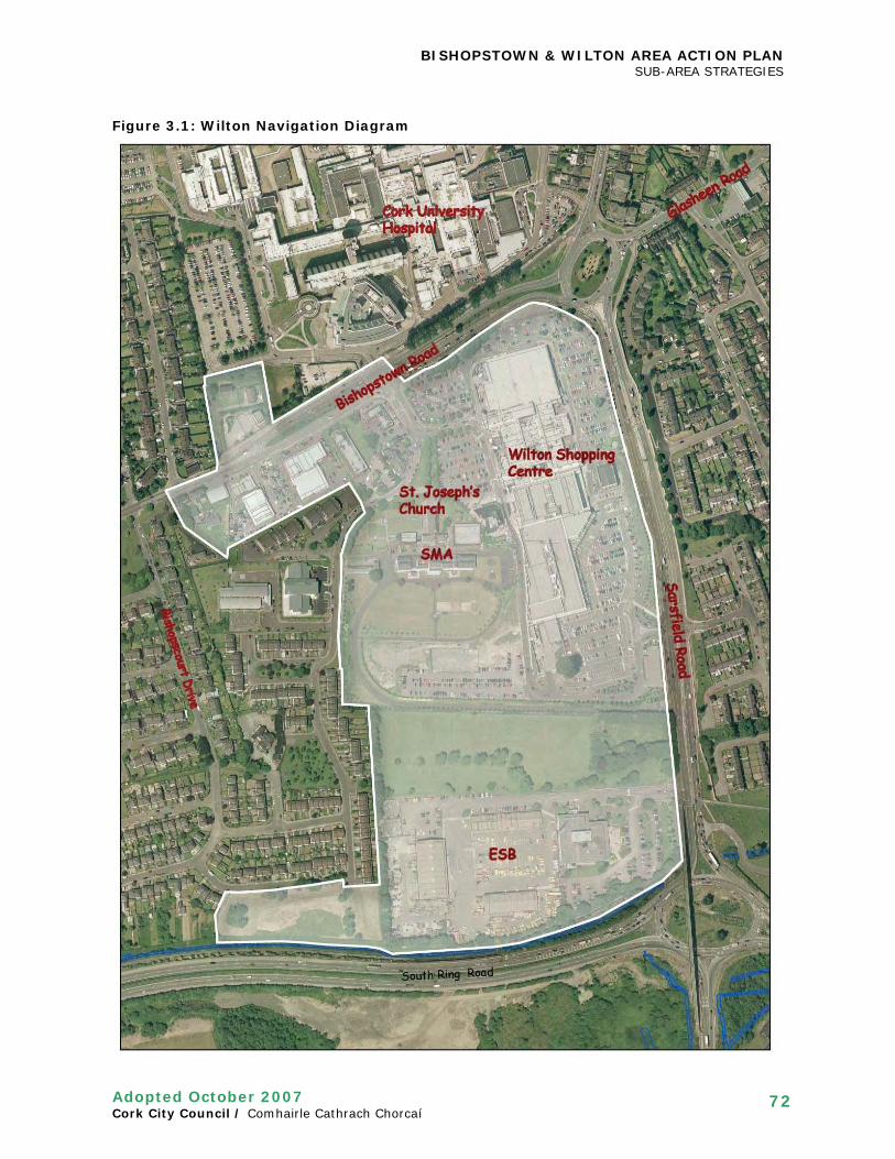
BISHOPSTOWN & WILTON AREA ACTION PLAN SUB-AREA STRATEGIES
Adopted October 2007 Cork City Council / Comhairle Cathrach Chorcaí
72
Figure 3.1: Wilton Navigation Diagram

BISHOPSTOWN & WILTON AREA ACTION PLAN SUB-AREA STRATEGIES
Adopted October 2007 Cork City Council / Comhairle Cathrach Chorcaí
73
3.1.4 The three key aspects of the vision for the precinct are therefore that: • The shopping centre and related lands should be comprehensively redeveloped to
form a new centre. • The development of the centre must be urban-format with buildings, spaces and
uses (and positive relationships between these) that together create a high quality city precinct. Further suburban-format development of the shopping centre development will not be considered appropriate.
• The centre should be a people-friendly place that contains well-connected public streets, spaces and routes and a mix of commercial and community uses that helps to create a proper heart to the south-west of the city within the district centre and a new residential neighbourhood with an appropriate mix of uses.
Overall objectives 3.1.5 The zoning objectives for the development of the area are illustrated in Figure 10.5 of
the City Plan 2004 (as amended by Variation No.6). The overarching development objectives for the development of the precinct are outlined in the following development plan policy and the Wilton Development Objectives diagram overleaf. Policy S25B: Wilton District Centre & Related Lands
To seek the regeneration of Wilton District Centre and related lands as a vibrant mixed use precinct to the highest standards of urban and building design, according to the zoning objectives and development objectives outlined above and Development Objectives diagram, and supplemented by the Bishopstown and Wilton Area Action Plan 2007. In particular proposals for the development of sites will be required to: • Be comprehensive in nature; • Be urban-format development of the highest standards of urban design and building
design; • Provide access points to the lands at the locations identified in the Development
Objectives diagram; • Provide the following key public spaces: a. The Wilton Neighbourhood Park, incorporating passive and active facilities; b. The Wilton Public Square; c. Sarsfield Square c. Key primary and secondary streets outlined in the Development Objectives diagram; d. A 15 metre River Glasheen Corridor. • Support the continued use of the Church, Community Centre and Bishopstown
Library, particularly in terms of access and parking; • Preserve and enhance protected structures; • Preserve key trees and key tree groups identified in the Development Objectives
diagram; • Ensure the development of the SMA grounds in a way that secures an appropriate
long-term framework for the complex and a new private space as wide as Wilton (SMA) House to the south of the building.
3.1.6 The next section provides amplification of this policy and the diagram, including specific guidance on mix of use, movement and accessibility, and urban design requirements.
3.1.7 It is proposed that there be three distinct inter-related areas in the precinct:
• A mixed use quarter focused on the existing District Centre; • A residential quarter on the lands to the south and west (in the ownership of the
SMA, Tesco and the ESB); • The Bishopstown Road quarter to the west of the existing access to Wilton Shopping
Centre (in various ownerships).
The section is organised to reflect this structure.

BISHOPSTOWN & WILTON AREA ACTION PLAN SUB-AREA STRATEGIES
Adopted October 2007 Cork City Council / Comhairle Cathrach Chorcaí
74
Figure 3.2: Wilton Development Objectives
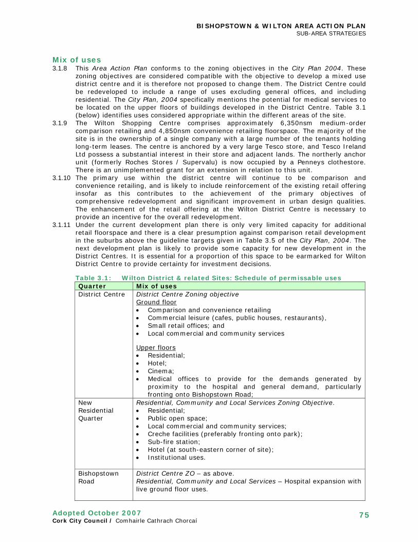
BISHOPSTOWN & WILTON AREA ACTION PLAN SUB-AREA STRATEGIES
Adopted October 2007 Cork City Council / Comhairle Cathrach Chorcaí
75
Mix of uses 3.1.8 This Area Action Plan conforms to the zoning objectives in the City Plan 2004. These
zoning objectives are considered compatible with the objective to develop a mixed use district centre and it is therefore not proposed to change them. The District Centre could be redeveloped to include a range of uses excluding general offices, and including residential. The City Plan, 2004 specifically mentions the potential for medical services to be located on the upper floors of buildings developed in the District Centre. Table 3.1 (below) identifies uses considered appropriate within the different areas of the site.
3.1.9 The Wilton Shopping Centre comprises approximately 6,350nsm medium-order comparison retailing and 4,850nsm convenience retailing floorspace. The majority of the site is in the ownership of a single company with a large number of the tenants holding long-term leases. The centre is anchored by a very large Tesco store, and Tesco Ireland Ltd possess a substantial interest in their store and adjacent lands. The northerly anchor unit (formerly Roches Stores / Supervalu) is now occupied by a Penneys clothestore. There is an unimplemented grant for an extension in relation to this unit.
3.1.10 The primary use within the district centre will continue to be comparison and convenience retailing, and is likely to include reinforcement of the existing retail offering insofar as this contributes to the achievement of the primary objectives of comprehensive redevelopment and significant improvement in urban design qualities. The enhancement of the retail offering at the Wilton District Centre is necessary to provide an incentive for the overall redevelopment.
3.1.11 Under the current development plan there is only very limited capacity for additional retail floorspace and there is a clear presumption against comparison retail development in the suburbs above the guideline targets given in Table 3.5 of the City Plan, 2004. The next development plan is likely to provide some capacity for new development in the District Centres. It is essential for a proportion of this space to be earmarked for Wilton District Centre to provide certainty for investment decisions.
Table 3.1: Wilton District & related Sites: Schedule of permissable uses Quarter Mix of uses District Centre District Centre Zoning objective
Ground floor • Comparison and convenience retailing • Commercial leisure (cafes, public houses, restaurants), • Small retail offices; and • Local commercial and community services Upper floors • Residential; • Hotel; • Cinema; • Medical offices to provide for the demands generated by
proximity to the hospital and general demand, particularly fronting onto Bishopstown Road;
New Residential Quarter
Residential, Community and Local Services Zoning Objective. • Residential; • Public open space; • Local commercial and community services; • Creche facilities (preferably fronting onto park); • Sub-fire station; • Hotel (at south-eastern corner of site); • Institutional uses.
Bishopstown Road
District Centre ZO – as above. Residential, Community and Local Services – Hospital expansion with live ground floor uses.

BISHOPSTOWN & WILTON AREA ACTION PLAN SUB-AREA STRATEGIES
Adopted October 2007 Cork City Council / Comhairle Cathrach Chorcaí
76
3.1.12 Upper floor uses should be predominantly residential in character but other uses will also be appropriate. The area of land zoned District Centre north of Bishopstown Road shall include retail units at ground floor level and may include residential or medical uses at upper floor levels.
3.1.13 The cluster of community uses fronting onto the proposed Wilton Square, including Bishopstown Library, Saint Joseph’s Church, and the SMA Community Centre are all very important uses to the functioning of the community in Wilton. Their continued use and operation is an objective in any development, and any redevelopment should not have a negative impact on the functioning of the uses or the privacy and security of the SMA grounds.
3.1.14 It is a specific objective to seek the development of a hotel within the centre to serve the general needs of the city and those visiting Cork University Hospital. This should be located in one of the corner building locations identified in the Development Objectives diagram, and be either at the corner of Bishopstown Road / Sarsfield Road or Sarsfield Road / Southern Ring Road. It may also be appropriate for voluntary sector housing to provide for the need relating to the hospital.
3.1.15 It is a specific objective to seek the development of a cinema on the upper floor of the block on the eastern side of Wilton Square, to provide for the needs of the area and to make a significant contribution to generating evening activity;
3.1.16 It also an objective to seek a mix of uses that provide activity and animate buildings and streets and the public spaces to be created.
3.1.17 It is a specific objective to seek a mix of commercial and community uses that provide for all sectors of the community (age and socio-economic groups), to ensure that the centre serves the whole community and also to provide a balanced pattern of evening activity.
3.1.18 In addition, the lands to the south and west of the District Centre should be developed as a high quality residential neighbourhood with a full range of local and community services, including the provision of a new neighbourhood park to serve the needs of the development and the surrounding neighbourhood, incorporating a playground and appropriate informal sports facilities (e.g. MUGAs), as outlined in Section 2.3: Public Open Space and Recreation.
3.1.19 Adequate creche facilities must also be provided within any development to meet the demand and needs of the development. Creches should be provided with adequate outdoor space and ideally be located to front onto the neighbourhood park. There is a latent demand in the area for crèche capacity to meet demand generated by the District Centre and Cork University Hospital. In addition, it is an objective of the City Council to secure a sub-fire station within the ESB lands to provide for the needs of the South-West of Cork and its hinterland.
Movement and accessibility 3.1.20 Figure 3.3: Wilton: Movement & Accessibility (overleaf) illustrates the movement and
accessibility principles for the development of the precinct. A core objective is to ensure that the development is both permeable and well connected by public streets, spaces and routes that are accessible to all, including significantly enhanced pedestrian access.
3.1.21 While the centre has good public transport access and benefits form the established
cluster of commercial uses the heavily trafficked Bishopstown and Sarsfield Roads act as a barrier to pedestrian and cyclist access.
3.1.22 It is likely that the majority of car parking provision in any redevelopment of the District
Centre will be provided at basement level. This will be complemented by on-street parking within streets and spaces.
3.1.23 In order to make Bishopstown Road and Sarsfield Road more attractive pedestrian
environments and attractive city streets it will be necessary to change the access arrangements to the Wilton District Centre and related lands. In particular, the Wilton roundabout will be converted to a traffic-controlled junction to improve the pedestrian and cycling environment.

BISHOPSTOWN & WILTON AREA ACTION PLAN SUB-AREA STRATEGIES
Adopted October 2007 Cork City Council / Comhairle Cathrach Chorcaí
77
Figure 3.3: Wilton: Movement and Accessibility

BISHOPSTOWN & WILTON AREA ACTION PLAN SUB-AREA STRATEGIES
Adopted October 2007 Cork City Council / Comhairle Cathrach Chorcaí
78
3.1.24 There should be two traffic-controlled access points to the site from Bishopstown Road and two from Sarsfield Road. In the event that the “SMA” access is not achievable from Sarsfield Road, then the second access should be via the existing ESB access Preferred locations are identified in Figure 3.3, including a relocation of the access to Cork University Hospital further west on Bishopstown Road, which should line up with a new link road through to Cardinal Way. However any relocation of the main entrance to CUH will require robust assessment and justification. Different locations for site access points and streets proposed at planning application stage will be considered on their merits.
3.1.25 Public car parking should be provided within the redevelopment to the development plan standards outlined in Table 11.4. Disabled parking should be provided at a rate of 5 per cent of total provision. Disabled parking must be provided within public streets and spaces, including spaces adjacent to Saint Joseph’s Church, the SMA Community Centre and the Bishopstown Library. Vehicular access must be maintained to Saint Joseph’s Church for ceremonial purposes via the tree-lined avenue.
3.1.26 An area to the front of Bishopstown library at the southern edge of the Wilton Square will be retained for surface public parking and have the capacity for 15-20 car parking spaces. An area to the west of the tree-lined avenue must be reserved for disabled parking purposes to provide proximate access to Saint Joseph’s Church, and be in the order of 10-15 spaces.
3.1.27 All streets must incorporate on-street parking to provide for accessibility and urban design benefits in relation to the animation and supervision of streets and spaces.
3.1.28 It is also necessary to reserve key primary and secondary streets within the development site to respond to the access points and to achieve key linkages. These streets will be taken in charge by the City Council.
3.1.29 Public transport will serve the precinct from Bishopstown Road and Sarsfield Road. The reconfiguration of Bishopstown Road should allow sufficient flexibility for the incorporation of a tram corridor, for which a feasibility study is currently being prepared for the City Council;
3.1.30 The pedestrian bridge in Figure 3.3 would provide a direct link from the Wilton Centre to CUH from building to building. The bridge is unlikely to be necessary if the three traffic-controlled junctions are provided with pedestrian crossings on Bishopstown Road, as this would provide significant improvements to the pedestrian realm.
3.1.31 Transport Impact Assessments must be provided for any major development, in order to assess the impacts of development on all modes of transport, including specific mitigation measures. The transportation hierarchy places modes of transport in the following order of priority (in descending order of importance): Pedestrians; cyclists; public transport; private cars.
Urban design qualities 3.1.32 The key principles for the design of the development are outlined below in:
• Urban structure and layout; • Urban grain: Density and building height; • New streets; • New public squares; • New green Spaces; and • Wilton (SMA) House.
3.1.33 Figure 3.4: Indicative Site Layout (overleaf) and Figure 3.5: Indicative Building heights (page 81) provide diagrams to illustrate the character of development within the precinct.
Urban Structure and Layout 3.1.34 Urban Structure refers to the pattern or arrangement of development blocks, streets,
buildings, open space and landscape on a site. It provides the foundations for detailed design of the constituent elements and creates a coherent framework, which forms the basis of the design of individual developments. Figure 3.4: Indicative Site Layout (overleaf) illustrates how the City Council consider the site should be configured. Other

BISHOPSTOWN & WILTON AREA ACTION PLAN SUB-AREA STRATEGIES
Adopted October 2007 Cork City Council / Comhairle Cathrach Chorcaí
79
configurations will be possible, providing that any development delivers the core zoning and development objectives outlined in this plan.
Figure 3.4: Indicative Site Layout

BISHOPSTOWN & WILTON AREA ACTION PLAN SUB-AREA STRATEGIES
Adopted October 2007 Cork City Council / Comhairle Cathrach Chorcaí
80
3.1.35 The proposed urban structure is guided by three key things: • The site and its defining elements and characteristics (e.g. existing buildings, spaces,
and natural heritage of significance); • The site’s context; • The vision for the proposed development based upon the principles set out in Chapter
6 of the City Plan 2004. 3.1.36 There are a number of existing elements of the site’s urban structure that will remain a
fixed part of the new centre: • Saint Joseph’s Church, which is a Local Landmark Building and visual focal point for
streets and Wilton Square; • Wilton (SMA) House and complex; • Cluster of other community uses (i.e. SMA Community Centre, Bishopstown Library,
SMA Cemetery); • The Avenue to the front of Saint Joseph’s Church; • River Glasheen and its corridor; • Wilton Shopping Centre and its related lands. • Bishopstown Road and Sarsfield Road.
3.1.37 There is a significant fall in the levels of the area from Bishopstown Road down to the
South Ring Road and also some change in levels within the shopping centre site itself. 3.1.38 Additional key elements of the proposed urban structure are:
• Access points to the site and related key primary and secondary streets; • Three new public squares, including Wilton Square to the front of the Church to
provide a focal town space for the district centre. • A new public Wilton Neighbourhood Park is proposed extending from the SMA
complex to the Glasheen River with an enhanced riverside walk; • Landmark corner buildings will be in three locations (see paragraph 3.1.42).
Urban grain: density and Building height 3.1.39 Building heights and intensity of use should respond to that set out in Figure 3.5:
Indicative Building Heights, which provides for greater density in the eastern portion of the precinct., with the western portion stepping down to the existing context. Development intensity within the Proposed Public (Airport) Safety Zone will need to take cognisance of guidelines when they are published, and the new residential neighbourhood is of lower density within the proposed PSZ;
3.1.40 In general terms building heights will be 3 storeys to the west of the development precinct in response to the existing scale of development and the presence of the proposed Airport Public Safety Zone.
3.1.41 Building heights fronting onto Bishopstown Road and Sarsfield Road will be urban in scale and height, and be between 4-6 storeys in height, depending upon the context. Building height will need to step down to existing residential areas (e.g. to the rear of houses on Wilton Avenue);
3.1.42 Landmark corner buildings will be located in three locations: • the corner of Bishopstown Road / Sarsfield Road; • the corner of Sarsfield Road / South Ring Road; and • Cork University Hospital site adjacent to the Bishoptown Road / Wilton Road junction
(see BW12: Cork University Hospital); These will not be tall buildings but will slightly taller buildings of architectural excellence.
New streets 3.1.43 Key primary and secondary streets within the development site are reserved to respond
to the access points and to achieve key linkages. The new street created to access the site from Sarsfield Road is located to provide Saint Joseph’s Church, a Local Landmark Building, as its vista stopper.

BISHOPSTOWN & WILTON AREA ACTION PLAN SUB-AREA STRATEGIES
Adopted October 2007 Cork City Council / Comhairle Cathrach Chorcaí
81
Figure 3.5: Indicative Building heights

BISHOPSTOWN & WILTON AREA ACTION PLAN SUB-AREA STRATEGIES
Adopted October 2007 Cork City Council / Comhairle Cathrach Chorcaí
82
3.1.44 Primary streets should be 21 metres in width and secondary streets should be to a minimum of 15 metres width. All streets must incorporate on-street parking to provide animation to streets and spaces.
New public squares 3.1.45 Three public squares should be created within the development:
• Wilton Square (to the front of Saint Joseph’s Church); • Sarsfield Square (to the front of a redeveloped Tesco store); • New square around beech tree in Tesco car park.
3.1.46 Wilton Square will provide the public focus for the district centre as a whole. This square
should be a minimum of 0.85 hectares in size (excluding vehicular streets but including an area of public car parking (see 10.119E, below). Careful consideration will need to be given to the design of this square and the relationship to The Avenue, existing community uses, and the floor levels of the development as a whole;
New green spaces and natural heritage 3.1.47 The following development objectives will apply to Wilton Park:
• The park should be designed according to the principles set out in Section 2.3; • At least 30% of the park area should be dedicated to active uses. These should
include a Multi Use Games Area (MUGA) and a Children’s playground. • The existing vehicular access to the SMA complex should be removed and replaced
with a new access to the complex from Cardinal Way in order to create an uninterrupted park not severed by an access road;
• The new park area should be integrated with the existing park area at Donscourt • A riverside walkway, of approximately 15 metres wide, should be incorporated into
the park and along the River Glasheen; and • Pedestrian routes should be provided according to Figure 3.3: Movement and
Accessibility diagram (above); • Provision for car parking should be made on the eastern side of the park adjoining
the proposed residential developments within the streets fronting onto the space; • A new ‘bring site’ should be established within the park.
3.1.48 The Wilton Neighbourhood Park links up with an existing public open space that provides
for the needs of the Donscourt / Cardinal Court development. An integrated landscape masterplan to provide a framework for the design of the whole park and the related River Glasheen corridor must be provided by the developer. The upgrading of the public open space outside of the ESB site will be completed by Cork City Council.
3.1.49 The tree buffer between the park and existing properties on Cardinal Way should be
reinforced with supplementary planting. 3.1.50 Key trees and tree groups of value to the character of the precinct are identified in
Figure 3.2 and should be preserved in any redevelopment. The City Council will protect trees by means of Tree Preservation Orders, as appropriate.
3.1.51 The River Glasheen Corridor should be designed to provide an attractive public realm
within a 15 metre corridor from the top of the river bank. The first 5 metres from the top of the bank should be a river biodiversity corridor.
Wilton (SMA) House 3.1.52 The SMA House (Wilton House) and its outbuildings are Protected Structures. Whilst
these buildings may remain in institutional use any future development must be subject to a comprehensive masterplan that ensures the long term future of the Protected Structures within a viable framework. It is also a development objective to secure the retention of the space to the south of SMA House as a private open space and organising element of any proposal. SMA House will form the visual focus of the Wilton Neighbourhood Park at its northern end.

BISHOPSTOWN & WILTON AREA ACTION PLAN SUB-AREA STRATEGIES
Adopted October 2007 Cork City Council / Comhairle Cathrach Chorcaí
83
3.2 CARRIGROHANE ROAD / VICTORIA CROSS / DENNEHY’S CROSS
Introduction 3.2.1 This section of the plan looks at the area around Victoria Cross, Dennehy’s Cross and
Carrigrohane Road. This is characterised as an area in transition, which has taken on a pattern of higher density development in recent years particularly around Victoria Cross. This development has been predominantly student apartment complexes. The area presents a number of other opportunity sites, for which it will be necessary to provide some development guidance. Guidance will also be given for the public realm and recreation in the area as well as access and movement. The area boundary runs east of the playing pitches on Carrigrohane Road and north of the Curragheen River. It follows a line south of the river Lee as far as Victoria Mills and extends south on both sides of Victoria Cross Road to Dennehy’s Cross.
Overview
Aim
To ensure the area around Victoria Cross and Carrigrohane Road develops in a planned and sustainable fashion by providing detailed development guidance, protecting amenities and quality of environment and ensuring ease of movement for all modes of transport.
3.2.2 This section will aim to:
• Provide a strategy for the development of opportunity sites around Victoria Cross and Carrigrohane Road
• Provide a framework for ease of movement and accessibility which in particular caters for the needs of public transport, pedestrians and cyclists
• Provide proposals to enhance the quality of the public realm and recreational facilities within the area
3.2.3 The section first of all deals with the area around Carrigrohane Road, which presents an
extensive development opportunity. It then looks at the area from Dennehy’s Cross north to Victoria Cross.
CARRIGROHANE ROAD SUB-AREA Existing Situation 3.2.5 The area south of Carrigrohane Road (See Figure 3.6) forms part of a key gateway into
the city from the west with the presence of County Hall and its landmark status. It is bounded by playing pitches (Pairc an Locha and Casement Park) to the west, the Curragheen River and Farranlea Road to the south, County Hall to the east and Carrigrohane Road to the north. The total size of the area is approximately 5.36 ha. The site is relatively flat and level with Carrigrohane Road, however is below the level of Farranlea Road to the rear, where there is a steep slope.

BISHOPSTOWN & WILTON AREA ACTION PLAN SUB-AREA STRATEGIES
Adopted October 2007 Cork City Council / Comhairle Cathrach Chorcaí
84
3.2.6 The area contains a number of mainly commercial/industrial type premises including sales showrooms for bulky goods such as farm machinery. The land is zoned for “Residential, Community and Local Services” in the City Plan 2004. The objective of this zoning is “to protect and provide for residential uses with other uses open for consideration, including community and local services, having regard to employment policies outlined in Chapter 3”. It is proposed that a gradual transition will therefore occur with mixed commercial/industrial uses relocating and giving way to residential and local services with linked amenities. It is desirable to retain some employment opportunities on site in line with the zoning objective by providing local and community services as well as a crèche.
Development Strategy- 3.2.4 This strategy provides guidance on the nature, scale and design of future development
for the area south of Carrigrohane Road, and includes: • Movement and accessibility; • Urban structure; and • Density and building heights; • Public realm and recreation.
3.2.5 The overall objectives for the site are contained in Objective BW19:
Objective BW19 Carrigrohane Road
Developers are required to provide and fund the elements specified as they are essential to ensure that the development provides for the proper planning and sustainable development of the area. Proposals for the development of the area on Carrigrohane Road (shown on Fig 3.6) will
be required to: 1. Contribute positively to the redevelopment of the area and provide the access points,
streets/roads and public spaces as outlined 2. Provide the required services and units at the activity nodes as proposed 3. Provide social and affordable housing in accordance with Part V of the Planning and
Development Act, 2000 and the City Plan, 2004 4. Provide appropriate social and recreational facilities commensurate with the need
arising from the development, including a crèche, playground and a MUGA or kick-about area;
5. Land will be reserved for the following elements which are considered essential: (a) New slip road and access point (b) Riverside Amenity Space- 10 metres at either side of the Curragheen River (c) Central area of active open space (d) Access roads to serve development sites to the rear
Carrigrohane Road River Curragheen channel

BISHOPSTOWN & WILTON AREA ACTION PLAN SUB-AREA STRATEGIES
Adopted October 2007 Cork City Council / Comhairle Cathrach Chorcaí
85
Movement and Accessibility Strategy- Carrigrohane Road 3.2.6 It is proposed to develop a hierarchy of streets with primary and secondary functions.
The design of individual streets will reflect their function and the traffic demands placed upon them. In designing streets, consideration should be given to all modes of transport, with a particular emphasis on sustainable modes (i.e. walking & cycling). See Figure 3.6: Movement and Accessibility (below).
3.2.7 The N22 corridor is the principal primary route adjoining the site, which, despite speed
limits, is currently a fast stretch of road approaching the City. It is a car-dominated environment and creates a barrier for pedestrian movement. The strategy takes account of these proposals.
3.2.8 The primary street within the site will be the new slip road, which requires a wider
carriageway, footpaths/ cycle lanes and landscaped area. It is proposed to reserve c. 15 metres along the northern side of the site for this purpose. Other secondary streets (“Access streets”) and tertiary streets will have lesser requirements.
Walking & cycling 3.2.9 The N22 will be upgraded to Green Route (inbound) to provide for cycling needs, and a
new outbound off-road cycle lane will be provided. New traffic-controlled junctions and pedestrian crossings will provide opportunities for safe pedestrian and cycle movements across the N22.
3.2.10 Cycle facilities should be provided to allow for comfortable and safe cycling routes in
both directions on the new slip road. Figure 3.6 Carrigrohane Road Movement and Accessibility

BISHOPSTOWN & WILTON AREA ACTION PLAN SUB-AREA STRATEGIES
Adopted October 2007 Cork City Council / Comhairle Cathrach Chorcaí
86
3.2.11 It is proposed to locate a linear park with a leisure walkway / cycleway along the Curragheen River to the south of the site. This will link up to the Lee Fields and existing Curragheen River walk. Three pedestrian-crossing points
Public transport 3.2.12 There are currently proposals to upgrade the N22 as it is a Green Route. It is proposed
to provide a bus lane/cycle lane along the northern side as well as improved footpath provision with two new footpaths provided at either side of the road.
3.2.13 A new bus stop is proposed on the northern side of the N22. Vehicular movement and parking 3.2.14 In order for traffic to enter the site, a signalized traffic junction is proposed on the
northwestern corner. An additional entrance point will be required further east depending on the progress of development. A pedestrian crossing point is proposed midway through the site (adjacent to the internal access road). This is the likely location for an additional vehicular access point in the future. A pedestrian access point only is proposed to the rear of the site onto Farranlea Road to ensure proper permeability throughout the site. Cycle facilities to allow access to development sites should be provided.
3.2.15 Parking provision will be required to meet current City Plan, 2004 standards.
Underground/basement parking is the preferred option for higher density/mixed use areas, while surface parking may be appropriate for the lower density / family type housing areas.
Urban Structure 3.2.16 Urban Structure refers to the pattern or arrangement of development blocks, streets,
buildings, open space and landscape on a site. The layout and orientation of development should be guided by factors such as the nature of surrounding development, natural features, accessibility, sunlight patterns and climate. This will have an importance influence on the quality and accessibility of a development and the impact it has on the surrounding area.
3.2.17 Figure 3.7: Development Objectives and Indicative Site Layout provides an indicative
urban structure based upon the following key features: • The proposed development should seek to maximize its locational attributes with
contemporary, quality design in the architecture, landscaped open space and public realm detailing.
• Building lines fronting onto Carrigrohane Road set-back (by at least 15m) to allow County Hall to remain the dominant landmark building on this city approach road;
• The creation of a new slip road (Primary Street) along the northern boundary of the site to allow permeability and connection to various parts of the site. This route will reduce the need for multiple access points onto Carrigrohane Road
• Secondary streets (“Access streets”); • Tertiary streets of at least 10 metres width to provide internal / local access roads
will be developed off the slip road, creating urban blocks within the development site; • The development of a riverside walkway/cycleway and linear amenity park along the
Curragheen River; • A new centrally located local park for active recreation including the provision of a
playground and possible Multi-Use Games Area (MUGA);

BISHOPSTOWN & WILTON AREA ACTION PLAN SUB-AREA STRATEGIES
Adopted October 2007 Cork City Council / Comhairle Cathrach Chorcaí
87
Figure 3.7 Carrigrohane Road Development Objectives & Indicative Site Layout
Urban grain 3.2.18 Urban grain takes account of the layout of streets, blocks and plots on site. It is
proposed to define a new grid structure based on permeability and the type of units proposed. Some account of the pattern of landownership should be made to allow development to occur on a phased basis. It is considered that none of the existing buildings on site merit retention and there are few existing dwellings adjacent.
3.2.19 The proposals include:
• A hierarchy of streets based on vehicular, pedestrian and cyclist activity. The slip road represents the principal through route with vehicular access routes serving various blocks within the site. Pedestrian only or shared surface routes should be proved at greater intervals to allow pedestrian permeability.
• Block widths should allow for ease of access, the ability to sustain a variety of building types and uses and the ability to change and adapt over time. The scale of blocks should allow for internal access to enable cars to be removed from the frontage and contained within the larger block structure. Blocks should generally be regular in shape to facilitate ease of development, subdivision into smaller parcels and containment of internal private open space.

BISHOPSTOWN & WILTON AREA ACTION PLAN SUB-AREA STRATEGIES
Adopted October 2007 Cork City Council / Comhairle Cathrach Chorcaí
88
Uses, Density and Building height
Mix of Uses and Density 3.2.20 As previously stated, the site is zoned for “Residential, Community and Local Services” in
the City Plan, 2004. It is therefore proposed that the predominant land use be residential. The zoning also allows for some local shops and services.
3.2.21 Proposed uses include:
• Different character areas in terms of residential development: 1. Urban-type units should be located in the area closest to County Hall. These are
higher density developments. The density proposed is 75+ dwelling units per hectare. The net developable area is approximately 0.72 ha.
2. Mixed-type units are proposed for the area adjacent to the playing pitches and to the rear of the site adjoining Farranlea Road. A variety of unit types are proposed here and the density should be at a rate of between 50 -75 units per hectare. The net developable area is approximately 3.18 ha.
• The City Council will require a mix of dwelling sizes to accommodate different household sizes in order to encourage mixed and balanced communities. It is considered that 50% of units should be “family units” and 50% dwellings designed for smaller household sizes on this site as a whole
• It is proposed that two “activity nodes” be developed with shops and services such as a crèche to cater for the needs of the local population. Facilities such as cafés could be provided to serve visitors to the Lee Fields. The activity nodes should be provided close to the main access points with parking provided along the building frontage
Building heights and massing 3.2.22 The City Plan, 2004 identifies the County Hall Gateway as an area with potential to
accommodate high buildings (paragraph 6.99). 3.2.23 A variety of building heights are proposed for the area (see Figure 3.8 (overleaf):
• Within the urban-type area, building heights should be a maximum of 6 storeys • For the mixed-type units (medium density), building heights will vary but a maximum
height of 5 storeys (along the site frontage) should be observed • The design of building footprints within the site should be based on a perimeter block
system which facilitates greater diversity of forms and uses and more active street frontages. The overall design approach and structure should take account of generic elements of the surrounding context (topography, vistas etc.).

BISHOPSTOWN & WILTON AREA ACTION PLAN SUB-AREA STRATEGIES
Adopted October 2007 Cork City Council / Comhairle Cathrach Chorcaí
89
Figure 3.8 Carrigrohane Road: Indicative Building heights
Public Realm and Recreation Strategy-Carrigrohane Road 3.2.24 High quality, usable open space will be an important element of the site’s
redevelopment. The Riverside Amenity Area will serve as the primary open space spine and will reinforce linkages with the existing Curragheen River Park and Lee Fields. An approximate depth of 10 metres is required on both sides of the river however this may be varied at points to provide a more interesting Riverside Amenity Space, while still providing cumulatively the same amount of amenity space in terms of actual area. The culverted section of the river on site should be opened up.
3.2.25 It is proposed that at least 15 % of the site area be reserved for public open space. This
should include both passive and active open space at a ratio of 70:30, active: passive. The majority of the passive space will be provided along the river corridor. A public walkway/cycleway should be provided along the entire length on the north side of the river. The central active area of open space will be approximately 0.25 ha in size.
3.2.26 Elsewhere, a hierarchy of private / semi-private or communal spaces should punctuate
the site ranging from gardens, communal courtyards, balconies / winter gardens etc. Standards for private open space provision are set out in Table 11.2 (Suburban Standards) of the City Plan, 2004. A tree belt should be provided along the site frontage, parallel to Carrigrohane Road
Infrastructure 3.2.24 In terms of drainage, the existing Inchigaggin sewer may need to be extended to service
additional development. All storm water runoff on site should discharge to the adjacent Curragheen River. The maximum runoff rate may be attenuated to a defined maximum rate subject to site-specific considerations.

BISHOPSTOWN & WILTON AREA ACTION PLAN SUB-AREA STRATEGIES
Adopted October 2007 Cork City Council / Comhairle Cathrach Chorcaí
90
Objective BW19 Carrigrohane Road
Developers are required to provide and fund the elements specified as they are essential to ensure that the development provides for the proper planning and sustainable development of the area. Proposals for the development of the area on Carrigrohane Road (shown on Fig 3.6) will
be required to: 6. Contribute positively to the redevelopment of the area and provide the access points,
streets/roads and public spaces as outlined 7. Provide the required services and units at the activity nodes as proposed 8. Provide social and affordable housing in accordance with Part V of the Planning and
Development Act, 2000 and the City Plan, 2004 9. Provide appropriate social and recreational facilities commensurate with the need
arising from the development, including a crèche, playground and a MUGA or kick-about area
10. Land will be reserved for the following elements which are considered essential: (a) New slip road and access point (b) Riverside Amenity Space- 10 metres at either side of the Curragheen River (c) Central area of active open space (d) Access roads to serve development sites to the rear

BISHOPSTOWN & WILTON AREA ACTION PLAN SUB-AREA STRATEGIES
Adopted October 2007 Cork City Council / Comhairle Cathrach Chorcaí
91
Development Strategy- Victoria Cross / Dennehy’s Cross 3.2.25 The area from Victoria Cross to Dennehy’s Cross has changed rapidly in recent years. As
a response to wider economic influences and the area’s proximity to UCC and public transport routes, the area has seen development with an urban character, the principal use being residential (many of which have been ‘Section 50’ student apartments). Much of this development has taken place without a strategy for the area as a whole and vision as to how it should be developed.
3.2.26 This sub-section provides a vision for the redevelopment of this area, which include a
strategy for development, movement and accessibility, and public realm, and provides guidance for particular development sites that have been identified:
Site 1 - Southeast corner of Dennehy’s Cross) Site 2 - Southwestern corner of Dennehy’s Cross) Site 3 - Northwestern Corner of Dennehy’s Cross) Site 4 - Northeastern Corner of Dennehy’s Cross) Site 5 - Health Service Executive Offices on Victoria Cross Road (Farm Centre) Site 6 - Top Car Garage and adjoining warehouse building on Victoria Cross Road Site 7 - Site of the Wylam Chinese Restaurant and Former Honda Garage Site 8 - Site of Crow’s Nest public house and related sites
3.2.27 The development strategy for the area is based upon the following key principles:
• The development of the area north of Model Farm Road / Magazine Road (sites 3-8) will generally be urban in character and to high densities with a general building height of 4+1 storeys (variations are identified below);
• Development south of Model Farm Road / Magazine Road (sites 1-2) will be a transition zone between the higher density developments to the north and the existing 2-storey housing to the south. It will be of the New Suburban development type (i.e. low density) and predominantly family housing;
• Development should have a strong sense of place and be designed to be consistent in terms of building design and urban design.
• The principal use will be residential; • Commercial uses providing local services are encouraged at ground floor level to
provide active frontages, however the preferred locations for these uses will be at Dennehy’s Cross and Victoria Cross;
• Where residential uses at ground floor level are proposed, the building line should be set back to maximise privacy.
3.2.28 Key development constraints include:
• Provision of an improved public realm on Victoria Cross Road and at Dennehy’s Cross, including a widened pedestrian realm (minimum 3 metre footpaths), street trees, and seating;
• Provision of a publicly accessible and continuous riverside walkway within a 10 metre public space;
• Provision of a cycle lane outbound towards Wilton. Site 1 (Southeast corner of Dennehy’s Cross) 3.2.29 It is proposed that Dennehy’s Cross will mark the transition from a more urban-type,
higher density development along Victoria Cross Road to lower density, single-type dwellings along Wilton Road. This site is located on the southeastern corner of Dennehy’s Cross. There are two existing dwellings on the corner as well as light industrial units further east. There is a steep slope to the rear of the site where the Presentation playing pitches are located. The site is 0.62 ha. in size. It is proposed that predominantly family-type, two- to three-storey dwellings be constructed on site. The density should be at a rate of 35-50 dwellings per hectare. The entrance should be located close to that existing on Magazine Road with a new footpath 2-3 metres wide included along the road

BISHOPSTOWN & WILTON AREA ACTION PLAN SUB-AREA STRATEGIES
Adopted October 2007 Cork City Council / Comhairle Cathrach Chorcaí
92
frontage. This area is also proposed as a local centre, therefore local shops and services should be provided at corner sites.
Site 2 (Southwestern corner of Dennehy’s Cross) 3.2.30 The site includes Dennehy’s Cross
House/Provision Store, Dennehy’s car showrooms and former post office. It is proposed that this site also be developed for predominantly family-type units with local shops and services. Any development should respect the setting of the adjoining Church of the Descent of the Holy Spirit, which has recently been added to the Record of Protected Structures and is an important landmark building. The site is approximately 0.3 ha. in size. The density should be approximately 35-50 dwellings per hectare. A public space should be provided to enhance the public realm. The building line should be set back along Model Farm Road in line with Dennehy’s Cross House to achieve the desired public space.
Site 3 (Northwestern Corner of Dennehy’s Cross) 3.2.31 Permission was granted by the City Council and on appeal to An Bord Pleanala for a
mixed use development comprising of 22 no. residential units, café, retail unit and basement car parking under Town Planning Reference number 04/29091.
Site 4 (Northeastern Corner of Dennehy’s Cross) 3.2.32 Permission was granted by the City Council and on appeal to An Bord Pleanala for a
mixed use development consisting of a residential, retail and commercial development including restaurant, off-licence, pharmacy, florist, salon, crèche, shop and post-office under Town Planning Reference number 05/30132.
Site 5 Health Service Executive Offices on Victoria Cross Road (Farm Centre) 3.2.33 The site is 0.41 ha. in size. The existing 4 storey building on site is used by the Health
Service Executive for offices. In the event of redevelopment a 10 metre strip should be reserved along the river bank (river corridor) for protection of amenity value, landscape, trees, ecology and the inclusion of a public walkway/cycleway. A general building height of four storeys plus one set back from the main building line (4+1) would be acceptable. A density of 75+ units per hectare would be acceptable as the site is located on a public transport corridor/green route and given surrounding land uses and permitted developments in the vicinity. In order to enhance the pedestrian realm, the footpath width should be increased to 3 metres along Victoria Cross Road. Ground floor uses should generally be commercial; however the building line should be set back if residential is proposed.
Site 6 Top Car Garage and adjoining warehouse building on Victoria Cross Road
3.2.34 Permission was granted for a residential development on the southern portion of the site (former heating and plumbing warehouse) under Town Planning Reference number 05/29844 with a Bord Pleanala decision requiring a height of 4 + 1. The building height should be stepped down towards Orchard Road. It is proposed that the adjoining site to the north (Top Car Garage) be developed in conjunction with this site with access from the south along the existing road serving the Ashbrook apartments to the rear. This would prevent multiple access points onto Victoria Cross Road. 10 metres should be reserved along the River Glasheen to the rear with new walkway/cycleway provided. The footpath width should be increased to 3 m. along the site frontage onto Victoria Cross Road.

BISHOPSTOWN & WILTON AREA ACTION PLAN SUB-AREA STRATEGIES
Adopted October 2007 Cork City Council / Comhairle Cathrach Chorcaí
93
Figure 3.9 Victoria Cross / Dennehy’s Cross Development Objectives

BISHOPSTOWN & WILTON AREA ACTION PLAN SUB-AREA STRATEGIES
Adopted October 2007 Cork City Council / Comhairle Cathrach Chorcaí
94
Site 7 Site of the Wylam Chinese Restaurant and Former Honda Garage 3.2.35 The site is 0.25 ha. in size. Existing buildings on site include a former Honda garage and
a Chinese restaurant. It is proposed that the site be developed for mainly residential development with some local shops/services on the ground floor. It is recommended that the front building line be set back to enhance the pedestrian environment on Victoria Cross Road. The site is bounded by the Curragheen River to the rear. Adjoining land uses include a new student apartment development to the east with an older 3-storey apartment development to the rear at the opposite side of the river. A 10-metre strip should be provided along the river bank with amenity route provided. A building height of 4+1 and density of 75+ units per hectare would be acceptable.
Site 8 Site of Crow’s Nest public house, 1-4 Victoria Tce. And M.P. Crowley shed and yard
3.2.36 Permission has been granted for a mixed-use residential and commercial development 05/30071 with 5 storeys along Carrigrohane Road and 6 storeys at the corner, taking cognizance of the character of adjoining residential areas.
Conservation strategy 3.2.37 The following buildings have been added to the Record of Protected Structures:
• Church of the Descent of the Holy Spirit at Dennehy’s Cross; • Victoria Cross Cycles building The following are considered to be of local architectural interest (see Section 2.4): • Millview House and numbers 1-4 Bridgeview Terrace.
Movement and Accessibility Strategy Pedestrian and cyclists 3.2.38 Improvements to the pedestrian realm are recommended.
• Where new developments occur, footpath widths should be increased to 3 metres. • Pedestrian crossing improvements are proposed at both Dennehy’s Cross and Victoria
Cross. • A new walkway/cycleway is proposed along the Glasheen River. This should be
provided as part of new developments with a 10 metre strip reserved along the river bank.
• Bicycle parking facilities should be implemented according to Cycle Parking Requirements to 2010
• Cycle’s convenience for right-turning from Victoria Cross Road to Model Farm Road should be considered
• New cycle lanes are proposed on Model Farm Road, Magazine Road and Victoria Cross Road.
Public Transport 3.2.39 Both Victoria Cross Road and Carrigrohane Road are designated Green Routes. The
Bishopstown Green Route (No. 8) has already been implemented, while the Ballincollig Route, which runs along Carrigrohane Road and Victoria Cross is to be implemented next year. This will improve public transport provision in the area.
Private Cars 3.2.40 Access points to new developments should minimise the impact on freeflow of traffic on
Victoria Cross Road and be serviced from existing access points where possible.

BISHOPSTOWN & WILTON AREA ACTION PLAN SUB-AREA STRATEGIES
Adopted October 2007 Cork City Council / Comhairle Cathrach Chorcaí
95
Figure 3.10 Victoria Cross / Dennehy’s Cross Movement and Accessibility

BISHOPSTOWN & WILTON AREA ACTION PLAN SUB-AREA STRATEGIES
Adopted October 2007 Cork City Council / Comhairle Cathrach Chorcaí
96
Public Realm and Recreation Strategy 3.2.41 Improvements to the pedestrian environment are proposed along Victoria Cross Road
with increased footpath widths. A 10-metre riverside amenity area is proposed along the Glasheen River with riverside walkway/cycleway. The upgrading of the existing public open space on Magazine Road to provide a pocket park to provide for local residents and those using the walkway. The existing green area should be upgraded with seating provided and tree planting to make the area more attractive.
Infrastructure 3.2.42 All sites adjoining the Glasheen River shall discharge storm water to the river. On other
sites, all storm runoff shall be retained on site where possible – i.e. where the proposed layout and soil permeability characteristics allow. If significant future development of the Bishopstown/Curragheen area is to be adequately serviced, an extension of the Inchigaggin Sewer would have to be considered in conjunction with a partial separation of the combined catchment.
Objective BW20 Dennehy’s Cross / Victoria Cross
Proposals for development sites from Dennehy’s Cross to Victoria Cross (shown on Fig 3.8) will be required to: 1. Contribute positively to the redevelopment of the area 2. Provide shops and services that serve as a local centre around Dennehy’s Cross 3. Ground floor uses should generally be commercial. However where residential is
proposed, the building line should be set back to maximise privacy 4. Provide social and affordable housing in accordance with Part V of the Planning and
Development Act, 2000 and the City Plan, 2004 5. Provide vehicular access points which minimise the impact on the free flow of traffic
on Victoria Cross Road by using existing access roads 6. Land will be reserved for the following elements which are considered essential:
(a) 10 meter buffer zone along the Glasheen River bank to preserve its ecological amenity value. Riverside walkways/cycleways should be provided along the river and connect with Victoria Bridge and
walkways/cycleways along Curragheen River (b) Improvements to the public realm: necessary space should be reserved for footpath improvements and increased widths (3 metres) and cycle lanes as part of new development sites.
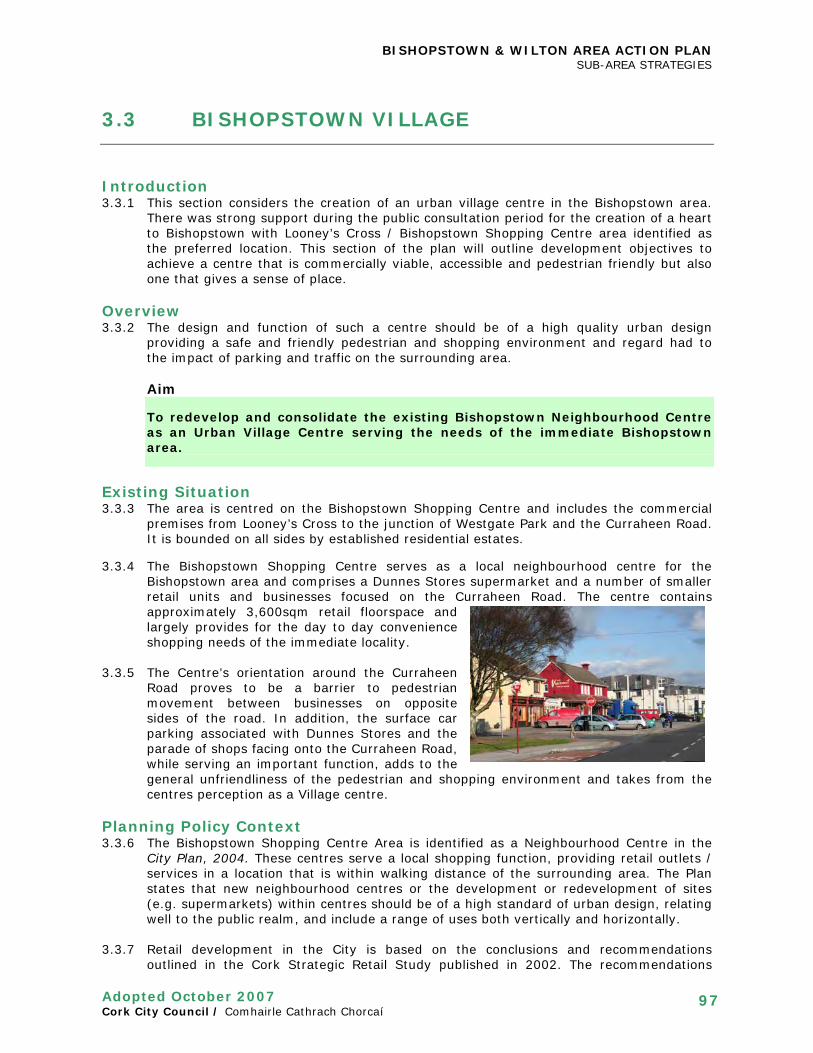
BISHOPSTOWN & WILTON AREA ACTION PLAN SUB-AREA STRATEGIES
Adopted October 2007 Cork City Council / Comhairle Cathrach Chorcaí
97
3.3 BISHOPSTOWN VILLAGE
Introduction 3.3.1 This section considers the creation of an urban village centre in the Bishopstown area.
There was strong support during the public consultation period for the creation of a heart to Bishopstown with Looney’s Cross / Bishopstown Shopping Centre area identified as the preferred location. This section of the plan will outline development objectives to achieve a centre that is commercially viable, accessible and pedestrian friendly but also one that gives a sense of place.
Overview 3.3.2 The design and function of such a centre should be of a high quality urban design
providing a safe and friendly pedestrian and shopping environment and regard had to the impact of parking and traffic on the surrounding area.
Aim To redevelop and consolidate the existing Bishopstown Neighbourhood Centre as an Urban Village Centre serving the needs of the immediate Bishopstown area.
Existing Situation 3.3.3 The area is centred on the Bishopstown Shopping Centre and includes the commercial
premises from Looney’s Cross to the junction of Westgate Park and the Curraheen Road. It is bounded on all sides by established residential estates.
3.3.4 The Bishopstown Shopping Centre serves as a local neighbourhood centre for the
Bishopstown area and comprises a Dunnes Stores supermarket and a number of smaller retail units and businesses focused on the Curraheen Road. The centre contains approximately 3,600sqm retail floorspace and largely provides for the day to day convenience shopping needs of the immediate locality.
3.3.5 The Centre’s orientation around the Curraheen
Road proves to be a barrier to pedestrian movement between businesses on opposite sides of the road. In addition, the surface car parking associated with Dunnes Stores and the parade of shops facing onto the Curraheen Road, while serving an important function, adds to the general unfriendliness of the pedestrian and shopping environment and takes from the centres perception as a Village centre.
Planning Policy Context 3.3.6 The Bishopstown Shopping Centre Area is identified as a Neighbourhood Centre in the
City Plan, 2004. These centres serve a local shopping function, providing retail outlets / services in a location that is within walking distance of the surrounding area. The Plan states that new neighbourhood centres or the development or redevelopment of sites (e.g. supermarkets) within centres should be of a high standard of urban design, relating well to the public realm, and include a range of uses both vertically and horizontally.
3.3.7 Retail development in the City is based on the conclusions and recommendations
outlined in the Cork Strategic Retail Study published in 2002. The recommendations

BISHOPSTOWN & WILTON AREA ACTION PLAN SUB-AREA STRATEGIES
Adopted October 2007 Cork City Council / Comhairle Cathrach Chorcaí
98
have been incorporated into the Retail Strategy outlined in the City Plan, 2004. The Strategy sets out the requirements for additional retail floorspace (convenience, warehousing and comparison) for the suburbs of the City from 2001 – 2011.
Development Framework 3.3.8 While the existing area zoned as a neighbourhood centre extents from Looney’s Cross to
Firgrove Avenue it is considered more appropriate to focus redevelopment objectives on the western end of the area around the existing Dunnes Stores shopping centre as it offers the best potential for the development of an integrated pedestrian friendly centre that offers functional efficiency. The services and facilities located in the Looney’s Cross area will continue to play an important part in the provision of local services for the area.
3.3.9 The redevelopment of the centre will have to take account of its locational context within
an established residential area and be capable of respecting the character of adjacent areas
Key Development Objectives 3.3.10 The key development objectives that apply to the area include:
• Retaining the role of the area as a local shopping centre • Redeveloping/enhancing the quality of the retail frontage • Protecting the residential amenity of residents in the immediate vicinity • Requiring the provision of underground car parking in any new redevelopment • Providing for new residential units in the village centre • Ensuring safe, convenient access to facilities in the village centre for pedestrians,
cyclists and users of public transport • Providing private and public parking to serve the area with safe access • Improving the quality of the public realm
• Ensuring the design and layout of the centre reinforces the idea that it is village centre and respects residential areas in the immediate vicinity.
Urban Structure 3.3.11 The term urban structure refers to the pattern or arrangement of development blocks,
streets, buildings, open space and landscape which make up urban areas. It is the interrelationship between all these elements, rather than their particular characteristics that bond together to make a place.
3.3.12 The existing urban structure of the sub-area is principally divided into two distinct areas
as the Curraheen Road creates a barrier between buildings and services on opposite sides of the road. Additionally, Barrett’s Lane, recently made one-way creates another distinct divide on the southern side of the Curraheen Road. This has the effect of diminishing any sense of place and hampering the functional efficiency of the centre.
3.3.13 However as the Curraheen Road is an important route in the area’s traffic network, the
existing urban structure of the sub-area will remain largely the same. In an effort to reduce the severance between services on opposite sides of the Road and remove the sense that this is a barrier, a raised table pedestrian priority area will be introduced. This will have the impact of calming through traffic and making drivers aware they are entering the village centre.
3.3.14 Some of the key features of the urban structure will be (See Figure 3.11):
• New built frontage onto the Curraheen Road • A new pedestrian street through the centre • The creation of two public spaces, Village Green and Village Square

BISHOPSTOWN & WILTON AREA ACTION PLAN SUB-AREA STRATEGIES
Adopted October 2007 Cork City Council / Comhairle Cathrach Chorcaí
99
Figure 3.11 Bishopstown Village Development Objectives & Indicative layout

BISHOPSTOWN & WILTON AREA ACTION PLAN SUB-AREA STRATEGIES
Adopted October 2007 Cork City Council / Comhairle Cathrach Chorcaí
100
Urban Grain 3.3.15 Urban grain refers to the pattern of the arrangement and size of buildings and their plots
in an area; and the degree to which an area's pattern of street-blocks and street junctions is respectively small and frequent, or large and infrequent.
3.3.16 The existing urban grain is largely suburban in character and lacks the fine grain of many
traditional villages in the City. The sub–area is dominated by the Dunnes Stores Shopping Centre and associated surface car parking. This should be seen in a positive manner however as it offers excellent potential and scope for the comprehensive redevelopment of the centre.
3.3.17 The sub-area has a mix of 1-2 storey buildings, many of which are converted 2-storey
residential semi-detached buildings. The recent ‘Cornfields’ development is mainly 3 storeys.
3.3.18 The northern side of the centre is dominated by surface car parking but also contains a
small green area that serves as public space for the residents of Firgrove Avenue. It is proposed to improve this space and incorporate it as part of the Village’s public realm
3.3.19 It is considered appropriate that a sense of enclosure of the Curraheen Road be
established by bringing the building line forward towards the road in identified areas. This will help give the centre a high street feel, enhance driver’s awareness of the centre and shorten the length of pedestrian movements across the road.
3.3.20 Similarly it is proposed to create a pedestrian street running through the existing Dunnes
Stores car park by the removal of the surface car parking and bringing forward the building line of the existing Dunnes Stores Centre to provide enclosure. It is also considered desirable that the existing commercial units in the Cornfields be reoriented to address the proposed street.
3.3.21 The aim is to enhance the appearance of the space and create a more attractive
environment for walking through as well as creating a visible connection between different parts of the centre. New buildings should incorporate a number of sub–divisions with active ground floor uses fronting onto the pedestrian spine and emphasise the street as a focal point.
Mix of Uses and Density 3.3.22 The sub area’s current function as a neighbourhood centre developed in an intermittent
manner with services and facilities responding to local need and eventually developing into a cluster of uses around the shopping centre. As a result it lacks the feel of a traditional village centre, is dominated by car parking and vehicular movements and lacks many community uses.
3.3.23 In recent years there has been a growth in the number of business uses (banks etc.) and
restaurants, with a parallel trend in fewer new shops and the closure of some local shops as they face competition from large suburban shopping centres.
3.3.24 The current zoning can accommodate an appropriate mix of uses for the centre. The mix
of uses should include an anchor convenience shopping store supported by a mix of shops and services which serve a local need. Redevelopment also provides the opportunity to introduce residential uses, particularly for the elderly (close to services and facilities), over these ground floor commercial uses.
3.3.25 It is not possible to develop a cluster of community uses in the centre due primarily to
site constraints but also in recognition that of the two potential areas for community services and facilities, the district centre is terms of scale and sustainability would be the more appropriate location.

BISHOPSTOWN & WILTON AREA ACTION PLAN SUB-AREA STRATEGIES
Adopted October 2007 Cork City Council / Comhairle Cathrach Chorcaí
101
3.3.26 It is proposed that two activity nodes, which are focii for active ground floor uses including ones that “spill out” into the space, be created: • The Village Square adjacent to Curraheen Road must be provided; • The Village Green adjacent to the pocket park could be provided (See Figure 3.11).
Design and Building Heights 3.3.27 A three storey maximum in building height will apply throughout the sub-area in
recognition of the scale and character of adjoining properties. The most desirable mix of uses is considered to be retail ground floor uses with residential overhead, although there made be some scope for locating restaurants or small retail offices on upper floors. The design of buildings should respect the existing character of the immediate adjoining area. Designs should also include proposals to maximise energy efficiency and renewable energy generation where possible.
Movement and Accessibility 3.3.28 Traffic congestion and conflict associated
with on-street parking leading to a subsequent reduction in the quality of the urban environment is one of the problems in the centre.
3.3.29 The centre is currently dominated by surface car parking and associated vehicular
movements which cause conflict with pedestrians. This is not only an issue on the Curraheen Road but within the Dunnes Stores site also. There are currently approximately 210 surface car parking spaces in and around the centre.
3.3.30 The removal or reduction of on-street parking within the “Pedestrian Priority Area” would
reduce vehicle/pedestrian conflict, ease traffic congestion and bring about a significant visual improvement to the centre.
3.3.31 It is therefore proposed that the majority of car parking associated with the centre be
located underground. It is however considered necessary to retain some surface car parking (approximately 50 spaces) for the convenience of shoppers, particularly the disabled. A number of areas for convenient surface car parking have been identified with a view to providing a convenient location to access local facilities and services and to avoid conflict between pedestrians and vehicles within the centre. These are illustrated on Figure 3.11.
3.3.32 It is considered desirable that the entrance to the underground car park be taken from
Curraheen Road. A possible second entrance from Firgrove Avenue may be considered. However this would be to serve residential development only.
3.3.33 The poor quality of the pedestrian/cycle environment will be improved by the relocation
of the majority of car parking underground and the development of a pedestrian/cycle street in its place. The street will have two activity areas with active uses at the Village Green and the Village square. It is proposed to allow loading / unloading vehicles to use the proposed pedestrian street between designated hours in the morning and evenings. A public cycle parking area will also be located in the proposed Village Square according to cycle requirements.
3.3.34 There is also poor pedestrian movement across the Curraheen Road which is dominated
by passing vehicular traffic. It is proposed to move the existing pedestrian crossing to the centre of the raised table at the current entrance to the garage. It is also considered

BISHOPSTOWN & WILTON AREA ACTION PLAN SUB-AREA STRATEGIES
Adopted October 2007 Cork City Council / Comhairle Cathrach Chorcaí
102
desirable to move the existing bus stop at Westgate further down the road towards the centre and incorporate a seated bus shelter.
Public Realm Strategy 3.3.35 The public realm strategy for the centre proposes the creation of three primary related
elements: the village green and the village square connected by the pedestrian street. These spaces will become the focus of activity in the new centre providing for both passive and active open spaces which are integrated with other uses.
1. Pedestrian Street Spine This will comprise of a 10 metre pedestrian/cycle spine running through the “Dunnes Stores site” connecting Curraheen Road to the uses within the site, and extend to Firgrove Drive if this is considered appropriate. The building line of the existing centre should be brought forward to enclose this space with active uses incorporated on the ground floors. The appropriacy of providing the spine from Firgrove Drive adjacent to the centre access point will depend on the nature, character and quality of the space likely to be created.
2. Village Green The existing green open space and the majority of trees will be retained and a small children’s playground developed and hard landscaped. This area should form part of the activity node at the northern end of the street.
3. Village Square This area must form part of the southern activity node and will front onto the Curraheen Road. The intensification of café / pub / restaurant uses fronting onto the square is considered desirable as is the reconfiguration of the “Cornfield development” to positively address the space at ground floor level. An area for cycle parking will be incorporated into the square.
3.3.36 It is also considered necessary to retain the linear belt of trees to the west immediately west of the existing Dunnes shopping centre to act as a visual buffer protecting the security and privacy of properties on Westgate Park.
Infrastructure 3.3.37 Existing infrastructure provision is considered adequate to meet the outlined
redevelopment opportunities.
Objective BW21 Bishopstown Village The City Council will require development proposals in the Village Centre to: • Provide for a mixture of uses; • Incorporate building heights at a maximum of three storeys • Provide a new built frontage onto the Curraheen Road • Provide for the creation of two public spaces: Village Green and Village Square • Provide a pedestrian/cycle street through the centre connecting Curraheen Road to
the development, with activity nodes at either end; • Provide for underground car parking • Provide for cycle facilities within Village Green and Village Square The Council will also seek to ensure an active frontage is provided onto the square from the commercial element of the Cornfields site.

BISHOPSTOWN & WILTON AREA ACTION PLAN IMPLEMENTATION STRATEGY
Adopted October 2007 Cork City Council / Comhairle Cathrach Chorcaí
103
4.0 IMPLEMENTATION STRATEGY
Introduction 4.0.1 The Area Action Plan has set out an extensive strategy for the development and
improvement of Bishopstown and Wilton. The City Council will play an active role in promoting and delivering some of the key projects listed.
4.0.2 The Implementation Strategy sets out the programme of actions that are considered
necessary to achieve the plan’s aims and objectives. Many of the proposals in the plan will be implemented by the private sector (as outlined within individual chapters). However the State and City Council (in consultation with the County Council) will have a key role to play in delivering many of the necessary improvements to the area.
4.0.3 A Project Team will be established to deliver the projects outlined in this plan and to
guide development on the key development precincts. The Project Team will be led and chaired by the Director of Services (Planning and Development).
Table 4.1 Schedule of City Council Projects
Ref. Action Approx
Cost Target Respons
ibility
AREA-WIDE PROJECTS
RESIDENTIAL DEVELOPMENT
none
GETTING AROUND
GA1 Implement Ballincollig Green Route including off-road riverside walkway/cycleways
€3m 2008 Traffic
GA2 Pilot Traffic Cells Project €150k 2008 Traffic
GA3 Identify and promote ‘Safe School Routes’ €40k 2008 Traffic
GA4 New local orbital bus route TBC 2008 Traffic
GA5 New bus lanes €5m 2010 Traffic
GA6 New cycle parking facilities at Lee Fields, Murphy’s Farm and County Hall
€50k 2008 Traffic
GA7 New cycle lanes on Melbourne Road, modernize cycle track on Sarsfield Road
€100k/80k 2008/10 Traffic
GA8 Review of current routing of buses and the location of bus stops
TBC 2008 Traffic / BE
GA9 Implement Wilton District centre access and movement strategy
n/a 2009 Developer led
GA10 Implement Bishopstown Village access and movement strategy
n/a 2009 Developer led
GA11 Pedestrian Junction and crossing improvements €300k 2008/10 Traffic
GA12 New Link Road from Ballincollig by-pass to Model Farm Road
€10m Dependent on funding
Cork County / Cork City

BISHOPSTOWN & WILTON AREA ACTION PLAN IMPLEMENTATION STRATEGY
Adopted October 2007 Cork City Council / Comhairle Cathrach Chorcaí
104
Ref. Action Approx
Cost Target Respons
ibility
GA13 Replacement of Wilton Roundabout with a signalised junction
€750,000 2010 Traffic / developer
PUBLIC OPEN SPACE AND RECREATION
PO1 Lee Fields Strategy (inc. new link to rear of Sacred Heart)
€750,000 2008 Parks
PO2 Landscape plan and upgrade works for Curragheen River Park
€150,000 2008/09 Parks
PO3 Murphy’s Farm/Bishopstown Park Strategy €2m 2008/09 Parks
PO4 Upgrade works at Woodbrook/Woodhaven €150,000 2007/08 Parks
PO5 Pocket park on Magazine Road and signage €75,000 2007/08 Parks
PO6 Playground at Bishopstown Village Green TBC 2009 Parks
PO7 Audit of condition of sports facilities and upgrading €10,000 2007 Parks
PO8 Recreational Facilities Needs Study €75,000 2010 Parks
PO9 Joint recreation strategy with County Council TBC 2007/08 Parks
BUILT ENVIRONMENT
BE1 Buildings of regional significance to be added to the Record of Protected Structures
n/a complete Planning Policy
INSITUTIONAL DEVELOPMENT
ID1 Consider introduction of disc parking to streets surrounding CUH and CIT
€50,000 2008/09 Institutions / Traffic
ID2 Improve road infrastructure in vicinity of institutions TBC 2009 Institutions / Roads Design
LOCAL SERVICES
LS1 Community Needs Study TBC 2008 Recreation &
Amenity
NATURAL HERITAGE
NH1 Adopt the nominated TPOs n/a 2008 Planning Policy / Parks
NH2 Carry out tree surveys and identify areas for tree planting
TBC 2008 Planning Policy / Parks
NH3a
Establish vehicle to provide ownership of river management / clean-up
TBC 2008 Planning Policy
NH3b
Carry out a phased clean up of local rivers TBC ongoing Planning Policy
NH4 Assess the adoption of zoning objectives that would protect areas of ecological importance
n/a 2008 (Draft
development plan)
Planning Policy

BISHOPSTOWN & WILTON AREA ACTION PLAN IMPLEMENTATION STRATEGY
Adopted October 2007 Cork City Council / Comhairle Cathrach Chorcaí
105
Ref. Action Approx Cost
Target Responsibility
INFRASTRUCTURE
I1 New Link road to rear of CIT €5m Dependent on Funding
Roads Design /
CIT
I2 New road from Bishopstown Road, Ardrostig Cross to Curraheen Road
€3-4m After GA12
Roads Design
I3 New road alignment / upgrading at Carrigrohane Bridge
€1m Dependent on Funding
Roads Design
I4 Acquire and deliver Carrigrohane Road Park and Ride facility
TBC 2009 Traffic
I5 Provide Curragheen Road Park and Ride facility TBC 2010 Traffic / Cork
County Council
AREA-BASED PROJECTS
WILTON DISTRICT CENTRE
WT1 Add St Joseph’s Church and the SMA House to the Record of Protected Structures.
n/a Complete Planning Policy
WT2 Place Tree Preservation Orders on:
• Monkey Puzzle Tree at Wilton House (SMA);
• Beech at TESCO’s Tree;
• Trees within ESB site;
• Trees within Wilton Shopping Centre site;
• Bishopscourt Green.
n/a Q1 2009 Planning Policy / Parks
CARRIGROHANE ROAD / VICTORIA CROSS / DENNEHY’S CROSS
CR2 Add Church of the Descent of the Holy Spirit, Victoria Cross Cycles, Millview House and nos. 1-4 Bridgeview Terrace to the Record of Protected Structures.
n/a complete Planning Policy
BISHOPSTOWN VILLAGE
BV1 Implement Pedestrian Priority Area on Curragheen Road
€500k 2010 (incorporate in GDC)
Roads Design / Planning

BISHOPSTOWN & WILTON AREA ACTION PLAN VARIATIONS TO CITY DEVELOPMENT PLAN
Adopted October 2007 Cork City Council / Comhairle Cathrach Chorcaí
106
5.0 VARIATION TO CORK CITY DEVELOPMENT PLAN, 2004
5.0.1 Variation (No. 6) Bishopstown and Wilton Area Action Plan was made to the Cork City Development Plan, 2004 on 14th January 2008. This incorporates any material changes which are contained within the AAP into the City Plan. Copies of the Variation are available from the Planning Policy Section or on the Cork City Council website.

BISHOPSTOWN & WILTON AREA ACTION PLAN ENVIRONMENTAL APPRAISAL
Adopted October 2007 Cork City Council / Comhairle Cathrach Chorcaí
107
6.0 ENVIRONMENTAL APPRAISAL
Introduction 6.0.1 An environmental appraisal of plan proposals and objectives is useful in determining the
wider implications and linkages between environmental, social and economic strategies and their likely subsequent impacts.
6.0.2 The Bishopstown and Wilton Area Action Plan is a non-statutory plan, which seeks to
amplify existing planning policy as stated in the City Plan, 2004 and provide general guidance rather than formally change policy. Therefore it is not considered to fall within the scope of the EU Strategic Environmental Assessment Directive (2001/42/EC) and the Planning and Development (Strategic Environmental Assessment) Regulations 2004 (S.I. 436 of 2004) which require an SEA to be carried out.
6.0.3 While the SEA Directive does not apply, an
environmental appraisal of the plan has been carried out and is structured using the same Environmental Categories set out in Table 4B of the Department of the Environment, Heritage and Local Government Guidelines: Assessment of the Effects of Certain Plans and Programmes on the Environment. It also follows the same approach to the Assessment/Matrix set out in paragraphs 4.24-4.26 of the Guidelines.
Criteria 6.0.4 The criteria for carrying out the appraisal have been based on the following:
• The physical environment as existing and proposed changes • Biodiversity impacts • Social requirements and general well being • Economic considerations • Resource requirements and alternatives • Sustainability assessments
6.0.5 Overall it is considered that proposals and objectives contained in the plan are
extremely important for the social, economic and environmental well-being of the Bishopstown and Wilton Area and the City at large. The review and monitoring of environmental impacts will continue during the Plan period with on-going appraisal of proposals and objectives.

BISHOPSTOWN & WILTON AREA ACTION PLAN ENVIRONMENTAL APPRAISAL
Adopted October 2007 Cork City Council / Comhairle Cathrach Chorcaí
108
Positive Negative Neutral sUncertain
Obj
ecti
ve R
ef
Sect
ion
Page
Sect
ion
Hea
ding
Biod
iver
sity
Popu
lati
on
Hum
an H
ealt
h
Flor
a /
Faun
a
Wat
er
Soil
Air
Qua
lity
Clim
atic
Fac
tor
Mat
eria
l ass
ets
Cult
ural
her
itag
e
Land
scap
e
Objective new medium sized residential development sites
2.1 13 Residential Development
Objective development of larger residential sites
2.1 14 Residential Development
s s
A balanced community
2.1 13 Residential Development
Objective Pedestrianisation/
Walking
2.2 17 Getting Around
Objective Cycling 2.2 18 Getting Around
Objective Public Transport
2.2 21 Getting Around
Objective Road Transport
2.2 21 Getting Around s s
Objective Mobility Management Plans
2.2 21 Getting Around
Objective Public Open Space(Parks, Playgrounds and Walkways)
2.3 26 Public Space and Recreation
Objective Recreation- sports facilities
2.3 28 Public Space and Recreation
Objective Archaeology
2.4 30 Built Environment
Objective Building Conservation
2.4
32
Built Environment

BISHOPSTOWN & WILTON AREA ACTION PLAN ENVIRONMENTAL APPRAISAL
Adopted October 2007 Cork City Council / Comhairle Cathrach Chorcaí
109
Obj
ecti
ve R
ef
Sect
ion
Pa
ge
Biod
iver
sity
Popu
lati
on
Hum
an H
ealt
h
Flor
a /
Faun
a
Wat
er
Soil
Air
Qua
lity
Clim
atic
Fac
tor
Mat
eria
l ass
ets
Cult
ural
Her
itag
e
Land
scap
e
Objective Legibility and Views & Prospects
2.4 35 Built Environment
Objective Sustainable building practice
2.4 41 Built Environment
Objective Development- Cork University Hospital and CIT
2.5 47 & 53
Institutional Development
Objective Mobility Management- Cork Institute of Technology
2.5 47 & 53
Institutional Development
Objective Childcare Provision
2.6 57 Local Services s
Objective Local Services
2.6 57 Local Services
Objective Areas of Natural Heritage
2.7 61 Natural Heritage
Objective Landscape Protection Zones
2.7 64 Natural Heritage
Objective Tree Preservation
2.7 65 Natural Heritage
Objective River Corridors
2.7 66 Natural Heritage
Objective: Wilton ‘District centre’
3.1 73 Sub-area Strategies
Objective Victoria Cross / Carrigrohane Road
3.2 88 & 93
Sub-area Strategies
Objective Bishopstown Village
3.3 100
Sub-area Strategies

BISHOPSTOWN & WILTON AREA ACTION PLAN APPENDIX 1
Adopted October 2007 Cork City Council / Comhairle Cathrach Chorcaí
110
APPENDIX 1
SUBMISSIONS RECEIVED DURING STAGE 2 CONSULTATION
No. Date Received Name Reference to On Behalf of
1 15/08/2006 Noel J.Collins Traffic & Housing
2 16/08/2006 Sean Cotter Pedestrian Crossing Sec Rossbrook Community Assoc
3 17/08/2006 Dr Eric Tully Traffic & Commercial 4 22/08/2006 Sophie Elabdaly National Roads Network NRA 5 28/08/2006 Tomas O'Scanlan Heritage 6 31/08/2006 Conor McDermott Residential + Flooding OPW 7 05/09/2006 Brian & Julia Abbot Residential
8 29/08/2006 John F. Aherne Housing & Parking Bishopstown Road Residents Assoc
9 24/08/2006 Brendan Counihan Site access 10 25/08/2006 Dr Tom O'Sullivan Hazards Health Service Autrhority
11 28/08/2006 Declan O'Connor Residential, Parking The Rise Residents Assoc
12 Elaine Gordon Residential, Hazards 13 08/09/2006 C Kenefick Residential
14 08/09/2006 Peter Cox Residential, Parking Glasheen Residents Group
15 09/09/2006 Catherine & Nicholas Mc Carthy Esso Site
16 08/09/2006 Patricia Kelleher Crows Nest Site 17 09/09/2006 Claire Aherne Residential
18 07/09/2006 John F. Aherne Residential, Pedestrian Bishopstown Road Residents Assoc
19 08/09/2006 Mary O'Shaughnessy Recreation 20 08/09/2006 Timothy Crowley Tree Pres, Heritage 21 08/09/2006 Tomas O'Scanlan Heritage 22 08/09/2006 Eleanor Lynch Public Amenities 23 08/09/2006 Donal Duggan Traffic Lights 24 08/09/2006 Mary Ryan Pedestrian Crossing 25 08/09/2006 Liam Heaphy Street names on maps 26 08/09/2006 Michael Daly Residential, Traffic 27 09/09/2006 Breda Scully SMA Lands 28 11/09/2006 Tomas O'Scanlan Pedestrianisation 29 12/09/2006 Mae O'Connor Residential, Access Bridge 30 12/09/2006 William Clifford Wants Public meeting 31 11/09/2006 Fr. Dan Cashman SMA Lands SMA Church
32 13/09/2006 Cllr Colm Burke The Grove Cycleway, Residential
Behalf of the Grove Residents
33 15/09/2006 Rev Canon G.P Hilliard & C Hilliard The Grove, Riverside Walk
34 12/09/2006 Tom Hernan 21 A the Rise
35 15/09/2006 The Grove Residents Assoc Proposals for the Grove
The Grove Residents Assoc
36 25/08/2006 Dr. Tom O'Sullivan Hazards Health & Safety Authority 37 18/09/2006 Aisling Linehan-Daly Public Amenities 38 14/09/2006 Jacinta Coughlan Access Bridge
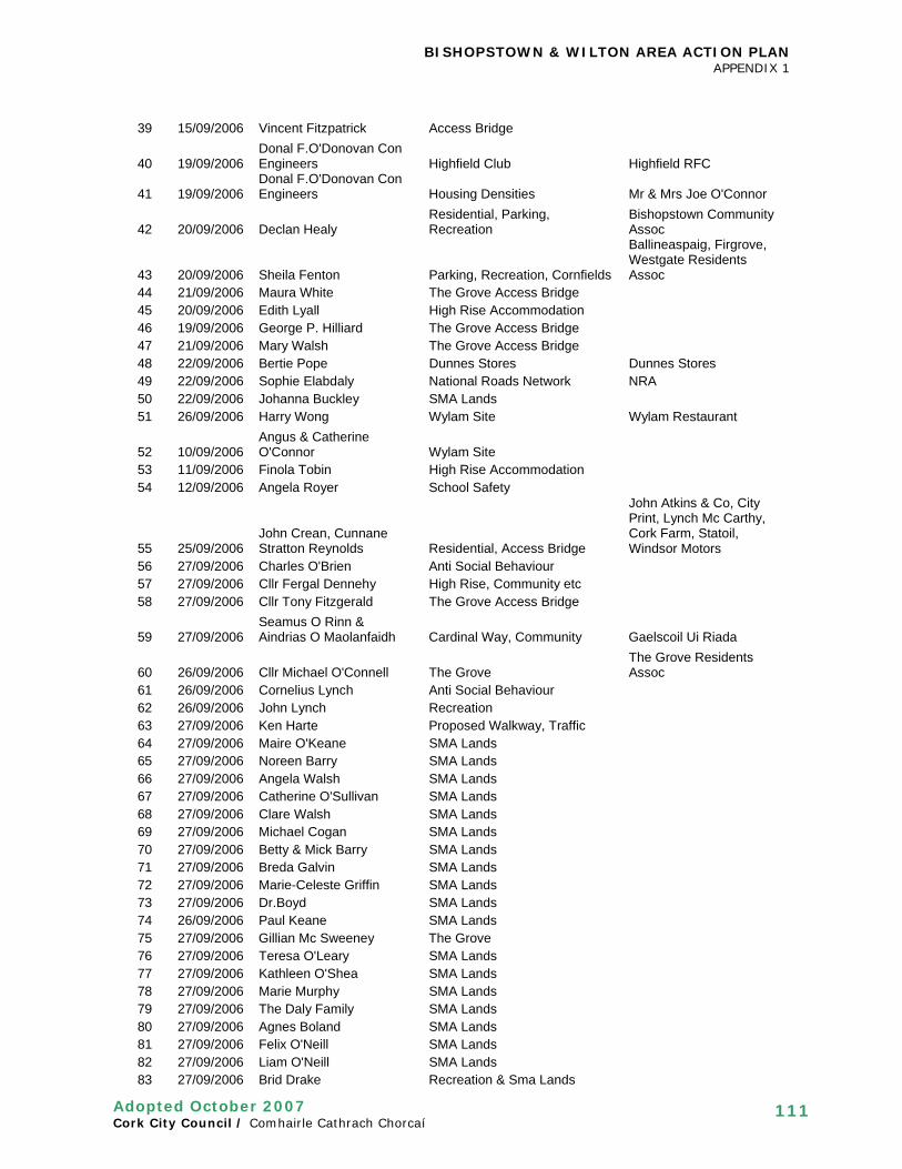
BISHOPSTOWN & WILTON AREA ACTION PLAN APPENDIX 1
Adopted October 2007 Cork City Council / Comhairle Cathrach Chorcaí
111
39 15/09/2006 Vincent Fitzpatrick Access Bridge
40 19/09/2006 Donal F.O'Donovan Con Engineers Highfield Club Highfield RFC
41 19/09/2006 Donal F.O'Donovan Con Engineers Housing Densities Mr & Mrs Joe O'Connor
42 20/09/2006 Declan Healy Residential, Parking, Recreation
Bishopstown Community Assoc
43 20/09/2006 Sheila Fenton Parking, Recreation, Cornfields
Ballineaspaig, Firgrove, Westgate Residents Assoc
44 21/09/2006 Maura White The Grove Access Bridge 45 20/09/2006 Edith Lyall High Rise Accommodation 46 19/09/2006 George P. Hilliard The Grove Access Bridge 47 21/09/2006 Mary Walsh The Grove Access Bridge 48 22/09/2006 Bertie Pope Dunnes Stores Dunnes Stores 49 22/09/2006 Sophie Elabdaly National Roads Network NRA 50 22/09/2006 Johanna Buckley SMA Lands 51 26/09/2006 Harry Wong Wylam Site Wylam Restaurant
52 10/09/2006 Angus & Catherine O'Connor Wylam Site
53 11/09/2006 Finola Tobin High Rise Accommodation 54 12/09/2006 Angela Royer School Safety
55 25/09/2006 John Crean, Cunnane Stratton Reynolds Residential, Access Bridge
John Atkins & Co, City Print, Lynch Mc Carthy, Cork Farm, Statoil, Windsor Motors
56 27/09/2006 Charles O'Brien Anti Social Behaviour 57 27/09/2006 Cllr Fergal Dennehy High Rise, Community etc 58 27/09/2006 Cllr Tony Fitzgerald The Grove Access Bridge
59 27/09/2006 Seamus O Rinn & Aindrias O Maolanfaidh Cardinal Way, Community Gaelscoil Ui Riada
60 26/09/2006 Cllr Michael O'Connell The Grove The Grove Residents Assoc
61 26/09/2006 Cornelius Lynch Anti Social Behaviour 62 26/09/2006 John Lynch Recreation 63 27/09/2006 Ken Harte Proposed Walkway, Traffic 64 27/09/2006 Maire O'Keane SMA Lands 65 27/09/2006 Noreen Barry SMA Lands 66 27/09/2006 Angela Walsh SMA Lands 67 27/09/2006 Catherine O'Sullivan SMA Lands 68 27/09/2006 Clare Walsh SMA Lands 69 27/09/2006 Michael Cogan SMA Lands 70 27/09/2006 Betty & Mick Barry SMA Lands 71 27/09/2006 Breda Galvin SMA Lands 72 27/09/2006 Marie-Celeste Griffin SMA Lands 73 27/09/2006 Dr.Boyd SMA Lands 74 26/09/2006 Paul Keane SMA Lands 75 27/09/2006 Gillian Mc Sweeney The Grove 76 27/09/2006 Teresa O'Leary SMA Lands 77 27/09/2006 Kathleen O'Shea SMA Lands 78 27/09/2006 Marie Murphy SMA Lands 79 27/09/2006 The Daly Family SMA Lands 80 27/09/2006 Agnes Boland SMA Lands 81 27/09/2006 Felix O'Neill SMA Lands 82 27/09/2006 Liam O'Neill SMA Lands 83 27/09/2006 Brid Drake Recreation & Sma Lands

BISHOPSTOWN & WILTON AREA ACTION PLAN APPENDIX 1
Adopted October 2007 Cork City Council / Comhairle Cathrach Chorcaí
112
84 27/09/2006 Sean Murray The Grove 85 27/09/2006 Catherine Murray The Grove 86 27/09/2006 Peg Quinlan SMA Lands 87 27/09/2006 Jack B. Cahill & Co Development adjacent to CUH Richard O'Brien 88 28/09/2006 J.G Fitzgerald Transport Bus Eireann 89 28/09/2006 Fr. Liam O'Callaghan SMA Lands SMA Church 90 28/09/2006 Dermot Hurley SMA Lands 91 28/09/2006 Ray Heffernan SMA Lands 92 28/09/2006 Brian Barrett SMA Lands 93 28/09/2006 Mary Coakley SMA Lands 94 28/09/2006 Daniel Coakley SMA Lands 95 28/09/2006 Nicholas Mc Carthy SMA Lands 96 28/09/2006 Anne Hurley SMA Lands 97 28/09/2006 Donal Hurley SMA Lands 98 28/09/2006 Oonagh Cregan SMA Lands 99 28/09/2006 Sean Murphy SMA Lands
100 28/09/2006 Mairead Coakley SMA Lands 101 28/09/2006 Helen Coughlan SMA Lands 102 28/09/2006 Joan O'Brien SMA Lands 103 28/09/2006 Brian J.O'Brien Amenities & SMA Lands 104 28/09/2006 Margaret Corr SMA Lands 105 28/09/2006 Marguerite Reardan SMA Lands 106 28/09/2006 Margaret O'Connell SMA Lands 107 28/09/2006 Con O'Connell SMA Lands 108 28/09/2006 William Beale SMA Lands 109 28/09/2006 Brendan Manley SMA Lands 110 28/09/2006 Noreen Ryan SMA Lands 111 28/09/2006 Mary Mc Carthy SMA Lands 112 28/09/2006 Phyllis Cunningham SMA Lands 113 28/09/2006 Phil Cahill SMA Lands 114 28/09/2006 Phyllis Sheehan SMA Lands 115 28/09/2006 Michael Higgins Parking, Housing, Recreation 116 28/09/2006 Myra O'Flaherty SMA Lands 117 28/09/2006 Patrick O'Flaherty SMA Lands 118 28/09/2006 Margeret Kennedy SMA & Anti Social Behaviour 119 28/09/2006 Joseph & Eileen Harte Firgrove Playground 120 28/09/2006 Maureen O'Donovan Student Apt, Traffic
121 29/09/2006 Cllr Brian Bermingham High Rise / The Grove developments
122 29/09/2006 Barbara Barrett-Callaghan SMA Lands
123 28/09/2006 Finbarr Sheehan Roads, Traffic, Footpaths Woodbrook/Stratton Pines Residents Assoc
124 29/09/2006 Ronald Swain Traffic 125 29/09/2006 Cllr Mary Shields Residential, Traffic 126 29/09/2006 Kenneth Sheehan Viscount Premises
127 29/09/2006 Mick Murphy High Rise, Public Amenities Communities for Sustainable Development
128 29/09/2006 Philip Curran Residential, Roads Melbourn Residents Association
129 29/09/2006 Cllr Jerry Buttimer Residential, Traffic, Parking 130 29/09/2006 Brady Shipman Martin Public Safety Zones Kelleher Partnership
131 29/09/2006 Dennehy & Dennehy Designs Riverside Farm
132 29/09/2006 Cllr Tony Fitzgerald The Grove 133 27/09/2006 Dr. Aileen Holland SMA Lands

BISHOPSTOWN & WILTON AREA ACTION PLAN APPENDIX 1
Adopted October 2007 Cork City Council / Comhairle Cathrach Chorcaí
113
134 29/09/2006 Ciaran O'Connor Development Oppertunities Sites
135 29/09/2006 Joseph Hegarty SMA Lands 136 29/09/2006 Therese Kennefick SMA Lands 137 29/09/2006 Ann Hogan SMA Lands 138 29/09/2006 Eoin O'Riordan Walks, SMA Lands 139 29/09/2006 Kathleen Dowling SMA Lands 140 29/09/2006 Anna Hennigan SMA Lands
141 29/09/2006 Peter & Vivienne Foley Creche Facilities Wonder Years Childcare Montessori
142 29/09/2006 Eileen O'Riordan Walks, SMA Lands 143 29/09/2006 Vincent Neff High Rise, Parking 144 29/09/2006 Sean O'Riordan Walks, SMA Lands 145 29/09/2006 Sean & Eithne O'Leary SMA Lands 146 29/09/2006 Pat Carroll SMA Lands 147 29/09/2006 Migella Cremin SMA Lands 148 29/09/2006 Maire Gillane SMA Lands 149 29/09/2006 John Gillane SMA Lands 150 29/09/2006 Kitty Mc Carthy SMA Lands 151 29/09/2006 Nora Hayes SMA Lands 152 29/09/2006 Marion Mc Carthy Roundabout, SMA Lands
153 29/09/2006 Eileen & Donnacha Broderick Pedestrian Crossing, Sma
154 29/09/2006 Catherine Mc Swiney SMA Lands 155 29/09/2006 F.A Kelly SMA Lands 156 29/09/2006 Claude & Annette Berard SMA Lands 157 29/09/2006 William & Vera Mannane SMA Lands 158 29/09/2006 Fr. Cormac Breathnach SMA Lands 159 29/09/2006 Margaret O'Sullivan SMA Lands 160 29/09/2006 Joan O'Leary SMA Lands 161 29/09/2006 Mark O'Leary SMA Lands 162 29/09/2006 James Manning SMA Lands 163 29/09/2006 John Reidy SMA Lands 164 29/09/2006 Breda Manning SMA Lands 165 29/09/2006 Jerh O'Leary SMA Lands 166 29/09/2006 Stella Hegarty SMA Lands 167 29/09/2006 Aileen Hegarty SMA Lands
168 29/09/2006 Mc Cutcheon Mulcahy Development Oppertunities Sites
Denis Desmond, Ciaran O'Connor, Paul & Tim O'Donoghue
169 29/09/2006 Development Planning Partnership Retail Tesco Ireland
170 29/09/2006 John Spain & Assoc Retail O'Donovan Properties Ltd
171 29/09/2006 Mc Cutcheon Mulcahy High Density Residential Dennehy Family & Frinailla Ltd
172 29/09/2006 Mc Cutcheon Mulcahy Presentation Bros Land Presentation Brothers 173 29/09/2006 Mc Cutcheon Mulcahy Sma House Sma Order 174 29/09/2006 Mc Cutcheon Mulcahy ESB Site ESB
175 29/09/2006 Mc Cutcheon Mulcahy Melbourne Business Park Dev Melbourne Business Park Ltd
176 29/09/2006 Mary O'Donovan SMA Lands 177 29/09/2006 Jean Mc Keown SMA Lands
178 29/09/2006 Murray O'Laoire Architects
Development Opportunities Sites Richard Woods
179 29/09/2006 J.E Keating & Assoc Curraheen Rd/Barretts Lane Tal Construction

BISHOPSTOWN & WILTON AREA ACTION PLAN APPENDIX 1
Adopted October 2007 Cork City Council / Comhairle Cathrach Chorcaí
114
180 29/09/2006 RPS Rezoning of lands at Carrigrohane John Atkins .
181 29/09/2006 Cunnane Stratton Reynolds SMA, ESB, Wilton SC Howard Holdings
182 29/09/2006 Matrix Associates Land on Bishopstown Road The Kelleher Group
183 29/09/2006 Cunnane Stratton Reynolds John A Woods Land Kenny Group
184 29/09/2006 Cunnane Stratton Reynolds Coca Cola, Carrigrohane Road Oyster Developments
185 29/09/2006 Brid & Pat Hartnett SMA Lands
186 29/09/2006
Des Dunnion, Maire Mulcahy & Brian Mc Carthy Pedestrial Crossings, Traffic
187 29/09/2006 Pat Mc Carthy CUH Health Service Executive 188 29/09/2006 Douglas Johnston Lands at Wilton Motors Wilton Motors 189 29/09/2006 Gillian Mc Sweeney Orchard Road 190 29/09/2006 Fr Cormac Breathnach SMA Lands 191 29/09/2006 Breda Kinnane SMA Lands 192 29/09/2006 Gemma Cadogan SMA Lands 193 29/09/2006 Marie Coffey SMA Lands 194 29/09/2006 Patrick Cadogan SMA Lands 195 29/09/2006 Brigid Murphy SMA Lands 196 29/09/2006 Maura Gleeson SMA Lands 197 29/09/2006 Anne Parfrey SMA Lands 198 29/09/2006 Betty O'Shea SMA Lands 199 29/09/2006 John O'Shea SMA Lands 200 29/09/2006 Denis Cadogan SMA Lands 201 29/09/2006 Una Flanagan SMA Lands 202 29/09/2006 Nora Gray SMA Lands 203 29/09/2006 Ken O'Brien SMA Lands 204 29/09/2006 John & Mary Morrissey SMA Lands 205 29/09/2006 Rosarie Crowley SMA Lands 206 29/09/2006 Betty Madden SMA Lands 207 29/09/2006 Robert & Mary Cotter SMA Lands 208 29/09/2006 Michael Mc Gregor SMA Lands 209 29/09/2006 Helen Murphy SMA Lands 210 29/09/2006 Rosaleen Mc Gregor SMA Lands 211 29/09/2006 Kay O'Connell SMA Lands 212 29/09/2006 Madge Mc Grath SMA Lands 213 29/09/2006 James O'Hea SMA Lands 214 29/09/2006 Michael O'Donovan SMA, Community Facilities 215 29/09/2006 Kathleen Cronin SMA Lands 216 29/09/2006 Sheila Mc Carthy SMA, Community Facilities 217 29/09/2006 Ellen Harvey SMA Lands 218 29/09/2006 Margaret Murphy SMA Lands 219 29/09/2006 Eithne Phelan SMA Lands 220 29/09/2006 Ms. O'Sullivan SMA Lands 221 29/09/2006 Barry Cogan SMA Lands 222 29/09/2006 Veda O'Sullivan SMA Lands 223 29/09/2006 Bridget White SMA Lands 224 29/09/2006 Winnie O'Flaherty SMA Lands 225 29/09/2006 Bernadette Holland SMA Lands 226 29/09/2006 Catherine Hayes SMA Lands 227 29/09/2006 Wendy Hancock SMA Lands

BISHOPSTOWN & WILTON AREA ACTION PLAN APPENDIX 1
Adopted October 2007 Cork City Council / Comhairle Cathrach Chorcaí
115
228 29/09/2006 Noel Redmond SMA Lands 229 29/09/2006 Mary O'Mahony SMA Lands 230 29/09/2006 Mary Kenny sma lands 231 29/09/2006 Anne Kingston SMA Lands 232 29/09/2006 Kathleen Hartnett SMA Lands 233 29/09/2006 Sheehan Family SMA Lands 234 29/09/2006 Vincent SMA Lands 235 29/09/2006 C O'Leary SMA Lands 236 29/09/2006 florence & Steve Geary SMA Lands 237 29/09/2006 Mary Murphy SMA Lands 238 29/09/2006 Mary Lee SMA Lands 239 29/09/2006 Sheila Forde SMA Lands 240 29/09/2006 Ingrid Clarke SMA Lands 241 29/09/2006 John Clarke SMA Lands
242 29/09/2006 Anna Maria Clarke-Moynihan SMA Lands
243 29/09/2006 Treasa Walsh SMA Lands 244 29/09/2006 Albert Collins SMA Lands 245 29/09/2006 Cormac Shinnick SMA Lands 246 29/09/2006 Carmel Uí Donnachadha SMA Lands 247 29/09/2006 Eleanor Barrett SMA Lands 248 29/09/2006 Edel O'Donovan SMA Lands 249 29/09/2006 Claire O'Donovan SMA Lands 250 29/09/2006 Mary O'Donovan SMA Lands 251 29/09/2006 Carmel Hallissey SMA Lands 252 29/09/2006 John Hallissey SMA Lands 253 29/09/2006 Terence McGuire SMA Lands 254 29/09/2006 Neil O'Connell SMA Lands 255 29/09/2006 Fergal O'Mahony SMA Lands 256 29/09/2006 May Hegarty-O'Mahony SMA Lands 257 29/06/2006 Jermone Hayfield SMA Lands
258 &259 29/09/2006 Denis & Catherine Hayes SMA Lands
260 29/09/2006 Pádraic ó Riórdáin SMA Lands 261 29/09/2006 Eva Mc Carthy SMA Lands 262 29/09/2006 Maire Mulcahy SMA Lands 263 29/09/2006 Tom Raftery SMA Lands 264 29/09/2006 Miriam Mc Guire SMA Lands 265 29/09/2006 Aideen McNamara SMA Lands 266 29/09/2006 Geraldine Keating SMA Lands 267 29/09/2006 Michael Mc Guire SMA Lands 268 29/09/2006 Eileen O'Meara sma lands 269 29/09/2006 Joseph Afre sma lands 270 29/09/2006 John Reynolds sma lands 271 29/09/2006 Phil Reidy SMA Lands 272 29/09/2006 Maria Broderick SMA Lands 273 29/09/2006 Morgan Broderick SMA Lands 274 29/09/2006 Martin Walsh SMA Lands 275 29/06/2006 N. O'Brien SMA Lands 276 29/09/2006 Sean Kearney SMA Lands 277 29/09/2006 Tim Murphy SMA Lands 278 29/09/2006 Denis & Mairead Murray SMA Lands 279 29/09/2006 Don Moran SMA Lands 280 29/09/2006 Roy & Helen Devine SMA Lands

BISHOPSTOWN & WILTON AREA ACTION PLAN APPENDIX 1
Adopted October 2007 Cork City Council / Comhairle Cathrach Chorcaí
116
281 29/09/2006 Breda Conneely SMA Lands 282 29/09/2006 Michael Conneely SMA Lands 283 29/09/2006 Patricia Browne SMA Lands 284 29/09/2006 Frank Gilligan sma lands 285 29/09/2006 Patricia Mc Namara sma lands 286 29/09/2006 Renee Long sma lands 287 29/09/2006 Gráinne Sugrue SMA Lands 288 29/09/2006 Tadhg Sugrue SMA Lands 289 29/09/2006 Mary Sugrue SMA Lands 290 29/09/2006 Marjorie Horgan sma lands 291 29/09/2006 Ann & Brendan Flynn sma lands 292 29/09/2006 Jerry & Eileen Corcoran sma lands 293 29/06/2006 Marie O'Callaghan SMA Lands 294 29/09/2006 Olivia Sheehan SMA Lands 295 29/09/2006 Mary Irwin SMA Lands 296 29/09/2006 Jean Stout SMA Lands 297 29/09/2006 Eileen Cahalane SMA Lands 298 29/09/2006 John & Sheila Mc Hugh SMA Lands 299 29/09/2006 Timothy Cahalane SMA Lands 300 29/09/2006 Joseph Moynihan SMA Lands 301 29/09/2006 Catherine Keane SMA Lands 302 29/09/2006 Maire Moynihan SMA Lands 303 29/09/2006 Liam Ryan SMA Lands 304 29/09/2006 Eileen Houston SMA Lands 305 29/09/2006 Thomas Houston SMA Lands 306 29/09/2006 Eileen Coffey sma lands 307 29/09/2006 James Keating sma lands 308 29/09/2006 Finbarr Morrissey sma lands 309 29/09/2006 Aileen Dineen SMA Lands 310 29/09/2006 Margaret O'Connell SMA Lands 311 29/09/2006 Andrew Sheehan SMA Lands 312 29/09/2006 Olivia Fitzgerald SMA Lands 313 29/09/2006 Caitlin Radek SMA Lands 314 29/09/2006 Catherine O'Keefe SMA Lands 315 29/09/2006 Frances Murray SMA Lands 316 29/09/2006 Mary O'Sullivan SMA Lands 317 29/06/2006 Denis Fitzgerald SMA Lands 318 29/09/2006 Donal Murphy SMA Lands 319 29/09/2006 Mona Brady SMA Lands 320 29/09/2006 Michael Moynihan sma lands 321 29/09/2006 P. Gray sma lands 322 29/09/2006 Thomas Ronan sma lands 323 29/09/2006 Margaret Ronan SMA Lands 324 29/09/2006 Bridget Mc Carthy SMA Lands 325 29/09/2006 Ann Ryan SMA Lands 326 29/09/2006 Brian O'Sullivan SMA Lands 327 29/09/2006 Eddie Mc Carthy SMA Lands 328 29/09/2006 John Mc Carthy sma lands 329 29/09/2006 Declan O'Shea sma lands 330 29/09/2006 Eamonn O'Shea sma lands 331 29/09/2006 Patrick & Anne O'Reilly SMA Lands 332 29/09/2006 Maura Moran SMA Lands 333 29/09/2006 Martin Morrissey SMA Lands 334 29/09/2006 Mary Herriott SMA Lands

BISHOPSTOWN & WILTON AREA ACTION PLAN APPENDIX 1
Adopted October 2007 Cork City Council / Comhairle Cathrach Chorcaí
117
335 29/09/2006 James Bourke SMA Lands 336 29/09/2006 Angela Bourke SMA Lands 337 29/09/2006 Una Looney SMA Lands 338 29/06/2006 Philip Mohally SMA Lands 339 29/09/2006 Patrick Kelleher SMA Lands 340 29/09/2006 Mary Kelleher SMA Lands 341 29/09/2006 John Quinn SMA Lands 342 29/09/2006 Niall O'Donovan sma lands 343 29/09/2006 John Dennehy sma lands 344 29/09/2006 Mary Haywood sma lands 345 29/09/2006 Eleanor Morrissey SMA Lands 346 29/09/2006 Michael Carey sma lands 347 29/09/2006 Patricia Carey sma lands 348 29/09/2006 Breda Morrissey sma lands 349 29/09/2006 Mary O'Flynn SMA Lands 350 29/09/2006 Ann Corcoran SMA Lands 351 29/09/2006 Denis & Mary O'Driscoll SMA Lands 352 29/09/2006 Mary Bambary SMA Lands 353 29/09/2006 Margaret Mohally SMA Lands 354 29/09/2006 Donal O'Leary sma lands 355 29/09/2006 Aislinn O'Leary sma lands 356 29/09/2006 Mary O'Leary sma lands 357 29/09/2006 Maire Cahill SMA Lands 358 29/09/2006 John Moran SMA Lands 359 29/09/2006 Garrett Gray SMA Lands 360 29/09/2006 Ann Harrington SMA Lands 361 29/09/2006 Anna Enright SMA Lands 362 29/06/2006 Angela Dennehy SMA Lands 363 29/09/2006 Phil Cummins SMA Lands 364 29/09/2006 Christine Kearney SMA Lands 365 29/09/2006 Winne Creedon SMA Lands 366 29/09/2006 Mary Casey SMA Lands 367 29/09/2006 Patrick Browne SMA Lands
368 29/09/2006 Richard & Frances Cuddihy sma lands
369 29/09/2006 Patricia Fitzgerald sma lands 370 29/09/2006 Margaret Beechinor sma lands 371 29/09/2006 Richard Murray SMA Lands 372 29/09/2006 Jackie O'Donnell sma lands 373 29/09/2006 Mary Cosgrave sma lands 374 29/09/2006 Nuala O'Sullivan sma lands 375 29/09/2006 Patricia Calnan SMA Lands 376 29/09/2006 Deirdre Wall sma lands 377 29/09/2006 Vince Stellans sma lands 378 29/09/2006 Helen Barry sma lands 379 29/09/2006 Richard & Martin Studdert SMA Lands 380 29/09/2006 Catherine Lynch SMA Lands 381 29/09/2006 Tony Duggan SMA Lands 382 29/09/2006 Michael Moloney SMA Lands 383 29/09/2006 Cora Redmond SMA Lands 384 29/09/2006 Gerard Buckley sma lands 385 29/09/2006 John & Patricia Corridan sma lands
386 29/09/2006 Thomas & Veronica O'Donovan sma lands
387 29/09/2006 Edward O'Sullivan SMA Lands

BISHOPSTOWN & WILTON AREA ACTION PLAN APPENDIX 1
Adopted October 2007 Cork City Council / Comhairle Cathrach Chorcaí
118
388 29/09/2006 Catherine O'Sullivan SMA Lands 389 29/09/2006 Frank O'Sullivan SMA Lands 390 29/09/2006 Thomas Cummins SMA Lands 391 29/06/2006 Elizabeth Downey SMA Lands 392 29/09/2006 Anne Ducey SMA Lands 393 29/09/2006 Doris George SMA Lands 394 29/09/2006 Eileen Harte SMA Lands 395 29/09/2006 Daniel Lynch SMA Lands 396 29/09/2006 Margaret Moloney SMA Lands 397 29/09/2006 Patrick & Monica Loughlin SMA Lands 398 29/09/2006 John Mullins sma lands 399 29/09/2006 Mary O'Riordan sma lands 400 29/09/2006 Denis O'Riordan sma lands 401 29/09/2006 Anita Daly SMA Lands 402 29/09/2006 Mona Crean sma lands 403 29/09/2006 Eleanor Crowley sma lands 404 29/09/2006 Michael Ruane sma lands 405 29/09/2006 Tim O'Driscoll SMA Lands 406 29/09/2006 Patrick O'Connor sma lands 407 29/09/2006 Denis Carey sma lands 408 29/09/2006 Patrick O'Connor sma lands 409 29/09/2006 Phyl Morris SMA Lands 410 29/09/2006 Pat Murphy SMA Lands 411 29/09/2006 Val Murphy SMA Lands 412 29/09/2006 Brigid Costello SMA Lands 413 29/09/2006 Katherine Buckley SMA Lands 414 29/09/2006 Jim Buckley sma lands 415 29/09/2006 Margaret Mullins sma lands 416 29/09/2006 Rosalie O'Mahony sma lands 417 29/09/2006 Jean Louise O'Mahony SMA Lands 418 29/09/2006 Charles O'Mahony SMA Lands 419 29/06/2006 Irene Hogan SMA Lands 420 29/09/2006 Marie O'Mahony-Roche SMA Lands 421 29/09/2006 Gwen O'Flaherty SMA Lands 422 29/09/2006 Noreen Mc Sweeney SMA Lands 423 29/09/2006 Cllr Dave Mc Carthy The Grove walkway 424 29/09/2006 Eileen O'Sullivan SMA Lands 425 29/09/2006 Pat Mc Carthy SMA Lands 426 29/09/2006 Tom & Clare Hunt SMA Lands 427 29/09/2006 Nora O'Leary SMA Lands
428 29/09/2006 Florence & Ellen O'Driscoll SMA Lands
429 29/09/2006 Mrs O'Donovan SMA Lands 430 29/09/2006 Andrew Foley SMA Lands 431 29/09/2006 Ann Mc Sweeney SMA Lands 432 29/09/2006 Frank O'Leary sma lands 433 29/09/2006 Margo O'Leary SMA Lands 434 29/09/2006 Marie Treacy SMA Lands 435 29/09/2006 Mary O'keefe SMA Lands 436 29/09/2006 Nancy Kelleher SMA Lands 437 29/09/2006 Florence O'Keefe SMA Lands 438 29/09/2006 Michael Ahern sma lands 439 29/09/2006 Maurice O'Sullivan sma lands 440 29/09/2006 PJ &Mary Callanan sma lands 441 29/09/2006 Aileen Flavin SMA Lands

BISHOPSTOWN & WILTON AREA ACTION PLAN APPENDIX 1
Adopted October 2007 Cork City Council / Comhairle Cathrach Chorcaí
119
442 29/06/2006 Ina Sheehy SMA Lands 443 29/09/2006 Margaret White SMA Lands 444 29/09/2006 Jane O'Brien SMA Lands 445 29/09/2006 Marna Carey SMA Lands 446 29/09/2006 Mary Tyrrell SMA Lands 447 29/09/2006 Siobhan Morrison SMA Lands 448 29/09/2006 Breda Deane SMA Lands 449 29/09/2006 Helen O'Keefe SMA Lands 450 29/09/2006 Sean Bungoyle SMA Lands 451 29/09/2006 Phil O'Hanlon sma lands 452 29/09/2006 Barbara Barrett sma lands 453 29/09/2006 Patricia Guilfoyle sma lands 454 29/09/2006 Bridget Fitzgerald sma lands 455 29/06/2006 Betty Moore sma lands 456 29/09/2006 Thos. P SMA Lands 457 29/09/2006 John Gately SMA Lands 458 29/09/2006 Ann & Eddie Burgess SMA Lands 459 29/09/2006 Noreen Twomey SMA Lands 460 29/09/2006 Heather Johnston SMA Lands 461 29/09/2006 S. Hutton sma lands 462 29/09/2006 John Heffernan sma lands 463 29/09/2006 Myra Kennedy sma lands 464 29/09/2006 Ellen Walsh SMA Lands 465 29/09/2006 Celia Kerrigan SMA Lands 466 29/09/2006 Edmund Dillane SMA Lands 467 29/09/2006 Cathleen O'Neill SMA Lands 468 29/06/2006 Liza O'Connor SMA Lands 469 29/09/2006 Anne O'Riordan SMA Lands 470 29/09/2006 Elizabeth Harris SMA Lands 471 29/09/2006 Maureen McGrath SMA Lands 472 29/09/2006 Anne O'Riordan sma lands 473 29/09/2006 Jerry O'Riordan sma lands 474 29/09/2006 Mrs. D.Hinds sma lands 475 29/09/2006 Della O'Leary SMA Lands 476 29/09/2006 Mary O'Connor SMA Lands 477 29/09/2006 Anthony Drummond SMA Lands 478 29/09/2006 Gina Mc Namara SMA Lands 479 29/09/2006 Mary Murray SMA Lands 480 29/09/2006 Donal & Noreen Sheehan SMA Lands 481 29/06/2006 Michael English SMA Lands 482 29/09/2006 Mary Cronin SMA Lands 483 29/09/2006 Mary Mulcahy SMA Lands 484 29/09/2006 Margaret Cotter SMA Lands 485 29/09/2006 Bridie Sheehan SMA Lands 486 29/09/2006 Peggy Lordan SMA Lands 487 29/09/2006 Breda Ryan SMA Lands 488 29/09/2006 Annette Stephen SMA Lands 489 29/09/2006 Sinead Mc Carthy sma lands 490 29/09/2006 Lorna Acton SMA Lands 491 29/09/2006 Mary O'Sullivan SMA Lands 492 29/09/2006 Morgan & Jean Lahiffe SMA Lands 493 29/09/2006 Bertie Harrington SMA Lands 494 29/09/2006 Pauline & Tim Sheehan SMA Lands 495 29/09/2006 Dolores O'Riordan sma lands

BISHOPSTOWN & WILTON AREA ACTION PLAN APPENDIX 1
Adopted October 2007 Cork City Council / Comhairle Cathrach Chorcaí
120
496 29/09/2006 Eileen & Christopher Mc Carthy sma lands
497 29/09/2006 Sheila Angland sma lands 498 29/09/2006 Eithne O'Mahony SMA Lands 499 29/06/2006 Keira O'Mahony SMA Lands 500 29/09/2006 Rita Clayton SMA Lands 501 29/09/2006 M Forde SMA Lands 502 29/09/2006 K. Jackson SMA Lands 503 29/09/2006 iAin H. SMA Lands 504 29/09/2006 David Ainscough SMA Lands 505 29/09/2006 Donal Hurley sma lands 506 29/09/2006 Nuala Keating sma lands 507 29/09/2006 Paula Stubbs sma lands 508 29/09/2006 Fr. Frank SMA Lands
509 29/09/2006 Nicholas & Catherine Mc Carthy SMA Lands
510 29/09/2006 Sean Keegan SMA Lands 511 29/09/2006 Sandra Meehan SMA Lands 512 29/06/2006 John Connolly SMA Lands 513 29/09/2006 Thomas Coughlan SMA Lands 514 29/09/2006 Sheila Coughlan SMA Lands 515 29/09/2006 Carthy SMA Lands 516 29/09/2006 Ann Walsh SMA Lands 517 29/09/2006 Lorna Cole SMA Lands 518 29/09/2006 Phil O'Donovan SMA Lands 519 29/09/2006 Maura O'Sullivan SMA Lands 520 29/09/2006 Denis Buckley SMA Lands 521 29/09/2006 A. O'Mahony SMA Lands 522 29/09/2006 Kathleen Lane sma lands 523 29/09/2006 Eileen Sexton SMA Lands 524 29/09/2006 Sheila White SMA Lands 525 29/09/2006 James Hobbins SMA Lands 526 29/06/2006 Michael Mc Knight SMA Lands 527 29/09/2006 Josephine Mc Knight SMA Lands 528 29/09/2006 Mary O'Shea SMA Lands 529 29/09/2006 Majella Kelleher SMA Lands 530 29/09/2006 Siobhan Luttrell SMA Lands 531 29/09/2006 Kevin O'Mahony SMA Lands 532 29/09/2006 Mary & Dermot Hickey SMA Lands 533 29/09/2006 Mary Murray SMA Lands 534 29/09/2006 Mary Fahy SMA Lands 535 29/09/2006 Deirdre O'Leary sma lands 536 29/09/2006 Paul O'Leary SMA Lands 537 29/09/2006 Gerard Boland SMA Lands 538 29/09/2006 Godfrey Dunlea SMA Lands 539 29/06/2006 Mary Moriarty SMA Lands 540 29/09/2006 Angela O'Leary SMA Lands 541 29/09/2006 Donal O'Sullivan SMA Lands 542 29/09/2006 Margaret O'Connor SMA Lands 543 29/09/2006 Maria O'Connor SMA Lands 544 29/09/2006 Aidan Bruton SMA Lands 545 29/09/2006 Ken Bruton SMA Lands 546 29/09/2006 Gerard Bruton sma lands 547 29/09/2006 Mary O'Callaghan sma lands 548 29/09/2006 Eileen Bruton sma lands

BISHOPSTOWN & WILTON AREA ACTION PLAN APPENDIX 1
Adopted October 2007 Cork City Council / Comhairle Cathrach Chorcaí
121
549 29/09/2006 Betty Mc Carthy sma lands 550 29/09/2006 Kay Fennessy sma lands 551 29/09/2006 Elaine Fennessy SMA Lands 552 29/09/2006 Betty Courtney SMA Lands 553 29/06/2006 Emma Clarke SMA Lands 554 29/09/2006 Sarah Clarke SMA Lands 555 29/09/2006 Eileen Cahill SMA Lands 556 29/09/2006 Terence Layton sma lands 557 29/09/2006 Thomas Morrissey sma lands 558 29/09/2006 Charles Bogue sma lands 559 29/09/2006 Eugene Mc Carthy SMA Lands 560 29/09/2006 Mary Mc Carthy SMA Lands 561 29/09/2006 Bartholomew Murphy SMA Lands 562 29/09/2006 Patricia Murphy SMA Lands 563 29/09/2006 Michael O'Shea SMA Lands 564 29/09/2006 John O'Sullivan SMA Lands 565 29/09/2006 John & Joan Sexton SMA Lands 566 29/06/2006 William Kennedy SMA Lands 567 29/09/2006 Andrias ó Maolanfaidh SMA Lands 568 29/09/2006 Andrais ó Maolanfaidh SMA Lands 569 29/09/2006 Catherine Collins SMA Lands 570 29/09/2006 Máire Murphy SMA Lands 571 29/09/2006 Mary Aherne SMA Lands 572 29/09/2006 Peggy Corkery SMA Lands 573 29/09/2006 Tom Johnston SMA Lands 574 29/09/2006 Jim Collins SMA Lands 575 29/09/2006 Mr & Mrs Meade sma lands 576 29/09/2006 Mrs A. Howe SMA Lands 577 29/09/2006 Terri O'Reilly SMA Lands 578 29/09/2006 Kay Reading SMA Lands 579 29/09/2006 Jean Kieran SMA Lands 580 29/09/2006 Mrs. B.Bird SMA Lands 581 29/09/2006 Jennie White SMA Lands 582 29/09/2006 Mary Shorten SMA Lands 583 29/09/2006 Hilary Mc Carthy SMA Lands 584 29/09/2006 Ann Coughlan SMA Lands 585 29/09/2006 Mairead O'Sullivan SMA Lands 586 29/09/2006 Ms. M Calnan SMA Lands 587 29/09/2006 Margaret Mc Carthy SMA Lands 588 29/09/2006 Michael Fahy SMA Lands 589 29/09/2006 Sheila Fahy SMA Lands 590 29/09/2006 Mary & Bill O'Donnell SMA Lands 591 29/09/2006 Ellen Walsh SMA Lands 592 29/09/2006 Claire Aherne SMA Lands 593 29/09/2006 Eileen Kiely SMA Lands 594 29/06/2006 Niamh Kiely SMA Lands 595 29/09/2006 Michael Costello sma lands 596 29/09/2006 M.P Fahy SMA Lands 597 29/09/2006 Colette Carroll SMA Lands 598 29/09/2006 Mary Carroll SMA Lands 599 29/09/2006 Carmel Carroll SMA Lands 600 29/09/2006 Pat Hegarty SMA Lands 601 29/09/2006 Kay Lucey sma lands 602 29/09/2006 Clair Lyons sma lands

BISHOPSTOWN & WILTON AREA ACTION PLAN APPENDIX 1
Adopted October 2007 Cork City Council / Comhairle Cathrach Chorcaí
122
603 29/09/2006 Phil O'Leary sma lands 604 29/09/2006 Ann Dempsey SMA Lands 605 29/09/2006 O'Donovan Family SMA Lands 606 29/09/2006 Kathleen Fleming SMA Lands 607 29/09/2006 Maureen Herlihy SMA Lands 608 29/09/2006 Mrs. C. Murphy SMA Lands 609 29/09/2006 Margaret Callanan SMA Lands 610 29/09/2006 Sheila Gallagher SMA Lands 611 29/09/2006 Doreen O'Brien SMA Lands 612 29/09/2006 Sheila Forde sma lands 613 29/09/2006 O'Donovan Family sma lands 614 29/09/2006 Teresa Bohane sma lands 615 29/09/2006 Kathleen O'Brien SMA Lands 616 29/09/2006 Lucy Carty SMA Lands 617 29/09/2006 Noel J.Collins SMA Lands 618 29/09/2006 Michael O'Loughlin SMA Lands 619 29/09/2006 Eda O'Loughlin SMA Lands 620 29/09/2006 Tom & Betty O'Connor SMA Lands 621 29/06/2006 Tony Duggan SMA Lands 622 29/09/2006 Maria Duggan SMA Lands 623 29/09/2006 Reg Hegarty SMA Lands 624 29/09/2006 James Duggan SMA Lands 625 29/09/2006 Margaret O'Brien SMA Lands 626 29/09/2006 Oliver O'Brien sma lands 627 29/09/2006 Therese & Joe Power SMA Lands 628 29/09/2006 Carmel Halnan SMA Lands 629 29/09/2006 Patricia Hegarty SMA Lands 630 29/09/2006 Mrs Bohan SMA Lands 631 29/09/2006 Ina Lynch SMA Lands 632 29/09/2006 Lucy O'Sullivan SMA Lands 633 29/09/2006 Mary Sisk SMA Lands 634 29/09/2006 Bernadette Bell SMA Lands 635 29/09/2006 Marie Fitzgerald SMA Lands 636 29/09/2006 Maureen Sneyd SMA Lands 637 29/09/2006 Anne Murphy SMA Lands 638 29/09/2006 Don Cashman SMA Lands 639 29/09/2006 Ted & Phyllis Barry sma lands 640 29/09/2006 Elizabeth Harrington SMA Lands 641 29/09/2006 Margaret Dawson SMA Lands 642 29/09/2006 James O'Rourke SMA Lands 643 29/06/2006 Kay Delaney SMA Lands 644 29/09/2006 Noreen O'Donovan SMA Lands 645 29/09/2006 Margaret O'Donovan SMA Lands 646 29/09/2006 Margaret Hayes SMA Lands 647 29/09/2006 Jackie Sheehan SMA Lands 648 29/09/2006 M Fielding SMA Lands 649 29/09/2006 Ellen Tobin SMA Lands 650 29/09/2006 Sheila Cremin SMA Lands 651 29/09/2006 Ann Twomey sma lands 652 29/09/2006 Joan Walsh SMA Lands 653 29/09/2006 Ann Seymour SMA Lands 654 29/09/2006 Mrs M. Cullinane SMA Lands 655 29/09/2006 Michael O'Brien SMA Lands 656 29/09/2006 Sheila Murphy SMA Lands

BISHOPSTOWN & WILTON AREA ACTION PLAN APPENDIX 1
Adopted October 2007 Cork City Council / Comhairle Cathrach Chorcaí
123
657 29/09/2006 Rose Murray sma lands 658 29/09/2006 Rosarie O'Connor sma lands 659 29/09/2006 Maura Aherne sma lands 660 29/09/2006 Mary Brophy SMA Lands 661 29/09/2006 Mary O'Sullivan SMA Lands 662 29/09/2006 Sarah P. Lyons SMA Lands 663 29/09/2006 Mary Murphy sma lands 664 29/09/2006 Kathleen Morrissey SMA Lands 665 29/09/2006 Mary O'Keefe SMA Lands 666 29/06/2006 Ellen Cooney SMA Lands 667 29/09/2006 Betty Moore SMA Lands 668 29/09/2006 Isobel Moloney sma lands 669 29/09/2006 Anne Mc Sweeney SMA Lands 670 29/09/2006 Mr. O'Brien SMA Lands 671 29/09/2006 B. Horgan SMA Lands 672 29/09/2006 Diana Morrissey SMA Lands 673 29/09/2006 Betty O'Brien SMA Lands 674 29/09/2006 Mary O'Neice SMA Lands 675 29/09/2006 Deirdre Bateman SMA Lands 676 29/09/2006 O'Sullivan sma lands 677 29/09/2006 Marjorie O'Donnell sma lands 678 29/09/2006 Berna Moran sma lands 679 29/09/2006 Mary Barry sma lands 680 29/09/2006 Marie Cronin sma lands 681 29/09/2006 Mary Kennedy SMA Lands 682 29/09/2006 Peggy Coveney SMA Lands 683 29/09/2006 Monica O'Shea SMA Lands 684 29/09/2006 Carmel Coppinger SMA Lands 685 29/09/2006 Muriel Collins SMA Lands 686 29/09/2006 Maura Kenny sma lands 687 29/09/2006 Emily Barry sma lands 688 29/06/2006 Phyl Ellis sma lands 689 29/09/2006 Christina Roche SMA Lands 690 29/09/2006 Noreen Murphy SMA Lands 691 29/09/2006 Christina Donnelly SMA Lands 692 29/09/2006 Betty Layton SMA Lands
693 29/09/2006 Richard & Breda Henchion sma lands
694 29/09/2006 Peter Hurley SMA Lands 695 29/09/2006 J. Cashman SMA Lands 696 29/09/2006 Tadhg & Betty Murphy SMA Lands 697 29/09/2006 Mr & Mrs P. Daly SMA Lands 698 29/09/2006 Mary Moran SMA Lands 699 29/09/2006 Eugene O'Sullivan SMA Lands 700 29/09/2006 Mary O'Donovan SMA Lands 701 29/09/2006 Patrick Barrett sma lands 702 29/09/2006 Rose Barrett sma lands 703 29/09/2006 Frances Keohane sma lands 704 29/09/2006 Denis Keohane sma lands 705 29/09/2006 Evelyn Flavin sma lands 706 29/09/2006 Pauline Howard SMA Lands 707 29/09/2006 Matt Walsh SMA Lands 708 29/09/2006 Catherine O'Sullivan SMA Lands 709 29/09/2006 Mary Murphy SMA Lands 710 29/09/2006 Unknown SMA Lands

BISHOPSTOWN & WILTON AREA ACTION PLAN APPENDIX 1
Adopted October 2007 Cork City Council / Comhairle Cathrach Chorcaí
124
711 29/09/2006 Una Drummond sma lands 712 29/09/2006 unknown sma lands 713 29/09/2006 S.F Warren sma lands 714 29/09/2006 Murielle Mc Carthy SMA Lands 715 29/09/2006 Betty Buckley SMA Lands 716 29/09/2006 Margaret White SMA Lands 717 29/06/2006 Nelly Martin sma lands 718 29/09/2006 Phil O'Sullivan SMA Lands 719 29/09/2006 Charles O'Brien SMA Lands 720 29/09/2006 Ann Bruton SMA Lands 721 29/09/2006 Nuala Linehan SMA Lands 722 29/09/2006 Eily Healy SMA Lands 723 29/09/2006 Christopher Bohan SMA Lands 724 29/09/2006 Josephine Brennan SMA Lands 725 29/09/2006 Theresa O'Sullivan sma lands 726 29/09/2006 John O'Brien sma lands 727 29/09/2006 Katty Twomey sma lands 728 29/09/2006 Joan Deasy sma lands 729 29/09/2006 Margaret Healy sma lands 730 29/09/2006 Millie O'Brien SMA Lands 731 29/09/2006 Maie Coughlan SMA Lands 732 29/09/2006 Claire Coleman SMA Lands 733 29/09/2006 Phil Molloy SMA Lands 734 29/09/2006 Nichola Martin SMA Lands 735 29/09/2006 Margaret Lynch sma lands 736 29/09/2006 Esther Crowe sma lands 737 29/09/2006 Eilish Kelly sma lands 738 29/09/2006 Esther Donnellan SMA Lands 739 29/09/2006 Joan Denton SMA Lands 740 29/09/2006 Sheila Mc Carthy SMA Lands 741 29/09/2006 Catherine Lynch sma lands 742 29/09/2006 Mary Desmond sma lands 743 29/09/2006 Carmel Duncombe SMA Lands 744 29/09/2006 Peggy Buckley SMA Lands 745 29/06/2006 Marie Kelly SMA Lands 746 29/09/2006 Margaret Kelleher sma lands 747 29/09/2006 Cara Riordan SMA Lands 748 29/09/2006 Breda Dowling SMA Lands 749 29/09/2006 Liam O'Driscoll SMA Lands 750 29/09/2006 Noreen Long SMA Lands 751 29/09/2006 Maura Daly SMA Lands 752 29/09/2006 Ann Chambers SMA Lands 753 29/09/2006 Aideen Roe SMA Lands 754 29/09/2006 Sandra sma lands 755 29/09/2006 Phil Chambers sma lands 756 29/09/2006 Nora Mc Carthy sma lands 757 29/09/2006 P.J Crowe sma lands 758 29/09/2006 Mary Crowley sma lands 759 29/09/2006 Nancy O'Sullivan SMA Lands 760 29/09/2006 K. O'Brien SMA Lands 761 29/09/2006 Kay O'Herlihy SMA Lands 762 29/09/2006 Helen Walsh SMA Lands 763 29/09/2006 Mary O'Donovan SMA Lands 764 29/09/2006 Ina Kieling sma lands

BISHOPSTOWN & WILTON AREA ACTION PLAN APPENDIX 1
Adopted October 2007 Cork City Council / Comhairle Cathrach Chorcaí
125
765 29/09/2006 Joan Mc Carthy sma lands 766 29/09/2006 Sheila Harrington sma lands 767 29/09/2006 T. Massett SMA Lands 768 29/09/2006 Denise Cullinane SMA Lands 769 29/09/2006 Karen Buckley SMA Lands 770 29/09/2006 Anne Kelly SMA Lands 771 29/09/2006 Eleanor Burke sma lands 772 29/09/2006 Phil Manley sma lands 773 29/09/2006 Angela Coults SMA Lands 774 29/06/2006 Christine O'Shea 775 29/09/2006 Teresa Collins SMA Lands 776 29/09/2006 Kathleen Murphy sma lands 777 29/09/2006 Kathleen Murray SMA Lands 778 29/09/2006 Dennehy SMA Lands 779 29/09/2006 Irene O'Sullivan SMA Lands 780 29/09/2006 Mary Hurley SMA Lands 781 29/09/2006 Violet Chilvers SMA Lands 782 29/09/2006 Sheila Morrissey SMA Lands 783 29/09/2006 Donal Murphy SMA Lands 784 29/09/2006 Maura O'Driscoll sma lands 785 29/09/2006 Peg Mc Allen sma lands 786 29/09/2006 Elaine Duggan sma lands 787 29/09/2006 Ann O'Mahony sma lands 788 29/09/2006 Angela Forde sma lands 789 29/09/2006 Kathleen Bermingham SMA Lands 790 29/09/2006 Teresa Finn SMA Lands 791 29/09/2006 Marian Hoey SMA Lands 792 29/09/2006 Maureen Murphy SMA Lands 793 29/09/2006 Marie Mitchell SMA Lands 794 29/09/2006 Catherine Byrne sma lands 795 29/09/2006 Bina Hogan sma lands 796 29/09/2006 Sr. Brendan O'Driscoll sma lands 797 29/09/2006 Sp. Maura Nagle SMA Lands 798 29/09/2006 Margaret Marthy SMA Lands 799 29/09/2006 Donal healy SMA Lands 800 29/09/2006 Mary Healy sma lands 801 29/09/2006 Maurice Madden sma lands 802 29/09/2006 John O'Leary sma lands 803 29/09/2006 M. Geary sma lands 804 29/06/2006 Istvan Pék SMA Lands 805 29/09/2006 Kathryn Gilles SMA Lands 806 29/09/2006 Enda Bevan SMA Lands 807 29/09/2006 Phil O'Connell SMA Lands 808 29/09/2006 C. O'Sullivan SMA Lands 809 29/09/2006 Margaret Dineen sma lands
810 29/09/2006 Donal & Maureen Mc Carthy sma lands
811 29/09/2006 Mrs. B Egmar sma lands 812 29/09/2006 Margaret Kiely SMA Lands 813 29/09/2006 Caoimhín ó Donnchú Traffic, Footpaths, Cycleways 814 29/09/2006 John Ryan SMA Lands 815 29/09/2006 Catherine Mc Grath 816 29/09/2006 Pat & Betty Murphy sma lands 817 29/09/2006 Charles O'Connell sma lands 818 29/09/2006 Ann O'Connell sma lands

BISHOPSTOWN & WILTON AREA ACTION PLAN APPENDIX 1
Adopted October 2007 Cork City Council / Comhairle Cathrach Chorcaí
126
819 29/09/2006 M. Riordan SMA Lands 820 29/09/2006 Phyl Gearty SMA Lands 821 29/09/2006 J.D Gearty SMA Lands 822 29/09/2006 Patrick & Alma Fox SMA Lands 823 29/09/2006 June Rooney SMA Lands 824 29/09/2006 Joan French sma lands 825 29/09/2006 Kathleen Dorgan sma lands 826 29/09/2006 Nora Dineen sma lands 827 29/09/2006 Mary Roche SMA Lands 828 29/09/2006 Mary Burke SMA Lands 829 29/09/2006 Kay Corcoran SMA Lands 830 29/09/2006 Margaret Hartnett sma lands 831 29/09/2006 Dolores Gardiner sma lands 832 29/09/2006 Irene Kavanagh sma lands 833 29/09/2006 Doreen Gradiner sma lands 834 29/09/2006 Mary Barrett SMA Lands 835 29/09/2006 Alice Browne SMA Lands 836 29/09/2006 P. Kelleher SMA Lands 837 29/06/2006 Sheila Murphy SMA Lands 838 29/09/2006 Mary O'Malley SMA Lands 839 29/09/2006 Eileen O'Connell sma lands 840 29/09/2006 Dominic Cahill sma lands 841 29/09/2006 Tony Mc Carthy sma lands 842 29/09/2006 Breda Madden SMA Lands 843 29/09/2006 Sheila O'Dwyer sma lands 844 29/09/2006 Denis O'Leary sma lands 845 29/09/2006 Doreen O'Leary sma lands 846 29/09/2006 Angie Murphy SMA Lands 847 29/09/2006 Denis Murphy SMA Lands 848 29/09/2006 Niamh Roe SMA Lands 849 29/09/2006 Teresa Roe SMA Lands 850 29/09/2006 Ann Mallen SMA Lands 851 29/09/2006 Marie O'Keefe sma lands 852 29/09/2006 Sheila O'Sullivan sma lands 853 29/09/2006 Lillian O'Leary sma lands
854 04/10/2006 Mairead Sheedy Residential size, primary school Dept of Education
855 06/10/2006 Martina Barrett sma lands