biological survey status update for the desert claim … · desert claim has since scaled back the...
TRANSCRIPT

Biological Survey Status Update for the
Desert Claim Wind Project
Kittitas County, Washington
Prepared for:
Desert Claim Wind Power LLC
505 14th Street, Suite 1150 Oakland, California 94612
Prepared by:
Joel Thompson
Western EcoSystems Technology, Inc.
2725 NW Walnut Blvd Corvallis, Oregon 97333
January 18, 2018
Pre-Decisional Document - Privileged and Confidential - Not For Distribution

2017 Biological Survey Status Update for Desert Claim
WEST, Inc. i January 18, 2018
EXECUTIVE SUMMARY
The proposed Desert Claim Wind Project (Project) is located in Kittitas County, Washington, approximately 8 - 10 miles (mi) north-northwest of the town of Ellensburg. In 2010, Desert Claim Wind Power LLC (Desert Claim) received a Site Certification Agreement (SCA) following the recommendation of the Washington’s Energy Facility Site Evaluation Council based on the Project layout and configuration anticipated at that time. The 2010 SCA permit approved construction and operation of up to 95, 2-megawatt (MW) wind turbines for a maximum capacity of 190 MW. Desert Claim has since scaled back the Project to a maximum of 31 turbines located within a smaller Project footprint with a project capacity of 80-100 MW. The developed portion of the Project area has also been reduced by approximately 30% from that described in the 2010 SCA. Although the current configuration includes a small area in the west that was not a part of the permitted Project area, a substantial portion of the permitted Project area to the east of Reecer Creek is no longer being utilized. Desert Claim is currently in the process of applying for an amendment to the SCA to accommodate proposed changes to the Project layout and configuration. The biological resources in the Project area have been studied extensively. Baseline biological surveys have been conducted by Western EcoSystems Technology (WEST) intermittently since 2002, including surveys for birds, bats, nesting raptors, sensitive plants and habitat. To support the SCA amendment application, WEST has compiled this report to summarize the various studies conducted from March 2002 to August 2017, and to assess the likely impacts of the revised Project relative to those anticipated with the original permitting project configuration. While surveys have been conducted over a period of more than 10 years, the results of these surveys have been similar. Given the considerable reduction in Project footprint now proposed, impacts to local habitats and wildlife are expected to be reduced compared to the potential impacts anticipated at the time EFSEC recommended the SCA.
2017 Biological Survey Status Update for Desert Claim
WEST, Inc. ii January 18, 2018
TABLE OF CONTENTS
EXECUTIVE SUMMARY ............................................................................................................ I
INTRODUCTION ....................................................................................................................... 1
Comparison of Current Project Configuration to 2010 Authorized Configuration .................... 1
BIOLOGICAL STUDIES ............................................................................................................. 2
Avian Use Surveys ................................................................................................................. 2
Fixed-point Bird Surveys and Bald Eagle Surveys (2002-2003) ........................................ 2
Fixed-point Large Bird/Eagle Surveys (2015-2016) ........................................................... 5
Fixed-point Large Bird Surveys (2017-2018) ....................................................................15
Avian Fatality Comparison to other Operational Projects.......................................................15
Raptor Nest Surveys (2002-2011) .........................................................................................17
Raptor and/ Eagle Nest Surveys (2016) ................................................................................19
Acoustic Bat Surveys (2009) .................................................................................................21
Threatened, Endangered, and Sensitive Species (TESS) Surveys (2010-2011) ...................22
Habitat Mapping and Potential Impacts to Habitats ...............................................................23
CONCLUSIONS ........................................................................................................................26
REFERENCES .........................................................................................................................27
LIST OF TABLES
Table 1. Summary of individuals and group observations by bird type and species for fixed-point surveys conducted at the Desert Claim Wind Projecta from December 7, 2015 – December 1, 2016. ...................................................................................................... 8
Table 2. Mean large bird use (number of large birds/800-meter plot/1-hour survey), percent of total use (%), and frequency of occurrence (%) for each large bird type and species by season during fixed-point surveys at the Desert Claim Wind Project from December 7, 2015 – December 1, 2016. .......................................................................11

2017 Biological Survey Status Update for Desert Claim
WEST, Inc. iii January 18, 2018
LIST OF FIGURES
Figure 1. Comparison of the 2010 (old) and 2017 (new) project boundaries and potential turbine layouts illustrating reduction in project size. ........................................................ 3
Figure 2. Original Project boundary, baseline fixed-point avian survey points, and bald eagle survey routes. Eagle observation data are from surveys conducted between March 2002 and April 2003. ............................................................................................ 4
Figure 3. Fixed-point avian survey locations and proposed 80-MW turbine layout (as of May 2016) at the Desert Claim Wind Project. ......................................................................... 6
Figure 4. Number of bald eagle (BAEA) and golden eagle (GOEA) observations recorded by month during fixed-point surveys conducted at the Desert Claim Wind Project from December 7, 2015 – December 1, 2016. ...............................................................10
Figure 5. Flight paths and perch locations of eagles observed during fixed-point surveys conducted at the Desert Claim Wind Project, Kittitas County, Washington, from December 7, 2015 – December 1, 2016. .......................................................................13
Figure 6. Diurnal raptor use (# observations/800-m plot/hour) by point for fixed-point surveys conducted from December 7, 2015 through December 1, 2016 at the Desert Claim Wind Project. .......................................................................................................14
Figure 7. Eagle use (# observations/800-m plot/hour) by point for fixed-point surveys conducted from December 7, 2015 through December 1, 2016 at the Desert Claim Wind Project. .................................................................................................................14
Figure 8. Location of 2017/2018 large bird survey points and associated 800-m survey plots relative to proposed turbine locations being considered at the Desert Claim Wind Project as of May 2017. .................................................................................................16
Figure 9. Location of raptor nests identified during raptor nests surveys conducted in 2002 – 2011 for the Desert Claim Wind Project. ........................................................................18
Figure 10. Location of raptor nests identified during 2016 raptor nest surveys for the Desert Claim Wind Project. .......................................................................................................20
Figure 11. Timing of bat activity at the Desert Claim Wind Project based on surveys conducted from August – October 2009. .......................................................................22
Figure 12. Habitat mapping and proposed turbine layout as provided in the 2009 Site Certification Agreement Application. ..............................................................................24
Figure 13. Habitat mapping based on 2017 proposed Project boundary, showing one of the four potential turbine layouts for illustation of potential habitat impacts. .........................25

2017 Biological Survey Status Update for Desert Claim
WEST, Inc. 1 January 18, 2018
INTRODUCTION
The proposed Desert Claim Wind Project (Project) is located in Kittitas County, Washington, approximately 8-10 mi north-northwest of the town of Ellensburg. In 2010, Desert Claim Wind Project LLC (Desert Claim) received a Site Certification Agreement (SCA) following the recommendation of the Washington’s Energy Facility Site Evaluation Council (EFSEC) based
on the Project layout and configuration anticipated at that time. Baseline biological surveys supporting the SCA were conducted by Western EcoSystems Technology (WEST) intermittently since 2002, including surveys for birds, bats, nesting raptors, sensitive plants, and their habitats. The 2010 SCA permit approved construction and operation of up to 95 2-megawatt (MW) wind turbines for a total capacity of 190 MW. Desert Claim has since scaled back the Project to a maximum of 31 turbines and a total capacity of 80-100 MW located within a smaller Project footprint. Desert Claim is applying for an amendment to the SCA to accommodate proposed changes to the Project layout and configuration. To support Desert Claim’s SCA amendment, WEST compiled this report to summarize the various studies conducted at Desert Claim to date, and to assess the likely impacts of the revised project relative to those anticipated with the original permitted configuration. While the biological surveys conducted at the Project between 2002 and 2009 predated current state (WDFW 2009) and federal (USFWS 2012; 2013) guidance documents relative to wind energy development, studies conducted since 2015 are consistent with current recommended survey guidelines. Studies conducted prior to the development of state and federal guidelines were undertaken with consideration given to agency input and guidance at the time. Several of the studies reported herein were conducted after the 2010 SCA was issued in order to satisfy several of the SCA’s requirements.
Comparison of Current Project Configuration to 2010 Authorized Configuration
The original 2010 SCA for Desert Claim approved construction and operation of up to 95 2-MW wind turbines with hub heights of 78.5 meters (m) and diameters of 92.5 m, on a Project area of approximately 5,200 acres (ac). Given this configuration, the maximum rotor swept area for Desert Claim was 604,530 square meters (m2). WEST has performed a suite of biological studies beginning in 2002 with the objective of satisfying the requirements for the 2010 SCA. However, the Project has since been scaled back to a maximum of 31 turbines on a Project area that been reduced by approximately 30% compared to that originally proposed (Figure 1). Although the Project area now includes approximately 320 acres in the northwest that were not included in the original Project, it no longer has turbines or other project facilities located on approximately 1,470 acres east of Reecer Creek that were previously included in the Project area (Figure 1). The two turbine models now under consideration for the Project are larger than those permitted in 2010. The current turbine models being considered have hub heights of 80-85 m and rotor diameters of 108-136 m. Although the turbines now being considered have a larger rotor swept area than the previously permitted turbines, there will be less than one-third as many turbines

2017 Biological Survey Status Update for Desert Claim
WEST, Inc. 2 January 18, 2018
as originally permitted for the Project. Given the current configurations under consideration, the total rotor swept area for the revised Project is expected to be 35 to 45% less than the total rotor swept area of the configuration permitted by the 2010 SCA.
BIOLOGICAL STUDIES
Avian Use Surveys
Fixed-point Bird Surveys and Bald Eagle Surveys (2002-2003)
Avian use surveys were conducted from March 2002 – April 2003 (Young et al. 2003) and used to support the original land use application to Kittitas County. Surveys included fixed-point surveys and roadside bald eagle surveys and covered a study area (Figure 2) that extended well beyond the current Project boundary. Fixed-point surveys resulted in a suite of avian observations generally consistent with that expected for the area. Nine diurnal raptor species and one owl species were identified, with red-tailed hawk (Buteo jamaicensis), rough-legged hawk (B. lagopus), American kestrel (Falco
sparverius) and northern harrier (Circus cyaneus) being the four most commonly observed species. Thirteen bald eagles (Haliaeetus leucocephalus) were observed during fixed-point surveys in 2002-2003; however the majority of bald eagle observations were located to the east and southeast of the study area, with none located within the area currently proposed for development. While all of the bald eagle observations were recorded outside of the current Project boundary, only Station A (Figure 2) was located within the current Project boundary. One golden eagle (Aquila chrysaetos) was observed from Station C (Figure 2), approximately 2.5 mi southeast of the most current Project boundary. Bald eagle was the only federally listed species observed during the 2002-2003 surveys, but it has since been delisted by the US Fish and Wildlife Service (USFWS). Roadside bald eagle surveys resulted in 39 bald eagle observations, all of which were south and east of the current Project area (Figure 2). Peak use by bald eagles was in the February - March timeframe, when bald eagles were often found associated with late winter/early spring calving operations along the Yakima River Valley. No golden eagles were observed during the bald eagle roadside surveys.

2017 Biological Survey Status Update for Desert Claim
WEST, Inc. 3 January 18, 2018
Figure 1. Comparison of the 2010 (old) and 2017 (new) project boundaries and potential turbine
layouts illustrating reduction in project size.

2017 Biological Survey Status Update for Desert Claim
WEST, Inc. 4 January 18, 2018
Figure 2. Original Project boundary, baseline fixed-point avian survey points, and bald eagle survey routes. Eagle
observation data are from surveys conducted between March 2002 and April 2003.

2017 Biological Survey Status Update for Desert Claim
WEST, Inc. 5 January 18, 2018
Fixed-point Large Bird/Eagle Surveys (2015-2016)
In December 2015, Desert Claim and WEST initiated additional fixed-point surveys to further document use of the current project area by large birds, with a focus on eagles. Surveys were conducted from six survey points that provided coverage of a majority of the 40 proposed (as of May 2016) turbine locations (Figure 3). Fixed-point large bird surveys were conducted on a weekly basis with each survey consisting of a 1-hour long observation period, resulting in a minimum of four hours per survey plot per month, which exceeds Eagle Conservation Plan (ECP) Guidance recommendations (a minimum one hour of observation time per plot per month; USFWS 2013). Although surveys were designed to estimate use by all large bird types within the project area, there was additional emphasis on raptors, particularly eagles. Data recorded for each large bird survey were consistent with data recorded during the 2002-2003 surveys, and included the date, start, and end time of observation period, plot number, species or best possible identification, number of individuals, sex and age class, the estimated distance to each bird when first observed as well as the closest distance, estimated height above ground, activity, and habitat. Distances were estimated with the assistance of a topographic map and/or aerial image of the survey plot and/or digital rangefinders. The initial flight behavior and habitat type (at first observation) were uniquely identified on the data sheet, with subsequent behaviors and habitats also recorded. Perch locations and flight paths of all large birds and other species of interest were mapped on US Geological Survey (USGS) 1:24,000-scale topographic maps to aid in recording locations of observations as accurately as possible. To support modeling of potential take of eagles using the USFWS Bayesian approach (USFWS 2013), flight height and behavior data were recorded at 1-min intervals for all eagles observed.

2017 Biological Survey Status Update for Desert Claim
WEST, Inc. 6 January 18, 2018
Figure 3. Fixed-point avian survey locations and proposed 80-MW turbine layout (as of May 2016) at the Desert Claim
Wind Project.

2017 Biological Survey Status Update for Desert Claim
WEST, Inc. 7 January 18, 2018
Fixed-point large bird surveys were conducted from December 7, 2015 – December 1, 2016, resulting in 52 rounds of surveys totaling 311 hours of survey effort. Twenty-two species of large birds were observed, including 10 different species of diurnal raptors and one owl species (Table 1). Among the raptor species observed, red-tailed hawk, rough-legged hawk, and bald eagle were the most common, which was generally consistent with the 2002-2003 survey effort (Young et al. 2003). Forty-eight bald eagles and two golden eagles were observed during the 2015-2016 surveys (Table 1). All bald eagle observations occurred in winter and spring, with 25 of the 48 (52%) occurring in January (Figure 4), while one golden eagle each was observed in fall and winter (Table 1). Estimates of mean bald eagle use ranged from 0.26 bald eagles/800-m plot/hour during winter, to 0.02 bald eagles/800-m plot/hour during spring (Table 2). While winter bald eagle use was similar to data collected in 2002-2003 (0.23 bald eagles/800-m plot/hour, when adjusted to equivalent survey duration; Young et al. 2003), spring bald eagle use was considerably less than that recorded in 2003 (0.11 bald eagles/800-m plot/hour; Young et al. 2003). Golden eagles were infrequently observed both in 2002-2003 (Young et al. 2003) and 2015-2016 (Table 1, Figure 4). Of the two observations in 2015-2016, only one was located inside the Project area (Figure 5), while the other was observed well outside the current Project area (about 2 mi from survey point DC2). While reported estimates of eagle use during 2015-2016 were similar to use estimates in 2002-2003, use of the Project area by other diurnal raptors (Buteos, Accipiters, falcons, etc.) during the 2015-2016 study was considerably lower than that recorded in 2002-2003 (Young et al. 2003). While recent (2015-2016) diurnal raptor use has been distributed relatively evenly throughout the Project area (Figure 6), eagle use has not. Point DC6, which is located closest to the irrigated pasture and hayfields associated with cattle operations along the Yakima River Valley, has had relatively higher use by bald eagles (Figures 5 and 7). This is consistent with survey data from 2002-2003 that also found higher use by bald eagles in the agricultural landscape of the valley bottom. Because only one golden eagle was recorded within an 800-m survey plot during 2015-2016 surveys, it is impossible to discern any trends in spatial use of the Project area by golden eagles. Additionally, the considerably lower use estimates for non-eagle raptors may be explained by the change in Project area and associated survey stations between 2002-2003 and 2015-2016. The majority of non-eagle raptor observations in 2002-2003 were made from stations B, D and E; all of which are east of Reecer Creek and well outside of the current Project area (Figures 2 and 3; Young et al. 2003).

2017 Biological Survey Status Update for Desert Claim
WEST, Inc. 8 January 18, 2018
Table 1. Summary of individuals and group observations by bird type and species for fixed-point surveys conducted at the Desert Claim Wind Project
a from December 7, 2015 – December 1, 2016.
Type/Species Scientific Name Fall Spring Summer Winter Total
# grps # obs # grps # obs # grps # obs # grps # obs # grps # obs
Waterbirds 0 0 2 2 3 3 0 0 5 5 great blue heron Ardea herodias 0 0 2 2 3 3 0 0 5 5 Waterfowl 7 196 20 173 0 0 15 69 42 438 American wigeon Anas americana 1 50 0 0 0 0 0 0 1 50 Canada goose Branta canadensis 5 144 11 129 0 0 12 58 28 331 greater scaup Aythya marila 0 0 2 9 0 0 0 0 2 9 green-winged teal Anas crecca 0 0 1 2 0 0 0 0 1 2 mallard Anas platyrhynchos 1 2 6 33 0 0 2 5 9 40 unidentified duck
0 0 0 0 0 0 1 6 1 6
Diurnal Raptors 82 84 75 79 29 31 167 169 353 363 Accipiters 1 1 1 1 0 0 1 1 3 3 Cooper's hawk Accipiter cooperii 0 0 1 1 0 0 1 1 2 2 sharp-shinned hawk Accipiter striatus 1 1 0 0 0 0 0 0 1 1 Buteos 54 55 52 56 23 24 110 111 239 246 red-tailed hawk Buteo jamaicensis 44 44 41 45 23 24 40 41 148 154 rough-legged hawk Buteo lagopus 7 8 11 11 0 0 70 70 88 89 Swainson's hawk Buteo swainsoni 1 1 0 0 0 0 0 0 1 1 unidentified buteo Buteo spp 2 2 0 0 0 0 0 0 2 2 Northern Harrier 6 6 7 7 1 1 8 8 22 22 northern harrier Circus cyaneus 6 6 7 7 1 1 8 8 22 22 Eagles 1 1 8 8 0 0 40 41 49 50 bald eagle Haliaeetus leucocephalus 0 0 8 8 0 0 39 40 47 48 golden eagle Aquila chrysaetos 1 1 0 0 0 0 1 1 2 2 Falcons 20 21 2 2 5 6 8 8 35 37 American kestrel Falco sparverius 19 20 2 2 5 6 5 5 31 33 prairie falcon Falco mexicanus 1 1 0 0 0 0 3 3 4 4 Other Raptors 0 0 5 5 0 0 0 0 5 5 unidentified raptor
0 0 5 5 0 0 0 0 5 5
Owls 0 0 2 2 0 0 1 1 3 3 great horned owl Bubo virginianus 0 0 2 2 0 0 1 1 3 3 Vultures 18 22 6 7 12 12 0 0 36 41 turkey vulture Cathartes aura 18 22 6 7 12 12 0 0 36 41

2017 Biological Survey Status Update for Desert Claim
WEST, Inc. 9 January 18, 2018
Table 1. Summary of individuals and group observations by bird type and species for fixed-point surveys conducted at the Desert Claim Wind Project
a from December 7, 2015 – December 1, 2016.
Type/Species Scientific Name Fall Spring Summer Winter Total
# grps # obs # grps # obs # grps # obs # grps # obs # grps # obs
Upland Game Birds 0 0 0 0 0 0 3 27 3 27 chukar Alectoris chukar 0 0 0 0 0 0 2 19 2 19 gray partridge Perdix perdix 0 0 0 0 0 0 1 8 1 8 Large Corvids 67 108 66 107 20 38 134 253 287 506 American crow Corvus brachyrhynchos 19 36 24 39 3 10 100 214 146 299 common raven Corvus corax 48 72 42 68 17 28 34 39 141 207 Overall 174 410 171 370 64 84 321 520 730 1,384 a Regardless of distance from observer.

2017 Biological Survey Status Update for Desert Claim
WEST, Inc. 10 January 18, 2018
Figure 4. Number of bald eagle (BAEA) and golden eagle (GOEA) observations recorded by month
during fixed-point surveys conducted at the Desert Claim Wind Project from December 7, 2015 – December 1, 2016.

2017 Biological Survey Status Update for Desert Claim
WEST, Inc. 11 January 18, 2018
Table 2. Mean large bird use (number of large birds/800-meter plot/1-hour survey), percent of total use (%), and frequency of occurrence (%) for each large bird type and species by season during fixed-point surveys at the Desert Claim Wind Project from December 7, 2015 – December 1, 2016.
Type/Species Mean Use % of Use % Frequency
Fall Spring Summer Winter Fall Spring Summer Winter Fall Spring Summer Winter
Waterbirds 0 0.01 0.05 0 0 0.3 4.2 0 0 1.2 5.0 0 great blue heron 0 0.01 0.05 0 0 0.3 4.2 0 0 1.2 5.0 0 Waterfowl 1.18 1.55 0 0.82 38.5 44.5 0 14.7 3.3 11.9 0 13.1 American wigeon 0.56 0 0 0 18.2 0 0 0 1.1 0 0 0 Canada goose 0.62 1.02 0 0.68 20.4 29.5 0 12.2 2.2 8.3 0 10.5 greater scaup 0 0.11 0 0 0 3.1 0 0 0 1.2 0 0 green-winged teal 0 0.02 0 0 0 0.7 0 0 0 1.2 0 0 mallard 0 0.39 0 0.06 0 11.3 0 1.1 0 6.0 0 2.6 unidentified duck 0 0 0 0.08 0 0 0 1.4 0 0 0 1.3 Diurnal Raptors 0.70 0.69 0.38 1.57 22.9 19.9 31.9 28.1 53.3 50.0 33.3 72.1 Accipiters 0.01 0.01 0 0.02 0.4 0.3 0 0.3 1.1 1.2 0 1.5 Cooper's hawk 0 0.01 0 0.02 0 0.3 0 0.3 0 1.2 0 1.5 sharp-shinned hawk 0.01 0 0 0 0.4 0 0 0 1.1 0 0 0 Buteos 0.42 0.56 0.28 1.10 13.8 16.1 23.6 19.8 37.8 41.7 25.0 61.5 red-tailed hawk 0.39 0.43 0.28 0.38 12.7 12.3 23.6 6.9 35.6 34.5 25.0 28.2 rough-legged hawk 0.02 0.13 0 0.72 0.7 3.8 0 12.9 2.2 11.9 0 52.6 unidentified buteo 0.01 0 0 0 0.4 0 0 0 1.1 0 0 0 Northern Harrier 0.07 0.07 0 0.09 2.2 2.1 0 1.6 6.7 7.1 0 6.4 northern harrier 0.07 0.07 0 0.09 2.2 2.1 0 1.6 6.7 7.1 0 6.4 Eagles 0 0.02 0 0.27 0 0.7 0 4.8 0 1.2 0 12.8 bald eagle 0 0.02 0 0.26 0 0.7 0 4.6 0 1.2 0 12.8 golden eagle 0 0 0 0.01 0 0 0 0.2 0 0 0 1.3 Falcons 0.20 0.02 0.10 0.09 6.5 0.7 8.3 1.6 20.0 2.4 8.3 9.0 American kestrel 0.19 0.02 0.10 0.06 6.2 0.7 8.3 1.1 18.9 2.4 8.3 6.4 prairie falcon 0.01 0 0 0.03 0.4 0 0 0.5 1.1 0 0 2.6 Owls 0 0.01 0 0.01 0 0.3 0 0.2 0 1.2 0 1.3 great horned owl 0 0.01 0 0.01 0 0.3 0 0.2 0 1.2 0 1.3 Vultures 0.07 0.07 0.13 0 2.2 2.1 11.1 0 5.6 6.0 11.7 0 turkey vulture 0.07 0.07 0.13 0 2.2 2.1 11.1 0 5.6 6.0 11.7 0

2017 Biological Survey Status Update for Desert Claim
WEST, Inc. 12 January 18, 2018
Table 2. Mean large bird use (number of large birds/800-meter plot/1-hour survey), percent of total use (%), and frequency of occurrence (%) for each large bird type and species by season during fixed-point surveys at the Desert Claim Wind Project from December 7, 2015 – December 1, 2016.
Type/Species Mean Use % of Use % Frequency
Fall Spring Summer Winter Fall Spring Summer Winter Fall Spring Summer Winter
Upland Game Birds 0 0 0 0.38 0 0 0 6.8 0 0 0 4.1 chukar 0 0 0 0.27 0 0 0 4.9 0 0 0 2.8 gray partridge 0 0 0 0.10 0 0 0 1.8 0 0 0 1.3 Large Corvids 1.11 1.14 0.63 2.80 36.4 32.9 52.8 50.2 57.8 57.1 33.3 87.9 American crow 0.40 0.46 0.17 2.39 13.1 13.4 13.9 42.8 21.1 27.4 5.0 80.3 common raven 0.71 0.68 0.47 0.42 23.3 19.5 38.9 7.4 43.3 40.5 28.3 30.0 Overall 3.06 3.48 1.20 5.58 100 100 100 100

2017 Biological Survey Status Update for Desert Claim
WEST, Inc. 13 January 18, 2018
Figure 5. Flight paths and perch locations of eagles observed during fixed-point surveys conducted at the Desert Claim Wind
Project, Kittitas County, Washington, from December 7, 2015 – December 1, 2016.

2017 Biological Survey Status Update for Desert Claim
WEST, Inc. 14 January 18, 2018
Figure 6. Diurnal raptor use (# observations/800-m plot/hour) by point for fixed-point surveys
conducted from December 7, 2015 through December 1, 2016 at the Desert Claim Wind Project.
Figure 7. Eagle use (# observations/800-m plot/hour) by point for fixed-point surveys conducted
from December 7, 2015 through December 1, 2016 at the Desert Claim Wind Project.

2017 Biological Survey Status Update for Desert Claim
WEST, Inc. 15 January 18, 2018
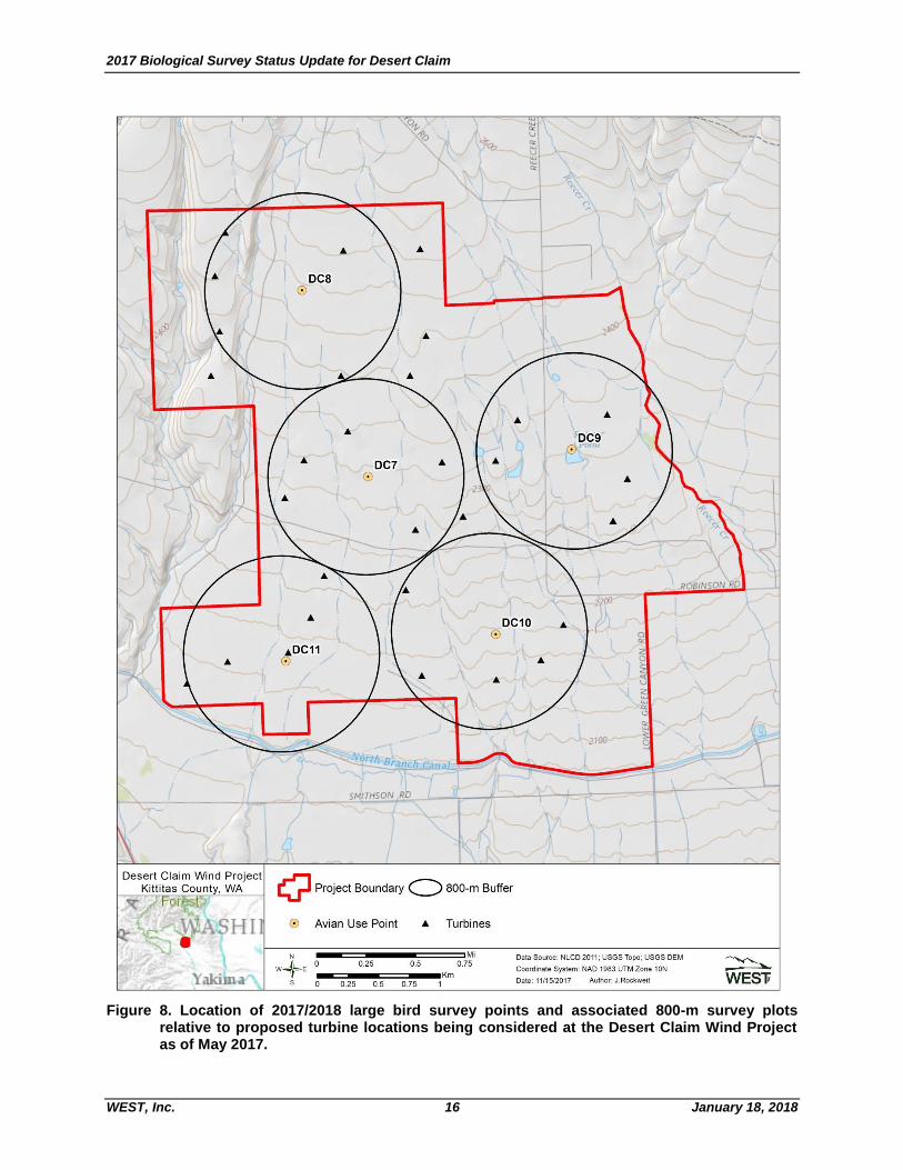
Fixed-point Large Bird Surveys (2017-2018)
An additional year of fixed-point surveys was initiated in May 2017, with the intent of satisfying the data collection recommendations of the USFWS’ ECP Guidance and new federal Eagle Rule which require two years of pre-construction data if a project proponent desires to pursue an eagle take permit (USFWS 2013; 2016). These surveys will continue through spring of 2018 and utilize methodologies that are consistent with those of the 2015-2016 surveys, with the exception that survey points were repositioned and five points (instead of six; Figure 8) are being surveyed. Despite this slight shift in survey stations, the 2017-2018 survey area provides coverage of a majority of all proposed turbine locations (Figure 8). From May 27 – August 30, 2017, 106 1-hour fixed-point bird use surveys were conducted and no bald or golden eagles have been observed, which is consistent with seasonal use patterns observed in previous years. Patterns of use by non-eagle raptors also appear to be consistent with those of previous years, with the notable exception of northern harrier, observations of which have increased relative to similar time periods in prior years.
Avian Fatality Comparison to other Operational Projects
While pre-construction bird use data is often useful for predicting impacts at proposed wind energy facilities, comparisons to nearby operational facilities are also useful. The proposed Desert Claim project is located approximately 2-3 mi east of the Kittitas Valley Wind Project, which reported overall bird fatality rates of 1.06 and 1.54 birds/MW/year for post-construction fatality monitoring surveys conducted from 2011 – 2012 and 2012 – 2013, respectively (Stantec 2012, 2013). The estimated fatality rate for raptors was reported as 0.09 and 0.03 raptors/MW/year for each year of surveys, respectively (Stantec 2012, 2013). Overall bird and raptor fatality rates estimated at the Kittitas Valley project were reported as being below the mean when compared to other wind projects in the Columbia Plateau Ecoregion. Given Desert Claim’s proximity to the Kittitas Valley Wind project, it might be expected that similar (below average) fatality rates would be observed at Desert Claim.
2017 Biological Survey Status Update for Desert Claim
WEST, Inc. 16 January 18, 2018
Figure 8. Location of 2017/2018 large bird survey points and associated 800-m survey plots
relative to proposed turbine locations being considered at the Desert Claim Wind Project as of May 2017.

2017 Biological Survey Status Update for Desert Claim
WEST, Inc. 17 January 18, 2018
Raptor Nest Surveys (2002-2011)
Helicopter-based nest surveys were conducted in 2002, 2009, 2010, and 2011 based on the project layout at the time of surveys. Additionally, ground-based raptor nest surveys were conducted in conjunction with threatened, endangered, and sensitive species (TESS) surveys in 2009 and 2011. Only two raptor species were confirmed nesting within 2.0 mi of the Project boundary; red-tailed hawk and great horned owl (Bubo virginianus; Figure 9). Multiple inactive nests have also been documented; however, only one of these was identified as a potential golden eagle nest and was located approximately 2-3 mi northeast of the current Project area (Figure 9). This nest was inactive at the time of the 2011 survey and therefore cannot be confirmed as that of a golden eagle nest, however based on size and location it is assumed to be the same historical nest site identified during a query of the Washington Priority Habitat and Species (PHS) database.

2017 Biological Survey Status Update for Desert Claim
WEST, Inc. 18 January 18, 2018
Figure 9. Location of raptor nests identified during raptor nests surveys conducted in 2002 – 2011 for the Desert Claim Wind
Project.

2017 Biological Survey Status Update for Desert Claim
WEST, Inc. 19 January 18, 2018
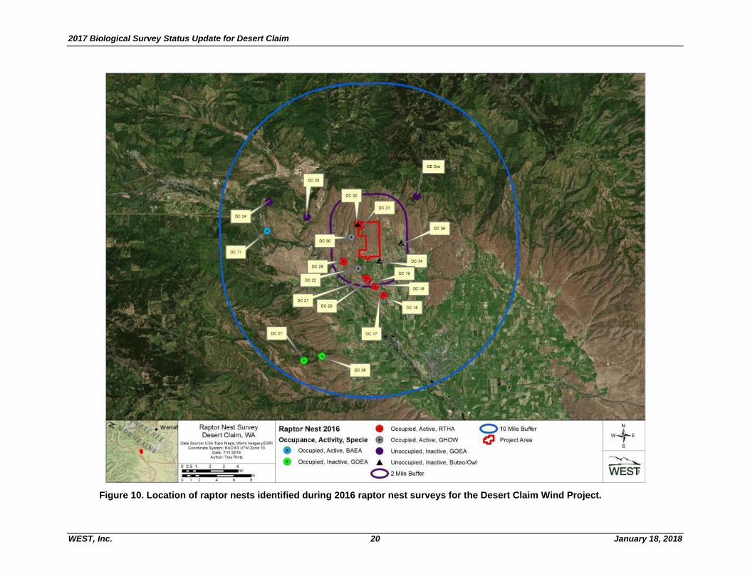
Raptor and/ Eagle Nest Surveys (2016)
Helicopter-based raptor nest surveys were conducted in late winter and spring of 2016 with the intent of documenting: 1) all raptor nests within the Project area and a surrounding 2-mi buffer, and 2) all potential eagle nests (i.e., of suitable size for supporting eagles) located within 10 mi of the current Project boundary. While raptors are known to utilize nests of all types, aerial surveys focused on species that build or use large stick nests (e.g., red-tailed hawk, ferruginous hawk [B. regalis], great horned owl) which are visible from the air. The initial eagle nest survey focused on identification of possible eagle nests and was conducted on March 2, 2016, during the courtship/early nesting period. The follow-up survey was conducted on May 24, 2016, when most nesting raptors would be incubating or brooding young, and focused on confirming the status of all possible eagle nests documented during the initial survey, while also thoroughly searching the Project area and surrounding 2-mi buffer for nests of other raptor species. Five nests were identified as likely golden eagle nests, two of which were classified as occupied during the initial survey based on the presence of fresh nesting materials (Figure 10). Adult golden eagles were also observed at each of the two occupied nests, located approximately 8-9 9 mi southwest of the Project, however, no adults or eggs were observed on or in the nests during the follow up survey in May. The other three nests identified, located between 3 and 7 mi from the Project, showed no evidence of use during the 2016 nesting season. Given the low number of occupied golden eagle nests within the 10-mi buffer and low use of the Project area by golden eagles, data collected to date suggests that Desert Claim should have minimal impacts on locally breeding golden eagles. One active bald eagle nest was located approximately 6.9 mi west of the Project (Figure 10) and contained two nestlings during the follow-up survey in May. Given the distance of the nest from Desert Claim, project development and operation should not cause any disturbance to this nest. Nesting substrates suitable for supporting large raptor nests were limited within the Project and immediately surrounding area. There were 15 nests mapped within the 2-mi buffer that were consistent with nests of hawks or owls, including six active red-tailed hawk nests, two active great horned owl nests, and four unoccupied raptor/owl nests (Figure 10). Only one nest, occupied by a pair of red-tailed hawks, was located within Project area (see Figure 10). This nest was approximately 280 m from the nearest proposed turbine location in the northwestern corner of the Project area. The next closest nest was another red-tailed hawk nest, which was located just outside the northwestern boundary of the Project area (see Figure 10), and was approximately 715 m from the nearest proposed turbine location.
2017 Biological Survey Status Update for Desert Claim
WEST, Inc. 20 January 18, 2018
Figure 10. Location of raptor nests identified during 2016 raptor nest surveys for the Desert Claim Wind Project.

2017 Biological Survey Status Update for Desert Claim
WEST, Inc. 21 January 18, 2018
Acoustic Bat Surveys (2009)
Acoustic bat surveys were conducted from August through October 2009. Three Anabat acoustic detectors were used at areas representative of potential turbine locations. Nightly bat activity was relatively low, averaging 2.75 bat passes per detector night across the three locations. Bat activity indices indicated that the peak bat activity period occurred from mid-August through mid-September (Figure 11). This temporal pattern of bat activity is consistent with that observed at most wind energy projects across the US where acoustic surveys have been conducted, and is consistent with the migratory timing of hoary bats (Lasiurus cinereus) and silver-haired bats (Lasionycteris noctivagans), two of the most commonly documented bat fatalities at wind energy projects. Although bat use is often used to predict bat fatality rates, the correlation is not well defined. For Desert Claim, a better indicator of potential impacts of the Project to bats is likely a comparison with the nearby Kittitas Valley Wind Project, which is located approximately 2-3 mi west of Desert Claim in similar habitats. Bat fatality rates at the Kittitas Valley Wind Project were estimated to be 0.12 and 0.31 bat fatalities/MW/year for the first and second years of standardized fatality monitoring, respectively (Stantec 2013). These estimates were well below the average of 1.14 bat fatalities/MW/year reported within the Columbia Plateau (Johnson and Erickson 2011). Thus, based on results of the acoustic bat surveys in 2009 and results from fatality monitoring at the nearby Kittitas Valley Wind Farm, it seems reasonable to expect that Desert Claim will have similarly low impacts on bats.

2017 Biological Survey Status Update for Desert Claim
WEST, Inc. 22 January 18, 2018
Figure 11. Timing of bat activity at the Desert Claim Wind Project based on surveys
conducted from August – October 2009.
Threatened, Endangered, and Sensitive Species (TESS) Surveys (2010-2011)
TESS surveys were conducted in buildable areas within the Project boundary in 2010 and 2011 (Enz and Bay 2010, 2011), which is largely consistent with the current Project area. Surveys were conducted on foot by walking meandering transects spaced approximately 50 m apart though all buildable lands within the project area (as defined at the time of survey; see buildable lands in Figure 9). TESS surveys conducted in 2010 resulted in the detection of three sensitive species: one sagebrush sparrow (Artemisiospiza nevadensis), 14 sage thrashers (Oreoscoptes
montanus), and two golden eagles, all of which are state candidates for listing as well as federal birds of conservation concern (WDFW 2017; USFWS 2008). Additional TESS surveys conducted in 2011 in sections 13 and 24 (see Figure 9) resulted in two additional sensitive species observations; one peregrine falcon (Falco peregrinus) and one long-billed curlew (Numenius americanus), both of which are federal species of concern (USFWS 2008). No state or federally threatened or endangered species were observed during TESS surveys, nor were any rare plants.
2017 Biological Survey Status Update for Desert Claim
WEST, Inc. 23 January 18, 2018
Based on the results of past (2010 and 2011) TESS surveys and the large reduction in Project footprint being proposed under the SCA Amendment, the potential for impacts to TESS is expected to be similar to or less than that documented previously. However, due to the time that has elapsed since the last TESS surveys (approximately seven years); an updated TESS survey is planned prior to project construction in all areas of potential disturbance. Final survey areas will be based on the final Project layout, with survey timing dependent on the Project’s
construction timeline, but ideally conducted during the breeding/flowering season immediately prior to construction. These planned surveys are consistent with recommendations in the 2010 SCA.
Habitat Mapping and Potential Impacts to Habitats
Habitat types were mapped within the original project area boundary in 2002, updated prior to the 2009 SCA application (Figure 12) and revised again in 2017 as a result of the updated Project layout (Figure 13). This mapping effort was utilized to determine the amount and type of habitats that may be either temporarily or permanently disturbed, and will be used as the basis for calculating mitigation requirements under the SCA. The current habitat map will also be used to inform the final TESS survey, as many sensitive species may be restricted to certain habitats. Grassland habitat covered more than half (57%) of the original Project area, with shrub/steppe (33%), agriculture (4.7%), riparian shrub (2%) and wet meadow (1.7%) accounting for most of the remaining habitat types (Figure 12). The current Project area has been reduced in size (from approximately 5,200 to approximately 3,700 ac, but the relative proportion of habitat types has not significantly changed; grassland still accounts for the majority of all habitat in the Project area (69%), followed by shrub/steppe (23%), agriculture (3.5%), riparian shrub (1.8%) and wet meadow (1.7%). Each of the remaining habitat types account for < 1% of the Project area (Figure 13). As a consequence of the reduction in Project area, number of turbines, and associated roads and collection lines, impacts to local habitats from the construction and operation of Desert Claim are also expected to be reduced. The total area impacted from turbine pad construction is expected to decrease by approximately 60% to 75% depending on the final turbine configuration. Road building activities are also expected to be substantially reduced under the current Project layouts. Under the turbine layout proposed in the 2010 SCA, approximately 27 mi of roads were to be constructed, while current turbine layouts are expected to utilize approximately 20 mi of roads, a reduction of approximately 25%.

2017 Biological Survey Status Update for Desert Claim
WEST, Inc. 24 January 18, 2018
Figure 12. Habitat mapping and proposed turbine layout as provided in the 2009 Site Certification Agreement Application.

2017 Biological Survey Status Update for Desert Claim
WEST, Inc. 25 January 18, 2018
Figure 13. Habitat mapping based on 2017 proposed Project boundary, showing one of the four potential turbine layouts for illustation of potential habitat impacts.

2017 Biological Survey Status Update for Desert Claim
WEST, Inc. 26 January 18, 2018
CONCLUSIONS
Baseline biological surveys at Desert Claim have been conducted since 2002, including surveys in support of Desert Claim’s 2010 SCA. Since then, Project boundaries and turbine layouts have substantially changed resulting in considerable changes in the potential impacts to local fauna and habitats. As a result, this report has been compiled to summarize the results of surveys conducted to date to support Desert Claim’s application to amend the 2010 SCA. Given the general consistency of survey results from data collected before and after the 2010 SCA, and the substantial reduction in the number of proposed turbines and Project footprint, it is expected that potential direct and indirect impacts of development and operation of Desert Claim will be considerably less under the currently proposed Project layout than impacts predicted under the Project footprint and turbine layout proposed in the original 2010 SCA.

2017 Biological Survey Status Update for Desert Claim
WEST, Inc. 27 January 18, 2018
REFERENCES
Anderson, R., D. Strickland, J. Tom, N. Neumann, W. Erickson, J. Cleckler, G. Mayorga, G. Nuhn, A. Leuders, J. Schneider, L. Backus, P. Becker, and N. Flagg. 2000. Avian Monitoring and Risk Assessment at Tehachapi Pass and San Gorgonio Pass Wind Resource Areas, California: Phase 1 Preliminary Results. In: Proceedings of the National Avian Wind Power Planning Meeting III (PNAWPPM-III), May 1998, San Diego, California. National Wind Coordinating Collaborative (NWCC)/RESOLVE, Washington, D.C. Pp 31-46.
Bureau of Land Management (BLM). 2006. Final Environmental Impact Statement for the Proposed Cotterel Wind Power Project and Proposed Resource Management Plan Amendment. FES 06-07. Serial No. IDI-33676. Prepared for the US Department of the Interior (USDOI), BLM, Twin Falls District, Burley Field Office, Cassia County, Idaho, on behalf of Windland, Inc., Boise, Idaho, and Shell WindEnergy Inc., Houston, Texas. March 2006.
Chatfield, A., W. P. Erickson, and K. Bay. 2010. Avian Baseline Studies at the Sun Creek Wind Resource Area, Kern County, California. Final Report: May 2009 - May 2010. Prepared for CH2M HILL, Oakland, California. Prepared by Western EcoSystems Technology, Inc., Cheyenne, Wyoming. September 30, 2010. Available online: http://www.blm.gov/pgdata/etc/medialib/blm/ca/pdf/ ridgecrest/alta_east_wind.Par.78046.File.dat/D3%20Avian%20Baseline%20Studies%202010.pdf
Chatfield, A., W. P. Erickson, and K. Bay. 2011. Avian Baseline Studies at the Alta East Wind Resource Area, Kern County, California. Final Report: July 10, 2010 - June 1, 2011. Prepared for CH2M HILL, Oakland, California. Prepared by Western EcoSystems Technology, Inc., Cheyenne, Wyoming. July 13, 2011. Appendix D-8. In: Bureau of Land Management (BLM). 2013. Alta East Wind Project: Proposed Plan Amendment and Final Environmental Impact Statement. CACA #0052537. US Department of the Interior BLM. February 2013. Available online: http://www.blm.gov/ca/st/en/fo/ridgecrest/alta_east_wind_project.html; 2011 Avian Baseline Report (Appendix D-8) available online: http://www.blm.gov/pgdata/etc/medialib/blm/ca/pdf/ ridgecrest/alta_east_wind.Par.22191.File.dat/D8%20Avian%20Baseline%20Studies%202011.pdf
Derby, C. and A. Dahl. 2009. Wildlife Studies for the Bitter Root Wind Resource Area, Yellow, Medicine, and Lincoln Counties, Minnesota. Annual Report: March 25, 2008 - October 8, 2008. Prepared for Buffalo Ridge Power Partners, Argyle, New York. Prepared by Western EcoSystems Technology, Inc. (WEST), Bismark, North Dakota. April 16, 2009. In: Minnesota Department of Commerce, Office of Energy Security. 2010. Bitter Root Wind Farm Project, Environmental Report. Site Permit Application, Appendix F. Minnesota Public Utilities Commission, Docket 25538. March 2010. Available online: http://www.calco.state.mn.us/commerce/energyfacilities/documents/ 25538/Appendix_%20F_Wildlife_Studies.pdf
Derby, C., K. Bay, and J. Ritzert. 2009. Bird Use Monitoring, Grand Ridge Wind Resource Area, La Salle County, Illinois. Year One Final Report, March 2008 - February 2009. Prepared for Grand Ridge Energy LLC, Chicago, Illinois. Prepared by Western EcoSystems Technology, Inc. (WEST), Cheyenne, Wyoming. July 29, 2009.
Derby, C., K. Bay, and A. Dahl. 2010. Wildlife Baseline Studies for the Dempsey Wind Resource Area, Roger Mills County, Oklahoma. Final Report: March 2008 – February 2009. Prepared for HDR Engineering, Minneapolis, Minnesota, and Dempsey Ridge Wind Farm, LLC, a wholly owned subsidiary of Acciona Wind Energy USA LLC, Chicago, Illinois. Prepared by Western EcoSystems Technology, Inc. (WEST), Bismarck, North Dakota. February 10, 2010.

2017 Biological Survey Status Update for Desert Claim
WEST, Inc. 28 January 18, 2018
Energy Facility Site Evaluation Council (EFSEC). 2010. Site Certification Agreement Between the State of Washington and Desert Claim Wind Power LLC for the Desert Claim Wind Power Project, Kittitas County, Washington. Prepared by the Energy Facility Site Evaluation Council, Olympia, Washington. 42 pp.
Enz, T., and K. Bay. 2010. Threatened and Endangered Species and Raptor Nest Surveys Desert Claim Wind Resource Area Kittitas County, Washington. Final report prepared for enXco, Inc., North Palm Springs, California.
Enz, T., and K. Bay. 2010. Threatened, Endangered, and Senstive Species, Raptor Nest, and Weed Report, Desert Claim Wind Resource Area, Kittitas County, Washington. Draft Report. Prepared for enXco, Inc., North Palm Springs, California. Prepared by, Western EcoSystems Technology, Inc., Cheyenne, Wyoming.
Erickson, W. P., E. Lack, M. Bourassa, K. Sernka, and K. Kronner. 2001. Wildlife Baseline Study for the Nine Canyon Wind Project, Final Report May 2000-October 2001. Technical report prepared for Energy Northwest, Richland, Washington. Prepared by Western EcoSystems Technology, Inc. (WEST), Cheyenne, Wyoming, and Northwest Wildlife Consultants, Inc. (NWC), Pendleton, Oregon.
Erickson, W. P., G. D. Johnson, K. Bay, and K. Kronner. 2002a. Ecological Baseline Study for the Zintel Canyon Wind Project. Final Report April 2001 – June 2002. Technical report prepared for Energy Northwest. Prepared for Energy Northwest by Western EcoSystems Technology, Inc. (WEST), Cheyenne, Wyoming, and Northwest Wildlife Consultants, Inc. (NWC), Pendleton, Oregon. June 2002.
Erickson, W. P., G. D. Johnson, D. P. Young, D. Strickland, R. Good, M. Bourassa, K. Bay, and K. Sernka. 2002b. Synthesis and Comparison of Baseline Avian and Bat Use, Raptor Nesting and Mortality Information from Proposed and Existing Wind Developments. Technical report prepared for Bonneville Power Administration, Portland, Oregon by WEST, Inc., Cheyenne, Wyoming. December 2002. Available online: http://www.bpa.gov/Power/pgc/wind/Avian_and_Bat_Study _12-2002.pdf
Erickson, W. P., J. Jeffrey, K. Kronner, and K. Bay. 2003b. Stateline Wind Project Wildlife Monitoring Annual Report, Results for the Period July 2001 - December 2002. Technical report submitted to FPL Energy, the Oregon Office of Energy, and the Stateline Technical Advisory Committee. Western EcoSystems Technology, Inc., Cheyenne, Wyoming. May 2003.
Erickson, W. P., D. P. Young, G. D. Johnson, J. Jeffrey, K. Bay, R. Good, and H. Sawyer. 2003d. Wildlife Baseline Study for the Wild Horse Wind Project. Summary of Results from 2002-2003 Wildlife Surveys May 10, 2002- May 22, 2003. Prepared for Zilkha Renewable Energy, Portland, Oregon. Prepared by Western EcoSystems Technology, Inc. (WEST), Cheyenne, Wyoming. November 2003. Available online: http://www.efsec.wa.gov/wildhorse/apl/Exhibits%20PDF/E14-Ecological% 20Baseline%20Study-%2011_20_03.pdf
Erickson, W. P., A. Chatfield, and K. Bay. 2011. Avian Baseline Studies for the North Sky River Wind Energy Project, Kern County, California. Final Report: May 18, 2010 – May 26, 2011. Final Report. Prepared for CH2M HILL, Portland Oregon. Prepared by Western EcoSystems Technology, Inc. (WEST), Cheyenne, Wyoming. July 7, 2011.
Good, R. E., M. Ritzert, and K. Bay. 2010. Wildlife Baseline Studies for the Timber Road Phase II Wind Resource Area, Paulding County, Ohio. Final Report: September 2, 2008 - August 19, 2009. Prepared for Horizon Wind Energy, Houston, Texas. Prepared by Western EcoSystems Technology, Inc. (WEST), Bloomington, Indiana. April 28, 2010.
2017 Biological Survey Status Update for Desert Claim
WEST, Inc. 29 January 18, 2018
Jeffrey, J. D., V. K. Poulton, K. J. Bay, K. F. Flaig, C. C. Roderick, W. P. Erickson, and J. E. Baker. 2007. Wildlife and Habitat Baseline Study for the Proposed Vantage Wind Power Project, Kittitas County, Washington. Final Report. Prepared for Invenergy. Prepared by Western EcoSystems Technology, Inc. (WEST), Cheyenne, Wyoming, and Walla Walla, Washington. August 2007. Available online: https://www.co.kittitas.wa.us/uploads/cds/land-use/Wind%20Farm/WSA-07-01%20Vantage%20Wind%20%20Power%20Project%20Application/VANTAGE_WILDLIFE_BASELINE%20REPORT_8.27.07.pdf
Jeffrey, J. D., W. P. Erickson, K. J. Bay, V. K. Poulton, W. L. Tidhar, and J. E. Baker. 2008. Wildlife Baseline Studies for the Golden Hills Wind Resource Area, Sherman County, Oregon. Final Report May 2006 – October 2007. Prepared for BP Alternative Energy North America Inc., Houston, Texas, by Western EcoSystems Technology, Inc. (WEST), Cheyenne, Wyoming.
Johnson, G. D., W. P. Erickson, M. D. Strickland, M. F. Shepherd, and D. A. Shepherd. 2000a. Final Report: Avian Monitoring Studies at the Buffalo Ridge Wind Resource Area, Minnesota: Results of a 4-Year Study. Final report prepared for Northern States Power Company, Minneapolis, Minnesota, by Western EcoSystems Technology, Inc. (WEST), Cheyenne, Wyoming. September 22, 2000. 212 pp.
Johnson, G. D., D. P. Young, W. P. Erickson, C. E. Derby, M. D. Strickland, R. E. Good, and J. W. Kern. 2000b. Final Report: Wildlife Monitoring Studies, Seawest Windpower Project, Carbon County, Wyoming, 1995-1999. Final report prepared for SeaWest Energy Corporation, San Diego, California, and the Bureau of Land Management, Rawlins, Wyoming, by Western EcoSystems Technology, Inc. (WEST), Cheyenne, Wyoming. August 9, 2000.
Johnson, G. D., W. P. Erickson, K. Bay, and K. Kronner. 2002. Baseline Ecological Studies for the Klondike Wind Project, Sherman County, Oregon. Final report prepared for Northwestern Wind Power, Goldendale, Washington. Prepared by Western EcoSystems Technology, Inc. (WEST) Cheyenne, Wyoming, and Northwest Wildlife Consultants, Inc. (NWC), Pendleton, Oregon. May 29, 2002. Available online: http://wind.nrel.gov/public/library/johnson5.pdf
Johnson, G. D., J. Jeffrey, J. Baker, and K. Bay. 2007. Baseline Avian Studies for the Windy Flats Wind Energy Project, Klickitat County, Washington. Prepared for Windy Point Partners, LLC. Prepared by Western EcoSystems Technology, Inc. (WEST), Cheyenne, Wyoming. May 29, 2007. Available online: http://www.efsec.wa.gov/Whistling%20Ridge/Adjudication/Cross%20Exhibits/ 06.06C%20Windy%20Flats-Environmental%20Report%20Excerpt.pdf
Johnson, G. D., K. Bay, and J. Eddy. 2009a. Wildlife Baseline Studies for the Dunlap Ranch Wind Resource Area, Carbon and Albany Counties, Wyoming. June 4, 2008 - May 27, 2009. Prepared for CH2M HILL, Englewood, Colorado. Prepared by Western EcoSystems Technology, Inc. (WEST), Cheyenne, Wyoming. July 25, 2009. Available online: http://amlportal.state.wy.us/ out/downloads/Dunlap%20Addendum4.pdf
Johnson, G. D., K. Bay, and J. Eddy. 2009b. Wildlife Baseline Studies for the High Plains Wind Resource Area, Carbon and Albany Counties, Wyoming. Prepared for CH2M HILL. Prepared by Western EcoSystems Technology, Inc. (WEST), Cheyenne, Wyoming.
Kerlinger, P., L. Culp, and R. Curry. 2005. Post-Construction Avian Monitoring Study for the High Winds Wind Power Project, Solano County, California. Year One Report. Prepared for High Winds, LLC and FPL Energy.

2017 Biological Survey Status Update for Desert Claim
WEST, Inc. 30 January 18, 2018
Kronner, K., R. Gritski, J. Baker, V. Marr, G. Johnson, and K. Bay. 2005. Wildlife Baseline Study for the Leaning Juniper Wind Power Project, Gilliam County, Oregon. Prepared by Northwest Wildlife Consultants, Inc. (NWC) and Western Ecosystems Technology, Inc. (WEST). Prepared for PPM Energy, Portland, Oregon and CH2M HILL, Portland, Oregon by NWC, Pendleton, Oregon, and WEST, Cheyenne, Wyoming. November 3, 2005.
Northwest Wildlife Consultants, Inc. (NWC) and Western Ecosystems Technology, Inc. (WEST). 2004. Ecological Baseline Studies for the Roosevelt Wind Project, Klickitat County, Washington. Final Report. Prepared by NWC, Pendleton, Oregon, and WEST, Inc., Cheyenne, Wyoming. September 2004.
Northwest Wildlife Consultants, Inc. (NWC), and Western EcoSystems Technology, Inc. (WEST). 2005. Ecological Baseline Studies and Wildlife Impact Assessment for the White Creek Wind Power Project, Klickitat County, Washington. Prepared for Last Mile Electric Cooperative, Goldendale, Washington. Prepared by K. Kronner, R. Gritski, and J. Baker, NWC, Goldendale, Washington, and G.D. Johnson, K. Bay, R.Good, and E. Lack, WEST, Cheyenne Wyoming. January 12, 2005.
Orloff, S. and A. Flannery. 1992. Wind Turbine Effects on Avian Activity, Habitat Use, and Mortality in Altamont Pass and Solano County Wind Resource Areas, 1989-1991. Final Report P700-92-001 to Alameda, Contra Costa, and Solano Counties, and the California Energy Commission, Sacramento, California, by Biosystems Analysis, Inc., Tiburon, California. March 1992.
Stantec. 2013. Kittitas Valley Wind Power Project, Cle Elum, Washington. Post-construction Monitoring. Summer 2012- Spring 2013. Year 2 Annual Report. Prepared for Sagebrush Power Partners, LLC, 808 Travis Street, Suite 700, Houston, Texas. Prepared by Stantec Consulting Services, 3995 South 700 East, Suite 300, Salt Lake City, Utah.
URS Corporation, Western EcoSystems Technology, Inc. (WEST), and Northwest Wildlife Consultants, Inc. (NWC). 2001. Avian Baseline Study for the Stateline Project. Prepared for FPL Energy Vansycle, LLC, Juno Beach, Florida.
US Fish and Wildlife Service (USFWS). 1973. Endangered Species Act (PL 93-205, as samended by PL 100-478 [16 USC 1531 et. seq.]); 50 Code of Federal Regulations (CFR) 402.
US Fish and Wildlife Service (USFWS). 2008. Birds of Conservation Concern 2008. December 2008. Division of Migratory Bird Management. Arlington, Virginia. http://www.fws.gov/migratorybirds/ NewReportsPublications/SpecialTopics/BCC2008 /BCC2008.pdf.
US Fish and Wildlife Service (USFWS). 2012. Land-Based Wind Energy Guidelines. March 23, 2012. 82 pp. Available online: http://www.fws.gov/cno/pdf/Energy/2012_Wind_Energy_Guidelines_final .pdf
US Fish and Wildlife Service (USFWS). 2013. Eagle Conservation Plan Guidance: Module 1 - Land-Based Wind Energy, Version 2. US Department of the Interior, Fish and Wildlife Service, Division of Migratory Bird Management. April 2013. Executive Summary and frontmatter + 103 pp. Available online: https://www.fws.gov/migratorybirds/pdf/management/eagleconservationplan guidance.pdf
US Fish and Wildlife Service (USFWS). 2016. Eagle Permits; Revisions to Regulations for Eagle Incidental Take and Take of Eagle Nests, Final Rule. Department of the Interior, US Fish and Wildlife Service. 50 CFR Parts 13 and 22. Federal Register: Vol 81, No. 242, Friday December 16, 2016, Rules and Regulations.
Washington Department of Fish and Wildlife (WDFW). 2009. Wind Power Guidelines. Olympia, Washington. 30 pp.

2017 Biological Survey Status Update for Desert Claim
WEST, Inc. 31 January 18, 2018
Washington Department of Fish and Wildlife (WDFW). 2017. Washington State Species of Concern List. Revised February 2017. Available online at: http://wdfw.wa.gov/conservation/endangered/All/
Western EcoSystems Technology, Inc. (WEST). 2003. Baseline Avian Studies for the Proposed Desert Claim Wind Power Project, Kittitas County, Washington. Final Report, July 2003. Prepared for Desert Claim Wind Power, LLC, Ellensburg, Washington. Prepared by Western EcoSystems Technology, Inc. Cheyenne, Wyoming.
Western EcoSystems Technology, Inc. (WEST). 2005a. Ecological Baseline Study at the Elkhorn Wind Power Project. Exhibit A. Final report prepared for Zilkha Renewable Energy, LLC, Portland, Oregon, by WEST, Cheyenne, Wyoming. June 2005.
Western EcoSystems Technology, Inc. (WEST). 2005b. Ecological Baseline Study for the Proposed Reardan Wind Project, Lincoln County, Washington. Draft Final Report. Prepared for Energy Northwest, Richland, Washington, by Western EcoSystems Technology, Inc. (WEST), Cheyenne, Wyoming. June 2005.
Western EcoSystems Technology, Inc. (WEST). 2005c. Wildlife and Habitat Baseline Study for the Proposed Biglow Canyon Wind Power Project, Sherman County, Oregon. March 2004 - August 2005. Prepared for Orion Energy LLC., Oakland, California. WEST, Cheyenne, Wyoming. October, 2005.
Western EcoSystems Technology, Inc. (WEST). 2006. Diablo Winds Wildlife Monitoring Progress Report, March 2005 - February 2006. Technical report submitted to FPL Energy and Alameda County California. WEST. Cheyenne, Wyoming.
Western EcoSystems Technology, Inc. (WEST) and the Colorado Plateau Research Station (CPRS). 2006. Avian Studies for the Proposed Sunshine Wind Park, Coconino County, Arizona. Prepared for Sunshine Arizona Wind Energy, LLC., Flagstaff, Arizona, by WEST, Cheyenne, Wyoming, and the CPRS. Ecological Monitoring and Assessment Program, Northern Arizona University, Flagstaff, Arizona. May 2006.
Western EcoSystems Technology, Inc. (WEST). 2009. Wildlife Baseline Studies for the Antelope Ridge Wind Resource Area, Union County, Oregon. August 28, 2008 - August 12, 2009. Draft final report prepared for Horizon Wind Energy, Houston, Texas. Prepared by WEST, Cheyenne, Wyoming.
Young, D.P., Jr., W. P. Erickson, J. Jeffrey, K. Bay, R. E. Good, and E. G. Lack. 2003a. Avian and Sensitive Species Baseline Study Plan and Final Report. Eurus Combine Hills Turbine Ranch, Umatilla County, Oregon. Technical report prepared for Eurus Energy America Corporation, San Diego, California and Aeropower Services, Inc., Portland, Oregon, by Western EcoSystems Technology, Inc. (WEST), Cheyenne, Wyoming. March 10, 2003.
Young, D.P., Jr., W. P. Erickson, K. Bay, J. Jeffrey, E. G. Lack, and H. H. Sawyer. 2003b. Baseline Avian Studies for the Proposed Desert Claim Wind Power Project, Kittitas County, Washington. Final Report. Prepared for Desert Claim Wind Power, LLC, Ellensburg, Washington, by Western EcoSystems Technology, Inc. (WEST), Cheyenne, Wyoming. July 2003.
Young, D.P., Jr., W. P. Erickson, K. Bay, J. Jeffrey, E. G. Lack, R. E. Good, and H. H. Sawyer. 2003c. Baseline Avian Studies for the Proposed Hopkins Ridge Wind Project, Columbia County, Washington. Final Report: March 2002 - March 2003. Prepared for RES North America, LLC, Portland, Oregon. Prepared by Western EcoSystems Technology, Inc. (WEST), Cheyenne, Wyoming. April 30, 2003. Available online: http://wind.nrel.gov/public/library/young5.pdf

2017 Biological Survey Status Update for Desert Claim
WEST, Inc. 32 January 18, 2018
Young, D.P., Jr., V. K. Poulton, and K. Bay. 2007a. Ecological Baseline Studies Report. Proposed Dry Lake Wind Project, Navajo County, Arizona. Prepared for PPM Energy, Portland, Oregon. Prepared by Western EcoSystems Technology, Inc. (WEST), Cheyenne, Wyoming. July 1, 2007. Available online: http://www.blm.gov/style/medialib/blm/az/pdfs/energy/dry-lake.Par.83529.File.dat/ AppC-eco_baseline_study.pdf
Young, D.P., Jr., G. D. Johnson, V. K. Poulton, and K. Bay. 2007b. Ecological Baseline Studies for the Hatchet Ridge Wind Energy Project, Shasta County, California. Prepared for Hatchet Ridge Wind, LLC, Portland, Oregon. Prepared by Western EcoSystems Technology, Inc. (WEST), Cheyenne, Wyoming. August 31, 2007. Available online: https://nrm.dfg.ca.gov/FileHandler.ashx? DocumentVersionID=41939