biodiversity offset package - infigen energy · biodiversity offset package bodangora wind farm...
TRANSCRIPT

www.nghenvironmental.com.au e: [email protected]
Bega - ACT and South East NSW
suite 1, 216 carp st (po box 470)
bega nsw 2550 (t 02 6492 8333)
Sydney Region
18/21 mary st
surry hills nsw 2010 (t 02 8202 8333)
Canberra - NSW SE & ACT
8/27 yallourn st (po box 62)
fyshwick act 2609 (t 02 6280 5053)
Brisbane
8 trawalla st
the gap qld 4061 (t 07 3511 0238)
Newcastle - Hunter and North Coast
7/11 union st
newcastle west nsw 2302 (t 02 4929 2301)
Wagga Wagga - Riverina and Western NSW
suite 1, 39 fitzmaurice st (po box 5464)
wagga wagga nsw 2650 (t 02 6971 9696)
Bathurst - Central West and Orana
35 morrisset st (po box 434)
bathurst nsw 2795 (t 02 6331 4541)
Biodiversity Offset Package BODANGORA WIND FARM
OCTOBER 2017

www.nghenvironmental.com.au e: [email protected]
Bega - ACT and South East NSW
suite 1, 216 carp st (po box 470)
bega nsw 2550 (t 02 6492 8333)
Sydney Region
18/21 mary st
surry hills nsw 2010 (t 02 8202 8333)
Canberra - NSW SE & ACT
8/27 yallourn st (po box 62)
fyshwick act 2609 (t 02 6280 5053)
Brisbane
8 trawalla st
the gap qld 4061 (t 07 3511 0238)
Newcastle - Hunter and North Coast
7/11 union st
newcastle west nsw 2302 (t 02 4929 2301)
Wagga Wagga - Riverina and Western NSW
suite 1, 39 fitzmaurice st (po box 5464)
wagga wagga nsw 2650 (t 02 6971 9696)
Bathurst - Central West and Orana
35 morrisset st (po box 434)
bathurst nsw 2795 (t 02 6331 4541)
Document Verification
Project Title: Bodangora Wind Farm
Project Number: 16-235
Project File Name: Biodiversity Offset Strategy_bodangora_Additional Clearing Draft.docx
Revision Date Prepared by (name) Reviewed by (name) Approved by (name)
Draft 1.0 12/10/17 Mitch Palmer Nick Graham-Higgs Nick Graham-Higgs
NGH Environmental prints all documents on environmentally sustainable paper including paper made from bagasse (a by-
product of sugar production) or recycled paper.
NGH Environmental Pty Ltd (ACN: 124 444 622. ABN: 31 124 444 622) and NGH Environmental (Heritage) Pty Ltd (ACN: 603
938 549. ABN: 62 603 938 549) are part of the NGH Environmental Group of Companies.
Biodiversity Offset Package
Bodangora Wind Farm
16-235 i
CONTENTS
1 BACKGROUND .......................................................................................................................... 3
2 OBJECTIVES OF THIS BOP .......................................................................................................... 5
3 IDENTIFICATION OF IMPACT AREAS .......................................................................................... 6
3.1 VEGETATION MAPPING ........................................................................................................................6
3.2 FIELD SURVEY .......................................................................................................................................7
3.3 PLANT COMMUNITY TYPES (PCTS) .......................................................................................................7
3.4 LIMITATIONS ........................................................................................................................................8
4 REQUIREMENT TO OFFSET ........................................................................................................ 9
5 IDENTIFICATION OF SUITABLE OFFSETS ................................................................................... 10
5.1 FIELD SURVEY .................................................................................................................................... 10
5.2 BIOBANKING ASSESSMENT ............................................................................................................... 10
6 PRELIMINARY RESULTS ........................................................................................................... 11
6.1 FIELD SURVEY .................................................................................................................................... 11
6.2 THREATENED SPECIES ....................................................................................................................... 11
6.3 ABILITY TO MEET OFFSET REQUIREMENT ......................................................................................... 17
7 MANAGEMENT ACTIONS AND RESPONSIBILITIES ..................................................................... 19
7.1 OBJECTIVES OF MANAGEMENT ACTIONS ......................................................................................... 19
7.2 FENCING AND SIGNAGE .................................................................................................................... 19
7.3 HABITAT FEATURES AND ASSISTED REGENERATION ........................................................................ 19
7.4 EROSION AND SOIL MANAGEMENT .................................................................................................. 20
7.5 WEED MANAGEMENT ....................................................................................................................... 20
7.6 FERAL AND PEST ANIMAL MANAGEMENT ........................................................................................ 20
7.7 FIRE MANAGEMENT .......................................................................................................................... 20
7.8 RESPONSIBILITIES .............................................................................................................................. 21
8 PERFORMANCE ...................................................................................................................... 22
8.1 SHORT TERM PERFORMANCE ........................................................................................................... 23
8.2 LONG TERM PERFORMANCE ............................................................................................................. 23
9 MONITORING & IMPLEMENTATION ........................................................................................ 23
10 ADAPTIVE MANAGAMENT ...................................................................................................... 26
10.1 ADAPTIVE MANAGEMENT PROCESS AND REVIEW ........................................................................... 26
10.2 CORRECTIVE ACTIONS ....................................................................................................................... 26
11 CONCLUSION ......................................................................................................................... 28

Biodiversity Offset Package
Bodangora Wind Farm
16-235 ii
12 REFERENCES ........................................................................................................................... 29
APPENDIX A BIOBANKING REPORTS ............................................................................................ A-I
APPENDIX B MONITORING PLOTS ................................................................................................ B-I
TABLES
Table 1-1 Condition C7 of the consolidated Conditions of Approval and relevant section of the Biodiversity
Offset Package (BOP) where requirement is addressed. ................................................................................ 4
Table 3-1 PCT within the development envelope ........................................................................................... 8
Table 4-1 Impact and Offset Credit Summary ................................................................................................ 9
Table 6-1 Areas of vegetation communities mapped during field survey ....................................................11
Table 6-2 Predicted threatened species to occur in potential offset sites ...................................................12
Table 6-3 Impact and Offset Credit Summary ..............................................................................................17
Table 6-4 PCT description within the offset area .........................................................................................18
Table 7-1 Roles and responsibilities..............................................................................................................21
Table 8-1 Performance targets for grassy woodland areas to achieve the proposed high ecological condition
state ..............................................................................................................................................................22
Table 8-2 Performance targets for derived grassland areas to achieve the proposed higher ecological
condition state* ............................................................................................................................................22
Table 9-1 Monitoring, implementation and reporting schedule ..................................................................24
Table 10-1 Summary of corrective action following the Trigger, Action, Response Plan ............................26
FIGURES
Figure 6-1 – Vegetation mapped and identified potential offset areas within the Glen Oak property .......13
Figure 6-2 – Location of offset area 1 ...........................................................................................................14
Figure 6-3 – Location of offset area 2 ...........................................................................................................15

Biodiversity Offset Package
Bodangora Wind Farm
16-235 3
1 BACKGROUND
Bodangora Wind Farm Pty Ltd (BWFPL), a subsidiary of Infigen Energy Pty Ltd, received planning approval
for the construction and operation of a wind farm and ancillary infrastructure at Bodangora, in central west
New South Wales, approximately 12 kilometres (km) north east of Wellington. The wind farm will consist
of 33 turbines. Each turbine has a maximum height of 150 metres (m) to blade tip. The turbines are
proposed to be located at elevations between 480 to 640 m above sea level.
Development infrastructure will occupy only a small part of each property, and the existing land use will
be preserved. Other elements required for the project include:
A 33/132 kilovolt (kV) substation plus switchyards and transformers to provide a connection
to the existing TransGrid 132 kV Wellington – Beryl transmission line, located in the centre-
east part of the project area;
An operation and maintenance centre in the south-west of the project area;
39 kilometres (km) of new and upgraded access tracks;
Around 37 km of underground (or overhead) 33 kV cabling to provide connections between
the wind turbines within the project area, located along access tracks as far as possible;
Around 8.2 km overhead (or underground) 33 kV transmission line, providing connection
between the wind farm and the proposed substation; and
Temporary and permanent wind monitoring masts.
Bodangora Wind Farm was assessed as a Major Project under Part 3A of the Environmental Planning and
Assessment Act (EP&A Act). The initial biodiversity assessment was undertaken by Kevin Mills and
Associates to assess biodiversity constraints associated with the wind farm site, in accordance with the
Director-Generals Requirements dated 12 November 2010. The project was determined and approved in
August 2013, and there have been three modifications made to the approval, with the latest in June 2017.
Condition C7 of the consolidated Conditions of Approval includes the requirement that;
Following the final design, and prior to commencement of construction in areas requiring
native vegetation clearing, that a Biodiversity Offset Package be prepared. The Biodiversity
Offset Package needs to be developed in consultation with the OEH. Table 1-1 demonstrates
conditions required to be addressed within this BOP.

Biodiversity Offset Package
Bodangora Wind Farm
16-235 4
Table 1-1 Condition C7 of the consolidated Conditions of Approval and relevant section of the Biodiversity Offset
Package (BOP) where requirement is addressed.
Condition Requirement Addressed Section of BOP
a
Identify the extent and types of habitat that would be
lost or degraded
Yes 3.1.3 and
Section 4
b
Identify the objectives and biodiversity outcomes to be
achieved (including ‘improve or maintain’ biodiversity
values), and assess the adequacy of the proposed offset
considered
Yes Section 2,
Section 7 and
Section 8
c
Develop the final suite of the biodiversity offset
measures selected and secured, including how they will
be secured, details of relative communities on the
offset site, and proposed management actions and
expected gains
Yes Section 7,
Section 8 and
Section 9
d
Detail the monitoring requirements for compensatory
habitat works and other biodiversity offset measures
proposed
Yes Section 9
e
Include timing and responsibilities for the
implementation of the provisions of the Package
Yes Section 8 and
Section 9
f
Provide evidence that the offset(s) has been
acquired/secured
BWFPL is
committed to
formalizing a
Biobanking
agreement
Ongoing. Will
be formalised
via Biobanking
agreement
g
Describe how securing the site addresses the residual
impacts of the action on threatened species
Yes Section 6
h
Describe the proposed long term funding for
management actions as well as roles and
responsibilities
Yes Section 7
I
Provide key milestones, performance indicators,
corrective actions and timeframes for the completion of
all actions outlined in the Package
Yes Section 8,
Section 9 and
Section 10
Further, conditions C1 and E21 of the consolidated Conditions of Approval require that the proponent;
Ensure that no more than 1.32 hectares (ha) of native vegetation is cleared for the Project,
unless the Secretary agrees otherwise;
That baseline mapping of vegetation communities be prepared in consultation with OEH as
part of the Construction Biodiversity Management Plan, and
In late 2016, the Proponent sought a modification to the Project Approval to include relocation of the
proposed substation and the installation of a 132 kV overhead high voltage power line from the substation,
feeding into the existing Wellington to Beryl 132kV line. At the time of that approval, it was considered
that the typical approach to clearing vegetation would generally follow the guidelines provided by ISSC3
Guide for the Management of Vegetation in the Vicinity of Electricity Assets. Under this approach, there
was minimal clearing of native vegetation required. Following commencement of detailed design for the
Bodangora transmission line, Transgrid the Network Service Provider advised that it had undertaken a
further risk assessment of all of its transmission line corridors. As a result of this review, Transgrid updated
its bushfire risk compliance program, resulting in the adoption of a more conservative approach in the
assessment of the extent of clearing vegetation both within and outside of its transmission line corridors.

Biodiversity Offset Package
Bodangora Wind Farm
16-235 5
As a consequence, in order to comply with Transgrid’s updated program, it will be necessary to seek
approval to increase total clearing from 1.32 to 3 hectares (ha) of native vegetation for the Bodangora
Wind Farm transmission line. NGH Environmental has been engaged by BWFPL to develop a Biodiversity
Offset Package required to offset he additional clearing requirements.
2 OBJECTIVES OF THIS BOP
The main objective of this Biodiversity Offset Package (BOP) is to identify and match the offset
requirements for the project in accordance with the Framework for Biodiversity Assessment (FBA) and that
biodiversity values of the offset site are improved. The BOP therefore includes;
Identification of impact areas (Section 3)
Requirement to offset (Section 4)
Identification of suitable offsets (Section 5 and Section 6)
Provide clear management strategies and actions for implementation at the offset site
(Section 7)
Outline monitoring, performance and reporting requirements (Section 8 and Section 9).
Under the FBA, ecosystem and species credit requirements identified for the project can be offset via:
a) Retiring credits via a BioBanking agreement
b) Contributing money to supplementary measures
c) Contributing money to a BioBanking Fund.
This BOP has been provided to demonstrate that the vegetation retained on site is of a suitable quantum
to provide an adequate offset for the unavoidable impacts to native vegetation generated by the proposal.
It is considered precautionary in that it considers all PCTs listed in the credit profile, however it is noted
that under the rules of the FBA only EECs and threatened species habitat require offsets (Section 9.4 FBA
2014):
9.4.1.1 The assessor is not required to determine an offset for the impacts of development on PCTs
that are:
(a) in a vegetation zone with a site value score of <17, and the PCT has not been identified as a
CEEC or EEC
(b) not associated with threatened species habitat according to Section 6.4, and are not identified
as a CEEC or EEC.
The selected offset area would be subject to an agreement that allows for retention of the offset area in
perpetuity with Option a) Retiring credits via a BioBanking agreement being utilised to retire the required
credits. Where possible, the BOP will aim to match ecosystem and species credits on a ‘like for like’ basis
through the retirement of biodiversity credits, in accordance with the credit profiles provided in the
project’s credit report.
Biodiversity Offset Package
Bodangora Wind Farm
16-235 6
3 IDENTIFICATION OF IMPACT AREAS
3.1 VEGETATION MAPPING
Consultation with the Office of Environment and Heritage (OEH) was undertaken on the 9th February 2017
regarding the agreed methodology and approach to baseline mapping of vegetation following the
Environmental Assessment submitted with the original Development Application in May 2012. Through
this consultation, OEH supported the following approach to the vegetation mapping.
The baseline map for field validation was prepared using high resolution digital aerial imagery interpreted
in a 3D digital GIS environment and using the methodology described in Maguire et al (2012). The baseline
mapping field set was augmented utilising data contained within Kevin Mills & Associates (2011) and
focussed on the ‘development envelope’. In general terms, the ‘development envelope’ includes a 200
metre radius from development components of the project and defined within this report as the project
area.
The following vegetation descriptors were utilised in preparation of the field map site;
1. The following parameters, taken from Kevin Mills & Associates (2011 pages 4 & 5) were
utilised;
a) Forest: a community of relatively closely spaced trees (projective foliage cover >30%)
growing taller than 10 metres.
b) Woodland: a community of well-spaced trees (projective foliage cover 10-30%)
growing to a height of 4 to 30 metres.
c) Open Woodland: a community of scattered trees (projective foliage cover <10%
growing to a height of 4 to 30 metres.
d) Grassland: vegetation dominated by grasses and forbs, with <10% tree and/or shrub
cover.
2. Each vegetation community was classified utilising the relevant NSW Plant Community Type
(PCT). Understorey is identified as either native, exotic, sown pasture or cropland;
3. Crown Cover % (CCP) Class (Woody Veg only);
4. Understorey type and condition – includes where an overstorey is not present;
a) Exotic - where >75% of species and cover are composed of exotic plants.
b) Poor - where native and exotic ground cover species are present however, where
exotic species occupy >50%, but <75% of both cover and species present.
c) Native moderate/good - >50% of species and cover are composed of native plants.
Following further consultation with OEH on 5th May 2017, it was agreed that the following vegetation would
be assessed as ‘non-native’ where any ‘PCT’;
1. Has an exotic understorey which is consistent with Kevin Mills definition of ‘exotic’
vegetation included within the original environmental assessment.
2. Is of ‘low quality vegetation’ in accordance with BioBanking Methodology. That being,
a. woody native vegetation with native over-storey percent foliage cover less than
25% of the lower value of the over-storey percent foliage cover benchmark for that
vegetation type, and where either:
- less than 50% of ground cover vegetation is indigenous species, or

Biodiversity Offset Package
Bodangora Wind Farm
16-235 7
- greater than 90% of ground cover vegetation is cleared; OR
b. native grassland, wetland or herbfield where either:
- less than 50% of ground cover vegetation is indigenous species, or
- more than 90% of ground cover vegetation is cleared: OR
c. native vegetation in degraded condition that can be unviable or have low viability.
Degraded condition means vegetation in the where at least half of the site
attributes are less than 50% of benchmark without the vegetation being in low
condition.
3.2 FIELD SURVEY
Site surveys were undertaken of the development site by two (2) NGH ecologists between the 6-8th March
2017 and accompanied by Owen Maguire (API consultant). The aims of the site surveys were as follows:
a) Determine vegetation communities present (PCT) within the project area, their
condition and extent.
b) Determine the composition and condition of understorey as per definitions set in Kevin
Mills & Associates (2011) and in section 3.1.
Additionally, further surveys were undertaken on the 10th-11th April 2017 by two (2) ecologists to further
validate areas identified within the initial mapping and undertake targeted threatened flora searches.
The following survey methods were utilised during the survey/s:
Complete floristics via biometric vegetation plots (17 plots)
Rapid assessment of dominant flora species (22 sites)
API mapping validation field points1 (96 points).
Targeted threatened flora searches.
General observation.
In total, data was collected from 135 sites across the project area encompassing all identified PCTs.
3.3 PLANT COMMUNITY TYPES (PCTS)
The majority of the land within the project area has been utilised extensively for agricultural purposes over
an extended period, and has included cropping and grazing (cattle and sheep). Much of the area is
completely cleared of tree cover, however poorly connected patches of remnant woodland vegetation as
well as isolated paddock trees occur throughout the site.
PCTs were identified from data collected via biometric vegetation plots, as mentioned in Section 3.2, with
floristic data entered into the Vegetation Information System tool (VIS classification 2.1). In total, eight (8)
PCTs were identified as being within the project area and described in Table 3-1:

Biodiversity Offset Package
Bodangora Wind Farm
16-235 8
Table 3-1 PCT within the development envelope
PCT
no.
Plant community type (PCT) EEC Condition class No of Plots
266 White Box grassy woodland in the upper
slopes sub-region of the NSW South
Western Slopes Bioregion
White Box – Yellow Box –
Blakely’s Red Gum Grassy
Woodland (TSC Act)
Poor to
Moderate/
Good
5
461 Tumbledown Gum woodland on hills in
the northern NSW South Western Slopes
Bioregion and southern Brigalow Belt
South Bioregion
Not an EEC Moderate/
Good
3
78 River Red Gum riparian tall woodland /
open forest wetland in the Nandewar
Bioregion and Brigalow Belt South
Bioregion
Not an EEC Poor 1
279 Blakely's Red Gum - White Cypress Pine
woodland on footslopes of hills in central
part of the NSW South Western Slopes
Bioregion
White Box – Yellow Box –
Blakely’s Red Gum Grassy
Woodland (TSC Act)
Poor 1
358 Mugga Ironbark - Red Box - White Box -
Black Cypress Pine tall woodland on rises
and hills in the northern NSW South
Western Slopes Bioregion
Not an EEC Moderate to
Good
1
345 Red Box - Tumbledown Gum - Red
Stringybark - Long-leaved Box dry
woodland, upper NSW South Western
Slopes Bioregion
Not an EEC Moderate to
Good
1
274 White Box - Rough-barked Apple alluvial
woodland of the NSW central western
slopes including in the Mudgee region
Not an EEC Poor 1
281 Rough-Barked Apple - red gum - Yellow
Box woodland on alluvial clay to loam
soils on valley flats in the northern NSW
South Western Slopes Bioregion and
Brigalow Belt South Bioregion
White Box – Yellow Box –
Blakely’s Red Gum Grassy
Woodland (TSC Act)
Moderate to
Good
1
- Exotic Grassland Not an EEC Poor 3
Following the final design of the development and in consultation with the OEH, it was assessed that of the
PCTs identified with the impact area, only two met the requirement to be offset, and is discussed further
in Section 4.
3.4 LIMITATIONS
The majority of the project area was easily accessible during the survey inspection/s of the impact areas
and allowed for a thorough search of the impact areas. The initial surveys were undertaken in early March,
and therefore the flora species lists reflect plant species detectable at this time. It is noted that conditions
over most recent summer within the Wellington region was very hot with limited rainfall (21.6 mm since
Jan 2017 to 6th March 2017). This therefore provided very dry conditions limiting availability of both exotic

Biodiversity Offset Package
Bodangora Wind Farm
16-235 9
and native grasses and the confidence of identification. Typically, this increases the abundance of the
hardier native grasses in areas of pasture.
Additionally, due to these weather conditions, both exotic and native grasses had been heavily impacted
by grazing and it was noted that supplementary feeding (via hay) was common on all properties. This time
of survey is in contrast to when the original surveys by Kevin Mills & Associates (2011) was completed
(October 2010 and July 2011) when exotic or temperate improved pasture species would have been more
prevalent. However, the flora list obtained are considered sufficient to identify PCT present within the
project area, but the abundance of native flora is likely to be higher at the time of this survey.
Additional rapid surveys and validation of the original mapping were undertaken in April following
substantial rainfall with the region. Conditions for identification of floristics had improved in some of areas
to allow further verification of some vegetation zones and changes to the original mapping were
appropriate.
4 REQUIREMENT TO OFFSET
The Conditions of Approval provide that that up to 1.32 ha of native vegetation is able to be cleared for the
development of Bodangora Wind Farm. As stated in Section 1, the Proponent is seeking a modification to
the Project Approval to increase clearing of native vegetation to 3 ha. Based on vegetation mapping of the
site, it has been assessed that clearing, additional to the 1.32 ha to a maximum clearance of 3 ha, would
impact two PCTs. These are listed in Table 4-1 below. A total of 113 ecosystem credits would be required
to be offset for the project. No species credits are required to be offset for the project.
Table 4-1 Impact and Offset Credit Summary
Plant Community Type Impact area / Credits generated by clearing
Number Name Area (Ha) Credits
266 White Box grassy woodland in the upper
slopes sub region of the NSW South Western
Slopes Bioregion
2.0 (estimate) 73
281 Rough Barked Apple-Red Gum-Yellow Box
woodland on alluvial clay to loam soils on
valley flats in the norther NSW South
Western Slopes Bioregion and Brigalow Belt
South Bioregion
1 (estimate) 40
Total 3.0* 113
* Note: this is based on designs at the time of the BOP being developed impacting upon a maximum of 3
hectares.

Biodiversity Offset Package
Bodangora Wind Farm
16-235 10
5 IDENTIFICATION OF SUITABLE OFFSETS
A preliminary BioBanking Assessment has been undertaken to provide certainty to the OEH that a suitable
quantum of ecosystem credits for an offset in relation to the impact on native vegetation are available
within the nominated offset site.
5.1 FIELD SURVEY
As discussed in Section 3, validation of vegetation communities and mapping of the project area was
conducted in March and April 2017. Data obtained during compilation of the BioMetric plots within the
impact area were in accordance with the Biobanking Assessment Methodology (OEH, 2014). This informed
the identification of Plant Community Types (PCT) through the NSW Vegetation Information System
Database (OEH, 2016).
Approximately 341 ha of vegetation within and surrounding the Glen Oak property was identified to
contain a potential offset area. Rapid assessment points identifying dominant canopy were undertaken
within the potential offset areas, with BioMetric plots undertaken following this in June 2017. Vegetation
communities were mapped accordingly with potential offset areas identified and discussed in Section 6.
The dominant Mitchell Landscape within the proposed offset area is Mullion Slopes (93% cleared).
The potential offset areas were walked on foot and mapped using a handheld GIS mapping device.
Photographs were taken within each identified vegetation community to provide evidence of the dominant
canopy species. Existing mapping and aerial imagery was also interpreted to assess boundaries of
vegetation communities and community extents within the proposed offset area. The required number of
BioMetric plots were obtained within the relevant vegetation zones.
5.2 BIOBANKING ASSESSMENT
Preliminary BioBanking credit calculations have been completed to determine the quantum of ecosystem
credits potentially available within the potential offset areas. The potential offset sites have been subjected
to previous historical clearing and agricultural land use regimes, albeit not as heavily as the vast majority
of vegetation within the impact areas, and therefore is a better condition than vegetation located within
the impact areas.

Biodiversity Offset Package
Bodangora Wind Farm
16-235 11
6 PRELIMINARY RESULTS
6.1 FIELD SURVEY
Vegetation communities with potential to provide the required offsets areas within the Glen Oak property
were mapped and BioMetric plot data obtained, with a total of 341.02 ha mapped. The area of the mapped
vegetation communities is summarised in Table 6-1 below, and are shown on Figure 6-1 below.
Table 6-1 Areas of vegetation communities mapped during field survey
Plant
Community
Type
Community Area (ha)
266 White Box grassy woodland of the upper slopes sub
region of the NSW South Western Slopes Bioregion
29.29
266
White Box grassy woodland of the upper slopes sub
region of the NSW South Western Slopes Bioregion –
Derived grassland 24
277
Blakely's Red Gum - Yellow Box grassy tall woodland of
the NSW South Western Slopes Bioregion 3.16
403
Dapper Mugga Ironbark - Western Grey Box - Blakely's
Red Gum - Black Cypress Pine grass shrub hill woodland
(southern Brigalow Belt South Bioregion) 33.98
461
Tumbledown Gum woodland on hills in the northern
NSW South Western Slopes Bioregion and
southern Brigalow Belt South Bioregion 14.90
358
Mugga Ironbark - Red Box - White Box - Black Cypress
Pines tall woodland on rises and hills in the northern
NSW South-western Slopes bioregion 195.99
345
Red Box – Tumbledown Red Gum - -Red Stringybark –
Long leaved Box dry woodland, upper NSW South
Western Slopes Bioregion 39.7
Total 341.02
Of the total areas mapped (Figure 6-1), two offset sites were identified, are available and can be secured
in perpetuity as offsets for the project (Figure 6-2 and Figure 6-3). These offset sites are summarised further
in Table 6-3 and Table 6-4.
6.2 THREATENED SPECIES
One threatened species, the Grey-crowned babbler Pomatostomus temporalis temporalis (approximately
10 individuals) were observed within offset area 1. It is considered likely that the population of this species
occurring within the locality would utilise this potential offset area as a foraging and roosting habitat
resource. Additionally, two threatened species were observed within vegetation surrounding the offset
area, the Superb parrot Polytelis swainsonii, which was identified foraging on the ground, and Little
lorikeets Glossopsitta pusilla, which were foraging within the nearby flowering Mugga Ironbark Eucalyptus
sideroxlyon. It is considered likely that the population of these species occurring within the locality would

Biodiversity Offset Package
Bodangora Wind Farm
16-235 12
utilise the proposed offset area as a foraging and roosting habitat resource regularly. No species credits
listed species will be impacted by the proposed works and therefore require offsetting.
Table 6-2 Predicted threatened species to occur in potential offset sites
Common name Scientific nameTS offset multiplier
Black-chinned Honeyeater (eastern subspecies) Melithreptus gularis subsp. gularis 1.3
Brown Treecreeper (eastern subspecies) Climacteris picumnus subsp. victoriae 2
Bush Stone-curlew Burhinus grallarius 2.6
Corben's Long-eared Bat Nyctophilus corbeni 2.1
Diamond Firetail Stagonopleura guttata 1.3
Flame Robin Petroica phoenicea 1.3
Gang-gang Cockatoo Callocephalon fimbriatum 2
Gilberts Whistler Pachycephala inornata 1.3
Glossy Black Cockatoo Calyptorhynchus lathami 1.8
Grey-crowned Babbler (eastern subspecies)
Pomatostomus temporalis subsp.
temporalis 1.3
Hooded Robin (south-eastern form) Melanodryas cucullata subsp. cucullata 1.7
Little Eagle Hieraaetus morphnoides 1.4
Little Lorikeet Glossopsitta pusilla 1.8
Little Pied Bat Chalinolobus picatus 2.1
Little Whip Snake Suta flagellum 2.3
Major Mitchells Cockatoo Lophochroa leadbeateri 1.9
Malleefowl Leipoa ocellata 2.6
Masked Owl Tyto novaehollandiae 3
Painted Honeyeater Grantiella picta 1.3
Powerful Owl Ninox strenua 3
Scarlet Robin Petroica boodang 1.3
Speckled Warbler Chthonicola sagittata 2.6
Spotted Harrier Circus assimilis 1.4
Spotted-tailed Quoll Dasyurus maculatus 2.6
Square-tailed Kite Lophoictinia isura 1.4
Swift Parrot Lathamus discolor 1.3
Turquoise Parrot Neophema pulchella 1.8
Varied Sitella Daphoenositta chrysoptera 1.3
Yellow-bellied Sheathtail-bat Saccolaimus flaviventris 2.2

Biodiversity Offset Package
Bodangora Wind Farm
16-235 13
Figure 6-1 – Vegetation mapped and identified potential offset areas within the Glen Oak property

Biodiversity Offset Package
Bodangora Wind Farm
16-235 14
Figure 6-2 – Location of offset area 1

Biodiversity Offset Package
Bodangora Wind Farm
16-235 15
Figure 6-3 – Location of offset area 2
Biodiversity Offset Package
Bodangora Wind Farm
16-235 16
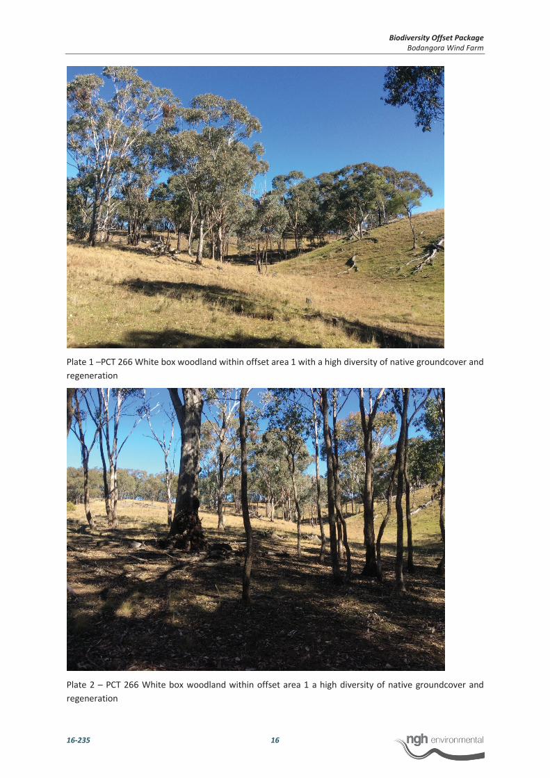
Plate 1 –PCT 266 White box woodland within offset area 1 with a high diversity of native groundcover and
regeneration
Plate 2 – PCT 266 White box woodland within offset area 1 a high diversity of native groundcover and
regeneration

Biodiversity Offset Package
Bodangora Wind Farm
16-235 17
Plate 3 – PCT 266 White box woodland within offset area 2
6.3 ABILITY TO MEET OFFSET REQUIREMENT
One of the two PCTs that are required to be offset were found to be within areas surveyed. Approximately
29.29 ha of PCT 266 is available within areas surveyed.
The identified offset sites (Figure 6-2 and Figure 6-3) contains three (3) PCTs which include the like for like
offset of PCT 266. Vegetation surveyed within offset area 1 was in good condition with a high abundance
and diversity of native species with minimal influence of exotic flora. Vegetation surveyed within offset
area 2 is in a generally lower condition state than that of offset area 1 and contains a moderate abundance
and diversity of native species, however also contains an area of derived grassland absent of over storey
species and higher abundance of exotic flora such as St Barnaby’s thistle Centaurea solstitialis. As
previously stated in section 6.1.2, a number of the vulnerable listed Grey-crowned babbler Pomatostomus
temporalis temporalis were observed utilising White Box vegetation within offset area 1 during the site
surveys. Hectares available in relation to the relevant vegetation zone within the identified offset areas
and credits generated are summarised below in Table 6-3.
Table 6-3 Impact and Offset Credit Summary
Plant Community Type Impact Offset
Number Name Area (Ha) Credits Area (Ha) Credits
266 White Box grassy woodland in the
upper slopes sub region of the NSW
South Western Slopes Bioregion
2.0 (estimate) 73 8.79 97
Biodiversity Offset Package
Bodangora Wind Farm
16-235 18
Plant Community Type Impact Offset
266 White Box grassy woodland in the
upper slopes sub region of the NSW
South Western Slopes Bioregion –
Derived grassland
- - 2.0 18
281 Rough Barked Apple-Red Gum-
Yellow Box woodland on alluvial
clay to loam soils on valley flats in
the norther NSW South Western
Slopes Bioregion and Brigalow Belt
South Bioregion
1.0 (estimate) 40 - -
Total 3.0 113 10.79 115
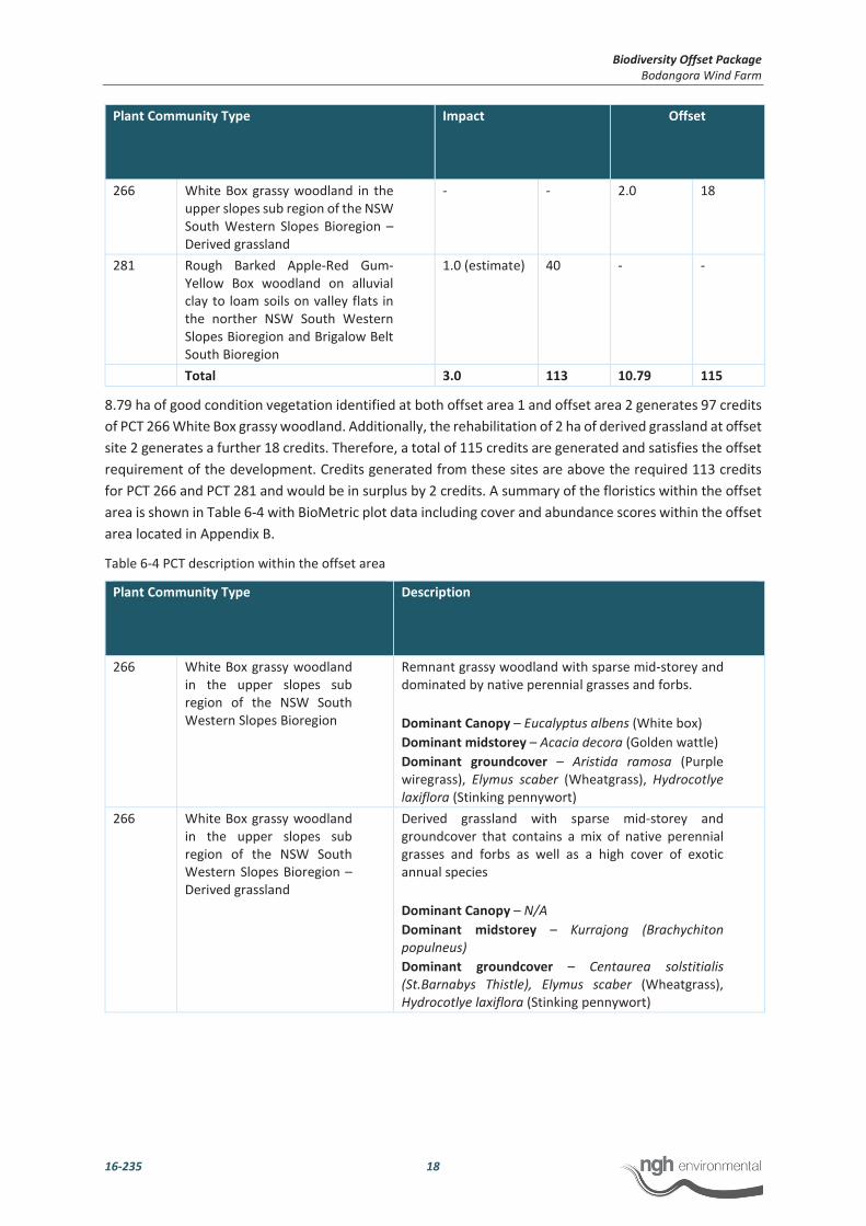
8.79 ha of good condition vegetation identified at both offset area 1 and offset area 2 generates 97 credits
of PCT 266 White Box grassy woodland. Additionally, the rehabilitation of 2 ha of derived grassland at offset
site 2 generates a further 18 credits. Therefore, a total of 115 credits are generated and satisfies the offset
requirement of the development. Credits generated from these sites are above the required 113 credits
for PCT 266 and PCT 281 and would be in surplus by 2 credits. A summary of the floristics within the offset
area is shown in Table 6-4 with BioMetric plot data including cover and abundance scores within the offset
area located in Appendix B.
Table 6-4 PCT description within the offset area
Plant Community Type Description
266 White Box grassy woodland
in the upper slopes sub
region of the NSW South
Western Slopes Bioregion
Remnant grassy woodland with sparse mid-storey and
dominated by native perennial grasses and forbs.
Dominant Canopy – Eucalyptus albens (White box)
Dominant midstorey – Acacia decora (Golden wattle)
Dominant groundcover – Aristida ramosa (Purple
wiregrass), Elymus scaber (Wheatgrass), Hydrocotlye
laxiflora (Stinking pennywort)
266 White Box grassy woodland
in the upper slopes sub
region of the NSW South
Western Slopes Bioregion –
Derived grassland
Derived grassland with sparse mid-storey and
groundcover that contains a mix of native perennial
grasses and forbs as well as a high cover of exotic
annual species
Dominant Canopy – N/A
Dominant midstorey – Kurrajong (Brachychiton
populneus)
Dominant groundcover – Centaurea solstitialis
(St.Barnabys Thistle), Elymus scaber (Wheatgrass),
Hydrocotlye laxiflora (Stinking pennywort)

Biodiversity Offset Package
Bodangora Wind Farm
16-235 19
7 MANAGEMENT ACTIONS AND RESPONSIBILITIES
BWFPL is committed to formalising a Biobanking agreement with the offset site landowner. A provisional
agreement had been agreed between BWFPL and the landowner previously (February 2012). Upon
approval of the BOP, the Biobanking agreement will be formalised with detailed credit value and process
for retirement of credits, total fund deposit and detailed management action costings.
7.1 OBJECTIVES OF MANAGEMENT ACTIONS
The core objective of the management actions are to improve biodiversity values and vegetation extent
within the offset sites. Management actions and improvement strategies have been developed that ensure
overall objectives and targets for the offset area are met or exceeded and are listed below and
demonstrated further within Table 9-1;
Fencing/Signage - Restrict all impacts from adjacent agricultural activities, improve
biodiversity values, protect cultural heritage values and notify the presence of the offset
area and conservation values of the site
Habitat features - Increase extent of habitat within the offset area and allow for
regeneration and natural recruitment of native flora
Erosion and soil management - Improve/maintain soil profile, promote natural regeneration
and protect heritage values
Weeds management - Minimise the occurrence of weeds within the site, reducing weed
infestations
Feral and pest animal management - Reduce presence of feral animals and overabundant
native herbivores within the Offset site to improve/maintain biodiversity values and
promote natural regeneration
Fire management - Regulate a fire regime for the offset area to maintain and improve
biodiversity values and protect natural recruitment.
7.2 FENCING AND SIGNAGE
Fencing should be stock proof and exclude illegal access for dumping of rubbish or collection of firewood.
Minimum construction standards for fencing include a seven (7) wire fence line, comprising the following:
lines 2.5mm HT wire;
5 metre steel picket spacing’s (165cm);
5 strainers per kilometre;
One stay per strainer.
The majority of existing fence lines and gates are in reasonable condition with only minor repair required.
Signage will be installed to notify that the area is a conservation area and contact number for emergencies
and further information should be provided.
7.3 HABITAT FEATURES AND ASSISTED REGENERATION
The clearing of native vegetation, whether remnant or regrowth, is not permitted within the offset area.
The landholder is to retain regrowth and/or natural regeneration of native plant species and no planting
or spreading of non-native vegetation and farming practices that use mechanical cultivation can occur at
any time. No apiaries can be installed within the offset area. As discussed further in Section 8, natural

Biodiversity Offset Package
Bodangora Wind Farm
16-235 20
regeneration will be encouraged and monitored and it is expected that offset areas have a high natural
recovery potential and therefore assisted natural regeneration will be facilitated. The key actions in
facilitating natural regeneration is via strict control on grazing activities and weed and pest management.
This is discussed further in Section 7.1.5 and 7.1.6. Active revegetation will only occur if natural
regeneration is deemed not optimal in meeting performance criteria listed in section 8. Where possible,
the clearing of vegetation within the impacts areas should be stockpiled and redistributed within the offset
area to enhance habitat features.
7.4 EROSION AND SOIL MANAGEMENT
There is no evidence of any current erosion or soil management issues however, monitoring will be
undertaken of areas of potential issues with temporary measures such as sediment controls implemented
should it be required.
7.5 WEED MANAGEMENT
Grassy woodland within the offset areas are relatively free of noxious weeds and with only a minor
occurrence of annual environmental weeds such as Centaurea solstitialis. However, further weed mapping
is required and will be obtained during the first monitoring event. As the offset area 1 are relatively weed
free, a weed containment control program will be implemented to limit the spread of priority and
environmental weeds into the offset area. The derived grassland within offset area 2 does contain a higher
abundance and cover of exotic annuals and therefore the initial weed control program implemented would
concentrate on the control and containment of weeds in the first instance. Ongoing monitoring and
inspections as demonstrated in Section 9 will identify extent of weed infestations that may occur during
the management of the offset area and assess the ongoing effectiveness of the control methods
implemented.
7.6 FERAL AND PEST ANIMAL MANAGEMENT
Feral animal control activities will be undertaken when inspections or monitoring indicate it is required
however feral animal control activities should be undertaken as a coordinated approach with surrounding
landholders in the region and in conjunction with Local Land Services (LLS) where practicable. Rabbits are
present onsite. Control activities may include methodologies such as baiting, trapping, warren ripping and
shooting with the control activities to be undertaken in accordance with NSW and Federal legislative
requirements.
A number of large groups of macropods where observed within and surrounding the offset area. Native
macropods numbers will be monitored and management of potential issues discussed with OEH prior to
undertaking any management action.
7.7 FIRE MANAGEMENT
Bushfire management of the offset area should be incorporated in the exiting Bushfire Management Plan
for the Bodangora Windfarm. Where possible, bushfire management will facilitate the exclusion of fire
from regeneration (and revegetation areas if applicable) to allow the juveniles plants to mature to a stage
where they are able to withstand bushfire and regenerate naturally following such an event (a minimum
of 15 years).

Biodiversity Offset Package
Bodangora Wind Farm
16-235 21
7.8 RESPONSIBILITIES
It is proposed that the BWFPL would be responsible for the management of the offset sites during the
operational life of the wind farm. BWFPL would finance the retiring of credits generated which in turn funds
the offset sites landowner to undertake management actions (such as fencing and weed control). This
provides surety that the actions will be undertaken, as the requirement to offset to the long term funding
and management of the offset package, as well as subject to auditing and reporting processes under
approval conditions.
At the decommissioning stage, the ongoing management would be the responsibility of the landowner. It
is expected that by this time the majority of the required management actions would have been
undertaken and ongoing management tasks will largely coincide with routine agricultural activities. Land
use restrictions will remain in place on the offset site in perpetuity so that any activities undertaken on the
offset site must be compatible with the site’s overall function: to improve biodiversity values. Management
actions and measures are included below in Table 7-1.
Table 7-1 Roles and responsibilities
Monitoring and reporting event Responsibility
Monitor site condition against biometric benchmark and
baseline data
Report on management actions conducted and their
effectiveness. Recommend if changes are required to
monitoring or management actions to better meet objectives
Implement corrective actions if the offset site is not meeting
performance targets for PCT 266.
Proponent/operator
External consultants
Landowner
Record management actions undertaken and their
effectiveness. Recommend if changes are required to
monitoring or management actions to better meet objectives
for the next year
Report unauthorised access by stock or vehicles.
Proponent/operator
Landowner
Ensure that sufficient time and resources are allocated to allow
for the implementation of biodiversity management and
monitoring strategies as outlined in the BOP.
Proponent/operator for life of project

Biodiversity Offset Package
Bodangora Wind Farm
16-235 22
8 PERFORMANCE
As stated in Section 2 and 7.1.1, the core objective of the BOP is to improve biodiversity values and
vegetation extent within the offset areas and facilitate the long term conservation of the site. In order to
achieve this objective, and determine the ongoing success of management actions implemented, both
short term and long performance criteria is proposed. The performance criteria are preliminary and are
intended to apply to the initial 3 years of the BOP implementation. Following the initial 3 year period, they
will be assessed and redeveloped as appropriate in response to monitoring outcomes and the success of
the management actions implemented. This is discussed further in Section 9.
Grassy woodland within the offset areas are currently in moderate to good condition but are expected with
the above mentioned management actions in Section 7 implemented, the offset areas will improve toward
a high condition state. Areas of derived grassland are considered to be in low to moderate condition
however with stringent managements actions, are expected to also improve significantly toward a higher
condition state. The performance targets following on from the site value score obtained at Year 0 are
proposed for offset areas and shown in Table 8-1 and Table 8-2. Further ecological monitoring plots are
required within the derived grassland of offset 2 to track progress against the performance criteria. The
performance targets would be monitored and revised as per Table 8-1 below and Table 9-1.
Table 8-1 Performance targets for grassy woodland areas to achieve the proposed high ecological condition state
Period
(Year)
Performance
Target
(Site Value
Score)
NSR NOC NMS NGCG NGCS NGCO EC NTH OR FL
0 59 20 6 1 51 0 9 1 1 1 12
1-5 >63 20 6 1-25 55 2 9 1 1 1 15
6-10 >68 >25 10 1-25 60 3-5 10 1 1 1 25
11-15 >74 >25 12-35 1-25 60-70 3-5 10-20 1 1 1 >50
16-20 >78 >25 12-35 1-25 60-70 3-5 10-20 1 1 1 >66
Table 8-2 Performance targets for derived grassland areas to achieve the proposed higher ecological condition
state*
Period
(Year)
Performance
Target
(Site Value
Score)
NSR NOC NMS NGCG NGCS NGCO EC NTH OR FL
0 21* 16 0 0 21 0 3 66 0 0 0
1-5 >30 20 0 1-25 25 2 5 40 0 1 15
6-10 >40 >25 6 1-25 40 3-5 10-20 20 0 1 25
11-15 >50 >25 10 1-25 60-70 3-5 10-20 <5 0 1 >50
Biodiversity Offset Package
Bodangora Wind Farm
16-235 23
16-20 >60 >25 12-35 1-25 60-70 3-5 10-20 <5 0 1 >66
*Plot data obtained and utilised for the derived grassland area are of similar condition to that of vegetation
within offset area 2 however, are located outside of the offset area. Ecological monitoring plots are
required to be implemented following approval of the BOP with performance targets updated accordingly.
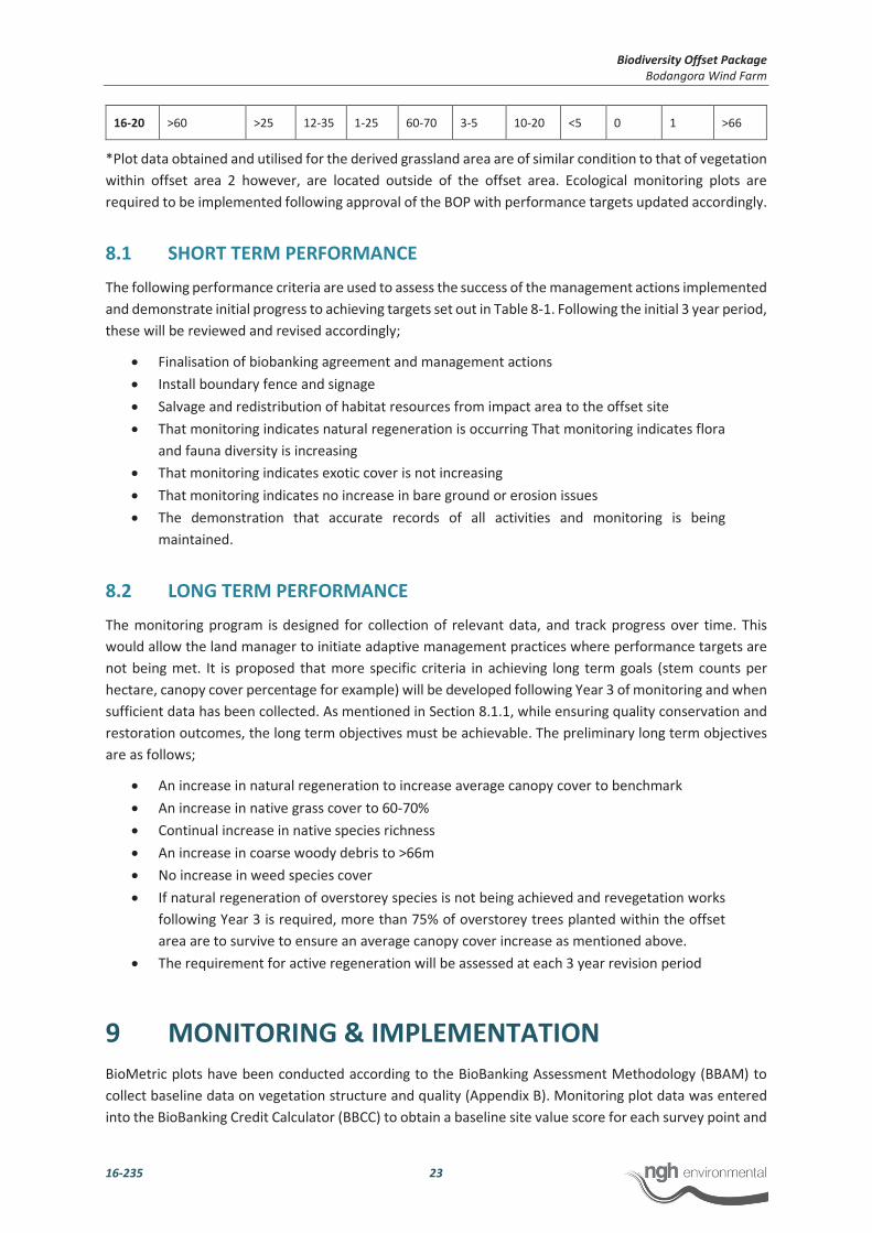
8.1 SHORT TERM PERFORMANCE
The following performance criteria are used to assess the success of the management actions implemented
and demonstrate initial progress to achieving targets set out in Table 8-1. Following the initial 3 year period,
these will be reviewed and revised accordingly;
Finalisation of biobanking agreement and management actions
Install boundary fence and signage
Salvage and redistribution of habitat resources from impact area to the offset site
That monitoring indicates natural regeneration is occurring That monitoring indicates flora
and fauna diversity is increasing
That monitoring indicates exotic cover is not increasing
That monitoring indicates no increase in bare ground or erosion issues
The demonstration that accurate records of all activities and monitoring is being
maintained.
8.2 LONG TERM PERFORMANCE
The monitoring program is designed for collection of relevant data, and track progress over time. This
would allow the land manager to initiate adaptive management practices where performance targets are
not being met. It is proposed that more specific criteria in achieving long term goals (stem counts per
hectare, canopy cover percentage for example) will be developed following Year 3 of monitoring and when
sufficient data has been collected. As mentioned in Section 8.1.1, while ensuring quality conservation and
restoration outcomes, the long term objectives must be achievable. The preliminary long term objectives
are as follows;
An increase in natural regeneration to increase average canopy cover to benchmark
An increase in native grass cover to 60-70%
Continual increase in native species richness
An increase in coarse woody debris to >66m
No increase in weed species cover
If natural regeneration of overstorey species is not being achieved and revegetation works
following Year 3 is required, more than 75% of overstorey trees planted within the offset
area are to survive to ensure an average canopy cover increase as mentioned above.
The requirement for active regeneration will be assessed at each 3 year revision period
9 MONITORING & IMPLEMENTATION
BioMetric plots have been conducted according to the BioBanking Assessment Methodology (BBAM) to
collect baseline data on vegetation structure and quality (Appendix B). Monitoring plot data was entered
into the BioBanking Credit Calculator (BBCC) to obtain a baseline site value score for each survey point and

Biodiversity Offset Package
Bodangora Wind Farm
16-235 24
vegetation zone. Replication of these plots would be undertaken annually for the operational life of the
wind farm and following commencement of the offset areas. As mentioned previously, further ecological
monitoring plots are required within derived grassland of offset area 2. This will provide annual information
about the improvement (or deterioration) of the offset site against key condition parameters such as native
species diversity, weed infestation, fallen logs and assist in determining whether predicted improvements
in habitat quality scores are achieved according to the values detailed in Table 8-1.
Management actions and their outcomes will be reported annually to the Department of Planning and OEH
for the duration of the project (up to 25 years) to demonstrate that a ‘maintain or improve’ outcome has
been met in accordance with core objectives of the BOP. The annual report would detail works undertaken
within the offset area during the previous year and an evaluation against the performance criteria
demonstrated in Table 8-1 and Section 8. The monitoring and reporting schedule is demonstrated in Table
9-1 however may be altered to reflect the results of monitoring and in consultation with OEH.
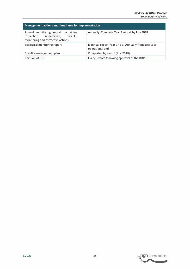
Table 9-1 Monitoring, implementation and reporting schedule
Management actions and timeframe for implementation
Actions Required Timeframe
Finalisation of biobanking agreement Signed biobanking agreement prior 30th June 2018
Install boundary fence and signage Completed by Year 1 (July 2018)
Salvage and redistribution of habitat
resources
Completed as required and ensuring no impact
on biodiversity values
Undertake weed mapping and weed
control
Weed mapping completed by Year 1 (July 2018).
Weed control ongoing. Annually review and revise
accordingly
Undertake feral animal control Baseline data completed by Year 1 (July 2018). Feral
animal control ongoing. Annually review and revise
accordingly
Undertake over abundant herbivore
control
Annually review and seek advice and necessary
permits from OEH
Undertake erosion and soil management
activities
Instigate remediation works following on from
annual monitoring results
Revegetation Initiate revegetation if increase in canopy species via
assisted natural regeneration is not greater than
numbers contained in Year 0 site value score by Year
3
Monitoring actions
Routine maintenance inspections of
fencing, erosion issues, weed abundance
and feral animal activity
Biannual (twice yearly) inspections and following
significant storm events (fencing only). Maintenance
as required.
Monitor natural regeneration Annually. Initiate revegetation if increase in canopy
species is not greater than numbers contained in
baseline/Year 0 by Year 3
Monitor revegetation Annually, following any revegetation works
Ecological monitoring Annually. Biometric plot surveys in comparison with
Year 0 site value score
Development of long term performance
criteria
Completed following Year 3 monitoring event.
Monitoring actions
Maintain accurate records of all
management activities undertaken
Ongoing from year 1
Biodiversity Offset Package
Bodangora Wind Farm
16-235 25
Management actions and timeframe for implementation
Annual monitoring report containing
inspection undertaken, results,
monitoring and corrective actions
Annually. Complete Year 1 report by July 2018
Ecological monitoring report Biannual report Year 1 to 3. Annually from Year 3 to
operational end
Bushfire management plan Completed by Year 1 (July 2018)
Revision of BOP Every 3 years following approval of the BOP
Biodiversity Offset Package
Bodangora Wind Farm
16-235 26
10 ADAPTIVE MANAGAMENT
10.1 ADAPTIVE MANAGEMENT PROCESS AND REVIEW
Adaptive management of the BOP will be receptive to any new and relevant data that may arise through
the monitoring set out in Table 9-1 and is key to the successful implementation of the BOP. This will allow
ongoing flexibility to manage objectives, allow for relevant feedback and modifications to the BOP. The
BOP will undergo a review and revision every 3 years in order to assess that the performance targets are
being achieved and make improvements accordingly.
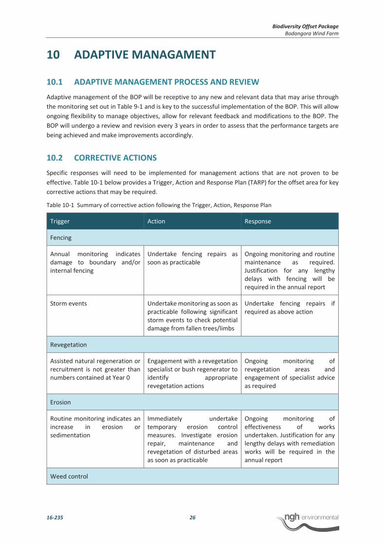
10.2 CORRECTIVE ACTIONS
Specific responses will need to be implemented for management actions that are not proven to be
effective. Table 10-1 below provides a Trigger, Action and Response Plan (TARP) for the offset area for key
corrective actions that may be required.
Table 10-1 Summary of corrective action following the Trigger, Action, Response Plan
Trigger Action Response
Fencing
Annual monitoring indicates
damage to boundary and/or
internal fencing
Undertake fencing repairs as
soon as practicable
Ongoing monitoring and routine
maintenance as required.
Justification for any lengthy
delays with fencing will be
required in the annual report
Storm events Undertake monitoring as soon as
practicable following significant
storm events to check potential
damage from fallen trees/limbs
Undertake fencing repairs if
required as above action
Revegetation
Assisted natural regeneration or
recruitment is not greater than
numbers contained at Year 0
Engagement with a revegetation
specialist or bush regenerator to
identify appropriate
revegetation actions
Ongoing monitoring of
revegetation areas and
engagement of specialist advice
as required
Erosion
Routine monitoring indicates an
increase in erosion or
sedimentation
Immediately undertake
temporary erosion control
measures. Investigate erosion
repair, maintenance and
revegetation of disturbed areas
as soon as practicable
Ongoing monitoring of
effectiveness of works
undertaken. Justification for any
lengthy delays with remediation
works will be required in the
annual report
Weed control

Biodiversity Offset Package
Bodangora Wind Farm
16-235 27
Routine monitoring indicates an
increase in target weed species
Adapt weed management
program and modify strategies
accordingly
Adjust control methods and
frequency of control.
Investigate suitability of strategic
conservation grazing for weed
suppression
Ongoing monitoring of
effectiveness of weed
management and adaption of
control methods and frequency
Feral animal and pest control
Annual monitoring indicates an
increase in feral animal
abundance
Adapt pest management
program and modify strategies
accordingly
Consultation with biosecurity
officers at Local Land Services to
identify appropriate actions and
coordinated baiting program.
Ongoing monitoring of actions
implemented following
specialist advice as required
Annual monitoring indicates an
over abundance of native
herbivore
Consult with OEH on appropriate
actions
Ongoing monitoring of actions
implemented following advice
from OEH
Ecological monitoring
Annual monitoring indicates
performance targets are not
being met
Assess fencing and ensure there
is no un-authorised stock access
Adapt weeds and pest animal
management strategies to
reduce competition
Engagement with a revegetation
specialist or bush regenerator to
identify appropriate remediation
actions
Consider the requirement for
active revegetation
Ongoing monitoring of
remediated areas following
engagement of specialist advice
as required
Biodiversity Offset Package
Bodangora Wind Farm
16-235 28
11 CONCLUSION
The preliminary BioBanking Assessment found that two offset areas are required within the Glen Oak
property to generate credits required for the development. The offset areas contain 8.79 hectares of PCT
266 White Box grassy woodland and 2 ha of White box derived grassland generating 115 credits, 2 more
than the required 113 credits. As such, a surplus of credits would be generated by the proposed offset site
to those required to offset development impacts. Credits generated from PCT 266 at this site will be retired
and secured by a biobanking agreement.
The BOP will be reviewed every three years and aim to ensure continual improvement and best practice
management through evaluating the effectiveness of management actions against the performance
criteria. With implementation of monitoring requirements and management actions within this BOP, the
objectives of ‘improve and maintain’ biodiversity values within the offset sites will be ensured.

Biodiversity Offset Package
Bodangora Wind Farm
16-235 29
12 REFERENCES Kevin Mills & Associates (2011). Flora and Fauna Assessment, Bodangora Wind Farm, Shire of Wellington.
Maguire O, Armstrong RC, Benson JS, Streeter R, Patterson C, McDonald P, Salter N, East E, Webster M,
Sheahan M and Young D (2012) Using high resolution digital aerial imagery interpreted in a 3-D digital GIS
environment to map plant communities in central-southern New South Wales. Cunninghamia 12, 247-266.
NSW Office of Environment and Heritage (OEH) 2014a Framework for Biodiversity Assessment - NSW
Biodiversity Offsets Policy for Major Projects
NSW Office of Environment and Heritage (OEH) 2014b NSW Biodiversity Offsets Policy for Major Projects
NSW Office of Environment and Heritage (OEH) 2014c BioBanking Assessment Methodology
NSW Office of Environment and Heritage (OEH) 2016 NSW Vegetation Information System: Classification
2.1

Biodiversity Offset Package
Bodangora Wind Farm
16-235 A-I
APPENDIX A BIOBANKING REPORTS

Biodiversity Offset Package
Bodangora Wind Farm
16-235 A-II
Bodangora Credit impact

Biodiversity credit report
Proposal ID:
Proposal name:
Calculator version:Date of report: 18/09/2017
222/2017/4382MP
Bodangora Wind Farm
This report identifies the number and type of biodiversity credits required for a major project.
Time: 1:57:14PM
Major Project details
Proposal address: Level 22 56 Pitt ST Sydney NSW 2000
v4.0
Infigen EnergyProponent name:
Proponent address: Level 22 56 Pitt ST Sydney NSW 2000
Proponent phone:
Assessor name: Mitch Palmer
+61 2 8031 9900
Assessor address: 7/11 Union street NEWCASTLE WEST NSW 2302
Assessor accreditation: 222
Assessor phone: 02 49292301

Summary of ecosystem credits required
Plant Community type Credits createdArea (ha)
Rough-Barked Apple - red gum - Yellow Box woodland on
alluvial clay to loam soils on valley flats in the northern
NSW South Western Slopes Bioregion and Brigalow Belt
South Bioregion
1.00 39.50
White Box grassy woodland in the upper slopes sub-region
of the NSW South Western Slopes Bioregion
2.00 73.01
3.00 113Total
Credit profiles

1. Rough-Barked Apple - red gum - Yellow Box woodland on alluvial clay to loam soils on valley flats
in the northern NSW South Western Slopes Bioregion and Brigalow Belt South Bioregion, (CW111)
Number of ecosystem credits created
IBRA sub-region
40
Upper Slopes - Central West
Offset options - IBRA sub-regionsOffset options - Plant Community types
Rough-Barked Apple - red gum - Yellow Box woodland on alluvial clay to
loam soils on valley flats in the northern NSW South Western Slopes
Bioregion and Brigalow Belt South Bioregion, (CW111)
Apple Box - Blakely's Red Gum moist valley and footslopes grass-forb
open forest of the NSW South Western Slopes Bioregion, (CW103)
Blakely's Red Gum - Yellow Box grassy tall woodland of the NSW South
Western Slopes Bioregion, (CW112)
Fuzzy Box Woodland on alluvial brown loam soils mainly in the NSW
South Western Slopes Bioregion, (CW138)
Fuzzy Box woodland on colluvium and alluvial flats in the Brigalow Belt
South Bioregion (including Pilliga) and Nandewar Bioregion, (CW139)
Blakely's Red Gum - White Box - Yellow Box - Black Cypress Pine box
grass/shrub woodland on clay loam soils on undulating hills of central
NSW South Western Slopes Bioregion, (CW209)
White Box - Rough-barked Apple alluvial woodland of the NSW central
western slopes including in the Mudgee region, (CW211)
White Box - White Cypress Pine - Western Grey Box shrub/grass/forb
woodland in the NSW South Western Slopes Bioregion, (CW213)
White Box grassy woodland of the Nandewar Bioregion and Brigalow Belt
South Bioregion, (CW215)
White Box grassy woodland in the upper slopes sub-region of the NSW
South Western Slopes Bioregion, (CW216)
Yellow Box - Blakely's Red Gum grassy woodland of the Nandewar
Bioregion, (CW225)
Yellow Box grassy tall woodland on alluvium or parna loams and clays on
flats in NSW South Western Slopes Bioregion, (CW226)
Apple Box - Rough-barked Apple terrace flats woodland of the southern
Brigalow Belt South Bioregion, (CW231)
White Box - Blakely's Red Gum - Long-leaved Box - Nortons Box - Red
Stringybark grass-shrub woodland on shallow soils on hills in the NSW
South Western Slopes Bioregion, (CW320)
Riparian Blakely's Red Gum - box - shrub - sedge - grass tall open forest
of the central NSW South Western Slopes Bioregion, (CW295)
Red Stringybark - Blakely's Red Gum +/- Long-leaved Box shrub/grass hill
woodland of the NSW South Western Slopes Bioregion, (CW285)
Red Box - White Box +/- Red Stringybark hill woodland in the NSW South
Western Slopes Bioregion, (CW280)
Yellow Box grassy woodland on lower hillslopes and valley flats in the
southern NSW Brigalow Belt South Bioregion, (CW330)
Upper Slopes - Central West
and any IBRA subregion that adjoins the
IBRA subregion in which the
development occurs
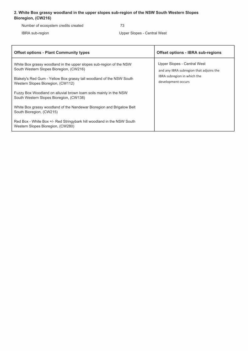
2. White Box grassy woodland in the upper slopes sub-region of the NSW South Western Slopes
Bioregion, (CW216)
Number of ecosystem credits created
IBRA sub-region
73
Upper Slopes - Central West
Offset options - IBRA sub-regionsOffset options - Plant Community types
White Box grassy woodland in the upper slopes sub-region of the NSW
South Western Slopes Bioregion, (CW216)
Blakely's Red Gum - Yellow Box grassy tall woodland of the NSW South
Western Slopes Bioregion, (CW112)
Fuzzy Box Woodland on alluvial brown loam soils mainly in the NSW
South Western Slopes Bioregion, (CW138)
White Box grassy woodland of the Nandewar Bioregion and Brigalow Belt
South Bioregion, (CW215)
Red Box - White Box +/- Red Stringybark hill woodland in the NSW South
Western Slopes Bioregion, (CW280)
Upper Slopes - Central West
and any IBRA subregion that adjoins the
IBRA subregion in which the
development occurs

Summary of species credits required

Biodiversity Offset Package
Bodangora Wind Farm
16-235 A-I
Potential offset credits

BioBanking credit report
Proposal ID:
Proposal name:
Calculator version:Date of report: 18/09/2017
222/2017/4380B
Bodangora WF offset
This report identifies the number and type of credits required at a BIOBANK SITE
Time: 1:59:47PM
Biobank details
Proposal address: Gillinghall Rd Bodangora NSW 2820
v4.0
Infigen EnergyProponent name:
Proponent address: Level 22 56 Pitt ST Sydney NSW 2000
Proponent phone:
Assessor name: Mitch Palmer
+61 2 8031 9900
Assessor address: 7/11 Union street NEWCASTLE WEST NSW 2302
Assessor accreditation: 222
Assessor phone: 02 49292301
Additional information required for approval:
Use of local benchmark
Expert report...
Request for additional gain in site value
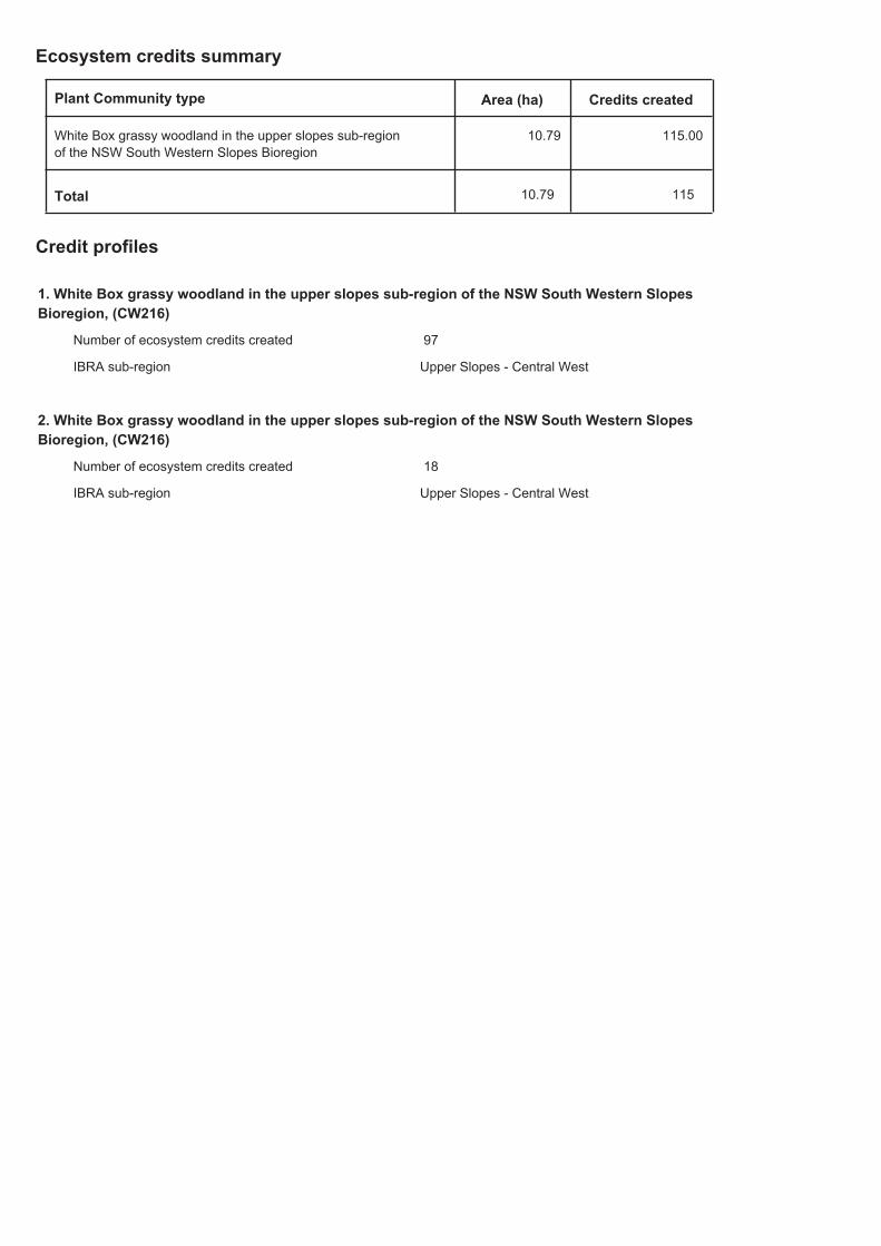
Ecosystem credits summary
Plant Community type Credits createdArea (ha)
White Box grassy woodland in the upper slopes sub-region
of the NSW South Western Slopes Bioregion
10.79 115.00
10.79 115Total
Credit profiles
1. White Box grassy woodland in the upper slopes sub-region of the NSW South Western Slopes
Bioregion, (CW216)
97Number of ecosystem credits created
IBRA sub-region Upper Slopes - Central West
2. White Box grassy woodland in the upper slopes sub-region of the NSW South Western Slopes
Bioregion, (CW216)
18Number of ecosystem credits created
IBRA sub-region Upper Slopes - Central West

Species credits summary
Additional management actions
Management action detailsVegetation type or threatened species
Additional management actions are required for:
White Box grassy woodland in the upper slopes
sub-region of the NSW South Western Slopes Bioregion
Exclude commercial apiaries
White Box grassy woodland in the upper slopes
sub-region of the NSW South Western Slopes Bioregion
Exclude miscellaneous feral species
White Box grassy woodland in the upper slopes
sub-region of the NSW South Western Slopes Bioregion
Feral and/or over-abundant native herbivore control
White Box grassy woodland in the upper slopes
sub-region of the NSW South Western Slopes Bioregion
Fox control
White Box grassy woodland in the upper slopes
sub-region of the NSW South Western Slopes Bioregion
Slashing

Biodiversity Offset Package
Bodangora Wind Farm
16-235 B-I
APPENDIX B MONITORING PLOTS
Coordinates for each of the monitoring plots
Site Easting Northing Description Image
BOP 10 698009 6414144 White Box Grassy Woodland PCT
266
Direction 110 SE
BOP11 698058 6414209 White Box Grassy Woodland PCT
266
Direction 300 NW
BOP12 698100 6414291 White Box Grassy Woodland PCT
266
Direction 205 SW
BOP 5 697640 6415332 White Box Grassy Woodland PCT
266
Direction 180 S
Biodiversity Offset Package
Bodangora Wind Farm
16-235 B-II
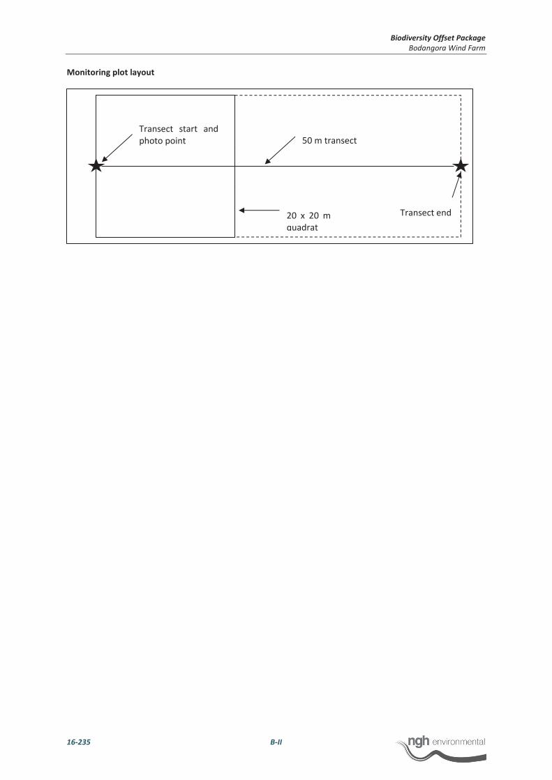
Monitoring plot layout
50 m transect
Transect start and
photo point
20 x 20 m
quadrat
Transect end

Biodiversity Offset Package
Bodangora Wind Farm
16-235 B-I
Offset Area Plot data – PCT 266
PlotName NPS NOS NMS NGCG NGCS NGCO EPC NTH OR FL
BOP10 21 4 2 60 0 10 2 1 1 10
BOP11 20 7.5 0 38 0 8 2 1 1 7
BOP12 20 5.5 0 54 0 8 0 1 1 20
BOP5 23 10.5 0 16 0 4 0 1 1 11
BOP 8* 16 0 0 16 0 6 70 0 0 0
BOP 9* 15 0 0 26 0 0 62 0 0 0
*Plot data obtained and utilised for the derived grassland area are of similar condition to that of vegetation within offset area 2 however, are located
outside of the offset area. Ecological monitoring plots are required to be implemented following approval of the BOP with performance targets updated
accordingly.
Full floristic data – PCT 266 only
Flora quadrat/random meander data sheet
Project: Bodangora WF
Survey date: 20/06/2017
Quadrat/RM ID: BOP10
GPS location: 698009 6414144
Family Exotic Scientific Name Common Name Cover% #individuals
Apiaceae Hydrocotyle laxiflora Stinking Pennywort 10 500
Asteraceae * Centaurea solstitialis St Barnabys Thistle 1 10
Asteraceae * Arctotheca calendula Capeweed 2 50
Brassicaceae * Brassica spp. Brassica 1 1
Campanulaceae Wahlenbergia luteola Bluebell 1 5
Chenopodiaceae Einadia nutans Climbing Saltbush 1 1
Convolvulaceae Dichondra repens Kidney Weed 5 100

Biodiversity Offset Package
Bodangora Wind Farm
16-235 B-II
Fabaceae (Faboideae) Glycine clandestina Twining glycine 5 50
Fabaceae (Faboideae) Desmodium varians Slender Tick-trefoil 2 50
Fabaceae (Mimosoideae) Acacia decora Western Silver Wattle 3 1
Fabaceae (Mimosoideae) Acacia implexa Hickory Wattle 1 1
Goodeniaceae Goodenia pinnatifida Scrambles Eggs 1 1
Myrtaceae Eucalyptus albens White Box 30 5
Myrtaceae Eucalyptus blakelyi Blakely's Red Gum 5 1
Phyllanthaceae Phyllanthus hirtellus Thyme Spurge 1 1
Plantaginaceae Plantago varia 1 2
Poaceae Austrostipa scabra Speargrass 2 10
Poaceae Austrostipa nodosa A Speargrass 2 10
Poaceae Aristida ramosa Purple Wiregrass 5 50
Poaceae Austrostipa setacea Corkscrew Grass 2 10
Poaceae Aristida vagans Threeawn Speargrass 5 50
Poaceae Bothriochloa macra Red Grass 10 100
Pteridaceae Cheilanthes sieberi Rock Fern 10 100
Rosaceae Acaena novae-zelandiae Bidgee-widgee 1 5
Flora quadrat/random meander data sheet
Project: Bodangora WF
Survey date: 20/06/2017
Quadrat/RM ID: BOP11
GPS location: 698058 6414209
Family Exotic Scientific Name Common Name Cover% #individuals
Apiaceae Hydrocotyle laxiflora Stinking Pennywort 20 500

Biodiversity Offset Package
Bodangora Wind Farm
16-235 B-III
Apiaceae Daucus glochidiatus Native Carrot 1 5
Asteraceae Vittadinia cuneata A Fuzzweed 1 3
Convolvulaceae Dichondra repens Kidney Weed 2 50
Fabaceae (Faboideae) Glycine clandestina Twining glycine 2 50
Fabaceae (Faboideae) Desmodium varians Slender Tick-trefoil 1 50
Fabaceae (Mimosoideae) Acacia implexa Hickory Wattle 1 1
Fabaceae (Mimosoideae) Acacia decora Western Silver Wattle 10 7
Geraniaceae Geranium retrorsum Cranesbill Geranium 1 10
Juncaceae * Juncus bufonius Toad Rush 1 5
Juncaceae Juncus subsecundus Finger Rush 2 20
Myrtaceae Eucalyptus albens White Box 50 15
Oxalidaceae Oxalis perennans 1 50
Phyllanthaceae Phyllanthus hirtellus Thyme Spurge 1 3
Plantaginaceae Plantago varia 1 10
Poaceae Austrostipa scabra Speargrass 5 50
Poaceae Aristida vagans Threeawn Speargrass 5 50
Poaceae Aristida ramosa Purple Wiregrass 5 50
Poaceae Rytidosperma caespitosum Ringed Wallaby Grass 5 10
Pteridaceae Cheilanthes sieberi Rock Fern 5 50
Rubiaceae Asperula conferta Common Woodruff 1 20
Flora quadrat/random meander data sheet
Project: Bodangora WF
Survey date: 20/06/2017
Quadrat/RM ID: BOP12

Biodiversity Offset Package
Bodangora Wind Farm
16-235 B-IV
GPS location: 698100 6414291
Family Exotic Scientific Name Common Name Cover% #individuals
Apiaceae Hydrocotyle laxiflora Stinking Pennywort 5 100
Asteraceae * Conyza spp. A Fleabane 1 10
Asteraceae * Carthamus lanatus Saffron Thistle 1 1
Chenopodiaceae Einadia nutans Climbing Saltbush 2 50
Convolvulaceae Dichondra repens Kidney Weed 2 50
Dilleniaceae Hibbertia riparia 1 5
Fabaceae (Faboideae) Glycine clandestina Twining glycine 2 100
Fabaceae (Faboideae) Desmodium varians Slender Tick-trefoil 1 20
Fabaceae (Mimosoideae) Acacia decora Western Silver Wattle 2 2
Fabaceae (Mimosoideae) Acacia implexa Hickory Wattle 1 1
Geraniaceae Geranium retrorsum Cranesbill Geranium 5 100
Juncaceae Juncus subsecundus Finger Rush 2 20
Juncaceae * Juncus bufonius Toad Rush 1 5
Myrtaceae Eucalyptus albens White Box 40 9
Myrtaceae Eucalyptus blakelyi Blakely's Red Gum 2 2
Phyllanthaceae Phyllanthus hirtellus Thyme Spurge 1 2
Poaceae Elymus scaber Common Wheatgrass 10 50
Poaceae Aristida ramosa Purple Wiregrass 1 20
Poaceae Austrostipa scabra Speargrass 5 50
Poaceae Rytidosperma caespitosum Ringed Wallaby Grass 1 5
Poaceae Bothriochloa macra Red Grass 5 50
Pteridaceae Cheilanthes sieberi Rock Fern 1 50
Rosaceae Acaena novae-zelandiae Bidgee-widgee 1 2