biodiversity management plan (bmp) upper cisokan …
TRANSCRIPT

i
BIODIVERSITY MANAGEMENT PLAN (BMP)
UPPER CISOKAN PUMPED STORAGE HYDROPOWER
Achieving Biodiversity Conservation through Integrated
Catchment Management
PT PLN (PERSERO)
MASTER DEVELOPMENT UNIT – UIP JBT I
FEBRUARY 2021

ii
Preface
This Biodiversity Management Plan (BMP) Upper Cisokan Pumped Storage (UCPS) is the revised version
of a BMP study conducted by PT. PLN UIP VI in cooperation with PPSDAL LPPM UNPAD. This update is
undertaken by PT PLN Unit Induk Pembangunan Jawa Bagian Tengah 1 in cooperation with the Center for
Environment and Sustainability Sciences Universitas Padjadjaran (CESS UNPAD) under the Agreement No.
006.PJ/HKM.02.01/4800002020, 31 March 2020, and with additional support from Penelope Ferguson,
Prof. Erik Meijaard and Rona Dennis.
The revised BMP of 2021 updates the BMP of 2015 following a review of implementation of impact
avoidance and mitigation measures between 2015 and 2020 and partial implementation of the
restoration and offsetting strategies. The update complies with the World Bank Environmental and Social
Standard 6 Biodiversity Conservation and Sustainable Management of Living Natural Resources. The
current version also addresses the potential biodiversity impacts from the transmission line development
which were not covered in the 2015 BMP.
The BMP UCPS consists of a project rational and vision in compliance with World Bank safeguards policies,
strategies and operational descriptions, legal foundation, an analysis of the biodiversity of the project
area, and a review of threats to biodiversity.
The BMP is implemented through an Integrated Catchment Management (ICM) approach that achieves
positive biodiversity conservation outcomes through impact mitigation management, catchment-wide
reforestation, direct management of wildlife threats, and community and other stakeholder participation.
Implementation of ICM will result in Indonesia’s first Green Dam, in which environmental, economic,
social, and ecological issues are addressed simultaneously.
This plan is a major contribution to PLN’s mission to generate electricity as an environmentally sound
medium that improves the quality of people's lives and drives economic development.
Bandung, 25 February 2021
PT PLN UIP VI

iii
Executive summary
PT PLN and its project partner the World Bank recognize that biodiversity can be impacted in a number of
ways and these impacts are produced by a range of interacting threats. Major threats facing Java’s
biodiversity are habitat loss and fragmentation through clearing, ineffective management of protected
areas, fire, agricultural encroachment, overhunting, the development of road systems, increased land
clearing for urban development, pollution, exotic species, and climate change.
The Upper Cisokan Pumped Storage (UCPS) project has carried out a series of biodiversity surveys in the
Cisokan project area, West Java, Indonesia, which indicate the biodiversity richness of the region.
Altogether, the survey teams have found 36 species of land mammals, 114 species of birds, 48 species of
reptiles, and 17 species of fish. Importantly, this includes several species listed by as Critically Endangered
or Endangered by the International Union for Conservation of Nature (IUCN) (Pangolin, Grizzled Langur
and Javan Slow Loris).
Under the UCPS Environmental and Social Management Plan (ESMP), PLN are required to prepare and
implement a Biodiversity Management Plan (BMP) to manage the direct and indirect impacts on
biodiversity within the project area of influence. This BMP updates and supersedes the previous BMP
publicly disclosed in 2011 as a sub-plan to the ESMP, as well as the BMP prepared but not published in
2015.
The BMP provides practical guidance for reducing threats to biodiversity where practical, to manage
identified risks, to engage with communities and stakeholders, and to pro-actively support the
development of knowledge in biodiversity conservation using the ESS 6 mitigation hierarchy. Through this
BMP, the aim is to engage with biodiversity professionals, government, the community, non-government
organizations (NGOs), researchers and appropriate individuals to achieve a high standard of biodiversity
and conservation management.
The Biodiversity Management Plan is implemented through an Integrated Catchment Management (ICM)
approach that simultaneously addresses biodiversity, environmental and social aspects of landscape
management. It provides a sound rationale for a range of actions that focus on:
• Construction-related impact mitigation and management;
• Reforestation and forest management;
• Wildlife management;
• Stakeholder participation; and
• Community engagement.
Within the project area of influence the BMP goals are:
• To achieve net gain of Critical Habitat and Natural Habitat.
• To protect and enhance the remnant forest communities (both the habitat and wildlife) to create
a self-sustaining ecosystem.

iv
• To protect and increase the populations of critically endangered and endangered species so that
they are self-sustaining.
• To take into account the ongoing threats to biodiversity conservation from the community and
rural development in the selection and implementation of conservation strategies.
• To create a common understanding amongst stakeholders and the community about the
biodiversity values and threats.
This plan provides clear guidance on how to protect and restore habitats and to protect and manage
endangered species in the project area of influence. The approach is based on adaptive management,
requiring continuous monitoring of success. Depending on the on-going achievements or setbacks in the
field, the plan is flexible and allows changes to the basic approach.
The ICM approach aims to deliver sustainable land and resource use outcomes for Upper Cisokan area,
and with that develop a “Green Dam”. The ICM Plan will be developed and implemented in parallel with
the site-based conservation programs that focus more on the areas directly impacted by project
development. The challenges to maintain Cisokan’s highly threatened wildlife are large. A well-funded
and executed, politically supported ICM approach is key to the long-term survival of these species.
Key updates and recommendation following review of 2015 BMP
Following the review and gap analysis of the BMP Action Plan 2015 implementation as well as the study
on biodiversity and social aspects in the UCPS areas, some recommendations and updates are made for
updated BMP Action Plan 2020. Updates are reflected in the revised BMP Action Plan 2020 (Table 11). In
addition, the review suggested the need to improve the BMP action plan implementation as follows:
1. Implementation of the BMP action plan needs to be carried out based on a priority scale in
accordance with the pre-construction, construction, and operation phases.
2. Extension (and revision if necessary) of the MoU and Agreement between PT. PLN (Persero) and
Perum Perhutani needs to be set up immediately so that revegetation in all working zones can be
continued to carry out in accordance with the BMP action plan.
3. It is necessary to strengthen institutions and governance that are responsible for implementing the
BMP action plan supported by providing the necessary resources.
4. Planning for revegetation programs and its targets (number of seeds needed, successful growth,
plant species, location of planting) needs to be more systematically arranged with more attention to
the updated BMP action plan recommendations.
5. Revegetation and reforestation programs need to be thoroughly and systematically planned,
including nurseries and seedling maintenance, planting and maintaining, and monitoring and
evaluating planting program. Communities are empowered not only in planting and maintaining,
buat also to be as providers of seeds.

v
6. Empower community in forest monitoring to tackle disturbances in restoration areas and to prevent
and control forest and land fires.
7. It is necessary to establish a reporting system for wildlife incidents (traffic accidents, electric shocks,
poaching, etc.) and wildlife encounter.
8. It is necessary to develop a benefit sharing program for the local community in relation to the
existence of working zones with sustainable use principle of local natural resources. For instance,
through the development of agroforestry systems.
9. It is necessary to evaluate the placement and design of artificial corridor features/infrastructure,
particularly rope bridges.
10. It is required to conduct regular outreach and counselling in order to protect the existence of
endangered and protected wildlife along with law enforcement for those involved in animal hunting
and/or trafficking.
11. Capacity building of work units with adequate resources that specifically manage catchment areas
and restoration areas.
12. The establishment of a multi-stakeholder coordinating body needs to be initiated at the relevant
Ministry level (BUMN, KLHK, ESDM) to coordinate the handling of various problems which the scope
is beyond the authority of PT. PLN (Persero) and Perum Perhutani.
13. Develop cross-sectoral collaborative networks in order to find alternative sources of funding for
environmental management (biodiversity conservation, community capacity building, local economic
development) in UCPS.
14. Awareness, education, and information programs need to be arranged more systematic and regularly
implemented. It is therefore the work unit that is specifically responsible for implementing the
program needs to be re-established within PT. PLN (Persero).
15. BMP action plan needs to be firmly integrated into the resettlement plan document.
16. Community livelihoods recovery programs, particularly for those who affected by the UCPS
hydropower development, need to be carried out in a planned manner with measurable targets. The
priority of local economic development is directed at the development of production systems based
on local natural resources such as agroforestry and natural tourism. Funding sources other than PLN
need to be explored, including through the CSR scheme of other companies located in the
administrative areas of West Bandung Regency, Cianjur Regency, and West Java Province.

vi
Contents
1 Introduction .................................................................................................................................... 1
1.1 Background .............................................................................................................................. 1
1.2 Purpose, Vision and Goals of the BMP ...................................................................................... 1
1.3 Development of the BMP and Integrated Catchment Management (ICM) ................................ 3
1.4 Version Control ........................................................................................................................ 4
2 Background to Land use and Biodiversity Issues in Upper Cisokan .................................................... 5
2.1 Indonesia – Megadiverse Nation .............................................................................................. 5
2.2 The Natural Resources and Biodiversity of Java ........................................................................ 6
2.3 Responses to Reducing Indonesia’s Biodiversity Loss ................................................................ 7
Box 2 - Indonesia’s Biodiversity Action Plan (IBSAP) ................................................................................. 7
2.4 Landscapes and Biodiversity of Cisokan .................................................................................... 8
2.5 Major vegetation types and ecosystems in UCPS ...................................................................... 9
2.5.1 Natural Forest .................................................................................................................. 9
2.5.2 Mixed garden / Talun / Agroforestry ................................................................................. 9
2.5.3 Scrub and Upland Vegetation ......................................................................................... 10
2.5.4 Settlement ..................................................................................................................... 10
2.5.5 Fields, Fish Pools, and Rice Fields .................................................................................... 10
2.6 Terrestrial Fauna .................................................................................................................... 10
2.6.1 Mammals ....................................................................................................................... 12
2.6.2 Reptiles and Amphibians ................................................................................................ 13
2.6.3 Birds ............................................................................................................................... 14
2.7 Flora ...................................................................................................................................... 14
2.8 Land Cover ............................................................................................................................. 14
2.9 Land Use in Cisokan................................................................................................................ 16
2.9.1 Land Allocated for Infrastructural Development ............................................................. 16
2.9.2 Production Forest Land................................................................................................... 16
2.9.3 Community Land ............................................................................................................ 16
2.10 Existing and Ongoing ‘Baseline’ Threats.................................................................................. 17
2.10.1 Deforestation and forest degradation through agricultural conversion ........................... 17
2.10.2 Hunting and Collecting of Wildlife................................................................................... 18

vii
2.11 Assessment of Critical and Natural Terrestrial Habitat ............................................................ 18
2.11.1 Critical Habitat Triggers According to ESS 6 ..................................................................... 19
2.11.2 Determining the counterfactual scenario ........................................................................ 24
2.11.3 Extent of Critical Habitat impacted ................................................................................. 26
2.12 Direct and Indirect Threats from UCPS Development ............................................................. 28
2.12.1 Land Clearing and Inundation ......................................................................................... 29
2.12.2 Induced Development from Improved Access ................................................................. 29
2.12.3 Hunting and Collecting by Workers ................................................................................. 30
2.13 Threats from Transmission Line Development ........................................................................ 30
2.13.1 Electrocution risks .......................................................................................................... 30
2.13.2 Collision risks .................................................................................................................. 31
2.13.3 Habitat loss and fragmentation from Transmission Line Development ............................ 32
2.14 Applying the mitigation hierarchy .......................................................................................... 32
2.15 Offsetting losses in a sustainable development context .......................................................... 33
3 BMP Strategy ................................................................................................................................. 34
3.1 Introduction to the ICM Approach .......................................................................................... 34
3.2 Biodiversity Management Fundamentals ............................................................................... 35
3.2.1 Fundamental 1 – Managing Impacts on Biodiversity and Targeting Net-Gain of Critical
Habitat 35
3.2.2 Fundamental 2 - Adapt Biodiversity Management through Continuous Improvement .... 36
3.2.3 Fundamental 3 - Leading Practice ................................................................................... 36
3.2.4 Fundamental 4 – Identifying Opportunities to Enhance Biodiversity Conservation .......... 37
3.2.5 Fundamental 5 – Engagement and Partnerships ............................................................. 37
3.2.6 Fundamental 6 – Performance and Measurement .......................................................... 38
3.2.7 Fundamental 7 – Integrated Management ...................................................................... 38
3.3 Location ................................................................................................................................. 38
3.4 Biodiversity Important Areas (BIA) ......................................................................................... 38
3.5 Working zones and timeframes .............................................................................................. 40
3.6 Reforestation targets ............................................................................................................. 41
4 Indonesian Regulations and Institutions ......................................................................................... 46
4.1 Environmental Regulations for Flora and Fauna ..................................................................... 46
4.2 Water Resource, Forestry and Catchment Management Regulations ..................................... 46

viii
4.3 Institutions ............................................................................................................................. 48
5 BMP Action Plan ............................................................................................................................ 50
5.1 Construction-Related Impact Management ............................................................................ 50
5.1.1 Minimizing Further Habitat Fragmentation and Losses ................................................... 50
5.1.2 Controlling Access .......................................................................................................... 52
5.1.3 Fire Management ........................................................................................................... 53
5.1.4 Managing Impacts of Traffic on Native Fauna ................................................................. 53
5.2 Risk Mitigation of Transmission Infrastructure........................................................................ 54
5.2.1 Mitigating animal electrocution ...................................................................................... 55
5.2.2 Mitigation of bird collision .............................................................................................. 56
5.2.3 Mitigating habitat loss and fragmentation ...................................................................... 57
5.3 Reforestation and Forest Management .................................................................................. 58
5.3.1 Collection of Plant Material, Management of Nurseries and Planting Services ................ 58
5.3.2 Forest Restoration and Ecological Connectivity ............................................................... 58
5.3.3 Forest Management ....................................................................................................... 61
5.4 Wildlife Management ............................................................................................................. 63
5.4.1 Wildlife and Habitat Management .................................................................................. 63
5.4.2 Wildlife Encounters ........................................................................................................ 65
5.5 Stakeholder Participation ....................................................................................................... 65
5.5.1 Strengthening Capacities for Institutionalizing Integrated Catchment Management ....... 65
5.5.2 Gaining Political Support ................................................................................................ 66
5.6 Community Engagement ........................................................................................................ 67
5.6.1 Biodiversity Awareness, Communication and Education ................................................. 67
5.6.2 Aligning Resettlement Programmes with the BMP .......................................................... 68
5.6.3 Alternative Sustainable Livelihoods for Communities ...................................................... 69
6 Program......................................................................................................................................... 71
7 Institutional Framework, Roles and Responsibilities ..................................................................... 104
7.1 Stakeholders ........................................................................................................................ 104
7.2 Institutional Framework ....................................................................................................... 105
7.3 Roles and Responsibilities .................................................................................................... 108
7.3.1 PLN Environmental Manager UIP .................................................................................. 108
7.3.2 Construction Manager (PLN UPK) ................................................................................. 108

ix
7.3.3 UCPS Stakeholder Engagement Team (PLN) .................................................................. 108
7.3.4 Contractors – all Packages (Including all Staff and Sub-contractors) ............................. 109
7.3.5 ICM Facilitation Team ................................................................................................... 109
7.3.6 BMP Facilitation Team .................................................................................................. 109
7.3.7 Technical Assistants ...................................................................................................... 109
7.3.8 Patrol teams ................................................................................................................. 109
8 Capacity and Training................................................................................................................... 111
8.1 Capacity ............................................................................................................................... 111
8.2 Training ................................................................................................................................ 111
9 Monitoring and Evaluation........................................................................................................... 113
9.1 Management Purposes ........................................................................................................ 113
9.2 Management Actions ........................................................................................................... 113
10 Reporting ................................................................................................................................. 115
11 Detailed Annual Task Lists and Budget until the end of 2023 .................................................... 116
12 Plan Update and Review .......................................................................................................... 120
13 Bibliography ............................................................................................................................. 121
Appendix 1. Detailed maps and instructions ........................................................................................ 124
Appendix 2. Suggested plant species for use in reforestation ............................................................... 139
Appendix 3. Wildlife culvert examples ................................................................................................. 144
Appendix 4. Structures facilitating wildlife dispersal on steep slopes ................................................... 145
Appendix 5. Rope bridges and other structures facilitating arboreal wildlife movement ...................... 146
Appendix 6. Protecting tree cover close to the road edge maintains canopy connectivity, facilitating
movement of arboreal species ............................................................................................................ 147
Appendix 7. Standard Operational Procedures (SOP) for Land Clearing and Rehabilitation................... 148
Roles and Responsibilities ................................................................................................................ 148
Background ..................................................................................................................................... 148
Phasing of land clearing SOP ............................................................................................................ 149
Preparation Phase Management Actions ......................................................................................... 149
Pre – Clearing Phase Management Actions ...................................................................................... 150
Clearing Phase Management Actions (i.e., land clearing, clearing and grubbing, and excavation) .... 151
Post-clearing Phase Management Actions ....................................................................................... 152
Appendix 8. Additional maps. .............................................................................................................. 153

x
List of Figures
Figure 1. Regional map showing the position of the project area in regional context ............................... 8
Figure 2. Google Earth View (West to East) of the Cisokan watershed...................................................... 9
Figure 3. The Javan Slow Loris (left) is a small, nocturnal primate found only on the Indonesian island of
Java. S. .................................................................................................................................................. 12
Figure 4. Photo by Ten Berger (1919) taking during a geological expedition in the upper Cisokan area,
showing the originally forested slopes in the steep river valley. ............................................................. 17
Figure 5. Larger landscape context of the project area with green areas indicating core habitats for the
species trigger Critical Habitat and yellow areas indicating connecting habitat. ..................................... 26
Figure 6. UCPS landscape showing land cover, presence of species triggering Critical Habitat, and the
approximate extent of the study area in which these species have been assessed. ................................ 27
Figure 7. Map showing general direction across Java of September – November raptor migration. ....... 32
Figure 8. Mitigation hierarchy in relation to impacts and biodiversity values ......................................... 33
Figure 9. ICM Objectives and Milestones. .............................................................................................. 35
Figure 10. Small to medium scale boundaries of the ICM Approach (Working Zones 1 to 4). .................. 44
Figure 11. Reforestation target for 500 m buffer zone ........................................................................... 45
Figure 12. Example of good road design through forest areas that minimizes wildlife impacts. .............. 51
Figure 13. A 400 kV line, with all conductor wires in the same horizontal plane. .................................... 57
Figure 14. Institutional Framework for UCPS Safeguards under an ICM Approach ................................ 106
Figure 15. Institutional Framework –Upper Cisokan ICM catchment management coordinated by
multiple stakeholders in the medium to long term .............................................................................. 107
Figure 13. A box culvert with guiding fences and raised ledges ............................................................ 144
Figure 14. Diagram showing location of tree nursery in reservoir area in relation to river and greenbelt.
............................................................................................................................................................ 151
Figure 15. Land cover and land use map for the UCPS area .................................................................. 153
List of Tables
Table 1. Key Target Species for Biodiversity Management in Cisokan ..................................................... 11
Table 2. Composition of Landscape Scale Land Cover in The UCPS Area in 2016 and 2019 ..................... 15

xi
Table 3. Criteria that can trigger the identification of Critical Habitat and the thresholds that provide
these triggers. ....................................................................................................................................... 20
Table 4. Species that trigger Critical Habitat in UCPS .............................................................................. 21
Table 5. Composition of landscape scale land cover in the UCPS area in 2016 and 2019 ........................ 25
Table 6. Estimated areas of direct and indirect impacts on critical habitat ............................................. 28
Table 7. BIA Descriptions, Predicted Impacts and Management Guidance ............................................. 39
Table 8. Reforestation targets. CA = corridor areas. ............................................................................... 42
Table 9. Summary of Institutions involved in Upper Cisokan, and the status of their planning documents
.............................................................................................................................................................. 48
Table 10. Key mitigation actions to reduce impact of transmission lines on biodiversity ........................ 54
Table 11. BMP Program – Significant Activities and Project Phases ........................................................ 71
Table 12. Key stakeholders for implementing the BMP. ....................................................................... 104
Table 13. Training Schedule for 2021 ................................................................................................... 111
Table 14. Reports and Reporting Requirements. .................................................................................. 115
Table 15. Key Tasks and Budget Pre-Construction Phase – January 2021 – July 2021............................ 116
Table 16. Key Tasks and Budget Year 1 Construction Phase – August 2021 – July 2022. ....................... 117
Table 17. Key Tasks and Budget Year 2 Construction Phase – August 2022 – July 2023. ....................... 119
Table 18. Plan Update and Review Timeframe ..................................................................................... 120

1
1 Introduction
1.1 Background PT PLN (Persero) plans to construct the Upper Cisokan Pumped Storage (UCPS) hydropower to significantly
increase the peaking capacity of the power generation system in Java – Bali and to escalate the ability to
absorb variable of renewable power electricity generation sustainably. The UCPS Scheme with a capacity
of 1040 MW in Cisokan River and Cirumamis River, West Java, is the first type of pumped storage
hydropower in Indonesia. The total area used for reservoirs construction, including the dam, transmission
line, power plant, access road, mines, and other field activities is approximately 720 ha located in the hills
of West Bandung District and Cianjur District. The permanent access road had been constructed in
September 2019, while the main construction work is intended to be commenced in 2021.
The construction of UCPS hydropower will likely change the surrounding environment. In 2011 PLN
prepared a comprehensive Environmental and Social Management Plan (ESMP). A Biodiversity
Management Plan (BMP) was prepared in 2014/15 as a result of detailed assessments of the risks to the
forests and wildlife.
Besides, to improve and protect the forest, PLN established an agreement with Perhutani for forest and
watershed conservation in 2015 as required in the BMP 2015. In addition, a report has been compiled
that covered information about forest soil conditions in Biodiversity Important Areas (BIAs), wildlife
corridors, and buffer zone.
With regard to the continuation of the UCPS hydropower main construction that will be commenced in
2021, the ESIA and ESMP have been updated and a review of BMP implementation and completing
document of Forest Partnership Framework between PLN and Perhutani was made as an evaluation of
the previous BMP implementation and the update of the BMP. The Forest Partnership Framework
between PLN and Perhutani was updated in 2020, as a follow-up adaptive plan document managing
“residual impact” and anticipating dynamic conditions of the construction related to land.
This updated Biodiversity Management Plan (BMP) is intended to provide practical guidance related to
terrestrial biodiversity protection and enhancement as part of the integrated catchment management
(ICM) approach to managing impacts from the UCPS hydropower project and land use in the catchment
more broadly. Long term benefits to the tributaries and rivers in the catchment will come from the
improved land cover, management and ecosystem connectivity.
1.2 Purpose, Vision and Goals of the BMP The purpose of the BMP is:
• To provide a simple, well structured, adaptive management approach to terrestrial biodiversity
conservation in the project area of influence;

2
• To provide detailed technical methods for land clearing, wildlife management, protection of
biodiversity important areas to minimize the potential impacts on habitat and wildlife from
project construction activities;
• To provide a long term vision and an integrated plan for the maintenance and enhancement of
habitat for threatened terrestrial mammal species in the project area of influence, while also
addressing the influences from, and on, resettlements and land uses in the catchment;
• To meet the World Bank ESF ESS6 and international best practice for biodiversity conservation.
Vision for the Upper Cisokan catchment:
Thriving and prosperous communities hosting Indonesia’s greenest dams and a refuge for Java’s
endangered species.
Goals of the BMP:
Within the project area of influence:
• Protect and replant at least 3,800ha of contiguous forest habitat to provide sufficient habitat for
viable populations of threatened wildlife and achieve net gain of critical and natural forest and
riparian habitat;
• To cease all illegal hunting and poaching of wildlife and illegal logging and land clearance;
• All 10 listed endangered wildlife species (see Table 1) are present and populations are increasing
in number;
• To take an Integrated Catchment Management (ICM) approach to UCPS safeguards and
ecosystem improvement that takes into account the ongoing / baseline threats to biodiversity
conservation from the community and rural development.
• To create a common understanding amongst stakeholders and the community about the
biodiversity values and threats.
The BMP will be implemented by PLN. PLN will require ongoing support from, and collaboration with,
Perhutani (government forestry agency and land owner), expert biodiversity conservation practitioners,
conservation NGOs, government stakeholders and the host communities.
The priorities are:
1) Minimising the direct impacts from Construction on the Biodiversity Important Areas (BIAs);
2) Focus on the immediate and medium term needs of the Critically Endangered Pangolin and Javan
Slow Loris, Endangered Javan Gibbon and Grizzled Leaf Monkey, and Javan Leopard to sustain and
enhance local populations;
3) Protecting and expanding forest habitats to connect the BIAs together and into the wider
landscape while addressing the indirect impacts on biodiversity. Reforestation across the Upper
Cisokan watershed will furthermore reduce sedimentation and increase dam life.

3
4) Ensuring community development programs, resettlement and other activities in the catchments
are complimentary to the reforestation and wildlife protection efforts (and do not compromise
/undermine them).
5) Develop an organizational structure and network that addresses the immediate and longer-term
needs of effective ICM.
1.3 Development of the BMP and Integrated Catchment Management (ICM) The UCPS has a comprehensive ESMP, which covers all aspects of the project that may impact on people
and the environment, including aspects such as biodiversity management, quarry management, access
road construction, environmental monitoring, and social and community impact management for the
project, during pre-construction, construction and operation. This ESMP was publicly disclosed in
February 2021, and complies with the World Bank Environmental and Social Framework. It also
encompasses the mitigation and monitoring requirements under the Environmental Management Plan or
Rencana Pengelolaan Lingkungan (RKL) and Environmental Monitoring Plan or Rencana Pemantauan
Lingkungan (RPL) from the Indonesian authorities.
The ESMP is designed as an overriding document in a hierarchy of control plans throughout the project
phases (Pre‐construction, Construction and Operation). The ESMP sets out the framework of
environmental management to be applied to the project. It includes the Environmental Principles,
Communication, Reporting, Monitoring and Review Procedures to which all parties are required to comply
with, including any sub plans.
The BMP is one of the sub-plans of the ESMP. The BMP provides a strategy and action plan for biodiversity
management across the project area of influence and has been developed within the context of a wider,
integrated approach to catchment management. The BMP document has been prepared in compliance
with the ESS6 all relevant project standards and legal requirements.
Recommendations in this BMP are based on several years of qualitative and descriptive-analytical
studies1. Information on the area’s biodiversity was obtained directly through field surveys and indirectly
through semi-structured interviews and focus group discussions (FGD) with local community members
and other stakeholder in the area. These data provided a solid biodiversity baseline from which to develop
appropriate management guidance.
In 2014 PLN started to explore ‘Integrated Catchment Management (ICM) as an approach to manage and
achieve all of the various outcomes from UCPS safeguards while also influencing the wider issues in the
catchment that were impacting on habitat, soil erosion and water quality. Further thinking about what
could be achieved with regard to protecting small populations of Endangered and Critically Endangered
1This assessment included a review of environmental documents that had been prepared as a supporting documents for UCPS hydropower development plans, such as AMDAL [2007], EIA [2011], EMP [2011], Rahmat Biodiversity Study [2009] and a Thematic Study of Flora and Fauna by the Indonesian Institute for Science’s (LIPI) Biology Research Center [2012]., UNPAD. 2013. Biodiversity Management Issues and Options. Uppe rCisokan Pumped Storage. Unpublished. UNPAD. 2014. Biodiversity Management Plan Upper Cisokan Pumped Storage. Unpublished. UNPAD have prepared two training modules (one for institutional stakeholders and one for the community) and publicity materials

4
species in a highly fragmented ecological setting, it became clear that additional actions were required
that would increase the availability of inter-connected forests habitats, thus increasing gene flow between
populations and increasing their effective (and eventually self-sustaining) population sizes. However a
biodiversity management plan would not be successful without considering the constraints of a densely
populated landscape, with many landowners, many competing demands on land use, and limited
opportunities for economic development. This thinking resulted in the concept of ICM and the vision of
developing a Green Dam.
This version of the BMP has been updated following review of the implementation and effectiveness of
mitigation measures between 2015 and 2020 (Center for Environment and Sustainability 2020).
1.4 Version Control This BMP is dated January 2021 and supersedes all other BMP documents, including the version attached
as Appendix 8 to the publicly disclosed version of the UCPS ESMP dated March 2011, and the most recent
BMP version prepared by UNPAD dated September 2015.
Current revisions are based on a review conducted in 2020, and the BMP will be further reviewed
periodically and updated where necessary to achieve the goals and vision, and will be based on results in
the field, consistent with the ‘adaptive management’ approach, or to adapt to social and environmental
changes that occur or as a result of consultation with relevant stakeholders.

5
2 Background to Land use and Biodiversity Issues in Upper Cisokan
2.1 Indonesia – Megadiverse Nation Indonesia is among the most biologically diverse nations on Earth, ranking third behind Brazil and
Colombia in total species richness, and second in terms of endemic species (see Box 1) (Mittermeier et al.
2004; Whitten et al. 2004).
The country supports the third largest expanse of tropical forest in the world (behind Brazil and the
Indonesia’s species-rich forests support some 37,000 types of vascular plant. These include more than 400
species of dipterocarps, the most valuable commercial timber trees in Southeast Asia, and the world’s
greatest diversity of palms. The forests also provide a center of diversity for a variety of unique plant taxa,
such as the carnivorous pitcher plants (Nepenthes) and members of the genus Rafflesia, of which one
species, Rafflesia arnoldii, produces the world’s largest flower.
Indonesia is equally rich in native fauna, ranking third in diversity and second in endemism among non-
fish vertebrates. Its forests, wetlands and marine environments support the second highest number of
mammal species, fourth highest number of reptiles, the fifth highest diversity of birds and freshwater
fishes, and an array of invertebrate fauna, including the greatest diversity of swallowtail butterflies and
dragonflies.
Box 1. Megadiversity and Biodiversity ‘Hotspots’
Megadiverse nations
The concept of megadiversity is based on the total number of species in a country and the number that are endemic (occur nowhere else in the world). The World Conservation Monitoring Centre recognized 17 megadiverse countries in 2000 of which Indonesia was among the three most species-rich. Together, these 17 countries support more than two thirds of the Earth’s species.
Biodiversity hotspots
Hotspot analyses aim to identify global conservation priorities by highlighting regions where high concentrations of endemic species are subjected to high rates of habitat loss or degradation. These areas support the vast majority of the planet’s most threatened mammals, birds, reptiles and amphibians.
In 2000, 25 regions were identified worldwide that contained up to 45% of all the world’s vascular plants and 35% of terrestrial vertebrates on just 1.4% of the Earth’s surface. The top 5 hotspots together contain 20% and 16% of all known plants and vertebrates on just0.4% of the Earth’s surface.
“The biodiversity hotspots are the environmental emergency rooms of our planet.” Russell A. Mittermeier, president of Conservation International.

6
2.2 The Natural Resources and Biodiversity of Java Java Island is located in the south-west of the Malayan Archipelago, an area of extremely high levels of
species diversity in the contact zone between Australasian and Indomalayan biological regions. Some
6,500 species of plant have been reported on Java, of which 4,500 are native to the island, and some 325
only occur on Java, i.e., they are endemic to the island (Whitten et al. 1996). Some of the rarer and many
endemic plants have only been collected once and their status in the wild is poorly known, making it hard
to develop and implement effective conservation programs for protecting them.
Java is also rich in animal species, although not as rich as during the Pleistocene when a varied fauna
existed that included dirk-toothed cats, pygmy hippopotamuses, and a range of elephant-like species
(Louys & Meijaard 2010). Still, a rich fauna remains with a wide-variety of mammal species, many of which
are endemic to the island, birds, reptiles, fish and amphibians, as well as numerous invertebrate species.
A count of these vertebrate species in 1996 totaled 864 species on Java (Whitten et al. 1996), but since
then many new species discoveries and taxonomic revisions have added a considerable number and the
total is now close to 1,000 species.
Java mostly consists of a long chain of volcanoes which have created some of the most fertile soils in the
South-East Asian region. The island therefore has a long history of agricultural use and it supports some
of the highest human population densities in the world. This high population density and demand for
agricultural land has resulted in high deforestation rates. Especially lowland and coastal forests have been
targeted and few such stands now remain. More recently, since the 1990s, deforestation has started to
affect previously safe mountain forests as well (Lavigne & Gunnell 2006). Presently only about 1.1 million
hectares of forest remain on Java (Prasetyo et al. 2013), covering about 7% of the land area. Most of these
forests, like those in Cisokan, are at high elevation.
Because most species on Java are ecologically associated with or dependent on forests, the island’s high
deforestation rates are a major threat to its species. In addition, collection and hunting pressure is also
high. The Javan Tiger became extinct in the 1960s and the Javan Rhino is nearly extinct with only some 40
animals remaining in the wild. Smaller species are also targeted. With 58% of interviewed households on
Java having had a cage bird in the past 10 years, and most birds being obtained from the wild (Jepson &
Ladle 2009), it is obvious how high the collection pressure is in Indonesian forests. This also includes
mammal species, such as pangolins, and reptiles such as the common gecko, which are both highly valued
for the medicinal trade, and increasingly rare in the wild (Meijaard & Achdiawan 2011). Thus, there are
few forests on Java that remain pristine and with a complete fauna. As a result, there are presently 44
species on Java listed as Critically Endangered or Endangered on the IUCN Red List of Threatened Species,
the global authority on species conservation needs.
Considering the commitments made by the Government of Indonesia towards biodiversity conservation,
the bottom line of the situation is that any responsible developments on Java should take the utmost care
to prevent further species declines, and attempt where possible to restore natural habitats and prevent
unsustainable harvest of species.

7
2.3 Responses to Reducing Indonesia’s Biodiversity Loss The Government of Indonesia has made positive steps towards curbing the loss of biodiversity. In the early
1990s, Indonesia was one of the first countries to sign the Convention on Biological Diversity (CBD) and to
develop a national Biodiversity Action Plan (see Box 2). Indonesia is also an active member of other
international organizations that deal with regional environmental issues, including the Asian Forest
Partnership and the International Tropical Timber Organization (ITTO).
The Government of Indonesia has implemented numerous environmental policy initiatives relating to the
forestry sector, agriculture, fisheries, energy and transport, industry and education. However, the ability
of the central government to regulate the use of natural resources has been complicated by changes in
administrative policy particularly, the rapid and far-reaching process of decentralization which transferred
regulatory authority over forests to the provincial and district levels (Djogo & Syaf 2004; Duncan 2007).
One benefit of the new policy framework is the ability of local government officials to declare protected
areas, increasing the involvement of local stakeholders who support the establishment of reserves and
feel a sense of ownership in the process. However, decentralization has also complicated the
implementation of a number of initiatives by slowing consensus between local and central governments
and cooperation between departments operating at a similar level.
The pressures currently facing Indonesia’s biodiversity have drawn high-level concern from the
international community (Sodhi et al. 2004; Sodhi et al. 2010). Indonesia’s environmental crisis has
attracted practical support from a number of international stakeholders, including governments, NGOs
and businesses. There are a host of international donors contributing to environmental programs in
Indonesia. In addition, there are currently more than 600 local and international NGOs working on
environmental issues throughout Indonesia. Negative biodiversity impacts of projects developments on
the island are therefore likely to attract significant international attention.
Box 2 - Indonesia’s Biodiversity Action Plan (IBSAP)
In 1992 the United Nations held its Conference on Environment and Development (UNCED), also known as the Earth Summit, in Rio de Janeiro, Brazil. At the summit, 189 parties, including Indonesia, signed the Convention on Biological Diversity (CBD), a legally binding international treaty aimed at the development of national strategies for the conservation and sustainable use of biodiversity.
In 1993 the Indonesian Government published its first Biodiversity Action Plan for Indonesia (BAPI), which set out a strategy to develop Indonesia’s natural resources while preserving biodiversity for current and future generations. Following the administrative changes associated with the 1998 regime collapse, the National Development Planning Agency (BAPPENAS) produced a revised version of the document in 2003, known as The Indonesia Biodiversity Strategy and Action Plan (IBSAP), which will guide the implementation of national biodiversity initiatives through to 2020.
The IBSAP established a policy for ground-level biodiversity conservation in various parks and reserves. Additional biodiversity management is undertaken in botanical and zoological gardens, safari parks, breeding and cultivation centres and arboretums. However, the document is not legally binding, limiting the powers of the Ministry of Environment to enforce adherence to the IBSAP.

8
2.4 Landscapes and Biodiversity of Cisokan The UCPS hydropower project is located in the province of West Java, on the Indonesian island of Java.
The watershed is west of the city of Bandung, about 3 hours travel from this city via the existing road
network (Figure 1). The Cisokan River originates from a forest upland area (maximum elevation about
2,000 m above sea level (asl), about 15 km south of the project development site (the light green area
south of the red star in Figure 1). After exiting the project area, the Cisokan waters flow towards the north
where they feed into the existing Waduk Jangari and Waduk Jatiluhur reservoirs, and eventually into the
Java Sea.
Figure 1. Regional map showing the position of the project area in regional context (red square in inset) and local context (red star).
The immediate Cisokan and Cirumamis catchments are made up of steep hills with a maximum altitude
of about 880 m asl. The upper dam area lies at an altitude of about 800 m asl, while the Cisokan valley
bottom that will become the lower reservoir is at an altitude of about 460 m asl, indicating the significant
elevation differences between the two reservoirs (Figure 2).Figure 2 also shows the patchy nature of the
land cover on the hills around the future reservoirs, with small forest patches being separated by grassy
or bare areas.

9
Figure 2. Google Earth View (West to East) of the Cisokan watershed. The approximate location of the lower dam (foreground) and upper dam (background).
2.5 Major vegetation types and ecosystems in UCPS To delineate the main vegetation types in Cisokan, we combined the results of biodiversity research
conducted by the Indonesian Institute for Sciences (LIPI) in 2012, as well as earlier studies by Ade Rahmat
in 2009, and the ANDAL UCPS hydropower study in 2007, with the results of the analysis of RapidEye
imagery maps 2011–2012. The resulting analysis identified several ecosystem types (or vegetation
communities), including natural degraded forest, production forest (with stands of pine, teak, or Altingia
excelsa), areas of mixed gardens or agroforestry (locally named talun), scrub areas, slash and burn
cultivation areas that make up agricultural fields on slopes, rice fields in flat areas, and fish ponds,
settlements and yards (refer map in Appendix 8 titled ‘Land Use and Land Cover Map’).
2.5.1 Natural Forest
LIPI (2012) and Rahmat (2009) recorded at least 376 species of plants belonging to 268 genera and 160
tribes in the area of natural forest in UCPS hydropower project site and surrounding areas. From the 160
tribes recorded, the dominant tribes that make up the forest community include Euphorbiaceae (22
species), Moraceae (21 species), Meliaceae (15 types), and Fabaceae (23 species). These areas generally
have the highest biodiversity. Refer to the Land Cover and Land Use Map in Appendix 8.
2.5.2 Mixed garden / Talun / Agroforestry
This system is also known as community forest and encompasses a variety of crops and plants. Some of
the dominant plant species in this ecosystem types are sugar palm (Arenga pinnata), timber species such
as Albizia falcataria, Parasserianthe ssp, and mahogany (Swietenia mahogany), as well as a range of fruit

10
trees for human consumption, including soursop (Annona muricata), menteng (Bacaurea racemosa),
rambutan (Nephelium lappaceum), and mango (Mangifera indica). Some of the plant species here have
high economic value such as durian (Durio zibethinus) and petai (Parkia speciosa). These areas can be
quite valuable for biodiversity, depending on species composition, size of the area, and also other threats
such as hunting.
2.5.3 Scrub and Upland Vegetation
These ecosystem types can be found along the Cirumamis River, Cilengkong River and on the east side of
the Cisokan River, especially on slopes. Although the status of these areas is in many cases protected
production forest, the areas are quite degraded because of illegal timber extraction, collection of grass
for animal feed and other resource extraction. This is also evident in the production foreststo the west of
the Cisokan River where communities havetrees such as Albizia falcataria, teak (Tectona grandis) and
calliandra (Calliandra calothyrsus). Local communities also utilize these upland scrub areas and fields for
slash and burn cultivation, often using annual cropsfor cultivation under stands of trees that had been
planted earlier. These cultivated land systems contain lemongrass (Andropogon citratus), mixed with reed
plants (Imperata cylindrica) and other grass species.
2.5.4 Settlement
Areas around houses are generally planted with various types of plants with economic or aesthetic value.
These are generally small areas of vegetation measuring less than 150 m2. Types of plants commonly
found in settlement yards include banana (Musa paradisiaca), coffee (Coffea spp.), jackfruit (Artocarpus
heterophylla), African Umbrella Tree (Maesopsis eminii), clove (Eugeuna aromatica), avocado (Persea
americana) and bamboo (Bambusa spp.).
2.5.5 Fields, Fish Pools, and Rice Fields
Fish pools are used to grow fish such as tilapia (Thylapia mozambica). Fishponds are generally found in
areas of land by the river where natural springs emerge. In addition to aquaculture, fishponds are
alternately used for growing rice. Generally rice is grown in wet paddy systemsusing high-yielding varieties
of rice, allowing 2 to 3 harvests per year. Surveys suggested that these environments are poor in native
species.
2.6 Terrestrial Fauna In the area of direct impact of the UCPS hydropower project development (including quarry, roads, dams
and transmission lines) 213 vertebrate species have been recorded, consisting of 36 species of mammals,
114 species of bird, and 48 species of reptiles and amphibians.
Of the animals found so far in Cisokan several mammals are of immediate global conservation concern
(Table 1), with three species, the Javan Slow Loris2 and Pangolin (Figure 3) being considered Critically
Endangered on the IUCN Red List of Threatened Species. This means that they are facing an extremely
2The Javan Slow Loris Nycticebusjavanicus was recently upgraded to full species level (Groves & Maryanto 2008), and is the only species of slow loris on Java island, to which it is endemic. Previously surveys in Cisokan had identified the species as Nycticebuscoucang. The taxonomic revision means that this same population is now considered Critically Endangered.

11
high risk of extinction in the wild. Their presence in Cisokan, and also their protected status in Indonesia,
means that the utmost effort is required to ensure that during project implementation not a single one of
these animals is negatively impacted through direct or indirect project interventions.
Table 1. Key Target Species for Biodiversity Management in Cisokan
Taxa Local name/English name Status
Protection status in Indonesia
IUCN Red List Category3
Artiodactyla
Tragulus javanicus (Osbeck, 1765) Pelanduk kancil/Javan Mouse-Deer P DD
Carnivora
Aonyx cinerea (Illiger, 1815) Sero ambrang/Small-clawed Otter NP VU
Arctictis binturong (Raffles, 1821) Binturung muntu/Binturong NP VU
Prionailurus bengalensis (Kerr, 1792) Meong congkok/Leopard Cat P LC
Panthera pardus melas (Cuvier, 1809) Macan tutuljawa/JavanLeopard P Currently not evaluated
Pholidota
Manis javanica (Desmarest, 1822) Trenggiling/Pangolin P EN
Primata
Presbytis comata (Desmarest, 1822) Lutung surili/Grizzled Leaf Monkey P EN
Trachypithecus auratus (Geoffroy, 1812) Lutung budeng/Javan Langur P VU
Hylobates moloch (Audebert, 1798) Owa Jawa/ Javan Gibbon P EN
Nycticebus javanicus (Geoffroy, 1812) Kukang/Javan Slow Loris P CR
Although densities of the species of highest conservation concern vary throughout the area, most species
appear to be wide-spread. Depending on their ecological needs (as well as local threats such as hunting
and collecting), species may occur in just one or two of the largest forest patches (for example, the Javan
Gibbon), in most large forest patches (for example, the Javan Leaf Monkeys), or wide-ranging throughout
the area with particular areas used as shelter (for example, the Javan Leopard) (see map in Appendix 8
titled ‘Selected species presence points in the UCPS area’).
3(DD = Data Deficient; LC = Least Concern; VU = Vulnerable; EN = Endangered; CR = Critically Endangered; P = Protected; NP = Not Protected).

12
It needs to be emphasized that so far most biodiversity survey efforts have been in the areas directly
impacted by project development (access road, project infrastructure, and the two dam sites), with fewer
surveys conducted in the broader watershed area. This gives a slightly biased view with more species
records in the areas of highest survey effort. Overall it is possible to deduce, however, that any reasonably
sized natural forest patch in the region will have at least some of the species of high conservation concern,
and maintaining the ecological quality and integrity of any patches of natural (albeit degraded) forest
should be a key objective of PLN’s biodiversity program.
2.6.1 Mammals
The lower dam area is richest in mammal species with 34 species so far detected, compared to 25 in the
upper dam area, 6 in the quarry area, 11 in the access road area, and 1 species in the area earmarked for
transmission line development. The habitat for various types of mammals, including several monkey
species, Javan deer, gibbons and leopards is highly fragmented into a number of small forest patches, and
the populations of these species are in urgent need of forest habitat expansion to meet their ecological
needs (LIPI, 2012). For example, the Javan Leopard (Panthera pardus melas) needs access to dense
vegetation with a continuous canopy as a place to hide, hunt or rest, and with access to prey populations
and water. It also needs to be part of a contiguous population of leopards allowing geneflow and
reproduction.
Five species of primate occur in the area, including the earlier-mentioned Javan Slow Loris (Nycticebus
javanicus), the Endangered Javan (or Silvery) Gibbon (Hylobates moloch), the Endangered Java Leaf
Monkey (Presbytis comata), the Vulnerable Javan Lutung (Trachypithecus auratus), and Long- tailed
Macaques (Macaca fascicularis). These species all occur in small forest fragments. Ecologically they can
cope with such degraded conditions, apart possibly from the gibbons which are quite fruit dependent (and
fruit availability tends to vary temporally). Also leaf monkeys and lutungs will come to the ground if
needed, and can cross between forest patches. Gibbons and Slow Loris are, however, likely restricted to
Figure 3. The Javan Slow Loris (left) is a small, nocturnal primate found only on the Indonesian island of Java. Slow lorises, including the Javan slow loris, are unique among primates in having a venomous bite. The Javan slow loris is seriously threatened by the illegal pet trade. The Javan Leopard is the largest remaining carnivore on Java (now that the Javan Tiger is extinct). It is widely persecuted and its prey base – deer, pigs and monkeys – is disappearing with ongoing deforestation.

13
one forest patch, where their survival is threatened by very small population sizes. The best primate
habitats remain in forest patches around the Jagaprana waterfall near the upper dam and the forest areas
around the Curuk Walet waterfall, Cimanggu, Cilengkong River, and the Gowek forest, all around the lower
dam.
The Javan Leopard (Panthera pardus melas) is genetically and morphologically very distinct and there have
been calls to assign it full species status (Meijaard 2004; Gippoliti & Meijaard 2007). The species is
frequently persecuted on Java and under high threat. Ecologically it can however cope quite well with
forest degradation. The existence of leopards in the Gowek and Pasir Nangka forest patches is evidenced
by various animal signs and recorded by camera traps (LIPI, 2012). In addition, interviews with residents
of the Babakan Bandung village and other villages indicate some level of conflict with leopards feeding on
people’s dogs and goats (LIPI, 2012).
Other mammal species of conservation interest that have so far been identified in the Cisokan area include
the Critically Endangered Pangolin (Manis javanica), a species which is highly sought after for the Chinese
medicine trade. Pangolins have been recorded in Cisokan within the last 2 years, including in the Gowek
forest, Curug Walet, Manggu, and the access road area. In July 2013, a case of poaching by local
communities was reported with the animal sold for USD 30/kg. There is apparently high market demand
for pangolins in the nearby towns of Cianjur and Sukabumi. The Near Threatened Black Giant Squirrel
(Ratufa bicolor) and the Vulnerable Small-clawed Otter (Aonyx cynerea) also occur in various parts of the
Cisokan area, but like the primates and leopard they appear widely dispersed and affected by
fragmentation and local hunting pressure. A final mammal of conservation interest is the Javan Mouse-
Deer (Tragulus javanicus), a species considered Data-Deficient by the IUCN because it is unclear whether
one or two species occur on Java. Hunting by the local communities prior to the 1960s has led to a major
population decline, and the species is now locally very rare. In 2012, the presence of mouse-deer was
reported along the accessroad around NR 25 and in the Gowek secondary forest, Pelesiran, Cimanggu and
Batu Bedil (LIPI, 2012).
Most IUCN-listed species in Cisokan are protected according to Indonesian law, which prohibits any
activities that harm the animal directly.
In a technical assessment of population viability based on an assessment of the ecological and genetic
requirements of the most threatened mammal species occurring in the UCPS area, Meijaard (2014)
estimated that a minimum area of some 3,800 ha would be required to maintain viable populations of
these species. If such an area would largely consist of connected forest patches, all species, possibly with
the exception of the Javan Gibbon and Javan Slow Loris, could retain viable populations, provided the
hunting and collection pressures were low or absent. The Javan Gibbon and Javan Slow Loris populations
would likely require active demographic and genetic management to maintain viable populations.
2.6.2 Reptiles and Amphibians
The surveys in UCPS have so far recorded 21 species of amphibians and 27 species of reptiles, of which
two snakes (Python reticulatus and P. molurus) are protected in Indonesia. None of the reptiles and
amphibians encountered so far in Cisokan is of global conservation concern.

14
2.6.3 Birds
In the project area 114 species of birds have been recorded, with 72 in the lower dam area species and
43 in the upper dam area, reflecting the greater forest cover in the former area. Forest area in the lower
and upper dam contain some typical forest bird species, such as Orange-fronted Barbet (Megalaima
armillaris), Blue-eared Barbet (Megalaima australis), Black-banded Barbet (Megalaima javenensis), Black
Eagle (Ictinaetus malayensis), Changeable Hawk-Eage (Spizaetus cirrhatus), and Banded Pitta (Pitta
guajana). From the recorded 114 species of birds, 11 are endemic to the island of Java, and 18 are
nationally protected by law. Two of the above-mentioned barbet species are listed as Near Threatened
by the IUCN, but overall the area’s avifauna is not rich in bird species of international conservation. This
may because of high collection pressure of sought-after cage birds. Bird poachers were frequently
encountered during surveys in the area.
2.7 Flora No plant species have been identified in Cisokan that are international listed as threatened, either in
earlier surveys (Rahmat 2009; Sutrisno et al. 2012) or during rapid assessments surveys in June and July
2013. One species was found that is CITES list (restricting international trade): the tree fern Cyathea
contaminans. Surveys identified several species that are considered rare on Java, including Pangium edule,
a tree with edible fruits, Syzygium polycephala, rosewood Albizia procera, Bischofia javanica, Castanopsis
javanica, and Arenga pinnata. The latter three are protected by law.
Four vegetation type surveys have been conducted since 1995. The most comprehensive survey is
conducted by Rahmat (2009). Based on field observations, there are 226 plant species found from about
69 plant families. The access road location has the largest number of plant species, which is 173 species,
quite large when compared to the quarry area, which has the smallest number of plant species, which is
86 species. The access road has a variety of habitats along the path, while in the quarry area it has been
opened for forest vegetation for quite a long time and is now dominated by grasses and bushes.
No rare or protected plants were found during the survey period, although Eugenia polyantha, Magnolia
glauca, Magnolia blumei, and Eugenis cuprea were rarely encountered. The most intact and diverse native
vegetation community is the secondary forest on the Cirumamis River site.
One species was found to be registered with CITES (limiting international trade), i.e., Cyathea spp. tree
ferns. The survey identified several species considered rare on Java, including Pangium edule, trees with
edible fruits, Syzygium polycephala, rosewood, Albizia procera, Bischofia javanica, Castanopsis javanica,
and Arenga pinnata. The last three types mentioned are protected by law.
2.8 Land Cover Land cover and land cover change were analyzed using WorldView 2 imagery data (0.5-meter resolution)
for 2016 and 2019, plus Planetscope imagery (3-meter resolution) for 2016 and 2020 for cloud-covered
areas in 2016 and 2019. The Land cover class used was a generalization of the land cover described
previously. The land cover classification used is as follows:
1. Water body

15
2. Vegetated land
a. Natural vegetation
• Natural forests
b. Man-made vegetation
• Pines
• Mixed gardens (Talun)
• Upland fields (Huma)
• Rice fields
3. No vegetation land
a. Open lands
4. Developed land
a. Settlements
Visual land cover analysis from land cover maps in 2016 and 2019 showed the dynamics of changes in the
landscape of the UCPS area. Open land is dominant in the northern and eastern part of the Cisokan River
as a result of the access road construction. In 2019, after the access road construction was completed, the
residents began to utilize the area as upland fields or Talun.
When calculating the total area of each land cover in 2016 and 2019, a significant of agroforest has
occurred in the three-year period. Table 2 shows the changes for each land cover within the range of ± 5
percent. In general, mixed gardens (talun) and dry field (upland field) were the two dominant land covers
in the UCPS area. The land cover composition of both combined covered about 83 percent in 2016 and
2019.
Table 2. Composition of Landscape Scale Land Cover in The UCPS Area in 2016 and 2019
No Land Cover 2016 2019
Change Hectares Percent Hectares Percent
1 Water bodies 40.63 1.18 27.27 0.79 -0.39
2 Mixed gardens 2359.30 68.34 2256.62 65.36 -2.97
3 Upland fields 506.98 14.68 612.63 17.74 3.06
4 Open lands 209.47 6.07 259.73 7.52 1.46
5 Settlements 55.37 1.60 87.54 2.54 0.93
6 Rice fields 149.39 4.33 193.58 5.61 1.28
7 Pines 10.22 0.30 9.92 0.29 -0.01
8 Forest 6.85 0.20 5.20 0.15 -0.05
9 No data 114.28 3.31 0 0 -3.31
Total 3452.49 100 3452.49 100 0.00
The land cover classification shows a highly fragmented land cover, with small natural forest fragments
embedded in a matrix of agricultural land and planted forest. Perhutani has allocated 303.24 ha of their
forestry estate land to conservation purposes of which 58.9 ha (19.4%) is natural forest and 12.23 ha (4%)

16
industrial forestry plantation. Perhutani blocks allocated to production total 1,655.71 ha, of which 157.23
ha 9.4%) is natural forest and 292.15 ha (17.7% industrial forestry plantation). Most of the larger industrial
forestry plantations in the region are located in the south of the Cisokan area, and there are few planted
forest areas in the immediate vicinity of the UCPS project area.
2.9 Land Use in Cisokan
2.9.1 Land Allocated for Infrastructural Development
The area allocated to the UCPS Hydropower scheme footprint covers 775.64 ha (PLN, 2009) and is
administratively located in two districts, West Bandung and Cianjur. This includes: 1) the construction of
a major power house, surge tank, switchyard, upper and lower dam); 2) the access road; 3) inundation
areas of upper and lower dam; 4) transmission lines and quarry and potential landslide areas.
Based on the land ownership maps of PT Perhutani III4, most developments for the hydropower UCPS are
in production forest areas that are managed by Perhutani (Forestry), in their Cianjur KPH and South
Bandung KPH administrative management units. The forest type in these production areas that overlap
with the UCPS hydropower infrastructural developments are mostly pine and teak forests.
Besides the production of forest land, the land that will be used by the UCPS hydropower also includes an
area of community land area of approximately 310 – 328 ha [LARAP 2011].
2.9.2 Production Forest Land
The production forests in the Cisokan area are managed by the regional forest services of Cianjur and
Bandung South Disticts. They have been differentiated into productive forest lands, non-productive forest
lands, and protected areas. Perhutani has divided their area up into 72 blocks with a total area of 1,770.78
ha, of which 428 ha (37%)is classified as Protected Forest and the remainder as Production Forest. Of the
428 ha classified as protected, about 227 ha has either no vegetation on it or has been classified as rocky
slopes. The Production Forest class (1342.40 ha) has been divided into production typesdepending on the
soil, slope and other characteristics of the individual management blocks. Most of these areas have been
planted with pine trees (543.79 ha), and the remainder have stands of mahogany, pine, natural forest,
Altingia excelsa, teak, Gmelina spp., Melia azedarach, or no tree cover.
2.9.3 Community Land
In the Cisokan area there is significant overlap between community-owned or community-claimed land
and areas used by Perhutani for forest production. The main villages of Lembur Sawah, Cimarel, Citapang,
Cipateunteung, Cimanggu, Cipedes, and Cilawang all use lands that are owned by Perhutani. Because
legally much of the land in the Upper Cisokan area belongs to Perhutani an informal use system exists in
which communities pay Perhutani a fee for the use of production forest land, especially on steeper areas
where slash-and-burn cultivation practices are used. As explained in the vegetation section above, these
community lands comprise of mixed garden, talun, agroforestry, rice fields, and fish ponds. Biodiversity
values vary spatially depending on the size and ecological integrity of remaining forest patches, but at a
4State Owned Forestry Company

17
landscape level these values are generally low on community land, with the obvious examples of the few
forest patches that retain highly threatened wildlife such as Javan Gibbons.
2.10 Existing and Ongoing ‘Baseline’ Threats
2.10.1 Deforestation and forest degradation through agricultural conversion
The main impact on vegetation is associated with land clearing, primarily for agricultural development.
No clear information is available on the history of land clearing, but there have likely been long-term
human impacts on the original forest vegetation. A vegetation map from 1950 shows the uplands around
Cisokan as still covered in natural forest (Planning Department of the Forest Service 1950), with lower-
lying areas likely used for community agriculture. A 1919 photo from the Cisokan River area where the
project is being developed shows mostly forested slopes, and also provides an idea of what the original
vegetation looked like, in case re-establishing this original vegetation cover becomes a longer-term a
management objective. Even then there would likely have been some level of degradation of forested
slope areas. Since about the 1960s, legal production forestry and illegal deforestation has significantly
increased to the present point at which there are few remaining forest areas larger than a few dozen
hectares.
Figure 4. Photo by Ten Berger (1919) taking during a geological expedition in the upper Cisokan area, showing the originally forested slopes in the steep river valley.

18
Community land use has significantly impacted areas of previously forested slopes, mainly through slash-
and-burn activities, with more permanent rice agriculture focused on the valley floors adjacent to the
rivers. Cutting and burning of the vegetation usually results in not only the clearing of undergrowth, but
also forest trees, such as teak and pine. The nature of this shifting type of agriculture has resulted in a
mosaic of forest patches—with the best forests often on the steepest slopes least suitable for
cultivation—and a matrix of more or less degraded forest and scrub areas, as well as grasslands. Some dry
rice is also grown on the slopes and some areas steep areas are planted with lemongrass crops that grow
well there. These community activities have had a major impact also on production forest areas (under
Perhutani management), and it is very hard to find a good pine tree now.
2.10.2 Hunting and Collecting of Wildlife
Communities also pose a threat to local biodiversity because of hunting and collecting activities, which
are legal, unless involving protected species, and can be hard to control, especially if the monetary value
of species is high. Such commercial collecting primarily targets species such as pangolin and a wide range
of bird species which are popular in the pet trade. Pet trade also affects some of the primates, with
especially Slow Loris being in high demand in South East Asian animal markets, but also other species such
as leaf monkeys are traded.
Wildlife conflict also poses a threat to species, especially pigs and deer feeding on agricultural crops.
Communities consider these species pests and hunt or trap them when they can. Indirectly this also affects
predators such as Javan Leopard, for whom the disappearance of the prey base forces it on occasions to
feed on dogs or other domestic animals, with potentially fatal consequences for the leopard.
Communities hold some traditional believes regarding the protection of some species or forest areas, but
considering the rapid decline in forest cover over the past 6 decades and generally declining wildlife
values, these positive forces have not been able to effectively counteract threats. Still, long-term
biodiversity management in the area should make use of traditional belief systems that help protect
wildlife where possible.
2.11 Assessment of Critical and Natural Terrestrial Habitat The project site is located in a mountainous area with intensive land use for gardens, production forests,
rice, and other crops. One area of secondary forest remains close to the lower reservoir area, which will
not be inundated. The entire landscape is habitat for a range of Critically Endangered, Endangered or
otherwise rare species, including Pangolin and Slow Loris. These species also occur elsewhere on the island
of Java, as well as other parts of South-East Asia.
The PLTA Cisokan project site is not in a protected area, but in several places REEPS animals were found,
so it is necessary to classify the habitat in the Cisokan hydropower area. Analysis of the biodiversity
characteristics with reference to ESS 6 is presented below.
The objectives of ESS 6 are:
• To protect and conserve biodiversity and habitats.

19
• To apply the mitigation hierarchy and the precautionary approach in the design and implementation of projects that could have an impact on biodiversity.
• To promote the sustainable management of living natural resources.
• To support livelihoods of local communities, including Indigenous Peoples, and inclusive economic development through the adoption of practices that integrate conservation needs and development priorities.
2.11.1 Critical Habitat Triggers According to ESS 6
2.11.1.1 Definitions and concepts
ESS 6 requires a differentiated risk management approach to habitats based on their sensitivity and
values. ESS addresses all habitats, categorized as ‘modified habitat’, ‘natural habitat’, and ‘critical
habitat’, along with ‘legally protected and internationally and regionally recognized areas of biodiversity
value’ which may encompass habitat in any or all of these categories.
The relevant definitions are as follows:
No net loss is defined as the point at which project-related biodiversity losses are balanced by gains resulting from
measures taken to avoid and minimize these impacts, to undertake on-site restoration, and finally to offset
significant residual impacts, if any, on an appropriate geographic scale.
Net gains are additional conservation outcomes that can be achieved for the biodiversity values for which the
natural or critical habitat was designated. Net gains may be achieved through full application of the mitigation
hierarchy that may include the development of a biodiversity offset.
Modified habitats are areas that may contain a large proportion of plant and/or animal species of non-native
origin, and/or where human activity has substantially modified an area’s primary ecological functions and species
composition. Modified habitats may include, for example, areas managed for agriculture, forest plantations,
reclaimed coastal zones, and reclaimed wetlands.
Natural habitats are areas composed of viable assemblages of plant and/or animal species of largely native origin,
and/or where human activity has not essentially modified an area’s primary ecological functions and species
composition.
Critical habitat is defined as areas with high biodiversity importance or value, including: (a) habitat of significant
importance to Critically Endangered or Endangered species, as listed in the IUCN Red List of threatened species or
equivalent national approaches; (b) habitat of significant importance to endemic or restricted-range species; (c)
habitat supporting globally or nationally significant concentrations of migratory or congregatory species; (d) highly
threatened or unique ecosystems; (e) ecological functions or characteristics that are needed to maintain the
viability of the biodiversity values described above in (a) to (d).
Restricted-range/ Endemic Species = Species with world distributions of less than 50,000 km2
Migratory species = Any species or lower taxon of wild animals, in which a significant proportion of the members
of the entire population or any geographically separate part of the population cyclically and predictably crosses
one or more national jurisdictional boundaries.

20
Congregatory Species = Species that gather in globally significant numbers at a particular site and at a particular
time in their life cycle for feeding, breeding or resting (during migration). For the purposes of the assessment and
as outlined within the IFC PS6 Guidance Note, the assessment of populations has occurred according to the
Estimated area Of Occurrence (EOO) as outlined in the IUCN Red List.
In areas of critical habitat, the Borrower will not implement any project activities that have potential
adverse impacts unless all of the following conditions are met:
a) No other viable alternatives within the region exist for development of the project in habitats of lesser
biodiversity value;
b) All due process required under international obligations or national law that is a prerequisite to a country
granting approval for project activities in or adjacent to a critical habitat has been complied with;
c) The potential adverse impacts, or likelihood of such, on the habitat will not lead to measurable net
reduction or negative change in those biodiversity values for which the critical habitat was designated;
d) The project is not anticipated to lead to a net reduction in the population of any Critically Endangered,
Endangered, or restricted-range species, over a reasonable time period;
e) The project will not involve significant conversion or significant degradation of critical habitats;
f) The project’s mitigation strategy will be designed to achieve net gains of those biodiversity values for
which the critical habitat was designated; and
g) A robust and appropriately designed, long-term biodiversity monitoring and evaluation program aimed at
assessing the status of the critical habitat is integrated into the Borrower’s management program.
2.11.1.2 Critical Habitat triggers
There are five criteria that can be ‘triggers’ if an area of habitat meets any one of them. That area will
then be considered critical habitat irrespective of failing to meet any other criterion (Table 3). Therefore,
critical habitat can be determined through a single criterion or where a habitat holds biodiversity meeting
all five criteria. This approach is generally more cautious but is used more widely in conservation. Critical
habitat criteria therefore have two distinctive characteristics. First, components of biodiversity are
essentially assigned to only two levels of conservation significance, those that trigger critical habitat and
those that do not. Second, each criterion is applied separately and not in combination, meaning that the
scores are not cumulative. The assessment for critical habitat was undertaken as a screening process
against the criteria defined within the IFC PS 6 Guidance Note, involving GIS analysis and desk-based data
collection, including a review of previous biodiversity studies.
Table 3. Criteria that can trigger the identification of Critical Habitat and the thresholds that provide these triggers.
Criteria Thresholds
Criterion 1: Critically
Endangered (CR) /
Endangered (EN) species:
(a) Areas that support globally-important concentrations of an IUCN Red-listed EN
or CR species (0.5% of the global population AND ≥ 5 reproductive units of a CR
or EN species)5;
(b) Areas that support globally-important concentrations of an IUCN Red-listed VU
species, the loss of which would result in the change of the IUCN Red List status to
EN or CR and meet the thresholds in (a).
(c) As appropriate, areas containing nationally/regionally-important
concentrations of an IUCN Red-listed EN or CR species.
5 This refers to the criteria for identifying Key Biodiversity Areas (KBA Standards and Appeals Committee 2019)

21
Criteria Thresholds
Criterion 2: Habitat of
significant importance to
endemic and/or restricted-
range species;
(a) Areas that regularly hold ≥10% of the global population size AND ≥10
reproductive units of a species.
Criterion 3: Habitat
supporting globally
significant concentrations of
migratory species and/or
congregatory species;
(a) Areas known to sustain, on a cyclical or otherwise regular basis, ≥ 1 percent of
the global population of a migratory or congregatory species at any point of the
species’ lifecycle.
(b) Areas that predictably support ≥10 percent of the global population of a
species during periods of environmental stress.
Criterion 4: Highly
threatened and/or unique
ecosystems; and/or
(a) Areas representing ≥ 5% of the global extent of an ecosystem type meeting
the criteria for IUCN status of CR or EN.
(b) Other areas, not yet assessed by IUCN, but determined to be of high priority for
conservation by regional or national systematic conservation planning.
Criterion 5: Areas associated
with key evolutionary
processes
No set criteria
2.11.1.3 Critical habitat evaluation in the UCPS terrestrial system
The species screening process initially identified the species so far recorded in the UCPS area which are
categorized on the IUCN Red List as Critically Endangered, Endangered or Vulnerable, endemic to Java or
otherwise range-restricted, or likely to aggregate in the UCPS area during migration. Each of the species
resulting from this initial screening was subsequently tested for the thresholds in Table 3 to determine
whether or not they could trigger the criteria for Critical Habitat. Results are in Table 4.
Table 4. Species that trigger Critical Habitat in UCPS
Common Name
(Indonesian / English)
Scientific Name
IUCN Listing or migratory
status
Species information Critical Habitat (CH) rationale
Sero ambrang/ Oriental Small-clawed Otter
Aonyx cinereus (Illiger, 1815)
VU Small-clawed otters are ecologically versatile species, often persecuted because of their impact on fish farms. They persist in a range of human-dominated habitats as well as forests (Meijaard 2014).
The species has a large range across South-East and South Asia and the Cisokan population does not support a globally-important concentration of an IUCN Red-listed VU species. CH not triggered.
Trenggiling/ Pangolin
Manis javanica (Desmarest, 1822)
CR This once common species of forests and human-dominated landscape has declined sharply because of unsustainable harvest for medicine and food (Challender et al. 2019).
The species has a large range across South-East and South Asia and the CIsokan population is unlikely to contain > 0.5% of the global population. CH not triggered.
Surili/ Grizzled Leaf Monkey
Presbytis comata (Desmarest, 1822)
EN This is an endemic species of West and Central Java of which < 2,500 are thought to remain. The species depends on forests (Nijman & Setiawan 2020).
The species was found in most of the BIAs. No formal population estimates exist, but Cisokan population likely exceeds 0.5% of global population and > 5 reproductive units. CH triggered.

22
Common Name
(Indonesian / English)
Scientific Name
IUCN Listing or migratory
status
Species information Critical Habitat (CH) rationale
Lutung budeng/ West Javan Ebony Langur
Trachypithecus auratus (É. Geoffroy Saint-Hilaire, 1812)
VU This species was recently split into a West Javan and East Javan species, with the species boundary approximately in the Cisokan area. It is unclear which species occurs in the project area. Both species are VU.
There are no reliable population estimates for either of the Trachypithecus species on Java, but it is not likely that the Cisokan population supports a globally-important concentration. CH not triggered.
Owa Jawa/ Javan Gibbon
Hylobates moloch (Audebert, 1798)
EN Javan Gibbon is a forest-dependent species unlikely to come to the ground and therefore dependent on connected forest areas. Nevertheless, the species occurs in a surprisingly large number of BIAs and forest corridors in Cisokan.
There are no reliable population estimates but the total population is likely only a few thousand (Nijman 2020). If the Cisokan area has some 10-20 gibbons it could possibly exceed 0.5% of the global population and 5 reproductive units. CH possibly triggered.
Kukang/ Slow Loris
Nycticebus javanicus (Boddaert, 1785)
CR This species does well in anthropogenic areas that seem to mimic a secondary tree fall zone, especially with pioneering plants, including bamboo (their most important sleep site), if it is not hunted or collected by communities. Cisokan seems to have an important population with suitable ecological conditions.
Population probably > 0.5% of global population, although no reliable population estimates exist for Java (Prof. Anna Nekaris pers. comm.). Species was found over the years in 14 grid cells, likely representing > 5 reproductive units. CH triggered.
Macan tutul jawa/ Javan Leopard
Panthera pardus melas (Cuvier, 1809)
Not eval.
Leopards require shelter and prey but are generally resilient in human-dominated landscapes. The Javan leopard, a highly distinct subspecies (Meijaard 2004) occurs in an area of ca. 1,159,864 ha (Wibisono et al. 2018)
The Javan subspecies is currently listed as Not Evaluated and the species does not trigger the other Critical Habitat criteria. The taxon used to be listed as Critically Endangered by IUCN, however, and there is no clear evidence that the conservation has improved. The UCPS population probably exceeds 0.5% of the global population, and records indicate that there could be >5 individuals. CH possibly triggered.
Javan Hawk Eagle
Nisaetus bartelsi
EN The status of this species in UCPS is unclear. There is one apparent record in Gowek from 2017 but this is not included in the baseline report (2020). This Javan endemic could well occur in the area, as it depends on forested hilly areas.
This species requires confirmation but if present in UCPS would likely exceed more than 0.5% of the global population and trigger Critical Habitat. CH possibly triggered.
Sikepmadu Asia / Crested Honey Buzzard
Pernis ptilorhynchus (Temminck, 1821)
M This bird of prey has a resident population as well as a migratory one. Global populations are estimated at 100,000 – 1,000,000 (BirdLife International 2016).
The northern form of the species migrates south, among others through Java. No population estimates are available but the species has only sporadically been recorded in Cisokan and is unlikely to harbour > 1% of the global population. CH not triggered.
Anis Kembang / Chestnut-capped Thrush
Zoothera interpres (Temminck, 1828)
EN This is a forest-bird that does not well in disturbed forest areas and is heavily poached as a popular cage bird (BirdLife International 2020).
The species is recorded in Cisokan but likely very rare and unlike to exceed 0.5% of the global population as it also occurs on Borneo, Peninsular Malaysia and the Lesser Sundas. CH not triggered.

23
Common Name
(Indonesian / English)
Scientific Name
IUCN Listing or migratory
status
Species information Critical Habitat (CH) rationale
King Cobra Ophiophagus hannah
VU The Kind Cobra occurs across large parts of SE Asia, but is considered very rare in Indonesia because of deforestation and harvesting of individuals for skin, food, pets, and especially traditional Chinese medicine (Stuart et al. 20112)
There are no reliable population estimates for this cobra on Java, but it is not likely that the Cisokan population supports a globally-important concentration. CH not triggered.
Rosewood Pterocarpus indicus
EN Rosewood is a highly sought-after timber, overharvested in many parts of its SE Asian range locally resulting in extinction. The IUCN consider it native to Java (Barstow 2018), but it may have been planted in Cisokan.
It’s been recorded in three locations in Cisokan, but the population is not likely to exceed 0.5% of the global population because of its wide distribution across many parts of mainland and island SE Asia. CH not triggered.
Merkus’s Pine Pinus merkusi VU This pine is endemic to the Philippines and Indonesia and naturally only occurs in the latter country in northern Sumatra. It’s been extensively planted throughout Indonesia, and the Cisokan stands should therefore be considered non-native
CH not triggered.
2.11.1.4 Critical Habitat evaluation along Transmission Line route
No systematic studies exist in Indonesia that have quantified the risk of transmission infrastructure to
wildlife, and the risk of electrocution and collision is therefore difficult to estimate. Collision by birds and
electrocution of birds, mammals and reptiles are key concerns, with the latter also avoiding potentially
large costs for the company if animal electrocution leads to power outages. It is easier to mitigate these
risks during the construction phase when mitigation measures are a small part of the budget, then during
the maintenance phase when such measures are relatively more expensive (Prinsen et al. 2012). The
precautionary principle should therefore be kept in mind when identifying mitigation needs.
No Critically Endangered species are likely to be impacted by electrocution or collision risks in the UCPS
transmission line area, although there might be some electrocution risk to slow lorises. The transmission
lines, however, run perpendicular to an area likely important for the Asian Flyway bird migration route,
with especially raptors using this region in the September to November migration season. Furthermore,
the habitat of at least two Critically Endangered species, Slow Loris and Pangolin will be affected by forest
clearing for transmission line development in the forested part of the transmission route.
The total length of the new transmission line is 31.4 km and the width is 20-40 m, requiring an area of
over 100 ha of cleared land, of which 50% is in secondary and plantation forest. No primary forest occurs
along the transmission line route. The two Critically Endangered mammal species indicate that the forest
areas converted for the transmission line are Critical Habitat. The Slow Loris will be affected by the
significant non-forest barrier as it is a forest-dependent species. Other primates such as the Grizzled Leaf
Monkey would also be affected as they need to come to the ground to cross the non-forest barrier, where

24
they are more likely to be hunted. Where new roads are built into forest areas, increased access to forest
will increase hunting pressure and deforestation risks. Elsewhere on Java, it was found that proximity to
roads is a driver for land use and land cover change, particularly up to 1 km off the road but tapering off
further than a kilometer away (CarbonTropic 2017). Published research also shows that a 1 km buffer
around roads represents an indication of indirect impacts from increased hunting, which decline linearly
with distance from roads (Clayton et al. 1997; Laurance et al. 2006). Access to forests via transmission
line routes will be much more difficult than roads due to the lack of vehicle access or ability to settle and
use land within the corridor, but it is possible, due to land pressures in Java, that the cleared route could
increase informal agriculture, settlement and hunting in the project area, even without road access.
Indirect impacts on critical habitat are therefore estimated at 31.4 km (transmission line length) * 0.5
(percentage in forest) * 0.2 km (zone indirectly impacted, applying lower rate of impact compared to
roads) = 314 ha indirectly impacted.
2.11.1.5 Critical Habitat evaluation in the aquatic system
While parts of the upper river areas are in a relative natural condition, the UCPS aquatic system should
be considered as modified because of the significant proportion of species of non-native origin (ca.
20%), with human activity having substantially modified the area’s primary ecological functions through
damming of the Cirata River downstream, deforestation and agricultural land use and altering species
composition through unsustainable fishing. None of the aquatic species identified so far in UCPS trigger
Critical Habitat.
2.11.2 Determining the counterfactual scenario
ESS 6 requires that if Critical Habitats occur that the project’s mitigation strategy will be designed to
achieve net gains of those biodiversity values for which the critical habitat was designated, i.e., net
positive impacts need to be achieved. The IUCN has argued that net present impacts are most feasible
when a counterfactual is used as a reference frame (Aiama et al. 2015). Establishing an objective baseline
or reference frame for the original condition of the selected priority biodiversity values prior to project
interventions is therefore an important part of a net positive impact approach. The project’s progress
towards achieving its net positive impact goals is evaluated against this reference frame. Two options exist
for evaluating the outcomes of net positive impact goals: reference frames can be fixed baselines (i.e.,
known condition of biodiversity features at a fixed point in time) or counterfactuals (i.e., a scenario that
would have occurred without the project interventions (Aiama et al. 2015).
The UCPS landscape is undergoing change irrespective of the development of the project. Landcover
change analysis between 2016 and 2019 indicates two main trends: 1) Loss of forest of ca. 4.4% over a 3-
year period; and 2) Increase in agricultural land and settlements at a rate of 25% over a 3-year period
(Table 5). This likely relates to an increasing human population in the area, possibly reduced yields from
agricultural lands (loss of soil fertility and soil erosion) and thus the need to open up new land, and income
from agriculture exceeding that from agroforestry. Without intervention, such trends will likely continue,
resulting in ever smaller forest patches and more agricultural land. Assuming a constant rate of decline,
the agroforest area will be reduced to less than 1,500 ha by 2050. Especially where agriculture is
developed on steep slopes, soil erosion will negatively impact sedimentation rates in the aquatic systems.

25
Table 5. Composition of landscape scale land cover in the UCPS area in 2016 and 2019
Land Cover 2016 (ha) 2019 (ha)
Agroforest and natural forest 2,366 2,262
Pine forest 10 10
Upland fields, rice fields and open lands
866 1066
Settlements 55 88
TOTAL AREA (incl. water and infrastructure)
3,452
The loss of forest habitat would undermine the ecological viability of the area for maintaining forest
species. This may already have resulted in the recent extinction of some species. For example, One
individual of the Binturong Arctictis binturong, a large, frugivorous mammal species, primarily feeding on
figs (Ficus spp.) (Nakabayashi & Ahmad 2018), was found in 2009 and 2012 in the Curug Walet forest area
(Sutrisno et al. 2012; Husodo et al. 2019), but has not been recorded since (Husodo et al. 2019), suggesting
it is likely extinct in the area. The species has large ranging requirements of ca. 6 km2 (Grassman Jr et al.
2005), and its dependence on fruit species may have undermined its ability to persist in Cisokan’s
dwindling forest areas. Many bird species similarly are unlikely to survive in increasingly small forest
patches (Diamond et al. 1987; Mardiastuti et al. 2019).
Not only habitat loss is threatening biodiversity under the counterfactual scenario. Unsustainable
poaching and collecting rates is also threatening species, such as the commercially valuable Pangolin, and
a range of song bird species that have been collected for many years in the area (Rahmat 2009). Many
bird species that were once common in these kinds of lowland and hilly parts of Java are now extinct in
the area and have never been encountered in recent surveys. This includes species like Crescent-chested
Babbler (Stachyris melanothorax), Western Yellow Wagtail (Motacilla flava), Great Tit (Parus major), and
Javan Myna (Acridotheres javanicus), which should be common in human-dominated areas on Java but
have rapidly decreased populations because of bird hunting activities (Hakim et al. 2020). One fish species,
Hampala macrolepidota, may also have disappeared because of unsustainable fishing.
In conclusion, the counterfactual scenario is one of declining ecological values in an already heavily
modified landscape, resulting in the extinction of especially larger forest-depending species such as
gibbons and langurs. The question is whether the no net loss needs to take this counterfactual into
consideration. Should the project’s impacts be measured against the project’s biodiversity baseline, or
against the trend that would likely have occurred if the project had not been implemented? Either way, it
is difficult in this environment to de-link the baseline with the project and it seems obvious that major
ecological restoration is needed in the area to avoid further declines in biodiversity. This includes
significant reforestation efforts with species that provide both social and environmental benefits. Such
reforestation would increase the ecological viability of remaining forest patches from a current estimated
25% of what the ecological value would be in primary forest conditions, but also improve the quality of
the aquatic system by protecting streams that flow into the reservoirs, providing improved fish spawning
sites, better habitat for invertebrates, reducing the temperature of the water through increased shading,

26
etc. The ecological restoration and biodiversity management objectives aim to increase the ecological
value of the landscape from 25 now to 50% after forest restoration has been fully implemented.
2.11.3 Extent of Critical Habitat impacted
To determine whether or there will be no measurable net reduction or negative change in those
biodiversity values for which the critical habitat was designated, and no significant conversion or
significant degradation of critical habitats, we assessed where Critical Habitat areas occurred in the
wider landscape of the UCPS project area and along the access road and transmission line.
Figure 5. Larger landscape context of the project area with green areas indicating core habitats for the species trigger Critical Habitat and yellow areas indicating connecting habitat. No detailed recent land cover map was available for the area around the access road and quarry.
Before determining what net losses and net gains mean in this landscape, a clearer description is
needed of the key ecological elements of the landscape that maintain the species triggering the Critical
Habitat threshold. The UCPS landscape is strongly human-modified with a long history of conversion of
forests to agricultural fields, and also maintenance of structural forest-type conditions in agroforestry
areas. The terrestrial landscape is therefore a Modified Habitat, parts of which provide habitat to
species triggering Critical Habitat. Species like Javan Leopard, Grizzled Leaf Monkey, and Slow Loris
(Table 4) depend on core habitat such as the agroforestry elements in the landscape, as well as the
ecological connections between these core habitats. Such connections can include land covers like open

27
land or scrub, if these provide essential connections between two core habitats. In essence this means
that the entire landscape around the project site is Critical Habitat for species that have adapted to
some extent to the human modifications in the landscapes. Figure 5 shows that around the project site a
landscape exists of modified habitat that covers at least some 15,000 ha. Some species, such as wide-
ranging leopards might even use a larger landscape, dispersing to other forested parts of West Java.
Figure 6. UCPS landscape showing land cover, presence of species triggering Critical Habitat, and the approximate extent of the study area in which these species have been assessed.
We mapped the presence records of species that trigger Critical Habitat (Table 4). This provides a general
area of the core and connecting habitats that are important for maintaining these species. Species records
are, of course, only available for the areas that were surveyed, and for all species that trigger Critical
Habitat it is likely that their ranges extend beyond the surveyed areas. Nevertheless, this provides a first
view on Critical Habitat near the project area (Figure 6). The size of the of study area where species records
were collected is approximately 2,688 ha, consisting for ca. 66% of agroforest areas where trees and tree
crops are cultivated for human use, but which also provide important biodiversity habitat. This does not
include the study area around the part of the access road closer to the quarry, where two locations were
studied in 2009 but no species were found triggering Critical Habitat (Sutrisno et al. 2012). This study area
above also does not include the field sites around the transmission line that were surveyed for
biodiversity. The study area was selected on the basis of the assumption that this area would be influenced
by project impacts.

28
Mapping the area of project infrastructure and inundated areas, indicates that the area of Critical Habitat
that will be directly impacted by project infrastructure is ca. 400 ha (Figure 6 and Table 6). Indirect
impacts are more difficult to estimate. They consist of a range of factors, such as the construction of the
access road improving access, and relocation of people that could result in greater pressure on remaining
forest stands. No data are currently available to more accurately measure the indirect impacts. Also, it is
difficult to de-link these indirect impacts from the counterfactual (see section 2.11.2), since there is
ongoing degradation and decline already. Taking a precautionary approach, we have considered the
remaining part of the study area as being indirectly impacted, i.e., 2,688 ha minus 400 ha = 2,288 ha).
Referring to ESS 6, the habitat around the transmission line sampling points is dominated by modified
habitats because there is much human interference and the transmission line project site is not in a
protected area. Several species that trigger Critical Habitat were found in forested parts of the
transmission line route, and directly and indirectly impacted areas were estimated above. Table 6 provides
an overall indication of direct and indirect impacts from reservoir and transmission line development,
resulting in a total of 2,629 ha of Critical Habitat impacted.
Table 6. Estimated areas of direct and indirect impacts on critical habitat
Area Direct Impacts (ha) Indirect Impacts (ha)
UCPS 400 2,288
Transmission Line 100 341
Estimated total impacts 500 2,629
Estimated total impacts based on counterfactual
500 1,867
As noted in the counterfactual analysis below, the prediction is that the Upper Cisokan agroforestry
habitat could decline from 2,262 ha to 1,500 ha over a 30-year time period, indicating a loss of 762 ha that
would occur even if the project was not implemented. It could thus be argued that the net loss of Critical
Habitat caused by the project (i.e., considering the counterfactual of no project impacts) is 2,629 minus
762 ha = 1,867 ha of Critical Habitat indirectly impacted based on the counterfactual assumption.
2.12 Direct and Indirect Threats from UCPS Development The conclusion from the Critical Habitat assessment is that two species occurring in UCPS pass the
thresholds for Critical Habitat, with an additional three species possibly doing this (Table 4). As no viable
alternatives have been identified for the project, ESS 6 requires that: 1) the impacts will not lead to
measurable net reduction or negative change in those biodiversity values for which the critical habitat
was designated; 2) the project is not anticipated to lead to a net reduction in the population of any
Critically Endangered, Endangered, or restricted-range species, over a reasonable time period; 3) the
project will not involve significant conversion or significant degradation of critical habitats; and 4) the
project’s mitigation strategy will be designed to achieve net gains of those biodiversity values for which
the critical habitat was designated.
Below, the impacts and biodiversity threats from project development are discussed in more detail to
inform mitigation and offsetting strategies.

29
2.12.1 Land Clearing and Inundation
Within the area directly impacted by hydropower infrastructure development (access road, reservoir area,
dams, switchyard, transmission lines, temporary access roads, spoil banks etc.), land clearing and / or
inundation in those parts that are still forested will add to pressure on remaining forest patches, and will
result in a net loss of forest area in the larger landscape unless reforestation activities are undertaken.
Land clearing along the access and other roads will impact an area of 27 km long width 40 m wide (an area
of approximately 107 ha), but impacts on biodiversity differs between road segments depending on the
type of vegetation the road dissects. Land clearing between km-0 and km-13 will primarily occur in
settlement, yard, mixed garden, talun, rice fields, and fish pond land cover types. The road section
between km-13 and km-25 towards the lower and upper dam will primarily cross the production forest
and remaining natural forests vegetation types, including six Biodiversity Important Areas (BIAs).
Plant species that will be lost due to understory clearing, tree felling or brush cutting between km-0 up to
km-13 (NR0 up to NR 13) will primarily include cultivated plant species with economic value to the
communities. This includes sugar palm (Arenga pinnata), bamboo (Bambusa apus) and coffee (Coffea
arabica), the loss of which can affect people's income. The clearing could also affect plant species that are
rarely found in West Java such as Kepel (Stelechocarpus burahol), Menteng (Bacaurea racemosa), Putat
(Planchonia valida) and Litsea resinosa.
Land clearing will also lead to the loss of natural forest. No protected plant species were found in these
natural forest areas. Land clearing during project development can also indirectly impact biodiversity
when this affects fruit-producing plants that provide food for different types of animals. This especially
concerns species of fig (Ficus spp.) and other fruits that contain high fat or protein and are important for
wildlife.
Further impacts from land clearing and associated damages include a decrease in the complexity of the
vertical stratification (stratum) and reduced horizontal canopy connectivity, impeding wildlife movement.
Canopy impacts and forest fragmentation also increase edge effects and induce micro-climatic changes
within the remaining forests.
The project footprint associated with the upper and lower dam inundation areas of 105 ha and 357 ha
respectively will create barriers to wildlife movements, as well as the loss of some habitat from the BIA6.
2.12.2 Induced Development from Improved Access
Construction of the access road to the project area will facilitate commodity transportation produced by
shifting cultivation and farms to nearby cities and towns, increasing the net revenues that can be obtained
from agriculture. This could increase the demand for shifting cultivation areas increasing the pressure on
remaining forests. Improved access may also attract immigrants who seek a living in the area, increasing
the pressure on scarce land and wildlife resources. Unless managed carefully, these changes will increase
the damage on vegetation and threaten the existing biodiversity in the UCPS hydropower area.
6Appendix 1 illustrates the overlap between the project footprint and the BIA.

30
Furthermore, during forest clearing, the ease of access would potentially facilitate the transportation of
stolen timber.
2.12.3 Hunting and Collecting by Workers
A final threat related to land clearing during the construction phase comes from project workers who
could engage in wildlife poaching and collection of timber from forests for construction or other purposes.
This primarily concerns areas where construction occurs adjacent or in natural forest areas. These workers
also increase the risk of fires that, especially during the dry season, could go out of control and affect
larger forest areas.
2.13 Threats from Transmission Line Development Two 500 kV transmission lines will connect the Upper Cisokan Power Plant with the Java-Bali Network on
the Saguling-Cibinong network in the North (15.5 km and 15.9 km). The total length of the new
transmission is 31.4 km, and the 'free space' corridor is 34 m long. The towers and corridors will require
an area of approximately 100.38 ha consisting of forest, agricultural and plantation land. The connection
locations on the grid have been selected with detailed modeling of the Java-Bali network, to maximize the
efficiency of the Upper Cisokan Pump Hydropower Plant and the limitations and redundancies of the
existing transmission line system.
The environmental and biodiversity impacts of the transmission lines can be categorized into three main
problems, each requiring specific mitigation strategies: (1) Electrocution; (2) Collision; and (3) Habitat loss
and fragmentation. There are also some potentially beneficial impacts of transmission lines. For example,
powerline infrastructure is regularly used by numerous bird species for roosting, foraging and hunting,
nest building, and rearing young. Species range from small birds that perch on powerlines to much larger
birds (e.g., eagles) (Hunting 2002). Ospreys (Pandion haliaetus) or White-bellied Sea-eagles (Haliaeetus
leucogaster) nest on towers, for example. Such nesting can cause transmission outages, or even fires, if
their nest materials or faeces provide a pathway for electrical current. Power outages can also be caused
by snakes (see below) and avoiding these are both important from the perspective of financial risk
management and biodiversity protection.
2.13.1 Electrocution risks
Electrocution from power infrastructure threatens many mammal species, yet knowledge of effective
evidence-based mitigation strategies is limited (Katsis et al. 2018). Roosting fruit bats and gliding
mammals (flying squirrels, colugos), and also carnivores (Kolnegari et al. 2018) are also sometimes killed
through electrocution, including leopards of which several cases of electrocution have occurred in India.
Electrocutions of primates tend to be concentrated in particular locations along the powerlines structures,
as shown in studies in India (Ram et al. 2015), Bangladesh (Al-Razi et al. 2019), Brazil (Lokschin et al. 2007)
and Kenya (Katsis et al. 2018), and affect especially those species that are commonly using horizontal
structures, such as slow lorises (Nycticebus) and langurs (Trachypithecus sp.) (Al-Razi et al. 2019). There
have been anecdotal stories of slow lorises between electrocuted on Java, but this was likely on smaller
transmission line infrastructure (V. Nijman, pers. comm.).

31
Mortalities in snakes from electrocution on powerlines are anecdotally documented but have not been
well studied. Larger, climbing snakes such as pythons could be at particular risk. For example, on the island
of Guam, the Brown Tree Snake (Boiga irregularis), which is non-native species on Java, causes frequent
electrical power outages, especially on high voltage transmission lines, on transformers, and inside
electrical substations (Fritts 2002). These snakes caused more than 1600 power outages in a 20-yr period,
with a single outage spanning the entire island and lasting 8 or more hours estimated to cost in excess of
$3,000,000 in lost productivity.
Avian electrocution can occur if a bird simultaneously contacts either two phase wires or an energized
phase wire and a grounded (earthed) contact, such as a steel member. Avian electrocutions can cause line
faults and outages that negatively impact system reliability and power quality. Because of behavioral
factors, raptors are more susceptible to electrocution than other groups of birds, although many other
bird species are larger than raptors (Eccleston & Harness 2018). For Java, the raptor species that are most
likely to be affected are Crested Serpent Eagle (Spilornis cheela), Crested Hawk-Eagle (Nisaetus cirrhatus)
or Black Eagle (Ictinaetus malaiensis) that might perch or nest on power infrastructure, and which have
all been identified as present in the transmission line area. Storks, herons and egrets can also be affected,
although no stork species have been recorded in the UCPS or transmission line areas.
2.13.2 Collision risks
Collisions with transmission infrastructure are mostly a problem for birds. Bird collisions most often occur
in raptors, species with either poor maneuverability (e.g., egrets), fast fliers, such as imperial pigeons
(Ducula spp.) and quails (Janss 2000), or waterbirds, such as ducks and rails (MWH and Stantec 2018). For
Java, the raptor species that is of most concern for being affected by the transmission infrastructure is the
endemic and Endangered Javan Hawk-eagle (Nisaetus bartels). Furthermore, migratory species that,
especially during the September to November migration pass west-to-east through the Javan highlands
and to the north of these (Nijman et al. 2006) could collide with towers or powerlines (Figure 7). This
includes Chinese Goshawk (Accipiter soloensis), Japanese Sparrowhawk (Accipiter gularis), Oriental
Honey-Buzzard (Pernis ptilorhynchus), Black Baza (Aviceda leuphotes), and Short-toed Eagle (Circaetus
gallicus).

32
Figure 7. Map showing general direction across Java of September – November raptor migration, which follows a general course through and north of the central mountain range on the island, and runs perpendicular to the main transmission line route (Nijman et al. 2006).
2.13.3 Habitat loss and fragmentation from Transmission Line Development
Mapping results show that >50% of the land cover in the transmission line route is forest, with the
remainder mostly consisting of fields and rice fields, and settlements. Two Critically Endangered mammal
species, Pangolin and Slow Loris, were identified to be present in the transmission line area. Within the
forest area, the transmission line will require opening up 20-40 m of land around the line, creating a
significant barrier for forest dependent species. The species that will likely most be affected are those
avoid coming to the ground such as Slow Loris and also Grizzled Leaf Monkey. In places where the access
road provide access to forests that did not previously occur, the risk of catching and hunting of birds,
mammals and other species also increases.
2.14 Applying the mitigation hierarchy ESS 6 states that for the protection and conservation of habitats and the biodiversity they support, the
mitigation hierarchy includes biodiversity offsets. Offsets will be considered as a last resort, only if
significant residual adverse impacts remain after all technically and financially feasible avoidance,
minimization, and restoration measures have been considered (Figure 8).
The BMP has sought to avoid and minimize impacts where possible, through improved management of
threats to wildlife (e.g., patrolling, community outreach, fire prevention), mitigating loss of ecological
connectivity through road culverts and arboreal bridges, and other measures. As clarified in the analysis
of the counterfactual, there is an ongoing trend, however, of biodiversity and habitat quality decline that
occurs irrespective of the project’s impact. The BMP is therefore focusing strongly on a major effort of
ecological restoration that benefits both the terrestrial and aquatic systems, and provides benefits to
communities, making it more likely to get their buy-in on sustainable (agro-)forest management and
reducing threats to biodiversity (poaching, unsustainable collecting, poison fishing etc.).

33
Figure 8. Mitigation hierarchy in relation to impacts and biodiversity values
2.15 Offsetting losses in a sustainable development context For the protection and conservation of habitats and the biodiversity they support, a biodiversity offset
will be designed and implemented to achieve measurable, additional, and long-term conservation
outcomes that can reasonably be expected to result in a net gain of biodiversity.
The Forest Partnership Framework in the BMP provides the key strategy for addressing the restoration
and offset components of the mitigation hierarchy. The framework is designed with a long-term goal to
restore a connected (agro-)forest landscape across 3,800 ha of land around the UCPS reservoirs and
project facilities. The 3,800 ha of restoration aims to provide a net positive gain, offsetting the 500 ha
of direct impacts and the 2,629 ha of indirect impacts, or 1,867 ha under the counterfactual scenario. It
simultaneously aims to restore the terrestrial biodiversity component by significantly increasing ecological
connectivity among forest areas, benefiting species that trigger the Critical Habitat criteria, such as Slow
Loris and Grizzled Leaf Monkey, and the aquatic habitat by improving ecological conditions alongside
tributaries flowing into the reservoirs and through improved fish management. Finally, the restoration
and offsetting strategies aim to fulfil socio-economic objectives through the development of financially
viable social forestry and agroforestry programs. These aim to restore original agroforestry-based land
uses in the UCPS area that provide communities with improved income and reduce ecologically damaging
land practices, such as open field agricultural on steep slopes.

34
3 BMP Strategy
3.1 Introduction to the ICM Approach Biodiversity management will happen within a broader context of UCPS safeguards management and
management of wider catchment issues. With many competing demands for land and water resources
and existing natural resource challenges in the Project catchment area, PLN is aware that the impacts
from the UCPS (both direct and indirect) need to be managed carefully to avoid further forest loss and
land degradation and negative socio-economic impacts in this regionally and nationally important river
basin. The complexity of overlaying multiple safeguard plans in an already crowded landscape requires
intense integration, coordination and supervision efforts to ensure synergy between plans and guard
against the plans working at cross-purposes. Sustainability of any of the mitigation measures cannot be
ensured if they are implemented in a piecemeal approach.
However well integrated PLN’s UCPS safeguards measures are, PLN is also now aware that sustainability
can also not be ensured by their work alone. The scheme is just one small part of the catchment, and
without addressing the interlocking issues of poverty, scarce land resources, inefficient land uses, and
environmental degradation, PLN’s efforts will be unsuccessful. Perhutani and the communities who own,
live in, work and manage the land surrounding the UCPS project will have to be involved to build on PLN’s
work and address some of the interlocking issues. Other stakeholders such as government agencies, NGOs
and universities will need to be involved to bring resources, funding and expertise to support PLN,
Perhutani and the communities. The ICM approach relies on strategic thinking and innovation on how to
bring together these key stakeholders.
This connected thinking has resulted in PLN championing the concept of ICM for the Upper Cisokan
catchment. PLN have a vision of UCPS being a Green Dam – a hydropower project that will enhance the
host environment by managing the catchment landscape for multiple outcomes (e.g., economic,
biodiversity, hydrology and social). ICM has the potential to produce substantial and sustainable benefits
to both the UCPS scheme and the Upper Cisokan catchment. PLN, supported by the World Bank, wants to
use the UCPS as the catalyst for a sustainable catchment, where all stakeholders are better off, and the
future for the critically endangered and endangered animals is secure.
Based on an assessment of the ecological and genetic requirements of the most threatened species
occurring in the UCPS area, we determined that a minimum area of some 3,800 ha should be targeted for
an ICM program. If such an area would largely consist of connected forest patches, all species, possibly
with the exception of the Javan Gibbon and Javan Slow Loris, could retain viable populations, provided
the hunting and collection pressures were low or absent. The Javan Gibbon and Javan Slow Loris
populations would likely require active demographic and genetic management to maintain viable
populations.
We anticipate that the most practical way to establish the ICM program is to pursue a collaborative forest
management option between PLN, local communities and Perhutani. This strategy would build on existing
land use patterns and land ownership, facilitating a relatively easy entry point to get the principal ideas of
ICM established and tested.

35
Figure 9. ICM Objectives and Milestones.
3.2 Biodiversity Management Fundamentals The BMP management recommendations for the Upper Cisokan area are developed on the basis of a
range of fundamental concepts that lay the foundation for selecting particular approaches. The
fundamentals embrace the ICM approach that seeks to deliver biodiversity outcomes alongside a range
of financial, legal, political, socio-economic, and broader environmental objectives. Key to its future
success are high quality of planning and execution of its action, recognition of pre-existing rights (legal
and informal) of Cisokan land owners and users, and a learning-based approach that continuously
translates project feedback about the extent to which objectives are achieved into adapted management
practices.
3.2.1 Fundamental 1 – Managing Impacts on Biodiversity and Targeting Net-Gain of Critical
Habitat
To achieve biodiversity conservation PLN is committed to:
• In-situ management of biodiversity7. The key to in situ management will be to 1) minimize
direct impacts from developments during the construction phase and mitigate the direct
impacts where these cannot be avoided; and 2) enhance habitat and mitigate the indirect
7 The BMP publicly disclosed in 2011 had considered the translocation of threatened and protected species away from the development sites as one of the potential management options, but a review of the logistical challenges of implementing translocations safely, and also the difficulty of finding suitable release site for translocated species—especially for animals like leopards that few people want near their village—the decision has been made to address biodiversity conservation in situ.
Without a biodiversity project, threatened Cisokan wildlife will go extinct within the foreseeable future.
A biodiversity project focused solely on protection of small forest fragments will prolong species survival, but populations are too small to guarantee long term viability.
Integrated catchment management seeks to reforested degraded land, simulatenously reconnecting fragmented populations of threatened species, increase economic outputs for communities and other stakeholders, and strengthen environmental service delivery. It is the only possible way to save Cisokan's threatened species.

36
impacts (e.g., increased pressure on remaining forest because of changing socio-economic
conditions).
• Focus on the 10 ‘species of interest’ (Table 1) because of limited resources, and knowing that
habitat improvements made for the high priority species will have benefits for non-target
species.
• Having in-depth knowledge of the habitat and species affected by development activities.
• Basing the biodiversity management decisions on a thorough understanding of species
requirements.
• Consulting with leading practitioners (such as tropical ecologists) with regard to specific
species management plans.
• Making decisions based on the best available species knowledge.
• Actively working towards improving species information and knowledge.
• Minimizing the physical impacts of development activities to the greatest possible extent
through rigorous planning, design and monitoring.
• Continuously assessing the direct and indirect, cumulative biodiversity, and ecosystem
services impacts.
• Revegetating disturbed areas consistent with pre-existing conditions or alternate land uses as
agreed with our key stakeholders.
• Creating buffer zones around areas with highest conservation values.
• Thoroughly assessing baseline data/information and seeking to improve and augment.
• Within the BIA’s the aim is to ensure that impacts on biodiversity are reduced to a minimum.
• In the broader landscape, the aim is to create a network of connected forest set asides that
overall provide sufficient habitat for threatened species for maintaining viable populations.
• Aim to provide a net benefit to the area’s biodiversity in the long term, through net gain of
habitat hectares and improving connectivity and reducing fragmentation.
3.2.2 Fundamental 2 - Adapt Biodiversity Management through Continuous Improvement
Through continual monitoring programs and continuous adaptation of biodiversity management plans,
PLN will incorporate new knowledge as it becomes available and use it to adapt management approaches
to changed circumstances. The BMP includes the following:
• The biodiversity strategy design is built around the baseline studies, Indonesian legislation,
World Bank safeguard policies and other relevant policies, procedures and standards.
• Project design, development and operations need to be revised as additional information
becomes available.
• Biodiversity management is adapted and updated following analysis of monitoring data and
evaluation of outputs.
3.2.3 Fundamental 3 - Leading Practice
Leading practice will be used with the following components in support of the BMP:
• Site Biodiversity Plans have been developed by biodiversity specialists for each Biodiversity
Important Area (BIA) and each major infrastructure development (dams, access road and

37
others) (Appendix 1). The plans capture design input, habitat set-asides, vegetation, plans and
revegetation requirements.
• SOPs, management modules and training modules developed by biodiversity specialists from
UNPAD will contribute throughout construction, operations, and maintenance (e.g., Appendix
7).
• The ICM approach has been developed with technical advisory from ICM and biodiversity
specialists.
• PLN will continue to engage specialists, undertake research and incorporate opportunities
from other approaches to biodiversity management and implement improvement,
replication, transferring knowledge and capturing the benefits.
3.2.4 Fundamental 4 – Identifying Opportunities to Enhance Biodiversity Conservation
We recognize that Cisokan’s biodiversity is of a highly fragmented and depleted nature and that species
survival without effective conservation intervention is unlikely in the medium or long term. Considering
the Indonesian regulations on species conservation (Act No. 5 of 1990) and ESS6, maintaining viable
populations of these threatened and protected species is therefore a key component of the project. This
can only be achieved through landscape-level management of a larger network of connected forest
fragments where threatened species are effectively protected from threats and through which they can
freely disperse, thus maintaining gene flow. These considerations are the core idea that will be managed
through an ICM approach that aims to achieve landscape level restoration of ecological values, but which
also integrates local socio-economic, environmental, and regulatory goals. Implementing effective ICM
will enhance biodiversity values in Cisokan over the longer term.
3.2.5 Fundamental 5 – Engagement and Partnerships
The reforestation and conservation of wildlife cannot happen without strong engagement by
communities, NGO’s, Perhutani and local and Government agencies. Funding, resources and expertise is
required from a range of stakeholders in order to achieve the goals of the BMP. We will form partnerships
and establish research programs with industry, government and other stakeholders to contribute to
biodiversity conservation.
An MOU has been signed with Perhutani to enable forest protection and enhancement work to be
undertaken on Perhutani land. A working agreement is underway between PLN and Perhutani at a
Regional level to determine the practical steps and implementation plan for the reforestation work.
Further MOU and working agreements will be developed as necessary with key land owners and other
stakeholders to achieve the ICM vision.
Engagement and communications are fundamental to the success of the Biodiversity Management Plan
and ICM. This includes:
• Engaging project managers, contractors and engineers and implementing induction and
training so as to achieve leading practice; and
• Engaging external stakeholders such as NGOs, government and local communities to support
the development and delivery of biodiversity conservation goals.

38
3.2.6 Fundamental 6 – Performance and Measurement
The BMP has metrics to assess and report biodiversity performance and identify opportunities for
improvement. This includes a set of key performance indicators that will be monitored by PLN with input
from a biodiversity conservation task force comprising our key stakeholders.
3.2.7 Fundamental 7 – Integrated Management
As clarified in Chapter 3.1., PLN will integrate the biodiversity action plans with other safeguards
responsibilities such as resettlement of displaced people, management of construction-related impacts,
watershed management and the management of environmental changes from hydropower operation.
The plans to resettlement of displaced people take into account the reforestation goals and plans. The
BMP has taken account of the potential social and socio-economic impacts from reforestation into
account and allowed for the development of opportunities for alternative livelihoods both on Perhutani
land and village-owned land. The BMP Action Plan shows how the community will be engaged to find
alternatives to illegal hunting, poaching and logging, and to explore options for cooperative forest
management.
The BMP action plans take into account the recommendations from PLN’s Watershed Management Study
by Geotrav (2013)8 and recognise that there will be dual roles of the reforestation process – increased
habitat and reduced erosion potential. Geotrav (2013) notes the entire upper Cisokan catchment shows
widespread signs of degradation with high erosion risk over 50% of the basin, and moderate risk over the
remaining 50%. Geotrav (2013) recommended a participatory planning approach with local communities
and related agencies to develop actions plans and an integrated strategy for upper Cisokan catchment
management. The needs of the local communities were recommended to be accommodated through the
design of crop and tree planting patterns, and selection of planted species, which would give an optimum
output for soil conservation and also income for the local communities. The BMP has taken these
recommendations into account.
3.3 Location The location covered by this plan is defined by the near-catchment area of the UCPS area (Figure 6), and
in which an area of 3,800 ha of connected and improved quality forest will be created through
reforestation and sustainable forest management.
3.4 Biodiversity Important Areas (BIA) Based on the biodiversity studies, the identification of species of main conservation concern (see Table
1), and the presence and size of good habitat, 15 Biodiversity Important Areas (BIA) have been identified
in the immediate project area, with a total area of about 425 ha (map titled Distribution of Biodiversity
Important Areas in the Cisokan area in Appendix 8). Parts of these BIAs overlap with the project footprint,
for example, in the inundation areas. It is important to note that the BMP Action Plan focusses on
protecting the land in the BIA that will not be inundated or converted for project development.
8 Insert reference to GEotrav report

39
These areas form the core of the biodiversity conservation plan. Protecting wildlife and minimizing habitat
loss in these BIA is the short term priority (see Section 3.5 Working zones and timeframes). The
biodiversity values and threats are well studied and understood, and the mitigation measures provide
protection mechanisms (developing ‘no-go areas’, reducing the footprint of land clearance activities) and
enhancement mechanisms such as reforestation of disturbed areas. These actions will be supervised by
PLN in partnership with Perhutani but many aspects of the plan will be implemented by specialist
biodiversity consultants and the civil works Contractors. The longer term plan is to expand habitat to
connect the BIAs and extend the forested areas into the wider landscape to achieve the goals of the BMP,
and this will be implemented in an integrated way with the other social and watershed issues in the
catchment.
Table 7. BIA Descriptions, Predicted Impacts and Management Guidance
BIA Area and land cover prior to development
Important wildlife and ranging needs Planned activities and area remaining after development
Management guidance
BIA-1 Datarmala
10 ha. Production forest, scrub, shifting cultivation, banana plantings
Pangolin. Range: 5-7 ha. Access road. 8 ha Avoid impact where possible. Selective land clearing, habitat rehabilitation, wildlife connectivity structures
BIA-2 Cipateung-teung
12.4 ha. Production forest, shifting cultivation, agroforestry with sugarpalm
Javan Slow Loris. Range: 0.4-25 ha. Access road. 10.4 ha
Avoid impact where possible. Selective land clearing, habitat rehabilitation, wildlife connectivity structures
BIA-3 Above Cipateung-teung
13.1 ha. Agroforestry with bamboo and sugar palm
Javan Slow Loris. Range: 0.4-25 ha. Access road. 11.8 ha
Avoid impact where possible. Selective land clearing, habitat rehabilitation, wildlife connectivity structures
BIA-4 Boundary Bandung-Cianjur
7.8 ha.Production forest with pine and other species, scrub land, shifting cultivation, agroforestry with bamboo and sugar palm
Javan Langur. Range: 2.5-20 ha. Access road. 6.6ha. Avoid impact where possible. Selective land clearing, habitat rehabilitation, wildlife connectivity structures
BIA-5 Puncak Haur
15.5 ha. Forest with Calliandracalothyrsus, scrub land, agroforestry domintaed by sugar palm
Javan Porcupine. Range: 5-30 ha; Javan Mouse Deer. Range: 4.3 ha; Javan Slow Loris. Range: 0.4-25 ha.
Access road and switch yard. 11.6 ha.
Avoid impact where possible. Selective land clearing, habitat rehabilitation, especially towards the east, wildlife connectivity structures
BIA-6 Pasir Nangka
44.7 ha.Agroforestry and natural forest. Also Production forest, scrub and shifting cultivation.
Grizzled Leaf Monkey.Range: 5-30 ha; Javan Langur. Range: 2.5-20 ha. Javan Slow Loris. Range: 0.4-25 ha; Javan Porcupine. Rage: 5-30 ha; Javan Mouse Deer. Range: 4.3 ha; Javan Leopard. Range:500-1,500ha.
Lower reservoir inundation, access road, Lot 1B spoil bank and concrete plant.20.2ha.
Avoid impact where possible. BIA-6 needs to be connected to BIA-8. Reforestation, selective land clearing, habitat enrichment, wildlife connectivity structures.
BIA-7 Power House
26.0 ha. Agroforestry with bananas, production forest with pine, scrub land and shifting cultivation.
Javan Gibbon. Range: 5-30 ha; Grizzled Leaf Monkey. Range: 5-30 ha; Javan Mouse Deer. Range: 4.3 ha; Oriental Small-Clawed Otter: Ranging needs unclear
Lower reservoir inundation, tail race tunnelportal, , 500Kv cable portal,. 20.0ha.
Avoid impact where possible. Connect BIA-7 with BIA-9, BIA-10, and BIA-11 through reforestation to the north and south; selective land clearing, habitat rehabilitation, especially towards the east, wildlife connectivity structures.
BIA-8 Gowek
26.6 ha. Natural forest. Grizzled Leaf Monkey. Range: 5-30 ha; Javan Langur. Range: 2.5-20 ha; Javan Porcupine. Rage: 5-30 ha; Javan Mouse Deer. Range: 4.3 ha; Javan Leopard. Range 500-1,500 ha;
No change in area. Expand forest area to Pasir Taman and Pasir Nangka (BIA6 and 12); habitat enrichment.

40
Pangolin. Range: 5-7 ha; Javan Leopard. Range: 500-1,500 ha.
BIA-9 Upper Dam, Japarana
48.1 ha. Pine forest, scurb land, shifting cultivation, agroforestry.
Javan Gibbon. Range: 5-30 ha; Javan Langur. Range: 2.5-20 ha; Pangolin. Range: 5-7 ha; Javan Porcupine. Rage: 5-30 ha; Leopard Cat. Range: 200-400 ha.
Upper Dam, Temporary Access Road, diversion channel. 45 ha.
Connect BIA-9 with BIA-7, BIA-10, and BIA-11through reforestation, habitat enrichment, wildlife connectivity structures.
BIA-10 Between Japarana and CurugWalet
2.8 ha.Natural forest along Cirumamis River, with pine forest and scrub land.
JavanLangur. Range: 2.5-20 ha. No change in area. Connect BIA-10 with BIA-7, BIA-9, and BIA-11through reforestation.
BIA-11 Curug Walet
24.8 ha. Natural forest, with quite dense tree cover.
Javan Gibbon. Range: 5-30 ha; Javan Langur. Range: 2.5-20 ha; Pangolin. Range: 5-7 ha; Leopard Cat. Range: 200-400 ha.
Lower reservoir inundation. 21.3ha.
Habitat enrichments, and habitat expansion by connecting BIA-11 with BIA-7, BIA-9, and BIA- 10.
BIA-12 Lemburhoream-PasirTaman
29.4 ha. Teak forest, scrub land, and agroforestry.
Javan Leopard. Range: 500-1,500 ha; Grizzled Leaf Monkey. Range: 5-30 ha; Javan Langur. Range: 2.5-20 ha.
Lower reservoir inundation, spoil bank (within reservoir). 20.7 ha
Habitat enrichment and expansion by connecting BIA-12 with BIA-8.
BIA-13 Across from Cangkuang
56.0 ha. Agroforestry Leopard Cat. Range: 200-400 ha; Grizzled Leaf Monkey. Range: 5-30 ha; Javan Langur. Range: 2.5-20 ha; Javan Slow Loris. Range: 0.4-25 ha; Wild Boar (ranging needs unclear)
Lower reservoir inundation. 45.2ha.
Habitat expansion to the north and habitat enrichment.
BIA-14 Ciawitali
78.3 ha. Pine forest, scrub land, shifting cultivation, and agroforestry with bamboo.
Leopard Cat. Range: 200-400 ha; Javan Gibbon. Range: 5-30 ha; Wild Boar (ranging needs unclear); Javan Slow Loris. Range: 0.4-25 ha; JavanLangur. Range: 2.5-20 ha.
Lower reservoir inundation. 54.5ha.
Habitat expansion by connecting with BIA-15.
BIA-15 Bungbulang
0.7 ha. Remnant natural forest above waterfall, pine forest, scrub land, shifting cultivation and agroforestry.
Javan Langur. Range: 2.5-20 ha; Javan Leopard. Range: 500-1,500 ha; Pangolin. Range: 5-7 ha.
No change in area Habitat expansion by connecting with BIA-14.
3.5 Working zones and timeframes The BIAs are presently forested islands in a non-forest landscape. They provide insufficient ecological
resources to sustain viable populations of threatened species. As pointed out above, at least 3,800 ha of
connected forest landscape is needed for species to survive. The ICM approach therefore uses
reforestation programs to restore the ecological functions of the landscape. A scaled working area is
proposed in terms of spatial boundaries and time periods.
Small to Medium Scale – Short (2 – 5 years) to Medium Term (10 years): Over the scale and time frame
of immediate concern for the ICM action plans, four forest management zones of increasing size are
proposed for the ICM approach within the near-catchment of the UCPS upper and lower reservoirs
(Figure 6):
• Working Zone 1 – BIAs (319 ha) – Short Term (2022 - 2024): At the smallest scale and short time
frame the ICM approach will focus on the 15 BIAs (Figure 6) which closely surround the UCPS
upper and lower reservoirs. They are the most critical habitats that are at risk from UCPS

41
construction and hunting and agricultural land clearance pressures, and require immediate and
ongoing protection.
• Working Zone 2 – Adjacent Forest Corridors (280 ha) – Short Term (2022 - 2027): the reforestation
of 21 Corridor Areas (Figure 10) which closely surround and link the above Zone 1 BIAs.
Management of these corridor areas, including reforestation, is needed to enlarge the available
forest habitat of endangered species. Corridors that connect BIAs allow forest-dependent animals
to move through the landscape.
• Working Zone 3 – 500 m Re-greening Buffer Zone (2195 ha) – Short Term (2023 - 2026): Re-
foresting the forest buffer zone defined by Ministry of Forestry Law9 with boundary 500 m from
the high water mark of the UCPS reservoirs (Figure 11).
• Working Zone 4 – Near-Catchment Extended Corridors (3800 ha) – Medium Term (2026 - 2031):
Reforest Extended Corridor Areas (Figure 10) with natural and production forest (Figure 6).
Large Scale – Long Term (20 to 25 years; 2026 - 2040)
• Working Zone 5: At the largest scale and over the longer term, to address the dual goals of
catchment management and wildlife habitat expansion, the area is bounded by the Upper Cisokan
catchment boundary (Figure 10) (area 374 km2) and by the boundaries of the forest reserves and
concessions on the catchment watershed along the catchment boundary. This boundary
represents the ultimate expansion of the ICM approach with a focus to extend the work
commenced in Working Zones 2 and 4 described below to develop natural and production forest
corridors, to extend the community development program to improve land use management and
soil conservation in agricultural, agro-forest and forest lands, and to implement a broader scale
soil and water (catchment) conservation program in the entire catchment to reduce erosion levels
and sediment transport into the lower Cisokan reservoir.
3.6 Reforestation targets
• Working Zone 1 – BIAs (319ha) – Short Term (2022 - 2024): 100% of BIA forested by end of 2017,
a total of 31ha reforested (Table 3).
• Working Zone 2 – Adjacent Forest Corridors (280 ha) – Short Term (2022 - 2027): 100% of the 21
connectivity areas to be forested by end of 2020 (280 ha), a total of 219ha reforested (Table 3).
9 The zone consists of a 500 m logging exclusion zone as required by Forest Law (U.U. No. 41 of 1999, article 50, line 3), 100 m zones of catchment protection forest around the reservoirs and along streamlines and protection forest on steep slopes (> 40%) as required by the Presidential Decree on the Management of Reserve Areas (Kepres 32 of 1990, articles 8, 16 and 18).

42
• Working Zone 3 – 500 m Re-greening Buffer Zone (2195 ha) – Short Term (2022 - 2025): 100% of
a 500m Reservoir Buffer Zone forested by end of 2025, a total of 1081ha reforested (12% or 216ha
per year) (Table 3 and Figure 7).
• Working Zone 4 – Near-Catchment Extended Corridors (3800 ha) – Medium Term (2026 - 2031):
3,800ha of extended corridors to be forested in near-catchment area and across the watershed
by 2031, a total of 1470 ha reforested (bare lands and upland agriculture lands) (Table 3).
Table 8. Reforestation targets. CA = corridor areas.
End of 2014 (prior to project
implementation and reservoir inundation)
End of 2022
End of 2023
End of 2024
End of 2025
End of 2026
End of 2027
2028
Forest Other
Wood Land
Planta-tions
Total wooded cover
Total wooded cover
Total wooded cover
Total wooded cover
Total wooded cover
Total wooded cover
Total wooded cover
Total wooded cover
BIA_01
0.4 7.2 7.5 8.0 8.0 8.0 8.0 8.0 8.0 8.0
BIA_02
10.0
10.0 10.4 10.4 10.4 10.4 10.4 10.4 10.4
BIA_03 9.1 2.3
11.4 11.8 11.8 11.8 11.8 11.8 11.8 11.8
BIA_04
3.7 3.5 7.1 6.6 6.6 6.6 6.6 6.6 6.6 6.6
BIA_05
12.2
12.2 11.6 11.6 11.6 11.6 11.6 11.6 11.6
BIA_06
30.1
30.1 15.0 18.0 20.2 20.2 20.2 20.2 20.2
BIA_07 6.7 8.5
15.2 15.2 16.0 16.0 16.0 16.0 16.0 16.0
BIA_08 18.2 8.0
26.2 26.2 26.2 26.2 26.2 26.2 26.2 26.2
BIA_09 28.0 4.6
32.7 32.7 32.9 32.9 32.9 32.9 32.9 32.9
BIA_10
2.0 2.0 2.0 2.8 2.8 2.8 2.8 2.8 2.8
BIA_11 15.3 3.6 0.3 19.1 19.1 20.0 21.3 21.3 21.3 21.3 21.3
BIA_12 13.2 1.4 0.1 14.7 17.0 19.0 20.7 20.7 20.7 20.7 20.7
BIA_13
30.2 4.8 35.0 38.0 42.0 45.2 45.2 45.2 45.2 45.2
BIA_14 0.6 19.4 21.2 41.2 47.0 53.0 54.5 54.5 54.5 54.5 54.5
BIA_15 17.3 5.4 0.0 22.7 25.5 28.5 30.7 30.7 30.7 30.7 30.7
TOTAL BIA
287.2 286.0 306.8 318.9 318.9 318.9 318.9 318.9
CA 1
1.7 0.8 2.5 2.8 3.3 4.7 6.5 8.5 8.6 8.6
CA 2 0.2 2.2
2.5 2.7 3.2 4.5 6.4 6.6 6.6 6.6
CA 3 0.2 4.5
4.6 5.1 6.1 8.6 12.0 12.0 12.3 12.3
CA 4 0.1 0.3 0.2 0.5 0.6 0.7 1.1 1.6 2.4 2.9 2.9
CA 5 0.0 4.8 5.4 10.2 11.2 13.5 18.8 26.4 32.1 32.1 32.1
CA 6 0.8 1.3 0.7 2.9 3.4 4.5 6.7 10.1 15.1 18.5 18.5
CA 7
2.7
2.7 3.0 3.6 5.0 7.0 7.7 7.7 7.7
CA 8 1.2 1.7
2.9 3.2 4.2 6.3 9.4 15.1 19.4 19.4
CA 9 0.2 2.2
2.4 2.6 3.4 5.1 7.7 12.3 13.0 13.0
CA 10
0.0 0.1 0.1 2.5 5.0 7.5 10.0 12.5 15.2 15.2
CA 11
0.3
0.3 2.0 4.0 6.0 8.0 10.0 11.8 11.8
CA 12 0.1 3.2
3.3 3.6 4.6 7.0 10.5 16.7 26.8 26.8
CA 13 0.3 0.6 0.4 1.3 1.9 2.9 4.3 6.5 9.7 11.0 11.0
CA 14
8.4
8.4 9.2 11.0 15.4 21.6 24.4 24.4 24.4
CA 15
1.3
1.3 1.9 2.8 4.2 6.3 9.0 9.0 9.0

43
CA 16 0.3
0.3 0.7 1.1 1.6 2.4 3.5 4.2 4.2
CA 17 11.9 2.6
14.5 16.0 19.2 26.8 37.5 40.1 40.1 40.1
CA 18
0.0 1.0 2.0 3.0 4.0 5.0 5.0 5.0
CA 19
0.0 1.0 2.0 3.0 4.0 4.5 4.5 4.5
CA 20
0.0 1.0 2.0 3.0 3.3 3.3 3.3 3.3
CA 21
0.2
0.2 1.0 2.0 3.0 3.5 3.5 3.5 3.5
TOTAL CA
60.8 76.4 101.1 145.7 204.7 254.1 279.9 279.6
500m buffer zone
279.5 685.3 148.9 1113.6 1247.3 1396.9 1564.6 1752.3 1962.6 2195.0 2195.0
3800 ha 466.6 1488.2 375.6 2330.4 2464.0 2613.7 2781.3 2969.1 3179.4 3411.8 3800.0

44
Figure 10. Small to medium scale boundaries of the ICM Approach (Working Zones 1 to 4). Red line show largest reforestation target area (zone 4)

45
Figure 11. Reforestation target for 500 m buffer zone (black line, zone 3)

46
4 Indonesian Regulations and Institutions
4.1 Environmental Regulations for Flora and Fauna The following list of Indonesian environmental regulations specifically pertains to flora and fauna. A full
list of environmental regulations is presented in the ESMP.
• Indonesian Act Number 5, 1990 about Conservation of Natural Resources and Ecosystems.
• Indonesian Act Number 32, 2009 about Protection and Environmental Management.
• Indonesian Act Number 27, 1999 about Environmental Impact Assessment.
• Indonesian Act Number 13, 1999 about Animal Poaching
• Indonesian Act Number 7, 1999 about Preservation of Fauna and Flora.
• Indonesian Act Number 8, 1999 about Utilization of Plants and Wildlife.
• Presidential Regulation Number 23, 1990 About Environmental Impact Management Agency
• President Regulation Number 4, 1993 about National Flora and Fauna.
• West Java Provincial Regulation 2/2006 about management of protected areas
The Indonesian Act no. 5 of 1990 is of most direct relevance to biodiversity conservation in the UCPS area,
as far as this concerns legally protected species. Article 21 of the Act states that:
I. Each person is forbidden to
a) take, cut, possess, damage, destroy, take care of, carry out and trade protected flora or its part
alive or dead
b) export protected flora or its part alive or dead from any places in Indonesia into other places
either inside or outside the country
2. Each person is forbidden to
a) catch, wound, kill, store, possess, carry out and trade protected fauna alive
b) store, possess, care of, and trade dead protected fauna
c) export protected fauna from any places in Indonesia into other places either inside or outside the
country
d) trade, store or possess skin, body or other part of protected fauna or things made from part of
fauna and export to any part of Indonesia to other places inside or outside the country
e) take, damage, destroy, trade, store or possess eggs and/or nests of protected fauna
Act Number 7 of 1999 clarifies which species are protected, with the fauna and flora sections above
indicating which species are concerned in Cisokan.
4.2 Water Resource, Forestry and Catchment Management Regulations The Indonesian government has passed Law No. 7 of 2004 on Water Resources and issued Government
Regulation (GR) No. 42 of 2008 on Water Resource Management and other relevant regulations to be
used as the basis for the legal framework to manage river basin and catchment areas. Both regulations

47
have comprehensive rulings, which incorporate, principles, scale and criteria, water use and management,
water conservation, public participation and community rights, authority, financing, and punishment.
These regulations stipulate principles that would ensure, among others, use sustainability, water balance,
social welfare, and integrated and environmentally-friendly approaches. Any model developed for the
Upper Cisokan area therefore has to adhere to such principles.
Spatial and land use planning related regulations are key to integrating catchment area management with
good forest and land management. To date, the Indonesian government has passed Law No. 26 of 2007
on Spatial Planning and issued, among others, GR No. 26 of 2008 on National Spatial Planning, GR No. 15
of 2010 on the Implementation of Spatial Planning, GR No. 68 of 2010 on Form and Procedures of Public
Participation in Spatial Planning, Presidential Regulation (PR) No. 28 of 2012 on Java-Bali Island Spatial
Planning, Presidential Decree (PD) No. 32 of 1990 on Protected Area Management, Minister of Public
Works Regulation (MoPWR) No. 15 of 2009 on Guidance to Formulate Provincial Spatial Planning and
MoPWR No. 41 of 2007 on Technical Guidelines on Criteria for Cultivated Area. These regulations can be
used to guide the planning, implementation and monitoring forest and land management including in
important areas of a river basin.
As discussed above, various regulations stipulate two key points when it comes to forest and ecosystem
protection and management in the Upper Cisokan area. These are (a) a strong objective to have forest
and ecosystem protection and (b) development of sustainable forest based on protection functions and
community welfare. According to Law No. 41 of 1999 on Forestry and Law No. 5 of 1990 on
Conservation of Biodiversity and Ecosystems and regulations the following forest areas have protection
and/or conservation status:
• Protection forest: a forest area that has the main function of protecting life-supporting systems
for hydrology, preventing floods, controlling erosion, preventing sea water intrusion and
maintaining soil fertility;
• Conservation forest: a forest area with specific characteristics, having the main function of
preserving plant and animal diversity and its ecosystem;
• Nature reserve: a forest area with specific characteristics, having the main function of preserving
plant and animal diversity and its ecosystem, and also as the place for life-supporting system;
• Nature conservation forest: a forest area with specific characteristics, having the main function of
protecting life supporting system, preserving species diversity of plants and animals, and
sustainable use of biological resources and its ecosystem;
• Hunting park: a forest area that is designed to be used as a park area for hunting.
• Other areas with protection and/or conservation status.
Importantly for the UCPS area, Law No. 26 of 2008 regarding national spatial planning requires that
logging in production forests can only be done, among others, outside 500 m of the edge of reservoirs.
This means that in the UCPS area a buffer zone needs to be created of 500 m around both reservoirs in
which no timber can be harvested.

48
4.3 Institutions Table 9. Summary of Institutions involved in Upper Cisokan, and the status of their planning documents
Institution
Activity Description Notes Relevance to ICM & Proposed Actions
PEMDA District Spatial and Development Plans:
20 year development plans which outline the development zones and restrictions for District development. The time schedule for review of these plans has not been identified.
UCPS project and ICM activities (infrastructure, forestry, conservation & agriculture development) will need to be integrated into the official district spatial plans. The spatial plans have been collected, yet require review through GIS overlays to assess where the ICM plans support or contradict the district government plans
Cianjur District
Rencana Tata Ruang Wilayah (RTRW) Kabupaten Cianjur 2011 - 2031
Bandung Barat District
Rencana Tata Ruang Wilayah (RTRW) Kabupaten Bandung Barat 2008 - 2028
Local government (Desa)
Village (Desa) Level Development Plans - RPJM (Rencana Pembangunan Jangka Menangah) 2015 - 2019 Desa developed in linkage with the BAPPENAS National Development Plan RPJMN 2015 - 2019
Five year village development plans which link with the national (BAPPENAS) development plan
Official village development plans for villages surrounding UCPS project not yet identified. Verification needed of their existence and contents. Review needed of overlap with LARAP developed development plans for villages involved in the re-settlement program
Regional Agency for Catchment Management (BBWS) (Balai Besar Wilayah Sungai) Citarum-Cisadane
River basin management plan - Integrated River Basin Water Resources Management Plan for Citarum River Basin (1998)
River basin water management and water resource development master plan for the Citarum basin. The planning period or schedule for review have not been identified.
The plan provides a technical guidance for the ICM reforestation and UCPS dam operation to be developed in accordance to the downstream water resource use and river basin management plans. Follow-up is required with BBWS to collect the plan, review its contents and input maps (e.g. critical land surveys) into GIS to determine how far ICM and UCPS development and activities are compatible with the broader plan.
Regional Agency for Catchment Management (BPDAS) (Balai Pengelolaan DAS) Citarum - Ciliwung
Catchment Management Plan - Integrated Catchment Management Plan (RP DAS) Citarum 2011 - 2026
15 year integrated catchment management plan outlining the surveys, spatial analysis and a strategy for catchment conservation in the Citarum basin. The time schedule for review has not been identified.
The plan provides a highly relevant technical background for the ICM reforestation, community development and upper catchment conservation programs. PLN need review plan contents and input relevant maps (e.g. critical land surveys) into GIS as a first step.

49
Institution
Activity Description Notes Relevance to ICM & Proposed Actions
Perum Perhutani III
Forest Management Plan - RPKH (Rencana Pengelolaan Kawasan Hutan) 2009 - 2015
15 year forest and forestry concession management plan outlining the spatial analysis and a strategy for production and non-production forest management in the Badung Selatan and Cianjar KPHs. The plan is currently scheduled for review in 2015, with the integration of the UCPS development, reservoirs and catchment management needs yet to be integrated.
The UCPS BMP and Perhutani RPKH require close integration. The process should progress with the PLN - Perhutani PKS development, or become an on-going planning exercise under the PKS guidance.

50
5 BMP Action Plan
5.1 Construction-Related Impact Management
5.1.1 Minimizing Further Habitat Fragmentation and Losses
5.1.1.1 Management Purposes
A. Habitat gaps and habitat losses caused by land clearing and cut and fill for access road,
inspections roads, dam site, switch yard, power house, disposal, and surge tanks need to be
minimized.
B. Revegetating and reforesting degraded areas.
5.1.1.2 Management Actions
To minimize further habitat fragmentation due to land clearing, the following will be carried out:
1. Prior to construction starting in any area, survey and clearly mark the BIAs (Working Zone 1)
and any areas in Working Zone 2 or 3 confirmed for reforestation by the PLN/Perhutani PKS
with tags/markers at least 1 month before.
2. Agreement for BIA (and blocks in Working Zone 2 and 3) management in accordance with the
BMP is required from Perhutani under the MOU and PKS agreement process. Shapefiles of
the boundaries of BIAs need to be uploaded onto Geographic Positioning Systems (GPS) and
used in the field to work out exactly where these boundaries are and where the physical
markers that demarcate the boundary should be placed.
3. Actions 1 and 2 are to be repeated for any new areas in Working Zone 2 and 3 confirmed for
reforestation by the PLN/ Perhutani PKS during the period of Construction, where the land is
at risk from impact from construction activities and / or encroachment.
4. Implement the land clearing SOP10 during any necessary works with in the BIA.
5. Provide features such as tunnels or rope bridges along temporary roads to enable wildlife
movement and to reduce potential traffic incidents (refer to guidance in Appendix, also see
Action 52 below).
10The land clearing SOP (see Appendix 7) provides detailed guidance on the management of land clearing, both in the context of the development roads, dams and other infrastructure, as well as land clearing in the reservoir areas, which requires a different approach.

51
Figure 12. Example of good road design through forest areas that minimizes wildlife impacts (State of Queensland 2000).
Slope stabilisation and revegetation will be implemented in areas disturbed for project construction.
Specific guidance on this is provided in the SOP for Land Clearing and Rehabilitation, including methods
for establishing and maintaining tree nurseries (Appendix 7):
6. Along the road between km 13 to km 22, especially in degraded road side areas, perennials
plants should planted, from the “support zone type”, see Appendix 2, for suggested species.
7. In areas close to settlements, reforestation of the road cuttings will be done with plants that
are beneficial to the community (non-timber benefits). These could include plants from the
“support zone type” or “agroforestry type”, see Appendix 2. Final plant species selection
depends on preferences from the communities for particular species, the extent to which
these species would be used by local wildlife (and thus provide a possible of human-wildlife
conflict), and their value for wildlife. Selection of species should be informed by the
Biodiversity consultant.
8. Along steep areas adjacent to the road between km 22 and km 25 native shrubs and trees
should be planted. In addition to functioning for habitat enrichment, planting the shrubs and
trees also aims to stabilize slopes and provide wildlife habitat. Prior to planting, terracing
should be considered, also in reference to slope stabilization.
9. In soil disposal areas, dam sides and around main buildings, revegetation is required to
stabilize soils. Consultation with communities and other stakeholders should determine what

52
type of plants should be used for revegetation. This component will be further developed by
PLN, once locally optimal and jointly agreed trade-off solutions have been developed between
the social, economic and environmental objectives of the area’s management.
10. Manage the UPK nursery to supply the type of plants and the volume of plants needed for
road and construction site landscaping, as recommended in the planting list. Plants need to
be supplied in a timely manner to avoid excessive time periods of soil exposure. Plant seeds,
seedlings and saplings need to be collected during land clearing, and maintained in tree
nursery areas before being used to restore the area (see Appendix 7). Plants can be sourced
from other nurseries as required.
11. Contractor’s landscape plan to be consistent with the BMP.
5.1.2 Controlling Access
5.1.2.1 Management Purposes
A. Minimize the increased potential for forest encroachment and wildlife poaching by people
who could use new roads to access forest areas.
B. Avoid forest encroachment.
C. Minimize the intensity of poaching.
D. Tree cutting by the people, due to improved access to the area through the access and
inspection roads.
5.1.2.2 Management Actions
Develop a practical management plan with Perhutani, local communities, and other land owners.
Suggestions include:
12. Create guard post on access and inspections roads near residential areas such as
Cipateungteung and Datarmala, and near protected forest areas such as Gowek forest and
the Japarana and Walet waterfalls.
13. Perform routine surveillance inspections on roads and in BIAs with the cooperation of local
landowners in order to remove traps and deter hunting, logging and removal of plants. These
activities should initially focus on the area directly impacted by development, where PLN has
legal ownership.
14. Install and maintain signs banning the use of roads by unauthorized people.
15. Install and maintain signs banning hunting, snaring, and other activities that could harm
protected wildlife, particularly near BIA and Working Zones.
To avoid or minimize habitat loss due to encroachment:
16. Work with the local communities to improve the understanding of environmental
conservation, and minimize encroachment in the BIAs and other Working Zones. These
actions need to be developed early on in the project, but are likely to be relevant over longer
time frames after enough trust has been built up with communities to start discussing access
and use of reforestation areas. Community engagement timing and content should be

53
integrated with other community consultation and engagement programs for the UCPS (such
as community land use mapping, resettlement planning, etc.).
5.1.3 Fire Management
5.1.3.1 Management Purposes
A. Prevent any project workers and locals from using fires in a way that could impact any
forested areas.
5.1.3.2 Management Actions
The efforts to prevent and control forest fires are as follows (will also be covered in SCMP):
17. Project workers are prohibited from making fires for cooking, burning trash, or campfire
except within the base camp or other locations specified by the Contractors’ Environmental
Manager or PLN. Prohibit careless disposal of cigarette butts.
18. A firefighter team is formed by the Contractors to fight fires when these do occur.
19. Fire risk factors within the vicinity of the site need to be identified and monitored, e.g.
proximity to active slash-and-burn clearing for cultivation by local communities.
20. Fire breaks shall be established around areas of potential high fire risk, e.g. the camp and
offices.
21. Education and awareness raising of local communities with regard to fire management and
prevention, and collaborative approaches to multi-objective management of areas that
targets both increased community incomes and more permanent tree cover (and reduced fire
use) on the area’s slopes. (Community engagement to occur in an integrated way with other
UCPS programs (such as social mapping, project consultation etc.)).
5.1.4 Managing Impacts of Traffic on Native Fauna
5.1.4.1 Management Purpose
A. To prevent wildlife deaths and minimize disturbance to wildlife along access and inspection
roads.
5.1.4.2 Management Actions
To prevent negative impacts of vehicle traffic on wildlife (animal collisions, disturbance etc.) the following
actions will be implemented by Contractors:
22. Information campaigns to explain to drivers about the biodiversity management objectives
that seek to avoid wildlife collisions and disturbance, including:
• Explanations of the kind of animals likely to be encountered on roads (snakes, nocturnal
wildlife etc.), and the appropriate action to be taken to avoid road kills.
• The importance of adhering to local vehicle speed limits, and the consequences of not
doing so.
• The need to report when animals have been hit, and clarity about where these reports
are kept and who they need to be reported to.

54
23. Install and maintain signs in areas of frequent wildlife crossings, saying "beware of animal
crossing" (complete with pictures of animals).
24. Develop a system in which drivers report locations of wildlife crossing and wildlife sightings.
5.2 Risk Mitigation of Transmission Infrastructure Impacts will be mitigated through the mitigation hierarchy with a focus on avoidance (especially of
collision and electrocution risk), mitigation (especially of habitat fragmentation effects), and offsetting of
residual impacts. Key actions are in Table 10, with technical details provided further below.
Because the risk of bird collision and electrocution on Java remains largely unstudied, a survey, desktop
or interview study is needed to determines which species are most vulnerable, the kind of mortalities to
be expected per kilometer of transmission line, and the best mitigation options, given the behavioural
and morphological characteristics of the most vulnerable species.
Table 10. Key mitigation actions to reduce impact of transmission lines on biodiversity
Actions BMP action item Relevant Document
Conduct survey to determine
which species on Java are
vulnerable to electrocution and
collision
Not yet in BMP Contract of PLN and contractor
Bring line design in line with
avian-safe structures, using appropriate horizonal and vertical
cable spacing
Not yet in BMP Contract of PLN and contractor
Insulate energized parts Not yet in BMP Contract of PLN and contractor
Apply anti-perch structures Not yet in BMP Contract of PLN and contractor
Create canopy bridges where
mammal mortalities occur
5. Develop, repair and maintain
features that will be used by wildlife
such as tunnels and rope bridges
Contract of PLN and contractor
Wire-marking to avoid collisions Not yet in BMP Contract of PLN and contractor
Monitoring of animal fatalities by
checking along entire length of
transmission lines
54. Report wildlife incidences, such as
animals getting hit by cars or a tree
falling in the project area based on the
Human-Wildlife Conflict Reporting
form that has been compiled
SOP Fauna Encounter/Accident
Report
Surveillance of inspection roads,
protected BIA and Working zones
for poaching, hunting, timber
harvesting etc. with the cooperation of local landowner
BMP Action 13 This activity should be part of
the MoU and PKS with
Perhutani, and it should engage
the community in its implementation.
Install and maintain signs banning
hunting, snaring and other
activities that could harm protected
wildlife,
BMP Action 13 This activity should be part of
the MoU and PKS with
Perhutani or in the contract
between PLN and contractor,
depending on legal authority on
transmission line land.
Community consultation regarding
conservation, and risks of
encroachment and over
exploitation of forest resources
BMP Action 16 The outreach should be carried
out jointly by the "BMP
Facilitation Team" consisting
of representatives of PLN,

55
Perhutani, and the community
(LMDH).
Offsetting strategy BMP Actions 25 – 44 for reforestation
and Actions 45 – 51 for community-
based forest management
See for details the action plan
in BMP
5.2.1 Mitigating animal electrocution
Reducing power line electrocutions is a raptor conservation priority worldwide. The best strategy is to
bury the power lines underground, but this is estimated to be 3 to 20 times more expensive than above-
ground infrastructure, especially for high voltage lines (Prinsen et al. 2012). If burying power lines is not
an option, physical separation between distribution structures that avoid animals from touching two
structures simultaneously is a key mitigation strategy. APLIC (2006) recommends a minimum of 152
horizontal centimeters (cm) and 102 vertical cm of separation between phase-to-phase and phase-to-
ground contacts in the vicinity of a likely perch. Structures meeting APLIC’s recommendations for eagles
are described as “avian friendly.” Above 230kV, engineering considerations usually dictate operational
safety clearances that exceed recommended avian spacing recommendations (MWH and Stantec 2018).
Retrofitting for avian-safe structures can include one or more of the following strategies (APLIC 2006):
i) line design or configuration: increasing separations to achieve adequate separation for the
species involved. When the power line is located within the distribution area of large raptors
or storks, this distance should be increased to 1.4 m;
ii) insulation: covering energised parts and/or covering grounded parts with materials
appropriate for providing incidental contact protection to birds. It is best to use suspended
insulators and vertical disconnectors, if upright insulators or horizontal disconnectors are
present, these should be covered. The length of insulated chains should be higher than 0.70
m;
iii) applying perch management techniques.
Avian electrocution risk is lower for transmission structures than distribution poles because engineering
requirements necessitate larger clearances (APLIC 2006). For transmission lines, APLIC (2006)
recommends an additional 0.5 cm of separation for each additional 1kV over 60kV. Transmission line
ratings reflect the phase-to-phase voltage differential; the phase-to-ground voltage differential is smaller.
The phase-to-ground voltage can be calculated by dividing the line voltage by the square root of three
(1.732), and should be used to determine the appropriate phase-to-ground clearance for transmission
lines (MWH and Stantec 2018).
An additional key mitigation measure to prevent primate electrocution is permanent insulation of the
wires (Lokschin et al. 2007). While this requires additional investment from the power company, it avoids
expensive power outages when animal electrocution causes short-circuits. The following structures
require different insulation measures (Prinsen et al. 2012):
• Terminal structures - All terminal structures should be constructed with sufficient insulation on
jumper wires and surge arrestors;

56
• Strain structures (where jumpers are used) - At least two jumper wires should be suspended
below the cross-arm, and the third jumper insulated. Alternatively all jumpers should be
insulated;
• Take-off structures - Switches should be designed so that perching by birds on switch gear is
unlikely, and/or all dangerous components are insulated. Switch gear should preferably be
mounted below the cross-arm. Alternatively, insulated perch sites are installed way above the
switch gear over the whole length;
• Intermediate structures with horizontal configuration of lines - Large enough to accommodate
the wingspan (or ‘wrist-to-wrist’) of the largest perching bird species in the country if all three
phases are above the cross-arm. Alternatively, two outer conductors should be suspended
below cross-arm.
• Intermediate structures with vertical or ‘delta’ configuration of lines - Large enough to
accommodate the ‘tip-of-toe to tip-of-beak or outstretched wing’ or ‘head-to-foot’ dimension
of largest species present (leopard).
Anti-perch devises can be useful to prevent birds from perching and potentially getting electrocuted, but
they need to be carefully positioned and shaped so that they do not force birds to perch even closer to
energized parts. Alternatively, if many birds are attracted to the nesting opportunities provided by
transmission towers, and removal of such nests is costly, the provision of artificial nests has shown to be
a cost-effective way to reduce natural nests in Japan (natural nests decay quickly and can cause short
circuits) (Shimbun 2017).
Furthermore, maintenance of natural canopy bridges, and the preparation of artificial canopy bridges over
the roads and over or under electric power supply lines could further minimize mortality of primates and
other arboreal mammals in forest patches (Lokschin et al. 2007; Al-Razi et al. 2019). This requires regular
patrolling of transmission line routes to look for electrocuted animals and determine whether alternative
crossing structures such as canopy bridges could guide animals away from transmission infrastructure.
Community monitoring along powerlines further helps identify electrocution hotspots, so that mitigation
measures (e.g., arboreal bridges) can be spatially targeted (Lokschin et al. 2007).
5.2.2 Mitigation of bird collision
Although different bird species fly at different heights above the ground, there is general consensus that
the lower power line cables are to the ground, the better for preventing bird collision. There is also
consensus that less vertical separation of cables is preferred as it poses less of an ‘obstacle’ for birds to
collide with (Figure 13). Horizontal separation of conductors is therefore preferred (Prinsen et al. 2012).
The most frequently used measure is wire-marking, which alerts birds to the presence of power lines and
provides them with more time to avoid the collision (Janss 2000). Since the assumption is that birds collide
with overhead cables because they cannot see them, fitting the cables with devices to make them more
visible to birds in flight has become the preferred mitigation option worldwide. Besides thickening, coating
or colouring the often least visible thin ground wires, a wide range of potential ‘line marking’ devices has
evolved over the years, including: spheres, swinging plates, spiral vibration dampers, strips, bird flappers,
aerial marker spheres, ribbons, tapes, flags, fishing floats, aviation balls and crossed bands. There is
generally a lack of quality evaluative research of the effectiveness of these devices at the international

57
level, the evidence to date suggests generally positive results (Prinsen et al. 2012). Jenkins et al. (2010)
conclude that, barring some notable exceptions, “any sufficiently large form of marker (which thickens
the appearance of the line at that point by at least 20 cm, over a length of at least 10-20 cm), placed with
sufficient regularity (at least every 5-10 m) on either the ground wires (preferably) or the conductors, is
likely to lower general collision rates by 50-80%”. Barrientos et al. (2011), reviewing 21 wire-marking
studies, similarly conclude that wire marking reduced bird mortality by 55-94%.
Figure 13. A 400 kV line, with all conductor wires in the same horizontal plane. This picture also demonstrates the almost invisible thin earth wire (black arrow) in top (Photo: EWT-WEP) (Prinsen et al. 2012).
5.2.3 Mitigating habitat loss and fragmentation
The key mitigation strategies to compensate the direct and indirect impacts to Critical Habitats are to:
1. Provide mitigation strategies that reduce impacts from forest fragmentation, unauthorized and
illegal land clearing away from the road, and illegal hunting.
2. Offset the areas directly and indirectly affected by transmission line infrastructure to ensure net
gain for the habitat of Critically Endangered species, following ESS6.
Where the transmission line passes through Perhutani land, the collaboration between PLN and Perhutani
through the renewed PKS should ensure that Perhutani as the legal authority for these forest areas
implements actions that prevent illegal logging and hunting, including the placement of sign post,
patrolling of forest edges and areas, community outreach, and law enforcement.
Where Critical Habitat is lost, this will be offset through the landscape-level reforestation program in the
UCPS landscape, under the working agreement (PKS) between PLN and Perhutani for reforestation in
working zones 1, 2, 3 and 4.

58
5.3 Reforestation and Forest Management
5.3.1 Collection of Plant Material, Management of Nurseries and Planting Services
5.3.1.1 Management Purposes
A. Fulfil annual reforestation targets as shown in Table 3.
B. Ensure a suitable supply of plants, including appropriate varieties / species, to replant
roadsides and construction areas in a timely manner.
C. Ensure good supply of plants, including appropriate varieties / species, for reforestation and
agroforestry activities in BIA and Working Zones 1 – 3 initially, and in future, Working Zone 4.
Work with Perhutani and communities to determine appropriate choice of tree species for
replanting (balancing ecological and economic goals).
D. Identify opportunities for local income from collecting seeds and seedlings, operating
nurseries and planting.
5.3.1.2 Management Actions
25. Contractor to prepare planting / landscaping plans for construction sites on PLN land
consistent with the BMP, and revegetate exposed areas quickly to avoid erosion and weed
infestations.
26. Review options and confirm a reliable supply of planting materials for BIA Working Zone 1 and
Working Zone 2: UPK Nursery, Perhutani nurseries, commercial nurseries and / or locally run
nurseries. Nurseries must be able to provide the appropriate species for ecological restoration
(preferably locally sourced materials), in a volume and quality required, and in a timely
manner. Ensure coordination between nurseries where required.
27. Review and ensure capacity (skills, labour force) for reforestation activities: UPK nursery,
Perhutani, commercial nurseries / foresters, local nurseries / labour.
28. Scope local interest in collecting local materials, nursery operation and tree planting
contracts. Consider developing local capacity and capability to be able to carry this out. This
may require some external expertise to train and support locals. Equal opportunity should be
provided to men, women and young people. Locals could be subcontracted by commercial or
Perhutani forest operators.
29. All replanting shall follow the recommendations for species in the BMP (Appendix 3) and the
planting plans for each block.
5.3.2 Forest Restoration and Ecological Connectivity
5.3.2.1 Management Purposes
A. Guarantee that the remaining wildlife habitats are protected and expanded through reforestation
and development of forested corridors and a green belt around the inundated areas.
B. Increase the quality of wildlife habitat, and increase other ecosystem functions, such as drinking
water provision, and prevention of erosion and landslides.
C. Maximize the ecological connectivity between forest patches and other species habitats and
develop a network of connected forest areas in the larger watershed that ensures that

59
biodiversity, environmental, legal, and socio-economic targets are met. Reforestation will be
prioritised according to the Working Zones as follows:
• Reforestation of PLN land around the construction areas and the 5m vertical green belt
(2015 – 2020).
• Working Zone 1 – BIAs (319ha) – (2015 – 2017).
• Working Zone 2 – Adjacent Forest Corridors (280 ha) – (2015 – 2020).
• Working Zone 3 – 500 m Re-greening Buffer Zone (2195 ha) – (2017 – 2020).
• Working Zone 4 – Near-Catchment Extended Corridors (3800 ha) – (2020 – 2025).
5.3.2.2 Management Actions
30. Confirm the legal requirements for forest and land protection as defined in Indonesia's laws
and regulations for protection of watersheds and waterways, reforestation of land identified
as critical, and protection of habitats of protected and endangered wildlife. Refer to Figure 8
and discussion in Section 4. Develop a proposal to change relevant blocks of land to Hutan
Lindung and other types of protected forest, in accordance with the relevant legislation and
relevant to the planting plans for each Working Zone. Outline the likely steps, and who will be
involved. Liaise with the relevant government ministries to seek land use classification
changes.
31. Confirm the planting plans for BIA / Working Zone 1 in partnership with Perhutani, PEMDA
and local community. All existing forest / land uses in the BIA will be identified, and if there
are any share croppers or other forest / land uses by the community then the affected people
will be part of the consultation process. The goals of the planting plan are: 1) to restore or
enhance ecological function for the key species known to be present, 2) to protect slopes from
erosion; and 3) provide tree-based incomes to communities. The plans should be consistent
with laws relating to conservation and protection forest (refer to action 30 above), and should
not adversely impact on people’s livelihoods or access to resources without mitigation.
Preferred species are native species with maximum ecological value for target species. In the
BIAs, no agriculture, monocultures or agro-forestry or sharecropper activity (other than non-
timber forest products) should be allowed. Agree on the blocks that will be subject to
replanting, prepare maps, confirm reality on the ground, and confirm the species list to meet
the appropriate goal(s), the timing and who will be responsible for supplying the plants,
planting, monitoring and maintenance, and the reporting progress. Input any community
requirements into the plan. The plan will be integrated into Perhutani’s forest management
program.
32. Facilitate community involvement and consultation in the reforestation planning and
implementation. If there will be any relocation of sharecroppers or adverse impacts on
livelihoods, the World Bank Safeguard Policy OP4.12 applies and mitigation measures must
be consistent with the policy.
33. Implement the planting plan for BIA / Working Zone 1.
34. Confirm the planting plans for Working Zone 2 in partnership with Perhutani. All existing
forest / land uses in the Zone will be identified, and if there are any share croppers or other
forest / land uses by the community then the affected people will be part of the consultation

60
process. The goals of the planting plan is to 1) restore or enhance ecological function for the
key species known to be present in the adjacent Working Zone 1 / BIA; 2) provide corridors of
habitat to allow animal movement between remnants; and 3) to protect slopes from erosion.
The plans should be consistent with laws relating to protection forest (refer to action 30
above) and should not adversely impact on people’s livelihoods or access to resources
without mitigation. Native species should be prioritized for maximum habitat value for target
species. Other tree species for ‘traditional’ agro-forestry and non-timber forest product
harvesting can also be planted, but no agriculture or tree monocultures. Agree on the blocks
that will be subject to replanting, prepare maps, confirm reality on the ground, and confirm
the species list to meet the appropriate goal(s), the timing, and who will be responsible for
supplying the plants, planting, monitoring and maintenance, and reporting progress. Input
any community requirements into the plan (where relevant). The plan will be integrated into
Perhutani’s forest management program.
35. Facilitate community involvement and consultation in the Working Zone 2 reforestation
planning and implementation. If there will be any relocation of sharecroppers or adverse
impacts on livelihoods, the World Bank Safeguard Policy OP4.12 applies and mitigation
measures must be consistent with the policy.
36. Implement the planting plan for Working Zone 2.
Working Zone 3 is called the ‘Reservoir Buffer Zone’ and covers an area extending to 500m horizontal
around each reservoir where logging is excluded. The proposed zone is based on an interpretation of
National Law No. 26 of 2008 (see Chapter 5.2). The land within Working Zone 3 is a mix of PLN, Perhutani,
private and community land.
37. Liaise with the Ministry of Environment and Forestry regarding legal zoning of the 500m
logging exclusion zone under the Forest Law (U.U. NO. 41 of 1999), and a 100m zone of
catchment protection forest around the reservoirs, along stream lines and to protect steep
slopes as required by the Presidential Decree on the Management of Reserve Areas (KePres
32 of 1990).
38. Determine the land available within Working Zone 3 that is available for reforestation and
protection by mapping ownership and forest cover, and develop a plan to reforest and protect
the land. Agreements will need to be made with land owners and users:
• PLN and Perhutani to develop a PKS regarding the reforestation and protection of
land from logging on land controlled by Perhutani.
• PLN and land owners / communities to develop agreements for reforestation and
cessation of land clearance on private / community land.
• PLN or Perhutani strategically acquire private or community land for reforestation
through land swaps, direct purchases and /or leases (depending on the land owner).
39. Confirm the planting plans for the blocks within Working Zone 3 in partnership with Perhutani
and the community. This will be done in an iterative way, following the agreement process
above. There are multiple goals for the planting plans: 1) To restore or enhance ecological
function for the key species known to be present in the adjacent Working Zone 1 / BIA, 2)

61
provide corridors of habitat to allow animal movement between renmants, 3) provide income
to communities (and avoid adverse impacts on income and livelihood) and Perhutani and 4)
protect land from soil erosion. Any resettlement would be voluntary. Native tree species are
preferred, but traditional agro-forestry or species with non-timber forest values can be
planted too. No logging or agriculture. The plans should be consistent with laws relating to
protection forest (refer to action 30 above). Agree on the blocks that will be subject to
replanting, prepare maps, confirm reality on the ground, and confirm the species list to meet
the appropriate goal(s), the timing, and who will be responsible for supplying the plants,
planting, monitoring and maintenance, and reporting progress. Input any community
requirements into the plan (where relevant). The plan will be integrated into Perhutani’s
forest management program.
40. Implement the planting plans for Working Zone 3.
41. Review progress of Working Zones 1, 2 and 3 reforestation approaches, practices, successes
and failures, and revise the approach to planting plans as required through the
implementation phase.
Working Zone 4 is a longer term aim (2020-2025) and the location of the blocks for reforestation is
indicative only, based on the review of forest cover undertaken in 2014. Working Zone 4 is essential to
achieve the 3,800 ha of contiguous forest cover and the minimum habitat requirements for in-situ
conservation of the key species of interest.
42. Find the most suitable land outside of Working Zones 1, 2 and 3, but within the wider
catchment, which could be useful for biodiversity conservation as part of the ICM. This will
involve conducting biodiversity surveys in the forest fragments in the wider landscape (those
identified in Working Zone 4 and the surrounds) to determine the nature of the habitat and
the presence of threatened species, and surveys of land / forest use by Perhutani and
communities. These areas shall be GPS mapped and documented, and recommendations
made for Working Zone 4.
43. Based on learnings from Working Zone’s 1 – 3, and the field surveys above, start detailed
planning for Working Zone 4. Revise and refine the location of the connected blocks, and plan
for a phased approach to reforestation across the Zone. Develop a set of criteria for
prioritisation of blocks, and follow those criteria through the planning process. Engage the
community in the process, and other stakeholders as required. Outputs are an updated
Working Zone 4 outline map showing the phased approach to reforestation 2020 – 2025.
44. Implementation of above to follow the planning phase.
5.3.3 Forest Management
5.3.3.1 Management Purposes
A. Protect the forested areas of the Working Zones to avoid future logging, land clearance,
hunting or poaching.
B. Explore ways to incorporate community benefits from forest management.
C. Monitor progress.

62
5.3.3.2 Management Actions
45. Blocks reforested in accordance with the BMP and the PLN / Perhutani PKS shall be GPS
mapped and entered into the PLN ICM database and Perhutani forest management database,
with the purpose of the land use documented (ecosystem services, agroforestry, non-timber
forest products etc.).
46. All reforested blocks require ongoing protection on the ground. This will be a combination of
awareness raising, patrolling and signage. PLN and Perhutani (and assisting organizations, see
under 6.4) to develop and implement a management strategy for BIA / Working Zone 1 and 2
that addresses the commercial, ecological, social and socio-economic incentives and
disincentives to keep the forests intact. Involves fire management, encroachment, illegal and
legal logging. This will involve community engagement / consultation. This is likely to be the
responsibility of Perhutani to manage on their land, however PLN and supporting
implementing organization (see 6.4) will support in terms of assisting with awareness raising,
research into incentives and disincentives and other methods to get community buy in.
Community may participate by providing patrolling services, maintaining tree plantings,
running awareness campaigns etc.
47. All reforested blocks in Working Zone 3 / Reservoir Buffer Zone require protection on the
ground. This will be a combination of awareness raising, patrolling and signage. PLN, village
leaders and Perhutani to develop and implement a management plan for Working Zone 3 /
Reservoir Buffer Zone that addresses the commercial, ecological, social and socio-economic
incentives and disincentives to keep the forests intact. Involves fire management,
encroachment, illegal and legal logging. For example, any land used for agroforestry is
maintained with full canopy, and not cleared for alternative land uses. This is likely to be the
responsibility of Perhutani to manage on their land, and village heads to manage on village
land, however PLN and supporting implementing organization (see 6.4) will support in terms
of assisting with awareness raising, research into incentives and disincentives and other
methods to get community buy in. Community may participate by providing patrolling
services, running awareness campaigns etc.
48. Review various models for long term community involvement in forest management such as
Community Forest Management (CFM), Community Forest (HkM) and other tenure or benefit
sharing options. This is to identify incentives for communities to keep forests intact and also
to identify alternative livelihoods to replace ‘slash and burn’ and other degrading agricultural
practices. Models may be voluntary, or provided for under Indonesian legislation. Update the
legal review on options provided in 2014 in the ICM Technical Advisory Report. Workshop
ideas with Perhutani and village representatives and explore possibilities. Prepare a decision
paper or similar to confirm the issues and options and recommendations / way forward.
49. Consider other models of long term forest management other than as proposed above, such
as status quo (Perhutani management), NGO management, changes to land status under
Indonesian legislation to conservation or protection forest. Perhutani and PLN to develop
possible scenarios and consult widely on proposals.

63
50. Implement forest management recommendations as appropriate. Perhutani and community
to lead the process, supported by PLN, ICM Facilitation Team, and other external parties as
required.
51. Annual forest cover to be measured using satellite imagery to document reforestation efforts.
This will be the responsibility of PLN to collect, analyse and report to stakeholders. The
methodology and outputs is to be consistent with the 2014 forest cover mapping and reports
(see Chapter 10. 2 on monitoring methods).
5.4 Wildlife Management
5.4.1 Wildlife and Habitat Management
5.4.1.1 Management purposes
A. To ensure that threatened or protected wildlife can survive and eventually expand population
sizes by reducing direct and indirect threats) and increasing available habitat.
B. Prevent wildlife disturbance and wildlife deaths (nest, eggs, infant, juvenile).
C. Avoid dangerous encounters between project workers and wildlife (e.g., venomous snakes).
5.4.1.2 Management Actions
To minimize impacts on animal movement due to the dissection of habitats by infrastructure:
52. Dry culverts (faunal underpasses) and canopy bridges will be installed to enhance
opportunities for fauna to safely cross the barrier imposed by the temporary and permanent
roads, distribution and transmission lines and similar infrastructure. Vegetation growth
around the culverts will be encouraged to provide cover for animals and facilitate entry into
culverts. Where arboreal species such as monkeys frequently cross, rope bridges will be
constructed to facilitate their movement across roads. Rope bridges will be made more
attractive to fauna by placement of branches and ropes, which will provide easier access. For
specifications for each BIA see Appendices 1 and for general guidance refer to Appendix 3, 4
and 5.
To prevent wildlife disturbances, hunting, poaching etc:
53. PLN ensures that project personnel understand the laws and legislation on protected species,
Law number 5 in 1990, and government regulation number 7 in 1999. Training will be part of
project / site inductions. All employees, consultants and contractors are prohibited from the
following activities at any time on the site:
• Hunting terrestrial or aquatic fauna
• Collecting native flora for personal or commercial use
• Possessing firearms, traps, snares, or other hunting equipment
• Chasing or disturbing fauna
• Keeping domestic cats, dogs, chickens, ducks, other domestic pets or otherwise Feeding
of wild animals

64
54. PLN will report and record any incidences involving wildlife, such as animals getting hit by cars
or a tree falling in the project area.
The ongoing monitoring and management of the 10 species of interest (Table 1) is important to determine
the success of the BMP and ICM.
55. Confirm presence of Javan Slow Loris in BIA 2, 3, 5, 6, 13 and 14 through rapid survey (Little
Fireface Project in West Java specialize in slow loris surveys, see
http://www.nocturama.org/). Biodiversity management in BIA 2 and 3 is presently only
justified on the reported (but unconfirmed) presence of Javan Slow Loris and getting
confirmation on species presence would be valuable11.
56. Develop patrol teams consisting of Perhutani staff, PLN staff, ICM Facilitation Team members,
community members, and / or, if required, government representatives. Teams conduct
regular patrols in the demarcated BIAs initially, and then the Working Zones 2 and 3
progressively as they are reforested. Teams check for illegal activities, remove traps and
generally protect these retained forests from encroachment. Patrols teams will be established
in:
• 2 teams - Sukaresmi (to cover the upper dam and access road BIAs)
• 1 team - Cibule (to cover the Gowek, Curug Walet and Pasir Salamareas)
• 1 team - Sukanagara (to cover higher reaches of Cisokan River in lower reservoir area)
• These teams report to the Pos Komando in the project camp, which in turn coordinates
with PLN and the ICM facilitator, and if required BKSDA, Perhutani, Puskesmas and other
relevant organizations.
• Data collection and analysis will be conducted by competent, independent wildlife
experts.
57. Implement an ongoing wildlife monitoring programme, focussed on the 10 species of interest.
Maintain data collecting efforts on species populations and habitat extent (see Monitoring
and Evaluation section below) to provide feedback to management and ensure an effective
adaptive management process that learns from successes and setbacks. This requires
contracting competent scientists that understand data collection and analysis to do the work,
who are able to extract information from the data that directly informs the adaptive
management process.
58. Based on the recommendations from monitoring reports, implement wildlife management
projects to sustain the individuals or populations. The actions will be specific to the issue
raised, but may include:
• Supplementary feeding
• Protection in the form of fencing, signs and increased patrolling
• Camera traps or other methods of intensive monitoring
• Providing veterinary care
11 In 2015, a slow loris was confirmed to occur near the PLN base camp in Cisokan.

65
5.4.2 Wildlife Encounters
5.4.2.1 Management Purposes
A. To reduce wildlife conflict with community members and resources (for example damage to
livestock or crops).
B. Avoid further negative impacts by local communities on wildlife, their habitats, and their food
resources (e.g., prey species for carnivores, fruit trees etc.).
5.4.2.2 Management Actions
Management actions that will be performed to manage wildlife encounters, protect wildlife and minimize
human-wildlife conflict include:
59. Implement wildlife encounter protocols and train project workers about what to do when
potentially dangerous wildlife is encountered, including a prohibition on handling (or killing)
snakes, catching animals deemed to be a threat, or taking any action potentially harmful to
wildlife. The best response is always to leave wildlife alone, and to leave wildlife management
to experts (see below).
60. Set up a rapid response wildlife management unit that has the ability to react quickly to
human-wildlife conflict. This function can be provided by a third party, rather than in-house
within PLN or Perhutani.
61. Provide information to the community, related to the behaviour of animals that can cause
interference, including how to avoid and deter the wildlife.
5.5 Stakeholder Participation
5.5.1 Strengthening Capacities for Institutionalizing Integrated Catchment Management
PLN cannot implement the BMP, or achieve the aspirations of a Green Dam without engagement and
participation by communities and stakeholders. PLN needs to raise awareness of the project and the
issues, seek partnerships, find funding and resources and get broad buy in and commitment to the
vision and goals. Engaging a BMP advisor is needed. The person and a group of Technical Assistants will
design detailed programs, implement actions on the ground, engage with and facilitate between
external stakeholders, and arrange financing. This team is referred to as the ICM Facilitation Team.
5.5.1.1 Management Purposes
A. Increase knowledge and awareness of ICM for Upper Cisokan and biodiversity management.
B. Increase the participation of local stakeholders ICM for Upper Cisokan, and in the
management of biodiversity.
A. Improving coordination and cooperation within PLN and between PLN, Perhutani, local
government, and the local communities related to ICM.
B. Harmonize the activities of the various parties (e.g. PLN, Perhutani and Community) in the
project area of influence to optimize the protection of habitat and wildlife populations,
including effectively addressing the interests of the public and other related parties.

66
5.5.1.2 Management Actions
To build capacity within PLN for using ICM as a way to integrate the numerous safeguards activities
during the Construction Period, and to integrate PLN’s activities into the near catchment:
62. Engage an ICM Facilitation Team that will assist PLN to champion the integrated approach to
safeguards, and to achieve results on the ground. The Team is responsible for assisting PLN to
implement biodiversity management, monitoring its impacts, and informing the stakeholders
about best management practices.
To develop and maintain relationships between key stakeholders:
63. Improve the stakeholders’ understanding of ICM and BMP by running stakeholder workshops,
field trips, and one-on-one meetings etc. This is an ongoing process, focusing on sharing
information, data, plans, resources etc. The outcome is engagement with the ICM vision and
goals.
64. Prepare and implement MOU and PKS with Perhutani to manage reforestation and land uses
in the near catchment (Working Zones 1–4).
65. Prepare and implement reforestation program with other stakeholders as required (such as
PEMDA, BKDSA) to achieve specific projects as required.
66. Continue to build trust and engagement with key stakeholders with the purpose of developing
an entity that will have long term responsibility for ICM in the catchment, align stakeholder
funding and projects with the goals and vision of ICM, and seek funding support.
To engage with other activities in the catchment, and ensure that they are aligned with the BMP vision
and goals:
67. Work with PEMDA and villages to contribute to Village Development Plans. Ensure the plans
are consistent with the vision and goals of the BMP and consistent with an ICM approach to
management of resources in the catchment. PLN will do this as part of the resettlement and
livelihood restoration process.
5.5.2 Gaining Political Support
Implementing the first successful Green Dam project in Indonesia has the potential to gain significant
political support, as well as financial support from local and national governments.
5.5.2.1 Management Purposes
A. Present a convincing case to local and national level government institutions for the social,
environmental and economic benefits that can be derived from an effectively implemented
ICM program in Cisokan.
B. Seek political support that can assist in diverting funding and resources into the catchment.

67
5.5.2.2 Management Actions
68. Develop clear materials that explain the ICM vision, and local and national costs and benefits
of ICM in language and graphics that policy and decision-makers can easily understand and
use.
69. Develop plans for how government could support the ICM implementation (e.g., through use
of Indonesia’s reforestation fund; engagement with the REDD+ working group, and others).
70. Present the case for ICM in Cisokan at local, national and international fora to create a ‘buzz’
about the program, getting media, NGOs, and other donor organizations interested, and
generating public support.
5.6 Community Engagement In addition to community awareness raising and consultation actions mentioned elsewhere in the
Action Plan, this section outlines plans to build a working relationship with communities and to
facilitate the transition to alternative, more environmentally sustainable livelihoods.
5.6.1 Biodiversity Awareness, Communication and Education
5.6.1.1 Management purposes
A. Increase knowledge and awareness of the issues and management of biodiversity.
B. Coordinate communications with wider project communications.
C. Effectively engage with communities to ensure that they can participate fully in the ICM plans
for the catchment and can maximise the benefits from development.
5.6.1.2 Management Actions
Improve awareness and understanding through various consultation methods:
71. Improve the communities’ understanding of PLN’s ICM approach to catchment issues, and
the BMP more specifically, and how forest-based incomes and improved and intensified
agricultural production can ultimately deliver net positive benefits to community economies
and forest production targets by running community-based workshops, field trips, meetings
etc. This will be coordinated by the BMP Facilitation Team and PLN’s stakeholder engagement
team for UCPS . Discussions can include both the development opportunities in the context
of the Cisokan project but also bring in environmental and biodiversity co-management ideas
when communities are receptive. The communications need to be inclusive of all community
members.
72. Increase the public awareness about the importance of threatened and protected wildlife.
Materials will be developed. Communications need to be addressed tactfully. Communities
are experiencing significant change during the project development, and biodiversity issues
are unlikely to be very high on their agendas. Environmental and biodiversity issues need to
be addressed as part of a jointly agreed strategy to increase community income and welfare,
and part of the wider UCPS Social and Community Management Plan (SCMP).

68
73. Develop a participatory process for ongoing community engagement / liaison – agree with
community leaders who will be involved, how, frequency, and how best to disseminate
information.
Communities will need support to engage with PLN on the BMP and the ICM approach. Communications
will need to be on their terms, and they may require expertise or assistance from PEMDA (or other
organisations) to be effective.
74. Engage PEMDA to be part of the communications to provide expertise and capacity.
75. Formulate MOU or similar between PLN, villages and PEMDA (and Perhutani where relevant)
to implement specific activities.
76. Support communities to engage by providing technical assistance, or facilitating the
involvement of an NGO to build capacity.
5.6.2 Aligning Resettlement Programmes with the BMP
Resettlement of people displaced from the UCPS project cannot be in conflict with the goals and
actions of the BMP.
5.6.2.1 Management Purpose
A. To integrate the BMP into the Resettlement Planning process to ensure that the resettlement
of displaced people does not impact on the goals and actions of the BMP.
B. To highlight the potential opportunities for resettled areas to contribute to reforestation and
watershed management and to achieve a more successful and sustainable livelihood
restoration program.
C. To ensure that any livelihoods that are adversely affected by the BMP will be addressed under
World Bank Safeguard Policy OP4.12 Involuntary Resettlement.
5.6.2.2 Management Actions
77. Provide the resettlement team with a checklist to assess each village against World Bank
safeguard principles the ESMP and the BMP. Review quick survey information such as the
location of dwellings and agricultural land, and review the draft resettlement plans, to ensure
that the above has been done.
78. Work with the resettlement team, PEMDA and village communities in a participatory way to
find solutions to resettlement that avoid conflicts with the BMP and to enhance any
opportunities to improve land use, land cover etc. in a way that meets the goals and actions
of the BMP. Influence the livelihood restoration and infrastructure development to be
environmentally sustainable. Ensure all social and environmental impacts are mitigated or
avoided (such as impacts on host community livelihoods). Sign MOU, or other agreement as
required, to formalise any arrangements. Assist with implementation (funding, resources
etc.). If necessary this may include specialist expertise (agricultural NGOs etc.) to assist with
the livelihood restoration in sensitive areas near BIAs or other Working Zones as required.

69
5.6.3 Alternative Sustainable Livelihoods for Communities
5.6.3.1 Management Purposes
A. Increase community incomes with activities that are aligned with biodiversity conservation
and broader ICM objectives. Increased community income in the UCPS area aims to decrease
the pressure on lands, reducing forest encroachment, and reducing the collecting and hunting
of wildlife.
B. Improve the sustainability of land use on Perhutani land by communities, to reduce
environmental impacts and increase income potential. This is intended to reduce the pressure
for land clearance and other high-impact agricultural practices.
5.6.3.2 Management Actions
Facilitate the opportunities for local income from reforestation activities:
79. Facilitate the opportunities for income from the reforestation process: plant material
collection, tree nursery management and / or tree planting contracts. Ensure there is equal
opportunity for men, women and youth.
80. Work with communities to identify keen groups or individuals to work with Perhutani on
forest patrolling activities in the BIA / Working Zone 1 and Working Zone 2 (and 3 once
established). Facilitate the development of patrols until such time as they are self-sufficient.
Refer to action number 56.
Facilitate the communities across the near catchment of UCPS to improve land use and transition to
sustainable livelihoods with improved income potential.
81. Through the collaborative approach of ICM, identify land uses that deliver both socio-
economic and biodiversity benefits. Work together with communities and specialists
(government agencies, NGOs, consultants, development partners) to identify and then
develop potential opportunities for alternative livelihoods on community or private land.
Prioritise land / communities in or near the reforestation Working Zones, and consider
opportunities for men, women and youth. Consider various approaches for assisting the
transition to new livelihoods (training, networking, mentoring, cooperative structures, fair
trade, infrastructure development, micro-finance, agricultural extension, provision of tools/
equipment/ raw materials). Develop community programs that link directly to the success of
maintaining (re)forested areas, and make community support conditional on forest
management performance. Community opportunities may include:
• Alternative methods of agriculture – higher value products, agro-forestry, non-timber
forest products.
• Adding value to agricultural or forest products –manufacturing, processing, packaging.
• Tourism.
Much of the village income is derived from legal and illegal use of forestry land for share cropping,
shifting agriculture, timber harvesting and non-timber forest products. Many hundreds of households
rely solely on forestry land in this way. The reforestation plan will change the way some people access

70
and use land, and this needs to be mitigated to ensure people are not worse off and that the
reforestation program is not compromised. Ideally, working together with the communities there is an
opportunity to provide alternative, sustainable livelihoods, with improved income potential.
82. Work with Perhutani, PEMDA and communities to develop plans for changes to community
land uses (share cropping, non-timber forest products etc.) on Perhutani land in the BIA /
Working Zone 1 and Working Zone 2. Through participatory processes, agree (through MOU)
to suitable land uses for alternative livelihoods (agroforestry, non-forest-timber products,
agriculture that protects soils from erosion), where these should be located, how they should
be ‘regulated’. Develop MOUs or similar to formalise the arrangements.
83. Implement the plans as described above.
84. Work with Perhutani and communities to develop plans for changes to land uses on Perhutani
land in Working Zones 3 and 4. Through participatory processes, agree (through MOUs) to
suitable land uses for alternative livelihoods (agroforestry, non-forest-timber products,
agriculture that protects soils from erosion), where these should be located, how they should
be ‘regulated’. Develop MOUs or similar to formalise the arrangements.
85. Implement the plans as described above.
86. Livelihood restoration plans need to be developed for any people adversely affected by the
reforestation process.

71
6 Program Table 11. BMP Program – Significant Activities and Project Phases
No BMP Action Plan
2015
Updated BMP Action Plan
2020
Project Stages Contact
person Document Remark Pre-
constructon Construction Operational
A. Construction-Related Impact Management
A1. Minimizing Further Habitat Fragmentation and Losses
1 Survey and mark
out BIA on the
ground prior to
construction at
least 1 month
before
(1) Mark out BIA boundary
both on the map and on the
ground
Perum
Perhutani
MoU PT. PLN
(Persero) and
Perum Perhutani,
Contract of PT.
PLN (Persero) and
Contractor
The installation of boundary
markers is necessary to
facilitate monitoring, and
also to make it easy for the
public to recognize.
The delineation of BIA
territorial boundaries and
corridors in the BMP AP
2020 should be included in
the MoU and PKS between
PT. PLN (Persero) and
Perum Perhutani.
2 Agreement for
BIA (and blocks in
Working Zone 2
and 3)
management in
accordance with
the BMP is
required from
Perum Perhutani
under the MoU
and PKS
(2) Extend MoU and PKS
with Perum Perhutani
PT. PLN
(Persero)
and Perum
Perhutani
MoU PT. PLN
(Persero) and
Perum Perhutani,
Perum Perhutani
Revegetation
Report
The contents of the MoU and
PKS are adjusted to several
findings of the BMP 2020,
such as community
engagement from seedling
nursery to planting
maintenance as well as tree
species selection based on
the BMP AP 2020
recommendations.

72
No BMP Action Plan
2015
Updated BMP Action Plan
2020
Project Stages Contact
person Document Remark Pre-
constructon Construction Operational
3 Confirm the
planting plans for
Working Zone 2
and 3 as required
during the period
of construction
(3) The planting plan in
Working Zones 2 and 3 is
adjusted to the goal of
improving the quality of
wildlife habitat and
accommodate community to
meet their daily needs
PT. PLN
(Persero)
and Perum
Perhutani
MoU PT. PLN
(Persero) and
Perum Perhutani
It should be included in the
MoU and PKS between PT.
PLN (Persero) and Perum
Perhutani
4 Implement the
land clearing
SOP12 during any
necessary works in
the BIA
(4) Continue to implement
the land clearing SOP12
during any necessary works
in the BIA as long as land
clearing takes place
Main
contactor
Contract of PT.
PLN (Persero) and
contractor
5 Provide features
such as tunnels or
rope bridges along
permanent and
temporary roads
(refer to guidance
in Annex also
action 51)
(5) Repair and maintain
features that will be used by
wildlife such as tunnels and
rope bridges that have been
built
Main
contactor
Contract of PT.
PLN (Persero) and
contractor
Repairs should consider the
suitability of materials and
designs for the target species.
Work steps:
1. Maintain tunnels as
corridors
2. Repair rope bridges by
considering the existing
conditions (in 2020)
between NR24,550 to
NR25,150 (BIA 6)
because the impact of AR
development on the rope
bridges of BIA 3, 4, and 5
is permanent with
geographical isolation
permanently (residue
impact)

73
No BMP Action Plan
2015
Updated BMP Action Plan
2020
Project Stages Contact
person Document Remark Pre-
constructon Construction Operational
3. Data management related
to the condition of the
features that have been
built and placed in a
location in accordance
with the BMP AP 2015
recommendations
6 Perennial planting
along the access
road between km
13 to km 22 for
stabilization,
especially in
degraded road side
areas (see
appendix 2)
(6) Continue perennial
planting in some landslide-
prone areas along the access
road, including the replanting
between km 13 to km 22 if
required
Contract of PT.
PLN (Persero) and
contractor
The plant chosen should
refer to the recommended
plant species in the BMP AP
2020 document. The
database of species planted
along the access road
between km 13 – km 22
should be developed.
7 Planting of trees
for community use
near resettlements.
These could
include plants
from the "support
zone" or
"agroforestry
type", see
appendix 2.
(7)Continue planting of trees
for community use near
resettlements
MoU PT. PLN
(Persero) and
Perum Perhutani
Plant species and
agroforestry models are
adjusted to the
recommendations in the
BMP AP 2020.
Plant species and
agroforestry types in the
BMP AP 2020 are the results
of the study of the PRA by
Perum Perhutani, FGD with
the community, and a list of
BMP 2015 plant species.
Work steps:

74
No BMP Action Plan
2015
Updated BMP Action Plan
2020
Project Stages Contact
person Document Remark Pre-
constructon Construction Operational
1. Planting according to the
species listed in the
species recommendation
list (appendix 2) in the
area near the settlement.
2. Monitor the planting that
has been done
3. Data management related
to plantings near the
resettlements area
8 Native shrubs and
trees planted for
stabilization on
steep slopes areas
adjacent to the
road between km
22 and km 25
(8)Continue planting native
shrubs and trees for
stabilization on steep slopes
areas adjacent to the road
between km 22 and km 25
Main
contactor
Contract of PT.
PLN (Persero) and
contractor
Planting has been carried out,
but landslides still occurred.
The species planted should
be in accordance with the
recommendations in the
BMP AP 2020. The database
of species planted along the
access road between km 22 –
km 25 should be developed.
9 Stabilize soil
disposal sites, dam
sides and around
main buildings
with revegetation.
Consult with
community about
type of plants.
(9) Continue to stabilize soil
disposal sites, dam sides, and
around main buildings with
revegetation.
Main
Contractor,
in
consultation
with PT.
PLN
(Persero)
and Perum
Perhutani
Contract of PT.
PLN (Persero) and
contractor
Plant species can refer to the
BMP AP 2020. The selection
of plant species for
revegetation during the
construction and operation
phases needs to consider the
benefits aspect for the local
community.
10 Manage the UPK
nursery to keep up
with demand
(type, quantity,
(10) Continue to manage the
UPK nursery to keep up with
demand (type, quantity,
PT. PLN
(Persero)
PT. PLN (Persero) UPK is currently conducting
nurseries only for planting
around the office purposes so
that UPK should work with

75
No BMP Action Plan
2015
Updated BMP Action Plan
2020
Project Stages Contact
person Document Remark Pre-
constructon Construction Operational
quality) for road
and construction
site landscaping,
as recommended
in the planting list
(see Appendix 7)
quality) for road and
construction site landscaping
the community in preparing
seedlings to be planted
around the road or around the
project site with the plant
species recommended in the
BMP AP 2020.
11 Contractor's
landscape plan to
be consistent with
the BMP
(11) Contractor's landscape
planning to be consistent
with the BMP should be
continued
Main
contractor
and
Consultant
E/S
These activities are included
in the contract between PLN
and the main contractor. The
recommendation in the BMP
AP 2015 should be taken into
account in landscape
planning.
A2 Controlling Access
12 Create guard post
on access and
inspections roads
near residential
areas such as
Cipateungteung
and Datarmala,
and near forested
areas such as
Gowek forests and
the Japarana and
Curug Walet
waterfalls.
(12) Re-create guard post on
access and inspections roads
near residential areas such as
Cipateungteung and
Datarmala, and near forested
areas such as Gowek forests
and the Japarana and Curug
Walet waterfalls
Main
contractor
and PT.PLN
(Persero)
Contract of PT.
PLN (Persero) and
contractor
Guard posts have been built
but now it is gone. Thus, it is
necessary to build a new
guard post, especially near
settlements and around BIA.
The establishment of this
guard post should be
included in the contract
between PLN and the
contractor so that the
financing for the construction
of this guard post is part of
the construction cost.
Develop database for any
security measure proceeded.

76
No BMP Action Plan
2015
Updated BMP Action Plan
2020
Project Stages Contact
person Document Remark Pre-
constructon Construction Operational
13 Surveillance of
inspection roads,
protected BIA and
Working zones for
poaching, hunting,
timber harvesting
etc. with the
cooperation of
local landowner
(13) Continue surveillance of
inspection roads, protected
BIA and Working zones for
poaching, hunting, timber
harvesting, etc. with the
cooperation of the local
landowner
Perum
Perhutani
No specific
document
Surveillance in BIA and
other Working Zones agains
natural resources extraction
needs to be done intensively.
Surveillance should engage
the community so there is a
need for cooperation among
Perum Perhutani, PT. PLN
(Persero), and the
community.
This activity should be part
of the MoU and PKS with
Perum Perhutani, and it
should engage the
community in its
implementation.
14 Install and
maintain signs
banning the use of
roads by
unauthorized
people
(14) Continue to maintain
signs banning the use of
roads by unauthorized people
Main
contractor
Contract of PT.
PLN (Persero) and
contractor
Surveillance of the access
road users needs to be done
more intensively.
1. Maintain existing
signboards
2. Evaluate the effectiveness
of the installation of
signboards based on data
and incident handling
report/ SOPs that have
been recorded previously.
3. Increase the number of
signs if needed
15 Install and
maintain signs
(15) Continue to maintain
signs banning hunting,
Main
contractor
Maintenance of signboards is
included in the contract

77
No BMP Action Plan
2015
Updated BMP Action Plan
2020
Project Stages Contact
person Document Remark Pre-
constructon Construction Operational
banning hunting,
snaring and other
activities that
could harm
protected wildlife,
particularly near
BIA and Working
Zones
snaring, and other activities
that could harm protected
wildlife, particularly near
BIA and Working Zones
Contract of PT.
PLN (Persero) and
contractor
between PLN and the
contractor
1. Evaluate the effectiveness
of the installation of
signboards based on data
and incident handling
report/ SOPs that have
been recorded previously.
2. Increase the number of
signs if needed.
16 Community
consultation
regarding
conservation, and
risks of
encroachment and
over exploitation
of forest resources
(16) Regularly implement
community consultation
regarding conservation, and
risks of encroachment and
over-exploitation of forest
resources
PT. PLN
(Persero)
and Perum
Perhutani
PT. PLN (Persero)
Report
Public awareness activities
have been carried out about
conservation and the risks of
land conversion and
excessive exploitation of
forest resources, but
community understanding is
still low.
1. Continue existing
socialization activities
2. The outreach should be
carried out jointly by the
"BMP Facilitation Team"
consisting of
representatives of PT.
PLN (Persero), Perum
Perhutani, and the
community (LMDH).
A3 Fire Management
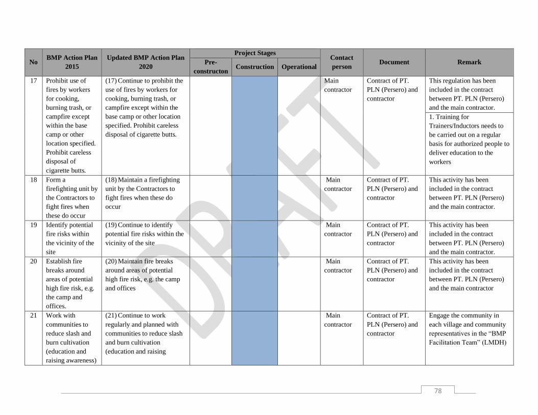
78
No BMP Action Plan
2015
Updated BMP Action Plan
2020
Project Stages Contact
person Document Remark Pre-
constructon Construction Operational
17 Prohibit use of
fires by workers
for cooking,
burning trash, or
campfire except
within the base
camp or other
location specified.
Prohibit careless
disposal of
cigarette butts.
(17) Continue to prohibit the
use of fires by workers for
cooking, burning trash, or
campfire except within the
base camp or other location
specified. Prohibit careless
disposal of cigarette butts.
Main
contractor
Contract of PT.
PLN (Persero) and
contractor
This regulation has been
included in the contract
between PT. PLN (Persero)
and the main contractor.
1. Training for
Trainers/Inductors needs to
be carried out on a regular
basis for authorized people to
deliver education to the
workers
18 Form a
firefighting unit by
the Contractors to
fight fires when
these do occur
(18) Maintain a firefighting
unit by the Contractors to
fight fires when these do
occur
Main
contractor
Contract of PT.
PLN (Persero) and
contractor
This activity has been
included in the contract
between PT. PLN (Persero)
and the main contractor.
19 Identify potential
fire risks within
the vicinity of the
site
(19) Continue to identify
potential fire risks within the
vicinity of the site
Main
contractor
Contract of PT.
PLN (Persero) and
contractor
This activity has been
included in the contract
between PT. PLN (Persero)
and the main contractor.
20 Establish fire
breaks around
areas of potential
high fire risk, e.g.
the camp and
offices.
(20) Maintain fire breaks
around areas of potential
high fire risk, e.g. the camp
and offices
Main
contractor
Contract of PT.
PLN (Persero) and
contractor
This activity has been
included in the contract
between PT. PLN (Persero)
and the main contractor
21 Work with
communities to
reduce slash and
burn cultivation
(education and
raising awareness)
(21) Continue to work
regularly and planned with
communities to reduce slash
and burn cultivation
(education and raising
Main
contractor
Contract of PT.
PLN (Persero) and
contractor
Engage the community in
each village and community
representatives in the “BMP
Facilitation Team” (LMDH)

79
No BMP Action Plan
2015
Updated BMP Action Plan
2020
Project Stages Contact
person Document Remark Pre-
constructon Construction Operational
awareness) through outreach,
leaflet distribution, etc.
A4 Managing Impacts of Traffic on Native Fauna
22 Work with road
users to inform
about biodiversity
management
objectives
(22) Continue to work
regularly and planned with
road users to inform about
biodiversity management
objectives until the
construction is completed
Main
contractor
Contract of PT.
PLN (Persero) and
contractor
The ESMP and SSHP
documents will be
disseminated to the workers
by the main contractor.
23 Install and
maintain signs in
areas of frequent
wildlife crossings,
saying "beware of
animal crossing"
(complete with
pictures of
animals)
(23) Maintain the installed
signs in areas of wildlife
crossings. If a new crossing
encountered, the signs should
be installed.
Main
contractor
Contract of PT.
PLN (Persero) and
contractor
Some of the signboards were
damaged.
24 Develop a system
in which drivers
report location of
wildlife sightings
or crossings
(24) Develop a report system
of wildlife sightings or
crossings that not only for
the drivers and workers but
also for the community
Main
contractor
Contract of PT.
PLN (Persero) and
contractor
A simple reporting system
should be prepared to make it
easier for drivers and the
public to report encounters
with wild animals.
B. Restoration and Forest Management
B1 Collection of Plant Material, Management of Nurseries and Planting Services

80
No BMP Action Plan
2015
Updated BMP Action Plan
2020
Project Stages Contact
person Document Remark Pre-
constructon Construction Operational
25 Contractor to
prepare planting
plans consistent
with the BMP
(25) PLN's policy that
requires contractors to carry
out revegetation around the
project site in accordance
with the guidance in the
BMP AP must be
implemented until the
construction phase is
completed
Main
contractor
Contract of PT.
PLN (Persero) and
contractor
This obligation is included in
the contract between PT.
PLN (Persero) and the
contractor
26 Review options
and confirm a
reliable supply of
planting materials
for BIA Working
Zone 1 and
Working Zones 2 :
UPK Nursery,
Perum Perhutani
nurseries,
commercial
nurseries and/or
locally run
nurseries
(26) The provision of seeds
and planting is given to
Perum Perhutani based on
the MoU and PKS between
PT. PLN (Persero) and
Perum Perhutani. The
community needs to be
involved in the provision of
seeds in accordance with the
guidance in the BMP AP and
suggestions from the
community.
PT. PLN
(Persero)
and Perum
Perhutani
MoU and PKS
between PT. PLN
(Persero) and
Perum Perhutani
PT. PLN (Persero) partners
with Perum Perhutani and
the community (LMDH) in
providing seeds. The
determination of plant
species refers to the BMP AP
2020 recommendations.
27 Review and ensure
capacity (skills,
labor force) for
reforestation
activities: UPK
nursery, Perum
Perhutani,
commercial
nurseries/foresters,
(27) Improve community
engagement as a provider of
plant seeds, maintenance,
and planting
PT. PLN
(Persero)
and Perum
Perhutani
Perhutani Report of
Planting Training
for Community.
Perum Perhutani has
provided training on how to
conduct nurseries to plant
maintenance for the
community. Training should
be continued from nursery to
maintenance. Then the
community put the training
results into practice in

81
No BMP Action Plan
2015
Updated BMP Action Plan
2020
Project Stages Contact
person Document Remark Pre-
constructon Construction Operational
local
nurseries/labor
revegetation activities with
Perum Perhutani.
28 Scope local
interest in
collecting local
materials, nursery
operation and tree
planting contracts
(28) Improve community
engagement in revegetation
not only limited in the
planting process but also
starting from seedling to
maintenance
Perum
Perhutani
Perhutani RO
Report.
Community engagement in
the provision of new
seedlings was carried out in
2019 although community
involvement in planting
activities has been carried
out since 2017. Community
involvement in the provision
of plant seeds needs to be
done in a planned manner
and with clear contracts.
29 All replanting
shall follow the
recommendations
for species in the
BMP and the
planting plans for
each block
(29) All replanting shall
follow the recommendations
for species in the BMP AP
2020. Plant species selection
also needs to consider
community suggestions.
PT. PLN
(Persero)
and Perum
Perhutani
Perhutani
Revegetation
Evaluation Report
2018 and 2019

82
No BMP Action Plan
2015
Updated BMP Action Plan
2020
Project Stages Contact
person Document Remark Pre-
constructon Construction Operational
30 Develop a
reforestation
proposal following
a review of
forestry and
watershed
protection laws
(30) Develop a
participatory/collaborative
reforestation proposal
following a review of
forestry and watershed
protection laws for all
management zones (Zone 1,
2, 3) in partnership with
Perum Perhutani and
community representative
PT. PLN
(Persero)
and Perum
Perhutani
No specific
document
Reforestation is aimed at
developing an agroforestry
model that combines the
objectives of fostering
wildlife habitat and meeting
community needs
31 Confirm the
planting plans for
BIA/Working
Zone 1 in
partnership with
Perum Perhutani,
PEMDA and local
community
(31) The revegetation is fully
given by PT. PLN (Persero)
to Perum Perhutani as the
leading sector and if
necessary it can involve
Pemda
PT. PLN
(Persero)
and Perum
Perhutani
Perhutani
Revegetation
Evaluation Report
2018 and 2019
Further planting plan in WZ
1 should follow the
recommendations in the
BMP AP 2020.
LMDH as community
representatives.
32 Engage
community in the
planting plans in
the Working Zone
1 and implement
any livelihood
restoration /
resettlement
(32) Engage community in
revegetation in planting,
maintenance, and providing
plant seeds
Perum
Perhutani
Perhutani
Revegetation
Evaluation Report
2019
Community engagement in
the planting process, starting
from planning, determining
the species, processing the
nursery, to performing
maintenance.
Develop a forest
management system and
institution in accordance with
Minister of Environment and
Forestry Regulation No.
39/2017 concerning social
forestry in the working area
of Perum Perhutani.

83
No BMP Action Plan
2015
Updated BMP Action Plan
2020
Project Stages Contact
person Document Remark Pre-
constructon Construction Operational
33 Implement the
planting plan for
BIA/Working
Zone 1
(33) Continue to implement
revegetation in Working
Zone 1 after the extension of
the MoU and PKS between
PLN and Perhutani is signed
until the construction phase
is completed
PT. PLN
(Persero)
and Perum
Perhutani
Perhutani
Revegetation
Evaluation Report
2018 and 2019
Further revegetation in
Working Zone 1 should
follow the recommendations
in the BMP AP 2020.
34 Confirm the
planting plans for
Working Zone 2 in
partnership with
Perum Perhutani
(34) Continue to implement
revegetation in Working
Zone 2 after the extension of
the MoU and PKS between
PT. PLN (Persero) and
Perum Perhutani is signed
until the construction phase
is completed
PT. PLN
(Persero)
and Perum
Perhutani
Perhutani
Revegetation
Evaluation Report
2018 and 2019
The revegetation plan in
Working Zone 2 should
follow the recommendations
in the BMP AP 2020 and
should be included in the
extension of the MoU and
PKS between PT. PLN
(Persero) and Perum
Perhutani.
35 Engage
community in the
planting plans in
the Working Zone
2 and implement
any livelihood
restoration /
resettlement
(35) Engage community not
only in the planting process
but also in the planting
planning
Perum
Perhutani
No specific
document
Community engagement in
revegetation should follow
the recommendations in the
BMP AP 2020.
Develop a forest
management system and
institution in accordance with
Minister of Environment and
Forestry Regulation No.
39/2017 concerning social
forestry in the working area
of Perum Perhutani.
36 Implement the
planting plan for
Working Zone 2
(36) Revegetation in
Working Zone 2 need to
consider community
suggestions and be
PT. PLN
(Persero)
and Perum
Perhutani
Perhutani
Revegetation
Evaluation Report
2018 and 2019
Revegetation in Working
Zone 2 should follow the
recommendations in the
BMP AP 2020 and should be

84
No BMP Action Plan
2015
Updated BMP Action Plan
2020
Project Stages Contact
person Document Remark Pre-
constructon Construction Operational
implemented after the
extension of the MoU and
PKS between PT. PLN
(Persero) and Perum
Pehutani
included in the extension of
the MoU and PKS between
PT. PLN (Persero) and
Perum Perhutani.
37 Liaise with the
Ministry of
Environment and
Forestry regarding
zoning of the
500m logging
exclusion zone
under the Forest
Law (UU No. 41
of 1999), and a
100m zone of
catchment
protection forest
around the
reservoirs, along
streamlines and to
protect steep
slopes as requires
by the Presidential
Decree on the
Management of
Reserve Areas
(KepPres 32 of
1990).
(37) Determine Working
zone 3 as a buffer zone
which is an area of 500m
from the reservoir boundary
agreed upon by PT. PLN
(Persero) and Perum
Perhutani and included in the
MoU and PKS between PT.
PLN (Persero) and Perum
Perhutani
PT. PLN
(Persero)
and Perum
perhutani
and KLHK/
watershed
managers
No specific
document
The determination of the
buffer zone should follow the
recommendations in the
BMP AP 2020.

85
No BMP Action Plan
2015
Updated BMP Action Plan
2020
Project Stages Contact
person Document Remark Pre-
constructon Construction Operational
38 Determine the
land available
within the
Working Zone 3
for reforestation
by mapping
ownership and
forest cover and
develop a plan to
reforest and
protect the land
(38) Delineating and
mapping Working Zone 3 as
the basis for environmental
management around the
reservoir, including
reforestation led by Perum
Perhutani. This plan is
included in the ICM
document.
PT. PLN
(Persero)
and Perum
Perhutani
and
watershed
managers
Perhutani
Revegetation
Evaluation Report
2018 and 2019
The Working Zone 3
delineation should follow the
recommendations in the AP
BMP 2020.
39 Confirm the
planting plans for
the blocks within
Working Zone 3 in
partnership with
Perum Perhutani
and the
community
(39) Revegetation in
Working Zone 3 is carried
out by Perum Perhutani in
partnership with the
community until the
construction phase is
completed
PT. PLN
(Persero)
and Perum
Perhutani
and
watershed
managers
Perhutani
Revegetation
Evaluation Report
2018 and 2019
Further revegetation plan in
Working Zone 3 should
follow the recommendations
in the BMP AP 2020 and
should be included in the
extension of the MoU and
PKS between PT. PLN
(Persero) and Perum
Perhutani.
40 Implement the
planting plans for
Working Zone 3
(40) Revegetation in
Working Zone 3 is carried
out by Perum Perhutani in
partnership with the
community during and after
the reservoir construction
phase
PT. PLN
(Persero)
and Perum
Perhutani
and
watershed
managers
Perhutani
Revegetation
Evaluation Report
2018 and 2019
Further revegetation in
Working Zone 3 should
follow the recommendations
in the BMP AP 2020 and
should be included in the
extension of the MoU and
PKS between PT. PLN
(Persero) and Perum
Perhutani.

86
No BMP Action Plan
2015
Updated BMP Action Plan
2020
Project Stages Contact
person Document Remark Pre-
constructon Construction Operational
41 Review progress
of Working Zones
1, 2 and 3
reforestation
approaches,
practices,
successes and
failures, and revise
as necessary
(41) Continue to review the
progress of reforestation in
all working zones until the
construction phase is
completed
PT. PLN
(Persero)
and Perum
Perhutani
and
watershed
managers
Perhutani
Revegetation
Evaluation Report
2018 and 2019
Perum Perhutani has made a
report on the evaluation of
revegetation implementation
in Working Zone 1, 2, and 3
during the pre-construction
phase. The results of the
evaluation should be used to
improve the quality of
reforestation planning and
implementation at the
construction phase.
42 Find suitable land
for reforestation in
Working Zone 4
which could be
useful for
biodiversity
conservation as
part of the ICM
(42) Delineating Zone 4 for
expansion of reforestation
areas and wildlife habitat.
The existence of Zone 4 must
be stated in the ICM
document
PT. PLN
(Persero)
and Perum
Perhutani
and
watershed
managers
No specific
document
The map of Working Zone 4
is attached in the ICM
document and its boundaries
should be agreed
immediately. Reforestation
and biodiversity conservation
are carried out focused on
working zones 1, 2, and 3,
with the concept of
reforestation based on
harmonization modeling of
the management of the
Cisokan forest area.

87
No BMP Action Plan
2015
Updated BMP Action Plan
2020
Project Stages Contact
person Document Remark Pre-
constructon Construction Operational
43 Detailed planting
planning for
Working Zone 4
based on learnings
from Working
Zone's 1-3 and the
field surveys
above
(43) Prepare a revegetation
plan in Zone 4 during the
construction phase covering
the area to be planted, the
estimated number of seeds
required for planting and
replanting, plants species
suitable for the purpose of
enhancing wildlife habitat
and/or utilization by local
communities, planting time
and maintenance period,
resource requirements
(manpower, capital, and
time).
PT. PLN
(Persero)
and Perum
Perhutani
and
watershed
managers
No specific
document
It is necessary to evaluate the
revegetation process of
Working Zone 1, 2, and 3 as
recommendations for
revegetation planning in WZ
4.
44 Implement the
Working Zone 4
planting plan
(44) Implement the
revegetation plan in the
operational phase until the
area planned for revegetation
is completed to be planted
PT. PLN
(Persero)
and Perum
Perhutani
and
watershed
managers
It can be started after
Working Zone 4 boundareis
have been set.
B2. Forest Management
45 GPS-based
mapping of
reforested blocks
in accordance with
the BMP and the
PT. PLN
(Persero)/Perum
Perhutani PKS
(45) Mark out mapped
locations on the ground to
facilitate orientation while
monitoring
PT. PLN
(Persero)
and Perum
Perhutani
Perhutani
Revegetation
Evaluation Report
2018 and 2019
A map of the reforestation
location is available in the
evaluation report on
revegetation by Perhutani.
This map is a reference for
reforestation in the
construction and operation
phases.

88
No BMP Action Plan
2015
Updated BMP Action Plan
2020
Project Stages Contact
person Document Remark Pre-
constructon Construction Operational
46 Awareness raising,
patrolling and sign
age to protect
Working Zone 1
and 2 blocks. All
reforested blocks
require ongoing
protection on the
ground.
(46) Improve the intensity of
awareness raising and
patrolling for all Working
Zones 1 and 2 during the
construction and operation
phases
PT. PLN
(Persero)
and Perum
Perhutani
No specific
document
The patrol is carried out by
forest rangers of Perum
Perhutani. Socialization of
environmental conservation
in BIA 14 has been carried
out by PT. PLN (Persero)
and raising awareness of the
importance of protecting the
environment has also been
carried out by PT. PLN
(Persero) in 2018 to
elementary students with the
theme of "peduli
Lingkungan".
PT. PLN (Persero) and
Perum Perhutani should
cooperate in carrying out
patrolling and include this
activity as part of the MoU
and PKS between PT. PLN
(Persero) and Perum
Perhutani.
47 Awareness raising,
patrolling and
signage to protect
Working Zone 3
and 4 blocks. All
reforested blocks
in Working Zone 3
require protection
on the ground.
(47) Expand patrolling area
to Zone 4 during the
construction and operation
phases
PT. PLN
(Persero)
and Perum
perhutani
No specific
document
PT. PLN (Persero) and
Perum Perhutani should
cooperate in carrying out
patrolling and include this
activity as part of the MoU
and PKS between PT. PLN
(Persero) and Perum
Perhutani. Implemented by
the BMP Facilitation Team
consisting of PT. PLN

89
No BMP Action Plan
2015
Updated BMP Action Plan
2020
Project Stages Contact
person Document Remark Pre-
constructon Construction Operational
(Persero), Perum Perhutani,
and community
representatives/LMDH.
48 Review various
models for long
term community
involvement in
forest management
such as
Community Forest
Management
(CFM),
Community Forest
(HkM) and other
tenure or benefit
sharing options
(48) Management models
that integrate biodiversity
conservation and the use of
natural resources by local
communities need to be
agreed among the parties:
PT. PLN (Persero), Perum
Perhutani, and the
community.
PT. PLN
(Persero)
and Perum
Perhutani
and local
government
Document is still in
draft version
The forest management
model should follow the
recommendations in the FPF
which is part of the BMP AP
2020. Review the PHBM
program and Social Forestry
for long term community
involvement in forest
management.
49 Consider other
models of long-
term forest
management other
than as proposed
above, such as
status quo (Perum
Perhutani
management),
NGO
management,
(49) Planning for the
development of integrated
management models at a
landscape scale (covering
zones 1, 2, 3, and 4) in terms
of conserving biodiversity
and its use to improve the
economy of local
communities
PT. PLN
(Persero)
and Perum
perhutani
and KLHK /
watershed
managers
Document is still in
draft version
Long-term forest
management models should
refer to the FPF which is part
of the BMP AP 2020.
Develop a forest
management system and
institution in accordance with
Minister of Environment and
Forestry Regulation No.
39/2017 concerning social

90
No BMP Action Plan
2015
Updated BMP Action Plan
2020
Project Stages Contact
person Document Remark Pre-
constructon Construction Operational
changes to land
status under
Indonesian
legislation to
conservation or
protection forest
forestry in the working area
of Perum Perhutani
50 Implement forest
management
recommendations
as appropriate (no
48 and 49)
(50)Implement integrated
management models at the
landscape scale
PT. PLN
(Persero)
and Perum
Perhutani
and KLHK /
watershed
managers
Document is still in
draft version
Implement forest
management
recommendations based on
FPF which is part of the
BMP AP 2020.
51 Measure forest
cover annually
using satellite
imagery to
document
reforestation
efforts.
(51)Measure forest cover
annually using satellite
imagery to document
reforestation efforts
PT. PLN
(Persero)
and Perum
Perhutani
This activity is carried out in
the framework of an
agreement between PT. PLN
(Persero) and Perum
Perhutani.
C Wildlife Management
C1. Wildlife and Habitat Management
52 Provided dry
culverts (faunal
underpasses) and
canopy bridges in
the temporary and
permanent roads,
distribution and
(52) Maintain dry culvert and
canopy bridges for animal
crossing on permanent and
temporary access roads and
provide these artificial
corridors on transmission
PT. PLN
(Persero)
and main
contractor
BMP 2014
Document -
Appendix 1, 3, 4, 5
Artificial corridors for
animals have been installed
in habitats that were
fragmented due to access
roads development. Several
rope bridges in BIA 5 and 6
were damaged.

91
No BMP Action Plan
2015
Updated BMP Action Plan
2020
Project Stages Contact
person Document Remark Pre-
constructon Construction Operational
transmission lines
and similar
infrastructure
lines and other similar
infrastructure
53 Site induction
training for
wildlife protection
under the laws and
legislation on
protected species,
Act No. 5 in 1990,
and government
regulation No. 7 in
1999
(53) Site induction training
for wildlife protection under
the laws and legislation on
protected species, Act No. 5
in 1990, government
regulation No. 7 in 1999, and
ministerial decree of LHK
No. P.20 of 2018. The
training for trainers (TFT)
program needs to be carried
out until the operation phase,
as well as to evaluate the
knowledge and abilities of
trainers
Main
contractor
Act No 5/1990,
Government
Regulation No
7/1999
Socialization to contractors is
carried out regularly every
month.
54 Report wildlife
incidences, such as
animals getting hit
by cars or a tree
falling in the
project area
(54) Report wildlife
incidences, such as animals
getting hit by cars or a tree
falling in the project area
based on the Human-Wildlife
Conflict Reporting form that
has been compiled
PT. PLN
(Persero),
BKSDA and
main
contractor
SOP Fauna
Encounter/Accident
Report
It is necessary to make an
accident reporting SOP.

92
No BMP Action Plan
2015
Updated BMP Action Plan
2020
Project Stages Contact
person Document Remark Pre-
constructon Construction Operational
55 Confirm presence
of Javan Slow
Loris in BIA 2, 3,
5, 6, 13 and 14
through rapid
survey
(55) Conduct regular
monitoring to observe the
presence and movement of
Javan slow lorises in BIA 1,
2, 3, 4, 6, 7, and 14
PT. PLN
(Persero)
BMP Monitoring
10 Species 2017
The presence of Javan slow
loris has been confirmed in
BIA 1,2,3,4,6,7, 14, Corridor
BIA 5 and BIA 6, and access
to Pasir Laja
56 Develop patrol
teams consisting
of Perum
Perhutani staff,
PT. PLN (Persero)
staff, BMP
Facilitation Team,
ICM Facilitation
Team members,
community
members, and/or,
if required,
government
representatives.
Surveillance of
protected BIA and
Working zones for
poaching, hunting,
timber harvesting
etc. (long term
solution to No. 13
above).
(56) Strengthening the patrol
team consisting of personnel
staffs from Perum Perhutani,
PT. PLN (Persero)N, BMP
Facilitation Team, ICM
Facilitation Team members,
community members, and/or,
if required, government
representatives. Improve
surveillance of hunting and
illegal logging activities in
Zones 1, 2, and 3.
PT. PLN
(Persero)
and Perum
Perhutani
Decree Team
Patroll Forming
The patrol team has not been
formally formed. PT. PLN
(Persero) only formed an
animal patrol team during the
land clearing process.
Develop BMP Facilitation
Team.
57 Implement an
ongoing wildlife
monitoring
programme,
(57) Continue to implement
an ongoing wildlife
monitoring programme,
PT. PLN
(Persero)
and main
contractor
BMP Monitoring
10 Species 2017
It has been implemented in
the BMP monitoring
program for 10 species in
2017. Recommendations will

93
No BMP Action Plan
2015
Updated BMP Action Plan
2020
Project Stages Contact
person Document Remark Pre-
constructon Construction Operational
focused on the 10
species of interest
focused on the 10 species of
interest
be implemented in action
plan 58
58 Implement
wildlife
management
projects based on
monitoring report
and outputs from
No. 57
(58) Expanding wildlife
monitoring programs beyond
the 10 target species
PT. PLN
(Persero)
BMP Monitoring
10 Species 2017
The recommendations of
BMP monitoring for 10
species in action plan 57
have not been implemented
C2 Wildlife Encounters
59 Implement
wildlife encounter
protocols and train
project workers
about what to do
when potentially
dangerous wildlife
is encountered
(59) Continue to implement
wildlife encounter protocols
refers to SOP Human -
Wildlife Conflict and train
project workers about what
to do when potentially
dangerous wildlife is
encountered during operation
phase. The contact person in
handling conflict needs to be
written on the signboard.
PT. PLN
(Persero)
and main
contractor
SOP Human -
Wildlife Conflict
and Wildlife
Management
Protocol (See SOP
Handling and
Rescue)
The animal encounter
protocol has referred to the
SOP Human - Wildlife
Conflict but has not been
disseminated to project
workers. The awareness to
project workers is only
carried out based on the
action plan 53.

94
No BMP Action Plan
2015
Updated BMP Action Plan
2020
Project Stages Contact
person Document Remark Pre-
constructon Construction Operational
60 Set up a rapid
response wildlife
management unit
that has the ability
to react quickly to
human-wildlife
conflict
(60) Establish a quick
response unit of wildlife
management that has the
ability to take quick actions
and follow the SOP Human -
Wildlife Conflict. In
addition, it is also necessary
to strengthen the relationship
between the PT. PLN
(Persero) Environmental Unit
and the BBKSDA Human-
Wildlife Conflict
Management Team.
PT. PLN
(Persero),
BKSDA,
and main
contractor
SOP Human -
Wildlife Conflict
and Wildlife
Management
Protocol (See SOP
Handling and
Rescue)
The animal encounter
protocol has referred to the
SOP Human - Wildlife
Conflict, but a team that has
a special task to prevent
conflicts between humans
and wildlife has not been
formed. It is necessary to
include the contact person in
handling conflict on the
signboards.
61 Consult with the
community about
wildlife
encounters to
discourage killing
and trapping
wildlife.
(61) Conduct regular
outreach to the community
regarding actions that must
be taken in the event of an
encounter with wild animals
to reduce poaching.
PT. PLN
(Persero)
and main
contractor
SOP Human -
Wildlife Conflict
and Wildlife
Management
Protocol (See SOP
Handling and
Rescue)
The animal encounter
protocol has referred to the
SOP Human - Wildlife
Conflict, but the provision of
information about wildlife
activities and wildlife
encounter procedures was
only through the BIA
signboards. The outreach
method was only
implemented in two hamlets,
Lembur Sawah and Pasir
Laja. It is necessary to
include the contact person in
handling conflict on the
signboards. D Stakeholder Participation
D1 Strengthening Capacities for Institutionalizing ICM

95
No BMP Action Plan
2015
Updated BMP Action Plan
2020
Project Stages Contact
person Document Remark Pre-
constructon Construction Operational
62 Develop and
maintain and ICM
facilitation team.
(62) Re-establish and
maintain ICM facilitation
team for assisting PLN to
plan and implement
biodiversity management in
the UCPS area
PT. PLN
(Persero)
GM PLN UIP JBT
I Decree (SK) 2014
dan 2015 about
Team ICM
Develop BMP Facilitation
Team
Multi-stakeholder
coordinating body
arrangement that will have
long term responsibility for
ICM in UCPS including
higher education and
research institution
involvement to provide
scientific-based biodiversity
and environmental
management
PT. PLN
(Persero)
PLN can convince the
relevant agencies or
ministries to assist in the
estabilishment and
development of a multi-
stakeholder coordinating
body
Revitalize PLN’s internal
structural unit to manage
BMP implementation
including restoring Assistant
Manager position to be
person-in-charge focus on
BMP implementation
assisted by technical
assistance
PT. PLN
(Persero)
63 Stakeholder
workshops, field
trips, and one-on-
one meetings etc.,
to improve
understanding
(63) Carry out meeting
forums (workshops,
outreach, socialization,
training, etc.) in order to
improve understanding and
institutionalization of ICM
PT. PLN
(Persero)
ICM Cisokan
Planning
Documents 2015
Workshops, meetings, etc.
can be performed as needed

96
No BMP Action Plan
2015
Updated BMP Action Plan
2020
Project Stages Contact
person Document Remark Pre-
constructon Construction Operational
64 Prepare and
implement MOU
and PKS with
Perum Perhutani
(64) Evaluate the
implementation of previous
MoU and PKS as well as
prepare MoU and PKS
extension (and revision if
required) between PT. PLN
(Persero) and Perum
Perhutani which will serve as
a basis for implementing
BMP AP during the
operation phase
PT. PLN
(Persero);
Perum
Perhutani
MoU PT. PLN
(Persero) and
Perum Perhutani
2015
65 Prepare and
implement
reforestation
program with
other stakeholders
as required
(65) Engage other
stakeholders (government
agencies, NGOs, etc.) to
harmonize, combine, and
implement related programs,
including, but not limited to,
reforestation, technical
assistance, etc.
PT. PLN
(Persero);
Perum
Perhutani,
local
Government
and
Stakeholders
ICM Cisokan
Planning
Documents 2015
Reforestation is adjusted to
the PHBm / social forestry
program in accordance with
the Ministry of Environment
and Forestry Regulation No,
39/2017
66 Continue to build
trust and
engagement with
stakeholders. Seek
funding support.
(66) Improve coordination,
communication, and
cooperation among relevant
stakeholders and make joint
efforts in finding sources of
funding other than the budget
provided by PT. PLN
(Persero) and Perum
Perhutani
PT. PLN
(Persero)
and Perum
Perhutani
ICM Cisokan
Planning
Documents 2015
Can refer to action plan No.
62
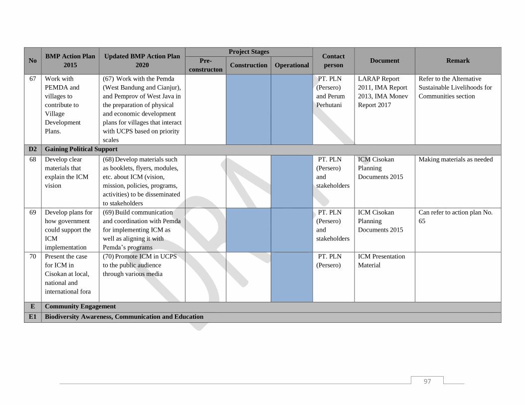
97
No BMP Action Plan
2015
Updated BMP Action Plan
2020
Project Stages Contact
person Document Remark Pre-
constructon Construction Operational
67 Work with
PEMDA and
villages to
contribute to
Village
Development
Plans.
(67) Work with the Pemda
(West Bandung and Cianjur),
and Pemprov of West Java in
the preparation of physical
and economic development
plans for villages that interact
with UCPS based on priority
scales
PT. PLN
(Persero)
and Perum
Perhutani
LARAP Report
2011, IMA Report
2013, IMA Monev
Report 2017
Refer to the Alternative
Sustainable Livelihoods for
Communities section
D2 Gaining Political Support
68 Develop clear
materials that
explain the ICM
vision
(68) Develop materials such
as booklets, flyers, modules,
etc. about ICM (vision,
mission, policies, programs,
activities) to be disseminated
to stakeholders
PT. PLN
(Persero)
and
stakeholders
ICM Cisokan
Planning
Documents 2015
Making materials as needed
69 Develop plans for
how government
could support the
ICM
implementation
(69) Build communication
and coordination with Pemda
for implementing ICM as
well as aligning it with
Pemda’s programs
PT. PLN
(Persero)
and
stakeholders
ICM Cisokan
Planning
Documents 2015
Can refer to action plan No.
65
70 Present the case
for ICM in
Cisokan at local,
national and
international fora
(70) Promote ICM in UCPS
to the public audience
through various media
PT. PLN
(Persero)
ICM Presentation
Material
E Community Engagement
E1 Biodiversity Awareness, Communication and Education

98
No BMP Action Plan
2015
Updated BMP Action Plan
2020
Project Stages Contact
person Document Remark Pre-
constructon Construction Operational
71 Improve the
communities’
understanding of
PLN’s ICM
approach to
catchment issues,
and the BMP
(71) Integrate ICM approach,
biodiversity and wildlife
awareness, and education
effort with other issues such
as illegal hunting, cut and
fill, reforestation, etc., to
improve communities’
understanding. It should be
implemented regularly.
PT. PLN
(Persero)
ICM Cisokan
Planning
Documents 2015
Through the BMP
Facilitation team
72 Increase the public
awareness about
the importance of
threatened and
protected wildlilfe
(72) Activities aimed at
improving public awareness
of the presence of wildlife
around UCPS are carried out
regularly until the operation
phase.
PT. PLN
(Persero)
ICM Cisokan
Planning
Documents 2015,
PLN Biodiversity
Eduaction Material
Can refer to action plan No.
71
73 Develop a
participatory
process for
ongoing
community
engagement /
liaison
(73) Arrange
programs/activities with the
community from 38 villages
around UCPS, including
monitoring to prevent illegal
hunting, forest encroachment
(for example through joint
patrols), etc. for biodiversity
conservation and utilization
of natural resources.
PT. PLN
(Persero)
and Perum
Perhutani,
and local
goverment
Perhutani
Participatory Rural
Appraisal Report
Participatory processes using
a retrospective approach to
reviewing current
engagements can be
undertaken as needed.
Engage community
(representatives) from each
hamlet/ LMDH.

99
No BMP Action Plan
2015
Updated BMP Action Plan
2020
Project Stages Contact
person Document Remark Pre-
constructon Construction Operational
74 Engage PEMDA
to be part of the
communications
(74) Engage Pemda (Cianjur
and West Bandung) in
community empowerment
programs related to the
management of working
zones 1, 2, and 3
PT. PLN
(Persero)
and Perum
Perhutani,
and local
goverment
ICM Cisokan
Planning
Documents 2015,
IMA Monev Report
2017
Can refer to action plan No.
65
75 Formulate MOU
or similar between
PLN, villages and
PEMDA (and
Perum Perhutani
where relevant) as
required
(75) Arrange an MoU
between PLN, Pemda, and
the community to support the
MoU between PT. PLN
(Persero) and Perum
Perhutani in the
implementation of the
updated BMP AP
PT. PLN
(Persero)
and Perum
Perhutani,
and local
goverment
ICM Cisokan
Planning
Documents 2015
Refer to the Alternative
Sustainable Livelihoods for
Communities section
76 Support
communities to
engage by
providing
technical
assistance and
capacity building
(76) Provide technical
assistance and mentoring to
communities related to local
economic empowerment
during the construction and
operation phases. PT. PLN
(Persero) can engage other
stakeholders (government
agencies, NGOs, etc.) as
needed.
PT. PLN
(Persero)
and Perum
Perhutani,
and local
goverment
ICM Cisokan
Planning
Documents 2015
Through the BMP facilitation
Team
E2 Aligning Resettlement Programmes with the BMP

100
No BMP Action Plan
2015
Updated BMP Action Plan
2020
Project Stages Contact
person Document Remark Pre-
constructon Construction Operational
77 Provide the
resettlement team
with a checklist to
assess each village
against World
Bank safeguard
principles the
ESMP and the
BMP
(77) Identify hamlets that
interact with the UCPS area
and make an inventory of
natural resource utilization in
working zones 1, 2, and 3 as
information for the LARAP
team and develop a spatial
database for the purposes of
wildlife management and
local economic
empowerment.
It can be further integrated
with SOP Handling and
Rescue and SOP Fauna
Encounter / Accident Report.
PT. PLN
(Persero)
and Perum
Perhutani,
ICM Cisokan
Planning
Documents 2015,
Resettlement Team
Field Notes 2015
78 Work with the
resettlement team,
PEMDA and
village commu-
nities in a partici-
patory way to find
solutions to re-
settlement that
avoid conflicts
with the BMP
(78) Coordinate with the
LARAP team to work
together with Pemda and the
community to find
agreements and solutions so
that conflicts do not occur in
the implementation (updated)
BMP AP
PT. PLN
(Persero)
and local
Goverment
LARAP Report
2011, IMA Report
2013, IMA Monev
Report 2017
Refer to the Alternative
Sustainable Livelihoods for
Communities section
E3 Alternative Sustainable Livelihoods for Communities

101
No BMP Action Plan
2015
Updated BMP Action Plan
2020
Project Stages Contact
person Document Remark Pre-
constructon Construction Operational
79 Facilitate the
opportunities for
income from the
reforestation
process: plant
material collec-
tion, tree nursery
manage-ment and
/ or tree planting
contracts
(79) Empower local
communities in reforestation
by providing plant seeds,
planting, and maintaining
plants based on clear
contracts
PT. PLN
(Persero)
and Perum
Perhutani,
ICM Cisokan
Planning
Documents 2015
Can refer to action plan No.
32 and No. 35 (BMP 2015)
80 Establish and
maintain
community forest
patrols in Working
Zone 1 and 2 (and
3 once
established)
(80) Work with Perum
Perhutani and carry out
bottom-up approach to
establish community forest
patrol
PT. PLN
(Persero)
and Perum
Perhutani,
ICM Cisokan
Planning
Documents 2015
Can refer to action plan No.
56
BMP Facilitation Team
81 Develop land use
plans for village /
community land
that generate
increased
community
income from
improved and
intensified
agricultural
practices.
(81) Maintain and prioritize
communities’ economic
restoration through various
programs as recommended in
BMP 2015 Action Plan,
including, but not limited to:
(1) Alternative methods of
agriculture (higher value
products, agroforestry, non-
timber forest products), (2)
Adding value to agricultural
or forest products –
manufacturing, processing,
packaging, and (3) Tourism,
etc.
PT. PLN
(Persero)
and Perum
Perhutani,
ICM Cisokan
Planning
Documents 2015,
PLN CSR Report
for Village Tourism
2019

102
No BMP Action Plan
2015
Updated BMP Action Plan
2020
Project Stages Contact
person Document Remark Pre-
constructon Construction Operational
82 Develop land use
plans that generate
increased
community
income from
improved and
intensified
silvicultural
practices in zones
1 and 2 (Perum
Perhutani land).
(82) Develop agroforestry
models in accordance with
the characteristics of BIA
and corridors and provide
ongoing assistance for
community economic
restoration programs
PT. PLN
(Persero)
and Perum
Perhutani,
Forest Partnership
Framework
document
83 Implement the
plans as described
above (No. 81 and
82)
(83) Develop a Forest
Partnership Framework
(FPF) which will serve the
basis for the Forest
Partnership Action Plan
(FPAP) for Perum Perhutani
land (WZ 1-4) utilization to
restore and provide
alternative livelihoods in
accordance with the
objectives of biodiversity
conservation
PT. PLN
(Persero);
Perum
Perhutani,
and local
Goverment
Forest Partnership
Framework
document
84 Develop land use
plans that generate
increased
community
income from
improved and
intensified
silvicultural
practices in zones
(84) Develop agroforestry
models and other agricultural
cultivation according to the
characteristics of the buffer
zone
PT. PLN
(Persero);
Perum
Perhutani,
and local
Goverment
Forest Partnership
Framework
document
Develop a forest
management system and
institution in accordance with
Minister of Environment and
Forestry Regulation No.
39/2017 concerning social
forestry in the working area
of Perum Perhutani

103
No BMP Action Plan
2015
Updated BMP Action Plan
2020
Project Stages Contact
person Document Remark Pre-
constructon Construction Operational
3 and 4 (Perum
Perhutani land).
85 Implement the
plans as described
above (No. 84)
(85) Implement agroforestry
models and other agricultural
cultivation in accordance
with the characteristics of the
buffer zone and provide
ongoing assistance for
community economic
recovery programs
PT. PLN
(Persero);
Perum
Perhutani,
and local
Goverment
Forest Partnership
Framework
document
86 Livelihood
restoration plans
need to be deve-
loped for any
people adversely
affected by the
reforestation
process
(86) Planning and
implementing programs and
activities for the economic
restoration of communities
affected by restrictions due to
the establishment of working
zones 1, 2, 3, and 4 in the
UCPS area
PT. PLN
(Persero);
Perum
Perhutani,
and local
Goverment
ICM Cisokan
Planning
Documents 2015
Livelihood restoration plan is
designed for 10 years

104
7 Institutional Framework, Roles and Responsibilities This section outlines:
Institutional frameworks – 1) how the governance and coordination of safeguards under the ICM
approach will be achieved by PLN in the short term and 2) how the governance and coordination of a
wider catchment program under an ICM approach will be achieved by multiple stakeholders in the
medium to long term.
Roles and responsibilities – 1) stakeholder and 2) individual roles and responsibilities for implementing
the tasks in the BMP.
7.1 Stakeholders Listed below (Table 12) are the key stakeholders who have a direct interest in the project area and /
or the Upper Cisokan catchment. Other interested and affected parties (government agencies, non-
governmental organisations etc.) will be identified and consulted as required through the
implementation of the plan.
Table 12. Key stakeholders for implementing the BMP.
Stakeholder Role
Communities and Local Government (Desa Kecamatan) Land owner, land user, inhabitants in local area.
The communities will need to participate in planning and implementation. The impacts and benefits on the people living and working in the area need to be well understood. Communities need to be able to maximise their benefits.
Perhutani / Perhutani KPH (South Bandung and Cianjur) / Forest Resource Management Division
Manager of lands on behalf of the Government of Indonesia. Forestry planning and management. Partner in the reforestation and forest protection program.
PEMDA / Local Govt / Governers Office (West Bandung, Cianjur)
Responsibilities for infrastructure and other community services on community (non-forest) land. Support of community development activities.
BAPPEDA District Planning Agency (West Bandung, Cianjur)
District planning agency responsible for development & integration of spatial plans, agency development & social support programs. Support and integration of plans.
District Forest & Plantation Agency (DisHutBun)
District agency responsible for spatial plans & management programs in forestry lands. Support of BMP and integration of plans in catchment.
District Environmental Agency D District agency responsible for monitoring environmental, biodiversity & catchment management programs. Support of BMP and integration of plans in catchment.
Regional Agency for Catchment Management (BPDAS)
Regional agency for Citarum river basin, forest & land management. Support of BMP and integration of plans in catchment.
Regional Agency for Natural Resource Conservation (BKSDA) - Citarum - Ciliwung
Regional agency for biodiversity conservation & protected area management. Support for BMP and integration of plans in catchment.

105
7.2 Institutional Framework During the Construction Phase PLN will coordinate the catchment reforestation and protection and
carry out activities in partnership with Perhutani, PEMDA and the community. PLN will engage an ICM
Facilitation Team with the expertise and capacity to support the implementation, by providing
technical skills and advice. The structure of how the safeguards activities are managed and interact
with each other, and how they interact with stakeholders, is provided in Figure 14.
The vision is to transform this program from a focus on the UCPS project to a focus on wider catchment
management, to produce multiple catchment benefits for multiple catchment stakeholders. A
suggested medium to long term structure of ICM of the Upper Cisokan catchment is provided in Figure
15. It will be necessary for a multi-stakeholder group to take a coordinating role, if the program is to
be sustainable.

106
Figure 14. Institutional Framework for UCPS Safeguards under an ICM Approach
`
UCPS ESMP
Construction impact management
Operation impact management
Watershed management strategy
Environmental monitoring
GIS database
Community engagement
Stakeholder consultation, MOU, PKS
COMMUNITY DEVELOPMENT
Infrastructure development
Village Development Plans
Sustainable village land uses
Sustainable forestry land uses
Partnerships with Perhutani for forest management
LARAP
Resettlement
Infrastructure
Support for sustainable livelihood development
FOREST AND CONSERVATION
Forest planning
Forest management
Managing community access
Community partnerships for forest management
PEMDA, BAPPEDAS etc.
Regional / spatial planning and social support
Communities and village
Government
PERHUTANI
Forestry concession management
BMP
BIA protection
3,800ha reforestation plan
Biodiversity technical advisory
Biodiversity monitoring and research
PLN - Coordinator Roles: Environmental and social safeguards, using an ICM approach.
Championing a catchment-wide ICM approach to managing the Upper Cisokan watershed. Engaging stakeholders and community to become involved in ICM and achieve the vision.
Implementation Facilitators Roles: Implementing projects on behalf of PLN, providing technical skills, building networks
with stakeholders, assisting community engagement, seeking and managing external funding and resources, monitoring, evaluation, reporting.
Key: Core responsibility Implementation partner
PLN

107
Figure 15. Institutional Framework –Upper Cisokan ICM catchment management coordinated by multiple stakeholders in the medium to long term
2020 Structure
WATERSHED MANAGEMENT
Soil protection and erosion control (land cover and land use management)
Water allocation and use
Water quality protection
Benefit sharing from hydropower
CSR from hydropower
PLN UCPS
FOREST AND CONSERVATION
Forest planning
Forest management
Community partnerships for forest management
Managing community forest land uses
Wildlife conservation management
Conservation tourism
COMMUNITY DEVELOPMENT
Infrastructure development
Village Development Plans
Sustainable land uses and livelihoods (agriculture, tourism, non-timber forest products) – village and forestry land
Community partnerships for forest management (with Perhutani)
Communities and Village
Government
PERHUTANI
Forestry concession
management
PEMDA
BAPPEDA etc.
Regional / spatial planning and social
support Conservation NGOs
Community Development NGOs
BKSDA Conservation BPDAS Catchment
management
BBWS River management
Multi-Stakeholder Coordinating Body Roles: Institutional coordination, program development, supervision & policy guidance. Reporting to relevant authorities. (Membership from the entities listed below)
Implementation Facilitator Role: ICM project management, implementation planning and oversight, implementation of
projects on behalf of the Coordinating Body, seeking and managing external funding and resources, managing publicity, monitoring, evaluation, reporting
Key: Core responsibility Funding, resources or other support……………………………Participant / beneficiary

108
7.3 Roles and Responsibilities
7.3.1 PLN Environmental Manager UIP
• Ensure this BMP is included as part of the Environmental Management System for this project,
including scheduling of tasks, inspections, monitoring, evaluation, reporting, etc.
• Ensuring the financial resources are available to implement the BMP.
• Ensuring the BMP is integrated into the wider project program (land acquisition, resettlement,
construction, community consultation, etc.).
• Reviews are carried out and recommendations made regarding biodiversity coverage in
Contractor environmental management plans.
• Monitoring changes to relevant legislation is monitored and where appropriate,
recommending any necessary changes to monitoring or management arrangements.
• Supervise consultants as required.
• To ensure that the biodiversity requirements in this plan are incorporated into final designs
and specifications.
• To ensure that appropriate clauses referring to protection of biodiversity and this biodiversity
plan are included in contractual scopes of work and bid documents.
• To ensure that Contractors include the requirements from this BMP into their job specific
Environmental Management Plans required under the Environmental Management Plan, and
that these plans are complied with at all times.
• Review and update the BMP.
7.3.2 Construction Manager (PLN UPK)
Key responsibilities for the Construction Manager in relation to this BMP are as follows:
• To ensure that the biodiversity requirements in this plan are incorporated into final designs
and specifications.
• To ensure that appropriate clauses referring to protection of biodiversity and this biodiversity
plan are included in contractual scopes of work.
• To ensure that Contractors include the requirements from this BMP into their job specific
Environmental Management Plans required under the Environmental Management Plan, and
that these plans are complied with at all times.
• To ensure that biodiversity issues are included in the regular inspections required under the
Environmental Management Plan.
• To ensure that the contractor/consultant workforce receives information on biodiversity and
the requirements in this plan in any compulsory environmental inductions required prior to
working on the Project.
• To ensure breaches of the biodiversity requirements in this plan are included as
environmental incidents, investigated accordingly and the required incident reports
forwarded to the relevant persons.
7.3.3 UCPS Stakeholder Engagement Team (PLN)
The responsibilities for the stakeholder engagement team in relation to this biodiversity plan concern:
• Requirements relevant to hunting, possession of wildlife, habitat protection etc. which may
require cooperation of landholders nearby and/or;

109
• The induction of project personnel from local communities who traditionally hunt;
• Advising on the involvement of local communities in protecting and patrolling forests areas
and conservation set asides.
• Advising on the involvement of local communities in the reforestation activities either through
joined planning or employment in tree planting and maintenance activities.
• Promotional activities relating to the BMP, monitoring programmes, successes etc.
7.3.4 Contractors – all Packages (Including all Staff and Sub-contractors)
• Contracts issued during the construction phases and subsequence stages and for any other
major works required during project development are to include the biodiversity
requirements.
• Any environmental management plan to be produced by the Contractor must include the
requirements of this biodiversity plan.
• Comply with all aspects of the BMP.
• Implement aspects of the BMP such as forest protection measures, wildlife conflict
management, incident reporting etc.
• Participate in all relevant training.
7.3.5 ICM Facilitation Team
• Provide technical assistance in ICM and BMP implementation to PLN.
• Provide a BMP Advisor to lead the team and assist PLN to achieve the BMP task list and goals.
• Assist PLN to implement the BMP and to synergise the efforts to effectively achieving the
various safeguards related aspects of the UCPS project with efficiency.
• Facilitate engagement between PLN and Perhutani, BPDAS, BKSDA, host communities and
other key stakeholders.
• Assist PLN and stakeholders to implement projects under the plan – by facilitating
engagement, collaboration and efficiencies. Provide training or other capacity building as
required.
• Assist PLN to develop a spatial GIS database and a plan for obtaining and managing catchment
data.
7.3.6 BMP Facilitation Team
• A coordinated team including staff from PLN, Perhutani and community representatives, to
improve engagement and outreach.
7.3.7 Technical Assistants
• Consultants will be engaged as required to conduct technical field work, species conservation
work and ongoing monitoring required to measure the progress of the reforestation and
habitat restoration project. This may form part of the TOR for the ICM Facilitation Team or
may be separate contracts.
7.3.8 Patrol teams
• Teams based in the area, made up of Perhutani staff, PLN staff, BMP facilitation team, ICM
facilitation team members, community members, and / or, if required, Government
representatives, with purpose of patrolling the BIA and other reforested areas to:
o Discourage poaching and illegal harvesting or land clearance

110
o Monitor and report poaching and illegal harvesting or land clearance
o Remove traps
o Help to spread the word about biodiversity conservation and the key messages about
the BIA.

111
8 Capacity and Training
8.1 Capacity This BMP shall be implemented as part of the implementation of the UCPS ESMP. However PLN do
not have biodiversity specialists or ecologists in-house and will rely on external consultants and other
specialists to implement key aspects of the BMP and provide further training.
An ICM Facilitation Team will be engaged to carry out many of the BMP tasks, on behalf of PLN:
• Induction training on the BMP to Contractors and consultants, and for new PLN staff
• Consultation and engagement with stakeholders ()
• Assistance to PLN in the development and maintenance of GIS databases for ICM
• Legal reviews of land classification
• Assisting Perhutani, PLN and / or contractors’ staff to demarcate BIA prior to construction
starting, and to demarcate other working zones as required through the period of
reforestation.
• Biodiversity surveys and monitoring of the BMP outcomes
• Species management
• Restoration planting guides
• Training PLN staff, communities and NGO’s in seed sourcing and plant nursery operation
Other specialists will be engaged as required to complete other tasks, such as wildlife handling
following an incident.
8.2 Training All those responsible for the management and implementation/operation of any aspect of the BMP
shall be adequately trained for their role. Evidence of training (records of attendance at workshops,
evidence of formal training) should be maintained by PLN, for inspection and auditing purposes.
Table 13. Training Schedule for 2021
Implementer Training scope Purpose/objective Training material Trainees/audience Schedule & budget
World Bank Technical Advisors
BMP Strategy and Action Plan
Vision
Objectives
Management strategies
Monitoring and Evaluation
Detailed training of the content of the BMP, how to implement
PLN
SInotech / Engineering Consultants
Contractors’ Management
Q2 2021
Refresher Q1 2022
World Bank Technical Advisors
Supervision of the BMP (refresher)
Supervision, monitoring and auditing of the BMP
How to manage non-compliance.
How to ensure that the actions are completed on time, and in an integrated way.
How to supervise work done by consultants and contractors.
Corrective actions.
PLN UIP VI Environmental Unit
UCPS management team
Q2 2022
ICM Facilitation Team – Lead
BMP Strategy and Action plan
Specific – targeted training on aspects in the BMP relevant
Particular attention will be paid to the specific
Contractors Ongoing as part of induction programs during

112
Implementer Training scope Purpose/objective Training material Trainees/audience Schedule & budget
Biodiversity Advisor
to the work program.
Relevant at the management level.
provisions in each contract’s technical
specifications indicating how the BMP is to be complied with
Engineering consultants
construction phase.
ICM Facilitation Team – Lead Biodiversity Advisor
BMP Strategy and Action plan
Induction to Biodiversity – relevant at the worker level.
Prohibitions
Relevant Actions from the Action Plan
Contractors
Workers
Ongoing as part of induction programs during construction phase.
ICM Facilitation Team – Lead Biodiversity Advisor
BMP Strategy and Action Plan
Management strategies
Monitoring and Evaluation
Training of project drivers to identify and report wildlife encountered on roads
Contractors
Workers
Q3 2021
and quarterly thereafter as required.
ICM Facilitation Team
BMP Strategy and Action Plan
Management strategies
Training of local patrol teams
Local patrol teams Q3 2021
World Bank ICM Case Study Site tour to visit examples of successful forest management in the Philippines.
PLN UIP VI Environmental Unit
UCPS Team
PLN Pusat
Stakeholders
Q3 2021
The training schedule will be reviewed and updated in Q2 2022.

113
9 Monitoring and Evaluation Monitoring fulfils two objectives. First, monitoring is required to show that PLN and its contractors
meet the criteria of the BMP, i.e., implementation monitoring: are all actions done as prescribed?
Second, PLN and its contractors are required to monitor the impact their own management and has
on biodiversity values, i.e., validation monitoring: Is implementing actions in the BMP resulting in
stable or growing populations of threatened wildlife?
9.1 Management Purposes A. Maintain an administrative system that monitors implementation of each action in the
BMP and checks against timelines.
B. Develop baseline data and compare with regular monitoring updates to determine the
direct and indirect impacts of project development on the species of most conservation
concern (Table 1) and their habitats. For most species, it will not be possible to obtain
baseline data that are more accurate than absence/presence statements. For Javan
Gibbons, which can be counted individually if directly sighted and which, as strictly
arboreal species, are unlikely to move between distinct BIAs, the aim should be to get
minimum population estimates. Similarly, for Javan Leopards, which can identified at the
individual level through camera trapping, the aim should be to obtain a minimum
population estimate for the area.
9.2 Management Actions 87. BMP Manager sets up and maintains a database in which all actions in the BMP and their
associated implementation times lines are monitored. Where actions can be quantified
(e.g., number of trees replanted; number of ha of land bought; number of community
agreements on joint land management) this should be recorded.
88. Monitor the presence of populations of the most endangered species (see Table 1, Javan
Mouse-Deer, Small-clawed Otter, Binturong, Leopard Cat, Javan Leopard, Pangolin,
Grizzled Leaf Monkey, Javan Langur, Javan Gibbon, Javan Slow Loris) and their habitat and
take action when their immediate survival seems threatened. PLN should hire
independent wildlife experts to conduct the following monitoring programs and take
action if populations are threatened. This may be the ICM Facilitation Team or a specialist
consultant:
• Camera traps should be installed in all BIAs to monitor the presence of terrestrial
species. Cameras are maintained by patrol teams, and photos collected on a monthly
basis and shared with the BMP Manager.
• Independent wildlife experts, working with the locally hired patrol teams, conduct
monitoring of arboreal species (especially primates) at least 3 times per year during
project development to check whether primates are still there and what their physical
condition is. If animals are in poor condition, immediate consultation and action is
required to see if supplementary feeding or other actions can increase the likelihood
of animal survival.

114
• Through annual analysis of remotely sensed imagery (high resolution) changes in
vegetation cover will be monitored in and around all BIAs12. If forest areas decline, or
if rehabilitation and reforestation activities are not resulting in visible increases in
forest cover, immediate action is needed to ensure that these programs are
effectively implemented.
89. Conduct annual interview surveys with communities to determine changes in attitudes
towards threatened wildlife and activities that could be detrimental or beneficial.
90. All permanent and temporary access roads will be monitored to determine areas where
wildlife cross, to record road kills, and to monitor whether wildlife tunnels and rope
bridges are being used. This requires the establishment of a system that allows project
drivers and other frequent users of the road to report wildlife sightings or report road
kills. Training drivers with an interest in wildlife and an ability to reliably identify species
is a cost-effective method that both results in regular data generation and increased buy-
in from project staff about biodiversity objectives of the project.
91. Monthly inspections of the retained vegetation areas around the access road and
construction sites during construction. Annual or bi-annual reforestation plots will be
carried out to monitor tree mortality and repeat planting when needed.
92. Three-yearly evaluation of monitoring data and review / revision of BMP.
12 Methods for annual classification of vegetation cover
Sources: WorldView-2, 50 cm Resolution, updated every year Output: Landcover map, Shapefile with land cover attributes Vegetation classes: Natural forest, other woodland, monocultural planted forest, non-woodland (scrub, grass, agriculture) FAO Definition forest: Land spanning more than 0.5 hectares with trees higher than 5 meters and a canopy cover of more than 10 percent, or trees able to reach these thresholds in situ. It does not include land that is predominantly under agricultural or urban land use. FAO Definition other wooded land: Land not classified as “Forest”, spanning more than 0.5 hectares; with trees higher than 5 meters and a canopy cover of 5–10 percent, or trees able to reach these thresholds in situ; or with a combined cover of shrubs, bushes and trees above 10 percent. It does not include land that is predominantly under agricultural or urban land use. Area of interest: ca. 6000 ha/60km2

115
10 Reporting
Table 14. Reports and Reporting Requirements.
Type of report and purpose
Frequency of Submission Report submitted to:
Daily / weekly inspections Monthly (except where incidents or non-compliance occurs)
Contractor to PLN Environmental Supervisor and BMP Coordinator.
Routine reporting Monthly – within ESMP reporting structure
Contractor to PLN Environmental Supervisor and BMP Coordinator.
3 monthly – within ESMP and Loan Agreement reporting structure
PLN to World Bank
Annually – within ESMP and AMDAL reporting structure
BPLHD West Java Province Environment Agency Cianjur and West Bandung Districts
Non compliance report Within 1 week of significant non compliance, otherwise incorporate into monthly reporting
From Contractor to PLN Environmental Supervisor and BMP Coordinator From PLN to: World Bank BPLHD West Java Province • Environment Agency Cianjur and West Bandung Districts
Incident report – memo or verbal report
As required, prior to remediation From Contractor to PLN Environmental Supervisor and BMP Coordinator
Any updates or revisions to the BMP As required, prior to implementation PLN provides updated document to: World Bank, BPLHD West Java Province • Environment Agency Cianjur and West Bandung Districts
Monitoring and Evaluation report – results from 3 yearly monitoring
3 yearly Consultant to provide to PLN, World Bank

116
11 Detailed Annual Task Lists and Budget until the end of 2023 The total costs for implementing the BMP and FPF between 2021 and 2030 is broadly estimated at
$8,000,000. This includes estimated costs of implementing social forestry programs in 30 villages @
$ 200,000 per 10 year (Meijaard et al. 2020) ($ 6,000,000), the costs of engaging an external
organization to provide expert input into program development ($1,000,000) and the
implementation costs of the BMP in the first three years (Table 15, Table 16, and Table 17. This
budget estimate needs to be further refined.
Table 15. Key Tasks and Budget Pre-Construction Phase – January 2021 – July 2021.
Action No. Key Tasks Detail Estimated Budget $US
PIC
62 Recruit BMP Advisor and ICM Facilitation Team 15,500 PLN
1/2/45 Survey and mark all BIAs and upload information into GIS
Part of PKS PLN and Perhutani 0 PLN . Perhutani
2/31/64/82/ Finalize PKS with Perhutani and develop mutually agreed reforestation plans for Working Zone 1 and 2
Part of PKS PLN and Perhutani 42,000 PLN/ Perhutani
32/35/74/86 Engage PEMDA and community in reforestation planning zone 1 and 2
PLN BMP budget 25,000 PLN/ Perhutani
4/5 Install culverts and rope bridges and follow SOP for land clearances along access road.
Road Contractor’s project budget for culverts, rope bridges installed by PLN
1,200 PLN ICM Facilitation Team
6/7/8/9 Reforest road sides, road cuttings, steep slopes adjacent to road. Ensure all areas are rehabilitated prior to signing off on Contract.
Road Contractor’s project budget
0 Road Contractor
10 Manage UPK nursery to prepare for / keep up with demand
PLN budget 12,000 PLN BMP Technical Consultant team
11/12/14/15/17/18/19/20/22/23/24/25/52/53/54/59/60
Sign off that the Main Contractors ESMP (landscape plan, planting plans, traffic management plans) is consistent with the BMP.
Main Contractor to prepare Contractors ESMP. PLN supervision budget
0 Main Contractor PLN
12 Create guard posts. Main Contractor’s budget 0 Main Contractor
13 Set up biodiversity patrolling and wildlife management
BMP Technical Consultant Team to develop plans
35,000 PLN BMP Technical Consultant team
14 Install prohibition signs on the use of roads (both of access road and temporary roads)
Main Contractor’s project budget
1,200 Main Contractor
15/23 Install prohibition signs for hunting, snaring or other activities harmful to wildlife, and careful driving.
Main Contractor’s project budget
1,200 Main Contractor
16/61/71/72/73/74/76
Improve local understanding about environmental conservation.
Undertake during wider community consultation / awareness raising pre-construction. PLN consultation budget
1,400 PLN, BMP Technical Consultant team
53, 59 Inform all contractors and personnel about relevant wildlife legislation, and wildlife encounter protocols
Main Contractor’s training budget
0 Main Contractor
54 Develop and implement system for reporting all wildlife incidences
Main Contractor’s monitoring budget
BMP Technical Consultant team
55 Confirm presence of threatened species in BIAs through field and interview surveys
Biodiversity consultant need to confirm budget
15,000 PLN Short-term consultant
60 Set up a rapid response wildlife management unit (animal conflict)
PLN budget allocated to Technical Consultant
15,000 PLN

117
BMP Technical Consultant team
67 Work with PEMDA to develop village development plans and promote ICM
Resettlement plan budget 10,000 PLN
77/78 Provide safeguards details to resettlement team and work with them to ensure their work avoids conflict with BMP
PLN Supervision budget 0 PLN
New action items transmission line
Survey on Java to determine bird mortalities from electrocution or collision
Not yet budgeted
Total (January – July 2021)
281,000
Table 16. Key Tasks and Budget Year 1 Construction Phase – August 2021 – July 2022.
Action No. Key Tasks Detail Estimated Budget $US
PIC
4/5/6/7/8/9/11/
Construction mitigation activities to minimise further habitat fragmentation and loss
Main Contractor’s budget 0 Main Contractor PLN to supervise
45 At least annually, survey and mark reforested areas and upload information into GIS
PLN BMP budget, part of PKS PLN & Perhutani
28,000 PLN
17/18/19/20 Implement effective anti-fire strategies Main Contractor’s budget 0 Main Contractor
22/24 Traffic management and driver training. PLN Supervision Budget Main Contractors Budget
0 PLN Main Contractor
26/27/28/29 Plan and prepare nursery operations PLN BMP budget 2,820 PLN ICM Facilitation Team
31/32/33/46/56/80
Implement reforestation zone 1 and protect and manage reforestation blocks
PLN BMP budget, part of PKS PLN &Perhutani
28,000 PLN Perhutani BMP Technical Consultant team
34/35/36/45/56/64/65/80/82/83/86
Finalise planning and implement reforestation zone 2. Protect and manage reforestation blocks in zone 2
PLN BMP budget, part of PKS PLN &Perhutani
28,000 PLN Perhutani BMP Technical Consultant team
37 Legal forest planning for Working Zone 3 / Reservoir buffer zone.
PLN BMP budget, part of PKS PLN &Perhutani
28,000 PLN Perhutani BMP Technical Consultant team
51 Assess annual forest cover by December 2015. PLN BMP budget 5,000 PLN
48/49/76 Develop models for community forest management
May require ICM Facilitation team or specialist consultancy advice
14,000 PLN
74/75/76 Engage with PEMDA and Develop MOU between PLN, villages and PEMDA if required
PLN BMP budget (LARAP??) 10,000 PLN BMP Technical Consultant team
53/54 Ongoing training and awareness of wildlife issues, and reporting of incidences.
Part of contractor’s training budget
0 Contractor
57/58/88/90 Design and implement wildlife monitoring and adaptive wildlife management
BMP Technical Consultant team 14,000 PLN, Short-term consultant BMP Technical Consultant team
16/21/71/72/73/76/61
Continue with a program to improve local understanding about environmental conservation and ICM (Carrying on from pre-construction consultation)
To coincide with other community consultation / engagement programs under SCMP and Resettlement
10,000 PLN ICM Facilitation team
63/66/68/69 Promote ICM locally and nationally ICM budget 7,000 PLN
87 Progress monitoring database / reporting system PLN supervision budget 0 PLN
New action items transmission line
Bring line design in line with avian-safe structures, using appropriate horizonal and vertical cable spacing
Not yet budgeted
New action items
Insulate energized parts Not yet budgeted

118
transmission line
New action items transmission line
Apply anti-perch structures Not yet budgeted
New action items transmission line
Wire-marking to avoid collisions Not yet budgeted
Total
260,000

119
Table 17. Key Tasks and Budget Year 2 Construction Phase – August 2022 – July 2023.
Action Plan No. Key Tasks Detail Estimated Budget
45 At least annually, survey and mark reforested areas and upload information into GIS
PLN BMP budget, part of PKS PLN & Perhutani
28,000 PLN
4/5/6/7/8/9/11/17/18/19/20/22/24/52/53/54/59/60
Ongoing construction mitigation activities to minimise further habitat fragmentation and loss, fire management, traffic management, wildlife encounters
Main Contractors Budget 0 Main Contractor
29/31/32/33/46/47/91
Implement reforestation zone 1 and protect and manage reforestation blocks
PLN BMP budget, part of PKS PLN & Perhutani
35,000 PLN Perhutani BMP Technical Consultant team
3/35/36/46/47/91 Implement reforestation zone 2 and protect and manage reforestation blocks
PLN BMP budget, part of PKS PLN & Perhutani
35,500 PLN Perhutani BMP Technical Consultant team
38/39/40/65/46/47/91
Implement reforestation zone 3 and protect and manage reforestation blocks
PLN BMP budget, part of PKS PLN & Perhutani
35,000 PLN Perhutani BMP Technical Consultant team
41 Review reforestation progress zones 1 and 2 PLN BMP budget, part of PKS PLN & Perhutani
35,000 BMP Technical Consultant team
42/43 Identify land for implementing reforestation zone 4 and start planning
PLN BMP budget, part of PKS PLN & Perhutani
35,000 PLN Perhutani BMP Technical Consultant team
51 Assess forest cover annually, before December 31 2016
ICM budget 5,000 PLN
50/79/82/83 84/86
Implement models for community forest management
PLN BMP budget, part of PKS PLN & Perhutani
14,000 PLN Perhutani BMP Technical Consultant team
56/57/88/90 Implement wildlife monitoring and adaptive wildlife management
BMP Technical Consultant team
14,000 PLN BMP Technical Consultant team
63/66/68/69/70 Promote ICM approaches, at local, national and international fora
BMP Technical Consultant team
7,000 PLN BMP Technical Consultant team
67 Work with PEMDA to develop village development plans and promote ICM
The aim is to seek external funding for implementation
10,000 PLN PEMDA BMP Technical Consultant team
21/61/71/72/73/74/75/76
Improve local understanding about wildlife conflict, environmental conservation and ICM
BMP Technical Consultant team
14,000 PLN PEMDA BMP Technical Consultant team
89 Annual community survey PLN Supervision budget 0 PLN
87 Progress monitoring database / reporting system
PLN supervision budget 0 PLN
Total
507,500

120
12 Plan Update and Review The BMP will be reviewed and updated as follows:
Table 18. Plan Update and Review Timeframe
Project Phase Estimated timeframe
Following BMP Monitoring and Evaluation (3 yearly)
Mid 2024
At least 6 months prior to reservoir filling. 2025
Following an incident that reveals shortcomings in the BMP
Any time
A suitably qualified consultancy will be engaged to review and update the BMP.

121
13 Bibliography Aiama D, Edwards S, Bos G, Ekstrom J, Krueger L, Quétier F, Savy C, Semroc B, Sneary M, Bennun
L. 2015. No Net Loss and Net Positive Impact Approaches for Biodiversity. Exploring the potential application of these approaches in the commercial agriculture and forestry sectors. Gland, Switzerland.
Al-Razi H, Maria M, Muzaffar SB. 2019. Mortality of primates due to roads and power lines in two forest patches in Bangladesh. Zoologia (Curitiba) 36.
APLIC. 2006. Reducing avian collisions with power lines: the state of the art in 2016. Washington, DC.
Barrientos R, Alonso JC, Ponce C, PalacÍn C. 2011. Meta-Analysis of the Effectiveness of Marked Wire in Reducing Avian Collisions with Power Lines. Conservation Biology 25:893-903.
Barstow M. 2018. Pterocarpus indicus. The IUCN Red List of Threatened Species 2018: e.T33241A2835450. https://dx.doi.org/10.2305/IUCN.UK.2018-2.RLTS.T33241A2835450.en. Downloaded on 21 January 2021.
BirdLife International. 2016. Pernis ptilorhynchus. The IUCN Red List of Threatened Species 2016: e.T22694995A93483912. https://dx.doi.org/10.2305/IUCN.UK.2016-3.RLTS.T22694995A93483912.en. Downloaded on 21 January 2021.
BirdLife International. 2020. Geokichla interpres. The IUCN Red List of Threatened Species 2020: e.T22733677A175952053. https://dx.doi.org/10.2305/IUCN.UK.2020-3.RLTS.T22733677A175952053.en. Downloaded on 22 January 2021.
CarbonTropic. 2017. Matenggeng Pumped Storage Hydroelectric Plant (MPSHP) Project: A Preliminary Ecological Assessment. February 2017. Jakarta, Indonesia.
Center for Environment and Sustainability. 2020. Review and Update Biodiversity Monitoring Plan (Bmp) Study. Upper Cisokan Pumped Storage Hydropower 1040 Mw. October 2020. Bandung, Indonesia.
Challender D, Willcox DHA, Panjang E, Lim N, Nash H, Heinrich S, Chong J. 2019. Manis javanica. The IUCN Red List of Threatened Species 2019: e.T12763A123584856. https://dx.doi.org/10.2305/IUCN.UK.2019-3.RLTS.T12763A123584856.en. Downloaded on 20 January 2021.
Clayton L, Keeling M, Milner-Gulland EJ. 1997. Bringing home the bacon: a spatial model of wild pig hunting in Sulawesi, Indonesia. Ecological Applications 7:642-652.
Diamond JM, Bishop KD, Van Balen S. 1987. Bird Survival in an Isolated Javan Woodland: Island or Mirror? Conservation Biology 1:132-142.
Djogo T, Syaf R. 2004. Decentralization without Accountability: Power and Authority over Local Forest Governance in Indonesia. Bogor, Indonesia.
Duncan CR. 2007. Mixed outcomes: The impact of regional autonomy and decentralization on indigenous ethnic minorities in Indonesia. Development & Change 38:711-733.
Eccleston DT, Harness RE. 2018. Raptor Electrocutions and Power Line Collisions in Sarasola J, Grande J, and Negro J, editors. Birds of Prey. Springer, Cham, Switzerland.
Fritts TH. 2002. Economic costs of electrical system instability and power outages caused by snakes on the Island of Guam. International Biodeterioration & Biodegradation 49:93-100.
Gippoliti S, Meijaard E. 2007. Taxonomic uniqueness of the Javan Leopard; an opportunity for zoos to save it. Bijdragen Tot de Dierkunde 76:55-57.
Grassman Jr LI, Tewes ME, Silvy NJ. 2005. Ranging, habitat use and activity patterns of binturong Arctictis binturong and yellow-throated marten Martes flavigula in north-central Thailand. Wildlife Biology 11:49-57.
Groves C, Maryanto I. 2008. Craniometry of slow lorises (genus Nycticebus) of insular Southeast Asia. Pages 115-122 in Shekelle M, Maryano T, Groves C, Schulze H, and Fitch-Snyder H, editors. Primates of the Oriental Night. LIPI Press, Bogor, Indonesia.
Hakim L, Abdoellah OS, Parikesit, Withaningsih S. 2020. Impact of agricultural crop type and hunting on bird communities of two villages in Bandung, West Java, Indonesia Biodiversitas 21:57-66.

122
Hunting K. 2002. A roadmap for PIER research on avian collisions with power lines in California. Technical report P500-02-071F. Sacramento, CA.
Husodo T, Febrianto P, Megantara EN, Shanida SS, Pujianto MP. 2019. Diversity of mammals in forest patches of Cisokan, Cianjur, West Java, Indonesia. Biodiversitas 20:1281-1288.
Janss GFE. 2000. Avian mortality from power lines: a morphologic approach of a species-specific mortality. Biological Conservation 95:353-359.
Jenkins AR, Smallie J, Diamond M. 2010. Avian collisions with power lines: a global review of causes and mitigation, with a South African perspective. Bird Conservation International 20:263-278.
Jepson P, Ladle RJ. 2009. Governing bird-keeping in Java and Bali: evidence from a household survey. Oryx 43:364-374.
Katsis L, Cunneyworth PMK, Turner KME, Presotto A. 2018. Spatial Patterns of Primate Electrocutions in Diani, Kenya. International Journal of Primatology 39:493-510.
KBA Standards and Appeals Committee. 2019. Guidelines for using a Global Standard for the Identification of Key Biodiversity Areas. Version 1.0. Prepared by the KBA Standards and Appeals Committee of the IUCN Species Survival Commission and IUCN World Commission on Protected Areas. Gland, Switzerland.
Kolnegari M, Qashqaei AT, Hazrati M, Basiri AA, Tork Abad MM, Ferrer M. 2018. Rare cases of carnivore mortality due to electric power distribution lines in Iran. Zoology and Ecology 28:418-420.
Laurance WF, Croes BM, Tchignoumba L, Lahm SA, Alonso A, Lee ME, Campbell P, Ondzeano C. 2006. Impacts of roads and hunting on central African rainforest mammals. Conservation Biology 20:1251-1261.
Lavigne F, Gunnell Y. 2006. Land cover change and abrupt environmental impacts on Javan volcanoes, Indonesia: a long-term perspective on recent events. Regional Environmental Change 6:86-100.
Lokschin LX, Rodrigo CP, Hallal Cabral JN, Buss G. 2007. Power Lines and Howler Monkey Conservation in Porto Alegre, Rio Grande do Sul, Brazil. Neotropical Primates 14:76-80, 75.
Louys J, Meijaard E. 2010. Palaeoecology of Southeast Asian megafauna-bearing sites from the Pleistocene and a review of environmental changes in the region. Journal of Biogeography 37:1432–1449.
Mardiastuti A, Mulyani YA, Hasan M, Kaban A. 2019. Is forest remnants able to support bird community? Case in tropical lowland forest of West Java, Indonesia. IOP Conference Series: Earth and Environmental Science 399:012034.
Meijaard E. 2004. The biogeographic history of the Javan leopard Panthera pardus based on a craniometric analysis. Journal of Mammalogy 85:302-310.
Meijaard E. 2014. A review of historical habitat and threats of Small-clawed Otter on Java. IUCN Otter Specialist Group Bulletin 31:40-43.
Meijaard E, Achdiawan R. 2011. Where Have All the Geckos Gone? http://www.thejakartaglobe.com/archive/where-have-all-the-geckos-gone/443645/. The Jakarta Post 28 May, 2011.
Meijaard E, et al. 2020. Toward improved impact evaluation of community forest management in Indonesia. Conservation Science and Practice n/a:e2189.
Mittermeier RA, Gil PR, Hoffman M, Pilgrim J, Brooks T, Mittermeier CG, Lamoreux J, da Fonseca GAB 2004. Hotspots Revisited. Earth's Biologically Richest and Most Endangered Terrestrial Ecoregions. The University of Chicago Press, Chicago, USA.
MWH and Stantec. 2018. Baseline Information Report Volume 4. Avifauna. Nakabayashi M, Ahmad AH. 2018. Short-term movements and strong dependence on figs of
binturongs (Arctictis binturong) in Bornean rainforests. European Journal of Wildlife Research 64:66.
Nijman V. 2020. Hylobates moloch. The IUCN Red List of Threatened Species 2020: e.T10550A17966495. https://dx.doi.org/10.2305/IUCN.UK.2020-2.RLTS.T10550A17966495.en. Downloaded on 20 January 2021.

123
Nijman V, Germi F, van Balen SB. 2006. Relative status of two species of migrant sparrowhawks on Java and Bali, Indonesia. Emu - Austral Ornithology 106:157-162.
Nijman V, Setiawan A. 2020. Presbytis comata. The IUCN Red List of Threatened Species 2020: e.T18125A17955175. https://dx.doi.org/10.2305/IUCN.UK.2020-2.RLTS.T18125A17955175.en. Downloaded on 20 January 2021.
Planning Department of the Forest Service 1950. Vegetation map of Indonesia. Scale 1: 2500000. Under supervision of L.W. Hannibal. Kolff & Co, Batavia, Netherlands-Indies.
Prasetyo LB, Wijaya CI, Setiawan Y. 2013. Spatial Model Approach for Deforestation: Case Study in Java Island, Indonesia. Pages 1901-1912. Geographic Information Systems: Concepts, Methodologies, Tools, and Applications. IGI Global.
Prinsen HAM, Smallie JJ, Boere GC, Píres N, editors. 2012. Guidelines on How to Avoid or Mitigate Impact of Electricity Power Grids on Migratory Birds in the African-Eurasian Region. AEWA Conservation Guidelines No. 14, CMS Technical Series No. 29, AEWA Technical Series No. 50, CMS Raptors MOU Technical Series No. 3, Bonn, Germany.
Rahmat A. 2009. UCPSS Biodiversity Survey. Upper Cisokan Pumped Power Project (UCPSS). Additional Environmental Studies 2009.
Ram C, Sharma G, Rajpurohit L. 2015. Mortality and threats to Hanuman langurs (Semnopithecus entellus entellus) in and around Jodhpur (Rajasthan). Indian Forester 141:1042–1045.
Shimbun C. 2017. Chubu Electric uses artificial nests so crows don't build their own on power towers. https://www.japantimes.co.jp/news/2017/05/22/national/chubu-electric-uses-artificial-nests-crows-dont-build-power-towers/.
Sodhi NS, Koh LP, Brook BW, Ng PKL. 2004. Southeast Asian biodiversity: An impending disaster. Trends in Ecology & Evolution 19:654-660.
Sodhi NS, Koh LP, Clements R, Wanger TC, Hill JK, Hamer KC, Clough Y, Tscharntke T, Posa MRC, Lee TM. 2010. Conserving Southeast Asian forest biodiversity in human-modified landscapes. Biological Conservation 143:2375-2384.
State of Queensland DoMR. 2000. Fauna Sensitive Road Design. Volume 1, Past and Existing Practices.
Stuart B, et al. 20112. Ophiophagus hannah. The IUCN Red List of Threatened Species 2012: e.T177540A1491874. https://dx.doi.org/10.2305/IUCN.UK.2012-1.RLTS.T177540A1491874.en. Downloaded on 21 January 2021.
Sutrisno H, et al. 2012. Final Report. A study on the flora and fauna in the project area of HEPP "Upper Cisokan Pumped Storage" West Java. Bogor, Indonesia.
Whitten T, Soeriaatmadja RE, Afiff SA 1996. The ecology of Java and Bali. Periplus Editions, Singapore.
Whitten T, van Dijk PP, Curran L, Meijaard E, Supriatna J, Ellis S. 2004. Sundaland in Mittermeier RA, Gil PR, Hoffmann M, Pilgrim J, Brooks T, Mittermeier CG, Lamoreux J, and da Fonseca GAB, editors. Hotspots revisited: Another look at Earth's richest and most endangered terrestrial ecoregions. Cemex, Mexico.
Wibisono HT, Wahyudi HA, Wilianto E, Pinondang IMR, Primajati M, Liswanto D, Linkie M. 2018. Identifying priority conservation landscapes and actions for the Critically Endangered Javan leopard in Indonesia: Conserving the last large carnivore in Java Island. PLOS ONE 13:e0198369.

124
Appendix 1. Detailed maps and instructions BIA 1 - Datarmala
Description: Located in the Datarmala area; an area of about 10 ha. Pangolin reported. Forest with pine, not too dense and lush, with stands of trees in bush/shrub land and fields. Intensive community use. Threats: Construction of access road will reduce the area by 2 ha. Access road can disrupt movement of pangolin. Recommended Management: 1. Avoid and minimize impacts where possible. 2. Land clearing follows SOP (see Appendix 7). 3. Install culverts to facilitate pangolin movement. 4. Replant areas adjacent to road and other degraded areas. 5. Install traffic signs to avoid car collisions with wildlife. 6. Install signs banning hunting and trapping by project workers.

125
BIA 2 - Cipateungteung
Description: Located in the Cipateungteung area; extent about 12.4 ha. Javan Slow Loris reported but not confirmed. In BIA-2, Slow Loris is reported in production pine forest habitat and planted sugar palm agroforestry. Threats: Construction of access road will reduce the area by 2 ha. Access road can disrupt movement of slow lorises. Recommended Management: 1. Avoid and minimize impacts where possible. 2. Invite slow loris specialist to survey BIA-2 and confirm presence of slow lorises. 3. Land clearing follows SOP (see Appendix 7). 4. Install rope bridges to facilitate movement of slow loris and other arboreal species. 5. Replant areas adjacent to road and other degraded areas. 6. Install traffic signs to avoid car collisions with wildlife. 7. Install signs banning hunting and trapping by project workers, specifically noting that slow lorises are protected by Indonesian law.

126
BIA 3 - above Cipateungteung
Description: Located north of the village of Cipateungteung; extent about 13.1 ha. Javan Slow Loris reported but not confirmed. In BIA-3, Slow Loris is reported in production pine forest habitat and planted sugar palm agroforestry. Threats: Construction of access road will reduce the area by 1.3 ha. Access road can disrupt movement of slow lorises. Recommended Management: 1. Avoid and minimize impacts where possible. 2. Invite slow loris specialist to survey BIA-2 and confirm presence of slow lorises. 3. Land clearing follows SOP (see Appendix 7). 4. Install rope bridges to facilitate movement of slow loris and other arboreal species. 5. Replant areas adjacent to road and other degraded areas. 6. Install traffic signs to avoid car collisions with wildlife. 7. Install signs banning hunting and trapping by project workers.

127
BIA 4 - Boundary area between Bandung and Cianjur
Description: Located at the boundary between the Bandung and Cianjur Districts. This BIA is small with an area of about 7.8 ha. Javan Langur and Grizzled Leaf Monkey have been reported, which may indicate that these primates use a larger area around this BIA, because their homes ranges are generally larger than the area of the BIA. Fruit trees (especially figs) are important for these species, and such trees need to be protected at all costs. In BIA-4 the vegetation consists of pine, Calliandra calotirsus, bamboo agroforestry and sugar palm. Threats: Construction of access road will reduce the area by 1.2 ha, and disturbe these shy primates. Access road can disrupt movement of primates. Recommended Management: 1. Avoid and minimize impacts where possible. 2. Land clearing follows SOP (see Appendix 7). 3. Install rope bridges to facilitate movement of primates and other arboreal species. 4. Replant areas adjacent to road and other degraded areas. 5. Install traffic signs to avoid car collisions with wildlife. 6. Install signs banning hunting and trapping by project workers.

128
BIA 5 - Puncak Haur
Description: Located in the Puncah Haur area; extent about 15.5 ha. Animals found at this location include Javan Slow Loris (reported, but not confirmed by field studies), Javan Porcupine, and Javan Mouse Deer. Porcupines generally occur in more open forest areas where they construct under-ground burrows. Vegetation consists of pine production forest with calliandra, and agroforestry and shifting cultivation dominated by palms. Threats: Construction of access road and switchyard building will reduce the area by 3.9 ha. Access road can disrupt movement of slow loris and increase risk of collissions with porcupines. Recommended Management: 1. Avoid and minimize impacts where possible. 2. Land clearing follows SOP (see Appendix 7). 3. Install rope bridges to facilitate movement of primates and other arboreal species. 4. Replant areas adjacent to road and other degraded areas. 5. Expand habitat to the east through land acquisition and replanting 6. Install traffic signs to avoid car collisions with wildlife. 7. Install signs banning hunting and trapping by project workers.

129
BIA 6 - Pasir Nangka
Description: Located near Pasir Nangka; extent of about 44.7 ha. Seven important species recorded: Grizzled Leaf Monkey, Javan Langur, Javan Slow Loris, Javan Porcupine, Javan Mouse Deer and Javan Leopard. Vegetation consists of fairly dense agroforestry in Pasir Nangka and natural forest areas adjacent to Gowek forest (see below); in between the two locations, there is also production forest, scrub land, and shifting cultivation. Threats: Construction of access road, LOT 1B spoil bank, PH C Plant, Camp LOT 1B B & C, temporary office buildings, Temporary access road and the Lower Dam inundation area will reduce the area by 24 ha. Various developments are likely to cause significant disturbance to local wildlife populations. Recommended Management: 1. Avoid and minimize impacts where possible. 2. Rearrange construction layout 3. Land clearing follows SOP (see Appendix 7). 4. Expanding the available amount of habitat by replanting areas to the north and also in area
connecting BIA6 with BIA8 (Gowek) is important. 5. Replant areas adjacent to road and other degraded areas and plant greenbelt. 6. Install traffic signs to avoid car collisions with wildlife and install signs banning hunting and
trapping by project workers.

130
BIA 7 - Power House area
Description: Located near the power house; extent about 26 ha. Four important species reported: Javan Gibbon, Grizzled Leaf Monkey, Javan Mouse Deer, and Small-clawed Otter. Vegetation consists of sparse pine forest and agroforestry land with banana plants, palms, and scrub land. Threats: Wildlife could be affected by the construction of the temporary access road, trailrace tunnel, outlet, generator house and 500kv cable, underground powerhouse, and the lower dam inundation area. This will reduce to remaining area to 16 ha. Disturbance and loss and fragementation of forest habitat are key concerns. Recommended Management: 1. Avoid and minimize impacts where possible. 2. Land clearing follows SOP (see Appendix 7). 3. Expand the available amount of habitat by replanting areas connecting BIA-7 with BIA-9, BIA-10
and BIA-11. 4. Plant greenbelt around reservoir. 5. Install traffic signs to avoid car collisions with wildlife, and signs banning hunting and trapping
by project workers.

131
BIA 8 - Gowek Forest
Description: Located in Gowek forest, with an area of 26.6 ha. Gowek forest is still covered with natural forest tree species. Several important species occur: Javan Leopard, Javan Gibbon, Grizzled Leaf Monkey, Javan Langur, Javan Mouse Deer, and pangolin. Threats: Construction of temporary access road will reduce the area by 1.1 ha. Noise and dust from lower dam construction could impact wildlife in Gowek, and large number of construction workers could enter Gowek forest in search of forest products or wildlife. A small part will be inundated. Recommended Management: 1. Avoid and minimize impacts where possible. 2. Land clearing follows SOP (see Appendix 7). 3. Expand the available amount of habitat by replanting areas connecting BIA-8 with BIA-12. 4. Plant greenbelt around reservoir. 5. Strictly prevent any workers from entering Gowek Forest by fencing off the forest area directly
adjacent to dam construction site. 6. Install traffic signs to avoid car collisions with wildlife. 7. Install signs banning hunting and trapping by project workers.

132
BIA 9 - Upper Dam area and Japarana
Description: Located in the Upper Dam area near Japarana waterfall; extent about 48.1 ha, consisting of pine forest, agroforestry, and scrub and shifting cultivation areas. Five important species recorded: Javan Gibbon, Javan Langur, Pangolin, Javan Porcupine, and Leopard Cat. Threats: A variety of on-site project activities including spoil bank for Upper Dam, Upper Dam Camp B, Headrace Tunnel, Temporary Access Roads, and diversion channel could reduce the area by 15.2 ha. Noise and dust from construction activities would disturb wildlife. Recommended Management: 1. Avoid and minimize impacts where possible. 2. Land clearing follows SOP (see Appendix 7). 3. Expand the available amount of habitat by replanting areas connecting BIA-9 with BIA-7, BIA-10,
and BIA-11, and expanding forest area to the north and south. 4. Plant greenbelt around reservoir. 5. Install rope bridges and culverts across roads and similar exposed areas to assist wildlife
movement. 6. Install traffic signs to avoid car collisions with wildlife. 7. Install signs banning hunting and trapping by project workers.

133
BIA 10 – Area between (Curug) Japarana and (Curug) Walet waterfalls
Description: Located in the area between Curug Japarana and Curug Walet; extent about 2.8 ha. Some natural forest remains on the steep banks of Cimaramis River, mixed with remnant pine forests and scrub and shifting cultivation land. One important species has been recorded: Javan Langur. Threats: No direct impacts and no predicted reduction in the available amount of forest habitat from project. Community shifting cultivation and associated burning is an ongoing threat. Recommended Management: 1. Avoid and minimize impacts where possible. 2. Replant the area to provide more natural forest for species such as Javan Gibbon in Curug Walet. 3. Implement ICM program to enlarge available forest habitats.

134
BIA 11 - Curug Walet
Description: Located on either side of the Cirumamis River, up and downstream from the (Curug) Walet waterfall; extent about 24.8 ha. Mostly degraded natural forest on steep cliffs. Four species of importance recorded: Javan Gibbon, Javan Langur, Pangolin, and Leopard Cat. Threats: Part of the area (3.4 ha) will be submerged by the lower dam reservoir. Construction of the underground powerhouse is some distance (0.5 km) away but could still have some impact. Recommended Management: 1. Avoid and minimize impacts where possible. 2. Expand the available amount of habitat by replanting areas connecting BIA-11 with BIA-7, BIA-
10, and BIA-9. 3. Remove seedlings prior to inundation. 4. Plant greenbelt around reservoir. 5. Plant greenbelt along Cirumamis River. 6. Install rope bridges and culverts across roads and similar infrastructure to facilitate wildlife
movements.

135
BIA12 - Pasir Taman
Description: Located near Taman Pasir, across the Cisokan River and opposite Gowek; extent about 27.9 ha. Teak production forest, quite open, and generally intercropped with quite lush agroforestry areas with palm trees and agricultural fields. Three important species: Javan Leopard, Grizzled Leaf Monkey, and Javan Langur Threats: Under the project activity, inundation by the lower dam reservoir and spoil bank require about 7.25 ha, reducing the area to 20.7 ha. Recommended Management: 1. Avoid and minimize impacts where possible. 2. Plant greenbelt around reservoir. 3. Expand area through reforestation and merge with BIA-6 and BIA-8. 4. Enrichment planting in degraded parts of this BIA.

136
BIA13 - Cigintung area
Description: Located near Cigintung, with an area of about 56 ha. BIA mostly consists of agroforestry, shifting cultination and open fields and scrub land. Five important species occur: Leopard Cat, Grizzled Leaf Monkey, Javan Langur, Javan Slow Loris, and Wild Boar (potentially important as a prey species for leopard). Pigs enter agricultural fields and destroy crops and are therefore considered agricultural pests. Threats: Inundation of lower dam reservoir will reduce the area by 10.8 ha, thus leaving about 45.2 ha. Ongoing shifting cultivation could further degrade the area. Recommended Management: 1. Avoid and minimize impacts where possible. 2. Plant greenbelt around reservoir. 3. Enrichment planting in degraded parts of this BIA.

137
BIA 14 - Ciawitali
Description: Located near Ciawitali village, with an area of 78.3 ha. Land cover consists of fairly extensive and lush agroforestry with palms and bamboo and on higher slopes pine forests with shrubs. Five important species occur: Leopard Cat, Wild Boar, Javan Slow Loris, Javan Gibbon, and Javan Langur. Threats: Inundation of lower dam reservoir will reduce the area by 23.8 ha, thus leaving about 54.4 ha. Ongoing shifting cultivation could further degrade the area. Ongoing shifting cultivation could further degrade the area. Recommended Management: 1. Avoid and minimize impacts where possible. 2. Plant greenbelt around reservoir. 3. Expand the area through reforestation and link it with BIA-15. 4. Enrichment planting in degraded parts of this BIA. 5. Implement ICM program to deal with resettlement impacts, shifting land use and expansion of
forest habitats.

138
BIA 15-Kawasan Bungbulang
Description: Located in the Bungbulang area, above the village of Citali; extent is about 30.7 ha. Land cover consists of natural forest remnants on steep cliffs around Ciawitali waterfall. Some pine occurs but not in dense stands, further scrub land and shifting cultivation. Areas bordering Citali village agroforestry vegetation is quite lush, with a variety of perennials planted (e.g., sugar palm, coconut, bamboo, coffee, durian, pine and teak). Based on local reports, three important species occur: Javan Langur, Javan Leopard, and Pangolin. Threats: No direct threats exist, although increased pressure to convert this forest for agriculture use needs to be countered. This could occur when people lose access to their agricultural lands in the inundated area. Recommended Management: 1. Avoid and minimize impacts where possible. 2. Expand the area through reforestation and link it with BIA-14. 3. Enrichment planting in degraded parts of this BIA. 4. Implement ICM program to deal with resettlement impacts, shifting land use and expansion of
forest habitats.

139
Appendix 2. Suggested plant species for use in reforestation
List of planted species for reforestation in the main zones used as ecological corridors
No Family Species Local Name 1 Araucariaceae Agathis spp. Damar
2 Dipterocarpaceae Anipsotera costata Mersawa
3 Dipterocarpaceae Anipsotera grassivenia Mersawa
4 Dipterocarpaceae Anipsotera marginata Mersawa
5 Dipterocarpaceae Dipterocarpus borneensis Keruing daun halus
6 Dipterocarpaceae Dipterocarpus caudiferus Keruing anderi
7 Dipterocarpaceae Dipterocarpus confertus Keruing tempurung
8 Dipterocarpaceae Dipterocarpus cornutus Keruing gajah
9 Dipterocarpaceae Dipterocarpus crinitus Keruing bulu
10 Dipterocarpaceae Dipterocarpus hasseltii -
11 Dipterocarpaceae Dipterocarpus kunstleri Keruing logam
12 Dipterocarpaceae Dipterocarpus retusus Keruing gunung
13 Dipterocarpaceae Dipterocarpus Gracilis Keruing keladan
14 Dipterocarpaceae Dryobalanops aromatica Kapur singkal
15 Dipterocarpaceae Dryobalanops lanceolata Kapur tanduk
16 Dipterocarpaceae Hopea dasyrachis Merawan
17 Dipterocarpaceae Hopea dryobalanoides Merawan
18 Dipterocarpaceae Hopea mengarawan Merawan
19 Dipterocarpaceae Hopea sericea Merawan
20 Dipterocarpaceae Shorea acuminata Meranti rumbai
21 Dipterocarpaceae Shorea amithiana Merembong
22 Dipterocarpaceae Shorea atrinervosa Balau hutan
23 Dipterocarpaceae Shorea bracteolata Damar kedontang
24 Dipterocarpaceae Shorea javanica Damar kaca
25 Dipterocarpaceae Shorea lamellata Damar tunan
26 Dipterocarpaceae Shorea assamica Merkunyit
27 Dipterocarpaceae Shorea acuminatissima Damar parkit
28 Dipterocarpaceae Shorea faguetiana Damar siput
29 Dipterocarpaceae Shorea falcifera Balau laut
30 Dipterocarpaceae Shorea gibbosa Damar buah
31 Dipterocarpaceae Shorea glauca Balau bunga
32 Dipterocarpaceae Shorea hopeifolia Damar kunyit
33 Dipterocarpaceae Shorea johorensis Merkuyung
34 Dipterocarpaceae Shorea laevis Balau tanduk
35 Dipterocarpaceae Shorea lepidota Meranti katuko
36 Dipterocarpaceae Shorea leprosula Meranti tembaga
37 Dipterocarpaceae Shorea macrophylla Tengkawang katuko
38 Dipterocarpaceae Shorea macroptera Tengkawang jantung
39 Dipterocarpaceae Shorea multiflora Damat tanduk
40 Dipterocarpaceae Shorea ochracea Damar kabaeng
41 Dipterocarpaceae Shorea ovalis Meranti kelungkung

140
42 Dipterocarpaceae Shorea ovata Mandirawan
43 Dipterocarpaceae Shorea pachyphylla Meranti kerucup
44 Dipterocarpaceae Shorea palembanica Tengkawang majau
45 Dipterocarpaceae Shorea parvifolia Meranti sabut
46 Dipterocarpaceae Shorea pauciflora Meranti udang
47 Dipterocarpaceae Shorea pinanga Awang lanyang
48 Dipterocarpaceae Shorea platycarpa Meranti kait
49 Dipterocarpaceae Shorea platyclados Meranti abang
50 Dipterocarpaceae Shorea polyandra Meranti kenuar
51 Dipterocarpaceae Shorea quadrinervis Tengkolong
52 Dipterocarpaceae Shorea retinodes Damar munsarai
53 Dipterocarpaceae Shorea sandakanensis -
54 Dipterocarpaceae Shorea selanica Meranti bopak
55 Dipterocarpaceae Shorea stenoptera Tengkawang lelon
56 Dipterocarpaceae Shorea tayamanniana Kelopak
57 Dipterocarpaceae Shorea uliginosa Meranti long
58 Dipterocarpaceae Shorea virescens Damar maja
59 Dipterocarpaceae Vatica oblongifolia Resak
60 Dipterocarpaceae Vatica rassak Resak
61 Dipterocarpaceae Vatica venulosa Resak
62 Lauraceae Cinnamomum porrectum (Roxb.) Kosterman Kisereh
63 Leguminosae Acacia mangium Akasia
64 Leguminosae Aleurites moluccana Wild. Kemiri
65 Meliaceae Khaya anthotheca (Welw.) C.DC. Mahoni uganda
66 Meliaceae Swietenia macrophylla King. Mahoni berdaun lebar
67 Meliaceae Melia azedarach L. Mindi
68 Myrtaceae Eucalyptus spp. Eucalyptus
69 Myrtaceae Gonystylus bancanus Kurz. Ramiin
70 Pinaceae Pinus merkusii Yung ett de. Vries Tusam/Pinus
71 Santalaceae Santtalum album L. Cendana
72 Vebernaceae Peronema canescens Sungkai
List of planted species for reforestation in the support zone No Family Species Local Name
1. Anacardiaceae Mangifera odorata Griff. Kuweni
2. Anacardiaceae Mangifera indica Blume Mangga
3. Anacardiaceae Mangifera foetida Blume Embacang
4. Arecaceae Arenga pinnata Merr. Aren
5. Arecaceae Cocos nucifera Linn Kelapa
6. Arecaceae Salacca edulis Reinw. Salak
7. Arecaceae Pinanga coronate Blume Binbin
8. Anonaceae Annona muricata Linn. Sirsak
9. Apocynaceae Alstonia scholaris R.Br. Lame
10. Bombaceae Durio zibethinus Murr. Durian
11. Bombaceae Ceiba pentandra Gaertn. Kapuk

141
12. Ebenaceae Diospyros javanica Bakh Budengan/Ki oray
13. Euphorbiaceae Aleurites moluccana Willd. Kemiri
14. Euphorbiaceae Antidesma bunius Sperng
15. Euphorbiaceae Bischofia javanica Blume Buni
16. Euphorbiaceae Baccaurea racemosa Muel. Arg
17. Euphorbiaceae Glochidion philipinensis Willd. Rambai
18. Fagaceae Castanopsis javanica A.DC. Saninten/Kuliwang
19. Leguminosae Albizia procera Benth. Albasiah
20. Leguminosae Parasrianthes falcataria (L.) I. Nielsen. WangkalJengjen
21. Leguminosae Pithecellobium jiringa (Jack). Prain. Jengkol
22. Leguminosae Calliandra spp Kaliandra
23. Leguminosae Parkia speciosa Hassk. Petai
24. Lythraceae Lagestroemia speciosa Pers Bungur
25. Malvaceae Hibiscus macrophyllus Roxb. Tisuk
26. Malvaceae Hisbiscus tiliaceus Linn. Waru
27. Meliaceae Aglaia dokoo Grift Pisitan
28. Meliaceae Swietenia macrophylla King Mahoni
29. Meliaceae Melia azedarach Blanco Mindi
30. Moraceae Artocarpus elastica Roxb. Teureup
31. Moraceae Artocarpus heterophyllus Lam. Nangka
32. Moraceae Ficus glomerata Hort ex Miq. Loa
33. Moraceae Ficus hispida Linn. Bisoro
34. Moraceae Ficus superba Miq Ki krasak
35. Moraceae Ficus variegate Blume Kondang
36. Mimosaceae Leucaena leucocephala Lam Petai cina
37. Mimosaceae Parkia speciosa Hassk Petai
38. Myrtaceae Syzygium aqueum Alston Jambu air
39. Myrtaceae Psidium guajava L Jambu biji
40. Myrtaceae Syzygium polyanthum Miq. Salam
41. Myrtaceae Syzygium pycnanthum Merr. & Perry Jajambuan
42. Myrtaceae Syzygium polycephalum (Miq.) Gowok
43. Pinaceae Pinus merkusii Jungh. & de Vriese Pinus
44. Rubiaceae Coffea spp Kopi
45. Rubiaceae Timonius timon (Spreng.) Merryll. Timon
46. Rubiaceae Neonauclea calycina Merryll Cangcaratan
47. Rutaceae Citrus sp Jeruk manis
48. Rutaceae Citrus grandis Hassk Jeruk besar
49. Sapindaceae Nephelium lappaceum L. Rambutan
50. Sterculiaceae Pterospermum javanicum Jungh. Bayur
51. Theaceae Schima walichii Choisy Puspa
52. Ulmaceae Meisopsis eminii (L.) Blume Manii
53. Ulmaceae Trema orientalis L. Anggrung
54. Urticaceae Leucosycke capitelata Wedd Walik angin
55. Urticaceae Villebrune rubescens Blume Ki Julang

142
List of planted species for reforestation in agroforestry areas
No Family Species Local Name
1. Anacardiaceae Mangifera foetida Blume Limus
2. Anacardiaceae Mangifera indica Blume Mangga
3. Anacardiaceae Mangifera odorata Griff. Kawini
4. Anacardiaceae Spondias dulcis Forst.f. Kadongdong
5. Annonaceae Annona muricata L. Manalika
6. Araceae Colocasia esculenta Schott. Tales
7. Arecaceae Arenga pinnata Merr. Kawung
8. Arecaceae Cocos nucifera Linn. Kalapa
9. Arecaceae Salacca edulis Reinw. Salak
10. Bombacaceae Ceiba petandra Gaertn. Kapuk
11. Bombacaceae Durio zibethinus Murr. Kadu
12. Bromeliaceae Ananas comosus (L.) Merr. Danas
13. Cannaceae Canna sp. Ganyong
14. Caricaceae Carica papaya L. Gedang
15. Convolvulaceae Ipomoea aquatica Forssk. Kangkung
16. Euphorbiaceae Baccaurea racemosa Muell. Arg. Menteng
17. Euphorbiaceae Aleurites moluccana Willd. Muncang
18. Euphorbiaceae Manihot esculenta Crantz Sampeu
19. Fabaceae Albizzia procera Benth. Albasiah
20. Fabaceae Erythrina variegata Linn. Dadap
21. Fabaceae Leucaena glauca Benth. Malanding
22. Fabaceae Paraserianthes falcataria (L.) I. Nielsen Jengjen
23. Fabaceae Parkia roxburghii G. Don. Petir
24. Fabaceae Pithecellobium jiringa (Jack)Prain Jengkol
25. Fabaceae Vigna sinensis Endl. Ex Hassk. Kacang panjang
26. Flacourticaceae Pangium edule Reinw. Kelewek
27. Gnetaceae Gnetum gnemon Linn. Tangkil
28. Labiatae Orthosiphon stamineus Benth Kumis kucing
29. Lauraceae Persea americana Mill. Alpuket
30. Liliaceae Allium cepa Banks. Ex Schult.f. Bawang
31. Malvaceae Hibiscus macrophyllus Roxb. Tisuk
32. Malvaceae Hibiscus sp Wera
33. Malvaceae Lansium domesticum Correa Dukuh
34. Malvaceae Melia azedarach Blanco Mindi
35. Malvaceae Swietenia mahagoni Jacq. Mahoni
36. Malvaceae Toona sinensis M. Roem Suren
37. Moraceae Artocarpus altilis (Parkinson) Fosberg. Sukun
38. Moraceae Artocarpus heterophylla Lam. Nangka
39. Musaceae Musa x paradisiaca L. Cau
40. Musaceae Eugenia aromaticum (L.) Merril & Perry Cengkeh
41. Musaceae Syzygium polyanthum Miq. Salam
42. Musaceae Eugenia polycephalum (Miq.) Merril & Perry. Kupa
43. Musaceae Psidium guajava L. Jambu batu

143
No Family Species Local Name
44. Musaceae Syzygium aqueum Alston Jambu air
45. Musaceae Syzygium malaccense (L.) Merrill.& Persl. Jambu bol
46. Orchidaceae Vanilla albida Blume Vanili
47. Orchidaceae Abdominea miniflora J.J.Smith Anggrek
48. Oxalidaceae Averrhoa carambola Linn. Balingbing
49. Pinaceae Pinus merkusii Jungh. & deVriese Pinus
50. Poaceae Bambusa apus Schult.f. Awi tali
51. Poaceae Bambusa sp. Awi
52. Poaceae Bambusa vulgaris Nees.. Haur
53. Poaceae Gigantochloa verticillata Munro Awi gombong
54. Poaceae Oryza sativa Hocht. Ex Steud. Pare
55. Poaceae Oryza sativa (L.) var glutinosa Pare ketan
56. Poaceae Oryza sativa (L.) var IR 46 Pare IR
57. Rhamnaceae Maesopsis eminii Engl. Manii
58. Rubiaceae Coffea arabica Benth. Kopi
59. Rutaceae Citrus grandis Hassk. Jeruk gede
60. Sapindaceae Pometia pinnata Forst. Lengsar
61. Sapindaceae Nephelium lappaceum L. Rambutan
62. Sapotaceae Palaquium sp Campolah
63. Solanaceae Solanum blumei Nees ex Blume Cacabean
64. Solanaceae Solanum lycopersicum Blanco Cengek
65. Solanaceae Solanum melongena Linn. Terong
66. Solanaceae Solanum nigrum Acerb. Ex Dun. Lenca
67. Verbenaceae Duranta erecta Linn. Sinyo nakal
68. Verbenaceae Tectona grandis Linn.f. Jati
69. Zingiberaceae Alpinia galanga Willd. Laja
70. Zingiberaceae Curcuma domestica Valeton Kunir

144
Appendix 3. Wildlife culvert examples
Figure 16. A box culvert with guiding fences and raised ledges

145
Appendix 4. Structures facilitating wildlife dispersal on steep slopes
Picture from left to right shows an illustration of the access road NR15 - NR25 [A], where animals can become ‘trapped’ on the road and unable
to avoid traffic. On the photos on the right, terraces are made facilitating animal movement [source: Ontario Road Ecology Group, Toronto Zoo,
2010, BLM National Science and Technology Center, 2007]
A
A
A
A
B
C
B

146
Appendix 5. Rope bridges and other structures facilitating arboreal
wildlife movement
Picture from left to right shows an illustration of the access road NR15 - NR25 [A], where animals can
become ‘trapped’ on the road and unable to avoid traffic. On the photos on the right, terraces are made
facilitating animal movement [source: Ontario Road Ecology Group, Toronto Zoo, 2010, BLM National
Science and Technology Center, 2007].

147
Appendix 6. Protecting tree cover close to the road edge maintains
canopy connectivity, facilitating movement of arboreal species
Figure above shows an example of touching canopies across an open road which prevents terrestrial
from having to come to the ground and thus accidents with cars [source: Working Forest Recreation
Program, Company and State of New Hampshire Department of Resources and Economic
Development, 2007].

148
Appendix 7. Standard Operational Procedures (SOP) for Land Clearing
and Rehabilitation
Roles and Responsibilities
This SOP is relevant for PLN, contractors, and any other associated organizations.
Background
This implementation procedure for land clearing provides direction for avoiding or minimizing
negative impacts on biodiversity during the construction phase. The clearing procedures take into
account the types of wildlife that exist in the project site, the key species that the project aims to
protect, and the impacts anticipated from vegetation clearing. In addition, the procedures consider
the features of existing vegetation in the area, specifically around the access road, dam construction
sites, as well as reservoirs.
The vegetation clearance procedure aims to:

149
1. Ensure that the implementation of land clearing is in accordance with the requirements of
environmental management required by the funder (the World Bank), the UCPS EMP13 (and sub-
plan BMP14), and the UPL / UKL of the AMDAL in accordance with Indonesian Regulations.
2. Minimize the negative impacts of land clearing on biodiversity, particularly the reduction in the
number of species and number of individuals of protected wildlife (see Table 1 in main report).
3. Minimize the negative impact from land clearing on habitat connectivity by minimizing
fragmentation of Biodiversity Important Areas (BIA) as prescribed in the BMP and where possible
maintaining canopy connectivity across cleared areas.
4. Maximize the use of various types of seedlings and saplings of plants that exist in areas prior to
land clearing to be planted back in areas that need to be rehabilitated (e.g., spoil banks) or that
are selected to function as forest corridors between BIAs.
Phasing of land clearing SOP
Land clearing procedures are divided into several distinct phases:
• Preparation phase: Intended for land clearing planning, notification of clearing procedures to the
contractor, and training for contractor and workers to ensure SOP is fully understood. The location
and management of tree nurseries also need to be determined at this stage.
• Pre-clearing phase. Areas that will not be cleared are clearly demarcated on the ground to ensure
that no forest areas or trees are damaged beyond what has been planned. Within the areas
scheduled for clearing, any trees with endangered or protected wildlife (e.g., nesting birds) are
marked, as well as underground burrows or other places currently used by wildlife. Input from a
biodiversity expert is required to determine next steps regarding the safe relocation of these
animals. At this stage, seedlings and saplings with the potential for habitat enrichment will be
collected, moved to the tree nurseries and properly maintained.
• Clearing phase: Intended to ensure that the felling of trees will not damage vegetation bordering
on clearing areas by careful directional felling. This coincides with PLN and contractors what refer
to as the land clearing, clearing and grubbing, and excavation works.
• Post-clearing phase: Seedlings and saplings that have been maintained in tree nurseries are
planted back in areas designated for rehabilitation (e.g., spoil banks) or reforestation (selected
corridor areas). Wildlife monitoring programs are implemented both in areas adjacent to land
clearing sites and in rehabilitation/reforestation zones.
Preparation Phase Management Actions
PLN shall establish a land clearing project team responsible for land clearing implementation. This
project team consists of environmental inspectors, wildlife experts, plant experts,
ecological/conservation experts.
Task of the land clearing project team are:
1. The environmental inspectors determine the priority of the clearing block (at all locations across
the project site, but especially when land clearing will happen in or near a BIA) and determine
which trees will be cleared. Also, the environmental inspector can temporarily stop clearing
13 Environmental Management Plan 14 Biodiversity Management Plan

150
activities when negative impacts on wildlife could occur. The environmental inspector generally
provides direction to the contractor regarding the rules that must be obeyed.
2. A wildlife expert is tasked to observe whether or not the clearing block is being used by wildlife.
The results of these inspections are reported to the environmental inspector.
3. A botanist is tasked to note the presence of plant seedlings and saplings which have the potential
for habitat rehabilitation. The results of these observations are reported to the environmental
inspector, and decisions are then made about which plants need to be taken to the tree nursery.
4. The contractor shall prepare a local tree nursery site for keeping the seedlings and saplings of
plants, hire people to maintain plants in the nursery, and provide means to water plants to
maximize survival.
5. The contractor shall set up a central information center for dealing with any human-wildlife
conflict issues, as well as a place for public complaints about clearing. The center should be placed
in a strategic location near the closest settlement, for example in the Village Hall, local school,
health centers, etc.) and can be the same center as used for managing project greivances..
6. The contractor is responsible for preparing and installing signs on animals crossing points, and
providing information to workers about a total ban on hunting or collecting. PLN will support the
contractor to do this.
7. The environmental inspector shall conduct an evaluation to ensure that the preparation stage has
been properly implemented.
Pre – Clearing Phase Management Actions
8. The wildlife expert marks all trees that are used by wildlife with yellow paint. This includes trees
with hollows or ground burrows used for nesting or sleeping. Active ground burrows are marked
by yellow stakes. Marked trees are not cut down before it can be ascertained with confidence that
the animals have left. Similarly no clearing or soil works are allowed in a radius of 5 meters from
an active burrow until the animal has left it.
9. The contractor is responsible for the collection of seedlings and saplings of potential for habitat
enrichment as identified by the botanist in the preparation phase. Training will be given as
required to ensure that there is maximum success rate with translocated plants. Seedlings and
saplings will be moved in polybags with minimal disturbance of root systems. The plants are
moved to a local nursery site, equipped with shade cloth and close to a permanent water source
from where the plants can be easily watered. Sufficient competent workers are hired to ensure
plants are kept alive until the time of planting. In the reservoir area (area to be inundated)
nurseries are established close to the river to facilitate watering. Once the location of the
greenbelt has been determined, seedling and saplings are planted at the start of the rainy season
when survival chances are highest.
10. The contractor shall prepare the project area and physically demarcate clearing block boundaries
with clear stakes at an interval of 25 meters to avoid unnecessary damage to soils and trees in the
area adjacent to work sites.
11. The contractor shall install signs to ban hunting or catching of wildlife in the area.
12. Wildlife experts need to identify places where culverts, rope bridges and other structures are to
be installed.

151
13. The environmental inspectors and wildlife expert need to ensure that all action items scheduled
for the pre-clearing phase have been carried out.
Clearing Phase Management Actions (i.e., land clearing, clearing and grubbing, and
excavation)
14. The environmental inspector must ensure that the contractor and workers (local supervisor level)
have received clearance and guidance or training on clearing procedures that should be
implemented.
15. Trees marked with yellow are not felled before a wildlife expert has ensured that the tree is not
being used by animals. Similarly, trees or burrows that are used by animals need to be protected
from clearing activities until a wildlife expert has confirmed that no animals remain.
16. Felling of trees should be directed towards the clearing area to prevent damage to trees that will
remain standing.
17. Hollow tree that have been felled (and have no commercial value), should be left in the remaining
forest area as these provide important microhabitats for a range of wildlife species.
18. Any animals hurt during the land clearing process (despite the above precautions) should be
handed over to the rapid response wildlife management unit (e.g., Aspinal Foundation). After the
animal has been brought back to health, it is released back into the area. If they are endangered
or critically endangered species then the individual will be monitored.
19. After each block is completed, a wildlife expert should make a clearing report which contains:
• The type and number of individual seedlings and saplings of plants taken to be maintained in
a nursery.
• The type and number of animals found during clearing, as well as the direction of movement
of animals. Including the number of bird's nest containing eggs or young birds.
• The type and number of animals to be treated.
• The number of suspected hollow tree inhabited by wildlife.
• The number of locations used by ground animals (as nests or shelter) .
• The number of damaged trees located in the area adjacent to the block clearing and
embankment areas.
20. To prevent bush fires, any activities that could potentially cause a fire are prohibited including
making a fire or discarding cigarette butts. The contractor is responsible for training staff
reguarding fire risk, and maintaining a trained fire fighting squad.
Greenbelt
Inundated area
Tree nurseries
River
Figure 17. Diagram showing location of tree nursery in reservoir area in relation to river and greenbelt.

152
21. The environmental inspector and wildlife expert need to ensure that all action items scheduled
for the clearing phase have been carried out.
Post-clearing Phase Management Actions
22. The environmental inspector ensures that wildlife monitoring takes place (refer to Chapter 9 on
Monitoring and Evaluation).
23. All exposed areas (road sides, cuttings, laydown areas, spoil banks etc.) shall be replanted as soon
as practical following earthworks / construction / end of temporary use. The contractor shall
follow the BMP, and seek input from wildlife and botanical experts, with respect to the types of
plants that should be replanted (based on the location, slope, and long term land use).
24. With input from wildlife and botanical experts areas for habitat enrichment planting or
reforestation are selected and at the right time of the year (start of the rainy season) trees from
tree nurseries are transplanted to new areas.
25. For at least the first year, all planted trees need to be monitored (and replaced if dead), watered
(if needed) and kept free from weeds, climbers and other plants that inhibit their growth. This
work is best done in collaboration with Perhutani and local communities as part of the ICM
program.
26. The environmental inspector and wildlife expert need to ensure that all action items scheduled
for the post-clearing phase have been carried out.

153
Appendix 8. Additional maps.
Figure 18. Land cover and land use map for the UCPS area