biodiversity management in the piombino port area
TRANSCRIPT

Biodiversity management in the Piombino port area
Thessaloniki, 6 of semptember 2012
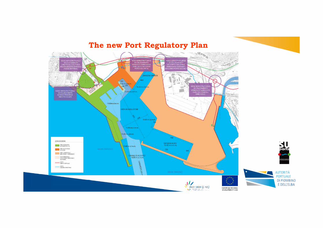
The new Port Regulatory Plan

At the time that the procedure for the Evaluation of Environmental Impact began, withthe aim of gaining conclusive approval for the new Regulatory Plan for the Port ofPiombino, the Ministry of the Environment and the Tuscan region asked for certainintegratory measures to be undertaken:
•Monitoring of the benthic biocenosis in the areas next to the large basin in the port ofPiombino;•Creation of bionomic maps of the areas next to the large basin in the port of Piombino;•Study of the coastal dynamics;•Environmental investigations relating to the atmosphere, noise and vibration;•Specialised study of viability and vehicle movement in the port of Piombino;•Closer examination within the transport studies for the port of Piombino;•Specialised study regarding the water component, including water discharges;•Close technical examination relating to the management of hazardous marinesediments;•Specialised study of the filling of the entrance channel;•Close examination of site activities.
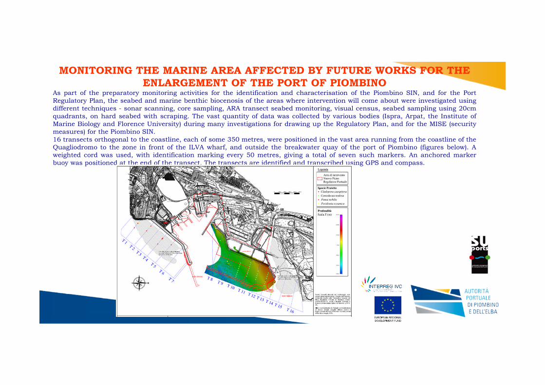
MONITORING THE MARINE AREA AFFECTED BY FUTURE WORKS FOR THEENLARGEMENT OF THE PORT OF PIOMBINO
As part of the preparatory monitoring activities for the identification and characterisation of the Piombino SIN, and for the PortRegulatory Plan, the seabed and marine benthic biocenosis of the areas where intervention will come about were investigated usingdifferent techniques - sonar scanning, core sampling, ARA transect seabed monitoring, visual census, seabed sampling using 20cmquadrants, on hard seabed with scraping. The vast quantity of data was collected by various bodies (Ispra, Arpat, the Institute ofMarine Biology and Florence University) during many investigations for drawing up the Regulatory Plan, and for the MISE (securitymeasures) for the Piombino SIN.16 transects orthogonal to the coastline, each of some 350 metres, were positioned in the vast area running from the coastline of theQuagliodromo to the zone in front of the ILVA wharf, and outside the breakwater quay of the port of Piombino (figures below). Aweighted cord was used, with identification marking every 50 metres, giving a total of seven such markers. An anchored markerbuoy was positioned at the end of the transect. The transects are identified and transcribed using GPS and compass.

Transects 1 – 2 Transects 3 - 4
Transects 5 - 6 Transects 7 - 8

Transects 9 – 10 Transects 11 - 12
Transects 13 - 14 Transects 15 - 16
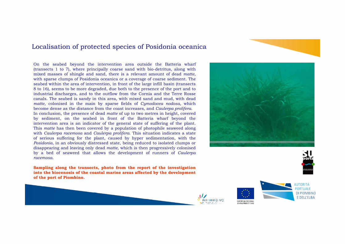
Localisation of protected species of Posidonia oceanica
On the seabed beyond the intervention area outside the Batteria wharf(transects 1 to 7), where principally coarse sand with bio-detritus, along withmixed masses of shingle and sand, there is a relevant amount of dead matte,with sparse clumps of Posidonia oceanica or a coverage of coarse sediment. Theseabed within the area of intervention, in front of the large infill basin (transects8 to 16), seems to be more degraded, due both to the presence of the port and toindustrial discharges, and to the outflow from the Cornia and the Terre Rossecanals. The seabed is sandy in this area, with mixed sand and mud, with deadmatte, colonised in the main by sparse fields of Cymodocea nodosa, whichbecome dense as the distance from the coast increases, and Caulerpa prolifera.In conclusion, the presence of dead matte of up to two metres in height, coveredby sediment, on the seabed in front of the Batteria wharf beyond theintervention area is an indicator of the general state of suffering of the plant.This matte has then been covered by a population of photophile seaweed alongwith Caulerpa racemosa and Caulerpa prolifera. This situation indicates a stateof serious suffering for the plant, caused by hyper sedimentation, with thePosidonia, in an obviously distressed state, being reduced to isolated clumps ordisappearing and leaving only dead matte, which is then progressively colonisedby a bed of seaweed that allows the development of runners of Caulerparacemosa.
Sampling along the transects, photo from the report of the investigationinto the biocenosis of the coastal marine areas affected by the developmentof the port of Piombino.
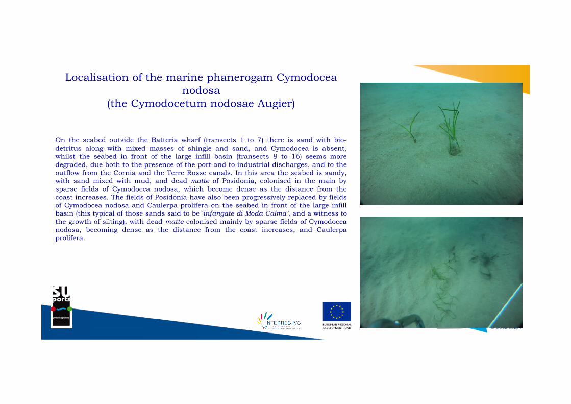
Localisation of the marine phanerogam Cymodoceanodosa
(the Cymodocetum nodosae Augier)
On the seabed outside the Batteria wharf (transects 1 to 7) there is sand with bio-detritus along with mixed masses of shingle and sand, and Cymodocea is absent,whilst the seabed in front of the large infill basin (transects 8 to 16) seems moredegraded, due both to the presence of the port and to industrial discharges, and to theoutflow from the Cornia and the Terre Rosse canals. In this area the seabed is sandy,with sand mixed with mud, and dead matte of Posidonia, colonised in the main bysparse fields of Cymodocea nodosa, which become dense as the distance from thecoast increases. The fields of Posidonia have also been progressively replaced by fieldsof Cymodocea nodosa and Caulerpa prolifera on the seabed in front of the large infillbasin (this typical of those sands said to be ‘infangate di Moda Calma’, and a witness tothe growth of silting), with dead matte colonised mainly by sparse fields of Cymodoceanodosa, becoming dense as the distance from the coast increases, and Caulerpaprolifera.

Localisation of the protected species Pinna nobilis
The presence of 13 examples of Pinna nobilis has been noted in the seas outside the area of intervention beyond the Batteriawharf (transects 1 to 7), at a distance from the port breakwater running from 80 metres (transect 1) to 300 metres (transect3), at depths between 6.6 and 11.8 metres, whereas four examples have been identified inside the intervention area, intransects 8 to 16, at 240 metres of distance from the coast and 6.1 of depth, and 300 metres of distance and 10.4 of depth.

Localisation of the protected species Cladocora caespitosa
The presence of six examples of Cladocora has been noted in the seas outside the area of intervention beyond the Batteria wharf(transects 1 to 7), at a distance from the port breakwater running from 200 metres (transects 3 and 5) to 300 metres (transects 1and 6), at depths between 8 and 11 metres, whereas but one example has been identified inside the intervention area in transects 8to 16. This example, identified in transect 13, was also anomalous as it was found at a depth of 4 metres, attached to the artificialrocks of the basin under construction.

LIMITS OF THE SEAWEED FIELDS AND THE BIONOMIC MAPThe in situ survey of the fields was conducted using direct methods, both with the use of underwater operators and of underwater videocameras towed from boats. The limits were marked with the use of marker buoys and GPS. The state of health of the fields for each partinvestigated was evaluated using structural variables such as the percentage of exposed matte and the density of the clumps. An underwatervideo camera towed by boat was also used in transects running perpendicular to the coast.The presence of Posidonia oceanica begins at a distance that varies between 600 and 800 metres from the coastline, first as a field withpatches of various size, on dead matte colonised by Caulerpa prolifera. The limits of the true fields may be placed at a depth of 10 to 14metres and at a distance from the coast of between 800 and 1,000 metres. The limits are generally of erosive type, with a step of mattealmost always greater than one metre in height. The fields are low density, with ample portions of exposed matte colonised by Caulerpa
prolifera. The fields are not affected by the foreseen port works.
Field limit Bionomic map

Planning marine works in coastal areas often interferes with protected organisms, creating problems both regarding theirconservation and for the realisation of the project itself. The Port Authority of Piombino intends to use mitigatory and/orcompensatory measures which have the aim of diminishing the seriousness of the problem, if not eliminating it altogether. Inparticular, the transfer of the few organisms of conservation interest identified in the area is foreseen.The results of the investigations have demonstrated the presence of an extensive field of the marine phanerogam Cymodoceanodosa, whilst the presence of Posidonia oceanica is very limited. Beyond this, some examples of the bivalve mollusc Pinnanobilis have been identified.The proposals foresee mitigation of the impact of the works on the current habitat by way of transfer of the examples of Pinnanobilis, of the patches of Posidonia oceanica, and of a significant part of the fields of Cymodocea nodosa.
Requests for integration made by the Ministry of the Environment and the Tuscan region on thebasis of the proposed transfer of protected organisms.
In relation to the species and habitat identified by the proposer that are protected by standard, and also by internationalconventions and agreements, the mitigatory and compensatory measures proposed must be properly intensified so as to allowthe reduction of impact on protected species and marine habitats in the area affected by the works, and on the biocenosispresent along the bordering coastline. The means to undertake the total transfer to another site of the examples of Pinnanobilis, and also of Cladocora caespitose, together with the transplantation of the fields of marine phanerogams, must bedefined in agreement with the Ministry of the Environment and the Protection of the Territory and the Seas, ISPRA, theTuscan Region and ARPAT. As regards the foreseen transplant of the marine phanerogam, the programme for this transplantand subsequent monitoring must be prepared and presented to the Ministry of the Environment and the Protection of theTerritory and the Seas, ISPRA, the Tuscan Region and ARPAT, indicating in detail the experimental protocol used. Allmitigatory and compensatory measures outlined above must be implemented before beginning any single work that affects thebiocenosis mentioned above. Before beginning any single work, a plan for the monitoring to be carried out before, during andafter the intervention of the marine biocenosis - not only of the area affected by the intervention but also of that surroundingarea affected by the deposition of sediment in suspension due to dredging - must be presented to the Ministry of theEnvironment and the Protection of the Territory and the Seas, ISPRA, the Tuscan Region and ARPAT. In addition, allcorrective action that is necessary must be put in hand. Monitoring must include all sites where organisms, fields andcolonies of conservationist importance have been relocated or replanted.

An in-depth investigation to complete the identification of protected species in the area affected by the marine work was carried out by thePort Authority in June 2012, along with the localisation of suitable seabed for the transfer, as a mitigatory and compensatory measure, ofthose examples identified.
One objective of the investigation was to identify all the examples of Cladocora caespitose and Pinna nobilis in the areas adjacent to theport of Piombino, along with a survey of the seabed where the presence of Cymodocea nodosa has been noted in the past. In addition, theinvestigation aimed to identify areas within the Gulf of Follonica suitable for the transfer of those protected animal and vegetable speciesobject of the investigation.
Pinna nobilis Cladocora caespitosa Cymodocea nodosa
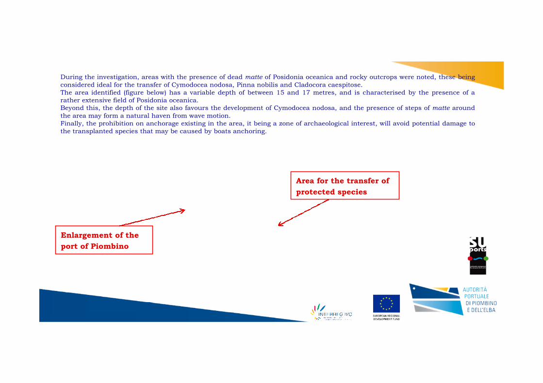
Enlargement of the
port of Piombino
Area for the transfer of
protected species
During the investigation, areas with the presence of dead matte of Posidonia oceanica and rocky outcrops were noted, these beingconsidered ideal for the transfer of Cymodocea nodosa, Pinna nobilis and Cladocora caespitose.The area identified (figure below) has a variable depth of between 15 and 17 metres, and is characterised by the presence of arather extensive field of Posidonia oceanica.Beyond this, the depth of the site also favours the development of Cymodocea nodosa, and the presence of steps of matte aroundthe area may form a natural haven from wave motion.Finally, the prohibition on anchorage existing in the area, it being a zone of archaeological interest, will avoid potential damage tothe transplanted species that may be caused by boats anchoring.

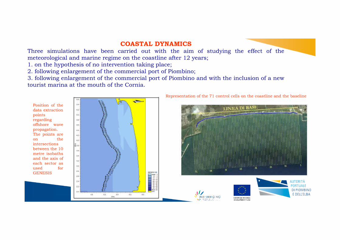
Representation of the 71 control cells on the coastline and the baseline
Position of thedata extractionpointsregardingoffshore wavepropagation.The points areon theintersectionsbetween the 10metre isobathsand the axis ofeach sector asused forGENESIS
COASTAL DYNAMICSThree simulations have been carried out with the aim of studying the effect of themeteorological and marine regime on the coastline after 12 years;1. on the hypothesis of no intervention taking place;2. following enlargement of the commercial port of Piombino;3. following enlargement of the commercial port of Piombino and with the inclusion of a newtourist marina at the mouth of the Cornia.
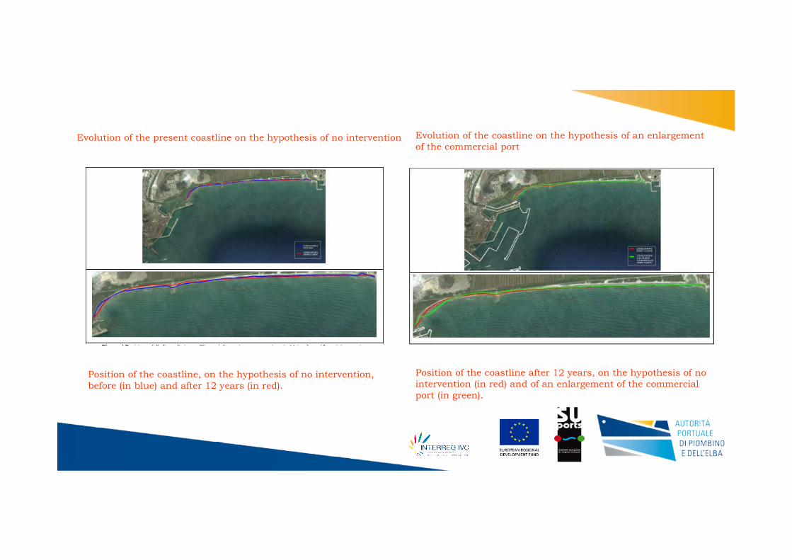
Evolution of the present coastline on the hypothesis of no intervention Evolution of the coastline on the hypothesis of an enlargementof the commercial port
Position of the coastline, on the hypothesis of no intervention,before (in blue) and after 12 years (in red).
Position of the coastline after 12 years, on the hypothesis of nointervention (in red) and of an enlargement of the commercialport (in green).

Effect of theenlargement ofthe commercialport and theconstruction of atourist marina
Position of the coastline on thehypothesis of no intervention (in red)and of an enlargement of thecommercial port and a tourist marina(in yellow).
The presence of a well-sheltered area beyond the eastern stem of the new breakwater for the commercial port would, in the absenceof a tourist marina, facilitate the accumulation of sediment with a foreseen extension over twelve years of some 60 to 70centimetres. This would cause the coastline to retreat by 10 to 15 metres along a stretch of 1,500 metres. Sand pushed towards theport by waves coming from the south-east would not be carried back towards the east by waves from the south-west preciselybecause of the sheltered conditions brought about by the new breakwater. The influence of the new works on the coastline aresignificantly less than those estimated in the simulation made in 2008, but it should be borne in mind that in that case theestimate also considered modification to the seabed, and so the two, carried out using different criteria and models, are in factsubstantially congruent, although in the current analysis the effects would be of lesser significance. In the case of a tourist marinabeing built, this would occupy the sheltered area, and so a sedimentation zone would no longer be present, and the coastline wouldevolve in a way virtually the same as that in the case of no intervention. The only foreseeable variation is an average retreat of somemetres along a stretch of around 500 metres. To reduce the effects of the new port works on the coastline in the absence of a touristmarina, a rock armour rip-rap barrier could be built that would follow the line of the breakwater foreseen for the tourist marina,with the aim of significantly limiting the area subject to sedimentation.

For further details and/or clarification you can contact my colleague Mrs. Claudia Bulleri at :
Thank you for your attention
Σας ευχαριστώ για την προσοχή σας