biodiversity development assessment report (bdar)
TRANSCRIPT

L O DG E
E N VI R ON ME N T A L
D a t e : 9 D e c e m b e r 2 0 1 9
P r o j e c t C o d e : L E 1 1 1 9
BIODIVERSITY DEVELOPMENT
ASSESSMENT REPORT (BDAR)
L E VE E WA L L N E A R
B U IL D IN G 29
P RE PA RE D F OR
U N IVE R S IT Y OF W O L LO N G ON G
BIODIVERSITY DEVELOPMENT ASSESSMENT REPORT
Levee Wall, University of Wollongong
LE1119 UOW Building 29 Levee BDAR v1.docx Page 1
LODGE ENVIRONMENTAL • www.lodgeenviro.com.au • ABN 85 631 988 148
Project Name:
Levee Wall – Building 29, University of Wollongong – Biodiversity
Development Assessment Report
Project Code:
LE1119
Document Tracking:
Record of Distribution
Copies Report No. & File Name Status Date Prepared for:
1 x PDF LE1119 UOW Building 29 Levee BDAR v0a.docx Rev.1 9th November
2019
The University of
Wollongong
COMMERCIAL IN CONFIDENCE
This document has been prepared consistent with accepted scientific practice, supported by available data and resource conditions, as determined by
limited data acquisition during the assessment period, evident at Site at the time. The designated recipients of this report accept all risks and responsibility
for losses, damages, costs and other consequences resulting directly or indirectly from using the results of the interpretation, the data, and any information
or conclusions drawn from it, whether or not caused by any negligent act or omission. To the maximum permitted by law, Lodge Environmental excludes
all liability to any person or identity, arising directly or indirectly from using the information or material contained herein.
INTELLECTUAL PROPERTY LAWS PROTECT THIS DOCUMENT
Copyright in the material provided in this document is owned by Lodge Environmental. Lodge Environmental reserves the right to revoke this report,
its content and results derived during the scope of work. Third parties may only use the information in the ways described in this legal notice:
• Temporary copies may be generated, necessary to review the data.
• A single copy may be copied for research or personal use.
• The documents may not be changed, nor any part removed including copyright notice.
• Request in writing is required for any variation to the above
• An acknowledgement to the source of any data published from this document is mandatory
Prepared by:
Jack Talbert
Environmental Planner and Ecologist
Accredited Biodiversity Assessor BAAS18140
•
Elira Reynolds
Ecologist
Lodge Environmental
ABN 85 631 988 148
Scientific License SL102041
Animal Research Authority – Flora and Fauna Survey
Mobile: 0423 296 045
Email: [email protected]

BIODIVERSITY DEVELOPMENT ASSESSMENT REPORT
Levee Wall, University of Wollongong
LE1119 UOW Building 29 Levee BDAR v1.docx Page 2
TABLE OF CONTENTS
1.0 Executive Summary ........................................................................................................................ 5
2.0 Introduction .................................................................................................................................... 6
2.1 Site Description ................................................................................................................................................................ 6
2.2 Project Description .......................................................................................................................................................... 6
2.3 Personnel and Qualifications ...................................................................................................................................... 2
3.0 Landscape Context .......................................................................................................................... 3
3.1 Landscape features ......................................................................................................................................................... 3
3.1.1 IBRA Bioregions and IBRA Subregions ............................................................................................................... 3
3.1.2 Mitchell Landscapes .................................................................................................................................................. 3
3.1.3 Other Features and Biodiversity Values Map .................................................................................................. 3
3.2 Site Context ........................................................................................................................................................................ 6
3.2.1 Native Vegetation Cover ......................................................................................................................................... 6
3.2.2 Patch Size ....................................................................................................................................................................... 8
4.0 Native Vegetation ........................................................................................................................... 9
4.1 Vegetation Field Assessment ...................................................................................................................................... 9
4.2 Plant Community Type Mapping ............................................................................................................................ 10
4.3 Vegetation Integrity Assessment (site condition) ............................................................................................. 14
5.0 Threatened Species ....................................................................................................................... 17
5.1 Identify Threatened Species for Assessment ...................................................................................................... 17
5.1.1 Ecosystem Credit Species ...................................................................................................................................... 17
5.1.2 Species Credit Species ............................................................................................................................................ 19
5.2 Determine Presence or Absence of a Candidate Species Credit Species ................................................ 26
5.2.1 Targeted Field Surveys – Flora ............................................................................................................................ 26
5.2.2 Field Surveys – Fauna .............................................................................................................................................. 26
5.2.3 Survey Weather ......................................................................................................................................................... 27
5.2.4 Survey Limitations .................................................................................................................................................... 27
5.3 Determine the area or count, and location of suitable habitat for a species credit species ........... 27
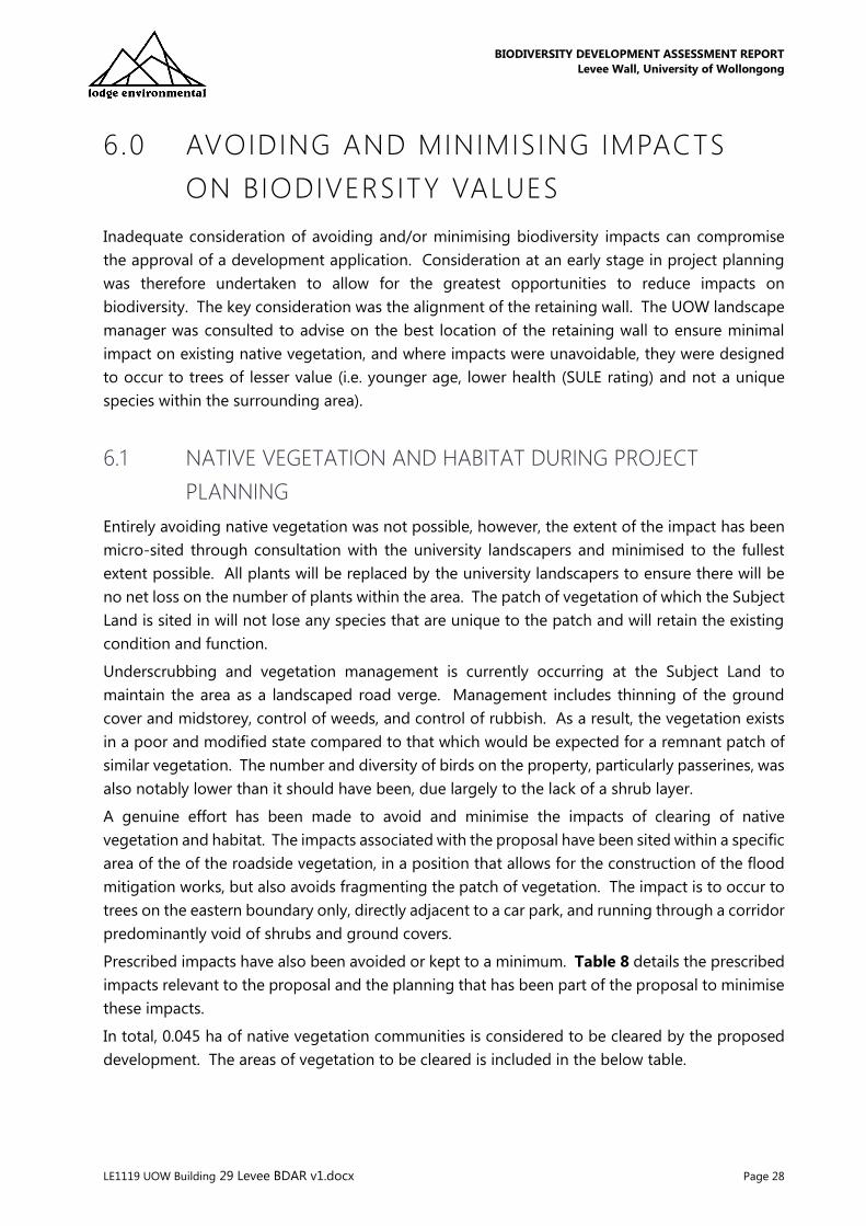
6.0 Avoiding and Minimising Impacts on Biodiversity Values ........................................................ 28
6.1 Native Vegetation and Habitat during Project Planning ............................................................................... 28
6.1.1 Prescribed Biodiveristy Impacts .......................................................................................................................... 29
6.1.2 Koala SEPP 44............................................................................................................................................................. 31
7.0 Impact Summary and Offset Assessment ................................................................................... 32
7.1 Direct Impact ................................................................................................................................................................... 32
7.2 Indirect impacts .............................................................................................................................................................. 32
7.3 Mitigation Measures .................................................................................................................................................... 32
7.4 Zoning ................................................................................................................................................................................ 33
7.5 Water Management Act 2000 .................................................................................................................................. 34

BIODIVERSITY DEVELOPMENT ASSESSMENT REPORT
Levee Wall, University of Wollongong
LE1119 UOW Building 29 Levee BDAR v1.docx Page 3
7.6 Local Provisions .............................................................................................................................................................. 34
7.7 Adaptive Management for Uncertain Impacts .................................................................................................. 35
7.8 Thresholds for the Assessment and Offsetting of Impacts of Development ......................................... 35
7.8.1 Serious and Irriversible Impacts .......................................................................................................................... 35
7.8.2 Impacts Requiring Offsetting ............................................................................................................................... 35
7.8.3 Impacts That Do Not Require Further Assessment ..................................................................................... 35
8.0 Final Credit Calculations ............................................................................................................... 36
8.1.1 Ecosystem Credits .................................................................................................................................................... 36
8.1.2 Species Credits .......................................................................................................................................................... 36
8.2 Credit Costs ...................................................................................................................................................................... 36
9.0 Conclusion ..................................................................................................................................... 38
10.0 References ..................................................................................................................................... 39
11.0 Limitations ..................................................................................................................................... 40

BIODIVERSITY DEVELOPMENT ASSESSMENT REPORT
Levee Wall, University of Wollongong
LE1119 UOW Building 29 Levee BDAR v1.docx Page 4
LIST OF TABLES, FIGURES & APPENDICES
TABLES
Table 1: Native Vegetation Cover .................................................................................................................................................. 6
Table 2: PCT 1245 – Sydney Blue Gum x Bangalay – Lilly Pilly moist forest ............................................................... 13
Table 3: PCTs, associated impacts and plots undertaken per BAM Table 4 requirement ..................................... 14
Table 4: Vegetation Integrity Scoring ........................................................................................................................................ 15
Table 5: Ecosystem credit species output from BAM calculator ..................................................................................... 17
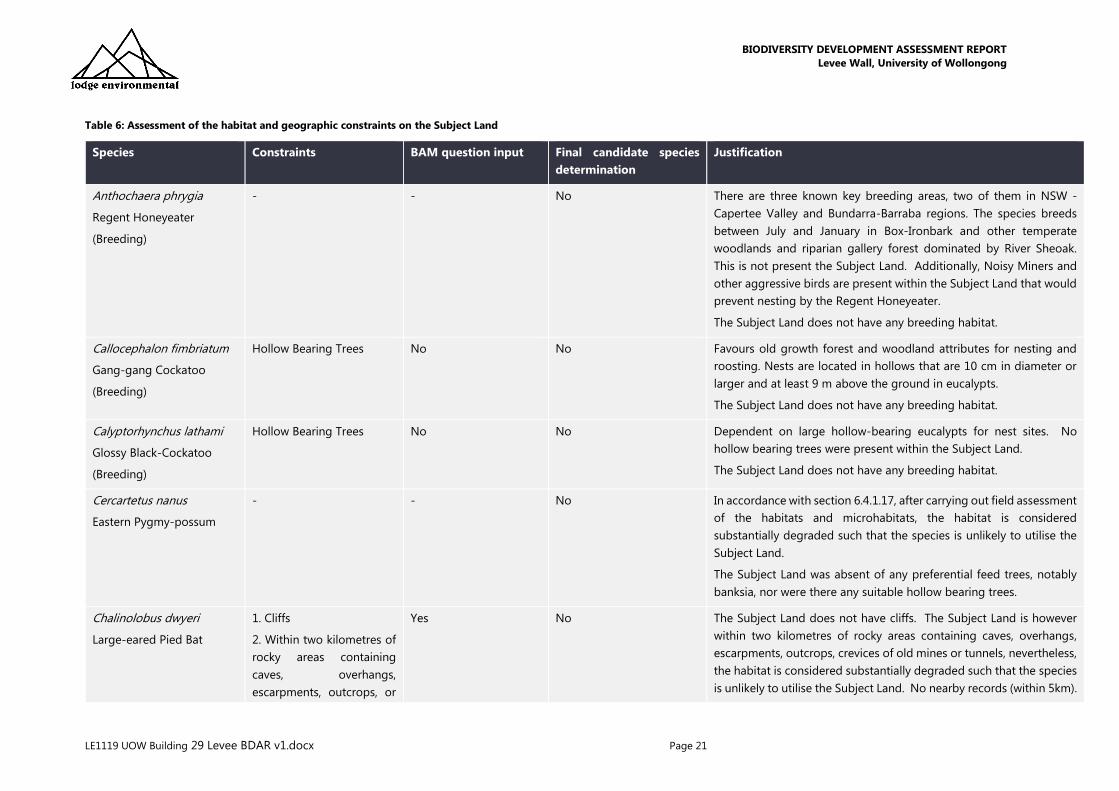
Table 6: Assessment of the habitat and geographic constraints on the Subject Land .......................................... 21
Table 7: Areas of vegetation communities to be impacted .............................................................................................. 29
Table 8: Prescribed biodiversity impacts .................................................................................................................................. 29
Table 9: Areas of vegetation requiring offsets ....................................................................................................................... 35
Table 10: Ecosystem credit requirement................................................................................................................................... 36
Table 11: Offset liability and cost ................................................................................................................................................ 36
FIGURES
Figure 1: Site Map
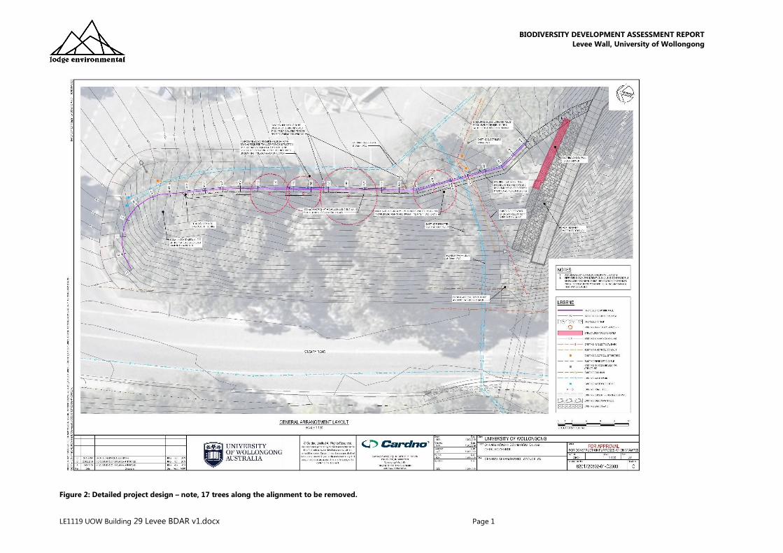
Figure 2: Detailed project design – note, 17 trees along the alignment to be removed.
Figure 3: Proposal Layout
Figure 4: Location Map
Figure 5: Biodiversity Values mapping
Figure 6: Native vegetation cover within 1,500m of the Subject Land
Figure 7: Plant Community Type mapping (DPIE 2016)
Figure 8: Validated Plant Community Types (LE 2019)
Figure 9: Vegetation Integrity Plots and Vegetation Zones
Figure 10: Areas of impacted land assessed within this BDAR. Circular areas represent tree for removal (4 in
total)
APPENDICES
Appendix A: BAM Site – Field Survey Plot Data
Appendix B: Flora Species List
Appendix C: Fauna Species List
Appendix D: BAM Calculator Report

BIODIVERSITY DEVELOPMENT ASSESSMENT REPORT
Levee Wall, University of Wollongong
LE1119 UOW Building 29 Levee BDAR v1.docx Page 5
1 .0 EXECUTIVE SUMMARY
The University of Wollongong proposes to construct a retaining wall and gabian wall (levee wall)
on the western side of the new Building 29. The project spans approximately 45 m and will require
removal of landscaped, roadside vegetation.
Impact to native vegetation will total a maximum of 0.045 ha. The proposal will impact planted
and naturally regenerating native plants which are consistent with Plant Community Type (PCT)
1245: Sydney Blue Gum x Bangalay - Lilly Pilly moist forest in gullies and on sheltered slopes. This
vegetation is not associated with a Threatened Ecological Community (TEC).
The impacts include removal of a maximum of 17 trees for the proposed wall alignment, as well
as areas of disturbance to the ground directly adjacent. Once the wall has been constructed, the
disturbed area directly adjacent to the wall will be replanted using species similar to those which
currently occur within the wider patch of vegetation. Impacts to native vegetation will be avoided
as much as possible, however, a conservative approach has allowed for an impact assessment on
a total removal of 17 trees.
One Biodiversity Assessment Method (BAM) plot was completed to assess the vegetation and
habitat values affected by the proposal. The data gathered was input into the BAM Credit
Calculator by an accredited assessor. The credit required for this proposal is 1 Ecosystem Credit
for PCT 1245: Sydney Blue Gum x Bangalay – Lilly Pilly moist forest. This is calculated at a cost of
$5,108.16 if purchased from the Biodiversity Conservation Trust Fund, noting prices are subject to
change.
Candidate species credit species were considered. Due to the fragmented occurrence of the
regrowth vegetation, within a heavily disturbed landscape, and lacking habitat complexity such as
tree hollows, no candidate species were considered as potentially occurring within the Subject
Land. Consequently, the BAM Credit Calculator did not generate a requirement for any Species
Credit offsets.
Additional avoidance and mitigation measures will be undertaken at the time of the wall
construction, with an ecologist to be present during clearance to catch and relocate any native
fauna encountered, ensure the impact does not go beyond the 17 trees considered within this
report, and to advise on additional tree retention. The University landscape manager will replace
all trees with similar natives at completion of the works.

BIODIVERSITY DEVELOPMENT ASSESSMENT REPORT
Levee Wall, University of Wollongong
LE1119 UOW Building 29 Levee BDAR v1.docx Page 6
2.0 INTRODUCTION
Lodge Environmental were commissioned by the University of Wollongong (UOW) to prepare this
Biodiversity Development Assessment Report (BDAR) to assess the impact of minor vegetation
removal associated with the construction of a flood training levee wall near Building 29 at the
UOW Wollongong main campus – Lot 119A DP15266.
This BDAR has been prepared by Accredited Assessor Jack Talbert (BAAS18140) in accordance
with the Biodiversity Conservation Regulation 2017 (BC Reg) and through application of the
Biodiversity Assessment Methodology (BAM) – case 00018261/BAAS18140/19/00018262.
This BDAR will accompany an Environmental Impact Statement (EIS) is support of the State
Significant Development Application (SSD-8596-Mod-2) for the Western Building modification
under the Environmental Planning and Assessment Act 1979 (EP&A Act). Specifically, the
Department of Planning, Industry and Environment (DPIE) has requested detail of the biodiversity
impacts related to clearing for the purposes of constructing the flood training wall in accordance
with the BAM and documented in a BDAR.
This report documents the results of the biodiversity assessment of the Subject Land, defined as
the area to be impacted by the development, and how the proponent proposes to avoid, minimise
and offset impacts from the proposed development upon native vegetation or biodiversity listed
under the State Biodiversity Conservation Act 2016 (BC Act) (s6.12 and 7.14(1)) and the Biodiversity
Conservation Regulation 2017 (s6.8). This report is based on information obtained through data
searches and field survey. The legislative context, methods used, and recommendations are
included within this report.
2.1 SITE DESCRIPTION
The Subject Land is located at the western end of the UOW campus within the Wollongong City
Council (WCC) Local Government Area (LGA). The land is located less than 3 km northwest of
Wollongong CBD. The Subject Land is zoned SP2 – Infrastructure under the Wollongong LEP
2009. The Subject Land is bounded by UOW roads and carparks to the north, east and south, and
by O’Leary Road to the west.
The Subject Land is entirely vegetated and currently acts as a screen between O’Leary Road and
the UOW Western Carpark. The vegetation was planted by the UOW approximately 40 years ago
with the aim of establishing vegetation within a road verge garden that would have likely existed
prior to the historic agrarian clearance (circa 1950).
2.2 PROJECT DESCRIPTION
This proposed development is a flood mitigation wall required to achieve flood mitigation
requirements as part of the Building 29 approval. A levee needs to be constructed in the Subject
Land to assist in diverting water into the riparian corridor to the south during intense rain events.
The levee will involve a retaining wall for the majority of the length, and a gabian wall for a minor
section at the southern end (Figure 2 and Figure 3).
BIODIVERSITY DEVELOPMENT ASSESSMENT REPORT
Levee Wall, University of Wollongong
LE1119 UOW Building 29 Levee BDAR v1.docx Page 7
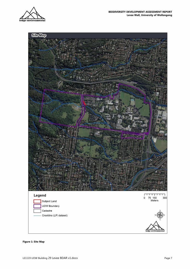
Figure 1: Site Map
BIODIVERSITY DEVELOPMENT ASSESSMENT REPORT
Levee Wall, University of Wollongong
LE1119 UOW Building 29 Levee BDAR v1.docx Page 1
Figure 2: Detailed project design – note, 17 trees along the alignment to be removed.

BIODIVERSITY DEVELOPMENT ASSESSMENT REPORT
Levee Wall, University of Wollongong
LE1119 UOW Building 29 Levee BDAR v1.docx Page 1
Figure 3: Proposal Layout

BIODIVERSITY DEVELOPMENT ASSESSMENT REPORT
Levee Wall, University of Wollongong
LE1119 UOW Building 29 Levee BDAR v1.docx Page 2
2.3 PERSONNEL AND QUALIFICATIONS
This BDAR has been prepared through the compilation of field data, desktop analysis and
reporting by the following technical professionals:
• Jack Talbert – Environmental Planner and Ecologist
BEnvSci (Honours), Accredited BAM Assessor (No: BAAS 18140)
Jack was the project manager for this assessment and completed or closely supervised all
surveys, data entry, GIS mapping, review, BAM credit calculations and report preparation
• Elira Reynolds – Ecologist
BSc (ConsBio)(Honours) / BCom
Elira assisted in the vegetation community mapping and completion of the vegetation
plots
All surveys were undertaken in accordance with the following:
• Animal Research Authority (ARA) granted under the NSW Animal Research Act 1985 by
the NSW Department of Primary Industries Secretary’s Animal Care and Ethics
Committee
• NSW Scientific License issued by the NSW Department of Planning, Industry and
Environment under s132C of the NSW National Parks and Wildlife Act 1974 (SL102041)
BIODIVERSITY DEVELOPMENT ASSESSMENT REPORT
Levee Wall, University of Wollongong
LE1119 UOW Building 29 Levee BDAR v1.docx Page 3
3.0 LANDSCAPE CONTEXT
3.1 LANDSCAPE FEATURES
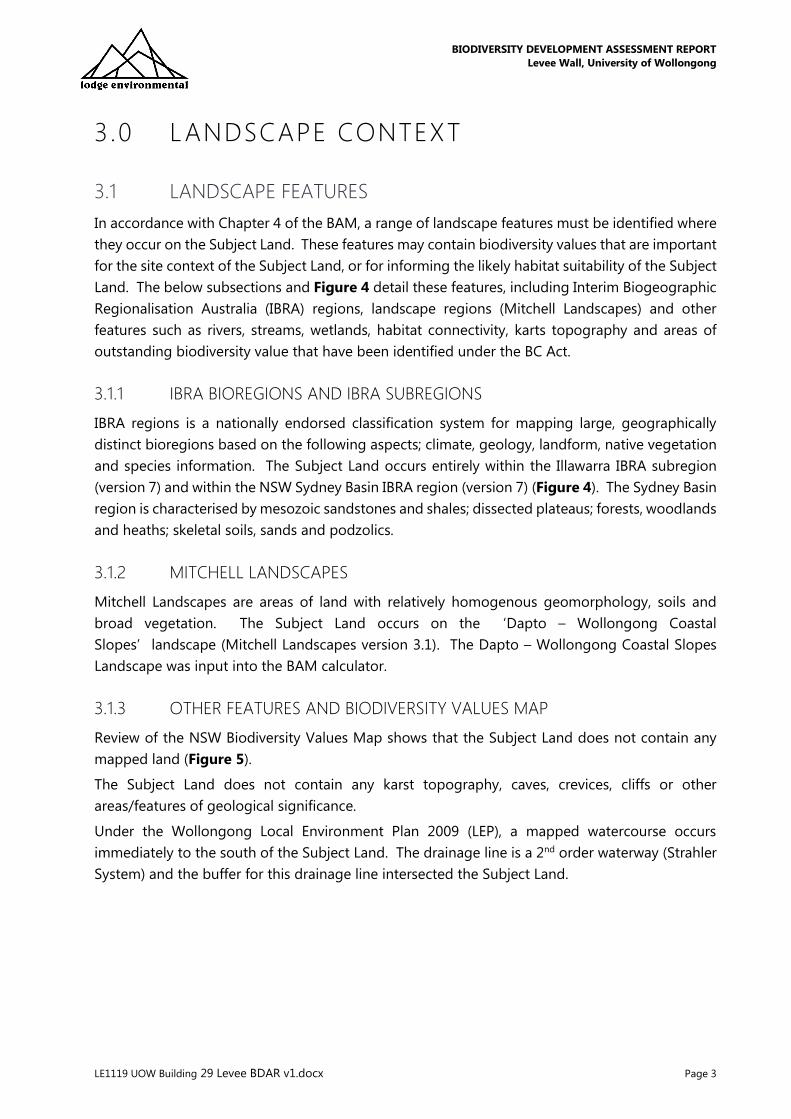
In accordance with Chapter 4 of the BAM, a range of landscape features must be identified where
they occur on the Subject Land. These features may contain biodiversity values that are important
for the site context of the Subject Land, or for informing the likely habitat suitability of the Subject
Land. The below subsections and Figure 4 detail these features, including Interim Biogeographic
Regionalisation Australia (IBRA) regions, landscape regions (Mitchell Landscapes) and other
features such as rivers, streams, wetlands, habitat connectivity, karts topography and areas of
outstanding biodiversity value that have been identified under the BC Act.
3.1.1 IBRA BIOREGIONS AND IBRA SUBREGIONS
IBRA regions is a nationally endorsed classification system for mapping large, geographically
distinct bioregions based on the following aspects; climate, geology, landform, native vegetation
and species information. The Subject Land occurs entirely within the Illawarra IBRA subregion
(version 7) and within the NSW Sydney Basin IBRA region (version 7) (Figure 4). The Sydney Basin
region is characterised by mesozoic sandstones and shales; dissected plateaus; forests, woodlands
and heaths; skeletal soils, sands and podzolics.
3.1.2 MITCHELL LANDSCAPES
Mitchell Landscapes are areas of land with relatively homogenous geomorphology, soils and
broad vegetation. The Subject Land occurs on the ‘Dapto – Wollongong Coastal
Slopes’landscape (Mitchell Landscapes version 3.1). The Dapto – Wollongong Coastal Slopes
Landscape was input into the BAM calculator.
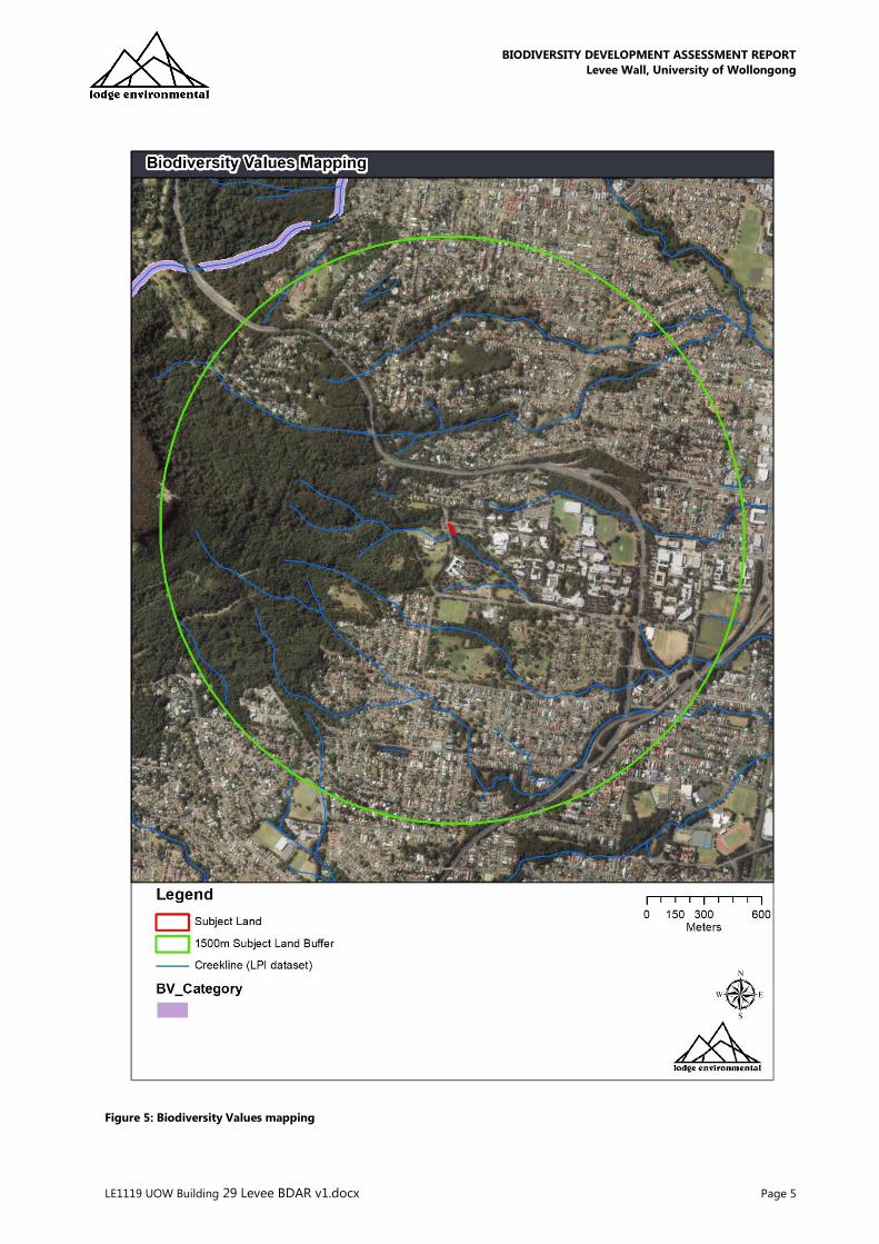
3.1.3 OTHER FEATURES AND BIODIVERSITY VALUES MAP
Review of the NSW Biodiversity Values Map shows that the Subject Land does not contain any
mapped land (Figure 5).
The Subject Land does not contain any karst topography, caves, crevices, cliffs or other
areas/features of geological significance.
Under the Wollongong Local Environment Plan 2009 (LEP), a mapped watercourse occurs
immediately to the south of the Subject Land. The drainage line is a 2nd order waterway (Strahler
System) and the buffer for this drainage line intersected the Subject Land.

BIODIVERSITY DEVELOPMENT ASSESSMENT REPORT
Levee Wall, University of Wollongong
LE1119 UOW Building 29 Levee BDAR v1.docx Page 4
Figure 4: Location Map
BIODIVERSITY DEVELOPMENT ASSESSMENT REPORT
Levee Wall, University of Wollongong
LE1119 UOW Building 29 Levee BDAR v1.docx Page 5
Figure 5: Biodiversity Values mapping
BIODIVERSITY DEVELOPMENT ASSESSMENT REPORT
Levee Wall, University of Wollongong
LE1119 UOW Building 29 Levee BDAR v1.docx Page 6
3.2 SITE CONTEXT
3.2.1 Native Vegetation Cover
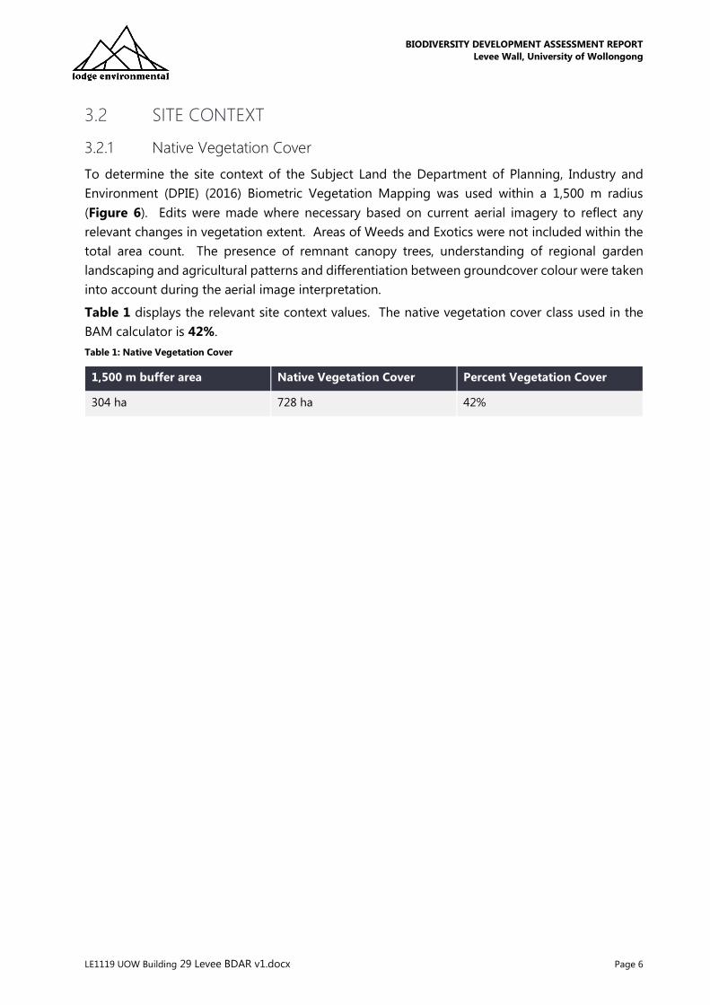
To determine the site context of the Subject Land the Department of Planning, Industry and
Environment (DPIE) (2016) Biometric Vegetation Mapping was used within a 1,500 m radius
(Figure 6). Edits were made where necessary based on current aerial imagery to reflect any
relevant changes in vegetation extent. Areas of Weeds and Exotics were not included within the
total area count. The presence of remnant canopy trees, understanding of regional garden
landscaping and agricultural patterns and differentiation between groundcover colour were taken
into account during the aerial image interpretation.
Table 1 displays the relevant site context values. The native vegetation cover class used in the
BAM calculator is 42%.
Table 1: Native Vegetation Cover
1,500 m buffer area Native Vegetation Cover Percent Vegetation Cover
304 ha 728 ha 42%
BIODIVERSITY DEVELOPMENT ASSESSMENT REPORT
Levee Wall, University of Wollongong
LE1119 UOW Building 29 Levee BDAR v1.docx Page 7
Figure 6: Native vegetation cover within 1,500m of the Subject Land

BIODIVERSITY DEVELOPMENT ASSESSMENT REPORT
Levee Wall, University of Wollongong
LE1119 UOW Building 29 Levee BDAR v1.docx Page 8
3.2.2 Patch Size
Patch size for each vegetation zone within the Subject Land was calculated and assigned to a
vegetation class, being either <5ha, 5-24 ha, 25-100 ha or ≥100 ha.
Patch size is defined within the BAM as an area of intact vegetation that:
a) occurs on the development site or biodiversity stewardship site, and
b) includes native vegetation that has a gap of less than 100 m from the next area of
moderate to good condition native vegetation (or ≤30 m from non-woody ecosystems).
Intact vegetation is defined as “vegetation where all tree, shrub, grass and/or forb structural
growth form groups expected for a plant community type are present”.
Patch size may extend onto adjoining land that is not part of the development site or biodiversity
stewardship site. The patch size class is used to assess the habitat suitability of the Subject Land
for threatened species.
A single patch of native vegetation was identified within the Subject Land. The patch size class
used to assess the habitat suitability for all native vegetation patches within the Subject Land is 5
ha as it has connectivity through riparian vegetation and native landscaping with UOW campus.

BIODIVERSITY DEVELOPMENT ASSESSMENT REPORT
Levee Wall, University of Wollongong
LE1119 UOW Building 29 Levee BDAR v1.docx Page 9
4.0 NATIVE VEGETATION
4.1 VEGETATION FIELD ASSESSMENT
The native vegetation within the Subject Land includes all areas of native vegetation including
native ground cover and the canopy area of trees. The native vegetation was mapped, in
accordance with the BAM, into Plant Community Types (PCT) within the Subject Land, using the
following methods:
• review of previous vegetation mapping – Biometric Vegetation Types (DPIE 2016)
• review of Protected Matters Search Tool (Commonwealth of Australia 2019)
• review of NSW Bionet Atlas of NSW Wildlife (2019)
• site assessment by ecologists Jack Talbert and Elira Reynolds on 13 November 2019. The
Subject Land was traversed to identify plant species present as well as dominance of
species per native vegetation patch. Initial survey focussed on traversing the entirety of
the Subject Land to confirm the sites stratification into vegetation zones reflecting the
broad condition state of vegetation.
• Plot based vegetation survey was then undertaken in accordance with the BAM – i.e. a 20
m x 20 m plot. Table 4 of the BAM was reviewed and used to inform the required number
of plots. The 20 m x 20 m plot included the vegetation integrity plots. Each plot was
randomly located within each vegetation zone while also avoiding ecotones, vehicle tracks
and their edges, or other disturbed areas that were readily distinguishable from the broad
condition state of the vegetation zone.
• a review of the BioNet Vegetation Classification database
(https://www.environment.nsw.gov.au/research/Vegetationinformationsystem.html) was
utilised to determine the most suitable PCT for the vegetation communities within the
Subject Land. This is in accordance with the NSW PCT classification (BioNet Vegetation
Classification (DPIE 2019)).
• Consideration was given to the geographic distribution (based upon IBRA subregions),
vegetation formation and floristics of vegetation within the Subject Land. The data for
each potential PCT including vegetation stratum floristics and formation, descriptive
attributes and distribution information were then reviewed and compared to the
observations made during field survey. A final determination was then made to determine
the most suitable PCT.

BIODIVERSITY DEVELOPMENT ASSESSMENT REPORT
Levee Wall, University of Wollongong
LE1119 UOW Building 29 Levee BDAR v1.docx Page 10
4.2 PLANT COMMUNITY TYPE MAPPING
A review of vegetation mapping that covers the Subject Land (DPIE 2016) identified a single
vegetation type which did not constitute a Plant Community Type (PCT), being:
• Weeds and Exotics – no PCT
On-site vegetation community assessment was based on analysis of site location, aspect,
condition and validated against DPIE Bionet Vegetation Classification
(https://www.environment.nsw.gov.au/NSWVCA20PRapp/search/pctsearch.aspx).
One homogenous vegetation community (comprising one PCT) was observed within the Subject
Land on the 13 November 2019 over four-person-hours.
The PCT was then broken down into distinct ‘vegetation zones’ for the purposes of input into
the BAM calculator. This stratification was based on observed condition, floristic composition and
structure. A vegetation zone is henceforth an area of native vegetation on the Subject Land that
has the same PCT and a similar broad condition state.
The vegetation communities confirmed within the Subject Land were:
• PCT 1245: Sydney Blue Gum x Bangalay – Lilly Pilly moist open forest in gullies and on
sheltered slopes, southern Sydney Basin Bioregion (Planted/regrowth – poor condition).
It is noted that the UOW grounds in their entirety have been subject to substantial historic
clearance, however a strict landscape management regime has resulted in planted vegetation
patches that are representative of PCTs which would have occurred prior to clearance.
Throughout the University, vegetation is comprised of mature, planted landscaping trees,
comprising both locally indigenous species and ornamental exotic species. A broad range of
native and exotic species have been planted throughout the University and the Subject Land itself.

BIODIVERSITY DEVELOPMENT ASSESSMENT REPORT
Levee Wall, University of Wollongong
LE1119 UOW Building 29 Levee BDAR v1.docx Page 11
Figure 7: Plant Community Type mapping (DPIE 2016)
BIODIVERSITY DEVELOPMENT ASSESSMENT REPORT
Levee Wall, University of Wollongong
LE1119 UOW Building 29 Levee BDAR v1.docx Page 12
Figure 8: Validated Plant Community Types (LE 2019)
BIODIVERSITY DEVELOPMENT ASSESSMENT REPORT
Levee Wall, University of Wollongong
LE1119 UOW Building 29 Levee BDAR v1.docx Page 13
The following table provides a detailed description of the PCT recorded within the Subject Land.
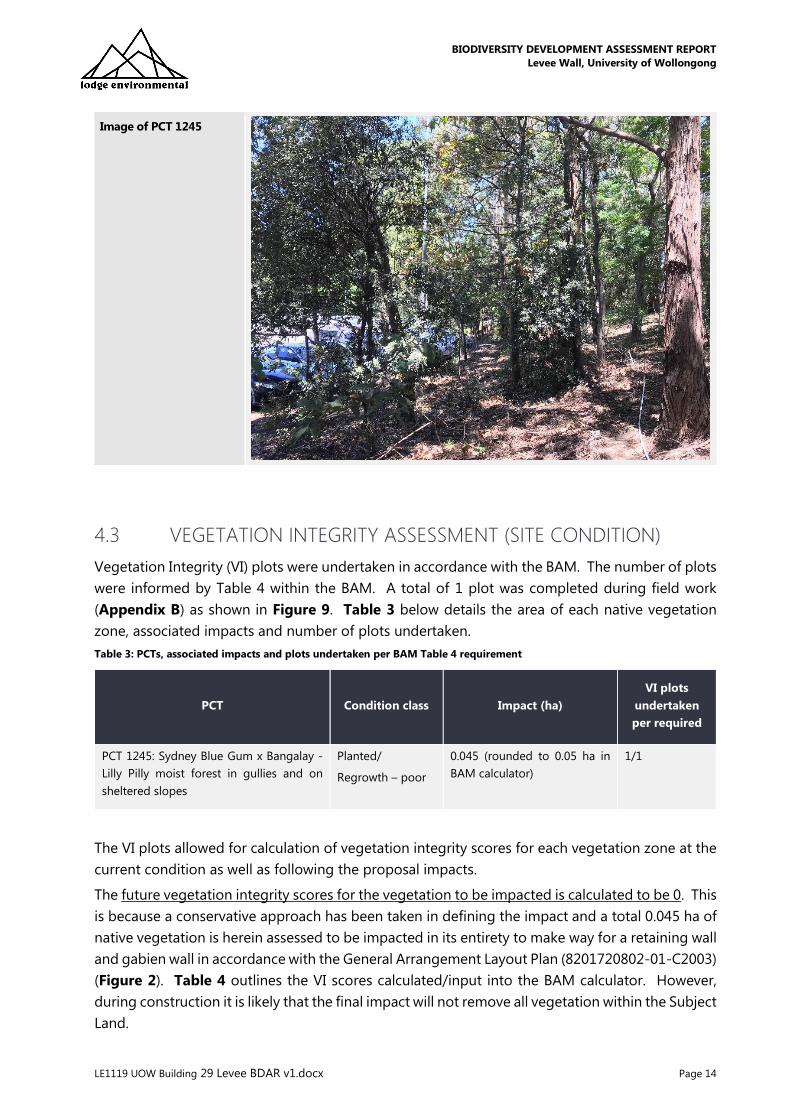
Table 2: PCT 1245 – Sydney Blue Gum x Bangalay – Lilly Pilly moist forest
PCT 1245 – Sydney Blue Gum x Bangalay – Lilly Pilly moist forest in gullies and sheltered slopes
PCT ID 1245
Vegetation formation Wet Sclerophyll Forest (Shrubby)
Vegetation class North Coast Wet Sclerophyll Forests
Condition Planted / regrowth – poor condition
Extent within Subject
Land
Approximately 0.045 ha of PCT 1245 in a poor condition was recorded within the Subject
Land.
Description The general community was represented primarily by codominance of Grey Ironbark
Eucalyptus paniculata and Sydney Blue Gum Eucalyptus saligna x botriodies. Other
common canopy species included Turpentine Syncarpia glomulifera and Tallowwood
Eucalyptus microcorys supported by occasional representations of Blackbutt Eucalyptus
pilularis. All vegetation is a result of tailored landscaping by the University aimed at re-
establishing a native dominant patch of roadside vegetation. The shrub layer consisted of
Prickly-leaved Tea-tree Melaleuca stypheloides, Illawarra Flame Tree Brachychiton
populneus, various Acacia species including; Two-veined Hickory Acacia binervata, Hickory
Wattle Acacia implexa and Stiff-leaf Wattle Acacia obtusifolia, as well as Willow Bottlebrush
Callistemon salignus, regrowth Swamp Oak Casuarina glauca and Turpentines Syncarpia
glomulifera. The ground layer was sparse, but included the climbing Native Grape Cayratia
clematidea, Rock Fern Cheilanthes sieberi, Blue Flax Lilly Dianella caerulea and Many-
flowered Mat-rush Lomandra multifora. The area is experiencing edge effects from the
adjacent disturbances evidenced by the presence of characteristic disturbance margin
weeds including; Madeira Vine Anredera cordifolia, Asparagus Weed Asparagus
aethiopicus, Lantana Lantana camara, Fennel Foeniculum vulgare, Senna Senna pendula,
Fireweed Senecio madagascariensis, Flatweed Hyperchaeris radicata and Trifolium
glomeratum Clusted Clover.
Survey effort One VI plot was established this zone. Plot 1.
PCT Justification:
Expected Species by
Stratum (Bold denotes
species relied upon for
identification of
vegetation type)
Upper Stratum:
Acmena smithii;
Livistona australis;
Synoum glandulosum;
Pittosporum undulatum;
Cryptocarya glaucescens;
Eucalyptus saligna;
Eucalyptus quadrangulata;
Eucalyptus pilularis;
Syncarpia glomulifera;
Mid Stratum:
Notelaea venosa;
Clerodendrum tomentosum;
Eupomatia laurina;
Ground Stratum:
Doodia aspera;
Pseuderanthemum variabile;
Oplismenus imbecillis;
Gymnostachys anceps;
Blechnum cartilagineum;
Adiantum formosum;
Calochlaena dubia;
TEC Status There are currently no TECs associated with this PCT.
Estimate of percent
cleared value of PCT in
the major catchment area
43%
BIODIVERSITY DEVELOPMENT ASSESSMENT REPORT
Levee Wall, University of Wollongong
LE1119 UOW Building 29 Levee BDAR v1.docx Page 14
Image of PCT 1245
4.3 VEGETATION INTEGRITY ASSESSMENT (SITE CONDITION)
Vegetation Integrity (VI) plots were undertaken in accordance with the BAM. The number of plots
were informed by Table 4 within the BAM. A total of 1 plot was completed during field work
(Appendix B) as shown in Figure 9. Table 3 below details the area of each native vegetation
zone, associated impacts and number of plots undertaken.
Table 3: PCTs, associated impacts and plots undertaken per BAM Table 4 requirement
PCT Condition class Impact (ha)
VI plots
undertaken
per required
PCT 1245: Sydney Blue Gum x Bangalay -
Lilly Pilly moist forest in gullies and on
sheltered slopes
Planted/
Regrowth – poor
0.045 (rounded to 0.05 ha in
BAM calculator)
1/1
The VI plots allowed for calculation of vegetation integrity scores for each vegetation zone at the
current condition as well as following the proposal impacts.
The future vegetation integrity scores for the vegetation to be impacted is calculated to be 0. This
is because a conservative approach has been taken in defining the impact and a total 0.045 ha of
native vegetation is herein assessed to be impacted in its entirety to make way for a retaining wall
and gabien wall in accordance with the General Arrangement Layout Plan (8201720802-01-C2003)
(Figure 2). Table 4 outlines the VI scores calculated/input into the BAM calculator. However,
during construction it is likely that the final impact will not remove all vegetation within the Subject
Land.

BIODIVERSITY DEVELOPMENT ASSESSMENT REPORT
Levee Wall, University of Wollongong
LE1119 UOW Building 29 Levee BDAR v1.docx Page 15
Table 4: Vegetation Integrity Scoring
PCT and condition class Impact (ha) Current VI score VI score after
development
PCT 1245: Sydney Blue Gum x Bangalay - Lilly
Pilly moist forest in gullies and on sheltered
slopes
0.05 ha 45.6 0

BIODIVERSITY DEVELOPMENT ASSESSMENT REPORT
Levee Wall, University of Wollongong
LE1119 UOW Building 29 Levee BDAR v1.docx Page 16
Figure 9: Vegetation Integrity Plots and Vegetation Zones
BIODIVERSITY DEVELOPMENT ASSESSMENT REPORT
Levee Wall, University of Wollongong
LE1119 UOW Building 29 Levee BDAR v1.docx Page 17
5.0 THREATENED SPECIES
5.1 IDENTIFY THREATENED SPECIES FOR ASSESSMENT
5.1.1 ECOSYSTEM CREDIT SPECIES
The ecosystem credit species predicted on site are provided in Table 5. All ecosystem credit
species were maintained in the assessment with the exception of Spotted-tailed Quoll, Broad-
headed Snake, Koala and Long-nosed Potoroo, as justified in Table 5.
Table 5: Ecosystem credit species output from BAM calculator
Species BC Act Listing EPBC Act Listing
Anthochaera phrygia
Regent Honeyeater
(Foraging)
Critically Endangered Critically Endangered
Artamus cyanopterus cyanopterus
Dusky Woodswallow
Vulnerable -
Callocephalon fimbriatum
Gang-gang Cockatoo
(Foraging)
Vulnerable -
Calyptorhynchus lathami
Glossy Black-Cockatoo
(Foraging)
Vulnerable -
Daphoenositta chrysoptera
Varied Sittella
Vulnerable -
Dasyurus maculatus
Spotted-tailed Quoll
REMOVED. Not likely to occur within
university grounds due to severe
disturbance on all sides of Subject
Land. No records within 5km.
Vulnerable Endangered
Falsistrellus tasmaniensis
Eastern False Pipistrelle
Vulnerable -
Glossopsitta pusilla
Little Lorikeet
Vulnerable -
Hieraaetus morphnoides
Little Eagle
(Foraging)
Vulnerable -
Hoplocephalus bungaroides
Broad-headed Snake
BIODIVERSITY DEVELOPMENT ASSESSMENT REPORT
Levee Wall, University of Wollongong
LE1119 UOW Building 29 Levee BDAR v1.docx Page 18
Species BC Act Listing EPBC Act Listing
(Foraging)
REMOVED. Not likely to occur within
university grounds due to severe
disturbance on all sides of Subject
Land. No records within 5 km.
Lathamus discolor
Swift Parrot
(Foraging)
Endangered Critically Endangered
Lophoictinia isura
Square-tailed Kite
(Foraging)
Vulnerable -
Miniopterus orianae oceanensis
Large Bent-winged Bat
(Foraging)
Vulnerable -
Miniopterus australis
Little Bent-winged Bat
(Foraging)
Vulnerable -
Mormopterus norfolkensis
Eastern Coastal Freetail-bat
Vulnerable -
Ninox connivens
Barking Owl
(Foraging)
Vulnerable -
Phascolarctos cinereus
Koala
(Foraging)
REMOVED. Not likely to occur within
university grounds due to severe
disturbance on all sides of Subject
Land. No records within 5km below
escarpment.
Vulnerable Vulnerable
Phoniscus papuensis
Golden-tipped Bat
Vulnerable -
Potorous tridactylus
Long-nosed Potoroo
REMOVED. Not likely to occur within
university grounds due to severe
disturbance on all sides of Subject
Land. No records within 5km.
Vulnerable Vulnerable
Pteropus poliocephalus
Grey-headed Flying-fox
(Foraging)
Vulnerable Vulnerable

BIODIVERSITY DEVELOPMENT ASSESSMENT REPORT
Levee Wall, University of Wollongong
LE1119 UOW Building 29 Levee BDAR v1.docx Page 19
Species BC Act Listing EPBC Act Listing
Ptilinopus regina
Rose-crowned Fruit-Dove
Vulnerable -
Ptilinopus superbus
Superb Fruit-Dove
Vulnerable -
Saccolaimus flaviventris
Yellow-bellied Sheathtail-bat
Vulnerable -
Scoteanax rueppellii
Greater Broad-nosed Bat
Vulnerable -
Tyto novaehollandiae
Masked Owl
(Foraging)
Vulnerable -
5.1.2 SPECIES CREDIT SPECIES
Species credit species are predicted within the BAM calculator based on an assessment of the
Subject Lands habitat attributes and geography. Some of the species predicted within the BAM
calculator may be incorrectly predicted and require further review prior confirming the final
candidate species list.
A predicted candidate species may be considered unlikely to utilise the Subject Land if the habitat
is considerably degraded to a degree that the species is not expected to utilise the area, or
otherwise an expert report has provided an assessment that identified the species is not likely to
be present. A predicted candidate species that does not have suitable habitat within the Subject
Land is then excluded from further assessment.
The Subject Land exists as a replanted area of roadside, native vegetation. The species have been
chosen by the landscapers at the University and aim to represent the vegetation which would
have occurred prior to the historic clearance associated with the land (circa 1950s) for farming.
The vegetation patch is no greater than 20m in width and bound by roads and concrete surfaces
on three sides. The trees within the Subject Land are not of an age cohort suitable to have
developed tree hollows, and therefore the Subject Land lacks significant habitat complexity. The
gardening regime within the vegetation also acts to keep the vegetation relatively thinned, free
of garbage, and native dominant. The Subject Land is thus considered highly modified.
This understanding of the Subject Land habitat condition was then combined with a review of
threatened species, populations and migratory species within a 10 km radius of the Subject Land
using BioNet Atlas of NSW Wildlife Search (DPIE 2019). A final assessment of the likelihood of
occurrence was then made based on; habitat condition, years since sighting of any nearby records,
number and proximity of nearby records, review of species habitat requirements, and experience.
Any species determined as not suitable for inclusion as candidate species, in accordance with
section 6.4 of the BAM, were then removed from any further consideration and targeted survey.
However, informal survey occurred irrelevant of likelihood whilst inspecting the Subject Land
broadly.

BIODIVERSITY DEVELOPMENT ASSESSMENT REPORT
Levee Wall, University of Wollongong
LE1119 UOW Building 29 Levee BDAR v1.docx Page 20
The Subject Land is not considered to have any suitable habitat for several candidate species. This
is due to the degraded nature of the Subject Land, notably the proximity to significant disturbance,
no hollow bearing trees, and a history of clearing, under scrubbing, and long term management.
Table 6 provides a justification of the candidate species removed from further assessment in
accordance with section 6.4.1.17 of the BAM.
BIODIVERSITY DEVELOPMENT ASSESSMENT REPORT
Levee Wall, University of Wollongong
LE1119 UOW Building 29 Levee BDAR v1.docx Page 21
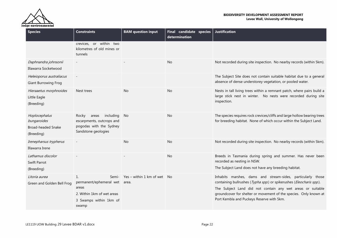
Table 6: Assessment of the habitat and geographic constraints on the Subject Land
Species Constraints BAM question input Final candidate species
determination
Justification
Anthochaera phrygia
Regent Honeyeater
(Breeding)
- - No There are three known key breeding areas, two of them in NSW -
Capertee Valley and Bundarra-Barraba regions. The species breeds
between July and January in Box-Ironbark and other temperate
woodlands and riparian gallery forest dominated by River Sheoak.
This is not present the Subject Land. Additionally, Noisy Miners and
other aggressive birds are present within the Subject Land that would
prevent nesting by the Regent Honeyeater.
The Subject Land does not have any breeding habitat.
Callocephalon fimbriatum
Gang-gang Cockatoo
(Breeding)
Hollow Bearing Trees No No Favours old growth forest and woodland attributes for nesting and
roosting. Nests are located in hollows that are 10 cm in diameter or
larger and at least 9 m above the ground in eucalypts.
The Subject Land does not have any breeding habitat.
Calyptorhynchus lathami
Glossy Black-Cockatoo
(Breeding)
Hollow Bearing Trees No No Dependent on large hollow-bearing eucalypts for nest sites. No
hollow bearing trees were present within the Subject Land.
The Subject Land does not have any breeding habitat.
Cercartetus nanus
Eastern Pygmy-possum
- - No In accordance with section 6.4.1.17, after carrying out field assessment
of the habitats and microhabitats, the habitat is considered
substantially degraded such that the species is unlikely to utilise the
Subject Land.
The Subject Land was absent of any preferential feed trees, notably
banksia, nor were there any suitable hollow bearing trees.
Chalinolobus dwyeri
Large-eared Pied Bat
1. Cliffs
2. Within two kilometres of
rocky areas containing
caves, overhangs,
escarpments, outcrops, or
Yes No The Subject Land does not have cliffs. The Subject Land is however
within two kilometres of rocky areas containing caves, overhangs,
escarpments, outcrops, crevices of old mines or tunnels, nevertheless,
the habitat is considered substantially degraded such that the species
is unlikely to utilise the Subject Land. No nearby records (within 5km).
BIODIVERSITY DEVELOPMENT ASSESSMENT REPORT
Levee Wall, University of Wollongong
LE1119 UOW Building 29 Levee BDAR v1.docx Page 22
Species Constraints BAM question input Final candidate species
determination
Justification
crevices, or within two
kilometres of old mines or
tunnels
Daphnandra johnsonii
Illawarra Socketwood
- - No Not recorded during site inspection. No nearby records (within 5km).
Heleioporus australiacus
Giant Burrowing Frog
- The Subject Site does not contain suitable habitat due to a general
absence of dense understorey vegetation, or pooled water.
Hieraaetus morphnoides
Little Eagle
(Breeding)
Nest trees No No Nests in tall living trees within a remnant patch, where pairs build a
large stick nest in winter. No nests were recorded during site
inspection.
Hoplocephalus
bungaroides
Broad-headed Snake
(Breeding)
Rocky areas including
escarpments, outcrops and
pogodas with the Sydney
Sandstone geologies
No No The species requires rock crevices/cliffs and large hollow bearing trees
for breeding habitat. None of which occur within the Subject Land.
Irenepharsus trypherus
Illawarra Irene
- No No Not recorded during site inspection. No nearby records (within 5km).
Lathamus discolor
Swift Parrot
(Breeding)
- - No Breeds in Tasmania during spring and summer. Has never been
recorded as nesting in NSW.
The Subject Land does not have any breeding habitat.
Litoria aurea
Green and Golden Bell Frog
1. Semi-
permanent/ephemeral wet
areas
2. Within 1km of wet areas
3 Swamps within 1km of
swamp
Yes – within 1 km of wet
area.
No Inhabits marshes, dams and stream-sides, particularly those
containing bullrushes (Typha spp.) or spikerushes (Eleocharis spp.).
The Subject Land did not contain any wet areas or suitable
groundcover for shelter or movement of the species. Only known at
Port Kembla and Puckeys Reserve with 5km.

BIODIVERSITY DEVELOPMENT ASSESSMENT REPORT
Levee Wall, University of Wollongong
LE1119 UOW Building 29 Levee BDAR v1.docx Page 23
Species Constraints BAM question input Final candidate species
determination
Justification
4. Waterbodies within 1km
of waterbody
Lophoictinia isura
Square-tailed Kite
(Breeding)
- - No Nest sites generally located along or near watercourses. No nests
were recorded during site survey.
The Subject Land does not have any breeding habitat.
Miniopterus australis
Little Bent-winged Bat
(Breeding)
Cave, tunnel, mine, culvert
or other structure known or
suspected to be used for
breeding
No No roost in caves, tunnels, tree hollows, abandoned mines, stormwater
drains, culverts, bridges and sometimes buildings, none of which
occur within the Subject Land. Only five nursery sites/maternity
colonies are known within Australia.
Miniopterus orianae
oceanensis
Large Bent-winged Bat
(Breeding)
Cave, tunnel, mine, culvert
or other structure known or
suspected to be used for
breeding
No No Caves are the primary roosting habitat, but also use derelict mines,
storm-water tunnels, buildings and other man-made structures.
The Subject Land does not have any breeding habitat.
Mixophyes balbus
Stuttering Frog
This species is found in rainforest and wet, tall open forest in the
foothills and escarpment on the eastern side of the Great Dividing
Range. Adults require deep leaf litter and this understorey vegetation.
The Subject Land does not contain suitable habitat. No nearby
records (within 5km).
Myotis macropus
Southern Myotis
1. Hollow bearing trees
2. Within 200 m of riparian
zone
3. Bridges, caves or artificial
structures within 200 m of
riparian zone
No No The Subject Land does not contain any hollow bearing trees, is more
than 200 m from a riparian zone with standing water, and does not
contain bridges, caves or artificial structures.
The Subject Land does not contain suitable habitat. No nearby
records (within 5km).
Ninox connivens
Barking Owl
(Breeding)
Hollow bearing trees,
hollow great than 20cm in
diameter
No This species roosts in shaded portions of tree canopies, including tall
midstorey trees with dense foliage such as Acacia and Casuarina
species. During nesting season, the male perches in a nearby tree
overlooking the hollow entrance.
BIODIVERSITY DEVELOPMENT ASSESSMENT REPORT
Levee Wall, University of Wollongong
LE1119 UOW Building 29 Levee BDAR v1.docx Page 24
Species Constraints BAM question input Final candidate species
determination
Justification
The Subject Land does not have any breeding habitat.
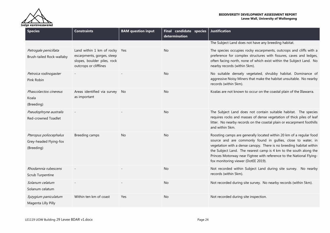
Petrogale penicillata
Brush-tailed Rock-wallaby
Land within 1 km of rocky
escarpments, gorges, steep
slopes, boulder piles, rock
outcrops or clifflines
Yes No The species occupies rocky escarpments, outcrops and cliffs with a
preference for complex structures with fissures, caves and ledges,
often facing north, none of which exist within the Subject Land. No
nearby records (within 5km).
Petroica rodinogaster
Pink Robin
- - No No suitable densely vegetated, shrubby habitat. Dominance of
aggressive Noisy Miners that make the habitat unsuitable. No nearby
records (within 5km).
Phascolarctos cinereus
Koala
(Breeding)
Areas identified via survey
as important
No No Koalas are not known to occur on the coastal plain of the Illawarra.
Pseudophryne australis
Red-crowned Toadlet
- - No The Subject Land does not contain suitable habitat. The species
requires rocks and masses of dense vegetation of thick piles of leaf
litter. No nearby records on the coastal plain or escarpment foothills
and within 5km.
Pteropus poliocephalus
Grey-headed Flying-fox
(Breeding)
Breeding camps No No Roosting camps are generally located within 20 km of a regular food
source and are commonly found in gullies, close to water, in
vegetation with a dense canopy. There is no breeding habitat within
the Subject Land. The nearest camp is 4 km to the south along the
Princes Motorway near Figtree with reference to the National Flying-
fox monitoring viewer (DotEE 2019).
Rhodamnia rubescens
Scrub Turpentine
- - No Not recorded within Subject Land during site survey. No nearby
records (within 5km).
Solanum celatum
Solanum celatum
- - No Not recorded during site survey. No nearby records (within 5km).
Syzygium paniculatum
Magenta Lilly Pilly
Within ten km of coast Yes No Not recorded during site inspection.

BIODIVERSITY DEVELOPMENT ASSESSMENT REPORT
Levee Wall, University of Wollongong
LE1119 UOW Building 29 Levee BDAR v1.docx Page 25
Species Constraints BAM question input Final candidate species
determination
Justification
Tyto novaehollandiae
Masked Owl
(Breeding)
Hollow bearing trees,
hollow greater than 20cm
in diameter
- No Roosts and breeds in moist eucalypt forested gullies, using large tree
hollows or sometimes caves for nesting. The Subject Land does not
have any breeding habitat.
Zieria granulata
Illawarra Zieria
- - No Not recorded during site survey. No nearby records (within 5km).
*species habitat associations informed by DPIE (2019) species profiles and species records assessed via Bionet (2019)

BIODIVERSITY DEVELOPMENT ASSESSMENT REPORT
Levee Wall, University of Wollongong
LE1119 UOW Building 29 Levee BDAR v1.docx Page 26
5.2 DETERMINE PRESENCE OR ABSENCE OF A CANDIDATE SPECIES
CREDIT SPECIES
5.2.1 TARGETED FIELD SURVEYS – FLORA
The following survey methods were undertaken on the 13th November 2019 by ecologists Jack
Talbert and Elira Reynolds:
• identification of plant species and vegetation communities present within the site with
comparison made to the DPIE (2016) Biometric Vegetation Type mapping
• search for signs of threatened species, observe and record significant flora, threatened
species and other incidental observations
• observe and record current disturbance and threats (e.g. weeds, grazing, trampling, litter)
• identifying potential habitat for threatened species (e.g. creeks, geology etc)
• recording presence of environmental weeds
• taking reference photographs of the entire site.
Following vegetation and habitat assessment undertaken on 13 November, the Subject Land was
considered too degraded to retain any habitat for candidate flora species in accordance with
Section 6.4.1.17. A species survey was conducted during the time period specified in the
Threatened Biodiversity Data Collection (s6.5.1.2 of the BAM) regardless.
Due to the small size of the Subject Land, thorough searches were taken throughout the entire
Subject Land. No candidate threatened flora species were recorded on the Subject Land. A
species list is included in Appendix B.
5.2.2 FIELD SURVEYS – FAUNA
The following survey methods were undertaken on the 13 November 2019 by ecologists Jack
Talbert and Elira Reynolds:
• search for signs of threatened species, observe and record significant fauna, threatened
and migratory species and other incidental observations
• identifying potential habitat for threatened species (e.g. hollow bearing trees, exfoliating
bark, boulders creeks, geology etc)
• taking reference photographs of the entire site.
The Subject Land was considered too degraded to retain any habitat for all candidate fauna
species in accordance with Section 6.4.1.17. Due to the small size of the Subject Land, searches
were still taken throughout the entire area. Opportunistic observations of fauna were recorded
during the survey, along with any sightings of scat, markings, signs of site usage, hair, feathers,
etc.
The Subject Land is homogenous in poor habitat condition with no hollow bearing trees, no trees
greater than 40 years, no mid stratum, wet areas, or rocky outcrops. The Subject Land exists as a

BIODIVERSITY DEVELOPMENT ASSESSMENT REPORT
Levee Wall, University of Wollongong
LE1119 UOW Building 29 Levee BDAR v1.docx Page 27
planted roadside of native vegetation. The Subject Land is considered to provide the following
limited fauna habitat only:
• intact canopy suitable for foraging by common arboreal mammals and birds.
A total of 6 fauna species were identified within the Subject Land. A species list is included in
Appendix C.
No candidate threatened fauna species were recorded on the Subject Land.
5.2.3 SURVEY WEATHER
The weather during the field survey on 13 November 2019 is summarised below.
• Temperature on the day: 17.8 – 21.9°C
• Dominant NE wind of 56 km/hr
• 0mm rainfall
• 64% humidity
• Low cloud cover
Observations were drawn from Bellambi AWS {station 068228}.
5.2.4 SURVEY LIMITATIONS
Habitat assessments were conducted to predict the likelihood of species occurrence at the site. A
conservative approach was applied in the assumption of the presence of species that could
potentially occur within the Subject Land. In this regard, the survey is considered adequate for
the purposes of this report. The aim of the survey was to record as many species as possible
within the timing and budgetary constraints of the project. A definitive list is not considered
possible (i.e. multiple seasons over longer periods) however the survey carried out is suitable to
accurately define the vegetation communities, condition and threatened flora and fauna presence
or likelihood.
5.3 DETERMINE THE AREA OR COUNT, AND LOCATION OF
SUITABLE HABITAT FOR A SPECIES CREDIT SPECIES
The Subject Land did not contain any confirmed candidate species. Targeted surveys for species
credit species were not required to be undertaken in accordance with Section 6.5 of the BAM.
BIODIVERSITY DEVELOPMENT ASSESSMENT REPORT
Levee Wall, University of Wollongong
LE1119 UOW Building 29 Levee BDAR v1.docx Page 28
6.0 AVOIDING AND MINIMISING IMPACTS
ON BIODIVERSITY VALUES
Inadequate consideration of avoiding and/or minimising biodiversity impacts can compromise
the approval of a development application. Consideration at an early stage in project planning
was therefore undertaken to allow for the greatest opportunities to reduce impacts on
biodiversity. The key consideration was the alignment of the retaining wall. The UOW landscape
manager was consulted to advise on the best location of the retaining wall to ensure minimal
impact on existing native vegetation, and where impacts were unavoidable, they were designed
to occur to trees of lesser value (i.e. younger age, lower health (SULE rating) and not a unique
species within the surrounding area).
6.1 NATIVE VEGETATION AND HABITAT DURING PROJECT
PLANNING
Entirely avoiding native vegetation was not possible, however, the extent of the impact has been
micro-sited through consultation with the university landscapers and minimised to the fullest
extent possible. All plants will be replaced by the university landscapers to ensure there will be
no net loss on the number of plants within the area. The patch of vegetation of which the Subject
Land is sited in will not lose any species that are unique to the patch and will retain the existing
condition and function.
Underscrubbing and vegetation management is currently occurring at the Subject Land to
maintain the area as a landscaped road verge. Management includes thinning of the ground
cover and midstorey, control of weeds, and control of rubbish. As a result, the vegetation exists
in a poor and modified state compared to that which would be expected for a remnant patch of
similar vegetation. The number and diversity of birds on the property, particularly passerines, was
also notably lower than it should have been, due largely to the lack of a shrub layer.
A genuine effort has been made to avoid and minimise the impacts of clearing of native
vegetation and habitat. The impacts associated with the proposal have been sited within a specific
area of the of the roadside vegetation, in a position that allows for the construction of the flood
mitigation works, but also avoids fragmenting the patch of vegetation. The impact is to occur to
trees on the eastern boundary only, directly adjacent to a car park, and running through a corridor
predominantly void of shrubs and ground covers.
Prescribed impacts have also been avoided or kept to a minimum. Table 8 details the prescribed
impacts relevant to the proposal and the planning that has been part of the proposal to minimise
these impacts.
In total, 0.045 ha of native vegetation communities is considered to be cleared by the proposed
development. The areas of vegetation to be cleared is included in the below table.
BIODIVERSITY DEVELOPMENT ASSESSMENT REPORT
Levee Wall, University of Wollongong
LE1119 UOW Building 29 Levee BDAR v1.docx Page 29
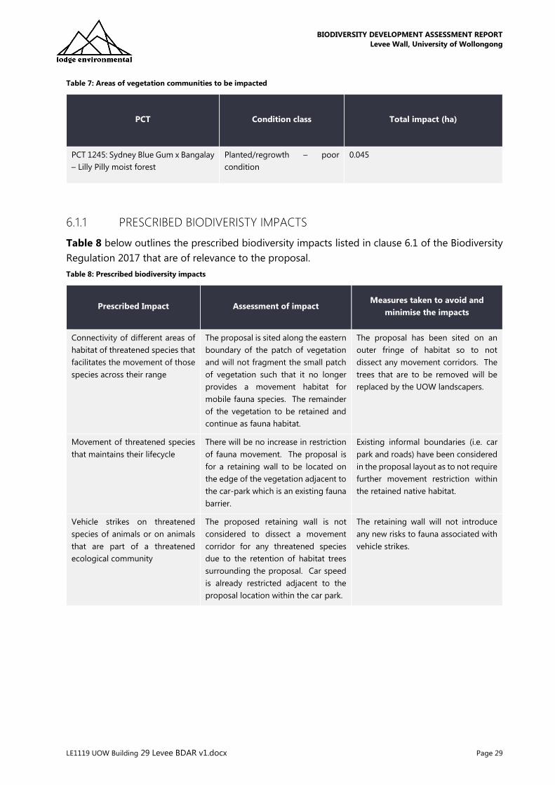
Table 7: Areas of vegetation communities to be impacted
PCT Condition class Total impact (ha)
PCT 1245: Sydney Blue Gum x Bangalay
– Lilly Pilly moist forest
Planted/regrowth – poor
condition
0.045
6.1.1 PRESCRIBED BIODIVERISTY IMPACTS
Table 8 below outlines the prescribed biodiversity impacts listed in clause 6.1 of the Biodiversity
Regulation 2017 that are of relevance to the proposal.
Table 8: Prescribed biodiversity impacts
Prescribed Impact Assessment of impact Measures taken to avoid and
minimise the impacts
Connectivity of different areas of
habitat of threatened species that
facilitates the movement of those
species across their range
The proposal is sited along the eastern
boundary of the patch of vegetation
and will not fragment the small patch
of vegetation such that it no longer
provides a movement habitat for
mobile fauna species. The remainder
of the vegetation to be retained and
continue as fauna habitat.
The proposal has been sited on an
outer fringe of habitat so to not
dissect any movement corridors. The
trees that are to be removed will be
replaced by the UOW landscapers.
Movement of threatened species
that maintains their lifecycle
There will be no increase in restriction
of fauna movement. The proposal is
for a retaining wall to be located on
the edge of the vegetation adjacent to
the car-park which is an existing fauna
barrier.
Existing informal boundaries (i.e. car
park and roads) have been considered
in the proposal layout as to not require
further movement restriction within
the retained native habitat.
Vehicle strikes on threatened
species of animals or on animals
that are part of a threatened
ecological community
The proposed retaining wall is not
considered to dissect a movement
corridor for any threatened species
due to the retention of habitat trees
surrounding the proposal. Car speed
is already restricted adjacent to the
proposal location within the car park.
The retaining wall will not introduce
any new risks to fauna associated with
vehicle strikes.

BIODIVERSITY DEVELOPMENT ASSESSMENT REPORT
Levee Wall, University of Wollongong
LE1119 UOW Building 29 Levee BDAR v1.docx Page 30
Figure 10: Areas of impacted land assessed within this BDAR. Circular areas represent tree for removal (4 in total)

BIODIVERSITY DEVELOPMENT ASSESSMENT REPORT
Levee Wall, University of Wollongong
LE1119 UOW Building 29 Levee BDAR v1.docx Page 31
6.1.2 KOALA SEPP 44
SEPP 44 aims to encourage the proper conservation and management of areas of natural
vegetation that provide habitat for Phascolarctos cinereus (Koala) to ensure a permanent free-
living population over their present range and reverse the current trend of Koala population
decline.
The site is not considered core, or potential, koala habitat as defined under SEPP 44 for the below
reasons:
• the Subject Land does not contain an area of land with a resident population of koalas or
recent sightings and historical records of a population
• the native vegetation within the Subject Land does not contain at least 15% of trees listed
in Schedule 2 of the SEPP.

BIODIVERSITY DEVELOPMENT ASSESSMENT REPORT
Levee Wall, University of Wollongong
LE1119 UOW Building 29 Levee BDAR v1.docx Page 32
7.0 IMPACT SUMMARY AND OFFSET
ASSESSMENT
7.1 DIRECT IMPACT
The direct impact imposed by the proposal is due to the construction of a flood mitigation wall,
which will include a retaining wall, gabian wall, and the removal of 17 trees. The total impact on
vegetation is 0.045 ha and has been assessed within the report. This will occur to PCT 1245 in a
poor condition, and not associated with a Threatened Ecological Community.
The total clearance of 0.045 ha of native vegetation has been considered within this report.
Within the native vegetation proposed to be impacted, the shrub layer is nearly entirely absent,
with the retaining wall being strategically located to avoid the more dense adjacent areas. The
trees which require removal are estimated at less than 40 years old and did not have any habitat
features such as hollows or fissures.
7.2 INDIRECT IMPACTS
Indirect impacts occur when project-related activities affect species or ecological communities in
a manner other than direct loss within the Subject Land. Indirect impacts may sterilise or reduce
the habitability of adjacent or connected habitats.
The proposal is not considered to impact any fauna through indirect impacts such as starvation,
exposure, predation by domestic and/or feral animals, loss of breeding opportunities, loss of
shade/shelter, reduction in viability of adjacent habitat due to edge effects, deleterious
hydrological changes, increased soil salinity, erosion, inhibition of nitrogen fixation, weed invasion,
noise, light spill, fertiliser drift, or increased human activity within or directly adjacent to sensitive
habitat areas. Considerable disturbance exists surrounding the proposed retaining wall area and
therefore the addition of the wall will not introduce any new disturbances to those surrounding.
Additionally, the wall has been sited to ensure no fragmentation to any biodiversity linkages.
7.3 MITIGATION MEASURES
As discussed earlier, the proposal has been sited to minimise impacts as much as possible. The
UOW landscape manager was engaged to inform the retaining wall alignment such that a
minimum number of trees are removed, and the ones selected are of a lesser value or poorer
health/SULE rating. It was not possible to avoid all native trees, and therefore the below mitigation
measures will be implemented to reduce the residual impact of the proposal.
Tree and habitat replacement
The proposal has been sited to minimise impacts to native vegetation. UOW has full time
landscapers who will replace the trees for removal with similar species as soon as construction is

BIODIVERSITY DEVELOPMENT ASSESSMENT REPORT
Levee Wall, University of Wollongong
LE1119 UOW Building 29 Levee BDAR v1.docx Page 33
complete. The trees removed shall be replaced using plantings sourced from a local provenance
nursery such as the Wollongong Botanic Gardens Nursery. The trees shall be representative of
the indigenous vegetation communities.
Where possible, logs and felled timber will be retained within the adjacent vegetation to act as
habitat for fauna.
Weed removal will be undertaken using mechanical and manual means, with any use of herbicides
to be given careful consideration to impacts on aquatic habitat.
Construction and Environmental Management Plan
A Construction and Environmental Management Plan (CEMP) will be prepared that will outline
appropriate erosion, sediment and control protocols for implementation during construction.
This will ensure there are no impacts from erosion associated with the construction. Drainage will
be controlled in line with the Protection of the Environment Operations Act 1997 to avoid impacts
downstream. The sediment and erosion measures are to be in accordance with best practice
guidelines (Landcom 2004).
Equipment, heavy machinery and materials will be situated in designated lay-down areas in the
adjacent car park where they are least likely to cause erosion, or damage to vegetation.
Tree removal measures will also be included within the CEMP. These will state that:
• Prior to the removal of any tree, each tree will be inspected by a qualified ecologist. The
ecologist will remain on site for the duration of the tree removal to ensure any fauna
enouctered is relocated. The ecologist will be commissioned at least 5 days prior to the
removal of any trees.
• if felled vegetation cannot be retained as ground habitat, it must be mulched and
stockpiled on site. The mulch and stockpiling must be appropriately controlled with
sediment fencing. The mulch will be reused on site.
• Councils tree preservation orders are to be observed at all times. All trees not specified
for removal are to be maintained during the works.
• All tree protection fencing is to be installed prior to any works being carried out and
maintained for the duration of the civil works.
7.4 ZONING
The Subject Land is zoned SP2 – Special Infrastructure: Education Establishment. The objectives
of this zoning are to:
• provide for infrastructure and related uses
• to prevent development that is not compatible with or that may detract form the provision
of infrastructure
• to provide for key transport corridors.
The proposal is not in contradiction to these objectives.

BIODIVERSITY DEVELOPMENT ASSESSMENT REPORT
Levee Wall, University of Wollongong
LE1119 UOW Building 29 Levee BDAR v1.docx Page 34
7.5 WATER MANAGEMENT ACT 2000
The Subject Land is within a riparian corridor, classified as 3rd order (Strahler Stream Order). It is
understood UOW has a landscape management plan for the riparian corridor which will allow for
the permanent protection and management of the riparian corridor. In accordance with the Water
Management Act, stormwater outlet structures and essential services are permissible, as listed
within the Riparian Corridor Matrix.
7.6 LOCAL PROVISIONS
The Subject Land is covered by Clause 7.4 ‘Riparian Lands’ of the Wollongong Local
Environmental Plan 2009 (WLEP). The development therefore must not adversely impact upon
riparian lands. The above-mentioned mitigation measures will ensure that there is no adverse
impact upon the riparian lands. The purpose of the proposal is to mitigate detrimental high
volume and high velocity flows and therefore improve the function of the riparian environment.
Specifically, a ‘Category 2’ watercourse is located within the southern extent of the Subject
Land. In accordance Chapter E23: Riparian Land Management of the Wollongong Development
Control Plan (WDCP) 2009, a Category 2 watercourse comprises a 30m extent ‘measured from
the top of a watercourse bank away from the watercourse centreline’, encompassing a 20m Core
Riparian Zone and a further 10m Vegetated Buffer’.
The development will abide by the ‘Riparian Corridor Objectives’ of a Category 2 watercourse,
which are to:
• Maintain/restore the natural functions of watercourses;
• Maintain the viability of native riparian vegetation;
• Minimise ‘edge effects’ at the riparian corridor / urban interface by the provision of a
suitable riparian corridor width;
• Maintain adequate riparian corridor width, based on geomorphological and
environmental
• considerations and to maintain or improve bank stability;
• Protect water quality of the watercourse through an adequate riparian corridor width;
• Restore the vegetation, geomorphic structure, hydrology and water quality of the riparian
• corridor to its original (pre-European) state, where practicable;
• Minimise the number of road crossings and such crossings are deigned to maintain
riparian connectivity;
• Restrict the encroachment of flood compatible development (e.g. playing fields) to the
edge of the riparian corridor rather than within the core riparian zone;
• Locate infrastructure or utility services (i.e. electricity, water, sewerage etc) outside the
riparian corridor, wherever practicable; and
• Treat stormwater run-off outside the riparian corridor before discharge into the
watercourse.
BIODIVERSITY DEVELOPMENT ASSESSMENT REPORT
Levee Wall, University of Wollongong
LE1119 UOW Building 29 Levee BDAR v1.docx Page 35
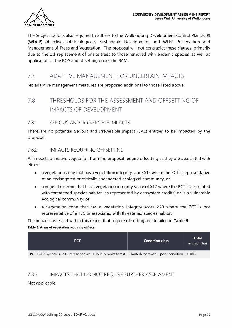
The Subject Land is also required to adhere to the Wollongong Development Control Plan 2009
(WDCP) objectives of Ecologically Sustainable Development and WLEP Preservation and
Management of Trees and Vegetation. The proposal will not contradict these clauses, primarily
due to the 1:1 replacement of onsite trees to those removed with endemic species, as well as
application of the BOS and offsetting under the BAM.
7.7 ADAPTIVE MANAGEMENT FOR UNCERTAIN IMPACTS
No adaptive management measures are proposed additional to those listed above.
7.8 THRESHOLDS FOR THE ASSESSMENT AND OFFSETTING OF
IMPACTS OF DEVELOPMENT
7.8.1 SERIOUS AND IRRIVERSIBLE IMPACTS
There are no potential Serious and Irreversible Impact (SAII) entities to be impacted by the
proposal.
7.8.2 IMPACTS REQUIRING OFFSETTING
All impacts on native vegetation from the proposal require offsetting as they are associated with
either:
• a vegetation zone that has a vegetation integrity score ≥15 where the PCT is representative
of an endangered or critically endangered ecological community, or
• a vegetation zone that has a vegetation integrity score of ≥17 where the PCT is associated
with threatened species habitat (as represented by ecosystem credits) or is a vulnerable
ecological community, or
• a vegetation zone that has a vegetation integrity score ≥20 where the PCT is not
representative of a TEC or associated with threatened species habitat.
The impacts assessed within this report that require offsetting are detailed in Table 9.
Table 9: Areas of vegetation requiring offsets
PCT Condition class Total
impact (ha)
PCT 1245: Sydney Blue Gum x Bangalay – Lilly Pilly moist forest Planted/regrowth – poor condition 0.045
7.8.3 IMPACTS THAT DO NOT REQUIRE FURTHER ASSESSMENT
Not applicable.
BIODIVERSITY DEVELOPMENT ASSESSMENT REPORT
Levee Wall, University of Wollongong
LE1119 UOW Building 29 Levee BDAR v1.docx Page 36
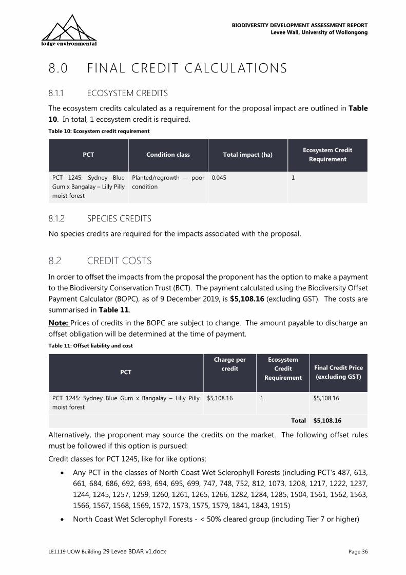
8.0 FINAL CREDIT CALCULATIONS
8.1.1 ECOSYSTEM CREDITS
The ecosystem credits calculated as a requirement for the proposal impact are outlined in Table
10. In total, 1 ecosystem credit is required.
Table 10: Ecosystem credit requirement
PCT Condition class Total impact (ha) Ecosystem Credit
Requirement
PCT 1245: Sydney Blue
Gum x Bangalay – Lilly Pilly
moist forest
Planted/regrowth – poor
condition
0.045 1
8.1.2 SPECIES CREDITS
No species credits are required for the impacts associated with the proposal.
8.2 CREDIT COSTS
In order to offset the impacts from the proposal the proponent has the option to make a payment
to the Biodiversity Conservation Trust (BCT). The payment calculated using the Biodiversity Offset
Payment Calculator (BOPC), as of 9 December 2019, is $5,108.16 (excluding GST). The costs are
summarised in Table 11.
Note: Prices of credits in the BOPC are subject to change. The amount payable to discharge an
offset obligation will be determined at the time of payment.
Table 11: Offset liability and cost
PCT
Charge per
credit
Ecosystem
Credit
Requirement
Final Credit Price
(excluding GST)
PCT 1245: Sydney Blue Gum x Bangalay – Lilly Pilly
moist forest
$5,108.16 1 $5,108.16
Total $5,108.16
Alternatively, the proponent may source the credits on the market. The following offset rules
must be followed if this option is pursued:
Credit classes for PCT 1245, like for like options:
• Any PCT in the classes of North Coast Wet Sclerophyll Forests (including PCT's 487, 613,
661, 684, 686, 692, 693, 694, 695, 699, 747, 748, 752, 812, 1073, 1208, 1217, 1222, 1237,
1244, 1245, 1257, 1259, 1260, 1261, 1265, 1266, 1282, 1284, 1285, 1504, 1561, 1562, 1563,
1566, 1567, 1568, 1569, 1572, 1573, 1575, 1579, 1841, 1843, 1915)
• North Coast Wet Sclerophyll Forests - < 50% cleared group (including Tier 7 or higher)

BIODIVERSITY DEVELOPMENT ASSESSMENT REPORT
Levee Wall, University of Wollongong
LE1119 UOW Building 29 Levee BDAR v1.docx Page 37
• Not containing HBTs
• In the IBRA subregions Illawarra , Ettrema, Jervis, Moss Vale, Sydney Cataract and Northern
Basalts or any IBRA subregion that is within 100 kilometres of the outer edge of the
impacted site.

BIODIVERSITY DEVELOPMENT ASSESSMENT REPORT
Levee Wall, University of Wollongong
LE1119 UOW Building 29 Levee BDAR v1.docx Page 38
9.0 CONCLUSION
This BDAR has been prepared by Accredited Assessor Jack Talbert (BAAS18140) in accordance
with the Biodiversity Conservation Regulation 2017 (BC Reg) and through application of the
Biodiversity Assessment Methodology (BAM) – case 00018261/BAAS18140/19/00018262.
After all avoidance and mitigation measures, the proposal will result in the maximum removal of
0.045 ha of native vegetation associated with poor, planted/regrowth PCT 1245: Sydney Blue Gum
x Bangalay – Lilly Pilly moist forest.
Application of the BAM requires that 1 Ecosystem Credit for PCT 1245: Sydney Blue Gum x
Bangalay – Lilly Pilly moist forest is retired by the proponent. This is calculated at a cost of
$5,108.16 if purchased from the Biodiversity Conservation Trust Fund, noting prices are subject to
change. The BAM Credit Calculator did not generate a requirement for any Species Credit offsets.

BIODIVERSITY DEVELOPMENT ASSESSMENT REPORT
Levee Wall, University of Wollongong
LE1119 UOW Building 29 Levee BDAR v1.docx Page 39
10.0 REFERENCES
Bureau of Meteorology (BOM) (2019) Temperature, humidity, wind, cloud and rainfall observations are from
Bellambi AWS {station 068228}. Pressure observations are from Albion Park (Shellharbour Airport) {station
068241}. http://www.bom.gov.au/climate/dwo/201911/html/IDCJDW2146.201911.shtml
Commonwealth Department of the Environment & Energy (2012). Interim Biogeographic Regionalisation
for Australia, Version 7. Available online: http://www.environment.gov.au/land/nrs/science/ibra/australias-
bioregions-maps
Department of Primary Industries (DPI) (2014). Noxious and environmental weed control handbook – A
guide to weed control in non-crop, aquatic and bushland situations. 6th Edition. Department of Trade and
Investment, Regional Infrastructure and Services. Available at:
http://www.dpi.nsw.gov.au/content/agriculture/pests-weeds/weeds/publications/noxious-enviro-weed-
control
DPIE (2016). NSW Guide to Surveying Threatened Plants.
https://www.environment.nsw.gov.au/resources/threatenedspecies/160129-threatened-plants-survey-
guide.pdf
Department of Planning, Industry and Environment (DPIE) (2019). Atlas of NSW Wildlife. Wildlife Data Unit,
DPIE, Parramatta NSW. Accessed 1 October 2018. Available at
http://www.environment.nsw.gov.au/atlaspublicapp/UI_Modules/ATLAS_/AtlasSearch.aspx
Department of Planning, Industry and Environment (DPIE) (2019). Threatened species profiles. Available at
http://www.threatenedspecies.environment.nsw.gov.au/index.aspx
Department of Planning, Industry and Environment (DPIE) (2019c). Threatened Species Test of Significance
Guidelines
DEC (2004). Threatened Species Survey and Assessment: Guidelines for developments and activities
(working draft). NSW Department of Environment and Conservation, Hurstville NSW
DotEE (2019). Protected Matters Report using coordinates -34.404079° 150.872880°. Report created:
27/11/19 10:52:37
Department of the Environment and Energy (2019). National Flying-fox Monitoring Program.
http://www.environment.gov.au/biodiversity/threatened/species/flying-fox-monitoring. Accessed 27
November 2019.
Fairley, A., & Moore, P. (2010). Native Plants of the Sydney Region. From Newcastle to Nowra and west to
the Dividing Range. Allen & Unwin
Google Earth (2018). -34.404079° 150.872880°, http://www.earth.google.com [Imagery date 2/24/2016]
Keith, D. (2004). Ocean shores to desert dunes: the native vegetation of New South Wales and the ACT.
NSW Department of Environment and Conservation, Hurstville.
Landcom (2004). Soils and Construction Volume 1 Managing Urban Stormwater., 4th Edition, March 2004.
Narla Environmental (2017). Flora and Fauna Assessment University of Wollongong New Arts and Social
Sciences Building. Prepared for University of Wollongong c/- Ethos Urban October 2017.
Tozer, M.G., Turner, K., Keith, D.A., Tindall, D., Pennay, C., Simpson, C., MacKenzie, B., Beukers, P. & Cox, S.
(2010). Native vegetation of southeast NSW: a revised classification and map for the coast and eastern
tablelands. Cunninghamia 11(3), 359-406.

BIODIVERSITY DEVELOPMENT ASSESSMENT REPORT
Levee Wall, University of Wollongong
LE1119 UOW Building 29 Levee BDAR v1.docx Page 40
11 .0 LIMITATIONS
This report and the associated services performed by Lodge Environmental are in accordance with
the scope of services set out in the contract between Lodge Environmental and the Client. The
scope of services was defined by the requests of the Client, by the time and budgetary constraints
imposed by the Client, and by the availability of access to Site.
Lodge Environmental derived the data in this report primarily from visual inspections, and, limited
survey and analysis made on the dates indicated. In preparing this report, Lodge Environmental
has relied upon, and presumed accurate, certain information provided by government authorities,
the Client and others identified herein. The report has been prepared on the basis that while
Lodge Environmental believes all the information in it is deemed reliable and accurate at the time
of preparing the report, it does not warrant its accuracy or completeness and to the full extent
allowed by law excludes liability in contract, tort or otherwise, for any loss or damage sustained
by the Client arising from or in connection with the supply or use of the whole or any part of the
information in the report through any cause whatsoever.
The data, findings, observations, conclusions and recommendations in the report are based solely
upon the state of the Site at the time of the investigation. The passage of time, manifestation of
latent conditions or impacts of future events (e.g. changes in legislation, scientific knowledge, land
uses, etc) may render the report inaccurate. In those circumstances, Lodge Environmental shall
not be liable for any loss or damage that may be occasioned directly or indirectly through the use
of, or reliance on, the contents of the report.
This report has been prepared on behalf of and for the exclusive use of the Client, and is subject
to and issued in connection with the provisions of the agreement between Lodge Environmental
and the Client. Lodge Environmental accepts no liability or responsibility whatsoever and
expressly disclaims any responsibility for or in respect of any use of or reliance upon this report
by any third party or parties.
It is the responsibility of the Client to accept if the Client so chooses any recommendations
contained within and implement them in an appropriate, suitable and timely manner.
BIODIVERSITY DEVELOPMENT ASSESSMENT REPORT
Levee Wall, University of Wollongong
LE1119 UOW Building 29 Levee BDAR v1.docx Page 41
Appendices

BIODIVERSITY DEVELOPMENT ASSESSMENT REPORT
Levee Wall, University of Wollongong
LE1119 UOW Building 29 Levee BDAR v1.docx Page 42
Appendix A: Vegetation Plot Data

BIODIVERSITY DEVELOPMENT ASSESSMENT REPORT
Levee Wall, University of Wollongong
LE1119 UOW Building 29 Levee BDAR v1.docx Page 43
Plot
ID
Composition Structure Function
Tree Shrub Grass Forb Fern Other Tree Shrub Grass Forb Fern Other Large
trees
>80
cm
Hollow
trees
Litter
cover
CWD Tree
stem
5-9
Tree
stem
10-
19
Tree
stem
20-29
Tree
stem
30-49
Tree
stem
50-79
Tree
regen
High
threat
exotic
Plot
1
13 6 2 1 1 3 93.1 9.1 2.5 0.1 0.1 2.1 0 0 77.6 3.5 26 32 23 4 5 Yes 3.3
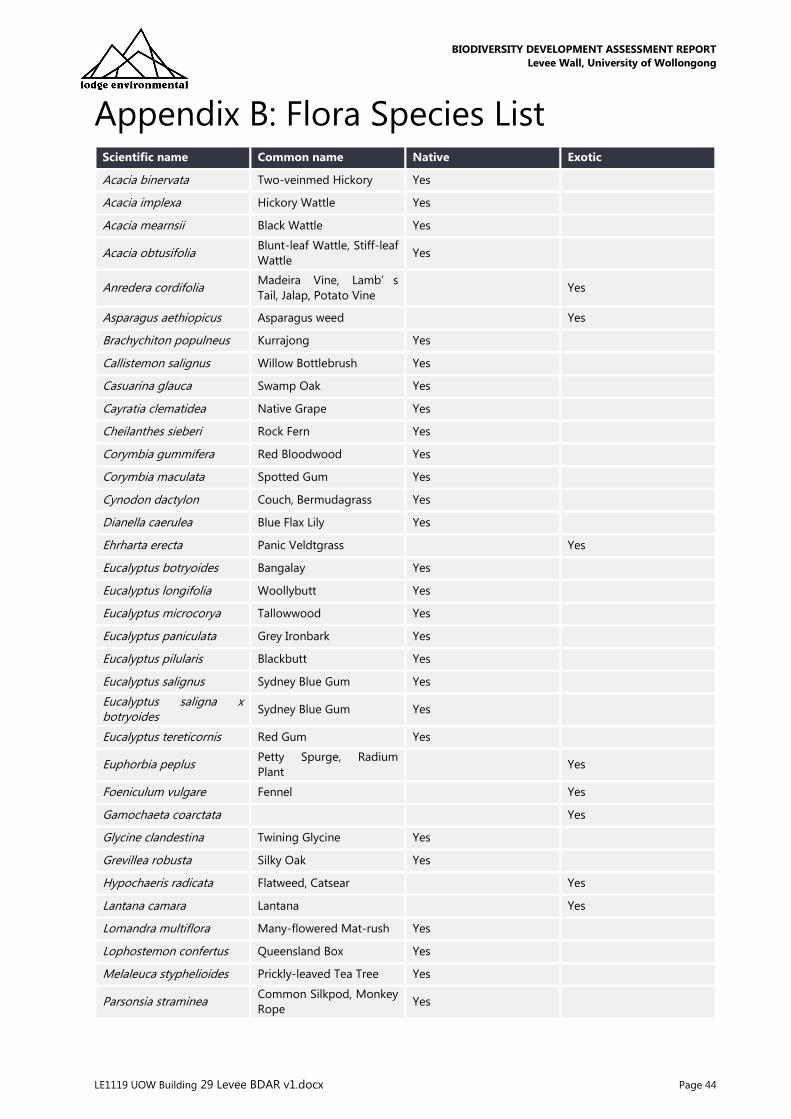
BIODIVERSITY DEVELOPMENT ASSESSMENT REPORT
Levee Wall, University of Wollongong
LE1119 UOW Building 29 Levee BDAR v1.docx Page 44
Appendix B: Flora Species List Scientific name Common name Native Exotic
Acacia binervata Two-veinmed Hickory Yes
Acacia implexa Hickory Wattle Yes
Acacia mearnsii Black Wattle Yes
Acacia obtusifolia Blunt-leaf Wattle, Stiff-leaf
Wattle Yes
Anredera cordifolia Madeira Vine, Lamb’s
Tail, Jalap, Potato Vine Yes
Asparagus aethiopicus Asparagus weed Yes
Brachychiton populneus Kurrajong Yes
Callistemon salignus Willow Bottlebrush Yes
Casuarina glauca Swamp Oak Yes
Cayratia clematidea Native Grape Yes
Cheilanthes sieberi Rock Fern Yes
Corymbia gummifera Red Bloodwood Yes
Corymbia maculata Spotted Gum Yes
Cynodon dactylon Couch, Bermudagrass Yes
Dianella caerulea Blue Flax Lily Yes
Ehrharta erecta Panic Veldtgrass Yes
Eucalyptus botryoides Bangalay Yes
Eucalyptus longifolia Woollybutt Yes
Eucalyptus microcorya Tallowwood Yes
Eucalyptus paniculata Grey Ironbark Yes
Eucalyptus pilularis Blackbutt Yes
Eucalyptus salignus Sydney Blue Gum Yes
Eucalyptus saligna x botryoides
Sydney Blue Gum Yes
Eucalyptus tereticornis Red Gum Yes
Euphorbia peplus Petty Spurge, Radium
Plant Yes
Foeniculum vulgare Fennel Yes
Gamochaeta coarctata Yes
Glycine clandestina Twining Glycine Yes
Grevillea robusta Silky Oak Yes
Hypochaeris radicata Flatweed, Catsear Yes
Lantana camara Lantana Yes
Lomandra multiflora Many-flowered Mat-rush Yes
Lophostemon confertus Queensland Box Yes
Melaleuca styphelioides Prickly-leaved Tea Tree Yes
Parsonsia straminea Common Silkpod, Monkey
Rope Yes

BIODIVERSITY DEVELOPMENT ASSESSMENT REPORT
Levee Wall, University of Wollongong
LE1119 UOW Building 29 Levee BDAR v1.docx Page 45
Pittosporum undulatum Native Daphne, Sweet
Pittosporum Yes
Pseuderanthemum variabile
Pastel Flower Yes
Senecio madagascariensis Fireweed Yes
Senna pendula Senna Yes
Syncarpia glomulifera Turpentine Yes
Solanum stelligerum - Yes
Syzygium australe Brush Cherry Yes
Trifolium glomeratum Clustered Clover Yes
Yucca aloifolia Yucca Yes
*denotes threatened species

BIODIVERSITY DEVELOPMENT ASSESSMENT REPORT
Levee Wall, University of Wollongong
LE1119 UOW Building 29 Levee BDAR v1.docx Page 46
Appendix C: Fauna Species List Class Name Scientific Name Common Name
Bird Anthochaera carunculata Red Wattlebird
Eopsaltria australis Eastern Yellow Robin
Grallina cyanoleuca Australian Magpie-lark
Gymnorhina tibicen Australian Magpie
Manorina melanocephala Noisy Myna
Acridotheres tristis Common Myna

BIODIVERSITY DEVELOPMENT ASSESSMENT REPORT
Levee Wall, University of Wollongong
LE1119 UOW Building 29 Levee BDAR v1.docx Page 47
Appendix D: Biodiversity Offset Payment
Calculator (BOPC) Report

Biodiversity Offset Payment CalculatorVersion: 2.0
Last updated: 04/11/2019 17:42
Message!If you would like to meet your offset obligation by making a payment to the Biodiversity Conservation Fund, please contact the BCT team [email protected] (mailto:[email protected])
Ecosystem credits for plant communities types (PCT), ecological communities & threatened species habitat
IBRAsubregion
PCTcommonname
Threatenstatus
Offsettradinggroup
Riskpremium
Administrativecost
Methodologyadjustment
factor
Chargeper
credit
No. ofecosystem
credits
Finalcreditscharge
Total ecosystem credits (incl. GST) $5,618.94
()
Credit Offset Payment Calculator ()
Payments ()

IBRAsubregion
PCTcommonname
Threatenstatus
Offsettradinggroup
Riskpremium
Administrativecost
Methodologyadjustment
factor
Chargeper
credit
No. ofecosystem
credits
Finalcreditscharge
Illawarra 1245 -Sydney BlueGum xBangalay -Lilly Pillymoist forestin gullies andon shelteredslopes,southernSydneyBasinBioregion
No NorthCoast WetSclerophyllForests;.<50%
19.72% $165.15 1.6690 $5,108.13 1 $5,108.13
Subtotal (excl. GST) $5,108.13
GST $510.81
Total ecosystem credits (incl. GST) $5,618.94
Calculated as on: 26/11/2019 14:51:07 Grand total $5,618.94