bio-inspired multi-agent data harvesting in a proactive
TRANSCRIPT
Bio-inspired Multi-Agent Data Harvesting in a Proactive UrbanMonitoring Environment∗
Uichin Lee†, Eugenio Magistretti‡, Mario Gerla†, Paolo Bellavista‡, Pietro Lio§, Kang-Won Lee�
†UCLA ‡University of Bologna §University of Cambridge �IBM Research
March 25, 2008
Abstract
Vehicular sensor networks (VSNs) enable brand new and promising sensing applications, such astraffic reporting, relief to environmental monitoring, and distributed surveillance. In our past work, wehave designed and implemented MobEyes, a middleware solution to support VSN-based urban monitor-ing, where agent vehicles (e.g., police cars) move around and harvest meta-data about sensed informationfrom regular VSN-enabled vehicles. In typical urban sensing operations, multiple agents should collabo-rate in harvesting and searching for key meta-data in parallel. Thus, it is critical to effectively coordinatethe harvesting operations of multiple agents in a decentralized and lightweight way. The paper presents anovel meta-data harvesting algorithm, called datataxis, whose primary idea is to effectively cover a largesearch area by properly alternating foraging behaviors inspired by E. coli chemotaxis and Levy flightsto favor agent movements towards “information patches” where the concentration of meta-data is high.The proposal avoids harvesting work duplication via stigmergy-based prevention of useless concentra-tion of agents in the same region at the same time. We have validated datataxis via extensive simulationsthat demonstrate how the proposed bio-inspired behavior of harvesting agents effectively balances theirmovements, by outperforming other decentralized strategies. Moreover, our solution has shown to berobust and to work well under a wide range of operation parameters, thus making it easily and rapidlydeployable for different urban sensing operations.
1 Introduction
Vehicular sensor networks (VSNs) are becoming increasingly popular and relevant to the industry due torecent advances in inter-vehicular communication technologies and decreasing cost of communication de-vices. Differently from traditional wireless sensor nodes, vehicles are not typically affected by energyconstraints and can easily be equipped with powerful processing units, wireless communication devices,GPS, and sensing devices such as chemical detectors, still/video cameras, vibration and acoustic sensors.Thus, they enable brand new and promising sensing applications, such as traffic reporting, relief to envi-ronmental monitoring, and distributed surveillance. In particular, there is an increasing interest in proactive
∗Research was sponsored in part by the U.S. Army Research Laboratory and the U.K. Ministry of Defence and was accom-plished under Agreement Number W911NF-06-3-0001. The views and conclusions contained in this document are those of theauthor(s) and should not be interpreted as representing the official policies, either expressed or implied, of the U.S. Army ResearchLaboratory, the U.S. Government, the U.K. Ministry of Defence or the U.K. Government. The U.S. and U.K. Governments areauthorized to reproduce and distribute reprints for Government purposes notwithstanding any copyright notation hereon. Corre-sponding author: Kang-Won Lee, E-mail address: [email protected].
1

urban sensing applications where vehicles continuously monitor events from urban streets, maintain senseddata in their local storage, process them (e.g., extracting license plate numbers from still images), and routemessages to vehicles in their vicinity to achieve a common goal (e.g., to allow police agents to pursue themovements of runaway cars). In general, VSNs could be an excellent complement to the fixed deploymentof static cameras/sensors. The distributed and opportunistic cooperation among sensor-equipped vehicleshas the additional benefit of making it harder for potential attackers to thwart the surveillance. Of course,this added level of surveillance capability may raise privacy concerns, but in general people are willingto accept it when only recognized authorities can collect and process these data for forensic purposes, forcounteracting terrorism, or simply for the common good (e.g., traffic jam reporting).
The above examples show that VSN-based urban monitoring often requires the collection, storage, andretrieval of massive amounts of sensed data. This is a major departure from conventional sensor networks,where data is dispatched to “sinks” for further processing. Obviously, it is impossible to deliver all thestreaming data collected by video sensors on regular cars to a police authority sink because of sheer vol-ume; also a-priori input filtering is usually impossible because nobody can anticipate which data will be ofuse for future investigations. Thus, there is the hard technical challenge to find a completely decentralizedsolution for VSN applications, with low overhead, good scalability, and tolerance to disruption caused bymobility/attacks. To that purpose, we have designed and implemented the MobEyes middleware 1 MobEyesagents (e.g., police cars) move around and harvest meta-data (with features about sensed data and contextinformation such as timestamp and location) when they are in direct communication range with regular ve-hicles; regular cars collect meta-data from other opportunistically encountered vehicles. In typical urbansensing operations, given the large scale of the targeted regions, multiple agents should collaborate in har-vesting distributed meta-data and searching for key information in parallel. Thus, it is critical to design aneffective mechanism to coordinate the movement of agents so that they can efficiently collect all meta-dataof interest in a totally decentralized and lightweight way. Multi-agent harvesting is a challenging problemdue to the very dynamic nature of the target environment (e.g., continuous meta-data creation/movement)and the scale of operation, without any a-priori knowledge of the needed meta-data location.
Based on the observation that social animals (ranging from bacteria to vertebrae) efficiently solve a par-tially similar challenge – namely the foraging problem to find good food sources, this paper presents a novelmulti-agent coordination algorithm for MobEyes harvesting agents that takes inspirations from biologicalsystems. In particular, we have considered multiple biological phenomena: (a) Foraging behavior of E. colibacteria that operate in distinct modes of locomotion based on the level of nutrient concentration; (b) Levywalk behavior of many biological organisms and groups, e.g., albatrosses and fishing boats, to improve foodsearch over large-scale regions; and (c) Stigmergy found in ants and other social insects that use varioustypes of pheromones to signal nest mates with potential conflicts, e.g., a sort of “no entry” sign. By delv-ing into finer details, we propose a novel harvesting strategy, called datataxis (a la chemotaxis of E. colibacteria), that guides the agents to stay and acquire meta-data on “information patches,” the regions wherenewly created and not-harvested meta-data are concentrated (based on a simple metric for meta-data densityestimation per road segment). Secondly, MobEyes harvesting agents adapt their behavior by following a3-state transition diagram that sometimes forces them to change their area of exploration by exploiting Levywalk-inspired movement patterns, which are considered suitable for the large scale of the typically targetedregions. Third, to avoid harvesting work duplication, MobEyes agents exploit stigmergy-inspired techniquesfor conflict resolution to prevent from useless concentration of agents in the same region at the same time.
We have thoroughly validated the datataxis performance via an extensive simulation study taking into
1We provide a brief overview of MobEyes in Section 2; interested readers can refer to [39] for the detailed description ofMobEyes architecture and protocols.

consideration different scenarios with different search areas, number of agents, and algorithm parametersettings. Using a Manhattan mobility model, we compare the harvesting efficiency of our datataxis foraging(DTF) with other decentralized harvesting strategies, such as random walk foraging (RWF), biased randomwalk foraging (BRWF), and an idealized preset pattern foraging (PPF) where agents have static knowledgeon meta-data density distribution. From this study, we show that DTF effectively balances the movementof multiple agents and well distributes them notwithstanding the minimum agent coordination needed. Thepaper also shows that DTF always performs better than RWF and BRWF, and very close to PPF in allcases. Finally, we analyze the sensitivity of DTF performance with respect to two key parameters (namely,constrained walk duration and constrained walk radius), thus demonstrating the DTF robustness for a widerange of the operation parameter space.
The remainder of the paper is organized as follows: Section 2 presents a brief overview of MobEyes toallow the full understanding of the following agent coordination proposal. Section 3 defines the addressedcoordination problem, while Section 4 describes the foraging behaviors in the nature that inspired our work.Then, we present our original datataxis solution for multi-agent coordination, which is extensively evaluatedin Section 6. Related work and conclusive remarks end the paper.
2 MobEyes Overview
We first describe two application scenarios that are representative of the MobEyes applications. Based onthese scenarios, we examine the key components of MobEyes, namely meta-data dissemination, meta-dataharvesting, and data access.
2.1 Urban Sensing Scenarios
In the first scenario, police agents use the background information collected by MobEyes-enabled vehiclesto investigate a tip that criminals might spread poisonous chemicals in a particular section of the city (say,major city intersection). The MobEyes vehicles are equipped with cameras and chemical detection sensors.In this scenario, a search of the MobEyes distributed database will help locate and verify the attack and trackthe criminal vehicles leading to their capture. In the second scenario, we assume there has been a suicidebombing at the Embassy. The police agents investigate the MobEyes database to reconstruct the itinerary ofthe attack vehicle and detect possible colluding vehicles.
These scenarios are both representative MobEyes surveillance applications. Yet, they are very differentin terms of search requirements. In the first case, there is great urgency to detect the location of the attackand possibly prevent it. In the second case, the investigation is more of forensic nature. Moreover, it ispossible that in the first case the MobEyes drivers will quickly become aware of the poison and escape thescene (not before taking pictures of the attack vehicles). The key is that whether MobEyes drivers perceive athreat or are unaware of any danger, they will move in the urban grid under the prevailing traffic constraints(traffic lights, congestion at major intersections, queues at freeway on ramps, etc). Experimental evidencefrom realistic urban simulations has shown that, as a result of the above traffic constraints, the vehiclescarrying the meta-data related to a particular event (e.g., gas leak, explosion, attack trajectory, kidnapping,etc) tend to form clusters that are uniformly distributed over a relatively large area. This observation is usedin designing an effective search strategy.

2.2 MobEyes Protocol
In MobEyes, vehicles continuously generate a huge amount of sensed data, store it locally, and periodicallyproduce small size meta-data chunks obtained by processing the sensed data, e.g., license plate numbers oraggregated chemical readings. They include meta-data associated with the sensed data (e.g., vehicle posi-tion, timestamp, vehicle ID number and possible additional context such as simultaneous sensor alerts) andthe features of interest extracted by local filters. A set of chunks are packed into a single packet for effi-ciency. This section briefly describes our diffusion protocol that is used by non-agent vehicles (i.e., regularnodes) to opportunistically spread meta-data by exploiting mobility. The diffused meta-data represent thefirst level distributed index that can be used to support targeted searches. It then describes the meta-dataharvesting protocol used by agent vehicles, where are policy cars in our example. The police agents performproactive harvesting in the background to build a second level distributed index of sensed data that resideson agent vehicles. The index is locally processed by police vehicles to detect possible anomalies and trig-ger alarms, and may also be interrogated electronically from the Central Office in response to time criticalqueries, for example. Finally, we describe how the actual data can be retrieved. Note that additional detailsabout the design and implementation of the MobEyes prototype are out of the scope of this paper. Interestedreaders are referred to [5].
2.2.1 Meta-data Diffusion
A regular node periodically advertises newly generated meta-data to its neighbors in order to increase theopportunities for agents to harvest the meta-data. Clearly, excessive advertising will introduce too muchoverhead, whereas too few advertising will result in delayed data harvesting, as agents will need to contactmore vehicles to complete the harvesting process. MobEyes tries to balance the trade-off between harvestinglatency and advertisement overhead. In the meta-data advertisement, the packet header includes a packettype, generator ID, locally unique sequence number, packet generation timestamp, and generator’s currentposition. Each packet is uniquely identified by the generator ID and its sequence number pair, and containsa set of meta-data locally generated during a fixed time interval.
Neighbor nodes receiving a packet store it in their local meta-data databases. Therefore, depending onthe mobility and the encounters of regular nodes, packets are opportunistically diffused into the networkof vehicles. We call this a passive diffusion. MobEyes can be configured to perform either single-hoppassive diffusion (only the source advertises its packet to current single-hop neighbors) or k-hop passivediffusion (the packet travels up to k-hop as it is forwarded by j-hop neighbors with j < k). As detailed inthe experimental evaluation section, we find it is sufficient for MobEyes to use a lightweight k-hop passivediffusion strategy with very small k values to achieve a desired level of diffusion.
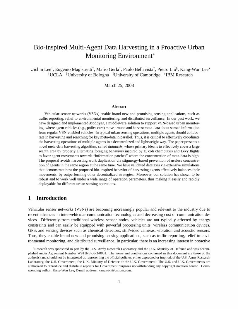
Figure 1 depicts the operation of MobEyes with the case of two sensor nodes, C1 and C2, whose radioranges are represented as dotted circles. In the figure, a black triangle with timestamp represents an en-counter. According to the MobEyes meta-data diffusion protocol, C1 and C2 periodically advertise a newmeta-data packet SC1,1 and SC2,1 respectively where the subscript denotes 〈ID, Seq.#〉. At time T − t4,C2 encounters C1, and thus they exchange these advertisements. As a result, C1 carries SC2,1 and C2carries SC1,1. We note that meta-data diffusion is time and location sensitive, i.e., it is spatial-temporalinformation diffusion. In fact, regular nodes keep track of the freshness of meta-data packets by using asliding window with the maximum window size of a fixed expiration time. In addition, since a single ad-vertisement packet may contain multiple meta-data records, it is possible to define packet sensing locationas the average position of all meta-data in the packet. When a packet expires or the packet originator moves
TT
T-t6
T-t5T-t4
T-t3
T-t2
T-t1
Trajectory
C1C2
Advertise Advertise
Encounter Point
Time Sum.0
T-t4SC1,1
SC2,1
Time Sum.0
T-t4SC2,1
SC1,1
Figure 1: MobEyes single-hop passive diffusion
away more than a threshold distance from the packet sensing location, the packet is automatically disposed.The expiration time and the maximum distance are system parameters that should be configured dependingon the requirements of an urban monitoring application.
2.2.2 Meta-data Harvesting
In parallel with the meta-data diffusion, the MobEyes agents may collect meta-data from regular nodes byperiodically querying the nearby nodes. The goal of meta-data harvesting is to collect all the meta-datagenerated in a specified area. For efficiency, a police agent should harvest only those meta-data packets thathave not been collected already. In order to identify missing packets, a MobEyes agent node compares its listof meta-data packets with that of its neighbors, by exploiting a space-efficient data structure for membershipchecking. In our design, a MobEyes agent uses a Bloom filter to advertise its set of recently harvested meta-data packets. Since each meta-data has a unique node ID and sequence number pair, we use this as inputfor the hash functions of the Bloom filter. When an agent broadcasts a harvest request message it includes aBloom filter for the meta-data it has already harvested. Upon receiving this, a regular node prepares a list ofpackets that are not already in the agent’s packet list, and sends them to the agent using a random back-offto minimize collisions. In response, the agent sends back an acknowledgment with a piggybacked list ofsuccessfully received packets. Upon overhearing this, each neighbor updates their list of packets to send.
In the basic design of MobEyes, we have only considered a single agent scenario or a multi-agent scenariowhere the agents harvested data without coordination using random movement [39]. In general, however,we envision that there will be multiple collaborating agents that try to harvest important information con-currently. Thus MobEyes should support the operation of multiple agents. In effect, multiple agents createa distributed and partially replicated index of sensed data. The main goal of this paper is to strategicallycontrol the trajectory of agent nodes to efficiently harvest meta-data so that they can be collectively used forlater data access. We present a detailed problem description for this paper in the next section.
2.2.3 Data Access
In vehicular area networks (VANETs), geographic routings (or geo-routings) have been investigated exten-sively for its scalability. To handle intermittent connectivity due to heterogeneous vehicle distribution andtime-of-day effects (e.g., during off-rush hours and in peripheral areas), mobility has been exploited to “as-

sist” geo-routing; i.e., a vehicle carries packets and forwards them to a newly found vehicle that is movingtowards the destination [38, 68, 72]. A prerequisite for geo-routing is a location service that tells where thedestination is. However, it is challenging to devise an efficient, scalable, and robust location service protocoldue to the dynamic nature of vehicular networks (mobility, channel errors) [71]. An elegant way of reducingthis cost is by exploiting spatial-temporal correlation that exists in most realistic mobility patterns; i.e., thedistance between two nodes is more or less correlated with the time elapsed since they last encountered eachother. This observation brought forth Last Encounter Routing (LER) [31]. In MobEyes, since each vehiclecan piggyback the current position into its meta-data advertisement, LER can be supported at no extra cost.LER, however, does not address the intermittent connectivity problem. In MobEyes, LER is enhanced withthe carry-and-forward functionality. The enhanced LER plays a key role when an agent tries to retrieve theactual data, or to send a dump request to the target vehicle.
3 Problem Definition: Multi-Agent Coordination
Our primary objective of this paper is to design an algorithm to control the movement of multiple agents toharvest dynamically generated meta-data in an unspecified region as efficiently as possible.
The design goals for our multi-agent harvesting algorithm can be summarized as follows.
• Low communication overhead: The protocol should not involve a tight, close range control of agents’movement based on continuous streaming of agents coordinates since it would incur heavy commu-nication overhead. Also such a scheme is not robust in the face of intermittent connectivity.
• Efficiency: The protocol must be efficient. Ideally, we want our algorithm to perform similarly to acentralized coordination algorithm, in terms of data harvesting efficiency (i.e., how fast can we collectall of the interested data) and the control efficiency of agents movement (i.e., how much redundantdata collection could be avoided).
• Self-organization: The protocol should be self-organizing and adaptive to the dynamics of the envi-ronment, such as the changes in the movement patterns and densities of the vehicles in VSN and thedata carried by those vehicles, and also to the dynamic events and creation of interesting data.
• Delay tolerance: Some or most part of the network formed by vehicles may exhibit intermittentconnectivity. Hence, we require our algorithm to work well in a delay tolerant scenario.
For all the requirements listed above, we notice that the nature has already solved a similar problem.In particular, social insects and animals coordinate their efforts to effectively collect food without priorknowledge of the food sources; yet they are known to solve this problem quite effectively, if not optimally[60]. According to the foraging theory, animals are presumed to search for nutrients and obtain them in away to maximize the ratio of energy intake over the time spent for foraging. In effect, they are solving themulti-agent harvesting problem.
We also notice that our problem is related to a problem found in robotics, in which multiple “cooperative”robots try to complete a task quickly and reliably. In this case, three generic multi-agent tasks have beenconsidered, namely forage, consume, and gaze. The forage task is to wander around the environment lookingfor the items of interests (attractors) [50]. After picking up these items, the robot agent takes them to aspecified home base. Similarly to forage, the consume task involves wandering about the environment tofind attractor, but upon finding an attractor, it performs a task on the object (e.g., toxic waste cleanup,

assembly) [66]. In the gaze task, a robot searches for an area that has not been gazed, moves towards it, andthen gazes over it until the entire environment has been covered (e.g., vacuuming house, lawn mowing) [43].Our meta-data harvesting scenario is similar to the consume task. However, there is a major difference. Inour case, the data sources are mobile and the meta-data are epidemically disseminated in the network. Sincevehicles move in an urban grid, it is possible that after a while the same area may become “productive”again, as more data pours in from alternate paths or (in the case of trajectory tracking) from different viewpoints. Thus, harvested areas are replenishable after a time-out and for a limited period. To the best of ourknowledge, the literature in cooperative robots did not deal with this scenario.
4 Foraging Behaviors in the Nature
We review key foraging behaviors observed in the nature that can be applied to tackle our problem. We firstreview the social foraging behavior of insects such as ants and honey bees. These insects use stigmergy ordances to communicate information about the food sources and recruit other members. We then review thechemotaxes of E. coli bacteria, which operates in various modes, i.e., for searching nutrients and movingtowards an area whose density in nutrients is high. Finally, we review the model for Levy walk, which canbe used to take agents to a relatively long distance so that when multiple agents collide in the same area, andexhibit an efficient search behavior.
4.1 Stigmergy
Information harvesting, which is our main theme of this paper, is directly related to the food foragingproblem solved by stigmergy. Ants need to find routes in an effective manner to possibly ephemeral foodsources. Since it is not immediately obvious how long the current site will remain as a valid foraging site,they have to solve a dynamic problem of remembering a rewarding source while exploiting newly discoveredfood sites. It has been established that ants can optimize their foraging by selecting the most rewardingsource. Several works have confirmed that the selection is the result of a trail modulation according to foodquality, and have shown the existence of an optimal quantity of laid pheromone for which the selection ofa source is at the maximum. Moreover, the selection of a rich source is more efficient if many individualslay small quantities of pheromone, instead of a small group of individuals laying a higher trail amount. Inmany cases, the nutrients are distributed in patches, and the main issue of foraging is finding such patches,and deciding how long it will take before depleting and leaving the current food sources.
Physical contacts and other forms of direct communication, e.g., via sound or vibrations, are limited bothspatially and temporally; only neighbors in the vicinity can receive the signal. On the contrary, pheromonetrails are long lasting and can be considered a wide broadcast that slowly dissipates in time. Researchers havefound that there are different types of pheromones used by ants. First, there are long-lasting pheromones,which are used to maintain the spatial organization of ant networks, and volatile pheromones, which areused to quickly mark routes leading to current food sources. For instance, the pygidial gland L. distinguendaproduces a long-lasting trail pheromone (that lasts about 25 minutes), which guides the ants back to the trailor the colony when they are detached from the trail network [34]. Second, there is a short-live repellentpheromone, which effectively serves as a no-entry signal. This is quite different from attractant pheromonesused to mark the routes to food sites. Although insects usually generate a gradient pointing to a source,their scope may be not only to generate attraction but also as a “flag” of dominance, or “antagonism” asfound in fish and mammals [28, 19]. For instance, the urine signals social rank in tilapia [3], which has
the same meaning as the fecal glucocorticoid laid down (and not accumulated) in some mammals [26, 30].In addition, there are several examples of non-accumulability and diffusive (or mobile) behavior. There arerecent work on human [42, 69] showing that diffusive, sub-threshold (i.e., low quantity and not accumulable)of certain pheromones produce effects in humans.
In the literature, ant-like algorithms have been proposed to solve network routing problems (see Section7 for detailed discussion), however, the concept of pheromones has not been explored in the context ofnetworking. In this paper, we borrow the idea of stigmergy for indirect communication between agents tomark the areas that they have swept for information. In this way, the agents can move out from the area thathas already been searched for by other agents.
4.2 Chemotaxis of E. coli
Another biological foraging behavior that we study in the context of information harvesting is the chemo-tactic (or foraging) behavior of E. coli bacteria [6]. E. coli is one of the main species of common bacteriathat live in the lower intestines of mammals including humans. E. coli gets its locomotion from a set of rigidflagella that enables the bacteria to swim. When the flagella turn clockwise, the bacteria tumbles and doesnot move to any particular direction. On the other hand, when flagella turn counter-clockwise, the bacteriawill swim in a directional movement. The sensors of an E. coli are the receptor proteins that are stimulatedby external substances. Based on the level of nutrients (or attractants) a bacterium will move in differentmodes. More specifically, when an E. coli is in some substance without food or noxious substances, itsflagella will alternate between moving clockwise and counter-clockwise so that the bacterium will alternatebetween tumbling and swimming. This alternation will move the bacterium in random directions. We canconsider this movement mode a search for food. If the bacteria are placed in a substance with a nutrient withhomogenous concentration, they will exhibit a search behavior but with increased run length of swimmingand decreased tumble time. In effect, they will search for nutrients more aggressively when they are ina nutrient environment. Finally, when the bacteria detect a change in the concentration level of nutrition,they will swim along the gradient of concentration toward the most nutrition rich area, and spend less timetumbling. If somehow, an E. coli encounters a region where nutrient gradient does not increase after theswim, it will return to the baseline search mode to search for even higher concentrations.
The chemotactic behavior of E. coli is very simple. From an algorithmic perspective, it combines agreedy heuristic with random search – when the nutrient gradient is detected a bacterium moves along thehighest gradient and when it hits a hill it starts a random search. A similar strategy can be employed bydata harvesting agents – the agents can try to move towards an area where the density of new informationis high, and before they detect enough concentration of new information, they can roam around to detectan area with promising outcomes. This is one of the main ideas that we will evaluate quantitatively usingsimulations in Section 6. Of course, the functional capability of E. coli is very simplistic and primitive, andwe should not restrict our algorithms to exactly follow its behavior. Thus we leverage extra informationand communication means, e.g., from pheromone trails left by other agents and the history of informationdensity in the region, to coordinate the movements and the queries of the agents more effectively.
4.3 Levy Walk
The intense programs of observations and data collection of animal foraging strategies have attracted theinterest of mathematicians and computer scientists. A freely diffusive particle is characterized by a meansquare displacement which increases linearly in time, < X2(t) >∼ t. However, a variety of interesting

physical and biological systems violate this temporal behavior. There is nowadays a growing agreementthat foraging and movement patterns of some biological organisms may have so-called “Levy-flight” char-acteristics. Levy random walks, named after the French mathematician Paul Pierre Levy [41], are known tooutperform Brownian random walks for searching when the precise location of the targets is not known apriori but their spatial distribution is uniform. A Levy walk comprises of random sequences of movement-segments, with lengths l, drawn from a probability distribution function having a power-law tail, p(l) ∼ �−a
where 1 < a < 3. In other words, a Levy walk has no intrinsic step length scale and thus steps of seeminglyvery long length may be observed. Such a distribution is said to have a “heavy” tail because large-lengthvalues are more prevalent than would be present within other random distributions, such as Poisson or Gaus-sian. Viswanathan et al., [65, 4] demonstrated that a = 2 constitutes an optimal Levy-flight search strategyfor locating targets that are distributed randomly and sparsely. Under such conditions, the a = 2 Levysearch strategy minimizes the mean distance traveled and presumably the mean energy expended beforeencountering a target.
It has been also reported that the Levy strategy is optimal, which results in space filling paths, if thesearcher has no prior knowledge of target locations, and if the mean spacing between successive targetsgreatly exceeds the searcher’s perceptual range. A growing literature is showing that Levy-flights witha = 2 characterize the movement patterns of a diverse range of animals [57, 54, 53, 67, 58, 64] including,albatrosses, deer, bumblebees, ants, beetles, grasshoppers, spider mites, jackals, microzooplankton, bacterialmotion, fruit fly flight patterns, spider monkeys and even human hunter-gathers, and human eye movements.
Although the validity of power law tails in the search pattern of some animal species such as albatrossesand deer is still under debate, there are growing evidences of Levy search in human physiology and be-haviors, which are crucial to our model. For instance, Segev et al. [55] recently reported that Levy -stabledistributions with an inverse-square law tail characterize the electrical activity of some neuronal networks.Odorant receptors whose sequence and structure are strongly conserved from low vertebrates to human,determine scale-free pheromone tracking [53, 54]. More importantly, human scan paths and travels haveLevy characteristics [9, 10]. In general, the past research on Levy walk shows that occasional long jumpscombined with short range search results in a effective search pattern when the target locations are unknown,and they are randomly dispersed in a large area. We use this insight to design the wide area search behaviorof the agents, especially when they discover multiple agents are operating in the same region.
5 Bio-inspired Agent Coordination for Meta-data Harvesting
Inspired by the foraging behaviors and search patterns found in the nature that we studied above, we nowpresent an algorithm for multi-agent meta-data harvesting in urban environments.
5.1 Information Density and Datataxis
One of the key insights learned from the common foraging behavior in the nature is that, to maximizeenergy intake efficiency over time and labor, each agent should move towards geographical areas wherenutrition is currently richer. In MobEyes, vehicle mobility is exploited for effective and inexpensive meta-data dissemination, i.e., regular cars carry-and-forward meta-data to harvesting agents. Therefore, meta-data are likely located where the number of vehicles is greater. As an indicator to the concentration ofinformation, we define the information density as the number of meta-data carriers, i.e., regular cars actuallytransporting meta-data, in a road segment. In our scenario, it is obvious that vehicle density is proportional

to information density. Like E. coli bacteria, our goal is to find a patch that contains a large number of“useful” meta-data carriers with information not yet harvested by either the same or another cooperatingharvesting agent. For instance, Figure 2 shows an example of Manhattan grid style road layout, and thenumber of vehicles in S#1 is greater than that in S#2. As a first level approximation, a promising solutionfor agents is to mimic the foraging behavior of E. coli by estimating the gradient of information densityand moving to a direction where this gradient increases (similarly to the swim of E. coli in a solution witha nutrient gradient), while performing a random search when there is no specific gradient (similarly to thetumble of E. Coli in a homogeneous environment). We name this bio-inspired behavior of harvesting agentsas datataxis (inspired by the chemotaxis of E. coli).
RoadSegment
S#1
A#1
S#2
A#2
Figure 2: Urban road layout (Manhattan grid) example
The key for effective datataxis is to estimate vehicle density in a decentralized way with minimum over-head. To achieve this goal, we propose to divide any road into a set of segments (called “road segments”),each of which is uniquely identifiable. For the sake of simplicity, we define a road segment as segmentof a road in between two nearby junction points, or intersections. For instance, the two junction points,S#2&A#1 and S#2&A#2 in Figure 2 form a road segment. We note that any urban area can be representedas a set of road segments.
While MobEyes regular nodes are in a specific road segment, they periodically estimate density of thatsegment by simply counting the number of their neighbors. The per-segment density is the average of theestimated density values of a specific road segment, and agents can collect such per-road segment densitysamples via the regular MobEyes protocol for meta-data harvesting, with no additional communicationoverhead. To obtain more accurate and statistically appropriate density estimations, agents locally computeaverage densities over time in the following way. For each road segment an agent maintains the densityestimation over a fixed window of size T s. Time is discretized into bins whose size is Δ each, and eachepoch starts every Δs. There are K = T/Δ bins for each road segment. Let Di denote the density estimateduring [Tc − (i + 1)Δ, Tc − iΔ] (i.e., the average density for a given epoch) where Tc is the latest epochtime. For each incoming density sample, an agent first checks whether the sample is within the range T ;if so, the corresponding bin is updated. The average density is then calculated as the average of all thebins, i.e.,
∑K−1i=0 Di/K. Note that this average density no longer reflects “absolute” density, but “relative”
density over a period of time. In Section 6, we show that this can effectively estimate the real density inurban environments.

5.2 Differentiating the Foraging-based Behavior of MobEyes Agents
Simply implementing the model of a simple E. Coli behavior in all cooperating agents is insufficient torealize effective harvesting of meta-data in urban environments. As corroborated by the wide set of simu-lation results reported in the following section, a significant performance improvement can be obtained bydifferentiating the behavior of harvesting agents depending on their operation state. We have extensivelyexplored bio-inspired coordination behaviors to identify, evaluate, and adopt the most suitable differentiatedworking modes to obtain the largest harvesting coverage with minimum overhead. In our design, MobEyesagents operate in one of the following three modes: (a) the Levy Jump (LJ) mode, (b) the Biased Jump (BJ)mode, and (c) the Constrained Walk (CW) mode. The LJ/BJ modes are considered as the exploration stageto find the best possible location to start a more focused search, whereas the CW mode can be consideredas the exploitation stage where agents try to harvest as much as possible by carefully and finely controllingtheir movements. Figure 3 presents a transition diagram consisting of the three possible states of operationby MobEyes harvesting agents.
LevyJump
Constrained Walk
Target zone found
Conflicts, low yield
BiasedJump
Arrival
Figure 3: Agent state diagram
First of all, a MobEyes agent starts with the LJ mode and searches for dense areas with vehicles. Inthe Levy jump literature, it is known that the jump distance following a power law distribution with theexponent of 2 is known to be optimal for non-destructive foraging, i.e., a foraging scheme where agent can“productively” visit the same place many times [65].2 The key idea of the LJ mode is that agents can choosea long distance with some probability, due to the heavy tail of the power law distribution. Thanks to thelong jumps, the area covered by the agents will be much larger than the area that would have been coveredby only random walk movement patterns [65]. In our model, the network size is finite, and thus, we use atruncated Levy jump distribution: f(d) = dmaxdmin
dmax−dmin
1x2 where we set the dmax as the network diameter and
dmin as the communication range. The angle of a jump from the current location is selected randomly. Foreach jump, the agent steers its movement towards the road segment that minimizes the distance to the newjump location. However, for a given location, it may not be feasible to jump toward a certain direction. Forinstance, if an agent is located at the bottom left corner of the network, a jump is feasible toward the firstquadrant. The key idea of a Levy jump is to have a long jump with some probability for efficient exploration.Thus, we modify the angle selection such that we only consider the region that can span a chosen distance.In the previous example, the jump direction is chosen from the first quadrant.
Once the agent finds a dense area above a certain threshold dθ, the agent changes its operation state tothe BJ mode so that it can move toward that location. The target location is the mid-point of the densestroad segment, which is also set as the reference point of the CW mode that will be used by the agent asdescribed below. The agent steers its movement towards the road segment that minimizes the distance to thedetermined reference point (i.e., a simple greedy movement).
2Recall that since vehicles move in the urban grid, it may be very possible that after a while the same area may become“productive” again.

When entering the CW region (the circular area with center the reference point and radius R), the agentswitches its mode to the CW mode and starts harvesting meta-data within that region. The default choicein MobEyes is to automatically set the distance parameter R as a function of the number of agents and thesize of the overall search area. MobEyes supports two operating sub-modes for an agent in the CW state.First, the agent follows the road segment that maximizes the positive per-segment density change. In thiscase, since we exclude the current road segment from the candidate road segment for the next movement,it is possible that the rate change may be negative. If this occurs, the harvesting agent chooses the roadsegment that minimizes the change. Second, the agent can follow a biased random walk along a set of roadsegments in the vicinity; the set consists of the segments with density greater than a configurable threshold.If the explored urban area has the shape of a long strip, staying within a CW region could be inefficient.For this reason, the MobEyes agent periodically performs short range jumps to explore the nearby area afterCW duration Tcw, thus changing its reference point. To avoid the worst case of continuous jumping arounda region where there is not much gain, after a configurable time interval, the agent performs a long jump toa random direction, and switches its mode to the LJ mode to collect the density information again as in theinitial phase. This behavior is repeated until the harvesting procedure has ended.
5.3 Conflict Resolution
One crucial issue in multi-agent harvesting is to coordinate the search operations of multiple cooperatingagents. Ideally, we want the agents to direct themselves in the richest information areas while not steppingother agents’ toes. In other words, each agent coverage area should be non-overlapping with the othersand, when agents encounter each other, one of them should be able to quickly move to a different non-overlapping region. This agent conflict problem can be generally handled in the following two ways. Thefirst approach is based on an implicit detection mechanism. When multiple agents are present in the sameregion, the estimated information density will be lower than normal because much of the meta-data wouldhave already been harvested by other agents. Thus, the agents can infer that there may be other agents if theinformation density is lower than usual or significantly drops suddenly. We call this implicit since it doesnot require any extra inter-agent communication.
The second conflict detection mechanism is explicit and is inspired by the stigmergy. Similar to thepheromone trail left by ants, a harvesting agent leaves a trail on the regular vehicles when it collects meta-data. The trail information will contain the ID of a collecting agent and the timestamp of data collection. Thetrail expires after a fixed period of time Texp. We set the time threshold based on the agent’s average speed,and the size of the network. Each regular vehicle records this trail information which is returned to a newlyencountered agent. If there are more than two agents harvesting in a same region, a conflict is detected.In this case, an agent with lower ID will perform a long jump to a random location that is outside the CWregion of the conflicting agents. As a result, the LJ mode will be initiated and thus, the overall process startsover. Note that although we assume that the agent does not use the previously learned statistics, we canbetter optimize the knowledge of the history data such that the jump direction can be configured toward thedirection that yield better harvesting rate.
In addition to these two approaches, other more complex solutions are possible. For instance, a harvestingagent could proactively broadcast its presence to the other agents (say up to k-hop neighbors). Moreover,agents could steer their mobility patterns to minimize conflict possibilities, e.g., by forming a Voronoiconstellation, at the cost of high communication overhead. However, we find that our simple pheromonetrail is sufficiently efficient as conflict detection method as shown in the experimental result section, whileimposing only a small amount of overhead.

In this paper, we estimate the information density as proportional to vehicle density. We neglected thefact that in mobility-assist data dissemination, how frequently a neighbor set changes has a great impacton the efficiency of data dissemination. For instance, if a group of nodes travel together, there will beno information dissemination within themselves. We consider the usefulness of information carriers usingNeighborhood Changing Rate (NCR) [32]. Given a sample interval, NCR is defined as a fraction of leavingneighbors over the total number of neighbors (i.e., the number of nodes at the beginning and the number ofincoming nodes). This statistics can be used along with density estimates to more accurately estimate theinformation density in MobEyes.
6 Evaluation
We evaluate the proposed meta-data harvesting algorithm via extensive ns2 [49] simulation experiments runin different urban deployment environments. After describing the simulation setup, we report the accuracyof density distribution estimates perceived by agents and compare various foraging schemes. Then, weanalyze the performance of our proposal and its robustness (insensitivity) to configuration parameters bysimulating its operation under various parameter ranges.
6.1 Simulation Setup
In all the reported experiments mobile nodes communicate by using IEEE 802.11 with fixed bandwidth of11Mbps and nominal radio range of 250m. Two-ray ground propagation is the model used for physical layercharacteristics [52]. We have chosen the model parameter values according to state-of-the-art work in thevehicular field [72] [20].
Vehicle movements comply with the Manhattan mobility model (MT) by Bai et al. [25]. In MT, mobilenodes move on the streets defined by a map that is composed by a number of horizontal and vertical streets.Each street has two lanes for each direction, as shown in Figure 4. Nodes are allowed to move along the gridof horizontal and vertical streets; at each intersection, vehicles make independent decisions about the nextdirection; the choice of direction (straight, left, right) is equally probable. To evaluate the independence onspecific deployment environment characteristics, we have run simulations in two different sets of scenarios:7x7 and 14x14 grids (the length of each grid segment is set to 300m to avoid interference between nearbystreets). As shown in Figure 4, some horizontal streets are initially populated by vehicles: Street 2 and 6 for7x7 grids and Street 3, 8, and 13 for 14x14 grids.
To model the above streets as dense areas, we set transition probabilities such that vehicles on thesestreets make left or right turns with probability 0.1, and go straight with probability 0.8. When nodes reachthe boundary of the simulated region, they bounce back by inverting their direction (modeled by forcingU-turn with probability 1). If this happens, we reset the node and treat it as a new incoming node thatcarries no meta-data. In this way, we can keep constant the node density in the simulation area. Note thisis a worst case scenario for data harvesting since in reality new cars entering the targeted region may havehad opportunities to encounter other cars outside the region and as a result may already carry some usefulmeta-data.
In addition, MT mimics the mobility of real vehicles by using acceleration and deceleration. Moreover,nodes driving on the same lane maintain a predefined safety distance and the speeds of two consecutivenodes are dependent, i.e., overtaking is not allowed. The speed is randomly drawn from [vmin, vmax]. Weconsider different numbers of nodes N=100, 200, 300. The minimum speed is set to vmin=1m/s and the

maximum speed is set to vmax=10, 20, 30m/s. We fix the speed of harvesting agents to a constant, 10m/s.
6
5
4
3
2
1
1 2 3 4 5 6 7
7
1
2
34
5
6
7
8
9
10
11
12
13
14
1 2 3 4 5 6 7 8 9 10 11 12 13 14
6
3/7
8
1
2
4
5
1
4
3
2
(a) (b)
Figure 4: Street maps used for the Manhattan mobility model: (a) 2400mx2400m network area. Horizontalstreets 2 and 6 (marked with thick solid lines) are initially populated. (b) 4800mx4800m network area.Horizontal streets 3, 8, and 13 (marked with thick solid lines) are initially populated. In both cases, theregular mobility pattern (marked with think dotted lines with sequence numbers) is traveled by agents in thePreset Pattern foraging strategy.
We consider and evaluate the following foraging schemes for meta-data harvesting agents: (a) RandomWalk Foraging (RWF), (b) Biased Random Walk Foraging (BRWF), (c) Preset Pattern Foraging (PPF),and (d) DataTaxis Foraging (DTF). Agents in RWF randomly choose road segments and harvest meta-datafrom encountered vehicles. Agents in BRWF operate similarly to RWF ones except that they choose roadsegments based on a defined transition probability that is biased by knowledge about “food sources” andthus, in our simulation setting, they are more likely to stay in initially populated streets (i.e., street 2/6 for7x7 grids, and street 3, 8, and 13 for 14x14 grids). In PPF, we define a preset mobility pattern for the agentsrepresenting that the agents are fully aware of the movement patterns of others. To simulate this behavior,we configured the agents to move along the predetermined path that includes the populated streets (as shownin Figure 4). When the static awareness of other agents’ movements is feasible, PPF represents a good agentmovement strategy, which ensures the coverage of most popular streets in our scenario. In this case, theagents are equally spaced on the route so that there will be no conflicts among them (recall that agent speedis fixed to 10m/s).
Finally, DTF implements our proposed scheme for meta-data harvesting coordination. Unless otherwisementioned, we use the following settings for DTF. An agent explores a region while in the Levy Jump mode.To estimate meta-data density per road segment, the agent uses the window size of T=500 seconds. An agentswitches its mode to the CW mode if it finds an area where the aggregated density is above dθ = 2. Aftermoving to an information patch, an agent stays there for 300s (in CW mode). An agent performs short jumpswithin a CW region, where the radius of the CW region is set to 600m. If it finds another region after thejump, a conflict is detected, and it performs a long jump, where the maximum jump range is set to 900m.The number of agents used in the simulation varies from 1 to 4 nodes for 7x7 grids and 1 to 6 nodes for14x14 grids.
The starting positions of the agents are the same for all foraging schemes. The meta-data advertisementperiod of regular nodes and the harvesting request period are kept constant and equal to 3s through all thesimulations. A new meta-data is generated with the Poisson rate λ = 1/10, i.e., every 10s on average. We
measure the performance in terms of the total number of harvested meta-data packets. If multiple agents areused, we calculate both per-agent and aggregate harvesting rates. When calculating the harvesting rate, weonly count the number of distinct meta-data that have been harvested. Unless otherwise specified, we reportthe average values out of 30 runs, each of which takes 1500s (25 minutes).
6.2 Simulation Results
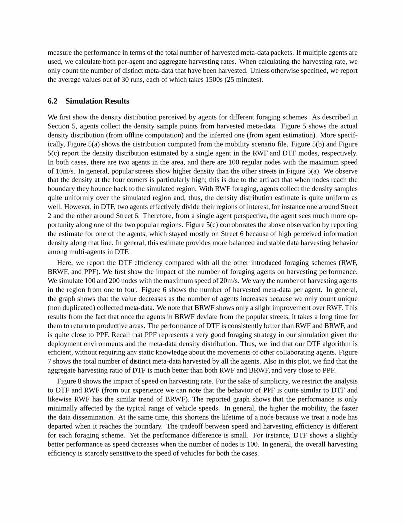
We first show the density distribution perceived by agents for different foraging schemes. As described inSection 5, agents collect the density sample points from harvested meta-data. Figure 5 shows the actualdensity distribution (from offline computation) and the inferred one (from agent estimation). More specif-ically, Figure 5(a) shows the distribution computed from the mobility scenario file. Figure 5(b) and Figure5(c) report the density distribution estimated by a single agent in the RWF and DTF modes, respectively.In both cases, there are two agents in the area, and there are 100 regular nodes with the maximum speedof 10m/s. In general, popular streets show higher density than the other streets in Figure 5(a). We observethat the density at the four corners is particularly high; this is due to the artifact that when nodes reach theboundary they bounce back to the simulated region. With RWF foraging, agents collect the density samplesquite uniformly over the simulated region and, thus, the density distribution estimate is quite uniform aswell. However, in DTF, two agents effectively divide their regions of interest, for instance one around Street2 and the other around Street 6. Therefore, from a single agent perspective, the agent sees much more op-portunity along one of the two popular regions. Figure 5(c) corroborates the above observation by reportingthe estimate for one of the agents, which stayed mostly on Street 6 because of high perceived informationdensity along that line. In general, this estimate provides more balanced and stable data harvesting behavioramong multi-agents in DTF.
Here, we report the DTF efficiency compared with all the other introduced foraging schemes (RWF,BRWF, and PPF). We first show the impact of the number of foraging agents on harvesting performance.We simulate 100 and 200 nodes with the maximum speed of 20m/s. We vary the number of harvesting agentsin the region from one to four. Figure 6 shows the number of harvested meta-data per agent. In general,the graph shows that the value decreases as the number of agents increases because we only count unique(non duplicated) collected meta-data. We note that BRWF shows only a slight improvement over RWF. Thisresults from the fact that once the agents in BRWF deviate from the popular streets, it takes a long time forthem to return to productive areas. The performance of DTF is consistently better than RWF and BRWF, andis quite close to PPF. Recall that PPF represents a very good foraging strategy in our simulation given thedeployment environments and the meta-data density distribution. Thus, we find that our DTF algorithm isefficient, without requiring any static knowledge about the movements of other collaborating agents. Figure7 shows the total number of distinct meta-data harvested by all the agents. Also in this plot, we find that theaggregate harvesting ratio of DTF is much better than both RWF and BRWF, and very close to PPF.
Figure 8 shows the impact of speed on harvesting rate. For the sake of simplicity, we restrict the analysisto DTF and RWF (from our experience we can note that the behavior of PPF is quite similar to DTF andlikewise RWF has the similar trend of BRWF). The reported graph shows that the performance is onlyminimally affected by the typical range of vehicle speeds. In general, the higher the mobility, the fasterthe data dissemination. At the same time, this shortens the lifetime of a node because we treat a node hasdeparted when it reaches the boundary. The tradeoff between speed and harvesting efficiency is differentfor each foraging scheme. Yet the performance difference is small. For instance, DTF shows a slightlybetter performance as speed decreases when the number of nodes is 100. In general, the overall harvestingefficiency is scarcely sensitive to the speed of vehicles for both the cases.

0 500 1000 1500 2000
0 500
1000 1500
2000 0.6 0.8 1
1.2 1.4 1.6 1.8 2
Density Per Road Segment
X Coord. Y Coord.
1.5 1
(a) Scenario File
0 500 1000 1500 2000
0 500
1000 1500
2000 0
0.1
0.2
0.3
0.4
0.5
Density Estimate
Per Road Segment
X Coord. Y Coord.
0.3 0.25 0.2 0.15
(b) RWF mode
0 500 1000 1500 2000
0 500
1000 1500
2000 0
0.2
0.4
0.6
0.8
1
Density Estimate
Per Road Segment
X Coord. Y Coord.
0.6 0.4 0.2
(c) DTF mode
Figure 5: Density Distribution
4000
4500
5000
5500
6000
6500
7000
7500
8000
1 2 3 4
Avg. Num. of Harvested
Meta-data Per Agent
Number of Agents
RWFBRWFDTFPPF
(a) N = 100
10000
11000
12000
13000
14000
15000
16000
17000
18000
19000
1 2 3 4
Avg. Num. of Harvested
Meta-data Per Agent
Number of Agents
RWFBRWFDTFPPF
(b) N = 200
Figure 6: Number of harvested meta-data per agent (7x7 grids)

6000
7000
8000
9000
10000
11000
12000
13000
1 2 3 4
Aggregated Num. of
Harvested Meta-data
Number of Agents
RWFBRWFDTFPPF
(a) N = 100
14000
16000
18000
20000
22000
24000
26000
28000
1 2 3 4
Aggregated Num. of
Harvested Meta-data
Number of Agents
RWFBRWFDTFPPF
(b) N = 200
Figure 7: Aggregated number of harvested meta-data (7x7 grids)
5000
6000
7000
8000
9000
10000
11000
12000
13000
1 2 3 4
Aggregated Num. of
Harvested Meta-data
Number of Agents
DTF: 30m/sDTF: 20m/sDTF: 10m/sRWF: 30m/sRWF: 20m/sRWF: 10m/s
(a) N = 100
14000
16000
18000
20000
22000
24000
26000
28000
1 2 3 4
Aggregated Num. of
Harvested Meta-data
Number of Agents
DTF: 30m/sDTF: 20m/sDTF: 10m/sRWF: 30m/sRWF: 20m/sRWF: 10m/s
(b) N = 200
Figure 8: Impact of speed

50
100
150
200
250
300
350
400
450
500
0 200 400 600 800 1000 1200 1400 1600
Harvesting Rate Per Block
Time (s)
RWFBRWFDTFPPF
(a) 1 agent scenario
20
40
60
80
100
120
140
160
0 200 400 600 800 1000 1200 1400 1600
Harvesting Rate Per Block
Time (s)
RWFBRWFDTFPPF
(b) 4 agent scenario
Figure 9: Harvesting rate per road segment over time
To further analyze the behavior of foraging schemes, we examine the per-agent harvesting rate overtime. Each agent is programmed to print out the number of harvested meta-data when leaving its currentroad segment, and we collect the number over the period of 1500s. Agent speed is 10m/s and there are100 regular nodes with maximum speed equal to 20m/s. Figure 9 shows the results for a single agent case(Figure 9(a)) and a four agent case (Figure 9(b)). From the graphs, we note that the harvesting rates of DTFfluctuate less than that of the other meta-data harvesting strategies. That stems from the fact that DTF agentstend to remain in high density areas once they find them. On the contrary, let us rapidly notice that PPFshows drastic changes since PPF agents periodically travel from a highly dense area to a less dense area onthe rectangular path.
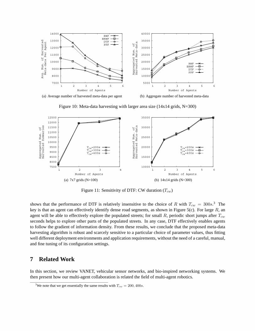
To evaluate the proposal scalability, we run simulations with a relevantly higher network size, regularnode number, and agent number; 300 regular nodes move in 14x14 grids at the maximum speed of 20m/s,while the meta-data harvesting agent number ranges from 1 to 6. In Figure 10, we report the averageper-agent number and the aggregated number of harvested meta-data. The figure shows that the overallperformance trend with respect to the number of agents does not change if compared with the 7x7 gridscenario. DTF persistently outperforms RWF and BRWF, and DTF is comparable to PPF. The numberof harvested meta-data rather gradually decreases compared to the 7x7 grid scenario. Since the area sizeforaging is quadrupled, the inter-conflict time among agents is longer enough for regular nodes to fill itslocal meta-data storage. In general, the impact of conflicts for a given foraging pattern mainly determinedby its conflict frequency. For instance, BRWF experiences more conflicts than RWF since agents tend tostay in populated streets; and each agent in DTF is likely to stay in one of the populated streets. Conflictsare also influenced by meta-data generation rate and speed of meta-data diffusion, but these factors areinvariants with respect to the choice of the foraging strategy.
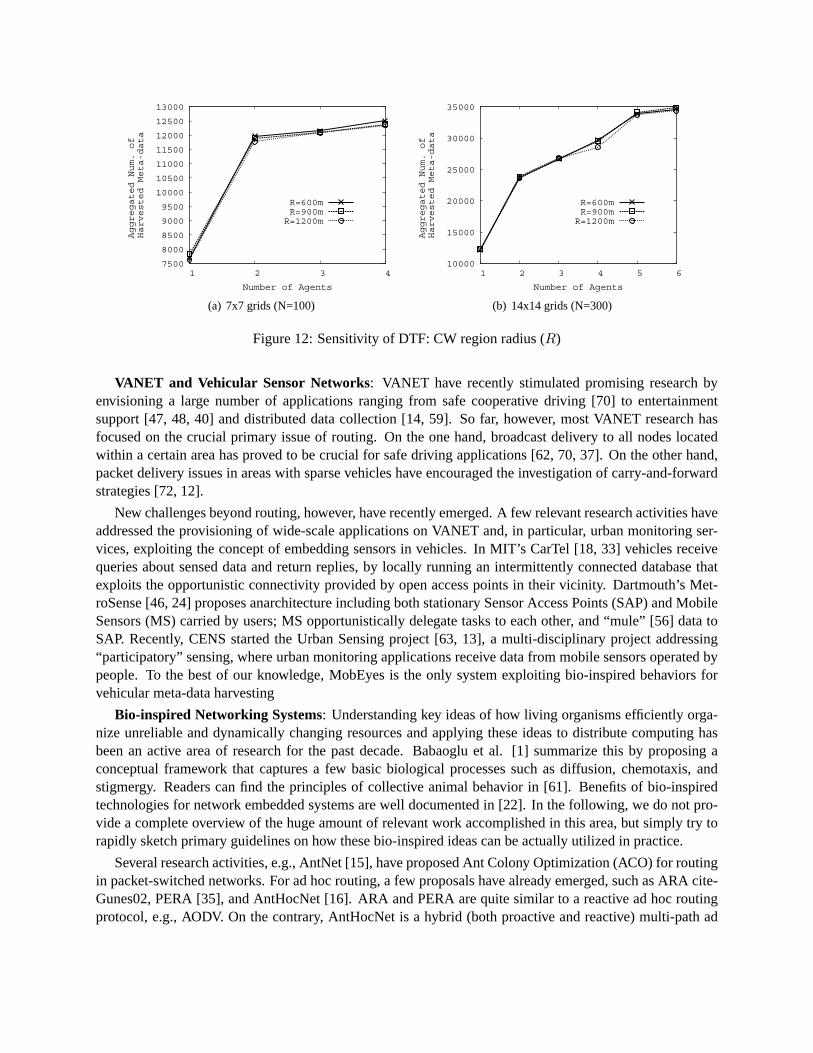
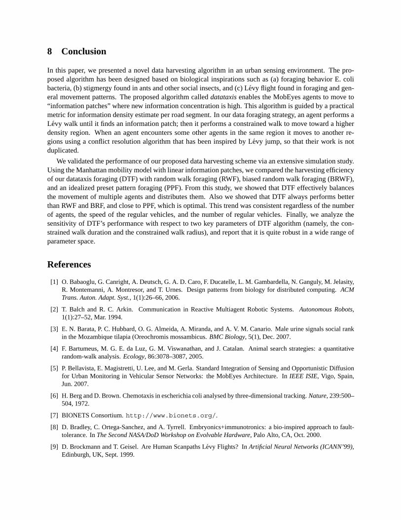
Finally, we investigate the sensitivity of DTF performance to two parameters: CW duration (Tcw) andCW region radius (R). We use Tcw=200, 300, 400s and R=600, 900, 1200m. We note that when Tcw istoo small, the agents tend to hop around the region frequently and, on the opposite, when Tcw is too long,it may hinder the agents from exploring other potentially fruitful areas. Figure 11 shows that DTF wellbehaves with a scarce dependency on the choice of Tcw. Thus, it shows that our algorithm is relativelyrobust to the Tcw parameter selection. The CW radius (R) determines the range of exploitation of agentswhen they found an information patch. In particular, we consider a range of R from R = 600m, whichcorresponds 4x4 grids in our simulation, to R = 1200m, which corresponds to 8x8 grids. Figure 12
7000
8000
9000
10000
11000
12000
13000
14000
1 2 3 4 5 6
Avg. Num. of Harvested
Meta-data Per Agent
Number of Agents
RWFBRWFDTFPPF
(a) Average number of harvested meta-data per agent
5000
10000
15000
20000
25000
30000
35000
40000
1 2 3 4 5 6
Aggregated Num. of
Harvested Meta-data
Number of Agents
RWFBRWFDTFPPF
(b) Aggregate number of harvested meta-data
Figure 10: Meta-data harvesting with larger area size (14x14 grids, N=300)
7500
8000
8500
9000
9500
10000
10500
11000
11500
12000
12500
1 2 3 4
Aggregated Num. of
Harvested Summaries
Number of Agents
Tcw=200sTcw=300sTcw=400s
(a) 7x7 grids (N=100)
10000
15000
20000
25000
30000
35000
1 2 3 4 5 6
Aggregated Num. of
Harvested Meta-data
Number of Agents
Tcw=200sTcw=300sTcw=400s
(b) 14x14 grids (N=300)
Figure 11: Sensitivity of DTF: CW duration (Tcw)
shows that the performance of DTF is relatively insensitive to the choice of R with Tcw = 300s.3 Thekey is that an agent can effectively identify dense road segments, as shown in Figure 5(c). For large R, anagent will be able to effectively explore the populated streets; for small R, periodic short jumps after Tcw
seconds helps to explore other parts of the populated streets. In any case, DTF effectively enables agentsto follow the gradient of information density. From these results, we conclude that the proposed meta-dataharvesting algorithm is robust and scarcely sensitive to a particular choice of parameter values, thus fittingwell different deployment environments and application requirements, without the need of a careful, manual,and fine tuning of its configuration settings.
7 Related Work
In this section, we review VANET, vehicular sensor networks, and bio-inspired networking systems. Wethen present how our multi-agent collaboration is related the field of multi-agent robotics.
3We note that we get essentially the same results with Tcw = 200, 400s.
7500
8000
8500
9000
9500
10000
10500
11000
11500
12000
12500
13000
1 2 3 4
Aggregated Num. of
Harvested Meta-data
Number of Agents
R=600mR=900mR=1200m
(a) 7x7 grids (N=100)
10000
15000
20000
25000
30000
35000
1 2 3 4 5 6
Aggregated Num. of
Harvested Meta-data
Number of Agents
R=600mR=900mR=1200m
(b) 14x14 grids (N=300)
Figure 12: Sensitivity of DTF: CW region radius (R)
VANET and Vehicular Sensor Networks: VANET have recently stimulated promising research byenvisioning a large number of applications ranging from safe cooperative driving [70] to entertainmentsupport [47, 48, 40] and distributed data collection [14, 59]. So far, however, most VANET research hasfocused on the crucial primary issue of routing. On the one hand, broadcast delivery to all nodes locatedwithin a certain area has proved to be crucial for safe driving applications [62, 70, 37]. On the other hand,packet delivery issues in areas with sparse vehicles have encouraged the investigation of carry-and-forwardstrategies [72, 12].
New challenges beyond routing, however, have recently emerged. A few relevant research activities haveaddressed the provisioning of wide-scale applications on VANET and, in particular, urban monitoring ser-vices, exploiting the concept of embedding sensors in vehicles. In MIT’s CarTel [18, 33] vehicles receivequeries about sensed data and return replies, by locally running an intermittently connected database thatexploits the opportunistic connectivity provided by open access points in their vicinity. Dartmouth’s Met-roSense [46, 24] proposes anarchitecture including both stationary Sensor Access Points (SAP) and MobileSensors (MS) carried by users; MS opportunistically delegate tasks to each other, and “mule” [56] data toSAP. Recently, CENS started the Urban Sensing project [63, 13], a multi-disciplinary project addressing“participatory” sensing, where urban monitoring applications receive data from mobile sensors operated bypeople. To the best of our knowledge, MobEyes is the only system exploiting bio-inspired behaviors forvehicular meta-data harvesting
Bio-inspired Networking Systems: Understanding key ideas of how living organisms efficiently orga-nize unreliable and dynamically changing resources and applying these ideas to distribute computing hasbeen an active area of research for the past decade. Babaoglu et al. [1] summarize this by proposing aconceptual framework that captures a few basic biological processes such as diffusion, chemotaxis, andstigmergy. Readers can find the principles of collective animal behavior in [61]. Benefits of bio-inspiredtechnologies for network embedded systems are well documented in [22]. In the following, we do not pro-vide a complete overview of the huge amount of relevant work accomplished in this area, but simply try torapidly sketch primary guidelines on how these bio-inspired ideas can be actually utilized in practice.
Several research activities, e.g., AntNet [15], have proposed Ant Colony Optimization (ACO) for routingin packet-switched networks. For ad hoc routing, a few proposals have already emerged, such as ARA cite-Gunes02, PERA [35], and AntHocNet [16]. ARA and PERA are quite similar to a reactive ad hoc routingprotocol, e.g., AODV. On the contrary, AntHocNet is a hybrid (both proactive and reactive) multi-path ad

hoc routing protocol and consists of two main processes: stigmergic learning and diffusion. During stig-mergic learning, nodes send out ant-like agents (similar to RREQ control packets in AODV) which sampleand reinforce good paths to the destination. Routing information is kept in an array of stigmergic variables,called pheromone tables. ARA and PERA share the same concept, but in AntHocNet, this mechanism isfurther supported by a diffusion process that spreads this information to other agents. Packets are routedunder the probabilistic guidance of the learned pheromone tables. In the BIONETS project [7, 17], bio-inspired techniques are used for autonomic self-evolving network services in an environment of a hugenumber of low-cost sensors nodes with heterogeneous capabilities and mobility. BIONETS considers evo-lutionary paradigms to drive the adaptation process of autonomic services (e.g., natural selection), and socialparadigms for the provisioning of the necessary cooperation mechanisms. Note that bio-inspired technolo-gies can also be applicable to network security such as virus propagation [29], intrusion detection [21],fault-tolerance [8], attack modeling [36], etc.
Fiore et al. propose Eureka which identifies the regions of the network where the required information ismore likely to be stored and steers the queries to those regions [27]. The concept of “information density” isproposed to estimate the amount of information cached by nodes in a specific area. Given this metric, queriesare forwarded along density gradients, i.e., to nodes with higher density than the forwarder. Each nodemaintains local density information by monitoring the multi-hop information pulling. The measured localdensity is shared with the neighbors to make a better estimate. The Datataxis scheme shares the same densitygradient idea. We have adapted the idea of the Datataxis scheme in our MobEyes application, with somerelevant modifications. The key differences are: 1) we deal with massive sensor data (specifically, spatio-temporal data streams) and only a mere fraction of data is accessed; 2) we approximate the informationdensity with the physical node density, because MobEyes uses controlled epidemic dissemination of spatio-temporal data, which is driven by physical density; and 3) we use a mechanical search method in whichthe trajectory of agents is controlled not only by the Datataxis density gradient direction, but also by thebio-inspired Levy walk concept.
Bio-inspired Multi-agent Robotic Systems Cooperative multi-agent mobile robot design is based ona behavior-based paradigm where a mobile robot control system is decomposed based on task-achievingbehaviors [11, 2]. A finite state machine is typically used to describe these behaviors. Each active behaviorprocessor computes its reaction to its perceptual stimuli from sensors, and perceptual triggers cause tran-sitions between states. This paradigm is useful for controlling mobile robots in dynamic environments. Inour system, the agent state transition diagram is composed of two states: Levy Jump and Datataxis, and thestate transition is triggered when a certain event happens such as conflicts. Interested readers are referred to[23] for a taxonomy of cooperative robotics and [51] for a brief introduction to the current research topicsin multi-robot systems.
The behavior-based paradigm is related to biological systems and thus, many researchers have examinedthe social characteristics of insects and animals when designing multi-robot systems. The simple localcontrol rules of various biological societies such as ants, bees, and birds have been used to demonstrate theability of multi-robot teams to flock, forage, etc [44, 66]. Moreover, behaviors in higher animals such ascooperation, competition, and selfishness has been also studied in multi-robot control [45]. The effective ofcommunications on the performance of a multi-robot system has been also studied. Balch et al. found thatcommunication provides benefits for particular types of tasks, and in many cases, minimal communicationof small amount of information can lead to great performance improvement [2]. Our work is similar inconcept to the foraging and cooperation among robots. However, the main difference is in that MobEyesagents are not tightly-controlled as in the robotics case, and we incorporated novel ideas such as Levy jumpsto improve the search efficiency and simple repulsive pheromone trails to coordinate multiple agents.
8 Conclusion
In this paper, we presented a novel data harvesting algorithm in an urban sensing environment. The pro-posed algorithm has been designed based on biological inspirations such as (a) foraging behavior E. colibacteria, (b) stigmergy found in ants and other social insects, and (c) Levy flight found in foraging and gen-eral movement patterns. The proposed algorithm called datataxis enables the MobEyes agents to move to“information patches” where new information concentration is high. This algorithm is guided by a practicalmetric for information density estimate per road segment. In our data foraging strategy, an agent performs aLevy walk until it finds an information patch; then it performs a constrained walk to move toward a higherdensity region. When an agent encounters some other agents in the same region it moves to another re-gions using a conflict resolution algorithm that has been inspired by Levy jump, so that their work is notduplicated.
We validated the performance of our proposed data harvesting scheme via an extensive simulation study.Using the Manhattan mobility model with linear information patches, we compared the harvesting efficiencyof our datataxis foraging (DTF) with random walk foraging (RWF), biased random walk foraging (BRWF),and an idealized preset pattern foraging (PPF). From this study, we showed that DTF effectively balancesthe movement of multiple agents and distributes them. Also we showed that DTF always performs betterthan RWF and BRF, and close to PPF, which is optimal. This trend was consistent regardless of the numberof agents, the speed of the regular vehicles, and the number of regular vehicles. Finally, we analyze thesensitivity of DTF’s performance with respect to two key parameters of DTF algorithm (namely, the con-strained walk duration and the constrained walk radius), and report that it is quite robust in a wide range ofparameter space.
References
[1] O. Babaoglu, G. Canright, A. Deutsch, G. A. D. Caro, F. Ducatelle, L. M. Gambardella, N. Ganguly, M. Jelasity,R. Montemanni, A. Montresor, and T. Urnes. Design patterns from biology for distributed computing. ACMTrans. Auton. Adapt. Syst., 1(1):26–66, 2006.
[2] T. Balch and R. C. Arkin. Communication in Reactive Multiagent Robotic Systems. Autonomous Robots,1(1):27–52, Mar. 1994.
[3] E. N. Barata, P. C. Hubbard, O. G. Almeida, A. Miranda, and A. V. M. Canario. Male urine signals social rankin the Mozambique tilapia (Oreochromis mossambicus. BMC Biology, 5(1), Dec. 2007.
[4] F. Bartumeus, M. G. E. da Luz, G. M. Viswanathan, and J. Catalan. Animal search strategies: a quantitativerandom-walk analysis. Ecology, 86:3078–3087, 2005.
[5] P. Bellavista, E. Magistretti, U. Lee, and M. Gerla. Standard Integration of Sensing and Opportunistic Diffusionfor Urban Monitoring in Vehicular Sensor Networks: the MobEyes Architecture. In IEEE ISIE, Vigo, Spain,Jun. 2007.
[6] H. Berg and D. Brown. Chemotaxis in escherichia coli analysed by three-dimensional tracking. Nature, 239:500–504, 1972.
[7] BIONETS Consortium. http://www.bionets.org/.
[8] D. Bradley, C. Ortega-Sanchez, and A. Tyrrell. Embryonics+immunotronics: a bio-inspired approach to fault-tolerance. In The Second NASA/DoD Workshop on Evolvable Hardware, Palo Alto, CA, Oct. 2000.
[9] D. Brockmann and T. Geisel. Are Human Scanpaths Levy Flights? In Artificial Neural Networks (ICANN’99),Edinburgh, UK, Sept. 1999.
[10] D. Brockmann, L. Hufnagel, and T. Geisel. The Scaling Laws of Human Travel. Nature, 439:462–465, Jan.2006.
[11] R. A. Brooks. A Robust Layered Control Syste For A Mobile Robot. IEEE Journal of Robotics and Automation,RA-2(1):14–23, Mar. 1986.
[12] J. Burgess, B. Gallagher, D. Jensen, and B. N. Levine. MaxProp: Routing for Vehicle-Based Disruption-TolerantNetworks. In IEEE INFOCOM, Barcelona, Spain, Apr. 2006.
[13] J. Burke, D. Estrin, M. Hansen, A. Parker, N. Ramanathan, S. Reddy, and M. B. Srivastava. Participatory Sensing.In ACM WSW, Boulder, CO, USA, Oct.-Nov. 2006.
[14] M. Caliskan, D. Graupner, and M. Mauve. Decentralized discovery of free parking places . In ACM VANET, LosAngeles, CA, USA, Sept. 2006.
[15] G. D. Caro and M. Dorigo. AntNet: Distributed Stigmergetic Control for Communications Networks. ArtificialLife, 5(2):137–172, 1999.
[16] G. D. Caro, F. Ducatelle, and L. M. Gambardella. AntHocNet: An Adaptive Nature-Inspired Algorithm forRouting in Mobile Ad Hoc Networks. Telecommunications (ETT), Special Issue on Self Organization in MobileNetworking, 16(2):137–172, 2005.
[17] I. Carreras, I. Chlamtacand, F. D. Pellegrini, and D. Miorandi. BIONETS: Bio-Inspired Networking for PervasiveCommunication Environments. IEEE Transactions on Vehicular Technology, 56(1):218–229, Jan. 2007.
[18] MIT’s CarTel Central. http://cartel.csail.mit.edu/.
[19] P. Chamero, T. Marton, D. Logan, K. Flanagan, J. Cruz, A. Saghatelian, B. Cravatt, and L. Stowers. Identificationof Protein Pheromones that Promote Aggressive Behaviour. Nature, 450:899–902, Dec. 2007.
[20] Z. D. Chen, H. Kung, and D. Vlah. Ad Hoc Relay Wireless Networks over Moving Vehicles on Highways. InACM MOBIHOC, Long Beach, CA, USA, Oct. 2001.
[21] D. Dasgupta and F. F. Gonzalez. An immunity-based technique to characterize intrusions in computernetworks.IEEE Transactions on Evolutionary Computation, 6(3):281–291, Jun 2002.
[22] F. Dressler. Benefits of Bio-inspired Technologies for Networked Embedded Systems: An Overview . InDagstuhl Seminar 06031 on Organic Computing - Controlled Emergence, Dagstuhl, Germany, 2006.
[23] G. Dudek, M. Jenkin, E. Milios, and D. Wilkes. A Taxonomy for Swarm Robots. In Intelligent Robots andSystems’93, Yokohama, Japan, 1993.
[24] S. B. Eisenman, G.-S. Ahn, N. D. Lane, E. Miluzzo, R. A. Peterson, and A. T. Campbell. MetroSense Project:People-Centric Sensing at Scale. In ACM WSW, Boulder, CO, USA, Oct.-Nov. 2006.
[25] N. S. F. Bai and A. Helmy. The IMPORTANT Framework for Analyzing the Impact of Mobility on Performanceof Routing for Ad Hoc Networks. AdHoc Networks Journal - Elsevier, 1:383–403, Nov. 2005.
[26] C. Fichtel, C. Kraus, A. Ganswindt, and M. Heistermann. Influence of reproductive sea-son and rank on fecalglucocorticoid levels in free-ranging male Verreaux’s si-fakas (Propithecus verreauxi). Horm Behav., 51(5):640–8, May 2007.
[27] M. Fiore, C. Casetti, and C.-F. Chiasserini. Efficient Retrieval of User Contents in MANETs. In IEEE INFO-COM, Anchorage, AK, USA, May 2007.
[28] C. Gemeno, A. Sans, C. Lopez, R. Albajes, and M. Eizaguirre. Pheromone Antagonism in the European CornBorer Moth Ostrinia Nubilalis. J Chem Ecol., 32(5):1071–84, May 2006.
[29] S. Goel and S. Bush. Biological Models of Security for Virus Propagation in Computer Networks. ;login:,29(6):49–56, Dec. 2004.

[30] L. Gould, T. Ziegler, and D. Wittwer. Effects of reproductive and social variables on fecal glucocorticoid levelsin a sample of adult male ring-tailed lemurs (Lemur catta) at the Beza Mahafaly Reserve, Madagascar. Am JPrimatol., 67(1):5–23, Sep. 2005.
[31] M. Grossglauser and M. Vetterli. Locating Nodes with EASE: Mobility Diffusion of Last Encounters in Ad HocNetworks. In IEEE INFOCOM, San Francisco, CA, USA, Mar.-Apr. 2003.
[32] J. Harri, B. Zhou, M. Gerla, F. Filali, and C. Bonnet. Neighborhood Changing Rate: A Unifying Parameter toCharacterize and Evaluate Data Dissemination Scenarios. In WONS’07, Innsbruck, Austria, Jan. 200.
[33] B. Hull, V. Bychkovsky, K. Chen, M. Goraczko, A. Miu, E. Shih, Y. Zhang, H. Balakrishnan, and S. Madden.CarTel: A Distributed Mobile Sensor Computing System. In ACM SenSys, Boulder, CO, USA, Oct.-Nov. 2006.
[34] D. E. Jackson and F. L. Ratnieks. Primer: Communications in Ants. Current Biology, 16(15):570–574, 2006.
[35] H. M. John S. Baras. A Probabilistic Emergent Routing Algorithm for Mobile Ad Hoc Networks. In WiOpt’03,INRIA Sophia-Antipolis, France, 2003.
[36] J. Kong, X. Hong, D. Wu, and M. Gerla. Complexity-theoretic Modeling of Biological Cyanide Poisoningas Security Attack in Self-organizing Networks. In IEEE 7th International Symposium on BioInformatics andBioEngineering (BIBE), Boston, MA, Oct. 2007.
[37] G. Korkmaz, E. Ekici, F. Ozguner, and U. Ozguner. Urban Multi-Hop Broadcast Protocols for Inter-VehicleCommunication Systems. In ACM VANET, Philadelphia, PA, USA, Oct. 2004.
[38] J. LeBrun, C.-N. Chuah, D. Ghosal, and M. Zhang. Knowledge-Based Opportunistic Forwarding in VehicularWireless Ad Hoc Networks. In IEEE VTC’05, Dollas, TX, USA, Sept. 2005.
[39] U. Lee, E. Magistretti, B. Zhou, M. Gerla, P. Bellavista, and A. Corradi. MobEyes: Smart Mobs for UrbanMonitoring with a Vehicular Sensor Network. IEEE Wireless Communicationsg, 13(5), Sept. 2006.
[40] U. Lee, J.-S. Park, E. Amir, and M. Gerla. FleaNet: A Virtual Market Place on Vehicular Networks. In IEEEV2VCOM, San Francisco, CA, USA, Jul. 2006.
[41] P. Levy. Theorie de l’addition des variables aleatoires. Gauthier-Villars, Paris, 1954.
[42] J. Lundstrom, M. Goncalves, F. Esteves, and M. Olsson. Psychological effects of sub-threshold exposure to theputative human pheromone 4,16-androstadien-3-one. Horm Behav., 44(5):395–401, Dec. 2003.
[43] D. MacKenzie and R. C. Arkin. Emergent bucket brigading: a simple mechanisms for improving performancein multi-robot constrained-space foraging tasks. In SPIE Conference on Mobile Robots VII, Boston, MA, 1993.
[44] M. J. Mataric. Designing Emergent behaviours: From Local Interactions to Collective Intelligenc. In Interna-tional Conference on Simulation of Adaptive Behavior: From Animals to Animats, 1992.
[45] D. McFarland. Towards Robot Cooperation. From Animals to Animats, pages 440–444, 1995.
[46] University of Dartmouth MetroSense. http://metrosense.cs.dartmouth.edu/.
[47] A. Nandan, S. Das, G. Pau, M. Gerla, and M. Y. Sanadidi. Co-operative Downloading in Vehicular Ad-HocWireless Networks. In IEEE WONS, St. Moritz, Swiss, Jan. 2005.
[48] A. Nandan, S. Tewari, S. Das, G. Pau, M. Gerla, and L. Kleinrock. AdTorrent: Delivering Location CognizantAdvertisements to Car Networks. In IFIP WONS, Les Menuires, France, Jan. 2006.
[49] ns-2 (The Network Simulator). http://www.isi.edu/nsnam/ns/.
[50] E. H. Ostergaard, G. S. Sukhatme, and M. J. Matari. Emergent bucket brigading: a simple mechanisms forimproving performance in multi-robot constrained-space foraging tasks. In AGENTS’01, Montreal, Quebec,Canada, May 2001.
[51] L. E. Parker. Current Research in Multirobot System. Artificial Life Robotics, 7(1/2):1–5, 2003.

[52] T. Rappaport. Wireless Communications: Principles and Practice. IEEE Press Piscataway, NJ, USA, 1996.
[53] A. M. Reynolds. Scale-free movement patterns arising from olfactory-driven foraging. Physical Review E, 72(4),Oct. 2005.
[54] A. M. Reynolds and M. A. Frye. Free-Flight Odor Tracking in Drosophila Is Consistent with an Optimal Inter-mittent Scale-Free Search. PLoS ONE, 2(4), 2007.
[55] R. Segev, M. Benveniste, E. Hulata, N. Cohen, A. Palevski, E. Kapon, Y. Shapira, and E. Ben-Jacob. Long TermBehavior of Lithographically Prepared In Vitro Neuronal Networks. Physical Review Letters, 88(11), Mar. 2002.
[56] R. C. Shah, S. Roy, S. Jain, and W. Brunette. Data MULEs: Modeling a Three-tier Architecture for SparseSensor Networks. Elsevier Ad Hoc Networks Journal, 1(2-3):215–233, Sept. 2003.
[57] M. Shlesinger and J. Klafter. Levy walks versus levy flights. edited by H. E. Stanley and N. Ostrowsky (Dor-drecht, The Netherlands: Martinus Nijhoff Publishers), pages 279–283, 1986.
[58] D. Sims, D. RIGHTON, and J. W. PITCHFORD. Minimizing errors in identifying Le’vy flight behaviour oforganisms. Journal of Animal Ecology, 76(2):222–229, Mar. 2007.
[59] D. Sormani, G. Turconi, P. Costa, D. Frey, M. Migliavacca, and L. Mottola. Towards lightweight informationdissemination in inter-vehicular networks . In ACM VANET, Los Angeles, CA, USA, Sept. 2006.
[60] D. Stephens and K. Krebs. Foraging Theory. Princeton University Press, NJ, USA, 1986.
[61] D. J. T. Sumpter. The Principles of Collective Animal Behaviour. Philosophical Transactions of the RoyalSociety of London: Series B, 361:5–22, Nov. 2005.
[62] M. Torrent-Moreno, D. Jiang, and H. Hartenstein. Broadcast reception rates and effects of priority access in802.11-based vehicular ad-hoc networks. In ACM VANET, Philadelphia, PA, USA, Oct. 2004.
[63] CENS’ Urban Sensing. http://research.cens.ucla.edu/projects/2006/Systems/UrbanSensing/.
[64] G. Viswanathan, V. Afanasyev, and S. Buldyrev. Levy flight search patterns of wandering albatrosses. Nature,381:413–415, 1996.
[65] G. Viswanathan, S. V. Buldyrev, S. Havlin, M. G. E. da Luz, E. P. Raposo, and H. E. Stanley. Optimizing thesuccess of random searches. Nature, 401:911–914, 1999.
[66] I. A. Wagner, Y. Altshuler, V. Yanovski, and A. M. Bruckstein. Cooperative Cleaners: A Study in Ant Robotics.The International Journal of Robotics Research, 27(1):127–151, Mar. 2008.
[67] R. Wehner and M. V. Srinivasan. Searching behaviour of desert ants, genusCataglyphis . Journal of ComparativePhysiology A: Neuroethology, Sensory, Neural, and Behavioral Physiology, 142(3):315–338, Sept. 1981.
[68] H. Wu, R. Fujimoto, R. Guensler, and M. Hunter. MDDV: a Mobility-entric Data Dissemination Algorithm forVehicular Networks. In ACM VANET, Philadelphia, PA, USA, Oct. 2004.
[69] C. Wyart, W. Webster, J. Chen, S. Wilson, A. McClary, R. Khan, and N. Sobel. Smelling a single component ofmale sweat alters levels of cortisol in women. J Neurosci., 27(6):1261–5, Feb. 2007.
[70] Q. Xu, T. Mak, J. Ko, and R. Sengupta. Vehicle-to-vehicle safety messaging in DSRC. In ACM VANET,Philadelphia, PA, USA, Oct. 2004.
[71] Y. Yu, G.-H. Lu, and Z.-L. Zhang. Enhancing Location Service Scalability with HIGH-GRADE. In IEEEMASS’04, Fort Lauderdale, Florida, USA, October 2004.
[72] J. Zhao and G. Cao. VADD: Vehicle-Assisted Data Delivery in Vehicular Ad Hoc Networks. In IEEE INFOCOM,Barcelona, Spain, Apr. 2006.